Embed Size (px)
Citation preview

Applications of GIS and Remote Sensing for the Forest Resource Monitoring System
including Carbon Stock
JICA-PNGFA PROJECT for Capacity Development on Forest Resource Monitoring for Addressing Climate Change
Kiyoshi SuzukiJICA Expert
Forest Inventory/Project CoordinatorJICA-PNGFA Project
Closing Ceremony and final Workshop for Project Completion5th - 6th March 2014
Holiday Inn Hotel, Port Moresby, PNG
105/03/2014
5th March 2014
JICA-PNGFA PROJECT for Capacity Development on Forest Resource Monitoring for Addressing Climate Change
Contents
1. Necessity of Forest Monitoring2. Project Activities for Forest Monitoring3. Conceptual Structure of Forest Monitoring of PNGFA4. Forest Area Change Analysis5. Field Monitoring for Remote Sensing6. Training and Trial of Forest Carbon Survey7. Carbon analysis using airborne data8. Forest carbon estimation for FRA20159. Summary
205/03/2014

JICA-PNGFA PROJECT for Capacity Development on Forest Resource Monitoring for Addressing Climate Change
1. Issues and Challenges in PNG
1. National level Forest Basemap is not developed since 19722. Forest GIS (FIMS: Forest Inventory and Mapping System) is not updated since 19963. Existing forest related data is not sufficient for carbon estimation
AsAs--Is (Current)Is (Current)
JICA/PNGFA Project
ToTo--Be (Goals)Be (Goals)
Forest Resource Information Management Database System
R2 = 0.8345
haあたり空間体積(m3/ha)
haあ
たり
材積
(kg
/ha)
Forest Basemap
Satellite Imagery Airborne Data
Estimation/Modeling
1. National level Forest Resource Basemap is developed and utilized2. National level Forest Resource GIS/Database is developed and utilized3. Forest Monitoring System including Carbon stock is designed/demonstrated
305/03/2014
Challenges:Vast forest area, but most are inaccessible to do forest survey for whole countryLack of funds to conduct full scale forest inventory97% of PNG land is customary landPhysical structure of land – mountainous, etc.
JICA-PNGFA PROJECT for Capacity Development on Forest Resource Monitoring for Addressing Climate Change
5
Temporal Monitoring
Carbon Stock Estimation
Annual Compensation
Reference Classification
Correspondence relationship
Cloud Compensation
Correspondence Relationship
Reference Accuracy
Cloud Compensation
REL setting
Benchmark MAP
Multi-Temporal SAR(PALSAR)
Historical Satellite(LANDSAT/SPOT)
High Frequency Optical(RapidEye: 5 satellite)
Identification
R2 = 0.8345
haあたり空間体積(m3/ha)
haあ
たり
材積
(kg
/ha)
Change Detection
Monitoring for MRV
Necessity of Forest Monitoring
Historical change and future trend analysis
Continuous monitoring in future
405/03/2014

JICA-PNGFA PROJECT for Capacity Development on Forest Resource Monitoring for Addressing Climate Change
Forest Areachange detection
Carbon content by 5 carbon pools
x =
Concept of Forest Monitoring for REDD+
Carbon analysis using airborne data
Carbon Emission / Removal
from Forest
Training and trial of forest carbon survey
Activities of JICA-PNGFA Project
Field verification for Remote Sensing
Forest area change analysis
µ
0 1,000 2,000 3,000 4,000 5,000500m
WEST SEPIK
EAST SEPIK
NUKU
VANIMO/GREEN RIVER
AITAPE/LUMI
AMBUNTI/DREKIKIR
TELEFOMIN
MAPRIK
WOSERA GAWI
WEWA K
Vanimo_Kwila
Amanab5_6LogOver07-10
PALSAR_2010_HH_HV_HHHV
RGB
Red: Band_1
Green: Band_2
Blue: Band_3
Project Activities for Forest Monitoring
Forest carbon estimation for FRA2015
Activity Data Emission Factor
505/03/2014
JICA-PNGFA PROJECT for Capacity Development on Forest Resource Monitoring for Addressing Climate Change
Area / Provincial Office
Satellite Imagery
search analysis display …
Data base
Head Quarter
Conceptual Structure of Forest Monitoring of PNGFA
Country-level monitoring(Satellite)
Field-level monitoring
(Field survey)
Conventional data(Logging operation map etc.)
Field Survey & Reporting
GISGPSLocal knowledge & information
Instruction of field surveyData-sharing Report
Satellite Image
Forest Basemap
Survey result
Data management & Monitoring on country level
605/03/2014

JICA-PNGFA PROJECT for Capacity Development on Forest Resource Monitoring for Addressing Climate Change
µ
0 1,000 2,000 3,000 4,000 5,000500m
WEST SEPIK
EAST SEPIK
NUKU
VANIMO/GREEN RIVER
AITAPE/LUMI
AMBUNTI/DREKIKIR
TELEFOMIN
MAPRIK
WOSERA GAWI
WEWAK
Amanab5_6LogOver07-10
Optical satellite image (RapidEye) 2010
Forest Area Change Analysis
705/03/2014
JICA-PNGFA PROJECT for Capacity Development on Forest Resource Monitoring for Addressing Climate Change
µ
0 1,000 2,000 3,000 4,000 5,000500m
WEST SEPIK
EAST SEPIK
NUKU
VANIMO/GREEN RIVER
AITAPE/LUMI
AMBUNTI/DREKIKIR
TELEFOMIN
MAPRIK
WOSERA GAWI
WEWAK
Vanimo_Kwila
Amanab5_6LogOver07-10
PALSAR_2007_HH_HV_HHHV
RGB
Red: Band_1
Green: Band_2
Blue: Band_3
Cloud free satellite image (ALOS/PALSAR) 2007
Forest Area Change Analysis
805/03/2014

JICA-PNGFA PROJECT for Capacity Development on Forest Resource Monitoring for Addressing Climate Change
µ
0 1,000 2,000 3,000 4,000 5,000500m
WEST SEPIK
EAST SEPIK
NUKU
VANIMO/GREEN RIVER
AITAPE/LUMI
AMBUNTI/DREKIKIR
TELEFOMIN
MAPRIK
WOSERA GAWI
WEWAK
Vanimo_Kwila
Amanab5_6LogOver07-10
PALSAR_2010_HH_HV_HHHV
RGB
Red: Band_1
Green: Band_2
Blue: Band_3
Cloud free satellite image (ALOS/PALSAR) 2010
Deforestation by forest clearance
Forest Area Change Analysis
905/03/2014
JICA-PNGFA PROJECT for Capacity Development on Forest Resource Monitoring for Addressing Climate Change
Forest Area Change Analysis
2000-2005
Romei Tadji FMA, West Sepik
1005/03/2014

JICA-PNGFA PROJECT for Capacity Development on Forest Resource Monitoring for Addressing Climate Change
Training on field verification
Field Verification for Remote SensingConcept of field verification
Purpose To develop the capacity of the relevant PNGFA officers to conduct field verification using GPS and GIS.
Period March 2013
Participants 16 PNGFA officers- Area office- Plantation- Forest Research Institute (FRI)
1105/03/2014
JICA-PNGFA PROJECT for Capacity Development on Forest Resource Monitoring for Addressing Climate Change
Field Verification for Remote SensingSatellite image (RapidEye) with pictures captured by GPS
1205/03/2014

JICA-PNGFA PROJECT for Capacity Development on Forest Resource Monitoring for Addressing Climate Change
563410456341035634102
56342045634203
56341015534128
5534324
5534227 5634202
5534325 56343045534326 5634303
56342015534228
5534424 5534425
5534327 5634302
5534426
5534524
56343015534328
5534525 5634504
5534427 5634402
5534526
5534624
55344285634401
56346045534625
5534527
5534626 5634603
56345015534528
5534627 55346285634601
5634105
5634205
5634405
5634505
5634605
5634305
5534724 5534725 5634704563470356347025634701 5634705
5534623
Milne Bay
Central
Northern
0 10 20 30 40 505km
¯
Field Verification for Remote SensingSatellite images and other data are ready for use
1305/03/2014
JICA-PNGFA PROJECT for Capacity Development on Forest Resource Monitoring for Addressing Climate Change
FF
FFF
F F FFFFF FF
FFFF
FFFF
F
FFF FF
Hs
Saf/W
Po5
40
60
30
50
70
80
90
100
110
120130140
150
160
170
180 19
020
0
210
220
230
20
240
250
260
30
40
180
60
30
190
240
200
40
20
70
30
180
190
260
70
210
260
60
20
130
180
120
40
170
30
80
140
30
30
200
50
50
160
30
40
130
20
30
30
40
40
170
150
200
30
30
170
50
70
190
30
20
PNGFA-JICA GIS/Ground Truth Workshop
µ
0 200 400 600 800 1,000100m
F ArcPhoto
Road
River
Vegetation(FIMS)
Contour_5534816_10m
RapidEye_5534816(2011-07-24)
Red: Band_3
Green: Band_2
Blue: Band_1
LANDSAT_p096r066(20010303)
Red: NONE
Green: NONE
Blue: NONE
Satellite image with Vegetation and 10m Interval Contour
Field Verification for Remote Sensing
1405/03/2014

JICA-PNGFA PROJECT for Capacity Development on Forest Resource Monitoring for Addressing Climate Change
10m Interval Contour derived from Digital Elevation Model
Field Verification for Remote Sensing
1505/03/2014
JICA-PNGFA PROJECT for Capacity Development on Forest Resource Monitoring for Addressing Climate Change
Slope analysis derived from Digital Elevation Model
Field Verification for Remote Sensing
1605/03/2014

JICA-PNGFA PROJECT for Capacity Development on Forest Resource Monitoring for Addressing Climate Change
Training of below ground biomass survey
Training and Trial of Forest Carbon SurveyTraining of forest carbon measurement
Purpose To develop the capacity of the relevant PNGFA officers to conduct field measurement of above ground biomass, dead wood, litter and understory vegetation to estimate forest carbon.
Period May 2012
Participants 16 PNGFA officers- HQ - Area office- Provincial office - FRI
Purpose To develop the capacity of the officers of relevant organizations, especially FRI scientists, to conduct below ground biomass survey.
Period September 2012
Participants 40 participantsPNGFA- HQ - Area office - FRIOther organization - OCCD - UNITECH
1705/03/2014
JICA-PNGFA PROJECT for Capacity Development on Forest Resource Monitoring for Addressing Climate Change
Plot size Measurement Object
Mainplot(1ha)
40m x250m
Live and deadstanding wood,palms and vines
Dead lying wood
Subplot
5m x 5m Live and deadstanding wood
Dead lying wood
1m x 1m Tree sapling
Dead wood1m x 1m Understory
vegetation
Litter
Training and Trial of Forest Carbon Survey
1805/03/2014

JICA-PNGFA PROJECT for Capacity Development on Forest Resource Monitoring for Addressing Climate Change
Training and Trial of Forest Carbon Survey
1905/03/2014
JICA-PNGFA PROJECT for Capacity Development on Forest Resource Monitoring for Addressing Climate Change
Canopy Volume
Airborne Survey Data (GeoSAR & LiDAR)
Stand Volume
Field Survey
Tree SpeciesTree HeightDBH
Allometric Model
Correlation Analysis between Canopy Vol. and Stand Vol.
R2 = 0.8345
haあたり空間体積(m3/ha)
haあ
たり
材積
(kg
/ha)
Stan
d V
olum
e (m
3/ha
)
Canopy Volume (m3/ha)
Carbon Stock Amount
Prof ile Graph Title
Profile Graph Subtitle
2,0001,5001,0005000
35
30
25
20
15
10
At least 250m is desired to see canopy profile
Illustration Only
DSM – DTM = Canopy Vol.L shape plot design in
consideration of GeoSAR
Canopy vol.
DSM
DTM
Carbon analysis using airborne data
2005/03/2014

JICA-PNGFA PROJECT for Capacity Development on Forest Resource Monitoring for Addressing Climate Change
Biomass by carbon poolArea
Area of Forest Base Map 2012
IPCC 2006 Guidelines
Above Ground Biomass: Tier1 Default valueBelow Ground Biomass: Tier1 Default value X
calculation
Total Forest Biomass in PNG
Total Forest Biomass Carbon Stock in PNG
X 0.47 and 0.451 (IPCC default)
Translated and applied to
Litter: Dead wood: Soil organic matter:
Excluded for Tier 1 approach
Classification of Global Ecological Zone (FAO)
Forest carbon estimation for FRA2015
2105/03/2014
JICA-PNGFA PROJECT for Capacity Development on Forest Resource Monitoring for Addressing Climate Change
Forest Base Map 2012
- New Forest Base Map 2012 was developed using high resolution satellite imagery under JICA-PNGFA Project. Area of Forest types on Forest Base Map 2012 are calculated as in table below.
Forest type Area (ha)
PLow Altitude Forest on Plains & Fans
5,044,831
HLow Altitude Forest on Uplands
15,060,791
L Lower Montane Forest 8,443,151
Mo Montane Forest 811,434
D Dry Seasonal Forest 960,685
B Littoral Forest 86,343
Fri Seral Forest 155,027
Fsw Swamp Forest 2,199,899
M Mangrove Forest 649,604
W Woodland 2,952,213
Sa Savanna 655,446
Sc Scrub 394,500
Area of Forest types of Forest Base Map 2012
Forest carbon estimation for FRA2015
05/03/2014 22

JICA-PNGFA PROJECT for Capacity Development on Forest Resource Monitoring for Addressing Climate Change
Forest Base Map 2012
(PNGFA/JICA)
Total Living Biomass
(Mt)CF
Total forest biomass
carbon (Mt)
P 2,073.43
0.47
974.51
H 6,189.99 2,909.29
Fri 63.72 29.95
Fsw 904.16 424.95
D 214.42 100.78
B 19.27 9.06
W 491.25 230.89
Sa 64.23 30.19
Sc 38.66 18.17
L 1,501.19 705.56
Mo 144.27 67.81
M 185.84 0.451 83.8 Total 11,890.43 5,592.22
Forest carbon estimation for FRA2015
2305/03/2014
JICA-PNGFA PROJECT for Capacity Development on Forest Resource Monitoring for Addressing Climate Change
Summary1. Forest monitoring is necessary to address REDD+. 2. JICA-PNGFA Project contributed some parts of forest
monitoring system through its activities.3. Forest area change analysis were conducted on trial basis.
This activity is very important for PNGFA to conduct both historical analysis and future monitoring.
4. Training on field verification were conducted. Data for field verification is ready for use.
5. Training and trial on forest carbon survey were conducted.6. Carbon analysis using airborne data were conducted.7. Basemap results assisted forest biomass carbon calculation
for FAO FRA2015. *FRA: Forest resource assessment
2405/03/2014

Major Achievement of Japan Grant Aid
JICA-PNGFA PROJECT for Capacity Development on Forest Resource Monitoring for Addressing Climate Change
Masamichi HARAGUCHITeam Leader of Grant Aid Technical Assistant
Kokusai Kogyo Co., Ltd (KKC)
Closing Ceremony and final Workshop for Project Completion5th - 6th March 2014
Holiday Inn Hotel, Port Moresby, PNG
2014/3/5 1
05th March 2014
JICA-PNGFA PROJECT for Capacity Development on Forest Resource Monitoring for Addressing Climate Change
Contents• Cooperation/Integration of JICA Project & Grant Aid Program• Distribution Plan & Cooperation with Organizations• Introduction of Procured Equipment (Data)
– Satellite Imagery (Optical/Radar), Airborne Data• List of Procured Equipment • Equipment Delivery & Set-up• Airborne Data Collection• Data Sharing: Property/Right & MoA• Data & User Management (Trial Operating)• Technical Assistance
– TA4: Topo Map Scan, Training Program for Universities & Institute• Current Situation and Potential for Future
– TA3: Canopy Volume Estimation for Carbon Stock
2014/3/5 2

JICA-PNGFA PROJECT for Capacity Development on Forest Resource Monitoring for Addressing Climate Change
Full Cooperation of JICA Project & Grant Aid Program
2014/3/5 3
Japan Grant Aid (JICS)
EquipmentRemote Sensing GIS facilitySatellite ImagesAirborne dataField survey equipment
Initial Training on installation &setting of equipment and data
Technical Assistance (TA) forutilization of equipment and data
On the Job Training (OJT) on RS/GISsoftware and data
JICA Technical Cooperation (T/C)
1. base 1. Nation-wide forest base map
2. National level forest resource database
3. M system of 3. Monitoring system of forest resource including
carbon stocks
Expected Output
Objective:
To enhance the capacity of relevant institutions in PNG for monitoring of nation-wide forest resource including carbon stock to address climate change
JICA-PNGFA PROJECT for Capacity Development on Forest Resource Monitoring for Addressing Climate Change
Full Integration of JICA Technical Cooperation (TC)& Grant Aid Technical Assistance (TA)
2014/3/5 4
JICA TC Analysis & DesignCapacity Building
Grant Aid TA @PNGProcessing Design
Grant Aid TA @JPNMass Production
Grant Aid Equipment ProcurementRemote Sensing/GIS-Database Facility
Satellite Imagery/Airborne DataField Survey Equipment
Grant Aid TA @JPNForest Basemap
Forest Resource Database
Grant Aid TA @PNGWork for Change DetectionImplementation of System
JICA TC Application of Map/DBOperation of Map/DB
• Current situation analysis• User Needs & Assessment• Pilot/Demonstration Activity• Remote Sensing
–Core-Analysis Design–Development Methodology
• GIS Database–Current system Analysis–Basic System Design
• Expanding Area (Sub-National)• Remote Sensing
–Processing Design–Mosaic/Standardization–Improvement Methodology
• GIS Database–Detail System Design–Development System–Operational/Monitoring
• Expanding Area (National)• Remote Sensing
–Mass Production–Compiling Data
• GIS Database–Re-disign System–Re-develop System
Training in Japan

JICA-PNGFA PROJECT for Capacity Development on Forest Resource Monitoring for Addressing Climate Change
Contents of Technical Cooperation & Technical Assistance
2014/3/5 5
TC3. Monitoring system of forest resource including carbon stocks
TA1: Creation of national forest base maps using remote sensing technologies
TA2: Development/construction of a national-level forest GIS/Database
TA3: Estimation of carbon stock which would be essential information for the forest resource monitoring
TA4: Formulation of a program to strengthen implementation capacity and to support educational institutions
TC1: Nation-wide forest base map
TC2:National level forest resource database
Slide: 19-22
Slide: 23-32
JICA-PNGFA PROJECT for Capacity Development on Forest Resource Monitoring for Addressing Climate Change
Distribution Plan & Cooperation with Organizations
2014/3/5 6
DAL DEC
UPNG UNITECH
OCCD
HQ
FRI
PNGFA
•Satellite Imagery•WS & GIS (View)
•Satellite Imagery•WS & GIS (View)
Satellite ImageryWS & Server
GIS (Pro Editing)Remote Sensing
Field Survey Equipment
•Satellite Imagery•WS & GIS (Education)
•Remote Sensing (Education)•Field Survey Equipment
•Satellite Imagery•WS & GIS (Education)•Remote Sensing (Education)•Field Survey Equipment
WS & GIS (View)
Educational ProgramForest Management GIS
Remote Sensing (Hands-on)
EnvironmentConservation
AgricultureLivestock
Analysis ResultsThematic Maps
OfficersOfficers
International RequirementCross-check / Verification
Tech. Input Tech. Input
Implementing Organizations
Educational Institutions
Forestry Forestry
•Satellite Imagery will be shared with other sector implementing organization for compatible data usage
•WS & GIS is delivered to each organizations
•Universities have academic license of GIS for education

JICA-PNGFA PROJECT for Capacity Development on Forest Resource Monitoring for Addressing Climate Change
2014/3/5 7
Satellite Imagery (Optical): RapidEye
Ref. RapidEye Web
JICA-PNGFA PROJECT for Capacity Development on Forest Resource Monitoring for Addressing Climate Change
2014/3/5 8
Comparison of RapidEye (5m) & Landsat (30m)

JICA-PNGFA PROJECT for Capacity Development on Forest Resource Monitoring for Addressing Climate Change
2014/3/5 9
Satellite Imagery (Radar): ALOS/PALSAR (Japan)
Ref. JAXA Web
ALOS-2 (SAR) and ALOS-3 (Optical)
ALOS: Advanced Land Observation Satellite
• National Land Monitoring and Managements• Resources Managements• Disaster/Forest Monitoring • ALOS-2 is planed to be launch in 2013-14,
and ALOS-3 is hoped in 2014-15 (TBD)
Launch:Jan. 24, 2006 by H-2A Rocket #8> Stopped operation in Mar. 2011
Objectives: ① Cartography (1/25,000 scale)② Environmental Monitoring③ Disaster/Forest Monitoring
Three mission instruments: ①PRISM ②AVNIR-2 ③PALSAR
PRISM
PALSAR
AVNIR-2
PRISM
PALSAR
AVNIR-2
ALOS-2: SAR Satellite ALOS-3: Optical Satellite
PRISMPanchromatic Remote sensing Instrument for Stereo Mapping
AVNIR-2Advanced Visible & Near-Infra
Red Radiometer type 2
PALSARPhased Array type L-band Synthetic Aperture Radar
JICA-PNGFA PROJECT for Capacity Development on Forest Resource Monitoring for Addressing Climate Change
2014/3/5 10
Cloud Compensation & Change Detection
Change Detection => Forest Monitoring
2007 PALSAR 2010 PALSAR Change Analysis
Existing Map Rapid Eye
Cloud Compensation => Forest Basemap
PALSAR

JICA-PNGFA PROJECT for Capacity Development on Forest Resource Monitoring for Addressing Climate Change
2014/3/5 11
Airborne Data Collection & Application
What is Canopy Volume?
R2 = 0.8345
haあたり空間体積(m3/ha)
haあ
たり
材積
(kg
/ha)
DTM
DSM
Tree Stand Volume Relational Expression of Canopy Volume and Tree Stand Volume
Canopy Volume
Tree
Sta
nd V
olum
e
Spatial Volume
JICA-PNGFA PROJECT for Capacity Development on Forest Resource Monitoring for Addressing Climate Change
2014/3/5 12
Digital Canopy Volume derived from Airborne DataDSM DTM
Canopy Volume

JICA-PNGFA PROJECT for Capacity Development on Forest Resource Monitoring for Addressing Climate Change
2014/3/5 13
Item No. Item Item (detail) TotalPNGFA
HQFRI
RegionOffice
ProvinceOffice
OCCD DEC DALUPNGRSC
1 Desktop PC Desktop PC 32 6 4 5 0 1 1 1 7
2 Laptop Laptop PC 18 5 4 5 4 0 0 0 03 Potable GPS Potable GPS 31 4 4 10 4 1 1 1 24 A3 Printer (Color) A3 Printer (Color) 8 1 1 5 0 0 0 0 05 A3 Scanner A3 Scanner 8 1 1 5 0 0 0 0 06 A0 Scanner A0 Scanner 1 0 0 0 0 0 0 0 17 A0 Plotter A0 Plotter & Scanner 3 1 1 0 0 0 0 0 08 Data Server Data Server 2 1 1 0 0 0 0 0 0
Software/Satellite Imagery (to be installed)LPS 5 2 1 0 0 0 0 0 1IMAGINE (Pro) 5 2 1 0 0 0 0 0 1ATCOR 2 1 0 0 0 0 0 0 1AutoSync 2 1 0 0 0 0 0 0 1Radar Mapping Suite 2 1 0 0 0 0 0 0 1HEAK Core Level1(15 License/set) 2 0 0 0 0 0 0 0 1 15 1HEAK Photo-Level1(15 License/set) 2 0 0 0 0 0 0 0 1 15 1Architect 1 0 1 0 0 0 0 0 0Developer 2 1 1 0 0 0 0 0 0Server&Developer 1 1 0 0 0 0 0 0 0ArcInfo 5 2 1 0 0 0 0 0 1ArcEditor 4 2 0 0 0 0 0 0 1ArcView 15 2 1 5 0 1 1 1 2Spatial Analyst 10 4 2 0 0 0 0 0 23D Analyst 10 4 2 0 0 0 0 0 2
1 FD1 LS1 FD1 LS1 FD1 LS
12 ArcGIS Server ArcGIS Server 2 1 1 0 0 0 0 0 0
0 1
11 ArcGIS license
0 1
Spatial Analyst Academic (30 License) 3 0 0
0 0
0 0 0 0
3D AnalystAcademic (30 License) 3 0 0 0 0
0 0 0 10 0 0 0ArcInfo Academic (30 License/set) 3
011
01
0
0
222
0
Unitech
7
0411
0
0
11
0eCognition
09
10
ERDAS
List of Procured Equipment (1/2)
JICA-PNGFA PROJECT for Capacity Development on Forest Resource Monitoring for Addressing Climate Change
List of Procured Equipment (2/2)
2014/3/5 14
Item No. Item Item (detail) TotalPNGFA
HQFRI
RegionOffice
ProvinceOffice
OCCD DEC DALUPNGRSC
13 MS SQL Server MS SQL Server 2 1 1 0 0 0 0 0 014 MS Visual Studio MS Visual Studio 3 2 1 0 0 0 0 0 015 MapInfo MapInfo 1 1 0 0 0 0 0 0 016 ALOS/PALSAR 2010 1 1 0 0 0 0 0 0 017 RapidEye 2010 1 1 0 0 0 0 0 0 018 ALOS/PALSAR 2007 1 1 0 0 0 0 0 0 0
19 Compass Compass 30 3 4 19 0 0 0 0 0
20 Clinometer Clinometer 30 3 4 19 0 0 0 0 021 Diameter Tapes (10m) Diameter Tapes (10m) 30 3 4 19 0 0 0 0 022 Distance Tape (100m) Distance Tape (100m) 30 3 4 19 0 0 0 0 023 Distance Tape (50m) Distance Tape (50m) 30 3 4 19 0 0 0 0 0
24 Digital Camera Digital Camera 15 5 3 5 0 0 0 0 1
Wedge Prism (BAF 1) 30 3 4 19 0 0 0 0 0
Wedge Prism (BAF 2) 30 3 4 19 0 0 0 0 026 Hypsometer Hypsometer 30 3 4 19 0 0 0 0 027 Densiometer Densiometer 16 3 4 5 0 0 0 0 2
28 Shelf Storage Shelf Storage 8 4 4 0 0 0 0 0 0
29 Cabinet (Vertical) Cabinet (Vertical) 8 4 4 0 0 0 0 0 030 Cabinet (Horizontal) Cabinet (Horizontal) 12 6 6 0 0 0 0 0 0
31 Projector sets Projector sets 2 1 1 0 0 0 0 0 0
32 Portable Generator Portable Generator 2 1 1 0 0 0 0 0 0
00
44
1
4
0
4
0
0
442
0
44
0000
0
Unitech
Satellite Imagery
25Wedge Prism (Angle Count) Factor 1 & 2

JICA-PNGFA PROJECT for Capacity Development on Forest Resource Monitoring for Addressing Climate Change
2014/3/5 15
Area OfficeGIS
DesktopProvince Office
GPSLaptop
HQ, FRI, UPNG, Unitech
Plotter & Scanner
•Delivery of most the equipment's including airborne data is completed
•Set-up GIS in Area Office & Univ. is completed and training is started
•Training of GPS was conducted in JICA Workshop in March, 2012
Equipment Delivery and Set-up, Training
JICA-PNGFA PROJECT for Capacity Development on Forest Resource Monitoring for Addressing Climate Change
Airborne Data Collection
2014/3/5 16
Milne Bay, Central Suau(Lowland. Logged over)
PNGFA REDD+ Pilot
Kokoda(Montane, High Altitude)
DEC GeoSAR Study
•Quality assessment has passed & product was delivered in Feb. 2013
•Data acquisition is successfully completed in December 2012 (AAM)

JICA-PNGFA PROJECT for Capacity Development on Forest Resource Monitoring for Addressing Climate Change
Data Sharing: Property/Right & MoA
2014/3/5 17
Org. Item PNGFA FRIArea
OfficeOCCD
DECDAL
UPNGUNITECH
Other
PNG
FA
FIMS (del. timber) ◎ ○ ☓ ☓ ☓ ☓ ☓
FIPS ◎ ☓ ☓ ☓ ☓ ☓ ☓
PSP ☓ ◎ ☓ ☓ ☓ ☓ ☓
Japa
n G
rant
Aid RapidEye ◎ ◎ ○ ☓ ○ ○ ☓
thematic map ◎ ◎ ○ ○ ○ ○ ○
PALSAR ◎ ○ ☓ ☓ ☓ ☓ ☓
ortho & change ◎ ◎ ○ ○ ○ ○ ○
JICA GeoEye & LiDAR ◎ ○ ☓ ☓ ☓ ☓ ☓
NM
B(M
RA) GeoSAR ◎ ○ ☓ ☓ ☓ ☓ ☓
processed data ◎ ○ ○ ☓ ☓ ☓ ☓
TopoMAP ◎ ◎ ○ ☓ ☓ ☓ ☓
Ope
n D
ata LANDSAT ○ ○ ○ △ △ △ △
ASTER G-DEM ○ ○ ○ △ △ △ △
SRTM ○ ○ ○ △ △ △ △
PNGRIS, Geobook, etc ◎ ◎ ○ △ △ △ △
◎ Main Data Owner
MOAfocus
○ Licensed User △ Possible to Share☓ Not Share (not allowed/necessary)
JICA-PNGFA PROJECT for Capacity Development on Forest Resource Monitoring for Addressing Climate Change
Data & User Management (Trial Operating)
2014/3/5 18
ICT Support
JICA Support
Users○
☓
☓
Read/View
Copy
Write/Update
○
○
○
Read/View
Copy
Write/Update
Backup
Manage○
○
Server@HQ/FRID-Drive:WS@Area Office

JICA-PNGFA PROJECT for Capacity Development on Forest Resource Monitoring for Addressing Climate Change
2014/3/5 19
Topo Map Scanning: Using A0 Plotter/Scanner for GISWorkflowWorkflow File Naming RuleFile Naming Rule
Index Map of Topographic MapIndex Map of Topographic Map
Enable to gain quick access to the maps
X,Y
Scan Georectify Edgecut
File File Naming Rule
Scanned images TOPOs+Sheet No.+Sheet Name
Georectified images TOPOr+Sheet No.+Sheet Name
Edgecut images TOPO+Sheet No.+Sheet Name
JICA-PNGFA PROJECT for Capacity Development on Forest Resource Monitoring for Addressing Climate Change
2014/3/5 20
Training Program for Universities and InstituteContents:- Introduction to ArcGIS- Map design- GIS outputs- File geodatabase- Spatial data- Digitizing- Geoprocessing- Spatial analysis- Introduction to
ArcGIS 3D Analyst- Analyzing raster data- Creating surface- Analyzing topographic
surface- Analyzing distance- Suitability analysis- Hydrological analysis- Ecotope mapping

JICA-PNGFA PROJECT for Capacity Development on Forest Resource Monitoring for Addressing Climate Change
Current Situation and Potential for Future: Group2
2014/3/5 21
Organization
Division Provision of TA Current situation Future possibility
UNITECH
Forestry
GIS/RS training program was implemented inDec. 2012 (10 people)
Stagnation due to poor infrastructure conditions caused by delayed transfer to the facility as scheduled
Entry of graduates of the training program, cooperation and collaboration for mass production
Surveying &Land Studies
Nothing in particular:Request for TA to the Forestry
The procured PCs, GIS & RS teaching materials are effectively utilized in their education and research activities
TA to the Dept. of Forestry & candidate subcontractor in mass production operation
UPNG
RemoteSensing Center
Nothing in particular:Advice on GIS/RS training program
The procured large plotter/scanner is effectively utilized
Technical exchange for past satellite data analysis and airborne data analysis
EnvironmentalScience &Geography
FormulationGIS/RS training program (4 people)
New classes were started, which are popular among the students.
Cooperate with graduates, subcontract for mass production
JICA-PNGFA PROJECT for Capacity Development on Forest Resource Monitoring for Addressing Climate Change
Current Situation and Potential for Future: Group1&3
2014/3/5 22
Organization
DivisionProvision of technical
assistanceCurrent situation Future possibility
PNGFA Area Office
Mar. 2013 Ground Truth WS
Oct. to Dec. 2013Agriculture information development WS
Acquired basic skills for handling satellite data and GIS in the farmland information development WS. Expected to utilize the skills in the future
Practice of monitoring in coordination with local areas (ground truth, information collection)
OCCDNothing in particular:WS in 2012
The procured GIS is utilized some time because they have OSS equipment from UN-REDD/FAO.
Cross-validation of forest info necessary for international reports
DECNothing in particular:WS in 2012
The equipment is not utilized due to lack of understanding but considered to utilize it after MTG with PNGFA
Management &planning, updating & sharing of info of protection areas & wetlands
DALNothing in particular:WS in 2012
The equipment is not utilized due to the issue of command channel butconsidered to utilize it after MTG with PNGFA
Development of detailed agriculture info (crops, etc.), collection of info on plantations

JICA-PNGFA PROJECT for Capacity Development on Forest Resource Monitoring for Addressing Climate Change
2014/3/5 23
Addressing Emission Factor with Airborne Data
EMISSION FACTORACTIVITY DATA x CO2 Emission=
Satellite MonitoringArea and area change
Inventory SurveyInformation on carbon stocks associated with each land category
Optical Satellite
Radar/SAR Satellite
•It is very difficult to implement field survey for a large number/wide
•It is not easy to measure tree height accurately
•We would like some compensating method.
Airborne LiDAR/SAR
LiDAR:LightDetectionAndRanging
JICA-PNGFA PROJECT for Capacity Development on Forest Resource Monitoring for Addressing Climate Change
2014/3/5 24
Overview of Demonstration of Carbon Stock EstimationCorrelation Analysis of Canopy
Volume and Stand Volume
R2 = 0.8345
haあたり空間体積(m3/ha)
haあ
たり
材積
(kg
/ha)
Stan
d V
olum
e
Canopy Volume
Canopy Volume
Airborne Survey (GeoSAR & LiDAR)
Stand Volume
Field Survey
Tree SpeciesTree HeightDBH
Allometric Model
Carbon Stock Amount
Profile Graph Title
Profile Graph Subtitle
2,0001,5001,0005000
35
30
25
20
15
10
At least 250m is desired to see canopy profile

JICA-PNGFA PROJECT for Capacity Development on Forest Resource Monitoring for Addressing Climate Change
2014/3/5 25
Digital Canopy Volume derived from Airborne RadarProf ile Graph Title
Profile Graph Subtitle
2,0001,5001,0005000
35
30
25
20
15
10
JICA-PNGFA PROJECT for Capacity Development on Forest Resource Monitoring for Addressing Climate Change
2014/3/5 26
Detail Plot Survey for Canopy Volume Estimation
µ
0 20 40 60 80 10010m
Geo-Eye Imagery and Ground-based Survey by PNGFA May 2012

JICA-PNGFA PROJECT for Capacity Development on Forest Resource Monitoring for Addressing Climate Change
2014/3/5 27
Assessment of LiDAR & GeoSAR (Plain Area)
JICA-PNGFA PROJECT for Capacity Development on Forest Resource Monitoring for Addressing Climate Change
2014/3/5 28
Correlation Analysis between Canopy Volume & Biomass

JICA-PNGFA PROJECT for Capacity Development on Forest Resource Monitoring for Addressing Climate Change
2014/3/5 29
Assessment of LiDAR & GeoSAR (Montane Area)
TreeHight_GeoSAR2012
LiDAR/LAS 3D Image
JICA-PNGFA PROJECT for Capacity Development on Forest Resource Monitoring for Addressing Climate Change
2014/3/5 30
Estimated Carbon Stock by LiDAR Canopy Volume

JICA-PNGFA PROJECT for Capacity Development on Forest Resource Monitoring for Addressing Climate Change
2014/3/5 31
GeoSAR Terrain Illumination Correction
JICA-PNGFA PROJECT for Capacity Development on Forest Resource Monitoring for Addressing Climate Change
Suggestions for Improving Canopy Volume Estimation• Analyze with GeoSAR Terrain Illumination
Corrected Data• Analyze based on Slope and Vegetation Type
Clusters• Analyze with Canopy Cover & Crown Density
Info by Ground Survey & Densiometer• Analyze with National Forest Inventory Info in
the Future• Analyze with the Classification of Secondary
Forest and Forest Degradation Level • Improve the Pre-Processing of Path/Swath
Coordination (by Data Provider)
2014/3/5 32

JICA-PNGFA PROJECT for Capacity Development on Forest Resource Monitoring for Addressing Climate Change
Summary• JICA Project & Grant Aid Program are cooperated & Integrated
• Equipment were distributed as plan mostly (some changed)
• Satellite Image (Optical/Radar), Airborne Data were collected
• Equipment were distributed as plan mostly (some changed)
• Airborne Data was collected as planned (take time though)
• Data Sharing: Property/Right & MoA will be agreed later
• Data & User Management are on trial operation (with S.R.O)
• Technical Assistance was implemented and completed in Dec.
– TA4: Topo Map Scanning was completed, Training Program for UPNG, UNITECH & FRI were conducted
– TA3: Canopy Volume Estimation for Carbon Stock was demonstrated and recommendation are arranged
2014/3/5 33
JICA-PNGFA PROJECT for Capacity Development on Forest Resource Monitoring for Addressing Climate Change
Closing Ceremony and final Workshop for Project Completion5th - 6th March 2014
Holiday Inn Hotel, Port Moresby, PNG
Tenkyu tru (Picture: setting Grant Aid equipment's)
2014/3/5 34

Evaluation Outline of the Current Project and
Concept of Next JICA T/C Project
JICA-PNGFA PROJECT for Capacity Development on Forest Resource Monitoring for Addressing Climate Change
Tatsuya Watanabe Chief Advisor
JICA PNGFA Project
Closing Ceremony and final Workshop for Project Completion5th - 6th March 2014
Holiday Inn Hotel, Port Moresby, PNG
5 March, 2014 1
JICA-PNGFA PROJECT for Capacity Development on Forest Resource Monitoring for Addressing Climate Change
Contents1. Sequence for terminal evaluation and new
project formulation
2. Outline of the JICA Project Joint Evaluation
3. Evaluation comments taken account or incorporated into new project formulation
4. Overall Concept of the new Project
5 March, 2014 2

JICA-PNGFA PROJECT for Capacity Development on Forest Resource Monitoring for Addressing Climate Change
2011 2012 2013 2014 2015 2016 2017 2018 2019
Grant Aid Programme
Current JICA T/C Project Next JICA T/C Project
Detailed Planning Survey
Joint Final Evaluation
PNG Next Project Proposal
Capacity for monitoring forest resource including Carbon
1. Base Map2. Database 3. Monitoring
Capacity to continuously update forest information by using database for SFM and Climate Change
1. Expansion of database 2. Forest Plan and monitoring 3. Information for addressing REDD+
PNGFA Decision Support System (AUS)
NFI Preparation (FAO/UN-REDD)
NFI Implementation (FAO/EU)
NFI: National Forest Inventory
1. Sequence for terminal evaluation and new project formulationin the timeframe of JICA and relevant projects in 2011-2019
5 March, 2014 3
JICA-PNGFA PROJECT for Capacity Development on Forest Resource Monitoring for Addressing Climate Change
2. Outline of the JICA Project Joint Evaluation1. Objectives of terminal evaluation
To review whether objectives can be achieved by the time of termination of the project period and to give recommendations and lessons learned for a future relevant activities.
2. Members of Joint Evaluation Team[Japanese side]
• Mr. Hiroki Miyazono, Leader of Japanese-side Review Team, Senior Advisor, JICA• Mr. Toshihiro Shima, Forestry Agency, Ministry of Agriculture, Forestry and Fisheries• Mr. Hiroyuki Miyazaki, Global Environment Department, JICA• Ms. Asako Takimoto, Social Development Department, Global Link Management Inc.
[PNG side]• Mr. Michael Gigmai, Leader of PNG-side Review Team, Foreign Aid Division (Bilateral),
Department of National Planning and Monitoring• Mr. Michael Ketava, Monitoring and Evaluation Division, Department of National
Planning and Monitoring• Mr. Wakai Digine, Infrastructure and Economic Division , Department of National
Planning and Monitoring
Schedule• 3 October -23 October 2013
5 March, 2014 4

JICA-PNGFA PROJECT for Capacity Development on Forest Resource Monitoring for Addressing Climate Change
1.The next project can include activities necessary to enhance the current project activities
2.More inputs needed to base map improvement and estimation of national level carbon stock change and reference emission level
3.Application of the project’s products to forest management planning and other multipurpose usage
4.More field level C/P training and establishing data collection and exchange system with provincial offices
5.How to maximize the impact of the project achievement is still concern (Publicity issue)
6.Seamless transition to the next project
Project Purpose
New Output 1
New Output 2
New Output 2
New activitiesSorry, too late!
3. Evaluation comments taken account or incorporated into new project formulation
5 March, 2014 5
4. Overall Concept of the new Project
PNG Forest Resource Information
Management System
(PNG-FRIMS)Output 1NFRIMS is expanded
and enhanced
Output 2The national forest plan, provincial forest plans, forest management plans and their monitoring system are improved through
steady operation of PNG-FRIMS.
Output 3Forest information for addressing REDD+ is
prepared
Overall GoalForests in PNG are conserved and managed in a sustainable manner, while at the same time, mitigation and adaptation measures against climate change are promoted.
Project PurposeCapacity of the PNGFA to continuously update forest information and to fully operationalize and utilize PNG-FRIMS for promoting sustainable forest management and for addressing climate change is enhanced.
Project Period: 5 years (from 2014 to 2019)
5 March, 2014 6

JICA-PNGFA PROJECT for Capacity Development on Forest Resource Monitoring for Addressing Climate Change
Closing Ceremony and final Workshop for Project Completion5th - 6th March 2014
Holiday Inn Hotel, Port Moresby, PNG
Thank youTenkyu tru
Arigatou gozaimashita
5 March, 2014 7

Forest definition and forest classification
JICA-PNGFA PROJECT for Capacity Development on Forest Resource Monitoring for Addressing Climate Change
Rabbie Inzing Lalo & Gewa Gamoga
Closing Ceremony and final Workshop for Project Completion5th - 6th March 2014
Holiday Inn Hotel, Port Moresby, PNG
PNG Forest AuthorityForest Policy & Planning Directorate
2014/3/6 1
JICA-PNGFA PROJECT for Capacity Development on Forest Resource Monitoring for Addressing Climate Change
After this presentation you will learn the basics about:
1. Forest definition
2. Land Cover / Land Use
3. Forest classification
4. Importance of forest definition
5. Challenges of forest definition
Questions, Answers & Comments
Learning outcomes
2014/3/6 2

JICA-PNGFA PROJECT for Capacity Development on Forest Resource Monitoring for Addressing Climate Change
Narration: It is difficult to find just one definition of a forest. In nature there is a continuum of woody vegetation, from open woody vegetation on the left, to closed woody vegetation on the right. Where the forest starts and open woody vegetation, or savanna, ends is an arbitrary definition. This is illustrated with red lines in the graph.
(http://www.cifor.cgiar.org/fctoolbox/download/Topic-4-Section-A.pdf.)
0 10 Canopy Cover 30 100
Source: FAO 2007
Canopy cover10 30 1000
This landscape seen from above shows the tree crowns as green dots.
Forest Definition
Minimum Area
Canopy cover
Minimum Tree ht.
2014/3/6 3
JICA-PNGFA PROJECT for Capacity Development on Forest Resource Monitoring for Addressing Climate Change
FAO’s definition of a forest
Forest Definition…
•Minimum land area is 0.5 hectares• Minimum canopy cover is 10%• Minimum height is 5 metres
http://www.fao.org/docrep/014/am665e/am665e00.pdf2014/3/6 4
JICA-PNGFA PROJECT for Capacity Development on Forest Resource Monitoring for Addressing Climate Change
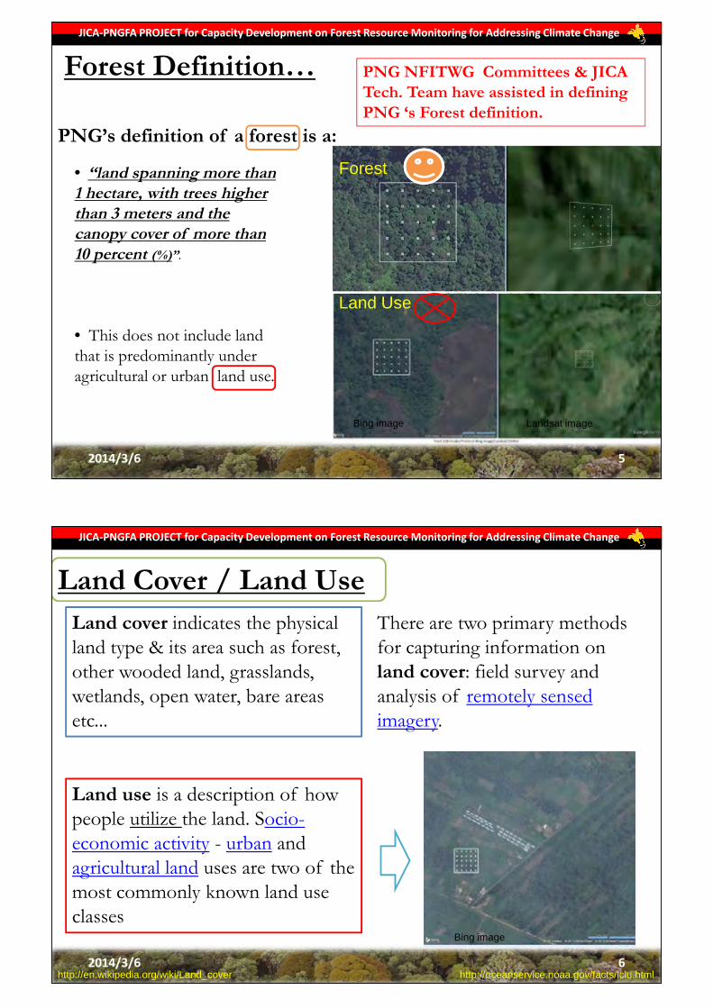
PNG’s definition of a forest is a:
Forest Definition…
• “land spanning more than 1 hectare, with trees higher than 3 meters and the canopy cover of more than 10 percent (%)”.
• This does not include land that is predominantly under agricultural or urban land use.
PNG NFITWG Committees & JICA Tech. Team have assisted in defining PNG ‘s Forest definition.
Land Use
Forest
Bing image Landsat image
2014/3/6 5
JICA-PNGFA PROJECT for Capacity Development on Forest Resource Monitoring for Addressing Climate Change
Land Cover / Land Use
http://en.wikipedia.org/wiki/Land_cover http://oceanservice.noaa.gov/facts/lclu.html
Land cover indicates the physical land type & its area such as forest, other wooded land, grasslands, wetlands, open water, bare areas etc...
Land use is a description of how people utilize the land. Socio-economic activity - urban and agricultural land uses are two of the most commonly known land use classes
There are two primary methods for capturing information on land cover: field survey and analysis of remotely sensed imagery.
Bing image
2014/3/6 6

JICA-PNGFA PROJECT for Capacity Development on Forest Resource Monitoring for Addressing Climate Change
Land Cover / Land Use…Land Use Hierarchical rules was invented in order of preferences as follows (Gamoga per.com. 2014) :1. Settlement 10%2. Cropland 20%3. Forestland 30%4. Grassland 30%5. Wetland 30%
% assigned based on land use definition. For example a 1ha. forest/plot area with ≥10% covered by settlement is considered settlement. Next option is cropland & so forth.This is in consistent with our forest definition where land predominantly under agriculture or urban land use is excluded.
Bing imageBing image
2014/3/6 7
JICA-PNGFA PROJECT for Capacity Development on Forest Resource Monitoring for Addressing Climate Change
Forest classification• Arranging different forest types into their rightful classes
• Under the JICA/PNGFA project we classified 12 different forest types using GIS, RS technologies, human interpretation work and Ground truthing1.Low Altitude Forest on Plains & Fans2.Low Altitude Forest on Uplands3.Lower Montane Forest4.Montane Forest5.Dry Seasonal Forest6.Littoral Forest7.Seral Forest8.Swamp Forest9.Mangrove Forest10.Woodland11.Savanna12.Scrub
Object based classification (eCognition Software)
2014/3/6 8

JICA-PNGFA PROJECT for Capacity Development on Forest Resource Monitoring for Addressing Climate Change
Importance of forest definition
1. Foundation for any forestry related work;2. Differentiate landuse and forest area;3. Differentiate non-forest and forest area;4. Consistency in reporting and research work;5. Country specific & very useful for interested stakeholders’ to
use;6. Assist and guide forestry projects and on-going donor projects.
2014/3/6 9
JICA-PNGFA PROJECT for Capacity Development on Forest Resource Monitoring for Addressing Climate Change
Challenges of forest definition
1. Method of sampling and data analysis will vary
according to forest types;
2. Natural forest versus planted forest;
3. Other wooded areas versus actual forest areas;
4. Some RS satellite imageries and GIS classification work
cannot differentiate between certain forest types following
the forest definition.
2014/3/6 10

JICA-PNGFA PROJECT for Capacity Development on Forest Resource Monitoring for Addressing Climate Change
Closing Ceremony and final Workshop for Project Completion5th - 6th March 2014
Holiday Inn Hotel, Port Moresby, PNG
Thank you for your attention!2014/3/6 11

Applied Data and Technology to develop Forest Base Map
JICA-PNGFA PROJECT for Capacity Development on Forest Resource Monitoring for Addressing Climate Change
Masamichi HARAGUCHITeam Leader of JICA Short-term Consultants
Kokusai Kogyo Co., Ltd (KKC)
Closing Ceremony and final Workshop for Project Completion5th - 6th March 2014
Holiday Inn Hotel, Port Moresby, PNG
2014/3/6 1
06th March 2014
JICA-PNGFA PROJECT for Capacity Development on Forest Resource Monitoring for Addressing Climate Change
Contents• Classification Target by Satellite Remote Sensing• Object-based Classification (compare with Pixel based)• Object-based (eCognition) Classification Training (in Japan)• Proposed Classification Flow Chart• Applied Classification Procedure (Demonstration)
– Segmentation & Vegetation Classification
• Applied Correction for Cloud Area (Demonstration)• Interpretation Exercise for Classification/Assessment• Assessment of Automatic Classification Result• Mass Production based on Classification Flow & C/P Input
2014/3/6 2

JICA-PNGFA PROJECT for Capacity Development on Forest Resource Monitoring for Addressing Climate Change
Classification Target by Satellite Remote Sensing
2014/3/6 3
IPCC 2006GL AFOLU
FAO FRA2010 PNG CR
Forest andNon-forest in Forest Base Map 2010
No.Vegetation type in Forest Base Map
2010Condition Code
Forest land Forest Forest 1 Low Altitude Forest on Plains and Fans below 1,000m P2 Low Altitude Forest on Uplands below 1,000m H3 Lower Montane Forest above 1,000m L4 Montane Forest above 3,000m Mo5 Dry Seasonal Forest in Western Prov. D6 Littoral Forest B7 Seral Forest Fri8 Swamp Forest Fsw9 Woodland W
10 Savanna Sa11 Scrub Sc
Grassland Other land Non-forest 12 Grassland and Herbland G13 Alpine grassland above 3,200m Ga14 Subalpine grassland 2,500m - 3,200m Gi
Forest land Forest Forest 15 Mangrove MCropland Other land 16 Agricultural Land Use O
WetlandsInland Water Bodies
17 Lakes and larger rivers E
Other Land Other land 18 Bare areas ZSettlements 19 Settlements and larger urban centres UForest land Forest Forest 20 Forest Plantation -Depending on national definition of forest and thresholds chosen
Other land Non-forest 21 Plantation other than forest plantation -
Non-forest
Depending on national definition of forest and thresholds chosen
Other wooded land (Non Forest)
JICA-PNGFA PROJECT for Capacity Development on Forest Resource Monitoring for Addressing Climate Change
Classification Target by Satellite Remote Sensing
2014/3/6 4
Hl(Large crowned forest)
Hm(Medium crowned forest)
Hs(Small crowned forest)
2 Low Altitude Forest on Uplands Hl Large crowned forestHm Medium crowned forestHmAr Medium crowned forest with Araucaria commonHmd Medium crowned depauperate/damaged forestHme Medium crowned forest with an even canopyHs Small crowned forestHse Small crowned forest with an even canopyHsAr Small crowned forest with Araucaria commonHsCa Small crowned forest with CastanopsisHsCp Small crowned forest with Casuarina papuanaHsN Small crowned forest with NothofagusHsRt Small crowned forest with Rhus taitensis
Interpretation (Aerial photo)Remote sensing (Satellite)

JICA-PNGFA PROJECT for Capacity Development on Forest Resource Monitoring for Addressing Climate Change
Object-based Classification (compare with Pixel based)
2014/3/6 5
Original Image Pixel-Based Classification Object-Based Classification
JICA-PNGFA PROJECT for Capacity Development on Forest Resource Monitoring for Addressing Climate Change
Object-based Classification (compare with Pixel based)
2014/3/6 6
RapidEye image eCognition segmentation Pixel-based classification
FIMS vegetation Forest base map (Obj. based) Forest base map (Pxl. based)
1:25,000 Level

JICA-PNGFA PROJECT for Capacity Development on Forest Resource Monitoring for Addressing Climate Change
Object-based (eCognition) Classification Training (in Japan)
2014/3/6 7
- Create classes- Input data (images)- Threshold of parameters- Procedure of processing(c) Object based
classification(a) Forest (b) Pixel based
classification
JICA-PNGFA PROJECT for Capacity Development on Forest Resource Monitoring for Addressing Climate Change
2014/3/6 8
No Vegetation
All
Low VegetationHigh Vegetation
Brightness・ Cloud・ Water body・ Shadow
Human interpretation・ Woodland・ Savanna・Scrub
Human interpretation・ Bare areas・ Larger urban centres
Green, NIR, Brightness, DEM, SlopeMangroveSwamp ForestDry Seasonal ForestForest Plantation, Plantation other than F.P.Seral ForestGrassland and HerblandLittoral ForestLow Altitude Forest on Plains and FansLow Altitude Forest on Uplands
DEM
Lowland0m <= DEM <1,000m
Midland1,000m <= DEM < 3,000m
Highland 3,000m <= DEMGreen, NIR, SlopeGrassland and HerblandSubalpine GrasslandForest Plantation, Plantation other than F.P.Seral ForestSwamp ForestLower Montane Forest
NIR, Green, SlopeSubalpine GrasslandAlpine GrasslandSeral ForestSwamp ForestMontane Forest
NDVI・ Woodland, Savanna, Scrub・ Grassland and Herbland・ Other
NDVI
As of 21st December, 2012
Blue: Parameters and classification by eCognition automatic classificationRed: Human Interpretation on ArcGIS
・ No Vegetation
Brightness, NIR・ Cloud ・ Shadow・ Bare areas
Human interpretation・ Agricultural Landuse
Human interpretationWhen mis-classificationpolygons are found after automatic classification,human interpretation is applied to.
Human interpretationWhen mis-classification polygons are foundafter automatic classification, human interpretation is applied to.
Human interpretationWhen mis-classification polygons are foundafter automatic classification, human interpretation is applied to.
12
GIS analysis・ Lakes and larger rivers・ Sea
GIS analysis, Human interpretation・ Forest Plantation・ Plantation other than FP
GIS analysis・ Forest Plantation・ Plantation other than FP
Proposed Classification Flow Chart

JICA-PNGFA PROJECT for Capacity Development on Forest Resource Monitoring for Addressing Climate Change
Proposed Classification Procedure (Demo)
2014/3/6 9
Location : Western Highlands
JICA-PNGFA PROJECT for Capacity Development on Forest Resource Monitoring for Addressing Climate Change
Proposed Classification Procedure (Demo)
2014/3/6 10
Segmentation

JICA-PNGFA PROJECT for Capacity Development on Forest Resource Monitoring for Addressing Climate Change
Proposed Classification Procedure (Demo)
2014/3/6 11
1st : Vegetation area using NDVI
JICA-PNGFA PROJECT for Capacity Development on Forest Resource Monitoring for Addressing Climate Change
Proposed Classification Procedure (Demo)
2014/3/6 12
2nd : Classification of No Vegetation area

JICA-PNGFA PROJECT for Capacity Development on Forest Resource Monitoring for Addressing Climate Change
Proposed Classification Procedure (Demo)
2014/3/6 13
3rd : Classification of Low Vegetation area
JICA-PNGFA PROJECT for Capacity Development on Forest Resource Monitoring for Addressing Climate Change
Proposed Classification Procedure (Demo)
2014/3/6 14
4th : Classification of High Vegetation area

JICA-PNGFA PROJECT for Capacity Development on Forest Resource Monitoring for Addressing Climate Change
Proposed Classification Procedure (Demo)
2014/3/6 15
5th : Classification of High Vegetation area
JICA-PNGFA PROJECT for Capacity Development on Forest Resource Monitoring for Addressing Climate Change
Proposed Classification Procedure (Demo)
2014/3/6 16
6th : Classification of High Vegetation area

JICA-PNGFA PROJECT for Capacity Development on Forest Resource Monitoring for Addressing Climate Change
2014/3/6 17
PALSAR image
Classification Result from RapidEye
Dissolved image
Corrected image
Correction for Cloud Area (Demonstration)
JICA-PNGFA PROJECT for Capacity Development on Forest Resource Monitoring for Addressing Climate Change
2014/3/6 18
Correction for Cloud Area (Demonstration)
ClassificationCorrected cloud cover
Classification

JICA-PNGFA PROJECT for Capacity Development on Forest Resource Monitoring for Addressing Climate Change
2014/3/6 19
Interpretation Exercise for Classification
19
Image ID: Satellite
Location X 1315447.47 Location Y 8865507.56 Location X 10°10'45.40''S Location Y 148°25'29.42''EDate: Scale: Date: 11/26/2003 Elevation: 3-20m asl
Image ID: Satellite
Location X 1315447.47 Location Y 8865507.56 Location X 10°10'45.40''S Location Y 148°25'29.42''EDate: Scale: Date: 11/26/2003 Elevation: 3-20m asl
Grassland and Herbland “G”Grassland
Grasses, sedges, herbs and very low woody shrubs.Generally less than 3m tall.Scattered trees may be present.-Reddish brown (RGB452)
Vegetation typeStructural formation
NANANAMatt
Definition of FIMS
Shape (Crown)Color
PatternTexture
- Sign of settlement and gardening and areas Often contains burnt patches
2nd condition1st condition
4th condition
Characteristics of
RapidEye image
eCognition
Circum-stanceShade
ShapeSize
Rapid Eye (Color: B: G: R: ) Google Earth image
RapidEye sample images
Comments
3rd condition
Rapid Eye (Color: B: G: R: ) Google Earth image
Image ID: Satellite
Location X 1315447.47 Location Y 8865507.56 Location X 10°10'45.40''S Location Y 148°25'29.42''EDate: Scale: Date: 11/26/2003 Elevation: 3-20m asl
Image ID: Satellite
Location X 1315447.47 Location Y 8865507.56 Location X 10°10'45.40''S Location Y 148°25'29.42''EDate: Scale: Date: 11/26/2003 Elevation: 3-20m asl
Rapid Eye (Color: B: G: R: ) Google Earth image
Rapid Eye (Color: B: G: R: ) Google Earth image
JICA-PNGFA PROJECT for Capacity Development on Forest Resource Monitoring for Addressing Climate Change
2014/3/6 20
Assesment of Automatic Classification Result
Classification before update parameters
Classification after update parameters

JICA-PNGFA PROJECT for Capacity Development on Forest Resource Monitoring for Addressing Climate Change
Mass Production based on Classification Flow &CP Input
2014/3/6 21
Forest classification by eCognition software
Over 1,000 tiles RapidEye imagery
Automatic classification result
JICA-PNGFA PROJECT for Capacity Development on Forest Resource Monitoring for Addressing Climate Change
Summary• Classification Target by Satellite RS was identified• Object-based Classification was applied for the project• Object-based Classification Training was conducted in Japan• Classification Flow Chart was developed and applied• Classification Procedure was applied and demonstrated
– Segmentation & Vegetation Classification (by eCognition)
• Cloud Area was corrected by using ALOS/PALSAR(Radar)• Interpretation Capacity of C/Ps were improved (IC Card)• Automatic Classification Results were assessed by C/P • Mass Production for PNG Foret Basemap was conducted
2014/3/6 22

JICA-PNGFA PROJECT for Capacity Development on Forest Resource Monitoring for Addressing Climate Change
Closing Ceremony and final Workshop for Project Completion5th - 6th March 2014
Holiday Inn Hotel, Port Moresby, PNG
Tenkyu tru(Picture: 2nd WS in Mar. 2013)
2014/3/6 23

Ground Truth for Remote Sensing
JICA-PNGFA PROJECT for Capacity Development on Forest Resource Monitoring for Addressing Climate Change
Samuel GibsonOfficer – Forest Inventory
Forest Policy and Planning DirectoratePNG Forest Authority
Closing Ceremony and final Workshop for Project Completion5th - 6th March 2014
Holiday Inn Hotel, Port Moresby, PNG
JICA-PNGFA PROJECT for Capacity Development on Forest Resource Monitoring for Addressing Climate Change
Outline
1 What is Ground truthing(GT)?
2 Purpose - Importance to Remote Sensing.
3 Ground truth and PNG Forest Base Map development.
4 Workflow of GT work developed by JICA and KKC
5 Results - Comparison of Satellite data with Field ground data – existing vegetation.Field observation on Land use change.
6 Summary and future work

JICA-PNGFA PROJECT for Capacity Development on Forest Resource Monitoring for Addressing Climate Change
1.What is Ground Truthing(GT)?
Ground truthing is the act of authenticating or verifying a captured remotely sensed or satellite image by way of physically visiting the site and collecting on site field data for comparison with the image of the same location.
Before GT SurveyBefore GT Survey After GT SurveyAfter GT Survey
Same agriculture areas with settlement and burnt out area in Ramu - Madang.
Satellite image with direction(red cone) of photo taken On site field photo taken by GPS Camera
JICA-PNGFA PROJECT for Capacity Development on Forest Resource Monitoring for Addressing Climate Change
2. Purpose of Ground truthing
To delineate the different vegetation and forest type in the area of interest. Satellite imagery data will not always give a detail answer to your query on the AOI
Build up level of confidence and common understanding with PNGFA and Japan counterpart officers. Interpreting Satellite data must be consistent to all who have knowledge of AOI.
Enable capacity of field officers from regional and provincial officers to be able to undertake GT work where when requested. Several officers have some exposure to GIS work and GPS use which is essential for all field officers nationwide.

Lk;JICA-PNGFA PROJECT for Capacity Development on Forest Resource Monitoring for Addressing Climate Change
Introduction
Ground truthing is important to confirm present status of forest and vegetationcover.
During the JICA PNGFA project ground truth work was very crucial and it wasundertaken to have an insight of the what the current status of the forestespecially the four main regions of PNG.
These four region possess some very typical vegetation type and their existenceover the years are affected by human natural activities.
Some of mono species of forest in these region and also changes to density offorest (e.g. Forest to Woodland or Woodland to Savanna and grassland).Based onwhat PNGRIS/FIMS has shown us over the years.
3. Ground Truthing and the PNG Forest Base Map development
JICA-PNGFA PROJECT for Capacity Development on Forest Resource Monitoring for Addressing Climate Change
Summary of Ground truth work A total of six (6) ground truth were conducted with the assistance from JICA and KKC with data prepared from Satellite image.
Forest Definition for Forest and other Wooded was also defined for the country and ground truth was also conducted in Western Province and Central province for this purpose.
Province/Region Participants Area of Interest (AOI)
1. Highlands JICA/PNGFA/KKC Highlands Forest type/Landuse
2. Western JICA/PNGFA Delineate Dry evergreen forest/Savannah
3. Central JICA/PNGFA/KKC Woodland/Grassland and Savannah
4. Morobe JICA/PNGFA/FRI/KKC Upland Forest (Hm)/Agriculture/Montane
5.East New Britain PNGFA/KKC-JICA Agriculture and forest plantation from Forest
6.Manus PNGFA Natural mono stand of Calophyllum/Hm

JICA-PNGFA PROJECT for Capacity Development on Forest Resource Monitoring for Addressing Climate Change
Most important point is:Consider from Remote Sensing at first!Consider from Remote Sensing at first!
(That means to consider how to classify by imagery)
JICA-PNGFA PROJECT for Capacity Development on Forest Resource Monitoring for Addressing Climate Change
4.Work Flow of GT work
1. Select 1. Select Vegetation TypeVegetation Type
• Which vegetation type do you want to check on the field for classification?
• Which vegetation type is difficult to distinguish on imagery?
2. Select Areas2. Select Areas
3. Select Points3. Select Points • What POI to check for color and texture of imagery?• Select some points for each not only vegetation types but also
patterns of color and texture.
• In which area is there typical vegetation type you selected?• In which area are there same vegetation type?
• Selected points, imagery, FIMS . Load and counter should be put on a map with legend, scale, direction and grid line.
4. Create Maps4. Create Maps
5. Prepare 5. Prepare MaterialsMaterials • Maps, GPS with camera, Survey sheets, Tools for
measurement, Binocular, etc.

JICA-PNGFA PROJECT for Capacity Development on Forest Resource Monitoring for Addressing Climate Change
No.Vegetation type in Forest Base Map
2010Condition Code
1 Low Altitude Forest on Plains and Fans below 1,000m P2 Low Altitude Forest on Uplands below 1,000m H3 Lower Montane Forest above 1,000m L4 Montane Forest above 3,000m M5 Dry Seasonal Forest in Western Prov. D6 Littoral Forest B7 Seral Forest Fri8 Swamp Forest Fsw9 Woodland W
10 Savanna Sa11 Scrub Sc12 Grassland and Herbland G13 Alpine grassland above 3,200m Ga14 Subalpine grassland 2,500m - 3,200m Gi15 Mangrove M16 Agricultural Land Use O17 Lakes and larger rivers E18 Bare areas Z19 Settlements and larger urban centres U20 Forest Plantation -21 Plantation other than forest plantation -
True Colour R:3 G:2 B:1
False Colour R:5 G:3 B:2
E.g. Some area in Morobe Province

JICA-PNGFA PROJECT for Capacity Development on Forest Resource Monitoring for Addressing Climate Change
JICA-PNGFA PROJECT for Capacity Development on Forest Resource Monitoring for Addressing Climate Change
Work Flow of GT work
1. Select 1. Select Vegetation TypeVegetation Type
• Which vegetation type do you want to check on the field for classification?
• Which vegetation type is difficult to distinguish on imagery?
2. Select Areas2. Select Areas
3. Select Points3. Select Points • What POI to check for color and texture of imagery?• Select some points for each not only vegetation types but also
patterns of color and texture.
• In which area is there typical vegetation type you selected?• In which area you are unable to identify vegetation type?
• Selected points, imagery, FIMS . Load and counter should be put on a map with legend, scale, direction and grid line.
4. Create Maps4. Create Maps
5. Prepare 5. Prepare MaterialsMaterials • Maps, GPS with camera, Survey sheets, Tools for
measurement, Binocular, etc.

JICA-PNGFA PROJECT for Capacity Development on Forest Resource Monitoring for Addressing Climate Change
JICA-PNGFA PROJECT for Capacity Development on Forest Resource Monitoring for Addressing Climate Change
5.

JICA-PNGFA PROJECT for Capacity Development on Forest Resource Monitoring for Addressing Climate Change
What to do in the field during GTBefore you leave for the site (AOI) create a format of reporting or collecting information that can support the device you use
In this way, it is easier to understand the type of data you can use later and also share with other people who do not have any idea at all of what a forest or vegetation type is all about.
Created by R. LaloPNGFA, HQ.
JICA-PNGFA PROJECT for Capacity Development on Forest Resource Monitoring for Addressing Climate Change
Ground Truth equipments
Binoculars- for tree Id and confirmation Camera with GPS
Field recording sheets, tape measure, length tape, height pole, GPS with Camera, Camera with GPS, Suunto Clinometer, Suunto Compass.

JICA-PNGFA PROJECT for Capacity Development on Forest Resource Monitoring for Addressing Climate Change
6.Summary
Through this JICA and Japan Grant aid Project;
• Ground truthing was very crucial to ensure that Satellite data was interpreted with less difficulty and more consistency
• PNGFA CP officers have developed the capacity to relate Remote Sensing data to GT data where a more systematic approach is used through the workflow developed
• So far Field officers who attended various workshops by JICA are able to communicate in simple GIS language through use of GPS and GIS with PFO, RO and HQ and other relevant stake holder offices within provinces thus collecting vital data to add to our PNGFA database.
JICA-PNGFA PROJECT for Capacity Development on Forest Resource Monitoring for Addressing Climate Change
Challenges/Future work
• Not many provinces were visited (GT) due to PNGFA counter funding and workload at HQ doing GIS and RS work.
• Time spent on GT was only to accessible areas by road, sea and air with little access to bush tracks, villages and remote locations due to sensitive landownership issues
• Ground truthing is and will be an on going activity to improve the Base Map currently developed and also add value to the monitoring work by means of verifying field base features observed through remote sensing.
• As the role out of GIS computers to Provincial offices the work on GT should be eased through field office base and Capacity of field officers should be enhanced to do GT instead of HQ officers

JICA-PNGFA PROJECT for Capacity Development on Forest Resource Monitoring for Addressing Climate Change
Acknowledgement
This work would not be made possible without the effort ofthe following people;
1. Japan International Cooperation Agency (JICA) and KKC2. The PNGFA Counterpart officers; Perry Malan, Rabbie
Lalo, Patrick La’a and Elizabeth Kaidong with assistancefrom Jehu Antiko and Oala Iuda.
3. PNGFA Management especially, Dr. Turia and Mr. C Bigolfor their tireless Leadership role.
4. Lastly, NFS Provincial/Regional office & FRI field officersas participants in the Ground Truth for Remote Sensingwork throughout the country.
JICA-PNGFA PROJECT for Capacity Development on Forest Resource Monitoring for Addressing Climate Change
Closing Ceremony and final Workshop for Project Completion5th - 6th March 2014
Holiday Inn Hotel, Port Moresby, PNG
Thankyou and Questions please…[email protected] /327 7828

Demarcation ofAgriculture Land Use
JICA-PNGFA PROJECT for Capacity Development on Forest Resource Monitoring for Addressing Climate Change
Mr. Jehu Antiko Assistant Cartographer
Inventory & Mapping Branch
Policy and Planning/PNG Forest Authority
Closing Ceremony and final Workshop for Project Completion5th - 6th March 2014
Holiday Inn Hotel, Port Moresby, PNG
Mr. Oala Iuda Local Technical (GIS) Assistant
Capacity Development on Forest Resource Monitoring for Addressing Climate Change
JICA-PNG FA Project
Email: [email protected] Email: [email protected]
1
JICA-PNGFA PROJECT for Capacity Development on Forest Resource Monitoring for Addressing Climate Change
Part 1Introductioni. Purposeii. Workshop
Part 2Methodsi. Heads-up Digitizingii. Imagery and web applicationsiii. MASP and PNGRISiv. Editing and classification
Part 3Results and Recommendationi. Graph Showing Comparison Between Existing PNG
Agriculture Datasets ii. Challenges/ Constrainsiii. Recommendations
2

JICA-PNGFA PROJECT for Capacity Development on Forest Resource Monitoring for Addressing Climate Change
Part 1 Introduction
i. Purpose
3
Main purpose of demarcation work:Improvement of Forest Base Map Version 0
JICA-PNGFA PROJECT for Capacity Development on Forest Resource Monitoring for Addressing Climate Change
Part 1 Introduction
Forest Base Map Version 0 has no Agriculture Information
i. Purpose
4

JICA-PNGFA PROJECT for Capacity Development on Forest Resource Monitoring for Addressing Climate Change
Part 1 Introduction
5
Duration: Two weeks for each Region (5).- Southern Region, Momase and Highlands - Region, New Guinea Islands Region, Area West.
Participants: PNGFA Regional/Area Officers.FRI Officers
Activities: 1. Refresher course on ArcGIS and GPS used.2. Digitizing possible Agricultural areas.
ii. Workshop
Subsistence (SUB)–Agricultural Land-use which has the following attributes: Located closer to rural settings (place) where the produce is mainly for consumption and smaller in size. Usually subsistencegardening are scattered, with irregular shapes, pattern and rough textures on a satellite image. Subsistence Land use activities include fallow areas as well.
Commercial (COM) – Agricultural Land use areas that are manage by small holders (Block owners) mostly for monetary benefits(coffee, cocoa, banana..) as identified thru MASP and confirm by local knowledge. Such land uses cover a smaller area and may have smooth/rough texture and irregularpatterns in a satellite image.
Mixed (MIX) – Agricultural Land use areas which have both subsistence and commercial activities coexisting. These Land use types are identified thru local knowledge. Mixed Agricultural Land use activities have irregular shapes and pattern and a roughtexture on satellite images.
Uncertain (AUN) – Uncertain Agricultural land use has the following attributes:Agricultural Land use areas where the types of agriculturalactivities are not clearly identifiable.Agricultural Land use areas which cannot be identified inGoogle Maps, Bing Maps and RapidEye Images due to heavy cloud cover or poor image resolution. Local knowledgeabout area of interest is limited thus cannot confirm.
Grazing (GRZ) – Agricultural Land use areas that have extensive grasslandwhich are used for cattle grazing. Grazing areas usually have regular patterns and smooth texture on a satellite image.
JICA-PNGFA PROJECT for Capacity Development on Forest Resource Monitoring for Addressing Climate Change
Part 1 Introductionii. Workshop
Definitions were derived from:
Agricultural Land use definitions and codes were used only for workshop purposes.
Actual Field Work Perspective
GIS and Remote Sensing PerspectiveGIS and Remote Sensing Perspective
Relevant Literature; MASP and PNGRIS (FIMS)
Agricultural Land use DefinitionsDefinitions
6

JICA-PNGFA PROJECT for Capacity Development on Forest Resource Monitoring for Addressing Climate Change
Part 1 ii. Workshop: Agricultural Land use, Plantation classification and code allocation
7
Possible agricultural land
Plantation [PLT] (managed by company/state)
Agriculture [AGR] (managed by smallholder/individual)
Agriculture Plantation [PAG](e.g. Oil palm, Coconut)
Uncertain [PUN]
Forest Plantation [PFR](e.g. Kamarere, Balsa)
Mixed [MIX](Commercial and subsistence)
Subsistence [SUB](e.g. Kaukau, Taro)
Commercial [COM](e.g. Oil palm, Coco)
Uncertain [AUN]
Cattle grazing [GRZ]
Agricultural Land use definitionsand codes were used only for workshop purposes.
JICA-PNGFA PROJECT for Capacity Development on Forest Resource Monitoring for Addressing Climate Change
Part 2: Methods
i. Heads-up Digitizing or On-Screen DigitizingGIS technique of extracting features from raster or imagery through the use of GIS software and computer hardware
Mapping Standards Digitizing Scale: 1: 50 000 to 1: 30 000 Coordinate System: Universal Transvers MercatorZone: 54, 55, 56 and 57Datum: World Geodetic System (WGS) 1984Units: Meters
8

JICA-PNGFA PROJECT for Capacity Development on Forest Resource Monitoring for Addressing Climate Change
RapidEye imagery
Demarcation of Agriculture Land use
Interpretation
Google Earth/Bing MASP/PNGRIS
Very High Resolution Satellite imagery Existing Agriculture layer DEM (Digital Elevation Model)
Reference Data
With Local Knowledge
Part 2: Methodsii. Imagery and web applications
9
GPS Points/Pictures
JICA-PNGFA PROJECT for Capacity Development on Forest Resource Monitoring for Addressing Climate Change
PNGRIS: Papua New Guinea Resource Information System.Contains information on natural resources, land use cover and population distribution.Eg. Land use areas, Forest areas , Urban areas, Population distribution.
Part 2 Methodsiii. MASP and PNGRIS
10

JICA-PNGFA PROJECT for Capacity Development on Forest Resource Monitoring for Addressing Climate Change
Part 2 Methodsiii. MASP and PNGRIS
MASP: Mapping Agriculture Systems ProjectMASP Contains Land use types. Eg. Agriculture, Plantation, Other, Urban.
• MASP and PNGRIS are not perfect.• Land Use activities are dynamic
and change over time.• MASP and PNGRIS can be used
as reference layers.
11
JICA-PNGFA PROJECT for Capacity Development on Forest Resource Monitoring for Addressing Climate Change
iv. Editing and classificationPart 2: Methods
12
Digitizing Errors- Slivers: Small overlaps between polygons. - Spelling error of land use classes, Miss coding - Selection of non-agricultural areas.
Error Correction Techniques- Geometry Check - Topology Check- Spelling Check
Classification and Dissolving of AgricultureLand use Classes
Integration to BasemapVersion 0

JICA-PNGFA PROJECT for Capacity Development on Forest Resource Monitoring for Addressing Climate Change
iv. Editing and classificationPart 2: MethodsAgricultural Land use, Plantation classification and code allocation
Possible agricultural land
Plantation [PLT] (managed by company/state)
Agriculture [AGR] (managed by smallholder/individual)
Agriculture Plantation [PAG](e.g. Oil palm, Coconut)
Uncertain [PUN]
Forest Plantation [PFR](e.g. Kamarere, Balsa)
Mixed [MIX](Commercial and subsistence)
Subsistence [SUB](e.g. Kaukau, Taro)
Commercial [COM](e.g. Oil palm, Coco)
Uncertain [AUN]
Cattle grazing [GRZ]
Forest PlantationCode: Qf
Agriculture PlantationCode: Qa
Agriculture Land UseCode: O
Basemap Version 1 Class
New Land UseClasses
13
JICA-PNGFA PROJECT for Capacity Development on Forest Resource Monitoring for Addressing Climate Change
Part 3: Results and Recommendationi. Graph Showing Comparison Between Existing PNG Agriculture Datasets
14
683,116.96
26,358.26
4,558,935.00 4,504,510.00
54,710.00
438,675.00
0
500000
1000000
1500000
2000000
2500000
3000000
3500000
4000000
4500000
5000000
Agriculture Plantation Land use area O: Agriculture Land Use
Qa: Agriculture Plantation
Qf: Forest Plantation
MASP FIMS Basemap Version 1
Are
a in
ha
Base Data

JICA-PNGFA PROJECT for Capacity Development on Forest Resource Monitoring for Addressing Climate Change
Part 3: Results and RecommendationComparison of Forest Basemap V0 before and after Agriculture Land Use Demarcation
15
Time Limitation
JICA-PNGFA PROJECT for Capacity Development on Forest Resource Monitoring for Addressing Climate Change
Part 3 Results and Recommendationii. Challenges/ Constrains
Cloud cover in RapidEye and Bing Map
RapidEye Bing Map
Two weeks given for Workshop
16

JICA-PNGFA PROJECT for Capacity Development on Forest Resource Monitoring for Addressing Climate Change
Part 3 Results and Recommendationii. Challenges/ Constrains
Poor image resolution in Google and Bing Maps (e.g. Landsat image 30m resolution in some areas)
Bing Map Google Map
30m Resolution
17
JICA-PNGFA PROJECT for Capacity Development on Forest Resource Monitoring for Addressing Climate Change
Part 3Results and Recommendationiii. Recommendations
More ground truth activities needed to verify uncertain areas.
Participants must be taught on basic use of GIS software before demarcation of Land Use boundaries.
Adequate time must be set for Agriculture Land use demarcation.2
3
1
18
4Integration of RapidEye Imagery with Google Earth to improve Demarcation Performance.
JICA-PNGFA PROJECT for Capacity Development on Forest Resource Monitoring for Addressing Climate Change
Closing Ceremony and final Workshop for Project Completion5th - 6th March 2014
Holiday Inn Hotel, Port Moresby, PNG
Thank you…Tenkyu tru…
Arigato gozaimasu…
19