Embed Size (px)
Citation preview
•Eu AsiaEGEE-III INFSO-RI-222667
Enabling Grids for E-sciencE
www.eu-egee.org
EGEE and gLite are registered trademarks
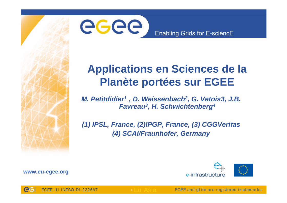
Applications en Sciences de la Planète portées sur EGEE
M. Petitdidier1 , D. Weissenbach2, G. Vetois3, J.B. Favreau3, H. Schwichtenberg4
(1) IPSL, France, (2)IPGP, France, (3) CGGVeritas(4) SCAI/Fraunhofer, Germany
Enabling Grids for E-sciencE
EGEE-III INFSO-RI-222667
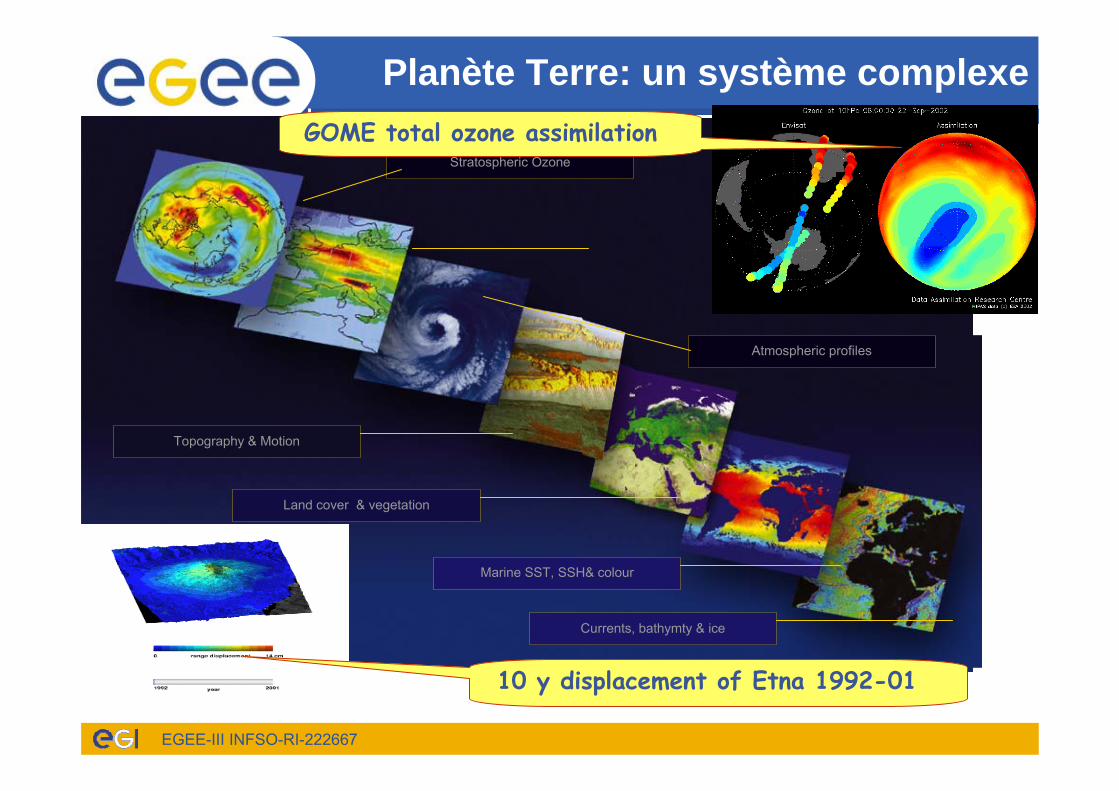
Topography & Motion
Land cover & vegetation
Marine SST, SSH& colour
Currents, bathymty & ice
Planète Terre: un système complexe
Stratospheric Ozone
Atmospheric profiles
10 y displacement of Etna 1992-01
GOME total ozone assimilation
Enabling Grids for E-sciencE
EGEE-III INFSO-RI-222667
Caractéristiques• Observations
– D’instrument simple à instrument complexe– Instruments au sol, abord de ballons, de fusée, d’avions et de satellite– Série temporelle 1D, 2D, 3D– Représentées par coordonnées géographiques et altitude ou profondeur =>
GIS et Open Geospatial Consortium(OGC) Components– Observations uniques => grands centres de données
• Expertises distribuées géographiquement– Campagnes internationales– Modèles: collaboration entre plusieurs disciplines⇒ De même pour la Grille
• Modélisation • De simple à très complexe• De local à global
• Besoins de types de calculateurs– Selon phase de la recherche– Nécessité de passerelle en particulier pour les données produites– Metadonnées, accès facile aux données– Interopérabilité=> Intérêt pour les services Web et la grille dès 2000
Enabling Grids for E-sciencE
EGEE-III INFSO-RI-222667
Earth Science Cluster dans EGEE
• EGEE-III Strategic Discipline Cluster for Earth Science (ES) Grid User– ES Application porting support – Workflow management tools – Tools and services – Documentation – best practice – Coordinating collaborations with other ES projects– Dissemination in Earth Science community– ES Grid community building
• Parterns: Fraunhofer SCAI, CNRS:IPSL&IPGP, CGGveritas, GCRAS, IISAS, ASGC Taiwan
Enabling Grids for E-sciencE
EGEE-III INFSO-RI-222667 EU ASIA Dec 2009 5
ES Cluster to the ES Grid Virtual Research Community
• 9VOs with ES applications– ESR (earth Science Research), EGEODE (expanding
Geosciences on Demand), SEEGRID ( 3VOs), eEarth…• 25 European and Associated Countries + Taiwan
– Albania, Armenia, Belarus, Bosnia, Bulgaria, France, Georgia, Germany, Greece, Herzegovina, Hungary, Italy, Macedonia, Moldavia, Netherlands, Portugal, Romania, Russia, Serbia, Slovakia, Spain, Switzerland, Turkey, UK, Ukrainia
– Taiwan (ASGC)• Connection with projects:
– CYCLOPS, EnviroGrid, EELA2 , EUAsiaGRID, EUMEDGRID-support…..
– Private companies: CGGVeritas,Vito, BluePlanet…– Organisations: ESA, ECMWF, OGC,OGF…
Enabling Grids for E-sciencE
EGEE-III INFSO-RI-222667
Partenaires FrançaisVO ESR• IPSL (Institut Pierre Simon Laplace) Paris• IPGP (Institut de Physique du Globe de Paris) Paris• LISA• LOA ( Laboratoire d’Optique Atmosphérique) Lille• BRGM Orléans• LGEI (Laboratoire de génie de l’Environnement Industriel et des risques
industriels et Naturels)- Ecole des Mines d’AlèsGeocluster –VO EGEODE : aspects sismiques• Geosciences-Azur• IPGP• IPG/EOST - Strasbourg• ISTEP• UPMC/SISYPHE• UBO/IUEM BrestDSI-IRD a participé à la réunion en mai 2009
Compagnies privées• CGGVeritas – Geocluster• Footways
Enabling Grids for E-sciencE
EGEE-III INFSO-RI-222667
STANDARDS
• Involvement of ES Grid VRC partners:– OGF leading global standardization effort for grid computing. – European and international standardization organizations and
initiatives (OGF, OGC, INSPIRE Drafting Teams, GEO SIF and the SIF European Team);
– contribution to the on-going OGF-OGC collaboration for interoperability and standardization
– GEOSS (Global Earth Observation System of Systems) activities, which aim to design a system of systems by adopting appropriate standards for models, interfaces and protocols for geoinformation sharing
– Specific ES standard especially for geospatial metadata and data format, and network services: initiatives for the specification of community standards (e.g. OGC GALEON, UNIDATA THREDDS and CF-NetCDF, NcML, NcML-G; SeaDataNet CDI ISO profile)
– Discipline standards
Enabling Grids for E-sciencE
EGEE-III INFSO-RI-222667
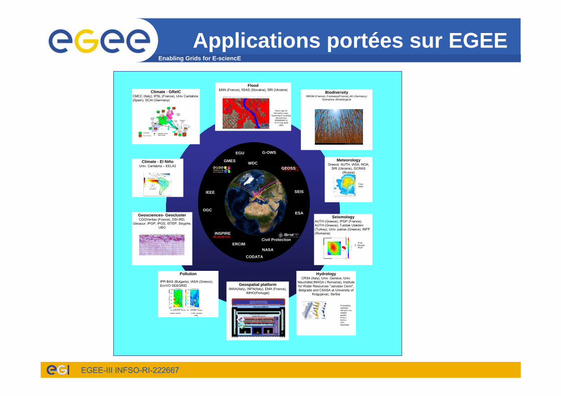
Applications portées sur EGEE
OGC
INSPIRE
GMES
Civil Protection
GEOSS MeteorologyGreece: AUTH, IASA, NOA;
SRI (Ukraine), GCRAS (Russia)
Climate - GRelCCMCC (Italy), IPSL (France), Univ Cantabria(Spain), SCAI (Germany)
FloodEMA (France), IISAS (Slovakia), SRI (Ukraine)
Flood map for Normanton area,
Queensland, Australiaderived from
RADARSAT-214-17 Feb 2009
(SRI)
SEIS
Geosciences- GeoclusterCGGVeritas (France), DSI-IRD,
Geoazur, IPGP, IPGS, ISTEP, Sisyphe, UBO
Climate - El NiñoUniv. Cantabria – EELA2
IEEE
CODATA
WDCS
ERCIM
BiodiversityBRGM (France), Footways(France),JKI (Germany)
Scenarios climatological
HydrologyCRS4 (Italy), Univ. Genève, Univ.
Neuchâtel,INHGA ( Romania), Institute for Water Resources "Jaroslav Cerni", Belgrade and CSASA at University of
Kragujevac, Serbia
Geospatial platformIMAA(Italy), INFN(Italy), EMA (France),
IMHO(Portugal)
dsds
CYCLOPS Platform
CYCLOPS InfrastructureCYCLOPS Infrastructure
Environm
ental
Mon
itoring
Resource Infrastructure
ProcessingSystems
Infrastructure
Data Systems
GRID Platform (EGEE)
Sensorsystems
Security Infrastructure
Security Infrastructure
Interope
rabilityPlatform
Interope
rabilityPlatform
Business logic Services
Presentation and Fruition Services
Real Time and Near Real Time Applications for Civil Protection
(Data integration, high‐performance computing and distributed environment for simulations)
Spatial Data Infrastructure ServicesSpatial Data Infrastructure Services
Advanced GridServices
Geospatial ResourcesServices
Forecastingseawaterintrusion in a coastalaquiferFrom J. KerrouUniv. Neuchâtel
UN-SPIDER
ESA
NASA
EGU
Pollution
a. Basic scenario b. 50% r eductionof NO
x
IPP-BAS (Bulgaria), IASA (Greece), EnvVO-SEEGRID
IPGP-E.Clévédé
SeismologyAUTH (Greece), IPGP (France), AUTH (Greece), Tubitak Ulakbim(Turkey), Univ. patras (Greece), INFP (Romania)
FromE. Clévédé -
IPGP
G-OWS
INSPIRECivil Protection
CODATA
ERCIMNASA
OGC
SEISIEEE
ESA
GMES
GEOSSWDC
EGU
FromIASA
Enabling Grids for E-sciencE
EGEE-III INFSO-RI-222667
Exploitation de Grands Jeux de données
• Données satellitales– Parasol : étude de la résolution utilisée- LOA– IASI: extraction de profils d’ozone – LISA
• Scénarios– Footprint FP6 Programme Européen - BRGM
4 millions de scenarios
• Sismologie– Traitement de la base Geoscope (28 stations, 25 années)
Outils: étude paramétrique
Hydrology• Flash flood (EMA, FR)
– Cyberinfrastructure for civil protection operative procedures(http://www.cyclops-project.eu)
• Flood in large rivers– Satellite data (SRI, Ukrainia)– Cascade of models (IISAS, SK)
• Drinking water supply, management and planning– Lizza PAKP Grid enabled groundwater flow simulation (Faculty of
Sciences, Kragujevac, Serbia )• Pesticide risk assesment and management in water
resources– risks of pesticides being transferred to ground-
and surface water resources– Footprint (eu-footprint.org)
• Scenarios (climatology, crops, soil, pesticides….)– Footways (www.footways.edu) –Start-up
• Paper submitted: 6 hydrological applications ported on Grid
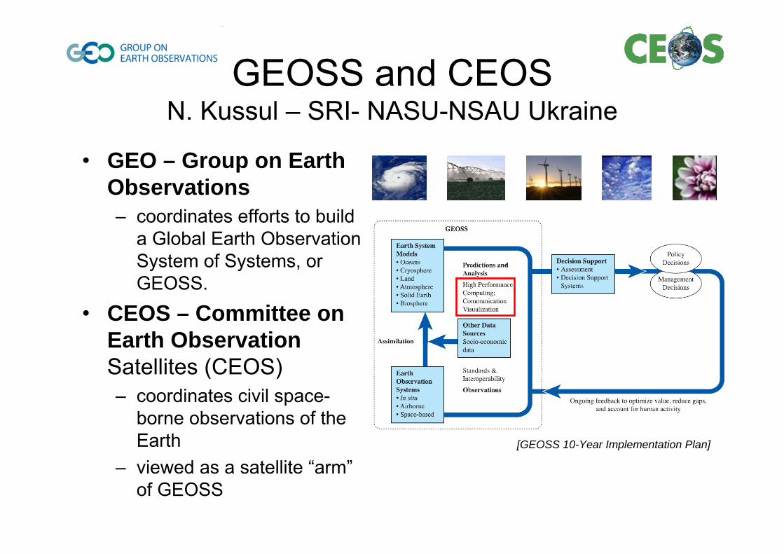
GEOSS and CEOSN. Kussul – SRI- NASU-NSAU Ukraine
• GEO – Group on Earth Observations– coordinates efforts to build
a Global Earth Observation System of Systems, or GEOSS.
• CEOS – Committee on Earth ObservationSatellites (CEOS) – coordinates civil space-
borne observations of the Earth
– viewed as a satellite “arm”of GEOSS
[GEOSS 10-Year Implementation Plan]
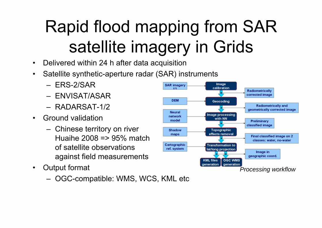
• Delivered within 24 h after data acquisition• Satellite synthetic-aperture radar (SAR) instruments
– ERS-2/SAR– ENVISAT/ASAR– RADARSAT-1/2
• Ground validation– Chinese territory on river
Huaihe 2008 => 95% matchof satellite observationsagainst field measurements
• Output format– OGC-compatible: WMS, WCS, KML etc
Processing workflow
Rapid flood mapping from SAR satellite imagery in Grids
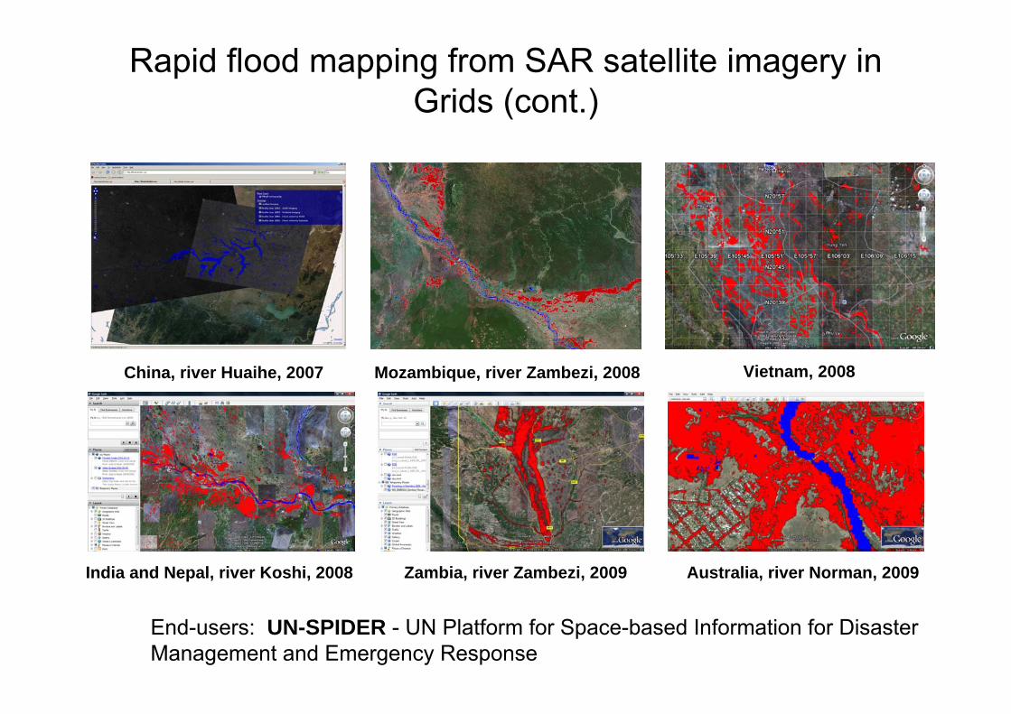
India and Nepal, river Koshi, 2008 Zambia, river Zambezi, 2009 Australia, river Norman, 2009
China, river Huaihe, 2007 Mozambique, river Zambezi, 2008 Vietnam, 2008
Rapid flood mapping from SAR satellite imagery in Grids (cont.)
End-users: UN-SPIDER - UN Platform for Space-based Information for Disaster Management and Emergency Response
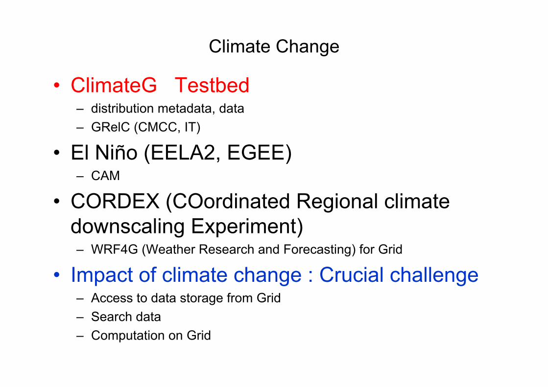
Climate Change
• ClimateG Testbed– distribution metadata, data– GRelC (CMCC, IT)
• El Niño (EELA2, EGEE)– CAM
• CORDEX (COordinated Regional climatedownscaling Experiment)– WRF4G (Weather Research and Forecasting) for Grid
• Impact of climate change : Crucial challenge– Access to data storage from Grid– Search data – Computation on Grid
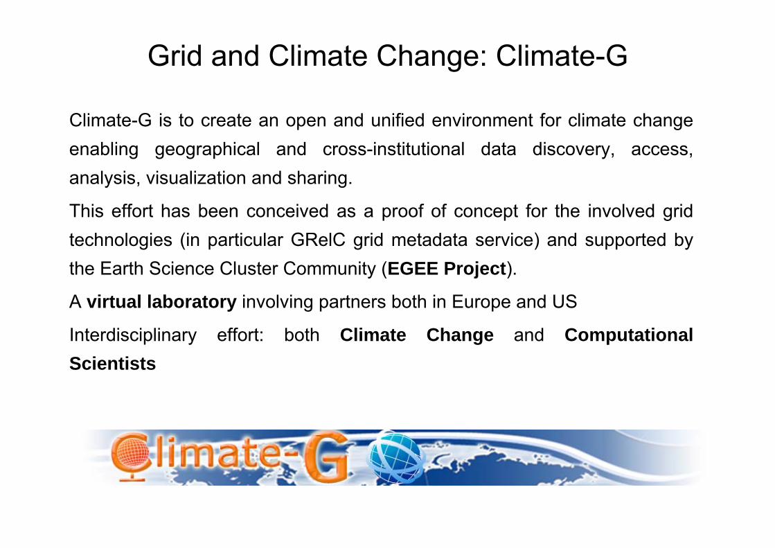
Grid and Climate Change: Climate-G
Climate-G is to create an open and unified environment for climate change enabling geographical and cross-institutional data discovery, access, analysis, visualization and sharing.
This effort has been conceived as a proof of concept for the involved grid technologies (in particular GRelC grid metadata service) and supported by the Earth Science Cluster Community (EGEE Project).
A virtual laboratory involving partners both in Europe and US
Interdisciplinary effort: both Climate Change and Computational Scientists
16
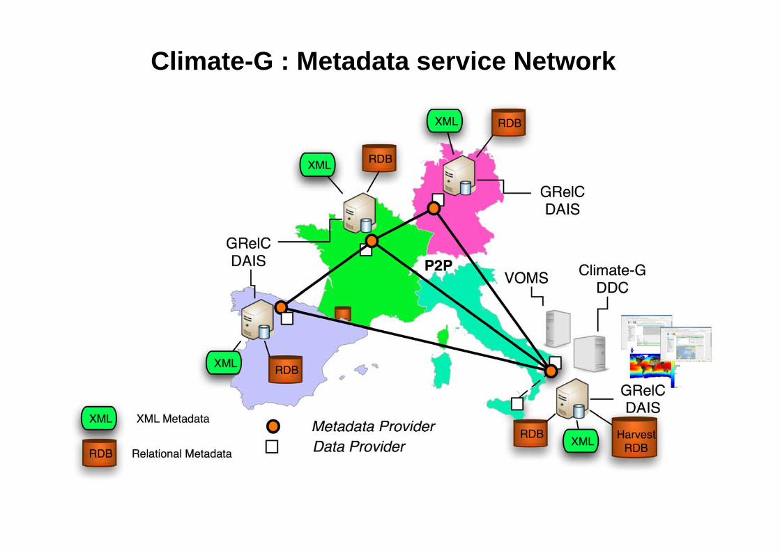
Climate-G : Metadata service Network
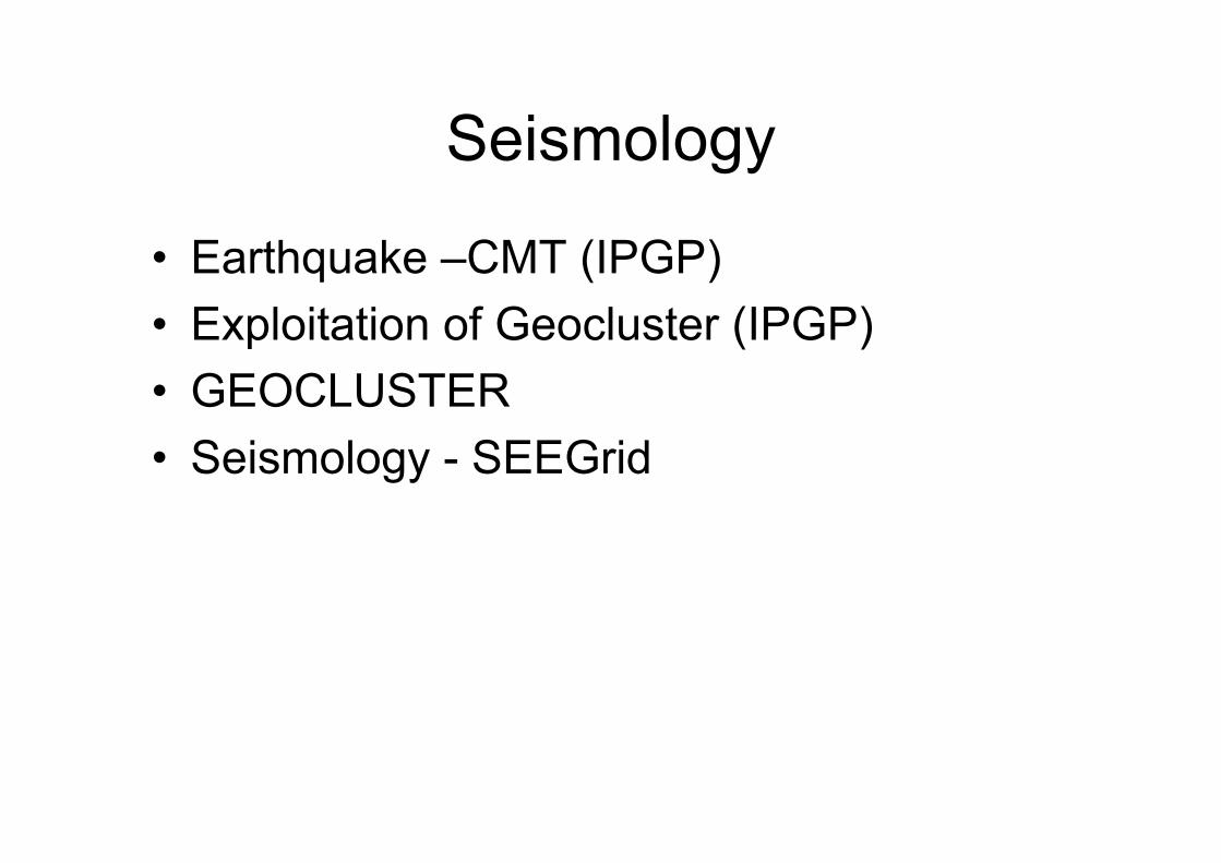
Seismology
• Earthquake –CMT (IPGP)• Exploitation of Geocluster (IPGP)• GEOCLUSTER• Seismology - SEEGrid
Enabling Grids for E-sciencE
EGEE-III INFSO-RI-222667 EGU Vienna - April 2009 – M. Petitdidier 18
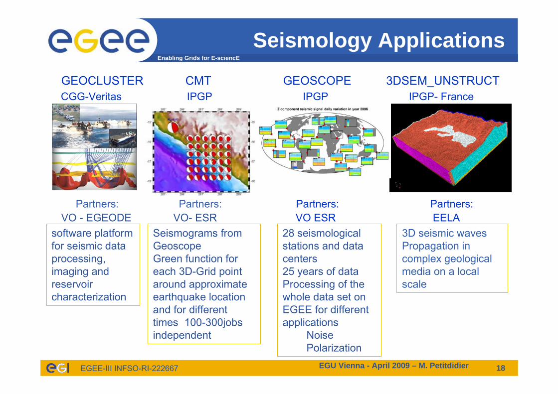
Seismology Applications
GEOCLUSTER CMT GEOSCOPE 3DSEM_UNSTRUCTCGG-Veritas IPGP IPGP IPGP- France
VO - EGEODE VO- ESR VO ESR EELAPartners: Partners: Partners: Partners:
software platform for seismic data processing, imaging and reservoir characterization
Seismograms fromGeoscopeGreen function for each 3D-Grid point around approximateearthquake location and for differenttimes 100-300jobs independent
28 seismological stations and data centers25 years of dataProcessing of the whole data set on EGEE for different applications
NoisePolarization
3D seismic waves Propagation in complex geological media on a local scale
SEE-GRID-SCISeismology Virtual Organization (VO)
in South Eastern EuropeC. Ozturan (Bogazici University, TR)
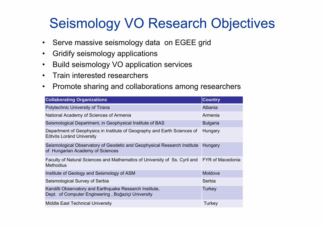
Seismology VO Research Objectives• Serve massive seismology data on EGEE grid• Gridify seismology applications• Build seismology VO application services• Train interested researchers • Promote sharing and collaborations among researchers
Collaborating Organizations CountryPolytechnic University of Tirana Albania
National Academy of Sciences of Armenia Armenia
Seismological Department, in Geophysical Institute of BAS Bulgaria
Department of Geophysics in Institute of Geography and Earth Sciences of Eötvös Loránd University
Hungary
Seismological Observatory of Geodetic and Geophysical Research Institute of Hungarian Academy of Sciences
Hungary
Faculty of Natural Sciences and Mathematics of University of Ss. Cyril and Methodius
FYR of Macedonia
Institute of Geology and Seismology of ASM Moldova
Seismological Survey of Serbia Serbia
Kandilli Observatory and Earthquake Research Institute,Dept. of Computer Engineering , Boğaziçi University
Turkey
Middle East Technical University Turkey
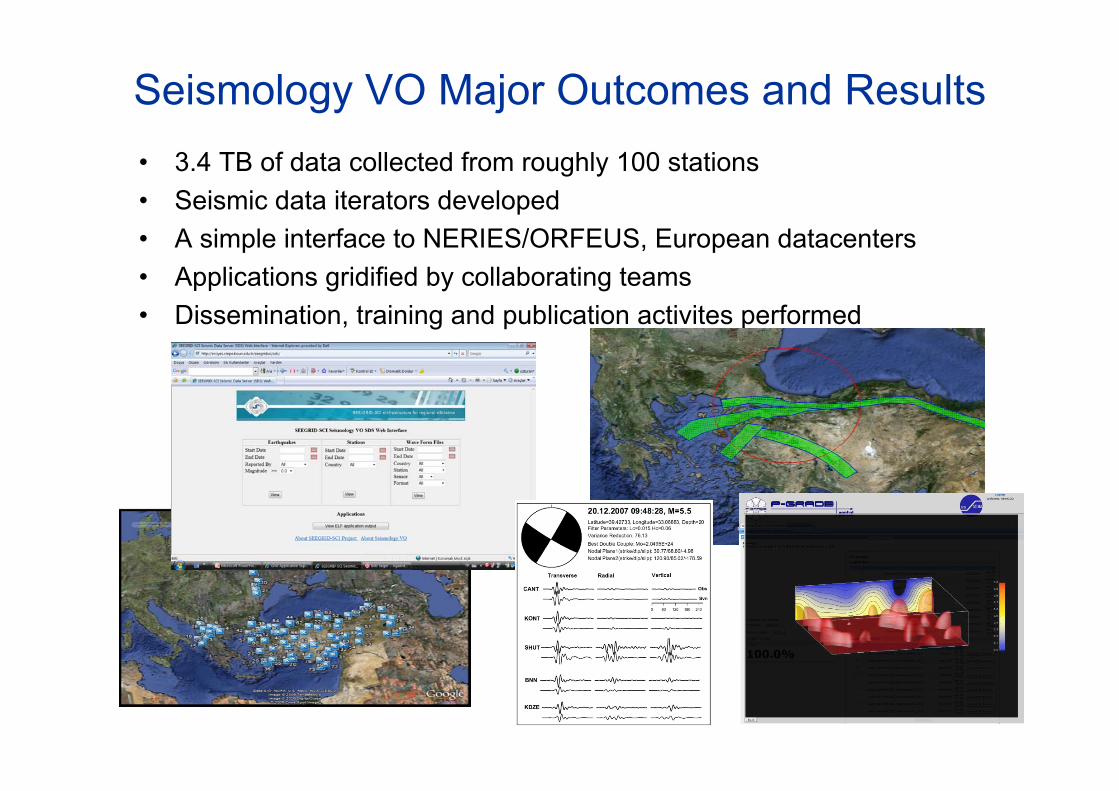
Seismology VO Major Outcomes and Results• 3.4 TB of data collected from roughly 100 stations• Seismic data iterators developed • A simple interface to NERIES/ORFEUS, European datacenters• Applications gridified by collaborating teams• Dissemination, training and publication activites performed
Enabling Grids for E-sciencE
EGEE-III INFSO-RI-222667
ES Cluster DEVELOPMENTS
– Automatic workflow composition using semantic dataWorkflow developed by KWF-Grid and Int-eu-gridsupported and adapted by II-SAS, Bratislava
Workflows for meteorological, hydrological and hydraulics applications
– GENESI-DR (Ground European Network for Earth Science Interoperations - Digital Repositories) Interface
– GEOCLUSTER: licence server, Grid file browser (Kereon), help porting applications (gEclipe), GUI for job control,…www.egeode.org
Enabling Grids for E-sciencE
EGEE-III INFSO-RI-222667
Collaboration avec EU-AsiaGrid
• EUASIAGrid (www.euasiagrid.org)– Italie(INFN),République Tchèque(CESNET), France, Taiwan,
Indonésie, Malaysie, Philippines, Singapour, Thailande, UK, Vietnam
– Mitigation of natural disasters (Tremblements de terre, innondation,typhon…)
– Changement climatique, …• WRF4G (Weather Research and Forecasting on Grid)
– WRF porté sur EELA2 & EGEE pour passer de sortie de modèle global à résultats régionaux (downscaling) par l’Université de Cantabria (Espagne)
– Participe à CORDEX– Tutorial en Thailande regroupant personnes de EUASIAGRID
intéressées– Installation en Thailande et autres pays
Enabling Grids for E-sciencE
EGEE-III INFSO-RI-222667
ES Vision
• Problem: How and can I use this data for my research? – Interpretation: I may not have the domain knowledge?– Data knowledge: how was it created? What is the quality?– Data access: I do not want a Terabyte, I want just what I need!
• Not only valid for data, but also for algorithms/models!• Harmonization needed
• ES Grid platform to share knowledge over a continuum of time anda variety of geographical scales, to share data and information and to provide the required computing resources.
• The platform will be built by steps the first one is this proposal...• Roadmap for a dedicated Earth Science Grid Platform, Earth
Science Informatics Journal, 2010(white paper from the DEGREE project)
Enabling Grids for E-sciencE
EGEE-III INFSO-RI-222667
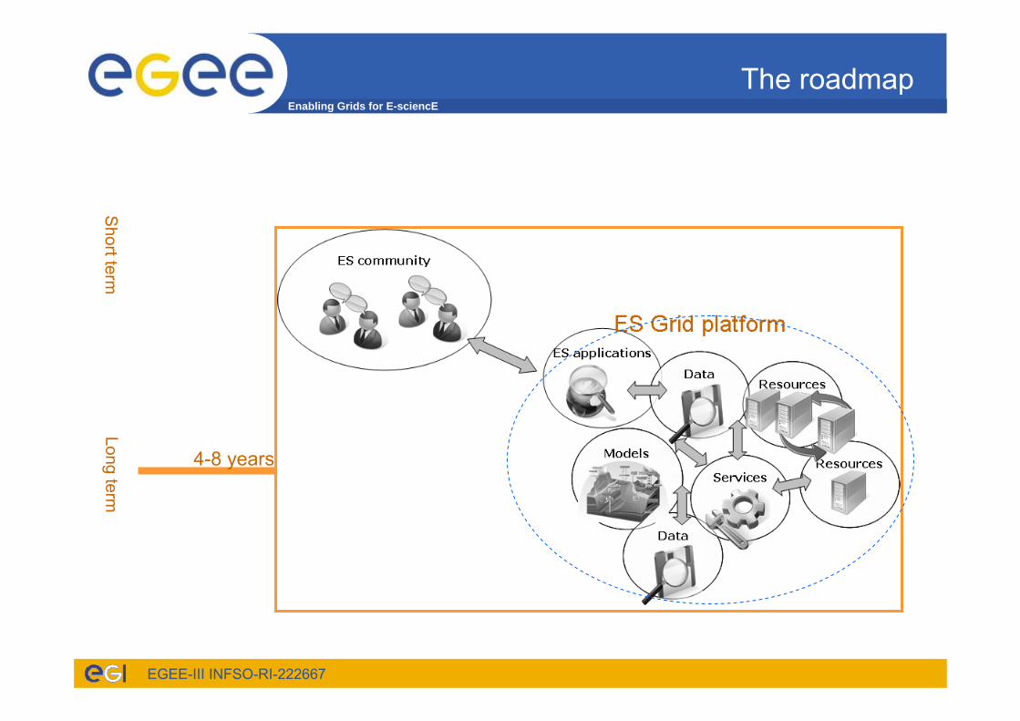
The roadmap
Long term
Long termestablish a standard ES Grid platform fully integrating the major emerging ES standards (OGC, ISO 19115, OAIS, etc.). This ES Grid Platform shall be able to provide ES users with easy and seamless access to distributed and diverse data and to support them in enlarging collaboration, creativity and productivity.
4-8 years
Short term
Enabling Grids for E-sciencE
EGEE-III INFSO-RI-222667
Publications
– Eos, AGU Transactions, Grid computing for Earth Sciences, Vol. 90, N° 14, p117&119, 7 April 2009.
– Special issue of Earth Science Informatics Journal12 papiers publiés en Juin 2009, un en 2010
– Environ 30 papiers dans Journaux internationaux par ES VRCImportant de signaler les publications pour les instances scientifiquesRéférences à EGEE dans remerciements…
– En France 5 thèses (ES) avec résultats obtenus sur EGEE, 2 àsoutenir; 1 thèse collaboration scientifique avec IPSL
– Papier soumis au Journal d’Hydrologie à la demande d’un éditeur suite au papier Eos
6 Applications en hydrologie– Actes de Conférences – résumés étendus ou papier >40– Livre: 1 en Russe, chapitres dans des livres
Enabling Grids for E-sciencE
EGEE-III INFSO-RI-222667
CONCLUSION• Organisation of the ES Grid VRC
– coordination scientifique et technique– Un groupe d’experts spécialisés en ES – Des partenaires ES avec différents niveaux d’implication
• ES Grid VRC opportunité pour les partenaires de travailler ensemble– Remplir les besoins en suspens – To address community issues;
• User Forum 5 – Uppsala 12-16 April 2010– http://egee-uf5.eu-egee.org/index.php?id=689
• European Geosciences Union 2-7 May 2010– Sessions « Grille » Lundi 2 et Tuesday 3 May – Geosciences Applications on Grid and HPC
http://meetingorganizer.copernicus.org/EGU2010/session/1921– 29 résumés
• Réunion à Paris –date à fixer


![Plaidoyer pour la planète [699] - free-scores.com · Plaidoyer pour la planète 48 Pascal Millon Musicalités - 32 Mouchard - Juin 2017 - Sacem . Pièce no 13 21 25 29 699 Plaidoyer](https://img.pdfslide.us/doc/110x75/5f0920ec7e708231d4255d37/plaidoyer-pour-la-plante-699-free-plaidoyer-pour-la-plante-48-pascal-millon.jpg)