Embed Size (px)
Citation preview
APPLICATION OF TERRESTRIAL PHOTOGRAMMETRY FOR GLACIER MONITORING IN ALPINE ENVIRONMENTS
V. Kaufmann *, R. Ladstädter
Institute of Remote Sensing and Photogrammetry Graz University of Technology, Austria
[email protected], [email protected]
Commission VIII, WG VIII/8
KEY WORDS: Glaciology, Mapping, Change Detection, DEM/DTM, Photogrammetry, Terrestrial, Camera, Digital ABSTRACT: The present paper investigates the application of terrestrial photogrammetry for glacier mapping using either consumer, semi-professional or professional SLR digital cameras and a fully digital photogrammetric workflow.
* Corresponding author.
1. INTRODUCTION
Terrestrial photogrammetry was the standard method for mapping high mountain terrain in the early days of mountain cartography, until it was replaced by aerial photogrammetry (cp. Kostka, 2004 and Brunner, 2006). Although terrestrial photogrammetry has many drawbacks compared to aerial photogrammetry, e.g., area-wide mapping cannot be accomplished economically and horizontal mapping accuracy is highly inhomogeneous, it continued to be used for local studies, primarily with an environmental background. Terrestrial photogrammetric surveys for mapping small areas in mountainous regions were performed from time to time until recently (e.g., Brecher & Thompson, 1993; Palà et al., 1999, Kaufmann & Ladstädter, 2004; Ladstädter & Kaufmann, 2004; Pitkänen & Kajuutti, 2004; Kajuutti & Pitkänen, 2007).
1.1 Glacier Monitoring
Worldwide glacier monitoring aims at improving knowledge of the world’s water resources and documenting climatic trends (Haeberli et al., 1998). Glacier mass balances of alpine glaciers are stringently determined using the glaciological method based on ablation stakes. Net (annual) mass balances can also be obtained applying the geodetic/photogrammetric method, which determines the volumetric change of a glacier through surface height measurements. Glacier length change and change in area also serve as good indicators of glacier mass balance.
1.2 Motivation
Two glacier inventories (1969 and 1998) have been compiled for the Austrian Alps. Both inventories provide the basis for detailed analysis, including glacier volume change (for details see Lambrecht & Kuhn, 2007). Only a few Austrian glaciers are monitored on an annual basis applying the glaciological method. Compared with this quite labor-intensive and time-consuming method, measurements of glacier length change are carried out annually by volunteers of the Austrian Alpine Club (OeAV) at about 100 Austrian glaciers. The volunteers’ glacier reports often comprise terrestrial photographs of the glaciers
monitored. For the purpose of comparison, these photographs are taken from the same positions each year. Modern low-priced digital (consumer) cameras and highly automatic digital photogrammetric workflows suggest the rebirth of terrestrial photogrammetry for mapping projects in high mountain environments. This is especially true for small study areas, such as single mountain slopes or cirques where the monitoring of surface changes and processes is of particular interest. In this paper the authors not only propose but also exemplify a glacier monitoring concept based on stereoscopic terrestrial photographs taken with, for example, off-the-shelf consumer cameras. In the future, data acquisition could be done by the volunteers mentioned above. A first step in this direction is a digital database of terrestrial photographs of selected Austrian glaciers, which could then eventually be photogrammetrically evaluated deriving metric information on surface height change and glacier length change.
1.3 Gössnitzkees Glacier
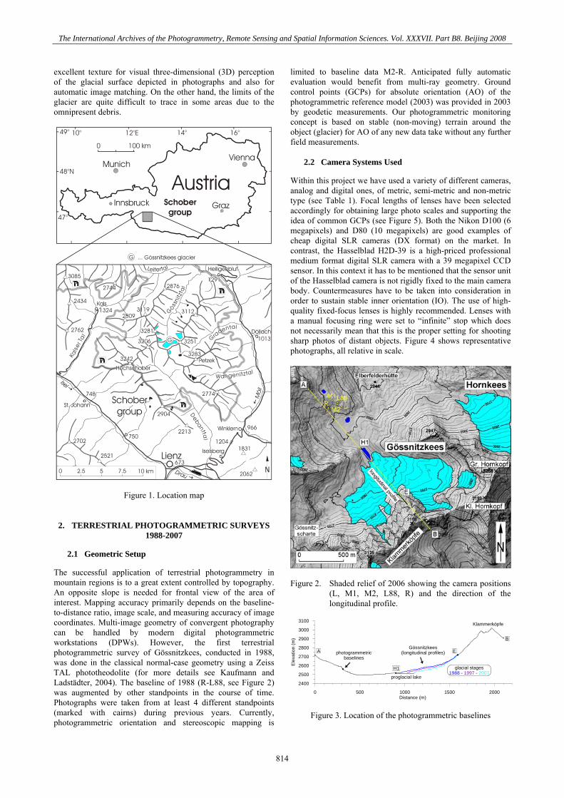
Gössnitzkees ("kees" is the local name for glacier), located in the Schober group of the Hohe Tauern range, Austria, was selected as a test site because of its favorable topographic setting for terrestrial photogrammetry and also because its glacier history (1850-2006) has already been investigated in depth and can be derived from old maps, field evidence and multi-temporal aerial photographs (Kaufmann & Ladstädter, 2008), see Figure 1. Moreover, recent annual geodetic measurements are available for comparison and control (cp. Kienast & Kaufmann, 2004). Gössnitzkees (0.59 km² in 2006) is a typical cirque glacier. A distinct accumulation area for snow and firn is missing, and steep rock faces confine the glacier in the upper part. Avalanches from couloirs of the headwalls nourish the glacier with snow, ice and rocks. This is the reason why Gössnitzkees is to a great extent covered by a thin layer of debris. This mantle of debris protects the glacier from excessive ablation in the summer. For photogrammetric applications, however, this supraglacial debris provides
813
The International Archives of the Photogrammetry, Remote Sensing and Spatial Information Sciences. Vol. XXXVII. Part B8. Beijing 2008
excellent texture for visual three-dimensional (3D) perception of the glacial surface depicted in photographs and also for automatic image matching. On the other hand, the limits of the glacier are quite difficult to trace in some areas due to the omnipresent debris.
Figure 1. Location map
2. TERRESTRIAL PHOTOGRAMMETRIC SURVEYS 1988-2007
2.1 Geometric Setup
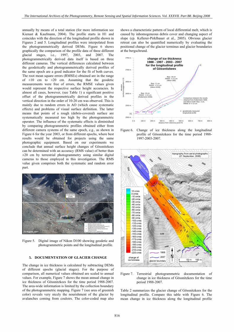
The successful application of terrestrial photogrammetry in mountain regions is to a great extent controlled by topography. An opposite slope is needed for frontal view of the area of interest. Mapping accuracy primarily depends on the baseline-to-distance ratio, image scale, and measuring accuracy of image coordinates. Multi-image geometry of convergent photography can be handled by modern digital photogrammetric workstations (DPWs). However, the first terrestrial photogrammetric survey of Gössnitzkees, conducted in 1988, was done in the classical normal-case geometry using a Zeiss TAL phototheodolite (for more details see Kaufmann and Ladstädter, 2004). The baseline of 1988 (R-L88, see Figure 2) was augmented by other standpoints in the course of time. Photographs were taken from at least 4 different standpoints (marked with cairns) during previous years. Currently, photogrammetric orientation and stereoscopic mapping is
limited to baseline data M2-R. Anticipated fully automatic evaluation would benefit from multi-ray geometry. Ground control points (GCPs) for absolute orientation (AO) of the photogrammetric reference model (2003) was provided in 2003 by geodetic measurements. Our photogrammetric monitoring concept is based on stable (non-moving) terrain around the object (glacier) for AO of any new data take without any further field measurements.
2.2 Camera Systems Used
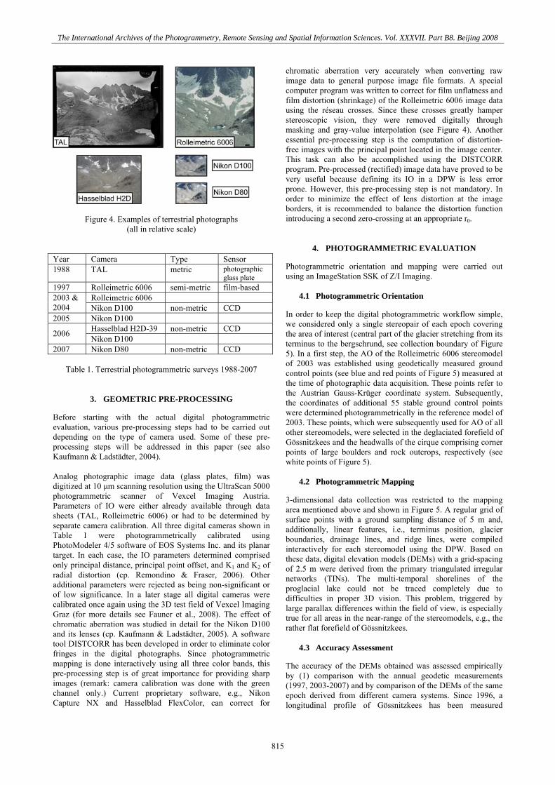
Within this project we have used a variety of different cameras, analog and digital ones, of metric, semi-metric and non-metric type (see Table 1). Focal lengths of lenses have been selected accordingly for obtaining large photo scales and supporting the idea of common GCPs (see Figure 5). Both the Nikon D100 (6 megapixels) and D80 (10 megapixels) are good examples of cheap digital SLR cameras (DX format) on the market. In contrast, the Hasselblad H2D-39 is a high-priced professional medium format digital SLR camera with a 39 megapixel CCD sensor. In this context it has to be mentioned that the sensor unit of the Hasselblad camera is not rigidly fixed to the main camera body. Countermeasures have to be taken into consideration in order to sustain stable inner orientation (IO). The use of high-quality fixed-focus lenses is highly recommended. Lenses with a manual focusing ring were set to “infinite” stop which does not necessarily mean that this is the proper setting for shooting sharp photos of distant objects. Figure 4 shows representative photographs, all relative in scale.
Figure 2. Shaded relief of 2006 showing the camera positions
(L, M1, M2, L88, R) and the direction of the longitudinal profile.
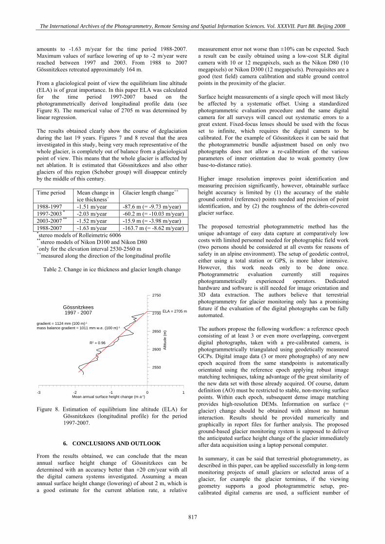
0 500 1000 1500 2000Distance (m)
2400
2500
2600
2700
2800
2900
3000
3100
Ele
vatio
n (m
)
Klammerköpfe
proglacial lake
photogrammetricbaselines
A
B
H1
Gössnitzkees(longitudinal profiles) E
glacial stages1988 - 1997 - 2007
Figure 3. Location of the photogrammetric baselines
814
The International Archives of the Photogrammetry, Remote Sensing and Spatial Information Sciences. Vol. XXXVII. Part B8. Beijing 2008
Figure 4. Examples of terrestrial photographs (all in relative scale)
Year Camera Type Sensor 1988 TAL metric photographic
glass plate 1997 Rolleimetric 6006 semi-metric film-based
Rolleimetric 6006 2003 & 2004 Nikon D100 non-metric CCD 2005 Nikon D100
Hasselblad H2D-39 non-metric CCD 2006 Nikon D100 2007 Nikon D80 non-metric CCD
Table 1. Terrestrial photogrammetric surveys 1988-2007
3. GEOMETRIC PRE-PROCESSING
Before starting with the actual digital photogrammetric evaluation, various pre-processing steps had to be carried out depending on the type of camera used. Some of these pre-processing steps will be addressed in this paper (see also Kaufmann & Ladstädter, 2004). Analog photographic image data (glass plates, film) was digitized at 10 μm scanning resolution using the UltraScan 5000 photogrammetric scanner of Vexcel Imaging Austria. Parameters of IO were either already available through data sheets (TAL, Rolleimetric 6006) or had to be determined by separate camera calibration. All three digital cameras shown in Table 1 were photogrammetrically calibrated using PhotoModeler 4/5 software of EOS Systems Inc. and its planar target. In each case, the IO parameters determined comprised only principal distance, principal point offset, and K1 and K2 of radial distortion (cp. Remondino & Fraser, 2006). Other additional parameters were rejected as being non-significant or of low significance. In a later stage all digital cameras were calibrated once again using the 3D test field of Vexcel Imaging Graz (for more details see Fauner et al., 2008). The effect of chromatic aberration was studied in detail for the Nikon D100 and its lenses (cp. Kaufmann & Ladstädter, 2005). A software tool DISTCORR has been developed in order to eliminate color fringes in the digital photographs. Since photogrammetric mapping is done interactively using all three color bands, this pre-processing step is of great importance for providing sharp images (remark: camera calibration was done with the green channel only.) Current proprietary software, e.g., Nikon Capture NX and Hasselblad FlexColor, can correct for
chromatic aberration very accurately when converting raw image data to general purpose image file formats. A special computer program was written to correct for film unflatness and film distortion (shrinkage) of the Rolleimetric 6006 image data using the réseau crosses. Since these crosses greatly hamper stereoscopic vision, they were removed digitally through masking and gray-value interpolation (see Figure 4). Another essential pre-processing step is the computation of distortion-free images with the principal point located in the image center. This task can also be accomplished using the DISTCORR program. Pre-processed (rectified) image data have proved to be very useful because defining its IO in a DPW is less error prone. However, this pre-processing step is not mandatory. In order to minimize the effect of lens distortion at the image borders, it is recommended to balance the distortion function introducing a second zero-crossing at an appropriate r0.
4. PHOTOGRAMMETRIC EVALUATION
Photogrammetric orientation and mapping were carried out using an ImageStation SSK of Z/I Imaging.
4.1 Photogrammetric Orientation
In order to keep the digital photogrammetric workflow simple, we considered only a single stereopair of each epoch covering the area of interest (central part of the glacier stretching from its terminus to the bergschrund, see collection boundary of Figure 5). In a first step, the AO of the Rolleimetric 6006 stereomodel of 2003 was established using geodetically measured ground control points (see blue and red points of Figure 5) measured at the time of photographic data acquisition. These points refer to the Austrian Gauss-Krüger coordinate system. Subsequently, the coordinates of additional 55 stable ground control points were determined photogrammetrically in the reference model of 2003. These points, which were subsequently used for AO of all other stereomodels, were selected in the deglaciated forefield of Gössnitzkees and the headwalls of the cirque comprising corner points of large boulders and rock outcrops, respectively (see white points of Figure 5).
4.2 Photogrammetric Mapping
3-dimensional data collection was restricted to the mapping area mentioned above and shown in Figure 5. A regular grid of surface points with a ground sampling distance of 5 m and, additionally, linear features, i.e., terminus position, glacier boundaries, drainage lines, and ridge lines, were compiled interactively for each stereomodel using the DPW. Based on these data, digital elevation models (DEMs) with a grid-spacing of 2.5 m were derived from the primary triangulated irregular networks (TINs). The multi-temporal shorelines of the proglacial lake could not be traced completely due to difficulties in proper 3D vision. This problem, triggered by large parallax differences within the field of view, is especially true for all areas in the near-range of the stereomodels, e.g., the rather flat forefield of Gössnitzkees.
4.3 Accuracy Assessment
The accuracy of the DEMs obtained was assessed empirically by (1) comparison with the annual geodetic measurements (1997, 2003-2007) and by comparison of the DEMs of the same epoch derived from different camera systems. Since 1996, a longitudinal profile of Gössnitzkees has been measured
815
The International Archives of the Photogrammetry, Remote Sensing and Spatial Information Sciences. Vol. XXXVII. Part B8. Beijing 2008
annually by means of a total station (for more information see Kienast & Kaufmann, 2004). The profile starts in H1 and coincides with the direction of the longitudinal profile shown in Figures 2 and 5. Longitudinal profiles were interpolated from the photogrammetrically derived DEMs. Figure 6 shows graphically the comparison of the profile data of three different glacial stages, i.e., 1997, 2003, and 2007. The photogrammetrically derived data itself is based on three different cameras. The vertical differences calculated between the geodetically and photogrammetrically derived profiles of the same epoch are a good indicator for the fit of both curves. The root mean square errors (RMSEs) obtained are in the range of ±10 cm to ±20 cm. Assuming that the geodetic measurements were free of errors, the RMSE values given would represent the respective surface height accuracies. In almost all cases, however, (see Table 1) a significant positive offset of the photogrammetrically derived profiles in the vertical direction in the order of 10-20 cm was observed. This is mainly due to random errors in AO (which cause systematic effects) and problems of visual surface definition. The latter means that points of a rough (debris-covered) surface are systematically measured too high by the photogrammetric operator. The influence of the systematic effects is diminished by comparing photogrammetric profiles obtained either from different camera systems of the same epoch, e.g., as shown in Figure 6 for the year 2003, or from different epochs, where best results would be obtained for projects using the same photographic equipment. Based on our experiments we conclude that annual surface height changes of Gössnitzkees can be determined with an accuracy (RMS value) of better than ±20 cm by terrestrial photogrammetry using similar digital cameras to those employed in this investigation. The RMS value given comprises both the systematic and random error part.
geodetic reference point H1photogrammetric control point (N)photogrammetrically determined tie point (T)geodetically measured profile point additional point for velocity measurementlongitudinal profilephotogrammetric mapping area
E
longitudinalprofile
H1
23 August, 2003 Figure 5. Digital image of Nikon D100 showing geodetic and
photogrammetric points and the longitudinal profile.
5. DOCUMENTATION OF GLACIER CHANGE
The change in ice thickness is calculated by subtracting DEMs of different epochs (glacial stages). For the purpose of comparison, all numerical values obtained are scaled to annual values. For example, Figure 7 shows the mean annual change in ice thickness of Gössnitzkees for the time period 1988-2007. The area-wide information is limited by the collection boundary of the photogrammetric mapping. Figure 7 (see area of greenish color) reveals very nicely the nourishment of the glacier by avalanches coming from couloirs. The color-coded map also
shows a characteristic pattern of local differential melt, which is caused by inhomogeneous debris cover and changing aspect of slope (cp. Kellerer-Pirklbauer et al., 2005). Obvious glacier retreat can also be quantified numerically by evaluating the positional change of the glacier terminus and glacier boundaries at the bergschrund.
0 m 100 m 200 m 300 m 400 m 500 m 600 m 700 m 800 mdistance from reference point H1
2500 m
2550 m
2600 m
2650 m
2700 m
2750 m
elev
atio
n(v
ertic
al e
xagg
erat
ion
2.5)
change of ice thickness1988 - 1997 - 2003 - 2007
for the longitudinal profileof Gössnitzkees
1988 1997 2003 2007
Comparison between the resultsobtained from Rolleimetric 6006and Nikon D100: Bias: 3 cm,RMSE of +/-12 cm
geodetically measuredlongitudinal profile
Bias: 16 cmRMSE: +/-22 cm
(Rolleimetric 6006)
Bias: 11 cmRMSE: +/-12 cm
(Nikon D100)
Bias: 18 cmRMSE: +/-11 cm
(Nikon D80)
H1
E
Figure 6. Change of ice thickness along the longitudinal
profile of Gössnitzkees for the time period 1988-1997-2003-2007.
Figure 7. Terrestrial photogrammetric documentation of
change in ice thickness of Gössnitzkees for the time period 1988-2007.
Table 2 summarizes the glacier change of Gössnitzkees for the longitudinal profile. Compare this table with Figure 6. The mean change in ice thickness along the longitudinal profile
816
The International Archives of the Photogrammetry, Remote Sensing and Spatial Information Sciences. Vol. XXXVII. Part B8. Beijing 2008
amounts to -1.63 m/year for the time period 1988-2007. Maximum values of surface lowering of up to -2 m/year were reached between 1997 and 2003. From 1988 to 2007 Gössnitzkees retreated approximately 164 m. From a glaciological point of view the equilibrium line altitude (ELA) is of great importance. In this paper ELA was calculated for the time period 1997-2007 based on the photogrammetrically derived longitudinal profile data (see Figure 8). The numerical value of 2705 m was determined by linear regression. The results obtained clearly show the course of deglaciation during the last 19 years. Figures 7 and 8 reveal that the area investigated in this study, being very much representative of the whole glacier, is completely out of balance from a glaciological point of view. This means that the whole glacier is affected by net ablation. It is estimated that Gössnitzkees and also other glaciers of this region (Schober group) will disappear entirely by the middle of this century. Time period Mean change in
ice thickness+ Glacier length change++
1988-1997 -1.51 m/year -87.6 m (= -9.73 m/year) 1997-2003 * -2.03 m/year -60.2 m (= -10.03 m/year) 2003-2007 ** -1.52 m/year -15.9 m (= -3.98 m/year) 1988-2007 -1.63 m/year -163.7 m (= -8.62 m/year) *stereo models of Rolleimetric 6006 **stereo models of Nikon D100 and Nikon D80 +only for the elevation interval 2530-2560 m ++measured along the direction of the longitudinal profile
Table 2. Change in ice thickness and glacier length change
-3 -2 -1 0 1Mean annual surface height change (m a-1)
2550
2600
2650
2700
2750
Alti
tude
(m)
ELA = 2705 mGössnitzkees1997 - 2007
R2 = 0.96
gradient = 1124 mm (100 m)-1
mass balance gradient = 1011 mm w.e. (100 m)-1
Figure 8. Estimation of equilibrium line altitude (ELA) for
Gössnitzkees (longitudinal profile) for the period 1997-2007.
6. CONCLUSIONS AND OUTLOOK
From the results obtained, we can conclude that the mean annual surface height change of Gössnitzkees can be determined with an accuracy better than ±20 cm/year with all the digital camera systems investigated. Assuming a mean annual surface height change (lowering) of about 2 m, which is a good estimate for the current ablation rate, a relative
measurement error not worse than ±10% can be expected. Such a result can be easily obtained using a low-cost SLR digital camera with 10 or 12 megapixels, such as the Nikon D80 (10 megapixels) or Nikon D300 (12 megapixels). Prerequisites are a good (test field) camera calibration and stable ground control points in the proximity of the glacier. Surface height measurements of a single epoch will most likely be affected by a systematic offset. Using a standardized photogrammetric evaluation procedure and the same digital camera for all surveys will cancel out systematic errors to a great extent. Fixed-focus lenses should be used with the focus set to infinite, which requires the digital camera to be calibrated. For the example of Gössnitzkees it can be said that the photogrammetric bundle adjustment based on only two photographs does not allow a re-calibration of the various parameters of inner orientation due to weak geometry (low base-to-distance ratio). Higher image resolution improves point identification and measuring precision significantly, however, obtainable surface height accuracy is limited by (1) the accuracy of the stable ground control (reference) points needed and precision of point identification, and by (2) the roughness of the debris-covered glacier surface. The proposed terrestrial photogrammetric method has the unique advantage of easy data capture at comparatively low costs with limited personnel needed for photographic field work (two persons should be considered at all events for reasons of safety in an alpine environment). The setup of geodetic control, either using a total station or GPS, is more labor intensive. However, this work needs only to be done once. Photogrammetric evaluation currently still requires photogrammetrically experienced operators. Dedicated hardware and software is still needed for image orientation and 3D data extraction. The authors believe that terrestrial photogrammetry for glacier monitoring only has a promising future if the evaluation of the digital photographs can be fully automated. The authors propose the following workflow: a reference epoch consisting of at least 3 or even more overlapping, convergent digital photographs, taken with a pre-calibrated camera, is photogrammetrically triangulated using geodetically measured GCPs. Digital image data (3 or more photographs) of any new epoch acquired from the same standpoints is automatically orientated using the reference epoch applying robust image matching techniques, taking advantage of the great similarity of the new data set with those already acquired. Of course, datum definition (AO) must be restricted to stable, non-moving surface points. Within each epoch, subsequent dense image matching provides high-resolution DEMs. Information on surface (= glacier) change should be obtained with almost no human interaction. Results should be provided numerically and graphically in report files for further analysis. The proposed ground-based glacier monitoring system is supposed to deliver the anticipated surface height change of the glacier immediately after data acquisition using a laptop personal computer. In summary, it can be said that terrestrial photogrammetry, as described in this paper, can be applied successfully in long-term monitoring projects of small glaciers or selected areas of a glacier, for example the glacier terminus, if the viewing geometry supports a good photogrammetric setup, pre-calibrated digital cameras are used, a sufficient number of
817
The International Archives of the Photogrammetry, Remote Sensing and Spatial Information Sciences. Vol. XXXVII. Part B8. Beijing 2008
stable ground control points is available in the vicinity of the area of interest, and AO can be done for at least one reference model using available geodetic control.
ACKNOWLEDGMENTS
The authors would like to thank the Hohe Tauern National Park Service located at Döllach, Carinthia, for their kind support. The help provided by G. Dullnig and H. Keuschnig is greatly appreciated. Furthermore, we wish to thank Vexcel Imaging Graz (a 100% subsidiary of the Microsoft Corporation) for providing us with the opportunity to use their camera calibration facility. In this respect we would like to extend our particular thanks to Michael Gruber of Vexcel Imaging Graz. The work presented in this paper has been partly carried out with the financial support of the Austrian Science Foundation (FWF) within the project ALPCHANGE.
REFERENCES
Brecher, H.H. & Thompson, L.G., 1993. Measurement of the retreat of Qori Kalis glacier in the tropical Andes of Peru by terrestrial photogrammetry. In: PE&RS (59) 6, pp. 1017-1022.
Brunner, K., 2006. Frühe Anwendungen der Photogrammetrie für topographische Aufnahmen in der geowissenschaftlichen Forschung und auf Expeditionen. In: Schriftenreihe des Studiengangs Vermessungswesen der Universität der Bundeswehr München (46), Festschrift für Prof. Dr.-Ing. Egon Dorrer zum 60. Geburtstag, in German, pp. 37-48.
Fauner, A., Ladstädter, R. & Kaufmann, V., 2008. Geometric calibration of the Hasselblad H3D medium format camera. In: IAPRS, Beijing, China, XXXVII, in this volume.
Haeberli, W., Hoelzle, M. & Suter, S. (Eds.), 1998. Into the second century of worldwide glacier monitoring – prospects and strategies. Studies and reports in hydrology (56), UNESCO Publishing, 227 pages.
Kajuutti, K. & Pitkänen, T., 2007. Close-range photography and DEM production for glacier change detection. In: Zeitschrift für Gletscherkunde und Glazialgeologie (41), pp. 131-145.
Kaufmann, V. & Ladstädter, R., 2004. Documentation of the retreat of a small debris-covered cirque glacier (Goessnitzkees, Austrian Alps) by means of terrestrial photogrammetry. In: Proceedings of the 4th ICA Mountain Cartography Workshop, Vall de Núria, Catalonia, Spain, Monografies tècniques 8, Institut Cartogràfic de Catalunya, Barcelona, pp. 65-76.
Kaufmann, V. & Ladstädter, R., 2005. Elimination of color fringes in digital photographs caused by lateral chromatic aberration. In: Proceedings of the XX International Symposium CIPA 2005, Turin, Italy, Vol. 1, pp. 403-408.
Kaufmann, V. & Ladstädter, R., 2008. Documentation of the retreat of Gössnitzkees and Hornkees glaciers (Hohe Tauern range, Austria) for the time period 1997-2006 by means of aerial photogrammetry. In: Proceedings of the 6th ICA Mountain Cartography Workshop, Lenk, Switzerland, in press.
Kellerer-Pirklbauer, A., Bauer, A. & Proske, H., 2005. Terrestrial laser scanning for glacier monitoring: Glaciation changes of the Gößnitzkees glacier (Schober group, Austria)
between 2000 and 2004. In: Conference Volume of the 3rd Symposion of the Hohe Tauern National Park for Research in Protected Areas, Kaprun, Austria, pp. 97-106.
Kienast, G. & Kaufmann, V., 2004. Geodetic measurements on glaciers and rock glaciers in the Hohe Tauern National Park (Austria). In: Proceedings of the 4th ICA Mountain Cartography Workshop, Vall de Núria, Catalonia, Spain, Monografies tècniques 8, Institut Cartogràfic de Catalunya, Barcelona, pp. 101-108.
Kostka, R., 2004. Zur Methodik der photogrammetrischen Arbeiten Erwin Schneiders. In: Arbeiten aus Nepal – Erwin Schneider zum Gedächtnis. High Mountain Research, Association for Comparative Alpine Research, Munich, Vol. 9, Universitätsverlag Wagner, Innsbruck, in German, pp. 41-65.
Ladstädter, R. & Kaufmann, V., 2004. Change detection of a mountain slope by means of ground-based photogrammetry: A case study in the Austrian Alps. In: Proceedings of the 4th ICA Mountain Cartography Workshop, Vall de Núria, Catalonia, Spain, Monografies tècniques 8, Institut Cartogràfic de Catalunya, Barcelona, pp. 77-88.
Lambrecht, A. & Kuhn, M., 2007. Glacier changes in the Austrian Alps during the last three decades, derived from the new Austrian glacier inventory. Annals of Glaciology (46), pp. 177-184.
Palà, V., Calvet, J., Garćia Sellés, D. & Ximenis, L., 1999. Terrestrial photogrammetry at Johnsons Glacier, Livingston Island, Antarctica. Acta Geologica Hispanica (34) 4, in Spanish, pp. 427-445.
Pitkänen, T. & Kajuutti, K., 2004. Close-range photogrammetry as a tool in glacier change detection. In: IAPRS, Istanbul, Turkey, XXXV, Part B7, pp. 769-773.
Remondino, F. & Fraser, C., 2006. Digital camera calibration methods: considerations and comparisons. In: IAPRS, Dresden, Germany, XXXVI, Part 5, pp. 266-272.
818