Embed Size (px)
Citation preview

Application of Remote Sensing in Developing Idealized Flow Conditions in
River Network Simulation
By Shahab Afshari Ph.D. Candidate and Research Assistant at
Civil Engineering Department
Advisor Balázs M. Fekete Assistant Professor at
Civil Engineering Department

Introduction • River Systems, the veins of the Earth
http
://pi
xsha
rk.c
om/a
maz
on-r
iver
.htm
/ ht
tp://
ww
w.su
perf
oods
-for
-sup
erhe
alth
.com
/
http://hydrosheds.cr.usgs.gov/images/

Introduction • River flow information is essential for many
important uses across broad rang of scales. - Global water balances - Engineering design - Flood forecasting - Reservoir operation - Water supply - Environmental management - Recreation

Introduction • Natural streams are characterized by changes in cross-
section geometry, bed-slope, and geophysical properties (bed roughness, hydraulic slope, etc.) along their reaches.
Figure is adopted from Dave Rosgen, (1996), Applied River Morphology, page 4-4.

Introduction • Variations in the shape and size of the alluvial channel bed
geometry result from several interacting features of the river system including effect of different flow regimes, bed-slope, sediment load, etc.
Figure is adopted from Dave Rosgen, (1996), Applied River Morphology, page 2-2.

Introduction • Different River Morphology and Natural Riverbed Geometry
Figures are adopted from Dave Rosgen, (1996), Applied River Morphology.

Introduction • Different River Morphology and Natural Riverbed Geometry
Figure are adopted from Dave Rosgen, (1996), Applied River Morphology, page 5-151

Introduction
• Vital need for fresh water in the future
• Growing of Population and Middle Class putting more stress on water bodies and fresh water demands
• Need for more accurate, timely and accessible streamflow data
• Rivers are essential resources for tracking amount of fresh water in hydrological cycle.
http
://w
ww
.scie
ntifi
cam
eric
an.c
om/re
port/
wat
er/
http
://w
ww
.cap
sweb
.org
/blo
g/

River Network Models – SimpleTools • River network models developed for spatially and
temporally analyzing and estimating flow discharge over large domains, that can be exported to the other hydrological models.
• Simplification of either governing flow relations and physical boundary conditions of river extent, for example, riverbed geometry and geo-morphological features of river channels will turn river network models into feasible tools to be incorporated in regional and even global-scale fresh-water analysis.
• Two sets of river network model platform have been created :
1) Gridded River Network 2) Vectored River Network
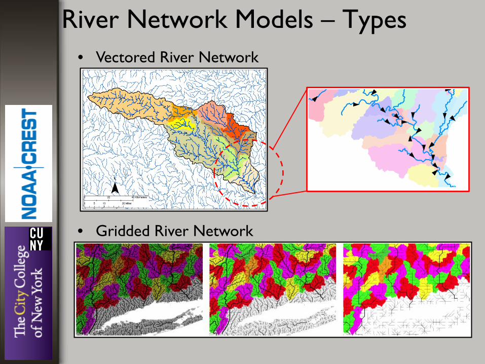
• Vectored River Network
• Gridded River Network
River Network Models – Types

River Network Models – Structure General Flow Equ. (Saint-Venant equ.)
Actual Riverbed Geometry
Simplified Flow Routing Schemes
Uniform Regular Geometries
- Muskingum-Cunge - Kinematic Routing - Cascading Resv. - etc.
- Rectangle - Trapezoid - 2nd-order parabola
- Two basic structural components are: 1) simplified flow routing schemes 2) regular-shaped bed-geometries Either of these components can be improved!

Improving Riverbed Geometry • Simplifying the river bed geometries could reduce the
burden of assembling the required data. • Implementing less detailed flow routing procedures
could lower the computational burden.
• Developing idealized riverbed geometries based on streamflow information, and employing them in flow routing schemes and river network models.

Idealized Flow Conditions • Average conditions over longer river reaches are more
uniform and predictable based on flow and topography consideration.
• Average flow conditions expressed as power-law “at-a-station” hydraulic relationships between key channel components, (i.e. water depth, top-width, flow velocity, flow area against discharge) have been studied since 60‘s.
w
Ymax 𝑌 �
Idealized Geometry
𝒀� =𝜷𝜶𝑾 𝜷
𝜷 + 𝟏
Idealized Geometry:

Preliminary Experiment • Idealized geometries can be calculated and assigned
alongside the river channel

At-A-Station Relations &
Idealized Geometry
Modified Flow Routing Schemes
Modified River Network Model
River Flow Information Records
Ground-Based Measurement
Space-Based Measurement

Ground-Based Flow Measurement • Establishing robust relationships for riverbed geometry and
its hydraulic properties will require analysis of river surveyed data for wide range of various sizes with different flow regimes over diverse landscapes and regional domains.
• There are several sources, e.g. national/private agencies that provide in-situ streamflow measurement
Figures are adopted from Dave Rosgen, (1996), Applied River Morphology. page 5-24

Ground-Based Flow Measurement
USGS/NWIS
Daily Data Surveyed Data
- Provides daily Mean, Maximum, and Minimum time-series of stage-height and corresponding discharge values. - They will be used as basic limiting tools for selecting surveyed data in following studies.
H: Stage-height Q: Discharge ---------------------- H = c* Q f + H0 Y = H – H0 ---------------------- Y : maximum water depth in a river cross-section
H, Stage-height H0 , offset

At-A-Station Relations &
Idealized Geometry
Modified Flow Routing Schemes
Modified River Network Model
River Flow Information Records
Ground-Based Measurement
Space-Based Measurement

Space-Based Flow Measurement • Application of remote sensing
techniques for data acquisition over river extents is becoming as an alternative surveying approach along with field measurements.
• Remote sensing surveys can provide full range of spatial and temporal variation in river systems at regional and continental scales captured through various satellite-based, or airborne products
Digital rendering of the SWOT satellite.
http://www.satellitetoday.com/technology/
http
://w
ww
.san-
lo.c
om/p
hoto
gram
met
ry.h
tml
http
://w
ww
.san-
lo.c
om/p
hoto
gram
met
ry.h
tml/
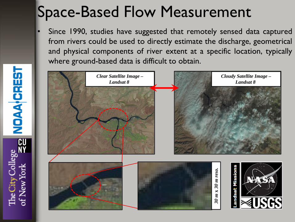
Space-Based Flow Measurement • Since 1990, studies have suggested that remotely sensed data captured
from rivers could be used to directly estimate the discharge, geometrical and physical components of river extent at a specific location, typically where ground-based data is difficult to obtain.
Clear Satellite Image – Landsat 8
Cloudy Satellite Image – Landsat 8
30 m
x 3
0 m
reso
.

Space-Based Flow Measurement • Gaging Reach vs. Gaging Stations Temporal and spatial variation of the size and shape of alluvial channel alongside the reach would restrict the gaging station to geometrically represent just the immediate vicinity.
A-A
B-B
A-A
B-B
Stage-Height
Top-
Wid
th
Proper Cross-Section for USGS in-situ river survey
Gag
e St
.

Discharge
max
.Dep
th
Space-Based Flow Measurement • Gaging Reach vs. Gaging Stations Advantages of the remote sensing, or specifically, satellite optical imagery over other river surveying techniques is the development and utilization of gaging reaches rather than gaging stations.
B-B
USGS – Daily Data
B-B
Satellite Image - Water Surface Area (SA) - Length of Gaging Reach (L) SA
L
- Flow Area (A) - Mean Top-Width (𝑊� )
Derivable
SAL�
= 𝑾 Ymax Ymax = α𝑾β
β β+𝟏� Ymax= 𝒀� SA 𝒀� . SA = Water Vol.
𝐖𝐖𝐖𝐖𝐖 𝐕𝐕𝐕.𝑳⁄
= 𝑨� Q 𝐐
𝑨�� = 𝑽�
GIVENS
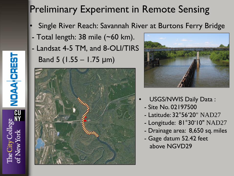
Preliminary Experiment in Remote Sensing
• Single River Reach: Savannah River at Burtons Ferry Bridge - Total length: 38 mile (~60 km). - Landsat 4-5 TM, and 8-OLI/TIRS Band 5 (1.55 – 1.75 μm)
• USGS/NWIS Daily Data : - Site No. 02197500 - Latitude: 32°56‘20" NAD27 - Longitude: 81°30‘10" NAD27 - Drainage area: 8,650 sq. miles - Gage datum 52.42 feet above NGVD29

Preliminary Experiment in Remote Sensing
s

Preliminary Experiment in Remote Sensing

Adopted from Downing et. al., 2010
Remote Sensing of Rivers, A Practical Approach???

“Eventually, all things merge into one, and a river runs through it. The river was cut by the world’s great flood and runs over rocks from the basement of time. It sings a song of wisdom and life for greater life far greater than man can hear…” Norman Maclean, 1976
Questions and Comments

References 1. John E. Costa; Robert M. Hirsch, 2004, U.S. Stream Flow Measurement and Data Dissemination Improve, EOS, 85, 197-203. 2. Leopold, L. B., M. G. Wolman, and J. P. Miller, 1964, , W. H. Freeman and Company. 3. Leopold, L. B., and T. Maddock Jr, 1991, The Hydraulic Geometry of Stream Channels and Some Physiographic Implications. 4. Leopold L. B.,Harvard University Press. 5. Dingman, S. L., 2007, Analytical derivation of at-a-station hydraulic geometry relations, Journal of Hydrology, 334, 17-27. 6. Ponce, V. M., and V. Yevjevich, 1978, Journal of the Hydraulics Divisions, ASCE, 104(HY12), 1663-1667. 7. Ponce, V. M., and P. V. Changanti, 1994, Variable-parameter Muskingum-Cunge method revisited, Journal of Hydrology, 162, 433-439. 8. Moussa, R., and C. Bocquillon, 1996, Criteria for the choice of flood-routing methods in natural channels, Journal of Hydrology, 186, 1-30. 9. Tang, X., D. W. Knight, P. G. Samuels, 1999, Volume Conservation in Variable Parameter Muskingum-Cunge Method, Journal of Hydraulic Engineering, 125, 610-620. 10. Vörösmarty, C. J., B. M. Fekete, M. Meybeck, and R. B. Lammers, 2000, Geomorphometric attributes of the global river system of rives at 30-minute spatial resolution, Journal of Hydrology, 237, 17-39. 11. Lehner, B., K. L. Verdin, and A. Jarvis , 2008, New global hydrography derivied from spaceborne elevation data, AGU EOS Transaction, 89, 93-94. 12. Garbrecht, J., 1990, Analytical representation of cross-section hydraulic properties, Journal of Hydrology, 119, 43-56. 13. Knighton, D., 1998, Hodder Arnold. 14. Ferguson, R.I., 1986, Hydraulics and Hydraulic geometry, Progress in Physical Geography, 10, 1-31. 15. Gupta, R. S., 2008, Hydrology and Hydraulic Systems, Waveland Press, Inc.. 16. Henderson, F. M., 1966, Open Channel Flow, Macmillan Publishing Co., Inc.. 17. Chow, V. T. (Ed.), 1959, Handbook of Applied Hydrology, McGraw-Hill Book Company, Inc.. 18. Krause, P., D. P. Boyle, and F. Base, 2005, Comparison of different efficiency criteria for hydrological model assessment, Advances in Geosciences, 5, 89-97. 19. Hofle, B., M. Vetter, N. Pfeifer, G. Mandlburger, and J. Stotter, 2009, Water surface mapping from airborne laser scanning using signal intensity and elevation data, Earth Surface Processes and Landforms, 34, 1635-1649. 20. Bailly, J., Y. L. Coarer, P. Languille, C. Stigermark, and T. Allouis, 2010, Geostatistical estimations of bathymetric LiDAR errors on rivers, Earth Surface Processes and Landforms, 35, 1199-1210. 21. Bjerklie, D. M., S. L. Dingman, C. J. Vorosmarty, C. H. Bolster, R. G. Congalton, 2003, Evaluating the potential for measuring river discharge from space, Journal of Hydrology, 278, 17-38. 22. Bjerklie, D. M., D. Moller, L. C. Smith, and L. Dingman, 2005, Estimating discharge in rivers using remotely sensed hydraulic information, Journal of Hydrology, 309, 191-209. 23. Brakenridge G. R., S. V. Nghiem, E. Anderson, and S. Chien, 2005, Space-Based Measurement of River Runoff, EOS, Transactions, American Geophysical Union, 86, 185-192. 24. Li M., L. Xu, and M. Tang, 2011, An extraction method for water body of remote sensing image based on oscillatory network, Journal of Multimedia, 6, 252-260. 25. Feyisa, G. L., H. Meilby, R. Fensholt, S. R. Proud, 2014, Automated water extraction index: A new technique for surface water mapping using Landsat imagery, Remote Sensing of Environment, 140, 23-35. 26. Jiang H., M. Feng, Y. Zhu, N. Lu, J. Huang, and T. Xiao, 2014, An automated method for extracting rivers and lakes from Landsat imagery, Remote Sensing, 6, 5067-5089. 27. Dingman, S. L., and K. P. Sharma, 1997, Statistical development and validation of discharge equation for natural channels, Journal of Hydrology, 199, 13-35. 28. Singh V. P., 2003, On the theories of hydraulic geometry, International Journal of Sediment Research, 18, 196-218. 29. Gleason C. J., L. C. Smith, 2014, Toward global mapping of river discharge using satellite images and at-many-stations hydraulic geometry, PNAS, 111, 4788-4791. 30. Gleason C. J., 2015, Hydraulic geometry of natural rivers: A review and future directions, Progress in Physical Geography, 1-24. 31. Fekete, B. M., C. J. Vörösmarty, and R. B. Lammers, 2001, Scaling gridded river network for macro-scale hydrology: Development and analysis and control of error, Water Resources Research, 37, 1955-1968. 32. Vörösmarty, C. J., B. Moore III, A. L. Grace, M. Gildea, J. M. Melillo, B. J. Peterson, E. B. Rastetter, and P. A. Steudler, 1989, Continental scale models of water balance and fluvial transport: An application to South America, Global Biogeochemstry Cycles, 3, 241-265. 33. Vörösmarty, C. J., C. A. Federer, and A. L. Schloss, 1998, Possible implications for global-scale water balance and terrestrial ecosystem modeling, Journal of Hydrology, 207, 147-169. 34. Cohen, S., A. J. Kettner, J. P. M. Syvitski, and B. M. Fekete, 2013, WBMsed: a distributed global-scale daily riverine sediment flux model - model description and validation, Computational Geosciences, 53, 80-93.