Embed Size (px)
Citation preview

Application of a Combined Daily Rain Gauges and Rainfall Satellite Estimates Scheme for Basin
Management
Daniel Vila ([email protected])Daniel Vila ([email protected])
Cesar Luis Garcia ([email protected])Cesar Luis Garcia ([email protected])
Centro de Relevamiento y Evaluación de Recursos Agrícolas y Naturales
DevCoCast Advanced Training Course at ITC 07-18 February 2011

Relevance and interest
Hydrological information is needed for:
DevCoCast Advanced Training Course at ITC 07-18 February 2011

(a) Develop a blended product based on Hydroestimator algorithm (Vicente et al., 1998) and daily rain gauge values using the Combined Scheme (CoSch) technique (Vila et al, 2009)
(b) Calculate daily catchment information like: mean areal rainfall, maximum precipitation, percentage of the catchment with more than 1 mm, conditional precipitation, etc.
(c) Catchment level or at a region of interest (ROI).
Objectives and Target
Provide a tool and a source of hydro-meteorological data to: Scientists, Resource managers, Public and private decision makers
DevCoCast Advanced Training Course at ITC 07-18 February 2011

?
Pluviometer Hydroestimator
MAIN GOAL: QUANTIFY PRECIPITATION
OVER LAND
MULTI-SATELLITE APPROACH GAUGE OBSERVATIONS
• PROS
• Great spatial and temporal coverage
• IR/MW blended techniques: a good approach to take advantage of the physically based MW estimates and IR high resolution
• CONS
• The performance is highly dependant on the regime and the scale
• PROS
• Unique source of direct measurement
• Largest available records for climate studies
• CONS
• Unevenly distributed around the world
• Sampling and instrumental errors (wind, evaporation, etc.)
MERGING APPROACH: “THE BEST OF BOTH WORLDS”
DevCoCast Advanced Training Course at ITC 07-18 February 2011

Combined Scheme (CoSch) technique

Hydroestimator CoSch

Sample ROIs
Resulting variable values
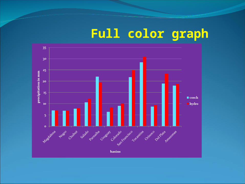
Full color graph

Effort vs. Result

ExerciseTo go under revision…

CoSch.wmvFull video of exercise in automatic mode, 2 min.

Starting exercise package
14.2 mb – 17 files
If you get to the end: 34.9 mb – 101 files
Batch mode to process time series: o.kAutomatic for DevCoCast users: no o.k

Batch mode on february
Size of the ROIsWeather regimeType of stormsSeason of yearGround Station Density

Administrative Boundaries?
Statistical analysis
Downscaling to 4km

Mid-IR WV TIRVIS
75 degree West
MTSAT-1RMet-7
MSGGOES-EGOES-W
GOES East

heel erg bedankt !! Muchas gracias !!