Embed Size (px)
Citation preview
1
Application Dossier for the European Geopark Network Terras de Cavaleiros Aspiring Geopark, Portugal
Application Dossier for the European Geopark Network Terras de Cavaleiros Aspiring Geopark, Portugal
2
3
Application Dossier for the European Geopark Network Terras de Cavaleiros Aspiring Geopark, Portugal
CREDITS:Texts: Diamantino Pereira, Artur Sá, Sílvia Marcos, AnaLima, Maria João Rodrigues, Ana Luísa Fernandes,Susana Magalhães, Susana Matias
Maps: Alcino Loureiro
Photos: Terras de Cavaleiros Geopark archive, ValterCavaleiro
Layout: Pedro Coelho
Application Dossier for the European Geopark Network Terras de Cavaleiros Aspiring Geopark, Portugal
4
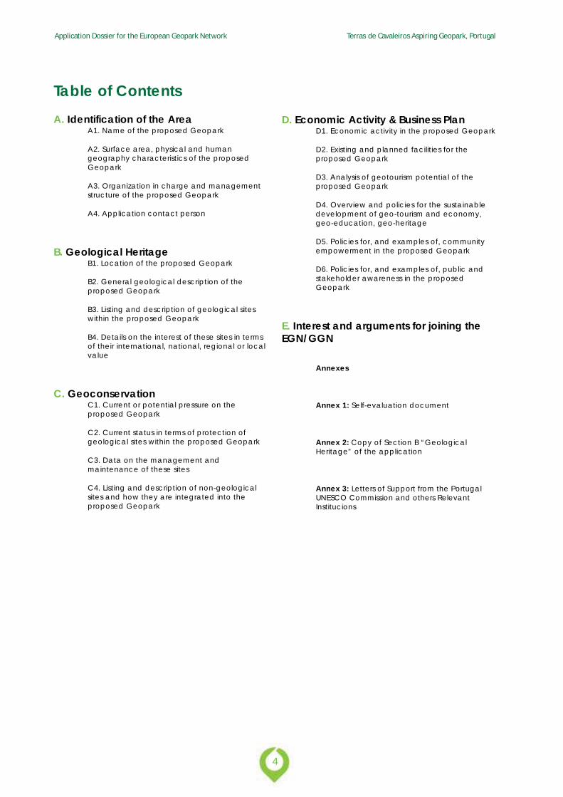
Table of ContentsA. Identification of the Area
A1. Name of the proposed Geopark
A2. Surface area, physical and humangeography characteristics of the proposedGeopark
A3. Organization in charge and managementstructure of the proposed Geopark
A4. Application contact person
B. Geological HeritageB1. Location of the proposed Geopark
B2. General geological description of theproposed Geopark
B3. Listing and description of geological siteswithin the proposed Geopark
B4. Details on the interest of these sites in termsof their international, national, regional or localvalue
C. GeoconservationC1. Current or potential pressure on theproposed Geopark
C2. Current status in terms of protection ofgeological sites within the proposed Geopark
C3. Data on the management andmaintenance of these sites
C4. Listing and description of non-geologicalsites and how they are integrated into theproposed Geopark
D. Economic Activity & Business PlanD1. Economic activity in the proposed Geopark
D2. Existing and planned facilities for theproposed Geopark
D3. Analysis of geotourism potential of theproposed Geopark
D4. Overview and policies for the sustainabledevelopment of geo-tourism and economy,geo-education, geo-heritage
D5. Policies for, and examples of, communityempowerment in the proposed Geopark
D6. Policies for, and examples of, public andstakeholder awareness in the proposedGeopark
E. Interest and arguments for joining theEGN/GGN
Annexes
Annex 1: Self-evaluation document
Annex 2: Copy of Section B “GeologicalHeritage” of the application
Annex 3: Letters of Support from the PortugalUNESCO Commission and others RelevantInstitucions
5
Application Dossier for the European Geopark Network Terras de Cavaleiros Aspiring Geopark, Portugal
A. Identification of the Area
Application Dossier for the European Geopark Network Terras de Cavaleiros Aspiring Geopark, Portugal
6
A. Identification of the areaA1. Name of the proposed GeoparkName in Portuguese: Geoparque Terras de Cavaleiros
Name in English: Terras de Cavaleiros Geopark (Landsof Knights Geopark)
The meaning of the name of the proposed geoparkis twofold. The word “Terras/Lands” takes us back tomedieval times and to the vastness of the territory.The word “Cavaleiros/Knights” is associated with theheroic act of the knight Martim Gonçalves deMacedo; During the Aljubarrota fight in 1385 he savedfrom death the Master of Avis that became latter Kingof Portugal - D. João I.
A2. Surface area, physical and humangeography characteristics of theproposed Geopark
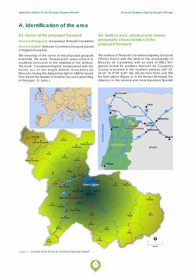
The territory of Terras de Cavaleiros Aspiring Geopark(TCAG) match with the limits of the municipality ofMacedo de Cavaleiros, with an area of 699.2 km2
spread across 30 parishes. Macedo de CavaleirosCounty is located in the northern plateau (41º 32’16.15’’ N, 6º 58’ 8.29’’ W), 181 km from Porto and 505km from Lisbon (Figure 1). In the Iberian Peninsula thedistance to the nearest and most important Spanish
Figure 1 - Location of the Terras de Cavaleiros Aspiring Geopark
7
Application Dossier for the European Geopark Network Terras de Cavaleiros Aspiring Geopark, Portugal
cities is 149 km to Zamora, 221 km to Salamanca, 248km to Valladolid, 294 km to Vigo and 401 km to Madrid.
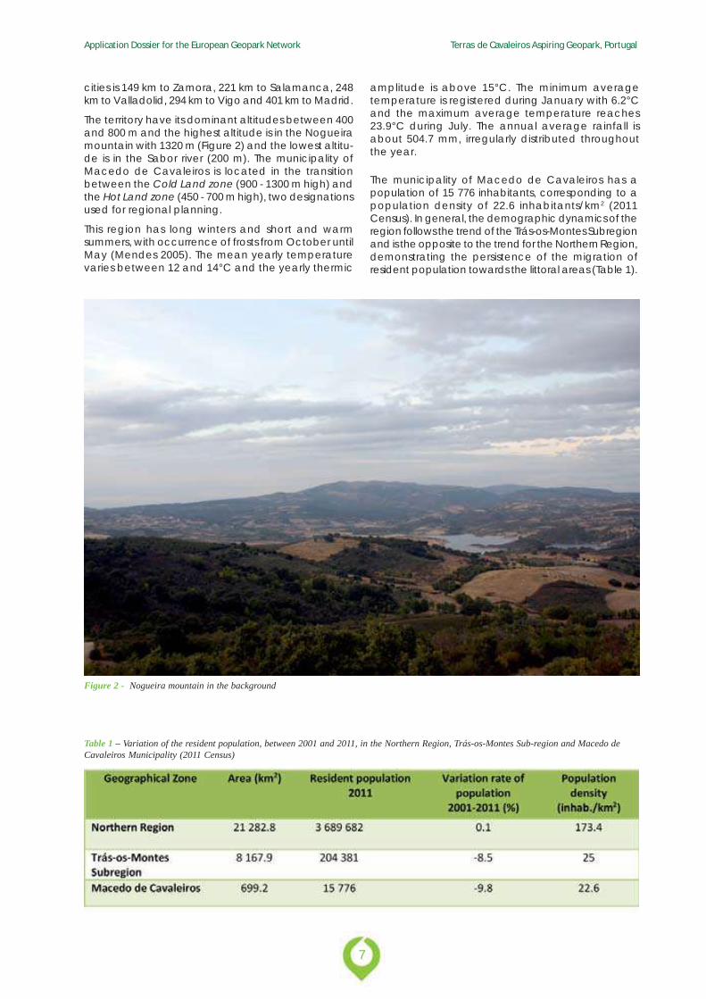
The territory have its dominant altitudes between 400and 800 m and the highest altitude is in the Nogueiramountain with 1320 m (Figure 2) and the lowest altitu-de is in the Sabor river (200 m). The municipality ofMacedo de Cavaleiros is located in the transitionbetween the Cold Land zone (900 - 1300 m high) andthe Hot Land zone (450 - 700 m high), two designationsused for regional planning.
This region has long winters and short and warmsummers, with occurrence of frosts from October untilMay (Mendes 2005). The mean yearly temperaturevaries between 12 and 14°C and the yearly thermic
The municipality of Macedo de Cavaleiros has apopulation of 15 776 inhabitants, corresponding to apopulation density of 22.6 inhabitants/km2 (2011Census). In general, the demographic dynamics of theregion follows the trend of the Trás-os-Montes Subregionand is the opposite to the trend for the Northern Region,demonstrating the persistence of the migration ofresident population towards the littoral areas (Table 1).
Table 1 – Variation of the resident population, between 2001 and 2011, in the Northern Region, Trás-os-Montes Sub-region and Macedo deCavaleiros Municipality (2011 Census)
Figure 2 - Nogueira mountain in the background
amplitude is above 15°C. The minimum averagetemperature is registered during January with 6.2°Cand the maximum average temperature reaches23.9°C during July. The annual average rainfall isabout 504.7 mm, irregularly distributed throughoutthe year.
Application Dossier for the European Geopark Network Terras de Cavaleiros Aspiring Geopark, Portugal
8
The aging population, 28.1% according to the 2011Census, leads to a significant increase of the elderlydependency ratio in Macedo de Cavaleiros. In turn,the low birth is one of the factors that directly reflectthe decrease in the dependency ratio of young,indicating a lower weight of the younger age groupsin its population structure (11.7%) (Table 2).
Table 2 - Distribution of the population by age groups in Macedo deCavaleiros (2011 Census)
The municipality still has 13.6% of its population withoutany level of education; however 61.1% completedcompulsory studies (Census 2011) (Table 3). The schoolnetwork in the Municipality of Macedo de Cavalei-ros is constituted by the Vertical Grouping of Schoolsof the Municipality that includes nine kindergartensand four schools of different levels. It is noteworthythat there are also several private establishments:three kindergartens, the Children’s Centre NuclisolJean Piaget, the Social Centre of Nossa Senhora deFátima, the Nossa Senhora da Paz College, and theInstitute Jean-Piaget - Higher School of Education andHealth.
Table 3 - Level of education in the municipality of Macedo deCavaleiros (2011 Census)
Presently, 37% of population is professionally activeand the unemployment rate is around 10%. In whatconcerns the distribution of the active population ofthe municipality by the three sectors of activity, notethat the majority is employed in the tertiary sector(68.6%), comparing to the secondary sector (17.5%)and to the primary (13.9%) (Graph 1) (Census 2011).The primary sector is the most important one in themunicipality and is confined to agriculture andlivestock. Regarding the secondary sector, the activitywith largest contribution is construction, supported bythe manufacturing industries. The tertiary sector in theterritory, with almost 70% of the active population,relies on trade activities, educational, health and so-cial services.
Cultural identity is evidenced by the preservation oftraditions, the richness of the gastronomy and regio-nal products, and the memories of people. There areseveral associations that ensure art forms, such asdance, theatre or music, like AJAM - Youth Associationof Macedo Artists, the Potrica Association - CulturalAction Group from Nordeste Transmontano region,the Pauliteiros of Salselas, the Cultural andRecreational Group of Casa do Povo, local musicalbands, among others.
Graph 1 - Sectors of economic activity in the Municipality of Macedode Cavaleiros (2011 Census)
The Cultural Centre is the pole of the Macedo deCavaleiros culture that offers a diversified programme,like theatre, music, dance and exhibitions addressedto local population, presenting local, regional andnational artists. Events such as the Hunting Fair, theTourism Fair and Business Fair of S. Pedro, theChocalheiro Carnival, the International Festival ofTraditional Music, are some of the major culturalattractions in Macedo de Cavaleiros.
9
Application Dossier for the European Geopark Network Terras de Cavaleiros Aspiring Geopark, Portugal
The Terras de Cavaleiros Geopark Association(TCGA) is the management structure of theGeopark. It’s a non-profit association, created bypublic deed on 2012 October 16th, located on theground floor at the Cultural Centre of Macedo deCavaleiros. The mission of the association is tocontribute to the knowledge, protection, promotionand dissemination of the cultural and naturalheritage of the territory, with special focus ongeological heritage; and also with a perspectiveof deepening and dissemination of scientificknowledge, by encouraging the tourism andsustainable development of the territory of the Ter-ras de Cavaleiros Aspiring Geopark.
The association’s main objectives are:
· Reconciling the conservation of the natural, ma-terial and immaterial heritage and socioeconomicsustainable development of the population andthe municipality;
· Improve and manage the support structures forthe visitor of the geopark;
· Report the values of the geopark, providinginformation and supporting their visitation;
· Promote and support innovative actions whichare generators of employment, qualifying theterritory of the geopark and which contribute tothe fixation and development of its population;
A3. Organization in charge and management structure of the proposed Geopark
· Identify, create services and quality products asdifferentiating mark of the territory;
· Manage the infrastructures that may be assignedor created by the association.
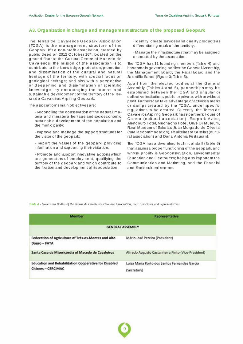
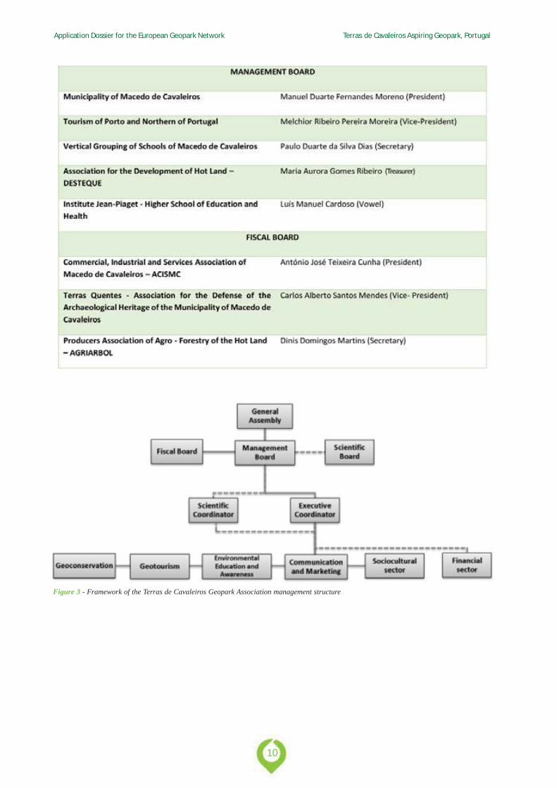
The TCGA has 11 founding members (Table 4) andhas as main governing bodies the General Assembly,the Management Board, the Fiscal Board and theScientific Board (Figure 3; Table 5).
Apart from the elected bodies at the GeneralAssembly (Tables 4 and 5), partnerships may beestablished between the TCGA and singular orcollective institutions, public or private, with or withoutprofit. Partners can take advantage of activities, marksor stamps created by the TCGA, under specificregulations to be created. Currently, the Terras deCavaleiros Aspiring Geopark has 9 partners: House ofCareto (cultural association), Ecopark Azibo,Alendouro Hotel, Muchacho Hotel, Olive Oil Museum,Rural Museum of Salselas, Solar Morgado de Oliveira(rural accommodation), Pauliteiros of Salselas (cultu-ral association) and Dona Antónia Restaurant.
The TCGA has a diversified technical staff (Table 6)that assures a proper functioning of the geopark, andwhose priority is Geoconservation, EnvironmentalEducation and Geotourism; being also important theCommunication and Marketing, and the Financialand Sociocultural sectors.
Table 4 - Governing Bodies of the Terras de Cavaleiros Geopark Association, their associates and representatives
Application Dossier for the European Geopark Network Terras de Cavaleiros Aspiring Geopark, Portugal
10
Figure 3 - Framework of the Terras de Cavaleiros Geopark Association management structure
11
Application Dossier for the European Geopark Network Terras de Cavaleiros Aspiring Geopark, Portugal
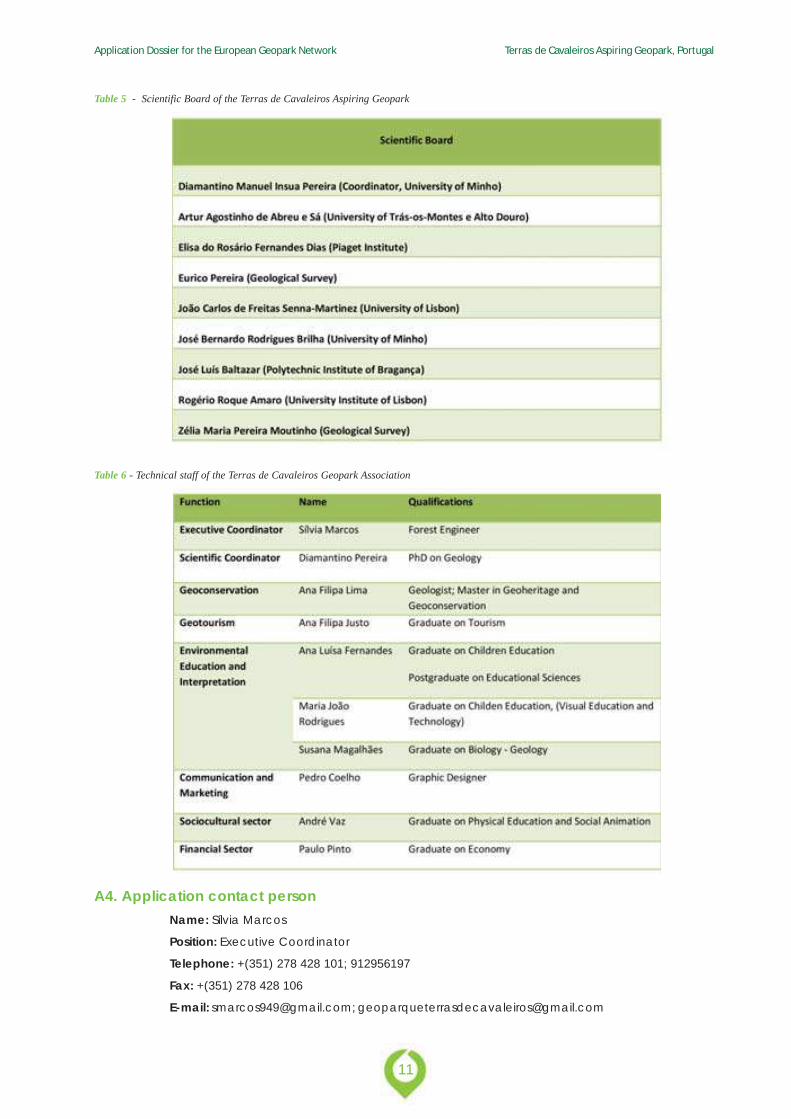
Table 5 - Scientific Board of the Terras de Cavaleiros Aspiring Geopark
A4. Application contact personName: Sílvia Marcos
Position: Executive Coordinator
Telephone: +(351) 278 428 101; 912956197
Fax: +(351) 278 428 106
E-mail: [email protected]; [email protected]
Table 6 - Technical staff of the Terras de Cavaleiros Geopark Association
Application Dossier for the European Geopark Network Terras de Cavaleiros Aspiring Geopark, Portugal
12
B. Geological Heritage
13
Application Dossier for the European Geopark Network Terras de Cavaleiros Aspiring Geopark, Portugal
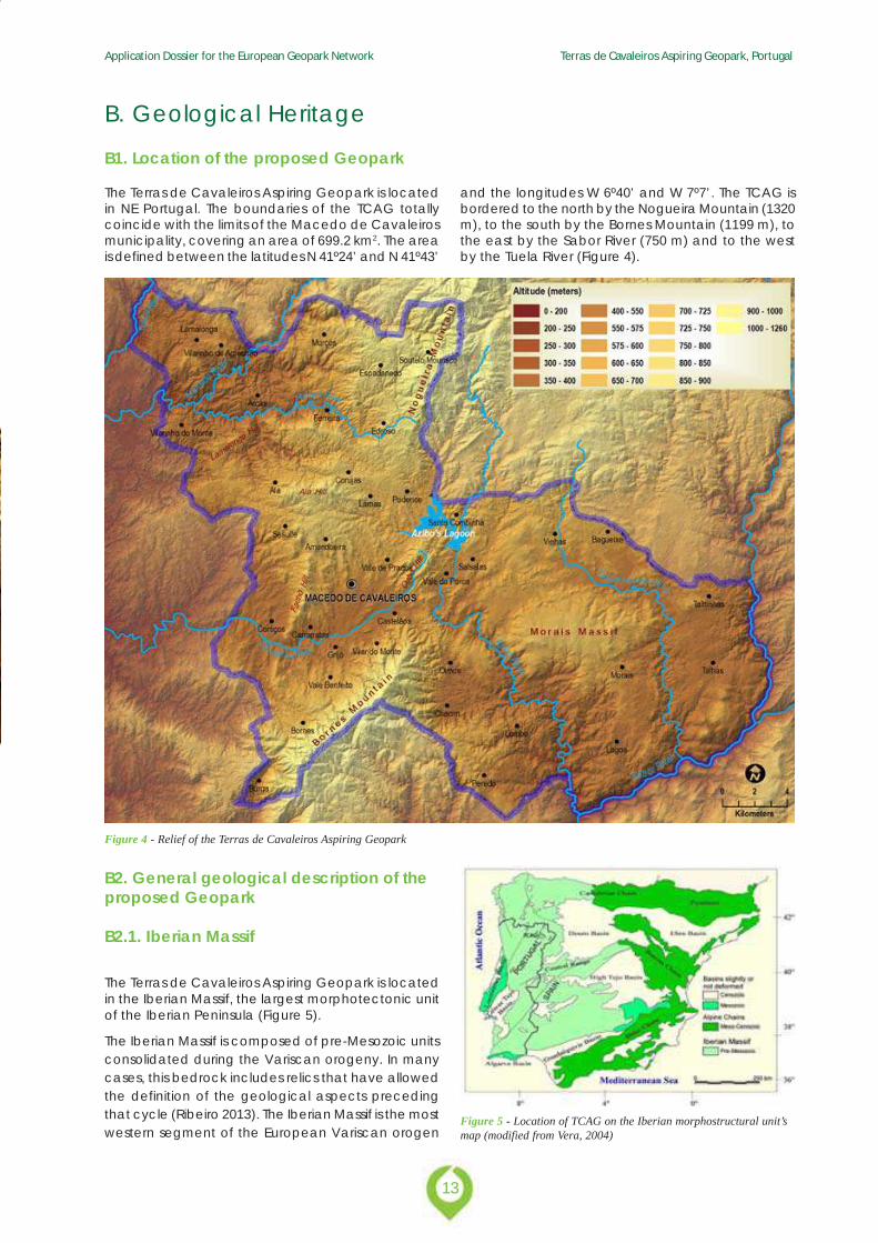
The Terras de Cavaleiros Aspiring Geopark is locatedin NE Portugal. The boundaries of the TCAG totallycoincide with the limits of the Macedo de Cavaleirosmunicipality, covering an area of 699.2 km2. The areais defined between the latitudes N 41º24’ and N 41º43’
B. Geological Heritage
B1. Location of the proposed Geopark
and the longitudes W 6º40’ and W 7º7’. The TCAG isbordered to the north by the Nogueira Mountain (1320m), to the south by the Bornes Mountain (1199 m), tothe east by the Sabor River (750 m) and to the westby the Tuela River (Figure 4).
Figure 4 - Relief of the Terras de Cavaleiros Aspiring Geopark
B2. General geological description of theproposed Geopark
B2.1. Iberian Massif
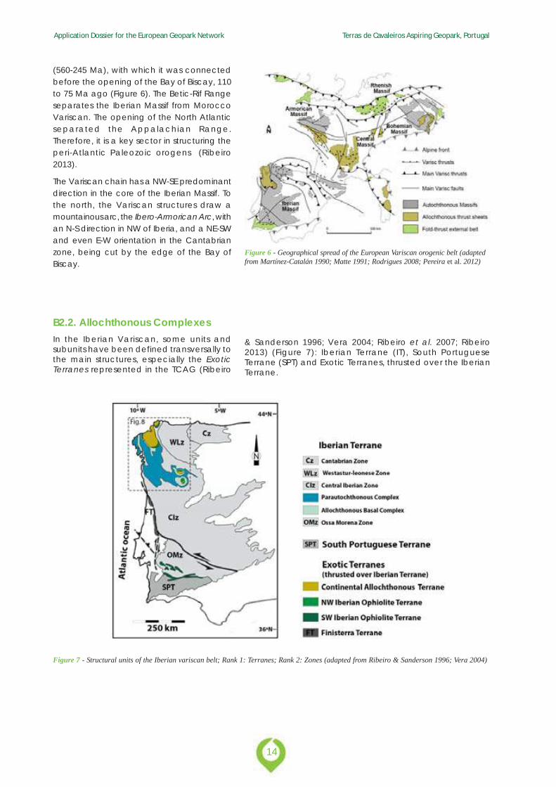
The Terras de Cavaleiros Aspiring Geopark is locatedin the Iberian Massif, the largest morphotectonic unitof the Iberian Peninsula (Figure 5).
The Iberian Massif is composed of pre-Mesozoic unitsconsolidated during the Variscan orogeny. In manycases, this bedrock includes relics that have allowedthe definition of the geological aspects precedingthat cycle (Ribeiro 2013). The Iberian Massif is the mostwestern segment of the European Variscan orogen
Figure 5 - Location of TCAG on the Iberian morphostructural unit’smap (modified from Vera, 2004)
Application Dossier for the European Geopark Network Terras de Cavaleiros Aspiring Geopark, Portugal
14
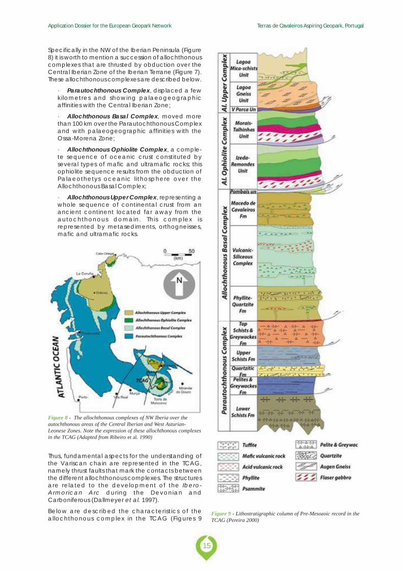
Figure 7 - Structural units of the Iberian variscan belt; Rank 1: Terranes; Rank 2: Zones (adapted from Ribeiro & Sanderson 1996; Vera 2004)
(560-245 Ma), with which it was connectedbefore the opening of the Bay of Biscay, 110to 75 Ma ago (Figure 6). The Betic-Rif Rangeseparates the Iberian Massif from MoroccoVariscan. The opening of the North Atlanticseparated the Appalachian Range.Therefore, it is a key sector in structuring theperi-Atlantic Paleozoic orogens (Ribeiro2013).
The Variscan chain has a NW-SE predominantdirection in the core of the Iberian Massif. Tothe north, the Variscan structures draw amountainous arc, the Ibero-Armorican Arc, withan N-S direction in NW of Iberia, and a NE-SWand even E-W orientation in the Cantabrianzone, being cut by the edge of the Bay ofBiscay.
Figure 6 - Geographical spread of the European Variscan orogenic belt (adaptedfrom Martínez-Catalán 1990; Matte 1991; Rodrigues 2008; Pereira et al. 2012)
B2.2. Allochthonous ComplexesIn the Iberian Variscan, some units andsubunits have been defined transversally tothe main structures, especially the ExoticTerranes represented in the TCAG (Ribeiro
& Sanderson 1996; Vera 2004; Ribeiro et al. 2007; Ribeiro2013) (Figure 7): Iberian Terrane (IT), South PortugueseTerrane (SPT) and Exotic Terranes, thrusted over the IberianTerrane.
15
Application Dossier for the European Geopark Network Terras de Cavaleiros Aspiring Geopark, Portugal
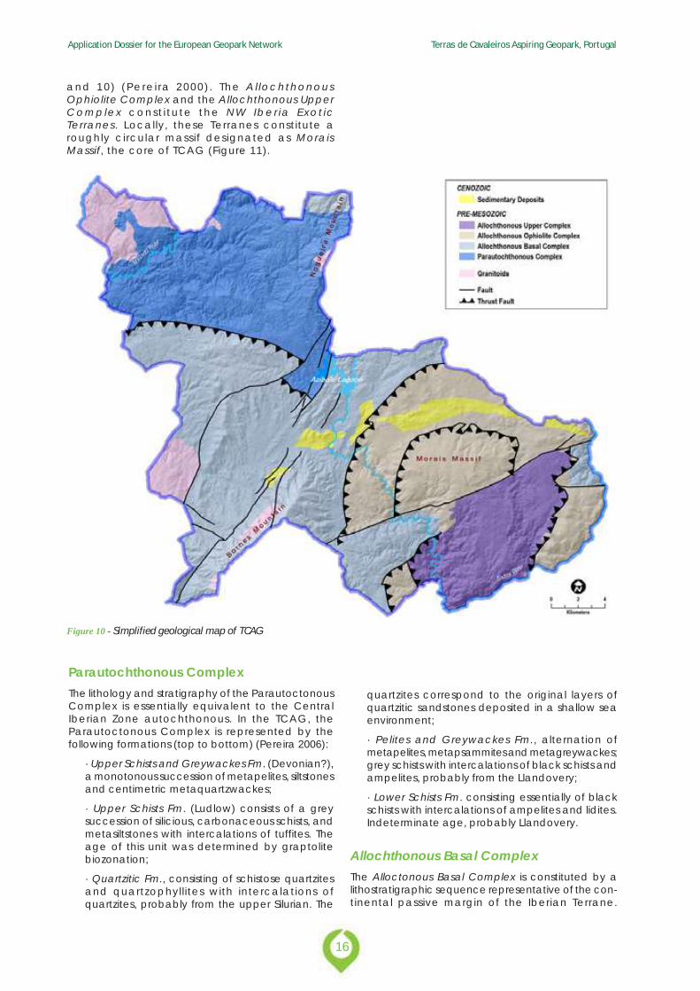
Specifically in the NW of the Iberian Peninsula (Figure8) it is worth to mention a succession of allochthonouscomplexes that are thrusted by obduction over theCentral Iberian Zone of the Iberian Terrane (Figure 7).These allochthonous complexes are described below.
· Parautochthonous Complex, displaced a fewkilometres and showing palaeogeographicaffinities with the Central Iberian Zone;
· Allochthonous Basal Complex, moved morethan 100 km over the Parautochthonous Complexand with palaeogeographic affinities with theOssa-Morena Zone;
· Allochthonous Ophiolite Complex, a comple-te sequence of oceanic crust constituted byseveral types of mafic and ultramafic rocks; thisophiolite sequence results from the obduction ofPalaeothetys oceanic lithosphere over theAllochthonous Basal Complex;
· Allochthonous Upper Complex, representing awhole sequence of continental crust from anancient continent located far away from theautochthonous domain. This complex isrepresented by metasediments, orthogneisses,mafic and ultramafic rocks.
Figure 9 - Lithostratigraphic column of Pre-Mesozoic record in theTCAG (Pereira 2000)
Thus, fundamental aspects for the understanding ofthe Variscan chain are represented in the TCAG,namely thrust faults that mark the contacts betweenthe different allochthonous complexes. The structuresare related to the development of the Ibero-Armorican Arc during the Devonian andCarboniferous (Dallmeyer et al. 1997).
Below are described the characteristics of theallochthonous complex in the TCAG (Figures 9
Figure 8 - The allochthonous complexes of NW Iberia over theautochthonous areas of the Central Iberian and West Asturian-Leonese Zones. Note the expression of these allochthonous complexesin the TCAG (Adapted from Ribeiro et al. 1990)
Application Dossier for the European Geopark Network Terras de Cavaleiros Aspiring Geopark, Portugal
16
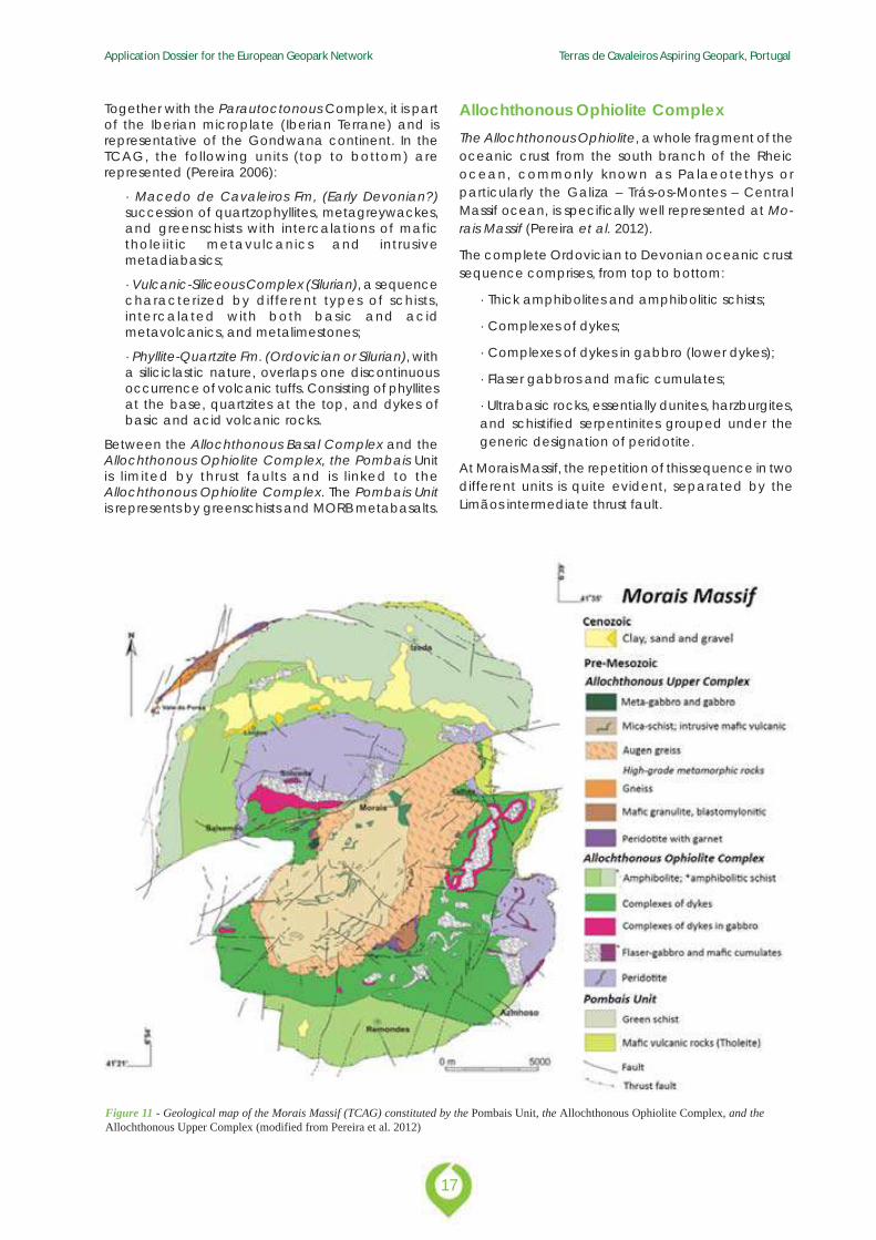
and 10) (Perei ra 2000) . The Al lochthonousOphiolite Complex and the Allochthonous UpperComplex const i tu te the NW Iber ia Exot icTerranes. Locally, these Terranes constitute aroughly circular massif designated as MoraisMassif, the core of TCAG (Figure 11).
Figure 10 - Simplified geological map of TCAG
Parautochthonous ComplexThe lithology and stratigraphy of the ParautoctonousComplex is essentially equivalent to the CentralIberian Zone autochthonous. In the TCAG, theParautoctonous Complex is represented by thefollowing formations (top to bottom) (Pereira 2006):
· Upper Schists and Greywackes Fm. (Devonian?),a monotonous succession of metapelites, siltstonesand centimetric metaquartzwackes;
· Upper Schists Fm. (Ludlow) consists of a greysuccession of silicious, carbonaceous schists, andmetasiltstones with intercalations of tuffites. Theage of this unit was determined by graptolitebiozonation;
· Quartzitic Fm., consisting of schistose quartzitesand quartzophyllites with intercalations ofquartzites, probably from the upper Silurian. The
quartzites correspond to the original layers ofquartzitic sandstones deposited in a shallow seaenvironment;
· Pelites and Greywackes Fm., alternation ofmetapelites, metapsammites and metagreywackes;grey schists with intercalations of black schists andampelites, probably from the Llandovery;
· Lower Schists Fm. consisting essentially of blackschists with intercalations of ampelites and lidites.Indeterminate age, probably Llandovery.
Allochthonous Basal ComplexThe Alloctonous Basal Complex is constituted by alithostratigraphic sequence representative of the con-tinental passive margin of the Iberian Terrane.
17
Application Dossier for the European Geopark Network Terras de Cavaleiros Aspiring Geopark, Portugal
Together with the Parautoctonous Complex, it is partof the Iberian microplate (Iberian Terrane) and isrepresentative of the Gondwana continent. In theTCAG, the following units (top to bottom) arerepresented (Pereira 2006):
· Macedo de Cavaleiros Fm, (Early Devonian?)succession of quartzophyllites, metagreywackes,and greenschists with intercalations of mafictholeiitic metavulcanics and intrusivemetadiabasics;
· Vulcanic-Siliceous Complex (Silurian), a sequencecharacterized by different types of schists,intercalated with both basic and acidmetavolcanics, and metalimestones;
· Phyllite-Quartzite Fm. (Ordovician or Silurian), witha siliciclastic nature, overlaps one discontinuousoccurrence of volcanic tuffs. Consisting of phyllitesat the base, quartzites at the top, and dykes ofbasic and acid volcanic rocks.
Between the Allochthonous Basal Complex and theAllochthonous Ophiolite Complex, the Pombais Unitis l imited by thrust faults and is l inked to theAllochthonous Ophiolite Complex. The Pombais Unitis represents by greenschists and MORB metabasalts.
Allochthonous Ophiolite ComplexThe Allochthonous Ophiolite, a whole fragment of theoceanic crust from the south branch of the Rheicocean, commonly known as Palaeotethys orparticularly the Galiza – Trás-os-Montes – CentralMassif ocean, is specifically well represented at Mo-rais Massif (Pereira et al. 2012).
The complete Ordovician to Devonian oceanic crustsequence comprises, from top to bottom:
· Thick amphibolites and amphibolitic schists;
· Complexes of dykes;
· Complexes of dykes in gabbro (lower dykes);
· Flaser gabbros and mafic cumulates;
· Ultrabasic rocks, essentially dunites, harzburgites,and schistified serpentinites grouped under thegeneric designation of peridotite.
At Morais Massif, the repetition of this sequence in twodifferent units is quite evident, separated by theLimãos intermediate thrust fault.
Figure 11 - Geological map of the Morais Massif (TCAG) constituted by the Pombais Unit, the Allochthonous Ophiolite Complex, and theAllochthonous Upper Complex (modified from Pereira et al. 2012)
Application Dossier for the European Geopark Network Terras de Cavaleiros Aspiring Geopark, Portugal
18
Allochthonous Upper ComplexThe Allochthonous Upper Complex represents a com-plete sequence of continental crust deriving from adistant margin, relatively to the autochthonousdomain. Presumably this complete fragment of con-tinental crust had its origin on the Armorica microplate(Exotic Terrain), an independent continentalfragment, as well as from the north of Gondwana (Ri-beiro et al. 2007).
The sequence is represented, from top to bottom by:
· Lagoa mica schists with mafic volcanic intrusions;
· Lagoa augen gneiss;
· Mafic granulites, blastomylonitic;
· Garnet peridotite.
The Terranes mentioned above are the majorlithospheric plates affected during the VariscanOrogeny. The NW Iberian Sector, with its owngeological history full of singularities, corresponds toa fragment of the Variscan chain. The reconstitutionof the palaeogeography and tectonic zones of theIberian in relation to Europe, before the opening ofthe Bay of Biscay during Cretaceous time, helps toidentify the origin (the root zone) of the AllochthonousUnits parts of the NW Iberia Allochthonous Massifs, ingeneral, and the Morais Massif, in particular, and thuslocates the NW Iberian sector in the general contextof the Variscan Chain (Figure 6).
As mentioned before, the geological units integratingthe NW massifs are called Allochthonous Unitsbecause they are displaced from their origin (the rootzone) for more than 200 km (Pereira et al. 2012).
Thanks to the crustal shortening during the continen-tal collision, a continental fragment overlapped anoceanic fragment and these two were placed overthe Gondwana margin. The collisional tectoniccompression, the crustal thickening and theassociated gravitic movements induced thatdisplacement occurred during the chain formation(380-280 Ma). A movement of about 2 cm/year during100x106 years originates around 200 km ofdisplacement for the Allochthonous Units. Thedisplacement of this pile of units originates fragmentsat the bottom, which constitute the ParautocthonousComplex (Pereira et al. 2012).
The Allochthonous Units are so called due to the factthey are not equivalent with the surrounding units,whereas the Parautochthonous Units, althoughconstituted by complexes of several layers, showlithological and stratigraphic affinity with units thathave not suffered displacement, and for therefore arecalled autochthonous (Pereira et al. 2012).
B2.3. Variscan GranitoidsSome igneous rocks occur in the TCAG, crosscuttingthe metasedimentary and metavolcanic units referredto above. Beyond the veins, mostly of quartz, severalgranitoids contemporaneous with the VariscanOrogeny and with a clear relation to the 3rd orogenic
phase (D3) can be described.
Rebordelo granite and granodiorite, porphyroids withmedium to coarse grain, essentially biotitic, pre to syn-D3, occurs in the occidental sector of the municipality,near the Vilarinho de Agrochão village.
Lebução granite, two-mica, medium grained granite,syn-D3 that occurs also in the occidental sector ofthe municipality, near the Vilarinho de Agrochãovillage.
Bornes and Serra de Pombares granite, a two-mica,medium-grain porphyroid granite late to post-D3.Shows cataclasis and strong arenization at thecontact with the Vilariça Fault.
Romeu granite, a medium grained, with muscovite,late to post-D3 granite.
Torre de Dona Chama granite, a coarse, porphyroid,two-mica granite, late to post-D3 that occurs nearthe western limit of the TCAG.
Burga granite, a muscovite microgranite, late to post-D3 that occurs in the Burga village, at the south limitof the TCAG.
B2.4. Cenozoic SedimentsUp to the 1990s, the Portuguese sediments of thewestern border of the Douro Cenozoic Basin, includingthe TCAG territory (Figure 5), were included in the so-called Iberian Raña facies, a gravelly deposit withsignificant coverage in the Douro Basin and also inthe Iberian Massif. Raña refers to an alluvial fan model,chronologically near the Plio-Pleistocene limit. Thisepisode was related to the transition from theendorheic drainage of the Cenozoic Iberian basinsto the present Atlantic drainage. More detailedresearch of these sediments (Pereira 1997, 1998, 1999,2006; Pereira et al. 2000) has revealed a fluvial networkin the proximal sector of the Douro Basin, and diversetectonosedimentary units as described below (Pais etal. 2012).
Upper Miocene to Lower PlioceneThe Bragança Formation is defined in north-easternPortugal as a lithostratigraphic unit recording aproximal fluvial palaeodrainage to the Cenozoic Dou-ro Basin in Spain (Pereira 1997, 1998, 1999; Pereira etal. 2000). It is recognized as being essentially Miocene,and may correspond to allostratigraphic units UBS11and UBS12 identified in the Mondego Basin and in theproximal sector of the Lower Tejo Basin (Pereira 1997,2006; Pais et al. 2012).
The fluvial sediments fill incised palaeovalleys inresponse to two tectonic episodes and theconsequent orogenic uplift. These palaeovalleysremain well preserved in the TCAG (Vale da Porca,Salselas and Castro Roupal outcrops), where they areoriented E–W, and to the east, near Vimioso (Vimiosooutcrop) and Miranda do Douro (Silva, Sendim, andAtenor outcrops), where they are oriented NW–SE andNS, respectively. In this most north-eastern sector of
19
Application Dossier for the European Geopark Network Terras de Cavaleiros Aspiring Geopark, Portugal
Portugal, geophysical research and drilling revealedthe tectonic control of the palaeovalleys of Sendimand Atenor, which have no morphological expression.Given the context of the major Vilariça fault, the fluvi-al system was strongly influenced by the developmentof strike-slip basins (De Vicente et al. 2011; Pais et al.2012), especially in the TCAG.
The Bragança Formation comprises two members, theCastro Member (lower member) and the AtalaiaMember (upper member), with similar compositionsand depositional architectures. An unconformity isdefined based on the recognition of a regionalerosion surface and a well-developed palaeosoil.Deep channel gravel deposits and gravelly bars arethe most characteristic lithofacies of the BragançaFormation. The sediments are immature and containmoderately weathered feldspars in the sand fractionand a predominance of smectite and kaolinite in theclay fraction. The gravel units are mostly red in colorwith lutite being brown, grey or green.
The Castro Member (lower member) has a thicknessof about 70 m. In the most proximal area, especiallyin the tectonic strike-slip basins, the sedimentary infillis characterized by an increased thickness in massivegravelly units and by sandy channels. In these areas,the lithofacies and sedimentary architecture arecompatible with the presence of alluvial fans thatwould have supplied the regional river system. Towardthe top of the member, the sedimentary cycle ischaracterized by a thickening of fine sediment layers.This architecture is well represented in the various sandpits of Sendas and Macedo de Cavaleiros regions andhas a regional extent.
The Atalaia Member (upper member) reaches athickness of about 50 m in the strike-slip basins ofBragança and Macedo de Cavaleiros (TCAG) andcorresponds to a succession of episodes with similarcharacteristics to the Castro Member. The same fluvi-al environment, braided, low sinuosity rivers resultedfrom a new tectono-sedimentary cycle. There is oftena succession of the architectural elements of gravellybars, derived from energetic fluvial episodes as wellas lateral accretion elements. Occasionally,abandoned channels cut flood deposits.
The Bragança Formation is the most extensivelyexposed unit in north-eastern Portugal. Its particularcharacteristics include deposits reflecting differentchannel conditions and flows, the more organizedfacies, the weathering of clasts, the clay mineralcontents with abundant smectite and neoformationof kaolinite, the development of incipient palaeosoils,the red color, and carbonate precipitation in incipientfractures. These characteristics indicate temperate towarm climatic conditions with a rainy season forminghigh-energy streams, and a dry season that alsofavoured oscillation of the water table (Pereira 1997,1998, 1999).
Geomorphological features indicate that, in the stageprior to the deposition of the Bragança Formation,river valleys incised in the bedrock developed as anerosional response to mountain uplift occurring sincethe Eocene (Pereira et al. 2000; De Vicente et al. 2008,
2011). Subsequently, the activity of this major tectonicepisode, which corresponds to the Betic compressionat about 9.5 Ma (Calvo et al. 1993), caused a staircaseorganization of large fault blocks in northern Portugaland the development of strike-slip basins associatedwith the Vilariça fault detachment (Ferreira 1991;Cunha 1992; Cabral 1995). It is most likely that theCastro Member represents the alluvial systemsresponse to the new morphotectonic regime (Perei-ra et al. 2000).
The Vale Álvaro Formation occurs in the eastern regionof Portugal unconformably overlying the mafic rocksthat constitute the Bragança Massif and the MoraisMassif (Limãos outcrops in the TCAG). It hastraditionally been indicated as probably Paleogene,based on sedimentological characteristics. Morerecently, palynological data (Poças et al. 2003; Po-ças 2004) have suggested an age between the LateMiocene and Pliocene, and a climate characterizedby seasonal contrasts (wet winters and hot summers)and overall moderate temperatures (Pais et al. 2012).
A sedimentary characterization of the Vale ÁlvaroFormation shows several episodes of coarse sedimentsconsistent with an alluvial fan model. Pedogenic andphreathic calcretes and dolocrete, widespread in thedistal area, developed between the debris flowepisodes. The proximal lithofacies of the Vale ÁlvaroFormation crop-out at Limãos (in the TCAG). The lowerpart consists of a 4 m thick dolocrete layer, followedby red, coarse, clast-supported gravel. Sub-roundedclasts are exclusively of weathered mafic andultramafic rocks from the Alloctonous OphioliteComplex located in the Morais Massif. The clayfraction is composed mainly of dioctahedralmontmorillonite and paligorskite, chlorite,interstratified chlorite-montmorillonite andoccasionally serpentine, talc and kaolinite (Pereira &Brilha 2000). The entire unit is consolidated byferruginous and carbonate cement (Pereira 2006).
The morphotectonic context, sedimentarycharacteristics and depositional architecture of theVale Álvaro Formation indicate an alluvial fan model,which relates to an episode of tectonic movementthat stressed the fault scarps (Pereira 1997, 2006). Theage of the Vale Álvaro Formation remains unclear,but it might be a proximal equivalent of the BragançaFormation with epigenetic carbonate developedalong the contact with basic rocks lying in tectonicdepressions.
Upper Pliocene to Lower PleistoceneThe Aveleda Formation consists of reddish depositsmainly of muddy matrix-supported gravel. Clasts ofseveral metasedimentary rocks and quartz aresubangular. Kaolinite and illite dominate the clayfraction.
The Aveleda Formation is generally located in twodifferent geomorphological settings. First, occurrencessurrounding the TCAG lie over a flattened surface,which marks a discontinuity with the older units, andhave its source on the resistant reliefs. Second,
Application Dossier for the European Geopark Network Terras de Cavaleiros Aspiring Geopark, Portugal
20
occasionally this unit lies within tectonic depressionsassociated with the Vilariça fault. The most importantoutcrops in this context are those in: Aveleda (northof Bragança), with Montesinho Mountain as a source;Sortes (south of Bragança), Azibeiro, Podence andArrifana (all in the TCAG), with Nogueira Mountain asa source; and Castelãos (TCAG), with Bornes Mountainas a source (Pereira 1997).
The lithofacies and architecture of Aveleda Formationindicate nearby sources and debris flows deposited asalluvial fan bodies. This unit establishes the transitionbetween the previous endorheic drainage network and
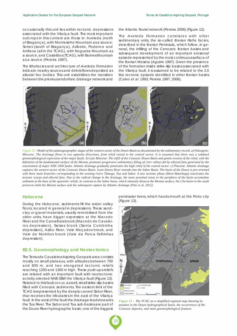
the Atlantic fluvial network (Pereira 2006) (Figure 12).
The Aveleda Formation correlates with othersedimentary units, the so-called Iberian Raña facies,described in the Iberian Peninsula, which follow, in ge-neral, the infilling of the Cenozoic Iberian basins andsubsequent development of an important erosionalepisode represented by the most continuous surface ofthe Iberian Meseta (Aguirre 1997). Given the presenceof the formation inside strike-slip basins associated withthe Vilariça fault, it is assumed to be related to the 2.0Ma tectonic episode identified in other Iberian basins(Calvo et al. 1993; Pereira 1997, 2006).
Figure 12 - Model of the palaeogeographic stages of the western sector of the Douro Basin as documented by the sedimentary record. a) Paleogene-Miocene: The drainage flows in two opposite directions, from relief raised in the central sector. It is assumed that there was a subduedgeomorphological expression of the major faults. b) Late Miocene: The infill of the Cenozoic Douro Basin and gentle erosion of the relief, with thedefinition of the fundamental surface of the Meseta, promotes progressive sedimentary filling of river valleys fed by alluvial fans generated by thereactivation of major NNE–SSW faults. Atlantic drainage gradually penetrates the high relief of the central sector. c) Pliocene: Atlantic drainagecaptures the western sector of the Cenozoic Douro Basin. A pre-Douro River extends into the Sabor Basin. The basin of the Douro is pre-orientedwith three main branches corresponding to the existing rivers Tâmega, Tua and Sabor. A new tectonic phase (Ibero-Manchega) reactivates thetectonic scarps and alluvial fans. Due to the radical change in the drainage, the more proximal areas in the periphery of the basin accumulatesediment at the base of the quartzitic reliefs. In contrast to the Sabor basin, which intensely dissects the Meseta surface, the Côa basin to the southpreserves both the Meseta surface and the subsequent capture by Atlantic drainage (Pais et al. 2012)
HoloceneDuring the Holocene, sediments fill the wider valleyfloors, located in general in depressions. These sand-clay or gravel materials, usually remobilized from theolder units, have bigger expression at the MacedoRiver and the Carvalhais brook (Macedo de Cavalei-ros depression), Salsas brook (Santa Combinhadepression), Azibo River, Vale Meçados brook, andVale de Moinhos brook (Vale da Porca-Talhinhasdepression).
B2.5. Geomorphology and NeotectonicsThe Terras de Cavaleiros Aspiring Geopark area consistsmostly on small plateaus, with altitudes between 700and 800 m, and two elongated tectonic reliefsreaching 1200 and 1300 m high. These push-ups reliefsare related with an important fault with neotectonicactivity oriented NNE-SSW the Vilariça fault (Figure 13).Related to this fault occur, as well, small strike-slip basinsfilled with Cenozoic sediments. The eastern limit of theTCAG is represented by the deeply carved Sabor River,that receives the tributaries in the east of the Vilariçafault. In the west of the fault the drainage leads towardsthe Tua River. The Sabor and Tua sub-basins are part ofthe Douro River hydrographic basin, one of the biggest
peninsular rivers, which has its mouth at the Porto city(Figure 13).
Figure 13 - The TCAG on a simplified regional map showing itsposition in the Douro hydrographical basin, the occurrences of theCenozoic deposits, and main geomorphological features
21
Application Dossier for the European Geopark Network Terras de Cavaleiros Aspiring Geopark, Portugal
The interpretation of the northern Portuguese relief hasemphasized the importance of the Vilariça fault. Thistectonic accident has a great expression in the TCAG,connected to the development of the strike-slip basinssuch as the Santa Combinha and Macedo de Cava-leiros, or the Vilariça to the south, as well as upliftedreliefs in a push-up model, like the Bornes and No-gueira Mountains (Cabral 1995; Pereira 1997; 2002;2006; 2010). Regionally, the Vilariça fault constitutesalso the limit between the eastern sector, where thefundamental surface of the Iberian Plateau is moreregular, and the western sector where the fundamen-tal surface is more eroded, marked by high centralplateaus dissected to the south of the Douro River,and by the Miranda depression to the north of theriver.
Some noteworthy geomorphological aspects of theTCAG are briefly described below:
· The regular flattening surface of the Morais Massifdevelops to the north of the Morais Fault, at about750 m and is representative of the North IberianPlateau. This surface, well preserved in theAlloctonous Ophiolite Complex peridotites (Massifof Morais) represents a reference for theinterpretation of all other regional surfaces. Portionsof the same surface are also preserved in the northbetween Santa Combinha and Vinhais regions;
· At the north of the Morais Massif, between Valeda Porca and Talhinhas develops a depressionoriented E-W, around 150 m below of the MoraisMassif and Vinhais surfaces;
· To the south of the Morais fault the footwall isnoticeable, which dropped about 100 m, in theTalhas and Lagoa sector, as well as the expressionof the fault scarp;
· In the NW sector of the TCAG the south flank ofthe Nogueira Mountain stands out, reaching analtitude of 1231 m (e.g. Pena Mourisca) in thePombares Massif granites. This tectonic relieforiented NNE-SSW is located to the west of themain branch of the Vilariça fault;
· The Macedo de Cavaleiros and Santa Combinhasectors are identified by small depressions orientedNE-SW and NNE-SSW, individualized between faultsdefined in the context of the tectonic structure(Vilariça fault);
· To SW the Bornes Moutain stands out as a tectonicrelief oriented NNE-SSW, parallel to the Vilariçafault, with the regular top at around 1200 m high.In the south limit of the municipality (near Burga)develops a fault scarp oriented close to N-S,extending to the Vilariça depression;
· At the western sector of the TCAG some flattenedscraps remain, slightly subsided relatively to the re-
gular levels of the North Iberian Plateau, which arealso a tectonic step to the Mirandela depression;
· In relation to the fluvial drainage network, theMacedo de Cavaleiros depression stands outdraining towards the Tuela River by the MacedoRiver and the Carvalhais stream. The remainingterritory falls within the Sabor River sub-basin, whichlimits the municipality at east. The Sabor River hashigh slopes and deep channels, with around 200m in the margins and 400 m relatively to the fun-damental surface. The tributary valleys, as theAzibo River and the mentioned brooks, have deepvalleys, which open at the tectonic depressionswhere they run in a flattened stream.
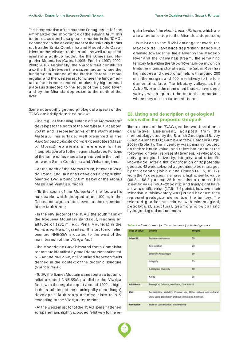
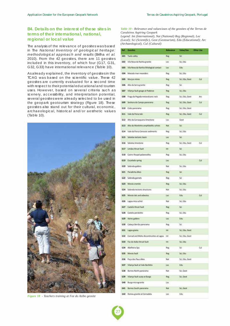
B3. Listing and description of geologicalsites within the proposed GeoparkThe selection of the TCAG geosites was based on aqualitative assessment, adapted from themethodology used by the Spanish Geological Survey(Garcia-Cortéz 2008; Garcia-Cortéz & Carcavilla Urquí2009) (Table 7). The inventory was primarily focusedon their scientific value, and takes into account thefollowing criteria: representativeness, key-location,rarity, geological diversity, integrity, and scientificknowledge. After a first identification of 82 potentialgeosites, 42 were selected as geosites to be managedby the geopark (Table 8 and Figures 14, 15, 16, 17).From the 42 geosites, nine have a high scientific value(66.3 – 58.8 points); 25 have also a remarkablescientific value (46.3 – 20 points); and finally eight havea low scientific value (17.5 – 7.5 points), however theirselection in this inventory was justified because theyrepresent geological elements of the territory. Theselected geosites are related with mineralogical,petrological, structural, geomorphological andhydrogeological occurrences.
Table 7 – Criteria used for the evaluation of potential geosites
Application Dossier for the European Geopark Network Terras de Cavaleiros Aspiring Geopark, Portugal
22
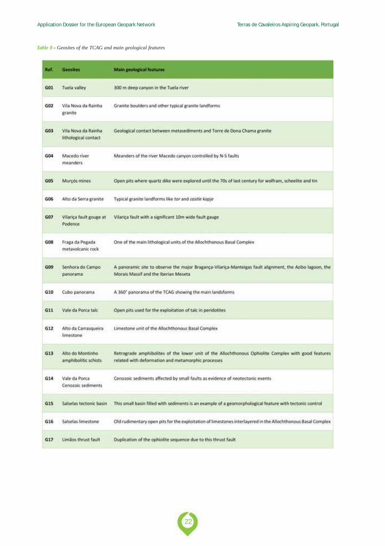
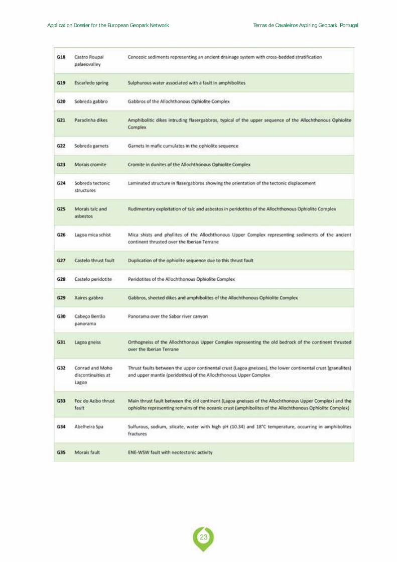
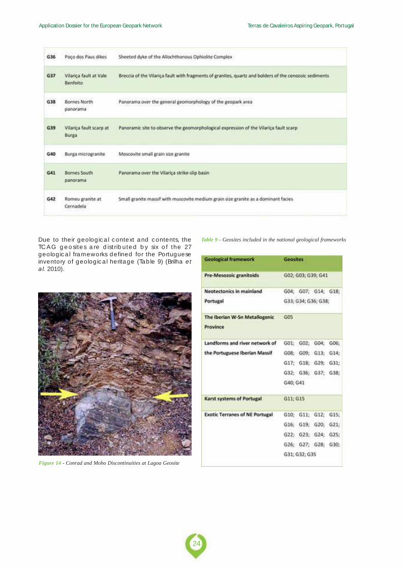
Table 8 - Geosites of the TCAG and main geological features
23
Application Dossier for the European Geopark Network Terras de Cavaleiros Aspiring Geopark, Portugal
Application Dossier for the European Geopark Network Terras de Cavaleiros Aspiring Geopark, Portugal
24
Due to their geological context and contents, theTCAG geosites are distributed by six of the 27geological frameworks defined for the Portugueseinventory of geological heritage (Table 9) (Brilha etal. 2010).
Figure 14 - Conrad and Moho Discontinuities at Lagoa Geosite
Table 9 - Geosites included in the national geological frameworks
25
Application Dossier for the European Geopark Network Terras de Cavaleiros Aspiring Geopark, Portugal
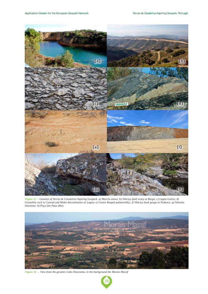
Figure 15 - Geosites of Terras de Cavaleiros Aspiring Geopark. a) Murcós mines; b) Vilariça fault scarp at Burga; c) Lagoa Gneiss; d)Granultite rock in Conrad and Moho discontinuties at Lagoa; e) Castro Roupal palaeovalley; f) Vilariça fault gouge at Podence; g) Salselaslimestone; h) Poço dos Paus dikes
Figure 16 - View from the geosites Cubo Panorama, in the background the Morais Massif
Application Dossier for the European Geopark Network Terras de Cavaleiros Aspiring Geopark, Portugal
26
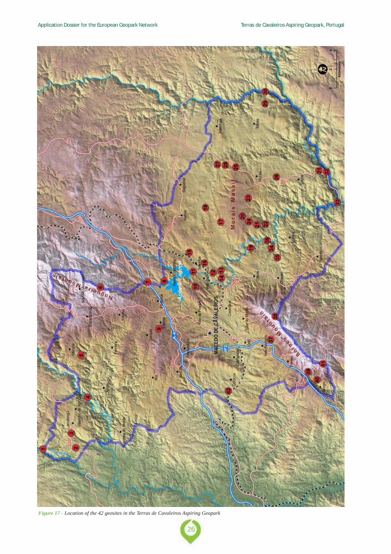
Figure 17 - Location of the 42 geosites in the Terras de Cavaleiros Aspiring Geopark
27
Application Dossier for the European Geopark Network Terras de Cavaleiros Aspiring Geopark, Portugal
B4. Details on the interest of these sites interms of their international, national,regional or local valueThe analysis of the relevance of geosites was basedin The National Inventory of geological heritage:methodological approach and results (Brilha et al.2010). From the 42 geosites, there are 11 geositesincluded in this inventory, of which four (G17, G31,G32, G33) have international relevance (Table 10).
As already explained, the inventory of geosites in theTCAG was based on the scientific value. These 42geosites are currently evaluated for a second timewith respect to their potential educational and tourismuses. However, based on several criteria such asscenery, accessibility, and interpretation potential,several geosites were already selected to be used inthe geopark geotourism strategy (Figure 18). Thesegeosites also stand out for their cultural, economic,archaeological, historical and/or aesthetic values(Table 10).
Table 10 - Relevance and values/uses of the geosites of the Terras deCavaleiros Aspiring GeoparkLegend: Int (International), Nat (National) Reg (Regional), Loc(Local); Sci (Scientific), Geot (Geotourism), Edu (Educational); Arc(Archaeological), Cul (Cultural)
Figure 18 - Teachers training at Foz do Azibo geosite
Application Dossier for the European Geopark Network Terras de Cavaleiros Aspiring Geopark, Portugal
28
C. Geoconservation
29
Application Dossier for the European Geopark Network Terras de Cavaleiros Aspiring Geopark, Portugal
C1. Current or potential pressure on theproposed Geopark
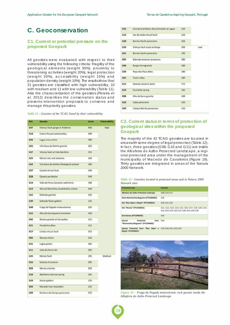
All geosites were evaluated with respect to theirvulnerability using the following criteria: Fragility of thegeological elements (weight 35%), proximity tothreatening activities (weight 20%), legal protection(weight 20%), accessibility (weight 15%) andpopulation density (weight 10%). The results show that21 geosites are classified with high vulnerability, 10with medium and 11 with low vulnerability (Table 11).Also the characterization of the geosites (Pereira etal. 2012) describes the conservation status andpresents intervention proposals to conserve andmanage this priority geosites.
C. Geoconservation
Table 11 - Geosites of the TCAG listed by their vulnerability
C2. Current status in terms of protection ofgeological sites within the proposedGeoparkThe majority of the 42 TCAG geosites are located inareas with some degree of legal protection (Table 12).In fact, three geosites (G08, G10 and G11) are insidethe Albufeira do Azibo Protected Landscape, a regi-onal protected area under the management of themunicipality of Macedo de Cavaleiros (Figure 19).Thirty geosites are integrated in areas of the Natura2000 Network.
Table 12 - Geosites located in protected areas and in Natura 2000Network sites
Figure 19 - Fraga da Pegada metavolcanic rock geosite inside theAlbufeira do Azibo Protected Landscape
Application Dossier for the European Geopark Network Terras de Cavaleiros Aspiring Geopark, Portugal
30
C3. Data on the management andmaintenance of these sitesThe evaluation of vulnerability constitutes the first stepto the establishment of the geosites managementpriorities. A detailed survey of the threats affecting thegeosites was developed, especially for the 21 geositeswith high vulnerability. This survey will allow theimplementation of mitigation measures for the mainthreats. In the context of the touristic evaluation,accessibility constitutes one of the evaluated aspects.Currently, there are ongoing interventions to improvethe access conditions to geosites. The safety of visitorshas also been considered, particularly in two geosites:G11 Vale da Porca talc and G16 Salselas limestone.
The geopark has also developed a Geological Routedesigned primarily to support geology research andteaching. The shorter route with 50.5 km links 10geosites, the longer one has 110 km and extends inthe TCAG periphery. This geological route of scientificand educational character allows visitors to learn thegeology of the Morais Polimetamorphic Massif. Withinformation distributed in panels placed at strategicsites and intended primarily for the secondary schoolstudents and university education, this route isassumed as a benchmark in education, disseminationand awareness for the preservation of the uniquegeodiversity of Terras de Cavaleiros Aspiring Geopark.This route has as reception and support infrastructurethe Geological Information Centre of Morais.
In order to promote these routes, a guide-book,interpretive panels, Android and iPhone Apps, and QRCode readers were implemented. Taking intoconsideration the visitation of school-age kids andschool groups, the TCAG has the Centre of GeologicalInterpretation of Morais, which is also prepared to assistother types of the public.
Training and information sessions were developed forthe local police forces in order to raise awarenessabout the need to conduct regular inspections in the
main geosites. Cleaning and promotion actions havebeen done in the geosites with touristic potential.
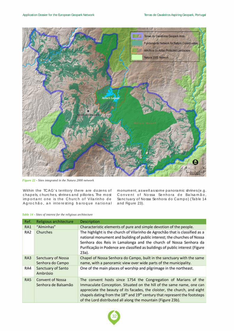
C4. Listing and description ofnon-geological sites and how they areintegrated into the proposed GeoparkThe municipality of Macedo de Cavaleiros holds aremarkable collection of natural and cultural valuesin addition to the high geological interest. Some ofthese natural occurrences are part of the Natura 2000Network: Montesinho/Nogueira (PTCON0002), Saborand Maçãs Rivers (PTCON0021), Morais (PTCON0023),Romeu (PTCON0043) and Special Protection ZonesSabor and Maçãs rivers (PTZPE0037) and Montesinho/Nogueira (PTCON0002). The territory has also animportant area under the designation of the Funda-mental Network for Nature Conservation that includesthe reserves RAN (National Agricultural Reserve) andREN (National Ecological Reserve) (Figure 22).
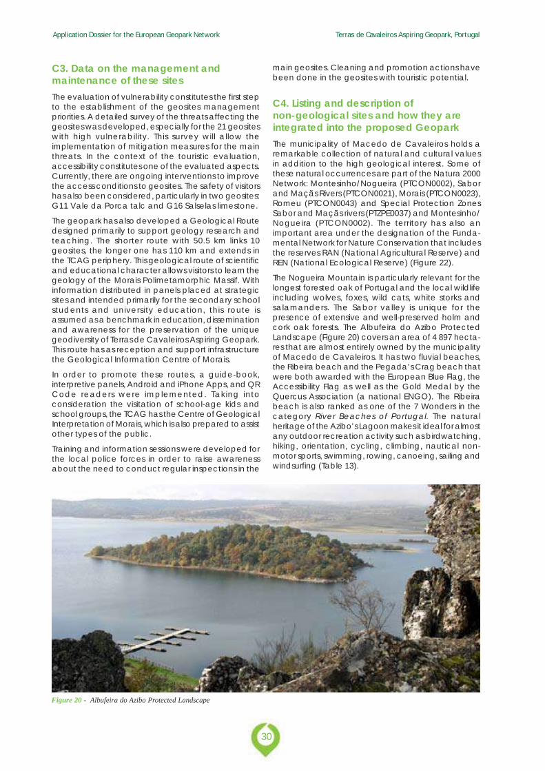
The Nogueira Mountain is particularly relevant for thelongest forested oak of Portugal and the local wildlifeincluding wolves, foxes, wild cats, white storks andsalamanders. The Sabor valley is unique for thepresence of extensive and well-preserved holm andcork oak forests. The Albufeira do Azibo ProtectedLandscape (Figure 20) covers an area of 4 897 hecta-res that are almost entirely owned by the municipalityof Macedo de Cavaleiros. It has two fluvial beaches,the Ribeira beach and the Pegada’s Crag beach thatwere both awarded with the European Blue Flag, theAccessibility Flag as well as the Gold Medal by theQuercus Association (a national ENGO). The Ribeirabeach is also ranked as one of the 7 Wonders in thecategory River Beaches of Portugal. The naturalheritage of the Azibo’s Lagoon makes it ideal for almostany outdoor recreation activity such as birdwatching,hiking, orientation, cycling, climbing, nautical non-motor sports, swimming, rowing, canoeing, sailing andwindsurfing (Table 13).
Figure 20 - Albufeira do Azibo Protected Landscape
31
Application Dossier for the European Geopark Network Terras de Cavaleiros Aspiring Geopark, Portugal
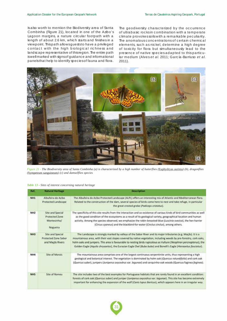
Is also worth to mention the Biodiversity area of SantaCombinha (Figure 21), located in one of the Azibo’sLagoon margins, a nature circular footpath with alength of about 2.6 km, which starts and finishes in aviewpoint. This path allows guests to have a privilegedcontact with the high biological richness andlandscape representative of this region. The entire pathis well marked with signs of guidance and informationalpanels that help to identify species of fauna and flora.
The geodiversity characterized by the occurrenceof ultrabasic rocks in combination with a temperateclimate provokes soils with a remarkable peculiarity.The anomalous concentrations of certain chemicalelements, such as nickel, determine a high degreeof toxicity for flora but simultaneously lead to thepresence of native species adapted to this particu-lar medium (Alves et al. 2011; García-Barriuso et al.2011).
Figure 21 - The Biodiversity area of Santa Combinha (a) is characterized by a high number of butterflies (Euphydryas aurinia) (b), dragonflies(Sympetrum sanguineum) (c) and damselflies species
Table 13 - Sites of interest concerning natural heritage
Application Dossier for the European Geopark Network Terras de Cavaleiros Aspiring Geopark, Portugal
32
Figure 22 - Sites integrated in the Natura 2000 network
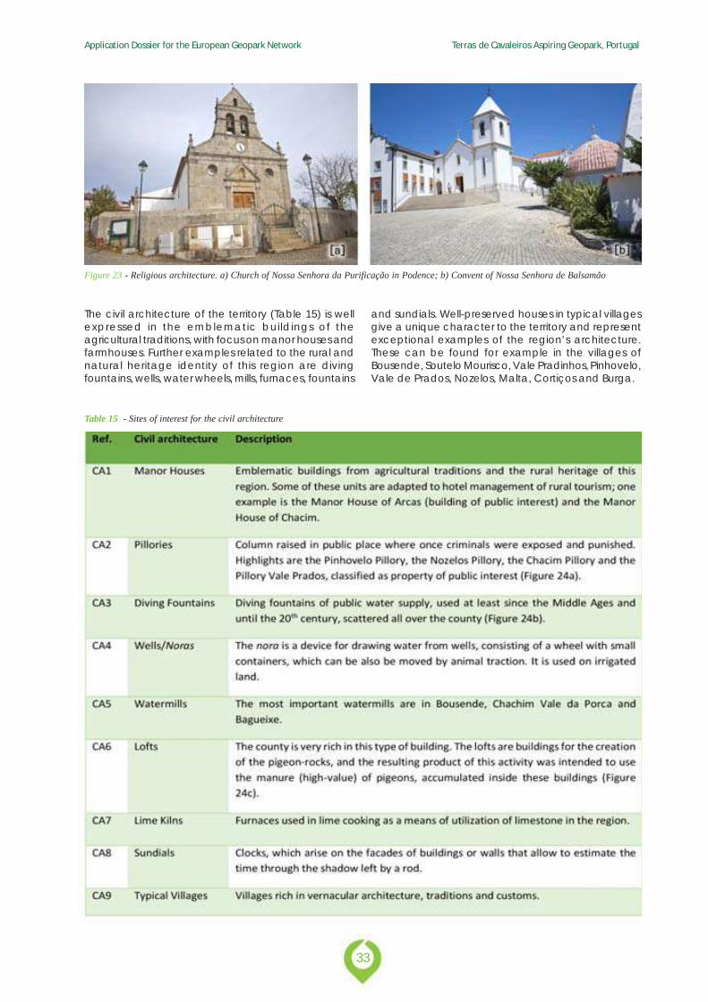
Within the TCAG’s territory there are dozens ofchapels, churches, shrines and pillories. The mostimportant one is the Church of Vilarinho deAgrochão, an interest ing baroque national
monument, as well as some panoramic shrines (e.g.Convent of Nossa Senhora de Balsamão,Sanctuary of Nossa Senhora do Campo) (Table 14and Figure 23).
Table 14 - Sites of interest for the religious architecture
33
Application Dossier for the European Geopark Network Terras de Cavaleiros Aspiring Geopark, Portugal
Figure 23 - Religious architecture. a) Church of Nossa Senhora da Purificação in Podence; b) Convent of Nossa Senhora de Balsamão
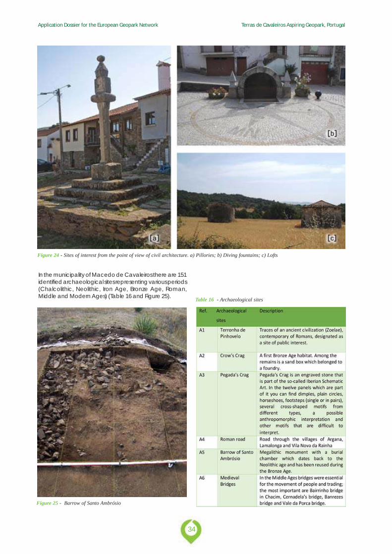
The civil architecture of the territory (Table 15) is wellexpressed in the emblematic buildings of theagricultural traditions, with focus on manor houses andfarmhouses. Further examples related to the rural andnatural heritage identity of this region are divingfountains, wells, water wheels, mills, furnaces, fountains
and sundials. Well-preserved houses in typical villagesgive a unique character to the territory and representexceptional examples of the region’s architecture.These can be found for example in the villages ofBousende, Soutelo Mourisco, Vale Pradinhos, Pinhovelo,Vale de Prados, Nozelos, Malta, Cortiços and Burga.
Table 15 - Sites of interest for the civil architecture
Application Dossier for the European Geopark Network Terras de Cavaleiros Aspiring Geopark, Portugal
34
Figure 24 - Sites of interest from the point of view of civil architecture. a) Pillories; b) Diving fountains; c) Lofts
In the municipality of Macedo de Cavaleiros there are 151identified archaeological sites representing various periods(Chalcolithic, Neolithic, Iron Age, Bronze Age, Roman,Middle and Modern Ages) (Table 16 and Figure 25).
Figure 25 - Barrow of Santo Ambrósio
Table 16 - Archaeological sites
35
Application Dossier for the European Geopark Network Terras de Cavaleiros Aspiring Geopark, Portugal
D. Economic Activity & Business Plan
Application Dossier for the European Geopark Network Terras de Cavaleiros Aspiring Geopark, Portugal
36
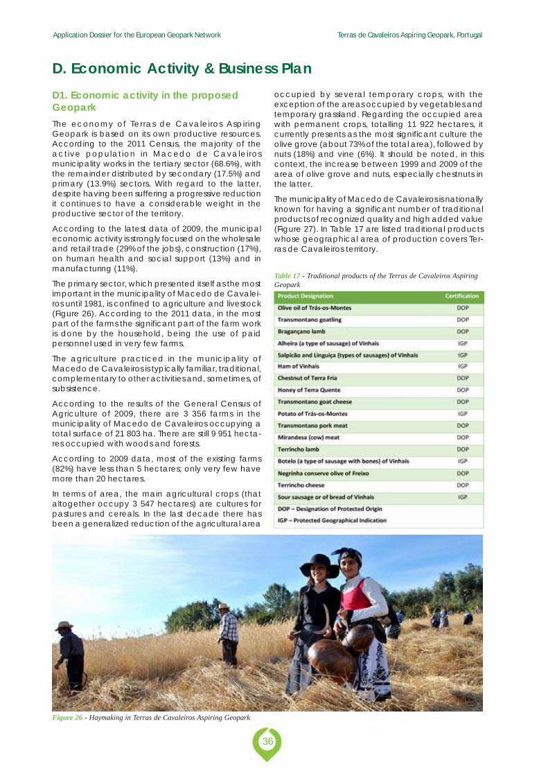
D1. Economic activity in the proposedGeoparkThe economy of Terras de Cavaleiros AspiringGeopark is based on its own productive resources.According to the 2011 Census, the majority of theactive population in Macedo de Cavaleirosmunicipality works in the tertiary sector (68.6%), withthe remainder distributed by secondary (17.5%) andprimary (13.9%) sectors. With regard to the latter,despite having been suffering a progressive reductionit continues to have a considerable weight in theproductive sector of the territory.
According to the latest data of 2009, the municipaleconomic activity is strongly focused on the wholesaleand retail trade (29% of the jobs), construction (17%),on human health and social support (13%) and inmanufacturing (11%).
The primary sector, which presented itself as the mostimportant in the municipality of Macedo de Cavalei-ros until 1981, is confined to agriculture and livestock(Figure 26). According to the 2011 data, in the mostpart of the farms the significant part of the farm workis done by the household, being the use of paidpersonnel used in very few farms.
The agriculture practiced in the municipality ofMacedo de Cavaleiros is typically familiar, traditional,complementary to other activities and, sometimes, ofsubsistence.
According to the results of the General Census ofAgriculture of 2009, there are 3 356 farms in themunicipality of Macedo de Cavaleiros occupying atotal surface of 21 803 ha. There are still 9 951 hecta-res occupied with woods and forests.
According to 2009 data, most of the existing farms(82%) have less than 5 hectares; only very few havemore than 20 hectares.
In terms of area, the main agricultural crops (thataltogether occupy 3 547 hectares) are cultures forpastures and cereals. In the last decade there hasbeen a generalized reduction of the agricultural area
D. Economic Activity & Business Plan
Figure 26 - Haymaking in Terras de Cavaleiros Aspiring Geopark
occupied by several temporary crops, with theexception of the areas occupied by vegetables andtemporary grassland. Regarding the occupied areawith permanent crops, totalling 11 922 hectares, itcurrently presents as the most significant culture theolive grove (about 73% of the total area), followed bynuts (18%) and vine (6%). It should be noted, in thiscontext, the increase between 1999 and 2009 of thearea of olive grove and nuts, especially chestnuts inthe latter.
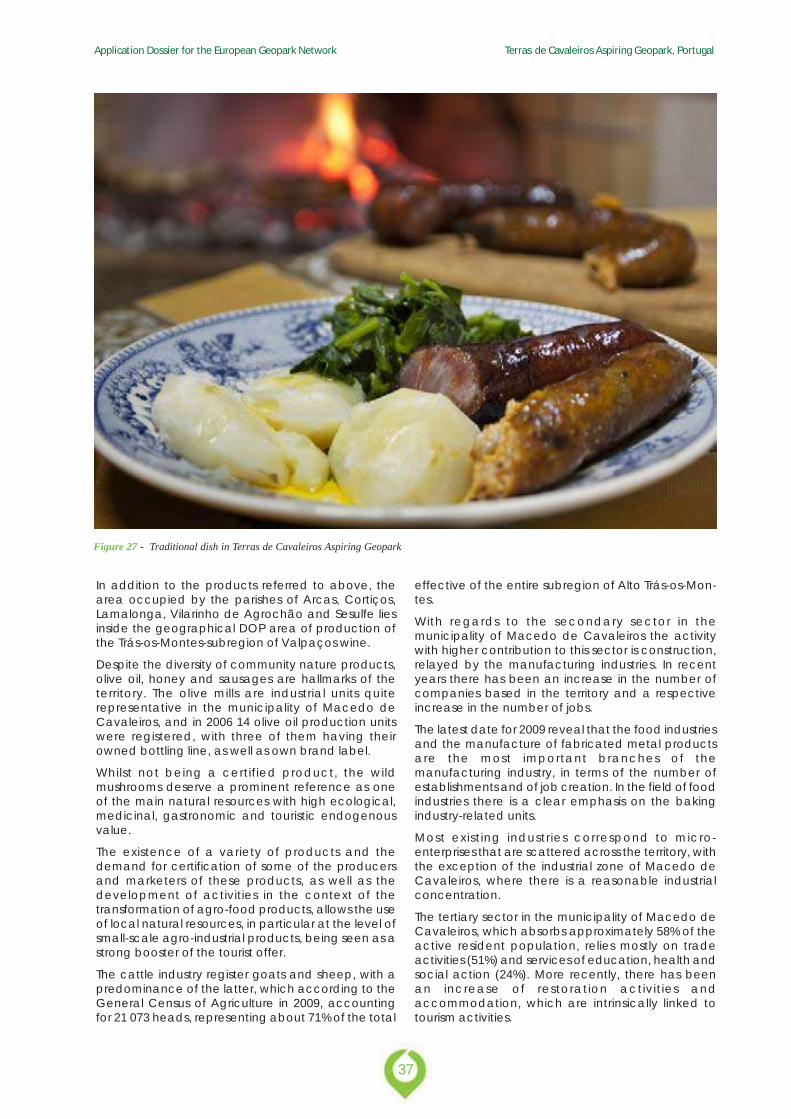
The municipality of Macedo de Cavaleiros is nationallyknown for having a significant number of traditionalproducts of recognized quality and high added value(Figure 27). In Table 17 are listed traditional productswhose geographical area of production covers Ter-ras de Cavaleiros territory.
Table 17 - Traditional products of the Terras de Cavaleiros AspiringGeopark
37
Application Dossier for the European Geopark Network Terras de Cavaleiros Aspiring Geopark, Portugal
Figure 27 - Traditional dish in Terras de Cavaleiros Aspiring Geopark
In addition to the products referred to above, thearea occupied by the parishes of Arcas, Cortiços,Lamalonga, Vilarinho de Agrochão and Sesulfe liesinside the geographical DOP area of production ofthe Trás-os-Montes-subregion of Valpaços wine.
Despite the diversity of community nature products,olive oil, honey and sausages are hallmarks of theterritory. The olive mills are industrial units quiterepresentative in the municipality of Macedo deCavaleiros, and in 2006 14 olive oil production unitswere registered, with three of them having theirowned bottling line, as well as own brand label.
Whilst not being a certified product, the wildmushrooms deserve a prominent reference as oneof the main natural resources with high ecological,medicinal, gastronomic and touristic endogenousvalue.
The existence of a variety of products and thedemand for certification of some of the producersand marketers of these products, as well as thedevelopment of activities in the context of thetransformation of agro-food products, allows the useof local natural resources, in particular at the level ofsmall-scale agro-industrial products, being seen as astrong booster of the tourist offer.
The cattle industry register goats and sheep, with apredominance of the latter, which according to theGeneral Census of Agriculture in 2009, accountingfor 21 073 heads, representing about 71% of the total
effective of the entire subregion of Alto Trás-os-Mon-tes.
With regards to the secondary sector in themunicipality of Macedo de Cavaleiros the activitywith higher contribution to this sector is construction,relayed by the manufacturing industries. In recentyears there has been an increase in the number ofcompanies based in the territory and a respectiveincrease in the number of jobs.
The latest date for 2009 reveal that the food industriesand the manufacture of fabricated metal productsare the most important branches of themanufacturing industry, in terms of the number ofestablishments and of job creation. In the field of foodindustries there is a clear emphasis on the bakingindustry-related units.
Most existing industries correspond to micro-enterprises that are scattered across the territory, withthe exception of the industrial zone of Macedo deCavaleiros, where there is a reasonable industrialconcentration.
The tertiary sector in the municipality of Macedo deCavaleiros, which absorbs approximately 58% of theactive resident population, relies mostly on tradeactivities (51%) and services of education, health andsocial action (24%). More recently, there has beenan increase of restoration activities andaccommodation, which are intrinsically linked totourism activities.
Application Dossier for the European Geopark Network Terras de Cavaleiros Aspiring Geopark, Portugal
38
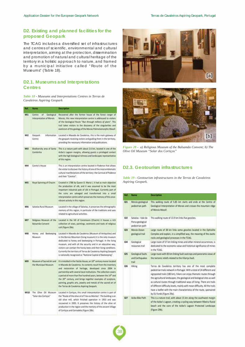
D2. Existing and planned facilities for theproposed GeoparkThe TCAG includes a diversified set of infrastructuresand centres of scientific, environmental and culturalinterpretation, aiming at the protection, disseminationand promotion of natural and cultural heritage of theterritory in a holistic approach to nature, and framedby a municipal initiative called “Route of theMuseums” (Table 18).
D2.1. Museums and InterpretationsCentres
Table 18 - Museums and Interpretations Centres in Terras deCavaleiros Aspiring Geopark
Figure 28 - a) Religious Museum of the Balsamão Convent; b) TheOlive Oil Museum “Solar dos Cortiços”
D2.3. Geotourism infrastructures
Table 19 - Geotourism infrastructures in the Terras de CavaleirosAspiring Geopark.
39
Application Dossier for the European Geopark Network Terras de Cavaleiros Aspiring Geopark, Portugal
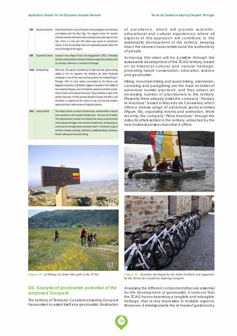
Figure 29 - a) Hiking; b) Azibo bike path in the TCAG
D3. Analysis of geotourism potential of theproposed GeoparkThe territory of Terras de Cavaleiros Aspiring Geoparkhas as vision to assert itself as a geotouristic destination
of excellence, which will provide scientific,educational and cultural experiences, where allaspects of this approach will contribute to thesustainable development of the territory, keepingintact the natural characteristics and the authenticityof people.
Achieving this vision will be possible through thesustainable development of the TCAG territory, basedon its historical-cultural and natural heritage,promoting nature conservation, education, scienceand geotourism.
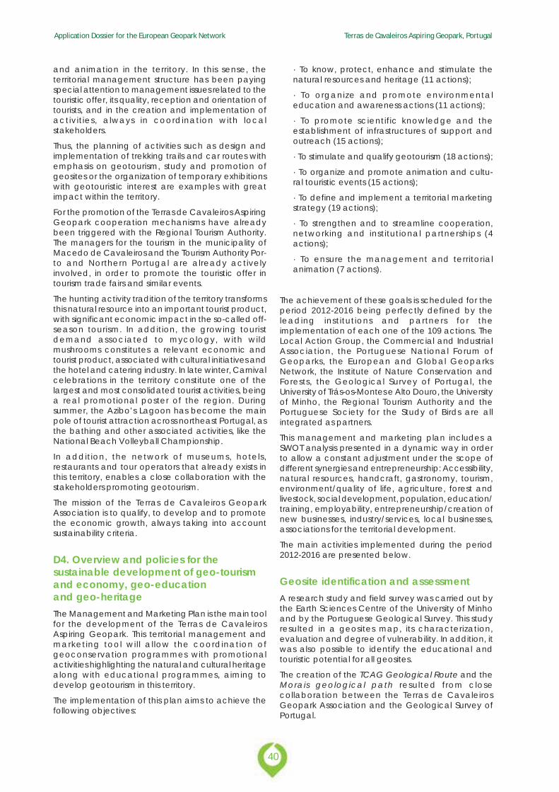
Hiking, mountain biking and quad-biking, orientation,canoeing and paragliding are the main activities ofadventure tourism practiced, and they attract anincreasing number of practitioners to the territory.Presently there already exists the company “Nordes-te Aventura” based in Macedo de Cavaleiros, whichoffers a diverse range of adventure sports activities(Figure 30), organizing events and animation. Morerecently, the company “Pena Aventura” through theAzibo EcoPark settled in the territory, attracted by thenew business perspectives that it offers.
Figure 30 - Activities developed by the Azibo EcoPark and supportedby the Terras de Cavaleiros Aspiring Geopark
Analysing the different components that are essentialfor the development of geotourism, it turns out thatthe TCAG has on its territory a tangible and intangibleheritage, that is very impressive in multiple aspects.Moreover, it is indisputable the richness of gastronomy
Application Dossier for the European Geopark Network Terras de Cavaleiros Aspiring Geopark, Portugal
40
and animation in the territory. In this sense, theterritorial management structure has been payingspecial attention to management issues related to thetouristic offer, its quality, reception and orientation oftourists, and in the creation and implementation ofactivities, always in coordination with localstakeholders.
Thus, the planning of activities such as design andimplementation of trekking trails and car routes withemphasis on geotourism, study and promotion ofgeosites or the organization of temporary exhibitionswith geotouristic interest are examples with greatimpact within the territory.
For the promotion of the Terras de Cavaleiros AspiringGeopark cooperation mechanisms have alreadybeen triggered with the Regional Tourism Authority.The managers for the tourism in the municipality ofMacedo de Cavaleiros and the Tourism Authority Por-to and Northern Portugal are already activelyinvolved, in order to promote the touristic offer intourism trade fairs and similar events.
The hunting activity tradition of the territory transformsthis natural resource into an important tourist product,with significant economic impact in the so-called off-season tourism. In addition, the growing touristdemand associated to mycology, with wildmushrooms constitutes a relevant economic andtourist product, associated with cultural initiatives andthe hotel and catering industry. In late winter, Carnivalcelebrations in the territory constitute one of thelargest and most consolidated tourist activities, beinga real promotional poster of the region. Duringsummer, the Azibo’s Lagoon has become the mainpole of tourist attraction across northeast Portugal, asthe bathing and other associated activities, like theNational Beach Volleyball Championship.
In addition, the network of museums, hotels,restaurants and tour operators that already exists inthis territory, enables a close collaboration with thestakeholders promoting geotourism.
The mission of the Terras de Cavaleiros GeoparkAssociation is to qualify, to develop and to promotethe economic growth, always taking into accountsustainability criteria.
D4. Overview and policies for thesustainable development of geo-tourismand economy, geo-educationand geo-heritageThe Management and Marketing Plan is the main toolfor the development of the Terras de CavaleirosAspiring Geopark. This territorial management andmarketing tool will allow the coordination ofgeoconservation programmes with promotionalactivities highlighting the natural and cultural heritagealong with educational programmes, aiming todevelop geotourism in this territory.
The implementation of this plan aims to achieve thefollowing objectives:
· To know, protect, enhance and stimulate thenatural resources and heritage (11 actions);
· To organize and promote environmentaleducation and awareness actions (11 actions);
· To promote scientific knowledge and theestablishment of infrastructures of support andoutreach (15 actions);
· To stimulate and qualify geotourism (18 actions);
· To organize and promote animation and cultu-ral touristic events (15 actions);
· To define and implement a territorial marketingstrategy (19 actions);
· To strengthen and to streamline cooperation,networking and institutional partnerships (4actions);
· To ensure the management and territorialanimation (7 actions).
The achievement of these goals is scheduled for theperiod 2012-2016 being perfectly defined by theleading institutions and partners for theimplementation of each one of the 109 actions. TheLocal Action Group, the Commercial and IndustrialAssociation, the Portuguese National Forum ofGeoparks, the European and Global GeoparksNetwork, the Institute of Nature Conservation andForests, the Geological Survey of Portugal, theUniversity of Trás-os-Montes e Alto Douro, the Universityof Minho, the Regional Tourism Authority and thePortuguese Society for the Study of Birds are allintegrated as partners.
This management and marketing plan includes aSWOT analysis presented in a dynamic way in orderto allow a constant adjustment under the scope ofdifferent synergies and entrepreneurship: Accessibility,natural resources, handcraft, gastronomy, tourism,environment/quality of life, agriculture, forest andlivestock, social development, population, education/training, employability, entrepreneurship/creation ofnew businesses, industry/services, local businesses,associations for the territorial development.
The main activities implemented during the period2012-2016 are presented below.
Geosite identification and assessmentA research study and field survey was carried out bythe Earth Sciences Centre of the University of Minhoand by the Portuguese Geological Survey. This studyresulted in a geosites map, its characterization,evaluation and degree of vulnerability. In addition, itwas also possible to identify the educational andtouristic potential for all geosites.
The creation of the TCAG Geological Route and theMorais geological path resulted from closecollaboration between the Terras de CavaleirosGeopark Association and the Geological Survey ofPortugal.
41
Application Dossier for the European Geopark Network Terras de Cavaleiros Aspiring Geopark, Portugal
Enhancing the natural and culturalheritageThe important natural and cultural heritage of theterritory has been under particular attention for overtwo decades, involving associations and other publicand private institutions to boost protection initiativesand promotion of this important heritage. In this sense,it can be highlighted the very characteristic floraconditioned by the occurrence of ultramafic rocks,the richness of the avifauna highly demanded bybirdwatchers, the reference activities on entomologyand herpetology largely associated with the Azibo’sLagoon, and the existence of archaeologicalmonuments.
Several scientists from portuguese universities andpolytechnics have collaborated actively with theterritorial management structure in the field ofgeology, birds, insects and mushrooms. Concerningarchaeology, there is a map of the territory of Macedode Cavaleiros, prepared by the Association ofDefence of the Archaeological Heritage “TerrasQuentes”.
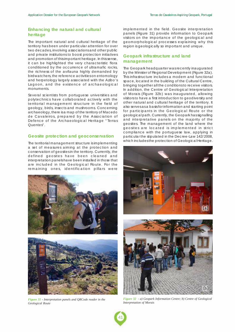
Geosite protection and geoconservationThe territorial management structure is implementinga set of measures aiming at the protection andconservation of geosites in the territory. Currently, thedefined geosites have been cleaned andinterpretation panels have been installed in those thatare included in the Geological Route. For theremaining ones, identification pillars were
implemented in the field. Geosite interpretationpanels (Figure 31) provide information to Geoparkvisitors on the importance of the geological andgeomorphological processes explaining why thisregion is geologically so important and unique.
Geopark infrastructure and landmanagementThe Geopark headquarter was recently inauguratedby the Minister of Regional Development (Figure 32a).This infrastructure includes a modern and functionalspace, located in the building of the Cultural Centre,bringing together all the conditions to receive visitors.In addition, the Centre of Geological Interpretationof Morais (Figure 32b) was inaugurated, allowingvisitors to have a first introduction to geodiversity andother natural and cultural heritage of the territory. Italso serves as a basis for information and starting pointfor participants in the Geological Route or thegeological path. Currently, the Geopark has signallingand interpretative panels on the majority of thegeosites. The management of the land where thegeosites are located is implemented in strictcompliance with the portuguese law, applying inparticular the stipulated in the Decree-Law 142/2008,which includes the protection of Geological Heritage.
Figure 31 - Interpretation panels and QRCode reader in theGeological Route
Figure 32 - a) Geopark Information Centre; b) Centre of GeologicalInterpretation of Morais
Application Dossier for the European Geopark Network Terras de Cavaleiros Aspiring Geopark, Portugal
42
Geo-educationThe Terras de Cavaleiros Aspiring Geopark is aninexorable reference in geology of the IberianPeninsula for many decades. For this reason, everyyear students of the majority of Portuguese universitiesand many Spanish universities come to the territoryto study in loco the geological singularity of the Mo-rais Polimetamorphic Massif. The implementation ofthe Geological Route of the Morais Massif brought anew dynamic to the educational programmesoffered to students of secondary schools anduniversities, which now have better conditions ofaccess to geosites and interpretation of the local andregional geology. In this sense, the Terras de Cavalei-ros Geopark Association supports university fieldcamps and excursions to the territory, helping themwith accommodation in the EcoPark Azibo, locatedin Salselas.
There is a diverse collection of publications about theterritory and its initiatives, which include publications,leaflets and tourism field guides for geotourismactivities.
Figure 33 - Interactive program in the Centre of GeologicalInterpretation of Morais
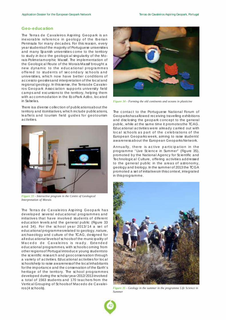
The Terras de Cavaleiros Aspiring Geopark hasdeveloped several educational programmes andinitiatives that have involved students of diferenteducation levels and the general public (Figure 33and 34). For the school year 2013/14 a set ofeducational programmes related to geology, nature,archaeology and culture of the TCAG, designed forall educational levels of schools of the municipality ofMacedo de Cavaleiros is ready. Extendededucational programmes, with schools coming fromother regions of Portugal introduce young students tothe scientific research and geoconservation througha variety of activities. Educational activities for localschools help to raise awareness of the local inhabitantsfor the importance and the conservation of the Earth’sheritage of the territory. The school programmesdeveloped during the scholar year 2012/2013 involveda total of 1563 students and 170 teachers from theVertical Grouping of Schools of Macedo de Cavalei-ros (4 schools).
Figure 34 - Forming the old continents and oceans in plasticine
The contact to the Portuguese National Forum ofGeoparks has allowed receiving travelling exhibitionsand disclosing the geopark concept to the generalpublic, while at the same time it promotes the TCAG.Educational activities were already carried out withlocal schools as part of the celebrations of theEuropean Geoparks week, aiming to raise students’awareness about the European Geoparks Network.
Annually, there is active participation in theprogramme “Live Science in Summer” (Figure 35),promoted by the National Agency for Scientific andTechnological Culture, offering activities addressedto the general public in the areas of astronomy,geology and biology. In the summer of 2013 the TCGApromoted a set of initiatives in this context, integratedin this programme.
Figure 35 - Geology in the summer in the programme Life Science inSummer
43
Application Dossier for the European Geopark Network Terras de Cavaleiros Aspiring Geopark, Portugal
The TCAG has been developing several courses opento the general public:
· Identification and conservation of wildmushrooms;
· Identification of wild orchids;
· Environmental Interpretation guide of Morais Site;
· Insects and plants guide of the Biodiversity areaof Santa Combinha.
Geotouristic and promotional activitiesThe awareness of local stakeholders in conjunctionwith the territorial management structure has allowedto attract an increasing number of visitors and hasprovided more and better information for them.Currently, it is possible to find complete programmestailored to the visitors’ needs, to experience and feelthe TCAG territory. The geopark has prepared sometouristic thematic trails that link several geosites. Thetrails are dedicated to the relation between geologyand society, to natural hazards and to the EarthHistory: Morais ocean path, Geological Resourcespath, and Geological Faults and Earthquakes path.
The offers provided by partners are properly suited tothe seasonality of the events and they start to get moreand more diversified, being accompanied by anincreasingly effective promotion and disseminationby the geopark management structure. In addition,the geopark also organizes several thematic eventsto celebrate special occasions or international days(e.g. Day of the Earth, Day of the Environment,European Geoparks Week, etc.).
The TCAG has made a significant effort on territorialpromotion through participation in media events, astelevision shows broadcasted from the territory, reportsin national media, participation in promotional eventsand tourism fairs. In addition, it has been producingvarious publications for visitors, such as leaflets, field-guides, magazines, brochures, etc. The hikerbackpack is a basic kit equipment that facilitates thevisitors to discover the territory (Figure 36).
Figure 36 - TCAG hiker backpack
Implementation, monitoring and reviewIn order to protect geosites, the TCAG implementeda monitoring programme that provides all thenecessary measures against damage or destruction.This monitoring programme is based in a databasethat considers the geosite location, identification,classification, description, age, land ownership,cleaning and conservation measures.
Monitoring and other geopark operations andservices occur regularly and take into account amanagement with focus on educational, geotouristicand promotional activities, as well as improvementsof the infrastructure and services.
International cooperation and EU fundingAmong the several projects approved with EuropeanUnion funding, it is worth to mention the project “Scrollthrough millions of geological years in the 12 878 haof Morais Site”, whose which main objective is thepreservation of the natural heritage and theinformation of local inhabitants, by raising awarenessfor entrepreneurship. This project featured a FEDERinvestment of 714 845 € and has been reimbursed byFEDER in 85%. Another project worth mentioning is theproject “Macedo Natura”, wherein the mainobjective is the promotion and nature conservationthrough the sustainable use of natural resources,included in the Fundamental Network of NatureConservation of the municipality of Macedo de Ca-valeiros. This project involved a total investment of 596355 € and has been reimbursed by the FEDER in 85%.
D5. Policies for, and examples of,community empowerment in theproposed GeoparkThe management and marketing plan of the territoryreveals a clear choice in geotourism and in thedevelopment of the local economy. In this sense, thegeopark management structure has established anumber of partnerships with local stakeholders, aimingat an increasing offer with high quality standards, inorder to increase visitors’ attraction. The diversity ofevents in the territory allows their attractiveness all yearround, bringing together regional and nationalimportant offers. Illustrative of this reality is the recentrefurbishment of two hotel units.
As another example of this vitality, it should be notedthat the entrepreneurs of Macedo de Cavaleiros havebeen systematically awarded with the prizes “EDPSustainable Entrepreneur”, having collected 1/3 of thetotal of the awards of the referred prize´s threeeditions.
D6. Policies for, and examples of, publicand stakeholder awareness in theproposed GeoparkWith the development of activities directed to localstakeholders, the appearance of new craft formsbeyond traditional wicker and related to flax is
Application Dossier for the European Geopark Network Terras de Cavaleiros Aspiring Geopark, Portugal
44
notorious. In addition, the TCGA begins to collaborateactively with local companies engaged in theproduction and marketing of other local products ofreference. Among these, the production of honey,cheese, and sausages, which are now nationalreference products, must be highlighted.
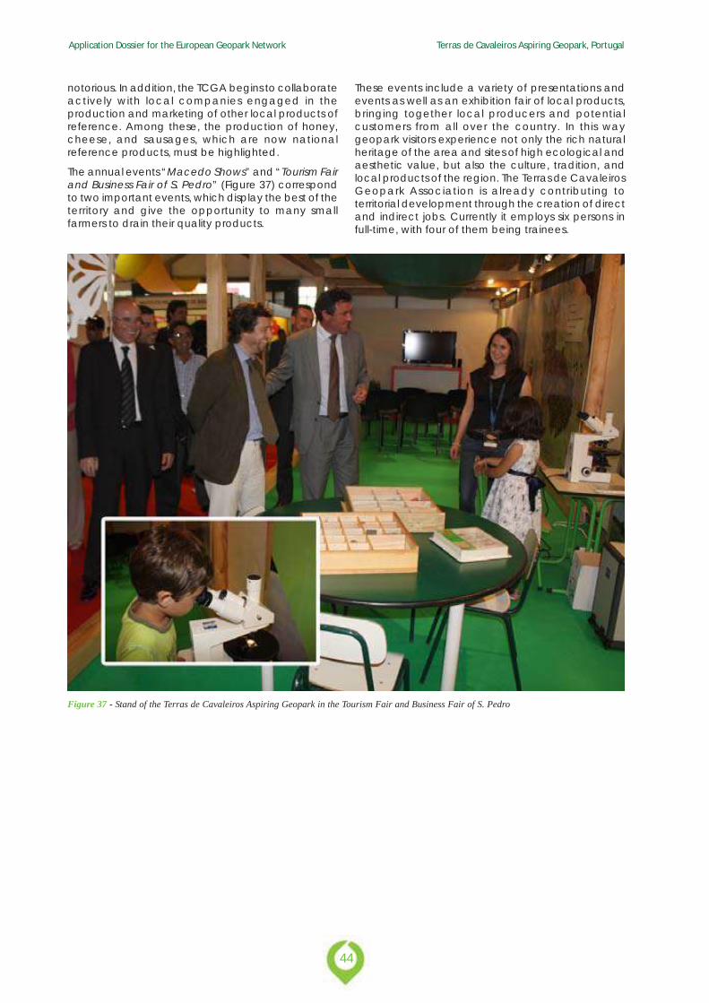
The annual events “Macedo Shows” and “Tourism Fairand Business Fair of S. Pedro” (Figure 37) correspondto two important events, which display the best of theterritory and give the opportunity to many smallfarmers to drain their quality products.
Figure 37 - Stand of the Terras de Cavaleiros Aspiring Geopark in the Tourism Fair and Business Fair of S. Pedro
These events include a variety of presentations andevents as well as an exhibition fair of local products,bringing together local producers and potentialcustomers from all over the country. In this waygeopark visitors experience not only the rich naturalheritage of the area and sites of high ecological andaesthetic value, but also the culture, tradition, andlocal products of the region. The Terras de CavaleirosGeopark Association is already contributing toterritorial development through the creation of directand indirect jobs. Currently it employs six persons infull-time, with four of them being trainees.
45
Application Dossier for the European Geopark Network Terras de Cavaleiros Aspiring Geopark, Portugal
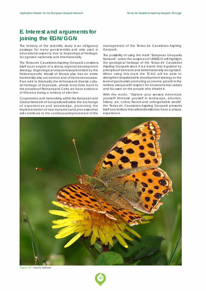
E. Interest and arguments for joining the EGN/GGN
Application Dossier for the European Geopark Network Terras de Cavaleiros Aspiring Geopark, Portugal
46
E. Interest and arguments forjoining the EGN/GGNThe territory of the scientific study is an obligatorypassage for many geoscientists and also used ineducational aspects, due to its geological heritage,recognized nationally and internationally.
The Terras de Cavaleiros Aspiring Geopark considersitself as an engine of a strong regional developmentstrategy. Its geological uniqueness epitomized by thePolimetamorfic Massif of Morais also has an entirebiodiversity also uncommon and of tremendous value.If we add to this reality the richness and diverse cultu-ral heritage of its people, whose roots date back tothe peoples of Romans and Celts, we have evidenceof this area being a territory of election.
Cooperation and networking within the European andGlobal Network of Geoparks will allow the exchangeof experiences and knowledge, promoting theimplementation of new dynamics and processes thatwill contribute to the continuous improvement of the
management of the Terras de Cavaleiros AspiringGeopark.
The possibility of using the mark “European GeoparksNetwork” under the auspices of UNESCO will highlightthe geological heritage of the Terras de CavaleirosAspiring Geopark since it is a brand that is guided byprinciples of demand and is internationally recognized.When using this mark the TCAG will be able tostrengthen its sustainable development strategy to thelevel of geotourism promoting economic growth in theterritory always with respect for environmental valuesand focused on the people who inhabit it.
With the motto: “Explore your senses! Adventureyourself! Immerse yourself in landscape, emotion,history, art, colors, flavors and unforgettable smells”the Terras de Cavaleiros Aspiring Geopark presentsitself as a territory that allows its visitors to have a uniqueexperience.
Figure 38 - Issoria lathonia
47
Application Dossier for the European Geopark Network Terras de Cavaleiros Aspiring Geopark, Portugal
BibliographyCabral J (1995) Neotectónica em Portugal Continental. Memórias doInstituto Geológico e Mineiro 31:265
Calvo J, Daams R, Morales J, Lopez-Martínez N, Agusti J, Anadon P,Armenteros I, Cabrera L, Civis J, Corrochano A, Diaz-Molina M,Elizaga E, Hoyos M, Martin-Suarez E, Martínez J, Moissenet E,Muñoz A, Pérez-Garcia A, Pérez-Gonzalez A, Portero J, Robles F,Santisteban C, Torres T, Van der Meulen AJ, Vera J, Mein P (1993)Up-to-date Spanish continental Neogene synthesis and paleoclimaticinterpretation. Rev Soc Geol Espana 6(3–4):29–40
Cunha PP (1992) Estratigrafia e sedimentologia dos depósitos doCretácico Superior e Terciário de Portugal Central, a leste deCoimbra. Ph.D., Univ. Coimbra, p 262
Dallmeyer R, Martínez Catalán J, Arenas R, Gil Ibarguchi J,Gutiérrez-Alonso G, Farias P, Bastida F, Aller J (1997)DiachronousVariscan tectonothermal activity in the NW IberianMassif: Evidence from 40Ar/39Ar dating of regional fabrics,Tectonophysics, 277:307-337.
De Vicente G, Cloetingh S, Muñoz-Martín A, Olaiz A, Stich D, VegasR, Galindo-Zaldivar J, Fernández-Lozano J (2008) Inversion ofmoment tensor focal mechanisms for active stresses aroundmicrocontinent Iberia: tectonic implications. Tectonics 27:1–22
De Vicente G, Cloetingh S, Van Wees JD, Cunha PP (2011) Tectonicclassification of Cenozoic Iberian foreland basins. Tectonophysics502(1–2):38–61
Ferreira AB (1991) Neotectonics in Northern Portugal. Ageomorphological approach. 2. Geomorph N F sup.-Bd 82:73–85
Martínez-Catalán J (1990) A non-cilindrical model for the northwestIberian allochthonous ter- rones and their equivalents in theHercynian belt of Western Europe. Tectonophysics 179:253-272.
Matte P (1991) Accretionary history and crustal evolution of theVariscan belt in western Europe. Tectonophysics, 196:309-337.
Noronha F, Ferreira N, Marques de Sá C (2006) Rochas granitóides:Caracterização Petrológica e Geoquímica, in Pereira E (coord):Notícia Explicativa da folha 2 da Carta Geológica de Portugal àescala 1/200000. Instituto Nacional de Engenharia, Tecnologia eInovação, Lisboa, 119p.
Pais J, Cunha P, Pereira D, Legoinha P, Dias R, Moura D, Silveira,A,Kullberg J C, González-Delgado J A (2012) The Paleogene andNeogene of Western Iberia (Portugal): A Cenozoic Record in theEuropean Atlantic Domain. SpringerBriefs in Earth Sciences, 158p,DOI: 10.1007/978-3-642-22401-0_1.
Pereira D I (1997) Sedimentologia e estratigrafia do Cenozóico deTrás-os-Montes oriental (NE Portugal). Ph.D., Univ. Minho, p 341
Pereira D I (1998) Enquadramento estratigráfico do Cenozóico deTrás-os-Montes oriental. Comunicações do IGM 84(1):A126–A129Lisboa
Pereira D I (1999) Terciário de Trás-os-Montes oriental: evoluçãogeomorfológica e sedimentar. Comunicações do IGM 86:213–226Lisboa
Pereira D I (2006) Depósitos Cenozóicos. In Pereira E (coord),Notícia Explicativa da Folha 2 da Carta Geológica de Portugal naescala 1:200000, Inst. Geol. Mineiro, pp 43–48
Pereira D I, Azevêdo T M (1991) Origem e evolução dos depósitos decobertura da região de Bragança. Mem. Not. Pub. Mus. Min. Geol.Univ. Coimbra, 112(A): 247–265
Pereira D I, Brilha J (2000) Mineralogia da fracção argilosa daFormação de Vale Álvaro (Bragança, NE Portugal). Ciências daTerra 14:83–88
Pereira D I, Alves M I, Araújo M A, Cunha P P (2000) Estratigrafia einterpretação paleogeográfica do Cenozóico continental do norte dePortugal. Ciências da Terra 14:73–82
Pereira E, Ribeiro A, Castro P (2000) Carta Geológica de Portugal àescala 1:50.000. Notícia explicativa da Folha 7 - D (Macedo deCavaleiros). Serv. Geol. de Portugal. 63p.
Pereira E (coord) (2006) Carta Geológica de Portugal à escala 1/200000. Notícia explicative da Folha 2. Instituto Nacional deEngenharia, Tecnologia e Inovação, Lisboa.
Pereira E, Rodrigues J, Castro P (2012) O Maciço de Morais:Relatório interno TCAG.
Ribeiro A (2013) A evolução Geodinâmica de Portugal: os ciclosante-mesozóicos. Geologia de Portugal, Escolar Editora, Vol I, 11-54
Ribeiro A, Pereira E, Dias R (1990) Structure in the NW of the IberiaPeninsula (Alloctonous sequences). In: Dallmeyer, R.D. and MartinezGarcia, E. (Eds.): Pre-Mesozoic Geology of Iberia, 220-236,Springer-Verlag.
Ribeiro A, Sanderson D (1996) SW-Iberia – Transpressional Orogenyin the Variscides. In: D.G. Gee and H.J. Zeyen (Eds). EUROPROBE-Lithosphere dynamics. Origin and evolution of continents. Publishedby Europrobe secretariate, Uppsala universuty, 138, 1996. SGE-IGME, Madrid, 890 p.
Application Dossier for the European Geopark Network Terras de Cavaleiros Aspiring Geopark, Portugal
48
APPLICATIONANNEXES
49
Application Dossier for the European Geopark Network Terras de Cavaleiros Aspiring Geopark, Portugal
Annex 1 Self Evaluation Document
Application Dossier for the European Geopark Network Terras de Cavaleiros Aspiring Geopark, Portugal
50
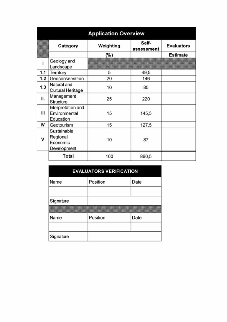
51
Application Dossier for the European Geopark Network Terras de Cavaleiros Aspiring Geopark, Portugal
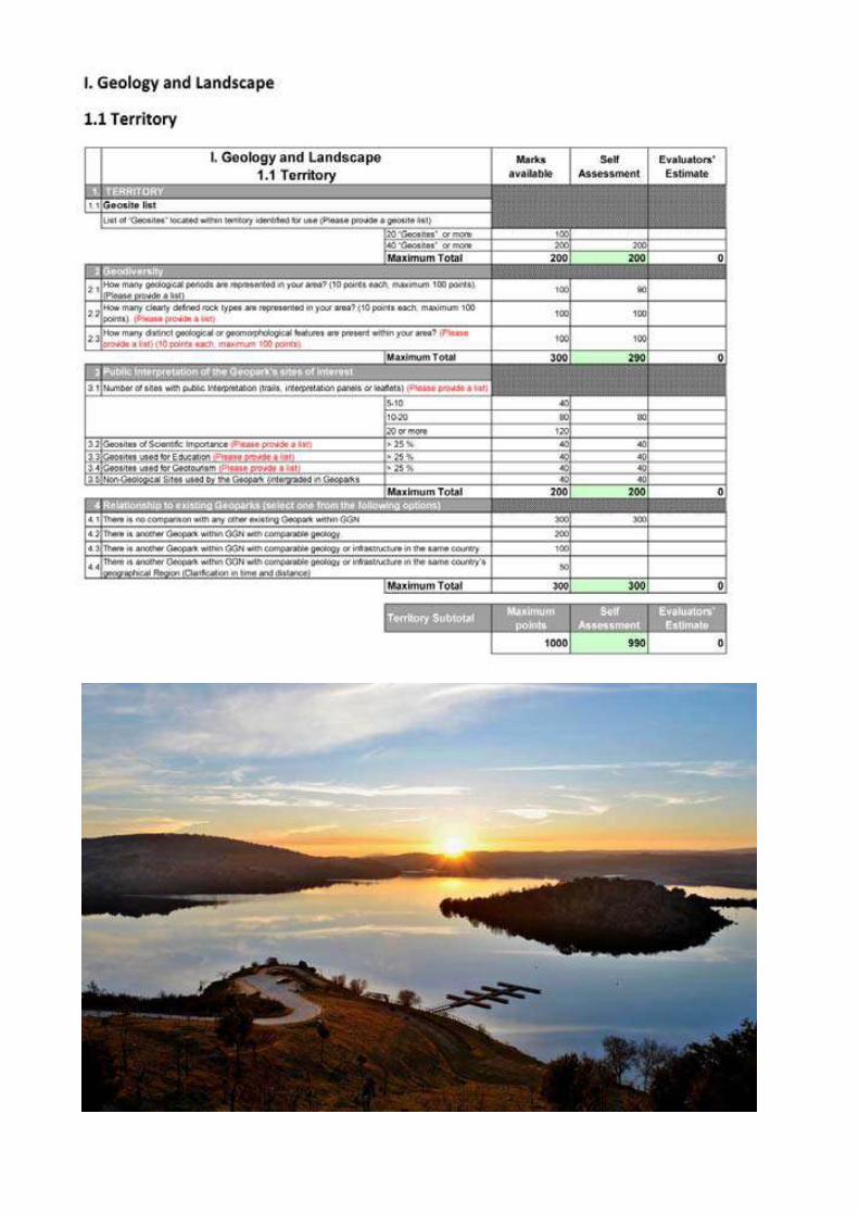
Application Dossier for the European Geopark Network Terras de Cavaleiros Aspiring Geopark, Portugal
52
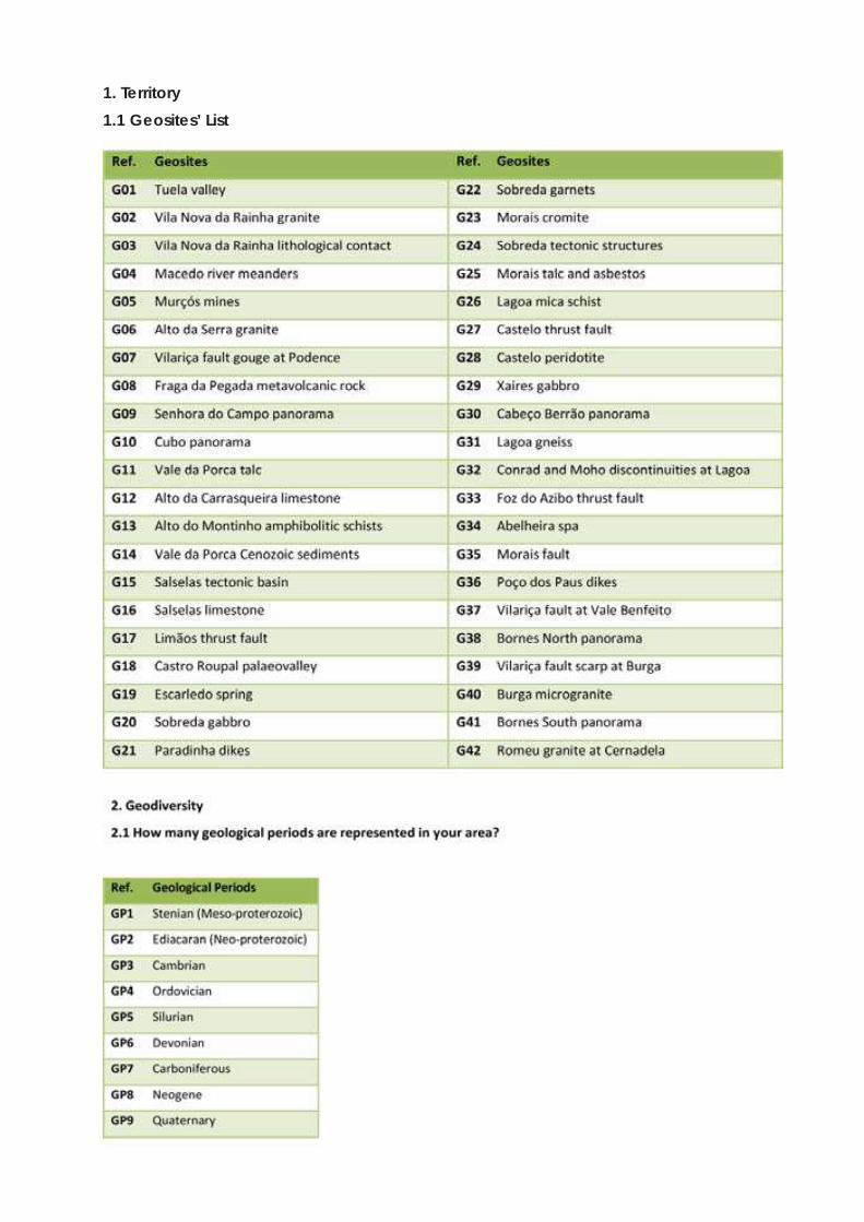
53
Application Dossier for the European Geopark Network Terras de Cavaleiros Aspiring Geopark, Portugal
1. Territory1.1 Geosites’ List
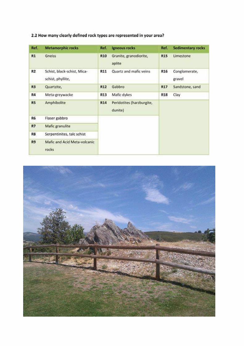
Application Dossier for the European Geopark Network Terras de Cavaleiros Aspiring Geopark, Portugal
54
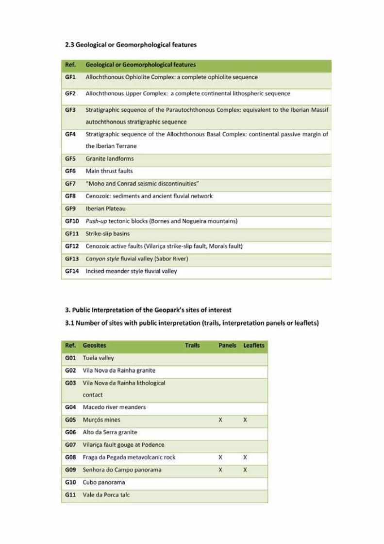
55
Application Dossier for the European Geopark Network Terras de Cavaleiros Aspiring Geopark, Portugal
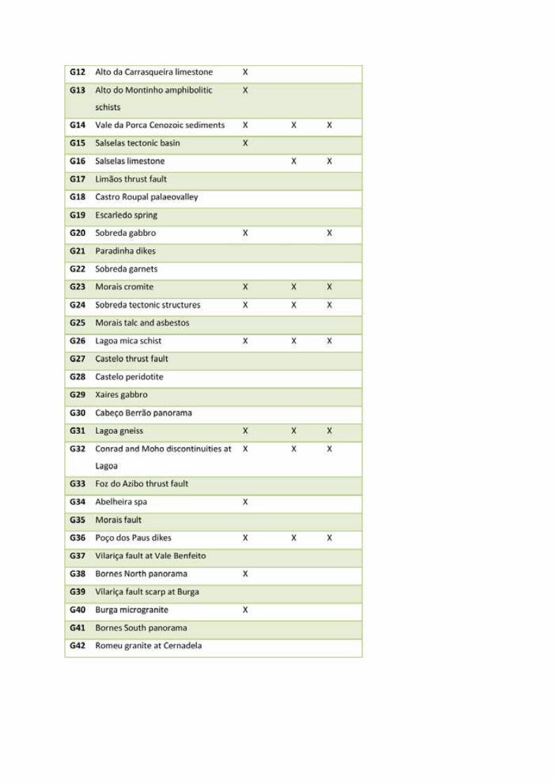
Application Dossier for the European Geopark Network Terras de Cavaleiros Aspiring Geopark, Portugal
56
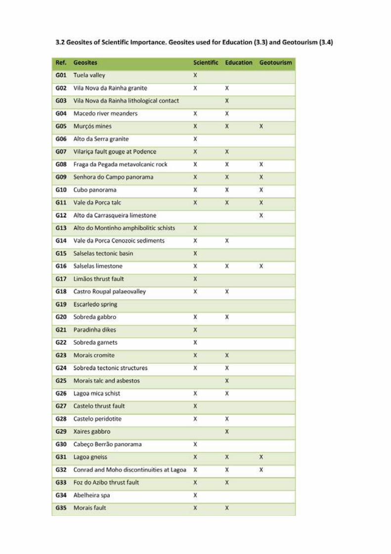
57
Application Dossier for the European Geopark Network Terras de Cavaleiros Aspiring Geopark, Portugal
Application Dossier for the European Geopark Network Terras de Cavaleiros Aspiring Geopark, Portugal
58

59
Application Dossier for the European Geopark Network Terras de Cavaleiros Aspiring Geopark, Portugal
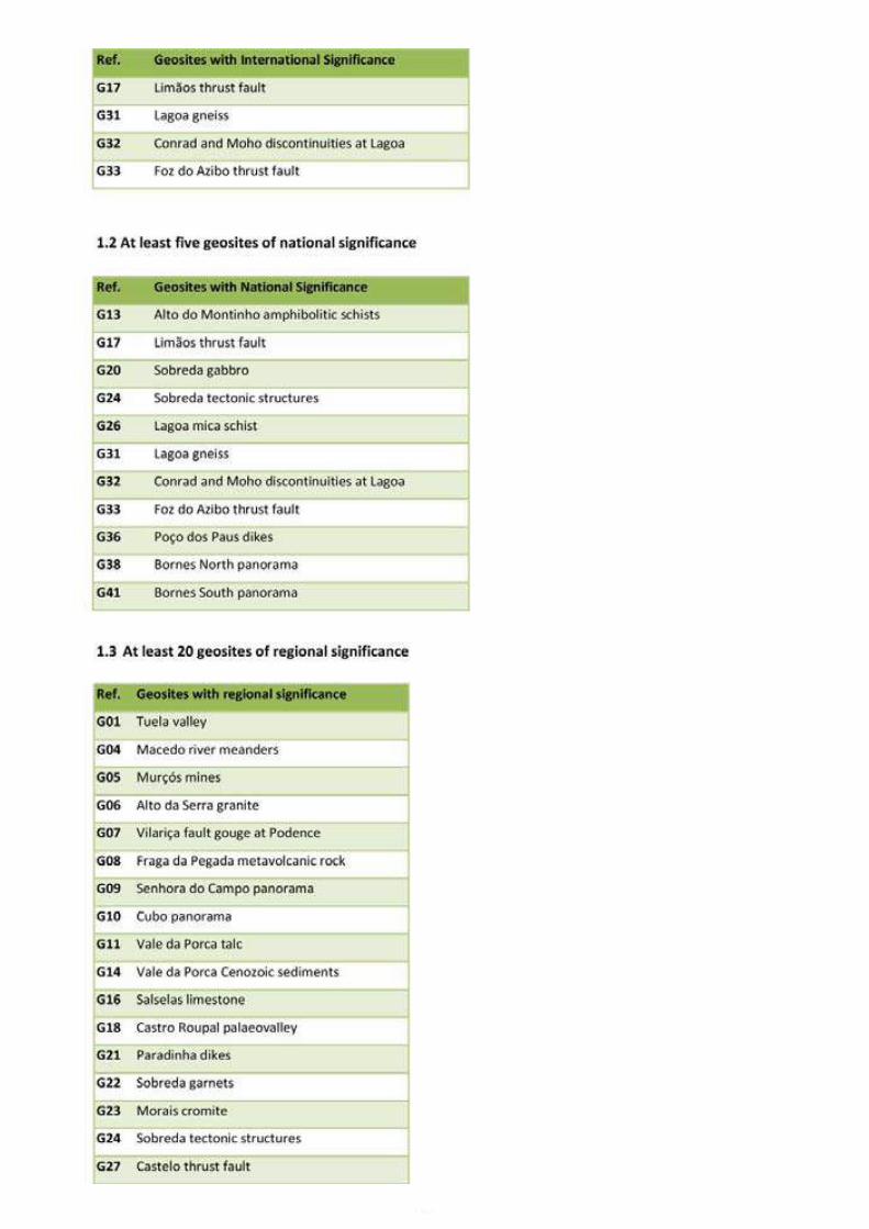
Application Dossier for the European Geopark Network Terras de Cavaleiros Aspiring Geopark, Portugal
60
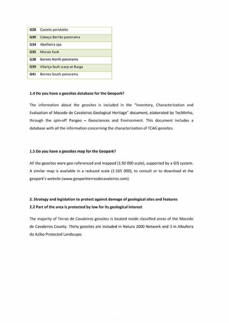
61
Application Dossier for the European Geopark Network Terras de Cavaleiros Aspiring Geopark, Portugal
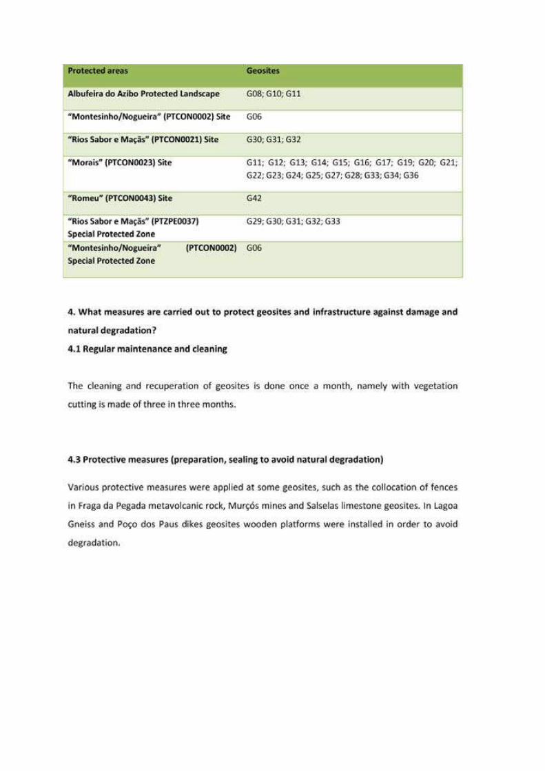
Application Dossier for the European Geopark Network Terras de Cavaleiros Aspiring Geopark, Portugal
62
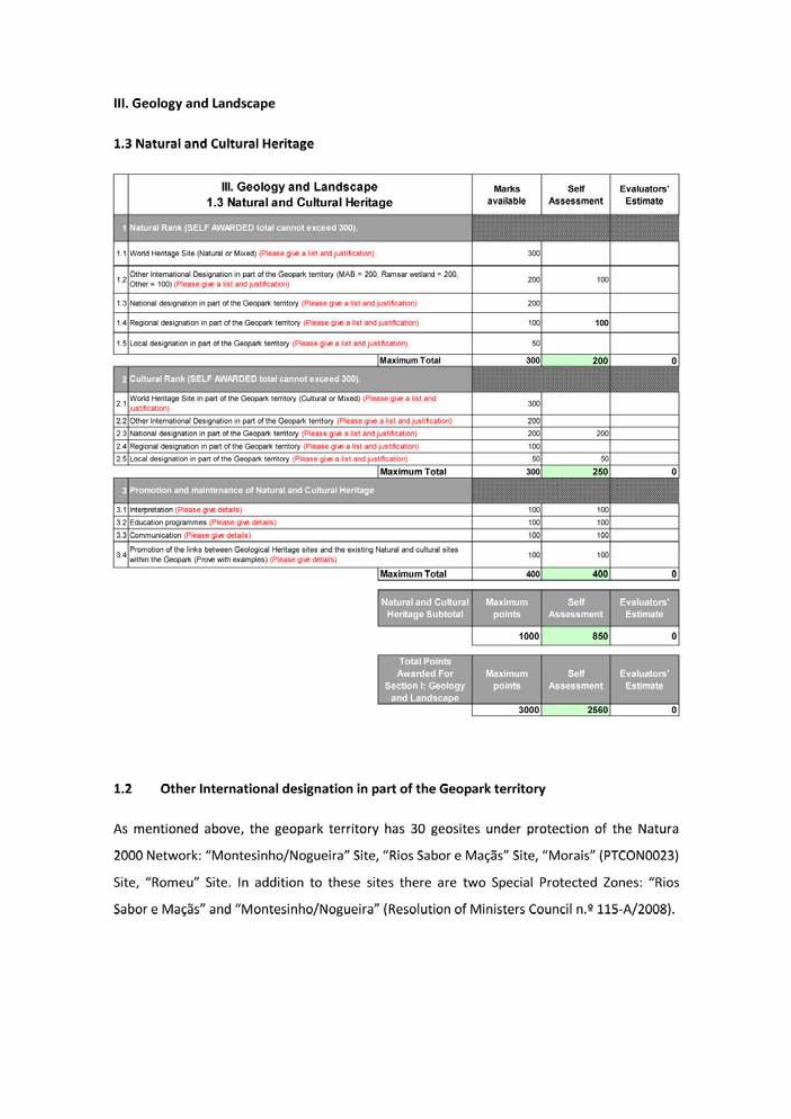
63
Application Dossier for the European Geopark Network Terras de Cavaleiros Aspiring Geopark, Portugal
Application Dossier for the European Geopark Network Terras de Cavaleiros Aspiring Geopark, Portugal
64
65
Application Dossier for the European Geopark Network Terras de Cavaleiros Aspiring Geopark, Portugal
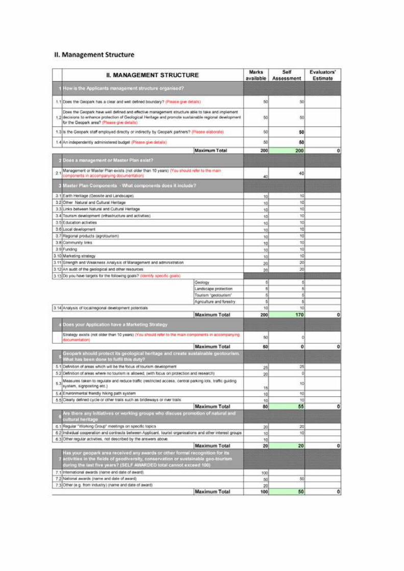
Application Dossier for the European Geopark Network Terras de Cavaleiros Aspiring Geopark, Portugal
66
Region:
Country:
Telephone:
Fax:
Email:
3. Address of Applicant Management Body
1. Name and Country of Applicant territory.
2. Name of the Applicant’s Management Body
Geoparque Terras de Cavaleiros, Portugal/ Lands of Knights Ge
Associacao Geoparque Terras de Cavaleiros/ Terras de Cavale
Global Geoparks Netw
Document A
Applicants Identity
Applicant’s Evaluation Docu
R/C Centro Cultural; Rua Engenheiro Moura Pegado 5340-302 M
geoparq
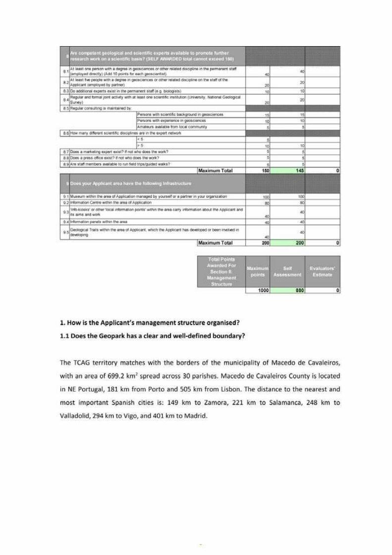
67
Application Dossier for the European Geopark Network Terras de Cavaleiros Aspiring Geopark, Portugal
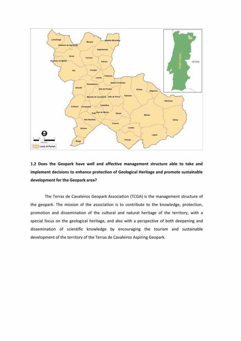
Application Dossier for the European Geopark Network Terras de Cavaleiros Aspiring Geopark, Portugal
68
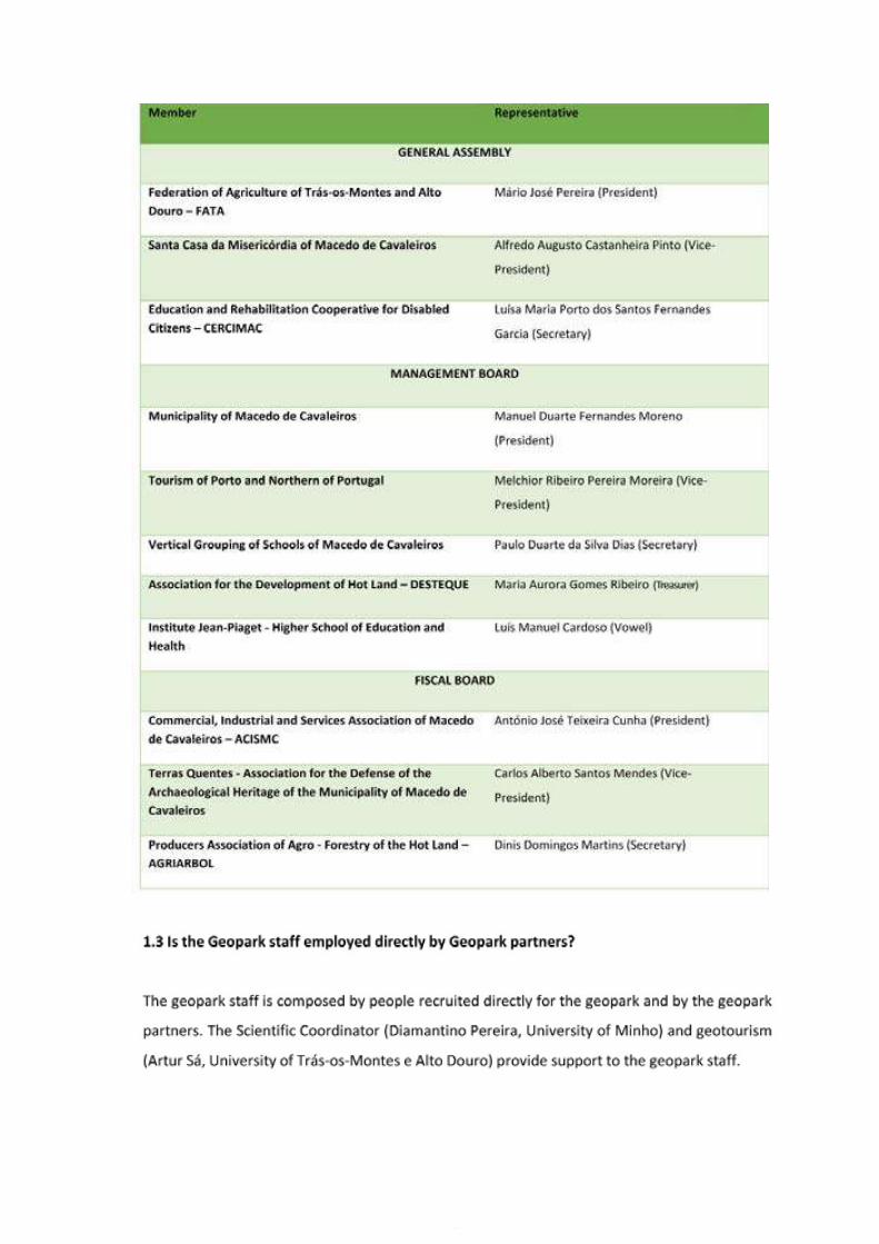
69
Application Dossier for the European Geopark Network Terras de Cavaleiros Aspiring Geopark, Portugal
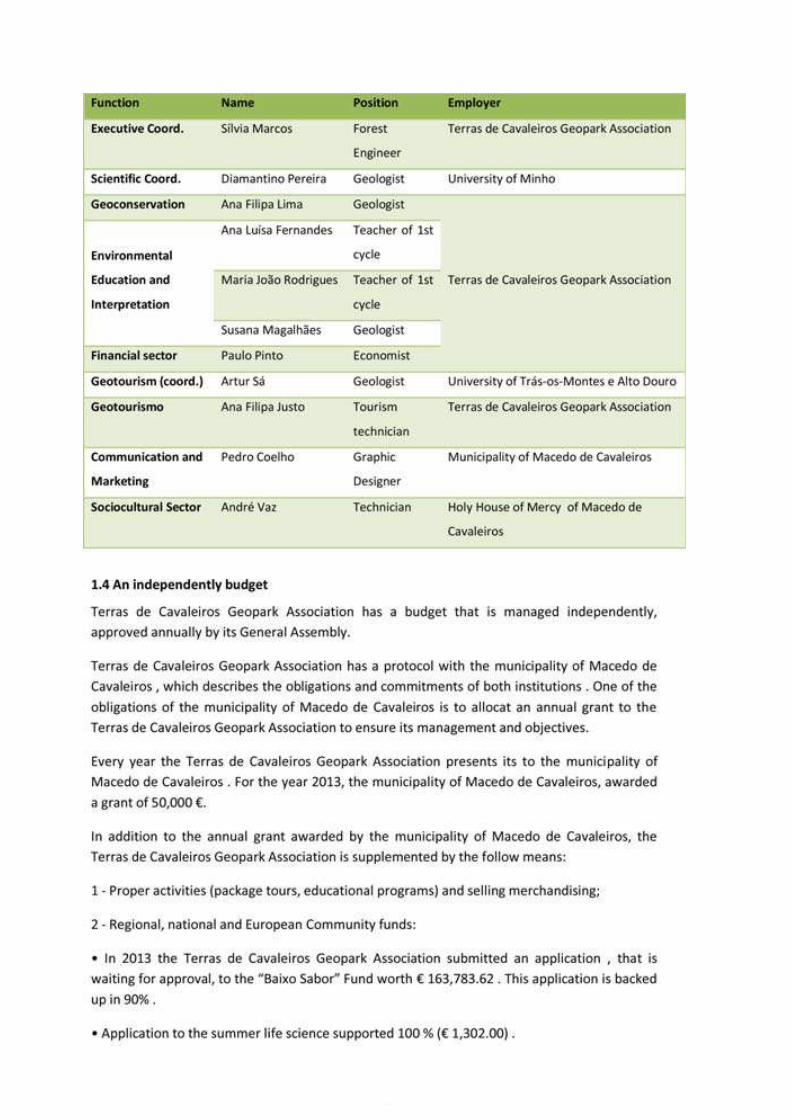
Application Dossier for the European Geopark Network Terras de Cavaleiros Aspiring Geopark, Portugal
70
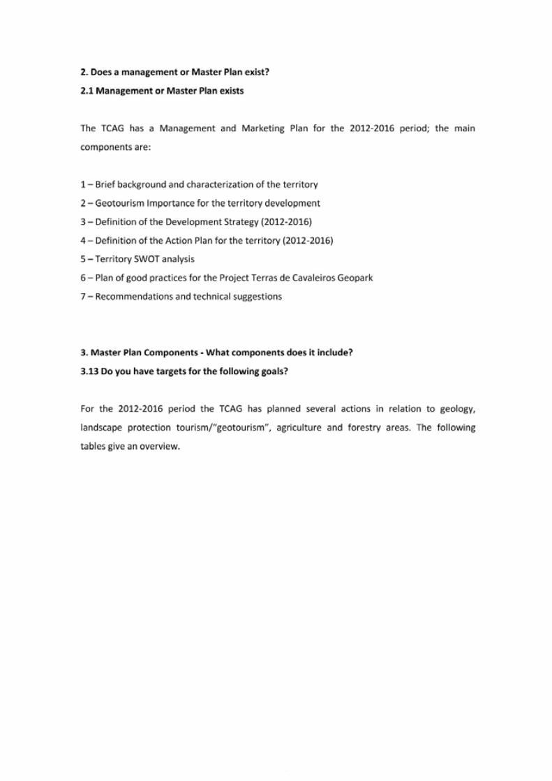
71
Application Dossier for the European Geopark Network Terras de Cavaleiros Aspiring Geopark, Portugal
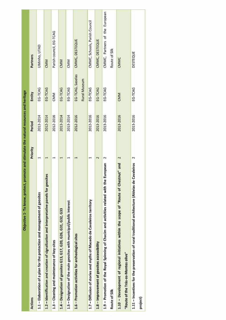
Application Dossier for the European Geopark Network Terras de Cavaleiros Aspiring Geopark, Portugal
72
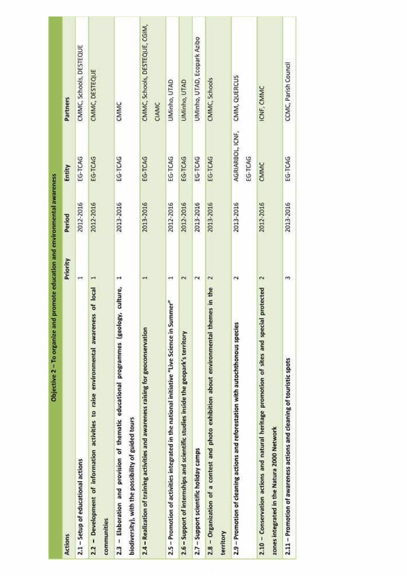
73
Application Dossier for the European Geopark Network Terras de Cavaleiros Aspiring Geopark, Portugal
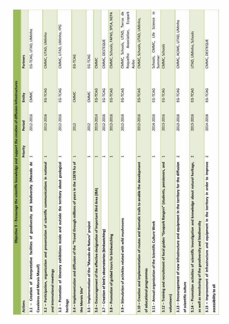
Application Dossier for the European Geopark Network Terras de Cavaleiros Aspiring Geopark, Portugal
74
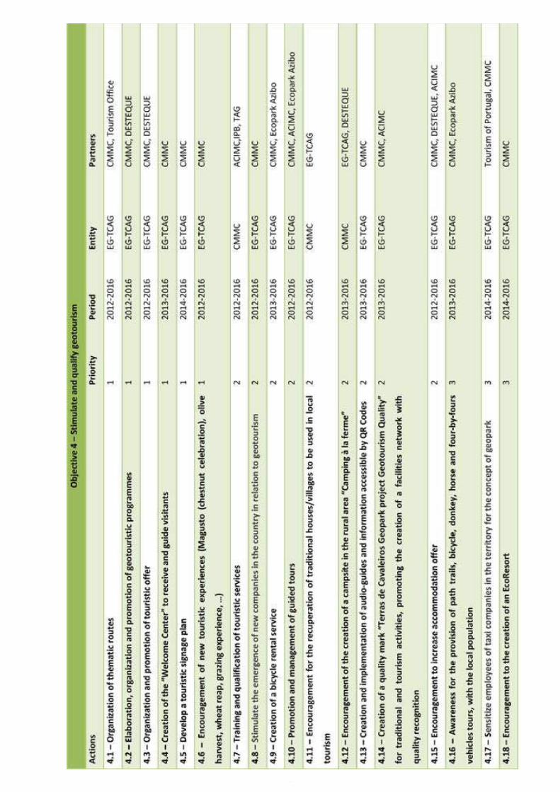
75
Application Dossier for the European Geopark Network Terras de Cavaleiros Aspiring Geopark, Portugal
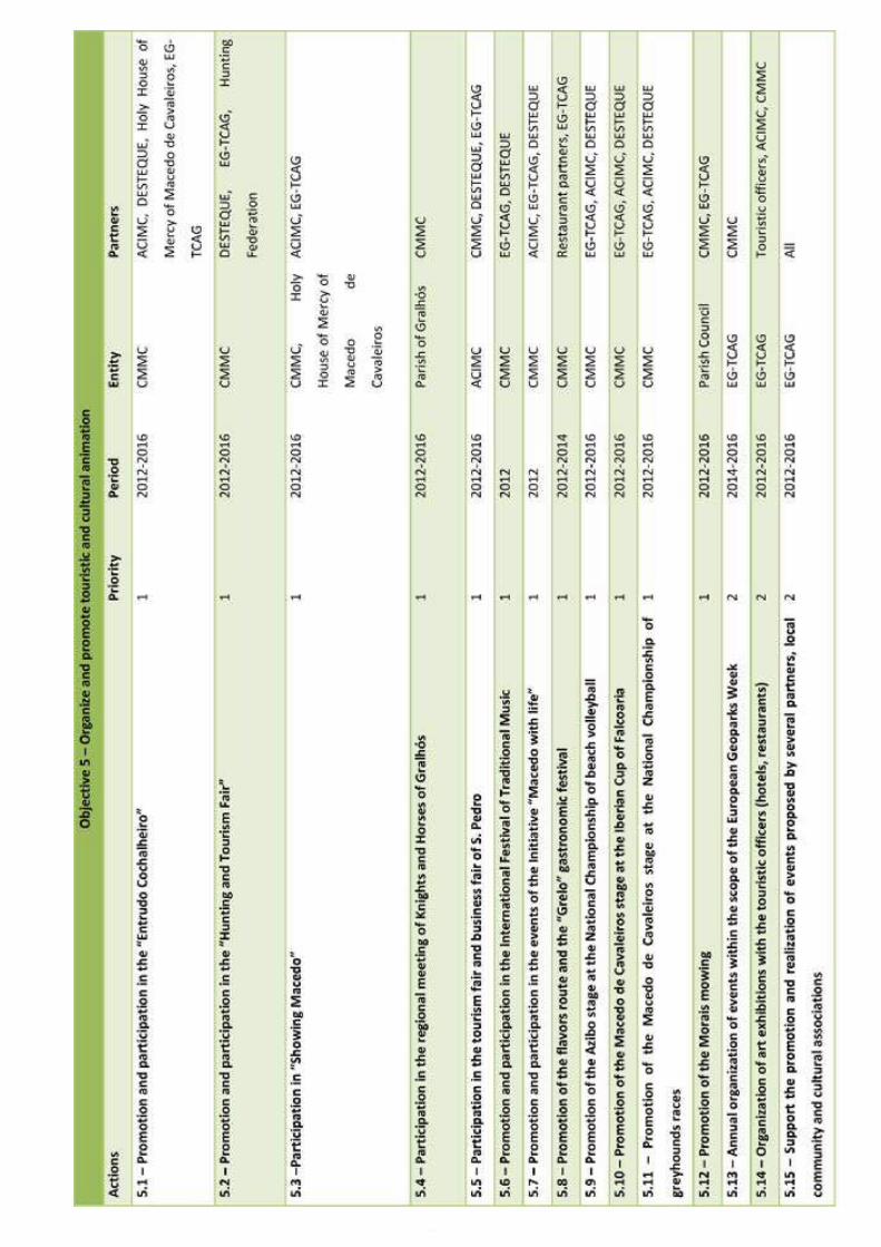
Application Dossier for the European Geopark Network Terras de Cavaleiros Aspiring Geopark, Portugal
76
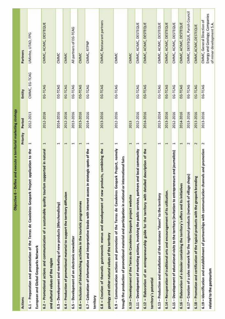
77
Application Dossier for the European Geopark Network Terras de Cavaleiros Aspiring Geopark, Portugal
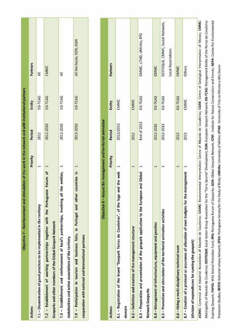
Application Dossier for the European Geopark Network Terras de Cavaleiros Aspiring Geopark, Portugal
78
79
Application Dossier for the European Geopark Network Terras de Cavaleiros Aspiring Geopark, Portugal
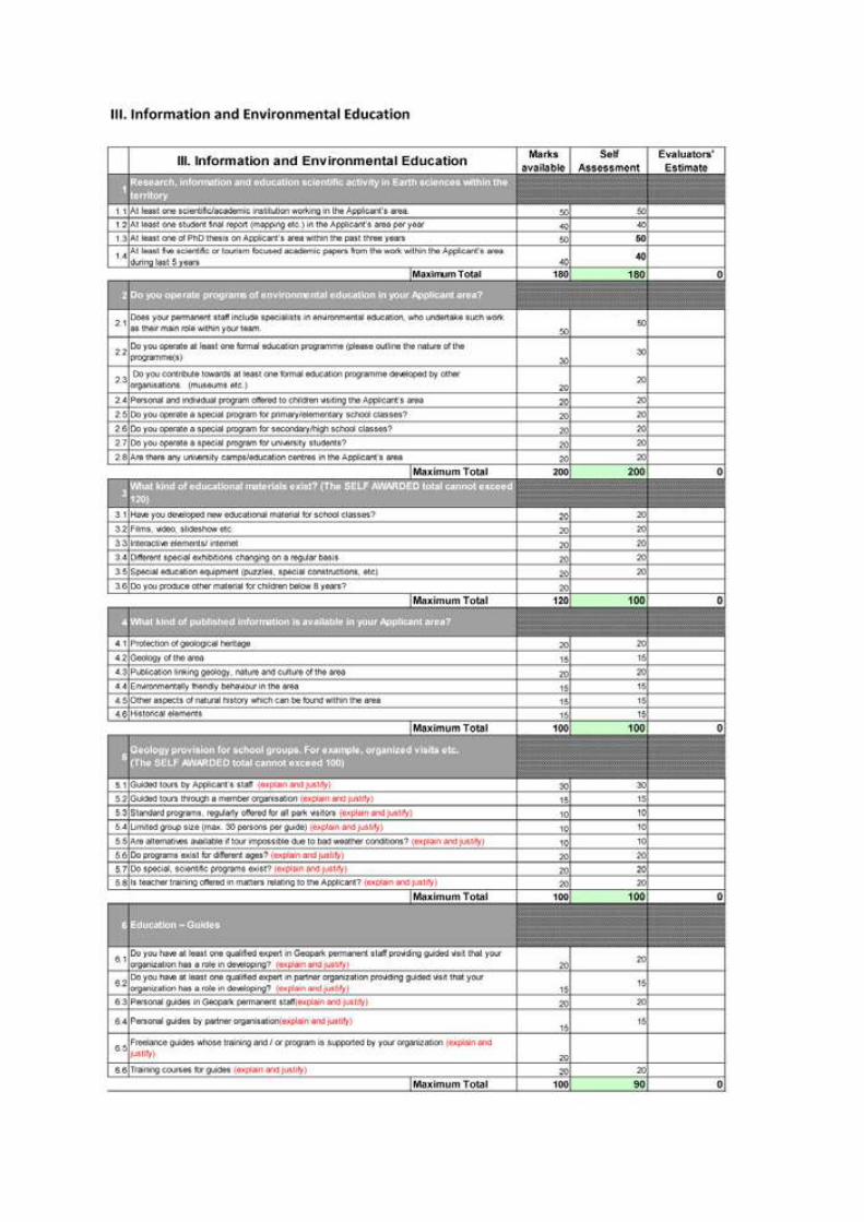
Application Dossier for the European Geopark Network Terras de Cavaleiros Aspiring Geopark, Portugal
80
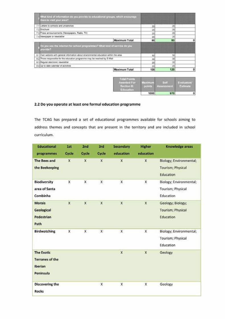
81
Application Dossier for the European Geopark Network Terras de Cavaleiros Aspiring Geopark, Portugal
Application Dossier for the European Geopark Network Terras de Cavaleiros Aspiring Geopark, Portugal
82
83
Application Dossier for the European Geopark Network Terras de Cavaleiros Aspiring Geopark, Portugal
Application Dossier for the European Geopark Network Terras de Cavaleiros Aspiring Geopark, Portugal
84
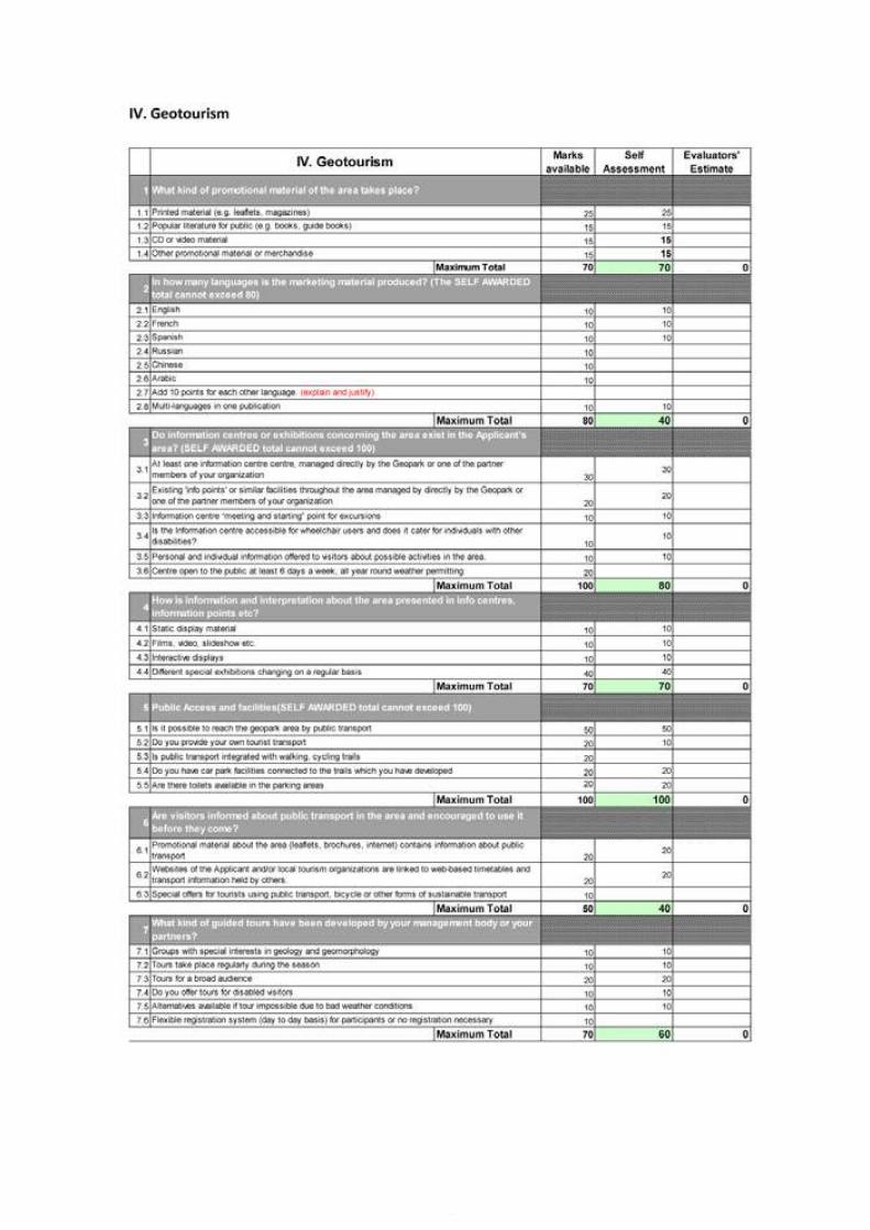
85
Application Dossier for the European Geopark Network Terras de Cavaleiros Aspiring Geopark, Portugal
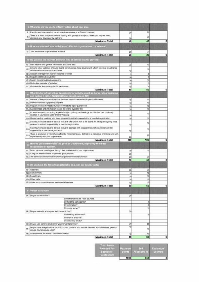
Application Dossier for the European Geopark Network Terras de Cavaleiros Aspiring Geopark, Portugal
86
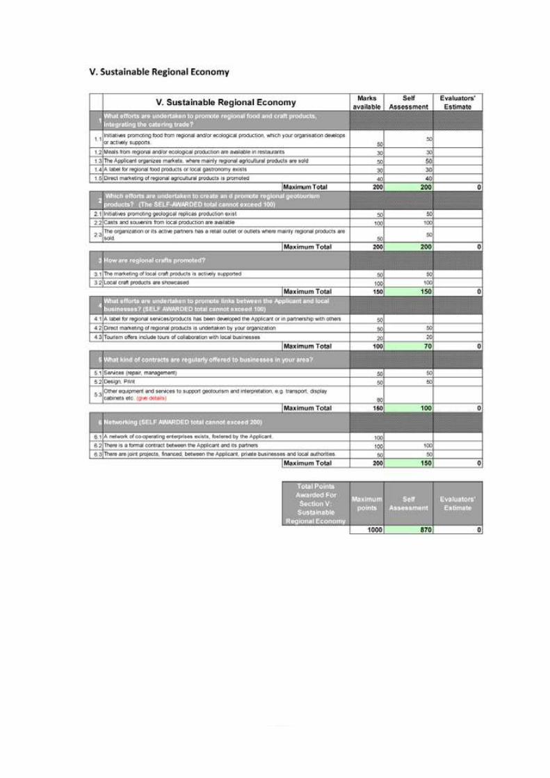
87
Application Dossier for the European Geopark Network Terras de Cavaleiros Aspiring Geopark, Portugal
Application Dossier for the European Geopark Network Terras de Cavaleiros Aspiring Geopark, Portugal
88
Annex 2Additional Copy of Section B
“Geological Heritage” of the Application
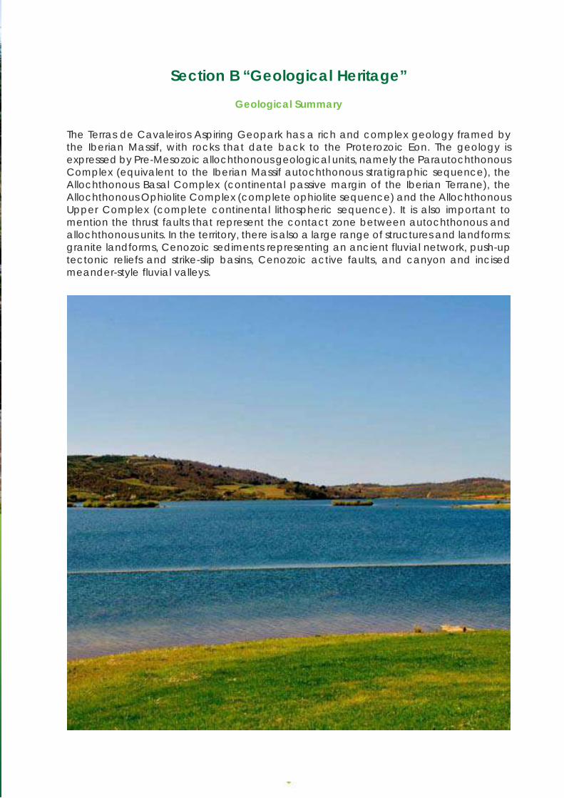
89
Application Dossier for the European Geopark Network Terras de Cavaleiros Aspiring Geopark, Portugal
Section B “Geological Heritage”Geological Summary
The Terras de Cavaleiros Aspiring Geopark has a rich and complex geology framed bythe Iberian Massif, with rocks that date back to the Proterozoic Eon. The geology isexpressed by Pre-Mesozoic allochthonous geological units, namely the ParautochthonousComplex (equivalent to the Iberian Massif autochthonous stratigraphic sequence), theAllochthonous Basal Complex (continental passive margin of the Iberian Terrane), theAllochthonous Ophiolite Complex (complete ophiolite sequence) and the AllochthonousUpper Complex (complete continental lithospheric sequence). It is also important tomention the thrust faults that represent the contact zone between autochthonous andallochthonous units. In the territory, there is also a large range of structures and landforms:granite landforms, Cenozoic sediments representing an ancient fluvial network, push-uptectonic reliefs and strike-slip basins, Cenozoic active faults, and canyon and incisedmeander-style fluvial valleys.
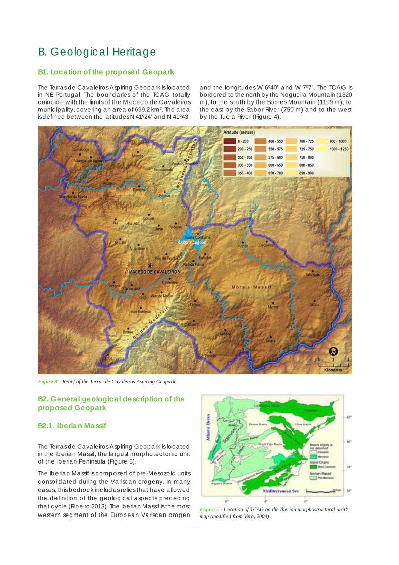
Application Dossier for the European Geopark Network Terras de Cavaleiros Aspiring Geopark, Portugal
90
The Terras de Cavaleiros Aspiring Geopark is locatedin NE Portugal. The boundaries of the TCAG totallycoincide with the limits of the Macedo de Cavaleirosmunicipality, covering an area of 699.2 km2. The areais defined between the latitudes N 41º24’ and N 41º43’
B. Geological Heritage
B1. Location of the proposed Geopark
and the longitudes W 6º40’ and W 7º7’. The TCAG isbordered to the north by the Nogueira Mountain (1320m), to the south by the Bornes Mountain (1199 m), tothe east by the Sabor River (750 m) and to the westby the Tuela River (Figure 4).
Figure 4 - Relief of the Terras de Cavaleiros Aspiring Geopark
B2. General geological description of theproposed Geopark
B2.1. Iberian Massif
The Terras de Cavaleiros Aspiring Geopark is locatedin the Iberian Massif, the largest morphotectonic unitof the Iberian Peninsula (Figure 5).
The Iberian Massif is composed of pre-Mesozoic unitsconsolidated during the Variscan orogeny. In manycases, this bedrock includes relics that have allowedthe definition of the geological aspects precedingthat cycle (Ribeiro 2013). The Iberian Massif is the mostwestern segment of the European Variscan orogen
Figure 5 - Location of TCAG on the Iberian morphostructural unit’smap (modified from Vera, 2004)
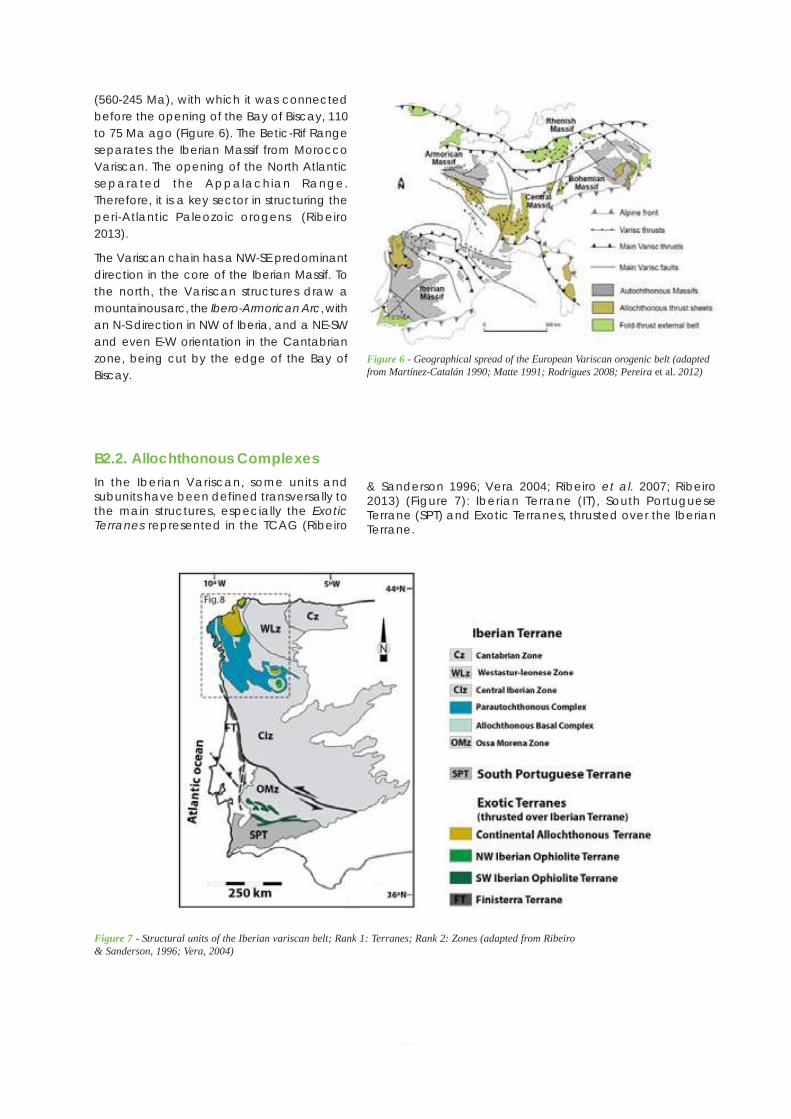
91
Application Dossier for the European Geopark Network Terras de Cavaleiros Aspiring Geopark, Portugal
Figure 7 - Structural units of the Iberian variscan belt; Rank 1: Terranes; Rank 2: Zones (adapted from Ribeiro& Sanderson, 1996; Vera, 2004)
(560-245 Ma), with which it was connectedbefore the opening of the Bay of Biscay, 110to 75 Ma ago (Figure 6). The Betic-Rif Rangeseparates the Iberian Massif from MoroccoVariscan. The opening of the North Atlanticseparated the Appalachian Range.Therefore, it is a key sector in structuring theperi-Atlantic Paleozoic orogens (Ribeiro2013).
The Variscan chain has a NW-SE predominantdirection in the core of the Iberian Massif. Tothe north, the Variscan structures draw amountainous arc, the Ibero-Armorican Arc, withan N-S direction in NW of Iberia, and a NE-SWand even E-W orientation in the Cantabrianzone, being cut by the edge of the Bay ofBiscay.
Figure 6 - Geographical spread of the European Variscan orogenic belt (adaptedfrom Martínez-Catalán 1990; Matte 1991; Rodrigues 2008; Pereira et al. 2012)
B2.2. Allochthonous ComplexesIn the Iberian Variscan, some units andsubunits have been defined transversally tothe main structures, especially the ExoticTerranes represented in the TCAG (Ribeiro
& Sanderson 1996; Vera 2004; Ribeiro et al. 2007; Ribeiro2013) (Figure 7): Iberian Terrane (IT), South PortugueseTerrane (SPT) and Exotic Terranes, thrusted over the IberianTerrane.
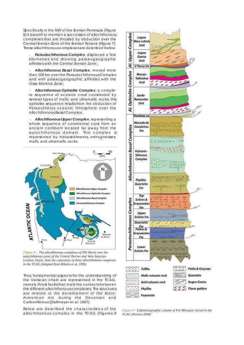
Application Dossier for the European Geopark Network Terras de Cavaleiros Aspiring Geopark, Portugal
92
Specifically in the NW of the Iberian Peninsula (Figure8) it is worth to mention a succession of allochthonouscomplexes that are thrusted by obduction over theCentral Iberian Zone of the Iberian Terrane (Figure 7).These allochthonous complexes are described below.
· Parautochthonous Complex, displaced a fewkilometres and showing palaeogeographicaffinities with the Central Iberian Zone;
· Allochthonous Basal Complex, moved morethan 100 km over the Parautochthonous Complexand with palaeogeographic affinities with theOssa-Morena Zone;
· Allochthonous Ophiolite Complex, a comple-te sequence of oceanic crust constituted byseveral types of mafic and ultramafic rocks; thisophiolite sequence results from the obduction ofPalaeothetys oceanic lithosphere over theAllochthonous Basal Complex;
· Allochthonous Upper Complex, representing awhole sequence of continental crust from anancient continent located far away from theautochthonous domain. This complex isrepresented by metasediments, orthogneisses,mafic and ultramafic rocks.
Figure 9 - Lithostratigraphic column of Pre-Mesozoic record in theTCAG (Pereira 2000)
Thus, fundamental aspects for the understanding ofthe Variscan chain are represented in the TCAG,namely thrust faults that mark the contacts betweenthe different allochthonous complexes. The structuresare related to the development of the Ibero-Armorican Arc during the Devonian andCarboniferous (Dallmeyer et al. 1997).
Below are described the characteristics of theallochthonous complex in the TCAG (Figures 9
Figure 8 - The allochthonous complexes of NW Iberia over theautochthonous areas of the Central Iberian and West Asturian-Leonese Zones. Note the expression of these allochthonous complexesin the TCAG (Adapted from Ribeiro et al. 1990)
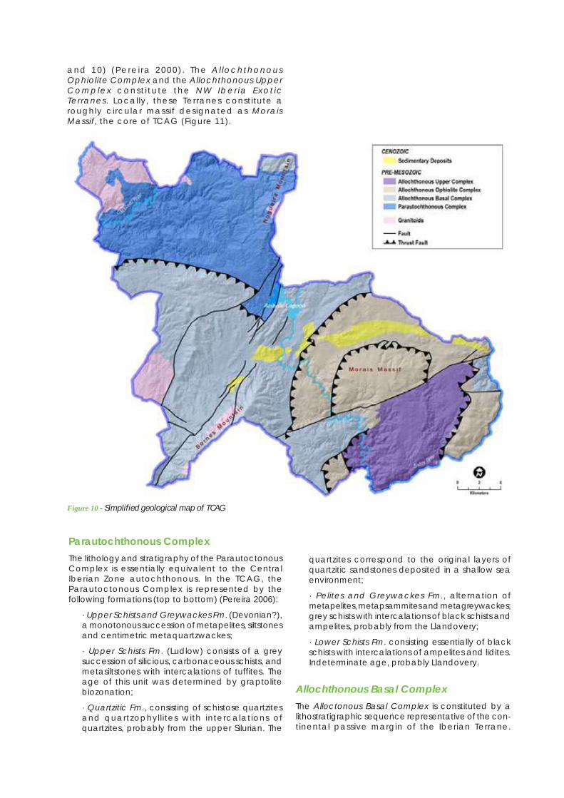
93
Application Dossier for the European Geopark Network Terras de Cavaleiros Aspiring Geopark, Portugal
and 10) (Perei ra 2000) . The Al lochthonousOphiolite Complex and the Allochthonous UpperComplex const i tu te the NW Iber ia Exot icTerranes. Locally, these Terranes constitute aroughly circular massif designated as MoraisMassif, the core of TCAG (Figure 11).
Figure 10 - Simplified geological map of TCAG
Parautochthonous ComplexThe lithology and stratigraphy of the ParautoctonousComplex is essentially equivalent to the CentralIberian Zone autochthonous. In the TCAG, theParautoctonous Complex is represented by thefollowing formations (top to bottom) (Pereira 2006):
· Upper Schists and Greywackes Fm. (Devonian?),a monotonous succession of metapelites, siltstonesand centimetric metaquartzwackes;
· Upper Schists Fm. (Ludlow) consists of a greysuccession of silicious, carbonaceous schists, andmetasiltstones with intercalations of tuffites. Theage of this unit was determined by graptolitebiozonation;
· Quartzitic Fm., consisting of schistose quartzitesand quartzophyllites with intercalations ofquartzites, probably from the upper Silurian. The
quartzites correspond to the original layers ofquartzitic sandstones deposited in a shallow seaenvironment;
· Pelites and Greywackes Fm., alternation ofmetapelites, metapsammites and metagreywackes;grey schists with intercalations of black schists andampelites, probably from the Llandovery;
· Lower Schists Fm. consisting essentially of blackschists with intercalations of ampelites and lidites.Indeterminate age, probably Llandovery.
Allochthonous Basal ComplexThe Alloctonous Basal Complex is constituted by alithostratigraphic sequence representative of the con-tinental passive margin of the Iberian Terrane.
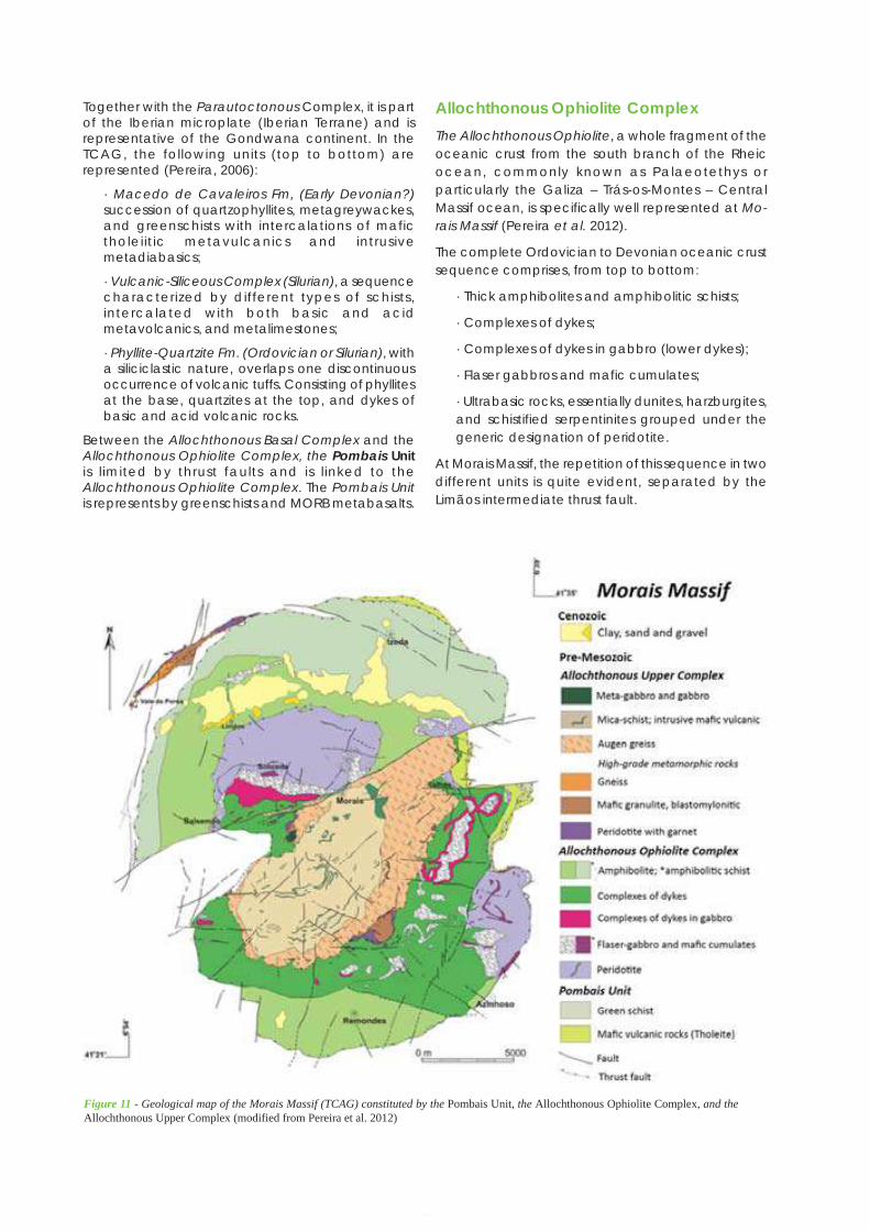
Application Dossier for the European Geopark Network Terras de Cavaleiros Aspiring Geopark, Portugal
94
Together with the Parautoctonous Complex, it is partof the Iberian microplate (Iberian Terrane) and isrepresentative of the Gondwana continent. In theTCAG, the following units (top to bottom) arerepresented (Pereira, 2006):
· Macedo de Cavaleiros Fm, (Early Devonian?)succession of quartzophyllites, metagreywackes,and greenschists with intercalations of mafictholeiitic metavulcanics and intrusivemetadiabasics;
· Vulcanic-Siliceous Complex (Silurian), a sequencecharacterized by different types of schists,intercalated with both basic and acidmetavolcanics, and metalimestones;
· Phyllite-Quartzite Fm. (Ordovician or Silurian), witha siliciclastic nature, overlaps one discontinuousoccurrence of volcanic tuffs. Consisting of phyllitesat the base, quartzites at the top, and dykes ofbasic and acid volcanic rocks.
Between the Allochthonous Basal Complex and theAllochthonous Ophiolite Complex, the Pombais Unitis l imited by thrust faults and is l inked to theAllochthonous Ophiolite Complex. The Pombais Unitis represents by greenschists and MORB metabasalts.
Allochthonous Ophiolite ComplexThe Allochthonous Ophiolite, a whole fragment of theoceanic crust from the south branch of the Rheicocean, commonly known as Palaeotethys orparticularly the Galiza – Trás-os-Montes – CentralMassif ocean, is specifically well represented at Mo-rais Massif (Pereira et al. 2012).
The complete Ordovician to Devonian oceanic crustsequence comprises, from top to bottom:
· Thick amphibolites and amphibolitic schists;
· Complexes of dykes;
· Complexes of dykes in gabbro (lower dykes);
· Flaser gabbros and mafic cumulates;
· Ultrabasic rocks, essentially dunites, harzburgites,and schistified serpentinites grouped under thegeneric designation of peridotite.
At Morais Massif, the repetition of this sequence in twodifferent units is quite evident, separated by theLimãos intermediate thrust fault.
Figure 11 - Geological map of the Morais Massif (TCAG) constituted by the Pombais Unit, the Allochthonous Ophiolite Complex, and theAllochthonous Upper Complex (modified from Pereira et al. 2012)
95
Application Dossier for the European Geopark Network Terras de Cavaleiros Aspiring Geopark, Portugal
Allochthonous Upper ComplexThe Allochthonous Upper Complex represents a com-plete sequence of continental crust deriving from adistant margin, relatively to the autochthonousdomain. Presumably this complete fragment of con-tinental crust had its origin on the Armorica microplate(Exotic Terrain), an independent continentalfragment, as well as from the north of Gondwana (Ri-beiro et al. 2007).
The sequence is represented, from top to bottom by:
· Lagoa mica schists with mafic volcanic intrusions;
· Lagoa augen gneiss;
· Mafic granulites, blastomylonitic;
· Garnet peridotite.
The Terranes mentioned above are the majorlithospheric plates affected during the VariscanOrogeny. The NW Iberian Sector, with its owngeological history full of singularities, corresponds toa fragment of the Variscan chain. The reconstitutionof the palaeogeography and tectonic zones of theIberian in relation to Europe, before the opening ofthe Bay of Biscay during Cretaceous time, helps toidentify the origin (the root zone) of the AllochthonousUnits parts of the NW Iberia Allochthonous Massifs, ingeneral, and the Morais Massif, in particular, and thuslocates the NW Iberian sector in the general contextof the Variscan Chain (Figure 6).
As mentioned before, the geological units integratingthe NW massifs are called Allochthonous Unitsbecause they are displaced from their origin (the rootzone) for more than 200 km (Pereira et al. 2012).
Thanks to the crustal shortening during the continen-tal collision, a continental fragment overlapped anoceanic fragment and these two were placed overthe Gondwana margin. The collisional tectoniccompression, the crustal thickening and theassociated gravitic movements induced thatdisplacement occurred during the chain formation(380-280 Ma). A movement of about 2 cm/year during100x106 years originates around 200 km ofdisplacement for the Allochthonous Units. Thedisplacement of this pile of units originates fragmentsat the bottom, which constitute the ParautocthonousComplex (Pereira et al. 2012).
The Allochthonous Units are so called due to the factthey are not equivalent with the surrounding units,whereas the Parautochthonous Units, althoughconstituted by complexes of several layers, showlithological and stratigraphic affinity with units thathave not suffered displacement, and for therefore arecalled autochthonous (Pereira et al. 2012).
B2.3. Variscan GranitoidsSome igneous rocks occur in the TCAG, crosscuttingthe metasedimentary and metavolcanic units referredto above. Beyond the veins, mostly of quartz, severalgranitoids contemporaneous with the VariscanOrogeny and with a clear relation to the 3rd orogenic
phase (D3) can be described.
Rebordelo granite and granodiorite, porphyroids withmedium to coarse grain, essentially biotitic, pre to syn-D3, occurs in the occidental sector of the municipality,near the Vilarinho de Agrochão village.
Lebução granite, two-mica, medium grained granite,syn-D3 that occurs also in the occidental sector ofthe municipality, near the Vilarinho de Agrochãovillage.
Bornes and Serra de Pombares granite, a two-mica,medium-grain porphyroid granite late to post-D3.Shows cataclasis and strong arenization at thecontact with the Vilariça Fault.
Romeu granite, a medium grained, with muscovite,late to post-D3 granite.
Torre de Dona Chama granite, a coarse, porphyroid,two-mica granite, late to post-D3 that occurs nearthe western limit of the TCAG.
Burga granite, a muscovite microgranite, late to post-D3 that occurs in the Burga village, at the south limitof the TCAG.
B2.4. Cenozoic SedimentsUp to the 1990s, the Portuguese sediments of thewestern border of the Douro Cenozoic Basin, includingthe TCAG territory (Figure 5), were included in the so-called Iberian Raña facies, a gravelly deposit withsignificant coverage in the Douro Basin and also inthe Iberian Massif. Raña refers to an alluvial fan model,chronologically near the Plio-Pleistocene limit. Thisepisode was related to the transition from theendorheic drainage of the Cenozoic Iberian basinsto the present Atlantic drainage. More detailedresearch of these sediments (Pereira 1997, 1998, 1999,2006; Pereira et al. 2000) has revealed a fluvial networkin the proximal sector of the Douro Basin, and diversetectonosedimentary units as described below (Pais etal. 2012).
Upper Miocene to Lower PlioceneThe Bragança Formation is defined in north-easternPortugal as a lithostratigraphic unit recording aproximal fluvial palaeodrainage to the Cenozoic Dou-ro Basin in Spain (Pereira 1997, 1998, 1999; Pereira etal. 2000). It is recognized as being essentially Miocene,and may correspond to allostratigraphic units UBS11and UBS12 identified in the Mondego Basin and in theproximal sector of the Lower Tejo Basin (Pereira 1997,2006; Pais et al. 2012).
The fluvial sediments fill incised palaeovalleys inresponse to two tectonic episodes and theconsequent orogenic uplift. These palaeovalleysremain well preserved in the TCAG (Vale da Porca,Salselas and Castro Roupal outcrops), where they areoriented E–W, and to the east, near Vimioso (Vimiosooutcrop) and Miranda do Douro (Silva, Sendim, andAtenor outcrops), where they are oriented NW–SE andNS, respectively. In this most north-eastern sector of
Application Dossier for the European Geopark Network Terras de Cavaleiros Aspiring Geopark, Portugal
96
Portugal, geophysical research and drilling revealedthe tectonic control of the palaeovalleys of Sendimand Atenor, which have no morphological expression.Given the context of the major Vilariça fault, the fluvi-al system was strongly influenced by the developmentof strike-slip basins (De Vicente et al. 2011; Pais et al.2012), especially in the TCAG.
The Bragança Formation comprises two members, theCastro Member (lower member) and the AtalaiaMember (upper member), with similar compositionsand depositional architectures. An unconformity isdefined based on the recognition of a regionalerosion surface and a well-developed palaeosoil.Deep channel gravel deposits and gravelly bars arethe most characteristic lithofacies of the BragançaFormation. The sediments are immature and containmoderately weathered feldspars in the sand fractionand a predominance of smectite and kaolinite in theclay fraction. The gravel units are mostly red in colorwith lutite being brown, grey or green.
The Castro Member (lower member) has a thicknessof about 70 m. In the most proximal area, especiallyin the tectonic strike-slip basins, the sedimentary infillis characterized by an increased thickness in massivegravelly units and by sandy channels. In these areas,the lithofacies and sedimentary architecture arecompatible with the presence of alluvial fans thatwould have supplied the regional river system. Towardthe top of the member, the sedimentary cycle ischaracterized by a thickening of fine sediment layers.This architecture is well represented in the various sandpits of Sendas and Macedo de Cavaleiros regions andhas a regional extent.
The Atalaia Member (upper member) reaches athickness of about 50 m in the strike-slip basins ofBragança and Macedo de Cavaleiros (TCAG) andcorresponds to a succession of episodes with similarcharacteristics to the Castro Member. The same fluvi-al environment, braided, low sinuosity rivers resultedfrom a new tectono-sedimentary cycle. There is oftena succession of the architectural elements of gravellybars, derived from energetic fluvial episodes as wellas lateral accretion elements. Occasionally,abandoned channels cut flood deposits.
The Bragança Formation is the most extensivelyexposed unit in north-eastern Portugal. Its particularcharacteristics include deposits reflecting differentchannel conditions and flows, the more organizedfacies, the weathering of clasts, the clay mineralcontents with abundant smectite and neoformationof kaolinite, the development of incipient palaeosoils,the red color, and carbonate precipitation in incipientfractures. These characteristics indicate temperate towarm climatic conditions with a rainy season forminghigh-energy streams, and a dry season that alsofavoured oscillation of the water table (Pereira 1997,1998, 1999).
Geomorphological features indicate that, in the stageprior to the deposition of the Bragança Formation,river valleys incised in the bedrock developed as anerosional response to mountain uplift occurring sincethe Eocene (Pereira et al. 2000; De Vicente et al. 2008,
2011). Subsequently, the activity of this major tectonicepisode, which corresponds to the Betic compressionat about 9.5 Ma (Calvo et al. 1993), caused a staircaseorganization of large fault blocks in northern Portugaland the development of strike-slip basins associatedwith the Vilariça fault detachment (Ferreira 1991;Cunha 1992; Cabral 1995). It is most likely that theCastro Member represents the alluvial systemsresponse to the new morphotectonic regime (Perei-ra et al. 2000).
The Vale Álvaro Formation occurs in the eastern regionof Portugal unconformably overlying the mafic rocksthat constitute the Bragança Massif and the MoraisMassif (Limãos outcrops in the TCAG). It hastraditionally been indicated as probably Paleogene,based on sedimentological characteristics. Morerecently, palynological data (Poças et al. 2003; Po-ças 2004) have suggested an age between the LateMiocene and Pliocene, and a climate characterizedby seasonal contrasts (wet winters and hot summers)and overall moderate temperatures (Pais et al. 2012).
A sedimentary characterization of the Vale ÁlvaroFormation shows several episodes of coarse sedimentsconsistent with an alluvial fan model. Pedogenic andphreathic calcretes and dolocrete, widespread in thedistal area, developed between the debris flowepisodes. The proximal lithofacies of the Vale ÁlvaroFormation crop-out at Limãos (in the TCAG). The lowerpart consists of a 4 m thick dolocrete layer, followedby red, coarse, clast-supported gravel. Sub-roundedclasts are exclusively of weathered mafic andultramafic rocks from the Alloctonous OfioliteComplex located in the Morais Massif. The clayfraction is composed mainly of dioctahedralmontmorillonite and paligorskite, chlorite,interstratified chlorite-montmorillonite andoccasionally serpentine, talc and kaolinite (Pereira &Brilha 2000). The entire unit is consolidated byferruginous and carbonate cement (Pereira 2006).
The morphotectonic context, sedimentarycharacteristics and depositional architecture of theVale Álvaro Formation indicate an alluvial fan model,which relates to an episode of tectonic movementthat stressed the fault scarps (Pereira 1997, 2006). Theage of the Vale Álvaro Formation remains unclear,but it might be a proximal equivalent of the BragançaFormation with epigenetic carbonate developedalong the contact with basic rocks lying in tectonicdepressions.
Upper Pliocene to Lower PleistoceneThe Aveleda Formation consists of reddish depositsmainly of muddy matrix-supported gravel. Clasts ofseveral metasedimentary rocks and quartz aresubangular. Kaolinite and illite dominate the clayfraction.
The Aveleda Formation is generally located in twodifferent geomorphological settings. First, occurrencessurrounding the TCAG lie over a flattened surface,which marks a discontinuity with the older units, andhave its source on the resistant reliefs. Second,
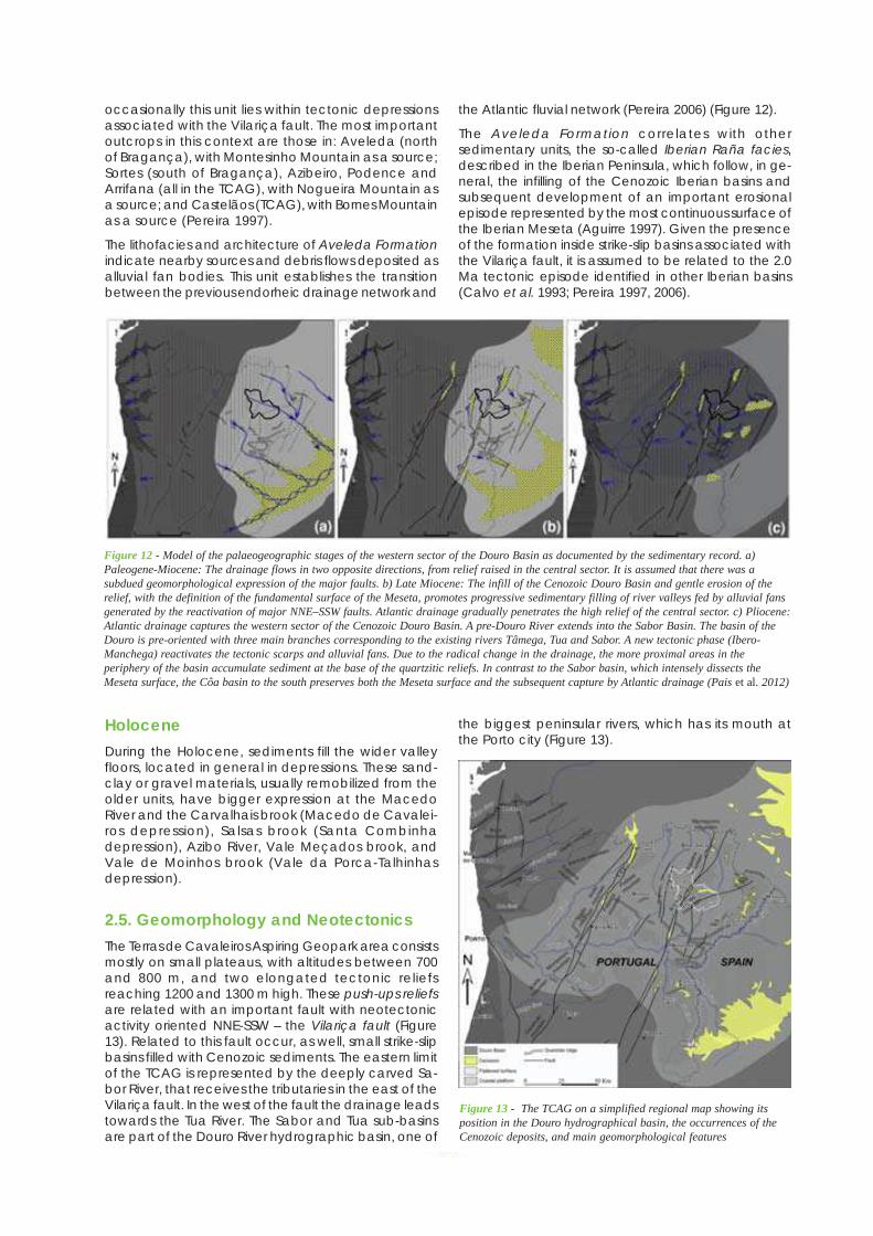
97
Application Dossier for the European Geopark Network Terras de Cavaleiros Aspiring Geopark, Portugal
occasionally this unit lies within tectonic depressionsassociated with the Vilariça fault. The most importantoutcrops in this context are those in: Aveleda (northof Bragança), with Montesinho Mountain as a source;Sortes (south of Bragança), Azibeiro, Podence andArrifana (all in the TCAG), with Nogueira Mountain asa source; and Castelãos (TCAG), with Bornes Mountainas a source (Pereira 1997).
The lithofacies and architecture of Aveleda Formationindicate nearby sources and debris flows deposited asalluvial fan bodies. This unit establishes the transitionbetween the previous endorheic drainage network and
the Atlantic fluvial network (Pereira 2006) (Figure 12).
The Aveleda Formation correlates with othersedimentary units, the so-called Iberian Raña facies,described in the Iberian Peninsula, which follow, in ge-neral, the infilling of the Cenozoic Iberian basins andsubsequent development of an important erosionalepisode represented by the most continuous surface ofthe Iberian Meseta (Aguirre 1997). Given the presenceof the formation inside strike-slip basins associated withthe Vilariça fault, it is assumed to be related to the 2.0Ma tectonic episode identified in other Iberian basins(Calvo et al. 1993; Pereira 1997, 2006).
Figure 12 - Model of the palaeogeographic stages of the western sector of the Douro Basin as documented by the sedimentary record. a)Paleogene-Miocene: The drainage flows in two opposite directions, from relief raised in the central sector. It is assumed that there was asubdued geomorphological expression of the major faults. b) Late Miocene: The infill of the Cenozoic Douro Basin and gentle erosion of therelief, with the definition of the fundamental surface of the Meseta, promotes progressive sedimentary filling of river valleys fed by alluvial fansgenerated by the reactivation of major NNE–SSW faults. Atlantic drainage gradually penetrates the high relief of the central sector. c) Pliocene:Atlantic drainage captures the western sector of the Cenozoic Douro Basin. A pre-Douro River extends into the Sabor Basin. The basin of theDouro is pre-oriented with three main branches corresponding to the existing rivers Tâmega, Tua and Sabor. A new tectonic phase (Ibero-Manchega) reactivates the tectonic scarps and alluvial fans. Due to the radical change in the drainage, the more proximal areas in theperiphery of the basin accumulate sediment at the base of the quartzitic reliefs. In contrast to the Sabor basin, which intensely dissects theMeseta surface, the Côa basin to the south preserves both the Meseta surface and the subsequent capture by Atlantic drainage (Pais et al. 2012)
HoloceneDuring the Holocene, sediments fill the wider valleyfloors, located in general in depressions. These sand-clay or gravel materials, usually remobilized from theolder units, have bigger expression at the MacedoRiver and the Carvalhais brook (Macedo de Cavalei-ros depression), Salsas brook (Santa Combinhadepression), Azibo River, Vale Meçados brook, andVale de Moinhos brook (Vale da Porca-Talhinhasdepression).
2.5. Geomorphology and NeotectonicsThe Terras de Cavaleiros Aspiring Geopark area consistsmostly on small plateaus, with altitudes between 700and 800 m, and two elongated tectonic reliefsreaching 1200 and 1300 m high. These push-ups reliefsare related with an important fault with neotectonicactivity oriented NNE-SSW – the Vilariça fault (Figure13). Related to this fault occur, as well, small strike-slipbasins filled with Cenozoic sediments. The eastern limitof the TCAG is represented by the deeply carved Sa-bor River, that receives the tributaries in the east of theVilariça fault. In the west of the fault the drainage leadstowards the Tua River. The Sabor and Tua sub-basinsare part of the Douro River hydrographic basin, one of
the biggest peninsular rivers, which has its mouth atthe Porto city (Figure 13).
Figure 13 - The TCAG on a simplified regional map showing itsposition in the Douro hydrographical basin, the occurrences of theCenozoic deposits, and main geomorphological features
Application Dossier for the European Geopark Network Terras de Cavaleiros Aspiring Geopark, Portugal
98
The interpretation of the northern Portuguese relief hasemphasized the importance of the Vilariça fault. Thistectonic accident has a great expression in the TCAG,connected to the development of the strike-slip basinssuch as the Santa Combinha and Macedo de Cava-leiros, or the Vilariça to the south, as well as upliftedreliefs in a push-up model, like the Bornes and No-gueira Mountains (Cabral, 1995; Pereira 1997; 2002;2006; 2010). Regionally, the Vilariça fault constitutesalso the limit between the eastern sector, where thefundamental surface of the Iberian Plateau is moreregular, and the western sector where the fundamen-tal surface is more eroded, marked by high centralplateaus dissected to the south of the Douro River,and by the Miranda depression to the north of theriver.
Some noteworthy geomorphological aspects of theTCAG are briefly described below:
· The regular flattening surface of the Morais Massifdevelops to the north of the Morais Fault, at about750 m and is representative of the North IberianPlateau. This surface, well preserved in theAlloctonous Ofiolite Complex peridotites (Massif ofMorais) represents a reference for theinterpretation of all other regional surfaces. Portionsof the same surface are also preserved in the northbetween Santa Combinha and Vinhais regions;
· At the north of the Morais Massif, between Valeda Porca and Talhinhas develops a depressionoriented E-W, around 150 m below of the MoraisMassif and Vinhais surfaces;
· To the south of the Morais fault the footwall isnoticeable, which dropped about 100 m, in theTalhas and Lagoa sector, as well as the expressionof the fault scarp;
· In the NW sector of the TCAG the south flank ofthe Nogueira Mountain stands out, reaching analtitude of 1231 m (e.g. Pena Mourisca) in thePombares Massif granites. This tectonic relieforiented NNE-SSW is located to the west of themain branch of the Vilariça fault;
· The Macedo de Cavaleiros and Santa Combinhasectors are identified by small depressions orientedNE-SW and NNE-SSW, individualized between faultsdefined in the context of the tectonic structure(Vilariça fault);
· To SW the Bornes Moutain stands out as a tectonicrelief oriented NNE-SSW, parallel to the Vilariçafault, with the regular top at around 1200 m high.In the south limit of the municipality (near Burga)develops a fault scarp oriented close to N-S,extending to the Vilariça depression;
· At the western sector of the TCAG some flattenedscraps remain, slightly subsided relatively to the re-
gular levels of the North Iberian Plateau, which arealso a tectonic step to the Mirandela depression;
· In relation to the fluvial drainage network, theMacedo de Cavaleiros depression stands outdraining towards the Tuela River by the MacedoRiver and the Carvalhais stream. The remainingterritory falls within the Sabor River sub-basin, whichlimits the municipality at east. The Sabor River hashigh slopes and deep channels, with around 200m in the margins and 400 m relatively to the fun-damental surface. The tributary valleys, as theAzibo River and the mentioned brooks, have deepvalleys, which open at the tectonic depressionswhere they run in a flattened stream.
B3. Listing and description of geologicalsites within the proposed GeoparkThe selection of the TCAG geosites was based on aqualitative assessment, adapted from themethodology used by the Spanish Geological Survey(Garcia-Cortéz 2008; Garcia-Cortéz & Carcavilla Urquí2009) (Table 7). The inventory was primarily focusedon their scientific value, and takes into account thefollowing criteria: representativeness, key-location,rarity, geological diversity, integrity, and scientificknowledge. After a first identification of 82 potentialgeosites, 42 were selected as geosites to be managedby the geopark (Table 8 and Figures 14, 15, 16, 17).From the 42 geosites, nine have a high scientific value(66.3 – 58.8 points); 25 have also a remarkablescientific value (46.3 – 20 points); and finally eight havea low scientific value (17.5 – 7.5 points), however theirselection in this inventory was justified because theyrepresent geological elements of the territory. Theselected geosites are related with mineralogical,petrological, structural, geomorphological andhydrogeological occurrences.
Table 7 – Criteria used for the evaluation of potential geosites
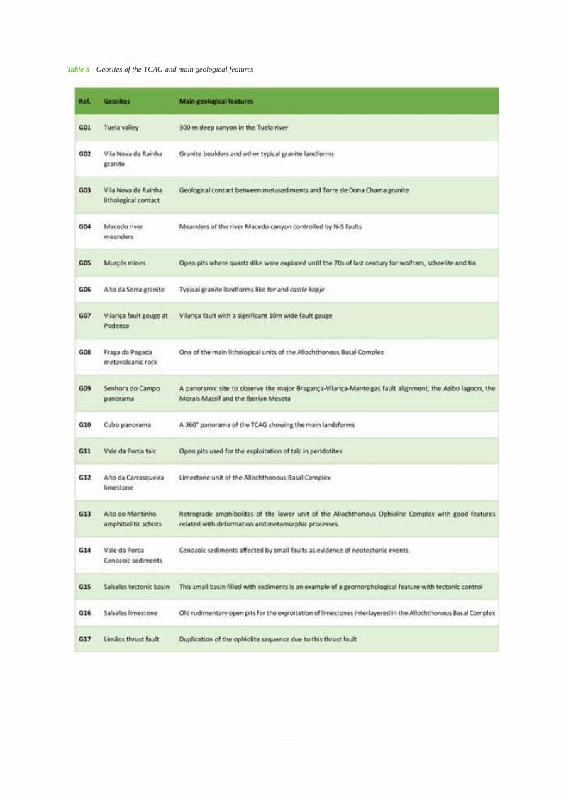
99
Application Dossier for the European Geopark Network Terras de Cavaleiros Aspiring Geopark, Portugal
Table 8 - Geosites of the TCAG and main geological features
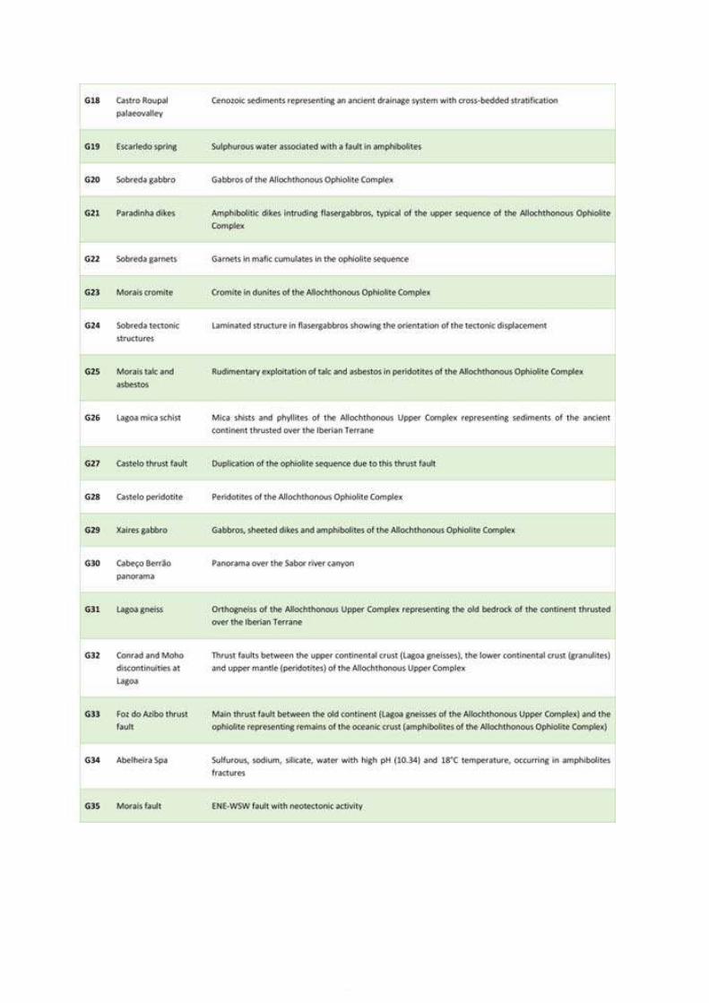
Application Dossier for the European Geopark Network Terras de Cavaleiros Aspiring Geopark, Portugal
100
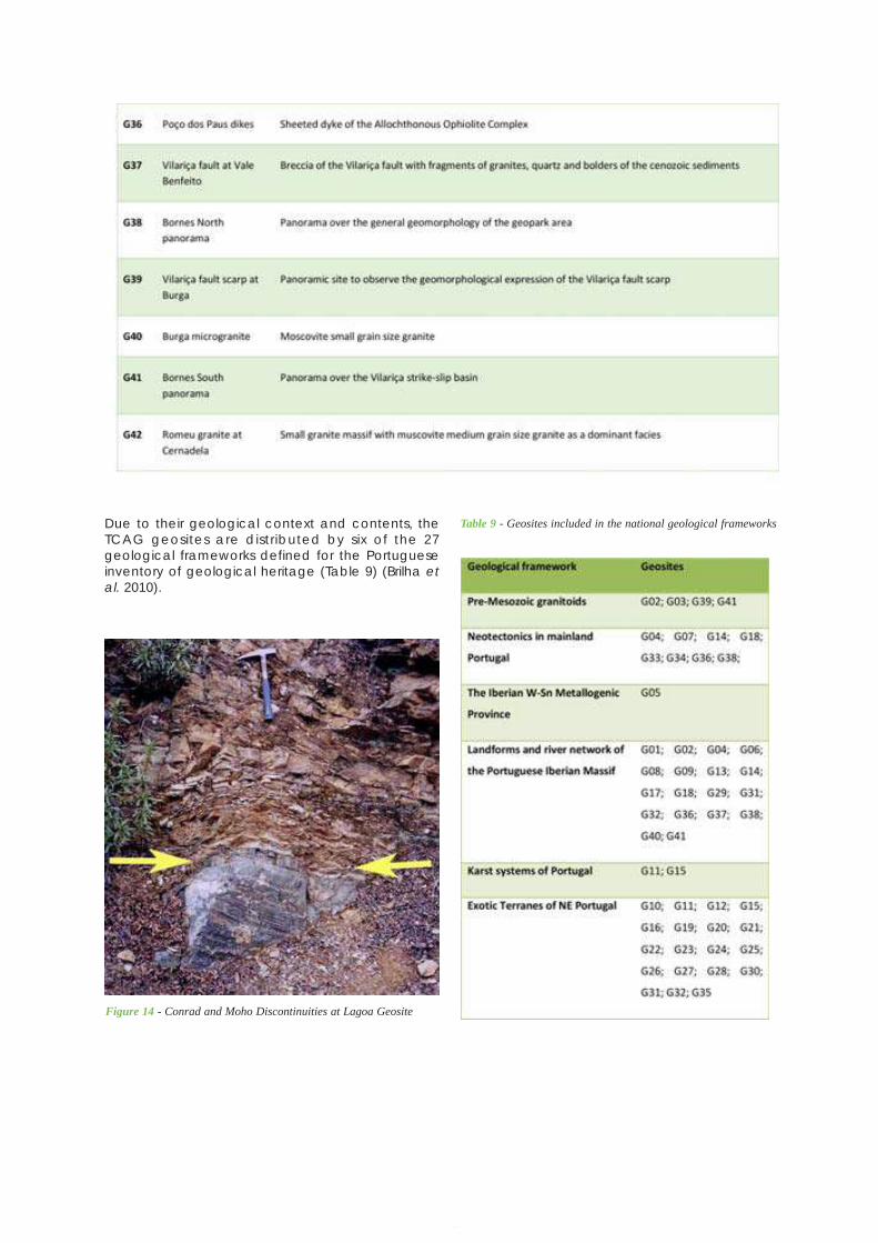
101
Application Dossier for the European Geopark Network Terras de Cavaleiros Aspiring Geopark, Portugal
Due to their geological context and contents, theTCAG geosites are distributed by six of the 27geological frameworks defined for the Portugueseinventory of geological heritage (Table 9) (Brilha etal. 2010).
Figure 14 - Conrad and Moho Discontinuities at Lagoa Geosite
Table 9 - Geosites included in the national geological frameworks
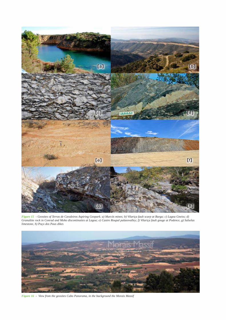
Application Dossier for the European Geopark Network Terras de Cavaleiros Aspiring Geopark, Portugal
102
Figure 15 - Geosites of Terras de Cavaleiros Aspiring Geopark. a) Murcós mines; b) Vilariça fault scarp at Burga; c) Lagoa Gneiss; d)Granultite rock in Conrad and Moho discontinuties at Lagoa; e) Castro Roupal palaeovalley; f) Vilariça fault gouge at Podence, g) Salselaslimestone, h) Poço dos Paus dikes
Figure 16 - View from the geosites Cubo Panorama, in the background the Morais Massif
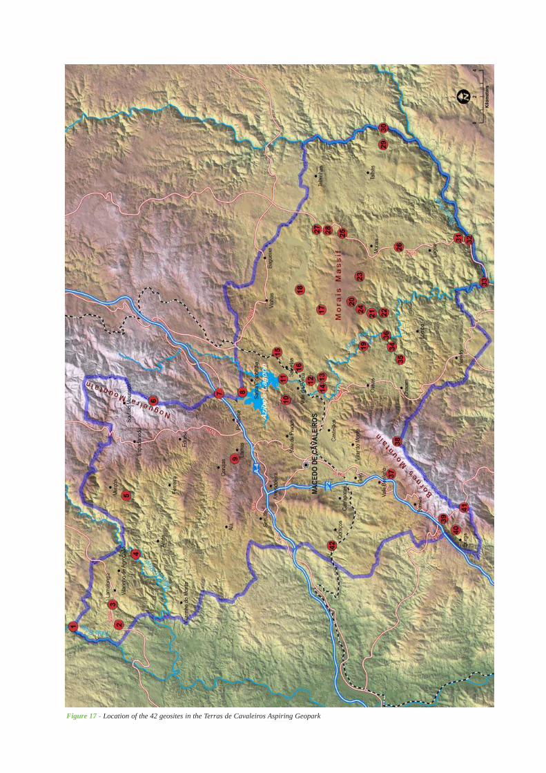
103
Application Dossier for the European Geopark Network Terras de Cavaleiros Aspiring Geopark, Portugal
Figure 17 - Location of the 42 geosites in the Terras de Cavaleiros Aspiring Geopark
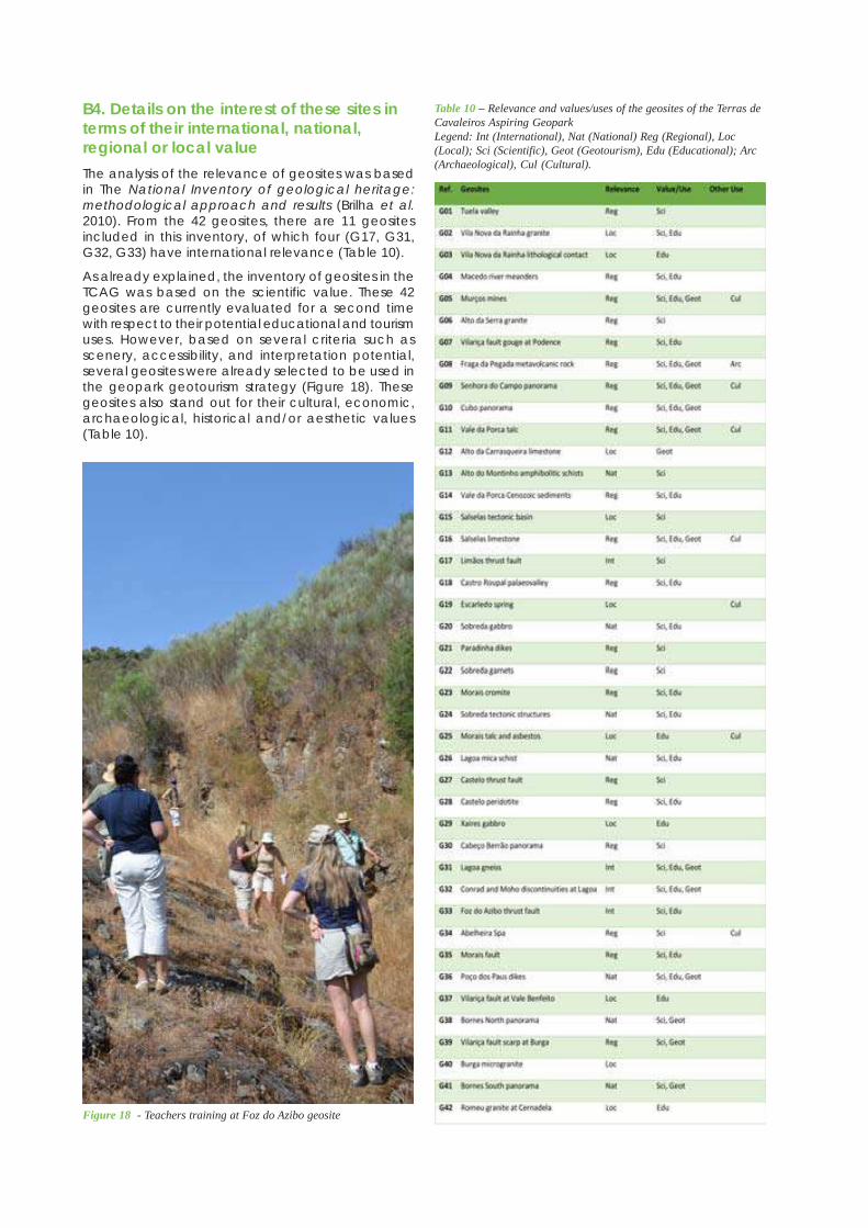
Application Dossier for the European Geopark Network Terras de Cavaleiros Aspiring Geopark, Portugal
104
B4. Details on the interest of these sites interms of their international, national,regional or local valueThe analysis of the relevance of geosites was basedin The National Inventory of geological heritage:methodological approach and results (Brilha et al.2010). From the 42 geosites, there are 11 geositesincluded in this inventory, of which four (G17, G31,G32, G33) have international relevance (Table 10).
As already explained, the inventory of geosites in theTCAG was based on the scientific value. These 42geosites are currently evaluated for a second timewith respect to their potential educational and tourismuses. However, based on several criteria such asscenery, accessibility, and interpretation potential,several geosites were already selected to be used inthe geopark geotourism strategy (Figure 18). Thesegeosites also stand out for their cultural, economic,archaeological, historical and/or aesthetic values(Table 10).
Table 10 – Relevance and values/uses of the geosites of the Terras deCavaleiros Aspiring GeoparkLegend: Int (International), Nat (National) Reg (Regional), Loc(Local); Sci (Scientific), Geot (Geotourism), Edu (Educational); Arc(Archaeological), Cul (Cultural).
Figure 18 - Teachers training at Foz do Azibo geosite
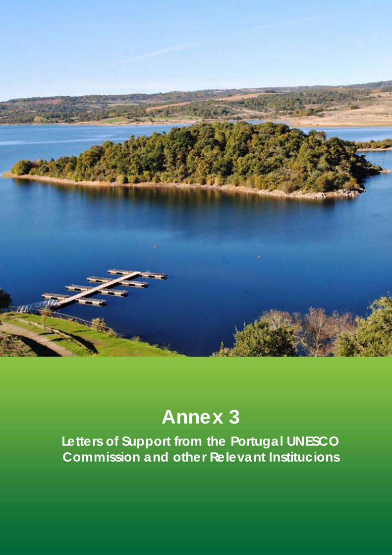
105
Application Dossier for the European Geopark Network Terras de Cavaleiros Aspiring Geopark, Portugal
Annex 3Letters of Support from the Portugal UNESCOCommission and other Relevant Institucions
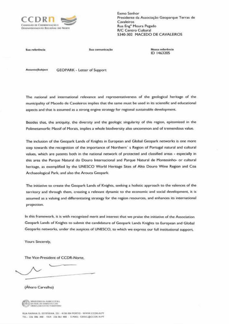
Application Dossier for the European Geopark Network Terras de Cavaleiros Aspiring Geopark, Portugal
106
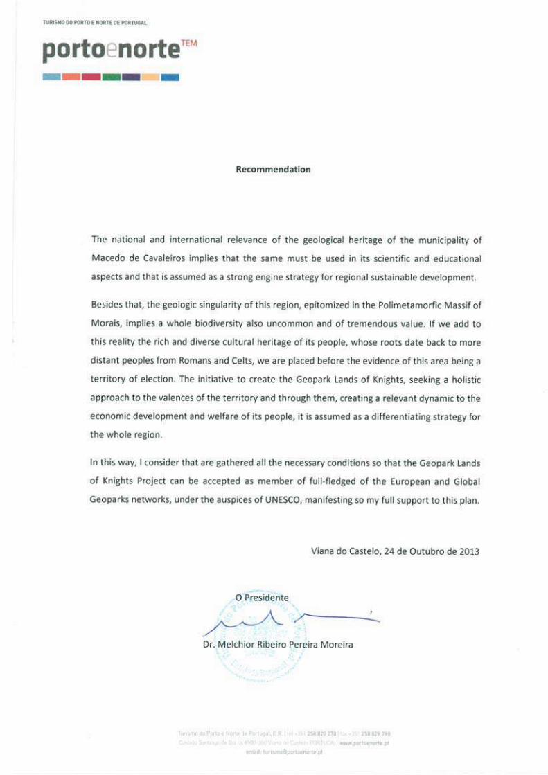
107
Application Dossier for the European Geopark Network Terras de Cavaleiros Aspiring Geopark, Portugal
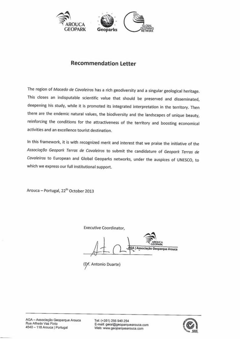
Application Dossier for the European Geopark Network Terras de Cavaleiros Aspiring Geopark, Portugal
108
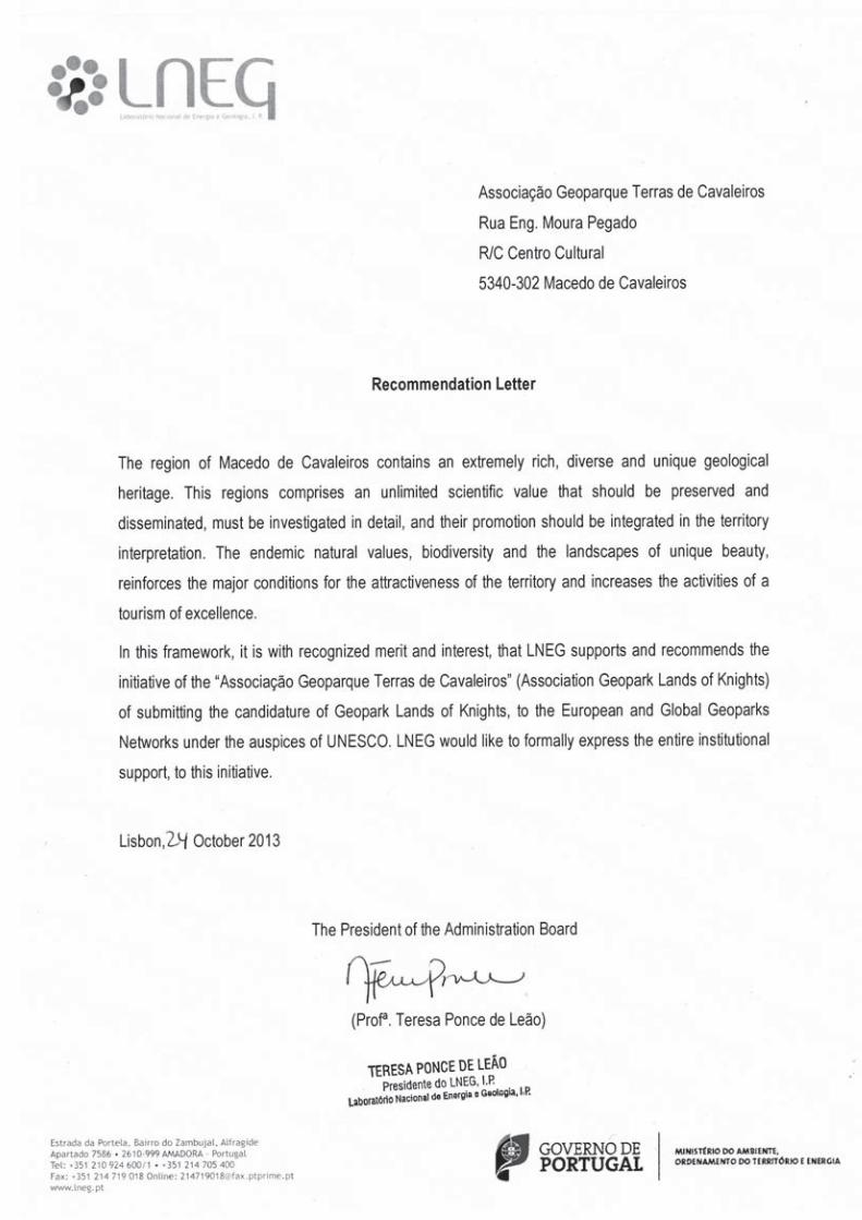
109
Application Dossier for the European Geopark Network Terras de Cavaleiros Aspiring Geopark, Portugal
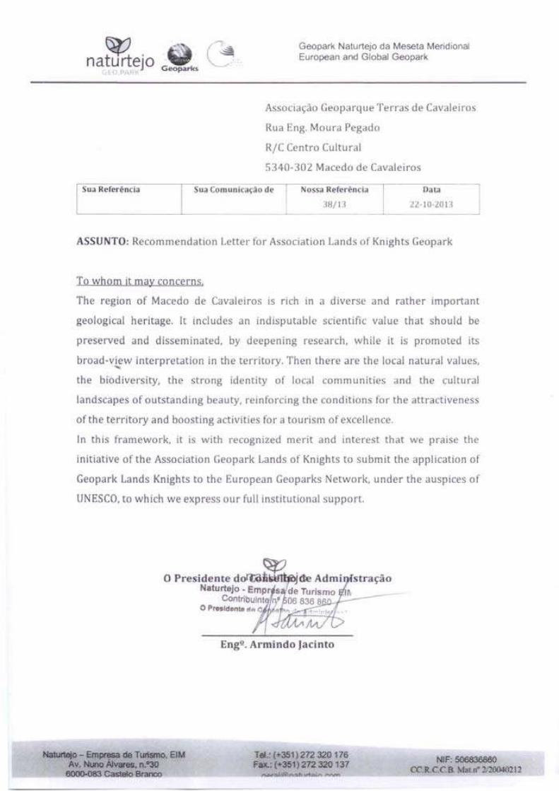
Application Dossier for the European Geopark Network Terras de Cavaleiros Aspiring Geopark, Portugal
110
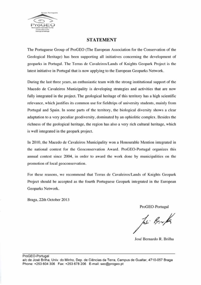
111
Application Dossier for the European Geopark Network Terras de Cavaleiros Aspiring Geopark, Portugal
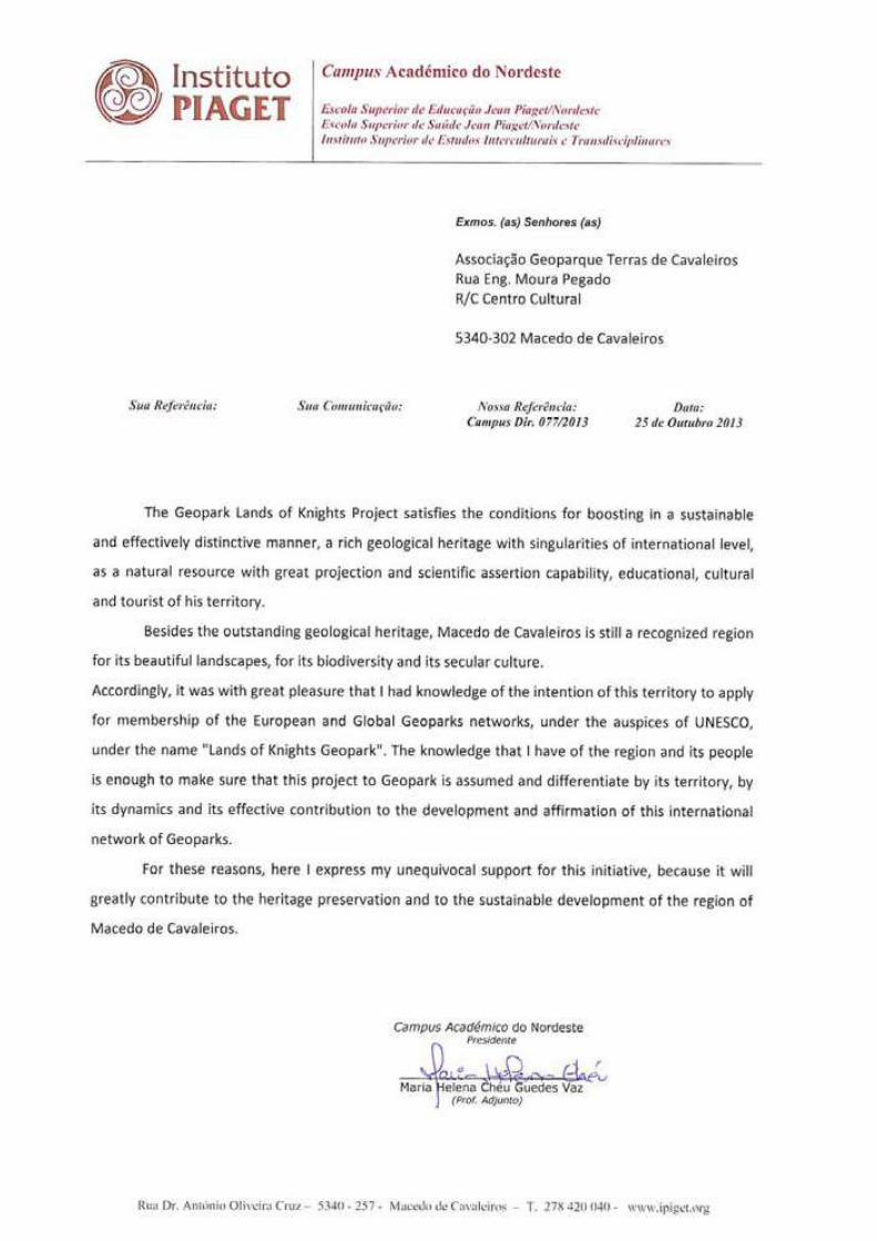
Application Dossier for the European Geopark Network Terras de Cavaleiros Aspiring Geopark, Portugal
112
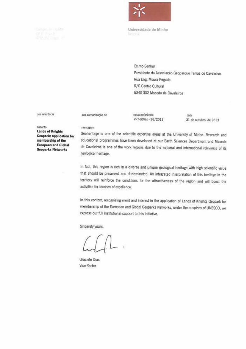
113
Application Dossier for the European Geopark Network Terras de Cavaleiros Aspiring Geopark, Portugal
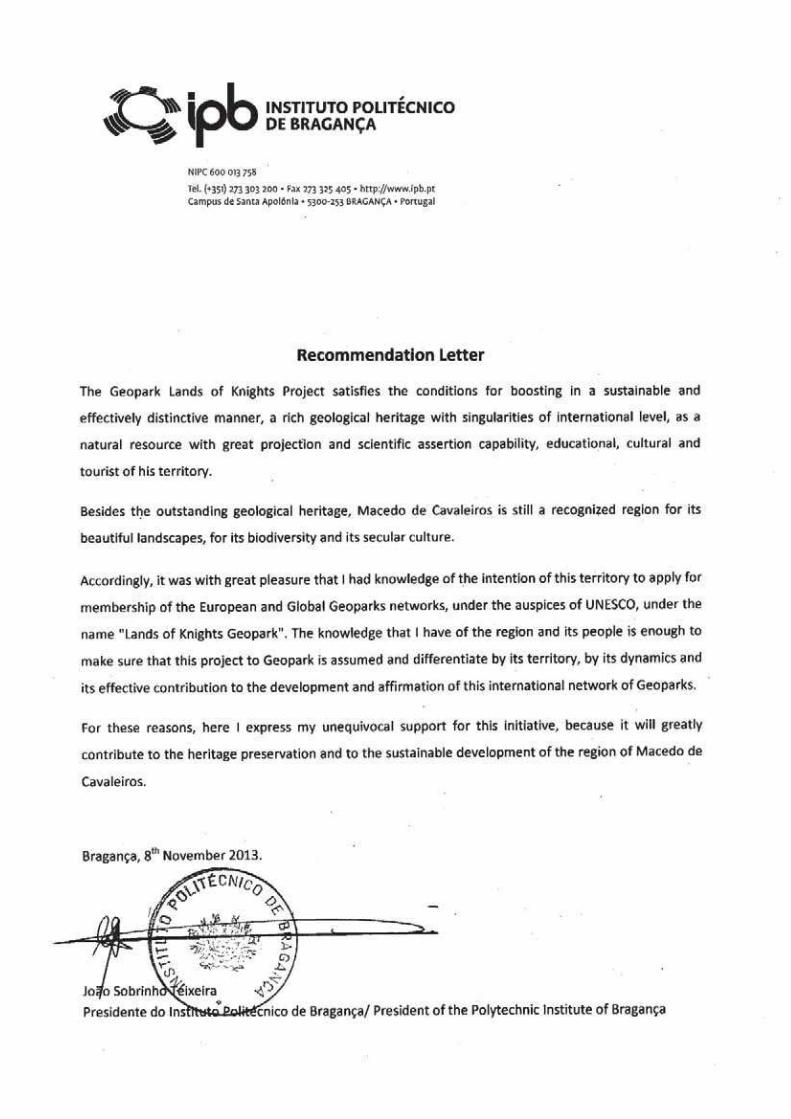
Application Dossier for the European Geopark Network Terras de Cavaleiros Aspiring Geopark, Portugal
114
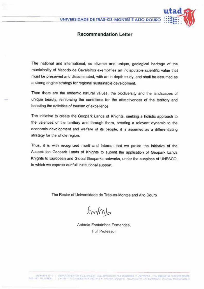
115
Application Dossier for the European Geopark Network Terras de Cavaleiros Aspiring Geopark, Portugal
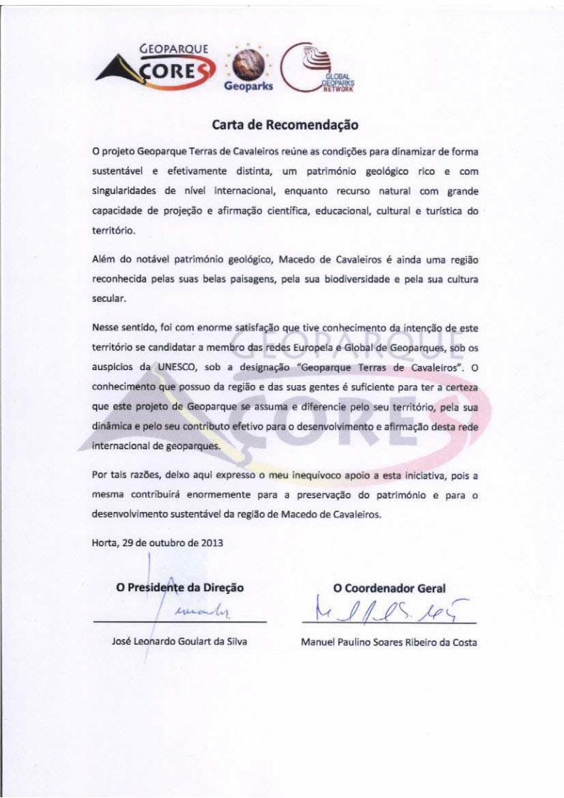
Application Dossier for the European Geopark Network Terras de Cavaleiros Aspiring Geopark, Portugal
116
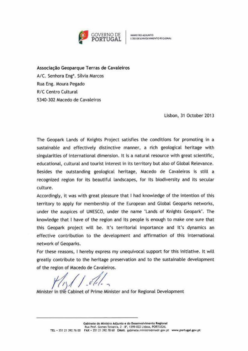
117
Application Dossier for the European Geopark Network Terras de Cavaleiros Aspiring Geopark, Portugal
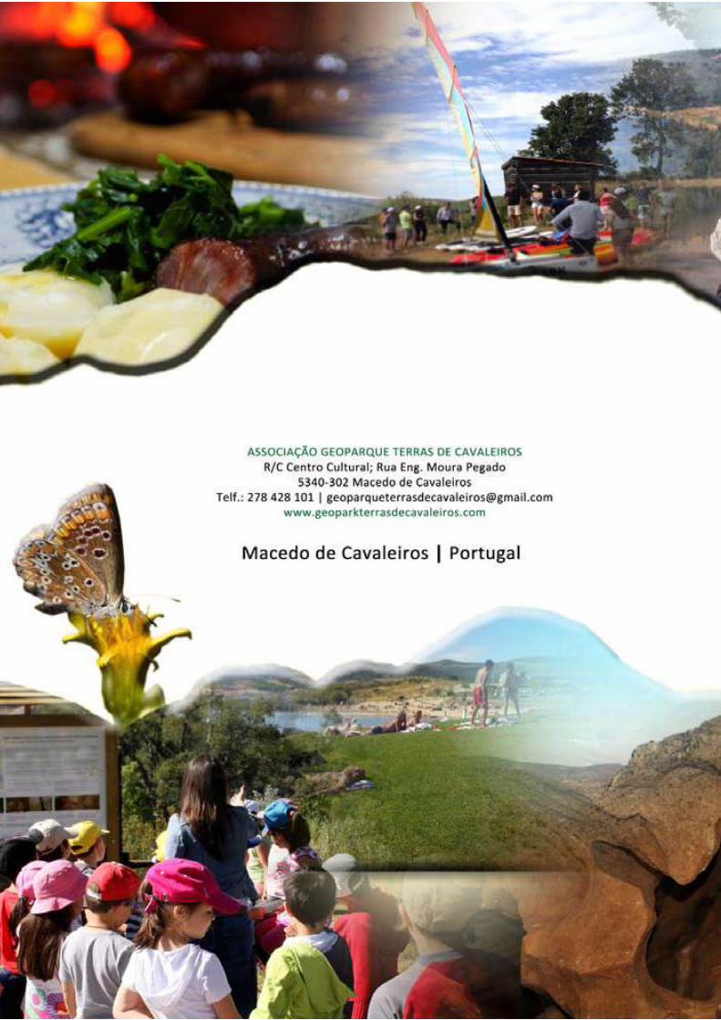
Application Dossier for the European Geopark Network Terras de Cavaleiros Aspiring Geopark, Portugal
118