Embed Size (px)
Citation preview
GHD | Report for City of Sydney- Draft WSUD & Stormwater Infrastructure Report | 104
Appendix N Flood alleviation opportunities
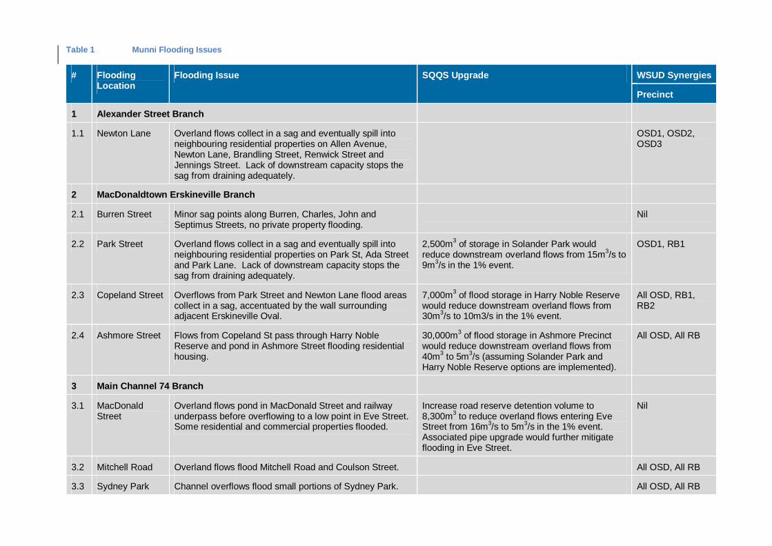
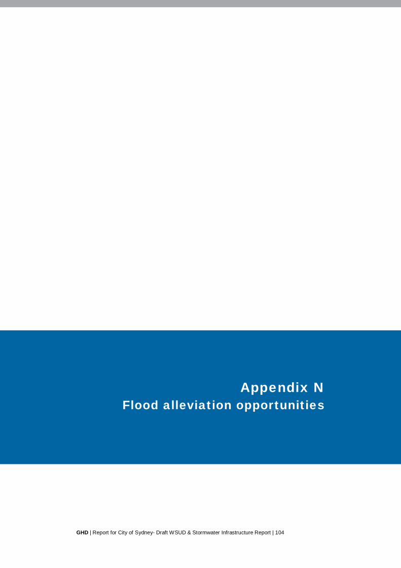
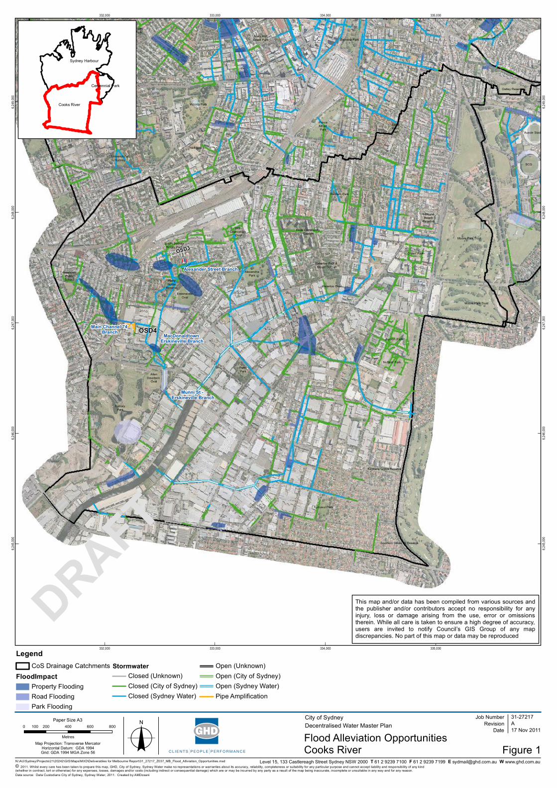
Table 1 Munni Flooding Issues
# FloodingLocation
Flooding Issue SQQS Upgrade WSUD Synergies
Precinct
1 Alexander Street Branch
1.1 Newton Lane Overland flows collect in a sag and eventually spill intoneighbouring residential properties on Allen Avenue,Newton Lane, Brandling Street, Renwick Street andJennings Street. Lack of downstream capacity stops thesag from draining adequately.
OSD1, OSD2,OSD3
2 MacDonaldtown Erskineville Branch
2.1 Burren Street Minor sag points along Burren, Charles, John andSeptimus Streets, no private property flooding.
Nil
2.2 Park Street Overland flows collect in a sag and eventually spill intoneighbouring residential properties on Park St, Ada Streetand Park Lane. Lack of downstream capacity stops thesag from draining adequately.
2,500m3 of storage in Solander Park wouldreduce downstream overland flows from 15m3/s to9m3/s in the 1% event.
OSD1, RB1
2.3 Copeland Street Overflows from Park Street and Newton Lane flood areascollect in a sag, accentuated by the wall surroundingadjacent Erskineville Oval.
7,000m3 of flood storage in Harry Noble Reservewould reduce downstream overland flows from30m3/s to 10m3/s in the 1% event.
All OSD, RB1,RB2
2.4 Ashmore Street Flows from Copeland St pass through Harry NobleReserve and pond in Ashmore Street flooding residentialhousing.
30,000m3 of flood storage in Ashmore Precinctwould reduce downstream overland flows from40m3 to 5m3/s (assuming Solander Park andHarry Noble Reserve options are implemented).
All OSD, All RB
3 Main Channel 74 Branch
3.1 MacDonaldStreet
Overland flows pond in MacDonald Street and railwayunderpass before overflowing to a low point in Eve Street.Some residential and commercial properties flooded.
Increase road reserve detention volume to8,300m3 to reduce overland flows entering EveStreet from 16m3/s to 5m3/s in the 1% event.Associated pipe upgrade would further mitigateflooding in Eve Street.
Nil
3.2 Mitchell Road Overland flows flood Mitchell Road and Coulson Street. All OSD, All RB
3.3 Sydney Park Channel overflows flood small portions of Sydney Park. All OSD, All RB

Table 2 Munni Flood Alleviation – WSUD Synergies
WSUD Synergies
# Name DescriptionPr
ecin
ct
OSD Redevelopment (On Site Detention)
OSD1 Everleigh Rail Workshops OSD as part of redevelopment.
OSD2 Australian TechnologyPark
OSD as part of redevelopment.
OSD3 Sydney Water SiteNewtown Street
OSD as part of redevelopment.
RB Retrofit (Public Space Retarding Basins)
RB1 Solander Park Retrofit RB to Solander Park.
RB2 MacDonald Street Design of RB to be included as part of WSUD project.
RB3 North – South Link Park(Ashmore Precinct)
RB to be accommodated within allocated POS within Ashmore redevelopment.
Loca
l
RR Road Renewals
RG Local raingardens Streetscape raingardens within source catchments can provide additional storage and flow attenuation (e.g. 50m3
per ha of treated catchment).
PR Private Retrofit
PR Private Rainwater Tanks Rainwater tanks with allocated air space storage (e.g. 1000L capacity per residential, 5000L capacity per non-residential).
Table 3 Rushcutters Bay Flooding Issues
# Flooding Location Flooding Issue SQQS Upgrade WSUD Synergies
Precinct
1 Roslyn Gardens Branch
1.1 Waratah Street Sag point, SQQS report suggests works havebeen carried out to alleviate this issue.
Nil
2 Craigend Street Branch
2.1 Craigend Street Ponding in sag to an approximate depth ofbetween 0.4 and 0.5m.
Nil
3 Boundary Street Branch
3.1 Oxford Street Sag in road with potential to flood shops,depth in street up to 0.45m.
Nil
3.2 Taylor Street Depths of 1.6m and 1.3m in sags resulting inproperty flooding.
New 1050mm diameter pipe from Taylor Street sagsbeneath Oxford Street to Boundary Street.
Nil
3.3 St Vincents Hospital Historical flooding reports. Nil
3.4 Boundary Street Hazardous flows in 5yr events and higheralong Boundary Street for several hundredmetres between Barcom Avenue andMaclachlan Avenue.
Currently receives overflows when capacity of culvertsbeneath Craigend Street is exceeded. An increase in inletcapacity in the MacLachlan Avenue / Boundary Streetvicinity would substantially reduce overland flows.
RB1
3.5 McLachlan Avenue Minor sag with regular flooding, includingflooding of private property.
Regrading of MacLachlan Avenue to Craigend Streetwould substantially reduce flooding in sag, but increaseflows to Craigend Street sag. Regrade footpath at cornerof Craigend Street and Neild Avenue to direct flows intochannel and redistribute flooding to adjacent oval.
RB1
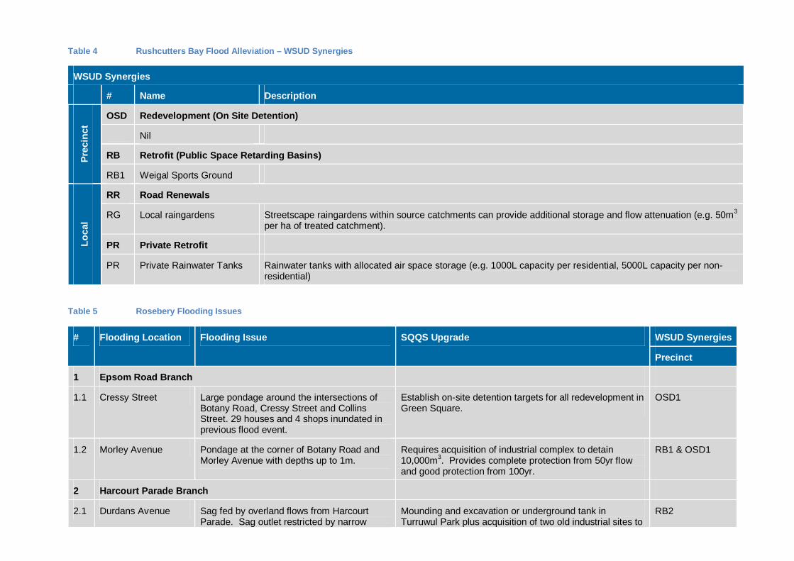
Table 4 Rushcutters Bay Flood Alleviation – WSUD Synergies
WSUD Synergies
# Name DescriptionPr
ecin
ct
OSD Redevelopment (On Site Detention)
Nil
RB Retrofit (Public Space Retarding Basins)
RB1 Weigal Sports Ground
Loca
l
RR Road Renewals
RG Local raingardens Streetscape raingardens within source catchments can provide additional storage and flow attenuation (e.g. 50m3
per ha of treated catchment).
PR Private Retrofit
PR Private Rainwater Tanks Rainwater tanks with allocated air space storage (e.g. 1000L capacity per residential, 5000L capacity per non-residential)
Table 5 Rosebery Flooding Issues
# Flooding Location Flooding Issue SQQS Upgrade WSUD Synergies
Precinct
1 Epsom Road Branch
1.1 Cressy Street Large pondage around the intersections ofBotany Road, Cressy Street and CollinsStreet. 29 houses and 4 shops inundated inprevious flood event.
Establish on-site detention targets for all redevelopment inGreen Square.
OSD1
1.2 Morley Avenue Pondage at the corner of Botany Road andMorley Avenue with depths up to 1m.
Requires acquisition of industrial complex to detain10,000m3. Provides complete protection from 50yr flowand good protection from 100yr.
RB1 & OSD1
2 Harcourt Parade Branch
2.1 Durdans Avenue Sag fed by overland flows from HarcourtParade. Sag outlet restricted by narrow
Mounding and excavation or underground tank inTurruwul Park plus acquisition of two old industrial sites to
RB2
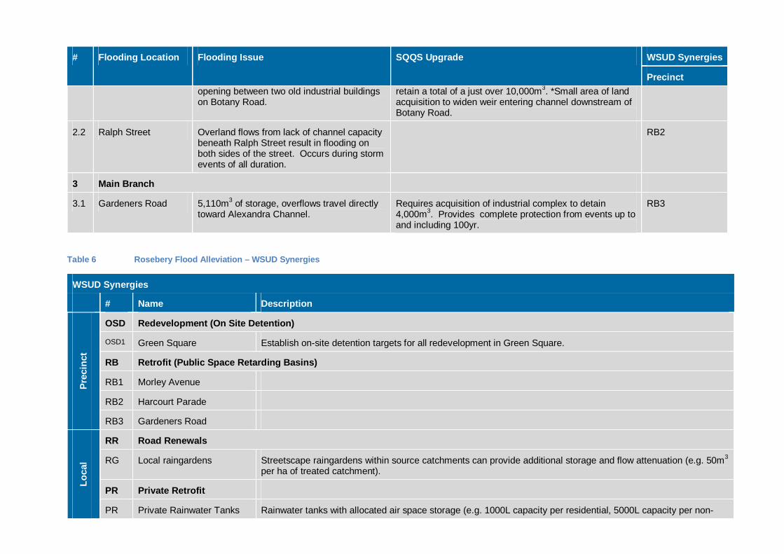
# Flooding Location Flooding Issue SQQS Upgrade WSUD Synergies
Precinctopening between two old industrial buildingson Botany Road.
retain a total of a just over 10,000m3. *Small area of landacquisition to widen weir entering channel downstream ofBotany Road.
2.2 Ralph Street Overland flows from lack of channel capacitybeneath Ralph Street result in flooding onboth sides of the street. Occurs during stormevents of all duration.
RB2
3 Main Branch
3.1 Gardeners Road 5,110m3 of storage, overflows travel directlytoward Alexandra Channel.
Requires acquisition of industrial complex to detain4,000m3. Provides complete protection from events up toand including 100yr.
RB3
Table 6 Rosebery Flood Alleviation – WSUD Synergies
WSUD Synergies
# Name Description
Prec
inct
OSD Redevelopment (On Site Detention)
OSD1 Green Square Establish on-site detention targets for all redevelopment in Green Square.
RB Retrofit (Public Space Retarding Basins)
RB1 Morley Avenue
RB2 Harcourt Parade
RB3 Gardeners Road
Loca
l
RR Road Renewals
RG Local raingardens Streetscape raingardens within source catchments can provide additional storage and flow attenuation (e.g. 50m3
per ha of treated catchment).
PR Private Retrofit
PR Private Rainwater Tanks Rainwater tanks with allocated air space storage (e.g. 1000L capacity per residential, 5000L capacity per non-
WSUD Synergies
# Name Descriptionresidential)
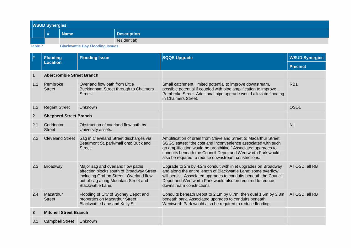
Table 7 Blackwattle Bay Flooding Issues
# FloodingLocation
Flooding Issue SQQS Upgrade WSUD Synergies
Precinct
1 Abercrombie Street Branch
1.1 PembrokeStreet
Overland flow path from LittleBuckingham Street through to ChalmersStreet.
Small catchment, limited potential to improve downstream,possible potential if coupled with pipe amplification to improvePembroke Street. Additional pipe upgrade would alleviate floodingin Chalmers Street.
RB1
1.2 Regent Street Unknown OSD1
2 Shepherd Street Branch
2.1 CodringtonStreet
Obstruction of overland flow path byUniversity assets.
Nil
2.2 Cleveland Street Sag in Cleveland Street discharges viaBeaumont St, park/mall onto BucklandStreet.
Amplification of drain from Cleveland Street to Macarthur Street,SGGS states: "the cost and inconvenience associated with suchan amplification would be prohibitive.” Associated upgrades toconduits beneath the Council Depot and Wentworth Park wouldalso be required to reduce downstream constrictions.
2.3 Broadway Major sag and overland flow pathsaffecting blocks south of Broadway Streetincluding Grafton Street. Overland flowout of sag along Mountain Street andBlackwattle Lane.
Upgrade to 2m by 4.2m conduit with inlet upgrades on Broadwayand along the entire length of Blackwattle Lane; some overflowwill persist. Associated upgrades to conduits beneath the CouncilDepot and Wentworth Park would also be required to reducedownstream constrictions.
All OSD, all RB
2.4 MacarthurStreet
Flooding of City of Sydney Depot andproperties on Macarthur Street,Blackwattle Lane and Kelly St.
Conduits beneath Depot to 2.1m by 8.7m, then dual 1.5m by 3.8mbeneath park. Associated upgrades to conduits beneathWentworth Park would also be required to reduce flooding.
All OSD, all RB
3 Mitchell Street Branch
3.1 Campbell Street Unknown
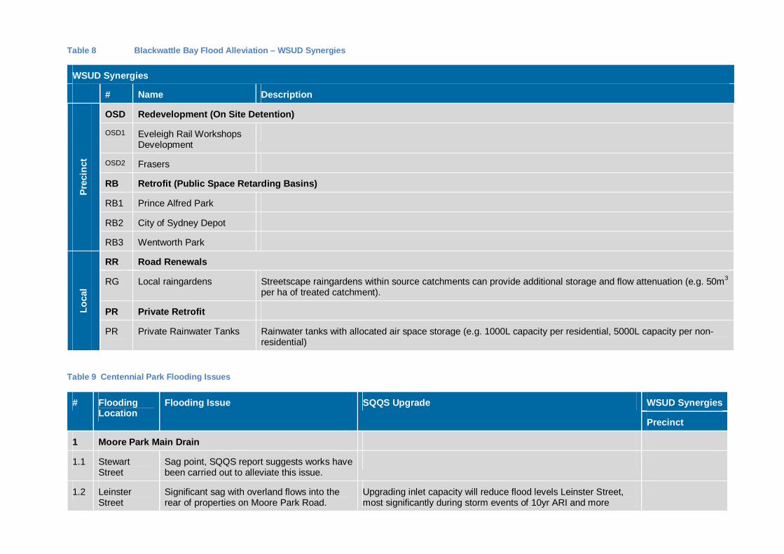
Table 8 Blackwattle Bay Flood Alleviation – WSUD Synergies
WSUD Synergies
# Name DescriptionPr
ecin
ct
OSD Redevelopment (On Site Detention)
OSD1 Eveleigh Rail WorkshopsDevelopment
OSD2 Frasers
RB Retrofit (Public Space Retarding Basins)
RB1 Prince Alfred Park
RB2 City of Sydney Depot
RB3 Wentworth Park
Loca
l
RR Road Renewals
RG Local raingardens Streetscape raingardens within source catchments can provide additional storage and flow attenuation (e.g. 50m3
per ha of treated catchment).
PR Private Retrofit
PR Private Rainwater Tanks Rainwater tanks with allocated air space storage (e.g. 1000L capacity per residential, 5000L capacity per non-residential)
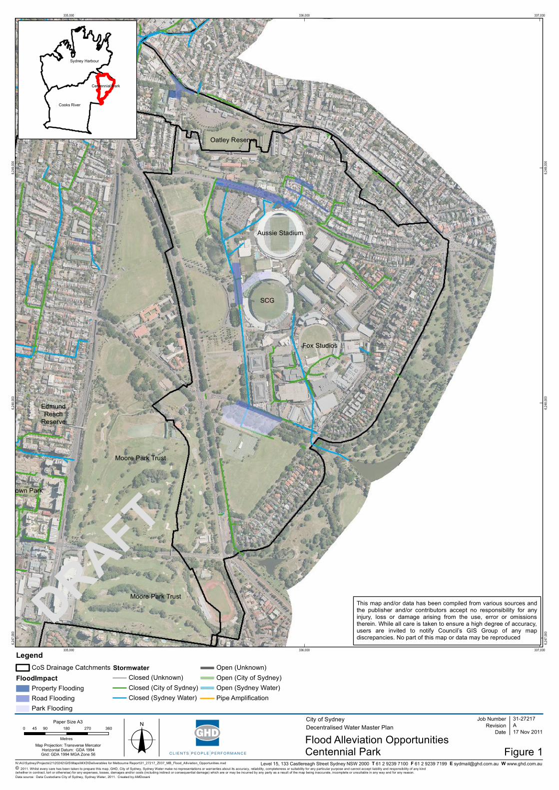
Table 9 Centennial Park Flooding Issues
# FloodingLocation
Flooding Issue SQQS Upgrade WSUD Synergies
Precinct
1 Moore Park Main Drain
1.1 StewartStreet
Sag point, SQQS report suggests works havebeen carried out to alleviate this issue.
1.2 LeinsterStreet
Significant sag with overland flows into therear of properties on Moore Park Road.
Upgrading inlet capacity will reduce flood levels Leinster Street,most significantly during storm events of 10yr ARI and more
# FloodingLocation
Flooding Issue SQQS Upgrade WSUD Synergies
Precinctfrequent.
1.3 Moore ParkRoad
Overland flows along a few hundred metresof Moore Park Road, extending to slightlyabove gutter levels in a 100yr ARI event.
Modification to flow routing across Moore Park Road from theLeinster Street branch could reduce overland flows along MoorePark Road.
1.4 DriverAvenue
Large sag outside the SCG collects flowsfrom Moore Park Road, Kippax Lake andtrunk drainage overflow.
Increase mounding around existing lake by 900mm to increaseretarding capacity.
RB1
1.5 Lang Road Substantial flooding on Lang Road andFederation Way, but does not threatenproperty.
Increase mounding/retarding capacity of lake. Potential site forabove ground retarding basin constructed using embankments.The area is slightly removed from the main drain. Potential sitefor excavated retarding basin. The high water table and sandysoils would make construction of an excavated detention basindifficult.
All RB
Table 10 Centennial Park Flood Alleviation – WSUD Synergies
WSUD Synergies
# Name Description
Prec
inct
OSD Redevelopment (On Site Detention)
Nil
RB Retrofit (Public Space Retarding Basins)
RB1 Kippax Lake
RB2 Bus Loop Field
RB3 Moore Park (Lot 1771)
Loca
l
RR Road Renewals
RG Local raingardens Streetscape raingardens within source catchments can provide additional storage and flow attenuation (e.g. 50m3
per ha of treated catchment).
PR Private Retrofit
WSUD Synergies
# Name Description
PR Private Rainwater Tanks Rainwater tanks with allocated air space storage (e.g. 1000L capacity per residential, 5000L capacity per non-residential)
Table 11 Johnstons Creek Flooding Issues
# FloodingLocation
Flooding Issue SQQS Upgrade WSUD Synergies
Precinct
1 Orphan School Creek (incl. St Andrews College Sub-Branch, Hockey Field Sub-Branch & Physics School Relief)
1.1 Carillon Avenue Overland flow path between CampbellStreet and Carillon Avenue east ofNewtown North Primary School.
Upgrade 160m of 600mm pipe to 1050mm beneath St Andrewsoval and increase inlet sizes around Carillon Avenue.
1.2 University ofSydney
Oval number 1 acts as a de factoretarding basin with flooding of theadjacent Sports Centre.
Oval #1 already functions as a de facto retarding basin, there maybe an opportunity to extend storage to other open spaces in theUniversity including Oval #2, St Johns Oval, Hockey Square andSt Andrews Oval (underground car park may be an issue).Monitor developments within the University with the aim ofassessing the potential for integration of harvesting / stormwater /re-use schemes. Further upgrade of pipe beneath St Andrewsoval will also help alleviate flooding.
RB1 & OSD2
1.3 Larkin Street Overland flows and property floodingbetween Parramatta Road and PyrmontBridge Road on Larkin Street, SparkesStreet, Arundel Street, Sparkes Lane andJunction Street.
Substantial ponding will only be slightly mitigated by major pipeupgrades, SQQS recommends designating this area as a floodzone.
RB1 & OSD2
2 Federal Park
2.1 CarpetWarehouse
Given the localised nature of the flooding and proximity to trunkdrainage it seems possible that flooding at 2.1 could be alleviatedwith inlet and/or pipe amplification. Alternatively flooding at thislocation may be a result of proximity to mean sea level.
Table 12 Johnstons Creek Flood Alleviation – WSUD Synergies
WSUD Synergies
# Name DescriptionPr
ecin
ct
OSD Redevelopment (On Site Detention)
OSD1 Harold Park
OSD2 University of Sydney
RB Retrofit (Public Space Retarding Basins)
RB1 University of Sydney
Loca
l
RR Road Renewals
RG Local raingardens Streetscape raingardens within source catchments can provide additional storage and flow attenuation (e.g. 50m3
per ha of treated catchment).
PR Private Retrofit
PR Private Rainwater Tanks Rainwater tanks with allocated air space storage (e.g. 1000L capacity per residential, 5000L capacity per non-residential)
Table 13 Alexandra Canal Flooding Issues
# Flooding Location Flooding Issue SQQS Upgrade WSUD Synergies
Precinct
1 Moore Park Main Drain
1.1 Sydney Park Large open space with existing pondarrangement. Retrofit ponds or allocate furtheropen space to flood detention.
RB1
1.2 Burrows Road RB1

Table 14 Alexandra Canal Flood Alleviation – WSUD Synergies
WSUD Synergies
# Name DescriptionPr
ecin
ct
OSD Redevelopment (On Site Detention)
OSD1 Nil
RB Retrofit (Public Space Retarding Basins)
RB1 Sydney Park
Loca
l
RR Road Renewals
RG Local raingardens Streetscape raingardens within source catchments can provide additional storage and flow attenuation (e.g. 50m3
per ha of treated catchment).
PR Private Retrofit
PR Private Rainwater Tanks Rainwater tanks with allocated air space storage (e.g. 1000L capacity per residential, 5000L capacity per non-residential)
Table 15 Woolloomooloo Flooding Issues
# FloodingLocation
Flooding Issue SQQS Upgrade WSUD Synergies
Precinct
1 Bourke Street
1.1 Yurong Street Major Sag also along Stream Street and waterponding on William Street near numbers 66-70. Potential for flooding up to 3m deep.
Extension of pipe from motorway to Stream Street via SirJohn Young Crescent and Riley Street. Nominal 1200mmdiameter required. This may worsen Bourke Street flooding.
1.2 Crown Street Number 24 flooded above floor level alsooverland flows along Palmer Street.
Riley Street pipe amplification as per 1.1 would also alleviateflooding along Crown Street.
1.3 Sydney EyeHospital
Flood level on driveway Large amounts of open space are available in the Domain,however there is little contributing catchment.
RB2
1.4 Bourke Street No 10 -12 reported road flooding. BourkeStreet, Wilson Street and Plunkett Street
Nil
# FloodingLocation
Flooding Issue SQQS Upgrade WSUD Synergies
Precinctidentified as an overland flow paths.
2 Forbes Street
2.1 Dowling Street Major sag formed by railway line, potential forflooding up to 3m deep.
Open space on Forbes Street and Brougham Street branchesis available in the Sydney Place Park, Plunkett Street PublicSchool and Forbes Street Parks.
RB1
2.2 Cowper WharfRoadway
Acts as a barrier to overland flows that wouldotherwise flow into the harbour. Also affectsBrougham Street drain. No recorded floodingin this location, but large potential for floodingdue to large flat area upstream of road beinglower than the road.
Lowering a section of the road to 1.6m would allow trappedflows into the bay.
RB1
Table 16 Woolloomooloo Flood Alleviation – WSUD Synergies
WSUD Synergies
# Name Description
Prec
inct
OSD Redevelopment (On Site Detention)
OSD1 Nil
RB Retrofit (Public Space Retarding Basins)
RB1 Sydney Place ParkPrecinct
RB2 The Domain
Loca
l
RR Road Renewals
RG Local raingardens Streetscape raingardens within source catchments can provide additional storage and flow attenuation (e.g. 50m3
per ha of treated catchment).
PR Private Retrofit
PR Private Rainwater Tanks Rainwater tanks with allocated air space storage (e.g. 1000L capacity per residential, 5000L capacity per non-
WSUD Synergies
# Name Descriptionresidential)
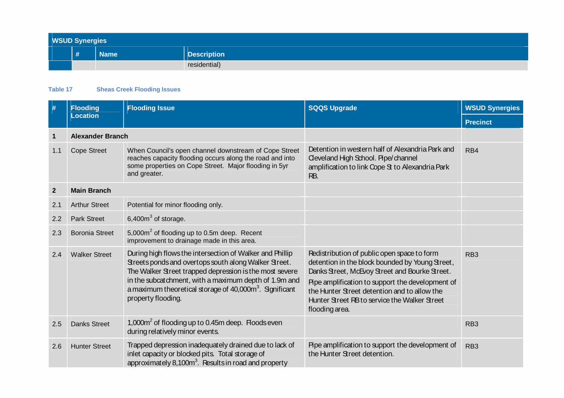
Table 17 Sheas Creek Flooding Issues
# FloodingLocation
Flooding Issue SQQS Upgrade WSUD Synergies
Precinct
1 Alexander Branch
1.1 Cope Street When Council's open channel downstream of Cope Streetreaches capacity flooding occurs along the road and intosome properties on Cope Street. Major flooding in 5yrand greater.
Detention in western half of Alexandria Park andCleveland High School. Pipe/channelamplification to link Cope St to Alexandria ParkRB.
RB4
2 Main Branch
2.1 Arthur Street Potential for minor flooding only.
2.2 Park Street 6,400m3 of storage.
2.3 Boronia Street 5,000m2 of flooding up to 0.5m deep. Recentimprovement to drainage made in this area.
2.4 Walker Street During high flows the intersection of Walker and PhillipStreets ponds and overtops south along Walker Street.The Walker Street trapped depression is the most severein the subcatchment, with a maximum depth of 1.9m anda maximum theoretical storage of 40,000m3. Significantproperty flooding.
Redistribution of public open space to formdetention in the block bounded by Young Street,Danks Street, McEvoy Street and Bourke Street.Pipe amplification to support the development ofthe Hunter Street detention and to allow theHunter Street RB to service the Walker Streetflooding area.
RB3
2.5 Danks Street 1,000m2 of flooding up to 0.45m deep. Floods evenduring relatively minor events.
RB3
2.6 Hunter Street Trapped depression inadequately drained due to lack ofinlet capacity or blocked pits. Total storage ofapproximately 8,100m3. Results in road and property
Pipe amplification to support the development ofthe Hunter Street detention.
RB3
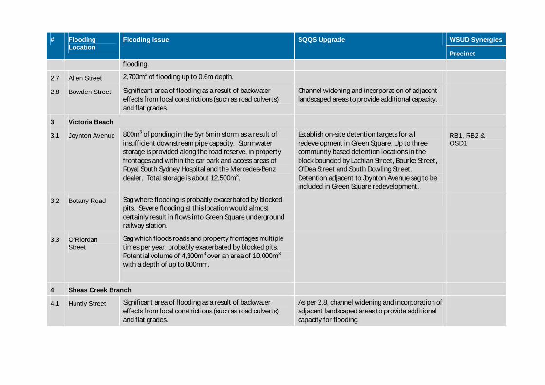
# FloodingLocation
Flooding Issue SQQS Upgrade WSUD Synergies
Precinctflooding.
2.7 Allen Street 2,700m2 of flooding up to 0.6m depth.
2.8 Bowden Street Significant area of flooding as a result of backwatereffects from local constrictions (such as road culverts)and flat grades.
Channel widening and incorporation of adjacentlandscaped areas to provide additional capacity.
3 Victoria Beach
3.1 Joynton Avenue 800m3 of ponding in the 5yr 5min storm as a result ofinsufficient downstream pipe capacity. Stormwaterstorage is provided along the road reserve, in propertyfrontages and within the car park and access areas ofRoyal South Sydney Hospital and the Mercedes-Benzdealer. Total storage is about 12,500m3.
Establish on-site detention targets for allredevelopment in Green Square. Up to threecommunity based detention locations in theblock bounded by Lachlan Street, Bourke Street,O'Dea Street and South Dowling Street.Detention adjacent to Joynton Avenue sag to beincluded in Green Square redevelopment.
RB1, RB2 &OSD1
3.2 Botany Road Sag where flooding is probably exacerbated by blockedpits. Severe flooding at this location would almostcertainly result in flows into Green Square undergroundrailway station.
3.3 O’RiordanStreet
Sag which floods roads and property frontages multipletimes per year, probably exacerbated by blocked pits.Potential volume of 4,300m3 over an area of 10,000m3
with a depth of up to 800mm.
4 Sheas Creek Branch
4.1 Huntly Street Significant area of flooding as a result of backwatereffects from local constrictions (such as road culverts)and flat grades.
As per 2.8, channel widening and incorporation ofadjacent landscaped areas to provide additionalcapacity for flooding.
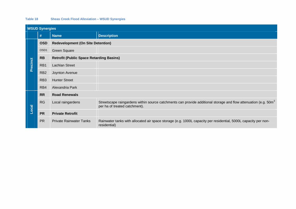
Table 18 Sheas Creek Flood Alleviation – WSUD Synergies
WSUD Synergies
# Name DescriptionPr
ecin
ct
OSD Redevelopment (On Site Detention)
OSD1 Green Square
RB Retrofit (Public Space Retarding Basins)
RB1 Lachlan Street
RB2 Joynton Avenue
RB3 Hunter Street
RB4 Alexandria Park
Loca
l
RR Road Renewals
RG Local raingardens Streetscape raingardens within source catchments can provide additional storage and flow attenuation (e.g. 50m3
per ha of treated catchment).
PR Private Retrofit
PR Private Rainwater Tanks Rainwater tanks with allocated air space storage (e.g. 1000L capacity per residential, 5000L capacity per non-residential)
Garden Island
Oatley Reserve
Vice Chancellors
Oval
Pyrmont PointPark
Metcalfe Park
NewtownPublicSchool
Cook Community Garden
Cadi Park andElizabeth Plaza
The Maze
Moore Park Trust
Royal Botanic Gardens
Darling Harbour
Moore Park Trust
Harold Park
Victoria Park
The Domain
Hyde Park North
JubileePark
Hyde Park South
PrinceAlfred Park
Tumbalong Park
SCG
AlexandriaPark
Fox Studios
Wentworth Park
The DomainLawns
Reg Bartley Oval
Pirrama Park
FederalPark
Redfern Park
Waterloo Oval
Circular Quay
Observatory Hill Park
Aussie Stadium
ErskinevilleOval
Bicentennial Park
JubileeOval
Joynton Park
Belmore Park
First Fleet Park
Blackwattle Bay Park
EddieWardPark
HarryNoble
Reserve
FederalPark
Wynyard Park
Crown Park
GreenPark
Embarkation Park
Waterloo Park & Mount Carmel
Nuffield Park
Dawes Point Park
Pyrmont Bay Park
Glebe Foreshore Walk East
EdmundResch
Reserve
University of Sydney
Harmony Park
Glebe Foreshore Walk West
Dr H J Foley Rest Park
Mary AnnStreet Park
South SydneyRotary Park
Caldwell Park
Forbes StreetReserve
Cook + Phillip Park
Gibba Park
Glebe Foreshore Walk West
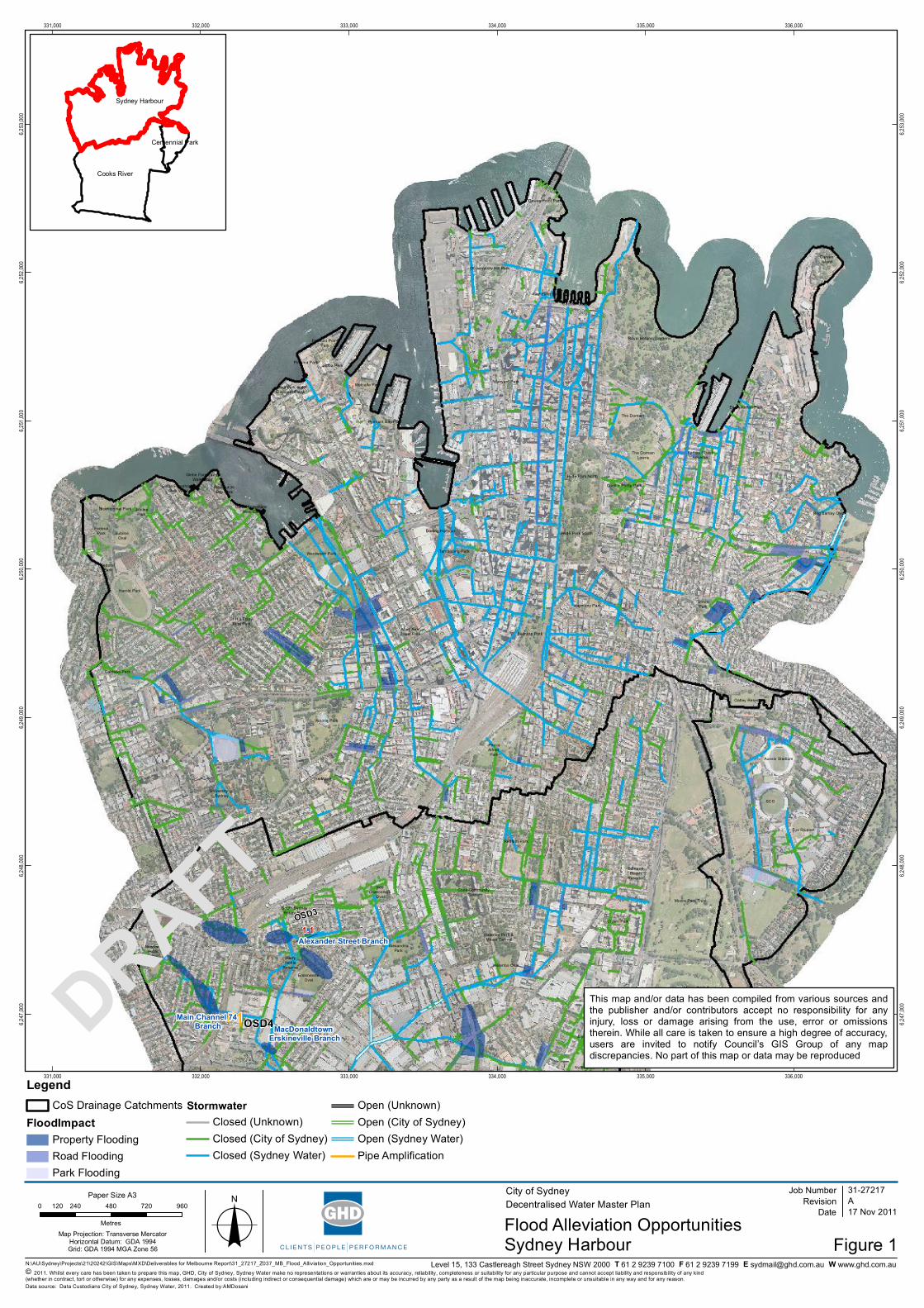
1.1
P1
OSD3
OSD4MacDonaldtown Erskineville Branch
Main Channel 74 Branch
Alexander Street Branch
331,000
331,000
332,000
332,000
333,000
333,000
334,000
334,000
335,000
335,000
336,000
336,000
6,247
,000
6,247
,000
6,248
,000
6,248
,000
6,249
,000
6,249
,000
6,250
,000
6,250
,000
6,251
,000
6,251
,000
6,252
,000
6,252
,000
6,253
,000
6,253
,000
N:\AU\Sydney\Projects\21\20242\GIS\Maps\MXD\Deliverables for Melbourne Report\31_27217_Z037_MB_Flood_Alliviation_Opportunities.mxd
0 240 480 720 960120
MetresMap Projection: Transverse Mercator
Horizontal Datum: GDA 1994Grid: GDA 1994 MGA Zone 56 o
© 2011. Whilst every care has been taken to prepare this map, GHD, City of Sydney, Sydney Water make no representations or warranties about its accuracy, reliability, completeness or suitability for any particular purpose and cannot accept liability and responsibility of any kind (whether in contract, tort or otherwise) for any expenses, losses, damages and/or costs (including indirect or consequential damage) which are or may be incurred by any party as a result of the map being inaccurate, incomplete or unsuitable in any way and for any reason.
City of SydneyDecentralised Water Master Plan
Figure 1
Job NumberRevision A
31-27217
17 Nov 2011Date
Data source: Data Custodians City of Sydney, Sydney Water, 2011. Created by:AMDosani
Level 15, 133 Castlereagh Street Sydney NSW 2000 T 61 2 9239 7100 F 61 2 9239 7199 E [email protected] W www.ghd.com.au
Paper Size A3
This map and/or data has been compiled from various sources andthe publisher and/or contributors accept no responsibility for anyinjury, loss or damage arising from the use, error or omissionstherein. While all care is taken to ensure a high degree of accuracy,users are invited to notify Council’s GIS Group of any mapdiscrepancies. No part of this map or data may be reproduced
Sydney Harbour
LegendCoS Drainage Catchments
FloodImpactProperty FloodingRoad FloodingPark Flooding
StormwaterClosed (Unknown)Closed (City of Sydney)Closed (Sydney Water)
Open (Unknown)Open (City of Sydney)Open (Sydney Water)Pipe Amplification
Cooks River
Sydney Harbour
Centennial Park
DRAFT
Flood Alleviation Opportunities
Oatley Reserve
Moore Park Trust
Moore Park Trust
SCG
Fox Studios
Aussie Stadium
Crown Park
EdmundResch
Reserve
335,000
335,000
336,000
336,000
337,000
337,000
6,247
,000
6,247
,000
6,248
,000
6,248
,000
6,249
,000
6,249
,000
N:\AU\Sydney\Projects\21\20242\GIS\Maps\MXD\Deliverables for Melbourne Report\31_27217_Z037_MB_Flood_Alliviation_Opportunities.mxd
0 90 180 270 36045
MetresMap Projection: Transverse Mercator
Horizontal Datum: GDA 1994Grid: GDA 1994 MGA Zone 56 o
© 2011. Whilst every care has been taken to prepare this map, GHD, City of Sydney, Sydney Water make no representations or warranties about its accuracy, reliability, completeness or suitability for any particular purpose and cannot accept liability and responsibility of any kind (whether in contract, tort or otherwise) for any expenses, losses, damages and/or costs (including indirect or consequential damage) which are or may be incurred by any party as a result of the map being inaccurate, incomplete or unsuitable in any way and for any reason.
City of SydneyDecentralised Water Master Plan
Figure 1
Job NumberRevision A
31-27217
17 Nov 2011Date
Data source: Data Custodians City of Sydney, Sydney Water, 2011. Created by:AMDosani
Level 15, 133 Castlereagh Street Sydney NSW 2000 T 61 2 9239 7100 F 61 2 9239 7199 E [email protected] W www.ghd.com.au
Paper Size A3
This map and/or data has been compiled from various sources andthe publisher and/or contributors accept no responsibility for anyinjury, loss or damage arising from the use, error or omissionstherein. While all care is taken to ensure a high degree of accuracy,users are invited to notify Council’s GIS Group of any mapdiscrepancies. No part of this map or data may be reproduced
Centennial Park
LegendCoS Drainage Catchments
FloodImpactProperty FloodingRoad FloodingPark Flooding
StormwaterClosed (Unknown)Closed (City of Sydney)Closed (Sydney Water)
Open (Unknown)Open (City of Sydney)Open (Sydney Water)Pipe Amplification
Cooks River
Sydney Harbour
Centennial Park
DRAFT
Flood Alleviation Opportunities
Oatley Reserve
Vice Chancellors
Oval
NewtownPublicSchool
Cook Community Garden
The Maze
SydneyPark
Moore Park Trust
Moore Park Trust
Victoria Park
PrinceAlfred Park
SCG
AlexandriaPark
PerryPark
Redfern Park
Turruwul Park
Waterloo Oval
Aussie Stadium
ErskinevilleOval
Joynton Park
AllanDavidson
Oval
Belmore Park
EddieWardPark
HarryNoble
Reserve
Crown Park
Park
Waterloo Park & Mount Carmel
Southern Cross Dr Reserve
Nuffield Park
EdmundResch
Reserve
University of Sydney
Harmony Park
Kimberly Grove Reserve
Dr H J Foley Rest Park
Mary AnnStreet Park
South SydneyRotary Park
Caldwell Park
1.1
P1
OSD3
OSD4
Munni St - Erskineville Branch
MacDonaldtown Erskineville Branch
Main Channel 74 Branch
Alexander Street Branch
332,000
332,000
333,000
333,000
334,000
334,000
335,000
335,000
6,245
,000
6,245
,000
6,246
,000
6,246
,000
6,247
,000
6,247
,000
6,248
,000
6,248
,000
6,249
,000
6,249
,000
N:\AU\Sydney\Projects\21\20242\GIS\Maps\MXD\Deliverables for Melbourne Report\31_27217_Z037_MB_Flood_Alliviation_Opportunities.mxd
0 200 400 600 800100
MetresMap Projection: Transverse Mercator
Horizontal Datum: GDA 1994Grid: GDA 1994 MGA Zone 56 o
© 2011. Whilst every care has been taken to prepare this map, GHD, City of Sydney, Sydney Water make no representations or warranties about its accuracy, reliability, completeness or suitability for any particular purpose and cannot accept liability and responsibility of any kind (whether in contract, tort or otherwise) for any expenses, losses, damages and/or costs (including indirect or consequential damage) which are or may be incurred by any party as a result of the map being inaccurate, incomplete or unsuitable in any way and for any reason.
City of SydneyDecentralised Water Master Plan
Figure 1
Job NumberRevision A
31-27217
17 Nov 2011Date
Data source: Data Custodians City of Sydney, Sydney Water, 2011. Created by:AMDosani
Level 15, 133 Castlereagh Street Sydney NSW 2000 T 61 2 9239 7100 F 61 2 9239 7199 E [email protected] W www.ghd.com.au
Paper Size A3
This map and/or data has been compiled from various sources andthe publisher and/or contributors accept no responsibility for anyinjury, loss or damage arising from the use, error or omissionstherein. While all care is taken to ensure a high degree of accuracy,users are invited to notify Council’s GIS Group of any mapdiscrepancies. No part of this map or data may be reproduced
Cooks River
LegendCoS Drainage Catchments
FloodImpactProperty FloodingRoad FloodingPark Flooding
StormwaterClosed (Unknown)Closed (City of Sydney)Closed (Sydney Water)
Open (Unknown)Open (City of Sydney)Open (Sydney Water)Pipe Amplification
Cooks River
Sydney Harbour
Centennial Park
DRAFT
Flood Alleviation Opportunities
GHD | Report for City of Sydney- Draft WSUD & Stormwater Infrastructure Report | 105
GHD
133 Castlereagh Street Sydney NSW 2000 T: 02 9239 7342 F: 02 9239 7199 E: [email protected] N:\AU\Sydney\Projects\21\20242\Tech\00 - Report\Draft Report\Draft Stormwater Report Rev5.docx
© GHD 2011
This document is and shall remain the property of GHD. The document may only be used for the purpose for which it was commissioned and in accordance with the Terms of Engagement for the commission. Unauthorised use of this document in any form whatsoever is prohibited.
Document Status
Rev No.
Author Reviewer Approved for Issue
Name Signature Name Signature Date
Draft Dan O’Halloran
Ashley Roberts
Michael Healey
6.6.2012

GHD | Report for City of Sydney- Draft WSUD & Stormwater Infrastructure Report | 106
www.ghd.com