Embed Size (px)
Citation preview

Appendix L
Bicycle Facilities Assessment

Route: FAU 7448
Section: 09-00093-00-BR
Municipality: City of Decatur
1
Brush College Road At Norfolk Southern
Crossing Study
Bicycle Facilities Assessment
January 2011

Route: FAU 7448
Section: 09-00093-00-BR
Municipality: City of Decatur
2
Bicycle Facilities Assessment
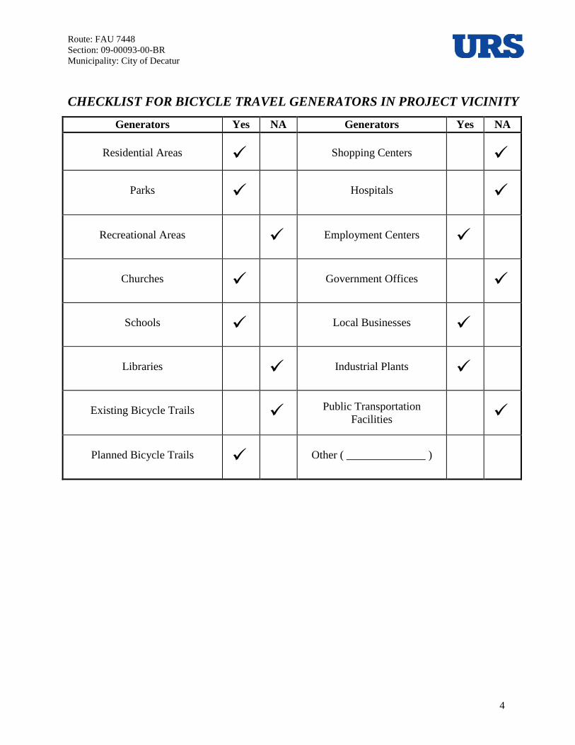
The location of this bicycle facilities assessment is the Brush College Road corridor and underpass
from William Street to Faries Parkway in Decatur. (Reference Corridor Map#1 and Corridor
Map#2) There are currently no provisions for bicycles through the project corridor. The occasional
bicyclist uses the existing roadway or a very narrow sidewalk along the east side of Brush College
Road. Signalized pedestrian crosswalks are present at both the William Street intersection at the
south end, and the Faries Parkway intersection at the north end of the corridor.
In November 2010, Mr. Jim Kiefer – Director of Operations for the Decatur Park District (217-422-
5911) was contacted regarding plans for a future bike trail at the project location. Mr. Kiefer said
that there are currently no long term plans for a bike trail at the project site.
Several efforts were made to obtain input from the Decatur Bicycle Club regarding this segment of
Brush College Road. Although no response was received directly from the Bicycle Club, members
did provide comments to Mark Smith, Director - Decatur Urban Area Transportation Study
(DUATS). According to Mr. Smith, the Bicycle Club conveyed that the study segment is currently a
“hostile” environment for bicyclists.
A Decatur Area Bicycle Map was obtained from the League of Illinois Bicyclists website
(http://www.bikelib.org/maps-and-rides/maps/decatur/). The map shows “Preferred On-Road Bike
Routes” throughout the City and shows “More Comfortable” to “Less Comfortable” routes. The
map classifies the section of Brush College Road between Faries Parkway and Cerro Gordo Street
as “less comfortable”. North of Faries Parkway, Brush College Road is coded as lower than “less
comfortable”.
There are multiple access streets in and out of the residential areas south of the underpass and north
of William Street. Brush College School is located on the west side of Brush College Road just
north of William Street. Pedestrian traffic is minimal to and from the north, as all students living
north of the underpass are bussed to and from school or dropped off.
An interview was conducted with Mr. Joseph Smith, the Principal of Brush College School, on
December 3, 2010. According to Mr. Smith, three students arrive by bicycle, but they come from
the west and do not travel along Brush College Road.
East End Plaza is located across the street from Brush College School, on the east side of Brush
College Road. Richland Community College is located approximately 0.9 miles north of Faries
Parkway on Brush College Road. Other destinations near the corridor include: Pepsi Refreshment
Services (< 0.1 miles north of site); ADM BioProducts plant (0.4 miles north of site); ADM
Corporate Headquarters (0.5 miles east of site on Faries Parkway); Caterpillar plant (0.8 miles
northwest of site on N. 27th
Street). The ADM James Randall Research Center (JRRC) is located
along this portion of Brush College Road, just south of the Norfolk Southern Rail Yard underpass.

Route: FAU 7448
Section: 09-00093-00-BR
Municipality: City of Decatur
3
There are currently no facilities for bicyclists along Brush College Road north of Faries Parkway.
According to Mark Smith, DUATS Director, the Bicycle/Pedestrian portions of the MPO’s 2035
Long Range Transportation Plan are being amended which will augment the currently planned route
along William Street. The amendments include planned provisions for alternative modes of
transportation (bikeways) along Faries Parkway. Additionally, the future plans lay out a bikeway
from William Street on the south, through the study area, extending north along Brush College
Road to IL Route 48. There are planned to be two segments extending from North Brush College
Road east on both Reas Bridge Road and Garver Church Road. It should be noted that the DUATS
Policy Committee has adopted the policy of providing adequate means for alternative transportation
on all new or major reconstruction projects.
Based on the long range plans to include bikeways along Faries Parkway and William Street, it is
recommended that provisions for a shared-use path be included with any improvements along this
segment of Brush College Road. The roadway also provides the only access across the Norfolk
Sothern Railroad Yard in this area. Although it is anticipated that experienced bicyclists will ride
almost exclusively on the roadway, it would be difficult to include dedicated bike lanes on the
proposed roadway and tie into the existing roadway at Fairies Parkway. Current traffic counts
warrant a four-lane section along this segment of Brush College Road. The DUATS organization
has discussed the matter and have indicated that a shared-use path will satisfy the needs of
pedestrians and the occasional bicyclist.
Considering the limited generators in this area, it is anticipated that there will be less than 100 users
per peak hour and an 8’wide shared-use path is recommended in accordance with Figure 42-3A of
the IDOT Bureau of Local Roads & Streets Manual. The roadway improvement study will evaluate
the feasibility of placing the shared-use path along the east side of Brush College Road. Interference
with existing structures or right-of-way issues may require that the path location be altered or
moved to the opposite side of the roadway. It is anticipated that a traffic signal may be added at the
entrance to the ADM JRRC/Marietta Street and Brush College Road intersection. In that event,
bicyclists will be able to cross the roadway at that location.
Notes on Changes Within the Project Area
Refer to the attached aerials of the project area. Note that the residential area shown on the north
side of Faries Parkway/East Garfield Street and east of Spencer Park was formerly a trailer park.
This land has been acquired by ADM and the trailer park has been removed. The cultivated area
shown just to the north of the former trailer park is now an ADM rail yard.
Route: FAU 7448
Section: 09-00093-00-BR
Municipality: City of Decatur
4
CHECKLIST FOR BICYCLE TRAVEL GENERATORS IN PROJECT VICINITY
Generators Yes NA Generators Yes NA
Residential Areas
Shopping Centers
Parks
Hospitals
Recreational Areas
Employment Centers
Churches
Government Offices
Schools
Local Businesses
Libraries
Industrial Plants
Existing Bicycle Trails
Public Transportation
Facilities
Planned Bicycle Trails
Other ( ______________ )

Route: FAU 7448
Section: 09-00093-00-BR
Municipality: City of Decatur
5
R Residential Areas BP Existing Bicycle
Trails G Government Offices
P Parks PBP Planned Bicycle
Trails B Local Businesses
P Recreational Areas
M Shopping Centers I Industrial Plants
C Churches H Hospitals T Public Transportation
Facilities
S Schools
E
Employment
Centers L Libraries
R
C
I P
I
R
S B
E C
I
R
R
R
PROJECT CORRIDOR
B
C S
P
PBP
PBP
Route: FAU 7448
Section: 09-00093-00-BR
Municipality: City of Decatur
6
CHECKLIST FOR ORGANIZATIONS AND PUBLIC COORDINATION
Generators Yes NA Generators Yes NA
Metropolitan Planning
Organization (if applicable)
League of Illinois
Bicyclists
Local Municipalities
Illinois Department of
Natural Resources
Park or Forest Preserve
District
Illinois Trails Conservancy
Project Corridor Map #1
PROJECT CORRIDOR

Route: FAU 7448
Section: 09-00093-00-BR
Municipality: City of Decatur
7
Project Corridor Map#2
Looking North along Brush College Road
PROJECT CORRIDOR

2035 Long Range Transportation Plan
Decatur Urbanized Area Transportation Study Page 148