Embed Size (px)
Citation preview

APPENDIX
KELLOG-WEAVER DUNESCIENTIFIC AND NATURAL AREA
RESOURCE INVENTORY
JUNE 1985
Present VegetationRELEVESDRY SAND PRAIRIE
Element AbstractFLORAElement Status Sheets
This document is made available electronically by the Minnesota Legislative Reference Library as part of an ongoing digital archiving project. http://www.leg.state.mn.us/lrl/lrl.asp

Aerial Photography 8/5/80USDA 40 27157 180 142
T'
KELLOGG WEAVER SNA

KELLOGG-WEAVER DUNES, SNA
PRESENT VEGETATION
Introduction
Kellogg-Weaver Dunes SNA Is a gently rol ling tract of sand prairie,interrupted by a scattered band of more steeply sloped stabl I ized duneswhIch fol Iowa north-northwest to south-southeast line through thepreserve. Associated wIth some of the dunes are active blowouts,characterized by smal I areas of unstabl I Ized sand.
Most of the preserve Is classed by the soil survey as duneland,with its wei I-drained sand surface not suited for cultivation. Bettersoils and a low-lying level topography, primarily in the northeast partof the preserve, did permIt cultivation, wIth the present vegetationthere reflecting severe disturbance.
Woody vegetatIon occurs on hillsIdes and in association with thedune areas, usually as aggregates of many woody and herbaceous species.Isolated Juniper and ash trees and colonies of invasIve shrubs and treesalso occur on the preserve. Planted wIndbreaks of pine grow within thepreserve in one location, and also outsIde the preserve along the northand west boundarIes.
Methods
The vegetation communIties of the Kellogg-Weaver preserve aremapped and described in the fol lowing section. Three major categorIesof cover type, based on vegetation composition, were recognized on thepreserve: I) sand praIrIe (with dunes and blowouts), 2) old field, and3) woody vegetation.
The vegetation community types that are considered elements* by theMinn. Natural Heritage Program were ranked according to theIr qual ity(i.e., how closely they resemble presettlement conditIons). Fourelement occurrence ranks are gIven: Grade A = excel lent, Grade B =good, Grade C = marginal, Grade D = poor. DefInitions of the aboveranks are provided In the element abstract for Sand PraIrie. Thisassessment was done in order to document the significance of thesecommunity types. The ranklngs are also useful for preserve managementbecause they reflect the degree to whIch the orIgInal vegetation hasbeen altered and the I ikel Ihood that a return to more natural condItIonscan be achieved.
Boundaries for the vegetatIon communities shown on the cover typemap were Identif led using aerIal photographs, USGS topographIc maps, andon-site field evaluations. The boundaries gIven are in most casesapproxImate. Sharp divisions between vegetatIon types are rare; thespecies composition In these boundary zones Is transitional.

In addItIon to the cover type categorIes a letter and number codecorrespondIng to more detal led explanatIons of certaIn features IsprovIded In the map explanatIon.
Releve plots were used to sample vegetation composItIon InrepresentatIve locatIons In the sand praIrIe, dunes and old fIelds.Plants found In these IOO-square-meter plots are lIsted In the RelevesectIon. LIsts of specIes were compIled for several types of woodedareas; see next sectIon.
*An Element Is a natural feature of partIcular Importance because It Isexemplary, unIque, threatened or endangered on a national or statewIdebasIs.

KELLOGG WEAVER SNA
[)
)
~VEGETATION
PLANT COMMUNITIESSand Prairie
P Sand Prairie
Degraded Sand Prairie
Sand Dunes and Blowouts
Woody Vegetation
[ =J Deciduous Woods
W2 Jack Pine Woods
W I Shrub Thickets
Disturbed Area
EZ2Zl Cultiva ted in I 984
OF Old Field
G Heavily Grazed .Planted Pines-Jack Pineand Red Pine
~ Buildings

Community Descriptions
SAND PRAIRIE: Element occurrence rank B
This community type covers most of the Kellogg-Weaver SNA. Occurringon the dry to dry-mesic well-drained sandy soils of hilltops, slopes anddepressions, the sand prairie is dominated by grasses, notably littlebluestem (Andro 0 on scoparius), porcupine grass (Sti p) spartea), Junegrass(Koelaria cristata , sand reed (Calamovilfa longifolia and big bluestem(Andropogon gerardi). Grama grass (Bouteloua hirsuta) is common on thedrier dunes and south-facing slopes.
The most abundant forbs are horsemint (Monarda punctata), pralrleragweed (Ambrosia psilostachya), peppergrass (Lepidium densiflorum), andstiff sunflower (Helianthus rigidus). Other prairie forbs found throughoutare spiderwort (Tradescantia occidentlis), leadplant (Amorpha canescens),prairie clover (Petalostemum~.), blazing-star (Liatris aspera),polygala (Polygala polygama), and hairy hawkweed (Hieraceum longipilum).
There are areas throughout the relatively undisturbed sand prairiethat have been degraded by past land use activity. These areas arecharacterized by a dominance of invasive bluegrass (Poa pratensis). Thissod forming grass is usually found in moister low places, forming extensivecolonies in some locations. Some of the bluegrass areas correspond withsites of formerly cultivated land, visible in old aerial photos.Galatowitsch (1984) compiled the data from many aerials, dating back to1950, into a composite map showing locations of fields and number of yearssince abandonment.
These Poa areas typically have a much denser vegetation cover than thesurrounding-nitive sand prairie, although prairie species are usually wellrepresented. Releve #1 was situated in one of these areas and reflects theirspecies diversity. Certain low areas, however, are more thickly coveredwith bluegrass, permitting only a few other species to grow in closeassociation-notably common milkweed (Asclepias syriaca), big bluestem(Andropogon gerardi), and smooth sumac (Rhus glabra).
Vegetation cover is not complete in the sand prairie. Bare sand istypically exposed over 10-25% of the surface. British-soldier lichen iscommon on these dry sandy patches. Releves #2 and #5 were conducted inthe sand prairie, showing the variable diversity and abundance of forbspecies found at different locations.
Within the sand prairie are found areas of sand dunes and blowouts.These landform types often contain typical sand prairie plants, and standsof woody vegetation. Most of the dune areas are complexes of prominenthills surrounding or adjacent to lower bowl-shaped areas of active andstabilized blowouts. The dunes are characterized by steeper slopes, moreopen sand in the stabilized parts and by bare, actively wind-blown sandblowouts.
Certain sand pralrle species such as sand reed (Calamovilfa longifolia),dropseed (Sporobolus sp.), sandbur (Cenchrus longispinus), and horsemint(Monarda punctata) predominate as colonizers and stabilizers of the opensand of blowouts, but species composition is similar to the surrounding

-2-
sand prairie. Releve #3 was located within a dune complex on a gentleeast-facing slope, with approximately 35-50% open sand. Grasses, includinglittle bluestem (Andropogon scoparius), porcupine grass (Stipa spartea),Junegrass (Koelaria cristata), sand reed (Calamovilfa longifolia), andsome grama grass (Bouteloua hirsuta) are predominant. Most forbs foundin dune areas are species that are disturbance-tolerant such as horsemint(Monarda punctata), ragweed (Ambrosia psilostachya), stiff sunflower(Helianthus rigidus), dogbane (Apocynum~.), carpetweed (Mollugoverticillata), silky prairie clover (Petalostemum villosum), and falseheather (Hudsonia tomentosa).
Woody vegetation finds a foothold in the dune complexes, either asisolated trees, mixed height stands, or as low growing colonies of suchplants as sumac (Rhus glabra), poison ivy (Toxiodendron radicans), andsand cherry (Prunus pumila).
WOODY VEGETATION
Wooded areas tend to be associated with the steeper slopes foundprimarily in the dunes and blowouts areas on the western half of thepreserve. Four types of woody vegetation are delineated on the map:1) deciduous woods (oak, juniper, ash, cottonwood, hazelnut, cherry);2) jack pine woods; 3) shrub thickets (juniper, plum, cherry, aspen);and 4) planted pines - jack pine and red pine.
Three large stands of natural deciduous woods occur along north tonortheast facing slopes in the hilly sand prairie community west of themain dunes areas. These are dense (cover 75-100%) canopy communitiesdominated by black oak (Quercus velutina), hackberry (Celtis occidentalis),green ash (Fraxinus pennsylvanica), and aspen (Populus grandidentata).Understory shrubs are prickly ash (Zanthoxylum americanum), hazelnut(Corylus americana), Virginia creeper (Parthenocissus gUinguefolia), andgooseberry (Ribes missouriense). At the edges of these stands are densepopulations of chokecherry (Prunus virginiana), wild plum (Prunusamericana), sumac (Rhus glabra), poison ivy (Toxicodendron radicans),and dogwood (Cornus ~.). See table for a species list of the largewooded area in the middle of the western SNA boundary.
Associated with the dune areas are small stands of deciduous woodsoften found on north and east facing slopes. Those consist of one ofseveral large trees surrounded by an open to dense growth of shortersaplings, shrubs and forbs. Characteristic trees are black oak (Quercusvelutina, green ash (Fraxinus pennsYlvania), cottonwood (Populus deltoides),and juniper (Juniperus virginiana). Shrubs include chokecherry (Prunusvirginiana), wild plum (Prunus americana), hazelnut (Corylus americana),poison ivy (Toxiodendron radicans), sumac (Rhus glabra), grape (Vitus ~.),bittersweet (Celastrus scandens), and prickly ash (Zanthoxylum americanum).
Woody vegetation also occurs as shrub thickets expanding into thesurrounding sand prairie. These thickets of chokecherry (Prunus virginiana),wild plum (Prunus americana), juniper (Juniperus virginiana), and aspen(Populus tremuloides) grow in low areas, particularly in the south part of

-3-
the preserve. Typically, these are concentric colonies with the youngerindividuals on the periphery.
Red and jack pines were planted in numerous areas throughout theKellogg-Weaver area. Within the SNA red pines (Pinus resinosa) wereplanted as a windbreak along a sand ridge between cultivated fields inthe northeast part of the SNA. Their age group is approximatelypresently about feet in height.
In the northwest corner of the SNA there is a stand of jack pinewoods (Pinus banksiana) mixed with oak (Quercus velutina), and green ash(Fraxinus pennsylvanica). Whether or not these pines, aged approximately
years, were naturally occurring, has not been determined.
OLD FIELDS
Vegetation indicative of severe disturbance covers a large area inthe north and northeast parts of the preserve. This area of recentlyabandoned agricultural fields is overgrown with weedy plants. Along somehillsides an abrupt line between intact prairie and old field vegetationis visible due, probably, to plowing of the original prairie.
Located in level low areas, on dark sandy soil, this community typeis dominated by vetch (Vicia villosa), and bluegrass (Poa pratensis).Many weedy forbs are present: horseweed (Conyza canadensis), giantragweed (Ambrosia trifida), prairie ragweed (Ambrosia psilostachya),evening primrose (Oenothera biennis), knotweed (Polygonum~.),
peppergrass (Lepidium densiflorum), wild lettuce (Lactuca scariola),and goat's beard (Tragopogon dubius). Releve #4 records the typicalvegetation found in these old fields. Bare soil is rare, occurringas low surface mounds of pocket gophers.

REF. NO: 1DATE: 17 July, 1984SURVEYOR: D. J. Eagan, M. LeoschkeLOCATION: Kellogg-Weaver Dunes SNA, T109N, R9W, Sec. 6. Wabasha County
Gently rolling tract of sand prairie interrupted by steep sloping,stabilized dunes and occasional blowouts. Within the MississippiValley outwash.
RELEVE HABITAT: Bluegrass area, within the sand prairie, dominated byPoa pratensis, on sandy dune land soil, gently sloping south, bare soil 5%(due to pocket gopher mounds)
SIZE: 100 sq. m.SPECIES RICHNESS: 22
(no. of native species per releve plot)
GRAMINOIDS
(i)Poa pratensis 4.5Stipa spartea 2.3Andropogon scoparius 2.3Koeleria cristata +.1Panicum sp +.2Pan i cum sp. +.1Grass-narrow lws. +.2Ca)~ex spp. 2.1Paspalum ciliatifolium +.2
FORBS
Ambrosia psilostachya 2.1Monarda punctata +.2
(i) Lepidium densiflorum 1.1Tradescantia occidentalis +.1Lithospermum cf. caroliniense +.1Physalis virginiana 1.1Ranunculus rhomboideus 1.1Erigeron strigosus r.lChenopodium sp. r.lAster ericoides +.1Euphorbia corollata +.1Polygala polygama +.2Liatris aspera +.1Anemone cylindrica +.1Convolvulus sepium r.l
SYMBOLS USED Off RELEVE DESCRIPTIONS
Height Class (Stratification)
8 >35 m7 20-35 m6 10-20 m5 5-10 m4 2-5 mGramlnold &Forb layer .... <2 m
For each species within the heIght class 2symbols are used (e.g., Zlzia aptera + .1):
the first is an estimate of cover-abundance.the second is an Index of sociability(dispersion of population)
Cover-abundance
r single occurrencet occasional, cover <5%1 plentiful. cover <5%2 very numerous, cover 5-25%3 any number of individuals, cover 25-50%4 any number of indIviduals, cover 50-75%5 any number of individuals, cover 75-100%
Sod abi 1ity
growing singlygrouped, few individualslarge group, many individualssmall colonies, extensive patches,broken rna t
5 extensive mat
Additional symbols
r rare or endangered speciescf precise identification not possible
although close resemblance exists toindicated taxon
i introduced species
Other species typical of Poa-dominated areas:
Andropogon gerardiRhus glabraPoa compressa

REF. NO: 2OAT E: 17 J u1y, 1984SURVEYOR: O. J. Eagan, M. LoeschkeLOCATION: Kellogg-Weaver Dunes SNA, T109N, R9W, Sec. 6. Wabasha CountyGently rolling tract of sand prairie interrupted by steep sloping,stabilized dunes and occasional blowouts. Within the Mississippi ValleyOutwash.
RELEVE HABITAT: Sand prairie on sandy duneland soil, level to gentlysloping hill-crest, 25% bare sand
Sn1l30LS USED ort RELEVE OESCR [PTIONS
Height Class (Stratification)
8 >35 m7 20-35 m6 10-20 TT1
5 5-10 m<1 2-5 mGraminoi d r, Forb 1ayer .... <2 m
SIZE: 100 sq. m.SPECIES RICHNESS: 17
(no. of native species per releve plot)
GRAMINOIDS
Andropogon scoparius 2.1Calamovilfa longifolia 1.1Koeleria cristata 1.1Stipa spartea 1.1Paspalum ciliatifolium +.1Bouteloua hirsuta +.2Panicum sp. +.1Panicum sp. +.1Carex sp. 1.1
FORBS
Monarda punctata 2.2Ambrosia psilostachya 1.2Lepidium densiflorum 2.1Helianthus rigidus 1.1Polygala polygama +.2Tradescantia occidentalis +.1Conyza canadensis 1.1Chenopodium sp. +.1
LICHENS, MOSSES
Cladonia cf. cristatella +.2
For each species within the height class 2symbols are used (e.g., Zizia aptera + .1):
the first is an estimate of cover-abundancethe second is an index of sociability(dispersion of population)
Cover-abundance
r single occurrence+ occasional, cover <5%1 plentiful, cover <5%2 very numerous, cover 5-25%3 any number of individuals, cover 25-50%<1 any number of individuals, cover 50-75%5 any number of individuals, cover 75-100%
Sociability
grovting singlygrouped, fevi individualslarge group, many individualssmall colonies, extensive patches,broken mat
5 extensive mat
Additional symbols
r rare or endangered speciescf precise identification not possible
although close resemblance exists toindicated taxonintroduced species
Other species typical of Sand Prairie:
Erigeron strigosusTragopogon dubiusAnemone cylindricaToxicodendron sp.Rumex acetosellaLi .a t r i s asp eraPrunus pumilaCyperus sp.Hieracium longipilumCoreopsis palmata

REF. NO: 3DATE: 18 July, 1984SURVEYOR: D. J. Eagan, M. LoeschkeLOCATION: Kellogg-Weaver Dunes SNA, TI09N, R9W, Sec. 6. Wabasha CountyGently rolling tract of sand prairie interrupted by steep sloping,stabilized dunes and occasional blowouts. Within the MississippiValley Outwash.
RELEVE HABITAT: Sand prairie nestled among stabilized dunes onduneland sand soil, gently sloping east, 40-50% bare sand.
SIZE: 100 sq. m.SPECIES RICHNESS: 2..2-
(no. of native species per releve plot)
SYHBOlS USED on RELEVE OESCR IPTlONS
Height Class (Stratification)
8 >35 m7 20-35 m6 10-20 rn5 5-10 m~ 2- 5 mGraminoid [, Forb layer .... <2 m
For each species wIthin the height class 2symbols are used (e.g., Zlzia ~tera + .1):
the first is an estimate of cover-abundancethe second is an index of sociability(dispersion of population)
GRAMINOIDS
Andropogon scoparius 2.1Stipa spartea 2.1Calamovilfa longifolia 1.1Koeleria cristata 1.1Paspalum ciliatifolium +.1Bouteloua hirsuta +.1Panicum sp. 1.1Carex sp. 1.1
FORBS
Ambrosia psilostachya 2.1Monarda punctata 1.1Lepidium densiflorum 1.1Conyza canadensis 1.1Polygala polygama +.1Helianthus rigidus +.1Tradescantia occidentalis 1.1Delphinium virescens r.lLiatris as'pera +.1Euphorbia corollata +.1Viola cf. petatifida +.2Chenopodium sp.Rhus glabra 1.1
LICHENS, MOSSES
Cladonia cf. cristatella +.2
Cover-abundance
r single occurrence+ occasional, cover <5%1 plentiful, cover <5%2 very numerous, cover 5-25%3 any number of individuals, cover 25-50%~ any number of individuals, cover 50-75%5 any number of individuals, cover 75-100%
SociabilitY..
gro'ning singlygrouped, fel-! individualslarge group, many individualssmall colonies. extensive patches,broken mat
5 extensive mat
Additional symbols
r rare or endangered speciescf precise identification not possible
although close resemblance exists toi ndi ca ted taxonintroduced species
Other species in areas similar to
Lithospermum caroliniensePetalostemum villosumMollugo verticillataPrunus pumilaPopulus tremuloides (seedlings)Erigeron strigosus,L\pocynum sp.
this and surrounding this releve
Apocynum sp.Toxicodenoron sp.Prunus virginianaCyperus sp.

On old field with dark sandy soil-Plainfield fine sandsloping, cover complete except for gopher mounds.
REF. NO: 4oAT E: 18 J u1y, 1984SURVEYOR: D. J. Eagan, M. LoeschkeLOCATION: Kellogg-Weaver Dunes SNA, T109N, R9W, Sec. 6. Wabasha County
Gently rolling tract of sand prairie interrupted by steep sloping,stabilized dunes and occasional blowouts. Within the MississippiValley Outwash.
RELEVE HABITAT:1evel to barely
SIZE: 100 sq. m.SPECIES RICHNESS: 10
(no. of native species per releve plot)
SY~1BOLS USED ot! RELEVE OESCR [PTIOtlS
Height Class (Stratification)
8 >35 m7 20-35 m6 10-20 m5 5-10 m<1 2-5 mGraminoi d [, Forb 1ayer .... <2 m
For each species within the height class 2symbols are used (e.g., Zilia aptera ~ .1):
the first is an estimate of cover-abundance.the second is an Index of sociability(dispersion of population)
GRAMINOIDS
(i)Grass 3.3(i)Poa pratensis
Panicum sp.1.3
+.1
FORBS
(i) Vicia cf. violsa 3.1Tradescantia occidentalis +.1Ambrosia psilostachya 1.1Monarda punctata 1.1Conyza canadensis 1.1Oenothera biennis +.2Asclepias syriaca r.1Chenopodium sp. +.1
(i) Tragopogoh dubius +.1Lepidium densiflorum 1.1
(i) Solanum nigrum +.1Polygonum cf. scandens 1.1
(i) Lactica scariola +.1
Cover-abundance
r single occurrence+ occasional, cover <5%1 plentiful, cover <5%2 very numerous. cover 5-25%3 any number of individuals, cover 25-50%<1 any number of individuals, cover 50-75%5 any number of individuals, cover 75-100%
Soci abi 1i ty
1 growing singly2 grouped, few individualsJ large group, many Individuals<1 small colonies, extensive patches,
broken mat5 extensive mat
Additional symbols
r rare or endangered speciescf precise identification not possible
although close resemblance exists toindicated taxon
i introduced species
Other species typical of this habitat
Ambrosia trifidaCarex spp.Helianthus rigidusSilene antirrhinaChenopodium album

REF. NO: 5DATE: 18 July 1984SURVEYOR: M. LoeschkeLOCATION: Kellogg-Weaver Dunes SNA, T109N, R9W, Sec. 6. Wabasha CountyGently rolling tract of sand prairie interrupted by steep sloping,stabilized dunes and occasional blowouts. Within the Mississippi ValleyOutwash.
RELEVE HAGITAT: Sand prairie on sandy duneland soil, gentle NW facingslope, just below a hilltop, bare sand 10%.
SIZE: 100 sq. m.SPECIES RICHNESS: 25
(no. of native species per releve plot)
SYr~BOLS USED orr RELEVE DESCRIPTlorrs
Height Class (Stratification)
8 >35 m7 20-35 m5 10-20 m5 5-10 m<1 2- 5 mGraminoid & Forb layer .... <2 m
For each species within the height class 2symbols are used (e.g., Zfzia aptera + .1):
the first is an estimate of cover-abundance,the second is an index of sociability(dispersion of population)
Cover-abundance
r single occurrence+ occasional, cover <5%1 plentiful, cover <5%2 very numerous, cover 5-25%3 any number of individuals, cover 25-50%<1 any number of individuals, cover 50-75%5 any number of individuals, cover 75-100%
Sociability
growing singlygrouped, fe~1 individualslarge group, many individualssmall colonies, extensive patches,broken mat
5 extensive mat
Additional symbols
r rare or endangered speciescf precise Identification not possible
although close resemblance exists toi nd i CiJ ted taxonintroduced species
FORBS
Monarda punctata 2.1Ambrosia psilostachya 1.1Lithospermum caroliniense 1.1Helianthus rigidus 1.1Liatris aspera +.1
1.1 Tradescantia occidentalis 1.1Anemone cylindrica +.1Euphorbia corollata +.1Polygala polygama 1.1Erigeron sp. +.1Conyza canadensis +.1
+.1 Ranunculus rhomboideus +.1Lepidium densiflorum +.1Oenothera biennis r.1Physalis virginiana r.1
(i) Tragopogon dubius r.lLespedeza capitata r.l
4.1
+.1+.1+.1
leaved
LICHENS, MOSSES
Cladonia cf. cristatella
GRAMINOIDS
Andropogon scopariusStipa spartea 1.1Sorghastrum nutansKoeleria cristataBouteloua hirsutaPanicum sp. hairyCarex sp. +.1
WOODY SPECIES
Juniperus virginiana r.1
Species adjacent to plot
Carex sp.Hieracium longipilumSmilacina stellata
Toxi codendron ro.-dic..a-flSChenopodium sp.Petalostemum purpureumDelphinium virescens

DRY SAND PRAIRIE
ELEMENT ABSTRACT
NATURAL COMMUNITYELEMENT NAME: Dry Sand Prairie
ELEMENT RANK: *Threatened in Minnesota
PLANT COMMUNITYCOVER TYPES: Calamovilfa longifolia
cristataAndropogan scoparius - Koeleria
BASIS FOR CONCERN: Habitat conditions necessary for the development of drysand prairie are relatively uncommon in Minnesota. On the presettlementlandscape, dry sand prairie was probably only prevalent in the AnokaSand Plain. The frequency of this community has been reduced throughoutits original range by human activities. Today undisturbed examples ofthis community are found in widely scattered, isolated areas in sandyriver terraces and coarse sandy outwash.
DESCRIPTION: Dry sand prairies are found on coarse textured soils rangingfrom sands to sandy loams. The soils are characterized by low soilfertility and high permeability; soil pH ranges from acid to neutral.Sand prairies are found on a variety of landforms throughout thenorthwest, southwest, southeast, and east central sections of thestate. They are found in mostly isolated areas under extreme habitatconditions associated with sandy river terraces, inland dunes, glaciallake beach lines, and sand outwash plains.
Dry sand prairies are dominated by Sand reed (Calamovilfa longifolia),Little bluestem (Andropogan sco arius), June grass (Koeleria cristata),and Big bluestem (Andropogan gerardi . Associated species includeCyperus schweinitzii, Sporobolus cryptandrus, Selaginella rupestris,Monarda punctata, Ambrosia psilostachya, Polygala polygama (E 1/2 Minn.),Cyperus filiculmis, Panicum lanuginosum, Aristida spp., Eragrostisspectabilis and Lithospermum caroliniense (E 1/2 Minn.). In areaswhere wind is actively moving the sand and dunes and blowouts areformed, a distinctive vegetation association occurs. These habitatsare characterized by plants which are able to colonize xeric,topographically unstable substrates. These include Petalostemumvillosum, Hudsonia tomentosa, Calamovilfa longifolia, Aristidatuberculosa, Froelichia floridana (E 1/2 Minn.), and Panicum v~llosissimum.
Evidence from a number of Midwestern states indicates many of theactive dune and blowout areas on the landscape today were formed inresponse to severe erosion created by intensive grazing and/orcultivation of the original prairie sod. In Minnesota, Galatowitsch(1984) stated no records were made of blowouts or open dunes inthe state survey of 1855 in the sand region of Wabasha County.Today, blowouts and dunes are common on the Kellogg-Weaver sand _prairie in this county. Similarly, Cooper (1935) suggested that theblowouts on the Anoka Sand Plain in Minnesota were due to grazingand cultivation. In Illinois~ the 1800's state survey of the sand
* Element ranks for natural community types are program-defined and donot represent an official federal or state status (e.g., no legalstatus exists).

region of the state did not note any occurrences of blowouts(Gleason and Hart 1910). In Wisconsin, Curtis (1959) stated muchof the original prairie sod in the sand barren regions had beenplowed and the resultant wind erosion created dunes and blowouts.Likewise, Chapman and Crispin (1984), in their study of the sandsregion of Newaygo county, Michigan, stated most of the largeropen sand prairies were plowed before 1900 and subsequent winderosion was so severe that blowouts and dunes were formed. Theabove evidence indicates active sand blowouts and dunes may havebeen relatively rare on the presettlement landscape, and areas ofactive sand today may be largely a result of human disturbance.
Sand prairies are relatively resilient to man induced disturbancessuch as grazing and, under certain conditions, even limitedcultivation. On the sterile, droughty soils, exotic weeds competepoorly with the native prairie species which pioneer quickly afterdisturbance. Galatowitsch (1984) found that the lighter soils inblowouts and dunes on a Wabasha county sand prairie were occasionallyused for small melon fields. After 25 to 32 years of abandonment,the vegetation composition of these fields could not be distinguishedfrom the vegetation composition of uncultivated sites in the studyarea. This type of cultivation typically involves abandonment afterone growing season and fertilizers are not used. On relativelylevel areas with darker soils, sand prairie can be easily destroyedby grazing and cultivation. These sandy soils with higher valuesof organic matter, nitrogen and soil moisture are much less resilientto disturbance than the lighter sand soils. Cultivation of suchsoils usually involves longer rotations and fertilization. Theresult is the replacement of the native perennial plants with exoticspecies and large populations of annuals. Natural, unplowed prairieon stabilized sands is easily distinguished by its high frequencyand cover of perennial prairie grasses (Andropogon scoparius, A.gerardi, and Koeleria cristata).
In Minnesota, numerous rare plant species are found in sand prairie.Most of these species prefer the open sand habitat of blowouts anddunes. Galatowitsch (1984) found the greatest abundance anddiversity of rare plants within the Kellogg-Weaver sand prairiepreserve on open sand areas and in the heavily grazed sand prairieareas. Galatowitsch further states the preservation of the dunesand blowouts, which support rare plant species, will depend ongrazing or some similar disturbance. Fire is not sufficient enoughto maintain large dunes and blowouts.
Dry sand prairies, due to their isolation, ot=ten contain disjunctpopulations of plants and/or plants at the edge of their naturalrange. In southeast Minnesota, the sand prairies contain a numberof species which reach their northern and western geographic limitsand occur nowhere else in Minnesota. These include Talinumrugospermum, Asclepias amplexicaulis, and Te hrosia virginiana.

Dry sand pralrle in Minnesota is typically associated with dry sandsavanna dominated by oaks or jack pine. These communities, whichoften intergrade with each other on the same site, are related bysuccessional trends. Low fire frequency often results in thereplacement of sand prairie by sand savanna or woodland. Since theearly 1900 1 s, effective fire suppression has allowed many of theoriginal sand prairie and savanna sites to develop into woodland.
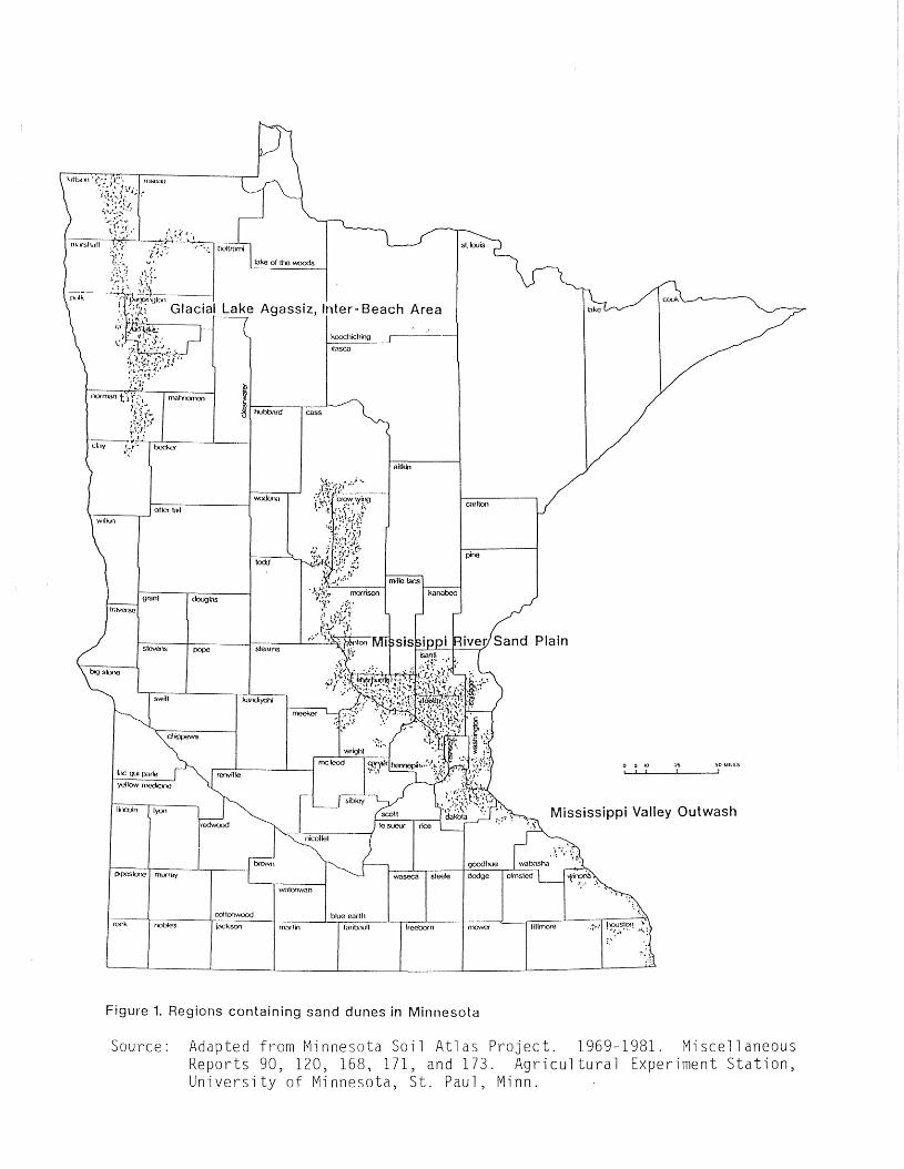
CURRENT STATUS: Intact dry sand prairie remnants, similar to dry sandsavanna, remain today in large part because of the droughty,infertile nature of their soils which make them unsuitable forcultivation. Dry sand prairie is currently threatened byagricultural uses such as grazing, tree planting (notably theestablishment of red pine plantations) and limited cultivationfor crops such as melons. Most of the remaining dry sand prairiesare located on or associated with sand dune complexes. These areasafford the fewest opportunities for development. Sand dunes arefound in three geographic regions of the state: (1) in southeastMinnesota, within the Mississippi Valley Outwash found below LakePeppin, (2) in east-central Minnesota, on the Mississippi RiverSand Plain from Brainerd to the Twin Cities, (3) in northwestMinnesota, within the Glacial Lake Agassiz, Inter-Beach Area.The extent of these three regions is shown on the map in Figure 1.
NUMBER OF OCCURRENCES: occurrences of A or B quality (as of Jan. 1985).
REPRESENTATIVE SITES: Kellogg-Weaver Scientific and Natural Area, WabashaCounty.Helen Allison Scientific and Natural Area, Anoka County.Agassiz Dunes, Polk and Norman Counties.
LITERATURE CITED: Chapman, K. A. and S. R. Crispin. 1984. A fieldsearch for Newaygo County prairies based on airphotos and the soi 1 survey. Mi ch. Bot. 23: 69-75.
Cooper, W. S. 1935. The history of the upperMississippi River in the late Wisconsin andpostglacial time. Minnesota Geological SurveyBulletin No. 26. 116 p.
Curtis, J. T. 1959. The Vegetation Qf Wisconsin.University of Wisconsin Press, Madison.
Galatowitsch, S. M. 1984. The effects of land useon the vegetation of a sand prairie in southeasternMinnesota. MS Thesis. University of Minnesota,Minneapolis. 177 p.
Gleason, H. A. and Hart J. 1910. The vegetation ofthe inland sand deposits of Illinois. Bulletin ofthe Illinois State Laboratory of Natural HistoryVol. 9:1-173.
PREPARED BY: Keith Wendt, Minn. Natural Heritage Program, 1/85
'/(/: '..."
,.'.
malYxxmo
Lake Agassiz, Inter- Beach Area
kooehiching
ilasca
aitkin
~o MillSI
~
Io 5 10
, I
Mississippi Valley Outwash
Sand Plain
:.'
dodge
goodhue
fillmore
cmUon
pine
sleele
freebornfaribaull
blue emlh
todJ
steams
watonwan
marlin
kandiyo/li
cot tOf1'MX>d
doughs
nobles
wack.•".~~-;-------1
swift
stevens
grant
yellow mede.lO
be QUi parle
lincoln lyon
ppeslCXJe mlxray
rock
\----..-1 otic< ta"
Figure 1. Regions containing sand dunes in Minnesota
Source: Adapted from Minnesota Soil Atlas Project. 1969-1981. MiscellaneousReports 90, 120, 168, 171, and 173. Agricultural Experiment Station,University of Minnesota, St. Paul, Minn.

DRY SAND PRAIRIE - ELEMENT OCCURRENCE RANKING
Occurrence of dry sand prairie are ranked according to their degree ofnaturalness (i .e., how close they resemble presettlement conditions).Exemplary occurrences ranked B or higher are considered natural areas ofstatewide significance.
RANK A -- Prairie occurrences that are virtually undisturbed by man, orrecovered to an extent where community structure and composition is intact andreflects presettlement conditions. Rank A sites typically have topographicvariety in the form of dunes and flats which allows a high vegetational diversityof adapted climax prairie species as well as sand barren species. Stabilizedhabitats are distinguished by a high frequency and cover of native pere~nial
grasses - Andropogon scoparius, ~. gerardi, Koeleria cristata, and Panicumvirgatum. They have an absence of exotic spec es, and annual plants whichindicate past grazing and cultivation. Partially unstabilized habitats, suchas dunes and blowouts, show the processes of active wind erosion and deposition.Such areas provide pioneer surfaces for a unique association of native sandbinding plants - Calamovilfa longifolia, Hudsonia tomentosa and Petalostemumvillosum. This habitat in Rank A sites is distinguished by the absence ofintroduced or weedy species such as Verbascum thapsus, Erigeron canadensis, andPanicum capillare.
RANK B -- These prairies are similar in species composition and habitat varietyto Rank A sites, except some of the conservative species may be absent, orthe complement of characteristic species may not be fully represented. Thesetracts typically have had a history of light-moderate disturbance from grazing,or very limited cultivation such as establishment of small melon fieldsabandoned after 1 growing season and never fertilized. As a result theoriginal proportions of native prairie species may have shifted, and occasionalweedy species may have entered the prairie. Poa spp. typically increase underthese conditions, as do the short native prairie grasses which are lessfrequent on Rank A sites. With removal of disturbance, these sites will intime recover to more natural condition.
RANK C -- These sites are characterized by a species composition and structurethat has been substantially altered from their presettlement character. A longhistory of moderate-heavy grazing activity and cultivation attempts is usuallythe major disturbance. In general, such areas have a low native speciesdiversity with large populations of forbs and annual grasses replacing thenative perennial grasses. On flat or low areas Poa~ may form mono-dominantpatches excluding all other species. Exotic species and annual ruderalsindicating cultivation attempts are typically present: Lepedium densiflorum,Erigeron canadensis, and Cenchrus longispinus. Although these sites stillmaintain native sand prairie species, their original character has beensubstantially altered.
RANK D -- These sites have been heavily disturbed by overgrazing and long termcultivation. The result is a near complete replacement of the original nativeflora by exotic species and weedy native plants. Dense turfs of Eurasionpasture grasses such as Agropyron repens, Bromus inermis and Poa 2QQ. oftendominate the habitat. On the lighter soils annual ruderals indicating pastcultivation and fertilization are the most abundant species.

FLORA
Methods
The flora of Kellogg-Weaver Dunes SNA was sampled at three timesduring the growing season of 1983. During those visits, a set of voucherspecimens was collected for a purpose of documenting the flora of thesite. A list of the species which were vouchered are presented in TableI • This represents a preliminary list of the flora, additional field
work will likely add additional species to the list.
Rare Species
Of the 126 species of vascular plants vouchered at this site, fourhave statewide significance because of their rarity.
Asclepias amplexicaulis Sm. (clasping milkweed)
This species is listed as Special Concern in Minnesota. It isrestricted in the state to dunes and sand prairies in southeasternMinnesota, although it also occurs in other midwestern states. There areseveral (5-10) small colonies ofthis species on the SNA. However, theywere severely afflicted by an unknown insect pest and few of them set seedin 1983.
Carex annectens Bickn. (a species of sedge)
This species is listed as special concern in Minnesota and was firstdiscovered in the state in 1978 at the Kellogg-Weaver Dunes SNA. At thattime, only one clump was found, but its exact location was not recorded.An intensive effort was made in 1983 to relocate this species on the SNA.The effort was unsuccessful, and the current status of this species at thesite is unknown. Efforts should continue to relocate this population.
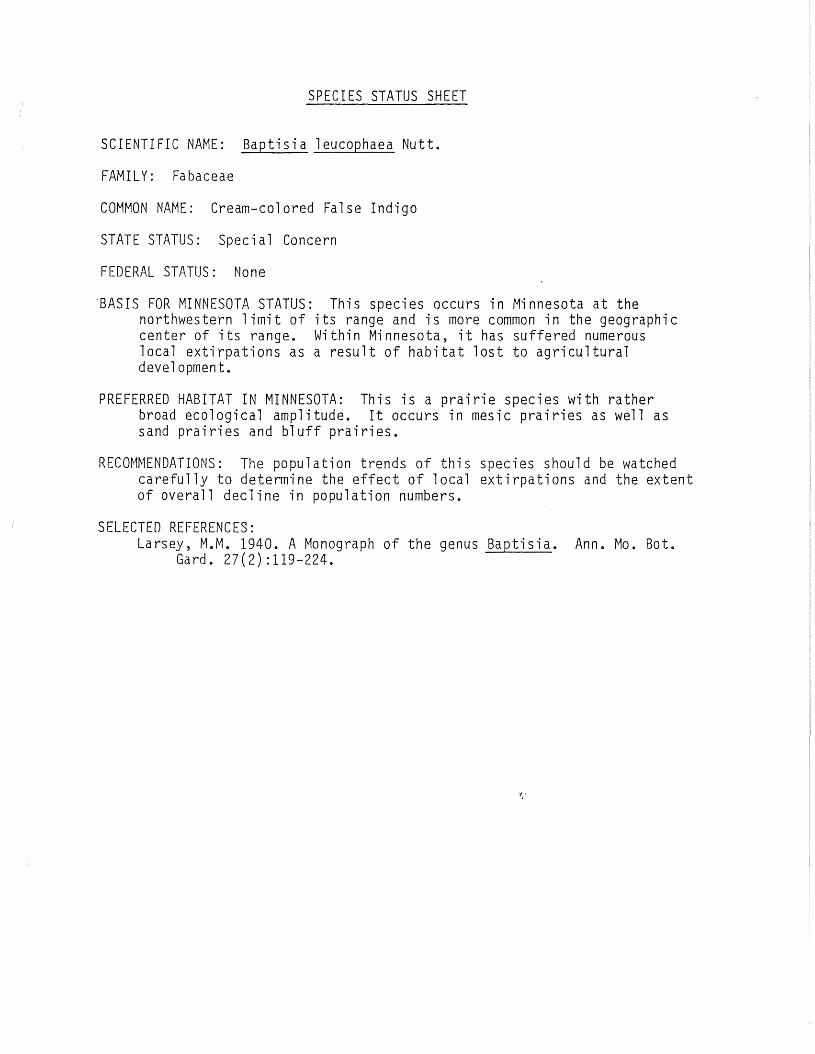
Baptisia leucophaea Nutt (wild indigo)
This species is listed in Minnesota as Special Concern. It is knownto occur at 19 locations in 5 counties in Minnesota. The population atKellogg-Weaver Dunes as rather small, and is concentrated along thesouthwestern and southcentral portion of the unit.
Tephrosia virginiana (L.) Pers. (Goat's-rue)
This species is listed as Special Concern in Minnesota. Within thestate, it is restricted to sand prairies and dunes in the southesterncorner of the state, where it is peripheral to the main range of thespecies. It is occasional to frequent on the SNA, with scattered coloniesand individual plants well established at several locations on the unit.
Additional rare species that should be looked for during futurevisits to the SNA include: Talinum rugospermum, Aristida tuberculosa,Desmodium illinoense, and Tradescantia ohiensis.

Table Plant Species List for Kellogg Weaver Dunes SNA
AceraceaeAcer negundo L.
AizoaceaeMollugo verticillata L.
AmaranthaceaeFroel ichia floridana (Nutt.). Mog.
AnacardiaceaeRhus glabra L.
AsclepiadaleaeSPC *Asclepias amplexicaulis Sm.
Asclepias syriaca L.Asclepias verticillata L.Asclepias viridiflora Rof. Var. lanceolata (rves) Torr.
AsteraceaeAmbrosia psilostachya DC.Antennaria neodioica GreeneArtemisia ludoviciana Nutt.Aster sericeus Vent.Coreopsis palmata Nutt.Crepis tectorum L.Erigeron strigosus Muhl.Gnaphalium obtusifolium L.Helianthus occidentalis RiddellHelianthus rigidus (Cass) Desf.Hieracium longipilum Torr.Kuhnia eupatorioides L.Liatris aspera michx.Solidago missouriensis NuttSoidago nemoralis Ait.Tragopogon major jacq.
BoraginaceaeLithospermum caroliniese (Walt.) MacM.
Campanul aceaeSpecularia perfoliata (L.) DC.
Cappar idaceaePolanisia graveolens Rof.
Capri fol i aceaeLonicera tatarica L.
Caryophyll aceaLonicera tatarica L.
Caryophyll acea

Silene anthirrhina L.
Che nopod i ac eaeChenopodium hybridum L. yare gigantospermum (Aellen) RouleanChenopodium leptophyllum Nutt.Cycloloma atriplicifolium (Spreng.) Coult.Sol sola kali L. yare tenuifolia tausch
CistaceaeHudsonia tomentosa Nutt.
Comme1in ac eaeTradescantia occidentalis (Butt.) Smyth
Coryl ac eaeCorylus americana Watt.
Cyperac eaeSPC*Carex annectens Bickn.
Carex brevior (Dew.) Mack.Carex foenea Willd.Carex heliophila Mack.Carex muhlenbergia Willd.Carex sprengelii Spreng.Cyperue fil iculmis Vahl.Cyperus schweinitzii Torr.
EquisetaceaeEqui setum 1aev igatum A. Br.
EricaceaeArctostaphylos uva-ursi (L.) Spreng.
Euphorbi aceaeEuphorbia corollata L.Euphorbia geyeri Engelm.
FabaceaeAmorpha canescens Pursh
SPC*Baptisia leucophaea NuttCassia fasciculata Michx.Lespedeza capitata Michx.Petalostemum candidum (Willch) Michx.Petalostemum purpureum (Vent.) Rydb.Staphostyles helvola (L.) Ell.
SPC*Tephrosia virginiana (L.) Pers.Vicia villosa Roth.
Fag aceaeQuercus velutina Farm.
IridaceaeSisyrinchium campestre Brickn.
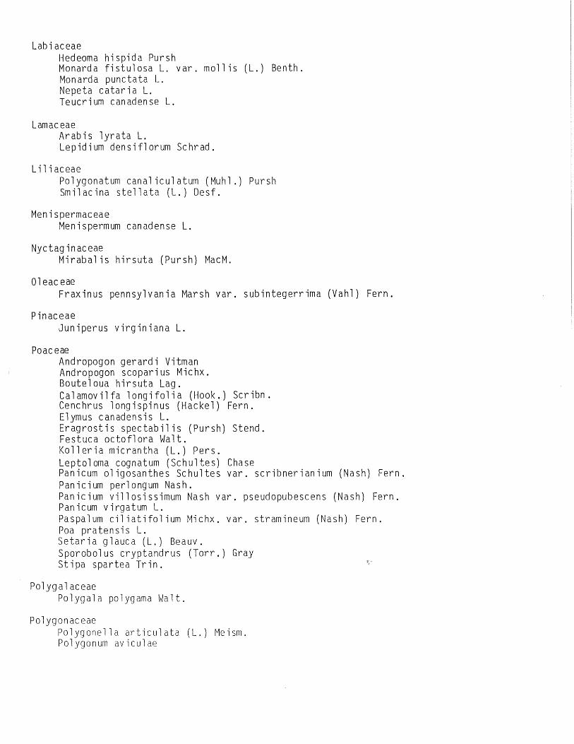
LabiaceaeHedeoma hispida PurshMonarda fistulosa L. var. mollis (L.) Benth.Monarda punctata L.Nepeta cataria L.Teucrium canadense L.
LamaceaeArabis lyrata L.Lepidium densiflorum Schrad.
LiliaceaePol Y90 nat um can ali cu1at um (Mu h1.) Pur sIISmilacina stellata (L.) Desf.
MenispermaceaeMenispermum canadense L.
Nyctag inaceaeMirabalis hirsuta (Pursh) MacM.
01 eac eaeFraxinus pennsylvania Marsh var. subintegerrima (Vahl) Fern.
PinaceaeJuniperus virginiana L.
Poac eaeAndropogon gerardi VitmanAndropogon scoparius Michx.Bouteloua hirsuta Lag.Calamovilfa longifolia (Hook.) Scribn.Cenchrus longispinus (Hackel) Fern.Elymus canadensis L.Eragrostis spectabilis (Pursh) Stend.Festuca octoflora Walt.Kolleria micrantha (L.) Pers.Leptoloma cognatum (Schultes) ChasePanicum oligosanthes Schultes var. scribnerianium (Nash) Fern.Panicium perlongum Nash.Panicium villosissimum Nash var. pseudopubescens (Nash) Fern.Panicum virgatum L.Paspalum ciliatifolium Michx. var. stramineum (Nash) Fern.Poa pratensis L.Setaria glauca (L.) Beauv.Sporobolus cryptandrus (Torr.) GrayStipa spartea Trin.
Polygal aceaePolygala polygama Walt.
PolygonaceaePolygonella articulata (L.) ~1eism.
Polygonum aviculae

Polygonum convolvurlusPo1ygon um ten ueRumex ac eto se 11 a
RanunculaceaeAnemone caroliniana Walt.Anemone cylindrica GrayAnemone patens L.Delphinium virescens Nutt.Ranunculus rhomboideus Goldie
RhamnaceaeCeanothus ovatus Desf.
Rosac eaeFragaria virglnlana DuchesneGeum triflorum PurshPotentilla arguta PurshPrunus americana MarshPrunus pumila L.Prunus virginiana L.Rose arkansana PorterRubus occidentalis
RubiaceaeGalium aparine L.
RutaceaeXanthoxylum americanium Mill.
Sal icaceaePopulus grandidentata Michx.Populus tremuloides Michx.
SaxifragaceaeHeuchera richardsonii R. Br.Ribes missouriense Nutt.
ScrophulariaceaLinaria canadensis (L.) Dumont.
Sol anaceaePhysalis heterophylla Nees.Physalis virginiana Mill.
Til i aceaeTilia americana L.
Ulmac eaeCeltis occidentalis L.
Verben ac eaeVerbena hastata L.

ViolaceaeViola pedatifida L.
'/ i tac eaeVitis riparia Michx.Parthenocissus inserta (Kerner) K. Fritsch
SPECIES STATUS SHEET
SCIENTIFIC NAME: Baptisia leucophaea Nutt.
FAMI LY: Fa baceae
COMMON NAME: Cream-colored False Indigo
STATE STATUS: Special Concern
FEDERAL STATUS: None
'BASIS FOR MINNESOTA STATUS: This species occurs in Minnesota at thenorthwestern limit of its range and is more common in the geographiccenter of its range. Within Minnesota, it has suffered numerouslocal extirpations as a result of habitat lost to agriculturaldevelopment.
PREFERRED HABITAT IN MINNESOTA: This is a prairie species with ratherbroad ecological amplitude. It occurs in mesic prairies as well assand prairies and bluff prairies.
RECOMMENDATIONS: The population trends of this species should be watchedcarefully to determine the effect of local extirpations and the extentof overall decline in population numbers.
SELECTED REFERENCES:Larsey, M.M. 1940. A Monograph of the genus Baptisia. Ann. Mo. Bot.
Gard. 27(2) :119-224.

ELEMENT NAME:
FEDERAL STATUS:
STATE STATUS:
NATURAL HERITAGEPROGRAM STATUS:
BASIS FOR STATUSCLASSIFICATION:
PREFERRED HABITAT:
DISTRIBUTION:
OCCURRENCES INMINNESOTA:
# OF OCCURENCESIN MANAGED AREAS:
POTENTIAL THREATSTO SPEC IES:
STATUS SHEET
Tephrosia virginiana (L) Pers; (Goats-rue)
None
None
Threatened
This species has specific habitat requirements and a veryrestricted geographic distributuion in Minnesota.Furthermore, it is known to be a very poor colonizer andfaces a drastic popul~tion decline as its habitat isconverted to agricultural and commercial uses.
This species is known to occur in sand dunes, sandy goatprairies, Pine barrens, oak savannas and dry prairies.In Minnesota, the largest population is in an oak savannain sandy soil. Its present occurrances in sand dunes andgoat prairies may represent relict populations that havetemporarily sruvived the land conversion that savannasare less susceptable to.
See map
This species has been documented from two sites inHouston county and one each in Wabasha, Fillmore andWinona Counties. Information on the Fillmore County sitedates from 1920 and should be verified before anystatement is made about its current status in that county.
This species is not known to occur in any managed area.
A housing development is known to currently threaten onesite, but other specific threats are not known.Certainly any drastic alteration of the habitat on whichthe plants depend would jeopardize their existence.
REFERENCES: Fox, W. B. 1945. The Leguminosae in Iowa.Nat. 34(1): 207-230.
Am. Mi d1.
Welsh, S. L. 1960. Legumes of the North-Central states:Galegeae. Iowa State Journal of Sci. 35(2): 111-250.

LOCATION INSTUDY AREA:
EVALUATION:
This species was first documented to occur in thevicinity of the study area in 1926 (Fassett andHotchkiss). The only description given was, "sandprairie; Wabasha County." This leaves considerable doubtabout the exact location of the site, but it was likelynear the study area. The next recorded occurrance in thearea was in 1961 (Morley) when the plant was collected insection 18, about 1/2 mile south of the study area. Thislocation was confirmed in 1979 (Smith). Although thisspecies has never been documented) to occur within thestudy area, it is possible that a search might discoverit there.
Since the plant has not been documented to occur in thestudy area, little can be said in evaluation. There is,however, a very large and well established populationoccurring in an oak savanna seven miles southwest of thestudy area. This site is the best occurence currentlyknown, and would most likely surpass anything that mightbe discovered in the study area. However, the oaksavanna is not protected and could be threatened by anynumber of developments. Therefore, if a population couldbe found in the study area, it would be high priority forpreservation.