Embed Size (px)
Citation preview

Appendix K.
Real Estate Plan
Delta Islands and Levees Feasibility Study Real Estate Plan 20 June 2018
1
REAL ESTATE PLAN
DELTA ISLANDS AND LEVEES FEASIBILITY STUDY (DELTA STUDY)
20 June 2018
PREPARED BY THE SACRAMENTO DISTRICT
U.S. ARMY CORPS OF ENGINEERS
Delta Islands and Levees Feasibility Study Real Estate Plan 20 June 2018
2
TABLE OF CONTENTS
1. INTRODUCTION 2. PROJECT AUTHORITY
3. PROJECT DESCRIPTION
4. DESCRIPTION OF LERRDs
5. LERRDs OWNED BY THE NFS AND CREDITING
6. STANDARD FEDERAL ESTATES AND NON-STANDARD ESTATES
7. DESCRIPTION OF ANY EXISTING FEDERAL PROJECT IN OR PARTIALLY IN THE PROPOSED PROJECT 8. DESCRIPTION OF ANY FEDERALLY OWNED LAND NEEDED FOR THE PROJECT
9. APPLICATION OF NAVIGATIONAL SERVITUDE TO THE LERRD’S REQUIREMENT
10. PROJECT MAP
11. ANTICIPATED INCREASED FLOODING AND IMPACTS
12. COST ESTIMATE
13. RELOCATION ASSISTANCE BENEFITS
14. MINERAL / TIMBER ACTIVITY
15. NON-FEDERAL SPONSOR’S ABILITY TO ACQUIRE
16. ZONING ANTICIPATED IN LIEU OF ACQUISITION
17. ACQUISITION SCHEDULE
18. DESCRIPTION OF FACILITY AND UTILITY RELOCATIONS
19. HAZARDOUS, TOXIC, AND RADIOLOGICAL WASTE IMPACTS
20. ATTITUDE OF LANDOWNERS
EXHIBIT A – ASSESSMENT OF NON-FEDERAL PARTNER’S REAL ESTATE ACQUISITION CAPABILITY EXHIBIT B– CADASTRAL MAP AND TRACT REGISTER
EXHIBIT C- RISK LETTER
Delta Islands and Levees Feasibility Study Real Estate Plan 20 June 2018
3
DELTA ISLANDS AND LEVEES
REAL ESTATE PLAN
1. Introduction This Real Estate Plan, prepared in accordance with ER 405-1-12, Sections 12-16, supports the revised Delta Islands and Levees Feasibility Study. The purpose of the revised study is to determine the Federal interest in providing Ecosystem Restoration (ER) improvements to the Sacramento – San Joaquin Rivers Delta (Delta) in Northern California. The purpose of this Real Estate Plan is to define and describe the minimum real property interests needed to construct the project’s Recommended Plan. This Plan includes restoring habitat value in the Delta to native species through subsidence reversal and subsequent restoration of intertidal habitat in the flooded Big Break region and is to be used for planning purposes only. Modifications to the Recommended Plan may occur during the project’s Preconstruction, Engineering and Design (PED) phase which could require adjustments to the real property rights needed, the scope of the acquisition area(s), and estimates of the real property acquisition and administrative costs. Non Federal Sponsor The USACE initiated the Feasibility Study at the request of the California Department of Water Resources (DWR), the non-Federal sponsor for the study. The USACE and DWR discussed various acquisition options with the main land owner in the study area, East Bay Regional Park District to provide their lands for the project. However, East Bay Regional Park District cannot convey fee title or a permanent easement due to legal restrictions (California Pub. Resources Code, §§ 5540, 5540.5.) They indicated that they were interested in becoming a second non-federal sponsor, along with DWR. That will require a modified Project Partnership Agreement after project authorization to limit East Bay Regional Park District's responsibilities to those associated with the provision of some of the land for the project 2. Project Authority The study is authorized by the Flood Control Act of 1936, Pub. L. 74-738 and the Water Supply, Reliability, and Environmental Improvement Act, Pub. L. 108-361 (2004) as modified by the Water Resources Development Act of 2007, Pub. L. 110-114. Detailed information regarding the project authority, including interim studies and reports is contained in Chapter 2 of the Feasibility Report. 3. Project Description This project will help a declining but critical Delta ecosystem by restoring and maintaining aquatic and riparian habitats in an area called Big Break, near Jersey Island in the western Delta, where erosion and subsidence have caused the loss of fast lands and marshes to
Delta Islands and Levees Feasibility Study Real Estate Plan 20 June 2018
4
shallow open water. Restored intertidal marshes at Big Break will provide habitat for native plants and wildlife, including species designated as endangered, threatened and special-status by federal and state resource agencies, and will marginally improve floodplain functions and Delta water quality. The project will use dredged materials produced by maintenance dredging of the nearby Stockton Ship Channel and conveyed as a slurry through a temporary floating pipeline to form a base on which new marsh habitat can form. The project will place approximately 100,000 cubic yards of material within the target area during each annual dredging cycle; over its ten-year construction period a total of 1,000,000 cubic yards of dredged will be placed at Big Break, creating about 340 acres of new marshlands. Vegetation will be planted incrementally during each dredged material placement cycle, so that marsh grasses and aquatic plants will take root as of the first year of dredged material placement.
4. Description of Lands, Easements, Rights-Of-Way, Relocations, and Disposal Areas (LERRDs) required for project construction
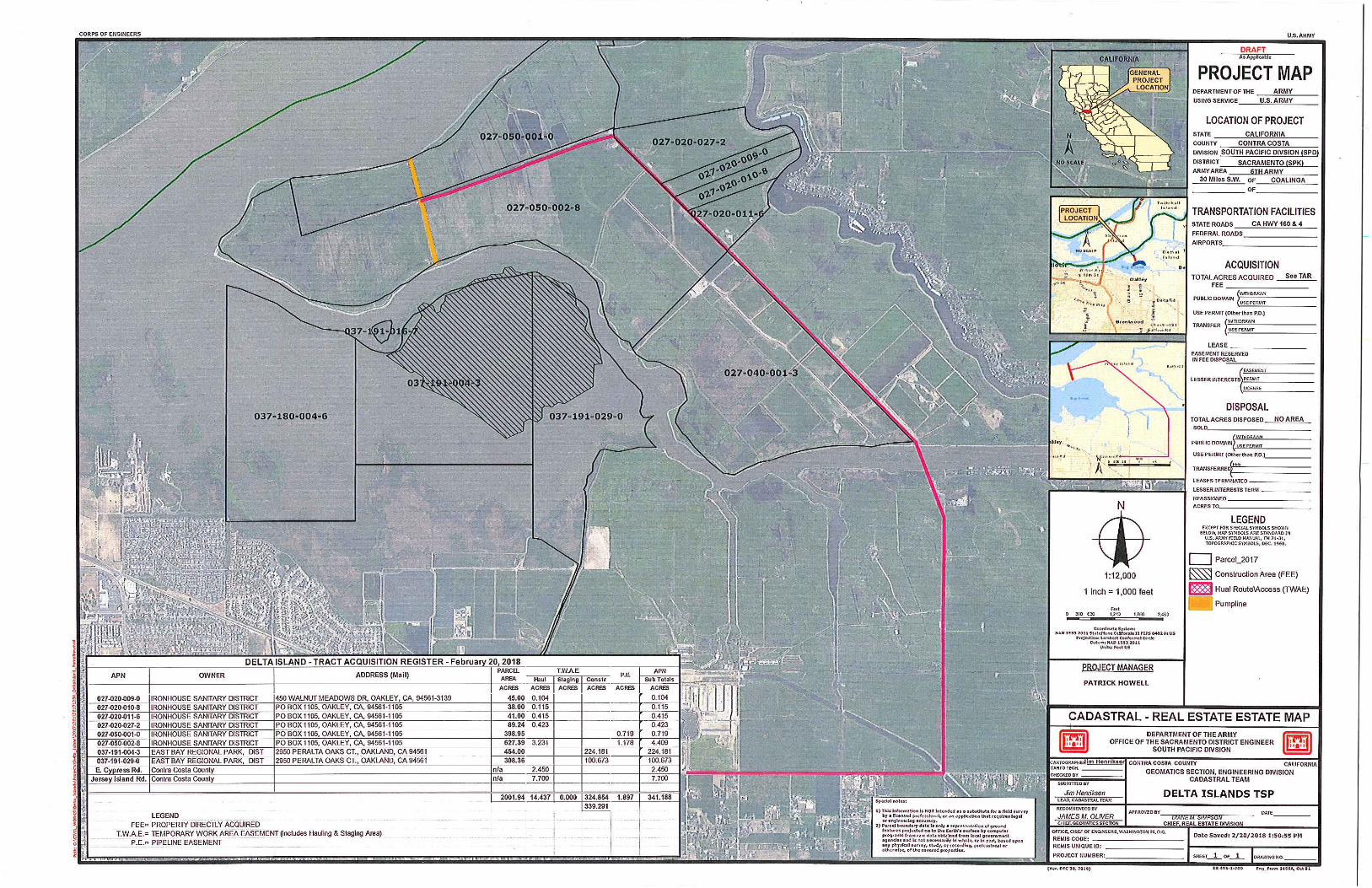
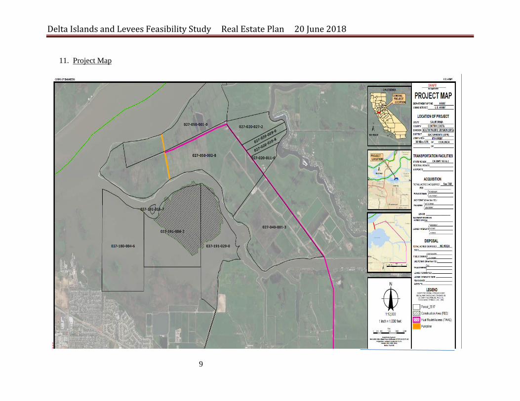
The District’s Cadastral Section identified four property parcels within which real estate rights will need to be acquired to construct the project: two tracts of shallow open water apparently owned in fee by the East Bay Regional Park District, where the project’s 340 acres of new intertidal marsh would be created, and two nearby parcels of marsh and fast lands on Jersey Island owned in fee by the Ironhouse Sanitary District, a sewage treatment and water purification agency serving Oakley and Bethel Island. On Jersey Island the project will need to acquire a 10-year right to run a temporary pipeline alongside an agricultural ditch, a 10-year right to create and use a one-acre temporary construction and laydown yard at the south end of this pipeline for storage of project equipment and materials during each annual dredging cycle (a period of about two months each year), and a 10-year right of vehicular use of existing unpaved private roads on Jersey Island for delivery of materials and construction equipment (also for about two months each year); as shown in the Cadastral Map and Tract Register ( Exhibit B) a) Accordingly the Non-Federal Sponsor East Bay Regional Park District will provide the
following real property interests of the submerged lands at Big Break:
i. EBRPD will provide through agreement/MOU 340 acres of submerged lands for real property use within the project’s proposed footprint,
ii. A lease executed by the NFS may also be required from the State Lands Commission pending their investigation on their jurisdiction in the proposed project area. To summarize, the lease application may include:
Standard Application for Lease of State Lands Project information (Scope of work, technical data, timeline, map, etc.) SAP (Sample & Analysis Plan) SAR (Sample & Analysis Report) DMMO authorization letter to dredge Bathymetric survey
Delta Islands and Levees Feasibility Study Real Estate Plan 20 June 2018
5
Permits from other regulatory agencies Minimum expense deposit: $3,000+ (may vary, based on environmental and engineering review needs) Non-refundable filing fee: $25 Recent photos (approx. 5 or 6 photos taken within the past 6 months)
b) The Non-Federal Sponsor will need to obtain the following real property interests from
the Iron house Sanitary District: c)
i. A ten-year .70 acre pipeline easement for placement and operation of a temporary 18”diameter dredged material pipeline across Jersey Island, on a run of about 1,000 linear feet, to remain in place for the ten-year construction phase of the project, or until all dredged material is conveyed to the restoration site*; and
*(The sections of pipeline that will cross the levee maintenance roads on the north and south levees of Jersey Island will be covered with dirt to avoid obstructing vehicle passage and will be removed at the conclusion of the two-month construction cycle each year.)
ii. A ten-year easement over a rectangle of land approximately 1.00 acre in size at
the south side of Jersey Island adjacent to the point the temporary pipeline crosses over the island’s south-side levee, for construction of a fenced equipment and materials staging yard to use for approximately two months each year during the Project’s ten-year period of construction; and
iii. A ten-year, vehicular easement or right of entry over approximately 5.20 acres of
existing unpaved levee roads and an agricultural access lane bisecting Jersey Island adjacent to the proposed pipeline location, for use by construction vehicles and equipment belonging to the project’s contractor and by vehicles belonging to the Corps and the non-federal sponsor, primarily during each year’s two-month dredging cycle.
No structures presently exist within the project footprint that would require relocation during project construction. Upon execution of a Project Partnership Agreement (PPA) the Sacramento District Engineering Branch will prepare final designs for project construction. The tract register and tract maps will reflect any final modifications to project designs for staging areas, access requirements, and restoration features and a take letter will be provided to the Non-Federal Sponsor for acquisition of the appropriate real property rights and interests.
Delta Islands and Levees Feasibility Study Real Estate Plan 20 June 2018
6
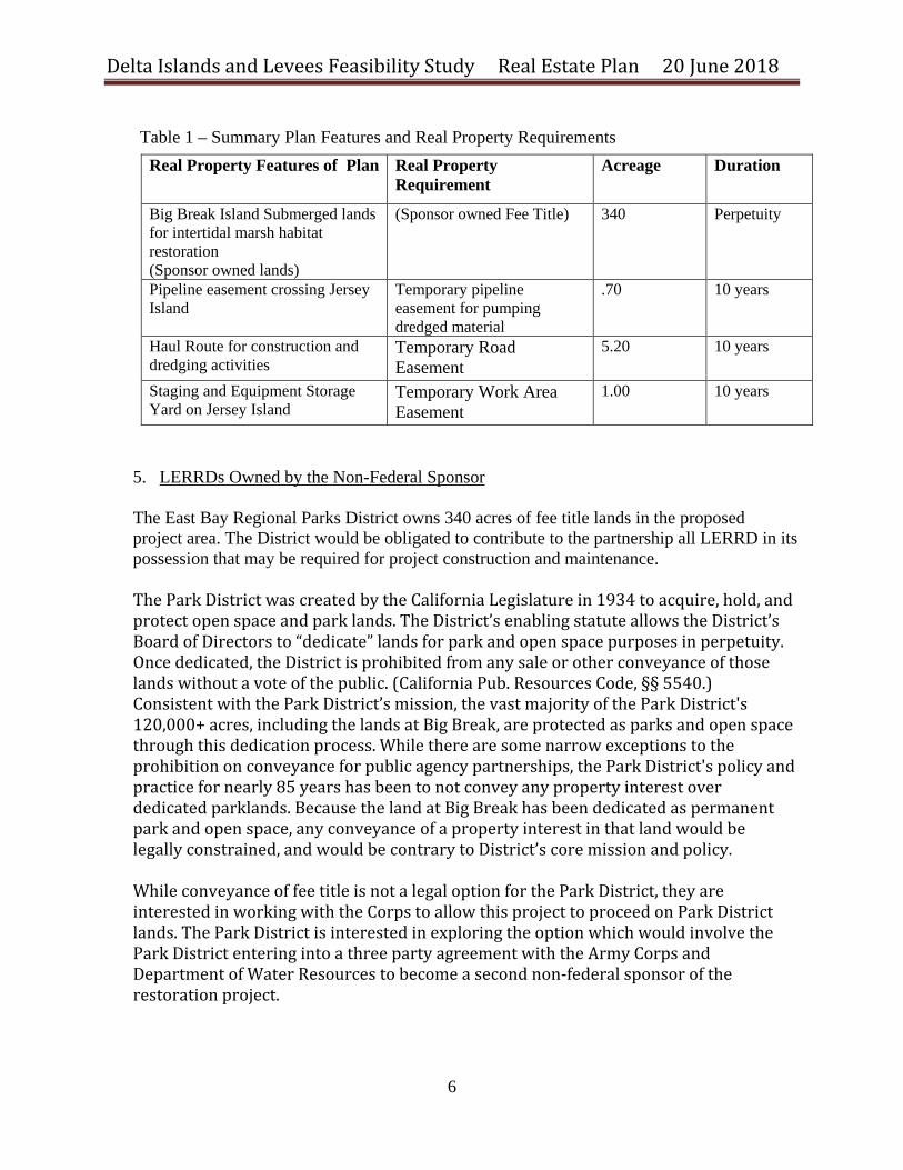
Table 1 – Summary Plan Features and Real Property Requirements
Real Property Features of Plan Real Property Requirement
Acreage Duration
Big Break Island Submerged lands for intertidal marsh habitat restoration (Sponsor owned lands)
(Sponsor owned Fee Title) 340 Perpetuity
Pipeline easement crossing Jersey Island
Temporary pipeline easement for pumping dredged material
.70 10 years
Haul Route for construction and dredging activities
Temporary Road Easement
5.20 10 years
Staging and Equipment Storage Yard on Jersey Island
Temporary Work Area Easement
1.00 10 years
5. LERRDs Owned by the Non-Federal Sponsor The East Bay Regional Parks District owns 340 acres of fee title lands in the proposed project area. The District would be obligated to contribute to the partnership all LERRD in its possession that may be required for project construction and maintenance. The Park District was created by the California Legislature in 1934 to acquire, hold, and protect open space and park lands. The District’s enabling statute allows the District’s Board of Directors to “dedicate” lands for park and open space purposes in perpetuity. Once dedicated, the District is prohibited from any sale or other conveyance of those lands without a vote of the public. (California Pub. Resources Code, §§ 5540.) Consistent with the Park District’s mission, the vast majority of the Park District's 120,000+ acres, including the lands at Big Break, are protected as parks and open space through this dedication process. While there are some narrow exceptions to the prohibition on conveyance for public agency partnerships, the Park District's policy and practice for nearly 85 years has been to not convey any property interest over dedicated parklands. Because the land at Big Break has been dedicated as permanent park and open space, any conveyance of a property interest in that land would be legally constrained, and would be contrary to District’s core mission and policy. While conveyance of fee title is not a legal option for the Park District, they are interested in working with the Corps to allow this project to proceed on Park District lands. The Park District is interested in exploring the option which would involve the Park District entering into a three party agreement with the Army Corps and Department of Water Resources to become a second non-federal sponsor of the restoration project.

Delta Islands and Levees Feasibility Study Real Estate Plan 20 June 2018
7
6. Crediting for LERRDs For purposes of crediting the Sponsor must provide a credit appraisal of the real property it contributes or obtains in performance of its obligations under the PPA. The Sponsor’s credit appraisal must conform to Uniform Appraisal Standards (USPAP) and must be prepared by a certified appraiser who is approved as a qualified appraiser by the USACE Sacramento District Appraisal Branch.
7. Standard Federal Estates Temporary Work Area Easement A temporary easement and right-of-way in, on, over and across portions of Jersey Island for a period not to exceed 10 years after the execution of the construction contract, for use by the State of California, its representatives, agents, and contractors as a (borrow area) (work area), including the right to borrow and/or deposit fill, spoil and waste material thereon) (move, store and remove equipment and supplies, and erect and remove temporary structures on the land and to perform any other work necessary and incident to the construction of the Delta Project, together with the right to trim, cut, fell and remove there from all trees, underbrush, obstructions, and any other vegetation, structures, or obstacles within the limits of the right-of-way; reserving however, to the landowners, their heirs and assigns, all such rights and privileges as may be used without interfering with or abridging the rights and easement hereby acquired; subject, however, to existing easements for public roads and highways, public utilities, railroads and pipelines.
Temporary Well and Pipeline Easement A temporary and assignable easement in, on, over and across portions of Jersey Island for a period not to exceed 10 years to locate, construct, operate, maintain, repair, replace, and/or remove pipeline(s) and appurtenances thereto; subject, however, to existing easements for public roads and highways, public utilities, railroads and pipelines. Non Standard Estates Lease The California State Land Commission may require a lease executed by the NFS for work on their jurisdictional lands prior to solicitation of a construction contract. The Commission is currently investigating the area to determine where and if a lease is required. The following items may be required to complete a lease.
- Standard Application for Lease of State Lands - Project information (Scope of work, technical data, timeline, map, etc.) - SAP (Sample & Analysis Plan)
Delta Islands and Levees Feasibility Study Real Estate Plan 20 June 2018
8
- SAR (Sample & Analysis Report) - DMMO authorization letter to dredge - Bathymetric survey - Permits from other regulatory agencies - Minimum expense deposit: $3,000+ (may vary, based on environmental and engineering
review needs) - Non-refundable filing fee: $25 - Recent photos (approx. 5 or 6 photos taken within the past 6 months) MOU/Agreement/PPA– will be required to construct the project on sponsor owned lands
8. Description of any Existing Federal Projects in or Partially in the Proposed Project No existing federal projects have a scope of work or study area that would fully or partially overlap with the footprint of the proposed project. 9. Description of any Federally-owned Land needed for the Project No federally-owned lands are available or needed for this project. 10. Application of Navigational Servitude to the LERRDs Requirement Use of the Navigational Servitude is not needed for this project. Contractors will have to obtain approvals from the Coast Guard and with the Sacramento District’s Regulatory Branch for placement of temporary floating pipelines during dredging operations to ensure proper marking and signaling within navigable waterways.
Delta Islands and Levees Feasibility Study Real Estate Plan 20 June 2018
9
11. Project Map
Delta Islands and Levees Feasibility Study Real Estate Plan 20 June 2018
10
12. Anticipated Increased Flooding and Impacts
Hydraulic modeling and analysis show that the new intertidal marsh lands to be created by the project would not increase flooding risks and instead would tend to reduce the velocity of water flowing through the Big Break area. 13. Cost Estimate for Necessary Real Property Rights
A preliminary estimate of the costs of acquiring LERRDs necessary to support the project’s Tentatively Selected Plan was prepared to assist in the calculation of a cost-benefit analysis for the purpose of quantifying the federal interest in the proposed Delta Islands project. The cost estimate meets the intent of Real Estate Policy Guidance Letter (PGL) No. 31, Real Estate Support to Civil Works Planning Paradigm (3x3x3), which requires a less formal estimation of the cost of acquiring real property rights when these costs are expected to represent a small component of overall project costs. The PGL directs that “For projects in which the value of real estate (lands, improvements, and severance damages) are not expected to exceed ten percent of total project costs (total cost to implement project), a cost estimate (or rough order of magnitude) will be acceptable for purposes of the feasibility phase.” The table on the following page estimates the direct and administrative costs associated with acquiring real property interests necessary to construct, operate and maintain the proposed project. This estimate was prepared on March 16, 2018. If the project’s selected plan receives headquarters endorsement at the scheduled Agency Decision Milestone (ADM) meeting, real property acquisition costs will be updated thereafter to reflect current price levels. See page 12, below.
Delta Islands and Levees Feasibility Study Real Estate Plan 20 June 2018
11
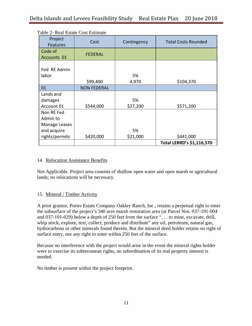
Table 2- Real Estate Cost Estimate Project
Features Cost Contingency Total Costs Rounded
Code of Accounts 01 FEDERAL
Fed RE Admin labor
$99,400
5% 4,970 $104,370
01 NON FEDERAL Lands and damages Account 01
$544,000
5%
$27,200 $571,200 Non RE Fed Admin to Manage Leases and acquire rights/permits $420,000
5% $21,000 $441,000
Total LERRD’s $1,116,570
14. Relocation Assistance Benefits Not Applicable. Project area consists of shallow open water and open marsh or agricultural lands; no relocations will be necessary. 15. Mineral / Timber Activity A prior grantor, Porter Estate Company Oakley Ranch, Inc., retains a perpetual right to enter the subsurface of the project’s 340 acre marsh restoration area (at Parcel Nos. 037-191-004 and 037-191-029) below a depth of 250 feet from the surface “. . . to mine, excavate, drill, whip stock, explore, text, collect, produce and distribute” any oil, petroleum, natural gas, hydrocarbons or other minerals found therein. But the mineral deed holder retains no right of surface entry, nor any right to enter within 250 feet of the surface. Because no interference with the project would arise in the event the mineral rights holder were to exercise its subterranean rights, no subordination of its real property interest is needed. No timber is present within the project footprint.
Delta Islands and Levees Feasibility Study Real Estate Plan 20 June 2018
12
16. Non-Federal Sponsor’s Ability to Acquire The non-Federal sponsor possesses experienced real estate staff members capable of drafting real property instruments and professionally managing the acquisition of the real interests needed for the Delta Islands project. As an agency of the State of California the non-Federal sponsor also possesses condemnation authority. 17. Zoning Anticipated in Lieu of Acquisition There is not an application or enactment of new zoning ordinances proposed in lieu of, or to facilitate, acquisition in connection with the project nor are such actions anticipated.
18. Acquisition Schedule
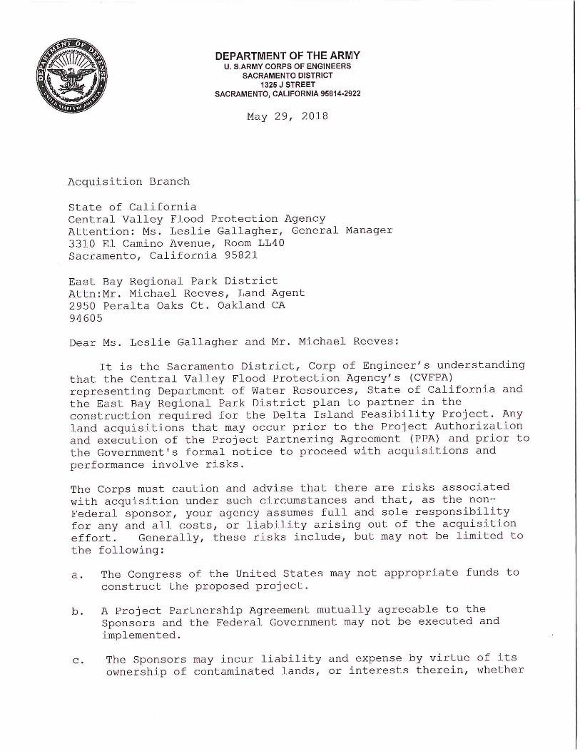
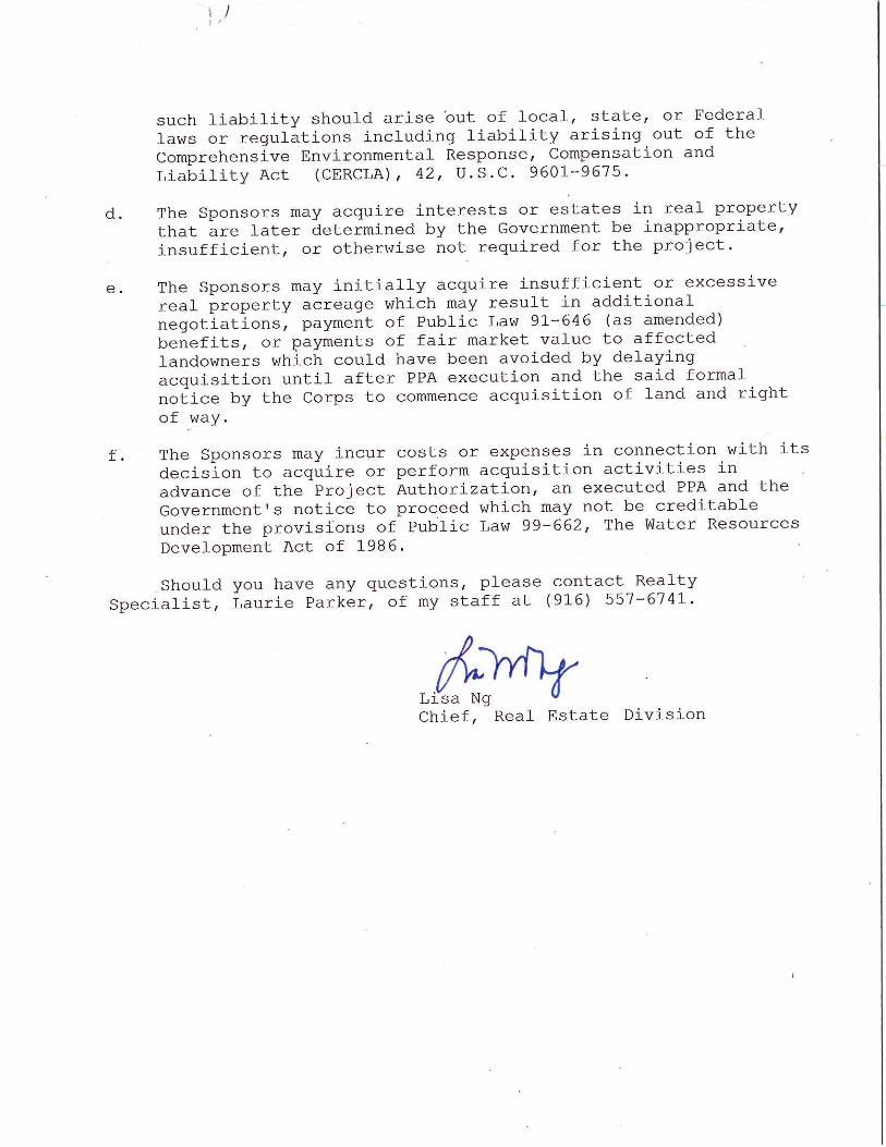
The non-Federal sponsor will be directed to begin real property acquisition for the Project only after a PPA is fully executed. A risk letter will be sent from the Corps to the State of California alerting the State, as non-Federal Sponsor, to the risks associated with purchasing project lands or obtaining easements, servitudes or rights-of-way in advance of the execution of a PPA. The project’s proposed period of construction extends through ten annual dredging cycles, with an anticipated placement of 100,000 cubic yards of dredged material within the project area each year. Thus the construction phase of the project is expected to extend to ten or more years.
Delta Islands and Levees Feasibility Study Real Estate Plan 20 June 2018
13
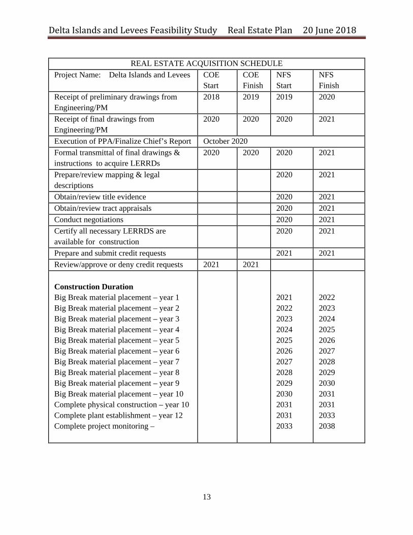
REAL ESTATE ACQUISITION SCHEDULE
Project Name: Delta Islands and Levees COE Start
COE Finish
NFS Start
NFS Finish
Receipt of preliminary drawings from Engineering/PM
2018 2019 2019 2020
Receipt of final drawings from Engineering/PM
2020 2020
2020 2021
Execution of PPA/Finalize Chief’s Report October 2020 Formal transmittal of final drawings & instructions to acquire LERRDs
2020 2020
2020 2021
Prepare/review mapping & legal descriptions
2020 2021
Obtain/review title evidence 2020 2021 Obtain/review tract appraisals 2020 2021 Conduct negotiations 2020 2021 Certify all necessary LERRDS are available for construction
2020 2021
Prepare and submit credit requests 2021 2021 Review/approve or deny credit requests 2021 2021 Construction Duration Big Break material placement – year 1 Big Break material placement – year 2 Big Break material placement – year 3 Big Break material placement – year 4 Big Break material placement – year 5 Big Break material placement – year 6 Big Break material placement – year 7 Big Break material placement – year 8 Big Break material placement – year 9 Big Break material placement – year 10 Complete physical construction – year 10 Complete plant establishment – year 12 Complete project monitoring –
2021 2022 2023 2024 2025 2026 2027 2028 2029 2030 2031 2031 2033
2022 2023 2024 2025 2026 2027 2028 2029 2030 2031 2031 2033 2038
Delta Islands and Levees Feasibility Study Real Estate Plan 20 June 2018
14
19. Description of Facility and Utility Relocations
No facility or utility relocations will be required for project construction. 20. Hazardous, Toxic, and Radiological Waste (HTRW)
Naturally Occurring Hazards None are anticipated
Hazards from Agricultural Practices
None are anticipated.
Hazards from Historical Mercury Mining None are anticipated Borrow Materials Historic chemical and granular test results of dredged materials from the Stockton Ship Channel at existing placement sites indicate that the dredged materials are chemically cleaner than the existing baseline sampling from the project area footprint. Future materials from dredging operations would be sampled prior to operations and maintenance dredging. Materials meeting baseline criteria would be utilized for marsh habitat creation. Materials not meeting baseline criteria would be conveyed to alternative disposal sites. Project construction activities are not expected to disturb existing HTRW sources that could lead to contamination of environmental resources. Therefore the tentatively selected plan is not expected to create any measurable HTRW effects. 21. Attitude of Landowners
Letters have been sent to the East Bay Regional Park District and to the Ironhouse Sanitary
District to introduce the project and to request cooperation in providing necessary real property rights for project construction and operation. Two recent meetings have occurred with the land owners and the East Bay Regional Park District has indicated that they are interested in being a second non-federal sponsor and are not only supportive of the project but have joined us to participate as a sponsor.
In February 2013 when the project included flood risk features that were subsequently eliminated, two scoping meetings were held to educate the public about the study efforts and to request comments, in accordance with NEPA and CEQA. Results of these outreach efforts
Delta Islands and Levees Feasibility Study Real Estate Plan 20 June 2018
15
were favorable. Numerous agencies, organizations, and individuals, including the U.S. Bureau of Reclamation, U.S. Fish and Wildlife Service, National Oceanic and Atmospheric Administration (NOAA Fisheries), U.S. Environmental Protection Agency, California Department of Fish and Wildlife, Sacramento County, San Joaquin County, Contra Costa County, Yolo County, Alameda County, Solano County, various levee maintenance agencies, local landowners and residents expressed support for marshland creation and habitat restoration in the area of the project site.
----------------------------------------Exhibit “A” Follows--------------------------------------------------
Delta Islands and Levees Feasibility Study Real Estate Plan 20 June 2018
16
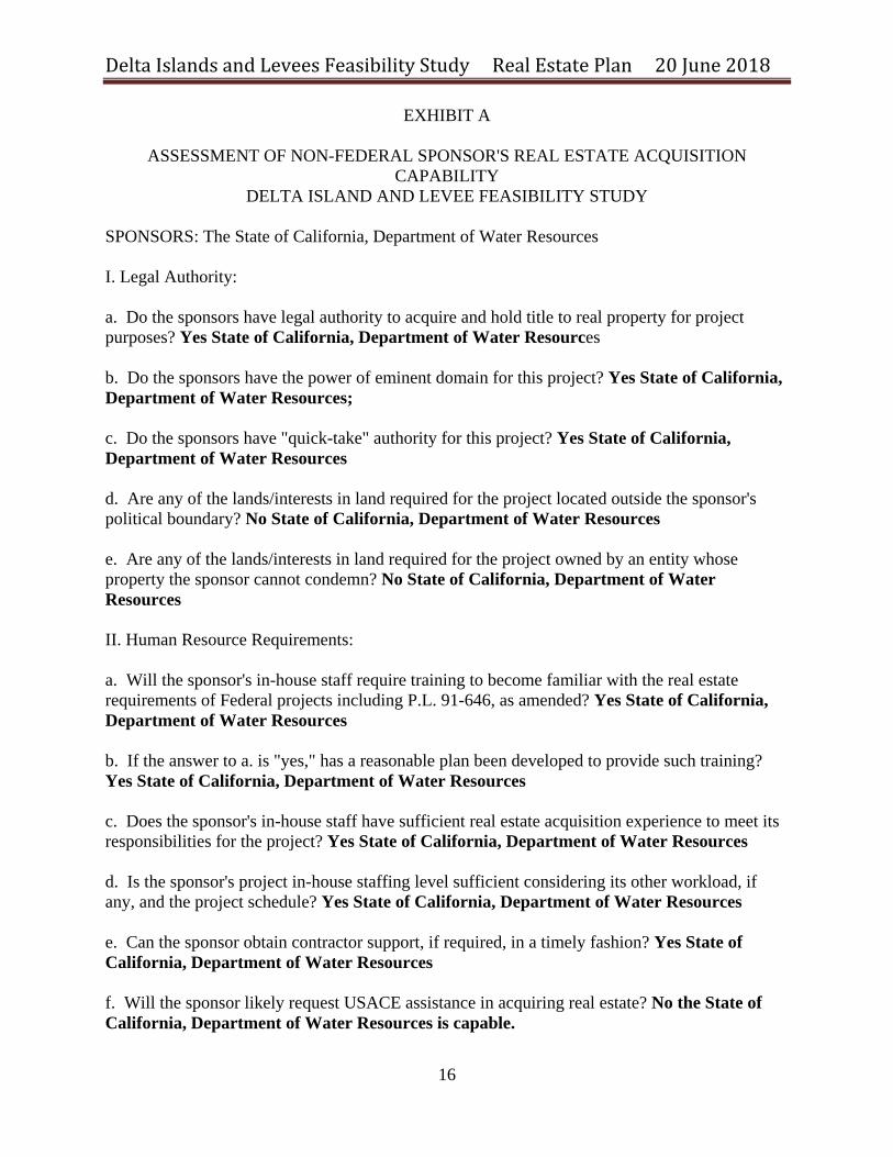
EXHIBIT A
ASSESSMENT OF NON-FEDERAL SPONSOR'S REAL ESTATE ACQUISITION CAPABILITY
DELTA ISLAND AND LEVEE FEASIBILITY STUDY
SPONSORS: The State of California, Department of Water Resources I. Legal Authority: a. Do the sponsors have legal authority to acquire and hold title to real property for project purposes? Yes State of California, Department of Water Resources b. Do the sponsors have the power of eminent domain for this project? Yes State of California, Department of Water Resources; c. Do the sponsors have "quick-take" authority for this project? Yes State of California, Department of Water Resources d. Are any of the lands/interests in land required for the project located outside the sponsor's political boundary? No State of California, Department of Water Resources e. Are any of the lands/interests in land required for the project owned by an entity whose property the sponsor cannot condemn? No State of California, Department of Water Resources II. Human Resource Requirements: a. Will the sponsor's in-house staff require training to become familiar with the real estate requirements of Federal projects including P.L. 91-646, as amended? Yes State of California, Department of Water Resources b. If the answer to a. is "yes," has a reasonable plan been developed to provide such training? Yes State of California, Department of Water Resources c. Does the sponsor's in-house staff have sufficient real estate acquisition experience to meet its responsibilities for the project? Yes State of California, Department of Water Resources d. Is the sponsor's project in-house staffing level sufficient considering its other workload, if any, and the project schedule? Yes State of California, Department of Water Resources e. Can the sponsor obtain contractor support, if required, in a timely fashion? Yes State of California, Department of Water Resources f. Will the sponsor likely request USACE assistance in acquiring real estate? No the State of California, Department of Water Resources is capable.
Delta Islands and Levees Feasibility Study Real Estate Plan 20 June 2018
17
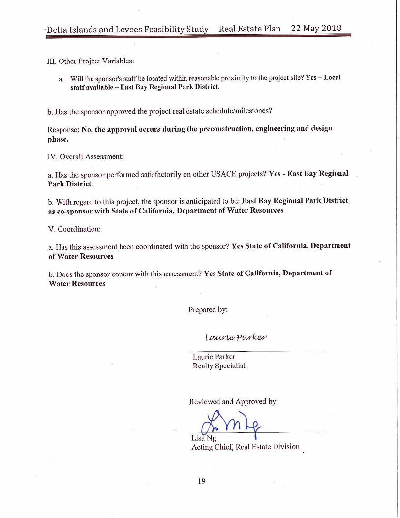
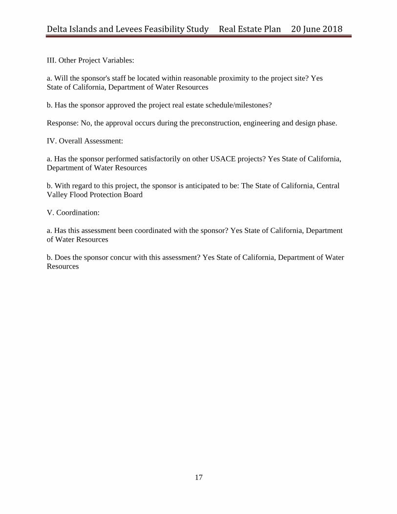
III. Other Project Variables: a. Will the sponsor's staff be located within reasonable proximity to the project site? Yes State of California, Department of Water Resources b. Has the sponsor approved the project real estate schedule/milestones? Response: No, the approval occurs during the preconstruction, engineering and design phase. IV. Overall Assessment: a. Has the sponsor performed satisfactorily on other USACE projects? Yes State of California, Department of Water Resources b. With regard to this project, the sponsor is anticipated to be: The State of California, Central Valley Flood Protection Board V. Coordination: a. Has this assessment been coordinated with the sponsor? Yes State of California, Department of Water Resources b. Does the sponsor concur with this assessment? Yes State of California, Department of Water Resources
Delta Islands and Levees Feasibility Study Real Estate Plan 20 June 2018
18
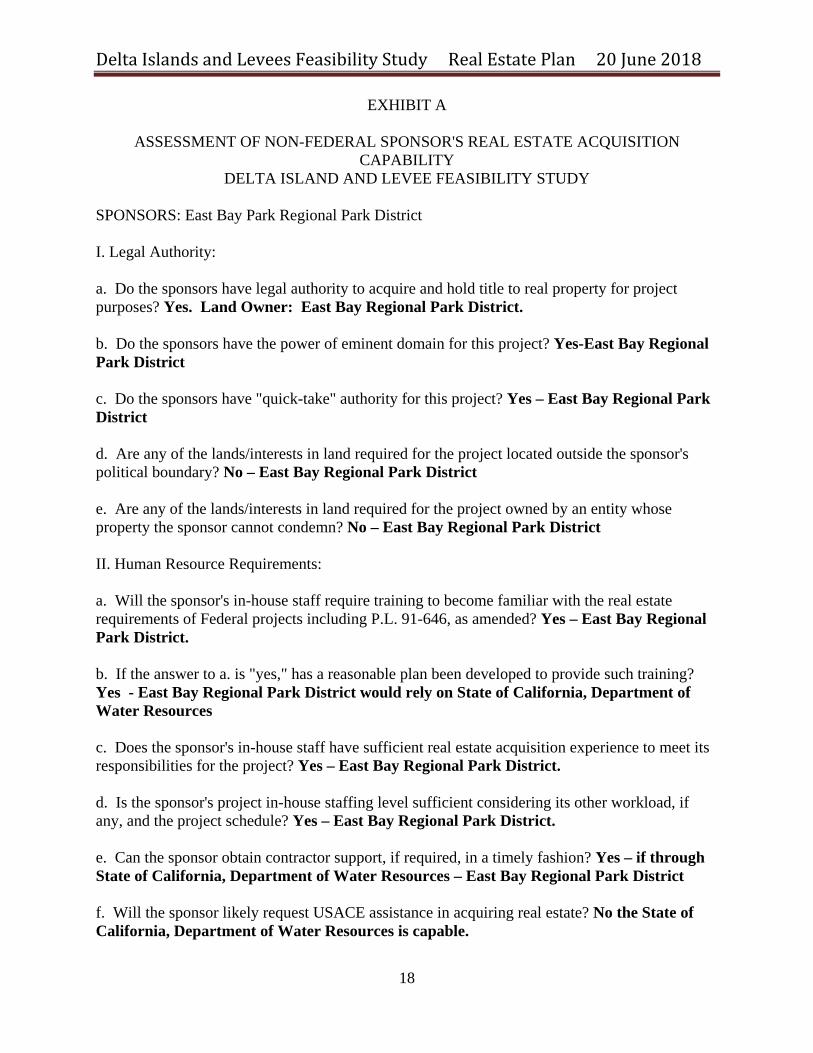
EXHIBIT A
ASSESSMENT OF NON-FEDERAL SPONSOR'S REAL ESTATE ACQUISITION CAPABILITY
DELTA ISLAND AND LEVEE FEASIBILITY STUDY
SPONSORS: East Bay Park Regional Park District I. Legal Authority: a. Do the sponsors have legal authority to acquire and hold title to real property for project purposes? Yes. Land Owner: East Bay Regional Park District. b. Do the sponsors have the power of eminent domain for this project? Yes-East Bay Regional Park District c. Do the sponsors have "quick-take" authority for this project? Yes – East Bay Regional Park District d. Are any of the lands/interests in land required for the project located outside the sponsor's political boundary? No – East Bay Regional Park District e. Are any of the lands/interests in land required for the project owned by an entity whose property the sponsor cannot condemn? No – East Bay Regional Park District II. Human Resource Requirements: a. Will the sponsor's in-house staff require training to become familiar with the real estate requirements of Federal projects including P.L. 91-646, as amended? Yes – East Bay Regional Park District. b. If the answer to a. is "yes," has a reasonable plan been developed to provide such training? Yes - East Bay Regional Park District would rely on State of California, Department of Water Resources c. Does the sponsor's in-house staff have sufficient real estate acquisition experience to meet its responsibilities for the project? Yes – East Bay Regional Park District. d. Is the sponsor's project in-house staffing level sufficient considering its other workload, if any, and the project schedule? Yes – East Bay Regional Park District. e. Can the sponsor obtain contractor support, if required, in a timely fashion? Yes – if through State of California, Department of Water Resources – East Bay Regional Park District f. Will the sponsor likely request USACE assistance in acquiring real estate? No the State of California, Department of Water Resources is capable.