Embed Size (px)
Citation preview

Final Non-federal Oil and Gas Management Plan/EIS K-1
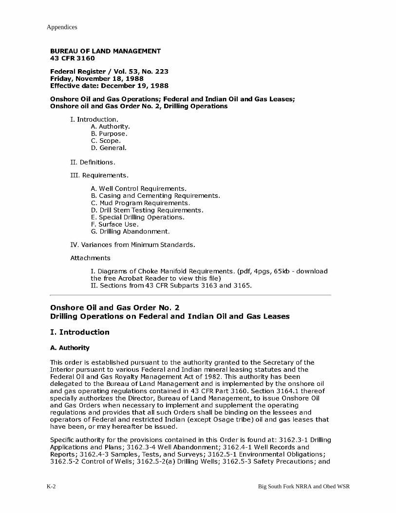
APPENDIX K: DEPARTMENT OF INTERIOR’S ONSHORE OIL AND GAS ORDER NUMBER 2, SECTION III.G., DRILLING
ABANDONMENT
Appendices
K-2 Big South Fork NRRA and Obed WSR

Appendix K: Department of Interior’s Onshore Oil and Gas Order Number 2, Section III.G., Drilling Abandonment
Final Non-federal Oil and Gas Management Plan/EIS K-3

Appendices
K-4 Big South Fork NRRA and Obed WSR

Appendix K: Department of Interior’s Onshore Oil and Gas Order Number 2, Section III.G., Drilling Abandonment
Final Non-federal Oil and Gas Management Plan/EIS K-5

Appendices
K-6 Big South Fork NRRA and Obed WSR
Appendix K: Department of Interior’s Onshore Oil and Gas Order Number 2, Section III.G., Drilling Abandonment
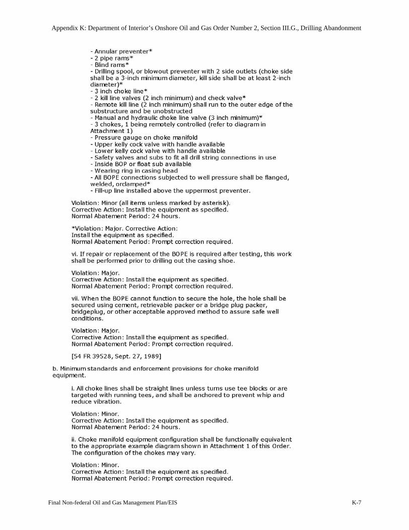
Final Non-federal Oil and Gas Management Plan/EIS K-7

Appendices
K-8 Big South Fork NRRA and Obed WSR
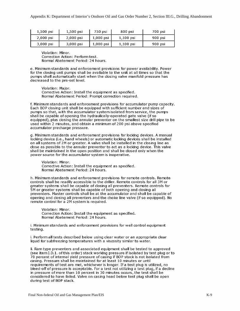
Appendix K: Department of Interior’s Onshore Oil and Gas Order Number 2, Section III.G., Drilling Abandonment
Final Non-federal Oil and Gas Management Plan/EIS K-9

Appendices
K-10 Big South Fork NRRA and Obed WSR

Appendix K: Department of Interior’s Onshore Oil and Gas Order Number 2, Section III.G., Drilling Abandonment
Final Non-federal Oil and Gas Management Plan/EIS K-11

Appendices
K-12 Big South Fork NRRA and Obed WSR

Appendix K: Department of Interior’s Onshore Oil and Gas Order Number 2, Section III.G., Drilling Abandonment
Final Non-federal Oil and Gas Management Plan/EIS K-13

Appendices
K-14 Big South Fork NRRA and Obed WSR

Appendix K: Department of Interior’s Onshore Oil and Gas Order Number 2, Section III.G., Drilling Abandonment
Final Non-federal Oil and Gas Management Plan/EIS K-15
Appendices
K-16 Big South Fork NRRA and Obed WSR

Final Non-federal Oil and Gas Management Plan/EIS L-1
APPENDIX L: GUIDELINE FOR THE DETECTION AND QUANTIFICATION OF CONTAMINATION AT OIL AND GAS
OPERATIONS
Prepared by Mark VanMouwerik
CSU Research Associate/Contaminants Specialist November 1999
Updated by Pete Penoyer Hydrologist
Water Resources Division National Park Service Fort Collins, Colorado
May 2004
I. WHAT IS THE PURPOSE OF THIS DOCUMENT?
This document is to be used as a guideline for collecting samples at sites within National Park Service (NPS) units where there are oil or gas operations. Samples will indicate whether or not contamination exists at the site as a result of an operation.
It is important that specific contaminants are tested for and that specific methodology is used so that contamination is accurately defined and so that results taken at different times by different people at the same site can be reliably compared. This guideline presents methodology for analyzing soil, sediment, groundwater, and surface water.
Specifically, guidelines are presented for: 1) when owner/operators must collect samples, 2) what contaminants to test for, 3) how to collect samples, 4) quality assurance/quality control, 5) how to analyze samples in the laboratory, 6) required detection limits and choosing environmental benchmarks, and 7) sample plan and reporting requirements.
Note that in this guideline “Superintendent” refers to the Superintendent and/or members of his/her staff who will represent him/her on these issues. In many cases, the Superintendent's actual involvement may be only that of approving the recommendations of the staff member(s).
II. WHEN AND WHERE TO COLLECT SAMPLES
The Superintendent can require sampling by an operator at a site if it has recently experienced a release, has a history of releases, or the facility is operated in a manner that poses a risk of releasing crude oil, natural gas condensates, produced water, or any other “contaminating substance” associated with an oil or gas operation.
Sampling can occur at any time during or after an operation. (“After” refers to when an owner/operator sells the operation, transfers its leasing rights, or closes the operation and abandons the site.) In most instances, sampling by the operator should be conducted under the direction of a Sampling and Analysis Plan that has been approved by the Superintendent to
Appendices
L-2 Big South Fork NRRA and Obed WSR
ensure all work will be performed in a professional manner, meets the resource protection needs of the park, and with the knowledge of the appropriate Park staff.
Sampling will be biased, not random, focusing on areas where contamination is obvious (visible) or suspected (such as near production or storage facilities). The exact sample locations and number of samples collected are site-specific and will be determined by the Superintendent, or proposed by the site operator in a Sampling and Analysis Plan or Work Plan submitted to the Superintendent for review and approval. Owner/operators are responsible for sample collection, sample analyses, and reporting of results, not NPS.
Sample data from a nearby (but off-site) “clean” location will be needed to determine “background” concentrations at the site for the contaminants of concern. A comparison of the contaminated site data with “background” data will allow resource managers to determine how contaminated the site is. If the site has been remediated, comparisons of sample data with “background” data can indicate if the clean-up met the Superintendent’s remediation goals for the site.
Note that incoming owner/operators at new or existing oil or gas operations may wish to test the site for contamination before they begin operations. If they choose to do so, it is strongly suggested they test for the contaminants and use the methodology given in this guideline so that if samples are required during or after the operation for any reason, all data can be reliably compared.
III. WHAT CONTAMINANTS TO TEST FOR
Contaminating substances that can be found at oil and gas sites are primarily crude oil, natural gas condensate, produced water, drilling mud, lube (motor) oil, and solvents. The individual contaminants found in these substances are listed in Table 1. Though other contaminants also are found in these substances, those in Table 1 were chosen because of their greater environmental toxicity and because they are good indicators of the presence of the contaminating substance(s) of interest.
When contamination of a site by one of these six contaminating substances is being investigated, sampling and analyses for some or all of the individual contaminants found in that contaminating substance should occur. Two lists of contaminants were compiled and are designated as “Tier I” (the smaller group, indicated by “xx” in Table 1) and “Tier II” (the more comprehensive group, indicated by both “xx” and “x”). Having two tiers to choose from allows the Superintendent flexibility in what contaminants he/she requires that the operator test for. The Tier I contaminants are included in the Tier II contaminants and therefore will always be tested for.
Tier I sampling should be conducted when basic information is needed. For instance, if contamination at a site is suspected but not known, testing for Tier I contaminants will confirm this; it will also give an idea of the severity of contamination. Tier I sampling might also be conducted where Park natural resources (like groundwater, vegetation, or surface water) are at low/no risk.

Appendix L: Guideline for the Detection and Quantification of Contamination at Oil And Gas Operations
Final Non-federal Oil and Gas Management Plan/EIS L-3
TABLE 1: CONTAMINANTS TO TEST FOR WHEN INVESTIGATING VARIOUS TYPES OF CONTAMINATION AT OIL AND GAS SITES.
Contaminants that should be tested for during Tier I sampling are indicated by “xx”, while those with either an “x” or “xx” should be tested for during Tier II sampling.
containmant
where found: soil/sediment = S groundwater/surface water = W
Contaminating substances individual contaminants are associated with:
crude oil condensate j produced
water drilling mud lube (motor)
oil solvents k PAHs a S, W x x x x x x TPH b S, W xx xx x x xx xx BTEX c S, W x xx x x x xx
metals arsenic S, W x x x barium S, W x xx xx x cadmium S, W x x x x chromium S, W x x xx copper S, W x x x x iron S, W x x lead S, W x x x xx magnesium S, W x x x x mercury e S, W x x x nickel S, W xx x x selenium S, W x x strontium S, W x xx vanadium S, W xx x x zinc S, W x xx x xx ammonia W x x calcium W x x x chloride S, W xx potassium W x x x sodium S, W xx xx xx sulfates W x gross alpha emissions g W x radium-226 g S xx pentachlorophenol S, W x surfactants S, W x pH S, W x x x x conductivity/salinity h S, W x xx xx TDS W x x grain size S x x x xx x total organic carbon S x x x x x x percent moisture i S xx xx xx xx xx xx static water level j W xx xx xx xx xx xx temperature W xx xx xx xx xx xx
Appendices
L-4 BIG SOUTH FORK NRRA AND OBED WSR
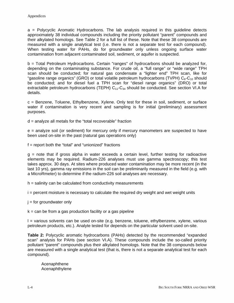
a = Polycyclic Aromatic Hydrocarbons. The lab analysis required in this guideline detects approximately 38 individual compounds including the priority pollutant “parent” compounds and their alkylated homologs. See Table 2 for a full list of these. Note that these 38 compounds are measured with a single analytical test (i.e. there is not a separate test for each compound). When testing water for PAHs, do for groundwater only unless ongoing surface water contamination from adjacent contaminated soil, sediment, or aquifer is suspected.
b = Total Petroleum Hydrocarbons. Certain "ranges" of hydrocarbons should be analyzed for, depending on the contaminating substance. For crude oil, a “full range” or “wide range” TPH scan should be conducted; for natural gas condensate a “lighter end” TPH scan, like for “gasoline range organics” (GRO) or total volatile petroleum hydrocarbons (TVPH) C6-C10 should be conducted; and for diesel fuel a TPH scan for “diesel range organics” (DRO) or total extractable petroleum hydrocarbons (TEPH) C11-C34 should be conducted. See section VI.A for details.
c = Benzene, Toluene, Ethylbenzene, Xylene. Only test for these in soil, sediment, or surface water if contamination is very recent and sampling is for initial (preliminary) assessment purposes.
d = analyze all metals for the “total recoverable” fraction
e = analyze soil (or sediment) for mercury only if mercury manometers are suspected to have been used on-site in the past (natural gas operations only)
f = report both the “total” and “unionized” fractions
g = note that if gross alpha in water exceeds a certain level, further testing for radioactive elements may be required. Radium-226 analyses must use gamma spectroscopy; this test takes approx. 30 days. At sites where produced water contamination may be more recent (in the last 10 yrs), gamma ray emissions in the soil can be preliminarily measured in the field (e.g. with a MicroRmeter) to determine if the radium-226 soil analyses are necessary.
h = salinity can be calculated from conductivity measurements
i = percent moisture is necessary to calculate the required dry weight and wet weight units
j = for groundwater only
k = can be from a gas production facility or a gas pipeline
l = various solvents can be used on-site (e.g. benzene, toluene, ethylbenzene, xylene, various petroleum products, etc.). Analyte tested for depends on the particular solvent used on-site.
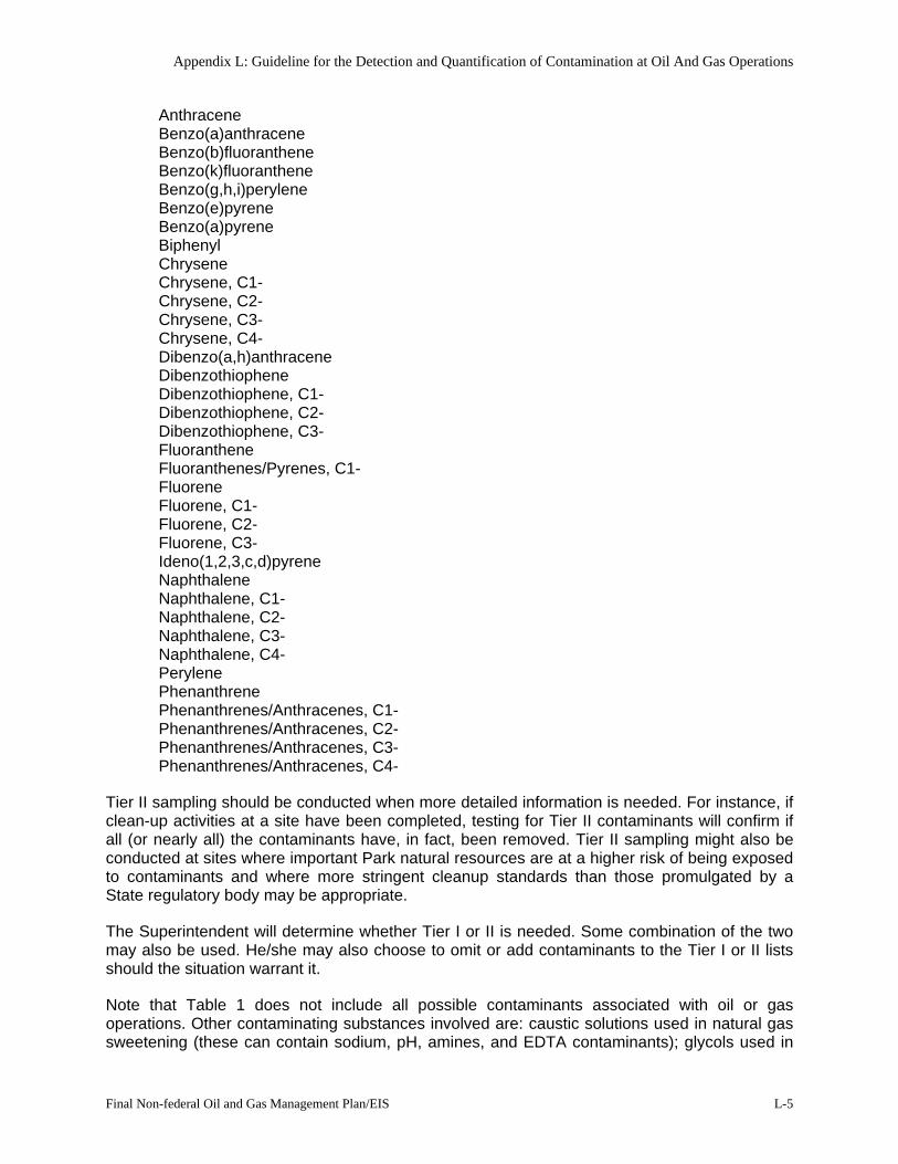
Table 2: Polycyclic aromatic hydrocarbons (PAHs) detected by the recommended “expanded scan” analysis for PAHs (see section VI.A). These compounds include the so-called priority pollutant “parent” compounds plus their alkylated homologs. Note that the 38 compounds below are measured with a single analytical test (that is, there is not a separate analytical test for each compound).
Acenaphthene Acenaphthylene
Appendix L: Guideline for the Detection and Quantification of Contamination at Oil And Gas Operations
Final Non-federal Oil and Gas Management Plan/EIS L-5
Anthracene Benzo(a)anthracene Benzo(b)fluoranthene Benzo(k)fluoranthene Benzo(g,h,i)perylene Benzo(e)pyrene Benzo(a)pyrene Biphenyl Chrysene Chrysene, C1- Chrysene, C2- Chrysene, C3- Chrysene, C4- Dibenzo(a,h)anthracene Dibenzothiophene Dibenzothiophene, C1- Dibenzothiophene, C2- Dibenzothiophene, C3- Fluoranthene Fluoranthenes/Pyrenes, C1- Fluorene Fluorene, C1- Fluorene, C2- Fluorene, C3- Ideno(1,2,3,c,d)pyrene Naphthalene Naphthalene, C1- Naphthalene, C2- Naphthalene, C3- Naphthalene, C4- Perylene Phenanthrene Phenanthrenes/Anthracenes, C1- Phenanthrenes/Anthracenes, C2- Phenanthrenes/Anthracenes, C3- Phenanthrenes/Anthracenes, C4-
Tier II sampling should be conducted when more detailed information is needed. For instance, if clean-up activities at a site have been completed, testing for Tier II contaminants will confirm if all (or nearly all) the contaminants have, in fact, been removed. Tier II sampling might also be conducted at sites where important Park natural resources are at a higher risk of being exposed to contaminants and where more stringent cleanup standards than those promulgated by a State regulatory body may be appropriate.
The Superintendent will determine whether Tier I or II is needed. Some combination of the two may also be used. He/she may also choose to omit or add contaminants to the Tier I or II lists should the situation warrant it.
Note that Table 1 does not include all possible contaminants associated with oil or gas operations. Other contaminating substances involved are: caustic solutions used in natural gas sweetening (these can contain sodium, pH, amines, and EDTA contaminants); glycols used in
Appendices
L-6 BIG SOUTH FORK NRRA AND OBED WSR
natural gas dehydration; and surfactants, acidizing agents, corrosion inhibitors, solvents, biocides, etc. used in oil or gas well workover and completion. The Superintendent may require that contaminants associated with these substances be tested for if they are suspected of having been released on-site.
IV. HOW TO COLLECT SAMPLES
A. Sample Locations
1. Soil
Background samples should be collected from an area as close to the site as possible where it is certain no contaminating substances from the site could have reached (from surface runoff, off-site dumping, migration from wind, etc.).
For soils that are known to be contaminated, samples should be collected from the spot and depth where contamination appears to be highest. For sites where soils are suspected of being contaminated, seek out areas near production facilities, storage tanks, valves, etc., and adjacent low points in the topography where contaminated runoff may have passed over or “puddled up” and concentrated. Collect sample at a depth where contamination would be highest: in most cases probably the top one to two inches. Note that releases in very porous (e.g. sandy) soil may percolate down and pool immediately above deeper, less porous soil layers (e.g. clay or silt strata, particularly if saturated), pool at the water table, or concentrate in highly organic layers.
For sites where removal of contaminated soils has already occurred, a sample should be collected in the top inch or so of the newly exposed soil to insure that all the contaminants that percolated down into the soil were, in fact, removed. (Note: At hydrocarbon release sites, screening of soils at the base of the excavation for volatile organic compounds/VOCs with a photo-ionization detector could improve the confidence that Tier II sample selection is sufficient to confirm a site is clean.)
All samples will be grab samples. (As a rule, composite samples should not be collected.) Where contamination is suspected but not known, the sampling device probably should be some type of tube or auger in order to capture equal amounts of soil over the depth of the profile; depending on the properties of the soil (like how hard or rocky it is), however, other devices (like a trowel) may work better. Sample collectors may have to communicate with the laboratory to ensure that enough soil is collected for the various analyses.
For BTEX samples, see section B.1. below.
The total number of samples to be collected will be site-specific and determined by the Superintendent. Enough samples should be collected and analyzed to meet the Tier I or Tier II sampling objective (see section III).
2. Sediment
Background samples should be collected from sediment adjacent to the sediments in question, but where it is reasonably certain no contaminating substances from the site (or other sites in the area) could have reached (from surface runoff, off-site dumping, etc.).

Appendix L: Guideline for the Detection and Quantification of Contamination at Oil And Gas Operations
Final Non-federal Oil and Gas Management Plan/EIS L-7
As with soils, sediments known to be contaminated should be sampled from the spot and depth where contamination appears to be highest. For sediments suspected of being contaminated, seek out areas near production facilities, storage tanks, valves, etc., and adjacent areas where potentially contaminated sediment in runoff could have settled out. Sample the sediment that has accumulated since the spill/release began. In some cases this may be the top ¼ inch, in others it may be the top several inches.
For sites where removal of contaminated sediments has already occurred, samples should be collected in the newly exposed sediment to insure that all contaminants were, in fact, removed.
All samples will be grab samples. (As a rule, composite samples should not be collected.) Where contamination is suspected but not known, or the layer of contaminated sediment is more than a couple inches thick, the sampling device probably should be some type of tube or auger in order to capture equal amounts of sediment over the depth of the profile; depending on the properties of the sediment (like how rocky it is) and the depth of the water, however, other devices may work better. Sample collectors may have to communicate with the laboratory to ensure that enough sediment is collected for the various analyses.
The total number of samples to be collected will be site-specific and determined by the Superintendent. Enough samples should be collected and analyzed to meet the Tier I or Tier II sampling objective (see section III).
3. Groundwater
Groundwater samples should be collected if the Superintendent determines that hydrogeological conditions at the site are such that groundwater resources under or near the site are reasonably at risk. Samples can be collected either via established monitoring wells or with “push” technology (such as Geoprobe).
It is critical that: a) sampling occurs in the right areas (for example, one location must be upgradient of the potential point of impact and at least two must be downgradient); and b) wells are screened at the appropriate depths to intercept any contaminant plume(s). (This will require knowledge of the local hydrogeology and the contaminants involved and their environmental fate characteristics). If “push” technology is used to collect soil samples for lab analysis or for on-site screening of various media (soil, ground water) for contaminants and samples are collected on more than one occasion, care must be taken to sample the exact same locations and at the same depths in the aquifer. Typically, once contamination is found in ground water using screening methodologies, monitoring wells are required by State regulatory agencies to ensure sample quality and integrity is sufficient to base regulatory decisions.
“Low-flow” sample collection methods should be used as per the EPA guidance document in IV.B.3 below.
Groundwater samples should not be filtered.
For BTEX samples, see section B.3. below.
All samples will be grab samples. (As a rule, composite samples should not be collected.) Sample collectors may have to communicate with the laboratory to ensure that enough sample is collected for the various analyses.
Appendices
L-8 BIG SOUTH FORK NRRA AND OBED WSR
The total number of samples to be collected will be site-specific and determined by the Superintendent or through his/her approval of the owner/operator’s Sampling and Analysis Plan after consultation with Park resource staff. Enough samples should be collected and analyzed to meet the Tier I or Tier II sampling objective (see section III).
4. Surface Water
Background samples should be collected upstream of any possible inputs of contaminated water (e.g. surface runoff or shallow groundwater) from the site.
Where contamination is obvious, such as in a surface sheen, collect samples right at the surface, avoiding any scum, algae, or other detritus on the water surface if possible (and note in fieldbook if present). Where a contaminating substance such as chlorinated solvents (dense nonaqueous phase liquids, or DNAPLs) was released or is suspected at the bottom of an aquifer (e.g. above a clay layer or aquitard), then collect samples at a depth immediately above the base of the aquifer, the depth of the first fine-grained layer below the water table, or both. For surface water suspected of being contaminated but it is unknown whether the contaminants are “floaters” or “sinkers,” collect samples at a depth of 3-12 inches.
For BTEX samples, see section B.4. below.
Again, all samples will be grab samples. (As a rule, composite samples should not be collected.) Sample collectors may have to communicate with the laboratory to ensure that enough sample is collected for the various analyses.
The total number of samples to be collected will be site-specific and determined by the Superintendent. Factors such as flow, depth, and the size of the water body are important here. Enough samples should be collected and analyzed to meet the Tier I or Tier II sampling objective (see section III).
B. Sample Collection Methodologies
Acceptable sampling methodology must be used so that results are as representative as possible. Sample collection can be complex and should be conducted by experienced professionals (typically a contractor). This could also help if the values or methods are challenged by one of the interested parties involved (State regulatory agency, Park, owner/operator etc.). Furthermore, experienced professionals are also trained in the appropriate precautions to protect the health and safety of the sample collector(s) from exposure to potentially harmful contaminants or hazardous situations that could develop.
Methodologies that should be used are typically those accepted/sanctioned by the appropriate State regulatory agency or are found in publications of widely recognized organizations (e.g. EPA, NOAA) that conduct environmental research. Acceptable methodologies are listed below for each environmental media (soil, sediment, etc.). In general, the State is authorized as the lead regulatory agency and should be the initial contact for appropriate sampling methodologies to employ when various environmental media are believed contaminated. In site-specific situations where a sensitive Park resource is threatened and more stringent cleanup than that required by a State agency may be appropriate, Park staff should consult WASO support offices as needed for appropriate criteria prior to discussion of more stringent cleanup levels with the owner/operator. If sample collection methodologies other than the above are used, they must contain the following to be acceptable: 1) Applicability of the procedure, 2) Equipment required,

Appendix L: Guideline for the Detection and Quantification of Contamination at Oil And Gas Operations
Final Non-federal Oil and Gas Management Plan/EIS L-9
3) Detailed description of procedures to be followed in collecting the samples, 4) Common problems encountered and corrective actions to be followed, and 5) Precautions to be taken. The methodology to be used must be cited in the sample plan. A basic description of collection methodology should be included in the report to the Superintendent (section VIII).
1. Soil
Methods from source documents published by the following organizations are acceptable:
-State Governing Regulatory Agency -U.S. EPA -American Society for Testing and Materials -U.S. Department of the Interior -American Petroleum Institute
Note that when collecting soil samples for BTEX analysis, specialized equipment and collection methods are necessary. Use a coring device such as the EnCore sampler or disposable plastic syringes. For detailed guidance, see section 4.1 and method 5035 in Chapter 4 of EPA’s SW-846, Update III (full reference in section VI.A. below).
2. Sediment
Methods from source documents published by the following organizations are acceptable:
-State Governing Regulatory Agency -U.S. EPA -American Society for Testing and Materials -U.S. Department of the Interior -American Petroleum Institute
3. Groundwater
Use: Environmental Protection Agency. 1992. RCRA Ground-Water Monitoring: Draft Technical Guidance. EPA/530/R-93-001. Office of Solid Waste, EPA, Washington, D.C.; or Publications of State Governing Regulatory Agency (DEQ, DEM, State EPA etc.)
“Low-flow” sampling should be conducted; for guidance, see:
Puls, R.W. and M.J. Barcelona. 1996. Ground Water Issue: Low-Flow (Minimal Drawdown) Ground-Water Sampling Procedures. EPA/540/S-95/504. Office of Solid Waste and Emergency Response, EPA, Washington, D.C.
Note that when collecting water samples for BTEX analysis, specialized equipment and collection methods are necessary. For detailed guidance, see section 4.1 and method 5030B in Chapter 4 of EPA’s SW-846, Update III (full reference in section VI.A. below).

Appendices
L-10 BIG SOUTH FORK NRRA AND OBED WSR
4. Surface Water
Methods from source documents published by the following organizations are acceptable:
-State Governing Regulatory Agency -U.S. EPA -American Society for Testing and Materials -U.S. Department of the Interior -American Petroleum Institute
Also recommended is this NPS guidance: Stednick, J.D. and D.M. Gilbert. 1998. Water quality inventory protocol: Riverine environments. National Park Service, Water Resources Division, Technical Report no. NPS/NRWRD/NRTR-98/177. Fort Collins, CO, 103 pp.
Note that when collecting water samples for BTEX analysis, specialized equipment and collection methods are necessary. For detailed guidance, see section 4.1 and method 5030B in Chapter 4 of EPA’s SW-846, Update III (full reference in section VI.A. below).
C. Sample Containers, Preservation, Storage
Refer to documents listed in sections VI.A. below and IV.B. above for specific guidance, including 40 CFR Part 136, if necessary. EPA’s SW-846, Update III is especially helpful.
Note that sediment samples should not be acidified for metals and that neither groundwater nor surface water samples should be filtered. Remember special conditions when sampling for BTEX (see section 4.1 and methods 5030 and 5035 in Chapter Four of SW-846, Update III) and for any metals requiring unusually low detection limits.
D. Chain of Custody
Proper chain-of-custody procedures must be used in sample handling (collection, shipping, storage, analysis). For examples, see Standard Methods for the Examination of Water and Wastewater for general guidance, and SW-846, Update III, Chapter 9, section 9.2.2.7 for detailed guidance.
V. QUALITY ASSURANCE/QUALITY CONTROL
Quality assurance/quality control (QA/QC) plans or Quality Assurance Project Plans (QAPPs) ensure that the data generated are scientifically valid, defensible, and of known precision and accuracy. Some of the basic elements of QA/QC or QAPP plans are:
data quality objectives (DQO)
field operating procedures (such as sample management, decontamination, equipment calibration, etc.)
field QA/QC requirements (such as data handling, collection of control samples like blanks, spikes and duplicates, etc.)
lab operating procedures (such as sample management, equipment calibration, etc.)
lab QA/QC procedures (such as data handling, control samples, etc.).

Appendix L: Guideline for the Detection and Quantification of Contamination at Oil And Gas Operations
Final Non-federal Oil and Gas Management Plan/EIS L-11
A QA/QC plan should be in place before any sampling begins. Basic QA/QC procedures to be followed should be described briefly in the sample plan (section VIII). If a certain QA/QC guidance document is used, it should be cited in the sample plan. Many guidance documents are available—several through EPA—including the following, recommended here:
Environmental Protection Agency. 1997. Test methods for evaluating solid waste, physical/chemical methods (SW-846), 3rd edition, Update III, Chapter One. EPA Office of Solid Waste and Emergency Response, EPA, Washington, D.C.
Adherence to the QA/QC plan should be documented throughout the project and demonstrated in the final report to the Superintendent.
Aspects of quality assurance that may be helpful can be found in:
Environmental Protection Agency. 1996. The volunteer monitor’s guide to quality assurance project plans. EPA Office of Wetlands, Ocean and Watersheds 4503F. EPA publication number: EPA 841-B-96-003. Also available at: http://www.epa.gov/owow/monitoring/volunteer/qappcover.htm
VI. HOW TO ANALYZE SAMPLES IN THE LABORATORY
A. Analytical Methods
Metals analyses must use the methods in EPA’s SW-846, Update III (or more recent). This applies to soil, sediment, groundwater, and surface water samples. Groundwater and surface water methods can also include EPA's 200 series for metals, or the 1600 series where extremely low (state-of-the-art) detection limits are desired. The full reference for the SW-846 document is:
Environmental Protection Agency. 1997. Test methods for evaluating solid waste, physical/chemical methods (SW-846), 3rd edition, Update III. EPA Office of Solid Waste and Emergency Response, EPA, Washington, D.C.
Polycyclic aromatic hydrocarbon (PAH) analyses must use a modification of method 8270 in EPA’s SW-846, Update III. Developed by the National Oceanic and Atmospheric Administration (NOAA), this method is referred to as “GC/MS method 8270 in selective ion mode (SIM)”, and is informally referred to as the “expanded scan” for PAHs. Consult the following for a detailed explanation of methodology:
Lauenstein, G.G., and A.Y. Cantillo (1998). Sampling and analytical methods of the National Status and Trends Program Mussel Watch Project: 1993-1996 update. NOAA Technical Memorandum NOS ORCA 130. 233 pp.
Total petroleum hydrocarbons (TPH) analyses will be for certain “ranges” of hydrocarbons, depending on the contaminating substance present. For crude oil, a “wide range” or “full range” TPH scan should be conducted to measure the heavier fractions. For natural gas condensate a “lighter end” TPH scan, such as for “gasoline range organics” (GRO), should be conducted. For diesel fuel, a TPH scan for “diesel range organics” (DRO) should be conducted to measure the mid-range fractions. Although many analytical methods are available for TPH, samples should be analyzed using only GC/FID (gas chromatograph/flame ionization detection) methodology. Method 8015B in EPA’s SW-846, Update III is highly recommended.

Appendices
L-12 BIG SOUTH FORK NRRA AND OBED WSR
Benzene, toluene, ethylbenzene, and xylene (BTEX) analyses should use method 8260B in EPA’s SW-846, Update III. Analysis for BTEX compounds is typically done in place of a TPH analysis when a refined product is released as opposed to crude oil.
Ammonia analyses should use EPA method 350.1 (or equivalent APHA method 4500-NH3 H, or USGS method 4523-85). Samples should not be filtered.
For all other contaminants in Table 1, use methods approved in 40 CFR Part 136 (EPA, Standard Methods for the Examination of Water and Wastewater (latest edition), ASTM, or USGS). Methods in the NPS, Water Resources Division “Water quality inventory protocol” (section IV.B.4 above) can also be used.
B. Laboratories
Samples must be sent to an experienced lab that can: 1) perform the above analytical methods; 2) achieve the required detection limits (section VII below); 3) perform the required QA/QC procedures (section V above); and 4) provide the information required in the sample plan and the final report to the Superintendent (section VIII below).
Note that in regards to the PAH analytical method (as specified in VI.A. above), only a few labs nationwide (perhaps a dozen) currently can perform this analysis. Many of these same labs can also “fingerprint” samples; that is, by analyzing hydrocarbon-contaminated samples, they can identify the type and source of the petroleum product at the site. A partial list of these labs follows (no government endorsement implied):
Arthur D. Little, Inc. Battell Marine Science Lab 25 Acorn Park 1529 West Sequim Bay Rd. Cambridge, MA. 02140 Sequim, WA 98382 (617) 498-5000 (360) 683-4151
Geochemical and Environmental Woods Hole Group, Environmental Research Group Laboratories Texas A&M University 375 Paramount Drive, Suite B 833 Graham Rd. Raynham, MA 02767-5154 College Station, TX. 77845 (508) 822-9300 or 563-5030 (409) 862-2323 ext. 115
VII. DETECTION LIMITS
Note: The term “detection limit” used herein refers to what is commonly called the “reporting limit” and occasionally called the “quantitation limit. A detection limit is what a lab (using a particular instrument in some combination with analytical method and skill level of operator) can quantify low levels of a contaminant substance with acceptable confidence. It does not refer to the sometimes much lower “instrument detection limit” or “method detection limit” where how well the value obtained represents the true value may be of low confidence. Also note that detection limits should not be confused with cleanup standards or cleanup criteria. Required cleanup levels/criteria are usually set by State regulatory authorities as the acceptable contaminant residue (usually well above detection limits) that may remain in some environmental media after a remedial effort has occurred. NPS is authorized to require more stringent cleanup criteria on a case-by-case basis, particularly in site-specific situations where sensitive ecological resources

Appendix L: Guideline for the Detection and Quantification of Contamination at Oil And Gas Operations
Final Non-federal Oil and Gas Management Plan/EIS L-13
could be threatened. Widely accepted, peer-reviewed research may then be used to support the NPS position that State criteria are not sufficiently protective and lower cleanup criteria are warranted.
Labs should achieve the detection limits (DLs) provided in Table 3 below. These DLs are below federal (and presumably state) standards and most other criteria currently in the literature. Therefore, analytical methods that achieve these DLs will be able to indicate if most standards and criteria are being met. Note, however, that the DLs for two contaminants—PAHs and mercury—are above some of the more strict standards or criteria that exist. This is because many labs cannot achieve DLs this low, and the DLs in the table were chosen so that most experienced and well-equipped labs could achieve them. Lower DLs are achievable for PAHs and mercury at some labs that have the expertise and special instrumentation (see section VI.B. above for examples).
If the natural resources at or near the site are particularly sensitive, pristine, or important to the Park, the Superintendent may wish to choose the strictest available standard or criteria as the remediation goal. He/she would then have to request some lower DLs (lower than those in Table 3) from the lab for PAHs and mercury.
For the contaminants in Table 1 that are not listed in Table 3, commonly reported DLs are acceptable.
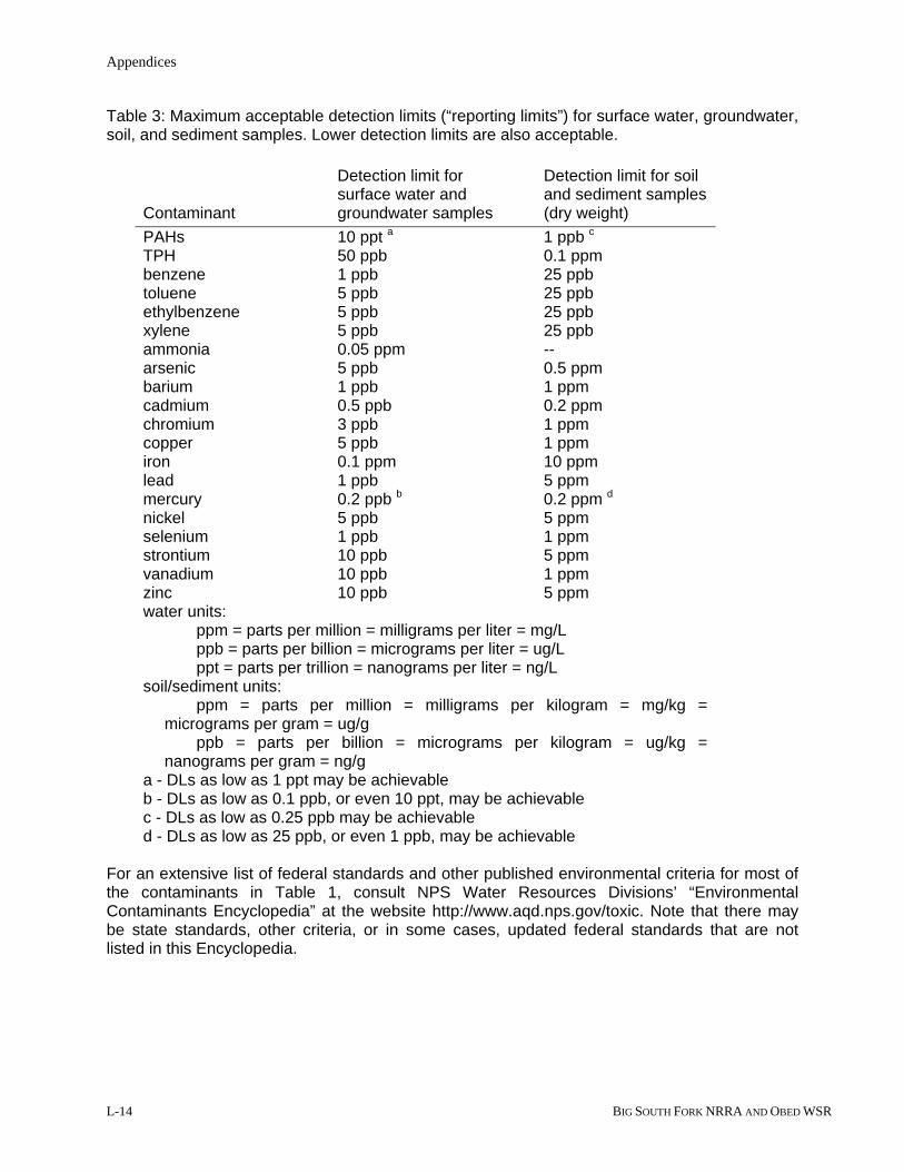
Appendices
L-14 BIG SOUTH FORK NRRA AND OBED WSR
Table 3: Maximum acceptable detection limits (“reporting limits”) for surface water, groundwater, soil, and sediment samples. Lower detection limits are also acceptable.
Contaminant
Detection limit for surface water and groundwater samples
Detection limit for soil and sediment samples (dry weight)
PAHs 10 ppt a 1 ppb c TPH 50 ppb 0.1 ppm benzene 1 ppb 25 ppb toluene 5 ppb 25 ppb ethylbenzene 5 ppb 25 ppb xylene 5 ppb 25 ppb ammonia 0.05 ppm -- arsenic 5 ppb 0.5 ppm barium 1 ppb 1 ppm cadmium 0.5 ppb 0.2 ppm chromium 3 ppb 1 ppm copper 5 ppb 1 ppm iron 0.1 ppm 10 ppm lead 1 ppb 5 ppm mercury 0.2 ppb b 0.2 ppm d nickel 5 ppb 5 ppm selenium 1 ppb 1 ppm strontium 10 ppb 5 ppm vanadium 10 ppb 1 ppm zinc 10 ppb 5 ppm water units:
ppm = parts per million = milligrams per liter = mg/L ppb = parts per billion = micrograms per liter = ug/L ppt = parts per trillion = nanograms per liter = ng/L
soil/sediment units: ppm = parts per million = milligrams per kilogram = mg/kg = micrograms per gram = ug/g ppb = parts per billion = micrograms per kilogram = ug/kg = nanograms per gram = ng/g
a - DLs as low as 1 ppt may be achievable b - DLs as low as 0.1 ppb, or even 10 ppt, may be achievable c - DLs as low as 0.25 ppb may be achievable d - DLs as low as 25 ppb, or even 1 ppb, may be achievable
For an extensive list of federal standards and other published environmental criteria for most of the contaminants in Table 1, consult NPS Water Resources Divisions’ “Environmental Contaminants Encyclopedia” at the website http://www.aqd.nps.gov/toxic. Note that there may be state standards, other criteria, or in some cases, updated federal standards that are not listed in this Encyclopedia.

Appendix L: Guideline for the Detection and Quantification of Contamination at Oil And Gas Operations
Final Non-federal Oil and Gas Management Plan/EIS L-15
VIII. SAMPLE PLAN AND REPORTING REQUIREMENTS
A. Sample Plan
The owner/operator should submit a Sampling and Analysis Plan to the Superintendent for approval before samples are collected. The plan must include:
sampling objectives (such as, “identify contaminants and concentrations involved,” “determine spatial extent of spill,” “determine if remediation is complete,” etc.)
the contaminating substances being investigated (such as crude oil, natural gas condensate, produced water, etc.)
list of individual contaminants that will be tested for (see Table 1) analytical methods to be used (see section VI. A.) type of samples to be collected (such as soil, sediment, groundwater, or surface water) citation and brief description of sample collection methodology to be used (see section
IV. B.) specific sample locations and number of samples at each (Superintendent will walk the
site and choose exact locations; this information may not be available until the time when samples are actually collected)
total number of samples (this information may not be available until the time when samples are actually collected)
acknowledgment that detection limits (that is, “reporting limits”) specified herein (section VII) will be achieved
brief description of QA/QC procedures to be followed and citation of any guidance document used (see section V)
acknowledgment that proper chain-of-custody procedures will be initiated and followed
B. Reporting Requirements
Upon completing sample collection and analyses, the owner/operator shall submit a report to the Superintendent. This report shall include:
sample ID number/name description of sample locations (include maps, sketches, or photos) sample depth brief description of spill area (apparent extent of spill, topography, vegetation, surface
water features, apparent soil conditions, etc.) date and time of sampling name of sample collector information pertinent to the sample collection methodology used (sampling devices
used, how samples were collected, etc.) sample containers used, any preservation methods, and storage conditions of samples date and time of analyses name of chemist/technician performing analyses type of sample (soil, sediment, groundwater, or surface water) sample fraction measured (such as “total”, “total recoverable”, etc.) analytical results and units (mg/kg, µg/L, etc.) percent moisture (for soil/sediment samples) wet weight and dry weight units (for soil/sediment samples) analytical methods used

Appendices
L-16 BIG SOUTH FORK NRRA AND OBED WSR
detection limits (that is, “reporting limits”) achieved method detection limits (MDL) for the analytical methods used indication of analyses done in the field (such as pH, conductivity, etc.) field observations made while collecting samples lab and field QA/QC results and procedures followed name of analytic equipment used appropriate chain-of-custody forms
IX. SPILL RESPONSE AND NOTIFICATION PROCEDURE FOLLOWING RELEASE OF A CONTAMINATING SUBSTANCE FROM A NONFEDERAL OIL AND GAS OPERATION IN A PARK UNIT
A. Initial Park Staff Actions Following Discovery of a Release
1. Secure the area to protect human health and safety
2. Notify operator of the release and immediate need to control the source and contain the release, and obtain information of the released substance
3. Initial site assessment to identify park resources potentially as risk from the release (surface water, wetlands, cultural resources, etc.), and quantity of released substance
4. Direct operator during initial spill containment actions to protect natural and cultural resources at risk, and to protect human health and safety
5. Notify Regional Spill Response Coordinator and relay all pertinent information
6. Obtain 5 liter sample of released substance (Note: need preservation and storage guidance for park staff) and initiate chain of custody documentation
7. Continue to oversee operator containment actions and maintain security
8. Park Superintendent advises operator that the operation is immediately “suspended” pursuant to NPS regulations at 36 CFR §9.51(c)(2)
9. Park staff prepares a detailed Case Incident Report on the spill event
B. Regional Spill Response Coordinator Notification Duties
1. Contact National Response Center to advise of release and obtain case number
2. Notify Environmental Quality Division (Dan Hamson), Geologic Resources Division (Jim Woods), Regional Minerals Coordinator (Linda Dansby), and Water Resources Division (Matt Hagermann) if release threatens water resources
3. Coordinate a conference call with above technical offices and park staff to define appropriate course of action relative to spill containment, public health and safety, site assessment, damage assessment, and operator responsiveness and capability
4. Notify pertinent state regulatory agencies and state trustees

Appendix L: Guideline for the Detection and Quantification of Contamination at Oil And Gas Operations
Final Non-federal Oil and Gas Management Plan/EIS L-17
C. Coordination of Response, Clean-up and Damage Assessment
1. All involved NPS staff track time and all other expenditures associated with the spill event
2. Park Superintendent prepares formal suspension notice for Regional Director’s signature in accordance with NPS regulations at 36 CFR §9.51(c)(2)
3. Park staff coordinates with designated On Scene Coordinator (EPA, Coast Guard, or NPS staff expert if EPA or Coast Guard does not dispatch a coordinator) and state regulatory agencies to oversee operator spill response and initial clean-up actions
4. Park staff coordinates with On Scene Coordinator (OSC) and state trustee agencies in the conduct of resource damage assessment (Note: operator may contract with approved consulting firm/laboratory to conduct assessment work)
5. All involved NPS offices evaluate site assessment results and reach consensus on additional remediation actions and reclamation goals, and communicate recommendations to park Superintendent. (Note: NPS regulations at 36 CFR §9.39(a)(1)(i) and §9.39(a)(2)(iii) require operators to remove or neutralize any contaminating substance)
6. Park staff coordinates with OSC and state trustee agencies in monitoring remediation and reclamation actions
7. Park Superintendent and NPS technical working group evaluates final remediation/reclamation success and determines if further legal action against the operator is required (Note: operators are liable for any damages to federally-owned or controlled lands, waters or resources pursuant to 36 CFR §9.51(a).

Appendices
L-18 BIG SOUTH FORK NRRA AND OBED WSR