Embed Size (px)
Citation preview
Appendix IS-3 Surface Fault Rupture Hazard Evaluation

BOARD OF
BUILDING AND SAFETY COMMISSIONERS
VAN AMBATIELOS PRESIDENT
E. FELICIA BRANNON VICE PRESIDENT
JOSEL YN GEAGA-ROSENTHAL GEORGE HOVAGUIMIAN
JAVIER NUNEZ
CITY OF Los ANGELES CALIFORNIA
ERIC GARCETTI MAYOR
DEPARTMENT OF
BUILDING AND SAFETY 201 NORTH FIGUEROA STREET
LOS ANGELES. CA 90012
FRANK M. BUSH GENERAL MANAGER
SUPERINTENDENT OF BUILDING
OSAMA YOUNAN, P.E. EXECUTIVE OFFICER
GEOLOGY REPORT APPROV AL LETTER
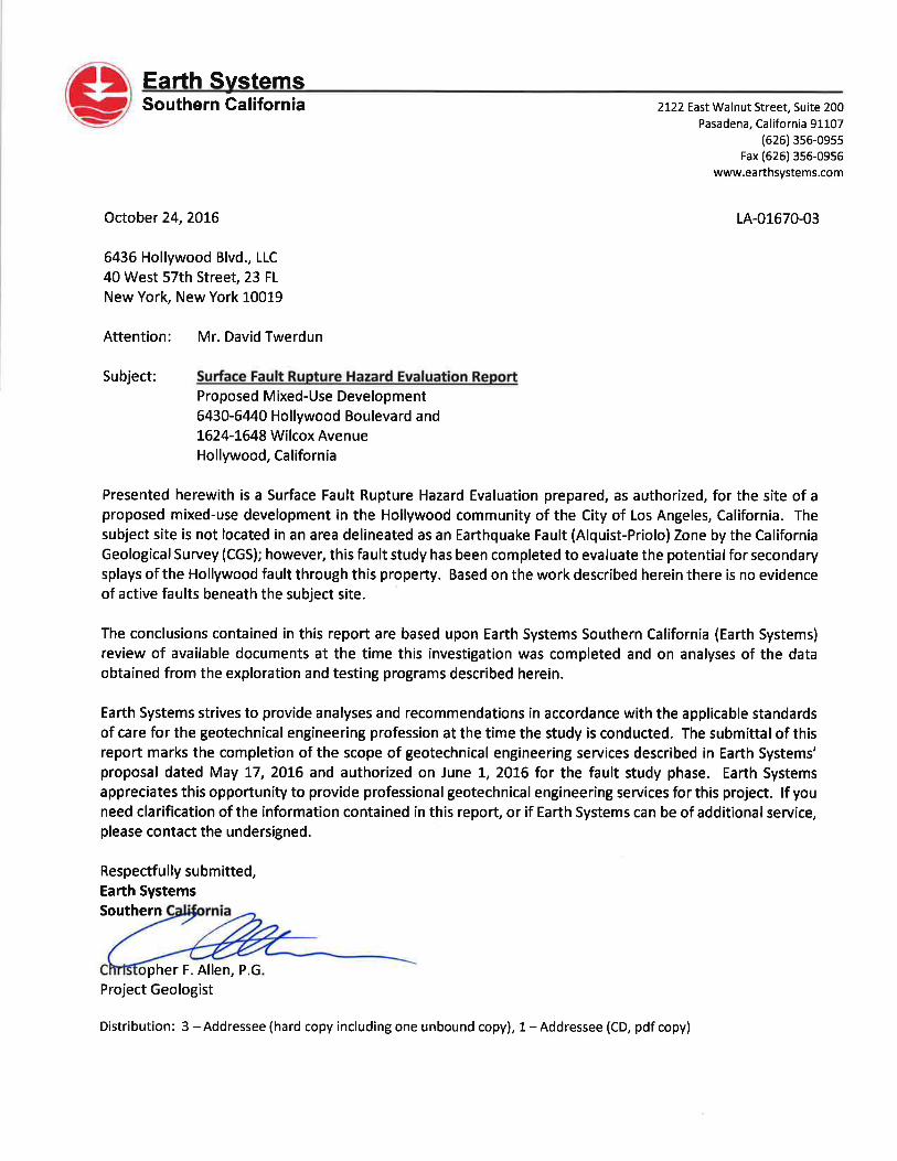
May 19, 2017
6436 Hollywood Blvd., LLC 40 W. 57th Street, 23 FI New York, NY 10019
TRACT: BLOCK:
Hollywood (MR 28-59/60) 14
LOG # 97575 SOILS/GEOLOGY FILE - 2
LOT(S): LOCATION:
FR 3, FR 4, FR 5 (Arb 1), FR 6 (Arb 1), FR 15 (Arb 2) & FR 16 (Arb 1) 1624-1644 N. Wilcox Avenue
CURRENT REFERENCE REPORT/LETTER(S) Geology Report
REPORT No. LA-01670-03
DATE(S) OF DOCUMENT 10/24/2016
PREPARED BY Earth Systems So. Calif.
The Grading Division of the Department of Building and Safety has reviewed the referenced report that presents a fault rupture hazard investigation at 1624 to 1644 Wilcox Avenue for the future mixed-use devolvement of the property. The site is not located within the Official Earthquake Fault Zone that was established by the California Geological Survey for the Hollywood fault (on the USGS 7.5 minute Hollywood Quadrangle). However, because of the proximity of the Hollywood fault, and to rule out the possibility that previously unrecognized splays traverse the site, a geologic investigation was conducted to evaluate the potential for surface fault rupture.
The field investigation included a transect of22 CPT soundings and 3 continuous core borings. Dr. Thomas Rockwell provided a detailed soil stratigraphic/pedological analysis to estimate the age of the soil horizons encountered in the continuous cores. The investigation documents continuous stratigraphy of at least late Pleistocene alluvial units. No faults were observed within the sediments at the site. Therefore, no building restrictions are recommended by Earth Systems Southern California. The referenced report is acceptable, provided the following conditions are complied with during site development:
1. Prior to issuance of any permit, a soil engineering report shall be submitted to the Grading Division to provide design recommendations for the proposed grading/construction.
~M.-(C'-.r' ''' _/_~~-' DANIEL C. SCHNEIDEREIT Engineering Geologist II
Log No. 97575 213-482-0480
cc: Earth Systems So. Calif., Project Consultant LA District Office
LADBS G·5 (Rev,11/23/2016) AN EQUAL EMPLOYMENT OPPORTUNITY - AFFIRMATIVE ACTION EMPLOYER
SURFACE FAULT RUPTURE HAZARD EVALUATION
Proposed Mixed-Use Development 6430-6440 Hollywood Boulevard and
1624-1648 Wilcox Avenue Hollywood, California
LA-01670-03
Prepared For
6436 HOLLYWOOD BLVD., LLC
October 24, 2016
Prepared By
Earth Systems Southern California 2122 East Walnut Street, Suite 200
Pasadena, California 91107
Phone (626) 356-0955 Fax (626) 356-0956
October 24, 2016 LA-01670-03
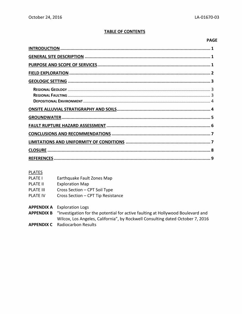
TABLE OF CONTENTS
PAGE
INTRODUCTION ..................................................................................................................... 1
GENERAL SITE DESCRIPTION .................................................................................................. 1
PURPOSE AND SCOPE OF SERVICES ........................................................................................ 1
FIELD EXPLORATION .............................................................................................................. 2
GEOLOGIC SETTING ............................................................................................................... 3
REGIONAL GEOLOGY ........................................................................................................................ 3 REGIONAL FAULTING ........................................................................................................................ 3 DEPOSITIONAL ENVIRONMENT ........................................................................................................... 4
ONSITE ALLUVIAL STRATIGRAPHY AND SOILS ......................................................................... 4
GROUNDWATER .................................................................................................................... 5
FAULT RUPTURE HAZARD ASSESSMENT ................................................................................. 6
CONCLUSIONS AND RECOMMENDATIONS ............................................................................. 7
LIMITATIONS AND UNIFORMITY OF CONDITIONS .................................................................. 7
CLOSURE ............................................................................................................................... 8
REFERENCES .......................................................................................................................... 9
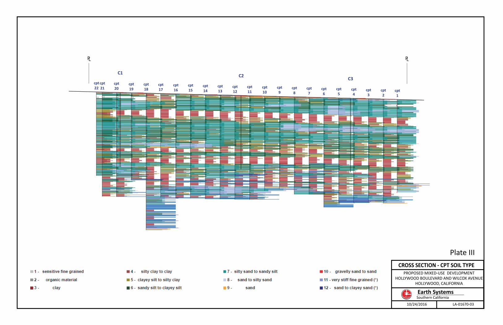
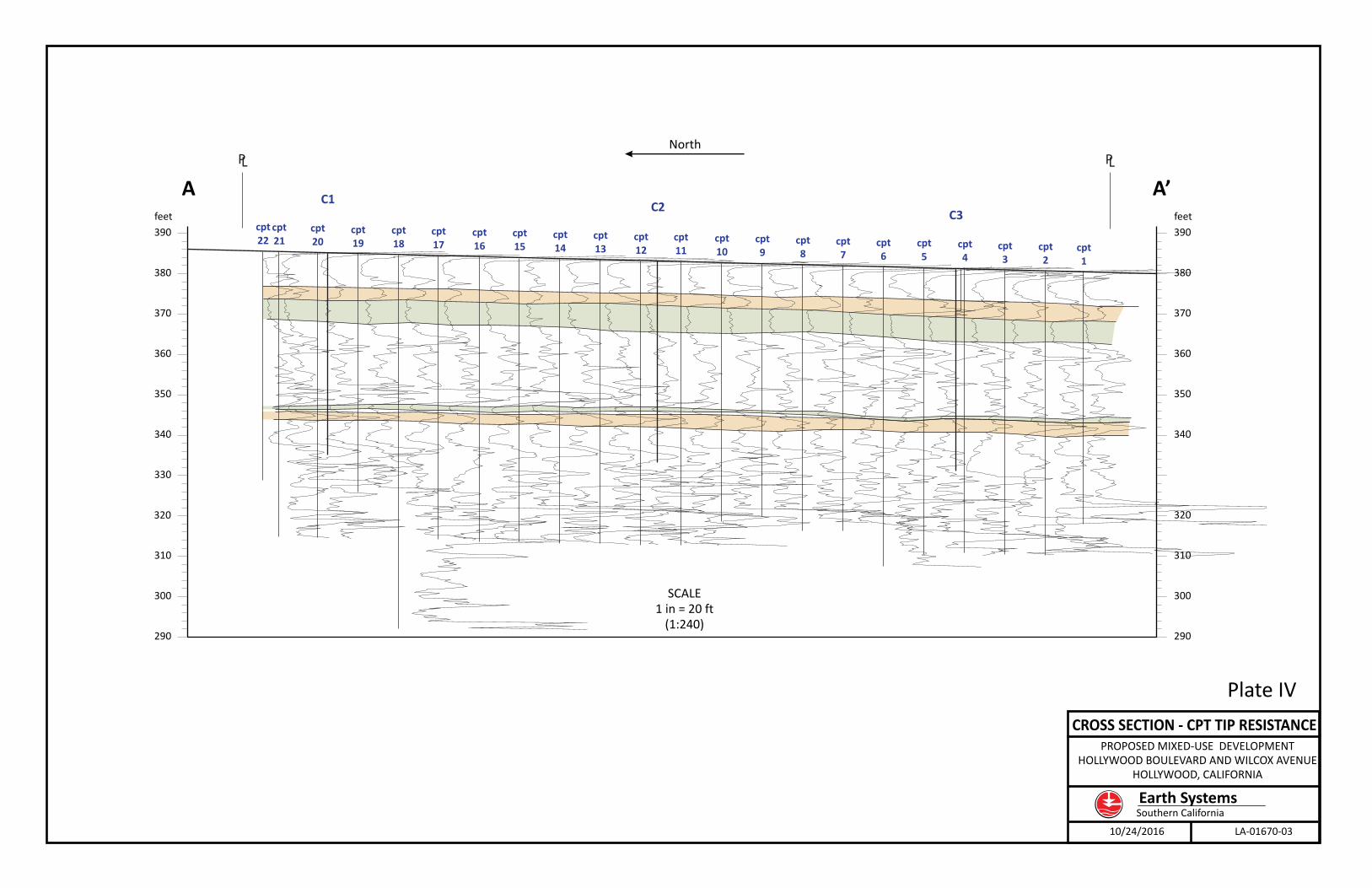
PLATES PLATE I Earthquake Fault Zones Map PLATE II Exploration Map PLATE III Cross Section – CPT Soil Type PLATE IV Cross Section – CPT Tip Resistance
APPENDIX A Exploration Logs APPENDIX B “Investigation for the potential for active faulting at Hollywood Boulevard and
Wilcox, Los Angeles, California”, by Rockwell Consulting dated October 7, 2016 APPENDIX C Radiocarbon Results
October 24, 2016 LA-01670-03
SURFACE FAULT RUPTURE HAZARD INVESTIGATION PROPOSED MIXED USE DEVELOPMENT
6430-6440 HOLLYWOOD BOULEVARD AND 1624-1648 WILCOX AVENUE HOLLYWOOD, CALIFORNIA
INTRODUCTION
Earth Systems was requested to conduct a Surface Fault Rupture Hazard Evaluation for a proposed mixed-use development project, located in the Hollywood district of the City of Los Angeles. The subject site is not located in an area delineated as an Earthquake Fault (Alquist-Priolo) zone by the California Geological Survey (CGS). However, as the Hollywood fault has been determined to be nearby and an active fault found during excavation and construction at the site would potentially be catastrophic, this fault study has been completed to evaluate the potential for secondary splays of the Hollywood fault through the area of a proposed high-rise to assure the absence of such hazards.
GENERAL SITE DESCRIPTION
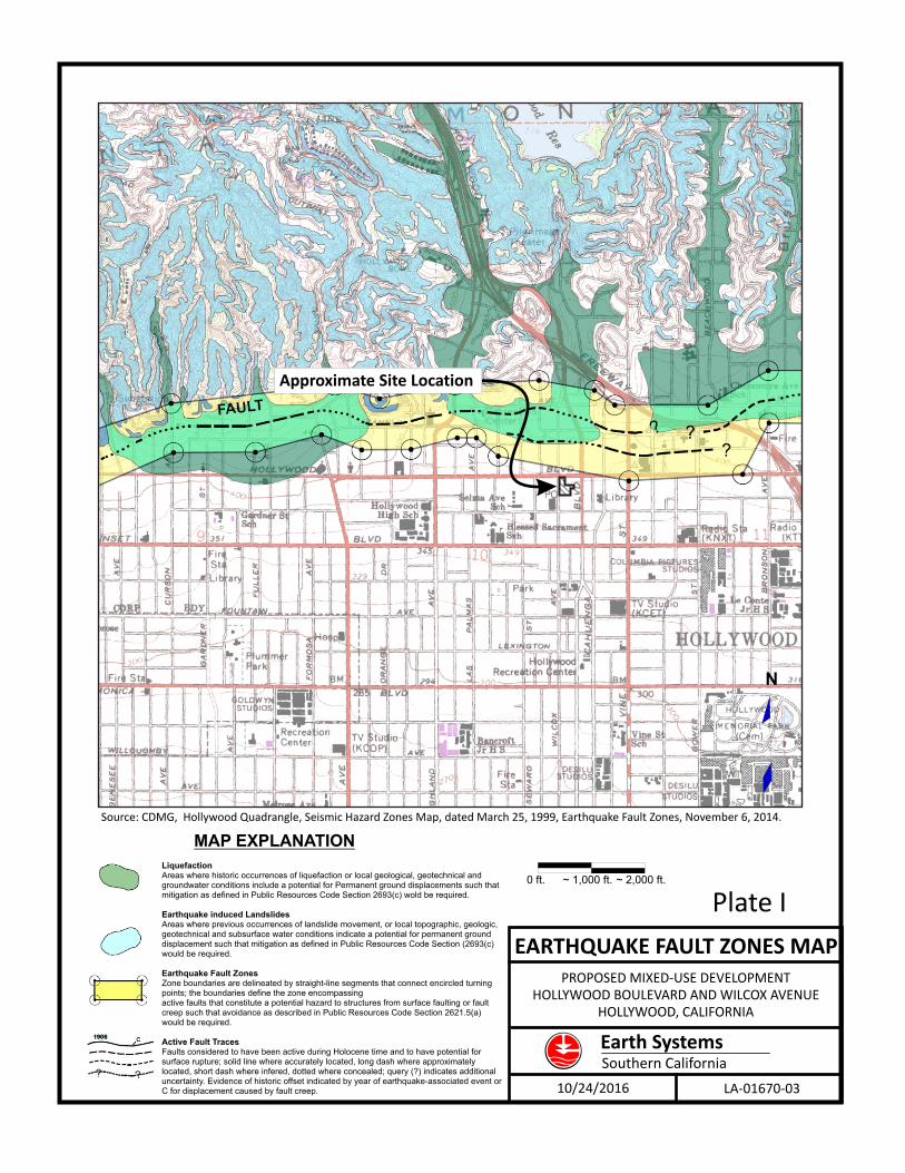
The approximate 1.42-acre site is located at the southeast intersection of Hollywood Boulevard and Wilcox Avenue in the Hollywood community of the City of Los Angeles, California. The site is approximately one-third of a mile southwest of the Hollywood (hwy-101) freeway and south of the Cahuanga Pass (see Plate I). The project site is composed of multiple parcels currently occupied by one- and two-story buildings and an asphalt-covered parking lot (Site Exploration Map, Plate II). Topographically, the property consists of relatively flat ground at an elevation of approximately 380 to 386 feet above mean sea level. Surface drainage is directed toward the southwest via sheet flow. The above-cited descriptions are intended to be illustrative, and are specifically not intended for use as a legal description of the subject property.
PURPOSE AND SCOPE OF SERVICES
The purpose of this study was to evaluate the potential for surface fault rupture, through the subject property, by determining whether there is any evidence of late Quaternary faulting being present in sediments preserved below the subject property. The study was conducted in accordance with Note 49 - Guidelines for Evaluating the Hazard of Surface Rupture [California Geological Survey (CGS),
October 24, 2016 2 LA-01670-03
EARTH SYSTEMS
2002], and Information Bulletin P/BC 2014-113 - Contents of Reports for Submittal to LADBS Grading Division (LADBS, 2014). Earth Systems’ scope of services for this fault rupture evaluation included the following:
A. A general reconnaissance of the site vicinity.
B. A review of available regional geologic information, as contained in published and
unpublished sources.
C. Subsurface exploration of the project site by drilling three (3) continuous core borings and 22
Cone Penetrometer (CPT) soundings on an alignment that is roughly perpendicular to the
regional trend of the Hollywood fault.
D. Review of the continuous core samples and the CPT data with Dr. Thomas Rockwell, Ph.D.,
P.G. (SDSU).
E. Analyses of the data obtained from the exploration and testing programs. F. A summary of findings, as provided in this written report.
FIELD EXPLORATION
Earth Systems’ field exploration for this study was initiated on July of 2016 with three (3) continuous core borings (C1, C2 and C3) to depths of 50 feet; logs of the cores are included in Appendix A. The purpose of the coring program was threefold: 1) to assess the subsurface stratigraphy at the site; 2) to determine the likely age range of the sediments based on the degree of soils developed in them; and 3) to assess whether trenching at the site was feasible based on the depth to top of the Pleistocene soils. Based on the initial assessment of the stratigraphy and soils exposed in the cores, it was determined that sediments of Pleistocene age are too deep to reasonably expose in a trench and that it would be best to move forward with a program of closely-spaced CPTs to determine continuity of the stratigraphy and buried soil surfaces. On August 10 of 2016, 22 CPTs were completed along a north-south alignment oriented roughly perpendicular to the regional trend of the Hollywood fault. These CPTs were spaced at intervals of ten (10) feet and were aligned in as straight a configuration as field conditions allowed. The locations of the exploratory test borings and CPT soundings are indicated on the attached Exploration Map (Plate II) and the Cross Sections (Plates III and IV). The top elevation of the CPT plots, as indicated on Plates III and IV, are based on the surface elevation at which the test was completed. Plots of the CPT data are included in Appendix A.
October 24, 2016 3 LA-01670-03
EARTH SYSTEMS
Other field exploration was completed as part of Earth Systems’ geotechnical evaluation of the site. That field exploration included drilling and sampling four (4) exploratory hollow-stem auger test borings to depths of approximately 50 to 90 feet below the existing ground surface. The location of those borings are included on the appended Exploration Map (Plate II) for reference.
GEOLOGIC SETTING
Regional Geology The project site is located on the La Brea plain, an area of coalescing young alluvial fans that emanate from the south flank of the Hollywood Hills, which are the eastern extension of the Santa Monica Mountains. Regionally, the project site is located at the boundary of the Peninsular Ranges and Transverse Ranges geomorphic provinces. The Peninsular Ranges geomorphic province is characterized by elongated northwest-southeast trending geologic structures such as the nearby Newport-Inglewood fault zone. In contrast, the Transverse Ranges geomorphic province is characterized by east-west trending geologic structures such as the nearby Santa Monica fault, the Hollywood fault, and the Santa Monica Mountains. The Santa Monica and Hollywood faults are typically considered the boundary between the two geomorphic provinces in the project vicinity. The distinctive geologic structure of the Transverse Ranges is dominated by the effects of north-south compressive deformation that has resulted in thrust faulting, strike‐slip faulting and bedrock folding. These active geologic features are attributed to convergence resulting from the “Big Bend” of the San Andreas fault and the northwestern motion of the Pacific Plate, which have caused thrust fault related earthquakes such as the 1994 Northridge (Mw6.7), the 1971 San Fernando (Mw6.7), and the 1987 Whittier Narrows (M6) earthquakes.
Regional Faulting The Hollywood fault is the most significant geologic feature of the area in terms of hazard. The projected surface trace of that fault is located approximately 700 feet north of the site. The California Geological Survey (CGS) has recently included the Hollywood fault in the Earthquake Fault (Alquist Priolo) Zoning program (CGS, 2014). This fault is considered part of the active Hollywood-Santa Monica-Raymond fault zone, a system of east trending reverse, oblique-slip, and left-lateral strike-slip faults that collectively form the southern boundary of the Transverse Ranges (Dolan, et al. 1997). Paleoseismic studies of the Hollywood and Santa Monica faults (Dolan et al., 1997, 2000a, and 2000b) suggest that these two faults have recurrence intervals of about 10,000 years or less, and that the Santa Monica fault last broke 1,000 to 3,000 years ago, while the Hollywood fault last ruptured 6,000 to 9,000 years ago, at least on the northern strand studied by Dolan’s group. The Hollywood Fault Zone is considered capable of producing a Mw 6.6 earthquake if it ruptures by itself, and potentially larger if it fails with the adjacent Santa Monica or Raymond faults.
October 24, 2016 4 LA-01670-03
EARTH SYSTEMS
Other active or potentially active faults in the immediate vicinity of the site include the North Salt Lake fault, which forms the southern boundary of the Hollywood Basin approximately 0.8 miles south of the site; the Upper Elysian Park fault located approximately 2.1 miles east of the site; the San Vicente fault located approximately 2.7 miles south of the site; and the Newport-Inglewood fault located approximately 5.2 miles southwest of the site. The site does not fall within a currently designated CGS Earthquake Fault Rupture Hazard (“Alquist-Priolo”) Zone as currently identified by CGS on the Earthquake Fault Zones Hollywood Quadrangle map dated 2014.
Depositional Environment The Hollywood fault traverses an area of recent sedimentation from coalescing alluvial fans generated from the Cahuanga Pass and Weid Canyon. Down‐gradient, these fans merge onto the distal portion of a larger composite alluvial fan (the La Brea plain). The mountainous terrain of the Hollywood Hills within these drainages consists almost entirely of mid‐Cretaceous igneous intrusive quartz diorite rock. Consequently, the alluvial fan deposits are composed mostly of coarse- to medium-grained feldspathic sands that fine down gradient to playa deposits at Salt Lake. The sediment yield from the Weid canyon drainage, which now includes the Mulholland dam, appears to dominate deposition on the composite fan in the vicinity of the subject site. However, rapid sedimentation was also achieved in the past from the Cahuanga Pass, which is thought to have been a former path of the LA River (Dolan, 1998). Conditions within these fans are generally poor for the preservation of detrital carbon, although several samples have been recovered and yielded radiocarbon ages that have determined the general ages of the near-surface alluvial deposits. The ages derived from these samples were used by Dolan et al. (1999, 2000) to date the stratigraphic sequence and to resolve the timing of the most recent surface rupture on the Hollywood fault in the vicinity of the subject site.
ONSITE ALLUVIAL STRATIGRAPHY AND SOILS Six stratigraphic units have been identified in the upper 50 feet below the subject site. These natural deposits generally exhibit weak soil development. The natural deposits are capped by artificial fill that varies in thickness across the site. The artificial fill encountered in the subsurface explorations was observed as deep as approximately five feet at the location of B3 and B5. Where observed, the fill soils were found to consist predominantly of poorly to moderately compacted, silty sand and sandy silt (SM and ML soil types based upon the Unified Soil Classification System). The fill is likely locally derived and likely represents on-site surface modifications during the original development of the property. The alluvial deposits observed below the fill soils were found to consist predominantly of loose to very dense silty sand, well-graded sand, and clayey sand (SM, SW and SC soil types). Each of the six major depositional units is distinguished by the presence of a soil profile that separates them, as the deposits
October 24, 2016 5 LA-01670-03
EARTH SYSTEMS
themselves are generally similar. Soil in this context is the weathering profile that evolves over time as surface deposits are exposed to weathering agents such as water and organic acids. In southern California, deposition of dust has also been shown to be a major factor in the development of soil profiles (Johnson et al., 1990; Reheis et al., 1997). The strength of a soil profile is therefore a function of several factors and how these factors, such as climate, have varied over time. In studies such as this one, time is the critical factor because the strength of the soil profile is in part a function of the length of time that it was exposed to weathering. When a sequence of soils is distinguished as a function of time, it is termed a chronosequence (Harden, 1982; Rockwell, 2000). Soil-dating techniques are useful for determining the ages of soil stratigraphic units and geomorphic surfaces, and soils can be used to bracket the age of faulting events (Birkeland et al., 1991; Shlemon and LaChapelle, 1993; McCalpin, 1996a). A relative soil development evaluation of the buried soil horizons beneath the site was made by the consultant soil stratigrapher (Rockwell, 2016; see Appendix B). The logs of the continuous core test borings and CPT soundings in Appendix A contain more detailed descriptions of the soils encountered. Dr. Thomas Rockwell provided a detailed log of core C3 and prepared a letter summarizing the interpreted ages of the observed soils (see Appendix B). A sample of detrital carbon was extracted from C1 at an approximate depth of 10.5 feet. That sample was transported to the UC Irvine, Department of Earth Systems Science for radiocarbon dating of which an age of 2,500 to 2,800 years before present (BP) was determined. Therefore, the top of the second stratigraphic unit, or Unit 2, is 2,500 to 2,800 years old. The B horizon of Units 2 and 3 would take 5,000 to 7,000 years to develop, possibly indicating a Pleistocene age (11,000 years BP) for the deposits below Unit 3 and very likely for those below Unit 4, which is approximately 25 feet deep. Based on the CPTs, distinct layering within the units can easily be traced at depths in excess of 40 feet. In summary, the upper 25 feet of deposits are interpreted as an early to middle Holocene sequence of strata, with latest Pleistocene strata below. Deposition at the site continued into the late Holocene with unit 1 accumulating in the past 2,500 years or so. These observations suggest that the alluvium in the upper 50 feet may be on the order of 18,000 to 20,000 years in age and younger The entire sequence accumulated due to aggradation of the local drainages in response to aggradation of the Los Angeles River during late Pleistocene and Holocene sea level rise. This is a significant length of time in fault hazard investigations, and the absence of deformation of these deposits would be a strong indicator that no active faults underlie the subject property.
GROUNDWATER Free groundwater was encountered at the base of boring B4 at an approximate depth of 90 feet. Based on the Seismic Hazards report for the Hollywood Quadrangle (CDMG, 1998), the shallowest historically recorded groundwater in the vicinity of the project site is approximately 80 feet. Fluctuations in groundwater levels may occur due to variations in rainfall, regional climate, and other factors.
October 24, 2016 6 LA-01670-03
EARTH SYSTEMS
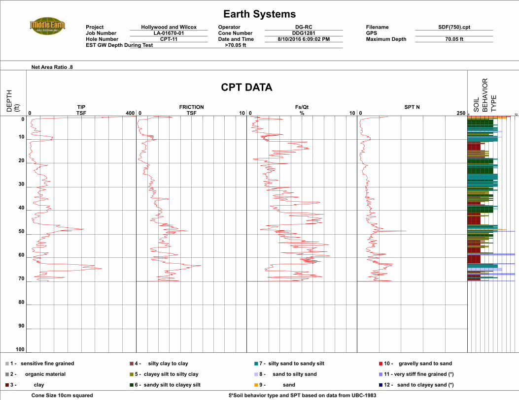
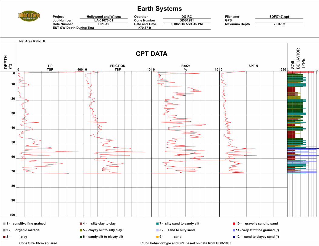
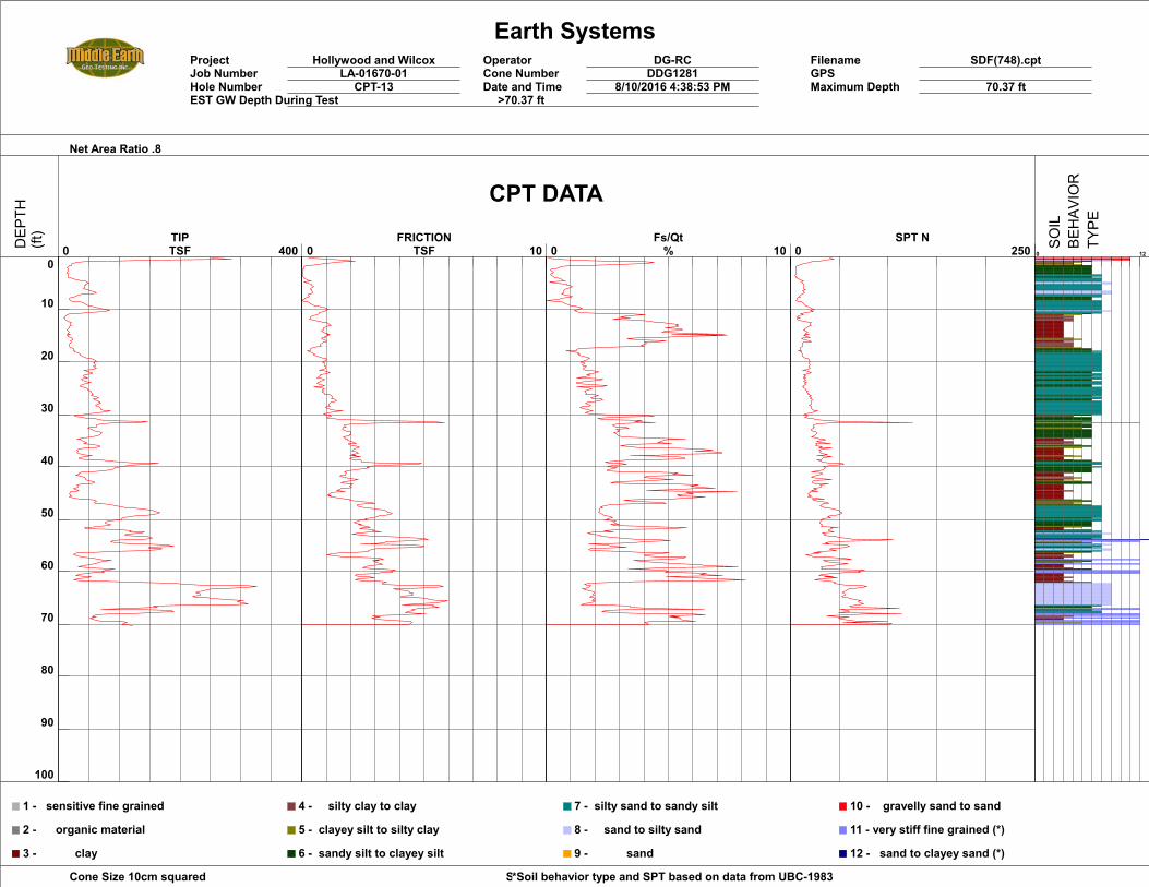
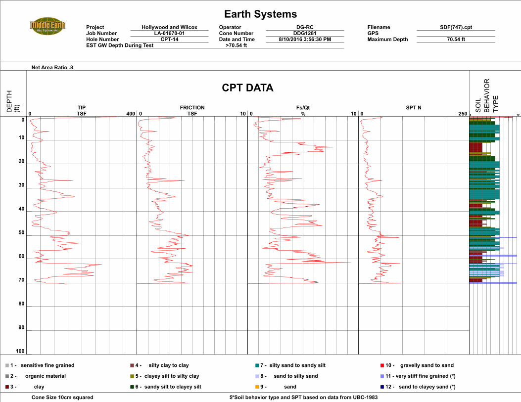
FAULT RUPTURE HAZARD ASSESSMENT A program of closely spaced CPTs was chosen as the best method to assess whether the buried soils and associated stratigraphy are continuous and unbroken across the project site, or whether there is a discontinuity that could indicate the presence of a buried fault. The exploration for this evaluation extended to refusal at depths of approximately 62 to 92 feet below existing grade. The continuous soil profiles exposed in this exploration, together with the age evaluation provided by Dr. Thomas Rockwell, provide the basis for our conclusions regarding the risk of fault rupture at the site. CPT tests record two primary types of data from which the soil type can be estimated. The cone tip records the resistance of the CPT probe being inserted into the ground, with sandy deposits usually having greater resistance than clayey deposits. In contrast, the sleeve records the frictional resistance to sliding of the CPT probe through a deposit; clayey deposits tend to have higher sleeve friction than sand, which has low friction values. The important point is that bedded stratigraphy, with interlayered sand, silt and clay, produces CPT tip and sleeve friction values that vary with depth, and if a sand layer is laterally continuous, the layer can be mapped in the subsurface by the continuity of the CPT signature from hole to hole. For this study, the buried soils along with other variations in stratigraphic characteristics, allowed for the evaluation of the lateral continuity of the subsurface soils across the site. The continuous cores and CPTs are plotted on cross section A-A. Plate III includes the plots of soil type developed from CPT interpretation, while Plate IV utilizes the plots of the tip resistance as directly recorded by the CPT. The six units that were observed and described in the continuous cores are recognizable in the CPT soundings. Several contacts were traced across the site and show no significant deflections or other indications of being displaced. Considering the close spacing of the CPT soundings (10 feet or less), and the observable continuity of the site stratigraphy, the stratigraphic correlations allow the conclusion that there is no evidence of faulting beneath the project site that has disrupted any of the soil layers. In general, small vertical displacements of less than a foot can be recognized if the displacement is abrupt and the CPT soundings were emplaced vertically. In this study, we recognize no vertical anomalies or steps that could be attributed to faulting. Considering the estimated age of the lower strata being late Pleistocene in age, this implies that the site is free of faults that have produced recognizable deformation for this period of time. As the absence of displacement in the Holocene (past 11,500 Years) is the metric applied to the evaluation for active faulting in California, the subject site is free of active faults, at least within the resolution of the techniques applied. The undisrupted, laterally continuous pre-Holocene stratigraphy, as shown on Plates III and IV demonstrate the absence of faults beneath the subject property. Accordingly, no restricted use zones related to hazards of surface fault rupture will be defined on this site.
October 24, 2016 7 LA-01670-03
EARTH SYSTEMS
CONCLUSIONS AND RECOMMENDATIONS
Based on the results of our investigation described above, it is Earth Systems opinion that there is no evidence of active faults being present at the site. Earth Systems has identified undisrupted, laterally continuous pre-Holocene age geologic strata across the site that indicates active faulting is not present within the depth and location explored. Therefore, the potential for surface fault rupture at the subject site during the design life of the structure is considered to be very low. It is our opinion that no restrictions on future development at the site are necessary with respect to the hazard of surface fault rupture. The site is located in southern California, which is within an active seismic area. Large numbers of earthquakes are recorded each year in southern California. Provided the close proximity of the Hollywood Fault, the site could be subject to strong ground shaking in the event of a large earthquake on a nearby fault. The effects of ground shaking can be mitigated by proper engineering design and construction in conformance with current building codes and engineering practices.
LIMITATIONS AND UNIFORMITY OF CONDITIONS The conclusions and recommendations submitted in this report relative to the proposed mixed-use development are based, in part, upon the data obtained from site observations during the field exploration operations, and past experience. In the event of any change in the assumed nature or design of the proposed project as planned, the conclusions and recommendations contained in this report shall not be considered valid unless the changes are reviewed and the conclusions of this report modified or verified in writing. This report is issued with the understanding that it is the responsibility of 6436 Hollywood Blvd, LLC to insure that the information and recommendations contained in this report are called to the attention of the architects and engineers for the project and incorporated into the plan. It is also the responsibility of 6436 Hollywood Blvd, LLC, and its representatives, to insure that the necessary steps are taken to see that the contractor and subcontractors carry out such recommendations in the field.
As the geotechnical engineers for this project, Earth Systems strives to provide its services in accordance with generally accepted geotechnical engineering practices in this community at this time. No warranty or guarantee is expressed or implied. This report was prepared for the exclusive use of 6436 Hollywood Blvd, LLC for the purposes stated in this document for the referenced project only. No third party may use or rely on this report without the express written authorization of Earth Systems for such use or reliance. It is recommended that Earth Systems be provided the opportunity for a general review of final design and specifications of the project so that earthwork and foundation recommendations may be properly interpreted and implemented into the design specifications. If Earth Systems is not accorded the privilege of making this recommended review, it can assume no responsibility for misinterpretation of the recommendations.
October 24, 2016 9 LA-01670-03
EARTH SYSTEMS
REFERENCES California Division of Mines and Geology, 1999, Seismic Shaking Maps of California, Map Sheet 48,
dated 1999. California Division of Mines and Geology/International Conference of Building Officials, 1998, Maps
of Known Active Fault Near-Source Zones in California and Adjacent Portions of Nevada, to be used with the 1997 Uniform Building Code.
California Division of Mines and Geology, 1999, Seismic Hazards Zone Map, Hollywood Quadrangle,
dated March 25, 1999. California Division of Mines and Geology, 1998, Seismic Hazard Evaluation for the Hollywood 7.5
Minute Quadrangle, Los Angeles County, California, Seismic Hazard Zone Report No.026, 1998. California Geological Survey, 2002, Guidelines for Evaluating the Hazard of Surface Fault Rupture,
Note 49, dated May 2002. California Geological Survey, 2008, Guidelines for Evaluating and Mitigating Seismic Hazards in
California, Special Publication 117A, dated 2008. California Geological Survey, 2014, Earthquake Fault Zones Map, Hollywood Quadrangle, dated
November 16, 2014. Dibblee, Thomas, W., Jr., 1991, edited by Ehrenspeck, Helmut E., Geologic Map of the Hollywood
Quadrangle, Los Angeles County, California, 1991. Dolan, J.F., 1998, Geomorphologic constraints on the evolution of state-of-activity of blind thrust
faults and a long-term Hollywood fault slip rate, northern Los Angeles basin: Geological Society of America Abstracts With Programs, 94th Annual Cordilleran Section Meeting, Long Beach, CA, v. 30, no. 5, p. 12 [abstract].
Dolan, J.F., Sieh, K., Rockwell, T.K., Guptill, P., and Miller, G., 1997, Active tectonics, paleoseismology,
and seismic hazards of the Hollywood fault, northern Los Angeles Basin, California: Geol. Soc. America Bull. 109:1595-1616.
Dolan, J.F., Sieh, K., and Rockwell, T.K., 2000a, Late Quaternary activity and seismic potential of the
Santa Monica fault system, Los Angeles, California: Geol. Soc. America Bull. 112:1559-1581. Dolan, J.F., Stevens, D., and Rockwell, T.K., 2000b, Paleoseismologic evidence for an early- to mid-
Holocene age of the most recent surface rupture on the Hollywood fault, Los Angeles, California: Seismological Society of America Bull. 90:334-344.
October 24, 2016 10 LA-01670-03
EARTH SYSTEMS
Earth Systems Southern California, 2006, Preliminary Geotechnical Report, Proposed Hotel Structure, Lots 17 and 18, and portions of Lots 1, 2, 3, and 16, Hollywood Tract, 6100-6104 Hollywood Boulevard, Los Angeles, California, LA-01051-01, dated July 19, 2006.
Earth Systems Southern California, 2013, Preliminary Geotechnical Report of Findings, Proposed
Mixed-Use Structure, Wingfield Tract, Lot 2 and Portions of Lots 1, 3 and 5, 7107 Hollywood Boulevard, Los Angeles, California, LA-01458-01, dated June 20, 2013.
Earth Systems Southern California, 2016, Preliminary Geotechnical Engineering Report, Proposed
Mixed-Use Development, 6430-1648 Hollywood Boulevard and 1624-1642 Wilcox Avenue, California, LA-01670-01, dated October 7, 2016.
Hernandez, J.L, and Treiman, J.A., 2014, Fault Evaluation Report FER 253, The Hollywood Fault in the
Hollywood 7.5’ Quadrangle, Los Angeles County, California, California Geological Survey, Dated February 14, 2014.
Hart, Earl W. and William A. Bryant, 1999, Fault-Rupture Hazard Zones in California, Alquist-Priolo
Fault Zone Act with index to Earthquake Fault Zone Maps, California Division of Mines and Geology Special Publication 42, revised 1999.
Hummon, C., Schneider, C.L., Yeats, R.S., Dolan, J.F., Sieh, K.E., and Huftile, G.J., 1994, Wilshire fault:
Earthquakes in Hollywood? Geology 22:291-294. Jennings, C.W, 1994, Fault Activity Map of California and Adjacent Areas: California Division of Mines
and Geology, Geological Data Map No. 6, scale 1:750,000. Lee, Kenneth L., 1968, Buckling of Partially Embedded Piles in Sand, Journal of the Soil Mechanics and
Foundations Division, Proceedings of the American Society of Civil Engineers, January 1968. Lindvall, S.C., Rockwell, T.K., Kasman, G., and Helms, J.G., 2001, Style, activity, and uplift rate of the
Hollywood fault in Hollywood and West Hollywood, California: Geol. Soc. America Abs. with Programs 33, 3:A-41
Los Angeles Department of Building and Safety, 2014, Contents for Reports for Submittal to LADBS
Grading Division, P/BC 2014-113, effective 1/1/2014 Petersen, M.D., Bryant, W.A., Cramer, C.H., Cao, T., Reichle, M.S., Frankel, A.D., Leinkaemper, J.J.,
McCrory, P.A., and Schwarz, D.P., 1996, Probabilistic Seismic Hazard Assessment for the State of California: California Division of Mines and Geology Open-File Report 96-08, 59 p.
Ponti, D.J., Quinn, J.P., Hillhouse, J.W., and Powell, C.L., II, 1996, Quaternary chronostratigraphic
constraints on deformation and blind-thrust faulting, northern Los Angeles basin, California: EOS, Trans. AGU, p. E644.
October 24, 2016 11 LA-01670-03
EARTH SYSTEMS
Ponti, D.J., and Project Staff FOQUS-LA, 2001, An integrated approach toward a new Quaternary stratigraphic model for the Los Angeles Basin, California: A framework for refined seismic hazards and groundwater studies: Geological Society of America Abstracts with programs 33(3):A-41
Sieh, Kerry E., 1993, “evaluation of the potential for fault movements along the proposed route of
the MetroRail Red Line”, dated February 1, 1993. Southern California Earthquake Center (SCEC), 1999, Recommended Procedures for Implementation
of DMG Special Publication 117, Guidelines for Analyzing and Mitigating Liquefaction Hazards in California, SCEC, University of Southern California, March 1999.
The Earth Technology Corporation, 2000, Los Angeles County Metropolitan Transportation Authority
– Metro Red Line, LA CBD to N. Hollywood STA 630+00 to Universal City, Sheets 101 and 102, dated July 22, 1994, revised 1/11/2000.
October 24, 2016 LA-01670-03
EARTH SYSTEMS
PLATES
PLATE I Earthquake Fault Zones Map PLATE II Exploration Map
PLATE III Cross Section – CPT Soil Type PLATE IV Cross Section – CPT Sleeve Resistance
Earth Systems Southern California
Plate I
EARTHQUAKE FAULT ZONES MAP
Approximate Site Location
PROPOSED MIXED-USE DEVELOPMENTHOLLYWOOD BOULEVARD AND WILCOX AVENUE
HOLLYWOOD, CALIFORNIA
10/24/2016 LA-01670-03
MAP EXPLANATION
~ 2,000 ft.~ 1,000 ft.0 ft.
N
Source: CDMG, Hollywood Quadrangle, dated March 25, 1999, Earthquake Fault Zones, November 6, 2014.Seismic Hazard Zones Map,
LiquefactionAreas where historic occurrences of liquefaction or local geological, geotechnical and groundwater conditions include a potential for Permanent ground displacements such that mitigation as defined in Public Resources Code Section 2693(c) wold be required.
Earthquake induced LandslidesAreas where previous occurrences of landslide movement, or local topographic, geologic, geotechnical and subsurface water conditions indicate a potential for permanent ground displacement such that mitigation as defined in Public Resources Code Section (2693(c) would be required.
Earthquake Fault ZonesZone boundaries are delineated by straight-line segments that connect encircled turning points; the boundaries define the zone encompassing active faults that constitute a potential hazard to structures from surface faulting or fault creep such that avoidance as described in Public Resources Code Section 2621.5(a) would be required.
Active Fault TracesFaults considered to have been active during Holocene time and to have potential for surface rupture; solid line where accurately located, long dash where approximately located, short dash where infered, dotted where concealed; query (?) indicates additional uncertainty. Evidence of historic offset indicated by year of earthquake-associated event or C for displacement caused by fault creep.

B2
B3
B1
B5
C1 C2
C3
B4
1251020
3678911
12
131415161718192122 4
BASE MAP: Preliminary Survey (PSOMAS, 8/13/2007)
SITE EXPLORATION MAP
Earth Systems Southern California
PROPOSED MIXED-USE DEVELOPMENTHOLLYWOOD BOULEVARD AND WILCOX AVENUE
HOLLYWOOD, CALIFORNIA
10/24/2016 LA-01670-03
Plate II
APPROXIMATE SCALE1 inch = 40 feet
(1:480)
020 20 40 80
LEGEND
APPROXIMATE CONTINUOUS CORE LOCATION
APPROXIMATE BORING LOCATION
APPROXIMATE LOCATION OF CROSS SECTION
APPROXIMATE CPT LOCATION
B5
C3
2
A'A
A’A
PROPOSED NEW1-STORY BUILDING
RENOVATE EXISTING BUILDING
PROPOSED 15-STORIES OVER 2-LEVELS
OF SUBTERRANEAN PARKING
EXISTING BUILDINGSTO BE DEMOLISHED
Earth Systems Southern California
Plate III
PROPOSED MIXED-USE DEVELOPMENTHOLLYWOOD BOULEVARD AND WILCOX AVENUE
HOLLYWOOD, CALIFORNIA
10/24/2016 LA-01670-03
North
A’
SCALE1 in = 20 ft
(1:240)
feet
340
360
350
380
370
390
Afeet
340
360
350
380
370
390
330
300
320
310
290
300
320
310
290
CROSS SECTION - CPT SOIL TYPE
A
330
C
BAb
C
BBC
AbCAb?B
BC
C
AbC
C
cpt22
cpt21
cpt20
cpt19
cpt18
cpt17
cpt16
cpt15
cpt14
cpt13
cpt12
cpt11
cpt10
cpt9
cpt8
cpt7
cpt6
cpt5
cpt4
cpt3
cpt2
cpt1
C3C1
C2
PL PL
Earth Systems Southern California
Plate IV
PROPOSED MIXED-USE DEVELOPMENTHOLLYWOOD BOULEVARD AND WILCOX AVENUE
HOLLYWOOD, CALIFORNIA
10/24/2016 LA-01670-03
North
A’
SCALE1 in = 20 ft
(1:240)
feet
340
360
350
380
370
390
Afeet
340
360
350
380
370
390
330
300
320
310
290
300
320
310
290
CROSS SECTION - CPT TIP RESISTANCE
A
330
C
BAb
C
BBC
AbCAb?B
BC
C
AbC
C
cpt22
cpt21
cpt20
cpt19
cpt18
cpt17
cpt16
cpt15
cpt14
cpt13
cpt12
cpt11
cpt10
cpt9
cpt8
cpt7
cpt6
cpt5
cpt4
cpt3
cpt2
cpt1
C3C1
C2
PL PL
October 24, 2016 LA-01670-03
EARTH SYSTEMS
APPENDIX A
Logs of Continuous Cores Logs of CPTs
Earth Systems 2122 East Walnut Street, Suite 200, Pasadena 91107
Southern California Phone: (626) 356-0955 Fax: (626) 356-0956
PROJECT NAME: Hollywood & Wilcox BORING NO: C1PROJECT NUMBER: DRILL RIG: CME 75
DRILLING DATE: DRILLING METHOD: 8-inch hollow-stem auger
BORING LOCATION: LOGGED BY: JS, JW, CA
Page 1 of 2
3
4
8
2
3
1
1
2
Bo
x
Ru
n
Sam
ple
rec
ove
ry
4
5
6
7
LA-01670-01
0
30
35
10
15
20
25
Ho
rizo
n
5
Ver
tica
l Dep
th7/20/2016
DESCRIPTION OF UNITS
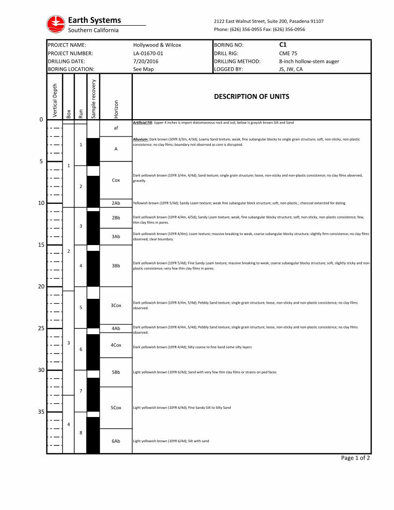
Artificial Fill: Upper 4 inches is import diatomaceous rock and soil, below is grayish brown Silt and Sand
Alluvium: Dark brown (10YR 3/3m, 4/3d); Loamy Sand texture; weak, fine subangular blocky to single grain structure; soft, non-sticky, non-plastic
consistence; no clay films; boundary not observed as core is disrupted.
Dark yellowish brown (10YR 4/4m); Loam texture; massive breaking to weak, coarse subangular blocky structure; slightly firm consistence; no clay films
observed; clear boundary.
Dark yellowish brown (10YR 5/4d); Fine Sandy Loam texture; massive breaking to weak, coarse subangular blocky structure; soft, slightly sticky and non-
plastic consistence; very few thin clay films in pores.
Dark yellowish brown (10YR 4/4m, 5/4d); Pebbly Sand texture; single grain structure; loose, non-sticky and non-plastic consistence; no clay films
observed.
See Map
4Cox Dark yellowish brown (10YR 4/4d); Silty coarse to fine Sand some silty layers
af
A
2Ab
CoxDark yellowish brown (10YR 3/4m, 4/4d); Sand texture; single grain structure; loose, non-sticky and non-plastic consistence; no clay films observed,
gravelly.
Dark yellowish brown (10YR 4/4m, 4/5d); Sandy Loam texture; weak, fine subangular blocky structure; soft, non-sticky, non-plastic consistence; few,
thin clay films in pores.
Yellowish brown (10YR 5/4d); Sandy Loam texture; weak fine subangular block structure; soft, non-plastic.; charcoal extarcted for dating
5Bb
5Cox
6Ab
Light yellowish brown (10YR 6/4d); Sand with very few thin clay films or strains on ped faces
Light yellowish brown (10YR 6/4d); Fine Sandy Silt to Silty Sand
Light yellowish brown (10YR 6/4d); Silt with sand
2Bb
3Bb
3Ab
Dark yellowish brown (10YR 4/4m, 5/4d); Pebbly Sand texture; single grain structure; loose, non-sticky and non-plastic consistence; no clay films
observed.
3Cox
4Ab
Earth Systems 2122 East Walnut Street, Suite 200, Pasadena 91107
Southern California Phone: (626) 356-0955 Fax: (626) 356-0956
PROJECT NAME: Hollywood & Wilcox BORING NO: C1PROJECT NUMBER: DRILL RIG: CME 75
DRILLING DATE: DRILLING METHOD: 8-inch hollow-stem auger
BORING LOCATION: LOGGED BY: JS, JW, CA
Page 2 of 2
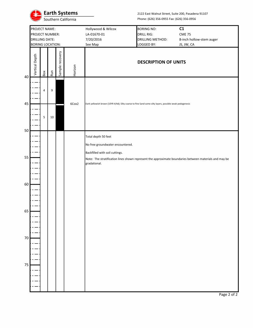
Note: The stratification lines shown represent the approximate boundaries between materials and may be
gradational.
Total depth 50 feet
No free groundwater encountered.
Backfilled with soil cuttings.
9
10
6Cox2 Dark yellowish brown (10YR 4/4d); Silty coarse to fine Sand some silty layers, possible weak pedogenesis
4
Bo
x
Ru
n
75
70
65
50
55
60
45
40
5
Ver
tica
l Dep
th
Ho
rizo
n
Sam
ple
rec
ove
ry
LA-01670-01
7/20/2016
See Map
DESCRIPTION OF UNITS
Earth Systems 2122 East Walnut Street, Suite 200, Pasadena 91107
Southern California Phone: (626) 356-0955 Fax: (626) 356-0956
PROJECT NAME: Hollywood & Wilcox BORING NO: C2PROJECT NUMBER: DRILL RIG: CME 75
DRILLING DATE: DRILLING METHOD: 8-inch hollow-stem auger
BORING LOCATION: LOGGED BY: JS, JW, CA
Page 1 of 2
Cox
2Bb
A
6Ab
3Ab
3Bcb
1
2
8
2
3
4
7
Bo
x
Ru
n
Sam
ple
rec
ove
ry
3
4
5
6
1
LA-01670-01
0
30
35
10
15
20
25
Ho
rizo
n
5
Ver
tica
l Dep
th7/20/2016
DESCRIPTION OF UNITS
Light yellowish brown (10YR 6/4d); Silt with sand
Dark yellowish brown (10YR4/4m) loam texture; massive breaking to weak, coarse subangular blocky structure; slightly firm consistence; no clay films
observed; clear boundary.
Dark yellowish brown (10YR 4/4m; fine sandy loam texture; massive breaking to weak, coarse subangular blocky structure; soft, slightly sticky and non-
plastic consistence; very few thin clay films in pores.
See Map
Artificial Fill: Grayish brown, to yellowish brown Silty Sand
Alluvium: Dark brown (10YR 3/3m, 4/3d); Loamy Sand texture; weak, fine subangular blocky to single grain structure; soft, non-sticky, non-plastic
consistence; no clay films; boundary not observed as core is disrupted.
Alluvium: Dark yellowish brown (10YR 3/4m, 4/4d); Sand texture; single grain structure; loose, non-sticky and non-plastic consistence; no clay films
observed; gravelly .
Dark yellowish brown (10YR 4/4m, 4/5d) sandy loam texture; weak, fine subangular blocky structure; soft, non-sticky, non-plastic consistence; few, thin
clay films in pores.
3CoxDark yellowish brown (10YR 4/4m, 5/4d); pebbly Sand texture; single grain structure; loose, non-sticky and non-plastic consistence; no clay films
observed.
4AbDark yellowish brown (10YR 4/4m, 5/4d); pebbly Sand texture; single grain structure; loose, non-sticky and non-plastic consistence; no clay films
observed.
4Cox Dark yellowish brown (10YR 4/4d); Silty coarse to fine Sand some silty layers, some fine gravel
5Bb
5Cox
Light yellowish brown (10YR 6/4d); Silty Sand few thin clay films llining pores
Light yellowish brown (10YR 6/4d); Fine Sandy Silt to Silty fine to medium Sand

Earth Systems 2122 East Walnut Street, Suite 200, Pasadena 91107
Southern California Phone: (626) 356-0955 Fax: (626) 356-0956
PROJECT NAME: Hollywood & Wilcox BORING NO: C2PROJECT NUMBER: DRILL RIG: CME 75
DRILLING DATE: DRILLING METHOD: 8-inch hollow-stem auger
BORING LOCATION: LOGGED BY: JS, JW, CA
Page 2 of 2
4
5
9
10
Bo
x
Ru
n
75
70
65
50
55
60
45
40 Ver
tica
l Dep
th
Ho
rizo
n
Sam
ple
rec
ove
ry
LA-01670-01
7/20/2016
See Map
No free groundwater encountered.
Backfilled with soil cuttings.
Note: The stratification lines shown represent the approximate boundaries between materials and may be
gradational.
DESCRIPTION OF UNITS
Total depth 50 feet
6Cox2 Dark yellowish brown (10YR 4/4d); Silty coarse to fine Sand some silty layers, possible weak pedogenesis
Earth Systems 2122 East Walnut Street, Suite 200, Pasadena 91107
Southern California Phone: (626) 356-0955 Fax: (626) 356-0956
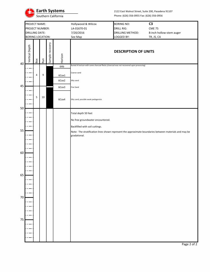
PROJECT NAME: Hollywood & Wilcox BORING NO: C3PROJECT NUMBER: DRILL RIG: CME 75
DRILLING DATE: DRILLING METHOD: 8-inch hollow-stem auger
BORING LOCATION: LOGGED BY: TR, JS, CA
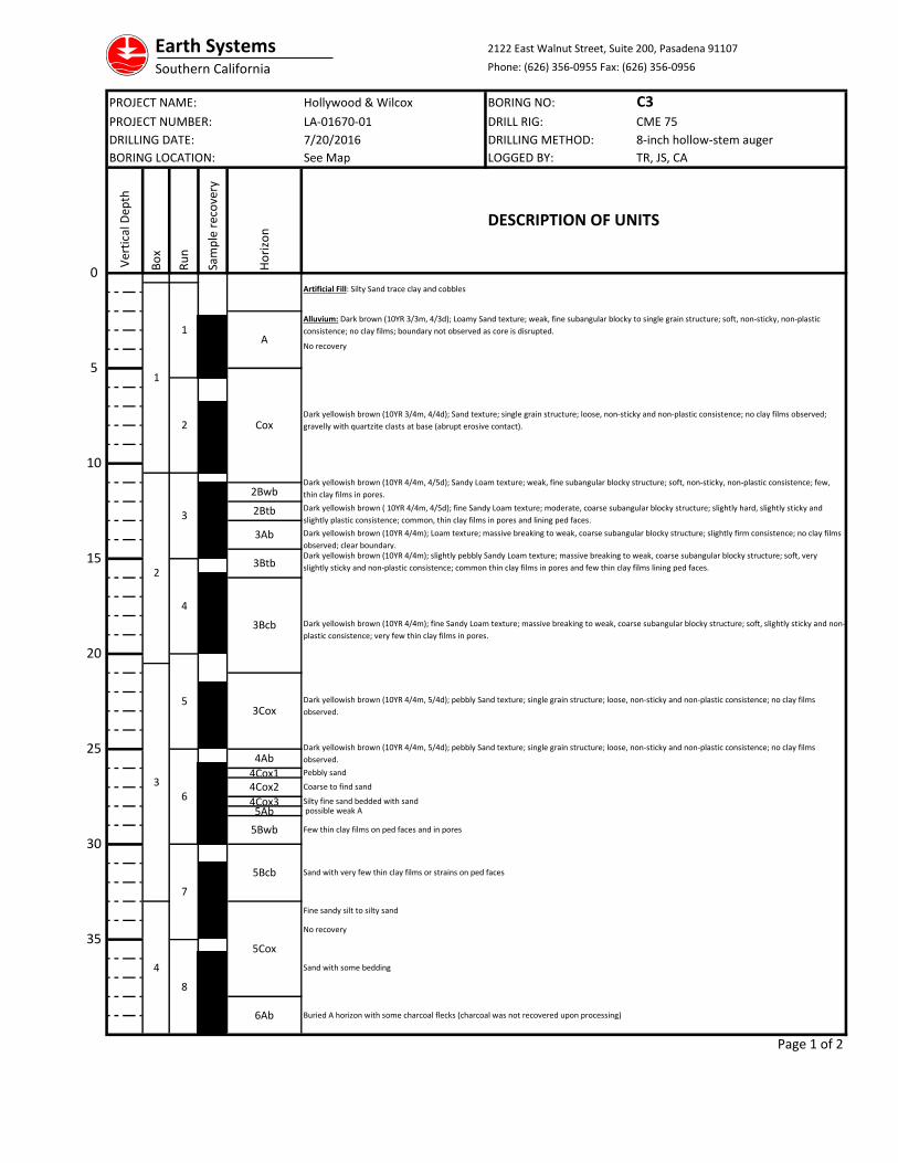
4Cox1
4Cox35Ab
Page 1 of 2
4
5
6
7
2
3
4
8
LA-01670-01
0
30
35
10
15
20
25
Ho
rizo
n
5
Ver
tica
l Dep
th
Bo
x
Ru
n
Sam
ple
rec
ove
ry
2
3
1
1
Buried A horizon with some charcoal flecks (charcoal was not recovered upon processing)
7/20/2016
DESCRIPTION OF UNITS
Sand with some bedding
Dark yellowish brown (10YR 4/4m, 5/4d); pebbly Sand texture; single grain structure; loose, non-sticky and non-plastic consistence; no clay films
observed.
Dark yellowish brown (10YR 4/4m); fine Sandy Loam texture; massive breaking to weak, coarse subangular blocky structure; soft, slightly sticky and non-
plastic consistence; very few thin clay films in pores.
Dark yellowish brown (10YR 3/4m, 4/4d); Sand texture; single grain structure; loose, non-sticky and non-plastic consistence; no clay films observed;
gravelly with quartzite clasts at base (abrupt erosive contact).
Artificial Fill: Silty Sand trace clay and cobbles
See Map
Dark yellowish brown (10YR 4/4m, 4/5d); Sandy Loam texture; weak, fine subangular blocky structure; soft, non-sticky, non-plastic consistence; few,
thin clay films in pores.
No recovery
Dark yellowish brown (10YR 4/4m); slightly pebbly Sandy Loam texture; massive breaking to weak, coarse subangular blocky structure; soft, very
slightly sticky and non-plastic consistence; common thin clay films in pores and few thin clay films lining ped faces.
Dark yellowish brown (10YR 4/4m); Loam texture; massive breaking to weak, coarse subangular blocky structure; slightly firm consistence; no clay films
observed; clear boundary.
Dark yellowish brown ( 10YR 4/4m, 4/5d); fine Sandy Loam texture; moderate, coarse subangular blocky structure; slightly hard, slightly sticky and
slightly plastic consistence; common, thin clay films in pores and lining ped faces.
Pebbly sand
Dark yellowish brown (10YR 4/4m, 5/4d); pebbly Sand texture; single grain structure; loose, non-sticky and non-plastic consistence; no clay films
observed.
6Ab
A
Alluvium: Dark brown (10YR 3/3m, 4/3d); Loamy Sand texture; weak, fine subangular blocky to single grain structure; soft, non-sticky, non-plastic
consistence; no clay films; boundary not observed as core is disrupted.
possible weak A
3Cox
5Bcb Sand with very few thin clay films or strains on ped faces
Fine sandy silt to silty sand
No recovery
4Cox2
5Bwb
Coarse to find sand
Silty fine sand bedded with sand
Few thin clay films on ped faces and in pores
5Cox
2Bwb
2Btb
Cox
3Ab
3Btb
3Bcb
4Ab
Earth Systems 2122 East Walnut Street, Suite 200, Pasadena 91107
Southern California Phone: (626) 356-0955 Fax: (626) 356-0956
PROJECT NAME: Hollywood & Wilcox BORING NO: C3PROJECT NUMBER: DRILL RIG: CME 75
DRILLING DATE: DRILLING METHOD: 8-inch hollow-stem auger
BORING LOCATION: LOGGED BY: TR, JS, CA
Page 2 of 2
Note: The stratification lines shown represent the approximate boundaries between materials and may be
gradational.
Total depth 50 feet
No free groundwater encountered.
Backfilled with soil cuttings.
9
10
6Cox2 Silty sand
Silty sand, possible weak pedogenisis
6Cox3
6Ab
6Cox4
Fine Sand
6Cox1
Buried A horizon with some charcoal flecks (charcoal was not recovered upon processing)
Coarse sand
75
70
65
50
55
60
45
40
5
4
Bo
x
Ru
n
Ver
tica
l Dep
th
Ho
rizo
n
Sam
ple
rec
ove
ry
LA-01670-01
7/20/2016
See Map
DESCRIPTION OF UNITS
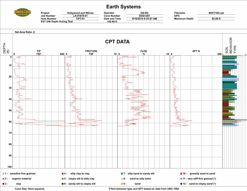
Earth SystemsProject Hollywood and Wilcox Operator DG-RC Filename SDF(739).cptJob Number LA-01670-01 Cone Number DDG1281 GPSHole Number CPT-01 Date and Time 8/10/2016 9:23:07 AM Maximum Depth 62.66 ftEST GW Depth During Test >62.66 ft
Net Area Ratio .8
Cone Size 10cm squared Soil Behavior Referance*Soil behavior type and SPT based on data from UBC-1983
0
10
20
30
40
50
60
70
80
90
100
0 400 TIPTSF 0 10
FRICTIONTSF 0 10
Fs/Qt% 0 250
SPT N0 12
1 - sensitive fine grained
2 - organic material
3 - clay
4 - silty clay to clay
5 - clayey silt to silty clay
6 - sandy silt to clayey silt
7 - silty sand to sandy silt
8 - sand to silty sand
9 - sand
10 - gravelly sand to sand
11 - very stiff fine grained (*)
12 - sand to clayey sand (*)
CPT DATA
DEP
TH(ft)
SOIL
BEHAV
IOR
TYPE
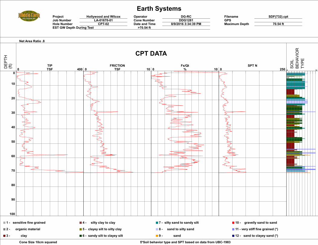
Earth SystemsProject Hollywood and Wilcox Operator DG-RC Filename SDF(732).cptJob Number LA-01670-01 Cone Number DDG1281 GPSHole Number CPT-02 Date and Time 8/9/2016 3:34:39 PM Maximum Depth 70.54 ftEST GW Depth During Test >70.54 ft
Net Area Ratio .8
Cone Size 10cm squared Soil Behavior Referance*Soil behavior type and SPT based on data from UBC-1983
0
10
20
30
40
50
60
70
80
90
100
0 400 TIPTSF 0 10
FRICTIONTSF 0 10
Fs/Qt% 0 250
SPT N0 12
1 - sensitive fine grained
2 - organic material
3 - clay
4 - silty clay to clay
5 - clayey silt to silty clay
6 - sandy silt to clayey silt
7 - silty sand to sandy silt
8 - sand to silty sand
9 - sand
10 - gravelly sand to sand
11 - very stiff fine grained (*)
12 - sand to clayey sand (*)
CPT DATA
DEP
TH(ft)
SOIL
BEHAV
IOR
TYPE
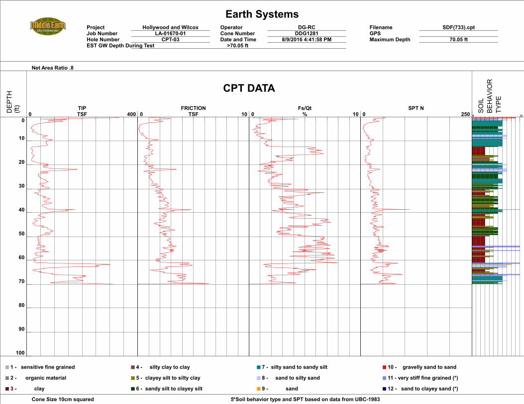
Earth SystemsProject Hollywood and Wilcox Operator DG-RC Filename SDF(733).cptJob Number LA-01670-01 Cone Number DDG1281 GPSHole Number CPT-03 Date and Time 8/9/2016 4:41:58 PM Maximum Depth 70.05 ftEST GW Depth During Test >70.05 ft
Net Area Ratio .8
Cone Size 10cm squared Soil Behavior Referance*Soil behavior type and SPT based on data from UBC-1983
0
10
20
30
40
50
60
70
80
90
100
0 400 TIPTSF 0 10
FRICTIONTSF 0 10
Fs/Qt% 0 250
SPT N0 12
1 - sensitive fine grained
2 - organic material
3 - clay
4 - silty clay to clay
5 - clayey silt to silty clay
6 - sandy silt to clayey silt
7 - silty sand to sandy silt
8 - sand to silty sand
9 - sand
10 - gravelly sand to sand
11 - very stiff fine grained (*)
12 - sand to clayey sand (*)
CPT DATA
DEP
TH(ft)
SOIL
BEHAV
IOR
TYPE
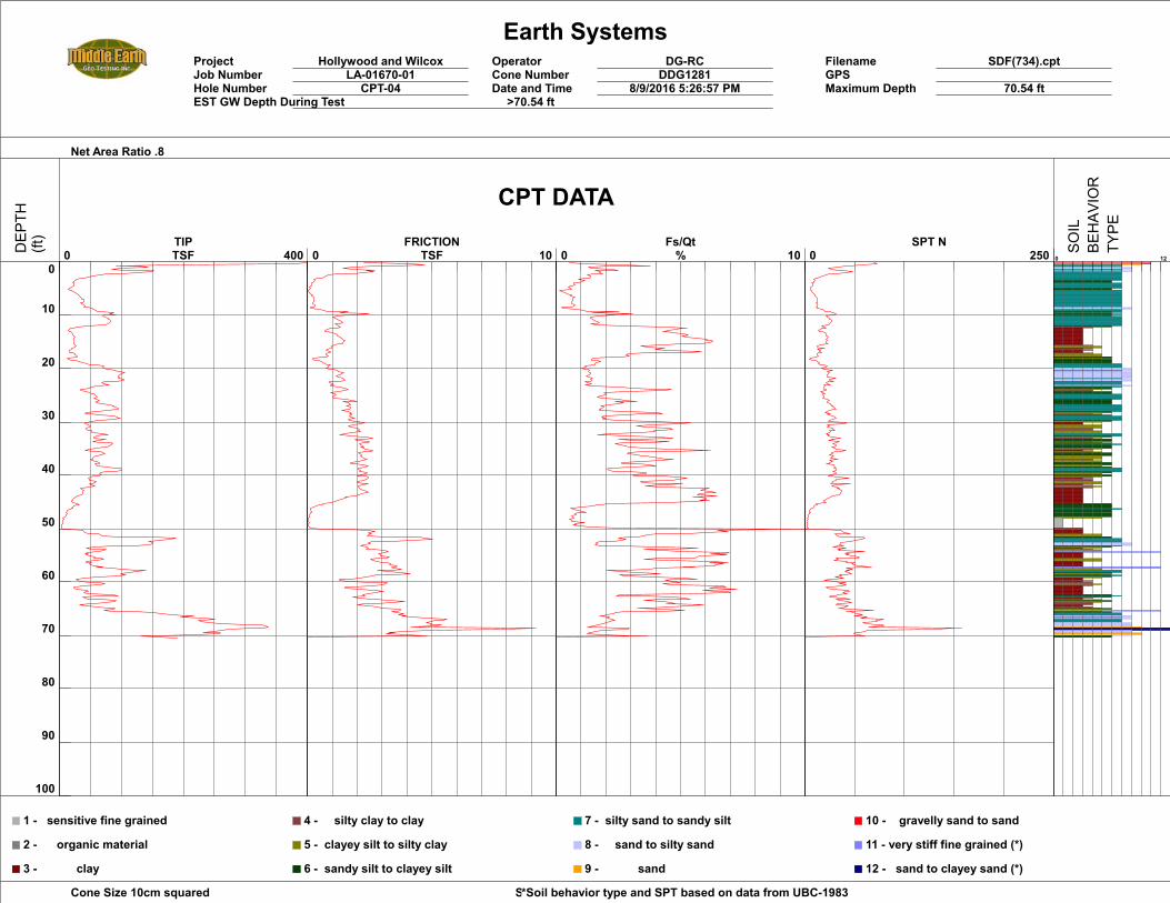
Earth SystemsProject Hollywood and Wilcox Operator DG-RC Filename SDF(734).cptJob Number LA-01670-01 Cone Number DDG1281 GPSHole Number CPT-04 Date and Time 8/9/2016 5:26:57 PM Maximum Depth 70.54 ftEST GW Depth During Test >70.54 ft
Net Area Ratio .8
Cone Size 10cm squared Soil Behavior Referance*Soil behavior type and SPT based on data from UBC-1983
0
10
20
30
40
50
60
70
80
90
100
0 400 TIPTSF 0 10
FRICTIONTSF 0 10
Fs/Qt% 0 250
SPT N0 12
1 - sensitive fine grained
2 - organic material
3 - clay
4 - silty clay to clay
5 - clayey silt to silty clay
6 - sandy silt to clayey silt
7 - silty sand to sandy silt
8 - sand to silty sand
9 - sand
10 - gravelly sand to sand
11 - very stiff fine grained (*)
12 - sand to clayey sand (*)
CPT DATA
DEP
TH(ft)
SOIL
BEHAV
IOR
TYPE
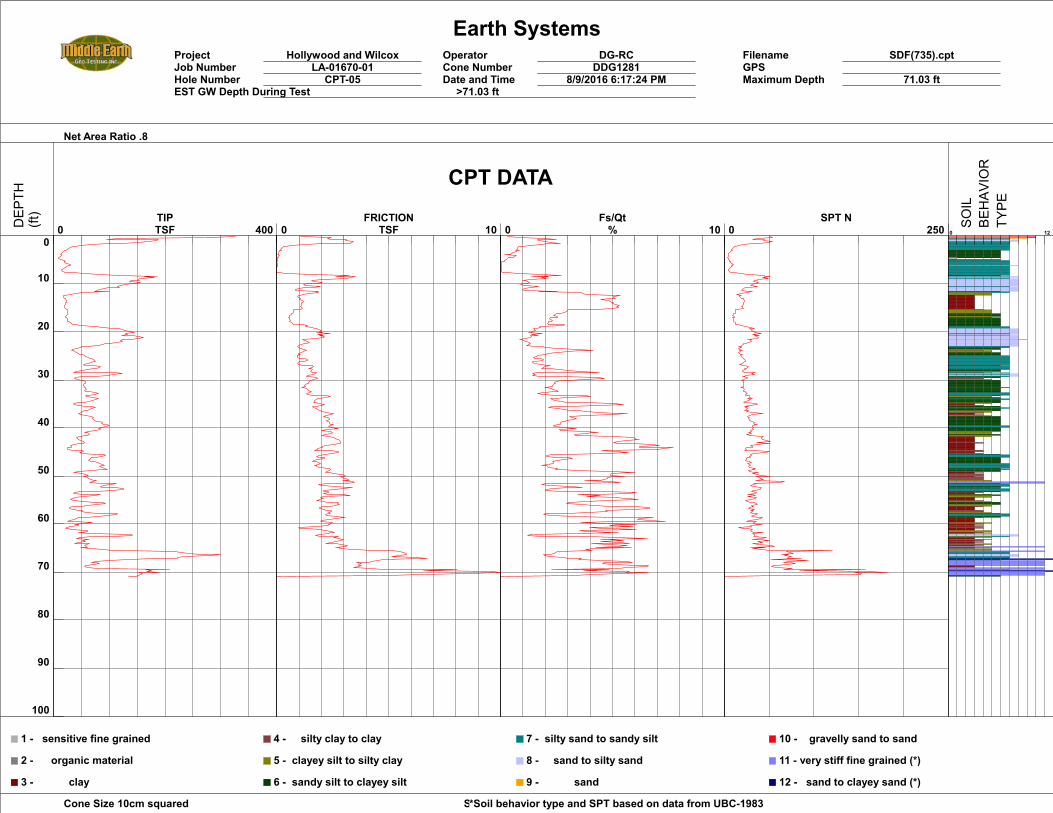
Earth SystemsProject Hollywood and Wilcox Operator DG-RC Filename SDF(735).cptJob Number LA-01670-01 Cone Number DDG1281 GPSHole Number CPT-05 Date and Time 8/9/2016 6:17:24 PM Maximum Depth 71.03 ftEST GW Depth During Test >71.03 ft
Net Area Ratio .8
Cone Size 10cm squared Soil Behavior Referance*Soil behavior type and SPT based on data from UBC-1983
0
10
20
30
40
50
60
70
80
90
100
0 400 TIPTSF 0 10
FRICTIONTSF 0 10
Fs/Qt% 0 250
SPT N0 12
1 - sensitive fine grained
2 - organic material
3 - clay
4 - silty clay to clay
5 - clayey silt to silty clay
6 - sandy silt to clayey silt
7 - silty sand to sandy silt
8 - sand to silty sand
9 - sand
10 - gravelly sand to sand
11 - very stiff fine grained (*)
12 - sand to clayey sand (*)
CPT DATA
DEP
TH(ft)
SOIL
BEHAV
IOR
TYPE

Earth SystemsProject Hollywood and Wilcox Operator DG-RC Filename SDF(738).cptJob Number LA-01670-01 Cone Number DDG1281 GPSHole Number SCPT-06 Date and Time 8/10/2016 8:00:31 AM Maximum Depth 74.15 ftEST GW Depth During Test >74.15 ft
Net Area Ratio .8
Cone Size 10cm squared Soil Behavior Referance*Soil behavior type and SPT based on data from UBC-1983
0
10
20
30
40
50
60
70
80
90
100
0 400 TIPTSF 0 10
FRICTIONTSF 0 10
Fs/Qt% 0 250
SPT N0 12
1 - sensitive fine grained
2 - organic material
3 - clay
4 - silty clay to clay
5 - clayey silt to silty clay
6 - sandy silt to clayey silt
7 - silty sand to sandy silt
8 - sand to silty sand
9 - sand
10 - gravelly sand to sand
11 - very stiff fine grained (*)
12 - sand to clayey sand (*)
CPT DATA
DEP
TH(ft)
SOIL
BEHAV
IOR
TYPE
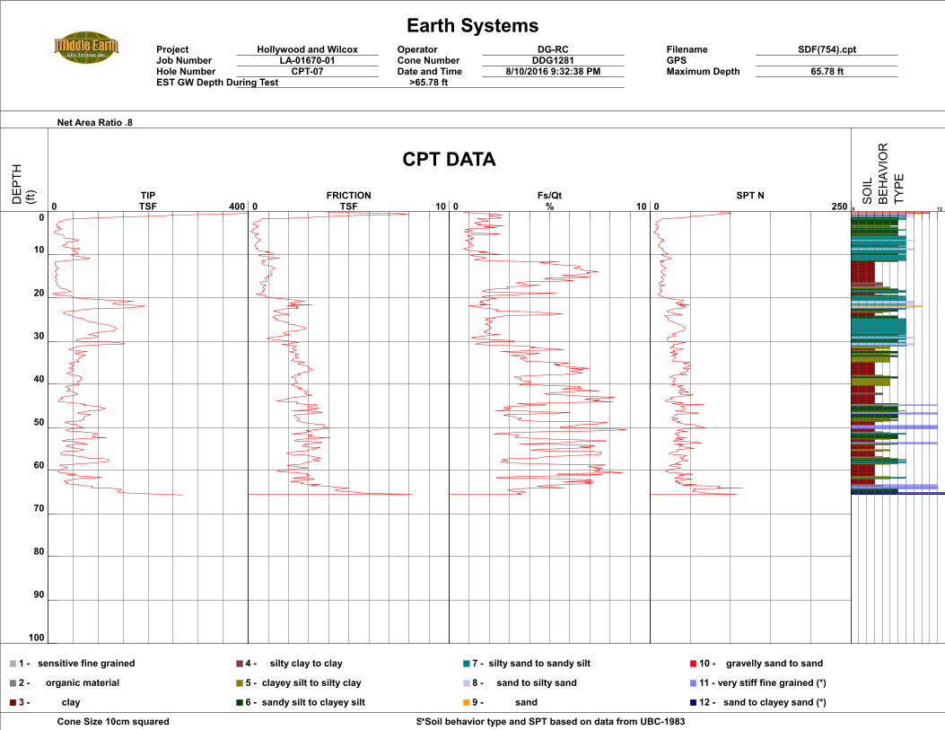
Earth SystemsProject Hollywood and Wilcox Operator DG-RC Filename SDF(754).cptJob Number LA-01670-01 Cone Number DDG1281 GPSHole Number CPT-07 Date and Time 8/10/2016 9:32:38 PM Maximum Depth 65.78 ftEST GW Depth During Test >65.78 ft
Net Area Ratio .8
Cone Size 10cm squared Soil Behavior Referance*Soil behavior type and SPT based on data from UBC-1983
0
10
20
30
40
50
60
70
80
90
100
0 400 TIPTSF 0 10
FRICTIONTSF 0 10
Fs/Qt% 0 250
SPT N0 12
1 - sensitive fine grained
2 - organic material
3 - clay
4 - silty clay to clay
5 - clayey silt to silty clay
6 - sandy silt to clayey silt
7 - silty sand to sandy silt
8 - sand to silty sand
9 - sand
10 - gravelly sand to sand
11 - very stiff fine grained (*)
12 - sand to clayey sand (*)
CPT DATA
DEP
TH(ft)
SOIL
BEHAV
IOR
TYPE

Earth SystemsProject Hollywood and Wilcox Operator DG-RC Filename SDF(753).cptJob Number LA-01670-01 Cone Number DDG1281 GPSHole Number CPT-08 Date and Time 8/10/2016 8:38:12 PM Maximum Depth 65.94 ftEST GW Depth During Test >65.94 ft
Net Area Ratio .8
Cone Size 10cm squared Soil Behavior Referance*Soil behavior type and SPT based on data from UBC-1983
0
10
20
30
40
50
60
70
80
90
100
0 400 TIPTSF 0 10
FRICTIONTSF 0 10
Fs/Qt% 0 250
SPT N0 12
1 - sensitive fine grained
2 - organic material
3 - clay
4 - silty clay to clay
5 - clayey silt to silty clay
6 - sandy silt to clayey silt
7 - silty sand to sandy silt
8 - sand to silty sand
9 - sand
10 - gravelly sand to sand
11 - very stiff fine grained (*)
12 - sand to clayey sand (*)
CPT DATA
DEP
TH(ft)
SOIL
BEHAV
IOR
TYPE

Earth SystemsProject Hollywood and Wilcox Operator DG-RC Filename SDF(752).cptJob Number LA-01670-01 Cone Number DDG1281 GPSHole Number CPT-09 Date and Time 8/10/2016 7:44:31 PM Maximum Depth 62.66 ftEST GW Depth During Test >62.66 ft
Net Area Ratio .8
Cone Size 10cm squared Soil Behavior Referance*Soil behavior type and SPT based on data from UBC-1983
0
10
20
30
40
50
60
70
80
90
100
0 400 TIPTSF 0 10
FRICTIONTSF 0 10
Fs/Qt% 0 250
SPT N0 12
1 - sensitive fine grained
2 - organic material
3 - clay
4 - silty clay to clay
5 - clayey silt to silty clay
6 - sandy silt to clayey silt
7 - silty sand to sandy silt
8 - sand to silty sand
9 - sand
10 - gravelly sand to sand
11 - very stiff fine grained (*)
12 - sand to clayey sand (*)
CPT DATA
DEP
TH(ft)
SOIL
BEHAV
IOR
TYPE
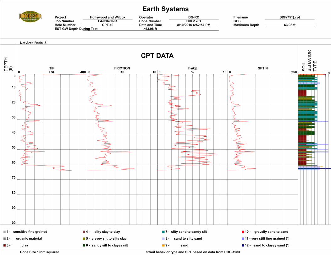
Earth SystemsProject Hollywood and Wilcox Operator DG-RC Filename SDF(751).cptJob Number LA-01670-01 Cone Number DDG1281 GPSHole Number CPT-10 Date and Time 8/10/2016 6:52:57 PM Maximum Depth 63.98 ftEST GW Depth During Test >63.98 ft
Net Area Ratio .8
Cone Size 10cm squared Soil Behavior Referance*Soil behavior type and SPT based on data from UBC-1983
0
10
20
30
40
50
60
70
80
90
100
0 400 TIPTSF 0 10
FRICTIONTSF 0 10
Fs/Qt% 0 250
SPT N0 12
1 - sensitive fine grained
2 - organic material
3 - clay
4 - silty clay to clay
5 - clayey silt to silty clay
6 - sandy silt to clayey silt
7 - silty sand to sandy silt
8 - sand to silty sand
9 - sand
10 - gravelly sand to sand
11 - very stiff fine grained (*)
12 - sand to clayey sand (*)
CPT DATA
DEP
TH(ft)
SOIL
BEHAV
IOR
TYPE
Earth SystemsProject Hollywood and Wilcox Operator DG-RC Filename SDF(750).cptJob Number LA-01670-01 Cone Number DDG1281 GPSHole Number CPT-11 Date and Time 8/10/2016 6:09:02 PM Maximum Depth 70.05 ftEST GW Depth During Test >70.05 ft
Net Area Ratio .8
Cone Size 10cm squared Soil Behavior Referance*Soil behavior type and SPT based on data from UBC-1983
0
10
20
30
40
50
60
70
80
90
100
0 400 TIPTSF 0 10
FRICTIONTSF 0 10
Fs/Qt% 0 250
SPT N0 12
1 - sensitive fine grained
2 - organic material
3 - clay
4 - silty clay to clay
5 - clayey silt to silty clay
6 - sandy silt to clayey silt
7 - silty sand to sandy silt
8 - sand to silty sand
9 - sand
10 - gravelly sand to sand
11 - very stiff fine grained (*)
12 - sand to clayey sand (*)
CPT DATA
DEP
TH(ft)
SOIL
BEHAV
IOR
TYPE
Earth SystemsProject Hollywood and Wilcox Operator DG-RC Filename SDF(749).cptJob Number LA-01670-01 Cone Number DDG1281 GPSHole Number CPT-12 Date and Time 8/10/2016 5:24:45 PM Maximum Depth 70.37 ftEST GW Depth During Test >70.37 ft
Net Area Ratio .8
Cone Size 10cm squared Soil Behavior Referance*Soil behavior type and SPT based on data from UBC-1983
0
10
20
30
40
50
60
70
80
90
100
0 400 TIPTSF 0 10
FRICTIONTSF 0 10
Fs/Qt% 0 250
SPT N0 12
1 - sensitive fine grained
2 - organic material
3 - clay
4 - silty clay to clay
5 - clayey silt to silty clay
6 - sandy silt to clayey silt
7 - silty sand to sandy silt
8 - sand to silty sand
9 - sand
10 - gravelly sand to sand
11 - very stiff fine grained (*)
12 - sand to clayey sand (*)
CPT DATA
DEP
TH(ft)
SOIL
BEHAV
IOR
TYPE
Earth SystemsProject Hollywood and Wilcox Operator DG-RC Filename SDF(748).cptJob Number LA-01670-01 Cone Number DDG1281 GPSHole Number CPT-13 Date and Time 8/10/2016 4:38:53 PM Maximum Depth 70.37 ftEST GW Depth During Test >70.37 ft
Net Area Ratio .8
Cone Size 10cm squared Soil Behavior Referance*Soil behavior type and SPT based on data from UBC-1983
0
10
20
30
40
50
60
70
80
90
100
0 400 TIPTSF 0 10
FRICTIONTSF 0 10
Fs/Qt% 0 250
SPT N0 12
1 - sensitive fine grained
2 - organic material
3 - clay
4 - silty clay to clay
5 - clayey silt to silty clay
6 - sandy silt to clayey silt
7 - silty sand to sandy silt
8 - sand to silty sand
9 - sand
10 - gravelly sand to sand
11 - very stiff fine grained (*)
12 - sand to clayey sand (*)
CPT DATA
DEP
TH(ft)
SOIL
BEHAV
IOR
TYPE
Earth SystemsProject Hollywood and Wilcox Operator DG-RC Filename SDF(747).cptJob Number LA-01670-01 Cone Number DDG1281 GPSHole Number CPT-14 Date and Time 8/10/2016 3:56:30 PM Maximum Depth 70.54 ftEST GW Depth During Test >70.54 ft
Net Area Ratio .8
Cone Size 10cm squared Soil Behavior Referance*Soil behavior type and SPT based on data from UBC-1983
0
10
20
30
40
50
60
70
80
90
100
0 400 TIPTSF 0 10
FRICTIONTSF 0 10
Fs/Qt% 0 250
SPT N0 12
1 - sensitive fine grained
2 - organic material
3 - clay
4 - silty clay to clay
5 - clayey silt to silty clay
6 - sandy silt to clayey silt
7 - silty sand to sandy silt
8 - sand to silty sand
9 - sand
10 - gravelly sand to sand
11 - very stiff fine grained (*)
12 - sand to clayey sand (*)
CPT DATA
DEP
TH(ft)
SOIL
BEHAV
IOR
TYPE
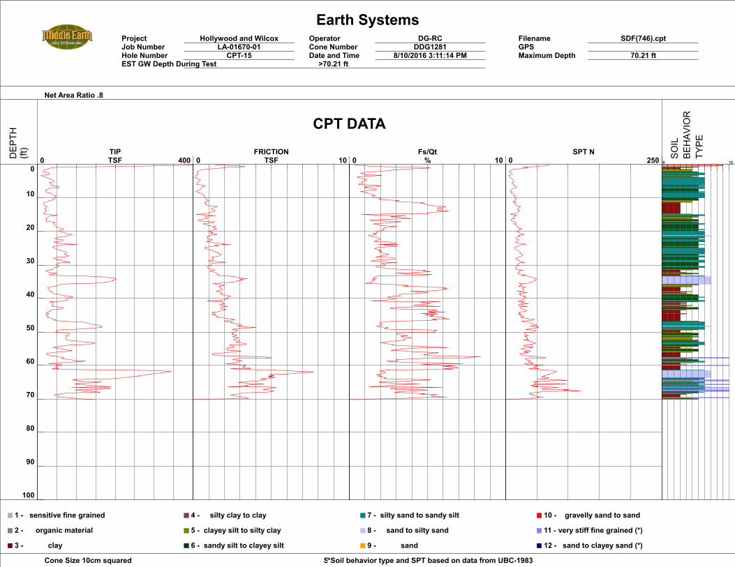
Earth SystemsProject Hollywood and Wilcox Operator DG-RC Filename SDF(746).cptJob Number LA-01670-01 Cone Number DDG1281 GPSHole Number CPT-15 Date and Time 8/10/2016 3:11:14 PM Maximum Depth 70.21 ftEST GW Depth During Test >70.21 ft
Net Area Ratio .8
Cone Size 10cm squared Soil Behavior Referance*Soil behavior type and SPT based on data from UBC-1983
0
10
20
30
40
50
60
70
80
90
100
0 400 TIPTSF 0 10
FRICTIONTSF 0 10
Fs/Qt% 0 250
SPT N0 12
1 - sensitive fine grained
2 - organic material
3 - clay
4 - silty clay to clay
5 - clayey silt to silty clay
6 - sandy silt to clayey silt
7 - silty sand to sandy silt
8 - sand to silty sand
9 - sand
10 - gravelly sand to sand
11 - very stiff fine grained (*)
12 - sand to clayey sand (*)
CPT DATA
DEP
TH(ft)
SOIL
BEHAV
IOR
TYPE
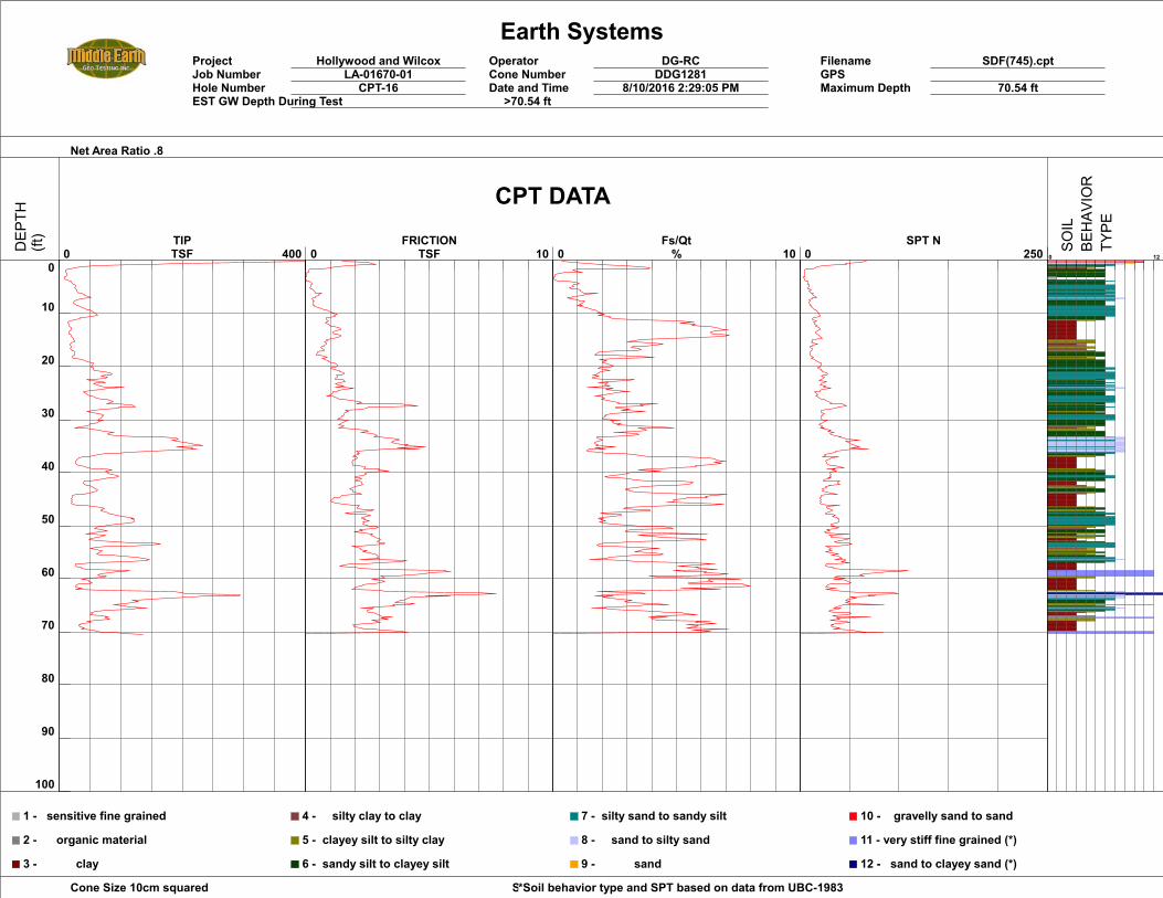
Earth SystemsProject Hollywood and Wilcox Operator DG-RC Filename SDF(745).cptJob Number LA-01670-01 Cone Number DDG1281 GPSHole Number CPT-16 Date and Time 8/10/2016 2:29:05 PM Maximum Depth 70.54 ftEST GW Depth During Test >70.54 ft
Net Area Ratio .8
Cone Size 10cm squared Soil Behavior Referance*Soil behavior type and SPT based on data from UBC-1983
0
10
20
30
40
50
60
70
80
90
100
0 400 TIPTSF 0 10
FRICTIONTSF 0 10
Fs/Qt% 0 250
SPT N0 12
1 - sensitive fine grained
2 - organic material
3 - clay
4 - silty clay to clay
5 - clayey silt to silty clay
6 - sandy silt to clayey silt
7 - silty sand to sandy silt
8 - sand to silty sand
9 - sand
10 - gravelly sand to sand
11 - very stiff fine grained (*)
12 - sand to clayey sand (*)
CPT DATA
DEP
TH(ft)
SOIL
BEHAV
IOR
TYPE
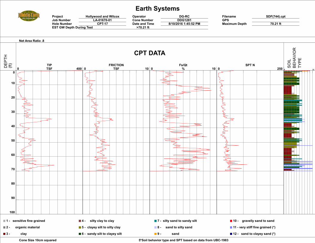
Earth SystemsProject Hollywood and Wilcox Operator DG-RC Filename SDF(744).cptJob Number LA-01670-01 Cone Number DDG1281 GPSHole Number CPT-17 Date and Time 8/10/2016 1:45:52 PM Maximum Depth 70.21 ftEST GW Depth During Test >70.21 ft
Net Area Ratio .8
Cone Size 10cm squared Soil Behavior Referance*Soil behavior type and SPT based on data from UBC-1983
0
10
20
30
40
50
60
70
80
90
100
0 400 TIPTSF 0 10
FRICTIONTSF 0 10
Fs/Qt% 0 250
SPT N0 12
1 - sensitive fine grained
2 - organic material
3 - clay
4 - silty clay to clay
5 - clayey silt to silty clay
6 - sandy silt to clayey silt
7 - silty sand to sandy silt
8 - sand to silty sand
9 - sand
10 - gravelly sand to sand
11 - very stiff fine grained (*)
12 - sand to clayey sand (*)
CPT DATA
DEP
TH(ft)
SOIL
BEHAV
IOR
TYPE
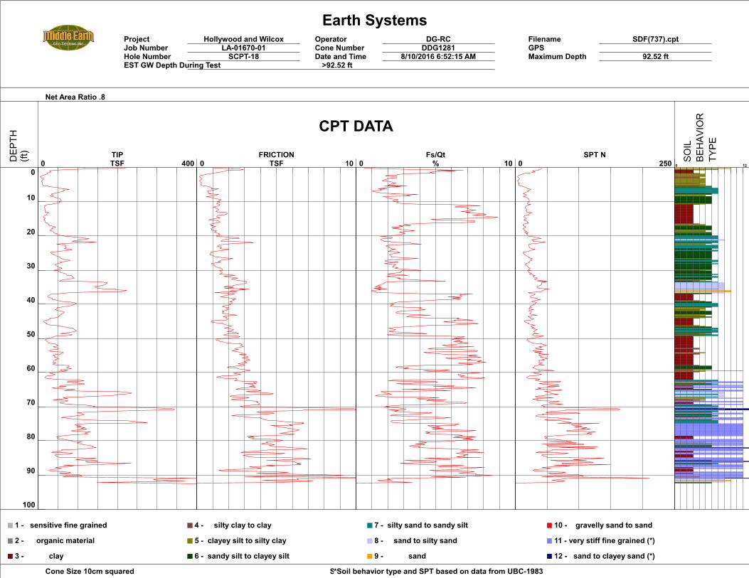
Earth SystemsProject Hollywood and Wilcox Operator DG-RC Filename SDF(737).cptJob Number LA-01670-01 Cone Number DDG1281 GPSHole Number SCPT-18 Date and Time 8/10/2016 6:52:15 AM Maximum Depth 92.52 ftEST GW Depth During Test >92.52 ft
Net Area Ratio .8
Cone Size 10cm squared Soil Behavior Referance*Soil behavior type and SPT based on data from UBC-1983
0
10
20
30
40
50
60
70
80
90
100
0 400 TIPTSF 0 10
FRICTIONTSF 0 10
Fs/Qt% 0 250
SPT N0 12
1 - sensitive fine grained
2 - organic material
3 - clay
4 - silty clay to clay
5 - clayey silt to silty clay
6 - sandy silt to clayey silt
7 - silty sand to sandy silt
8 - sand to silty sand
9 - sand
10 - gravelly sand to sand
11 - very stiff fine grained (*)
12 - sand to clayey sand (*)
CPT DATA
DEP
TH(ft)
SOIL
BEHAV
IOR
TYPE

Earth SystemsProject Hollywood and Wilcox Operator DG-RC Filename SDF(743).cptJob Number LA-01670-01 Cone Number DDG1281 GPSHole Number CPT-19 Date and Time 8/10/2016 1:06:44 PM Maximum Depth 59.05 ftEST GW Depth During Test >59.05 ft
Net Area Ratio .8
Cone Size 10cm squared Soil Behavior Referance*Soil behavior type and SPT based on data from UBC-1983
0
10
20
30
40
50
60
70
80
90
100
0 400 TIPTSF 0 10
FRICTIONTSF 0 10
Fs/Qt% 0 250
SPT N0 12
1 - sensitive fine grained
2 - organic material
3 - clay
4 - silty clay to clay
5 - clayey silt to silty clay
6 - sandy silt to clayey silt
7 - silty sand to sandy silt
8 - sand to silty sand
9 - sand
10 - gravelly sand to sand
11 - very stiff fine grained (*)
12 - sand to clayey sand (*)
CPT DATA
DEP
TH(ft)
SOIL
BEHAV
IOR
TYPE
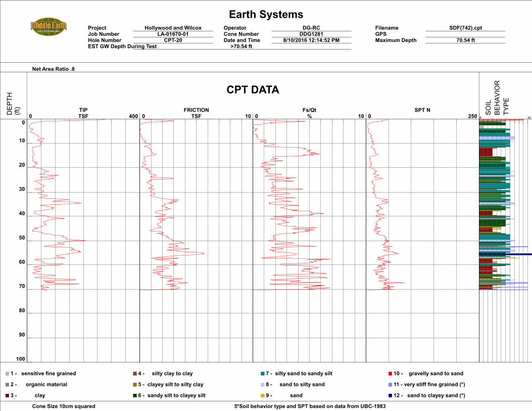
Earth SystemsProject Hollywood and Wilcox Operator DG-RC Filename SDF(742).cptJob Number LA-01670-01 Cone Number DDG1281 GPSHole Number CPT-20 Date and Time 8/10/2016 12:14:52 PM Maximum Depth 70.54 ftEST GW Depth During Test >70.54 ft
Net Area Ratio .8
Cone Size 10cm squared Soil Behavior Referance*Soil behavior type and SPT based on data from UBC-1983
0
10
20
30
40
50
60
70
80
90
100
0 400 TIPTSF 0 10
FRICTIONTSF 0 10
Fs/Qt% 0 250
SPT N0 12
1 - sensitive fine grained
2 - organic material
3 - clay
4 - silty clay to clay
5 - clayey silt to silty clay
6 - sandy silt to clayey silt
7 - silty sand to sandy silt
8 - sand to silty sand
9 - sand
10 - gravelly sand to sand
11 - very stiff fine grained (*)
12 - sand to clayey sand (*)
CPT DATA
DEP
TH(ft)
SOIL
BEHAV
IOR
TYPE
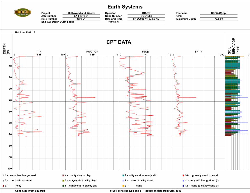
Earth SystemsProject Hollywood and Wilcox Operator DG-RC Filename SDF(741).cptJob Number LA-01670-01 Cone Number DDG1281 GPSHole Number CPT-21 Date and Time 8/10/2016 11:27:50 AM Maximum Depth 70.54 ftEST GW Depth During Test >70.54 ft
Net Area Ratio .8
Cone Size 10cm squared Soil Behavior Referance*Soil behavior type and SPT based on data from UBC-1983
0
10
20
30
40
50
60
70
80
90
100
0 400 TIPTSF 0 10
FRICTIONTSF 0 10
Fs/Qt% 0 250
SPT N0 12
1 - sensitive fine grained
2 - organic material
3 - clay
4 - silty clay to clay
5 - clayey silt to silty clay
6 - sandy silt to clayey silt
7 - silty sand to sandy silt
8 - sand to silty sand
9 - sand
10 - gravelly sand to sand
11 - very stiff fine grained (*)
12 - sand to clayey sand (*)
CPT DATA
DEP
TH(ft)
SOIL
BEHAV
IOR
TYPE
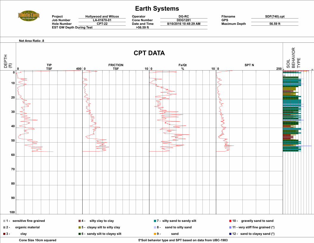
Earth SystemsProject Hollywood and Wilcox Operator DG-RC Filename SDF(740).cptJob Number LA-01670-01 Cone Number DDG1281 GPSHole Number CPT-22 Date and Time 8/10/2016 10:48:29 AM Maximum Depth 56.59 ftEST GW Depth During Test >56.59 ft
Net Area Ratio .8
Cone Size 10cm squared Soil Behavior Referance*Soil behavior type and SPT based on data from UBC-1983
0
10
20
30
40
50
60
70
80
90
100
0 400 TIPTSF 0 10
FRICTIONTSF 0 10
Fs/Qt% 0 250
SPT N0 12
1 - sensitive fine grained
2 - organic material
3 - clay
4 - silty clay to clay
5 - clayey silt to silty clay
6 - sandy silt to clayey silt
7 - silty sand to sandy silt
8 - sand to silty sand
9 - sand
10 - gravelly sand to sand
11 - very stiff fine grained (*)
12 - sand to clayey sand (*)
CPT DATA
DEP
TH(ft)
SOIL
BEHAV
IOR
TYPE
October 24, 2016 LA-01670-03
EARTH SYSTEMS
APPENDIX B “Investigation for the potential for active faulting at Hollywood Boulevard and Wilcox, Los Angeles,
California”, by Rockwell Consulting dated October 7, 2016
Rockwell Consulting 4560 Panorama Drive
La Mesa, CA 91941 [email protected]
October 7, 2016
Earth Systems Southern California Attn: Mr. Chris Allen 2122 East Walnut Street, Suite 200 Pasadena, CA 91107
Subject: Investigation for the potential for active faulting at Hollywood Boulevard and Wilcox, Los Angeles, California
Dear Mr. Allen:
This letter report primarily addresses the ages of alluvial deposits that are present beneath the proposed project site at Hollywood Boulevard and Wilcox Street in Los Angeles, CA. A detailed soil description (attached) was completed to characterize the soil stratigraphy at the site, as recovered in core C3, and it is this soil description that forms the basis for my interpretation of the ages of stratigraphic units that underlie the site in the shallow subsurface. The primary purpose of my involvement was to make assessments on the age of alluvium at the site to assess whether the site is impacted by active faulting. This report is intended to complement the fault evaluation conducted by Earth Systems, with the purpose of assessing the soil ages at this site to provide age control for the alluvium that is interpreted to be present beneath the site; it is not the primary report for the evaluation of on-site faulting.
Age of alluvial deposits in the core C3 – There are up to six primary alluvial units identified in core C3 that are interpreted to be present beneath the subject property. Each primary stratigraphic unit below the upper 10.4 feet of unit 1 is capped by a buried soil, with the strength of soil development ranging from very weak to moderate, as discussed below.
Four of the six stratigraphic units are capped by only an A/C profile with no observable clay films or development of a B horizon. These soils are considered very weakly developed and constitute relatively short intervals of surface exposure that probably range from a few hundred to no more than a couple thousand years. Two of the buried soils exhibit development of a weak argillic horizon with the presence of secondary clay in the form of argillans (clay films). These soils are interpreted to represent significantly more surface exposure age ranging from several thousand to as much as ten thousand years. Collectively, the entire section is interpreted to be late Pleistocene (lower part) to Holocene in age because a definitive, well-developed soil indicative of tens of thousands of years of surface exposure was not observed in boring B8 and because most units preserved most or all of the soil that had developed on each respective paleo-surface indicating that deep erosion and removal of a well-developed soil is unlikely.
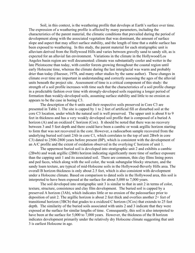
Soil, in this context, is the weathering profile that develops at Earth’s surface over time. The expression of a weathering profile is affected by many parameters, including the characteristics of the parent material, the climatic conditions that prevailed during the period of development along with the associated vegetation that was dominant, the amount of surface slope and aspect that may affect surface stability, and the length of time that a stable surface has been exposed to weathering. In this study, the parent material for each stratigraphic unit is alluvium derived from the Hollywood Hills and varies between gravelly sand to sandy silt, as is expected for an alluvial fan environment. Variations in the climate in the Hollywood/Los Angeles basin region are well documented: climate was substantially cooler and wetter in the late Pleistocene than today, with conifer forests growing throughout the coastal region until early Holocene time, whereas the climate during the last interglacial was warm and probably drier than today (Huesser, 1978, and many other studies by the same author). These changes in climate over time are important in understanding and correctly assessing the ages of the alluvial units beneath the project site. Assessment of time is a critical component of this study: the strength of a soil profile increases with time such that the characteristics of a soil profile change in a predictable fashion over time with strongly-developed soils requiring a longer period of formation than weakly-developed soils, assuming surface stability and little to no erosion as appears to be the case in boring C3.
The description of the 6 units and their respective soils preserved in Core C3 are presented in Table 1. The site is capped by 1 to 2 feet of artificial fill or disturbed soil at the core C3 location, under which the natural soil is well preserved. The upper unit is about 8 to 9 feet in thickness and has a very weakly developed soil profile that is composed of a buried A horizon (A) and an oxidized C horizon (Cox). It should be noted that there was no recovery between 3 and 5 feet depth and there could have been a cambic or weak argillic horizon starting to form that was not recovered in the core. However, a radiocarbon sample recovered from the underlying buried soil (unit 2Ab in core C1, which correlates to the top of unit 2Bwb in core C3) dated to 2500-2800 years before present (BP), which is consistent with the development of an A/C profile and the extent of oxidation observed in the overlying C horizon of unit 1.
The uppermost buried soil is developed into stratigraphic unit 2 and exhibits a cambic (2Bwb) and weak argillic (2Btb) horizon indicating significantly more time of surface exposure than the capping unit 1 and its associated soil. There are common, thin clay films lining pores and ped faces, which along with the soil color, the weak subangular blocky structure, and the sandy loam texture, are typical of mid-Holocene soils in the Hollywood-Beverly Hills area. The overall B horizon thickness is only about 2.5 feet, which is also consistent with development under a Holocene climate. Based on comparison to dated soils in the Hollywood area, this soil is interpreted to have been exposed at the surface for about 5,000 to 7,000 years.
The soil developed into stratigraphic unit 3 is similar to that in unit 2 in terms of color, texture, structure, consistence and clay film development. The buried soil is capped by a preserved A horizon (3Ab), which indicates little or no erosion of the paleosurface prior to deposition of unit 2. The argillic horizon is about 2 feet thick and overlies another 2+ feet of transitional horizon (3BCb) that grades to a oxidized C horizon (3Cox) that extends to 25 feet depth. The similarity of the buried soils associated with units 2 and 3 indicate that they were exposed at the surface for similar lengths of time. Consequently, this soil is also interpreted to have been at the surface for 5,000 to 7,000 years. However, the thickness of the B horizon indicates development primarily under the relatively dry Holocene climate suggesting that unit 3 is earliest Holocene in age.
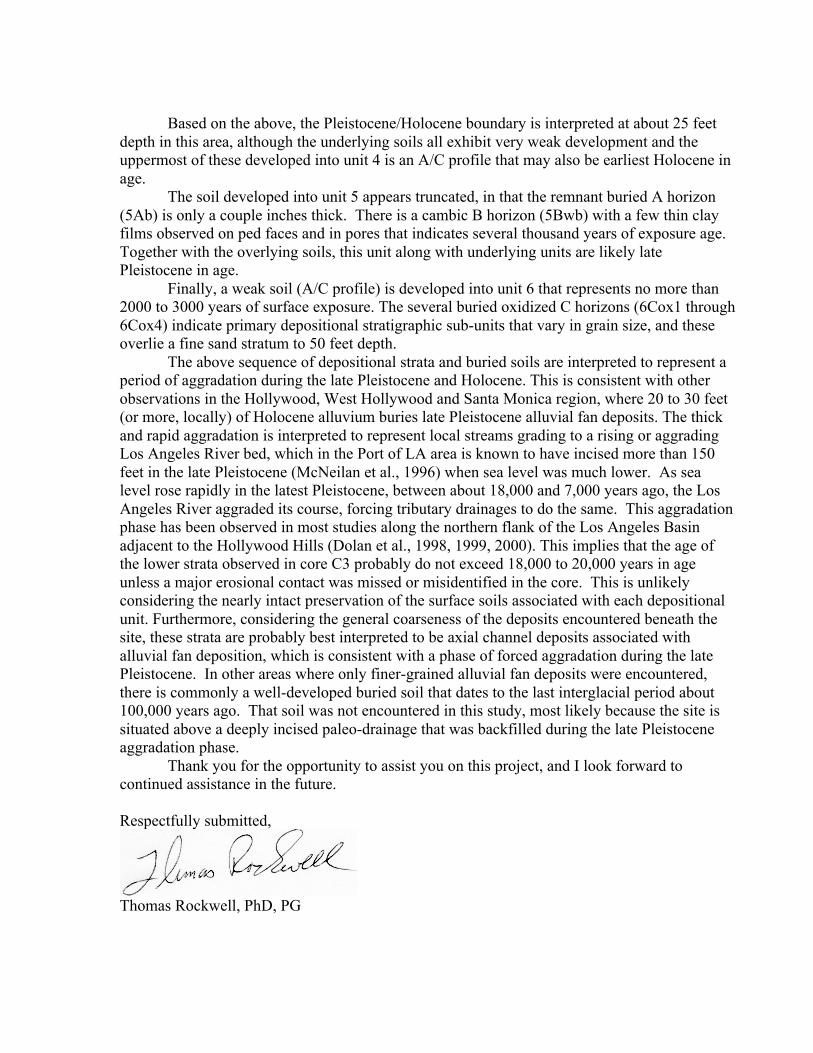
Based on the above, the Pleistocene/Holocene boundary is interpreted at about 25 feet
depth in this area, although the underlying soils all exhibit very weak development and the uppermost of these developed into unit 4 is an A/C profile that may also be earliest Holocene in age.
The soil developed into unit 5 appears truncated, in that the remnant buried A horizon (5Ab) is only a couple inches thick. There is a cambic B horizon (5Bwb) with a few thin clay films observed on ped faces and in pores that indicates several thousand years of exposure age. Together with the overlying soils, this unit along with underlying units are likely late Pleistocene in age.
Finally, a weak soil (A/C profile) is developed into unit 6 that represents no more than 2000 to 3000 years of surface exposure. The several buried oxidized C horizons (6Cox1 through 6Cox4) indicate primary depositional stratigraphic sub-units that vary in grain size, and these overlie a fine sand stratum to 50 feet depth.
The above sequence of depositional strata and buried soils are interpreted to represent a period of aggradation during the late Pleistocene and Holocene. This is consistent with other observations in the Hollywood, West Hollywood and Santa Monica region, where 20 to 30 feet (or more, locally) of Holocene alluvium buries late Pleistocene alluvial fan deposits. The thick and rapid aggradation is interpreted to represent local streams grading to a rising or aggrading Los Angeles River bed, which in the Port of LA area is known to have incised more than 150 feet in the late Pleistocene (McNeilan et al., 1996) when sea level was much lower. As sea level rose rapidly in the latest Pleistocene, between about 18,000 and 7,000 years ago, the Los Angeles River aggraded its course, forcing tributary drainages to do the same. This aggradation phase has been observed in most studies along the northern flank of the Los Angeles Basin adjacent to the Hollywood Hills (Dolan et al., 1998, 1999, 2000). This implies that the age of the lower strata observed in core C3 probably do not exceed 18,000 to 20,000 years in age unless a major erosional contact was missed or misidentified in the core. This is unlikely considering the nearly intact preservation of the surface soils associated with each depositional unit. Furthermore, considering the general coarseness of the deposits encountered beneath the site, these strata are probably best interpreted to be axial channel deposits associated with alluvial fan deposition, which is consistent with a phase of forced aggradation during the late Pleistocene. In other areas where only finer-grained alluvial fan deposits were encountered, there is commonly a well-developed buried soil that dates to the last interglacial period about 100,000 years ago. That soil was not encountered in this study, most likely because the site is situated above a deeply incised paleo-drainage that was backfilled during the late Pleistocene aggradation phase.
Thank you for the opportunity to assist you on this project, and I look forward to continued assistance in the future. Respectfully submitted,
Thomas Rockwell, PhD, PG
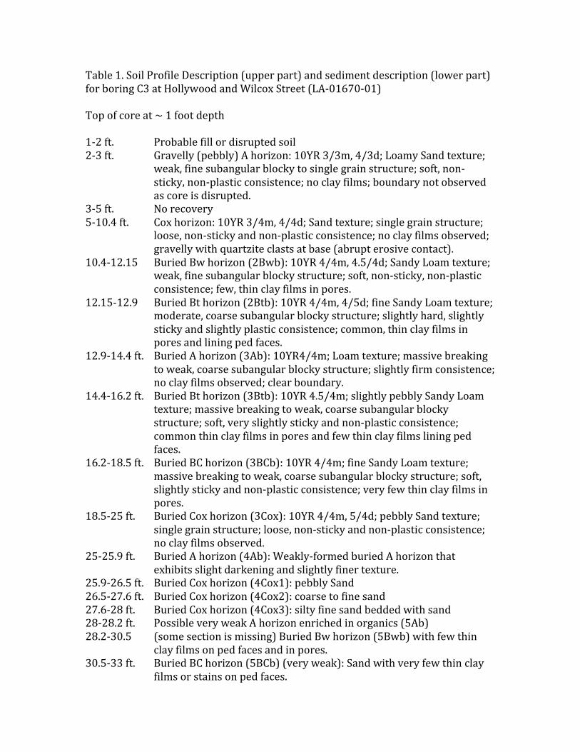
Table1.SoilProfileDescription(upperpart)andsedimentdescription(lowerpart)forboringC3atHollywoodandWilcoxStreet(LA-01670-01)Topofcoreat~1footdepth1-2ft. Probablefillordisruptedsoil2-3ft. Gravelly(pebbly)Ahorizon:10YR3/3m,4/3d;LoamySandtexture;
weak,finesubangularblockytosinglegrainstructure;soft,non-sticky,non-plasticconsistence;noclayfilms;boundarynotobservedascoreisdisrupted.
3-5ft. Norecovery5-10.4ft. Coxhorizon:10YR3/4m,4/4d;Sandtexture;singlegrainstructure;
loose,non-stickyandnon-plasticconsistence;noclayfilmsobserved;gravellywithquartziteclastsatbase(abrupterosivecontact).
10.4-12.15 BuriedBwhorizon(2Bwb):10YR4/4m,4.5/4d;SandyLoamtexture;weak,finesubangularblockystructure;soft,non-sticky,non-plasticconsistence;few,thinclayfilmsinpores.
12.15-12.9 BuriedBthorizon(2Btb):10YR4/4m,4/5d;fineSandyLoamtexture;moderate,coarsesubangularblockystructure;slightlyhard,slightlystickyandslightlyplasticconsistence;common,thinclayfilmsinporesandliningpedfaces.
12.9-14.4ft. BuriedAhorizon(3Ab):10YR4/4m;Loamtexture;massivebreakingtoweak,coarsesubangularblockystructure;slightlyfirmconsistence;noclayfilmsobserved;clearboundary.
14.4-16.2ft. BuriedBthorizon(3Btb):10YR4.5/4m;slightlypebblySandyLoamtexture;massivebreakingtoweak,coarsesubangularblockystructure;soft,veryslightlystickyandnon-plasticconsistence;commonthinclayfilmsinporesandfewthinclayfilmsliningpedfaces.
16.2-18.5ft. BuriedBChorizon(3BCb):10YR4/4m;fineSandyLoamtexture;massivebreakingtoweak,coarsesubangularblockystructure;soft,slightlystickyandnon-plasticconsistence;veryfewthinclayfilmsinpores.
18.5-25ft. BuriedCoxhorizon(3Cox):10YR4/4m,5/4d;pebblySandtexture;singlegrainstructure;loose,non-stickyandnon-plasticconsistence;noclayfilmsobserved.
25-25.9ft. BuriedAhorizon(4Ab):Weakly-formedburiedAhorizonthatexhibitsslightdarkeningandslightlyfinertexture.
25.9-26.5ft. BuriedCoxhorizon(4Cox1):pebblySand26.5-27.6ft. BuriedCoxhorizon(4Cox2):coarsetofinesand27.6-28ft. BuriedCoxhorizon(4Cox3):siltyfinesandbeddedwithsand28-28.2ft. PossibleveryweakAhorizonenrichedinorganics(5Ab)28.2-30.5 (somesectionismissing)BuriedBwhorizon(5Bwb)withfewthin
clayfilmsonpedfacesandinpores.30.5-33ft. BuriedBChorizon(5BCb)(veryweak):Sandwithveryfewthinclay
filmsorstainsonpedfaces.
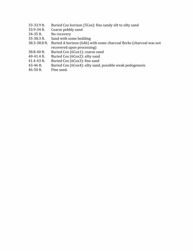
33-33.9ft. BuriedCoxhorizon(5Cox):finesandysilttosiltysand33.9-34ft. Coarsepebblysand34-35ft. Norecovery35-38.3ft. Sandwithsomebedding38.3-38.8ft. BuriedAhorizon(6Ab)withsomecharcoalflecks(charcoalwasnot
recovereduponprocessing)38.8-40ft. BuriedCox(6Cox1):coarsesand40-41.4ft. BuriedCox(6Cox2):siltysand41.4-43ft. BuriedCox(6Cox3):finesand43-46ft. BuriedCox(6Cox4):siltysand,possibleweakpedogenesis46-50ft. Finesand.
October 24, 2016 LA-01670-03
EARTH SYSTEMS
APPENDIX C
Radiocarbon Results
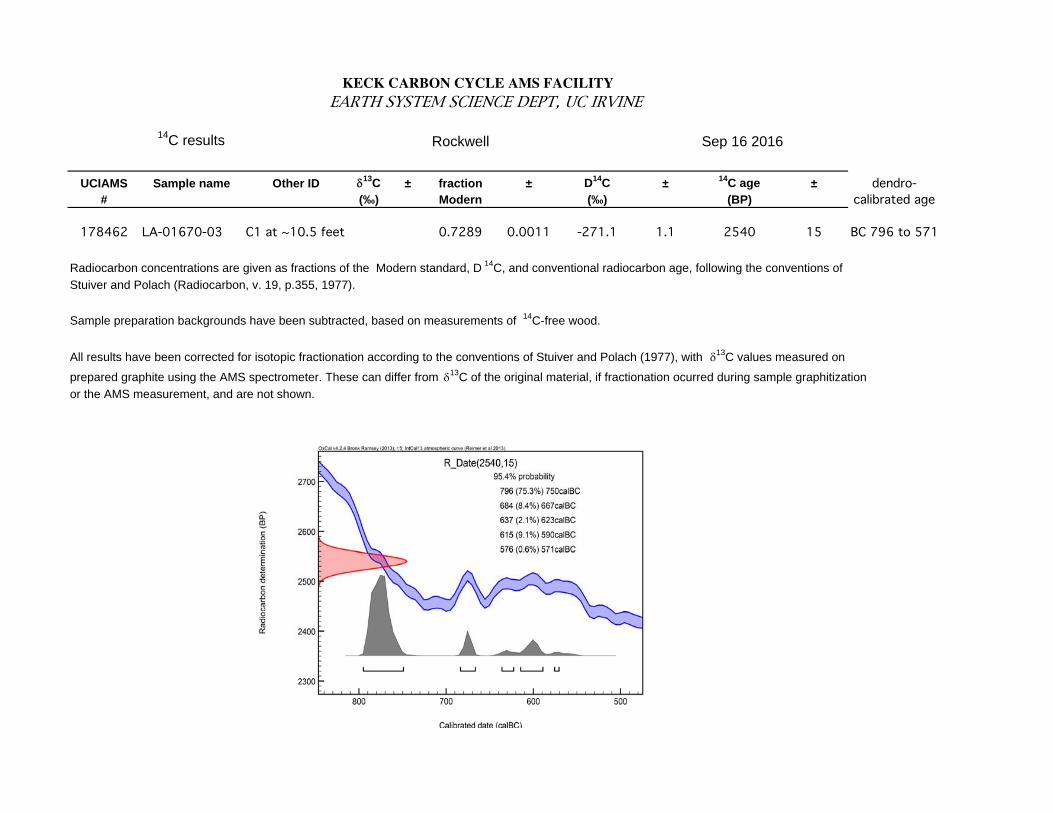
KECK CARBON CYCLE AMS FACILITY EARTH SYSTEM SCIENCE DEPT, UC IRVINE
14C results Rockwell Sep 16 2016
UCIAMS Sample name Other ID 13C ± fraction ± D
14C ±
14C age ±
# (‰) Modern (‰) (BP)
178462 LA-01670-03 C1 at ~10.5 feet 0.7289 0.0011 -271.1 1.1 2540 15 BC 796 to 571
Radiocarbon concentrations are given as fractions of the Modern standard, D14
C, and conventional radiocarbon age, following the conventions of
Stuiver and Polach (Radiocarbon, v. 19, p.355, 1977).
Sample preparation backgrounds have been subtracted, based on measurements of 14
C-free wood.
All results have been corrected for isotopic fractionation according to the conventions of Stuiver and Polach (1977), with 13C values measured on
prepared graphite using the AMS spectrometer. These can differ from 13C of the original material, if fractionation ocurred during sample graphitization
or the AMS measurement, and are not shown.
dendro-calibrated age


![Hollywood Publishing [=] the Sins of Hollywood (1922)](https://img.pdfslide.us/doc/110x75/577cd7ce1a28ab9e789fc44e/hollywood-publishing-the-sins-of-hollywood-1922.jpg)