Embed Size (px)
Citation preview

HE-C-1DRAFT - City of San Diego Housing Element 2021-2029
APPENDIX HE-C - CONSTRAINTS AND ZONING ANALYSISThe City has made strides to reduce constraints to development that are within the City’s purview since
the Housing Element was last updated in 2013. Reductions to constraints during the previous cycle
include:
• Reducing the minimum parking requirement for residential development in transit priority areas
to zero;
• Adding new mixed-use zones to the Land Development Code to facilitate by-right approval and
promote more walkable, transit-oriented projects that seek to provide a better housing-jobs-
recreation balance;
• Streamlining accessory dwelling unit (i.e., granny flat) regulations and waiving certain impact and
administrative fees;
• Establishing a density bonus program for projects providing micro-units; and
• Amending Land Development Code regulations and zones to allow by-right development of
transitional housing facilities and permanent supportive housing in zones that allow multifamily
housing.
Constraints on housing development persist and remain a factor in how much housing can be produced
within the City. The City continues to examine and strategize ways to reduce barriers to development
while protecting other interests, such as historic preservation, quality of life, parks and open space, and
ecological resources.

HE-C-2 City of San Diego Housing Element 2021-2029 - DRAFT
GOVERNMENTAL CONSTRAINTSGovernmental constraints are barriers to building housing that the City can exercise some control over
through regulatory changes, process improvements, and community planning. The top governmental
constraints include: land use, environmental regulations, permitting processes, building code
requirements, site improvement requirements, permitting and infrastructure fees, flood regulations,
accessibility regulations, and mobility planning.
LAND USE AND ZONING
Approximately 5 percent of the City’s land remains vacant and available for development, so the majority
of additional residential development will occur from redevelopment sites with existing uses and more
efficient use of existing residential land. Since the adoption of the City’s General Plan in 2008, which
included the City of Villages smart growth strategy, the City has been working to comprehensively update
its community plans to implement the General Plan’s policies and strategies. The City’s community plan
update program is rezoning large portions of the City to allow more, denser residential development in
the areas most suitable for higher-density infill housing: near major transit stops and transit stations,
along major commercial corridors, and in “village” areas that are designated in community plans. Since
2013, Community Plan Updates have added capacity for more than 74,000 additional residential units.
City Council adopted new mixed-use zones in July 2019 that facilitate a mix of employment, residential,
and commercial uses and use floor area ratio instead of dwelling units to regulate residential density.
These zones are designed to diversify land uses, create vibrant pedestrian environments, and foster
transit-oriented development.
The Land Development Code section of the Municipal Code contains the City’s planning, zoning,
subdivision, and building regulations. Zoning regulations are the City’s primary tool to regulate the type,
location, mix, intensity, site planning, and design of land uses and structures. The regulations codify
land use policies found the City’s General Plan and in adopted community plans. Citywide zones are
applied to properties through the City’s Official Zoning Map to implement the land use maps in adopted
community plans. In some communities, Planned District Ordinances (PDOs) within the Municipal Code
apply community-specific zoning and development policies. While there will be a continuing long-term
role for PDO’s in certain communities with very unique characteristics, most PDO’s will be replaced with
citywide zoning, as they go through the community plan update process. Additional land use policies
in adopted community plans are implemented through the Community Plan Implementation Overlay
Zone.
Regarding zoning, most Citywide zones and PDO zoning designations that permit residential uses
establish maximum residential densities, but do not establish minimum residential densities. The density
maximums within residential and mixed-use zones (expressed in dwelling units per lot or square feet
of lot area per dwelling unit) are the primary limiting factor for how many units per acre can be built in
HE-C-3DRAFT - City of San Diego Housing Element 2021-2029
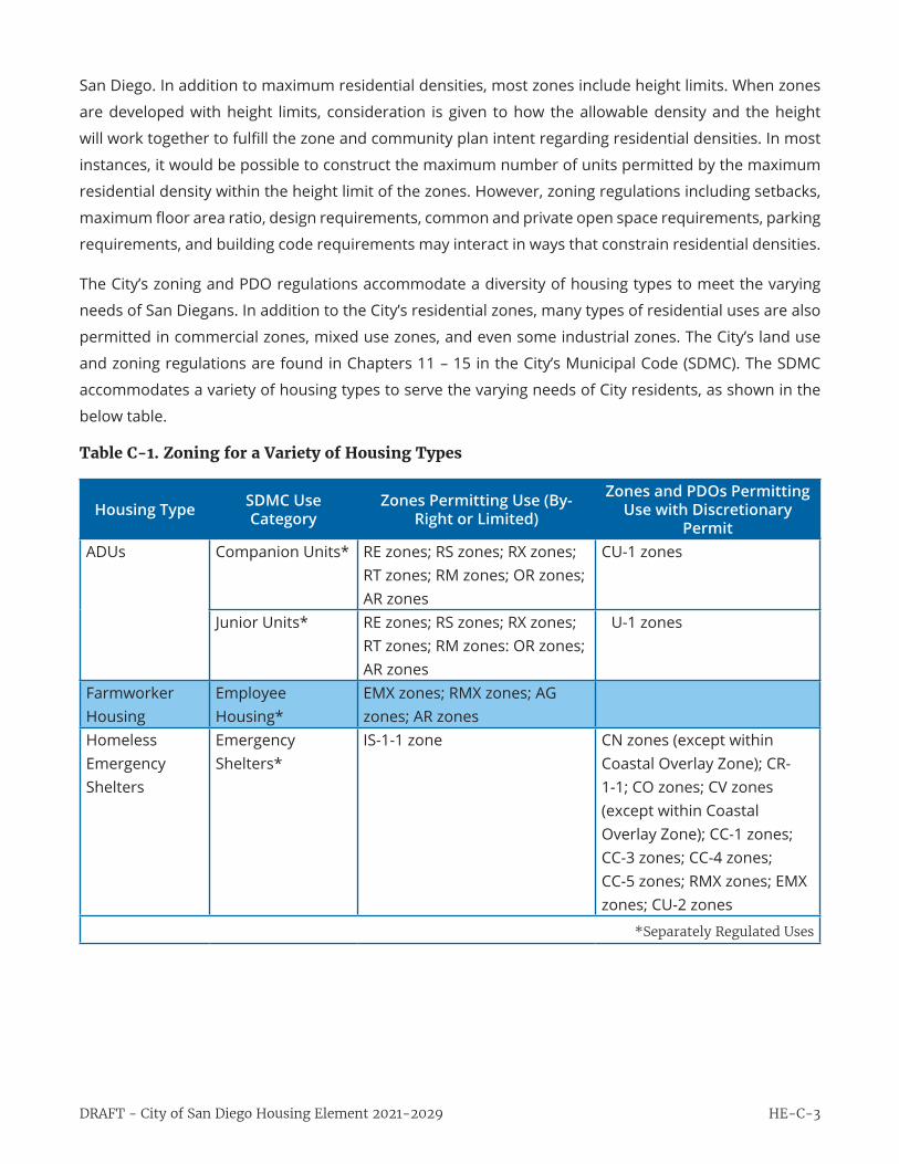
San Diego. In addition to maximum residential densities, most zones include height limits. When zones
are developed with height limits, consideration is given to how the allowable density and the height
will work together to fulfill the zone and community plan intent regarding residential densities. In most
instances, it would be possible to construct the maximum number of units permitted by the maximum
residential density within the height limit of the zones. However, zoning regulations including setbacks,
maximum floor area ratio, design requirements, common and private open space requirements, parking
requirements, and building code requirements may interact in ways that constrain residential densities.
The City’s zoning and PDO regulations accommodate a diversity of housing types to meet the varying
needs of San Diegans. In addition to the City’s residential zones, many types of residential uses are also
permitted in commercial zones, mixed use zones, and even some industrial zones. The City’s land use
and zoning regulations are found in Chapters 11 – 15 in the City’s Municipal Code (SDMC). The SDMC
accommodates a variety of housing types to serve the varying needs of City residents, as shown in the
below table.
Table C-1. Zoning for a Variety of Housing Types
Housing Type SDMC Use Category
Zones Permitting Use (By-Right or Limited)
Zones and PDOs Permitting Use with Discretionary
PermitADUs Companion Units* RE zones; RS zones; RX zones;
RT zones; RM zones; OR zones; AR zones
CU-1 zones
Junior Units* RE zones; RS zones; RX zones; RT zones; RM zones: OR zones; AR zones
CU-1 zones
Farmworker Housing
Employee Housing*
EMX zones; RMX zones; AG zones; AR zones
Homeless Emergency Shelters
Emergency Shelters*
IS-1-1 zone CN zones (except within Coastal Overlay Zone); CR-1-1; CO zones; CV zones (except within Coastal Overlay Zone); CC-1 zones; CC-3 zones; CC-4 zones; CC-5 zones; RMX zones; EMX zones; CU-2 zones
*Separately Regulated Uses

HE-C-4 City of San Diego Housing Element 2021-2029 - DRAFT
Housing Type SDMC Use Category
Zones Permitting Use (By-Right or Limited)
Zones and PDOs Permitting Use with Discretionary
PermitHousing for Special Needs Populations
Continuing Care Retirement Communities*
IP-3 zones; RMX zones; EMX zones; RM-3 zones; RM-4 zones; RM-5 zones
CC-1 zones; CC-3 zones; CC-4 zones; CC-5 zones; CN zones; CR-1 zones; CO-1 zones; CO-3 zones; CV zones; RM-1 zones, RM-2 zones; CU-zones
Residential Care Facilities*
IP-3 zones; RMX zones; EMX zones; CN zones; CR-1 zones; CO-1 zones; CO-3 zones; CV zones; CC-1 zones; CC-3 zones; CC-4 zones; CC-5 zones; RE zones; RS zones; RX zones; RT zones; RM-1 zones; RM-2 zones; RM-3 zones; RM-4 zones; OR zones; AR zones
CU zones; BLPD: subdistrict C; redevelopment subdistrict; CVPD: SP
Manufactured Housing
Mobilehome Parks RS zones; RX zones; RM zones
Single Dwelling Units
RE zones; RS zones; RX zones; RT zones; RM zones; AG zones; AR zones; OR zones
CU-1 zones; CU-3 zones; BLPD: redevelopment subdistrict, subdistrict D; CVPD: SF zones; LJSPD: Zone 2
Companion Units* RE zones; RS zones; RX zones; RT zones; RM zones; OR zones; AR zones
CU-1 zones
Mixed-Use Housing
Shopkeeper Units RMX zones; EMX zones; CN zones; CR-1 zones; CO-1 zones; CO-3 zones; CV zones; CC-1 zones; CC-3 zones; CC-4 zones; CC-5 zones; RM-3 zones; RM-4 zones; RM-5 zones
CU zones; BLPD: redevelopment subdistrict
Live/Work Quarters*
IS zones; RMX zones; EMX zones; CN zones; CR-1-1; CO-1 zones; CO-3 zones; CV zones; CC zones
CU zones; BLPD: redevelopment subdistrict
Watchkeeper’s Quarters*
IP zones; IL zones; IH zones; IS zones; IBT zones; EMX zones; CR-2 zones; CC-2 zones
*Separately Regulated Uses
HE-C-5DRAFT - City of San Diego Housing Element 2021-2029
Housing Type SDMC Use Category
Zones Permitting Use (By-Right or Limited)
Zones and PDOs Permitting Use with Discretionary
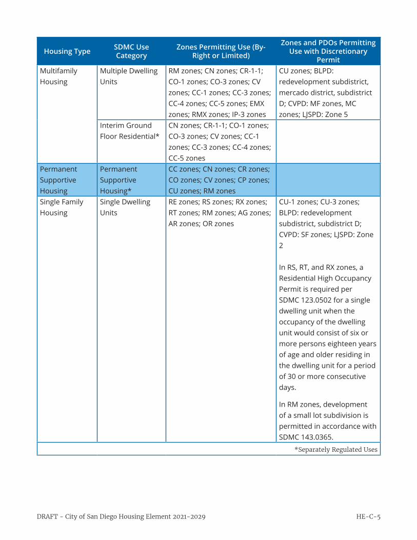
PermitMultifamily Housing
Multiple Dwelling Units
RM zones; CN zones; CR-1-1; CO-1 zones; CO-3 zones; CV zones; CC-1 zones; CC-3 zones; CC-4 zones; CC-5 zones; EMX zones; RMX zones; IP-3 zones
CU zones; BLPD: redevelopment subdistrict, mercado district, subdistrict D; CVPD: MF zones, MC zones; LJSPD: Zone 5
Interim Ground Floor Residential*
CN zones; CR-1-1; CO-1 zones; CO-3 zones; CV zones; CC-1 zones; CC-3 zones; CC-4 zones; CC-5 zones
Permanent Supportive Housing
Permanent Supportive Housing*
CC zones; CN zones; CR zones; CO zones; CV zones; CP zones; CU zones; RM zones
Single Family Housing
Single Dwelling Units
RE zones; RS zones; RX zones; RT zones; RM zones; AG zones; AR zones; OR zones
CU-1 zones; CU-3 zones; BLPD: redevelopment subdistrict, subdistrict D; CVPD: SF zones; LJSPD: Zone 2 In RS, RT, and RX zones, a Residential High Occupancy Permit is required per SDMC 123.0502 for a single dwelling unit when the occupancy of the dwelling unit would consist of six or more persons eighteen years of age and older residing in the dwelling unit for a period of 30 or more consecutive days.
In RM zones, development of a small lot subdivision is permitted in accordance with SDMC 143.0365.
*Separately Regulated Uses

HE-C-6 City of San Diego Housing Element 2021-2029 - DRAFT
Housing Type SDMC Use Category
Zones Permitting Use (By-Right or Limited)
Zones and PDOs Permitting Use with Discretionary
PermitSingle Room Occupancy
Living Units (CCPDO)
CCPDO zones: C, NC, ER, BP, MC, RE, PC; BLPD: redevelopment subdistrict
Rooming House RMX zones; EMX zones; CN zones; CR-1-1; CO-1 zones; CO-3 zones; CV zones; CC-1 zones; CC-3 zones; CC-4 zones; CC-5 zones; RM zones
CU-2 zones; BLPD: subdistrict D
Boarder & Lodger Accommodations*
RMX zones; EMX zones; CN zones; CR-1-1; CO-1 zones; CV zones; CC-1 zones; CC-3 zones; CC-4 zones; CC-5 zones; RM zones; RE zones; RS zones; RX zones; RT zones; OR zones; AR zones
CU zones; BLPD: subdistrict A
Student Housing
Fraternity Houses, Sorority Houses, and Student Dormitories*
IP-2 zones; IL zones; IH zones; IS zones; IBT zones; RMX zones; EMX zones; CN zones; CR-1-1; CO-1 zones; CV zones; CC-1 zones; CC-3 zones; CC-4 zones; CC-5 zones; RM-1 zones; RM-2 zones; RM-3 zones; RM-4 zones
Transitional Housing
Transitional Housing Facilities*
CC zones; CN zones; CR zones; CO zones; CV zones; CP zones; CU zones; RM zones
Work Furlough and Probationary Residential Facilities
Correctional Placement Centers*
CR zones; CO-1 zones; CO-2 zones; CV zones (except within Coastal Overlay Zone); CC zones; IP zones; IL zones; IH zones; IS zones
*Separately Regulated Uses

HE-C-7DRAFT - City of San Diego Housing Element 2021-2029
Companion Units
Companion Units are permitted by-right in all Residential zones. Recently adopted State legislation now
permits Companion Units in zones that permit a mix of uses. As described in the Housing Element
section “City Implementation of State Housing Legislation,” the City generally implements changes
required by State law through amendments to the Land Development Code. Land Development Code
Updates occur regularly (usually once or twice per year) and is included as a program of the Housing
Element.
While the City does not have a short-term vacation rental ordinance, regulations for companion units
do seek to address the rental of companion units for short-term versus long-term uses. The San Diego
Municipal Code Section 141.0302 (e) states “a companion or junior unit shall not be used for a rental
term of less than 30 consecutive days.” There is currently no data available to determine how this
use regulation affects housing supply or demand. Code enforcement is complaint based, so tracking
the impacts of an ordinance on housing supply must be extrapolated based on complaint data. As of
January 2020, the City’s Development Services Department and the City Treasurer’s Office agreed to
take steps to better understand and regulate property owners who build companion units and register
to pay transient occupancy tax. This will identify which companion units property owners are trying to
rent as short-term vacation rentals.
Employee Housing
Employee housing is housing provided for six or fewer agricultural workers in accordance with the
California Health and Safety Code, Employee Housing Act. The Health and Safety Code requires that
any employee housing providing accommodations for six or fewer employees shall be treated as a
single-family structure. This mandates that employee housing shall not be required to apply for any
additional permit or process that would not be required of a single-family residential structure in the
same zone. Implementation of this section of the Health and Safety Code will be implemented through
an amendment of the Land Development Code.
Emergency Shelters
Emergency Shelters are permitted by-right in zone IS-1-1. All other zones where Emergency Shelters are
permitted, permit this use conditionally and a discretionary process is required. While there are many
areas throughout the City where Emergency Shelters are permitted conditionally, there are very few
zoned IS-1-1 to permit Emergency Shelters (approximately 95 acres).
The purpose of the IS zone is to provide for small-scale industrial activities within urbanized areas. It
is intended that the IS zones permit a wide range of industrial and nonindustrial land uses to promote
economic vitality and neighborhood scale in development. The regulations of the IS zone provide
reduced lot area, landscaping, and parking requirements. The total sites with an IS zone account for
approximately 90 contiguous acres in the Midway-Pacific Highway Community, and five contiguous

HE-C-8 City of San Diego Housing Element 2021-2029 - DRAFT
acres in the Pacific Beach Community.
Midway-Pacific Highway is a centrally located urban community with strong connections to the regional
transit system and in close proximity to Downtown. Pacific Beach is a coastal community that consists
primarily of residential uses with two key commercial corridors. The grid layout of Pacific Beach provides
ease of travel for pedestrians and access to key bus routes connect transit users directly to downtown
and some key transit centers, providing access to amenities throughout the City.
Many of the sites with an IS zone consist of low-scale industrial and commercial uses and large
underutilized parking lots, providing opportunities for infill development and redevelopment to realize
the full potential of the land. The IS zone has no height limit, but instead measures intensity based on
Floor Area Ratio (FAR). The maximum FAR for the IS zone is 2.0 and this FAR could on average encompass
74 dwelling units per acre. With 95 total acres of sites zoned as IS, and measuring at 74 dwelling units
per acre; the 5,084 people experiencing homelessness in the City could be accommodated within the
sites zoned as IS.
Separately Regulated Uses
Per SDMC 141.0101, the City’s Separately Regulated Use Regulations provide regulations for specific uses
that may be desirable and appropriate in a particular zone if limitations or conditions are placed on the
development of those uses to minimize detrimental effects to neighboring properties or incompatibility
with the permitted uses of the base zone. The regulations in this article apply to the development of
uses that are identified in the Use Regulations Tables in Chapter 13, Article 1 (Base Zones) as Limited
Uses or as uses requiring a discretionary permit (Neighborhood Use Permit or a Conditional Use Permit).
Limited Uses are uses that are permitted by right subject to the supplemental regulations in this article.
Uses requiring a Neighborhood Use Permit are uses that may provide essential or desirable community
services but have the potential to cause limited, identifiable adverse impacts on surrounding
development within a localized area. SDMC Chapter 14 Article 1 contains supplemental regulations and
development standards to minimize these impacts and identifies issues to be reviewed by the decision
maker in evaluating a proposed use to determine whether and under what conditions the use will be
permitted. A decision on a Neighborhood Use Permit shall be made in accordance with Process Two (staff
decision with discretion). Uses requiring a Conditional Use Permit are uses that may provide essential
or desirable community services but could have adverse impacts on the surrounding community if not
located, designed, and operated with sensitivity. SDMC Chapter 14 Article 1 contains supplemental
regulations and development standards to minimize these impacts and identifies issues to be reviewed
by the decision maker in evaluating a proposed use to determine whether and under what conditions
the use will be permitted. These regulations and standards are not intended to reflect all issues that
might be associated with a proposed development, but only those commonly associated with a typical
development. A proposed development may require development restrictions or the application of
conditions to address issues beyond those identified in this article, based on the development’s location

HE-C-9DRAFT - City of San Diego Housing Element 2021-2029
or characteristics. A decision on a Conditional Use Permit shall be made in accordance with Process
Three (by a hearing officer), Process Four (by the Planning Commission), or Process Five (by City Council)
as indicated in the regulations for each conditional use.
Residential Use Type Definitions in the SDMC:
• Boarder and Lodger Accommodations: Boarder means an individual resident who is furnished
sleeping accommodations and meals in a residential structure. Lodger means any person renting
a room in a residential structure for living or sleeping purposes without having free access to and
use of the rest of the structure. Boarder and lodger accommodations are permitted only as an
accessory use to a primary dwelling unit.
• Companion unit: An accessory structure on a residential lot that provides independent living
facilities for one or more persons, independent of the primary dwelling unit, which includes
permanent provisions for living, sleeping, eating, cooking, and sanitation.
• Continuing Care Retirement Communities: Developments that are licensed by the state as both a
residential care facility for the elderly and a skilled nursing facility, regulated under the California
Health and Safety Code, and overseen by the California Department of Social Services. They
provide residents with multiple living environments based on the changing level of care required
by the resident. The communities typically provide independent dwelling units, assisted living
dwelling units, and convalescent and memory care rooms.
• Employee Housing: Housing that is provided for agricultural workers in accordance with the
California Health and Safety Code, Employee Housing Act. Employee housing does not include
housing for persons engaged in household domestic service.
• Interim Ground Floor Residential: Residential development within commercial zones is
permitted only when a commercial structure exists on the premises or is a part of the proposed
development. Residential use is restricted on the ground floor in accordance with Section
131.0540. Interim ground floor residential may be permitted within existing commercial space for
up to 10 years with a Neighborhood Use Permit.
• Junior unit: An accessory structure that is 500 square feet or less in size and is contained entirely
within an existing, habitable single dwelling unit.
• Live/Work Quarters: Studio spaces in buildings that were originally designed for industrial or
commercial occupancy that have been converted to integrate living space into the work space.
• Mobilehome: A structure that is transportable in one or more sections, which, in the traveling
mode, is 8 body feet or more in width, or 30 feet or more in length, or, when erected on-site,
has 240 or more square feet of lot coverage, and which is built on a permanent chassis and
designed to be used as a dwelling when connected to the required utilities, and includes the

HE-C-10 City of San Diego Housing Element 2021-2029 - DRAFT
plumbing, heating, air conditioning, and electrical systems contained therein; except that such
term shall include any structure which meets all the requirements of this paragraph except the
size requirements and with respect to which the manufacturer voluntarily files a certification and
complies with the standards established under this part. Mobilehome includes a mobilehome
subject to the National Manufactured Housing Construction and Safety Act of 1974 (42 U.S.C. and
5401, et seq.).
• Mobilehome Park: A premises with two or more mobilehomes used as dwelling units, other than
a companion unit, junior unit, or employee housing.
• Multiple Dwelling Unit: Two or more dwelling units on a single lot. The term does not include
companion units, junior units, or employee housing.
• Permanent supportive housing: Housing with no limit on length of stay that is occupied by the
target population, and that is linked to onsite or offsite services that assist the supportive housing
resident in retaining the housing, improving their health status, and maximizing their ability to
live and, when possible, work in the community. Permanent supportive housing may provide
mental health support and counseling, as well as other services needed to support families and
individuals with independent living.
• Residential Care Facilities: Facilities that provide in-house treatment or rehabilitation programs
for residents on a 24-hour basis. Residential care facilities include drug and alcohol rehabilitation
and recovery facilities and residential and community care facilities as defined by the state or
county. Housing for senior citizens, nursing homes, convalescent homes, work furlough and
probationary residential facilities, and emergency shelters are not residential care facilities.
• Rooming House: A dwelling unit where three or more rooms, excluding kitchens and bathrooms,
are rented to three or more individuals under three or more separate rental agreements or
leases. Housing protected by federal or state law, including housing for persons protected under
the Fair Housing Act (42 U.S.C. section 3604(f) and the California Fair Employment and Housing
Act (California Government Code section 12900 et seq.), or housing otherwise subject to the
City’s Separately Regulated Use regulations in Chapter 14, Article 1, shall not constitute a rooming
house.
• Single Dwelling Units: Dwelling units where no more than one dwelling unit is located on a lot,
usually detached, and occupied by a single household unit.
• Shopkeeper Unit: A dwelling unit with both living quarters and commercial space where the
commercial use is located on the ground floor and operated by the resident of the dwelling unit.
• Transitional Housing Facilities: Facilities that offer residential accommodations for a specified
period of time, mental health support and counseling services, and other support services
HE-C-11DRAFT - City of San Diego Housing Element 2021-2029
to prepare families and individuals for independent living. Transitional housing facilities do
not include drug or alcohol in-house treatment or rehabilitation facilities, work furlough or
probationary residential facilities, or emergency shelters.
Low-Barrier Navigation Centers
The City operates Temporary Bridge Shelters, which meet the State definition of low-barrier navigation
centers. These shelters provide shelter beds, services, and “a bridge” to permanent supportive housing.
As of January 2020, the City, in conjunction with non-profit partners, operated four bridge shelters in the
CCPD. Within the CCPD, three shelters are within the MC district, which permits homeless facilities as a
conditional use, and one shelter is within the “Public/Civic” (PC) district and is permitted as a conditional
use.
The City will amend the land development code in 2020, to ensure low barrier navigation centers are
allowed as a use by right in areas zoned for mixed use and nonresidential zones permitting multifamily
uses if they meet the requirements of Article 12 (commencing with Section 65660), of Chapter 3, Division
1, Title 7 of the California Government Code.
Transitional and Permanent Supportive Housing
The City allows transitional housing by-right in all zones that allow residential uses. Transitional housing
facilities are also permitted as a limited use in zones indicated with an “L” and may be permitted with a
Conditional Use Permit decided in accordance with Process Five, in the zones indicated with a “C” in the
Use Regulations Tables in Chapter 13, Article 1 (Base Zones) subject to some operational regulations.
These limited or conditional use regulations apply to transitional housing for seven or more persons;
transitional housing for six or fewer persons is permitted in all zones that allow multifamily housing.
The CO-2 zones, which are Commercial--Offices zones, do not allow housing, with the exception of
transitional housing and permanent supportive housing. In the CO-2 zones, transitional housing for 6
or fewer persons is permitted, transitional housing for 7 or more persons is permitted as a limited use,
and permanent supportive housing is permitted as a limited use.
In addition to the base zones, the City also has planned districts, which provide the means to adopt
plans for certain areas of the City which provide land use, capital improvements, and public facilities
controls in lieu of conventional zoning. Per Section 151.0103, (a) The applicable zoning regulations
in a planned district are those included in the planned district and any Land Development Code
zoning regulations expressly incorporated into that planned district. Planned district regulations shall
supersede any zoning regulations in the Land Development Code that are inconsistent or not expressly
incorporated into the planned district regulations, except as follows: (4) Transitional housing facilities
and permanent supportive housing shall be permitted as a Process One limited use in accordance with
Section 141.0313 and Section 141.0315 in all planned district zones that permit transitional housing
facilities as a conditional use.

HE-C-12 City of San Diego Housing Element 2021-2029 - DRAFT
SUPPLEMENTAL HEIGHT LIMITATIONS
Supplemental height limitations are height limitations that are separate from and additional to
maximum building height regulations of the City’s base zones. Supplemental height limitations
include inflexible building height limitations and building height thresholds that trigger a discretionary
development permit; are implemented through overlay zones found in the City’s Municipal Code; and
affect approximately 14,371 acres of the City, much of which is zoned to permit residential uses. The
related, natural resource-related or airport-related. The supplemental height limitations that affect
residential development are described in this section.
Community Character-Related Height Limitations
The City’s Municipal Code includes supplemental height limitations, adopted through various
mechanisms, that have the stated purpose of protecting certain aspects of a community or area’s
existing development at the time of adoption, or ensuring the compatibility of new development with
existing development in a community/area.
The Coastal Height Limit Overlay Zone (CHLOZ): — Adopted by the voters of the City of San Diego
through a 1972 local voter initiative (Proposition D), the CHLOZ —limits all new buildings and structures
to a maximum height of 30 feet (as measured according to the 1970 Uniform Building Code) west of
Interstate 5, except within the Downtown and Barrio Logan communities, and two additional smaller
areas in Mission Bay Park and near the U.S.-Mexico border. This height limitation equates to a
maximum of three stories for any new structure within the CHLOZ. The specific communities affected
by the CHLOZ are: Torrey Pines, University (partial), La Jolla, Pacific Beach, Mission Beach, Ocean Beach,
Midway-Pacific Highway, and Peninsula. The A development project may only exceed the 30-foot
height limit with the approval of a majority vote of the approval of the City of San Diego. The CHLOZ is
the most impactful supplemental height limitation in the City because it restricts densities in coastal
communities to approximately 44-73 dwelling units per acre (or up to approximately 96 dwelling units
per acre where a site’s sloping topography can be utilized to advantage) and because of its inflexibility.
The CHLOZ is unlikely to be repealed, although specific projects may request a public vote to exceed the
30-foot height limit via the City Council or through a ballot initiative. The CHLOZ has only been amended
by voter approval three times since its adoption to add exceptions its list of structures allowed to the
exceed the 30-foot height limit. The CHLOZ applies to 2,000 parcels in the Adequate Sites Inventory.
The Clairemont Mesa Height Limit Overlay Zone (CMHLOZ) was adopted in 1997 by the City Council to
maintain existing low-profile development and public views to Mission Bay and the Pacific Ocean in the
western portion of the Clairemont Mesa community. It limits new development to heights of 30 feet in
most of the community, with development within an area of a few blocks permittedto reach heights of
40 feet. The City Council can allow deviations from these limits through a discretionary Process 5 (City
Council decision) Site Development Permit. Also, development projects that include affordable housing
HE-C-13DRAFT - City of San Diego Housing Element 2021-2029
units at a percentage and affordability level that meets the eligibility requirements an affordable housing
density bonus under the City’s Affordable Housing Regulations or State density bonus law may utilize
an incentive or waiver to exceed the CMHLOZ height limitation without a Process 5 Site Development
Permit. The CMHLOZ applies to 488 parcels in the Adequate Sites Inventory.
The City’s Community Plan Implementation Overlay Zone (CPIOZ) is utilized to implement supplemental
development regulations that are tailored to specific sites within certain community plan areas.
The intent of the CPIOZ is to ensure that development proposals are reviewed for consistency with
the use and development criteria (referred to as supplemental development regulations) that have
been adopted for the sites with the applicable community plan and analyzed by the associated
environmental document. Typically, the supplemental development regulations applied through
CPIOZ consists of objective standards designed to address a community- or site-specific concern or
condition identified during the development of the applicable community plan CPIOZ supplemental
development regulations can include height limitations or discretionary permit review requirements,
which can potentially affect the residential densities that can be realized on sites where CPIOZ has been
applied. CPIOZ supplemental development regulations that are applicable in the following communities
include height limitations or discretionary review thresholds that apply to sites where residential uses
are permitted:
• Uptown: The CPIOZ supplemental development regulations in the Uptown Community Plan
are intended to address concerns about zone-permitted new building heights along mixed-
use corridors zoned for higher residential densities and transitions between those corridors
and nearby areas of lower-scale existing development. The portions of the Uptown community
where CPIOZ requires discretionary permit review for projects proposing structures taller than a
threshold building height are as follows:
• University Heights neighborhood: 30 foot building height threshold
• Maximum building height otherwise permitted ministerially in the adopted RM-2-5 zone
(maximum 29 dwelling units per acre): 40 feet
• Mission Hills neighborhood: 50 foot building height threshold
• Maximum building height otherwise permitted ministerially in the adopted CC-3-6 zone
(maximum 44 dwelling units per acre): 65 feet
• Hillcrest and Bankers Hill/Park West neighborhoods: 65 foot building height threshold
• Maximum building height otherwise permitted ministerially in the adopted zones:
» CC-3-6 zone (maximum 44 dwelling units per acre): 65 feet
» CC-3-8 zone (maximum 73 dwelling units per acre): 100 feet
HE-C-14 City of San Diego Housing Element 2021-2029 - DRAFT
» RM-4-10 zone (maximum 109 dwelling units per acre): None
• Proposed development projects that exceed the height limitations above may be approved
through a Process 3 (hearing officer decision) Site Development Permit. The Uptown CPIOZ
applies to 620 parcels in the Adequate Sites Inventory.
• Mid-City – Eastern Area: CPIOZ is applied to the Chollas Triangle area within the Eastern Area
community of the Mid-City Communities Plan area, which includes 10 parcels in the Adequate
Sites Inventory. This CPIOZ was adopted to ensure transitions between nearby existing lower-
scale development and new development on the site. The supplemental development regulations
of the CPIOZ set a maximum building height of 65 feet (where 100 feet would otherwise be
allowed in the adopted CC-3-5 zone), and requires a maximum of 3 stories along University
Avenue at the north of the site, transitioning up to a maximum of 6 stories at the south. While the
CPIOZ limits potential building heights, the maximum residential density of 29 dwelling units per
acre in the CC-3-5 zone should still be achievable within structures of 3-6 stories/65 feet.
Developments that provide affordable housing may request incentives and waivers in accordance with
Density Bonus Law, and height limitations imposed by the CMHLOZ or any CPIOZ can be waived. While
some Supplemental Development Regulations of a CPIOZ can potentially affect residential densities,
CPIOZ also provides opportunities for permit streamlining through reduced environmental review.
The Supplemental Design Regulations are in place to implement the intent of the community-specific
CPIOZ, which is analyzed in the associated environmental document to mitigate associated land use
impacts. When a development proposal is consistent with the Supplemental Development Regulations
and the base-zone regulations, it may be possible to process permits ministerially or to streamline
the environmental review by demonstrating consistency with the community plan’s environmental
document. Where development projects are consistent, the environmental document’s review of
the land use of the land use impacts can greatly reduce the time and cost associated with additional
environmental analysis.
Natural Resource-Related Height Limitations
Within two communities (Mission Valley and Navajo), CPIOZ is applied to areas that permit residential
and mixed use development along the San Diego River, an existing natural resource, accompanied by
supplemental development regulations intended to implement the San Diego River Park Master Plan
and ensure compatibility of new development with the river and river park. These CPIOZ regulations
include building height limitations and massing requirements, with the low-scale (maximum 35 feet)
required adjacent to the river corridor area and increasing maximum heights (up to the applicable zone
maximum) with increasing distance from the river. These requirements apply to 3 parcels in the Navajo
community and 23 parcels in the Mission Valley community in the Adequate Sites Inventory.

HE-C-15DRAFT - City of San Diego Housing Element 2021-2029
Airport-Related Height Limitations
The City of San Diego has one international airport, three general aviation airports, and three military
airports/airfields within or adjacent to its boundaries. The San Diego County Regional Airport Authority
serves as the state-mandated Airport Land Use Commission (ALUC) for public use and military airports
in San Diego County. The ALUC protects public health, safety, and welfare by adopting Airport Land
Use Compatibility Plans (ALUCPs), which minimize the public’s exposure to excessive noise and safety
hazards in Airport Influence Areas (AIAs) near public and military airports. The AIA is defined by state
law as “the area in which current and projected future airport-related noise, safety, airspace protection,
or overflight factors/layers may significantly affect land use or necessitate restrictions on land use”
(California Business and Professions Code §11010(b)(13)(B)).
After the ALUC adopts an ALUCP for an airport/airfield, local agencies with jurisdiction within the AIA
must either amend their land use plans and regulations to be consistent with the ALUCP or overrule the
ALUCP (California Public Utilities Code §§21675.1(d), 21676, 21676.5). The City of San Diego implements
the regulations of applicable ALUCPs through its Airport Land Use Compatibility Overlay Zone (ALUCOZ)
and, for ALUCPs that have not yet been incorporated into the regulations of the ALUCOZ, through staff
review of development projects against ALUCP policies and project submission to the ALUC for ALUCP
consistency determination prior to permit approval/issuance. (See the Airport Land Use Compatibility
Plans and Other Airport-Related Regulations constraint for additional discussion on airport land use
compatibility.)
As mentioned above, airspace protection is one of the required airport land use compatibility factors
identified in state law and addressed in ALUCPs. For each airport, an airspace protection area is
designated to protect navigable airspace and avoid creation of hazards to aircraft in flight. The airspace
protection area boundary establishes the area where policies and standards regarding airspace
protection apply. The airspace protection boundary is based on the outermost edge of the following
airspace surfaces:
• Code of Federal Regulations Title 14, Part 77 (Part 77) 100:1 FAA notification surface boundary for
air navigation obstruction/hazard evaluation
• Part 77 civil airport imaginary airspace surfaces
• Approach surfaces for both runway ends defined by the criteria in FAA Order 8260.3B, United
States Standard for Terminal Instrument Procedures (TERPS)
Additional boundaries at the ends of the runway represent the Threshold Siting Surfaces (TSSs) within
which specific building and structure height limitations apply. A TSS defines critical airspace that must
be protected to allow for safe aircraft approaches to runways. Any objects penetrating the TSSs would
cause the runway thresholds to be displaced, reducing available landing distances.
HE-C-16 City of San Diego Housing Element 2021-2029 - DRAFT
Residential and mixed-use projects in San Diego that are located within the airspace protection
boundary of an airport are subject to airspace protection policies and regulations, including the Part 77
FAA notification regulations and the regulations in the City’s ALUCOZ. As required by the ALUCOZ and
ALUCPs, proposed projects (ministerial and discretionary) that would exceed the Part 77 FAA notification
criteria are required by the City to notify the FAA of the proposed development and obtain an FAA
Determination of No Hazard to Air Navigation prior to discretionary permit approval or building permit
issuance. Permits will not be approved for projects determined to be potential hazards or obstructions,
but proposed projects may be modified to conform with Part 77 and ALUCOZ regulations in order to
obtain permits.
To further protect the public and aircraft from structural hazards, the City has adopted the Airport
Approach Overlay Zones (AAOZ) to provide supplemental regulations for property surrounding the
airport approach path for San Diego International Airport (SDIA). Within the approach area east of SDIA,
structures are not permitted to vertically encroach within 50 feet of the FAA established approach path.
Projects may only deviate from the AAOZ with approval from the City Council.
Achievable Rresidential densities for future projects close to an airport could be affected by the FAA or
the AAOZ height limits. It is difficult to determine how much the FAA or AAOZ height limits would limit
the number of units in a project since allowable structure height is dependent on the regulations of
the applicable zone, the project site’s ground elevation, and distance from an airport runway. Within
the approach path for SDIA, the areas east of the runway in the Uptown community and Little Italy
neighborhood of the Downtown community are most likely to be affected by airport-related height
limitations. The areas west of SDIA are within the Coastal Height Limit Overlay Zone, which limits
structures to 30 feet, and are therefore less likely to behave the achievable residential density affected
by FAA and AAOZ height limitations.
AIRPORT LAND USE COMPATIBILITY PLANS AND OTHER AIRPORT-RELATED REGULATIONS
Airport land use compatibility planning aims to protect public health, safety, and welfare while ensuring
safe air travel and operations at airports and airfields. The City of San Diego Diego has one international
airport, three general aviation airports, and three military airports/airfields within or adjacent to the
City’s boundaries. The San Diego County Regional Airport Authority (SDCRAA) serves as the state-
mandated Airport Land Use Commission (ALUC) for public use and military airports in San Diego County.
The SDCRAA prepares, and the ALUC adopts Airport Land Use Compatibility Plans (ALUCPs), which set
policies consistent with federal and State law to minimize the public’s exposure to excessive noise and
safety hazards in areas near public and military airports.
Airport Land Use Compatibility Planning Requirements
State law requires the San Diego County ALUC to prepare ALUCPs for all public-use and military

HE-C-17DRAFT - City of San Diego Housing Element 2021-2029
airports in the County (California Public Utilities Code §21675). As required by State law, the California
Department of Transportation (Caltrans) Division of Aeronautics publishes the California Airport Land
Use Planning Handbook (the Handbook) to provide guidance to ALUCs in preparing ALUCPs. State law
requires ALUCs to be guided by the information in the Handbook when preparing ALUCPs (California
Public Utilities Code §21674.7). An ALUCP focuses on a defined area around each airport known as
the Airport Influence Area (AIA). The AIA is “the area in which current and projected future airport-
related noise, safety, airspace protection, or overflight factors/layers may significantly affect land use or
necessitate restrictions on land use” (California Business and Professions Code §11010(b)(13)(B)).
ALUCs have a degree of flexibility and discretion to make planning decisions they consider appropriate
for the airports within their jurisdiction. State law requires that ALUCs base their ALUCPs on a long-
range airport master plan or airport layout plan (ALP) which reflects the anticipated growth of the
airport for at least the next 20 years (California Public Utilities Code §21675(a)). For military airfields,
the Department of Defense prepares an Air Installations Compatible Use Zones (AICUZ) study for each
airfield. It establishes standards of compatibility for land uses based upon noise exposure contours and
accident potential safety zones. By State law, the ALUCP for a military airport must be consistent with
the noise and safety compatibility standards established by the AICUZ.
After the ALUC adopts an ALUCP, local agencies with jurisdiction within the AIA must either amend their
land use plans and regulations to be consistent with the ALUCP or overrule the ALUCP (California Public
Utilities Code §§21675.1(d), 21676, 21676.5). A local agency can make its land use plans and regulations
consistent with an ALUCP in the following ways: incorporate the ALUCP policies into its General Plan
elements; adopt the ALUCP as a local policy document; or adopt an overlay zone that incorporates the
policies and standards of the ALUCP to supplement the standard zoning requirements.
A local agency can overrule the ALUCP or a part of the ALUCP with a two-thirds majority vote of its
governing body. The overrule resolution must include findings describing how the local agency’s current
land use plans and regulations achieve the objectives of the State ALUC statute (California Public Utilities
Code §§21676 and 21676.5).
As technology advances, airport operations and airline fleets change, and State guidance is revised, new
ALUCPs have been gradually adopted to replace outdated plans from the past and to reflect appropriate
implementation strategies. Also, as local jurisdiction land use plans and regulations are updated and
amended, and as properties are proposed for rezoning, jurisdictions including the City of San Diego
are required by State law to submit these projects for ALUC for a determination of consistency with
the applicable adopted ALUCP. If the ALUC determines that a land use plan, regulation, or rezoning is
not consistent with the ALUCP, the project must be amended or the jurisdiction’s governing body must
overrule the ALUC as described above.

HE-C-18 City of San Diego Housing Element 2021-2029 - DRAFT
ALUCP Compatibility Factors and Residential Uses in the City of San Diego
The City has adopted the Airport Land Use Compatibility Overlay Zone (ALUCOZ) to implement the
policies and compatibility criteria found in ALUCPs applicable within the City’s boundaries and uses the
ALUCOZ (or project review against an ALUCP, prior to ALUCP implementation through the (ALUCOZ) to
review all proposed residential development projects within an AIA to ensure land use compatibility.
The land use compatibility factors that can affect residential development within AIAs are safety, noise,
and airspace protection (building and structure height). Residential and mixed-use projects located in
an AIA are required, as a condition of approval from the City, to be consistent with the ALUCOZ or
ALUCP (as applicable); or the project applicant may ask the City Council to override the ALUCP.
Airport Safety Zones (SZ) identify areas subject to safety compatibility standards that apply to different
land use categories within each SZ. The SZ boundaries are based on general aviation aircraft accident
location data and data regarding runway configurations. SZs make up 11 percent of the City’s total
acreage, and residential uses may be prohibited or be subject to density limitations that are lower than
permitted by the applicable land use plan and zoning.
Airport Noise Contours identify areas subject to airport-related Community Noise Equivalent Levels
(CNEL) above 60 decibels (db) within the following ranges: 60-65 db CNEL, 65-70 db CNEL, 70-75 db
CNEL, and 75+ db CNEL. These areas are subject to noise compatibility standards that apply to different
land use categories within each noise contour range. Residential uses in the 60-65 and 65-70 db CNEL
noise contours must provide noise mitigation measures to ensure comfortable interior noise levels for
all habitable rooms. New residential uses in noise contours of 70 db or greater are not permitted unless
located in an area specifically identified in an ALUCP where new residential uses will be permitted.
Residential and mixed-use projects in AIAs are also subject to airspace protection regulations, including
Federal Aviation Administration (FAA) regulations, state regulations, and the City’s ALUCOZ regulations.
Airspace protection requirements, including building and structure height limitations, are discussed in
the Supplemental Height Limitations – Airport-Related Height Limitations section above.
PERMIT AND PROJECT PROCESSING PROCEDURES
The permitting process is often cited as a constraint to developing housing, particularly affordable
housing. Determining which process a residential or mixed-use project must go through depends on
the size and complexity of the proposal, whether code deviations and/or variances are requested,
and whether other Municipal Code regulations (e.g. for conditional uses, Environmentally Sensitive
Lands, Historical Resources, CPIOZ) apply. Ministerial permits, also known as by right permits, involve
application of objective standards and criteria found in the Municipal Code.
Discretionary permits involve additional project review by City staff in different development disciplines
and review against applicable policies. Such projects must also be presented to the respective community
HE-C-19DRAFT - City of San Diego Housing Element 2021-2029
planning group for a recommendation. Before a discretionary permit is approved, a determination must
be made that approval of the permit meets the required findings, both standard and supplemental.
Therefore, discretionary permits review is typically a longer process than ministerial (by-right) review,
and often costlier as well due to staff review costs charged to the project applicant (see Fees section).
Depending on the varying review disciplines needed for a project review, the complexity of a project, and
the level of preparedness and responsiveness of a project applicant; permitting for a ministerial project
can take anywhere from 6 to 8 months. Whereas permitting for a discretionary project faces additional
challenges related to the need for environmental review, the potential for an appeal, and the public
hearing process. The discretionary permitting timeframe can range from 18 to 32 months. Permitting
for all developments requires a ministerial permit. The timeframe for discretionary permitting includes
considers both discretionary and ministerial permits needed.
Project complexity can determine the number of staff reviewers needed for project review. Expedited
project review is available for a fee or free for any eligible projects (e.g. Affordable Housing, Sustainable
Buildings, Infill Development). Under expedited review, the timeframe for reviewers is shortened by
four to 15 days for each review cycle. The expedite program provides applicants with an opportunity to
have their projects prioritized for review.
In accordance with section 65913.4 of the California Government Code, also known as SB 35, a permit
applicant may submit an application for a development that is subject to the streamlined, ministerial
approval process and is not subject to a conditional use permit, if they meet the objective planning
standards as outlined in the government code. Since the adoption of this section of the Government
Code, the City has not yet received an application under these provisions. The City is prepared to act
in accordance with the provisions of California Government Code Section 65913.4 and to provide
streamlined, ministerial approval when it applies.

HE-C-20 City of San Diego Housing Element 2021-2029 - DRAFT
Permit Process
Decision Type Decision Maker Permit Types Timeframe
Process 1Ministerial (By Right)
Staff
Building permits for projects that comply with applicable building, zoning, and development regulations; parcel maps, and lot line adjustments
6 to 8 months
Process 2 Discretionary Staff
Includes coastal development permits, neighborhood development permits, and neighborhood use permits
18 to 24
months
Process 3 Discretionary Hearing Officer
Includes variances, certain site development permits, and certain conditional use permits. Site development permits are required when development is proposed on environmentally sensitive land and for large multifamily developments on consolidated lots. Conditional use permits are required when development is proposed that is subject to supplemental conditions identified in the Municipal Code
18 to 36
months
Process 4 DiscretionaryPlanning
Commission
Includes certain conditional use permits, certain site development permits, and planned development permits. Planned development permits are not required for residential development but are an option for large residential developments to allow greater flexibility than standard zoning
18 to 36
months
Process 5 Discretionary
Planning Commission
eecommendation and City Council
approval
Includes tentative maps, condominium conversion maps, easement vacations, public right-of-way vacations, rezonings, and land use plan amendments
18 to 36
months
The City has five permit review processes, which have the following characteristics:
Table C-2. City of San Diego Permitting Processes

HE-C-21DRAFT - City of San Diego Housing Element 2021-2029
LOCAL REGULATIONS APPLYING TO HOUSING FOR PERSONS WITH DISABILITIES AND SPECIAL NEEDS
The San Diego Municipal Code defines “family” in Chapter 11, Article 3, Division 1 as “two or more persons
related through blood, marariage, or legal adoption or joined through a judicial or administrative order
of placement of guardianship; or unrelated persons who jointly occupy and have equal access to all
areas of a dwelling unit and who function together as an integrated economic unit.” Residential uses
are referred to as “single unit,” “multiple unit,” “single family,” and “multi-family,” and do not reference
“family” as it is defined in the San Diego Municipal Code. The definition of family therefore does not
constrain or limit development of residential care facilities or other specialized housing for unrelated
individuals and those with disabilities or special needs. There are many special housing types permitted
in San Diego that serve unrelated individuals, including Rooming Houses, Boarder and Lodger
Accommodations, Single Room Occupancy Hotels, Companion Units, Employee Housing, Dormitories
and Student Housing, Residential High Occupancy uses, Guest Quarters, Emergency Shelters, Permanent
Supportive Housing, Transitional Housing, and Residential Care Facilities.
The Municipal Code often includes supplemental regulations for special housing types, such as design
and operation requirements. In several cases location requirements apply; for example, transitional
housing and permanent supportive housing are not permitted in agricultural zones in Proposition A
lands. Other regulations include ensuring the premises provide the necessary safety and security
features, such as lighting in parking lots; requiring emergency contact information for the premises
be located in a highly visible place on the property; operational plans to minimize loitering; and design
requirements to ensure residents have sufficient privacy and space.
In zones that allow residential uses, transitional housing and residential care facilities for 6 or fewer
residents are permitted. For transitional housing and residential care facilities for 7 or more residents,
either limited use or conditional use permits are required, which, as described above, includes
specifications for the privacy, security, and safety of residents, employees, and visitors.
Requirements for discretionary permits and community noticing requirements may pose constraints
to development. For example, Residential Care Facilities provide in-house treatment or rehabilitation
programs on a 24-hour basis. These include drug and alcohol rehabilitation and recovery facilities. These
facilities are permitted in numerous commercial and residential zones but are often a source of fear
and concern for community members. Permit noticing requirements can result in intense community
opposition being expressed at community meetings and decision maker hearings.
Reasonable Accommodation
The City is required by the Federal Fair Housing Act and the California Fair Employment and Housing
Act to provide a process for consideration of reasonable accommodation requests. A deviation process
is available to applicants for circumstances where the existing zoning regulations would preclude
HE-C-22 City of San Diego Housing Element 2021-2029 - DRAFT
residential development for persons with disabilities. All requests for accommodation are determined
on a case-by-case basis. In addition to filling out the necessary form (form DS-18), Development
Services Department staff may request additional information to determine the reasonableness of the
accommodation requested.
Group Homes
Continuing Care Retirement Communities (CCRCs) are licensed by the state as both residential care
facilities for the elderly and skilled nursing facilities, regulated under the California Health and Safety
Code, and overseen by the California Department of Social Services. They provide residents with multiple
living environments based on the changing level of care required by the resident. The communities
typically provide independent dwelling units, assisted living dwelling units, and convalescent and
memory care rooms. CCRCs are permitted in the following zones by-right: IP-3; RMX; EMX; RM-3; RM-4;
and RM-5. They are permitted with a discretionary permit in the following zones: CC-1; CC-3; CC-4; CC-5;
CN; CR-1; CO-1; CO-3; CV; RM-1, RM-2; and CU. These facilities are not further divided into subcategories
of 6 or fewer or 7 or more persons.
Residential Care Communities provide in-house treatment or rehabilitation programs for residents on
a 24-hour basis. Residential care facilities include drug and alcohol rehabilitation and recovery facilities
and residential and community care facilities as defined by the state or county. Housing for senior
citizens, nursing homes, convalescent homes, work furlough and probationary residential facilities,
and emergency shelters are not residential care facilities. Residential care communities for 6 or fewer
persons are permitted in the following zones by-right: IP-3; RMX; EMX; CN; CR-1; CO-1; CO-3; CV; CC-1;
CC-3; CC-4; CC-5; RE; RS; RX; RT; RM-1; RM-2; RM-3; RM-4; OR; and AR. Residential care communities for 7
or more persons are permitted with a discretionary permit in the following zones: CU; BLPD: subdistrict
C; redevelopment subdistrict; and CVPD: SP.
For futher discussion on transitional and permanent supportive housing, see the Land Use and Zoning
section (p. C-2 through C-11).
Incentive Programs
The City provides the Voluntary Accessibility Program, which encourages residential development that
incorporates accessible design features to meet the needs of as many users as possible. The intent is to
reduce the potential for occupants to be displaced from their home dues to a disability, to allow those
persons to visit neighboring dwelling units, and to increase the numer of accessible dwelling units in
the local housing supply that meet long term housing needs by offering incentives that facilitate this
type of accessible design. In addition, the City’s existing Affordable Housing Density Bonus Program
includes incentives for housing that meets the needs of disabled veterans and seniors, who often
require accessible housing.

HE-C-23DRAFT - City of San Diego Housing Element 2021-2029
STATE BUILDING CODE REQUIREMENTS
Model Codes apply to the construction, alteration, moving, removal, demolition, repair, conversion,
maintenance, and use of all buildings or structures in the City of San Diego. The model codes used by
the City of San Diego are: the California Building Code, California Mechanical Code, California Plumbing
Code, California Fire Code, California Electrical Code, and the State of California Energy Conservation
requirements (Title 24). While individual building code requirements can impede development of
affordable housing, early identification of the requirements during the conceptual design state may
save delays during final construction permit stages.
The 2019 California Building Standards Code is currently in effect for projects deemed complete on
or after January 1st, 2020. State standards are effective regardless of whether the City adopts the
standards. The parts of the Building Code that are adopted by reference are adopted so that local
amendments to the code can be made. Local amendments are only incorporated if they are reasonably
necessary due to local climatic, geological, or topographical conditions of the City as outlined below:
Climactic Conditions
Each year, the City of San Diego experiences periods of high temperatures, accompanied by low
humidity and high winds. Years of drought in the City’s semi-arid natural environment have increased
the combustibility of vegetation. These conditions create an environment in which the Fire Department
commits large numbers of firefighting resources to control and extinguish wildland fires. The City
experienced major wildfires in 2003 and 2007. Limited firefighting resources may have great difficulty
controlling fires in structures.
San Diego is exposed to sunny or partially sunny days for more than half of the days in the year and,
as a result, is a national leader in the implementation of solar photovoltaic systems. Streamlining the
approval process through the adoption of standards for solar systems facilitates broader adoption
and, therefore, achieving the net zero energy consumption goals of the City’s General Plan. As noted
above, the City of San Diego has a semi-arid natural environment, and as such, water conservation
is an important goal. The Climate Action Plan for the City of San Diego has as one of its goals water
efficient buildings. To achieve that goal, San Diego must adopt water conservation and efficient water
use standards. In addition to requiring the use of water efficient plumbing fixtures, the City of San Diego
reduces water consumption through various water reuse programs. Reducing the quantity of water
supplied to plumbing fixtures can also result in reduced water consumption.
San Diego is subjected to flood hazards along the coastal neighborhoods to the west and in its valleys
and, therefore, restricts construction in special flood hazard areas because portions of the City are
subject to flooding during high rainfall years.

HE-C-24 City of San Diego Housing Element 2021-2029 - DRAFT
Geological Conditions
The City of San Diego is situated near three major earthquake faults, each capable of generating quakes
with magnitude of 7.0 or greater on the Richter scale: the Elsinore Fault, northeast of the City; the
Rose Canyon Fault, which extends from La Jolla Cove through Rose Canyon and into downtown San
Diego; and the Coronado Banks Fault, which extends in a northwest/southeast direction just off the
coast under the Pacific Ocean. The most severe threat from earthquakes is damage to and collapse of
buildings and other structures due to ground movement. Earthquakes can also cause fires by damaging
gas and power lines, and can make firefighting difficult or impossible by breaking water mains and
damaging sprinkler systems.
The City of San Diego is included in the Acquist Priolo Special Fault Study Zone and the Rose Canyon
fault area, both with high mapped seismic accelerations that impact construction of high rise buildings.
Topographical Conditions
The City of San Diego has over 900 linear miles of wildland urban interface, where backyards of
homes meet the natural vegetation, including coastal sage scrub and chaparral. Access to this natural
vegetation for purposes of firefighting is made difficult by topographical features of the City that include
hills, mountains and canyons. These topographical features create significant difficulties for emergency
personnel attempting to extinguish fires in these areas.
Because of the prevalence of canyons, preserved open space, the Pacific Ocean, and an international
border, the City of San Diego has constrained buildable space that requires vertical construction.
Because of the prevalence of canyons, steep slopes, the ocean to the west, as well as rivers passing
through canyon and terminating in the ocean, San Diego includes neighborhoods that are subject to
flooding during periods of high rainfall.
SITE IMPROVEMENT REQUIREMENTS
Site improvements are required to ensure that minimum standards for public facilities are maintained to
protect public health, safety, and welfare. Site improvements can include improvements on-site, frontage
improvements, or off-site improvements. On-site improvements include grading and connections for
wet and dry utilities; frontage improvements provide access to the site, such as sidewalk improvements;
and off-site improvements are required of discretionary projects as mitigation measures for impacts
on the transportation network. The cost of providing include facilities such as streets, sidewalks, storm
water facilities, sanitary sewers, water lines, and other utilities that serve the site being developed is the
responsibility of that development. Developers must provide necessary on-site improvements as part
of the project development.
In urbanized communities, many of the facilities needed to serve a development are already
existing, resulting in fewer needed improvements. For ministerial projects, off-site improvements
HE-C-25DRAFT - City of San Diego Housing Element 2021-2029
are generally paid indirectly through the payment of Development Impact Fees (DIFs) or Facilities
Benefit Assessments (FBAs) (see Fees constraint for further information). Discretionary projects
often implement and pay directly for off-site improvements. These off-site improvements are usually
identified in a development’s associated environmental document to mitigate for impacts caused by
the development. Site improvements increase the cost of development, and vary greatly depending
on improvements needed. Recent independent analysis of associated development costs shows that
site improvement costs can range from $15 to $80 per square foot of the site area. For developments
with significant impacts, large off-site improvements in the transportation right-of-way may be required
as mitigation, and can cost upwards of hundreds of thousands of dollars.While these costs can be a
burden on development, especially discretionary projects that have expensive mitigation measures,
they are necessary to accommodate the demands additional residents place on community resources
and infrastructure.
FEES
Proposition 13 significantly reduced funding for the infrastructure necessary to support residential
development. The City’s Capital Improvements Budget has thus been severely underfunded in
comparison to the facilities needs generated by new development. The burden of paying for population-
based facilities has shifted from the government to the developer, thus adding to the cost of development
and to the price of housing. The most significant fees associated with residential development are for
infrastructure and public facilities. Facilities Benefit Assessments (FBA) or Development Impact Fees
(DIF) are charged for development in all planned urbanizing and urbanized communities within the City
of San Diego. A developer usually pays one or the other, not both.
In the City’s designated Planned Urbanizing Areas, builders are required to pay FBAs. The FBAs are
calculated based on the number of units constructed and the estimated cost of needed facilities. There
is a significant difference in fee amounts depending upon the community. In 2019, FBAs ranged from
$4,753 to $129,838 per single family unit, and from $3,326 to $90,887 per multi-family unit.
In the older urbanized areas of the City, builders pay DIFs to mitigate the impact of the development
on existing public facilities. There are significant differences in fee amounts by community. In 2019,
the DIFs ranged from $2,295 per unit to $17,750 per unit, for all residential development. Builders are
also required to pay the City per-unit fees for the acquisition and maintenance of park and recreational
facilities. Additionally, payment of school fees, County Water Authority fees, water and sewer capacity
and installation fees, are also required and assessed at the time of permit issuance based on project
size and complexity.
To facilitate new residential development, an FBA and DIF Deferral program allows eligible projects to
defer fees for up to two years. Builders sign a Fee Deferral Agreement and pay a $500 fee to cover the
costs of processing and recording. Fees must be paid in full before a Final Inspection can be scheduled,

HE-C-26 City of San Diego Housing Element 2021-2029 - DRAFT
and the property cannot be occupied until a Certificate of Occupancy is issued. Table C-3 at the end
of this appendix provides a list of development impact fees that the City requires, broken down by
community and asset type.
The City also requires that residential development meet an inclusionary affordable housing
requirement. For residential development in most of the City (except in the North City Future Urbanizing
Area), the ordinance requires payment of an Inclusionary Affordable Housing fee, or set aside of a
percentage of the constructed units at affordable rents/prices. In the North City Future Urbanizing Area,
developers must set aside no less than 20 percent of their units for families earning no more than 65
percent of AMI, or they may donate to the City developable land of equivalent value.
In addition to facilities- and infrastructure-related fees, fees associated with processing a proposed
development’s approvals and permits must be paid by the project applicant. The City charges fees
related to plan checking, mapping, addressing, inspections, and records; when they apply. Many fees
that apply to development are not imposed by the City. For example, the State seismic fee, the building
standards fee, school deposit fees, and fees set by the County Water Authority, may be required of a
development and are established by agencies other than the City.
Although simple, small projects can be permitted for just a few thousand dollars, large and more
complex projects can expend hundreds of thousands of dollars for the permitting process. In general,
the estimated costs for the building plan check and inspection associated with ministerial construction
permits can range between approximately $7,000 and $9,000 for single family and duplex units, and
as low as $14,000 for moderate-sized multifamily housing projects to more than $300,000 for very
large multifamily developments. A recent independent analysis shows that multifamily development
costs commonly range between $200,000 and $600,000 per unit. Total associated costs for permits and
fees within already urbanized communities generally range from approximately $9,000 to $15,000 per
unit. The combined costs of permits and fees range from approximately 1.8% to 7.5% of the cost of
development.
INCLUSIONARY HOUSING ORDINANCE
The City has three inclusionary housing programs. Since 1992, a requirement has been in effect in
portions of the North City that are now designated for urban uses. These areas were, until the 1990s,
designated as “future urbanizing” areas. In these areas 20 percent of residential units constructed must
be affordable to families earning no more than 65 percent of AMI. Projects with more than ten units
must build these affordable units on site or near the site of the market-rate units. Smaller projects may
pay an in-lieu fee. While this requirement does increase the overall cost of housing production, results
have shown that the second highest proportion of affordable units are developed in the North City.
During the 5th Cycle, development in the North City produced 723 affordable units, which was second
only to the Centre City Planning District (downtown), which produced 1,427 from 2010-2019.

HE-C-27DRAFT - City of San Diego Housing Element 2021-2029
The Inclusionary Housing Ordinance, enacted by the City Council on May 20, 2003, applies to all new
residential developments of two units or more, outside of the “future urbanizing” areas. Developers had
the option of providing at least 10 percent of the homes in residential developments at affordable rates
for low- to moderate-income families or paying an affordable housing fee. These fees make up, in part,
the Affordable Housing Fund. In October 2011, the Inclusionary Housing Ordinance was amended by the
City Council. The revised ordinance requires all rental development to pay an Inclusionary Affordable
Housing fee. The ordinance was most recently amended in December 2019. The new requirement is
that developers set aside 10 percent of the homes they build for households earning up to 60 percent
of area median income, or they can pay the in-lieu fee of $22 per square foot. Fees collected through
the ordinance are dedicated to building affordable housing across the City.
Developers of for-sale affordable housing have an option to provide 10 percent of the total homes
at affordable rates instead of paying a fee, with a similar option for developers who are converting
apartments to condominiums. Exemptions are allowed for certain types of rental housing projects.
The fee schedule was also revised, with a reduction in the fees for condominium conversions, and a
proration of the fees for projects with fewer than 10 units.
COASTAL ZONE
There are approximately 5,804 acres of land designated for residential uses in the City that are within
the Coastal Zone, subject to regulations of the California Coastal Act. Within portions of the Coastal
Zone, the City has permitting jurisdiction. While in some of the City’s Coastal Zone the City’s permits are
“non-appealable,” meaning the City’s decision on a development project is not appealable to the Coastal
Commission for a hearing, in another portion of the Coastal Zone the City’s permits are appealable. Most
of the housing in the Coastal Zone consists of high-cost market-rate units due to coastal desirability. In
many cases, the new construction replaces smaller, previously existing dwellings. Development in the
Coastal Zone is constrained by high land values and the Coastal Height Limit Overlay Zone, which sets a
30-foot height limit on all buildings west of Interstate 5, except within Downtown, Barrio Logan and two
additional non-residential areas.
The limited availability and high price of land in the Coastal Zone make it difficult to provide new
affordable units without large subsidies. In addition, transit service near the coast, which is often needed
by low-income residents, is limited. The City of San Diego’s primary strategy to obtain more affordable
units in and near the Coastal Zone is through the City’s inclusionary affordable housing regulations and
through the Coastal Zone Affordable Housing Replacement Requirements.
In accordance with California Code 65590, the Coastal Zone Affordable Housing Replacement
Requirements (San Diego Municipal Code Chapter 14, Article 3, Division 8) require review any project
that proposes the conversion or demolition of dwelling units within the Coastal Overlay Zones that
are occupied by persons or families of lower income or moderate income. Projects are reviewed

HE-C-28 City of San Diego Housing Element 2021-2029 - DRAFT
for compliance to determine if the development is subject to the replacement requirements of the
regulations. When the conversion or demolition of a residential structure is not exempt from the
replacement requirements under this provision, the applicant is referred to the San Diego Housing
Commission (SDHC) to obtain a Coastal Affordable Housing Compliance Agreement. The SDHC conducts
tenant surveys to determine if the project will result in the displacement of low- or moderate-income
residents. Where low- or moderate-income residents are at risk of displacement, the developer must
either replace those units at a rate affordable to those income groups or must pay an in-lieu fee.
An analysis conducted through the 5th Housing Element Cycle determined that between 1982 and 2012,
the City authorized the demolition or conversion of 228 units occupied by low- and moderate-income
residents. To replace these units, 43 low- and moderate-income units were provided by developers
within the Coastal Zone and 187 were provided by the Housing Commission using funds collected
through the payment of coastal affordable housing in-lieu fees. A more recent analysis showed that
between 2013 and 2019 the City authorized the demolition or conversion of approximately 259 dwelling
units within the Coastal Zone. Of those demolished, six units were found to be affordable and in need of
replacement. The in-lieu fee was collected for all six units, totaling $112,800.
ENVIRONMENTAL REGULATIONS
Not all constraints to development are negative or undesirable. Some constraints reflect important
goals that compete with housing for scarce resources. For example, San Diego is the most biodiverse
county in the continental United States and is therefore home to many unique and endangered species.
More than half of these species inhabit the Multiple Habitat Preservation Area (MHPA) within the City’s
Multiple Species Conservation Program (MSCP) area. The MSCP is a comprehensive habitat conservation
planning program that was adopted in 1997 to preserve and manage sensitive ecosystems.
The City’s total habitat conservation goal is 52,727 acres, and to date 50,917 acres (96.57% of total) are
conserved. While the MSCP constrains the potential future housing supply, the City of Villages strategy
supports preserving natural open space areas by directing new growth and increasing densities in
mixed-use activity areas served by transit.
Federal, State, and local environmental laws and regulations pertaining to floodplains, hillsides,
wetlands, coastal habitat, geological hazards, and environmentally sensitive lands also limit the land
available for residential development and/or require additional planning and, sometimes, mitigation for
development.
FLOODPLAINS
Federal Emergency Management Agency (FEMA) maps are incorporated by reference into the City’s
Municipal Code and added into the City’s Geographic Information Systems that are used for project
review. Any project that is located within a special flood hazard area is flagged for in-depth review in

HE-C-29DRAFT - City of San Diego Housing Element 2021-2029
accordance with the City’s Environmentally Sensitive Lands regulations. Floodplains are also examined
during community plan updates to minimize flood hazards.
MOBILITY
Increased traffic from single-occupancy vehicles is frequently cited as a top concern by those in
opposition to mid-range and high-density residential projects. The City continues to implement the City
of Villages strategy of adding residential density near transit, but most households in the City have at
least one car, regardless of their proximity to transit. Community members also underplay the potential
of transit as a regular means of transportation, based on perceived and real shortcomings in current
transit frequency and reach. The City will need to continue to plan and build the necessary bicycle,
pedestrian, and transit infrastructure to provide more options which make it easier and more attractive
for people to get around without the automobile, thus reducing congestion while accommodating more
residential density in the City’s Transit Priority Areas.
NONGOVERNMENTAL CONSTRAINTSNongovernmental constraints are barriers to building housing that the City has less control over but can
influence or help support greater change. These constraints include communities’ priorities, property
owners’ decisions, macroeconomics, climate change, land, labor, and construction costs, seismic
hazards, geological constraints, wildfires, and water.
COMMUNITIES’ PRIORITIES AND CONCERNS
Each of the City’s 52 communities is guided by a community plan that provides goals and priorities, a
land use plan, and policies. These plans are guides for development within the community for 20 to
30 years. Community plans are updated based on prioritized need and staff and funding availability.
While 14 community plans have been updated since the last Housing Element was adopted, many
communities are still operating under goals and land use maps established in the 1970s, 80s, and 90s
when undeveloped land in the City was still available. Many of the City’s older community plans called
for predominantly single-family development, the outcome of which is that 27,950 acres of land in the
City are designated for single family residential uses (13 percent of land in the City and 47.5 percent of
residentially designated land). Many citizens express deep attachment to their single-family homes and
single-family residential neighborhoods, and express deep concern about and opposition to changes to
their vision and the existing development conditions of those neighborhoods.
In addition to a community plan, most communities have a citizen-led community planning group. The
purposes of these groups, per Council Policy 600-24 which governs their formation, recognition, and
operation, are to:
• Make recommendations to the City Council, Planning Commission, City staff and other
HE-C-30 City of San Diego Housing Element 2021-2029 - DRAFT
governmental agencies on matters specifically concerning the preparation of, adoption of,
implementation of, or amendment to, the General Plan or a land use plan when a plan relates to
each recognized community planning group’s planning area boundaries.
• Advise on other matters as requested by the City or other governmental agencies, including
all elements of the General Plan and adopted community plans, CIP infrastructure needs
identification, etc.
• Review individual development projects that require discretionary permit approval for
conformance with the Land Development Code, adopted Community Plan and/or the General
Plan.
As mentioned above, the City’s Planning Department is working to update its older community plans
through its ongoing work program. Community plan updates are intended to revisit and reconsider
community goals and priorities; to implement the City’s 2008 General Plan, including its City of Villages
smart growth strategy; and incorporate other City policies and actions such as those in the City’s Climate
Action Plan. The City of Villages strategy and the Climate Action Plan promote compact mixed use
villages and employment centers that are located near transit services and support walking, bicycling
and transit as attractive and viable transportation options.
A challenge in updating community plans in many communities is balancing the need for new housing
with a variety of community interests including historic preservation, building height concerns,
parks, open space, peak travel period single-occupancy vehicle congestion (see Mobility constraint),
and perceived stress on infrastructure and facilities. Concerns are often expressed about increasing
residential development and densities by community members and community planning groups, even
in communities with existing multifamily development, due to feared and perceived negative impacts.
These concerns also result in community opposition to individual development projects that are
consistent with community plans or that seek affordable housing density bonuses.
To address these concerns, the City works proactively to educate planning group members and
residents about the need for more housing, and about how planning and travel choices relate to issues
of community concern; to identify areas to focus high-intensity development within a community in a
manner that addresses housing needs and community preferences; to develop neighborhood-specific
design guidance for new development.
Since 2014, City Council has adopted 13 community plans, two community plan amendments, and two
specific plans, which combined added the capacity for more than 74,000 new housing units in urban or
urbanizing areas. The City needs to continue to update community plans and adopt additional density
bonus and incentive programs to add capacity and incentivize construction. Doing so will ensure that
the City addresses future housing and employment needs.

HE-C-31DRAFT - City of San Diego Housing Element 2021-2029
LAND, LABOR, AND CONSTRUCTION COSTS
The price of land in San Diego remains high due to scarcity, the City’s desirability, and other factors.
High land prices are a leading contributor to high housing prices, which make it difficult for developers
to build housing for the lower and middle-income portions of the housing market. According to local
economists, land values are difficult to track citywide because land value is assessed on a project-by-
project basis. Land costs range between $200 to $350 per square foot in some urban neighborhoods,
and are roughly 15 percent to 16 percent of a project’s total costs. Due to San Diego’s size, land costs
can differ significantly by community. Land values vary by community because of how much money
a developer and its lender believe a project can recoup in rent prices. If a project cannot sustain a
minimum return on investment, low land values do not make up the cost of building a project in a low-
demand neighborhood. Land in high-demand neighborhoods goes for a higher price, but the ability
to charge a higher rent allows for construction. This value-cost ratio cannot address middle- and low-
income housing, since high land values, high construction costs, and therefore high rents only provide
for housing construction that meets the needs of above-moderate households.
San Diego, like Los Angeles, has considerably higher land costs than other Southern California
jurisdictions. According to the University of California Riverside Center for Economic Forecasting and
Deveopment, “higher land costs drive up the cost of other components.” The UC Riverside study found
that “total financing cost is higher in Los Angeles than in the other (comparison) cities for an otherwise
identical project with the same direct and indirect costs.” The proportion of land cost to total project
cost in San Diego is the same as in Los Angeles at around 15 percent. Projects in other Southern
California jurisdictions spend about 2 percent of project budget on land costs. In addition, the report
finds “transit-oriented communities can and often do command a higher land cost premium because of
their proximity to major transit stops.”40 While cities cannot control costs driven by market conditions,
policymakers can develop density bonus programs and reduce parking minimums. The City of San Diego
has done both and will continue to bring forward incentive programs designed to reduce development
costs and produce more housing across all affordability levels.
As the City changes planned land uses and zoning in communities through the community plan update
process, land values and development yields can change. Such changes can potentially result in cost-
to-value (return on investment) ratios that make new development more financially viable. Incentives
such as those offered under the City’s Affordable Housing Density Bonus program can also improve
development financial viability and affordable housing supplies.
Labor costs impact the total cost for construction. Labor costs have risen, especially in expensive,
unionized metro areas in California, since the Great Recession in 2008. Following the recession, housing
development in San Diego took several years to recover. Construction costs dropped 15 percent due to
the low demand, and the construction labor force dropped considerably during the recession, which led
to a shortage of construction workers that exists today.

HE-C-32 City of San Diego Housing Element 2021-2029 - DRAFT
Materials costs have increased faster than inflation in recent years. This has been a particular problem
for higher-density residential development, which can require more costly building materials such as
concrete and steel per the construction type standards in the California Building Code. In the past three
years (2017-2020) the cost of raw materials (i.e., concrete, lumber, and steel) increased by 20 percent.
Increasing labor costs—due to the shortage of qualified workers—and increasing materials costs are
leading developers to build projects below permitted densities because building larger or taller buildings
cannot currently offset the costs to construct such projects. Currently, typical construction costs for
multi-family residential projects are between $200 - $375 per square foot depending upon construction
type.41 The construction costs related to the provision of amenities in new development, such as gyms,
pools, and community rooms, can also increase the costs of construction and ultimately rents/prices.
MACROECONOMY
One constraint to housing construction that is frequently cited by economists and developers is the
large gap between household income and housing costs. San Diegans on average earn wages that
are perilously close to or well below the expected annual cost of living. According to research by the
San Diego Regional Economic Development Corporation, the expected annual cost of living (including
housing and transportation costs) for an owner-occupied household is an estimated $96,000 and the
same household’s median income is also $96,000; and the expected annual cost of living for a renter-
occupied household is $61,000 while the renter household’s median income is only $50,000. While San
Diego’s economy includes many well-paying jobs in technology and biotechnology, it also includes many
low-paying jobs in retail, services, and the visitor industry.
PROPERTY OWNERS’ DECISIONS
The decision to develop a property remains with the property owner, though the City controls land
use through zoning and related regulations. Private property owners can constrain the market when
they wait to develop or sell their land in anticipation of an increase in value through market changes or
up-zoning. The City provides incentives to induce certain types of construction, such as the Affordable
Housing Density Bonus program. The City cannot require residential development on land permitted
for other uses, unless an applicant wishes to use a housing density bonus.
CLIMATE CHANGE
The State legislature has passed a variety of legislation to address climate change challenges and
impacts, including legislation to reduce greenhouse gas (GHG) emissions (SB 32, AB 32); to require
renewable energy procurement by the State (SB 100, SB 350); to fund efficient and emissions-reducing
transportation improvements (SB 1); to prepare a state adaptation strategy (AB 1482, SB 246, SB 379,
AB 2800); and to set regional GHG emissions reduction targets for passenger vehicles (SB 375), among
others. Many of these goals and targets are captured within the City of San Diego Climate Action Plan
(CAP), which was adopted in December 2015. The CAP outlines five strategies to reduce GHG emissions.

HE-C-33DRAFT - City of San Diego Housing Element 2021-2029
The City will continue to implement the CAP and the General Plan City of Villages Strategy, which focuses
growth into mixed-use activity centers that are pedestrian-friendly districts linked to a regional transit
system. This strategy helps to reduce encroachment into areas that are becoming more wildfire-prone
due to climate change and continues to preserve vulnerable ecosystems.
Despite local and State efforts to curb GHG emissions, slowing the effects of climate change requires
global action. California and San Diego, specifically, must prepare for rising sea levels, ocean acidification,
more wildfires (fueled by stronger Santa Ana winds), stronger El Ninos, and less rainfall. These issues
are already present and will continue to grow despite many ongoing local efforts to prevent them and
prepare for them.
SEISMIC HAZARDS AND GEOLOGICAL CONSTRAINTS
The Rose Canyon Fault, the largest fault underneath the City, poses potential risks to public health and
safety if an earthquake should occur. The City and the County of San Diego have mapped faults and
geologic hazards, and in 2001, the City identified 858 buildings that were subject to the City’s Retrofit
Ordinance, which ensures buildings constructed before 1939 are demolilshed or retrofitted to better
withstand an earthquake.42 The City is considered to be at a lower risk of an earthquake than cities with
more active faults, such as San Francisco and Los Angeles, but an earthquake along the San Andreas
Fault could have implications for San Diego.
Steep slopes and coastal bluffs can experience landslides, debris flows, mudslides, and erosion. These
effects impact where development can occur throughout the City and can result in damages to existing
development. The San Diego Seismic Safety Study takes into account the geologic constraints and
risks within the City in addition to mapping all known faults and areas of seismic activity.43 The City
has regulations in place to reduce the potential for slope failure, erosion, and mudslides when new
development is proposed in areas subject to geological risks.44
WILDFIRES AND THE WILDLAND-URBAN INTERFACE
Homes are increasingly being built within the wildland-urban interface, which are areas where homes
are built near or among lands prone to wildland fires. As climate change leads to less rainfall, decreased
snowpack, warmer temperatures, and higher winds, these areas are becoming more susceptible
to larger, faster wildfires.45 The County has implemented numerous Fire and Building Code changes
to better protect residents from the effects of wildfires, but wildfires are becoming more dangerous
and destructive. The City should continue to implement the City of Villages strategy to add growth to
dense urban environments, which reduces reliance on single occupancy vehicles and prevents further
encroachment into suburban and rural areas where wildfires are more likely to occur.
HE-C-34 City of San Diego Housing Element 2021-2029 - DRAFT
WATER SUPPLY
The effects of climate change are continuing to constrain the region’s ability to supply water. Conservation
efforts following droughts across California in 2015 reduced demand significantly, but future anticipated
growth will increase demand for water as climate change reduces rainfall and snowpack, which fills the
City’s largest water source–the Colorado River. The San Diego County Water Authority’s 2015 Urban
Water Management Plan estimates water demand will increase gradually starting in 2020 but will be
12 percent lower in 2035 compared to projections in the Water Authority’s 2010 plan.46 Assuming
conservation behaviors continue among the population, and the Water Authority continues to identify
new, cost-effective ways to supply water, San Diego should be able to supply the water needed for the
City’s anticipated growth.47 However, natural disasters, such as earthquakes, tsunamis, wildfires, and
droughts can put stress on, or sever, the City’s water supply.

HE-C-35DRAFT - City of San Diego Housing Element 2021-2029
This page intentionally left blank.

HE-C-37HE-C-36 DRAFT - City of San Diego Housing Element 2021-2029City of San Diego Housing Element 2021-2029 - DRAFT
Community Transportation Park Library Fire Police Water Per Single Dwelling Unit
FBA Communities
Black Mountain Ranch $16,501 $11,706 $4,735 $6,785 $0 $0 $39,723
Black Mountain Ranch - Senior Housing
- - - - - - -
Carmel Valley $7,985 $24,343 $0 $0 $0 $0 $32,328
Del Mar Mesa -AR-2 $85,202 $29,072 $4,028 $0 $0 $3,747 $122,048
Mira Mesa $13,315 $23,351 $0 $475 $0 $0 $37,142
North University City $26,288 $0 $0 $5,514 $0 $0 $31,802
Otay Mesa $25,167 $11,749 $1,304 $838 $1,425 $0 $40,487
Pacific Highlands Ranch $20,684 $26,296 $2,740 $0 $0 $3,179 $52,899
Pacific Highlands Ranch-Del Mar Highlands Estates Only
$14,065 $17,882 $1,863 $0 $0 $2,162 $35,972
Rancho Encantada $0 $4,753 $0 $0 $0 $0 $4,753
Rancho Peñasquitos $19,509 $16,046 $0 $0 $0 $0 $35,555
Sabre Springs $7,395 $0 $0 $0 $0 $0 $7,395
Scripps Miramar Ranch $1,502 $15,824 $8,162 $2,016 $0 $0 $27,500
Torrey Highlands $102,058 $13,604 $5,792 $0 $0 $3,924 $125,378
DIF Communities
Barrio Logan $1,127 $11,848 $384 $559 $0 $0 $13,918
Clairemont Mesa $357 $3,827 $891 $128 $0 $0 $5,203
College Area $2,177 $11,731 $846 $553 $0 $0 $15,306
Downtown $1,396 $5,808 $0 $1,234 $0 $0 $8,438
Encanto Neighborhoods $2,170 $7,141 $39 $467 $0 $0 $9,818
Golden Hill $1,743 $11,550 $0 $270 $0 $0 $13,563
Kearny Mesa $525 $8,102 $509 $81 $0 $0 $9,216
La Jolla $958 $4,363 $358 $181 $0 $0 $5,861
Linda Vista (Per 1,500 Sq. Ft. for Non-Residential Fire Component)
$840 $754 $359 $230 $0 $0 $2,184
Mid-City $616 $11,976 $396 $285 $0 $0 $13,273
Midway-Pacific Highway $3,731 $3,726 $0 $164 $0 $0 $7,621
Mission Beach $3,647 $0 $0 $0 $0 $0 $3,647
Mission Valley $1,057 $11,430 $410 $245 $0 $0 $13,142
Navajo $3,255 $3,477 $1,014 $131 $0 $0 $7,877
Table C-3. City of San Diego Fees by Community Plan Area and Financing Type Per Single Dwelling Unit

HE-C-39HE-C-38 DRAFT - City of San Diego Housing Element 2021-2029City of San Diego Housing Element 2021-2029 - DRAFT
Community Transportation Park Library Fire Police Water Per Single Dwelling Unit
North Park $749 $5,853 $422 $77 $0 $0 $7,101
Ocean Beach $868 $5,869 $794 $415 $0 $0 $7,945
Old Town San Diego $1,897 $1,810 $0 $448 $0 $0 $4,155
Otay Mesa-Nestor $889 $12,175 $237 $494 $0 $0 $13,795
Pacific Beach $392 $2,219 $210 $147 $0 $0 $2,968
Peninsula $1,505 $2,404 $0 $154 $0 $0 $4,063
Rancho Bernardo $1,351 $843 $668 $19 $0 $0 $2,881
San Pasqual-Single Dwelling Unit $2,054 $0 $0 $0 $0 $0 $2,054
San Pasqual-Multiple Dwelling Unit $1,438 $0 $0 $0 $0 $0 $1,438
San Ysidro $1,442 $9,118 $276 $94 $0 $0 $10,931
Serra Mesa $1,932 $4,830 $484 $718 $0 $0 $7,964
Skyline/Paradise Hills $1,050 $4,525 $1,027 $281 $0 $0 $6,883
Southeastern San Diego $980 $8,840 $10 $53 $0 $0 $9,883
South University City (Per ADT for Non-Residential)
$252 $609 $711 $724 $0 $0 $2,295
Tierrasanta $13,090 $3,016 $877 $768 $0 $0 $17,750
Torrey Pines $567 $10,491 $0 $0 $0 $0 $11,058
Uptown $1,092 $10,572 $263 $106 $0 $0 $12,033
Via de la Valle $1,277 $1,448 $537 $141 $505 $0 $3,907

HE-C-41HE-C-40 DRAFT - City of San Diego Housing Element 2021-2029City of San Diego Housing Element 2021-2029 - DRAFT
Community Transportation Park Library Fire Police Water Per Multiple Dwelling Unit
FBA Communities
Black Mountain Ranch $11,551 $8,194 $3,314 $4,749 $0 $0 $27,806
Black Mountain Ranch - Senior Housing
$6,270 $4,448 $1,799 $2,578 $0 $0 $15,095
Carmel Valley $5,590 $17,040 $0 $0 $0 $0 $22,630
Del Mar Mesa -AR-2 - - - - - - -
Mira Mesa $9,321 $16,346 $0 $333 $0 $0 $25,999
North University City $18,402 $0 $0 $3,860 $0 $0 $22,262
Otay Mesa $22,370 $10,443 $1,159 $745 $1,267 $0 $35,987
Pacific Highlands Ranch $14,479 $18,408 $1,918 $0 $0 $2,226 $37,031
Pacific Highlands Ranch-Del Mar Highlands Estates Only
- - - - - - -
Rancho Encantada $0 $3,326 $0 $0 $0 $0 $3,326
Rancho Peñasquitos $13,657 $11,232 $0 $0 $0 $0 $24,889
Sabre Springs $5,177 $0 $0 $0 $0 $0 $5,177
Scripps Miramar Ranch $1,051 $11,076 $5,713 $1,411 $0 $0 $19,250
Torrey Highlands $71,443 $9,523 $4,055 $0 $0 $2,747 $87,768
DIF Communities
Barrio Logan $1,127 $11,848 $384 $559 $0 $0 $13,918
Clairemont Mesa $357 $3,827 $891 $128 $0 $0 $5,203
College Area $2,177 $11,731 $846 $553 $0 $0 $15,306
Downtown $1,396 $5,808 $0 $1,234 $0 $0 $8,438
Encanto Neighborhoods $2,170 $7,141 $39 $467 $0 $0 $9,818
Golden Hill $1,743 $11,550 $0 $270 $0 $0 $13,563
Kearny Mesa $525 $8,102 $509 $81 $0 $0 $9,216
La Jolla $958 $4,363 $358 $181 $0 $0 $5,861
Linda Vista (Per 1,500 Sq. Ft. for Non-Residential Fire Component)
$840 $754 $359 $230 $0 $0 $2,184
Mid-City $616 $11,976 $396 $285 $0 $0 $13,273
Midway-Pacific Highway $3,731 $3,726 $0 $164 $0 $0 $7,621
Mission Beach $3,647 $0 $0 $0 $0 $0 $3,647
Table C-4. City of San Diego Fees by Community Plan Area and Financing Type Per Multi-Family Dwelling Unit

HE-C-43HE-C-42 DRAFT - City of San Diego Housing Element 2021-2029City of San Diego Housing Element 2021-2029 - DRAFT
Community Transportation Park Library Fire Police Water Per Multiple Dwelling Unit
Mission Valley $1,057 $11,430 $410 $245 $0 $0 $13,142
Navajo $3,255 $3,477 $1,014 $131 $0 $0 $7,877
North Park $749 $5,853 $422 $77 $0 $0 $7,101
Ocean Beach $868 $5,869 $794 $415 $0 $0 $7,945
Old Town San Diego $1,897 $1,810 $0 $448 $0 $0 $4,155
Otay Mesa-Nestor $889 $12,175 $237 $494 $0 $0 $13,795
Pacific Beach $392 $2,219 $210 $147 $0 $0 $2,968
Peninsula $1,505 $2,404 $0 $154 $0 $0 $4,063
Rancho Bernardo $1,351 $843 $668 $19 $0 $0 $2,881
San Pasqual-Single Dwelling Unit
$2,054 $0 $0 $0 $0 $0 $2,054
San Pasqual-Multiple Dwelling Unit
$1,438 $0 $0 $0 $0 $0 $1,438
San Ysidro $1,442 $9,118 $276 $94 $0 $0 $10,931
Serra Mesa $1,932 $4,830 $484 $718 $0 $0 $7,964
Skyline/Paradise Hills $1,050 $4,525 $1,027 $281 $0 $0 $6,883
Southeastern San Diego $980 $8,840 $10 $53 $0 $0 $9,883
South University City (Per ADT for Non-Residential)
$252 $609 $711 $724 $0 $0 $2,295
Tierrasanta $13,090 $3,016 $877 $768 $0 $0 $17,750
Torrey Pines $567 $10,491 $0 $0 $0 $0 $11,058
Uptown $1,092 $10,572 $263 $106 $0 $0 $12,033
Via de la Valle $1,277 $1,448 $537 $141 $505 $0 $3,907