Embed Size (px)
Citation preview
APPENDIX E
Soils, Land Capability and Land Use Assessment
REPORT
Application for EA, AEL and GA for the proposed Lanele Oil Terminal 1 (Lot 1) Project at Ambrose Park, in Bayhead, Durban: Soils, Land Capability and Land Use Impact Assessment Lanele Group (Pty) Ltd
Submitted to:
Lanele Group (Pty) Ltd
Submitted by:
Golder Associates Africa (Pty) Ltd. P.O. Box 6001 Halfway House, 1685 Building 1, Maxwell Office Park
Magwa Crescent West Waterfall City Midrand, 1685 South Africa
+27 11 254 4800
1791874-323920-3
October 2019
October 2019 1791874-323920-3
i
Distribution List 1 x Electronic copy Lanele Group (Pty) Ltd
1 x Electronic copy Thyssenkrupp Industrial Solutions South Africa (Pty) Ltd
1 x Electronic copy Golder project folder
1 x Electronic copy e-projects library [email protected]
October 2019 1791874-323920-3
ii
ABBREVIATIONS AND ACRONYMS
Abbreviation / Acronym Explanation
DBSA Development Bank of Southern Africa
DWS Department of Water and Sanitation
EC Electrical Conductivity
ECO Environmental control officer
EIA Environmental Impact Assessment
EHS Environment, health and safety
EMPr Environmental Management Programme
Golder Golder Associates Africa (Pty) Ltd.
IFC International Finance Corporation
IMO International Maritime Organisation
JET A1 Jet aviation grade kerosene
Lanele Lanele Group (Pty) Ltd
Mamsl Metres above mean sea level
Mbgl Metres below ground level
MFO Marine Fuel Oil
MGO Marine Gas Oil
MPP Multi Product Pipeline
NEMA National Environmental Management Act, 1998 (Act No. 107 of 1998)
NOOA Terminal NOOA Fuel Storage and Handling Terminal
Project Lanele Oil Terminal 1 (Lot 1) project
SSL Soil screening levels
SSV Soil screening values
Thyssenkrupp Thyssenkrupp Industrial Solutions South Africa (Pty) Ltd.
ULP 95 Unleaded Petrol 95 octane
ULSD Ultra-Low Sulphur Diesel
October 2019 1791874-323920-3
iii
Table of Contents
1.0 PROJECT INTRODUCTION ...................................................................................................................... 1
2.0 PROJECT DEVELOPMENT ....................................................................................................................... 1
3.0 PROJECT DESCRIPTION ......................................................................................................................... 1
3.1 Location .......................................................................................................................................... 1
3.2 Facility Details ................................................................................................................................ 3
4.0 SPECIALIST STUDY INTRODUCTION ..................................................................................................... 3
4.1 Methodology ................................................................................................................................... 4
4.1.1 Desktop Study ............................................................................................................................ 4
4.1.2 Field Survey and Soil Classification ............................................................................................ 4
4.1.3 Soil Sampling and Analysis ........................................................................................................ 5
4.2 Land Evaluation .............................................................................................................................. 5
4.2.1 Baseline Contaminated Land Status ........................................................................................... 5
4.2.2 Soil and Land Capability Classification ....................................................................................... 6
4.2.3 Land Use Mapping ..................................................................................................................... 6
5.0 POLICY LEGAL AND ADMINISTRATIVE FRAMEWORK ......................................................................... 6
6.0 BASELINE DESCRIPTION ........................................................................................................................ 7
6.1 Environmental Setting ..................................................................................................................... 7
6.1.1 Temperature ............................................................................................................................... 7
6.1.2 Rainfall and Evaporation ............................................................................................................. 8
6.1.3 Topography ................................................................................................................................ 9
6.1.4 Geology .................................................................................................................................... 10
6.1.5 Land Use .................................................................................................................................. 10
6.2 Soil ............................................................................................................................................... 12
6.3 Field Survey and Soil Classification .............................................................................................. 12
6.5 Land Capability ............................................................................................................................. 18
7.0 ENVIRONMENTAL IMPACT ASSESSMENT .......................................................................................... 20
7.1 Methodology for Assessing Impact Significance ........................................................................... 20
7.2 Project Phases ............................................................................................................................. 22
7.3 Detailed Description of Potential Impacts during all Phases of the Proposed Project ................... 22
October 2019 1791874-323920-3
iv
7.3.1 Soil aspects impacted ............................................................................................................... 22
7.3.1.1 Soil Erosion .............................................................................................................................. 22
7.3.1.2 Soil Contamination ................................................................................................................... 23
7.4 Impact Assessment Summary ...................................................................................................... 23
8.0 ENVIRONMENTAL MANAGEMENT PROGRAMME ............................................................................... 25
8.1 Objectives ..................................................................................................................................... 25
8.2 Environmental Management and Mitigation Measures Identified .................................................. 25
8.3 Potential Cumulative Impacts Identified ........................................................................................ 25
8.4 Potential Impacts to be Mitigated in their Respective Phases ....................................................... 25
8.5 Summary of Mitigation and Management Measures for the Construction, Operational,
Decommissioning and Closure Phases ........................................................................................ 25
8.6 Mechanisms for Monitoring Compliance ....................................................................................... 27
9.0 DATA GAPS AND ASSESSMENT SHORTCOMINGS ............................................................................ 28
10.0 CONCLUSION .......................................................................................................................................... 29
1.0 SPECIALISTS .......................................................................................................................................... 29
11.0 REFERENCES ......................................................................................................................................... 30
TABLES
Table 1: Rainfall station used for Project site ..................................................................................................... 8
Table 2: Average monthly rainfall and evaporation for U3E001 meteorological station ...................................... 8
Table 3: Results of chemical analysis compared to SSV and SSL ................................................................... 15
Table 4: Impact assessment factors ................................................................................................................ 20
Table 5: Impact assessment scoring methodology .......................................................................................... 20
Table 6: Significance of impact based on point allocation ................................................................................ 21
Table 7: Rating of Impacts before and after mitigation ..................................................................................... 24
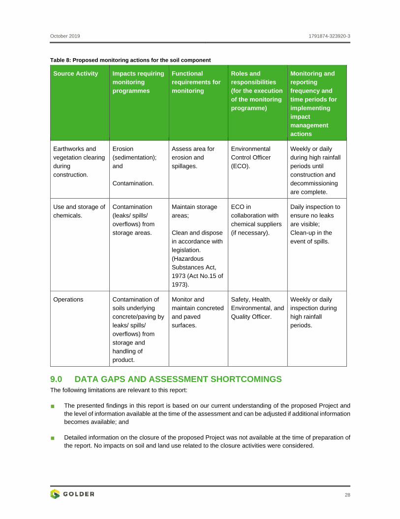
Table 8: Proposed monitoring actions for the soil component .......................................................................... 28
Table 9: Qualifications and experience of the specialists ................................................................................. 29
FIGURES
Figure 1: Regional locality map .......................................................................................................................... 2
Figure 2: Average annual maximum, minimum and average temperatures ....................................................... 7
Figure 3: Average monthly rainfall and evaporation (mm) at Station U6E003 .................................................... 9
Figure 4: Monthly rainfall boxplot for U6E003 Durban Wo station ...................................................................... 9
October 2019 1791874-323920-3
v
Figure 5: Annual rainfall measured at for U6E003 Durban Wo station ............................................................... 9
Figure 6: National Land Cover for Project Site ................................................................................................. 11
Figure 7: Soil profile showing signs of anthropogenic disturbance, characteristic of Anthrosols ...................... 12
Figure 8: Location of soil observation points for soil survey ............................................................................. 13
Figure 9: National Land Capability Classification for Project site ..................................................................... 19
APPENDICES
APPENDIX A Field Survey Plan
APPENDIX B Soil Profile Descriptions
APPENDIX C Laboratory Certificates
APPENDIX D Specialist CVs
APPENDIX E Specialist Declarations
October 2019 1791874-323920-3
1
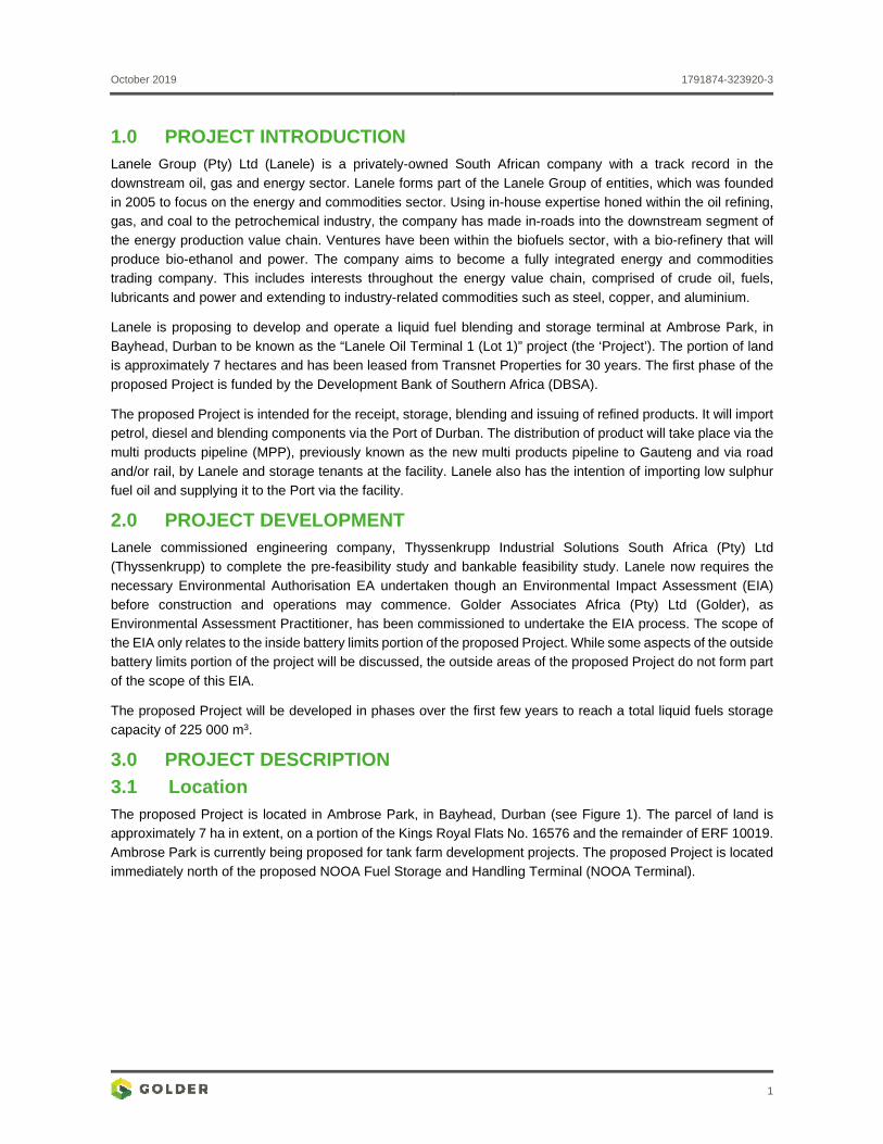
1.0 PROJECT INTRODUCTION Lanele Group (Pty) Ltd (Lanele) is a privately-owned South African company with a track record in the
downstream oil, gas and energy sector. Lanele forms part of the Lanele Group of entities, which was founded in 2005 to focus on the energy and commodities sector. Using in-house expertise honed within the oil refining, gas, and coal to the petrochemical industry, the company has made in-roads into the downstream segment of
the energy production value chain. Ventures have been within the biofuels sector, with a bio-refinery that will produce bio-ethanol and power. The company aims to become a fully integrated energy and commodities
trading company. This includes interests throughout the energy value chain, comprised of crude oil, fuels,
lubricants and power and extending to industry-related commodities such as steel, copper, and aluminium.
Lanele is proposing to develop and operate a liquid fuel blending and storage terminal at Ambrose Park, in
Bayhead, Durban to be known as the “Lanele Oil Terminal 1 (Lot 1)” project (the ‘Project’). The portion of land
is approximately 7 hectares and has been leased from Transnet Properties for 30 years. The first phase of the
proposed Project is funded by the Development Bank of Southern Africa (DBSA).
The proposed Project is intended for the receipt, storage, blending and issuing of refined products. It will import petrol, diesel and blending components via the Port of Durban. The distribution of product will take place via the
multi products pipeline (MPP), previously known as the new multi products pipeline to Gauteng and via road
and/or rail, by Lanele and storage tenants at the facility. Lanele also has the intention of importing low sulphur
fuel oil and supplying it to the Port via the facility.
2.0 PROJECT DEVELOPMENT Lanele commissioned engineering company, Thyssenkrupp Industrial Solutions South Africa (Pty) Ltd
(Thyssenkrupp) to complete the pre-feasibility study and bankable feasibility study. Lanele now requires the
necessary Environmental Authorisation EA undertaken though an Environmental Impact Assessment (EIA) before construction and operations may commence. Golder Associates Africa (Pty) Ltd (Golder), as Environmental Assessment Practitioner, has been commissioned to undertake the EIA process. The scope of
the EIA only relates to the inside battery limits portion of the proposed Project. While some aspects of the outside battery limits portion of the project will be discussed, the outside areas of the proposed Project do not form part
of the scope of this EIA.
The proposed Project will be developed in phases over the first few years to reach a total liquid fuels storage
capacity of 225 000 m3.
3.0 PROJECT DESCRIPTION
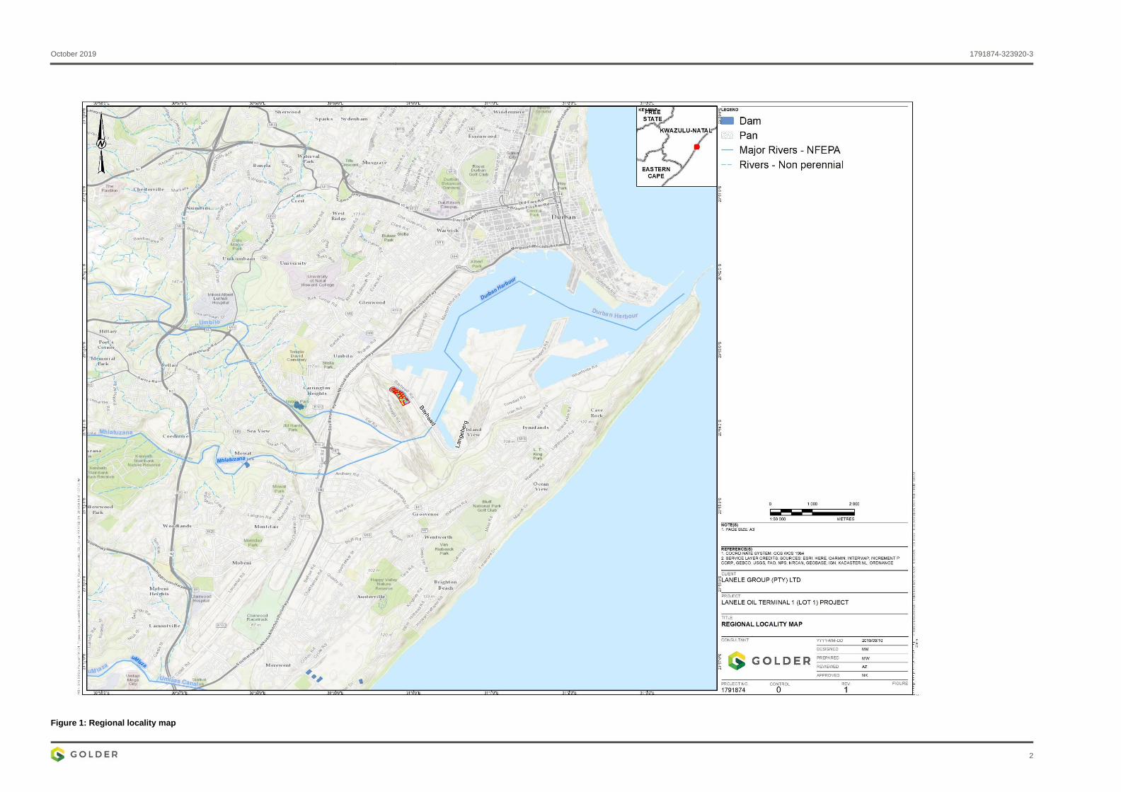
3.1 Location The proposed Project is located in Ambrose Park, in Bayhead, Durban (see Figure 1). The parcel of land is approximately 7 ha in extent, on a portion of the Kings Royal Flats No. 16576 and the remainder of ERF 10019.
Ambrose Park is currently being proposed for tank farm development projects. The proposed Project is located
immediately north of the proposed NOOA Fuel Storage and Handling Terminal (NOOA Terminal).
October 2019 1791874-323920-3
2
Figure 1: Regional locality map
October 2019 1791874-323920-3
3
3.2 Facility Details The operation of the proposed Project is primarily pipeline driven with limited gantry loading and, therefore, will
be operated as follows:
Single shift operation;
8-hour working day;
5-day working week;
21 working days per month; and
Ship receipts or pipeline injections after hours can be managed on an overtime basis with minimal staff.
The proposed facility will store mostly diesel 50 parts per million as ultra-low sulphur diesel (ULSD), special
diesel products and blends, unleaded petrol 95 octane (ULP 95), high octane blend stock, low octane ULP, aviation grade turbine kerosene (JET A1), in addition to blending components such as reformate, naphtha,
biofuels, marine gas oil (MGO) and marine fuel oil (MFO) 500 ppm according to the International Marine
Organisation (IMO) 2020 specification.
ULSD, ULP 95 and JET A1 will be received from Berths 6 and 9 (and also possibly Berth 2) in the Cutler Complex via common user infrastructure. The details of the receipt of low octane petrol, high octane blend stock
and special diesel blend stock is based on the following assumptions:
Low octane product is received from a destination approximately 5000 m away via pipeline at a rate of 600
m3/hr. Properties for calculation purposes have been assumed to be the same as ULP 95;
High octane blend stock is assumed to be reformate. It is assumed to be received from Berth 2 at a rate
of 800 m3/hr at maximum parcel size of 10 000 m3;
Low octane product is blended with high octane blend stock in a ratio of 4:1; and
Diesel blend stock is received from a destination approximately 5000 m away via pipeline at a rate of 600
m3/hr. Properties for calculation purposes have been assumed to be the same as ULSD.
ULSD, ULP 95 and JET A1 will be dispatched to Gauteng via the MPP. ULSD, ULP 95 and JET A1 will also be dispatched via road tankers. MGO will be received from Berth 2. MGO will be dispatched via pipeline to the
storage within the Port – located along side Berth 10.
The facility will have the ability to:
Blend (in-line) low octane unleaded petrol with high octane blend stock (e.g. toluene or reformate) to create
ULP 95;
Blend (in-tank) ULSD with blend stock to create special diesel products;
Add colorant (in-line) to imported ULP 95; and
Add conductivity additive (in-line) to imported ULSD product.
4.0 SPECIALIST STUDY INTRODUCTION The report provides the current soil characteristics, land capability and land use of the Project site. As part of the study, the soils within the Project site was surveyed during 21-22 November 2018. Representative samples of the modal profiles were submitted to Exova Jones Environmental Laboratory for analysis of the soil chemical
properties. The objectives of the study were to:
October 2019 1791874-323920-3
4
Conduct a detailed soils assessment on the proposed Project footprint;
Classify and map the observed soils per the South African Taxonomic Soil Classification System, 1991;
Map the current land-use within the proposed Project footprint;
Determine the impacts on soil and land use associated with the proposed Project; and
Propose environmental management actions required for the preservation of local soils (mitigation
measures).
This report presents the soil, land capability and land use impact assessment for the proposed Project.
4.1 Methodology 4.1.1 Desktop Study
The desktop study included a review of the historic and recent aerial imagery, evaluating topographic, land
cover, land use, land type maps and memoirs, and geological maps of the study area. Review of previous soil reports and soil surveys of the project area were also done. This background information was used to plan and
design the field survey.
4.1.2 Field Survey and Soil Classification
The field survey plan is provided in APPENDIX A. The soil survey was conducted per the standard soil survey techniques. During the field survey the Project site was delineated (into map units) and the natural resources,
terrain form, soil type and land use of the Project site, were recorded. The soil profile observations were
evaluated along transects, evaluating the soil at the main geological groups, land types and terrain units of the Project site. The shapefiles of the project boundary, existing and proposed infrastructure, surface water features, terrain, geology, landtype, existing land capability and land use were superimposed on Google Earth imagery
and 1:50 000 topographic map sheet to create field maps for the survey. The geographical positions of the
observation points were loaded onto a hand-held Global Positioning System to aid in field traversing of the
positions.
At each observation point, the soil was augered to a depth of 120 cm (unless an impenetrable layer was encountered restricting sampling depth) using a bucket auger. The relevant and distinct soil and landscape
features were recorded at each observation point. These included characteristics such as soil colour, texture, soil depth, stoniness, drainage class, parent material, signs of erosion, vegetation cover, micro-topography,
aspect and fauna.
For the classification, the soil characteristics were used to classify the soils according to the Taxonomic Soil Classification System for South Africa (Soil Classification Working Group, 1991). The procedure used in the
identification of the soil types using the Taxonomic Soil Classification System involved the following:
1. Demarcating the master horizons present in the profile;
2. Identifying diagnostic horizons or materials;
3. Establishing the soil form using the Key in the Classification Book;
4. Identifying family criteria;
5. Establishing the soil family; and
6. Determining the texture class of the A horizon, which was then added to the code of the soil family.
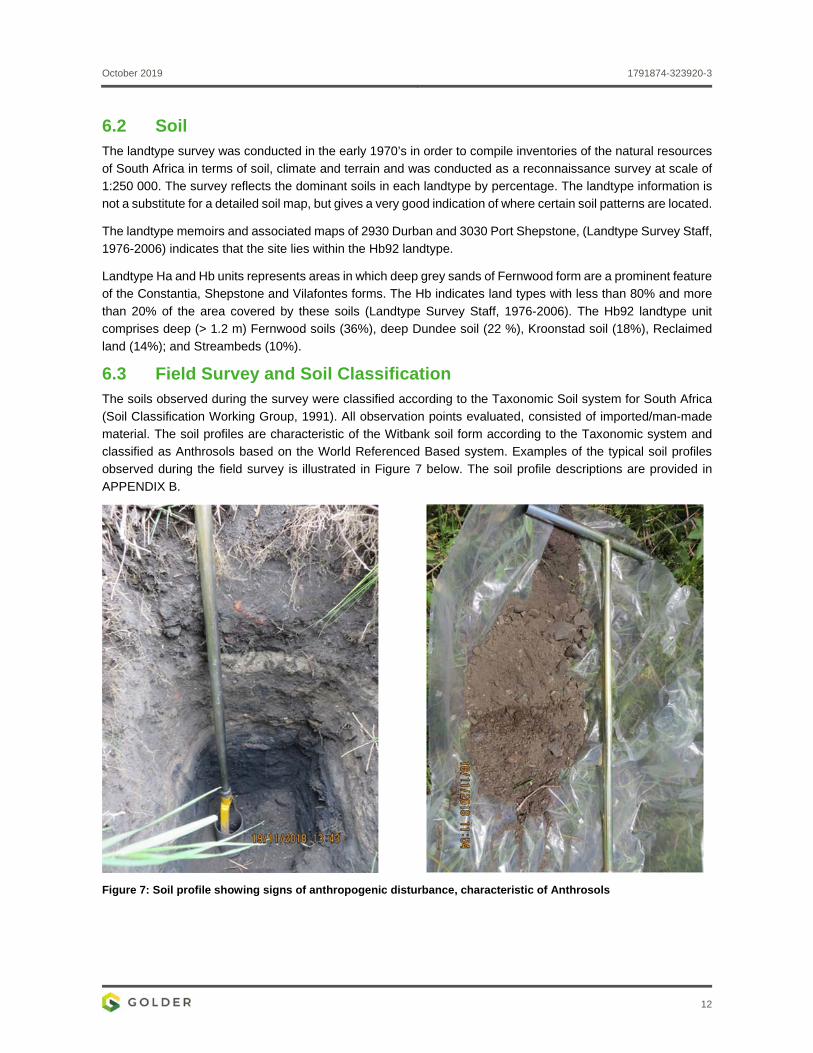
For this study, a set of 16 soil observation points within the Project site were evaluated and soil samples of the representative topsoil and subsoil horizons were collected (locations of observation points for the transect walks
are presented in Figure 8).
October 2019 1791874-323920-3
5
4.1.3 Soil Sampling and Analysis
Representative samples of the soil horizons were submitted to Exova Jones Environmental Laboratory for
analysis of the soil chemical properties including the following parameters:
Total elemental composition - aqua regia digestion, determination of trace metal elements by ICP-OES (Inductively Coupled Plasma - Optical Emission Spectrometry);
pH - extraction of solid samples using one part solid to 2.5 parts deionised water, determination of pH by
Metrohm automated probe analyser; and
Electrical Conductivity (EC) - extraction of solid samples using one part solid to 5 parts deionised water, the samples are shaken on an orbital shaker, determination of Specific Conductance by Metrohm
automated probe analyser.
4.2 Land Evaluation 4.2.1 Baseline Contaminated Land Status
Contaminated land legislation in South Africa strongly relates to the polluter pays principle and the tiered (phased) risk assessment approach. The proposed Project lies within an industrial area. Establishing baseline
soil characteristics and understanding the soil’s contamination status, is valuable for land owners who intend using land for industrial purposes where operations could potentially result in soil contamination. In order to discern if soil is contaminated, contaminant levels are compared with tabulated soil screening levels. If soil
screening levels are exceeded, then a site-specific risk assessment must be performed. If the outcome of this site-specific risk assessment indicates that there are unacceptable risks, then the Regulator needs to be informed to decide whether the site must be remediated (immediately or within a specified period) or does not
present an immediate risk, but must be monitored and managed or is not contaminated.
Given the nature of the Project, and the location thereof, the soil chemical properties were compared to the soil
screening values (SSV’s) published National Norms and Standards for the Remediation of Contaminated Land
and Soil Quality (published under Government Notice 331 in Government Gazette 37603 of 2 May 2014).
Soil screening values (SSVs) are used to assess whether constituents present in the soils require further in-
depth assessment:
SSV1: These SSVs are conservative concentrations that are the lowest of three potential source-pathway-
receptor model calculations:
Direct pathways for the protection of the child receptor taken as the most sensitive receptor in the
context of potentially high exposures anticipated for informal residential settlements in South Africa;
Indirect pathway for the protection of water resources in terms of human health based on the ingestion of drinking water. The model for contaminant transfer from soil to water is based on simplified partitioning model with allowance for finite limited dispersion, dilution and attenuation within the
groundwater-surface water medium, assuming a shallow water table within a typical porous sand
aquifer;
Indirect pathway for the protection of aquatic ecosystems by applying aquatic eco-toxicology to the same assumptions used to define the soil to surface water pathway used in the calculation of the
human health related water resource protection; and
The SSV1 represent soil values required to achieve Department Water Affairs Water Quality Guideline
levels for aquatic ecosystem protection and domestic water use, and are consistent both in terms of
October 2019 1791874-323920-3
6
method of derivation and acceptable risk level applied in development of the existing DWA Water
Quality Guidelines.
SSV2: If no risk to the water resource can be identified, then soil contaminant levels should be compared
to SSV2:
SSV2 Residential (Informal or Standard): The most sensitive is the child receptor, taken as the
sensitive receptor for informal settlements, since the exposure levels for the child on a standard
residential development define a slightly higher level of contaminant concentration;
SSV2 Commercial/Industrial: Commercial and industrial land use is defined by exposure criteria for an
adult maintenance worker based on outdoor exposure criteria; and
If the values are less than the most appropriate of the three categories of Soil Screening Value 2, then
the site is not a risk to human health and is not defined as being contaminated.
For this site SSV1s are used as the groundwater is considered the main water source that could potentially be
impacted.
The analytical results were also compared to the United States Environmental Protection Agency (US EPA)
Region 9 Soil Screening Levels (SSL). The SSLs are derived using conservative assumptions about site conditions and are likely to be more stringent than SSLs developed using more site-specific approaches. The
risk-based screening levels for the protection of groundwater are the most conservative values for most constituents and these were used to conduct the initial screening for constituents that may require further assessment (US EPA, 2017). The risk-based screening levels as presented in the table uses a Dilution Factor
of 1. As a conservative Phase 1 screening, a dilution factor of 20 was used according to the methodology of
screening indicated by the US EPA.
4.2.2 Soil and Land Capability Classification
The land capability of project footprints are usually assessed in accordance with the definitions and system
outlined by Scotney et al. (1987) and updated for South African soils by the Agricultural Research Council
(Schoeman, 2000), and compared to the National Land Capability values (DAFF, 2017).
4.2.3 Land Use Mapping
The current land use of the study area was mapped and described in accordance to the Spatial Planning and
Land Use Management Act 16 of 2013.
5.0 POLICY LEGAL AND ADMINISTRATIVE FRAMEWORK This specialist study is undertaken in accordance with the following legal and administrative framework
documents:
Environmental Impact Assessment Regulations of 2014 (published under Government Notice R982 of
Government Gazette 38282 of 4 December 2014, as amended);
International Finance Corporation (IFC) documents:
Performance Standards on Environmental and Social Sustainability (2012);
General Environment, Health and Safety (EHS) Guidelines (2007);
EHS Guidelines for Ports, Harbours and Terminals (2007); and
EHS Guidelines for Crude Oil and Petroleum Product Terminals (2007).
DBSA Environmental and Social Safeguards Standards (2018).
October 2019 1791874-323920-3
7
The following section outlines a summary of South African Environmental Legislation that needs to be
considered for the proposed Project with regards to management of soil:
The Bill of Rights states that environmental rights exist primarily to ensure good health and well-being, and
secondarily to protect the environment through reasonable legislation, ensuring the prevention of the
degradation of resources;
The environmental right is furthered in the National Environmental Management Act 107 of 1998 (NEMA), which prescribes three principles, namely the precautionary principle, the “polluter pays” principle and the preventive principle. It is stated in the above-mentioned Act that the individual/group responsible for the
degradation/pollution of natural resources is required to rehabilitate the polluted source;
Soils and land capability are protected under the NEMA, the Environment Conservation Act 73 of 1989,
the Minerals Act 50 of 1991 and the Conservation of Agricultural Resources Act 43 of 1983;
The NEMA requires that pollution and degradation of the environment be avoided or, where it cannot be
avoided, be minimised and remedied; and
The Conservation of Agriculture Resources Act 43 of 1983 requires the protection of land against soil
erosion and the prevention of water logging and salinisation of soils by means of suitable soil conservation works to be constructed and maintained. The utilisation of marshes, water sponges and watercourses is
also addressed.
6.0 BASELINE DESCRIPTION
6.1 Environmental Setting 6.1.1 Temperature
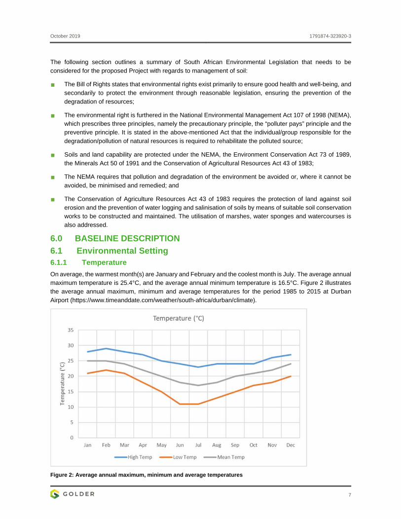
On average, the warmest month(s) are January and February and the coolest month is July. The average annual maximum temperature is 25.4°C, and the average annual minimum temperature is 16.5°C. Figure 2 illustrates
the average annual maximum, minimum and average temperatures for the period 1985 to 2015 at Durban
Airport (https://www.timeanddate.com/weather/south-africa/durban/climate).
Figure 2: Average annual maximum, minimum and average temperatures
October 2019 1791874-323920-3
8
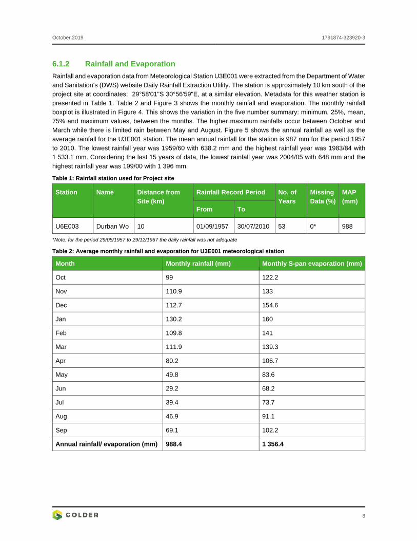
6.1.2 Rainfall and Evaporation
Rainfall and evaporation data from Meteorological Station U3E001 were extracted from the Department of Water and Sanitation’s (DWS) website Daily Rainfall Extraction Utility. The station is approximately 10 km south of the
project site at coordinates: 29°58'01"S 30°56'59"E, at a similar elevation. Metadata for this weather station is presented in Table 1. Table 2 and Figure 3 shows the monthly rainfall and evaporation. The monthly rainfall
boxplot is illustrated in Figure 4. This shows the variation in the five number summary: minimum, 25%, mean,
75% and maximum values, between the months. The higher maximum rainfalls occur between October and March while there is limited rain between May and August. Figure 5 shows the annual rainfall as well as the average rainfall for the U3E001 station. The mean annual rainfall for the station is 987 mm for the period 1957
to 2010. The lowest rainfall year was 1959/60 with 638.2 mm and the highest rainfall year was 1983/84 with 1 533.1 mm. Considering the last 15 years of data, the lowest rainfall year was 2004/05 with 648 mm and the
highest rainfall year was 199/00 with 1 396 mm.
Table 1: Rainfall station used for Project site
Station Name Distance from Site (km)
Rainfall Record Period No. of Years
Missing Data (%)
MAP (mm)
From To
U6E003 Durban Wo 10 01/09/1957 30/07/2010 53 0* 988
*Note: for the period 29/05/1957 to 29/12/1967 the daily rainfall was not adequate
Table 2: Average monthly rainfall and evaporation for U3E001 meteorological station
Month Monthly rainfall (mm) Monthly S-pan evaporation (mm)
Oct 99 122.2
Nov 110.9 133
Dec 112.7 154.6
Jan 130.2 160
Feb 109.8 141
Mar 111.9 139.3
Apr 80.2 106.7
May 49.8 83.6
Jun 29.2 68.2
Jul 39.4 73.7
Aug 46.9 91.1
Sep 69.1 102.2
Annual rainfall/ evaporation (mm) 988.4 1 356.4
October 2019 1791874-323920-3
9
Figure 3: Average monthly rainfall and evaporation (mm) at Station U6E003
Figure 4: Monthly rainfall boxplot for U6E003 Durban Wo station
Figure 5: Annual rainfall measured at for U6E003 Durban Wo station
6.1.3 Topography
The Project site is a narrow site approximately 680 m long and 160 m wide. The topography of the length of the
site varies from 7 metres above mean above mean sea level (mamsl) on the northern side, to 3 mamsl at the
October 2019 1791874-323920-3
10
stormwater channel, approximately 110 m into the site, and then remaining between 5 and 8 mamsl, with the
most southern side being at 4 mamsl. The western side of the site is slightly higher than the eastern side, with
a drop of about 0.7 m across the site, so that current water flow would be from west to east.
6.1.4 Geology
The local geology of the Project site is predominantly characterised by quaternary deposits in the form of beach
sand and dune deposits, underlain by estuarine deposits. Drilling conducted on the site in 2018 showed Carboniferous Karoo Supergroup lithology: dark grey, fine to coarse grained, Diamictite rock at an average depth of depth of about 29 m. The Dwyka Group rocks also comprises of shales and mudstones, but these were
not intersected from the drilled holes (Golder, 2018).
According to the published geological sheet (2930 DURBAN), the regional-scale geology is characterised by
Quaternary Berea and Bluff Sands deposits to the north-west and south-east of the site respectively (including red, yellow, brown and purple) and estuarine/alluvial deposits (known locally as Harbour beds), as well as Dwyka Diamictite (polymictic clasts, set in a poorly sorted fine grained matrix), with varved shale, mudstone with
dropstones and fluvioglacial gravel. Thick beds of dark grey, soft, silty clay (known locally as Hippo Mud) are
intercalated with the estuarine/alluvial sands.
6.1.5 Land Use
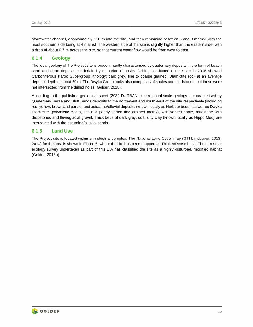
The Project site is located within an industrial complex. The National Land Cover map (GTI Landcover, 2013-
2014) for the area is shown in Figure 6, where the site has been mapped as Thicket/Dense bush. The terrestrial
ecology survey undertaken as part of this EIA has classified the site as a highly disturbed, modified habitat
(Golder, 2018b).
October 2019 1791874-323920-3
11
Figure 6: National Land Cover for Project Site
October 2019 1791874-323920-3
12
6.2 Soil The landtype survey was conducted in the early 1970’s in order to compile inventories of the natural resources
of South Africa in terms of soil, climate and terrain and was conducted as a reconnaissance survey at scale of 1:250 000. The survey reflects the dominant soils in each landtype by percentage. The landtype information is
not a substitute for a detailed soil map, but gives a very good indication of where certain soil patterns are located.
The landtype memoirs and associated maps of 2930 Durban and 3030 Port Shepstone, (Landtype Survey Staff,
1976-2006) indicates that the site lies within the Hb92 landtype.
Landtype Ha and Hb units represents areas in which deep grey sands of Fernwood form are a prominent feature of the Constantia, Shepstone and Vilafontes forms. The Hb indicates land types with less than 80% and more
than 20% of the area covered by these soils (Landtype Survey Staff, 1976-2006). The Hb92 landtype unit comprises deep (> 1.2 m) Fernwood soils (36%), deep Dundee soil (22 %), Kroonstad soil (18%), Reclaimed
land (14%); and Streambeds (10%).
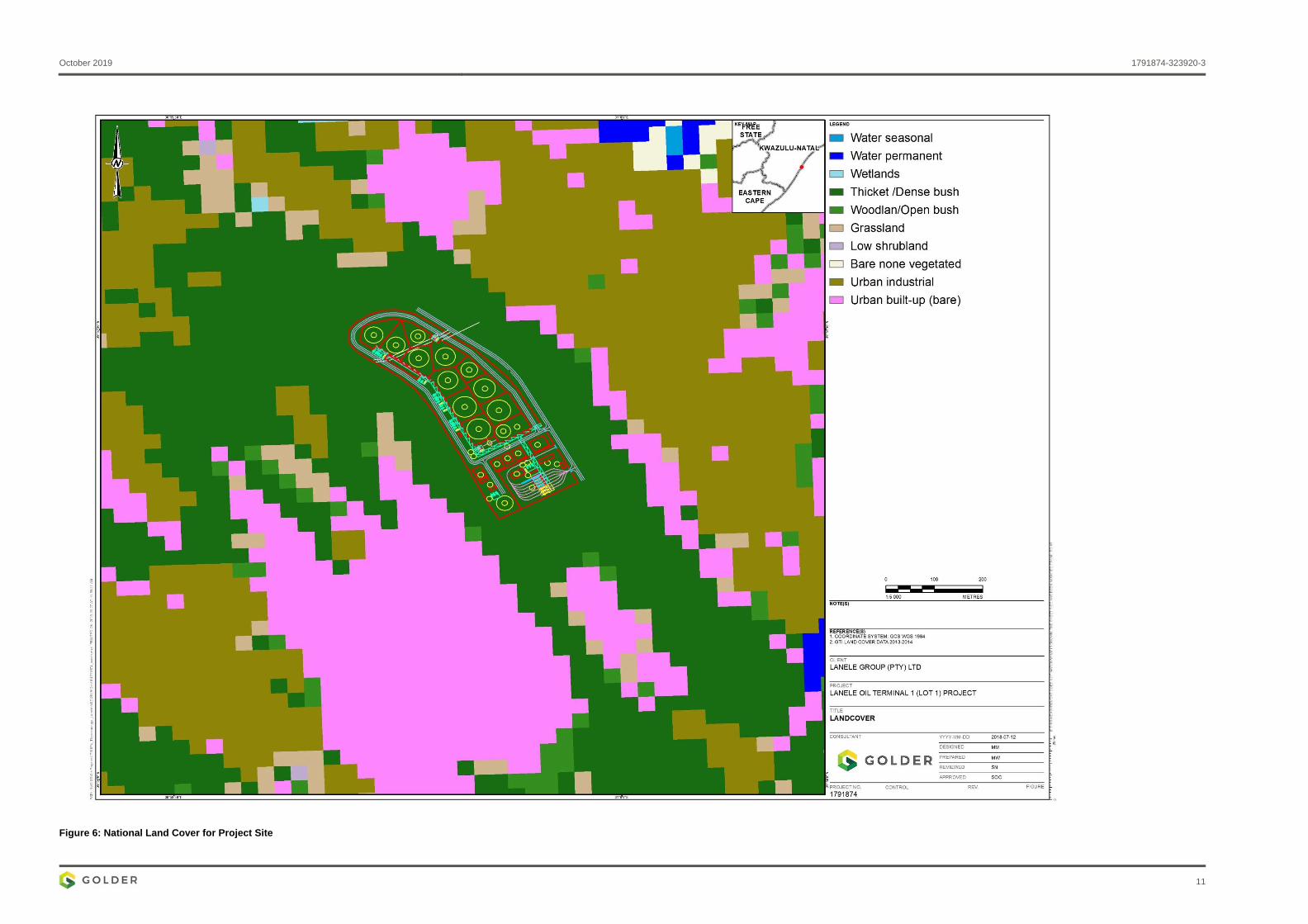
6.3 Field Survey and Soil Classification The soils observed during the survey were classified according to the Taxonomic Soil system for South Africa
(Soil Classification Working Group, 1991). All observation points evaluated, consisted of imported/man-made
material. The soil profiles are characteristic of the Witbank soil form according to the Taxonomic system and classified as Anthrosols based on the World Referenced Based system. Examples of the typical soil profiles observed during the field survey is illustrated in Figure 7 below. The soil profile descriptions are provided in
APPENDIX B.
Figure 7: Soil profile showing signs of anthropogenic disturbance, characteristic of Anthrosols
October 2019 1791874-323920-3
13
Figure 8: Location of soil observation points for soil survey
October 2019 1791874-323920-3
14
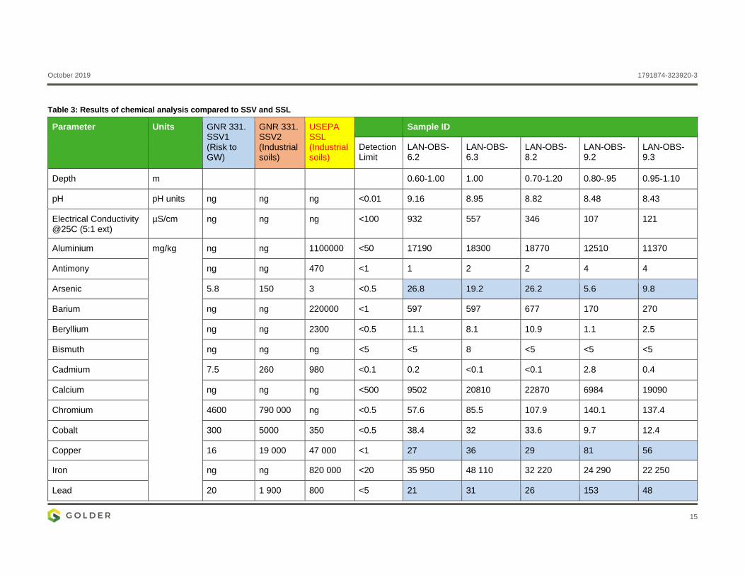
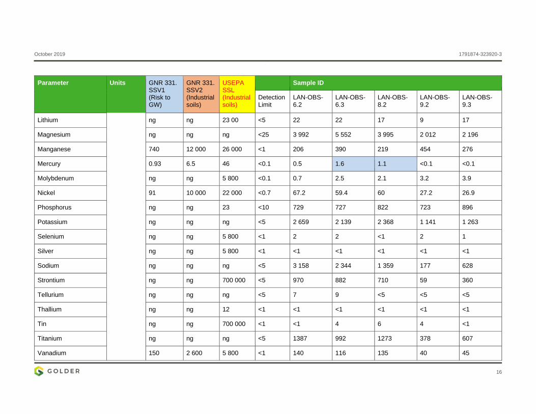
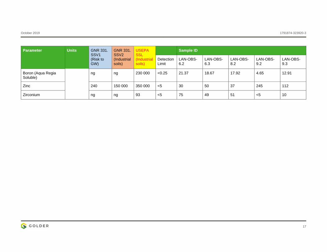
6.4 Soil Chemical Characteristics A summary of analytical laboratory results of sampled representative soil profiles is presented in Table 3.
Laboratory certificates of the analysis are presented in APPENDIX C.
The soil chemical results were evaluated using the soil screening values as described in Section 4.2.1. The
soils have the following chemical characteristics:
The pH of samples analysed are alkaline and range from 8.4 – 9.2;
The total concentration of Arsenic in all samples exceed the SSV1 (> 5.8 mg/kg) and the SSL for industrial
soils (> 3 mg/kg);
The total concentration of Copper and Lead in all samples exceed the SSV1;
The total concentration of Mercury in 2 samples (OB 6.3 and OB 8.2) exceed the SSV1 (> 0.93 mg/kg);
and
The concentrations of all constituents in all the soil samples were < SSV2 Industrial.
Given that the Project site is undeveloped and there are no on-site sources of contamination, the source of the
soil contamination is likely to be linked to the origin of the top layer of soil covering the site. While the laboratory results indicate that there are exceedances of the SSV1 and therefore a risk of potential groundwater
contamination exists, the results are within the SSV2 limits and as such the risk to the general public is
considered to be low.
October 2019 1791874-323920-3
15
Table 3: Results of chemical analysis compared to SSV and SSL
Parameter Units GNR 331. SSV1 (Risk to GW)
GNR 331. SSV2 (Industrial soils)
USEPA SSL (Industrial soils)
Sample ID
Detection Limit
LAN-OBS-6.2
LAN-OBS-6.3
LAN-OBS-8.2
LAN-OBS-9.2
LAN-OBS-9.3
Depth m
0.60-1.00 1.00 0.70-1.20 0.80-.95 0.95-1.10
pH pH units ng ng ng <0.01 9.16 8.95 8.82 8.48 8.43
Electrical Conductivity @25C (5:1 ext)
µS/cm ng ng ng <100 932 557 346 107 121
Aluminium mg/kg ng ng 1100000 <50 17190 18300 18770 12510 11370
Antimony ng ng 470 <1 1 2 2 4 4
Arsenic 5.8 150 3 <0.5 26.8 19.2 26.2 5.6 9.8
Barium ng ng 220000 <1 597 597 677 170 270
Beryllium ng ng 2300 <0.5 11.1 8.1 10.9 1.1 2.5
Bismuth ng ng ng <5 <5 8 <5 <5 <5
Cadmium 7.5 260 980 <0.1 0.2 <0.1 <0.1 2.8 0.4
Calcium ng ng ng <500 9502 20810 22870 6984 19090
Chromium 4600 790 000 ng <0.5 57.6 85.5 107.9 140.1 137.4
Cobalt 300 5000 350 <0.5 38.4 32 33.6 9.7 12.4
Copper 16 19 000 47 000 <1 27 36 29 81 56
Iron ng ng 820 000 <20 35 950 48 110 32 220 24 290 22 250
Lead 20 1 900 800 <5 21 31 26 153 48
October 2019 1791874-323920-3
16
Parameter Units GNR 331. SSV1 (Risk to GW)
GNR 331. SSV2 (Industrial soils)
USEPA SSL (Industrial soils)
Sample ID
Detection Limit
LAN-OBS-6.2
LAN-OBS-6.3
LAN-OBS-8.2
LAN-OBS-9.2
LAN-OBS-9.3
Lithium ng ng 23 00 <5 22 22 17 9 17
Magnesium ng ng ng <25 3 992 5 552 3 995 2 012 2 196
Manganese 740 12 000 26 000 <1 206 390 219 454 276
Mercury 0.93 6.5 46 <0.1 0.5 1.6 1.1 <0.1 <0.1
Molybdenum ng ng 5 800 <0.1 0.7 2.5 2.1 3.2 3.9
Nickel 91 10 000 22 000 <0.7 67.2 59.4 60 27.2 26.9
Phosphorus ng ng 23 <10 729 727 822 723 896
Potassium ng ng ng <5 2 659 2 139 2 368 1 141 1 263
Selenium ng ng 5 800 <1 2 2 <1 2 1
Silver ng ng 5 800 <1 <1 <1 <1 <1 <1
Sodium ng ng ng <5 3 158 2 344 1 359 177 628
Strontium ng ng 700 000 <5 970 882 710 59 360
Tellurium ng ng ng <5 7 9 <5 <5 <5
Thallium ng ng 12 <1 <1 <1 <1 <1 <1
Tin ng ng 700 000 <1 <1 4 6 4 <1
Titanium ng ng ng <5 1387 992 1273 378 607
Vanadium 150 2 600 5 800 <1 140 116 135 40 45
October 2019 1791874-323920-3
17
Parameter Units GNR 331. SSV1 (Risk to GW)
GNR 331. SSV2 (Industrial soils)
USEPA SSL (Industrial soils)
Sample ID
Detection Limit
LAN-OBS-6.2
LAN-OBS-6.3
LAN-OBS-8.2
LAN-OBS-9.2
LAN-OBS-9.3
Boron (Aqua Regia Soluble)
ng ng 230 000 <0.25 21.37 18.67 17.92 4.65 12.91
Zinc 240 150 000 350 000 <5 30 50 37 245 112
Zirconium ng ng 93 <5 75 49 51 <5 10
October 2019 1791874-323920-3
18
6.5 Land Capability The National Land Capability Classification was undertaken at a national scale, using the landtype data on a scale of 1:250 000 (DAFF, 2017). The land capability for the Project site, as defined in the National Land
Capability for South Africa, is classified as low-moderate to moderate - high capability (Figure 9). Given the location (within an existing industrial complex) of this land and the degree of land disturbance (fill material thickness of 2 -3 metres below ground level ((mbgl), the National Land Capability Classification described above
is not representative of the current conditions and thus the current land capability.
This was decided based on the findings of the soil field survey and the Geotechnical investigation of the Project
site. Standard soil survey approaches evaluate the soil characteristics within the 1.2 mbgl soil depth. The field survey and the geotechnical investigation found that natural soil was found at 2-3 mbgl. The surface material was classified as “fill” material (imported (manmade) material dumped onto original ground surface). Since the
material within the 0 – 1.2 mbgl fraction is not representative of the natural soil properties, conducting a land capability assessment based on the definitions and systems used for natural South African soils would not be
appropriate or meaningful.

October 2019 1791874-323920-3
19
Figure 9: National Land Capability Classification for Project site
October 2019 1791874-323920-3
20
7.0 ENVIRONMENTAL IMPACT ASSESSMENT
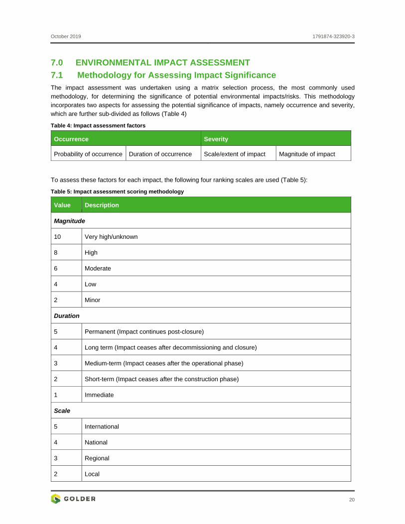
7.1 Methodology for Assessing Impact Significance The impact assessment was undertaken using a matrix selection process, the most commonly used
methodology, for determining the significance of potential environmental impacts/risks. This methodology incorporates two aspects for assessing the potential significance of impacts, namely occurrence and severity,
which are further sub-divided as follows (Table 4)
Table 4: Impact assessment factors
Occurrence Severity
Probability of occurrence Duration of occurrence Scale/extent of impact Magnitude of impact
To assess these factors for each impact, the following four ranking scales are used (Table 5):
Table 5: Impact assessment scoring methodology
Value Description
Magnitude
10 Very high/unknown
8 High
6 Moderate
4 Low
2 Minor
Duration
5 Permanent (Impact continues post-closure)
4 Long term (Impact ceases after decommissioning and closure)
3 Medium-term (Impact ceases after the operational phase)
2 Short-term (Impact ceases after the construction phase)
1 Immediate
Scale
5 International
4 National
3 Regional
2 Local
October 2019 1791874-323920-3
21
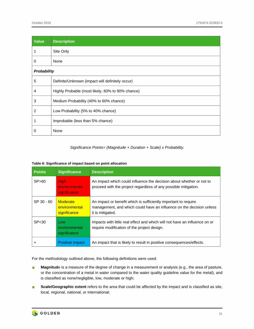
Value Description
1 Site Only
0 None
Probability
5 Definite/Unknown (impact will definitely occur)
4 Highly Probable (most likely, 60% to 90% chance)
3 Medium Probability (40% to 60% chance)
2 Low Probability (5% to 40% chance)
1 Improbable (less than 5% chance)
0 None
Significance Points= (Magnitude + Duration + Scale) x Probability.
Table 6: Significance of impact based on point allocation
Points Significance Description
SP>60 High environmental significance
An impact which could influence the decision about whether or not to proceed with the project regardless of any possible mitigation.
SP 30 - 60 Moderate environmental
significance
An impact or benefit which is sufficiently important to require management, and which could have an influence on the decision unless
it is mitigated.
SP<30 Low
environmental significance
Impacts with little real effect and which will not have an influence on or
require modification of the project design.
+ Positive impact An impact that is likely to result in positive consequences/effects.
For the methodology outlined above, the following definitions were used:
Magnitude is a measure of the degree of change in a measurement or analysis (e.g., the area of pasture, or the concentration of a metal in water compared to the water quality guideline value for the metal), and
is classified as none/negligible, low, moderate or high;
Scale/Geographic extent refers to the area that could be affected by the impact and is classified as site,
local, regional, national, or international;
October 2019 1791874-323920-3
22
Duration refers to the length of time over which an environmental impact may occur: i.e.
immediate/transient, short-term, medium term, long-term, or permanent; and
Probability of occurrence is a description of the probability of the impact actually occurring as improbable (less than 5% chance), low probability (5% to 40% chance), medium probability (40% to 60% chance), highly probable (most likely, 60% to 90% chance) or definite (impact will definitely occur).
7.2 Project Phases The soil impacts of the proposed Project were assessed based on the following understanding of actions (related
to the soil) anticipated during the following phases:
Construction phase:
The entire Project site will be levelled (or levelled terraces will be created). To create the ideal conditions for compaction, a large quantity of soil material will be removed and replaced with compactable material.
Operational phase:
The operation of the proposed Project is described in Section 3.2. Activities which may potentially impact
soils relate to:
The import of refined product via the Port of Durban and the distribution via pipeline; and
Storage, blending and issuing (road loading) of liquid fuels.
Closure phase:
It is understood that once the lease with Transnet expires, the facility will be sold or decommissioned. No
details regarding the decommissioning and closure of the facility was available at the time of preparation of this assessment. Thus, the impacts on soil and land use during this phase will not be assessed as part
of this study.
7.3 Detailed Description of Potential Impacts during all Phases of the Proposed Project
7.3.1 Soil aspects impacted
The key soil aspects affected due to the proposed Project activities are soil erosion and soil contamination.
7.3.1.1 Soil Erosion
Construction Phase
During the construction phase, areas which were initially covered with vegetation will be exposed, resulting in
the increased susceptibility of the soils to erosion. This effect is more pronounced when vegetation is removed, and the soil is left bare during the rainy season, or for stockpiled soils (with steep slopes, side slopes steeper than 1 in 3), which have not been vegetated before the start of the rainy season. Given the disruptive nature of
the earth moving activities anticipated during the pre-construction and construction phases, the soil
characteristics controlling the soil erodibility (soil organic matter content, structure and permeability) are likely to be altered. During the rainy season soil erosion will occur from runoff of stockpiled soil material to adjacent
lower land areas where materials will be deposited or cause sedimentation of streams or water courses.
The significance of the impact of soil erosion is rated as low during the construction phase. With appropriate
mitigation measures, the significance of this impact can remain low.
October 2019 1791874-323920-3
23
Operation Phase
It is understood that most of the surface of the Project site will be covered by either concrete (around facility infrastructural units), asphalt (roads) and paving, with smaller portions of grassed areas. Since the Project site will be covered at the operational stage of the Project, no soil erosion is foreseen, given that the soil surfaces
remain covered by the materials described above.
Closure
During the decommissioning and closure phase, areas which were initially covered with paving and concrete
will be exposed, resulting in the increased susceptibility of the underlying soils to erosion. This effect is more
pronounced when hardtop is removed, and the soil is left bare during the rainy season, or for stockpiled soils (with steep slopes, side slopes steeper than 1 in 3), which have not been vegetated before the start of the rainy
season.
Given the disruptive nature of the demolition activities anticipated during the closure phase, the soil
characteristics controlling the soil erodibility (soil organic matter content, structure and permeability) are likely
to be altered.
Furthermore, during the rainy season soil erosion will occur from runoff of stockpiled soil material to adjacent
low-lying areas where materials will be deposited or cause sedimentation of streams or water courses.
The significance of the impact of soil erosion is rated as low during the closure phase. With appropriate
mitigation measures, the significance of this impact can remain low.
7.3.1.2 Soil Contamination
Construction Phase
Soil contamination during this phase will mostly be caused by accidental spills of hydrocarbons, cement or concrete. The contamination of topsoil from cement mixing is also anticipated during the construction phase. Soil contamination will minimise the land suitability for other land uses outside of industrial due to the potential human health risk associated with contaminated soils. The impact significance is considered medium, given the effect will be localised and has the potential to be long-term if contaminants are not removed or contained. With appropriate mitigation measures, the significance of this impact can be low.
Operation Phase
Since the Project site will be covered at the operational stage of the proposed Project, the only likely pathways for soil contamination (from accidental spillages or leaks) are cracks in concrete or paving. The impact significance is considered medium, given soil contamination may be a source and pathway for groundwater contamination. With appropriate mitigation measures, the significance of this impact can be low.
Closure
Soil contamination during the closure phase will mostly be caused by new and historical spills of hydrocarbons. Soil contamination will minimise the land suitability for other land uses outside of industrial due to the potential human health risk associated with contaminated soils.
The impact significance is considered low, given the effect will be localised and has the potential to be long-term if contaminants are not removed or contained. With appropriate mitigation measures, the significance of this impact can be low.
7.4 Impact Assessment Summary All the predicted environmental impacts resulting from the proposed Project activities are described in Table 7
along with their significance ratings before and after mitigation.
October 2019 1791874-323920-3
24
Table 7: Rating of Impacts before and after mitigation
ACTIVITY POTENTIAL IMPACT ASPECTS
AFFECTED
Mag
nit
ud
e
Du
rati
on
Sca
le
Pro
bab
ility
Sig
nif
ican
ce
Sig
nif
ican
ce w
ith
ou
t
Mit
iga
tio
n
Mag
nit
ud
e
Du
rati
on
Sca
le
Pro
bab
ility
Sig
nif
ican
ce
Sig
nif
ican
ce w
ith
Mit
igat
ion
Construction Phase
Vegetation clearance and soil removal and soil
levelling
Disturbance of soil, resulting in
increased decomposition of soil
organic matter from topsoil
Loss of soils through erosion,
particularly for topsoil stockpiles with
unvegetated steep slopes.
Soil degradation
and subsequent
erosion
4 2 1 3 21 Low 2 2 1 2 10 Low
Construction of facility and access roads, Soil contamination from hydrocarbon
and chemical spills including
sterilisation by cement pollutants.
Soil quality 4 2 1 3 21 Low 2 2 1 2 10 Low
Operational Phase
Import of refined product via the port of
Durban and the distribution via pipeline
Soil contamination from hydrocarbon
and chemical spills or leaks from
pipeline on damaged or cracked
concrete/paved surfaces.
Soil quality 8 5 2 2 30 Moderate 4 3 1 2 16 Low
Storage, blending and issuing (road loading)
of refined products
Soil contamination from hydrocarbon
and chemical spills on damaged or
cracked concrete/paved surfaces.
Soil quality 8 5 2 2 30 Moderate 4 3 1 2 16 Low
October 2019 1791874-323920-3
25
8.0 ENVIRONMENTAL MANAGEMENT PROGRAMME This Environmental Management Programme (EMPr) addresses the management of potential environmental
impacts related to the proposed road realignment project. The EMPr is used for managing, mitigating, and monitoring of the environmental impacts associated with construction, operational and rehabilitation phases of
the realigned route.
8.1 Objectives Manage soil quality during the project phases.
8.2 Environmental Management and Mitigation Measures Identified A summary of mitigation measures should be presented:
For negative impacts (either/or):
Avoid;
Minimize;
Rehabilitate/Repair; or
Compensate.
For positive impacts:
Enhance.
8.3 Potential Cumulative Impacts Identified Since the Project site is located adjacent to other proposed tank farm developments and other industrial land uses, the cumulative impact on soil and land capability and potential for other land uses is considered low given
this context.
8.4 Potential Impacts to be Mitigated in their Respective Phases The following potential impacts will be mitigated.
Construction Phase
Loss of soils through erosion, particularly for stockpiled soils with unvegetated steep slopes; and
Soil contamination from hydrocarbon and chemical spills including sterilisation by cement pollutants.
Operational Phase
Storage of hazardous substances and materials to avoid and/or minimise chemical leaks/spills causing
contamination of soil and water resources; and
Overflow from contaminated storage facilities to avoid and/or minimize increased contaminated run-off
onto unsealed areas (grassed areas).
8.5 Summary of Mitigation and Management Measures for the Construction, Operational, Decommissioning and Closure Phases
8.5.1 Soil Erosion Erosion control measures need to be defined in a Land Clearance Form. The specific actions must indicate how
the following recommendations will be implemented:
October 2019 1791874-323920-3
26
a) Drainage channels must be developed as per the stormwater management plan and maintained. Drainage channels and soakaways must direct runoff away from cleared areas, but not into streams or rivers;
b) Sediment deposited in drainage channels must be removed prior to the rainy season or when channels are deemed to be full;
c) Provide adequate road drainage based on climate, road width, surface material, compaction, and maintenance; and
d) Periodic erosion monitoring to be undertaken in cleared areas.
Additional optional measures
Should erosion be evident or potentially likely, the following additional erosion controls can be utilised:
Mulching (applying organic materials) to stabilise exposed areas;
Lining steep channels and slopes (e.g. use jute matting);
Reducing or preventing off-site sediment transport through use of settlement ponds or silt fences;
Consideration needs to be given to the use of water for dust suppression– use of binding agents like molasses should be considered for unsealed roads and for dust suppression (relevant for pre-construction
and construction phases);
Creating buffer strips of vegetation around land clearance areas to slow down runoff upstream and
downstream;
Minimize:
Minimise erosion by designing and constructing access roads along gentle slopes and with drainage channels along the roads spaced at intervals dictated by the slope, rainfall pattern and erodibility;
Reduce:
Implement soil erosion minimisation techniques such as:
Scheduling construction and maintenance to avoid heavy rainfall periods (i.e., during the dry
season) to the extent practical;
Re-vegetating disturbed areas promptly;
Designing channels for post-construction flows as per stormwater management plan;
Restore:
Not applicable.
Compensate:
Not applicable.
Enhance:
Not applicable.
Monitoring Mechanism:
Environmental auditing to verify contractor compliance and soils handling and rehab procedures being
implemented; and
Annual maintenance inspections of drainage channels.
October 2019 1791874-323920-3
27
8.5.2 Soil Contamination
Avoid:
Ensure proper handling and storage of hazardous chemicals and materials (e.g. fuel, oil, cement, concrete, reagents, etc.) as per their corresponding safety data sheets; and
Maintenance of vehicles and equipment should be carried out in designated appropriate facilities fitted
with spillage containment, floors and sumps to capture any fugitive oils and greases.
Reduce:
Implementing regular site inspections for materials handling and storage as well as pipeline monitoring.
Restore:
Development of detailed procedures for spills containment and soils clean up.
Compensate:
Not applicable.
Enhance:
Not applicable.
Monitoring mechanisms:
Environmental inspections and auditing.
8.6 Mechanisms for Monitoring Compliance Mechanisms for compliance monitoring with and performance assessment against the environmental
management programme and reporting thereof, including:
Monitoring of impact management actions;
Monitoring and reporting frequency;
Responsible persons;
Time period for implementing impact management actions; and
Mechanisms for monitoring compliance.
The impact of the proposed Project activities on soil can be monitored by the following methods provided in
Table 8.
October 2019 1791874-323920-3
28
Table 8: Proposed monitoring actions for the soil component
Source Activity Impacts requiring monitoring
programmes
Functional requirements for
monitoring
Roles and responsibilities
(for the execution
of the monitoring programme)
Monitoring and reporting
frequency and
time periods for implementing
impact management actions
Earthworks and vegetation clearing
during construction.
Erosion (sedimentation);
and Contamination.
Assess area for erosion and
spillages.
Environmental Control Officer
(ECO).
Weekly or daily during high rainfall
periods until construction and decommissioning
are complete.
Use and storage of
chemicals.
Contamination
(leaks/ spills/ overflows) from storage areas.
Maintain storage
areas; Clean and dispose
in accordance with
legislation. (Hazardous
Substances Act, 1973 (Act No.15 of 1973).
ECO in
collaboration with chemical suppliers (if necessary).
Daily inspection to
ensure no leaks are visible; Clean-up in the
event of spills.
Operations Contamination of soils underlying
concrete/paving by leaks/ spills/
overflows) from
storage and handling of product.
Monitor and maintain concreted
and paved surfaces.
Safety, Health, Environmental, and
Quality Officer.
Weekly or daily inspection during
high rainfall periods.
9.0 DATA GAPS AND ASSESSMENT SHORTCOMINGS The following limitations are relevant to this report:
The presented findings in this report is based on our current understanding of the proposed Project and the level of information available at the time of the assessment and can be adjusted if additional information becomes available; and
Detailed information on the closure of the proposed Project was not available at the time of preparation of the report. No impacts on soil and land use related to the closure activities were considered.
October 2019 1791874-323920-3
29
10.0 CONCLUSION The soils observed during the survey were classified the Witbank soil form according to the Taxonomic system
and classified as Anthrosols based on the World Referenced Based system. Witbank soils are man-made deposits of soil material, with or without rock fragments or man-made material (e.g. concrete or slag). The soil material found within the top 1.2 mgbl fraction was analysed to determine the chemical characteristics thereof.
The soils have the following chemical characteristics:
The pH range from 8.4 – 9.2;
The total concentration of Arsenic in all samples exceed the SSV1 (> 5.8 mg/kg) and the SSL for industrial soils (> 3 mg/kg);
The total concentration of Copper and Lead in all samples exceed the SSV1;
The total concentration of Mercury in 2 samples (OB 6.3 and OB 8.2) exceed the SSV1 (> 0.93 mg/kg); and
The concentrations of all constituents in all the soil samples were < SSV2.
Since the soil material found at the Project site is a man-made deposit, rating the inherent land capability for the
site was not determined. (Note: Land Capability refers to the inherent natural capability of land for dryland crop production. The site is located within an industrial complex with no recent records of cropping (earliest Google
Earth Imagery Date: 2/2/2002).
The key soil and land use aspects affected due to the proposed Project are soil erosion and soil contamination.
These impacts have moderate to low impact significance and when mitigated have low impact significance. To
mitigate these impacts, erosion control measures should be implemented during the construction and closure phases of the proposed Project. The monitoring and maintaining the integrity of the storage facilities and
concrete and paved surfaces.
1.0 SPECIALISTS This Soils, Land Use and Land Capability Assessment report was prepared by Ilse Snyman, and the report
reviewed by Elize Herselman, of Golder. The details of the specialist’ qualifications and experience are provided
in Table 9 below:
Table 9: Qualifications and experience of the specialists
Role Name Qualifications and Experience
Soil Scientist Ilse Snyman MSc Agric Soil Science, Stellenbosch University,
Stellenbosch, 2011;
BSc Agric Agronomy & Soil Science, Stellenbosch University,
Stellenbosch, 2005;
Professional Natural Scientist- in the field of Soil Science,
2014; and
Ilse has over 5 years’ experience as soil scientist and
rehabilitation consultant.
Senior Soil
Scientist
Elize Herselman PhD Soil Science, University of Stellenbosch, South Africa,
2007;
October 2019 1791874-323920-3
30
Role Name Qualifications and Experience
MSc. Geography Soil Science aspects, UNISA, South Africa,
1998;
BSc.- Hons. Geography -Physical, Potchefstroom University,
South Africa, 1990;
BSc. Geography and Soil Science, Potchefstroom University,
South Africa, 1989; and
Elize has over 25 years’ experience in soil chemistry
research with special emphasis on trace elements and heavy
metals in soils.
Neither Golder nor the specialists that prepared this report has any vested interest in the proposed Lanele Oil Terminal 1 (Lot 1) project other than fair remuneration for professional services rendered. The findings
presented in this specialist report are those of the specialists, without influence from any other parties.
11.0 REFERENCES Chief Directorate: Spatial Planning and Information (CD: SPI). (2013). Report on the Workshops on Land Use
Classification Standards, Methodology and Symbology. Department of Rural Development and Land Reform
(DRDLR). Available from: http://www.ruraldevelopment.gov.za/phocadownload/spatial_Planning_Information/Final-Report-on-the-
workshops-on-NLUC-standards-methodology-and-symbology-3.pdf [Accessed on 27 February 2018].
Department of Water Affairs, 2008. Hydrological Services - Surface Water (Data, Dams, Floods and Flows).
[Online]; Available at: http://www.dwaf.gov.za/hydrology/ [Accessed 18 December 2018].
Department of Agriculture, Forestry and Fisheries, 2017. National land capability evaluation raster data layer,
2017. Pretoria.
World Weather Online available at: https://www.worldweatheronline.com/' title='Historical average weather.
FAO; IUSS, 2014. World reference base for soil resources 2014, international soil classification system for naming soils and creating legends for soil maps of the world. World soil resources reports no 106, FAO, Rome
191pp.
Golder. 2018a. Lanele Group: Ambrose Park PFS Geotechnical Investigation for Ambrose Park Fuel Storage
and Blending Terminal. Golder Report no. 18104103-321066-1.
Golder. 2018b Environmental Impact Assessment (EIA) for the proposed Lanele Oil Terminal 1 (Lot 1) Project
- Terrestrial Ecology Study. Golder Report no. 1791874-323584-2.
GeoTerra Images (GTI). 2013-2014. Landcover database.
Land Type Survey Staff, 1976-2006. Land type Survey Database. ARC-ISCW, Pretoria.
Schoeman J.L.; van der Walt M.; Monnik K.A.; Thackrah A.; Malherbe J.; Le Roux R.E. 2000. Development and
Application of a Land Capability Classification system for South Africa. ARC-ISCW Report no. GW/A/2000/57.

October 2019 1791874-323920-3
31
Soil Classification Working Group. 1991. Soil Classification: A Taxonomic system for South Africa. Memoirs of
the Agricultural Natural Resources of South Africa No. 15. Department of Agricultural Development, Pretoria.
US EPA (2017) Regional Screening Levels (RSLs) - Generic Tables (June 2017).
https://www.epa.gov/risk/regional-screening-levels-rsls-generic-tables-june-2017 (accessed Oct. 29, 2017).
October 2019 1791874-323920-3
Signature Page
Golder Associates Africa (Pty) Ltd.
Ilse Snyman Elize Herselman
Soil Scientist Snr Soil Scientist
ILS/EH/ck
Golder and the G logo are trademarks of Golder Associates Corporation
g:\projects\1791874 – eia thyssenkrupp durban\6.1 deliverables\eia phase\feiar\appendices\appendix e_soils\1791874-323920-3_lanele_soil_final_20190923.docx
October 2019 1791874-323920-3
APPENDIX A
Field Survey Plan
Golder Associates Africa (Pty) Ltd.
P.O. Box 6001 Halfway House, 1685 Building 1, Maxwell Office Park Magwa Crescent West Waterfall City Midrand, 1685 South Africa
T: +27 11 254 4800 +27 0 86 582 1561
Reg. No. 2002/007104/07 Directors: RGM Heath, MQ Mokulubete, SC Naidoo, GYW Ngoma Golder and the G logo are trademarks of Golder Associates Corporation golder.com
1.0 INTRODUCTION
Lanele Group (Pty) Ltd is proposing to develop and operate a liquid fuel blending and storage terminal at
Ambrose Park, in Bayhead, Durban to be known as the “Lanele Oil Terminal 1 (Lot 1)” project. The portion of
land is approximately 7 hectares (ha) and has been leased from Transnet Properties for 20 years with an option
to renew for an additional 10 years. The proposed Lanele Oil Terminal (Lot 1) project is funded by the
Development Bank of South Africa (DBSA).
The facility is intended for the receipt, storage, blending and issuing of refined products. It will import petrol,
diesel and blending components via the port of Durban. The distribution of product will take place via the multi
products pipeline (MPP), previously known as the new MPP, to Gauteng and via road and/or rail, by Lanele and
storage tenants at the facility. Lanele Group also has the intention of importing low sulphur fuel oil and supplying
it to the port via the facility.
As part of the Environmental Impact Assessment studies, Golder is assisting the Lanele Group with a number
of specialist studies are required.
This document details the fieldwork plan for the soil, groundwater and ecology specialist studies.
2.0 SOIL ASSESSMENT
2.1 Preparation for fieldwork
The locations of the transect walks were set out using aerial imagery of the facility, topography, land cover, land
use, land type maps, and geological maps of the facility. Information obtained from the geotechnical survey
conducted at the facility was also used, as a guideline in the preparation of a field surveying map.
MEMORANDUM DATE 15 November 2018 Project No. 1791874_Mem001
TO Natalie Kohler, Golder Associates
CC Fundo Mlambo, Andrew Zinn
FROM Aviwe Mgoqi, Ilse Snyman EMAIL [email protected]
LANELE OIL TERMINAL 1 (LOT 1)” PROJECT - SOILS SURVEY, ECOLOGICAL SURVEY, BOREHOLE DRILLING AND GROUNDWATER SAMPLING
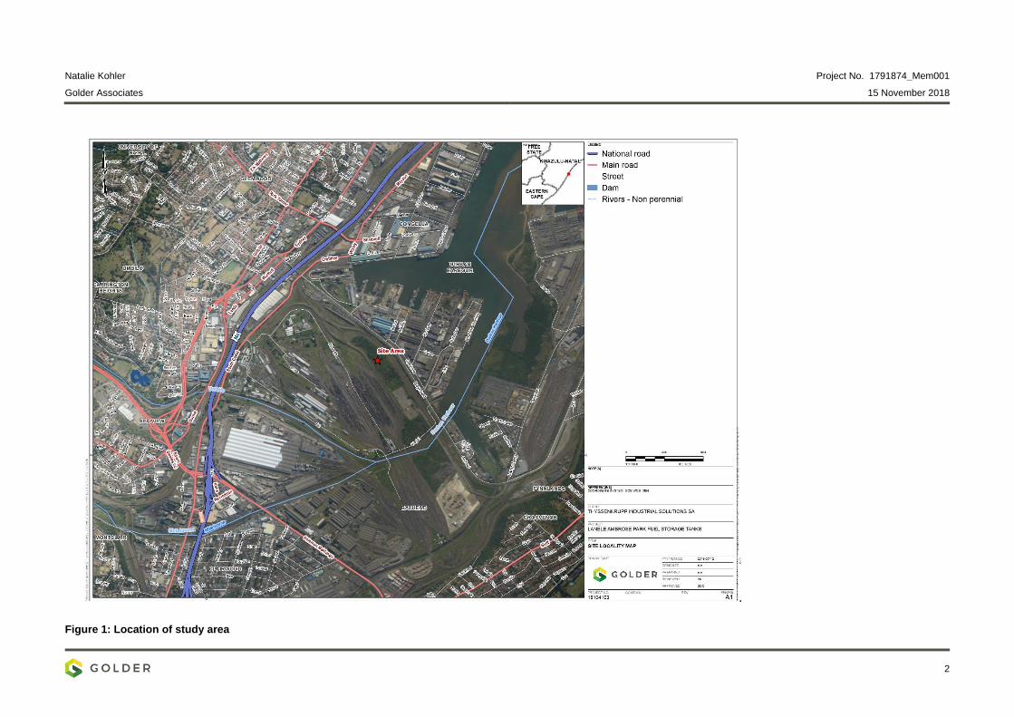
Natalie Kohler Project No. 1791874_Mem001
Golder Associates 15 November 2018
2
Figure 1: Location of study area
Natalie Kohler Project No. 1791874_Mem001
Golder Associates 15 November 2018
3
2.2 Soil Survey and Sampling
A site visit has been scheduled for the 20-21 November 2018, where a semi-detailed field survey will be
conducted to delineate and document the soil types, land use and terrain form of the facility. In areas which are
flat, the soil observations will be conducted according to a grid system. The soil variability will be assessed by
hand augering to a depth of 120 cm or deeper, unless prevented by impenetrable material or excessive wetness.
Observable soil characteristics such as colour, texture, soil depth, stoniness, and drainage class and parent
material will be logged. At each observation point the relevant and distinct features will also be recorded such
as signs of erosion, vegetation cover, micro-topography, aspect and fauna.
Once the dominant soil types have been identified during the transect walks, representative sites (modal
profiles) will be located, described in detail and sampled. At least 5 modal profiles will be described in detail and
soil samples collected of the topsoil and subsoil horizons. The soil characteristics will be described and classified
according to the Taxonomic Soil Classification System for South Africa (Soil Classification Working Group,
1991). For each modal profile the following features will be recorded in field:
Soil form and family (as defined in the Taxonomic Soil Classification System for South Africa,1991);
Soil depth (effective depth);
Estimated soil texture;
Soil structure, coarse fragments, calcareousness;
Underlying material; and
Current land use.
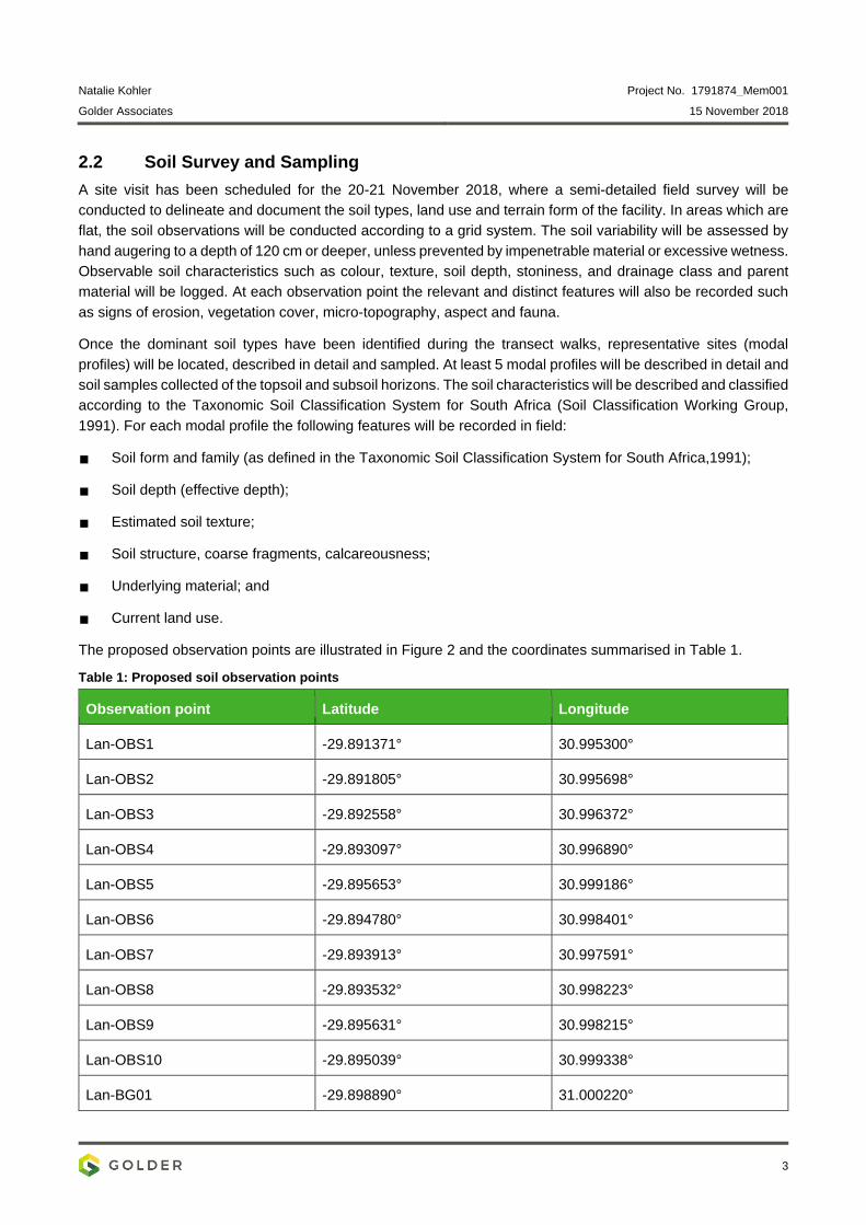
The proposed observation points are illustrated in Figure 2 and the coordinates summarised in Table 1.
Table 1: Proposed soil observation points
Observation point Latitude Longitude
Lan-OBS1 -29.891371° 30.995300°
Lan-OBS2 -29.891805° 30.995698°
Lan-OBS3 -29.892558° 30.996372°
Lan-OBS4 -29.893097° 30.996890°
Lan-OBS5 -29.895653° 30.999186°
Lan-OBS6 -29.894780° 30.998401°
Lan-OBS7 -29.893913° 30.997591°
Lan-OBS8 -29.893532° 30.998223°
Lan-OBS9 -29.895631° 30.998215°
Lan-OBS10 -29.895039° 30.999338°
Lan-BG01 -29.898890° 31.000220°
Natalie Kohler Project No. 1791874_Mem001
Golder Associates 15 November 2018
4
2.3 Laboratory analysis
Laboratory analysis of the soil samples will be conducted at Eco-Analytical Laboratories at the University of the
North West, South Africa. The soil properties which will be analysed, as required for classification purposes
include:
Phosphorus (Bray 1);
Exchangeable cations – Na, K. Ca, Mg (Ammonium Acetate Extraction);
pH (water and KCl);
Electrical conductivity
Organic matter content;
3-fraction particle size analysis
Clay mineral identification;
Acid saturation (%); and
Total metal and semi-metals analysis.
Natalie Kohler Project No. 1791874_Mem001
Golder Associates 15 November 2018
5
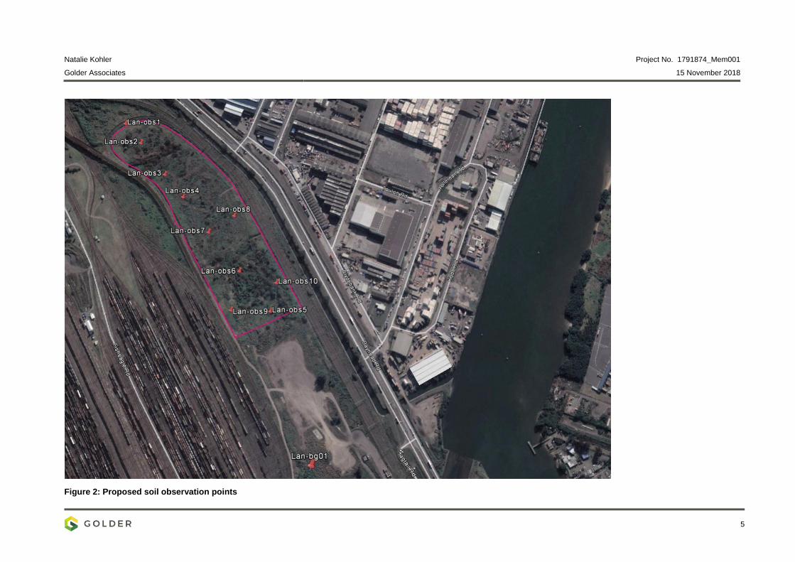
Figure 2: Proposed soil observation points
Natalie Kohler Project No. 1791874_Mem001
Golder Associates 15 November 2018
6
2.4 Assumptions
The facility is accessible to Golder personnel on the planned dates;
Where applicable, a dedicated person will be available to accompany Golder personnel during the
fieldwork and assist with access to required areas;
The security of buried services situated anywhere on the project site(s), which are NOT identified on the
drawings provided or suitably demarcated on site to us, will remain the responsibility of the client;
The proposed scope of work is based on current understanding of the level of information available and
can be adjusted if additional information becomes available;
The investigation procedures offered herein will involve operations and techniques using standard health
and safety norms applied by Golder to all its projects, and generally followed in the geotechnical
investigation industry. In the event that specific client requirements for safety issues are to be applied, of
which we have not been appraised in prior documentation, these will be implemented to the extent
reasonable and possible (within investigation industry standards and norms), but may attract additional
time and cost which are not covered in this present proposal and will be negotiated as contract extras;
Any water logged (or soft underfoot) areas may also present constraints insofar as accessibility of the site
for investigatory equipment is concerned and may therefore also require reconsideration of the proposed
programme and test method (and where necessary costing
3.0 ECOLOGICAL SURVEY- FIELD WORK METHOD
The aim of the ecological survey is to develop a habitat/ floristic characterization of the Lanele facility and identify
any important or sensitive ecological features (principally Red List/protected plant). The site visit will take place
over one day and access across the entire site will be required.
The area will be traversed on-foot and surveyed for plants, and other relevant biological features will also be
documented. Sampling is non-intrusive nor destructive, and essentially comprises identifying, documenting and
photographing (as required) individual plants and representative habitats. Data obtained will thus include both
written notes and photographs.
4.0 DRILLING AND GROUNDWATER SAMPLING
The drilling and sampling fieldwork is to be conducted by the Golder representative during 20 - 21 November
2018.
4.1 Approach
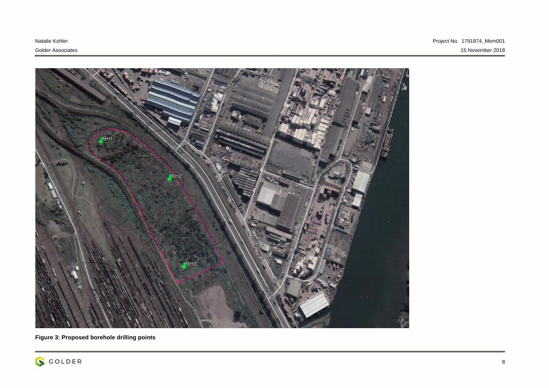
Drilling, lithological logging and groundwater sampling will be conducted at targeted areas, identified by Golder
during an internal technical meeting. Three (3) monitoring boreholes (Figure 3) will be drilled by mud rotary
drilling method, to a depth of fifteen meters (15m) per borehole. Borehole drilling and borehole construction will
be done under the supervision of a Golder hydrogeologist. Proposed coordinates for the boreholes are
summarised in Table 2.
We propose that the hydrogeological baseline study will proceed as follows:
Drilling, borehole construction and borehole development.
Hydraulic testing will be undertaken at all three drill locations, comprising slug or airlift recovery methods.
Once the boreholes have been developed, groundwater samples will be collected from each monitoring
borehole to gather information on the groundwater quality.
Natalie Kohler Project No. 1791874_Mem001
Golder Associates 15 November 2018
7
Piezometer installation will be carried out as part of the field work.
4.2 Laboratory analyses
Include analyses here
4.3 Reporting
Data collected from the hydrogeological baseline study will be analysed and a report prepared outlining the
results of the assessment. Recommendations for a monitoring regime will be provided.
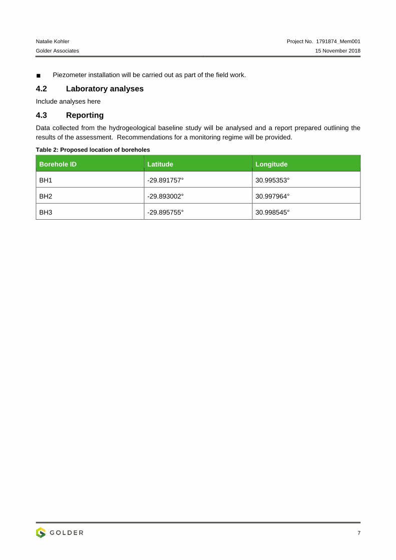
Table 2: Proposed location of boreholes
Borehole ID Latitude Longitude
BH1 -29.891757° 30.995353°
BH2 -29.893002° 30.997964°
BH3 -29.895755° 30.998545°
Natalie Kohler Project No. 1791874_Mem001
Golder Associates 15 November 2018
8
Figure 3: Proposed borehole drilling points
Natalie Kohler Project No. 1791874_Mem001
Golder Associates 15 November 2018
9
5.0 WORK SCHEDULE
The work is scheduled to be completed in the time indicated in the table below.
Table 3: Works schedule
Specialist survey Team member Duration on site
Soil Aviwe Mgoqi 20-22 Nov 2018
Ecology Andrew Zinn 20-Nov 2018
Groundwater Fundo Mlambo 20-22 Nov 2018
6.0 CONCLUDING REMARKS
The following team members will be available for regular telecons during the period
Elize Herselman
Ilse Snyman
Gerhard van der Linde
Jennifer Pretorius
Aviwe Mgoqi Ilse Snyman Elize Herselman Geochemist Soil Scientist Snr Soil Scientist
AM/ILS/EH/ck
g:\projects\1791874 – eia thyssenkrupp durban\3.2 in -out info\1791874_mem001_lanelefieldsurvey_151118.docx
October 2019 1791874-323920-3
APPENDIX B
Soil Profile Descriptions
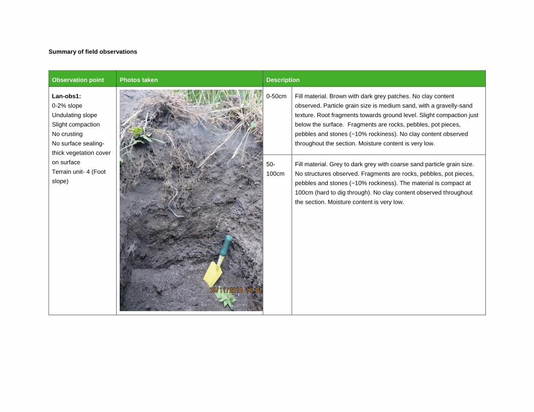
Summary of field observations
Observation point Photos taken Description
Lan-obs1:
0-2% slope
Undulating slope
Slight compaction
No crusting
No surface sealing-
thick vegetation cover
on surface
Terrain unit- 4 (Foot
slope)
0-50cm Fill material. Brown with dark grey patches. No clay content
observed. Particle grain size is medium sand, with a gravelly-sand
texture. Root fragments towards ground level. Slight compaction just
below the surface. Fragments are rocks, pebbles, pot pieces,
pebbles and stones (~10% rockiness). No clay content observed
throughout the section. Moisture content is very low.
50-
100cm
Fill material. Grey to dark grey with coarse sand particle grain size.
No structures observed. Fragments are rocks, pebbles, pot pieces,
pebbles and stones (~10% rockiness). The material is compact at
100cm (hard to dig through). No clay content observed throughout
the section. Moisture content is very low.
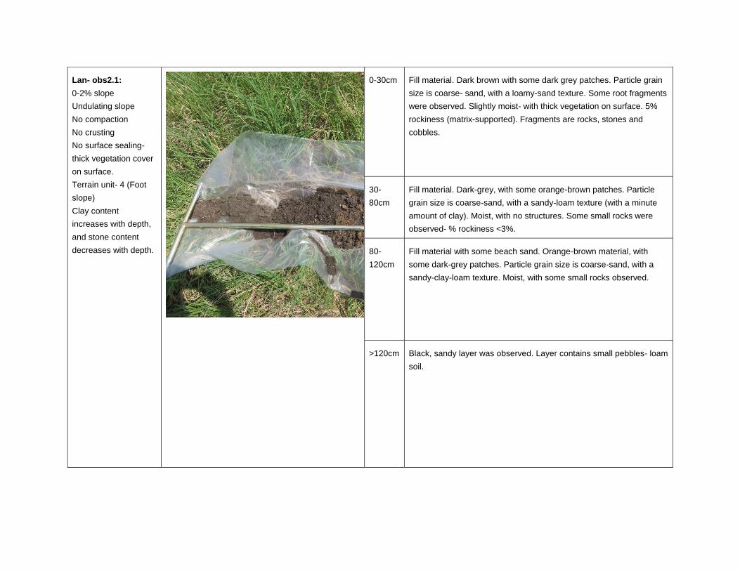
Lan- obs2.1:
0-2% slope
Undulating slope
No compaction
No crusting
No surface sealing-
thick vegetation cover
on surface.
Terrain unit- 4 (Foot
slope)
Clay content
increases with depth,
and stone content
decreases with depth.
0-30cm Fill material. Dark brown with some dark grey patches. Particle grain
size is coarse- sand, with a loamy-sand texture. Some root fragments
were observed. Slightly moist- with thick vegetation on surface. 5%
rockiness (matrix-supported). Fragments are rocks, stones and
cobbles.
30-
80cm
Fill material. Dark-grey, with some orange-brown patches. Particle
grain size is coarse-sand, with a sandy-loam texture (with a minute
amount of clay). Moist, with no structures. Some small rocks were
observed- % rockiness <3%.
80-
120cm
Fill material with some beach sand. Orange-brown material, with
some dark-grey patches. Particle grain size is coarse-sand, with a
sandy-clay-loam texture. Moist, with some small rocks observed.
>120cm Black, sandy layer was observed. Layer contains small pebbles- loam
soil.
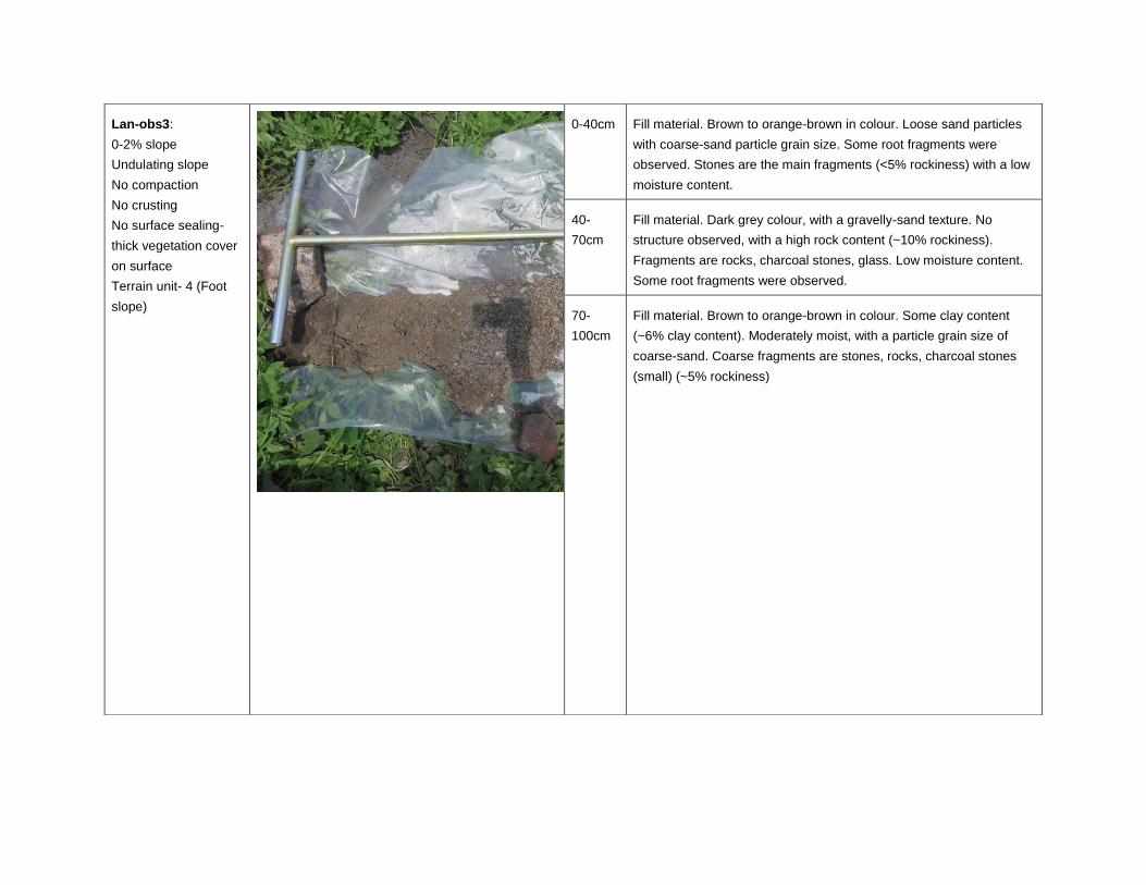
Lan-obs3:
0-2% slope
Undulating slope
No compaction
No crusting
No surface sealing-
thick vegetation cover
on surface
Terrain unit- 4 (Foot
slope)
0-40cm Fill material. Brown to orange-brown in colour. Loose sand particles
with coarse-sand particle grain size. Some root fragments were
observed. Stones are the main fragments (<5% rockiness) with a low
moisture content.
40-
70cm
Fill material. Dark grey colour, with a gravelly-sand texture. No
structure observed, with a high rock content (~10% rockiness).
Fragments are rocks, charcoal stones, glass. Low moisture content.
Some root fragments were observed.
70-
100cm
Fill material. Brown to orange-brown in colour. Some clay content
(~6% clay content). Moderately moist, with a particle grain size of
coarse-sand. Coarse fragments are stones, rocks, charcoal stones
(small) (~5% rockiness)
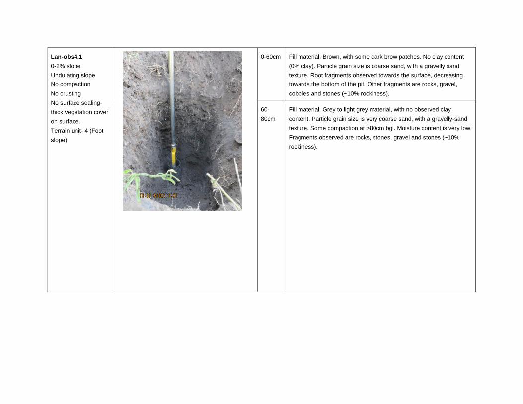
Lan-obs4.1
0-2% slope
Undulating slope
No compaction
No crusting
No surface sealing-
thick vegetation cover
on surface.
Terrain unit- 4 (Foot
slope)
0-60cm Fill material. Brown, with some dark brow patches. No clay content
(0% clay). Particle grain size is coarse sand, with a gravelly sand
texture. Root fragments observed towards the surface, decreasing
towards the bottom of the pit. Other fragments are rocks, gravel,
cobbles and stones (~10% rockiness).
60-
80cm
Fill material. Grey to light grey material, with no observed clay
content. Particle grain size is very coarse sand, with a gravelly-sand
texture. Some compaction at >80cm bgl. Moisture content is very low.
Fragments observed are rocks, stones, gravel and stones (~10%
rockiness).
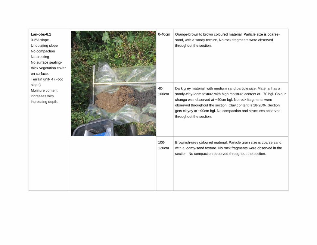
Lan-obs-6.1
0-2% slope
Undulating slope
No compaction
No crusting
No surface sealing-
thick vegetation cover
on surface.
Terrain unit- 4 (Foot
slope)
Moisture content
increases with
increasing depth.
0-40cm Orange-brown to brown coloured material. Particle size is coarse-
sand, with a sandy texture. No rock fragments were observed
throughout the section.
40-
100cm
Dark grey material, with medium sand particle size. Material has a
sandy-clay-loam texture with high moisture content at ~70 bgl. Colour
change was observed at ~40cm bgl. No rock fragments were
observed throughout the section. Clay content is 18-20%. Section
gets clayey at ~90cm bgl. No compaction and structures observed
throughout the section.
100-
120cm
Brownish-grey coloured material. Particle grain size is coarse sand,
with a loamy-sand texture. No rock fragments were observed in the
section. No compaction observed throughout the section.
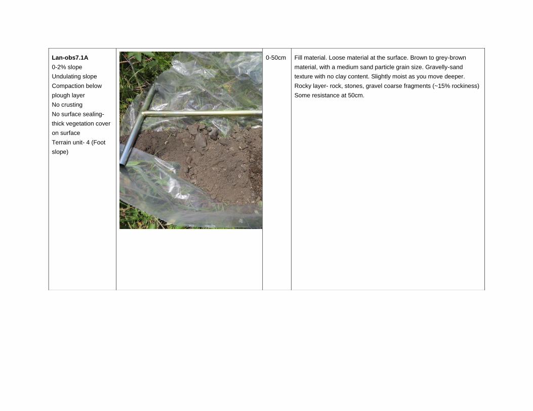
Lan-obs7.1A
0-2% slope
Undulating slope
Compaction below
plough layer
No crusting
No surface sealing-
thick vegetation cover
on surface
Terrain unit- 4 (Foot
slope)
0-50cm Fill material. Loose material at the surface. Brown to grey-brown
material, with a medium sand particle grain size. Gravelly-sand
texture with no clay content. Slightly moist as you move deeper.
Rocky layer- rock, stones, gravel coarse fragments (~15% rockiness)
Some resistance at 50cm.
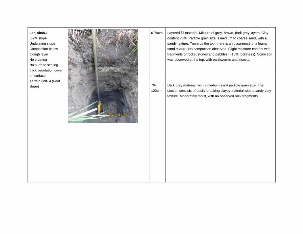
Lan-obs8.1
0-2% slope
Undulating slope
Compaction below
plough layer
No crusting
No surface sealing-
thick vegetation cover
on surface
Terrain unit- 4 (Foot
slope)
0-70cm Layered fill material. Mixture of grey, brown, dark grey layers. Clay
content <5%. Particle grain size is medium to coarse sand, with a
sandy texture. Towards the top, there is an occurrence of a loamy
sand texture. No compaction observed. Slight moisture content with
fragments of rocks, stones and pebbles (~10% rockiness). Some soil
was observed at the top, with earthworms and insects.
70-
120cm
Dark grey material, with a medium sand particle grain size. The
section consists of easily-breaking clayey material with a sandy-clay
texture. Moderately moist, with no observed rock fragments.
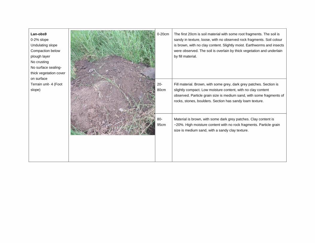
Lan-obs9
0-2% slope
Undulating slope
Compaction below
plough layer
No crusting
No surface sealing-
thick vegetation cover
on surface
Terrain unit- 4 (Foot
slope)
0-20cm The first 20cm is soil material with some root fragments. The soil is
sandy in texture, loose, with no observed rock fragments. Soil colour
is brown, with no clay content. Slightly moist. Earthworms and insects
were observed. The soil is overlain by thick vegetation and underlain
by fill material.
20-
80cm
Fill material. Brown, with some grey, dark grey patches. Section is
slightly compact. Low moisture content, with no clay content
observed. Particle grain size is medium sand, with some fragments of
rocks, stones, boulders. Section has sandy loam texture.
80-
95cm
Material is brown, with some dark grey patches. Clay content is
~20%. High moisture content with no rock fragments. Particle grain
size is medium sand, with a sandy clay texture.
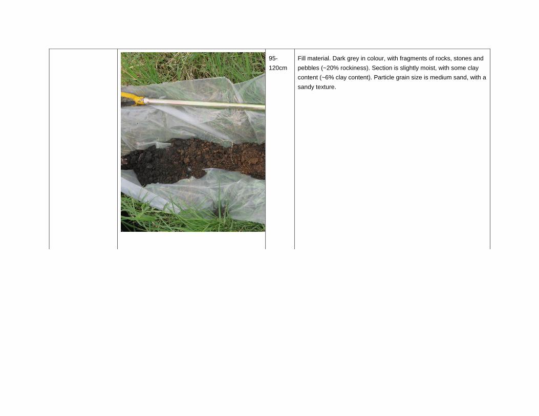
95-
120cm
Fill material. Dark grey in colour, with fragments of rocks, stones and
pebbles (~20% rockiness). Section is slightly moist, with some clay
content (~6% clay content). Particle grain size is medium sand, with a
sandy texture.
October 2019 1791874-323920-3
APPENDIX C
Laboratory Certificates
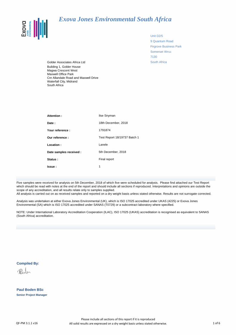
Unit D2/5
9 Quantum Road
Firgrove Business Park
Somerset West
Golder Associates Africa Ltd
Attention :
Date :
Your reference :
Our reference :
Location :
Date samples received :
Status :
Issue :
Compiled By:
Test Report 18/19737 Batch 1
Ilse Snyman
18th December, 2018
1
Paul Boden BSc
1791874
Exova Jones Environmental South Africa
7130
South Africa
Five samples were received for analysis on 5th December, 2018 of which five were scheduled for analysis. Please find attached our Test Report which should be read with notes at the end of the report and should include all sections if reproduced. Interpretations and opinions are outside the scope of any accreditation, and all results relate only to samples supplied. All analysis is carried out on as received samples and reported on a dry weight basis unless stated otherwise. Results are not surrogate corrected. Analysis was undertaken at either Exova Jones Environmental (UK), which is ISO 17025 accredited under UKAS (4225) or Exova Jones Environmental (SA) which is ISO 17025 accredited under SANAS (T0729) or a subcontract laboratory where specified. NOTE: Under International Laboratory Accreditation Cooperation (ILAC), ISO 17025 (UKAS) accreditation is recognised as equivalent to SANAS (South Africa) accreditation.
Building 1, Golder House Magwa Crescent West Maxwell Office Park Cnr Allandale Road and Maxwell Drive Waterfall City, Midrand South Africa
Lanele
5th December, 2018
Final report
Senior Project Manager
QF-PM 3.1.1 v16Please include all sections of this report if it is reproduced
All solid results are expressed on a dry weight basis unless stated otherwise. 1 of 6
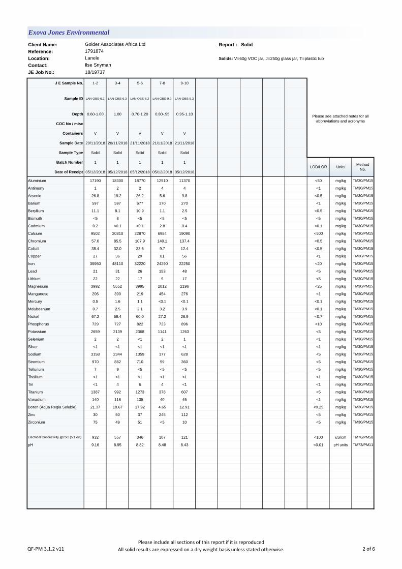
Client Name: Report : Solid
Reference:
Location: Solids: V=60g VOC jar, J=250g glass jar, T=plastic tub
Contact:
JE Job No.: 18/19737
J E Sample No. 1-2 3-4 5-6 7-8 9-10
Sample ID LAN-OBS-6.2 LAN-OBS-6.3 LAN-OBS-8.2 LAN-OBS-9.2 LAN-OBS-9.3
Depth 0.60-1.00 1.00 0.70-1.20 0.80-.95 0.95-1.10
COC No / misc
Containers V V V V V
Sample Date 20/11/2018 20/11/2018 21/11/2018 21/11/2018 21/11/2018
Sample Type Solid Solid Solid Solid Solid
Batch Number 1 1 1 1 1
Date of Receipt 05/12/2018 05/12/2018 05/12/2018 05/12/2018 05/12/2018
Aluminium 17190 18300 18770 12510 11370 <50 mg/kg TM30/PM15
Antimony 1 2 2 4 4 <1 mg/kg TM30/PM15
Arsenic 26.8 19.2 26.2 5.6 9.8 <0.5 mg/kg TM30/PM15
Barium 597 597 677 170 270 <1 mg/kg TM30/PM15
Beryllium 11.1 8.1 10.9 1.1 2.5 <0.5 mg/kg TM30/PM15
Bismuth <5 8 <5 <5 <5 <5 mg/kg TM30/PM15
Cadmium 0.2 <0.1 <0.1 2.8 0.4 <0.1 mg/kg TM30/PM15
Calcium 9502 20810 22870 6984 19090 <500 mg/kg TM30/PM15
Chromium 57.6 85.5 107.9 140.1 137.4 <0.5 mg/kg TM30/PM15
Cobalt 38.4 32.0 33.6 9.7 12.4 <0.5 mg/kg TM30/PM15
Copper 27 36 29 81 56 <1 mg/kg TM30/PM15
Iron 35950 48110 32220 24290 22250 <20 mg/kg TM30/PM15
Lead 21 31 26 153 48 <5 mg/kg TM30/PM15
Lithium 22 22 17 9 17 <5 mg/kg TM30/PM15
Magnesium 3992 5552 3995 2012 2196 <25 mg/kg TM30/PM15
Manganese 206 390 219 454 276 <1 mg/kg TM30/PM15
Mercury 0.5 1.6 1.1 <0.1 <0.1 <0.1 mg/kg TM30/PM15
Molybdenum 0.7 2.5 2.1 3.2 3.9 <0.1 mg/kg TM30/PM15
Nickel 67.2 59.4 60.0 27.2 26.9 <0.7 mg/kg TM30/PM15
Phosphorus 729 727 822 723 896 <10 mg/kg TM30/PM15
Potassium 2659 2139 2368 1141 1263 <5 mg/kg TM30/PM15
Selenium 2 2 <1 2 1 <1 mg/kg TM30/PM15
Silver <1 <1 <1 <1 <1 <1 mg/kg TM30/PM15
Sodium 3158 2344 1359 177 628 <5 mg/kg TM30/PM15
Strontium 970 882 710 59 360 <5 mg/kg TM30/PM15
Tellurium 7 9 <5 <5 <5 <5 mg/kg TM30/PM15
Thallium <1 <1 <1 <1 <1 <1 mg/kg TM30/PM15
Tin <1 4 6 4 <1 <1 mg/kg TM30/PM15
Titanium 1387 992 1273 378 607 <5 mg/kg TM30/PM15
Vanadium 140 116 135 40 45 <1 mg/kg TM30/PM15
Boron (Aqua Regia Soluble) 21.37 18.67 17.92 4.65 12.91 <0.25 mg/kg TM30/PM15
Zinc 30 50 37 245 112 <5 mg/kg TM30/PM15
Zirconium 75 49 51 <5 10 <5 mg/kg TM30/PM15
Electrical Conductivity @25C (5:1 ext) 932 557 346 107 121 <100 uS/cm TM76/PM58
pH 9.16 8.95 8.82 8.48 8.43 <0.01 pH units TM73/PM11
Lanele
Ilse Snyman
Please see attached notes for all abbreviations and acronyms
LOD/LOR UnitsMethod
No.
Exova Jones Environmental
Golder Associates Africa Ltd
1791874
QF-PM 3.1.2 v11Please include all sections of this report if it is reproduced
All solid results are expressed on a dry weight basis unless stated otherwise. 2 of 6
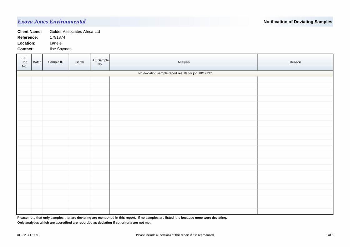
Notification of Deviating Samples
J E Job No.
Batch Depth J E Sample
No.Analysis Reason
Please note that only samples that are deviating are mentioned in this report. If no samples are listed it is because none were deviating.
Only analyses which are accredited are recorded as deviating if set criteria are not met.
Exova Jones Environmental
1791874
Lanele
Ilse SnymanContact:
Sample ID
Client Name: Golder Associates Africa Ltd
Reference:
Location:
No deviating sample report results for job 18/19737
QF-PM 3.1.11 v3 Please include all sections of this report if it is reproduced 3 of 6
JE Job No.:
SOILS
DEVIATING SAMPLES
SURROGATES
DILUTIONS
BLANKS
NOTE
Where an MCERTS report has been requested, you will be notified within 48 hours of any samples that have been identified as being outside ourMCERTS scope. As validation has been performed on clay, sand and loam, only samples that are predominantly these matrices, or combinationsof them will be within our MCERTS scope. If samples are not one of a combination of the above matrices they will not be marked as MCERTSaccredited.
Negative Neutralization Potential (NP) values are obtained when the volume of NaOH (0.1N) titrated (pH 8.3) is greater than the volume of HCl (1N) to reduce the pH of the sample to 2.0 - 2.5. Any negative NP values are corrected to 0.
Where a CEN 10:1 ZERO Headspace VOC test has been carried out, a 10:1 ratio of water to wet (as received) soil has been used.
All samples will be discarded one month after the date of reporting, unless we are instructed to the contrary.
% Asbestos in Asbestos Containing Materials (ACMs) is determined by reference to HSG 264 The Survey Guide - Appendix 2 : ACMs in buildings listed in order of ease of fibre release.
Data is only reported if the laboratory is confident that the data is a true reflection of the samples analysed. Data is only reported as accredited whenall the requirements of our Quality System have been met. In certain circumstances where all the requirements of the Quality System have not beenmet, for instance if the associated AQC has failed, the reason is fully investigated and documented. The sample data is then evaluated alongsidethe other quality control checks performed during analysis to determine its suitability. Following this evaluation, provided the sample results have not been effected, the data is reported but accreditation is removed. It is a UKAS requirement for data not reported as accredited to be consideredindicative only, but this does not mean the data is not valid. Where possible, and if requested, samples will be re-extracted and a revised report issued with accredited results. Please do not hesitate to contactthe laboratory if further details are required of the circumstances which have led to the removal of accreditation.
Where Mineral Oil or Fats, Oils and Grease is quoted, this refers to Total Aliphatics C10-C40.
Please note we are not a UK Drinking Water Inspectorate (DWI) Approved Laboratory .
REPORTS FROM THE SOUTH AFRICA LABORATORY
Any method number not prefixed with SA has been undertaken in our UK laboratory unless reported as subcontracted.
If you have not already done so, please send us a purchase order if this is required by your company.
The calculation of Pyrite content assumes that all oxidisable sulphides present in the sample are pyrite. This may not be the case. The calculation may be an overesitimate when other sulphides such as Barite (Barium Sulphate) are present.
Where analytes have been found in the blank, the sample will be treated in accordance with our laboratory procedure for dealing with contaminatedblanks.
ISO17025 accreditation applies to surface water and groundwater and usually one other matrix which is analysis specific, any other liquids areoutside our scope of accreditation.
As surface waters require different sample preparation to groundwaters the laboratory must be informed of the water type when submitting samples.
Where appropriate please make sure that our detection limits are suitable for your needs, if they are not, please notify us immediately.
Samples must be received in a condition appropriate to the requested analyses. All samples should be submitted to the laboratory in suitablecontainers with sufficient ice packs to sustain an appropriate temperature for the requested analysis. If this is not the case you will be informed andany test results that may be compromised highlighted on your deviating samples report.
NOTES TO ACCOMPANY ALL SCHEDULES AND REPORTS
Please note we are only MCERTS accredited (UK soils only) for sand, loam and clay and any other matrix is outside our scope of accreditation.
Where Mineral Oil or Fats, Oils and Grease is quoted, this refers to Total Aliphatics C10-C40.
18/19737
WATERS
It is assumed that you have taken representative samples on site and require analysis on a representative subsample. Stones will generally beincluded unless we are requested to remove them.
All analysis is reported on a dry weight basis unless stated otherwise. Results are not surrogate corrected. Samples are dried at 35°C ±5°C unlessotherwise stated. Moisture content for CEN Leachate tests are dried at 105°C ±5°C.
Surrogate compounds are added during the preparation process to monitor recovery of analytes. However low recovery in soils is often due to peat,clay or other organic rich matrices. For waters this can be due to oxidants, surfactants, organic rich sediments or remediation fluids. Acceptablelimits for most organic methods are 70 - 130% and for VOCs are 50 - 150%. When surrogate recoveries are outside the performance criteria butthe associated AQC passes this is assumed to be due to matrix effect. Results are not surrogate corrected.
A dilution suffix indicates a dilution has been performed and the reported result takes this into account. No further calculation is required.
QF-PM 3.1.9 v34Please include all sections of this report if it is reproduced
All solid results are expressed on a dry weight basis unless stated otherwise. 4 of 6
JE Job No.:
#
SA
B
DR
M
NA
NAD
ND
NDP
SS
SV
W
+
++
*
AD
CO
LOD/LOR
ME
NFD
BS
LB
N
TB
OC Outside Calibration Range
No Fibres Detected
Result outside calibration range, results should be considered as indicative only and are not accredited.
Results expressed on as received basis.
Surrogate recovery outside performance criteria. This may be due to a matrix effect.
AQC Sample
Suspected carry over
Trip Blank Sample
Blank Sample
Client Sample
AQC failure, accreditation has been removed from this result, if appropriate, see 'Note' on previous page.
Calibrated against a single substance
Indicates analyte found in associated method blank.
ABBREVIATIONS and ACRONYMS USED
Matrix Effect
No Asbestos Detected.
Limit of Detection (Limit of Reporting) in line with ISO 17025 and MCERTS
No Determination Possible
None Detected (usually refers to VOC and/SVOC TICs).
Samples are dried at 35°C ±5°C
Analysis subcontracted to an Exova Jones Environmental approved laboratory.
Not applicable
ISO17025 (UKAS Ref No. 4225) accredited - UK.
Dilution required.
ISO17025 (SANAS Ref No.T0729) accredited - South Africa.
MCERTS accredited.
18/19737
QF-PM 3.1.9 v34Please include all sections of this report if it is reproduced
All solid results are expressed on a dry weight basis unless stated otherwise. 5 of 6
JE Job No: 18/19737
Test Method No. DescriptionPrep Method
No. (if appropriate)
Description
ISO17025
(UKAS/SANAS)
MCERTS (UK soils
only)
Analysis done on As Received (AR) or Dried
(AD)
Reported on dry weight
basis
TM30Determination of Trace Metal elements by ICP-OES (Inductively Coupled Plasma - Optical Emission Spectrometry). Modified US EPA Method 200.7, 6010B and BS EN ISO 11885 2009
PM15Acid digestion of dried and ground solid samples using Aqua Regia refluxed at 112.5 °C. Samples containing asbestos are not dried and ground.
AD Yes
TM73Modified US EPA methods 150.1 and 9045D and BS1377:1990. Determination of pH by Metrohm automated probe analyser.
PM11 Extraction of as received solid samples using one part solid to 2.5 parts deionised water. AR No
TM76Modified US EPA method 120.1. Determination of Specific Conductance by Metrohm automated probe analyser.
PM58Dried and ground solid samples are extracted with water in a 5:1 water to solid ratio, the samples are shaken on an orbital shaker.
AD Yes
Exova Jones Environmental Method Code Appendix
QF-PM 3.1.10 v14 Please include all sections of this report if it is reproduced 6 of 6
October 2019 1791874-323920-3
APPENDIX D
Specialist CVs
1
Curriculum Vitae ILSE SNYMAN
Education
MSc Agric Soil Science, Stellsnbosch University, Stellenbosch, 2011
BSc Agric Agronomy & Soil Science, Stellenbosch University, Stellenbosch, 2005
Certifications
Professional Natural Scientist- in the field of Soil Science, 2014
Languages
English – Fluent
Afrikaans – Fluent
Johannesburg
Employment History
Golder Associates Africa – Johannesburg Soil Scientist (May 2015 to Present)
Responsible for assessing and interpreting soils in relation to agricultural production and overall environmental quality. Assisting with collecting of environmental soil, sediment and waste samples and in-field soil property assessment.
Golder Associates Africa – Pretoria Rehabilitation Consultant (July 2014 to April 2015)
Providing support for planning and execution of rehabilitation in the mining and industrial sectors. Devise and combine multiple concepts and considerations into integrated rehabilitation and eminent closure plans. Conceptualize and formulate rehabilitation and closure objectives, measures, associated packaging of solutions, as well as the actions for implementation. Assist in the completion of rehabilitation programmes to implementation phase. Assisting with rehabilitation and closure planning projects and interacting with multiple consulting disciplines to deliver innovative and integrated rehabilitation and closure plans to clients.
Elsenburg Agricultural College, Western Cape Department Of Agriculture –
Stellenbosch Lecturer (2009 to 2013)
Presentation of soil fertility and soil classification course to undergraduate 1st and 2nd year students.
Strategic Environmental Focus – Cape Town, South Africa Soil Scientist (2008 to 2009)
Conducting of soil surveys as part of Environment Impact Assessment projects, mainly to inform Agricultural Potential Assessments and Wetland Delineation in terms of soil parameters.
SENWES Ltd – Klerksdorp, South Africa Agronomist (2006 to 2007)
Advisory agronomic support to emerging farmers and commercial farmers on agricultural crop production aspects, agricultural production planning, grain (maize) crops yield estimation and soil moisture and soil classification
2
Curriculum Vitae ILSE SNYMAN
PROJECT EXPERIENCE – CONTAMINATED LAND REMEDIATION
Aluvert Blinds Gauteng, South Africa
Phase 1 Contaminated land Assessment
Middelbult 284IS Mpumalunga, South
Africa
Contaminated Land and Related Assessment of Portion 17, 49, 52, 53 & 54 of the farm Middelbult 284IS,
Minmetals North West, South Africa
Phase 1 Contaminated land assessment
Alrode, Alberton Gauteng, South Africa
Soil screening level assessment as part of a Phase I Environmental Site Assessment at a proposed new site
Kelvin Power Station Gauteng, South Africa
Phase 1 Contaminated land assessment
Delta EMD Mpumalunga, South
Africa
The setup of laboratory simulation of the potential remediation treatments for contaminated soil.
PROJECT EXPERIENCE – WASTE
Middelburg Ferrochrome
Mpumalunga, South Africa
Site reconnaissance survey and site-wide sampling of waste rock, tailings,and various other waste streams generated on site.
Phalaborwa Mining Company
Limpopo, South Africa
Site-wide sampling of waste rock, tailings, sewage sludge and various other waste streams generated on site.
Richards Bay Coal Terminal
Kwa-Zulu Natal, South Africa
Sampling and classification of material underlyding coal stockyards, and collection of waste sediment and water generated on site.
PROJECT EXPERIENCE – MINING
Wolwekrans, Mpumalunga, South
Africa
The assessment of the condition/effectivity of the evaporative soil covers of discard dumps.
Union Mine Mpumalunga, South
Africa
The assessment of the condition/effectivity of the evaporative soil covers of discard dumps.
TCSA Springbok Siding
Mpumalunga, South Africa
The development of practical surface rehabilitation plan for Springbok Siding- incuded a topsoil quality assessment.
3
Curriculum Vitae ILSE SNYMAN
TCSA Bethal Siding Mpumalunga, South
Africa
The development of practical surface rehabilitation plan for Bethal Siding- incuded a topsoil quality assessment.
PROJECT EXPERIENCE – ENVIRONMENTAL ASSESSMENT
Societe D'exploitation De Kipoi (SEK)- Kipoi
Copper Project Katanga, DRC
Soil, Land Use and Land Capability Assessment
Chirano TSF 1 North East Project
Ghana
Environmental Impact Assessment: Chirano TSF 1 North East Project: Groundwater, Geochemistry and Soils, Kinross Chirano Gold Mine, Ghana
Kokoya Liberia
Land capability, agricultural potential assessment for the proposed mining areas - Kokoya Gold Mining Project; Liberia;
Millsite Gauteng, South Africa
Soils Agricultural Potential Assessment for the proposed Millsite Residential Development
Fleurhof Ext 2 Gauteng, South Africa
Soils Agricultural Potential Assessment for the proposed Fleurhof Ext 2
Eskom South Africa
Soils Agricultural Potential Assessment for the Eskom Pretoria Strategic Environmental Assessment
Madibeng Local Municipality
North West, South Africa
Soils Agricultural Potential Assessment for the Madibeng Local Municipality Environmental Management Framework
SUPPLEMENTAL SKILLS
PROFESSIONAL AFFILIATIONS
SACNASP- Professional Natural Scientist, in the field of Soil Science
Soil Science Society of South Africa
1
Resumé DR J ELIZE HERSELMAN
Education
BSc. Geography and Soil Science , Potchefstroom University, South Africa, 1989
BSc.- Hons. Geography - Physical, Potchefstroom University, South Africa, 1990
MSc. Geography Soil Science aspects, UNISA, South Africa, 1998
PhD Soil Science , University of Stellenbosch, South Africa, 2007
Languages
Afrikaans – Fluent
English – Fluent
Golder Associates Africa (Pty) Ltd. – Cape Town
Golder Associates Africa (Pty) Ltd. – Cape Town Soil Scientist with 25 years’ experience in soil chemistry research with special emphasis on trace elements and heavy metals in soils (focus of PhD), including baseline concentrations in uncontaminated soils, research on leaching of elements in the soil profile, different extraction methods and procedures for trace elements, as well as plant uptake of trace elements from the soil. Expertise include: contaminated land assessments (phases 1, 2 and 3), identification of remediation options for contaminated sites and site assessment reports, waste management (classification, categorisation and assessment for potential downstream use applications), specialist input into basic and environmental impact assessments, Waste Management Licence Applications. Specialist fields: Waste Classification, Assessment and Management, Contaminated Land Assessments, Risk Assessments (source-pathway-receptor), Human Health Risk Assessments
Employment History
Golder Associates Africa (Pty) Ltd – Cape Town, South Africa Senior Soil Scientist and Waste Management Consultant, Waste and Land Quality Division (2005 to Present)
Waste classification and assessments, waste inventories, site assessments, wastewater sludge guidelines, water treatment residue guidelines and soil assessments and remediation at contaminated sites, human health risk assessments, ecological risk assessments.
ARC – Institute for Soil, Climate and Water – Pretoria, South Africa Researcher, Soil and Water Sciences (1996 to 2005)
Project leader of several projects on the behaviour of trace elements and heavy metals in soils related to plant uptake and water pollution Involvement in GIS and AGIS (Agricultural GIS, web based) projects
ARC – Institute for Soil, Climate and Water – Pretoria, South Africa Junior Researcher, Analytical Services (1991 to 1995)
Involved in chemical and mineralogical analyses and classification of soils.
Department of Geography – Potchefstroom University, South Africa Research Assistant (1988 to 1993)
Worked as a researcher assistant on physical Geography projects as well as soil related projects.
2
Resumé DR J ELIZE HERSELMAN
PROJECT EXPERIENCE – VARIOUS
Highveld Steel and Vanadium Corporation Witbank, Mpumulanga,
South Africa
Soil assessments, remediation strategies and hazard rating of various hazardous waste streams and footprint areas.
Optimum Water Reclamation Project
Hendrina, Mpumulanga, South Africa
Characterisation of and management options for water treatment residues produced by treating mine water for potable use.
Ferrometals Wiitbank, Mpumulanga,
South Africa
Classification and assessment of various hazardous waste streams.
Vanchem Witbank, Mpumulanga,
South Africa
Hazard rating and delisting of various hazardous waste streams. Soil assessment of footprint areas and recommendation of remediation strategies.
ArcelorMittal Vanderbijlpark, Free
State, South Africa
Soil assessment, refinement of organic source term and recommendation of remediation strategies.
City of Tshwane Pretoria, Gauteng, South
Africa
Reviewed the leaching status of trace elements in soils after decades of sludge application.
Water Research Commission
Pretoria, Gauteng, South Africa
Evaluation of partitioning coefficients for South African soils to inform the National Framework for the Management of Contaminated Land with empahsis on the protection of water resources.
Delta EMD Nelspruit, South Africa
Contaminated land assessment and Site Remediation after closure.
Richards Bay Coal Terminal
Richards Bay, KwaZulu Natal, South Africa
Contaminated Land Assessment, Waste classification and assessment, Conceptual Site Understanding
Middelburg Ferrochrome
Middelburg, Mpumalanga, South
Africa
Contaminated Land Assessment, Waste classification and assessment, Conceptual Site Understanding, Source-pathway-receptor assessment
Exxaro Ogies, Mpumalanga,
South Africa
Waste classification and assessment of various waste streams, mine residues, stockpiles and deposits
eThekwini Municipality Durban, KwaZulu Natal,
South Africa
Human Health and Ecological risk assessment at various Wastewater Treatment Plants (disposal of sludge on land).
3
Resumé DR J ELIZE HERSELMAN
SCAW Metals Germiston, Gauteng,
South Africa
- Phase 1 contaminated land assessment for 15 sites. Included Human Health and Ecological Risk Assessments. - Evaluation of treatment options for Cr(VI) rich baghouse dust.
Tubatse Ferrochrome Steelpoort,
Mpumalanga, South Africa
Soil contamination assessment, land use assessment, source term determination, remediation targets and measures at Cr(VI) contaminated site. Basic Assessment and Waste Management Licence Applications for Closure of waste facilities
Abbeydale Benoni, Gauteng, South
Africa
Soil assessment and remediation plan for a Cr(VI) contaminated site.
Department of Agriculture
Pretoria, Gauteng, South Africa
- Determined the baseline concentration and distribution of trace elements in virgin/unpolluted SA soils. Studied the adsorption capacities of South African soils for heavy metals.
Cape Gate Vanderbijlpark, Gauteng,
South Africa
Soil contamination assessment of waste footprints and development of remediation strategy.
Metalloys Meyerton, Gauteng,
South Africa
Classification of various hazardous waste streams. Soil assessment of footprint areas and recommendation of remediation strategies. Human health and ecological risk assessments.
Mogale Alloys Krugersdorp, Gauteng,
South Africa
Classification of various hazardous waste streams. Soil assessment of footprint areas and recommendation of remediation strategies. Included human health and ecological risk assessments
Manganese Metals Company
Krugersdorp, Gauteng, South Africa
Classification of various hazardous waste streams. Soil assessment of footprint areas and recommendation of remediation strategies.
Kumba Resources Pretoria, Gauteng, South
Africa
Environmental and human health risk of the Zwartkops Dolomite mine.
Water Research Commission
Pretoria, Gauteng, South Africa
Development of guidelines for the utilisation and disposal of wastewater sludge, Volumes 1 - 5. Included study on human health and ecological risk posed by sludge.
Water Research Commission
Pretoria, Gauteng, South Africa
Development of guidelines for the utilisation and disposal of water treatment residues (WTR) (sludge from potable water treatment). Included study on human health and ecological risk posed by sludge.
Water Research Commission
Pretoria, Gauteng, South Africa
Assessment of aquifer vulnerability protocols (soil zone) in urban catchments.
4
Resumé DR J ELIZE HERSELMAN
Water Research Commission
Pretoria, Gauteng, South Africa
Evaluation of dedicated land disposal (DLD) practices for South African sewage sludge and its impact on soil and groundwater.
Water Research Commission
Pretoria, Gauteng, South Africa
Conducted a survey 78 wastewater treatment plants in South Africa to establish the status quo of South African wastewater sludge quality.
Water Research Commission
Pretoria, Gauteng, South Africa
Developed critical levels for heavy metals in South African soils.
Department of Agriculture
Pretoria, Gauteng, South Africa
Compiled maps on different soil quality indicators of South African soils.
Sasol Secunda Sasolburg, Free State,
South Africa
Reviewed the leaching of trace elements and nutrients in soils after industrial effluent application.
PROFESSIONAL AFFILIATIONS
Member of the Soil Science Society of South Africa (SSSSA)
Member of International Association of Impact Assessors
Member of International Union of Soil Science
South African Council for Natural Scientific Professions (Reg no 400351/15)
PUBLICATIONS
Conference Proceedings
HERSELMAN J.E. . The mobility of heavy metals in selected soils: a leaching study with soil columns. Sustainable soil utilization and rural development. 20th Congress of SSSSA 1996. Bloemfontein, South Africa..
HERSELMAN J.E. & STEYN C.E. Predicted background values of trace
elements in South African soils. Joint congress SSSSA. SSSSA, SASCP & SAWSS. 2001. Pretoria, South Africa..
HERSELMAN J.E. & DU PREEZ H.G. Leaching of Cu, Cd and Zn in a sludge
applied soil. Soils and Crops Towards 2000. Joint Congress of the SSSSA and SASCP at Alpine Heath, KwaZulu-Natal. 1998. Alpine Heath, KwaZulu-Natal, South Africa..
DU PREEZ H.G., HERSELMAN J.E. & STEYN C.E. Extractability of cadmium
and copper in a soil ameliorated with sewage sludge. Soils and Crops Towards 2000. Joint Congress of the SSSSA and SASCP at Alpine Heath, KwaZulu-Natal. 1998. Alpine Heath, KwaZulu-Natal, South Africa..
VAN ZYL A.J., DU PREEZ H.G., LAZENBY E. & HERSELMAN J.E. Evaluation
of maximum permissible trace element concentrations for South African soils.
5
Resumé DR J ELIZE HERSELMAN
22nd Congress of the SSSSA. 1999. Pretoria, South Africa..
HERSELMAN J.E. & STEYN C.E. Baseline concentration of trace elements in South African soils. Golden Jubilee Congress of the Soil Science Society of South Africa. 2003. Stellenbosch, South Africa..
HERSELMAN J.E., STEYN C.E. & VENTER A. A trace element risk map for
South Africa. Soil Science Society of South Africa Combined Congress. 2005. Potchefstroom, South Africa..
VENTER A., HERSELMAN J.E. & BEUKES D.J. A pilot study to investigate the
effects of high salt water on plant and soil properties. 22nd Congress of the SSSSA. 1999. Pretoria, South Africa..
KIRSTEN W.F.A. & HERSELMAN J.E. A mica/vermiculite interstratified mineral.
11th International Clay Conference held in Ottawa, Ontario, Canada. 1997. Canada.
HERSELMAN J.E., VENTER A. & BEUKES D.J. A leaching study with high salt
water on soil columns. 22nd Congress of the SSSSA. SSSSA. 1999. Pretoria, South Africa..
STEYN C.E. & HERSELMAN J.E. Trace elements in the Mpumalanga province
as related to land use. Joint congress SSSSA, SASCP & SAWSS. 2001. Pretoria, South Africa.
STEYN C.E. & HERSELMAN J.E. Trace elements in developing countries using
South Africa as a case study. 8th International Symposium on Soil and Plant Analysis. Soil and Plant Analysis Council. 2003. Stellenbosch, South Africa..
HERSELMAN J.E. The environmental impact of sacrificial land disposal of
sewage sludge. WISA Anaerobic and Sludge Process Division: Sludge management and the future. 2002. Rand Water, South Africa..
STEYN C.E. & HERSELMAN J.E. Selenium in South Africa. Golden Jubilee
Congress of SSSSA in combination with SASCP & SASHS. 2003. University of Stellenbosch, South Africa..
STEYN C.E., HERSELMAN J.E., CLAASSENS A.S. & BARNARD R.O.
Micronutrient content in South African crops and soils - Implications for development. 15th International Symposium of the International Scientific Centre of Fertilizers (CIEC). 2004. Stellenbosch, South Africa.
STEYN C.E., HERSELMAN J.E. & SNYMAN H.G. Local factors that influence
the scientific basis of the new South African sludge guidelines. WISA Workshop on New Sewage Sludge Guidelines. Water Institute of Southern Africa (WISA) Anaerobic Sludge Division. 2004. South Africa.
Journal Articles Absorption Capacity of Selected South African Soils for Heavy Metal Disposal. .
MsC Thesis, Unisa, South Africa. (1998)
ARC-Institute for Soil, Climate and Water. - A hundred years of research towards the conservation and sustainable management of South Africa's land, water and climate resources. Water Wheel. 14/7/2003. (1902-2002 ), 2: 23-27. (English)..
6
Resumé DR J ELIZE HERSELMAN
South African Journal of Science. Baseline concentration of Cd, Co, Cr, Cu, Pb,
Ni and Zn in surface soils of South Africa. (2005), Vol 101 (11/12): 509-512.
Communications in Soil science and Plant analysis. Trace Elements in Developing Countries Using South Africa as a Case Study. (2005), Vol 36 (1/3): 155-168.
Water Science and Technology. Dedicated land disposal of wastewater sludge
in South Africa: Leaching of elements and nutrients. (2006), Vol 54 (5): 139-146..
The concentration of selected trace metals in South African soils. . PhD Dissertation, University of Stellenbosch, South Africa. (2007.)
Other STEYN C.E., HERSELMAN J.E. & SNYMAN H.G. Local factors that influence
the scientific basis of the new South African sludge guidelines. WISA Workshop on New Sewage Sludge Guidelines. Water Institute of Southern Africa (WISA) Anaerobic Sludge Division. 2004. South Africa
STEYN C.E., HERSELMAN J.E., CLAASSENS A.S. &
BARNARD R.O. Micronutrient content in South African crops and soils - Implications for development. 15th International Symposium of the International Scientific Centre of Fertilizers (CIEC). 2004. Stellenbosch, South Africa
STEYN C.E. & HERSELMAN J.E. Selenium in South Africa. Golden Jubilee
Congress of SSSSA in combination with SASCP & SASHS. 2003. University of Stellenbosch, South Africa.
HERSELMAN J.E. The environmental impact of sacrificial land disposal of
sewage sludge. WISA Anaerobic and Sludge Process Division: Sludge management and the future. 2002. Rand Water, South Africa.
STEYN C.E. & HERSELMAN J.E. Trace elements in developing countries using
South Africa as a case study. 8th International Symposium on Soil and Plant Analysis. Soil and Plant Analysis Council. 2003. Stellenbosch, South Africa.
STEYN C.E. & HERSELMAN J.E. Trace elements in the Mpumalanga province
as related to land use. Joint congress SSSSA, SASCP & SAWSS. 2001. Pretoria, South Africa
HERSELMAN J.E., VENTER A. & BEUKES D.J. A leaching study with high salt
water on soil columns. 22nd Congress of the SSSSA. SSSSA. 1999. Pretoria, South Africa.
KIRSTEN W.F.A. & HERSELMAN J.E. A mica/vermiculite interstratified
mineral. 11th International Clay Conference held in Ottawa, Ontario, Canada. 1997. Canada
7
Resumé DR J ELIZE HERSELMAN
VENTER A., HERSELMAN J.E. & BEUKES D.J. A pilot study to investigate the effects of high salt water on plant and soil properties. 22nd Congress of the SSSSA. 1999. Pretoria, South Africa.
HERSELMAN J.E., STEYN C.E. & VENTER A. A trace element risk map for
South Africa. Soil Science Society of South Africa Combined Congress. 2005. Potchefstroom, South Africa.
HERSELMAN J.E. & STEYN C.E. Baseline concentration of trace elements in
South African soils. Golden Jubilee Congress of the Soil Science Society of South Africa. 2003. Stellenbosch, South Africa.
VAN ZYL A.J., DU PREEZ H.G., LAZENBY E. & HERSELMAN J.E. Evaluation
of maximum permissible trace element concentrations for South African soils. 22nd Congress of the SSSSA. 1999. Pretoria, South Africa.
DU PREEZ H.G., HERSELMAN J.E. & STEYN C.E. Extractability of cadmium
and copper in a soil ameliorated with sewage sludge. Soils and Crops Towards 2000. Joint Congress of the SSSSA and SASCP at Alpine Heath, KwaZulu-Natal. 1998. Alpine Heath, KwaZulu-Natal, South Africa.
HERSELMAN J.E. & DU PREEZ H.G. Leaching of Cu, Cd and Zn in a sludge
applied soil. Soils and Crops Towards 2000. Joint Congress of the SSSSA and SASCP at Alpine Heath, KwaZulu-Natal. 1998. Alpine Heath, KwaZulu-Natal, South Africa.
HERSELMAN J.E. & STEYN C.E. Predicted background values of trace
elements in South African soils. Joint congress SSSSA. SSSSA, SASCP & SAWSS. 2001. Pretoria, South Africa.
HERSELMAN J.E. . The mobility of heavy metals in selected soils: a leaching
study with soil columns. Sustainable soil utilization and rural development. 20th Congress of SSSSA 1996. Bloemfontein, South Africa.
REPORTS
HERSELMAN J.E., 1998. Characterisation of sludge from the Vaalkop dam. (Afrikaans).
HERSELMAN J.E., 1999. 'n Ondersoek na die impak van verrykte afloopwater
van die SASOL Kunsmisfabriek by Secunda op grond- en waterbronne. (Afrikaans).
HERSELMAN J.E., 1999. Evaluasie van korrelkalk om plant- en grondprestasie te verbeter. (Afrikaans).
8
Resumé DR J ELIZE HERSELMAN
HERSELMAN J.E., 2000. Field experiments to determine the leaching of heavy metals through the soil profile of sludge applied soils. (English).
HERSELMAN J.E., 2001. Predicted concentration of trace elements in South
African soils.. (English).
HERSELMAN J.E., 2002. Evaluation of potential soil heavy metal pollution at the
Redhill site. (English).
HERSELMAN J.E., 2002. An evaluation of dedicated land disposal practices for
sewage sludge. (English).
HERSELMAN J.E., KIRSTEN W.F.A. & STEYN C.E., 2003. Evaluation of the
effect of OPEN-ALL on soil properties of selected soils: Phase 1: Incubation study. (English).
NARAIN S., HERSELMAN J.E., KIRSTEN W.F.A. &
STEYN C.E., 2004. Interpretation of analytical results for determining the ability to grow in desert sand using OPEN-ALL, Golden Harvest Plant Food (GHPF) and ARC soil recommendations. (English).
SNYMAN H.G., HERSELMAN J.E. & KASSELMAN G. 2004. A metal content
survey of South African sewage sludge and an evaluation of analytical methods for their determination in sludge. WRC Report no. 1283/1/04
HERSELMAN J.E., SNYMAN H.G. & STEYN C.E. 2004. An evaluation of
dedicated land disposal practices in South Africa. WRC Report no. 1209/1/04
SNYMAN, H.G. & HERSELMAN, J.E. 2006. Guidelines for the utilisation and
disposal of wastewater sludge: Volume 1of 5: Selection of management options. WRC Report Number: TT 261/06
SNYMAN, H.G. & HERSELMAN, J.E. 2006. Guidelines for the utilisation and
disposal of wastewater sludge: Volume2 of 5: Requirements for the agricultural use of wastewater sludge. WRC Report Number: TT 262/06
SNYMAN, H.G. & HERSELMAN, J.E. 2006. Premise for the development of
volume 1 and 2 of the South African sludge guidelines. WRC JE Report Number: 1453/1/06

October 2019 1791874-323920-3
APPENDIX E
Specialist Declarations
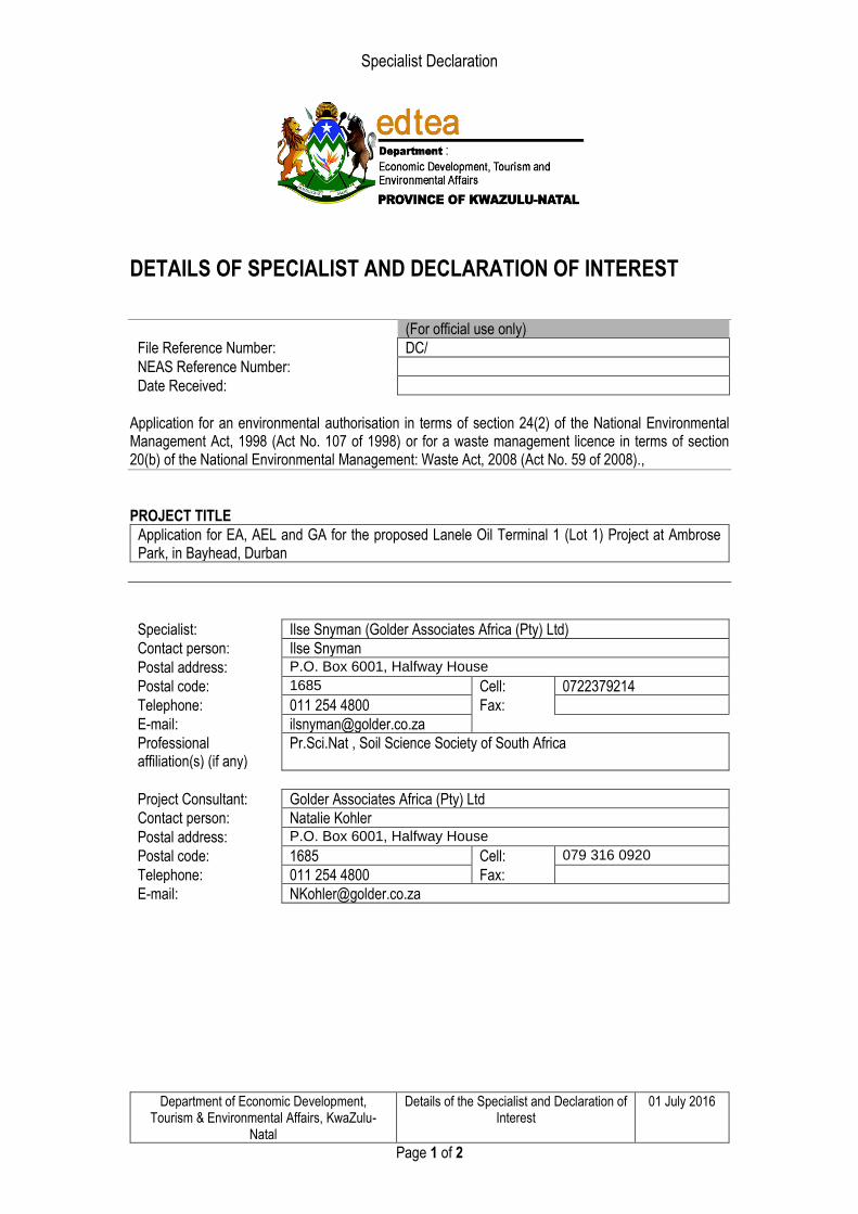
Specialist Declaration
Department of Economic Development, Tourism & Environmental Affairs, KwaZulu-
Natal
Details of the Specialist and Declaration of Interest
01 July 2016
Page 1 of 2
DETAILS OF SPECIALIST AND DECLARATION OF INTEREST
(For official use only)
File Reference Number: DC/
NEAS Reference Number:
Date Received:
Application for an environmental authorisation in terms of section 24(2) of the National Environmental Management Act, 1998 (Act No. 107 of 1998) or for a waste management licence in terms of section 20(b) of the National Environmental Management: Waste Act, 2008 (Act No. 59 of 2008).,
PROJECT TITLE
Application for EA, AEL and GA for the proposed Lanele Oil Terminal 1 (Lot 1) Project at Ambrose Park, in Bayhead, Durban
Specialist: Ilse Snyman (Golder Associates Africa (Pty) Ltd)
Contact person: Ilse Snyman
Postal address: P.O. Box 6001, Halfway House
Postal code: 1685 Cell: 0722379214
Telephone: 011 254 4800 Fax:
E-mail: [email protected]
Professional affiliation(s) (if any)
Pr.Sci.Nat , Soil Science Society of South Africa
Project Consultant: Golder Associates Africa (Pty) Ltd
Contact person: Natalie Kohler
Postal address: P.O. Box 6001, Halfway House
Postal code: 1685 Cell: 079 316 0920
Telephone: 011 254 4800 Fax:
E-mail: [email protected]
Specialist Declaration
Department of Economic Development, Tourism & Environmental Affairs, KwaZulu-
Natal
Details of the Specialist and Declaration of Interest
01 July 2016
Page 2 of 2
4.2 The specialist appointed in terms of the Regulations_
I, Ilse Snyman, declare that -- General declaration:
• I act as the independent specialist in this application;
• do not have and will not have any vested interest (either business, financial, personal or other) in the undertaking of the proposed activity, other than remuneration for work performed in terms of the Environmental Impact Assessment Regulations, 2014;
• I will perform the work relating to the application in an objective manner, even if this results in views and findings that are not favourable to the applicant;
• I declare that there are no circumstances that may compromise my objectivity in performing such work;
• I have expertise in conducting the specialist report relevant to this application, including knowledge of the Act, regulations and any guidelines that have relevance to the proposed activity;
• I will comply with the Act, regulations and all other applicable legislation;
• I have no, and will not engage in, conflicting interests in the undertaking of the activity;
• I undertake to disclose to the applicant and the competent authority all material information in my possession that reasonably has or may have the potential of influencing - any decision to be taken with respect to the application by the competent authority; and - the objectivity of any report, plan or document to be prepared by myself for submission to the competent authority;
• all the particulars furnished by me in this form are true and correct; and
• I am aware that a person is guilty of an offence in terms of Regulation 48 (1) of the EIA Regulations, 2014, if that person provides incorrect or misleading information. A person who is convicted of an offence in terms of sub-regulation 48(1) (a)-(e) is liable to the penalties as contemplated in section 49B(1) of the National Environmental Management Act, 1998 (Act 107 of 1998).
Signature of the specialist: Golder Associates Africa (Pty) Ltd
Name of company (if applicable): 11 September 2019
Date: _______________________________

Specialist Declaration
Department of Economic Development, Tourism & Environmental Affairs, KwaZulu-
Natal
Details of the Specialist and Declaration of Interest
01 July 2016
Page 1 of 2
DETAILS OF SPECIALIST AND DECLARATION OF INTEREST
(For official use only) File Reference Number: DC/ NEAS Reference Number: Date Received:
Application for an environmental authorisation in terms of section 24(2) of the National Environmental Management Act, 1998 (Act No. 107 of 1998) or for a waste management licence in terms of section 20(b) of the National Environmental Management: Waste Act, 2008 (Act No. 59 of 2008)., PROJECT TITLE
Application for EA, AEL and GA for the proposed Lanele Oil Terminal 1 (Lot 1) Project at Ambrose Park, in Bayhead, Durban
Specialist: Elize Herselman (Golder Associates Africa (Pty) Ltd) Contact person: Elize Herselman Postal address: P.O. Box 6001, Halfway House Postal code: 1685 Cell: 078 388 6311 Telephone: 011 254 4800 Fax: E-mail: [email protected]@golder.co.za Professional affiliation(s) (if any)
Project Consultant: Golder Associates Africa (Pty) Ltd Contact person: Natalie Kohler Postal address: P.O. Box 6001, Halfway House Postal code: 1685 Cell: 079 316 0920 Telephone: 011 254 4800 Fax: E-mail: [email protected]
Specialist Declaration
Department of Economic Development, Tourism & Environmental Affairs, KwaZulu-
Natal
Details of the Specialist and Declaration of Interest
01 July 2016
Page 2 of 2
4.2 The specialist appointed in terms of the Regulations_
I, Elize Herselman, declare that -- General declaration: I act as the independent specialist in this application; do not have and will not have any vested interest (either business, financial, personal or other) in the
undertaking of the proposed activity, other than remuneration for work performed in terms of the Environmental Impact Assessment Regulations, 2014;
I will perform the work relating to the application in an objective manner, even if this results in views and findings that are not favourable to the applicant;
I declare that there are no circumstances that may compromise my objectivity in performing such work;
I have expertise in conducting the specialist report relevant to this application, including knowledge of the Act, regulations and any guidelines that have relevance to the proposed activity;
I will comply with the Act, regulations and all other applicable legislation; I have no, and will not engage in, conflicting interests in the undertaking of the activity; I undertake to disclose to the applicant and the competent authority all material information in my
possession that reasonably has or may have the potential of influencing - any decision to be taken with respect to the application by the competent authority; and - the objectivity of any report, plan or document to be prepared by myself for submission to the competent authority;
all the particulars furnished by me in this form are true and correct; and I am aware that a person is guilty of an offence in terms of Regulation 48 (1) of the EIA Regulations,
2014, if that person provides incorrect or misleading information. A person who is convicted of an offence in terms of sub-regulation 48(1) (a)-(e) is liable to the penalties as contemplated in section 49B(1) of the National Environmental Management Act, 1998 (Act 107 of 1998).
Signature of the specialist: Golder Associates Africa (Pty) Ltd Name of company (if applicable): 10 September 2019 Date: _______________________________

golder.com