Embed Size (px)
Citation preview
GLASGOW SMALL URBAN AREA STUDY BARREN COUNTY
APPENDIX E – MEETING SUMMARIES
Meeting Minutes
TO: Shane McKenzie Jeff Moore
Co-Project Manager Co-Project Manager KYTC Central Office KYTC District Office #3 200 Mero Street 900 Morgantown Road Frankfort, KY 40622 Bowling Green, KY 42101
FROM: Brian Aldridge Project Manager Stantec Consulting Services Inc. DATE: February 19, 2016 SUBJECT: Glasgow Small Urban Area Study Item Number N/A
Barren County Project Team Kick-Off Meeting
A project team kick-off meeting for the subject project was held at the Kentucky Transportation Cabinet District 3 Office in Bowling Green, Kentucky on February 2, 2016 at 9:00 a.m. CST. The following individuals were in attendance:
Brittany Fisher Barren River Area Development District Kevin Gearlds KYTC – District 3 Justin Harrod KYTC - Central Office Planning Troy Hearn KYTC - Central Office Planning Deneatra Henderson KYTC – District 3 Shane McKenzie KYTC – Central Office Planning Greg Meredith KYTC – District 3 Jeff Moore KYTC – District 3 Planning Mikael Pelfrey KYTC – Central Office Planning Joe Plunk KYTC – District 3 Mike Russell KYTC – District 3 Renee Slaughter KYTC – District 3 Wendy Southworth KYTC - Central Office Design Wes Watt KYTC – District 3 Brian Aldridge Stantec Consulting Services Inc. Tom Creasey Stantec Consulting Services Inc. Len Harper Stantec Consulting Services Inc.
Heather Lawler Stantec Consulting Services Inc.
Jeff Moore welcomed everyone and said the purpose of the meeting was to discuss the progress to date on the Glasgow Small Urban Area (SUA) Study. He said the study will
-- 1 --
identify and examine transportation issues within and surrounding Glasgow and develop three classes of improvement projects. These include short-term improvements, long-term projects, and local street improvements/strategies. Handouts included an agenda and study area maps showing traffic generators, average daily traffic volumes and the critical crash rate factors. Plots of the draft environmental footprint maps were also provided. Brian Aldridge delivered a presentation on the study. The following enumerated items were discussed.
1. The primary goal of the meeting is to review the existing conditions analysis and
determine what will be presented at the advisory committee meeting on February 24th.
2. The goal of the study is to identify and examine transportation and multimodal issues related to safety and congestion in Glasgow and surrounding area. The SUA study area includes the city limits of Glasgow which is a little over 38 square miles. Short-term recommendations will include less resource intensive, quick win type projects the Kentucky Transportation Cabinet (KYTC), City of Glasgow, Barren County and/or private developers can pursue for further project development and implementation. The study will also seek to address long-term concerns by examining the future transportation needs and determining options for future improvement projects. Local improvements may also be included on city streets or county routes but would be the responsibility of the City of Glasgow, Barren County, and/or private developers.
3. The 2014 Barren County Comprehensive Plan requested the development of an urban transportation study for the Glasgow area. The last Glasgow SUA Study was completed in 1988. This SUA planning study is currently funded with Federal SPR (State Planning and Research) funds.
4. Maps were presented showing the planned and committed projects within the study area. There are four projects in the study area listed in the 2014 Six Year Highway Plan and 14 projects listed in the study area on the Unscheduled Needs List (UNL). The project team noted two additional Local Public Agency (LPA) projects to build shared-use facilities in Glasgow.
5. Maps depicting the existing conditions of the study area were discussed by the project team. These included roadway functional class, lane and shoulder widths, median widths and types, truck routes and truck weight class. Bridge sufficiency ratings were also shown.
6. The existing traffic volumes were presented to the project team. Two interchanges have opened to traffic within the past five years along the Louie B Nunn Parkway as part of the extension of the Veterans Outer Loop. The interchange at KY 3600 (exit 8) opened in May 2015 and the interchange at KY 1519 (exit 15) opened in 2011. Central Office Planning provided December 2015 counts at KY 3600, but no counts
-- 2 --
are available at KY 1519. The historic count data just north of the KY 90 interchange (exit 14) shows a significant decrease in demand after the KY 1519 interchange opened. A similar decrease is expected at the US 31E interchange (exit 11), but new count data are not yet available. District 3 is in the process of conducting new traffic counts at US 31E and a traffic count at KY 1519.
7. Stantec is working with KYTC Central Office to update the Bowling Green/Warren County Travel Demand Model, which will be used to develop 2040 No-Build traffic forecasts for the study. The new traffic counts at the four interchanges along the Louie B Nunn Parkway will be added to the model. In addition, the advisory committee will be asked to identify potential growth areas in Glasgow. The Barren County population projections provided by the Kentucky State Data Center suggest 20 percent growth from 2015 to 2040. The city of Glasgow had an annual growth of 1.5 percent between 2000 and 2010.
8. The crash history (January 2013 through December 2015) for study area roadways was discussed. In the three year period there were four crashes involving bicyclists and eight crashes involving pedestrians. These crashes are clustered in a few locations. Stantec will look at these clusters in more detail. The project team asked Stantec to review the November and December 2015 crash records in March to verify all crashes are accounted for.
9. Roadways with critical crash rate factors (CRF’s) greater than 1.0 were highlighted on a map. Brian said the segment crash analyses are complete and Stantec is working on the spot analyses to evaluate intersections. Stantec will look at locations where the CRF is greater than 1.0 in more detail.
10. Work on the Environmental Overview is underway. This will primarily involve
records searches and database reviews given the size of the study area. Draft environmental footprint maps were presented to the project team.
11. Public involvement for the study was discussed. There are to be three project team
meetings and two advisory committee meetings. A list of invitees for the advisory committee has been developed and the invitations for the February 24th advisory committee meeting will be mailed February 5th. The invite will include the meeting agenda and a website link where meeting materials can be viewed. The primary goal of the first advisory committee meeting is to have attendees identify trouble spots. Stantec will deliver a brief presentation explaining the project goals and the existing conditions analysis. This will be followed by a group exercise were attendees will be asked to identify roadway, safety, or traffic issues, such as: intersections where turn lanes or traffic signals are needed, roadways that are too narrow or congested, roadways that should be re-aligned, railroad crossings that need attention, and new connector roadways. The group will also be asked to identify multimodal needs such as bicycle and pedestrian facilities, transit improvements, freight improvements, or the potential need for an ADA transition plan. Plots showing the Planned/Committed Projects, Glasgow Alternative Transportation Endeavor
-- 3 --
(G.A.T.E.) Recommendations, Crash Locations, Environmental Footprint and Land Use will be provided to help kick start group discussion and solicit feedback.
12. The next step will be for Stantec to prepare for the first advisory committee meeting and continue work on the traffic forecasts and environmental overview. After the first advisory committee meeting Stantec will begin investigating alternatives.
13. Brian discussed the project schedule. The first advisory committee meeting will be
held on February 24th. The next project team meeting will be in April. At that time Stantec will present preliminary alternatives for the project team to review. After that, refined alternatives will be presented to the advisory committee and project team in June to solicit feedback and suggested prioritization.
The meeting ended at approximately 10:30 a.m. CST.
-- 4 --
Meeting Minutes
TO: Shane McKenzie Jeff Moore
Co-Project Manager Co-Project Manager KYTC Central Office KYTC District Office #3 200 Mero Street 900 Morgantown Road Frankfort, KY 40622 Bowling Green, KY 42101
FROM: Brian Aldridge Project Manager Stantec Consulting Services Inc. DATE: March 2, 2016 SUBJECT: Glasgow Small Urban Area Study Item Number N/A
Barren County Advisory Committee Meeting #1
A project Advisory Committee meeting for the subject project was held at the Glasgow City Hall Council Chambers in Glasgow, Kentucky on February 24, 2016 at 10:00 a.m. CST. The following individuals were in attendance:
Dick Doty Mayor of Glasgow Tommy Elliott Glasgow Independent Schools Brittany Fisher Barren River Area Development District Kurt Frey Glasgow Public Works Brad Groce Glasgow City Council Lana Hatcher Glasgow Transit Troy Hearn KYTC - Central Office Planning Deneatra Henderson KYTC – District 3 Guy Howie Glasgow Police Chip Jenkins Barren County Schools Kent Keen Barren County Sheriff’s Office Thom Kendall Joint City-County Planning Commission Dustin Luttrell KYTC – District 3 Shane McKenzie KYTC – Central Office Planning Jeff Moore KYTC – District 3 Planning Kevin Myatt Joint City-County Planning Commission Daryl Prie KYTC – District 3
Wendy Southworth KYTC - Central Office Design Scott Thomson KYTC - Central Office Planning
Joe Trigg City of Glasgow Wes Watt KYTC – District 3 Marlin Witcher Glasgow City Council
-- 1 --
Brian Aldridge Stantec Consulting Services Inc. Len Harper Stantec Consulting Services Inc.
Ashley Williamson Stantec Consulting Services Inc.
Jeff Moore welcomed everyone to the first Advisory Committee meeting and asked for formal introductions. He said the purpose of the meeting was to discuss the progress to date on the Glasgow Small Urban Area (SUA) Study and to get input from the Advisory Committee to help the project team identify trouble spots. Handouts included an agenda and study area maps showing planned and committed transportation improvements, average daily traffic (ADT) volumes, critical crash rate factors (CRF), number of lanes and lane widths, shoulder widths, truck routes, and truck weight class. Plots of the draft environmental footprint maps, existing and future land use, crash history, and the Glasgow Alternative Transportation Endeavor (G.A.T.E.) Plan were also provided. Brian Aldridge delivered a brief presentation on the study. The following enumerated items were discussed.
1. The primary goal of the meeting is to review the existing conditions analysis and to
get feedback from the Advisory Committee on problem areas before developing improvement alternatives.
2. The 2014 Barren County Comprehensive Plan requested the development of an urban transportation study for the Glasgow area. The last Glasgow SUA Study was completed in the 1988, and many of the priority projects from that study have been constructed. It is time to create a new plan that will address the current and future needs of Glasgow.
3. The goal of the study is to identify and examine transportation issues related to
safety and congestion in Glasgow and the surrounding area. This includes identifying multimodal needs. Short-term recommendations will be identified which include less resource intensive, quick win type projects the Kentucky Transportation Cabinet (KYTC), City of Glasgow, Barren County and/or private developers can pursue for further project development and implementation. The study will also seek to address long-term concerns by examining the future transportation needs. Local improvements may also be included on city streets or county routes but would be the responsibility of the City of Glasgow, Barren County, and/or private developers to fund.
a. Question: What is the definition of a short term project? Less complex projects that do not require a large amount of funding. Examples include signage improvements, the addition of turn lanes, or possibly pavement rehabilitation projects. Typically these are projects that can be implemented in one to five years. Larger more expensive projects that go through the typical highway development process can take 10 to 12 years to complete, from concept through construction. These larger projects are important but we also want
-- 2 --
to identify smaller projects that can be implemented more quickly as part of this study.
4. Maps were presented showing the planned and committed projects within the study area. There are four projects in the study area listed in the KYTC’s 2014 Six Year Highway Plan and 14 projects listed in the study area on the Unscheduled Needs List (UNL). The project team noted two additional Local Public Agency (LPA) projects to build shared-use facilities in Glasgow (Trojan Trail and Humble Avenue).
• Question: Do projects listed in the SUA Study carry more weight than projects listed on the UNL? No. The goal of this study is to take a fresh look at all the needs, including those that have already been included on the UNL as well as those not yet identified. Once projects have been defined we will then prioritize those projects as part of the SUA Study. This will help the KYTC, City of Glasgow, and Barren County determine how best to use available funding.
• Brian noted that the KY 90 Scoping Study, KYTC Item No. 3-8819, is underway and that a meeting with local officials was anticipated in late spring to discuss alternatives.
5. Large environmental footprint maps (human environment, natural environment,
prime farmland, and historic resources) were made available for participants to view and comment on after the presentation.
6. Maps depicting the existing conditions of the study area were discussed. These included roadway functional class, lane and shoulder widths, median widths and types, truck routes and truck weight class.
7. The existing traffic volumes were presented, and Brian mentioned the Louie B Nunn Cumberland Parkway, US 31E, KY 90, and the Veterans Outer Loop carry the highest traffic volumes within the study area. The Advisory Committee was asked to identify locations where congestion appears to currently be an issue. The locations that were identified are shown on Figure 1.
8. The crash history (January 1, 2013 to December 31, 2015) for study area roadways was discussed. Roadways with critical crash rate factors (CRF’s) greater than 1.0 were highlighted on a map, and Brian explained that these represent locations where the actual crash rate is higher than would be expected and that crashes are not likely random occurrences. Ten locations have a CRF greater than 1.0, and the project team will examine these locations in more detail to see if improvements are needed.
9. The Advisory Committee was asked to identify locations where there are safety
concerns. The identified locations are shown on Figure 2.
-- 3 --
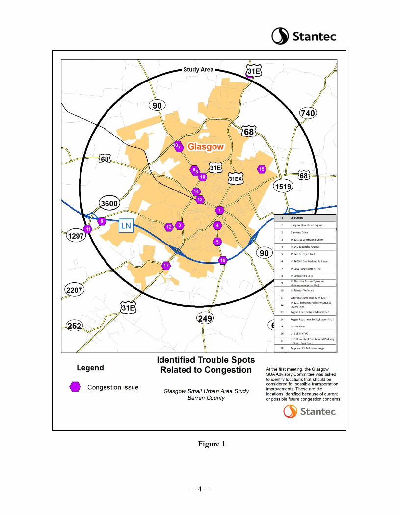
Figure 1
-- 4 --
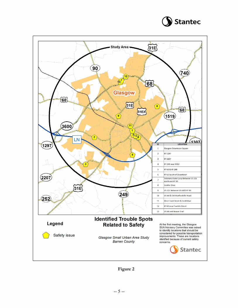
Figure 2
-- 5 --
10. Two interchanges have opened to traffic within the past five years along the Louie B Nunn Cumberland Parkway as part of the extension of the Veterans Outer Loop. The interchange at KY 3600 (exit 8) opened in May 2015 and the interchange at KY 1519 (exit 15) opened in 2011. Central Office Planning provided December 2015 counts at KY 3600, but no official counts are available at KY 1519. The historic count data just north of the KY 90 interchange (exit 14) shows a significant decrease in demand after the KY 1519 interchange opened. A similar decrease is expected at the US 31E interchange (exit 11). KYTC District 3 has recently conducted new traffic counts at both US 31E and KY 1519 and those will be available once the data are processed.
11. KYTC performed an audit of the interchange at KY 3600 (exit 8) and as a result is
evaluating some potential signage/marking improvements at this location.
12. Stantec is working with KYTC Central Office to update the Bowling Green/Warren County Travel Demand Model, which will be used to develop 2040 traffic forecasts for the study. The Barren County population projections provided by the Kentucky State Data Center suggest 20 percent growth from 2015 to 2040 and approximately 2/3 of that growth is expected to be within the city of Glasgow.
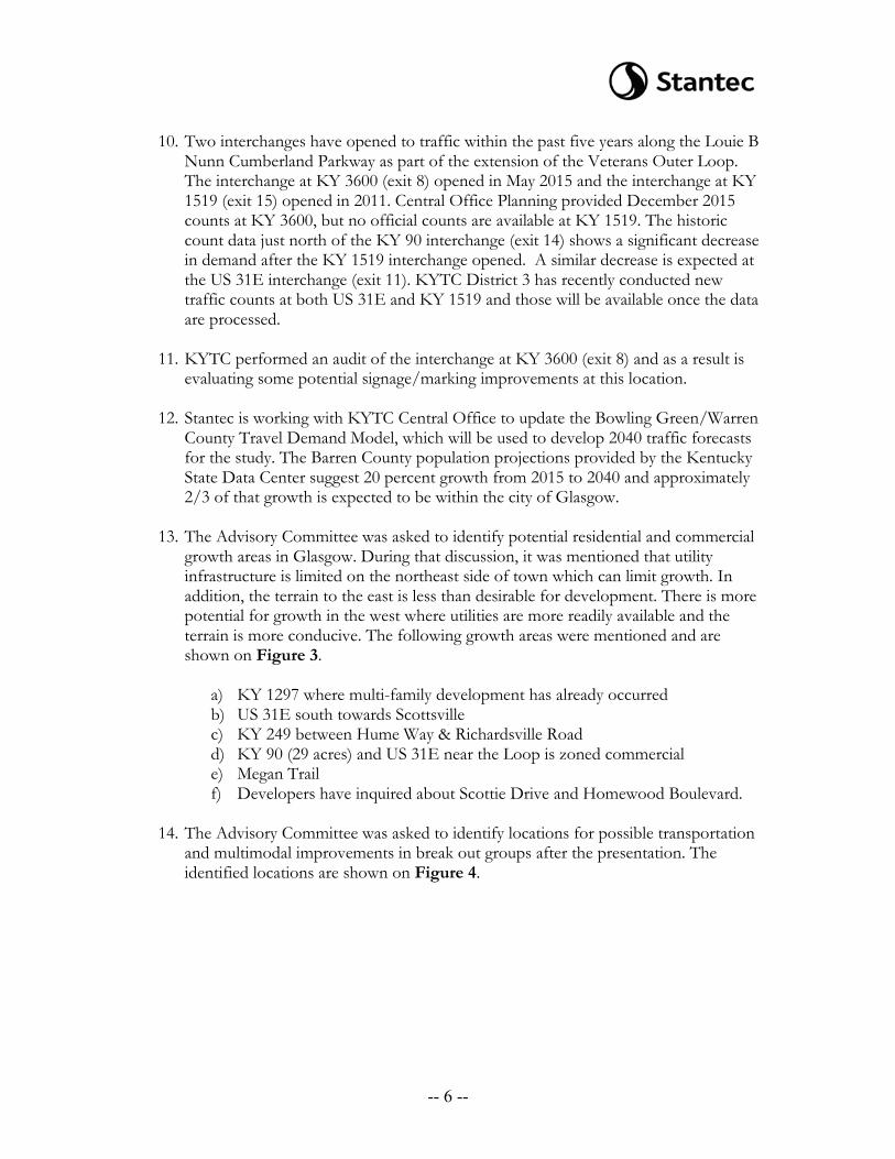
13. The Advisory Committee was asked to identify potential residential and commercial growth areas in Glasgow. During that discussion, it was mentioned that utility infrastructure is limited on the northeast side of town which can limit growth. In addition, the terrain to the east is less than desirable for development. There is more potential for growth in the west where utilities are more readily available and the terrain is more conducive. The following growth areas were mentioned and are shown on Figure 3.
a) KY 1297 where multi-family development has already occurred b) US 31E south towards Scottsville c) KY 249 between Hume Way & Richardsville Road d) KY 90 (29 acres) and US 31E near the Loop is zoned commercial e) Megan Trail f) Developers have inquired about Scottie Drive and Homewood Boulevard.
14. The Advisory Committee was asked to identify locations for possible transportation
and multimodal improvements in break out groups after the presentation. The identified locations are shown on Figure 4.
-- 6 --
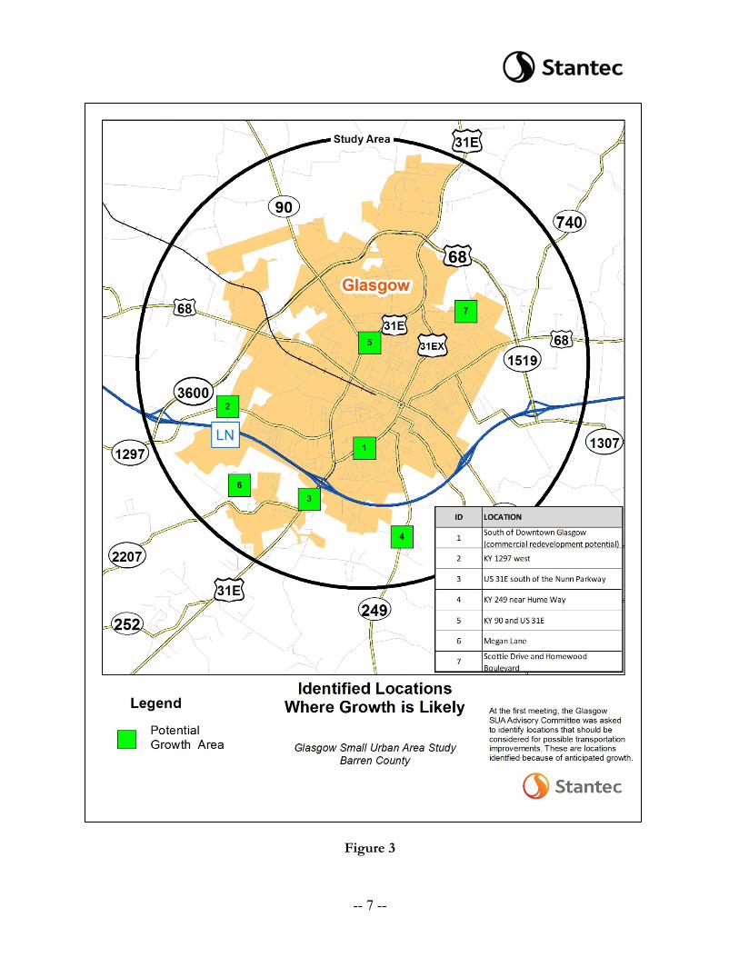
Figure 3
-- 7 --
Figure 4
-- 8 --
15. Brian discussed the project schedule. The next step will be for Stantec to continue work on the traffic forecasts and develop preliminary improvement alternatives based on comments received at today’s meeting. A second Advisory Committee meeting will be held in June where preliminary improvement alternatives will be presented to solicit feedback and suggested prioritization.
The meeting ended at approximately 12:30 p.m. CST.
-- 9 --
Meeting Minutes
TO: Shane McKenzie Jeff Moore
Co-Project Manager Co-Project Manager KYTC Central Office KYTC District Office #3 200 Mero Street 900 Morgantown Road Frankfort, KY 40622 Bowling Green, KY 42101
FROM: Brian Aldridge Project Manager Stantec Consulting Services Inc. DATE: May 11, 2016 SUBJECT: Glasgow Small Urban Area Study Barren County Project Team Meeting #2
A project team meeting for the subject project was held at the Kentucky Transportation Cabinet District 3 Office in Bowling Green, Kentucky on April 28, 2016 at 10:45 a.m. CDT. The following individuals were in attendance:
Brittany Fisher Barren River Area Development District Justin Harrod KYTC - Central Office Planning Troy Hearn KYTC - Central Office Planning Deneatra Henderson KYTC – District 3 Shane McKenzie KYTC – Central Office Planning Jeff Moore KYTC – District 3 Joe Plunk KYTC – District 3 Steve Ross KYTC – Central Office Planning Renée Slaughter KYTC – District 3 Wendy Southworth KYTC - Central Office Design Andy Stewart KYTC – District 3 Wes Watt KYTC – District 3 Brian Aldridge Stantec Consulting Services Inc. Tom Creasey Stantec Consulting Services Inc. Len Harper Stantec Consulting Services Inc.
Heather Lawler Stantec Consulting Services Inc.
Jeff Moore welcomed everyone and said the purpose of the meeting was to discuss the preliminary transportation improvement concepts developed for the Glasgow Small Urban Area (SUA) Study. Handouts included an agenda, a copy of the meeting summary from the first Advisory Committee meeting, and a map and table describing the preliminary improvement concepts.
-- 1 --
Brian Aldridge delivered a brief presentation. The following enumerated items were discussed.
1. Brian provided a recap of the first Advisory Committee meeting held on February
24th in Glasgow. During that meeting, attendees were asked to identify locations where congestion is an issue, trouble spots related to safety, areas where growth is anticipated, and locations for the project team to consider possible transportation improvements. The Advisory Committee identified:
• 18 locations with possible congestion issues • 14 trouble spots related to safety • 7 growth areas (primarily south and west of downtown) • 19 locations for potential transportation improvements
2. As a follow-up to the safety discussion during the Advisory Committee meeting,
KYTC District 3 performed an audit of the Cumberland Parkway interchange at KY 3600 (exit 8). Additional signage was added to the interchange as a result of the audit.
3. Brian mentioned that Stantec updated the crash analyses after the first project team meeting to ensure all crashes from late 2015 were included.
4. Scott Thomson provided Stantec preliminary traffic forecasts based on output from the Warren County travel demand model which has been updated based on information provided at the Advisory Committee meeting. Brian mentioned there was work remaining to address some minor issues with the model and that effort would be wrapping up soon.
5. Brian presented 18 conceptual improvement projects, saying these concepts were
developed based on a combination of input from the Advisory Committee, a review of the existing conditions, and field reconnaissance performed by Stantec. The location of each concept is shown on Figure 1 and they are summarized in Table 1. Discussion of each concept is below.
A. KY 2207 (Southfork Road) between MP 3.0 and MP 4.0 – This portion of the route includes four horizontal curves and has a Critical Crash Rate Factor (CRF) of 3.0. Of the 20 reported crashes over the past three years, 14 are wet-weather related. A short-term option could include the application of a high-friction pavement surface, which would require input from the KYTC Highway Safety Improvement Program (HSIP) team. A long-term improvement could include realigning the route to eliminate the curves.
-- 2 --
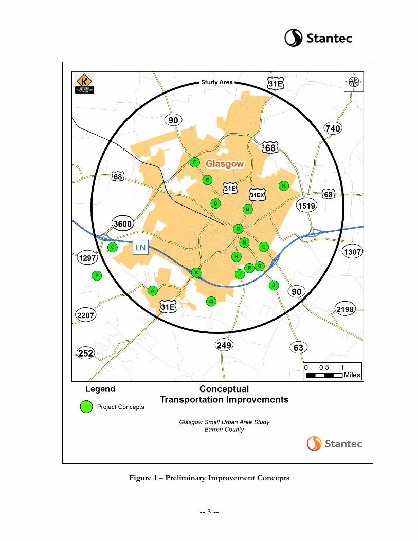
Figure 1 – Preliminary Improvement Concepts
-- 3 --
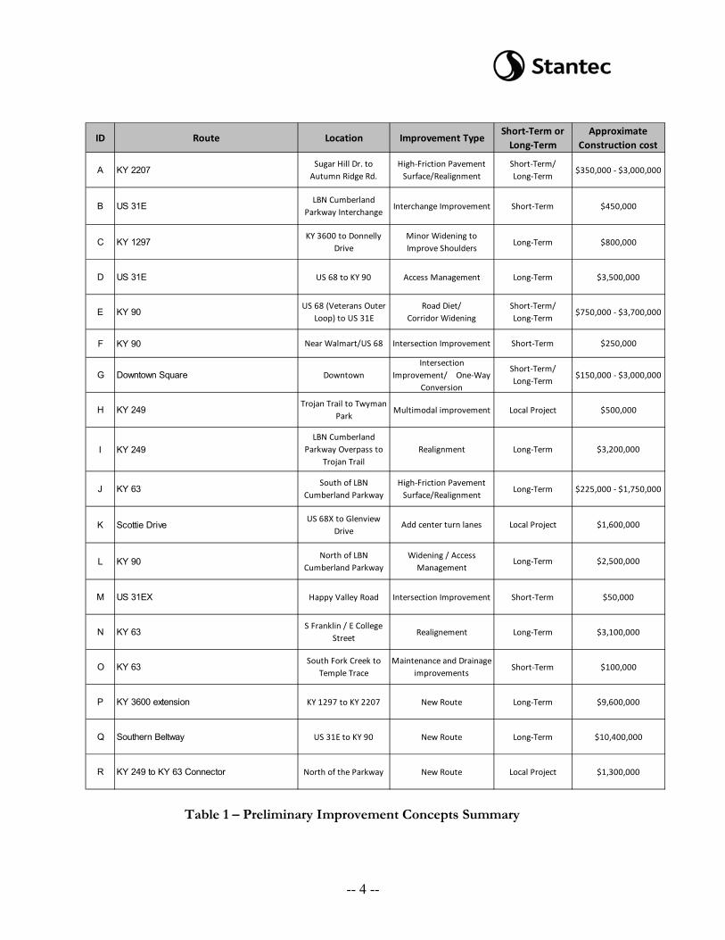
Table 1 – Preliminary Improvement Concepts Summary
ID Route Location Improvement TypeShort-Term or
Long-TermApproximate
Construction cost
A KY 2207Sugar Hill Dr. to
Autumn Ridge Rd.High-Friction Pavement
Surface/RealignmentShort-Term/ Long-Term
$350,000 - $3,000,000
B US 31ELBN Cumberland
Parkway InterchangeInterchange Improvement Short-Term $450,000
C KY 1297KY 3600 to Donnelly
DriveMinor Widening to Improve Shoulders
Long-Term $800,000
D US 31E US 68 to KY 90 Access Management Long-Term $3,500,000
E KY 90US 68 (Veterans Outer
Loop) to US 31ERoad Diet/
Corridor WideningShort-Term/ Long-Term
$750,000 - $3,700,000
F KY 90 Near Walmart/US 68 Intersection Improvement Short-Term $250,000
G Downtown Square DowntownIntersection
Improvement/ One-Way Conversion
Short-Term/ Long-Term
$150,000 - $3,000,000
H KY 249 Trojan Trail to Twyman
ParkMultimodal improvement Local Project $500,000
I KY 249LBN Cumberland
Parkway Overpass to Trojan Trail
Realignment Long-Term $3,200,000
J KY 63South of LBN
Cumberland ParkwayHigh-Friction Pavement
Surface/RealignmentLong-Term $225,000 - $1,750,000
K Scottie DriveUS 68X to Glenview
DriveAdd center turn lanes Local Project $1,600,000
L KY 90North of LBN
Cumberland ParkwayWidening / Access
ManagementLong-Term $2,500,000
M US 31EX Happy Valley Road Intersection Improvement Short-Term $50,000
N KY 63S Franklin / E College
StreetRealignement Long-Term $3,100,000
O KY 63South Fork Creek to
Temple TraceMaintenance and Drainage
improvementsShort-Term $100,000
P KY 3600 extension KY 1297 to KY 2207 New Route Long-Term $9,600,000
Q Southern Beltway US 31E to KY 90 New Route Long-Term $10,400,000
R KY 249 to KY 63 Connector North of the Parkway New Route Local Project $1,300,000
-- 4 --
B. US 31E at Louie B. Nunn Cumberland Parkway – This section of US 31E carries about 22,000 vehicles per day (VPD) and the volume is expected to increase. The issue is the proximity of the unsignalized westbound ramp terminal to the signalized intersection with Trojan Trail. A short-term project could include signalizing the ramp terminal intersection. A long-term project could include reconfiguring the interchange to either a new type (such as single point urban interchange) or widening US 31E under the parkway bridge to accommodate additional turn lane storage.
C. KY 1297 between KY 3600 and Donnelly Drive – This section of KY 1297 carries about 3,700 VPD and the volume is not expected to increase significantly. The existing shoulder is generally one to two feet of earth. Of the 12 reported crashes over the last three years, 10 were single vehicle crashes and most involved a roadway departure. A possible long-term improvement would be to add paved shoulders along the route.
D. US 31E between US68 and KY 90 – This portion of US 31E carries
about 17,800 VPD and has a CRF of 2.4. Traffic is expected to increase to about 23,000 VPD by 2040. Smith Road serves as a frontage road along the east side of US 31E but is located too close (about 75 feet) to provide effective intersections to serve both US 31E and frontage road traffic. Wall Street is currently a backage road connecting Happy Valley Road and many of the businesses along Cherry Street. A long-term improvement concept would be to construct a raised median along US 31E, eliminating non-signalized left-turn movements from the busy corridor. Smith Road would be eliminated and Wall Street would instead be extended to serve as a backage road for all the businesses fronting US 31E.
E. KY 90 between US 68 and US 31E - This section of KY 90 is
commercial in character. It is predominately an undivided four-lane section that carries about 13,000 vehicles per day and has a CRF of 1.2. The lack of left-turn lanes affects traffic operations and safety. With future traffic projected to about 19,000 VPD by 2040, one through lane in each direction should be capable of accommodating travel demand; that assumes the turn lanes already in place at US 68 and US 31E remain in place. Therefore, a short-term project could include a road diet to restripe the roadway as three lanes, with one travel lane per direction and a continuous center left-turn lane. Should future demand warrant the need for more lanes, a long-term project could include widening the corridor to a five-lane section.
F. KY 90 at Walmart – The signalized entrance from KY 90 to Walmart at
Max Wagoner Road is less than 500 feet from the US 68 intersection. This location sees about 13,000 VPD and has a CRF of 1.4; the majority
-- 5 --
of the reported crashes have been rear ends or angle crashes. South of the Walmart parking lot, there is space for additional development. A potential improvement would be to relocate the signalized intersection south away from the US 68 intersection. This could serve as a standalone project or could be included in project E. A short-term project could be to add signal ahead warning signage on KY 90 south of the signal at Max Wagoner Road and put reflector back plates on the signal heads.
G. Downtown Square – The Downtown Square in Glasgow is the
confluence of KY 90, US 68 Business, and US 31EX. Lined with on-street parking, traffic passing through the square follow a circular traffic pattern as each facility enters as a two-way street and traverses the square one-way. The traffic volumes on the one-way segments range from 7,200 to 8,200 VPD. One issue is the location of four mid-block crosswalks on the one-way segments. Another issue is the volume of traffic traversing the square and the merging/weaving movements required. Traffic often backs up well beyond the intersections adjacent to the square, particularly along KY 90 (Main Street). A possible short-term project would be to relocate the mid-block crosswalks to the four corners of the square which are currently stop-controlled or signalized. A long-term solution could be to convert Main Street and Washington Street to a one-way couplet to better facilitate travel through the square. The project team also considered closing the NE/SW roadways within the square and converting those pieces of the square to parking lots. Because the NE/SW roads carry US 31EX through the square it is unlikely they can be closed to through traffic.
H. KY 249 north of Trojan Trail – The City of Glasgow is currently
pursuing two Local Public Agency (LPA) projects to construct shared-use facilities along Trojan Trail and east of KY 249. Once constructed, these facilities would not be connected to one another. A potential short-term project could be to construct a shared use facility along KY 249 to connect the two amenities currently under development.
I. KY 249 between the Louie B. Nunn Cumberland Parkway overpass and
Trojan Trail – Carrying about 3,000 VPD, KY 249 suffers from a combination of poor horizontal and vertical alignment in this area. As a result, the intersection with Hilltopper Way is located in an area with less than desirable sight distance. North of Hilltopper Way, the alignment includes s-curves as it travels downgrade towards the bridge over the South Fork, just south of Trojan Trail. The KYTC has plans to replace the bridge, and the current plan is to replace and widen the bridge on its current alignment. A long-term improvement could include the realignment of KY 249, both horizontally and vertically, to connect to the proposed bridge improvement.
-- 6 --
J. KY 63 south of the Louie B. Nunn Cumberland Parkway – Between milepost 12.4 and 13.0, KY 63 suffers from a combination of poor horizontal and vertical alignment. This section carries about 2,400 VPD and there have been 11 crashes reported in the last three years (CRF = 1.1), 10 of which were single vehicle crashes. Of the 10 single vehicle crashes, eight occurred during wet weather. A short-term option could include the application of a high-friction pavement surface, which would require input from the KYTC Highway Safety Improvement Program (HSIP) team. A long-term improvement could include realigning the route to eliminate or increase the radii on the horizontal curves and to reduce the grade.
K. Scottie Drive – Scottie Drive is a city street that carries about 2,900
vehicles per day. It serves a number of neighborhoods as well as the Glasgow City Schools campus, located near the south end of the route near US 68 Business. At the Advisory Committee meeting, Scottie Drive was mentioned as a potential high-growth corridor as land remains available for residential development. A potential local project could be to widen Scottie Drive to a three-lane section to better accommodate access as the corridor grows.
L. KY 90 north of the Louie B. Nunn Cumberland Parkway – South and
through the parkway interchange, KY 90 is a four-lane facility. It transitions to a two-lane roadway north of the interchange, carrying about 14,000 VPD. A shopping center is located about 1,200 feet north of the interchange, and access to the shopping center and nearby businesses is poorly defined. There were 12 reported crashes in the vicinity over the last three years. A possible long-term solution would be to widen KY 90 to a three-lane section between the interchange and north of the shopping center and to implement access management improvements to better define the business access.
M. US 31EX at Happy Valley Road – The traffic signal located at the
intersection at US 31EX (Race Street) and Happy Valley Road is a diagonal span. There are currently no turn lanes on US 31EX, and based on observation it appears that a northbound left-turn lane from US 31EX onto Happy Valley Road may be warranted. A left turn lane was provided at this location previously. A possible short-term project could provide a left-turn lane on US 31EX and replace the diagonal span traffic signal with a conventional span wire arrangement.
N. KY 63 at College Street and Mill Street – Entering Downtown Glasgow,
KY 63 includes two 90 degree curves. Carrying between 1,800 and 2,400 VPD, the curves have advisory speeds posted as 15 miles per hour (MPH) but the speed limit is 35 MPH. A potential long-term project
-- 7 --
could include realigning KY 63 to the north to connect directly into the College Street corridor, eliminating the 90-degree curves.
O. KY 63 north of Temple Trace – The western ditch along KY 63 in this
section has suffered from severe erosion/washing, and there is no shoulder in the area as a result of the erosion. KYTC maintenance has attempted to minimize the erosion by placing channel lining in the ditch. The ditch connects to a tributary of South Fork that passes beneath the roadway north of Temple Trace. During a site visit, it was noted the culvert beneath the roadway was nearly full of water even though there had been no recent heavy rainfall event. The water did not appear to be moving. A possible short-term project could include improvements to better control the drainage issues. This could include a combination of ditching to clean the existing channel and culvert, or to either lower/increase the ditch area or to increase the size of the culvert beneath the roadway. The latter would require increasing the elevation on KY 63. A hydraulic analysis will be required to determine which option is more feasible.
P. KY 3600 Extension – In order to provide an alternative connection from
the Louie B. Nunn Cumberland Parkway to US 31E, and consequently an alternative north-south route passing over the parkway, a southern extension of KY 3600 could be constructed as a long-term concept. The original concept included an extension to KY 2207 (Southfork Road), but the project team agreed a connection to US 31E should be included with the project. The project could be phased, with KY 2207 providing a logical breakpoint for a first construction segment. This would effectively serve as a southwestern portion of the Veterans Outer Loop.
Q. Southern Beltway – There are no state-maintained east—west
connections south of the Louie B. Nunn Cumberland Parkway between US 31E and KY 90. As a long-term concept, a new route could be constructed to provide that connection.
R. KY 249 to KY 63 Connector – East-west travel alternatives are limited in
the southeast area of Glasgow. There has been some suggestion that a fifth interchange with the Louie B. Nunn Cumberland Parkway would be desirable to increase access to the area. However, the spacing of the existing interchanges would not accommodate a new interchange that meets FHWA requirements. As an alternative, a long-term concept could be to construct a new east-west connector between KY 249 and KY 63, ideally connecting Hilltopper Way to Lenna Drive. This connector would provide access at the west end to the US 31E interchange (via Hilltopper Way and Trojan Trail) and at the west end to the KY 90 interchange (via Lenna Drive).
-- 8 --
6. Troy Hearn requested that the study report include language that each project should
consider bicycle and pedestrian accommodations where appropriate. Brian said a project sheet will be developed for each project and some discussion will be included to note where bicycle and pedestrian improvements should be considered.
7. Brian discussed the project schedule. The preliminary concepts will be presented to the Advisory Committee on May 26th to solicit feedback and suggested prioritization. The final project team meeting will be in June.
8. Next Steps: Shane and Jeff will work on the invitation for the Advisory Committee
meeting. Stantec will work on a handout to include with the invitation. The handout will include a map showing the proposed projects and a table explaining each project. The concepts will be sorted by project type in the table and renumbered accordingly.
The meeting ended at approximately 12:30 p.m. CDT.
-- 9 --
Meeting Minutes
TO: Shane McKenzie Jeff Moore
Co-Project Manager Co-Project Manager KYTC Central Office KYTC District Office #3 200 Mero Street 900 Morgantown Road Frankfort, KY 40622 Bowling Green, KY 42101
FROM: Brian Aldridge Project Manager Stantec Consulting Services Inc. DATE: June 7, 2016 SUBJECT: Glasgow Small Urban Area Study Item Number N/A
Barren County Advisory Committee Meeting #2
The second project advisory committee meeting for the subject project was held at the Glasgow City Hall Council Chambers in Glasgow, Kentucky on May 26, 2016 at 9:00 a.m. CDT. The following individuals were in attendance:
Tony Atwood Glasgow Fire Department Dick Doty Mayor of Glasgow Tommy Elliott Glasgow Independent Schools Brittany Fisher Barren River Area Development District Kurt Frey Glasgow Public Works Lana Hatcher Glasgow Transit Troy Hearn KYTC - Central Office Planning Guy Howie Glasgow Police Stewart Lich KYTC- District 3 Brian Marr Glasgow Fire Department Shane McKenzie KYTC – Central Office Planning Jeff Moore KYTC – District 3 Kevin Myatt Joint City-County Planning Commission Melinda Overstreet Glasgow Daily Times Brian Shirley Glasgow Fire Department Tracey Shirley Glasgow-Barren County Emergency Medical Neil Thornbury T.J. Samson Community Hospital
Brian Aldridge Stantec Consulting Services Inc. Heather Lawler Stantec Consulting Services Inc.
Ashley Williamson Stantec Consulting Services Inc. Graham Winchester Stantec Consulting Services Inc.
-- 1 --
Jeff Moore welcomed everyone and said the purpose of the meeting was to discuss the progress to date on the Glasgow Small Urban Area (SUA) Study and present, discuss and receive feedback on potential solutions identified. As part of the meeting, Jeff said the committee members would have an opportunity to assist the project team in prioritizing improvement alternatives. Handouts included an agenda and study area maps identifying locations where the Advisory Committee noted congestion was an issue, trouble spots related to safety, areas where growth is anticipated, and locations for the project team to consider possible transportation improvements. Handouts also included a map and table describing the preliminary improvement concepts developed by the project team. The following enumerated items were discussed:
1. The goal of the study is to identify and examine transportation issues related to
safety and congestion in Glasgow and surrounding area. The SUA study area, which is just over 38 square miles, includes the city limits of Glasgow.
2. The Glasgow SUA Study will result in a list of recommendations which the KYTC, City of Glasgow, Barren County and/or private developers can take for further project development and implementation. The improvement concepts are categorized as follows:
a) Short-term: The short-term concepts are typically lower-cost projects that could
be implemented in the near term. These types of improvements should require little or no right-of-way to construct and in some cases may be implemented by the KYTC Division of Maintenance.
b) Long-term: The long-term concepts are higher cost projects that will require more significant resources to implement. These types of improvements will require additional right-of-way to construct and will likely need to be funded through the KYTC Six Year Plan (SYP) process.
c) Local projects: The local projects are not located on the state-maintained system and would likely need to be funded by the City of Glasgow or Barren County. A private developer may also take on this responsibility.
3. Brian Aldridge provided a recap of the first Advisory Committee meeting held on
February 24th in Glasgow. During that meeting, attendees were asked to identify locations where congestion is an issue, trouble spots related to safety, areas where growth is anticipated, and locations for the project team to consider possible transportation improvements. The Advisory Committee identified:
• 18 locations with possible congestion issues • 14 trouble spots related to safety • 7 growth areas (primarily south and west of downtown) • 19 locations for potential transportation improvements
-- 2 --
4. Population projections show Barren County, current population of 44,305, experiencing a 20 percent population growth from 2015 to 2040. Data is not available for individual cities, but Glasgow’s current population of 14,339 is expected to see a similar increase.
5. Brian briefly presented each of the 23 improvement concepts, listed below in Tables 1-4. The concepts were discussed as follows: • Concepts A1 and A2: US 31E at Louie B. Nunn Cumberland Parkway – This
section of US 31E carries about 22,000 vehicles per day (VPD) and the volume is expected to increase. The issue is the proximity of the unsignalized westbound ramp terminal to the signalized intersection with Trojan Trail. The project team initially presented a short-term project that could include signalizing the ramp terminal intersection and widening US 31E under the parkway bridge to accommodate additional turn lane storage. It was suggested that a long-term project to reconfiguring the interchange to a new type (such as single point urban interchange) to increase spacing between traffic signals should be considered. Therefore, Concept A2 was added as a long-term solution at the interchange.
i. New traffic volumes would need to be collected and a signal warrant analysis would need to be completed before a recommendation is made on traffic control for the intersection.
ii. It was pointed out that an interchange reconfiguration would require new bridges.
iii. Shift changes at nearby employers in IDEA Park align with the end of the school day (approximately 3 p.m.) causing congestion at the interchange.
• Concept B: KY 90 at Walmart – The signalized entrance from KY 90 to
Walmart at Max Wagoner Road is less than 500 feet from the US 68 intersection. This location sees about 13,000 VPD and has a CRF of 1.4; the majority of the reported crashes have been rear ends or angle crashes. South of the Walmart parking lot, there is space for additional development. A potential improvement would be to relocate the signalized intersection south away from the US 68 intersection. This could serve as a standalone project or could be included in project F. A short-term project could be to add signal ahead warning signage on KY 90 south of the signal at Max Wagoner Road and put reflector back plates on the signal heads.
• Concept C: US 31EX at Happy Valley Road – The traffic signal located at the intersection at US 31EX (Race Street) and Happy Valley Road is a diagonal span. There are currently no turn lanes on US 31EX, and based on observation it appears that a northbound left-turn lane from US 31EX onto Happy Valley Road may be warranted. A left turn lane was provided at this location previously. A possible short-term project could provide a left-turn lane on US 31EX and replace the diagonal span traffic signal with a conventional span wire arrangement.
-- 3 --
Tab
le 1
: Sho
rt-T
erm
Impr
ovem
ent A
ltern
ativ
es
-- 4 --
T
able
2: S
hort
-Ter
m/L
ong-
Ter
m Im
prov
emen
t Alte
rnat
ives
-- 5 --
Tab
le 3
: Lon
g-T
erm
Impr
ovem
ent A
ltern
ativ
es
-- 6 --
Tab
le 4
: Loc
al Im
prov
emen
t Alte
rnat
ives
-- 7 --
• Concept D: KY 63 north of Temple Trace – The western ditch along KY 63 in
this section has suffered from severe erosion/washing, and there is no shoulder in the area as a result of the erosion. KYTC maintenance has attempted to minimize the erosion by placing channel lining in the ditch. The ditch connects to a tributary of South Fork that passes beneath the roadway north of Temple Trace. During a site visit, it was noted the culvert beneath the roadway was nearly full of water even though there had been no recent heavy rainfall event. The water did not appear to be moving. A possible short-term project could include improvements to better control the drainage issues. This could include a combination of ditching to clean the existing channel and culvert, or to either lower/increase the ditch area or to increase the size of the culvert beneath the roadway. The latter would require increasing the elevation on KY 63. As-built plans are not available for the route, and a hydraulic analysis will be required to determine which option is more feasible.
i. The bike plan using KY 63 has been moved to College Street. ii. During heavy rains, water does not encroach onto the roadway.
• Concepts E1 and E2: KY 2207 (Southfork Road) between MP 3.0 and MP 4.0
– This portion of the route includes four horizontal curves and has a Critical Crash Rate Factor (CRF) of 3.0. Of the 20 reported crashes over the past three years, 14 are wet-weather related. A short-term option could include the application of a high-friction pavement surface. A long-term improvement could include realigning the route to eliminate the curves.
• Concepts F1 and F2: KY 90 between US 68 and US 31E - This section of KY 90 is commercial in character. It is predominately an undivided four-lane section that carries about 13,000 vehicles per day and has a CRF of 1.2. The lack of left-turn lanes affects traffic operations and safety. With future traffic projected to about 19,000 VPD by 2040, one through lane in each direction should be capable of accommodating travel demand; that assumes the turn lanes already in place at US 68 and US 31E remain in place. Therefore, a short-term project could include a road diet to restripe the roadway as three lanes, with one travel lane per direction and a continuous center left-turn lane. Should future demand warrant the need for more lanes, a long-term project could include widening the corridor to a five-lane section.
i. Congestion has increased since the Police Department has recently moved into the area, directly across from Big Lots. A traffic study would be needed to determine if another driveway for the Police Department is warranted.
ii. A more thorough traffic analysis would need to be completed before either of the solutions could move forward.
iii. There are additional proposed developments that would increase travel demand along KY 90 and add to the congestion.
-- 8 --
• Concepts G1 and G2: Downtown Square – The Downtown Square in Glasgow is the confluence of KY 90, US 68 Business, and US 31EX. Lined with on-street parking, traffic passing through the square follows a circular traffic pattern as each facility enters as a two-way street and traverses the square one-way. The traffic volumes on the one-way segments range from 7,200 to 8,200 VPD. One issue is the location of four mid-block crosswalks on the one-way segments. Another issue is the volume of traffic traversing the square and the merging/weaving movements required. Traffic often backs up well beyond the intersections adjacent to the square, particularly along KY 90 (Main Street). A possible short-term project would be to relocate the mid-block crosswalks to the four corners of the square which are currently stop-controlled or signalized. A long-term solution could be to convert Main Street and Washington Street to a one-way couplet to better facilitate travel through the square.
i. The semi-trucks traveling around the downtown square create additional downtown congestion. It was recommended that KY 90 have two through lanes. If an additional through lane is added there would not be enough room for turn lanes without taking significant amounts of on-street parking.
ii. It was suggested that eliminating some on-street parking may be feasible to facilitate additional lanes and improved traffic flow.
• Concepts H1 and H2: KY 63 south of the Louie B. Nunn Cumberland Parkway – Between milepost 12.4 and 13.0, KY 63 suffers from a combination of poor horizontal and vertical alignment. This section carries about 2,400 VPD and there have been 11 crashes reported in the last three years (CRF = 1.1), 10 of which were single vehicle crashes. Of the 10 single vehicle crashes, eight occurred during wet weather. A short-term option could include the application of a high-friction pavement surface. A long-term improvement could include realigning the route to eliminate or increase the radii on the horizontal curves. However, this would not result in a significant reduction in the grade.
• Concept I: KY 1297 between KY 3600 and Donnelly Drive – This section of KY 1297 carries about 3,700 VPD and the volume is not expected to increase significantly. The existing shoulder is generally one to two feet of earth. Of the 12 reported crashes over the last three years, 10 were single vehicle crashes and most involved a roadway departure. A possible long-term improvement would be to add paved shoulders along the route.
• Concept J: US 31E between US68 and KY 90 – This portion of US 31E carries
about 17,800 VPD and has a CRF of 2.4. Traffic is expected to increase to about 23,000 VPD by 2040. Smith Road serves as a frontage road along the east side of US 31E but is located too close (about 75 feet) to provide effective intersections to serve both US 31E and frontage road traffic. Wall Street is currently a backage road connecting Happy Valley Road and many of the businesses along Cherry Street. A long-term improvement concept would be to construct a raised median along US 31E, eliminating non-signalized left-turn movements from the busy
-- 9 --
corridor. Smith Road would be eliminated and Wall Street would instead be extended to serve as a backage road for all the businesses fronting US 31E.
i. There were some concerns expressed related to the location of the Holiday Inn Express and the proposed extension of Wall Street. Based upon further review of the site, it appears as though there is room in front of the Holiday Inn Express to accommodate the extension with only minimal impact to the hotel’s driveways and parking lot. However, survey data will be required to verify this.
• Concept K: KY 249 between the Louie B. Nunn Cumberland Parkway overpass
and Trojan Trail – Carrying about 3,000 VPD, KY 249 suffers from a combination of poor horizontal and vertical alignment in this area. As a result, the intersection with Hilltopper Way is located in an area with less than desirable sight distance. North of Hilltopper Way, the alignment includes s-curves as it travels downgrade towards the bridge over the South Fork, just south of Trojan Trail. The KYTC has plans to replace the bridge, and the current plan is to replace and widen the bridge on its current alignment. A long-term improvement could include the realignment of KY 249, both horizontally and vertically, to connect to the proposed bridge improvement.
• Concept L: KY 90 north of the Louie B. Nunn Cumberland Parkway – South and through the parkway interchange, KY 90 is a four-lane facility. It transitions to a two-lane roadway north of the interchange, carrying about 14,000 VPD. A shopping center is located about 1,200 feet north of the interchange, and access to the shopping center and nearby businesses is poorly defined. There were 12 reported crashes in the vicinity over the last three years. A possible long-term solution would be to widen KY 90 to a three-lane section between the interchange and north of the shopping center and to implement access management improvements to better define the business access.
• Concept M: KY 63 at College Street and Mill Street – Entering Downtown
Glasgow, KY 63 includes two 90 degree curves. Carrying between 1,800 and 2,400 VPD, the curves have advisory speeds posted as 15 miles per hour (MPH) but the speed limit is 35 MPH. A potential long-term project could include realigning KY 63 to the north to connect directly into the College Street corridor, eliminating the 90-degree curves.
i. A shared-use path and a pedestrian bridge crossing the proposed corridor are proposed in the area. The location and plans for the facility will need to be confirmed prior to the concept moving forward.
• Concept N: KY 3600 Extension – In order to provide an alternative connection from the Louie B. Nunn Cumberland Parkway to US 31E, and consequently an alternative north-south route passing over the parkway, a southern extension of KY 3600 could be constructed as a long-term concept to provide a connection to US 31E. The project could be phased, with KY 2207 providing a logical
-- 10 --
breakpoint for a first construction segment. This would effectively serve as a southwestern portion of the Veterans Outer Loop.
• Concept O: Southern Beltway – There are no state-maintained east—west connections south of the Louie B. Nunn Cumberland Parkway between US 31E and KY 90. As a long-term concept, a new route could be constructed to provide that connection.
i. It was noted that an interchange cannot be built at KY 249 because it would not satisfy Federal Highway Administration (FHWA) spacing requirements.
ii. Approximately half of the area within the vicinity of the proposed corridor is a certified Agriculture District and will require an Environmental Analysis.
• Concept P: KY 249 north of Trojan Trail – The City of Glasgow is currently pursuing two Local Public Agency (LPA) projects to construct shared-use facilities along Trojan Trail and east of KY 249. Once constructed, these facilities would not be connected to one another. A potential local project could be to construct a shared-use facility along KY 249 to connect the two amenities currently under development.
i. Phase II of a bike/pedestrian project will examine the needs and opportunities in the area.
• Concept Q: Scottie Drive – Scottie Drive is a city street that carries about 2,900
vehicles per day. It serves a number of neighborhoods as well as the Glasgow City Schools campus, located near the south end of the route near US 68 Business. At the Advisory Committee meeting, Scottie Drive was mentioned as a potential high-growth corridor as land remains available for residential development. A potential local project could be to widen Scottie Drive to a three-lane section to better accommodate access as the corridor grows.
i. It was noted that the area has the potential for high density residential development. The future traffic projections for the corridor were generally thought to be low.
• Concept R: KY 249 to KY 63 Connector – East-west travel alternatives are limited in the southeast area of Glasgow. There has been some suggestion that a fifth interchange with the Louie B. Nunn Cumberland Parkway would be desirable to increase access to the area. However, the spacing of the existing interchanges would not accommodate a new interchange that meets FHWA requirements. As an alternative, a long-term concept could be to construct a new east-west connector between KY 249 and KY 63, ideally connecting Hilltopper Way to Lenna Drive. This connector would provide access at the west end to the US 31E interchange (via Hilltopper Way and Trojan Trail) and at the west end to the KY 90 interchange (via Lenna Drive).
-- 11 --
6. The Advisory Committee members were asked to indicate their level of support for each conceptual improvement by rating them with colored stickers. Each member was given six green stickers, six yellow stickers, and six red stickers. Green stickers indicated attendee’s first list of priorities (10 points), yellow stickers indicated attendee’s second list of priorities (6 points), and red stickers indicated attendee’s third list of priorities (2 points). Committee members were also given two black stickers. Black stickers indicated strong disapproval of a concept (-10 points). Figures 1 and 2 show the stickers placed on each of the conceptual improvement alternatives and the concepts ranked from highest priority to lowest priority based on the results from the sticker exercise. Tables 1-4 also show the priority rankings for each alternative.
Figure 1: Stickers Received for Each Conceptual Improvement Alternative
-- 12 --
Figure 2: Ranking of Conceptual Improvement Alternatives
7. Brian discussed the project schedule. The final project team meeting will be held
June 28, 2016. Comments and ranking information collected today will be used to help determine the final recommendations. The final report will be completed in September 2016.
The meeting ended at approximately 11:30 a.m. CDT
118
74 74 72 60 60 58 54 54
44 44 40 38 36 34 30 30 26 18 2 2
-28
-78 -100
-50
0
50
100
150
F2 E1 J B G1 N Q C I G2 A2 D L H1 R A1 O P K E2 M H2 F1
Loca
l Offi
cial
s/St
akeh
olde
rs R
atin
g
Conceptual Improvement Alternatives
-- 13 --
Meeting Minutes
TO: Shane McKenzie Jeff Moore
Co-Project Manager Co-Project Manager KYTC Central Office KYTC District Office #3 200 Mero Street 900 Morgantown Road Frankfort, KY 40622 Bowling Green, KY 42101
FROM: Brian Aldridge Project Manager Stantec Consulting Services Inc. DATE: June 30, 2016 SUBJECT: Glasgow Small Urban Area Study Barren County Project Team Meeting #3
A project team meeting for the subject project was held at the Kentucky Transportation Cabinet District 3 Office in Bowling Green, Kentucky on June 28, 2016 at 10:00 a.m. CDT. The following individuals were in attendance:
Justin Harrod KYTC - Central Office Planning Deneatra Henderson KYTC – District 3 Shane McKenzie KYTC – Central Office Planning Jeff Moore KYTC – District 3 Mikael Pelfrey KYTC – Central Office Planning Joe Plunk KYTC – District 3 Amy Scott Barren River Area Development District Wendy Southworth KYTC - Central Office Design Wes Watt KYTC – District 3 Brian Aldridge Stantec Consulting Services Inc. Len Harper Stantec Consulting Services Inc.
Graham Winchester Stantec Consulting Services Inc.
Jeff Moore welcomed everyone and said the purpose of the meeting was to discuss the survey results from the second Advisory Committee Meeting and to finalize project team recommendations for the report. Handouts included the meeting summary from the second Advisory Committee Meeting and figures showing the prioritization of projects based on rankings from the Advisory Committee.
-- 1 --
Brian Aldridge delivered a brief presentation. The following enumerated items were discussed.
1. The purpose of the Glasgow SUA Study is to identify and examine transportation
issues related to safety and congestion in Glasgow and the surrounding area. Using input from the Advisory Committee three classes of projects were identified: local street improvements and strategies, short-term improvements, and long-term improvements.
2. Brian provided a recap of the first Advisory Committee Meeting held on February 24th in Glasgow. During the meeting, attendees identified 18 locations with possible congestion issues, 14 trouble spots related to safety, seven growth areas, and 19 locations for potential transportation improvements. From these identified locations, the Project Team developed conceptual improvement projects.
3. The second Advisory Committee Meeting was held on May 26th in Glasgow. During that meeting, attendees were given colored stickers to indicate their level of support for each improvement concept. Each member was given six green stickers, six yellow stickers, six red stickers, and two black stickers. The following point system was used to prioritize the projects:
• Green Stickers = First Priority (10 points) • Yellow Stickers = Second Priority (6 points) • Red Stickers = Third Priorities (2 points) • Black Stickers = Eliminate Concepts (-10 points)
Figures 1 and 2 show the stickers placed on each of the conceptual improvement alternatives and the concepts ranked from highest priority to lowest priority based on the results from the sticker exercise.
4. Based on input from the Advisory Committee, the project team ranked the projects as high, medium, or low priority. Tables 1, 2, and 3 present the improvement concepts based on this prioritization. Figures 3, 4, and 5 present maps of the improvement concept locations. Along with short and long term projects, local improvements were also prioritized. Table 4 presents the prioritization of these local improvement concepts.
-- 2 --
Figure 1: Stickers Received for Each Conceptual Improvement Alternative
Figure 2: Ranking of Conceptual Improvement Alternatives
-- 3 --
Ran
king
for
Proj
ect
Tea
m
Dis
cuss
ion
Hig
h
Hig
h
Hig
h
Hig
h
Hig
h
Hig
h
Hig
h
Loc
al O
ffici
als/
Stak
ehol
ders
Pr
iori
ty
Ran
king
1 (1
18 p
oint
s)
23 (-
78 p
oint
s)
4 (7
2 po
ints
)
2 (7
4 po
ints
)
2 (7
4 po
ints
)
5 (6
0 po
ints
)
8 (5
4 po
ints
)
14 (3
6 po
ints
)
22 (-
28 p
oint
s)
2016
C
onst
ruct
ion
Cos
t Est
imat
e
$3,7
000,
000
$750
,000
$250
,000
$350
,000
$3,5
00,0
00
$150
,000
$50,
000
$225
,000
$1,7
50,0
00
Impr
ovem
ent T
ype
Cor
ridor
wid
enin
g to
pro
vide
a fi
ve-la
ne
sect
ion
and
mul
timod
al a
ccom
mod
atio
ns
Roa
d D
iet t
o co
nver
t the
exi
stin
g un
divi
ded
four
-lane
sect
ion
to a
thre
e-la
ne se
ctio
n (tw
o tra
vel l
anes
with
a c
ontin
uous
cen
ter l
eft-t
urn
lane
)
Inte
rsec
tion
impr
ovem
ent t
o re
loca
te th
e si
gnal
ized
ent
ranc
e to
Wal
mar
t at W
agon
er
Roa
d
App
licat
ion
of h
igh-
frict
ion
pave
men
t sur
face
to
min
imiz
e oc
curre
nce
of w
et w
eath
er, s
ingl
e ve
hicl
e cr
ashe
s
Acc
ess M
anag
emen
t to
cons
truct
a ra
ised
med
ian
alon
g U
S 31
E, c
lose
por
tions
of S
mith
R
oad
(fron
tage
road
), an
d ex
tend
Wal
l Stre
et
Inte
rsec
tion
and
pede
stria
n cr
ossin
g im
prov
emen
ts to
elim
inat
e th
e m
id-b
lock
pe
destr
ian
cros
sings
and
redu
ce v
ehic
ular
w
eavi
ng c
onfli
cts
Inte
rsec
tion
impr
ovem
ent t
o pr
ovid
e a
left-
turn
lane
from
nor
thbo
und
US
31EX
to H
appy
V
alle
y Ro
ad
App
licat
ion
of h
igh-
frict
ion
pave
men
t sur
face
to
min
imiz
e oc
curre
nce
of w
et w
eath
er, s
ingl
e ve
hicl
e cr
ashe
s
Rec
onst
ruct
ion
of K
Y 6
3 to
impr
ove
the
horiz
onta
l and
ver
tical
alig
nmen
t.
Shor
t-Ter
m
or
Lon
g-Te
rm
Long
-Ter
m
Shor
t-Ter
m
Shor
t-Ter
m
Shor
t-Ter
m
Long
-Ter
m
Shor
t-Ter
m
Shor
t-Ter
m
Shor
t-Ter
m
Long
-Ter
m
Len
gth
1.3
Mile
s
0.25
M
iles
1.0
Mile
s
0.6
Mile
s
N/A
N/A
0.6
Mile
s
0.6
Mile
s
Loc
atio
n
US
68 (V
eter
ans
Out
er L
oop)
to
US
31E
Nea
r Wal
mar
t /
US
68 (V
eter
ans
Out
er L
oop)
Suga
r Hill
Dr.
to
Aut
umn
Ridg
e R
d.
US
68 to
KY
90
Dow
ntow
n
Hap
py V
alle
y R
oad
Sout
h of
LB
N
Cum
berla
nd
Park
way
Sout
h of
LB
N
Cum
berla
nd
Park
way
Rou
te
KY
90
KY
220
7
US
31E
Dow
ntow
n Sq
uare
US
31EX
KY
63
KY
63
ID
F an
d B
E1
J G1 C H1
H2
Tabl
e ES
-1: R
ecom
men
ded
Hig
h Pr
iori
ty P
roje
cts
-- 4 --
Figure 3: High Priority Conceptual Improvements
-- 5 --
Ran
king
for
Proj
ect
Tea
m
Dis
cuss
ion
Med
ium
Med
ium
Med
ium
Med
ium
Med
ium
Loc
al O
ffici
als/
Stak
ehol
ders
Pr
iori
ty
Ran
king
5 (6
0 po
ints
)
8 (5
4 po
ints
)
10 (4
4 po
ints
)
10 (4
4 po
ints
)
16 (3
0 po
ints
)
12 (4
0 po
ints
)
2016
C
onst
ruct
ion
Cos
t Est
imat
e
$9,6
00,0
00
$800
,000
$3,0
00,0
00
$18,
000,
000
$450
,000
$100
,000
Impr
ovem
ent T
ype
New
rout
e to
con
nect
the
LBN
C
umbe
rland
Par
kway
in
terc
hang
e at
KY
360
0 to
US
31E
Min
or w
iden
ing
to im
prov
e sh
ould
ers
One
-Way
Con
vers
ion
of M
ain
Stre
et a
nd W
ashi
ngto
n St
reet
, in
clud
ing
inte
rsec
tion
impr
ovem
ents
with
in th
e D
ownt
own
Squa
re
Inte
rcha
nge
Reco
nstru
ctio
n
Inte
rcha
nge
impr
ovem
ent t
o in
clud
e sig
naliz
atio
n of
the
wes
tbou
nd e
xit r
amp
Mai
nten
ance
and
dra
inag
e im
prov
emen
ts
Shor
t-Ter
m
or
Lon
g-Te
rm
Long
-Ter
m
Long
-Ter
m
Long
-Ter
m
Long
-Ter
m
Shor
t-Ter
m
Shor
t-Ter
m
Len
gth
1.4
Mile
s
1.5
Mile
s
N/A
0.4
Mile
s
0.2
Mile
s
Loc
atio
n
KY
129
7 to
US
31E
KY
360
0 to
D
onne
lly D
rive
Dow
ntow
n
LBN
C
umbe
rland
Pa
rkw
ay
Inte
rcha
nge
Sout
h Fo
rk
Cre
ek t
o Te
mpl
e Tr
ace
Rou
te
KY
360
0 ex
tens
ion
KY
129
7
Dow
ntow
n Sq
uare
US
31E
KY
63
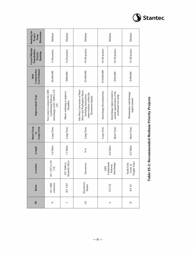
ID
N I G
2 A
D
Tabl
e ES
-2: R
ecom
men
ded
Med
ium
Pri
orit
y Pr
ojec
ts
-- 6 --
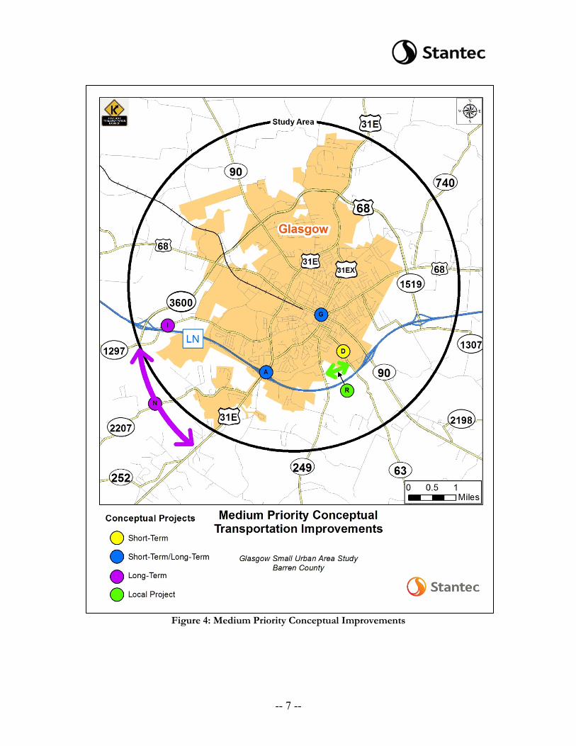
Figure 4: Medium Priority Conceptual Improvements
-- 7 --
R
anki
ng fo
r Pr
ojec
t T
eam
D
iscu
ssio
n
Low
Low
Low
Low
Low
Loc
al O
ffici
als/
Stak
ehol
ders
Pr
iori
ty
Ran
king
13 (3
8 po
ints
)
16 (3
0 po
ints
)
19 (1
8 po
ints
)
20 (2
poi
nts)
20 (2
poi
nts)
2016
C
onst
ruct
ion
Cos
t Est
imat
e
$2,5
00,0
00
$10,
400,
000
$3,2
00,0
00
$3,0
00,0
00
$3,1
00,0
00
Impr
ovem
ent T
ype
Min
or w
iden
ing
to p
rovi
de a
thre
e-la
ne se
ctio
n an
d A
cces
s M
anag
emen
t
New
rout
e to
con
nect
US
31E
to
K
Y 9
0 so
uth
of th
e LB
N
Cum
berla
nd P
arkw
ay
Rea
lignm
ent t
o ad
dres
s cur
vatu
re
issu
es fr
om n
orth
of t
he L
BN
C
umbe
rland
Par
kway
to th
e pr
opos
ed b
ridge
repl
acem
ent o
ver
Sout
h Fo
rk
Rea
lignm
ent o
f KY
220
7 to
el
imin
ate
the
serie
s of h
oriz
onta
l cu
rves
Rea
lignm
ent f
rom
nea
r Sou
th F
ork
brid
ge to
Col
lege
Stre
et
Shor
t-Ter
m
or
L
ong-
Term
Long
-Ter
m
Long
-Ter
m
Long
-Ter
m
Long
-Ter
m
Long
-Ter
m
Len
gth
0.4
Mile
s
3.3
Mile
s
0.6
Mile
s
1.0
Mile
s
0.3
Mile
s
Loc
atio
n
Nor
th o
f LB
N
Cum
berla
nd
Park
way
US
31E
to K
Y
90
LBN
C
umbe
rland
Pa
rkw
ay
Ove
rpas
s to
Troj
an T
rail
Suga
r Hill
Dr.
to
Aut
umn
Ridg
e R
d.
S Fr
ankl
in /
E C
olle
ge S
treet
Rou
te
KY
90
Sout
hern
B
eltw
ay
KY
249
KY
220
7
KY
63
ID
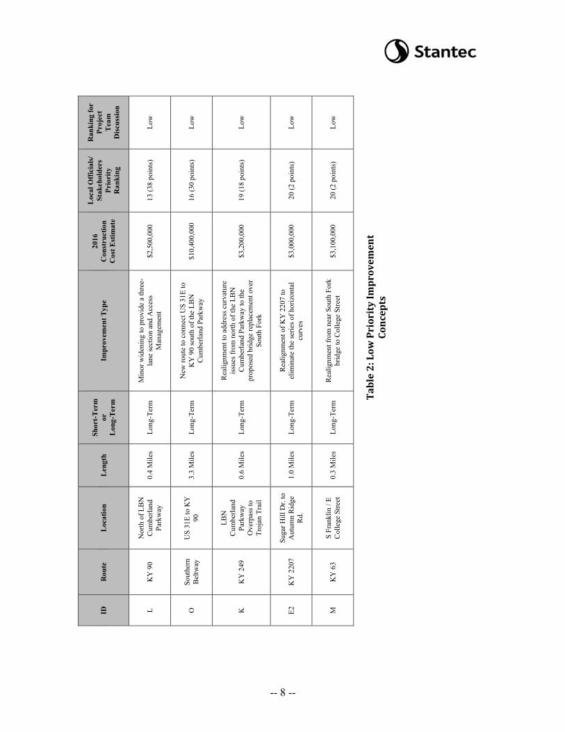
L O
K
E2
M
Tabl
e 2:
Low
Pri
orit
y Im
prov
emen
t Co
ncep
ts
-- 8 --
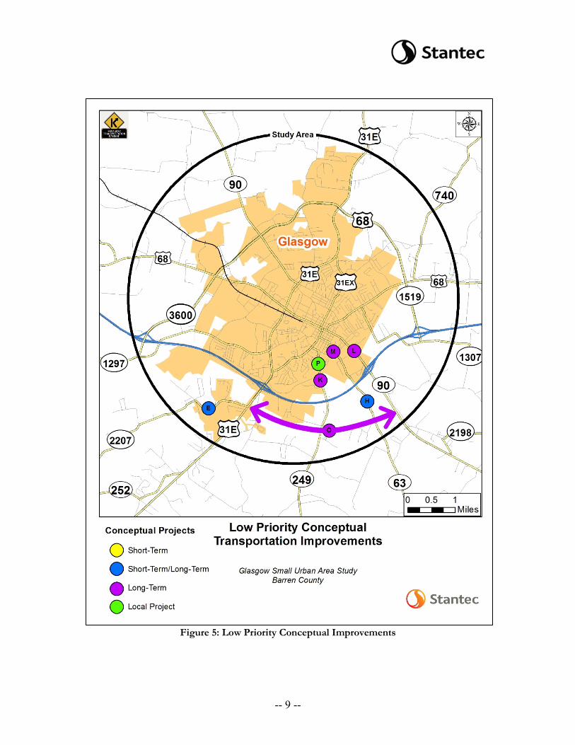
Figure 5: Low Priority Conceptual Improvements
-- 9 --
Ran
king
for
Proj
ect
Tea
m
Dis
cuss
ion
Hig
h
Med
ium
Low
Loc
al O
ffici
als/
Stak
ehol
ders
Pr
iori
ty
Ran
king
7 (5
8 po
ints
)
15 (3
4 po
ints
)
18 (2
6 po
ints
)
2016
C
onst
ruct
ion
Cos
t Est
imat
e
$1,6
00,0
00
$1,3
00,0
00
$500
,000
Impr
ovem
ent T
ype
Min
or w
iden
ing
to p
rovi
de a
th
ree-
lane
sect
ion
New
rout
e to
con
nect
KY
249
to
KY
63
north
of t
he L
BN
C
umbe
rland
Par
kway
Mul
timod
al im
prov
emen
t to
prov
ide
a sh
ared
-use
pat
h co
nnec
tion
Shor
t-Ter
m
or
Lon
g-Te
rm
Loca
l Pro
ject
Loca
l Pro
ject
Loca
l Pro
ject
Len
gth
0.7
Mile
s
0.6
Mile
s
0.5
Mile
s
Loc
atio
n
US
68 B
usin
ess
to
Gle
nvie
w
Driv
e
Nor
th o
f the
LB
N
Cum
berla
nd
Park
way
Troj
an T
rail
to
Twym
an P
ark
Rou
te
Scot
tie D
rive
KY
249
to
KY
63
Con
nect
or
KY
249
ID
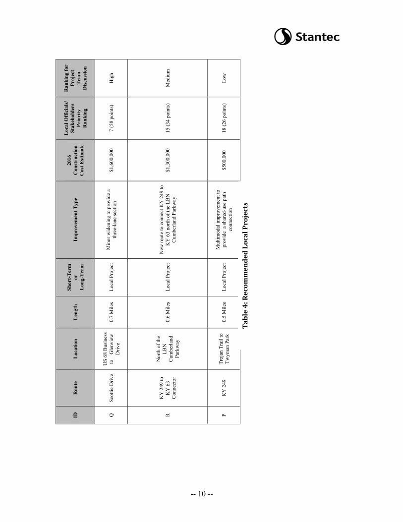
Q
R P
Tabl
e 4:
Rec
omm
ende
d Lo
cal P
roje
cts
-- 10 --
5. It is recommended that Projects F1, F2, and B be combined and considered together in the design phase. Project B, improvement of the intersection of KY 90 and US 68 near Walmart, would likely not move forward as a standalone project and should be considered alongside the corridor wide improvements to KY 90. During design a traffic study will be conducted to determine the appropriate typical section for KY 90. As a result Project F1, road diet to restripe KY 90 as three lanes, and Project F2, widening the corridor to a five lane section, will both be considered in the design phase of a KY 90 improvement project. The combination of these projects is ranked as a high priority.
6. Deneatra Henderson suggested making Project H2 a high priority project. Project H2 comprises of a realignment of KY 63 to eliminate the curves. The Advisory Committee was concerned that straightening this section would encourage faster speeds throughout the remaining curves along KY 63, creating a dangerous situation. To address the concerns of the Advisory Committee, the project could improve the curves to meet a 45 mph design speed rather than reconstructing the alignment into a straight line. The project team ultimately recommended changing the project description to “reconstruction of KY 63 to improve the horizontal and vertical alignment” rather than “realign KY 63 to eliminate curves.” The project is ranked as a high priority.
7. Project A has a short-term and a long-term solution, both of which are
recommended to be considered together in the design phase. Projects A1, interchange improvement, could include signalizing the ramp terminal intersection and widening US 31E under the parkway bridge to accommodate additional turn lane storage. Project A2, interchange reconstruction, reconfigures the interchange to a new type (such as single point urban interchange) to increase spacing between traffic signals should be considered. The combination of these projects is ranked as a medium priority.
8. Brian noted that the Kentucky Transportation Center (KTC) created a statewide
ranking of the most cost effective locations needing high friction pavement surface treatment. Based on these rankings, Projects E1 and H1 are unlikely to receive funding through the Highway Safety Improvement Program (HSIP). The project team recommends that separate funding be pursued through the Glasgow SUA Study and that both projects be rated as a high priority.
9. Although Project N, a new route connecting the LBN Parkway interchange at KY
3600 to US 31E, received the 5th highest ranking by the Advisory Committee, it was ranked as medium priority rather than high priority. Traffic volumes do not warrant a new route in this area.
10. At the second Advisory Committee Meeting, attendees raised concerns that the
extension of Wall Street as a part of Project J would not be possible due to limited space between Holiday Inn Express and O’Reilly Auto Parts. Stantec presented a
-- 11 --

schematic of the area on Google Earth showing the extension is feasible with minor disturbance of the Holiday Inn parking lot.
11. Brian discussed the project schedule. A draft report will be prepared by July 15th and
a final report will be prepared by September 1st.
The meeting ended at approximately 11:00 a.m. CDT.
-- 12 --