Embed Size (px)
Citation preview

APPENDIXD:
FACStreamResultsfortheCrystalRiver

A FACStream Primer An Overview for the Colorado Stream Mitigation Study Team 12/15/2014 Mark Beardsley and Brad Johnson

A FACStream Primer: An Overview for the Colorado Stream Mitigation Study Team Page 2
A FACStream Primer
Contents What is FACStream ......................................................................................................................... 4
FACStream Structural Model .......................................................................................................... 5
FACStream and the EPA 1-2-3 Approach. ....................................................................................... 7
FACStream Framework ................................................................................................................... 8
Watershed Scale ......................................................................................................................... 8
Water Supply (Vhyd) ................................................................................................................. 8
Sediment Supply (Vsed) ............................................................................................................ 8
Chemical Supply (Vchem) .......................................................................................................... 9
Riparian Scale .............................................................................................................................. 9
Riparian Vegetation (Vveg) ....................................................................................................... 9
Debris supply (Vdeb) ................................................................................................................. 9
Reach Scale ................................................................................................................................. 9
Stream Morphology (Vmorph) ................................................................................................... 9
Floodplain Connectivity (Vcon) ............................................................................................... 10
Stream Stability (Vstab) ........................................................................................................... 10
Physical Structure (Vstr) ......................................................................................................... 11
Biotic Structure (Vbio) ............................................................................................................ 11

A FACStream Primer: An Overview for the Colorado Stream Mitigation Study Team Page 3
A FACStream Primer
Figure 1: FACStream Scorecard. The components of FACStream are discussed in this "primer."
0 0
0 0
0
0 0
0 0
0
0 0 SEM
0 0 0
0 0
0 0
0 0
0 0
0 0
0 0
0 0
0
0
0 0
0 0
0
0 0
0 0
0 0
0 0
0 0
0 0 0
0 0
0 0
0 0
0
Vbio3: Macroinvertebrates
Vbio4: Fish/Amphibians
Vbio5: Other Animals
Vbio2: Macrophytes
Vstab1: Dynamic Eq.
Hydraulic Functions
Geomorphology Functions
Physicochemical Functions
Biology Functions
Functional scores by EPA category
Vdeb2: Detritus
Vcon1: FP Access
Confidence
Confidence
Confidence
Vbio1: Microbes
Vcon2: FP Extent
Vcon3: Saturation Duration
Vmorph1: Stream Evolution
Vmorph2: Planform
Vbio
Vstr
Confidence
Vmorph
Confidence
Vcon
Vstab
0
Proc
ess D
omai
n
Reach Condition Score
Mor
phol
ogy
Existing
Reference
Stream Type
0Vchem2: Organics/Nutrients
Vchem3: Water Quality
Vveg1: Riparian Veg.
Vveg2: Streamside Veg.
Vstab2: Resilience
Vstr1: Coarse Structure
Vstr2: Fine Structure
Vdeb1: LWD
Riparian Reference
Rosgen
0
0
0
0
Vhyd
Confidence
Confidence
Vsed
Vchem
Confidence
Vveg
Confidence
Vdeb
Confidence
0
Vmorph3: Dimension
Vmorph4: Profile
Vsed1: Land Erosion
Vhyd2: Channel Erosion
Vhyd3: Delivery
Vhyd2: Peak Flows
Vhyd3: Base Flows
Vhyd1: Total Volume Confinement
Valley Slope
Stream Order
0
Vchem1: Temperature
Physographic Region
Ecosystem
0
0
0Site/Reach ID:
River/Stream0
0
Date
Evaluators0 Project ID:
Reach length (Valley length in feet) Affiliation 0

A FACStream Primer: An Overview for the Colorado Stream Mitigation Study Team Page 4
What is FACStream FACStream (Functional Assessment of Colorado Streams) is a method for assessing functional condition of stream reaches in Colorado using 29 subvariables to score 10 state variables that combine to an overall condition score based on the degree of impairment.
A FACStream analysis reads like a report card representing the functional condition, or "health" of a reach at increasing levels of detail (Figure 1). The condition score, state variables, and subvariables are all scored using the academic grading scale where letter grades (A-F) correspond to numerical scores on a 50-100 scale (Table 1). Each grade represents a condition class defined by the degree of impairment. Pristine streams that have no impact would score 100 (A+). 50 (F-) represents the lowest level of functioning for a reach that is profoundly impaired but still recognizable as a feature conveying water.
FACStream uses a diagnostic approach similar to that in Western medicine. Health and condition are holistic terms, but assessing them is done by considering the basic components of the individual being evaluated. In humans, the individual is assessed based on their component systems, orthopedic, cardiovascular, psychological, etc. In stream ecology these components are called state variables. Natural interactions amongst state variables produce a healthy stream system that performs vital ecological functions. That is, each state variable represents a basic component in the "natural infrastructure" of a reach that performs the functions which are valued by society. The condition of each variable is assessed by the degree of impairment, and the combination of scores for each of these components describes overall condition of the reach. Like the medical assessment model, FACStream usually starts with a rapid evaluation of condition, which can then be expanded and augmented by intensive tests and procedures which pin-point specific areas of concern.
The health or condition of a reach is the primary determinant in its ability to function1. Thus, when being used in mitigation planning the FACStream condition score is converted to a Functional Capacity Index (FCI) which represents the percentage of possible aquatic functioning the stream is performing (Figure 2). FCI is the primary factor in quantifying ecological lift when calculating credits for stream mitigation.
1 Merriam Webster medical definition of health: 1) the condition of an organism or one of its parts in which it performs its vital functions normally or properly.
Score Grade Impairment
90-100 A Negligible
80-89 B Mild
70-79 C Significant
60-69 D Severe
50-59 F Profound (or unsustainable)Table 1: Scoring represents degree of impairment.

A FACStream Primer: An Overview for the Colorado Stream Mitigation Study Team
The contributing watershed is defined as the watershed area tributareach and is also commonly known as the "catchment."
This breakdown is important for practical track of where the sources of impairment areWhereas the reach and riparian components are "inherited to the site" from the contributing watershed
Most of the time, mitigation and restoration is accomplished with reach-scale projects. Reach-scale projects can effectively treat the impairment of reach and riparian variables, while the impairment of watershed variables is best understood as a constraint to functioning that cannot be mitigated with on-site treatments. For instance, if the main source of impairment is water quality (Vchem
then this is a constraint to the amount of lift that could be achieved by doing reach-level treatments.
Figure 2: Basic structure of FACStream
A FACStream Primer: An Overview for the Colorado Stream Mitigation Study Team
FACStream Structural ModelThe components of a stream’s infrastructure operate atorganizational levels of the contributing watershed, riparian zone, and the reach itself4). FACStream variables according to these basic levelscolor-coded to help the evaluator keep track of which level they need to be focusing upon to make the evaluation. Even though the FACStream assessment is focused on the stream, the "assessment area" is defined as the stream reach plus the riparian zone.
efined as the watershed area tributary to the bottom ofknown as the "catchment."
This breakdown is important for practical reasons in addition to the logical onestrack of where the sources of impairment are located and the feasibility of mitigating them
ereas the reach and riparian variables represent components of the site itself, watershed "inherited to the site" from the contributing watershed, or catchment
Most of the time, mitigation and restoration is accomplished with
scale projects can effectively treat the impairment of reach and riparian
le the impairment of
functioning that cannot be mitigated
chem),
amount of lift that could be achieved by
Figure 3: The organizational pyramid in FACStream srelationship of watershed, riparian, and reach-scale variables.
A FACStream Primer: An Overview for the Colorado Stream Mitigation Study Team Page 5
Structural Model components of a stream’s natural
operate at different levels of the landscape:
ntributing watershed, riparian , and the reach itself (Figures 3 and
. FACStream variables are organized according to these basic levels and
coded to help the evaluator keep track of which level they need to be
pon to make the evaluation. Even though the FACStream
focused on the stream, " is defined as the
stream reach plus the riparian zone. ry to the bottom of the
reasons in addition to the logical ones. It helps keep and the feasibility of mitigating them.
itself, watershed , or catchment.
: The organizational pyramid in FACStream shows the scale variables.

A FACStream Primer: An Overview for the Colorado Stream Mitigation Study Team
Improving function on such a reach would require fixing the water quacontributing watershed. Moreover, if the source of impairment is identified in riparian variables, then riparian treatments would beaddition to any necessary in-stream work.
FACStream’s approach acknowledges interactions amongst variablesimpact can have multiple or cascading effects. For example, shrub clearing in the riparian impairs riparian vegetation condition affects channel stability and structurechanges (channel evolution) that couldstructure. Changes to riparian vegetation and the assemblages of certain biotaheavily on detritus, and these impacts could cinteractions. As this simple example illustrates, a single stressor may cause impairment to many state variables because these variables interactions.
Figure 4: The FACStream organizational pyramid reflects processes occurring at different scales of the landscape. The photo shows a reach of the Slate River near Crested Butte, CO. The components of the pyramid (contributing watershed, riparian zone, and reach) are highlighted in the respective colors
A FACStream Primer: An Overview for the Colorado Stream Mitigation Study Team
reach would require fixing the water quality issue within the Moreover, if the source of impairment is identified in riparian
es, then riparian treatments would be required to increase condition and functioningeam work.
’s approach acknowledges interactions amongst variables and how one stressor or impact can have multiple or cascading effects. For example, shrub clearing in the riparian
riparian vegetation condition and debris supply directly, but it also likely stability and structure. Such instability might then lead to morphological
evolution) that could, in turn, affect floodplain connectivity and physical . Changes to riparian vegetation and debris supply would also likely have an impact on
f certain biota, particularly those that have terrestrial life stages or depend heavily on detritus, and these impacts could cascade to other taxa via trophic and competition
As this simple example illustrates, a single stressor may cause impairment to because these variables are highly integrated through complex
: The FACStream organizational pyramid reflects processes occurring at different scales of the landscape. The photo shows a reach of the Slate River near Crested Butte, CO. The components of the pyramid (contributing watershed,
d reach) are highlighted in the respective colors.
A FACStream Primer: An Overview for the Colorado Stream Mitigation Study Team Page 6
lity issue within the Moreover, if the source of impairment is identified in riparian
rease condition and functioning in
one stressor or impact can have multiple or cascading effects. For example, shrub clearing in the riparian zone
likely indirectly lead to morphological
and physical likely have an impact on
, particularly those that have terrestrial life stages or depend taxa via trophic and competition
As this simple example illustrates, a single stressor may cause impairment to highly integrated through complex
: The FACStream organizational pyramid reflects processes occurring at different scales of the landscape. The photo shows a reach of the Slate River near Crested Butte, CO. The components of the pyramid (contributing watershed,

A FACStream Primer: An Overview for the Colorado Stream Mitigation Study Team
FACStream and the EPA 1Like the US EPA Function-Based Framework for Stream Assessment and Restoration Projects (a.k.a. the Stream Functions Pyramid Framework)2, FACStream is an information framework and a working model to create an overall assessment of functional capacity. The model can accept any level of data as input, be it a first impression based on remote survey (EPA level 1), rapid field assessment (EPA Level 2), or intensive field assessment usually involving quantitative data (EPA Level 3Figure 5). FACStream includes protocols for using the framework in rapid assessment mode, employing a stressor/impact analysis as the basis for level 2can be backed by quantitative data (level 3).
In FACStream, the evaluator uses specific scoring guidelines to rate the condition of each of the 29 subvariables based on the best evidence available (level 1, 2, or 3), and then the values of state variables are calculated from overriding a calculated state variable score, but Finally, all of the state variables are combined into a comprehensive condition score for the reach.
The ability to utilize data and evidence FACStream, since it allows variables is not constrained to simply being a rapid assessment using best professional judgment.make the quality of the evidence supporting a variable score transparentrates the degree of confidence. but they do provide a means for communicating the quality of that score, and both the evaluator and the reviewer.
2 Harman, W., R. Starr, M. Carter, K. Tweedy, M.for Stream Assessment and Restoration and Watersheds, Washington DC EPA 843
A FACStream Primer: An Overview for the Colorado Stream Mitigation Study Team
FACStream and the EPA 1-2-3 Approach. Based
Framework for Stream Assessment (a.k.a. the
working model to create an overall ty.
The model can accept any level of data as input, be it a first impression
(EPA level 1), ssessment (EPA Level 2),
intensive field assessment usually data (EPA Level 3;
for using the framework in , employing a
analysis as the basis for level 2 variable scoring, but any level 2 variable score can be backed by quantitative data (level 3).
evaluator uses specific scoring guidelines to rate the condition of each of the s based on the best evidence available (level 1, 2, or 3), and then the values of
calculated from the relevant subvariables. The evaluator has an option of calculated state variable score, but may only do so if valid rationale is provided
Finally, all of the state variables are combined into a comprehensive condition score for the
The ability to utilize data and evidence of varying quality is an important componentvariables to be scored using the best data available and the method
is not constrained to simply being a rapid assessment using best professional judgment.he evidence supporting a variable score transparent, the evaluator also
Confidence ratings do not affect variable or condition scores, but they do provide a means for communicating the quality of that score, and this both the evaluator and the reviewer.
Harman, W., R. Starr, M. Carter, K. Tweedy, M. Clemmons, K. Suggs, C. Miller. 2012. A Functionfor Stream Assessment and Restoration Projects. US Environmental Protection Agency, Office of Wetlands, Oceans, and Watersheds, Washington DC EPA 843-K-12-006
Figure 5: Each of the 10 FACStream variable scores can be evaluated at any level of data rigor, but EPA level 2 data is a minimum standard for using FACStream to calculate mitigation credits. Monitoring and evaluation of success criteria will usually require leve
A FACStream Primer: An Overview for the Colorado Stream Mitigation Study Team Page 7
variable scoring, but any level 2 variable score
evaluator uses specific scoring guidelines to rate the condition of each of the s based on the best evidence available (level 1, 2, or 3), and then the values of
s an option of may only do so if valid rationale is provided.
Finally, all of the state variables are combined into a comprehensive condition score for the
portant component of the best data available and the method
is not constrained to simply being a rapid assessment using best professional judgment. To , the evaluator also
condition scores, this is helpful to
ons, K. Suggs, C. Miller. 2012. A Function-Based Framework Projects. US Environmental Protection Agency, Office of Wetlands, Oceans,
of the 10 FACStream variable scores can be evaluated at any level of data rigor, but EPA level 2 data is a minimum standard for using FACStream to calculate mitigation credits. Monitoring and evaluation of success criteria will usually require level 3 methods.

A FACStream Primer: An Overview for the Colorado Stream Mitigation Study Team Page 8
Level 2 is the lowest level of data rigor that should be used in mitigation planning, but level 1 is often sufficient for watershed inventories, watershed profiles, creating watershed plans, and searching for mitigation sites. Level 3 data is necessary to adequately monitor mitigation projects and evaluate success criteria, but for most projects only certain key variables will need to be monitored quantitatively, using standard field methods. FACStream clearly conveys which variables have been impaired, identifying the stressors responsible for impairment along the way. This information provides a rationale for the restoration plan, which is then used to outline performance standards and the monitoring program that will be used to show compliance.
FACStream Framework The FACStream framework consists of a set of state variables, each with several subvariables, organized according to the landscape pyramid. These components are ordered in an outline. State variables are identified in the form Vxxx, with the subscript indicating a particular variable. The subvariables for each state variable are simply numbered, for example Vhyd1 is a subvariable for the Vhyd variable, water supply.
Watershed Scale Water Supply (Vhyd) - Water is supplied to the reach from its contributing watershed in a characteristic pattern represented by its hydrograph. Anthropogenic stressors in the watershed may alter the hydrograph to change the overall annual volume of water that the reach receives (Vhyd1), and/or the frequency, magnitude, and duration of peak flows (Vhyd2) and low flows (Vhyd3). This variable rates the degree to which the amount and timing of water source is impacted by stressors within the watershed.
Vhyd1: Total Volume Vhyd2: Peak Flows Vhyd3: Minimum Flows
Sediment Supply (Vsed) - Sediment is produced in the contributing watershed via land erosion (Vsed1) (including both surface erosion, mass erosion, and point sources), and channel erosion (Vsed2). Some sediment enters the reach directly from valley side slopes, but most is discharged to the reach from the contributing watershed as bedload and suspended sediment in the stream. Watershed impacts affect sediment production, and major drainage impacts such as dams affect the delivery of sediment to the reach (Vsed3). This variable rates the degree of impact to the natural rate of sediment supply including the amount, timing, and size distribution of sediment.
Vhyd1: Land Erosion Vhyd2: Channel erosion Vhyd3: Transport

A FACStream Primer: An Overview for the Colorado Stream Mitigation Study Team Page 9
Chemical Supply (Vchem) - The physicochemical properties of the stream reach are largely inherited to the site from the contributing watershed, and biochemical processing by stream organisms and physical changes within the channel and floodplains can alter these conditions on the reach to some lesser degree. This variable uses three subvariables to rate the degree of departure from a natural temperature regime (Vchem1), amounts of organic inputs (POM, DOM) and nutrients (N, P, K) (Vchem2) in the incoming water as well as shifts to the characteristic water quality subvariables such as pH, conductivity, turbidity, and contaminants (Vchem3).
Vhyd1: Temperature Vhyd2: Organics/nutrients Vhyd3: Water Quality
Riparian Scale Riparian Vegetation (Vveg) - Riparian vegetation is critically important to supporting a stream reach. It provides the root structure and roughness that stabilizes banks, channels, and floodplains as well as providing a buffer to the stream from nearby stressors. Riparian vegetation also provides cover, shading, and habitat for species whose life history utilizes both aquatic and terrestrial life stages. This variable rates impacts to the natural extent, cover, and composition of riparian vegetation across the width of the historic floodplain (Vveg1) as well as along the edge of the stream (Vveg2).
Vhyd1: Riparian vegetation Vhyd2: Streamside vegetation
Debris supply (Vdeb) - Organic debris consists of the bodies and fragments of dead organisms, especially plants. Large woody debris (LWD) is the coarsest organic input to the stream, functioning primarily as a structural component and secondarily as a nutrient and energy source. Detritus includes smaller vegetative fragments such as leaves, needles, twigs, and grass, plus animal bodies and feces. Detritus is often the primary energy source for a stream reach, but it also functions in forming microhabitat and substrate structure. This variable considers these two materials separately (Vdeb1 and Vdeb2) to rate the degree to which the amount, timing and character of organic debris supply to the reach has been altered by stressors in the fetch area which includes the riparian area and adjacent side slopes.
Vhyd1: LWD Supply Vhyd2: Detritus Supply
Reach Scale Stream Morphology (Vmorph) - Streams exhibit characteristic patterns of geometry (morphology) by process domain as a result of geomorphic processes such as dynamic

A FACStream Primer: An Overview for the Colorado Stream Mitigation Study Team Page 10
equilibrium between hydrology and sediment, adaptations to natural disturbances, and response to biotic agents such as vegetation and beavers. Morphology is also frequently altered directly by humans. This variable rates the degree of departure from the reference stream morphology arising from channel evolution (Vmorph1), and as a degree of departure from reference conditions in planform (Vmorph2), dimension (Vmorph3), and profile (Vmorph4). Morphological impairment on streams in alluvial valleys is often a consequence of instability caused by stressors within or outside the reach.
Vmorph1: Evolution Vmorph2: Planform Vmorph3: Dimension Vmorph4: Profile
Floodplain Connectivity (Vcon) - Floodplain connectivity describes the degree to which water can access and hydrate the active floodplain. The amount and timing of water flow interacts with reach-scale channel and floodplain morphology to create a characteristic pattern in the frequency (Vcon1), lateral extent (Vcon2), and duration of saturation (Vcon3) from overbank flows and groundwater exchange on the reach. Thus, floodplain connectivity may be drastically altered by either watershed-scale hydrologic impacts (hydrograph) or site-scale geomorphic impacts including artificial levees, channelization, channel enlargement, and entrenchment. While the term floodplain has many different meanings in different disciplines, the area of concern in this variable is the active "bankfull" floodplain that typically has a saturation return interval of 0-5 years.
Vcon1: Saturation Frequency Vcon2: Floodplain Width Vcon3: Saturation Duration
Stream Stability (Vstab) - Stability and resilience are considered together to rate the probability that the stream will maintain its geomorphic structure. Stability assessment (Vstab1) is based on the dynamic equilibrium concept of balance between sediment supply and transport represented by Lane's Balance. Thus, stressors include anthropogenic alterations to stream power including hydrology (Vhyd), channel morphology (Vmorph), sediment supply (Vsed), and stabilizing factors like riparian vegetation (Vveg). Resilience (Vstab2) rates the ability of the system to recover after a large disturbance such as a large flood, wildfire, or mass erosion event. Primary factors include its ability to move and adjust, so riparian vegetation (Vveg) and floodplain connectivity (Vcon) are key, along with stressors such as channel hardening and floodplain encroachment.
Vstab1: Dynamic Equilibrium Vstab2: Resilience

A FACStream Primer: An Overview for the Colorado Stream Mitigation Study Team Page 11
Physical Structure (Vstr) - Heterogeneity in the physical structure of a stream is the result of complex interactions between water, substrate, and debris, via the processes of erosion, scour, and deposition that shape the form of bed, banks, and substrate. As in the case for morphology, biological drivers such as riparian vegetation and beavers may have a profound impact on physical structure and diversity. This variable rates the degree to which characteristic patterns of structural heterogeneity are altered by stressors by considering two scales of resolution. The coarse scale Vstr1 is meant to represent a level relevant for fish and larger animals by considering patterns of water velocity, depth, and physical cover. At a finer scale, Vstr2 is more relevant to benthic macroinvertebrate habitat, looking at characteristic substrate material size, type, and packing.
Vstab1: Coarse Structure Vstab2: Fine Structure
Biotic Structure (Vbio) - Biotic structure is the amount and diversity of organisms that live in the stream reach for all or part of their life history. The biota supported by the reach is not only a high-order function, but also component of the natural infrastructure of the reach that performs biochemical processing through a characteristic trophic structure. Sticking with convention, the diversity of organisms are assessed by taxonomic group in subvariables (Vbio1-5) to account for alterations caused by direct and indirect stressors.
Vbio1: Microbes Vbio2: Macrophytes Vbio3: Macroinvertebrates Vbio4: Fish Vbio5: Other Animals

FACStreamScoringSheetsfortheCrystalRiverThe Ecosystem Functional Assessment evaluated ten state variables using the FunctionalAssessment of Colorado Streams (FACStream) framework. State variables include: flow regime,sediment regime, water quality, floodplain connectivity, riparian vegetation, debris supply,morphology,stability,physicalstructure,andbioticstructure.TheCrystalRiverwasdelineatedinto36separateassessmentreachesdefinedbylocalchannelformanddegreeofvalleyconfinementtoprovideappropriatespatialresolutionforassessmentactivitiesfocusedonreachorchannel-scaleconditions(FigureA-1).
Statevariableassessmentsevaluatedcurrentconditionsandcharacterizedthedegreeofdeparturefromanunimpactedreferencestateusinga forensic,weight-of-evidenceapproach.Assignmentoffunctional condition scores for each state variable generally followed FACStream scoring criteriawhereascoreof100indicatedpristineconditionsandascoreof50indicatedsevereimpairment.Each reach also received an overall condition score based on composite scoring of all statevariables. Summary sheets for individual reaches indicate the relative degree of impact by eachstressoronindividualstatevariablescores.

FigureA-1:FACStreamreachesdelineationalongtheCrystalRiver

FACStreamStateVariableAssessments
ReachDistancefromHeadwaters(miles)
ValleySlope
ValleyConfine
StreamType
Ref.stream Vhyd Vsed Vchem Vconn Vveg Vdeb Vmorph Vstab Vstr Vbio
1 3.67 H VC A A 98 95 95 95 95 95 95 95 95 952 4.20 VH VC Aa+ Aa+ 98 92 95 95 95 95 95 95 95 953 4.51 M CC B B 98 92 95 95 95 95 95 95 95 95
4 5.26 VL UC C C 98 90 92 88 88 92 95 95 95 88
5 6.29 M CC B B 98 92 95 95 95 95 95 95 95 88
6 7.36 L PC D D 98 92 95 75 82 85 82 78 85 88
7 8.63 M CC F B 98 92 95 88 88 92 85 82 92 888 9.50 M VC G G 98 92 95 95 95 95 95 95 95 889 10.26 M CC B B 98 92 95 95 92 95 95 95 95 8810 10.59 L PC D D 98 92 95 85 85 92 95 95 95 8811 11.22 L CC B B 98 92 95 95 95 95 95 95 95 88
12 11.76 L PC C DA 98 92 95 78 78 85 82 85 82 88
13 12.40 L UC DA DA 98 92 95 95 92 95 95 95 95 8814 12.91 L PC C C 98 92 95 82 85 88 85 88 88 88
15 15.58 M VC G G 98 92 95 82 78 75 82 75 85 88
16 16.54 L PC D D 98 85 92 85 82 82 92 85 88 88
17 17.71 L PC D D 98 72 88 68 72 78 82 72 82 82
18 19.43 M CC B B 98 78 92 82 88 85 85 82 85 82
19 20.16 L PC C D 98 80 92 82 75 82 85 85 85 8220 21.24 M VC A/G A/G 98 85 92 92 92 95 95 92 95 8221 21.81 L PC D D 84 85 92 82 82 85 88 82 85 8222 22.18 L CC B B 84 85 92 92 95 95 92 88 92 8223 23.19 L PC D D 84 85 92 85 78 82 88 85 85 82
24 23.64 L CC B B 84 82 92 82 78 82 85 82 82 82
25 25.06 L VC F F 74 85 88 85 92 88 92 88 92 8226 25.44 L PC D D 74 82 88 85 85 85 85 82 82 8227 26.29 L CC B B 81 85 88 75 82 82 85 82 78 82
28 27.23 L PC/CC C/B C/B 81 85 85 82 88 88 88 85 85 82
29 27.72 L PC D D 62 85 82 74 82 85 85 78 65 82
30 29.02 L CC/VC B/F B/F 63 88 82 95 92 92 92 88 68 8231 30.94 L PC/CC C/B C/B 67 88 82 85 85 85 92 88 75 8232 32.03 L PC C C 70 88 82 78 82 85 85 82 72 82
33 33.49 L PC C C 82 85 82 75 75 72 82 78 80 82
34 33.74 L PC C/D C 82 82 85 88 82 85 85 78 85 8235 34.92 L CC B B 91 85 85 92 88 88 92 92 85 8236 35.06 L PC C C 91 85 88 91 92 95 82 95 85 82
CrystalRiverFACStreamLevel2Assessment

FACStreamStateVariableAssessments
Reach ConditionScore Notes
1 96 Wildernessreachwithnosignificantimpactsapparent2 95 Wildernessreachwithnosignificantimpactsapparent3 95 Wildernessreachwithnosignificantimpactsapparent
4 92 PrimaryimpactisBeaverLakeandthedam/dikethatseparatesitfromfloodplain(nutrientrichdrainagewater,clearedveg,floodplainisolation).
5 95 Confinedreachinsecludedcanyonwithminimalimpact
6 87 Theupperparthasfewimpacts.ImpactsbeginatIslandLake,especiallydike/damthatseparateslakefromthestream,highwayfillandrevetment.
7 91 Roadencroachmentisprimaryimpact,causingB->Gconversiondoetoconfinement.8 95 Veryconfinedreachinsecludedcanyonwithnoapparentimpacts9 94 Confinedreachinsecludedcanyonwithminimalimpactatcampground10 92 SomeimpactfromBoganFlatsCampgrounddevelopmentonvalleybottom11 95 Confinedreachinsecludedcanyonwithminimalimpact
12 87 Pastureclearingandfloodplaindruyingevidentonrightsideaffectslargefloodplainarea,channelappearstobestraightened(?)andsidechannelaccesscutoff.
13 94 SimilarstreamandvalleyconfigurarionasReach12,butfewfloodplainimpactsareevident.14 90 Roadandranchingimpactsonleftfloodplainarea.
15 86 Roadencroachmentandhardeningonanalreadyveryconfinedvalleyaffectsmostofthelengthofthereach,furtherconstrictionatmultiplebridges.
16 89 Impactsrelatedtovalleybottomresidentialdevelopment,bridgeconstriction.
17 81 SedimentinputsfromCoalCreeksubbasin-pastanthropogenicmasserosion,channelerosionfrommining,YetstreamformsimilartoR16.Bridges,levee,valleybottomdevelopment,roadsatRedstone
18 87 Acuteimpactsduetoroadencroachment,otherwiseminimalimpairment.Anysedimentsourceimpactsarenotfeltduetohightransportcapacityconfinedthresholdchannel
19 86 Pastureclearingandfloodplaindruyingevidentonrightside.20 92 Aconfinedorveryconfinedreachwithfewreach-scaleimpacts.21 84 Floodplaindevelopmentistheprimaryimpact,withresidential,reservoir/pond,levee/dam,roadfillsandhardening.22 89 Aconfinedorveryconfinedreachwithfewreach-scaleimpacts.23 85 Reach-scaleimpactsprimarilyroadfills,pastureclearingandFPdevelopment
24 83 Reach-scaleimpactsprimarilyroadfills,pastureclearingandFPdevelopment.SweetJessupdiversionpointandbypasschannelaresignificantimpacts.
25 85 Aconfinedorveryconfinedreachwithfewreach-scaleimpacts.26 82 Primaryimpactsareroadfillandhardening.Hydroimpactsinfered.27 81 Primaryimpactsareroadfillandhardening.Hydroimpactsinfered.
28 84 Borderline/alternatingconfinement.LotixcXSshowconfinementwithER~1.5-2.0.Mostdevelopmentisabovevalley-bottom,butthefewlowFPareaspresentonthereacharedeveloped(e.g.KOACG).
29 75 Reach-scaleimpactsprimarilyroadfills,pastureclearingandFPdevelopment.Diversiondamandbypasschannelaresignificantimpacts.
30 82 LoticXSshowconfinementwithER~1.5-2.0.Fewreach-scaleimpacts.Developmentisabovevalley-bottom.31 81 Bordderlineconfinedvalley(ER~2-3).Somefloodplaindevelopment,hydroimpactsinfered.32 79 Significantdvelpmentonvalleybottomincludinghatcheryandpond.Hydroimpactsinfered.
33 79 Primaryreach-scaleimpactsarevalley-bottomlanduseconversiontoresidential,pasture,andgolfcourse,plusconstrictionatmultiplebridges.Hydroimpactsinfered.
34 83 Majorimpactidpush-updamandlocalizedeffects,pluspastureclearingonlowerrightFP.Hydroimpactsinfered.35 88 Minimalimpacts.Bridge.Hydroimpactsinfered.36 89 Minimalimpactsonfloodplainorchannel.Grazing.Shortreachatconfluence.Hydroimpactsinfered.
CrystalRiverFACStreamAssessment

FACStreamStateVariableAssessments
Reach1 Vhyd Vsed Vchem Vconn Vveg Vdeb Vmorph Vstab Vstr Vbio
Grade A+ A- A A A A A A A AScore 98 92 95 95 95 95 95 95 95 95
Landuse-development
Landuse-pastureclearing
Landuse-miningdisturbance
Landuse-golfcourse/park
Waterwithdrawals
Road(fills,encroachment)
unpavedroadscontributiontototalsurface
erosionBridges/constrictions
Dam/diversionLevee/dike
By-passchannelDitch
Bank/channelarmorChannelalteration
GrazingWeeds/exoticvegetationExoticfauna,managed
fishery
NarrativesummaryequivalentofIHAresultsaboveall
diversions
Nosignificantstressors
Nosignificantstressors
Nosignificantstressors
Nosignificantstressors
Nosignificantstressors
Nosignificantstressors
Nosignificantstressors
Nosignificantstressors

FACStreamStateVariableAssessments
Reach2 Vhyd Vsed Vchem Vconn Vveg Vdeb Vmorph Vstab Vstr Vbio
Grade A+ A- A A A A A A A AScore 98 92 95 95 95 95 95 95 95 95
Landuse-development
Landuse-pastureclearing
Landuse-miningdisturbance
Landuse-golfcourse/park
Waterwithdrawals
Road(fills,encroachment)
unpavedroadscontributiontototalsurface
erosionBridges/constrictions
Dam/diversionLevee/dike
By-passchannelDitch
Bank/channelarmorChannelalteration
GrazingWeeds/exoticvegetation
Exoticfauna,managedfishery
NarrativesummaryequivalentofIHAresultsaboveall
diversions
Nosignificantstressors
Nosignificantstressors
Nosignificantstressors
Nosignificantstressors
Nosignificantstressors
Nosignificantstressors
Nosignificantstressors
Nosignificantstressors

FACStreamStateVariableAssessments
Reach Vhyd Vsed Vchem Vconn Vveg Vdeb Vmorph Vstab Vstr Vbio
Grade3 A+ A- A A A A A A A AScore 98 92 95 95 95 95 95 95 95 95
Landuse-development
Landuse-pastureclearing
Landuse-miningdisturbance
Landuse-golfcourse/park
Waterwithdrawals
Road(fills,encroachment)
unpavedroadscontributiontototalsurface
erosionBridges/constrictions
Dam/diversionLevee/dike
By-passchannelDitch
Bank/channelarmorChannelalteration
GrazingWeeds/exoticvegetation
Exoticfauna,managedfishery
NarrativesummaryequivalentofIHAresultsaboveall
diversions
Nosignificantstressors
Nosignificantstressors
Nosignificantstressors
Nosignificantstressors
Nosignificantstressors
Nosignificantstressors
Nosignificantstressors
Nosignificantstressors

FACStreamStateVariableAssessments
Reach4 Vhyd Vsed Vchem Vconn Vveg Vdeb Vmorph Vstab Vstr Vbio
Grade A+ B+ A- B+ B+ A- A A A B+Score 98 90 92 88 88 92 95 95 95 88
Landuse-development
Landuse-pastureclearing
Landuse-miningdisturbance
Landuse-golfcourse/park
Waterwithdrawals
Road(fills,encroachment)
unpavedroadscontributiontototalsurface
erosion
Roads Roads Roads
Bridges/constrictionsBridge/constrictionatbottomof
reach
Bridge/constrictionatbottomof
reachDam/diversion
Levee/dike BeaverLakedam BeaverLakedam BeaverLakedam BeaverLakedam BeaverLakedam
BeaverLakedam--releasehighwatertemps/
macrophyterichH20below(thoughoff-channel)
By-passchannelDitch
Bank/channelarmorChannelalteration
GrazingWeeds/exoticvegetation
Fewweeds
Exoticfauna,managedfishery
managedfishery
NarrativesummaryequivalentofIHAresultsaboveall
diversions
Nosignificantstressors
Nosignificantstressors
Nosignificantstressors

FACStreamStateVariableAssessments
Reach5 Vhyd Vsed Vchem Vconn Vveg Vdeb Vmorph Vstab Vstr Vbio
Grade A+ A- A A A A A A A B+Score 98 92 95 95 95 95 95 95 95 88
Landuse-development
Landuse-pastureclearing
Landuse-miningdisturbance
Landuse-golfcourse/park
Waterwithdrawals
Road(fills,encroachment)
unpavedroadscontributiontototalsurface
erosion
Bridges/constrictions Bridge/constrictionabovethereach
Dam/diversionLevee/dike
By-passchannelDitch
Bank/channelarmorChannelalteration
GrazingWeeds/exoticvegetation
Exoticfauna,managedfishery
managedfishery
NarrativesummaryequivalentofIHAresultsaboveall
diversions
Nosifnificantstressors
Nosifnificantstressors
Nosifnificantstressors
Nosifnificantstressors
Nosifnificantstressors
Nosifnificantstressors
Nosifnificantstressors

FACStreamStateVariableAssessments
Reach6 Vhyd Vsed Vchem Vconn Vveg Vdeb Vmorph Vstab Vstr Vbio
Grade A+ A- A C B- B B- C+ B B+
Score 98 92 95 75 82 85 82 78 85 88Landuse-
development
Landuse-pasture
clearing
Vegclearing/bare
ground
Landuse-mining
disturbance
Landuse-golf
course/park
IslandLakeon
floodplainreplace
vegwithopen
waterhabitat
IslandLakeon
floodplainlimits
detritus
IslandLakeon
floodplainlimits
resilience
Waterwithdrawals
Road(fills,
encroachment)
unpavedroads
contributionto
totalsurface
erosion
Roadfillatfor
highway
Roadfillatfor
highway
Roadfillatfor
highway
Roadfillatfor
highway
Bridges/constrictions Bridge
Dam/diversion
Levee/dike Islandlakeberm
By-passchannel
Ditch
Bank/channelarmor
IslandLakedike
androadfill
revetment-rip-
rap
IslandLakedike
androadfill
revetment-rip-
rap
IslandLakedike
androadfill
revetment-rip-
rap
ChannelalterationStraighteningat
IslandLake
Straighteningat
IslandLake
Straighteningat
IslandLake
Grazing
Weeds/exotic
vegetationWeeds
Exoticfauna,managed
fisherymanagedfishery
Narrativesummary
equivalentofIHA
resultsaboveall
diversions
Nosignificant
stressor

FACStreamStateVariableAssessments
Reach7 Vhyd Vsed Vchem Vconn Vveg Vdeb Vmorph Vstab Vstr Vbio
Grade A+ A- A B+ B+ A- B B- A- B+Score 98 92 95 88 88 92 85 82 92 88
Landuse-development
Landuse-pastureclearing
Landuse-miningdisturbance
Landuse-golfcourse/park
Waterwithdrawals
Road(fills,encroachment)
unpavedroadscontributiontototalsurface
erosion
Highwayencoachment
alongsignificantlength
Highwayencoachment
alongsignificantlength
Highwayencoachment
alongsignificantlength
Highwayencoachment
alongsignificantlength
Highwayencoachment
alongsignificantlength
Highwayencoachment
alongsignificantlength
Bridges/constrictionsDam/diversionLevee/dike
By-passchannelDitch
Bank/channelarmorRip-rapatroadfillalongsignificant
length
Rip-rapatroadfillalongsignificant
lengthChannelalteration
GrazingWeeds/exoticvegetation
Exoticfauna,managedfishery
managedfishery
NarrativesummaryequivalentofIHAresultsaboveall
diversions
Nosignificantstressors

FACStreamStateVariableAssessments
Reach8 Vhyd Vsed Vchem Vconn Vveg Vdeb Vmorph Vstab Vstr Vbio
Grade A+ A- A A A A A A A B+Score 98 92 95 95 95 95 95 95 95 88
Landuse-development
Landuse-pastureclearing
Landuse-miningdisturbance
Landuse-golfcourse/park
Waterwithdrawals
Road(fills,encroachment)
unpavedroadscontributiontototalsurface
erosion
Bridges/constrictionsbridge
constrictionatstartofthereach
Dam/diversionLevee/dike
By-passchannelDitch
Bank/channelarmorChannelalteration
GrazingWeeds/exoticvegetation
Exoticfauna,managedfishery
managedfishery
NarrativesummaryequivalentofIHAresultsaboveall
diversions
Nosignificantstressors
Nosignificantstressors
Nosignificantstressors
Nosignificantstressors
Nosignificantstressors
Nosignificantstressors
Nosignificantstressors

FACStreamStateVariableAssessments
Reach9 Vhyd Vsed Vchem Vconn Vveg Vdeb Vmorph Vstab Vstr Vbio
Grade A+ A- A A A- A A A A B+Score 98 92 95 95 92 95 95 95 95 88
Landuse-development
Landuse-pastureclearing
Landuse-miningdisturbance
Landuse-golfcourse/park
Campground(roads,pads,vegclearing)but
primarilyabovefloodplain
Waterwithdrawals
Road(fills,encroachment)
unpavedroadscontributiontototalsurface
erosionBridges/constrictions
Dam/diversionLevee/dike
By-passchannelDitch
Bank/channelarmorChannelalteration
GrazingWeeds/exoticvegetation
weeds
Exoticfauna,managedfishery
managedfishery
NarrativesummaryequivalentofIHAresultsaboveall
diversions
Nosignificantstressors
Nosignificantstressors
Nosignificantstressors
Nosignificantstressors
Nosignificantstressors
Nosignificantstressors

FACStreamStateVariableAssessments
Reach10 Vhyd Vsed Vchem Vconn Vveg Vdeb Vmorph Vstab Vstr Vbio
Grade A+ A- A B B A- A A A B+
Score 98 92 95 85 85 92 95 95 95 88Landuse-
development
Campground
developedon
floodplain
Campground
developedon
floodplain
Campground
developedon
floodplain
Landuse-pasture
clearing
Landuse-mining
disturbance
Landuse-golf
course/park
Waterwithdrawals
Road(fills,
encroachment)
unpavedroads
contributionto
totalsurface
erosion
Bridges/constrictions
Dam/diversion
Levee/dike
By-passchannel
Ditch
Bank/channelarmor
Channelalteration
Grazing
Weeds/exotic
vegetationfewweeds
Exoticfauna,managed
fisherymanagedfishery
Narrativesummary
equivalentofIHA
resultsaboveall
diversions
Nosignificant
stressors
Nosignificant
stressors
Nosignificant
stressors
Nosignificant
stressors
FACStreamStateVariableAssessments
Reach11 Vhyd Vsed Vchem Vconn Vveg Vdeb Vmorph Vstab Vstr Vbio
Grade A+ A- A A A A A A A B+Score 98 92 95 95 95 95 95 95 95 88
Landuse-development
Landuse-pastureclearing
Landuse-miningdisturbance
Landuse-golfcourse/park
Waterwithdrawals
Road(fills,encroachment)
unpavedroadscontributiontototalsurface
erosionBridges/constrictions
Dam/diversionLevee/dike
By-passchannelDitch
Bank/channelarmorChannelalteration
GrazingWeeds/exoticvegetation
Exoticfauna,managedfishery
managedfishery
NarrativesummaryequivalentofIHAresultsaboveall
diversions
Nosignificantstressors
Nosignificantstressors
Nosignificantstressors
Nosignificantstressors
Nosignificantstressors
Nosignificantstressors
Nosignificantstressors

FACStreamStateVariableAssessments
Reach12 Vhyd Vsed Vchem Vconn Vveg Vdeb Vmorph Vstab Vstr Vbio
Grade A+ A- A C+ C+ B B- B B- B+Score 98 92 95 78 78 85 82 85 82 88
Landuse-development
Landuse-pastureclearing
Pastureclearingmostofrightfloodplain
Pastureclearingmostofrightfloodplain
Landuse-miningdisturbance
Landuse-golfcourse/park
Waterwithdrawals
Road(fills,encroachment)
unpavedroadscontributiontototalsurface
erosion
Bridges/constrictions bridgeinmiddleofreach
Dam/diversionLevee/dike
By-passchannel
Ditch Floodplaindrained
Bank/channelarmor
Channelalteration
Sidechannelsandbranchescutoff,
floodplaindrained
Unnaturallydryfloodplain,conifer
encroachment
StraightenedSidechannelscutoff
StraightenedSidechannelscutoff
StraightenedSidechannelscutoff
GrazingWeeds/exoticvegetation
weeds
Exoticfauna,managedfishery
managedfishery
NarrativesummaryequivalentofIHAresultsaboveall
diversions
Nosignificantstressors

FACStreamStateVariableAssessments
Reach13 Vhyd Vsed Vchem Vconn Vveg Vdeb Vmorph Vstab Vstr Vbio
Grade A+ A- A A A- A A A A B+
Score 98 92 95 95 92 95 95 95 95 88Landuse-
development
Landuse-pasture
clearing
Landuse-mining
disturbance
Landuse-golf
course/park
Waterwithdrawals
Road(fills,
encroachment)
unpavedroads
contributionto
totalsurface
erosion
Bridges/constrictions
Dam/diversion
Levee/dike
By-passchannel
Ditch
Bank/channelarmor
Channelalteration
Grazing
Weeds/exotic
vegetation
unnaturaldrying
ofthefloodplain
Exoticfauna,managed
fisheryManagedfishery
Narrativesummary
equivalentofIHA
resultsaboveall
diversions
Nosignificant
stressors
Nosignificant
stressors
Nosignificant
stressors
Nosignificant
stressors
Nosignificant
stressors
Nosignificant
stressors
FACStreamStateVariableAssessments
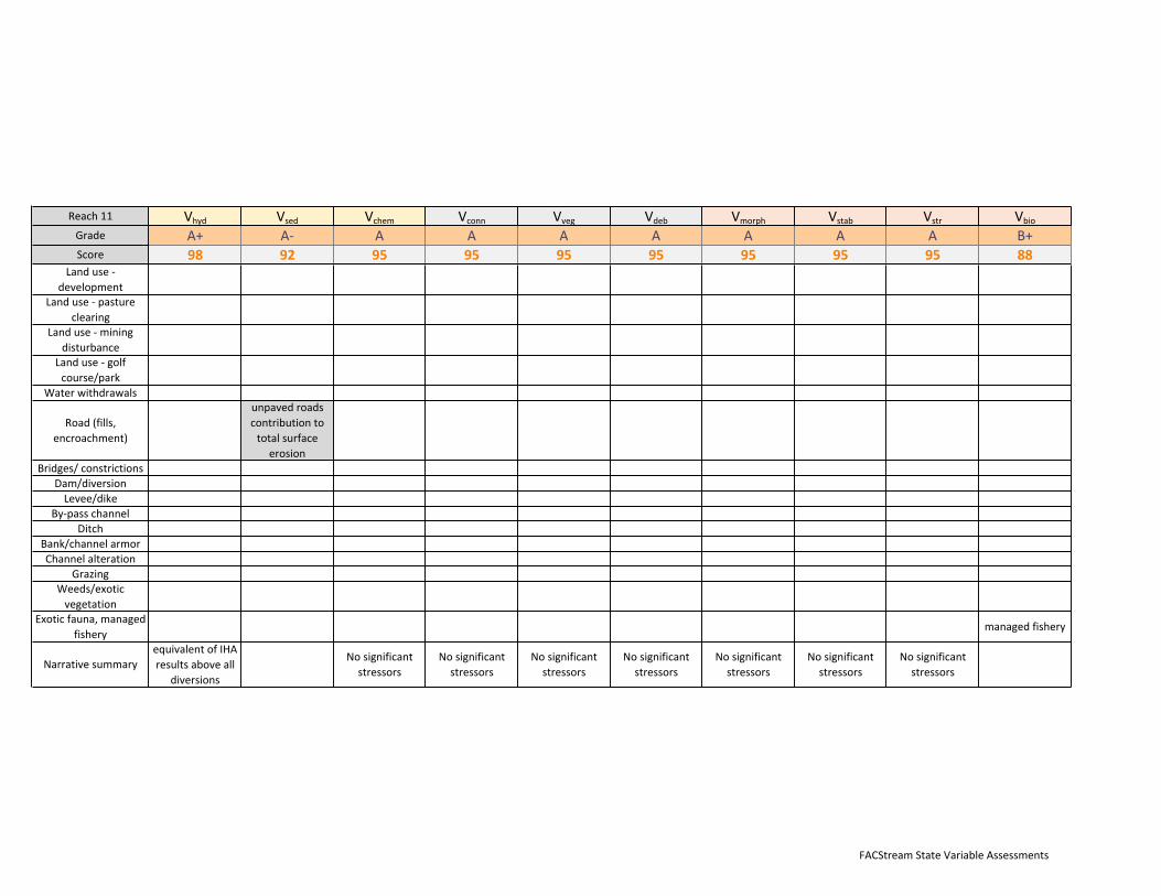
Reach14 Vhyd Vsed Vchem Vconn Vveg Vdeb Vmorph Vstab Vstr Vbio
Grade A+ A- A B- B B+ B B+ B+ B+
Score 98 92 95 82 85 88 85 88 88 88Landuse-
development
Landuse-pasture
clearingleftfloodplain leftfloodplain
Landuse-mining
disturbance
Landuse-golf
course/park
Waterwithdrawals
Road(fills,
encroachment)
unpavedroads
contributionto
totalsurface
erosion
fillforsecondary
roadnearlower
endofreach
fillforsecondary
roadnearlower
endofreach
Bridges/constrictions
Dam/diversion
Levee/dike
By-passchannel
Ditch
Bank/channelarmoralongroadlower
left
alongroadlower
left
alongroadlower
left
Channelalteration
Grazing
Weeds/exotic
vegetation
Exoticfauna,managed
fisheryManagedfishery
Narrativesummary
equivalentofIHA
resultsaboveall
diversions
Nosignificant
stressors

FACStreamStateVariableAssessments
Reach15 Vhyd Vsed Vchem Vconn Vveg Vdeb Vmorph Vstab Vstr Vbio
Grade A+ A- A B- C+ C B- C B B+
Score 98 92 95 82 78 75 82 75 85 88Landuse-
development
Landuse-pasture
clearing
Landuse-mining
disturbance
Landuse-golf
course/park
Waterwithdrawals
Road(fills,
encroachment)
unpavedroads
contributionto
totalsurface
erosion
Highwayfilland
hardeningalong
mostofthereach
Highwayfilland
hardeningalong
mostofthereach
RoadlimitsLWD
transportfrom
adjacent
hillslopes
Highwayfilland
hardeningalong
mostofthereach
Highwayfilland
hardeningalong
mostofthereach
Highwayfilland
hardeningalong
mostofthereach
Bridges/constrictions
Multiplebridges
withsome
constriction
Multiplebridges
withsome
constriction
Multiplebridges
withsome
constriction
Multiplebridges
withsome
constriction
Dam/diversion
Levee/dike
By-passchannel
Ditch
Bank/channelarmorHighwayfilland
hardening
Highwayfilland
hardening
Highwayfilland
hardening
Highwayfilland
hardening
Channelalteration
Grazing
Weeds/exotic
vegetationfewweeds
Exoticfauna,managed
fisherymanagedfishery
Narrativesummary
equivalentofIHA
resultsaboveall
diversions
Nosignificant
stressors
primaryeffectof
stressorsison
resilience.Highly
armored
thresholdchannel
butlimited
capacityfor
recoverydueto
roadfill

FACStreamStateVariableAssessments
Reach16 Vhyd Vsed Vchem Vconn Vveg Vdeb Vmorph Vstab Vstr Vbio
Grade A+ B A- B B- B- A- B B+ B+Score 98 85 92 85 82 82 92 85 88 88
Landuse-development
Housesandlawnsonrightsidevalleybottom
Housesandlawnsonrightsidevalleybottom
Housesandlawnsonrightsidevalleybottom
Landuse-pastureclearing
Landuse-miningdisturbance
miningexacerbatedland
erosin
historicminingeffects
Landuse-golfcourse/park
Waterwithdrawals
Road(fills,encroachment)
unpavedroadscontributiontototalsurface
erosion
HighwayandroadfillsonRedstone
side
Bridges/constrictionsDam/diversion
Levee/dikeLeveealongRbankprotectingRedstonetown
LeveealongRbankprotectingRedstonetown
By-passchannelDitch
Bank/channelarmorsomearmoringalongroadside
reaches
somearmoringalongroadside
reaches
somearmoringalongroadside
reaches
somearmoringalongroadside
reachesChannelalteration
GrazingWeeds/exoticvegetation
Exoticfauna,managedfishery
managedfishery
NarrativesummaryequivalentofIHAresultsaboveall
diversions
Majordepositionupstreamof
bridgeconstrictions

FACStreamStateVariableAssessments
Reach17 Vhyd Vsed Vchem Vconn Vveg Vdeb Vmorph Vstab Vstr Vbio
Grade A+ C- B+ D+ C- C+ B- C- B- B-Score 98 72 88 68 72 78 82 72 82 82
Landuse-development
Towndevelopedonvalleybottom
Towndevelopedonvalleybottom
Towndevelopedonvalleybottom
Towndevelopedonvalleybottom
Landuse-pastureclearing
Landuse-miningdisturbance
elevatedsedimentsupplyfrommininginCoalCreek
elevatedsedimentsupplyfrommininginCoalCreek
Landuse-golfcourse/park
Vegclearingandpark
development
Vegclearingandpark
developmentWaterwithdrawals
Road(fills,encroachment)
unpavedroadscontributiontototalsurface
erosion
Bridges/constrictions
Severalbridgeswithsignificant
constrictionlimitsfloodplainaccess
Severalbridgeswithsignificant
constrictionlimitsfloodplainaccess
Severalbridgeswithsignificant
constrictionlimitsfloodplainaccess
Severalbridgeswithsignificant
constrictionlimitsfloodplainaccess
Dam/diversionLevee/dike
By-passchannelDitch
Bank/channelarmoralongroadandtownlevee
alongroadandtownlevee
alongroadandtownlevee
Channelalterationstraighteningthroughtown
straighteningthroughtown
straighteningthroughtown
straighteningthroughtown
GrazingWeeds/exoticvegetation
weedsandexoticlawnveg
Exoticfauna,managedfishery
managedfishery;notablysmallerpopulationsthaninreferencestream/upper
Crystal
Narrativesummary IHAresultsequivalentofIHAresultsaboveall
diversions

FACStreamStateVariableAssessments
Reach18 Vhyd Vsed Vchem Vconn Vveg Vdeb Vmorph Vstab Vstr Vbio
Grade A+ C+ A- B- B+ B B B- B B-
Score 98 78 92 82 88 85 85 82 85 82Landuse-
development
minimalupland
development
minimalupland
development
Landuse-pasture
clearing
Landuse-mining
disturbance
elevated
sedimentsupply
fromminingin
CoalBasin
elevated
sedimentsupply
fromminingin
CoalBasin
Landuse-golf
course/park
Waterwithdrawals
Road(fills,
encroachment)
unpavedroads
contributionto
totalsurface
erosion
Highway Highway Highway Highway
Bridges/constrictions Severalbridges Severalbridges Severalbridges Severalbridges
Dam/diversion
Levee/dike
By-passchannel
Ditch
Bank/channelarmor
Channelalteration
Grazing
Weeds/exotic
vegetation
Exoticfauna,managed
fishery
managedfishery;
notablysmaller
populationsthan
inreference
stream/upper
Crystal
Narrativesummary IHAresults

FACStreamStateVariableAssessments
Reach19 Vhyd Vsed Vchem Vconn Vveg Vdeb Vmorph Vstab Vstr Vbio
Grade A+ C+ A- B- C B- B B B B-
Score 98 80 92 82 75 82 85 85 85 82Landuse-
development
Landuse-pasture
clearing
ranchonright
valleybotom
ranchonright
valleybottom
ranchonright
valleybottom
Landuse-mining
disturbance
ResidualCoal
Basineffects
ResidualCoal
Basineffects
Landuse-golf
course/park
Waterwithdrawals
Road(fills,
encroachment)
Bridges/constrictions
Dam/diversion
Levee/dike
By-passchannel
Ditchartificial
floodplaindrying
Bank/channelarmor
Channelalteration
Grazing
Weeds/exotic
vegetation
Exoticfauna,managed
fishery
managedfishery;
notablysmaller
populationsthan
inreference
stream/upper
Crystal
Narrativesummary IHAresults
sidechannelscut
off(compareto
upperportionof
reach)

FACStreamStateVariableAssessments
Reach20 Vhyd Vsed Vchem Vconn Vveg Vdeb Vmorph Vstab Vstr Vbio
Grade A+ B A- A- A- A A A- A B-
Score 98 85 92 92 92 95 95 92 95 82Landuse-
development
Landuse-pasture
clearing
Landuse-mining
disturbance
residualCoal
Basinsedsupply
residualCoal
Basinsedsupply
Landuse-golf
course/park
Waterwithdrawals
Road(fills,
encroachment)
Bridges/constrictions
Dam/diversion
Levee/dike
By-passchannel
Ditch
Bank/channelarmor
Channelalteration
Grazing
Weeds/exotic
vegetation
Exoticfauna,managed
fishery
managedfishery;
notablysmaller
populationsthan
inreference
stream/upper
Crystal
Narrativesummary IHAresultsNosignificant
stressors
Nosignificant
stressors
Nosignificant
stressors
Nosignificant
stressors
Nosignificant
stressors
Nosignificant
stressors

FACStreamStateVariableAssessments
Reach21 Vhyd Vsed Vchem Vconn Vveg Vdeb Vmorph Vstab Vstr Vbio
Grade B B A- B- B- B B+ B- B B-Score 84 85 92 82 82 85 88 82 85 82
Landuse-development
Landuse-pastureclearing
Landuse-miningdisturbance
Landuse-golfcourse/park
Waterwithdrawals
Majorwithdrawals
beginbelowthisreach
Road(fills,encroachment)
Bridges/constrictionsDam/diversion
Levee/dike LeveeandpondconstructedonFP
LeveeandpondconstructedonFP
By-passchannelDitch
Bank/channelarmorHardenedbanksalongroadand
levee
Hardenedbanksalongroadand
levee
Hardenedbanksalongroadand
levee
Hardenedbanksalongroadand
leveeChannelalteration
GrazingWeeds/exoticvegetation
Exoticfauna,managedfishery
managedfishery;notablysmallerpopulationsthaninreferencestream/upper
Crystal
Narrativesummary IHAresultsreduced
vegetatativesupply

FACStreamStateVariableAssessments
Reach22 Vhyd Vsed Vchem Vconn Vveg Vdeb Vmorph Vstab Vstr Vbio
Grade B B A- A- A A A- B+ A- B-Score 84 85 92 92 95 95 92 88 92 82
Landuse-development
Landuse-pastureclearing
Landuse-miningdisturbance
Landuse-golfcourse/park
Waterwithdrawals
Majorwithdrawals
beginbelowthisreach
Road(fills,encroachment)
roadfill/encroachment
attwoshortsegments
roadfill/encroachment
attwoshortsegments
roadfill/encroachment
attwoshortsegments
roadfill/encroachment
attwoshortsegments
Bridges/constrictionsOnebridgewith
narrowconstriction
Onebridgewithnarrow
constriction
Onebridgewithnarrow
constriction
Onebridgewithnarrow
constrictionDam/diversionLevee/dike
By-passchannelDitch
Bank/channelarmorChannelalteration
GrazingWeeds/exoticvegetation
Exoticfauna,managedfishery
managedfishery;notablysmallerpopulationsthaninreferencestream/upper
Crystal
Narrativesummary IHAresults Nosignificantstressors
Nosignificantstressors

FACStreamStateVariableAssessments
Reach23 Vhyd Vsed Vchem Vconn Vveg Vdeb Vmorph Vstab Vstr Vbio
Grade B B A- B C+ B- B+ B B B-
Score 84 85 92 85 78 82 88 85 85 82
Landuse-
development
Residential
development
encroachesonto
FP
Residential
development
encroachesonto
FP
Landuse-pasture
clearing
Pastureclearing
RB,mostofRFP
Pastureclearing
RB,mostofRFP
Landuse-mining
disturbance
ResidualCoal
Basineffects
ResidualCoal
Basineffects
Landuse-golf
course/park
Waterwithdrawals
Major
withdrawals
beginbelowthis
reach
Road(fills,
encroachment)
Highwayfilland
hardeningalong
portionofLB
Highwayfilland
hardeningalong
portionofLB
Highwayfilland
hardeningalong
portionofLB
Highwayfilland
hardeningalong
portionofLB
Bridges/constrictions
Dam/diversion
Levee/dike
By-passchannel
Ditch
Bank/channelarmorHardenedbanks
alomgroadfill
Hardenedbanks
alomgroadfill
Hardenedbanks
alomgroadfill
Channelalteration
Grazing
Weeds/exotic
vegetation
Exoticfauna,managed
fishery
managedfishery;
notablysmaller
populationsthan
inreference
stream/upper
Crystal
Narrativesummary IHAresults

FACStreamStateVariableAssessments
Reach24 Vhyd Vsed Vchem Vconn Vveg Vdeb Vmorph Vstab Vstr Vbio
Grade B B- A- B- C+ B- B B- B- B-Score 84 82 92 82 78 82 85 82 82 82
Landuse-development
FPconvertedtoponds
FPconvertedtoponds
FPconvertedtoponds
Landuse-pastureclearing
Landuse-miningdisturbance
ResidualCoalBasineffects
ResidualCoalBasineffects
Landuse-golfcourse/park
Waterwithdrawals
Firstmajordiversiononthisreach(Sweet
Jessup)Road(fills,
encroachment)
Bridges/constrictionsOnebridgewith
narrowconstriction
Onebridgewithnarrow
constriction
Dam/diversion
On-sitePush-updamand
diversioncausinglocalized
aggradation.Manypush-updamsabove
Push-updamatSJdiversion
Push-updamatSJdiversion
Levee/dike
By-passchannelUnregulatedby-passchanneltoSJdiversionintake
Ditch
Bank/channelarmor
HardeningalongSJbypass
channel,bridge,RBpond
HardeningalongSJbypass
channel,bridge,RBpond
HardeningalongSJbypass
channel,bridge,RBpond
Channelalteration
creationofby-passchannel,
naturalbranchescutoff
creationofby-passchannel,
naturalbranchescutoff
GrazingWeeds/exoticvegetation
Exoticfauna,managedfishery
managedfishery;notablysmallerpopulationsthaninreferencestream/upper
CrystalNarrativesummary IHAresults

FACStreamStateVariableAssessments
Reach25 Vhyd Vsed Vchem Vconn Vveg Vdeb Vmorph Vstab Vstr Vbio
Grade C B B+ B A- B+ A- B+ A- B-
Score 74 85 88 85 92 88 92 88 92 82Landuse-
development
Landuse-pasture
clearing
Landuse-mining
disturbance
ResidualCoal
Basineffects
Landuse-golf
course/park
WaterwithdrawalsCumulative
withdrawals
watertemp
effects
Road(fills,
encroachment)
Highwayfilland
hardeningalong
entirelengthof
LB
Highwayand
CrystalRRdfill
andhardening
Highwayand
CrystalRRdfill
andhardening
Highwayand
CrystalRRdfill
andhardening
Bridges/constrictions
Onebridgewith
narrow
constriction
Onebridgewith
narrow
constriction
Dam/diversion
Levee/dike
By-passchannel
Ditch
Bank/channelarmor
Highwayand
CrystalRRdfill
andhardening
Highwayand
CrystalRRdfill
andhardening
Highwayand
CrystalRRdfill
andhardening
Channelalteration
Grazing
Weeds/exotic
vegetation
Exoticfauna,managed
fishery
managedfishery;
notablysmaller
populationsthan
inreference
stream/upper
Crystal
Narrativesummary IHAresults
FACStreamStateVariableAssessments
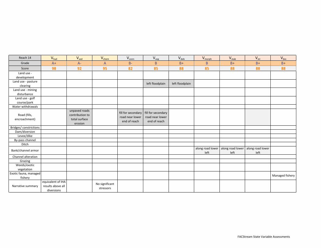
Reach26 Vhyd
Vsed
Vchem
Vconn
Vveg
Vdeb
Vmorph
Vstab
Vstr
Vbio
Grade C B- B+ B B B B B- B- B-
Score 74 82 88 85 85 85 85 82 82 82Landuse-
development
Landuse-pasture
clearing
Landuse-mining
disturbance
ResidualCoal
Basineffects
Landuse-golf
course/park
Waterwithdrawals
Cumulative
withdrawals
temperature
effectsduringlow
flows
Road(fills,
encroachment)
Highwayfilland
hardeningalong
entirelengthof
LB
Highwayand
CrystalRRdfill
andhardening
Highwayand
CrystalRRdfill
andhardening
Highwayand
CrystalRRdfill
andhardening
Bridges/constrictions
Dam/diversion
On-sitePush-up
damand
diversioncausing
localized
aggradation.
Manypush-up
damsabove
PUdamonthis
reach
PUdamonthis
reach
PUdamonthis
reach
PUdamonthis
reach
Levee/dike
By-passchannel
Ditch
Bank/channelarmor
Highwayand
CrystalRRdfill
andhardening
Highwayand
CrystalRRdfill
andhardening
Highwayand
CrystalRRdfill
andhardening
Channelalteration
Grazing
Weeds/exotic
vegetation
Exoticfauna,managed
fishery
managedfishery;
notablysmaller
populationsthan
inreference
stream/upper
Crystal
Narrativesummary IHAresults

FACStreamStateVariableAssessments
Reach27 Vhyd Vsed Vchem Vconn Vveg Vdeb Vmorph Vstab Vstr Vbio
Grade B- B B+ C B- B- B B- C+ B-
Score 81 85 88 75 82 82 85 82 78 82Landuse-
development
Landuse-pasture
clearing
Landuse-mining
disturbance
ResidualCoal
Basineffects
Landuse-golf
course/park
WaterwithdrawalsCumulative
withdrawals
temperature
effectsduringlow
flows
Road(fills,
encroachment)
Highwayfilland
hardeningalong
entirelengthof
LB
Highwayfilland
hardeningalong
entirelengthof
LB
Highwayfilland
hardeningalong
entirelengthof
LB
Highwayfilland
hardeningalong
entirelengthof
LB
Bridges/constrictions
Onebridgewith
narrow
constriction
Dam/diversion
Levee/dike
Majorleveeon
RB,cutsoff
significantportion
ofFParea
Levee=unnatural
hydrologyin
cutoffFP.Veg
impactsobserved
By-passchannel
Ditch
Bank/channelarmor
Highwayfilland
hardeningalong
entirelengthof
LB
Highwayfilland
hardeningalong
entirelengthof
LB
Highwayfilland
hardeningalong
entirelengthof
LB
Channelalteration
Grazing
Weeds/exotic
vegetation
Exoticfauna,managed
fishery
managedfishery;
notablysmaller
populationsthan
inreference
stream/upper
Crystal
Narrativesummary IHAresults

FACStreamStateVariableAssessments
Reach28 Vhyd Vsed Vchem Vconn Vveg Vdeb Vmorph Vstab Vstr Vbio
Grade B- B B B- B+ B+ B+ B B B-Score 81 85 85 82 88 88 88 85 85 82
Landuse-
development
Residentialand
Campground
Landuse-pasture
clearing
Landuse-mining
disturbance
ResidualCoal
Basineffects
Landuse-golf
course/park
WaterwithdrawalsCumulative
withdrawals
temperature
effectsduringlow
flows
Road(fills,
encroachment)
Onebridgewith
verynarrow
opening
Bridges/constrictions
Dam/diversion
On-sitePush-up
damand
diversioncausing
localized
aggradation.
Manypush-up
damsabove
Pushupdamat
diversionpoint
Pushupdamat
diversionpoint
Pushupdamat
diversionpoint
Levee/dike
By-passchannel
Ditch
Bank/channelarmoratbridgeand
diversion
atbridgeand
diversion
atbridgeand
diversion
Channelalteration
Grazing
Weeds/exotic
vegetation
Exoticfauna,managed
fishery
managedfishery;
notablysmaller
populationsthan
inreference
stream/upper
Crystal
Narrativesummary IHAresults

FACStreamStateVariableAssessments
Reach29 Vhyd
Vsed
Vchem
Vconn
Vveg
Vdeb
Vmorph
Vstab
Vstr
Vbio
Grade D- B B- C- B- B B C+ D B-
Score 62 85 82 74 82 85 85 78 65 82Landuse-
development
Landuse-pasture
clearing
Landuse-mining
disturbance
ResidualCoal
Basineffects
Landuse-golf
course/park
Waterwithdrawals
Cumulative
withdrawals
temperature
effectsfromlow
summerflows
decreasedpeak
discharge=
decreasedstage
andFPaccess
baseflowand
variability
alteration
Road(fills,
encroachment)
Bridges/constrictions
Dam/diversion
On-sitePush-up
damand
diversioncausing
localized
aggradation.
Manypush-up
damsabove
Lowprofilepush-
updamandlevee
tofeedbypass
channel
Lowprofilepush-
updamandlevee
tofeedbypass
channel
Lowprofilepush-
updamandlevee
tofeedbypass
channel
Levee/dike
LeveeonRBlimits
FPaccess
By-passchannel
Uncontrolled
diversionto
bypasschannel->
waterlosson
bypassreach
hydrolossesto
bypasschannel
decreasestage
Ditch
Bank/channelarmor
Hardening/rip-rap
onRBandlevee
Hardening/rip-rap
onRBandlevee
Hardening/rip-rap
onRBandlevee
Channelalteration
ExcavationforPU
damandbypass
channel
ExcavationforPU
damandbypass
channel
ExcavationforPU
damandbypass
channel
Grazing
Weeds/exotic
vegetation
Exoticfauna,managed
fishery
DscoreonWUA
(Eco-DSS)
managedfishery;
notablysmaller
populationsthan
inreference
stream/upper
Crystal
Narrativesummary IHAresults
supportedbyEco-
DSS

FACStreamStateVariableAssessments
Reach30 Vhyd Vsed Vchem Vconn Vveg Vdeb Vmorph Vstab Vstr Vbio
Grade D- B+ B- A A- A- A- B+ D+ B-Score 63 88 82 95 92 92 92 88 68 82
Landuse-development
Landuse-pastureclearing
Landuse-miningdisturbance
ResidualCoalBasineffects
Landuse-golfcourse/park
Waterwithdrawals Cumulativewithdrawals
temperatureeffects
Cumulativewithdrawals
baseflowandflowvariability
alteration
baseflowandflowvariability
alteration
Road(fills,encroachment)
Bridges/constrictionsDam/diversionLevee/dike
By-passchannelDitch
Bank/channelarmorChannelalteration
GrazingWeeds/exoticvegetation
Exoticfauna,managedfishery
D/CscoreonWUA(Eco-DSS)
managedfishery;notablysmallerpopulationsthaninreferencestream/upper
Crystal
Narrativesummary IHAresults Nosignificantstressors
Nosignificantstressors
Nosignificantstressors
Nosignificantstressors
supportedbyEco-DSS

FACStreamStateVariableAssessments
Reach31 Vhyd Vsed Vchem Vconn Vveg Vdeb Vmorph Vstab Vstr Vbio
Grade D+ B+ B- B B B A- B+ C B-Score 67 88 82 85 85 85 92 88 75 82
Landuse-development
Landuse-pastureclearing
Landuse-miningdisturbance
ResidualCoalBasineffects
Landuse-golfcourse/park
Waterwithdrawals Cumulativewithdrawals
temperatjureeffectsfromlowsummerflows
basflowandvariabilityalteration
Road(fills,encroachment)
Bridges/constrictions onebridgeatThomasCrRoad
Dam/diversionLevee/dike
By-passchannelDitch
Bank/channelarmor atbridge atbridgeChannelalteration
GrazingWeeds/exoticvegetation
Exoticfauna,managedfishery
CscoreonWUA(Eco-DSS)
managedfishery;notablysmallerpopulationsthaninreferencestream/upper
Crystal
Narrativesummary IHAresults Cumulativeeffects
nosignificantstressors
cumulativeeffectsof
contributingvariable
impairments
supportedbyEco-DSS

FACStreamStateVariableAssessments
Reach32 Vhyd Vsed Vchem Vconn Vveg Vdeb Vmorph Vstab Vstr Vbio
Grade D+ B+ B- C+ B- B B B- C- B-Score 70 88 82 78 82 85 85 82 72 82
Landuse-development
Residetiallanscaping,turf,
mowing,tree/shrubremoval
Residetiallanscaping,turf,
mowing,tree/shrubremoval
Landuse-pastureclearing
DownstreamofNorthCrystal
Bridge
DownstreamofNorthCrystal
Bridge
Landuse-miningdisturbance
PossibleextendedimpactsfromCoalBasininputs,noobvioussigns
Landuse-golfcourse/park
Golfcoursevegetation
conversion-turf,mowing,tree/shrubremoval
Golfcoursevegetation
conversion-turf,mowing,tree/shrubremoval
Waterwithdrawalstemperature
effectsfromlowsummerflows
baseflowandvariabilityalteration
Road(fills,encroachment)
Bridges/constrictions2majorbridgeswithsignificantconstriction
C->Fatbridges
Increasedriskofcatastrophic
failure,diminished
resilience,butgoodbridge
design
Constrictionscour,upstream
deposition
Dam/diversionLevee/dike
By-passchannelDitch
Bank/channelarmorHardening/armor
atbridgesHardening/armor
atbridgesHardening/armor
atbridgesChannelalteration
Grazing
Weeds/exoticvegetation
Exoticsassociatedwithresidentialandgolfcourselandscaping,someweeds
Exoticfauna,managedfishery
D/B-scoreWUA(Eco-DSS)
managedfishery;notablysmallerpopulationsthaninreferencestream/upper
Crystal
Narrativesummary IHAresultsCumulativeeffects
supportedbyEco-DSS

FACStreamStateVariableAssessments
Reach33 Vhyd Vsed Vchem Vconn Vveg Vdeb Vmorph Vstab Vstr Vbio
Grade B- B B- C C C- B- C+ B- B-Score 82 85 82 75 75 72 82 78 80 82
Landuse-development
Residetiallanscaping,turf,
mowing,tree/shrubremoval
Residetiallanscaping,turf,
mowing,tree/shrubremoval
Landuse-pastureclearing
DownstreamofNorthCrystal
Bridge
DownstreamofNorthCrystal
Bridge
Landuse-miningdisturbance
PossibleextendedimpactsfromCoalBasininputs,noobvioussigns
Landuse-golfcourse/park
Golfcoursevegetation
conversion-turf,mowing,tree/shrubremoval
Golfcoursevegetation
conversion-turf,mowing,tree/shrubremoval
Waterwithdrawalstemperature
effectsfromlowsummerflows
Road(fills,encroachment)
Bridges/constrictions5bridgeswithsignificantconstriction
5bridgeswithsignificantconstriction
C->Fatbridges
Increasedriskofcatastrophic
failure,diminished
resilience,butgoodbridge
design
Constrictionscour,upstream
deposition
Dam/diversionLevee/dike
By-passchannelDitch
Bank/channelarmorHardening/armor
atbridgesHardening/armor
atbridgesHardening/armor
atbridgesChannelalteration
Grazing
Weeds/exoticvegetation
Exoticsassociatedwithresidentialandgolfcourselandscaping,someweeds
Exoticfauna,managedfishery
B-scoreWUA(EcoDss)
managedfishery;notablysmallerpopulationsthaninreferencestream/upper
Crystal
Narrativesummary IHAresultsCumulativeeffects
supportbyEco-DSS
FACStreamStateVariableAssessments
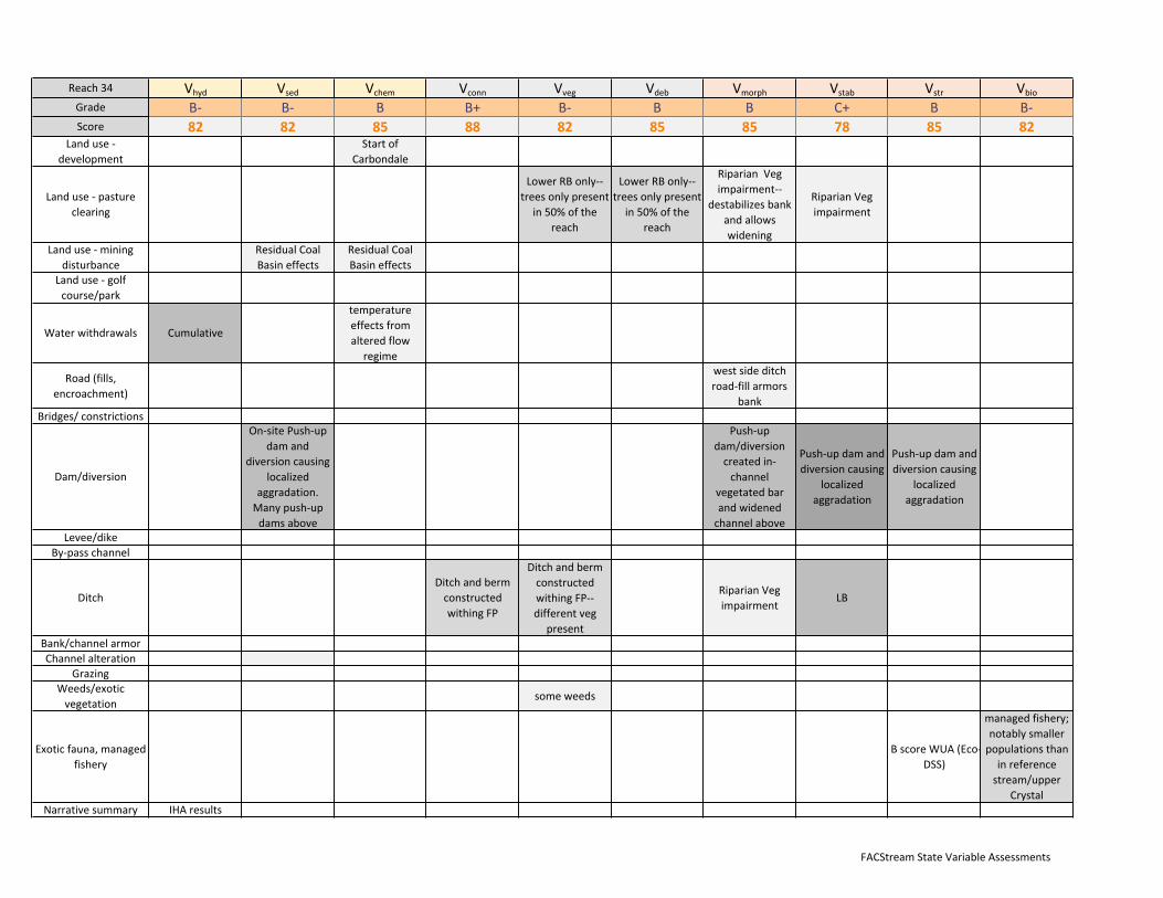
Reach34 Vhyd Vsed Vchem Vconn Vveg Vdeb Vmorph Vstab Vstr Vbio
Grade B- B- B B+ B- B B C+ B B-Score 82 82 85 88 82 85 85 78 85 82
Landuse-development
StartofCarbondale
Landuse-pastureclearing
LowerRBonly--treesonlypresent
in50%ofthereach
LowerRBonly--treesonlypresent
in50%ofthereach
RiparianVegimpairment--
destabilizesbankandallowswidening
RiparianVegimpairment
Landuse-miningdisturbance
ResidualCoalBasineffects
ResidualCoalBasineffects
Landuse-golfcourse/park
Waterwithdrawals Cumulative
temperatureeffectsfromalteredflow
regime
Road(fills,encroachment)
westsideditchroad-fillarmors
bankBridges/constrictions
Dam/diversion
On-sitePush-updamand
diversioncausinglocalized
aggradation.Manypush-updamsabove
Push-updam/diversioncreatedin-channel
vegetatedbarandwidenedchannelabove
Push-updamanddiversioncausing
localizedaggradation
Push-updamanddiversioncausing
localizedaggradation
Levee/dikeBy-passchannel
DitchDitchandbermconstructedwithingFP
DitchandbermconstructedwithingFP--differentveg
present
RiparianVegimpairment
LB
Bank/channelarmorChannelalteration
GrazingWeeds/exoticvegetation
someweeds
Exoticfauna,managedfishery
BscoreWUA(Eco-DSS)
managedfishery;notablysmallerpopulationsthaninreferencestream/upper
CrystalNarrativesummary IHAresults

FACStreamStateVariableAssessments
Reach35 Vhyd Vsed Vchem Vconn Vveg Vdeb Vmorph Vstab Vstr Vbio
Grade A- B B A- B+ B+ A- A- B B-Score 91 85 85 92 88 88 92 92 85 82
Landuse-development
Carbondalesurrounds
Landuse-pastureclearing
Landuse-miningdisturbance
ResidualCoalBasineffects?
Landuse-golfcourse/park
Waterwithdrawals Cumulative
temperatureeffectsfromalteredflow
regime
\
Road(fills,encroachment)
Bridges/constrictions CRMSbridgenearendofreach
bridgeisamostaswideasvalley--minimalimpact
deeppoolformatinfromscourunder
bridgenearpier
sedimentsupplyandmorphology
Dam/diversion sedimentsupplyLevee/dike
By-passchannelDitch
Bank/channelarmor sedimentsupplyChannelalteration sedimentsupply
GrazingWeeds/exoticvegetation
someweeds
Exoticfauna,managedfishery
BscoreWUA(Eco-DSS)
managedfishery;notablysmallerpopulationsthaninreferencestream/upper
Crystal
NarrativesummaryCRMSbridgedoesnothavemajor
impact
RoadfillfromCRMSbridgeislessthan1%
cumulativemorphology,
sedimentsupply,floodplainimpacts
supportedbyEco-DSS

FACStreamStateVariableAssessments
Reach36 Vhyd Vsed Vchem Vconn Vveg Vdeb Vmorph Vstab Vstr Vbio
Grade A- B B+ A- A- A B- A B B-
Score 91 85 88 91 92 95 82 95 85 82Landuse-
development
Carbondale
surrounds
Carbondale
surrounds
Landuse-pasture
clearing
Landuse-mining
disturbance
ResidualCoal
Basineffects
Landuse-golf
course/park
Waterwithdrawals Cumulative
Road(fills,
encroachment)
Bridges/constrictions
CRMSbridgewith
narrow
constriction
CRMSbridgewith
narrow
constriction
Dam/diversionmanyPUdamson
reachesabove
manyPUdamson
reachesabove
Levee/dike
By-passchannel
Ditch
Bank/channelarmor
Channelalteration
Grazing
Weeds/exotic
vegetationsomeweeds
Exoticfauna,managed
fishery
BscoreWUA(Eco-
DSS)
managedfishery;
notablysmaller
populationsthan
inreference
stream/upper
Crystal
Narrativesummary IHAresultsNosignificant
impacts
Nosignificant
impacts