Embed Size (px)
Citation preview

50 | GHD | Report for Water Corporation - Balanup Sewer Pressure Main, 61/32259
Appendix D – Borehole photographs

0m to 1.5m
1.5m to 3m
3m to 4.5m
4.5m to 6m
6m to 9m
A01 Balannup - Keane Road Pressure MainRevision Date Cad Reference
0 7/10/2015 Investigation
This drawing should be read in conjunction with report number 61/32259/151422
Figure No
GHD Pty LtdGHD Pty Ltd
999 Hay Street Perth WA 6000
PO Box 3106 Perth WA 6832
T 61 8 6222 8222 F61 8 6222 8555
E [email protected] www.ghd.com.au
Drawn Date Job Number
A4Title Client
TW 30/08/201561/32259 Borehole Photographs Water Corporation
Checked DateProject

0m to 1.5m
1.5m to 3m
GHD Pty LtdGHD Pty Ltd
999 Hay Street Perth WA 6000
PO Box 3106 Perth WA 6832
T 61 8 6222 8222 F61 8 6222 8555
E [email protected] www.ghd.com.au
Drawn Date Job Number
A4Title Client
TW 30/08/201561/32259 Borehole Photographs Water Corporation
Checked DateProject
A02 Balannup - Keane Road Pressure MainRevision Date Cad Reference
0 7/10/2015 Investigation
This drawing should be read in conjunction with report number 61/32259/151422
Figure No

0m to 1.5m
1.5m to 3m
GHD Pty LtdGHD Pty Ltd
999 Hay Street Perth WA 6000
PO Box 3106 Perth WA 6832
T 61 8 6222 8222 F61 8 6222 8555
E [email protected] www.ghd.com.au
Drawn Date Job Number
A4Title Client
TW 30/08/201561/32259 Borehole Photographs Water Corporation
Checked DateProject
A03 Balannup - Keane Road Pressure MainRevision Date Cad Reference
0 7/10/2015 Investigation
This drawing should be read in conjunction with report number 61/32259/151422
Figure No
0m to 1.5m
1.5m to 3m
GHD Pty LtdGHD Pty Ltd
999 Hay Street Perth WA 6000
PO Box 3106 Perth WA 6832
T 61 8 6222 8222 F61 8 6222 8555
E [email protected] www.ghd.com.au
Drawn Date Job Number
A4Title Client
TW 30/08/201561/32259 Borehole Photographs Water Corporation
Checked DateProject
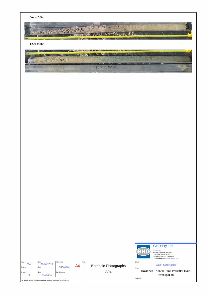
A04 Balannup - Keane Road Pressure MainRevision Date Cad Reference
0 7/10/2015 Investigation
This drawing should be read in conjunction with report number 61/32259/151422
Figure No

0m to 1.5m
1.5m to 3m
3.m to 4.5m
4.5m to 6m
6m to 7.5m
7.5m to 9m
9m to 10.5m
10.5m to 12m
GHD Pty LtdGHD Pty Ltd
999 Hay Street Perth WA 6000
PO Box 3106 Perth WA 6832
T 61 8 6222 8222 F61 8 6222 8555
E [email protected] www.ghd.com.au
Drawn Date Job Number
A4Title Client
TW 30/08/201561/32259 Borehole Photographs Water Corporation
Checked DateProject
A05 Balannup - Keane Road Pressure MainRevision Date Cad Reference
0 7/10/2015 Investigation
This drawing should be read in conjunction with report number 61/32259/151422
Figure No

0m to 1.5m
1.5m to 3m
GHD Pty LtdGHD Pty Ltd
999 Hay Street Perth WA 6000
PO Box 3106 Perth WA 6832
T 61 8 6222 8222 F61 8 6222 8555
E [email protected] www.ghd.com.au
Drawn Date Job Number
A4Title Client
TW 30/08/201561/32259 Borehole Photographs Water Corporation
Checked DateProject
A06 Balannup - Keane Road Pressure MainRevision Date Cad Reference
0 7/10/2015 Investigation
This drawing should be read in conjunction with report number 61/32259/151422
Figure No

0m to 1.5m
1.5m to 3m
GHD Pty LtdGHD Pty Ltd
999 Hay Street Perth WA 6000
PO Box 3106 Perth WA 6832
T 61 8 6222 8222 F61 8 6222 8555
E [email protected] www.ghd.com.au
Drawn Date Job Number
A4Title Client
TW 30/08/201561/32259 Borehole Photographs Water Corporation
Checked DateProject
A07 Balannup - Keane Road Pressure MainRevision Date Cad Reference
0 7/10/2015 Investigation
This drawing should be read in conjunction with report number 61/32259/151422
Figure No

0m to 1.5m
1.5m to 3m
GHD Pty LtdGHD Pty Ltd
999 Hay Street Perth WA 6000
PO Box 3106 Perth WA 6832
T 61 8 6222 8222 F61 8 6222 8555
E [email protected] www.ghd.com.au
Drawn Date Job Number
A4Title Client
TW 30/08/201561/32259 Borehole Photographs Water Corporation
Checked DateProject
A08 Balannup - Keane Road Pressure MainRevision Date Cad Reference
0 7/10/2015 Investigation
This drawing should be read in conjunction with report number 61/32259/151422
Figure No

0m to 1.5m
1.5m to 3m
GHD Pty LtdGHD Pty Ltd
999 Hay Street Perth WA 6000
PO Box 3106 Perth WA 6832
T 61 8 6222 8222 F61 8 6222 8555
E [email protected] www.ghd.com.au
Drawn Date Job Number
A4Title Client
TW 30/08/201561/32259 Borehole Photographs Water Corporation
Checked DateProject
A09 Balannup - Keane Road Pressure MainRevision Date Cad Reference
0 7/10/2015 Investigation
This drawing should be read in conjunction with report number 61/32259/151422
Figure No

0m to 1.5m
1.5m to 3m
GHD Pty LtdGHD Pty Ltd
999 Hay Street Perth WA 6000
PO Box 3106 Perth WA 6832
T 61 8 6222 8222 F61 8 6222 8555
E [email protected] www.ghd.com.au
Drawn Date Job Number
A4Title Client
TW 30/08/201561/32259 Borehole Photographs Water Corporation
Checked DateProject
A11 Balannup - Keane Road Pressure MainRevision Date Cad Reference
0 7/10/2015 Investigation
This drawing should be read in conjunction with report number 61/32259/151422
Figure No

0m to 1.5m
1.5m to 3m
GHD Pty LtdGHD Pty Ltd
999 Hay Street Perth WA 6000
PO Box 3106 Perth WA 6832
T 61 8 6222 8222 F61 8 6222 8555
E [email protected] www.ghd.com.au
Drawn Date Job Number
A4Title Client
TW 30/08/201561/32259 Borehole Photographs Water Corporation
Checked DateProject
A12 Balannup - Keane Road Pressure MainRevision Date Cad Reference
0 7/10/2015 Investigation
This drawing should be read in conjunction with report number 61/32259/151422
Figure No

0m to 1.5m
1.5m to 3m
GHD Pty LtdGHD Pty Ltd
999 Hay Street Perth WA 6000
PO Box 3106 Perth WA 6832
T 61 8 6222 8222 F61 8 6222 8555
E [email protected] www.ghd.com.au
Drawn Date Job Number
A4Title Client
TW 30/08/201561/32259 Borehole Photographs Water Corporation
Checked DateProject
A13 Balannup - Keane Road Pressure MainRevision Date Cad Reference
0 7/10/2015 Investigation
This drawing should be read in conjunction with report number 61/32259/151422
Figure No
0m to 1.5m
1.5m to 3m
GHD Pty LtdGHD Pty Ltd
999 Hay Street Perth WA 6000
PO Box 3106 Perth WA 6832
T 61 8 6222 8222 F61 8 6222 8555
E [email protected] www.ghd.com.au
Drawn Date Job Number
A4Title Client
TW 30/08/201561/32259 Borehole Photographs Water Corporation
Checked DateProject
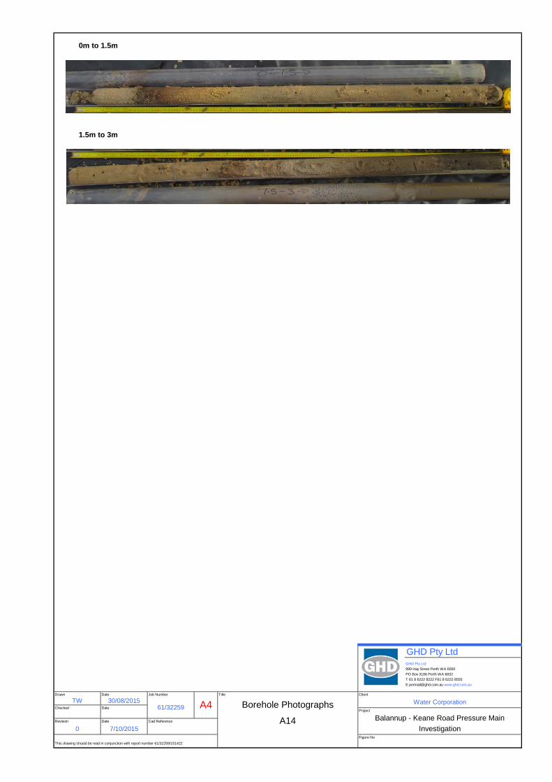
A14 Balannup - Keane Road Pressure MainRevision Date Cad Reference
0 7/10/2015 Investigation
This drawing should be read in conjunction with report number 61/32259/151422
Figure No

0m to 1.5m
1.5m to 3m
3m to 4.5m
GHD Pty LtdGHD Pty Ltd
999 Hay Street Perth WA 6000
PO Box 3106 Perth WA 6832
T 61 8 6222 8222 F61 8 6222 8555
E [email protected] www.ghd.com.au
Drawn Date Job Number
A4Title Client
TW 30/08/201561/32259 Borehole Photographs Water Corporation
Checked DateProject
A15 Balannup - Keane Road Pressure MainRevision Date Cad Reference
0 7/10/2015 Investigation
This drawing should be read in conjunction with report number 61/32259/151422
Figure No

0m to 1.5m
1.5m to 3m
GHD Pty LtdGHD Pty Ltd
999 Hay Street Perth WA 6000
PO Box 3106 Perth WA 6832
T 61 8 6222 8222 F61 8 6222 8555
E [email protected] www.ghd.com.au
Drawn Date Job Number
A4Title Client
TW 30/08/201561/32259 Borehole Photographs Water Corporation
Checked DateProject
A16 Balannup - Keane Road Pressure MainRevision Date Cad Reference
0 7/10/2015 Investigation
This drawing should be read in conjunction with report number 61/32259/151422
Figure No

0m to 1.5m
1.5m to 3m
GHD Pty LtdGHD Pty Ltd
999 Hay Street Perth WA 6000
PO Box 3106 Perth WA 6832
T 61 8 6222 8222 F61 8 6222 8555
E [email protected] www.ghd.com.au
Drawn Date Job Number
A4Title Client
TW 30/08/201561/32259 Borehole Photographs Water Corporation
Checked DateProject
A17 Balannup - Keane Road Pressure MainRevision Date Cad Reference
0 7/10/2015 Investigation
This drawing should be read in conjunction with report number 61/32259/151422
Figure No


GHD | Report for Water Corporation - Balanup Sewer Pressure Main, 61/32259 | 51
Appendix E – Logs from previous studies
Boreholes DP-BH10 to DP-BH10 (Douglas Partners, 2009)
Test Pits Galt-TP01 to Galt-TP11 and Galt-TP14 (Galt Geotechnics, 2013)
Hand Auger Boreholes Galt-HA01 to Galt-HA02 (Galt Geotechnics, 2013)
Cone Penetrometer Tests Galt-CPT01 to Galt-CPT07 (Galt Geotechnics, 2013)
Boreholes GHD13-BH06N, GHD13-BH06S and GHD13-BH22 to GHD13-BH27 (GHD, 2013)
Boreholes Hyd2o-AR5 and Hyd2o-AR6 (Hyd2O, 2013)


File: GL0426M 32mm s'pipe installed to (m): 4.0 Cone I.D. : EC145
Refusal:
Water (m): 1.0
LOCATION: 67 & 89 Anstey Road, Forrestdale
PROJECT: Geotechnical Study
CLIENT: Cedarwoods
12 tonne track mounted CPT Rig (M1)
and IRTP 2001 for friction reducer
Tested in accordance with AS 1289.6.5.1 - 1999
Co-ordinates:
Job Number: J1301201
Probe No.: CPT 01
Date: Thu, Oct 24, 2013
ELECTRIC FRICTION-CONE PENETROMETER
0
100
200
300
400
500
600
700
800
900
1000
0 5 10 15 20 25 30 35 40 45 50
01
23
45
Friction Sleeve fs (kPa)
Tip Resistance qc (MPa)
Dep
th (m
)
Tip
Res
ista
nce
Fri
ctio
n S
leev
e
0 1 2 3 4 5 6 7 8 9 10
01
23
45
Friction Ratio Rf (%)
Dep
th (m
)
0 1 2 3 4 5
01
23
45
Tip Resistance qc (MPa)
Dep
th (m
)

File: GL0425M Dummy probe to (m): Cone I.D. : EC145
Refusal:
Water (m): 0.5
LOCATION: 67 & 89 Anstey Road, Forrestdale
PROJECT: Geotechnical Study
CLIENT: Cedarwoods
12 tonne track mounted CPT Rig (M1)
and IRTP 2001 for friction reducer
Tested in accordance with AS 1289.6.5.1 - 1999
Co-ordinates:
Job Number: J1301201
Probe No.: CPT 02
Date: Thu, Oct 24, 2013
ELECTRIC FRICTION-CONE PENETROMETER
0
100
200
300
400
500
600
700
800
900
1000
0 5 10 15 20 25 30 35 40 45 50
01
23
45
Friction Sleeve fs (kPa)
Tip Resistance qc (MPa)
Dep
th (m
)
Tip
Res
ista
nce
Fri
ctio
n S
leev
e
0 1 2 3 4 5 6 7 8 9 10
01
23
45
Friction Ratio Rf (%)
Dep
th (m
)
0 1 2 3 4 5
01
23
45
Tip Resistance qc (MPa)
Dep
th (m
)

File: GL0424M Dummy probe to (m): Cone I.D. : EC145
Refusal:
Water (m): 0.5
LOCATION: 67 & 89 Anstey Road, Forrestdale
PROJECT: Geotechnical Study
CLIENT: Cedarwoods
12 tonne track mounted CPT Rig (M1)
and IRTP 2001 for friction reducer
Tested in accordance with AS 1289.6.5.1 - 1999
Co-ordinates:
Job Number: J1301201
Probe No.: CPT 03
Date: Thu, Oct 24, 2013
ELECTRIC FRICTION-CONE PENETROMETER
0
100
200
300
400
500
600
700
800
900
1000
0 5 10 15 20 25 30 35 40 45 50
01
23
45
Friction Sleeve fs (kPa)
Tip Resistance qc (MPa)
Dep
th (m
)
Tip
Res
ista
nce
Fri
ctio
n S
leev
e
0 1 2 3 4 5 6 7 8 9 10
01
23
45
Friction Ratio Rf (%)
Dep
th (m
)
0 1 2 3 4 5
01
23
45
Tip Resistance qc (MPa)
Dep
th (m
)

File: GL0423M Dummy probe to (m): Cone I.D. : EC145
Refusal: 75MPa
Water (m): Dry to 1.3
LOCATION: 67 & 89 Anstey Road, Forrestdale
PROJECT: Geotechnical Study
CLIENT: Cedarwoods
12 tonne track mounted CPT Rig (M1)
and IRTP 2001 for friction reducer
Tested in accordance with AS 1289.6.5.1 - 1999
Co-ordinates:
Job Number: J1301201
Probe No.: CPT 04
Date: Thu, Oct 24, 2013
ELECTRIC FRICTION-CONE PENETROMETER
0
100
200
300
400
500
600
700
800
900
1000
0 5 10 15 20 25 30 35 40 45 50
01
23
45
Friction Sleeve fs (kPa)
Tip Resistance qc (MPa)
Dep
th (m
)
Tip
Res
ista
nce
Fri
ctio
n S
leev
e
0 1 2 3 4 5 6 7 8 9 10
01
23
45
Friction Ratio Rf (%)
Dep
th (m
)
0 1 2 3 4 5
01
23
45
Tip Resistance qc (MPa)
Dep
th (m
)

File: GL0427M 32mm s'pipe installed to (m): 4.0 Cone I.D. : EC145
Refusal:
Water (m):
LOCATION: 67 & 89 Anstey Road, Forrestdale
PROJECT: Geotechnical Study
CLIENT: Cedarwoods
12 tonne track mounted CPT Rig (M1)
and IRTP 2001 for friction reducer
Tested in accordance with AS 1289.6.5.1 - 1999
Co-ordinates:
Job Number: J1301201
Probe No.: CPT 05
Date: Thu, Oct 24, 2013
ELECTRIC FRICTION-CONE PENETROMETER
0
100
200
300
400
500
600
700
800
900
1000
0 5 10 15 20 25 30 35 40 45 50
01
23
45
Friction Sleeve fs (kPa)
Tip Resistance qc (MPa)
Dep
th (m
)
Tip
Res
ista
nce
Fri
ctio
n S
leev
e
0 1 2 3 4 5 6 7 8 9 10
01
23
45
Friction Ratio Rf (%)
Dep
th (m
)
0 1 2 3 4 5
01
23
45
Tip Resistance qc (MPa)
Dep
th (m
)

File: GL0422M Dummy probe to (m): Cone I.D. : EC145
Refusal:
Water (m): Dry to 0.5
LOCATION: 67 & 89 Anstey Road, Forrestdale
PROJECT: Geotechnical Study
CLIENT: Cedarwoods
12 tonne track mounted CPT Rig (M1)
and IRTP 2001 for friction reducer
Tested in accordance with AS 1289.6.5.1 - 1999
Co-ordinates:
Job Number: J1301201
Probe No.: CPT 06
Date: Thu, Oct 24, 2013
ELECTRIC FRICTION-CONE PENETROMETER
0
100
200
300
400
500
600
700
800
900
1000
0 5 10 15 20 25 30 35 40 45 50
01
23
45
Friction Sleeve fs (kPa)
Tip Resistance qc (MPa)
Dep
th (m
)
Tip
Res
ista
nce
Fri
ctio
n S
leev
e
0 1 2 3 4 5 6 7 8 9 10
01
23
45
Friction Ratio Rf (%)
Dep
th (m
)
0 1 2 3 4 5
01
23
45
Tip Resistance qc (MPa)
Dep
th (m
)

File: GL0416M Dummy probe to (m): Cone I.D. : EC145
Refusal:
Water (m): 0.6
LOCATION: 67 & 89 Anstey Road, Forrestdale
PROJECT: Geotechnical Study
CLIENT: Cedarwoods
12 tonne track mounted CPT Rig (M1)
and IRTP 2001 for friction reducer
Tested in accordance with AS 1289.6.5.1 - 1999
Co-ordinates:
Job Number: J1301201
Probe No.: CPT 07
Date: Thu, Oct 24, 2013
ELECTRIC FRICTION-CONE PENETROMETER
0
100
200
300
400
500
600
700
800
900
1000
0 5 10 15 20 25 30 35 40 45 50
01
23
45
Friction Sleeve fs (kPa)
Tip Resistance qc (MPa)
Dep
th (m
)
Tip
Res
ista
nce
Fri
ctio
n S
leev
e
0 1 2 3 4 5 6 7 8 9 10
01
23
45
Friction Ratio Rf (%)
Dep
th (m
)
0 1 2 3 4 5
01
23
45
Tip Resistance qc (MPa)
Dep
th (m
)


Lithological Log
Client : Job Number : Bore NameProject: Start Hole :Easting End Hole :Northing Logged by :Datum: Total Depth :Drill type: RL Top of Casing :Hole diameter: RL Nat Surface :
Colour Particle Size Texture Organic
Content Comment
Bentonite Fine Sand LowSeal 1.0 m
SlightlyGravel Clayey Sand Moist
Medium 2.0 m
Solid Light Brown Sandy clay
Clayey Sand 3.0 m
Moist
4.0 m Saturated
Solid Light Grey Fine Sand
5.0 m
6.0 m End of hole
7.0 m
8.0 m
9.0 m
10.0 m
COLOUR : Black, White, BiegeDark/Medium/Light : Brown, Red, Orange, Yellow, Grey, BlueComposition : Solid , Blemish, Mottle Static Water Level
PARTICLE SIZE : Fine, Medium, CourseTEXTURE : Sand, Loamy Sand, Clayey Sand Date 16/05/2013
Silt, Loam, Sandy Loam, Clayey LoamClay, Sandy Clay Stickup above NS (m) 0.50
ORGANICS : High, Medium, Low Water Level bTOC (m) 2.62MOISTURE : Dry, Slightly Moist, Moist, Saturated Water Level bNS (m) 2.12
Soil Characteristics
Moisture
PVC
(C
lass
9)
sup
por
t
ba
ckfil
l
wa
ter
Slot / Screen Depth
Depth (metres)
AR56443568MGA Zone 50, GDA 94Drill Rig Hollow Auger75 mm
Renee Blandin5.8922.6722.17
H13008Cedar WoodsAnstey Road400425
Hyd2oSuite 6B 103 Rokeby Rd
Subiaco, WA 6008
PO Box 1055Subiaco WA 6904

Lithological Log
Client : Job Number : Bore NameProject: Start Hole :Easting End Hole :Northing Logged by :Datum: Total Depth :Drill type: RL Top of Casing :Hole diameter: RL Nat Surface :
Colour Particle Size Texture Organic
Content Comment
Solid Black
Bentonite Solid Grey Fine Sand LowSeal 1.0 m
SlightlyGravel Solid Light Grey Moist
Solid Light Brown Medium 2.0 m Coffey Rock
Mottled Medium Sandy clay Brown/Grey Coarse
Solid Medium Clayey Sand 3.0 m Medium Brown
Solid Dark Grey Moist
Solid Light Grey 4.0 m Saturated
Fine Sand
5.0 m
End of hole6.0 m
7.0 m
8.0 m
9.0 m
10.0 m
COLOUR : Black, White, BiegeDark/Medium/Light : Brown, Red, Orange, Yellow, Grey, BlueComposition : Solid , Blemish, Mottle Static Water Level
PARTICLE SIZE : Fine, Medium, CourseTEXTURE : Sand, Loamy Sand, Clayey Sand Date 16/05/2013
Silt, Loam, Sandy Loam, Clayey LoamClay, Sandy Clay Stickup above NS (m) 0.50
ORGANICS : High, Medium, Low Water Level bTOC (m) 3.79MOISTURE : Dry, Slightly Moist, Moist, Saturated Water Level bNS (m) 3.29
H13008Cedar WoodsAnstey Road400198
AR66443792MGA Zone 50, GDA 94Drill Rig Hollow Auger75 mm
Renee Blandin5.7823.7323.23
Soil Characteristics
Moisture
PVC
(C
lass
9)
sup
por
t
ba
ckfil
l
wa
ter
Slot / Screen Depth
Depth (metres)
Hyd2oSuite 6B 103 Rokeby Rd
Subiaco, WA 6008
PO Box 1055Subiaco WA 6904

52 | GHD | Report for Water Corporation - Balanup Sewer Pressure Main, 61/32259
Appendix F – Summary of laboratory test results
F1: Summary Test Report
F2: Summary of Test Results

REPORTED TEST SUMMARY
Report DateSample DateLot NumberSamples on ReportReport TypeReport Code
Page 1 of 6
5029/P/256 Keane Road Pressure Main25/08/201511/08/2015A01 Sample 1 Depth 0.0m5029/S/6394AS Soil Particle Size Distribution5029/R/1472-1
25/08/201511/08/2015A01 Sample 2 Depth 0.4m5029/S/6395AS Soil Particle Size Distribution5029/R/1473-1
25/08/201511/08/2015A01 Sample 3 Depth 0.6m5029/S/6396Atterberg Limits (with A-Line graph)5029/R/1474-1
25/08/201511/08/2015A01 Sample 4 Depth 0.8m5029/S/6397AS Soil Particle Size Distribution5029/R/1475-1
25/08/201511/08/2015A01 Sample 6 Depth 1.2m5029/S/6399AS Soil Particle Size Distribution5029/R/1476-1
25/08/201511/08/2015A01 Sample 7 Depth 1.5m5029/S/6400AS Soil Particle Size Distribution5029/R/1477-1
25/08/201511/08/2015A01 Sample 9 Depth 2.0m5029/S/6402AS Soil Particle Size Distribution5029/R/1478-1
25/08/201511/08/2015A01 Sample 10 Depth 2.3m5029/S/6403AS Soil Particle Size Distribution5029/R/1479-1
25/08/201511/08/2015A01 Sample 11 Depth 2.8m5029/S/6404AS Soil Particle Size Distribution5029/R/1480-1
25/08/201511/08/2015A01 Sample 13 Depth 3.8m5029/S/6405AS Soil Particle Size Distribution5029/R/1481-1
25/08/201511/08/2015A01 Sample 15 Depth 6.5m5029/S/6406AS Soil Particle Size Distribution5029/R/1482-1
26/08/201511/08/2015A01 Sample 5 Depth 1.0m5029/S/6398AS Soil Particle Size Distribution5029/R/1493-1
26/08/201511/08/2015A01 Sample 16 Depth 7.5m5029/S/6407AS Soil Particle Size Distribution5029/R/1494-1
26/08/201511/08/2015A01 Sample 17 Depth 8.5m5029/S/6408AS Soil Particle Size Distribution5029/R/1495-1
26/08/201511/08/2015A02 Sample 1 Depth 0.0m5029/S/6409AS Soil Particle Size Distribution5029/R/1496-1
26/08/201511/08/2015A02 Sample 2 Depth 0.3m5029/S/6410AS Soil Particle Size Distribution5029/R/1497-1
26/08/201511/08/2015A02 Sample 3 Depth 0.5m5029/S/6411AS Soil Particle Size Distribution5029/R/1498-1
26/08/201511/08/2015A02 Sample 4 Depth 0.8m5029/S/6412AS Soil Particle Size Distribution5029/R/1499-1
26/08/201511/08/2015A02 Sample 5 Depth 1.0m5029/S/6413AS Soil Particle Size Distribution5029/R/1500-1
26/08/201511/08/2015A02 Sample 6 Depth 1.3m5029/S/6414Atterberg Limits (with A-Line graph)5029/R/1501-1
26/08/201511/08/2015A02 Sample 7 Depth 1.5m5029/S/6415AS Soil Particle Size Distribution5029/R/1502-1
26/08/201511/08/2015A02 Sample 8 Depth 1.8m5029/S/6416AS Soil Particle Size Distribution5029/R/1503-1
26/08/201511/08/2015A02 Sample 9 Depth 2.0m5029/S/6417AS Soil Particle Size Distribution5029/R/1504-1
26/08/201511/08/2015A02 Sample 10 Depth 2.3m5029/S/6418AS Soil Particle Size Distribution5029/R/1505-1
26/08/201511/08/2015A02 Sample 11 Depth 2.5m5029/S/6419Atterberg Limits (with A-Line graph)5029/R/1506-1
26/08/201511/08/2015A02 Sample 12 Depth 2.8m5029/S/6420AS Soil Particle Size Distribution5029/R/1507-1
26/08/201511/08/2015A03 Sample 1 Depth 0.0m5029/S/6421AS Soil Particle Size Distribution5029/R/1508-1
26/08/201511/08/2015A03 Sample 2 Depth 0.2m5029/S/6422AS Soil Particle Size Distribution5029/R/1509-1
26/08/201511/08/2015A03 Sample 3 Depth 0.5m5029/S/6423Atterberg Limits (with A-Line graph)5029/R/1510-1
26/08/201511/08/2015A03 Sample 4 Depth 0.7m5029/S/6424AS Soil Particle Size Distribution5029/R/1511-1
26/08/201511/08/2015A03 Sample 5 Depth 1.0m5029/S/6425AS Soil Particle Size Distribution5029/R/1512-1
26/08/201511/08/2015A03 Sample 7 Depth 1.5m5029/S/6427AS Soil Particle Size Distribution5029/R/1513-1
26/08/201511/08/2015A03 Sample 8 Depth 1.8m5029/S/6428AS Soil Particle Size Distribution5029/R/1514-1
26/08/201511/08/2015A03 Sample 9 Depth 2.1m5029/S/6429AS Soil Particle Size Distribution5029/R/1515-1
26/08/201511/08/2015A03 Sample 10 Depth 2.3m5029/S/6430AS Soil Particle Size Distribution5029/R/1516-1
26/08/201511/08/2015A03 Sample 11 Depth 2.6m5029/S/6431AS Soil Particle Size Distribution5029/R/1517-1
26/08/201511/08/2015A03 Sample 12 Depth 2.8m5029/S/6432AS Soil Particle Size Distribution5029/R/1518-1
26/08/201511/08/2015A04 Sample 1 Depth 0.0m5029/S/6433AS Soil Particle Size Distribution5029/R/1519-1
26/08/201511/08/2015A04 Sample 2 Depth 0.3m5029/S/6434AS Soil Particle Size Distribution5029/R/1520-1
26/08/201511/08/2015A04 Sample 3 Depth 0.5m5029/S/6435AS Soil Particle Size Distribution5029/R/1521-1
26/08/201511/08/2015A04 Sample 4 Depth 0.8m5029/S/6436AS Soil Particle Size Distribution5029/R/1522-1

REPORTED TEST SUMMARY
Report DateSample DateLot NumberSamples on ReportReport TypeReport Code
Page 2 of 6
5029/P/256 Keane Road Pressure Main26/08/201511/08/2015A04 Sample 6 Depth 1.3m5029/S/6438AS Soil Particle Size Distribution5029/R/1523-1
26/08/201511/08/2015A04 Sample 7 Depth 1.5m5029/S/6439AS Soil Particle Size Distribution5029/R/1524-1
26/08/201511/08/2015A04 Sample 8 Depth 1.8m5029/S/6440AS Soil Particle Size Distribution5029/R/1525-1
26/08/201511/08/2015A04 Sample 9 Depth 2.0m5029/S/6441AS Soil Particle Size Distribution5029/R/1526-1
26/08/201511/08/2015A04 Sample 10 Depth 2.3m5029/S/6442AS Soil Particle Size Distribution5029/R/1527-1
26/08/201511/08/2015A04 Sample 12 Depth 2.8m5029/S/6444AS Soil Particle Size Distribution5029/R/1528-1
26/08/201511/08/2015A05 Sample 1 Depth 0.0m5029/S/6445AS Soil Particle Size Distribution5029/R/1529-1
26/08/201511/08/2015A05 Sample 2 Depth 0.2m5029/S/6446AS Soil Particle Size Distribution5029/R/1530-1
26/08/201511/08/2015A05 Sample 3 Depth 0.5m5029/S/6447AS Soil Particle Size Distribution5029/R/1531-1
26/08/201511/08/2015A05 Sample 4 Depth 0.8m5029/S/6448AS Soil Particle Size Distribution5029/R/1532-1
26/08/201511/08/2015A05 Sample 5 Depth 1.0m5029/S/6449AS Soil Particle Size Distribution5029/R/1533-1
26/08/201511/08/2015A05 Sample 6 Depth 1.3m5029/S/6450AS Soil Particle Size Distribution5029/R/1534-1
26/08/201511/08/2015A05 Sample 7 Depth 1.5m5029/S/6451AS Soil Particle Size Distribution5029/R/1535-1
26/08/201511/08/2015A05 Sample 8 Depth 1.8m5029/S/6452AS Soil Particle Size Distribution5029/R/1536-1
26/08/201511/08/2015A05 Sample 11 Depth 2.5m5029/S/6455AS Soil Particle Size Distribution5029/R/1537-1
26/08/201511/08/2015A05 Sample 12 Depth 2.8m5029/S/6456AS Soil Particle Size Distribution5029/R/1538-1
26/08/201511/08/2015A05 Sample 13 Depth 3.5m5029/S/6457AS Soil Particle Size Distribution5029/R/1539-1
05/09/201511/08/2015A04 Sample 5 Depth 1.0m5029/S/6437Atterberg Limits (with A-Line graph)5029/R/1754-1
05/09/201511/08/2015A05 Sample 9 Depth 2.0m5029/S/6453Atterberg Limits (with A-Line graph)5029/R/1755-1
05/09/201511/08/2015A05 Sample 10 Depth 2.2m5029/S/6454Atterberg Limits (with A-Line graph)5029/R/1756-1
05/09/201511/08/2015A05 Sample 15 Depth 4.8m5029/S/6458AS Soil Particle Size Distribution5029/R/1757-1
05/09/201511/08/2015A05 Sample 18 Depth 7.5m5029/S/6459AS Soil Particle Size Distribution5029/R/1758-1
05/09/201511/08/2015A06 Sample 1 Depth 0.0m5029/S/6460AS Soil Particle Size Distribution5029/R/1759-1
05/09/201511/08/2015A06 Sample 2 Depth 0.3m5029/S/6461AS Soil Particle Size Distribution5029/R/1760-1
05/09/201511/08/2015A06 Sample 3 Depth 0.5m5029/S/6462AS Soil Particle Size Distribution5029/R/1761-1
05/09/201511/08/2015A06 Sample 4 Depth 0.7m5029/S/6463AS Soil Particle Size Distribution5029/R/1762-1
05/09/201511/08/2015A06 Sample 5 Depth 1.1m5029/S/6464AS Soil Particle Size Distribution5029/R/1763-1
05/09/201511/08/2015A06 Sample 6 Depth 1.3m5029/S/6465AS Soil Particle Size Distribution5029/R/1764-1
05/09/201511/08/2015A06 Sample 7 Depth 1.4m5029/S/6466AS Soil Particle Size Distribution5029/R/1765-1
05/09/201511/08/2015A06 Sample 8 Depth 1.7m5029/S/6467Atterberg Limits (with A-Line graph)5029/R/1766-1
05/09/201511/08/2015A06 Sample 9 Depth 2.1m5029/S/6468AS Soil Particle Size Distribution5029/R/1767-1
05/09/201511/08/2015A06 Sample 10 Depth 2.3m5029/S/6469AS Soil Particle Size Distribution5029/R/1768-1
05/09/201511/08/2015A06 Sample 12 Depth 2.8m5029/S/6470AS Soil Particle Size Distribution5029/R/1769-1
05/09/201511/08/2015A07 Sample 1 Depth 0.0m5029/S/6471AS Soil Particle Size Distribution5029/R/1770-1
05/09/201511/08/2015A07 Sample 2 Depth 0.3m5029/S/6472AS Soil Particle Size Distribution5029/R/1771-1
05/09/201511/08/2015A07 Sample 3 Depth 0.5m5029/S/6473Atterberg Limits (with A-Line graph)5029/R/1772-1
05/09/201511/08/2015A07 Sample 4 Depth 0.8m5029/S/6474AS Soil Particle Size Distribution5029/R/1773-1
05/09/201511/08/2015A07 Sample 5 Depth 1.0m5029/S/6475AS Soil Particle Size Distribution5029/R/1774-1
05/09/201511/08/2015A07 Sample 6 Depth 1.3m5029/S/6476AS Soil Particle Size Distribution5029/R/1775-1
05/09/201511/08/2015A07 Sample 7 Depth 1.5m5029/S/6477AS Soil Particle Size Distribution5029/R/1776-1
05/09/201511/08/2015A07 Sample 8 Depth 1.8m5029/S/6478AS Soil Particle Size Distribution5029/R/1777-1

REPORTED TEST SUMMARY
Report DateSample DateLot NumberSamples on ReportReport TypeReport Code
Page 3 of 6
5029/P/256 Keane Road Pressure Main05/09/201511/08/2015A07 Sample 9 Depth 2.0m5029/S/6479Atterberg Limits (with A-Line graph)5029/R/1778-1
05/09/201511/08/2015A07 Sample 10 Depth 2.3m5029/S/6480AS Soil Particle Size Distribution5029/R/1779-1
05/09/201511/08/2015A07 Sample 11 Depth 2.5m5029/S/6481AS Soil Particle Size Distribution5029/R/1780-1
05/09/201511/08/2015A07 Sample 12 Depth 2.8m5029/S/6482AS Soil Particle Size Distribution5029/R/1781-1
05/09/201511/08/2015A08 Sample 1 Depth 0.0m5029/S/6483AS Soil Particle Size Distribution5029/R/1782-1
05/09/201511/08/2015A08 Sample 2 Depth 0.2m5029/S/6484AS Soil Particle Size Distribution5029/R/1783-1
05/09/201511/08/2015A08 Sample 3 Depth 0.5m5029/S/6485AS Soil Particle Size Distribution5029/R/1784-1
05/09/201511/08/2015A08 Sample 4 Depth 0.8m5029/S/6486AS Soil Particle Size Distribution5029/R/1785-1
05/09/201511/08/2015A08 Sample 6 Depth 1.2m5029/S/6488AS Soil Particle Size Distribution5029/R/1786-1
05/09/201511/08/2015A08 Sample 8 Depth 1.8m5029/S/6490AS Soil Particle Size Distribution5029/R/1787-1
05/09/201511/08/2015A08 Sample 9 Depth 2.0m5029/S/6491Atterberg Limits (with A-Line graph)5029/R/1788-1
05/09/201511/08/2015A08 Sample 10 Depth 2.3m5029/S/6492AS Soil Particle Size Distribution5029/R/1789-1
05/09/201511/08/2015A08 Sample 12 Depth 2.8m5029/S/6494AS Soil Particle Size Distribution5029/R/1790-1
05/09/201511/08/2015A09 Sample 3 Depth 0.5m5029/S/6497AS Soil Particle Size Distribution5029/R/1791-1
05/09/201511/08/2015A09 Sample 5 Depth 1.0m5029/S/6499AS Soil Particle Size Distribution5029/R/1792-1
05/09/201511/08/2015A09 Sample 6 Depth 1.4m5029/S/6500AS Soil Particle Size Distribution5029/R/1793-1
05/09/201511/08/2015A09 Sample 7 Depth 1.6m5029/S/6501AS Soil Particle Size Distribution5029/R/1794-1
05/09/201511/08/2015A09 Sample 8 Depth 1.8m5029/S/6502AS Soil Particle Size Distribution5029/R/1795-1
05/09/201511/08/2015A09 Sample 9 Depth 2.0m5029/S/6503AS Soil Particle Size Distribution5029/R/1796-1
05/09/201511/08/2015A09 Sample 11 Depth 2.4m5029/S/6505AS Soil Particle Size Distribution5029/R/1797-1
05/09/201511/08/2015A10 Sample 2 Depth 0.3m5029/S/6508AS Soil Particle Size Distribution5029/R/1798-1
05/09/201511/08/2015A10 Sample 3 Depth 0.5m5029/S/6509AS Soil Particle Size Distribution5029/R/1799-1
05/09/201511/08/2015A10 Sample 4 Depth 0.8m5029/S/6510AS Soil Particle Size Distribution5029/R/1800-1
05/09/201511/08/2015A10 Sample 5 Depth 1.0m5029/S/6511AS Soil Particle Size Distribution5029/R/1801-1
05/09/201511/08/2015A10 Sample 6 Depth 1.3m5029/S/6512AS Soil Particle Size Distribution5029/R/1802-1
05/09/201511/08/2015A11 Sample 1 Depth 0.0m5029/S/6513AS Soil Particle Size Distribution5029/R/1803-1
05/09/201511/08/2015A11 Sample 2 Depth 0.2m5029/S/6514AS Soil Particle Size Distribution5029/R/1804-1
05/09/201511/08/2015A11 Sample 5 Depth 1.0m5029/S/6517AS Soil Particle Size Distribution5029/R/1805-1
05/09/201511/08/2015A11 Sample 6 Depth1.3m5029/S/6518AS Soil Particle Size Distribution5029/R/1806-1
05/09/201511/08/2015A11 Sample 8 Depth 1.8m5029/S/6520Atterberg Limits (with A-Line graph)5029/R/1807-1
05/09/201511/08/2015A11 Sample 11 Depth 2.4m5029/S/6523AS Soil Particle Size Distribution5029/R/1808-1
05/09/201511/08/2015A12 Sample 2 Depth 0.3m5029/S/6526AS Soil Particle Size Distribution5029/R/1809-1
05/09/201511/08/2015A12 Sample 3 Depth 0.4m5029/S/6527AS Soil Particle Size Distribution5029/R/1810-1
05/09/201511/08/2015A12 Sample 4 Depth 0.8m5029/S/6528AS Soil Particle Size Distribution5029/R/1811-1
05/09/201511/08/2015A12 Sample 5 Depth 1.0m5029/S/6529Atterberg Limits (with A-Line graph)5029/R/1812-1
05/09/201511/08/2015A12 Sample 7 Depth 1.5m5029/S/6531AS Soil Particle Size Distribution5029/R/1813-1
05/09/201511/08/2015A12 Sample 8 Depth 1.8m5029/S/6532AS Soil Particle Size Distribution5029/R/1814-1
05/09/201511/08/2015A12 Sample 10 Depth 2.3m5029/S/6534AS Soil Particle Size Distribution5029/R/1815-1
05/09/201511/08/2015A12 Sample 11 Depth 2.5m5029/S/6535AS Soil Particle Size Distribution5029/R/1816-1
05/09/201511/08/2015A12 Sample 12 Depth 2.8m5029/S/6536AS Soil Particle Size Distribution5029/R/1817-1
05/09/201511/08/2015A13 Sample 2 Depth 0.3m5029/S/6538AS Soil Particle Size Distribution5029/R/1818-1

REPORTED TEST SUMMARY
Report DateSample DateLot NumberSamples on ReportReport TypeReport Code
Page 4 of 6
5029/P/256 Keane Road Pressure Main05/09/201511/08/2015A13 Sample 3 Depth 0.5m5029/S/6539AS Soil Particle Size Distribution5029/R/1819-1
05/09/201511/08/2015A13 Sample 5 Depth 1.0m5029/S/6541AS Soil Particle Size Distribution5029/R/1820-1
05/09/201511/08/2015A13 Sample 7 Depth 1.5m5029/S/6543AS Soil Particle Size Distribution5029/R/1821-1
05/09/201511/08/2015A13 Sample 8 Depth 1.8m5029/S/6544AS Soil Particle Size Distribution5029/R/1822-1
05/09/201511/08/2015A13 Sample 9 Depth 2.0m5029/S/6545AS Soil Particle Size Distribution5029/R/1823-1
05/09/201511/08/2015A14 Sample 1 Depth 0.0m5029/S/6549AS Soil Particle Size Distribution5029/R/1824-1
05/09/201511/08/2015A14 Sample 3 Depth 0.4m5029/S/6551AS Soil Particle Size Distribution5029/R/1825-1
05/09/201511/08/2015A14 Sample 4 Depth 0.8m5029/S/6552Atterberg Limits (with A-Line graph)5029/R/1826-1
07/09/201511/08/2015A08 Sample 5 Depth 1.0m5029/S/6487AS Soil Particle Size Distribution5029/R/1831-1
07/09/201511/08/2015A08 Sample 11 Depth 2.5m5029/S/6493AS Soil Particle Size Distribution5029/R/1832-1
07/09/201511/08/2015A09 Sample 1 Depth 0.0m5029/S/6495AS Soil Particle Size Distribution5029/R/1833-1
07/09/201511/08/2015A09 Sample 10 Depth 2.3m5029/S/6504AS Soil Particle Size Distribution5029/R/1834-1
07/09/201511/08/2015A09 Sample 12 Depth 2.6m5029/S/6506AS Soil Particle Size Distribution5029/R/1836-1
07/09/201511/08/2015A10 Sample 1 Depth 0.0m5029/S/6507AS Soil Particle Size Distribution5029/R/1837-1
07/09/201511/08/2015A11 Sample 3 Depth 0.5m5029/S/6515AS Soil Particle Size Distribution5029/R/1839-1
07/09/201511/08/2015A11 Sample 4 Depth 0.8m5029/S/6516AS Soil Particle Size Distribution5029/R/1840-1
07/09/201511/08/2015A11 Sample 7 Depth 1.5m5029/S/6519AS Soil Particle Size Distribution5029/R/1841-1
07/09/201511/08/2015A11 Sample 9 Depth 2.0m5029/S/6521AS Soil Particle Size Distribution5029/R/1842-1
07/09/201511/08/2015A11 Sample 10 Depth 2.3m5029/S/6522AS Soil Particle Size Distribution5029/R/1843-1
07/09/201511/08/2015A12 Sample 1 Depth 0.0m5029/S/6525AS Soil Particle Size Distribution5029/R/1844-1
07/09/201511/08/2015A12 Sample 6 Depth 1.3m5029/S/6530AS Soil Particle Size Distribution5029/R/1845-1
07/09/201511/08/2015A12 Sample 9 Depth 2.0m5029/S/6533Atterberg Limits (with A-Line graph)5029/R/1846-1
07/09/201511/08/2015A13 Sample 1 Depth 0.0m5029/S/6537AS Soil Particle Size Distribution5029/R/1847-1
07/09/201511/08/2015A13 Sample 4 Depth 0.8m5029/S/6540AS Soil Particle Size Distribution5029/R/1849-1
07/09/201511/08/2015A13 Sample 10 Depth 2.3m5029/S/6546AS Soil Particle Size Distribution5029/R/1851-1
07/09/201511/08/2015A13 Sample 11 Depth 2.5m5029/S/6547Atterberg Limits (with A-Line graph)5029/R/1852-1
07/09/201511/08/2015A13 Sample 12 Depth 2.8m5029/S/6548AS Soil Particle Size Distribution5029/R/1855-1
07/09/201511/08/2015A14 Sample 2 Depth 0.3m5029/S/6550AS Soil Particle Size Distribution5029/R/1856-1
07/09/201511/08/2015A14 Sample 5 Depth 1.0m5029/S/6553AS Soil Particle Size Distribution5029/R/1858-1
07/09/201511/08/2015A14 Sample 7 Depth 1.5m5029/S/6555Atterberg Limits (with A-Line graph)5029/R/1860-1
07/09/201511/08/2015A14 Sample 8 Depth 1.8m5029/S/6556AS Soil Particle Size Distribution5029/R/1862-1
07/09/201511/08/2015A14 Sample 9 Depth 2.1m5029/S/6557AS Soil Particle Size Distribution5029/R/1863-1
07/09/201511/08/2015A14 Sample 10 Depth 2.3m5029/S/6558AS Soil Particle Size Distribution5029/R/1865-1
07/09/201511/08/2015A15 Sample 1 Depth 0.0m5029/S/6561AS Soil Particle Size Distribution5029/R/1866-1
07/09/201511/08/2015A15 Sample 4 Depth 0.9m5029/S/6564AS Soil Particle Size Distribution5029/R/1868-1
07/09/201511/08/2015A15 Sample 5 Depth 1.0m5029/S/6565Atterberg Limits (with A-Line graph)5029/R/1869-1
07/09/201511/08/2015A15 Sample 9 Depth 2.0m5029/S/6569Atterberg Limits (with A-Line graph)5029/R/1870-1
07/09/201511/08/2015A16 Sample 3 Depth 0.6m5029/S/6577Atterberg Limits (with A-Line graph)5029/R/1871-1
07/09/201511/08/2015A16 Sample 8 Depth 1.8m5029/S/6582Atterberg Limits (with A-Line graph)5029/R/1878-1
07/09/201511/08/2015A17 Sample 3 Depth 0.6m5029/S/6589Atterberg Limits (with A-Line graph)5029/R/1879-1
08/09/201511/08/2015A01 Sample 8 Depth 1.8m5029/S/6401Atterberg Limits (with A-Line graph)5029/R/1890-1

REPORTED TEST SUMMARY
Report DateSample DateLot NumberSamples on ReportReport TypeReport Code
Page 5 of 6
5029/P/256 Keane Road Pressure Main08/09/201511/08/2015A03 Sample 6 Depth 1.3m5029/S/6426Atterberg Limits (with A-Line graph)5029/R/1891-1
08/09/201511/08/2015A04 Sample 11 Depth 2.5m5029/S/6443Atterberg Limits (with A-Line graph)5029/R/1892-1
08/09/201511/08/2015A08 Sample 7 Depth 1.5m5029/S/6489Atterberg Limits (with A-Line graph)5029/R/1893-1
08/09/201511/08/2015A09 Sample 2 Depth 0.2m5029/S/6496Atterberg Limits (with A-Line graph)5029/R/1894-1
08/09/201511/08/2015A09 Sample 4 Depth 0.8m5029/S/6498Atterberg Limits (with A-Line graph)5029/R/1895-1
08/09/201511/08/2015A11 Sample 12 Depth 2.8m5029/S/6524Atterberg Limits (with A-Line graph)5029/R/1896-1
08/09/201511/08/2015A13 Sample 6 Depth 1.4m5029/S/6542Atterberg Limits (with A-Line graph)5029/R/1897-1
09/09/201511/08/2015A14 Sample 6 Depth 1.3m5029/S/6554AS Soil Particle Size Distribution5029/R/1949-1
09/09/201511/08/2015A14 Sample 11 Depth 2.5m5029/S/6559AS Soil Particle Size Distribution5029/R/1950-1
09/09/201511/08/2015A14 Sample 12 Depth 2.8m5029/S/6560AS Soil Particle Size Distribution5029/R/1951-1
09/09/201511/08/2015A15 Sample 2 Depth 0.2m5029/S/6562AS Soil Particle Size Distribution5029/R/1952-1
09/09/201511/08/2015A15 Sample 3 Depth 0.5m5029/S/6563AS Soil Particle Size Distribution5029/R/1954-1
09/09/201511/08/2015A15 Sample 6 Depth 1.3m5029/S/6566AS Soil Particle Size Distribution5029/R/1955-1
09/09/201511/08/2015A15 Sample 7 Depth 1.5m5029/S/6567AS Soil Particle Size Distribution5029/R/1956-1
09/09/201511/08/2015A15 Sample 8 Depth 1.8m5029/S/6568AS Soil Particle Size Distribution5029/R/1957-1
09/09/201511/08/2015A15 Sample 10 Depth 2.3m5029/S/6570AS Soil Particle Size Distribution5029/R/1958-1
09/09/201511/08/2015A15 Sample 11 Depth 2.5m5029/S/6571AS Soil Particle Size Distribution5029/R/1959-1
09/09/201511/08/2015A15 Sample 12 Depth 2.8m5029/S/6572AS Soil Particle Size Distribution5029/R/1960-1
09/09/201511/08/2015A15 Sample 13 Depth 3.2m5029/S/6573AS Soil Particle Size Distribution5029/R/1961-1
09/09/201511/08/2015A15 Sample 14 Depth 4.2m5029/S/6574AS Soil Particle Size Distribution5029/R/1962-1
09/09/201511/08/2015A16 Sample 1 Depth 0.0m5029/S/6575AS Soil Particle Size Distribution5029/R/1963-1
09/09/201511/08/2015A16 Sample 2 Depth 0.3m5029/S/6576AS Soil Particle Size Distribution5029/R/1964-1
09/09/201511/08/2015A16 Sample 4 Depth 0.8m5029/S/6578AS Soil Particle Size Distribution5029/R/1965-1
09/09/201511/08/2015A16 Sample 5 Depth 1.0m5029/S/6579AS Soil Particle Size Distribution5029/R/1966-1
09/09/201511/08/2015A16 Sample 6 Depth 1.3m5029/S/6580AS Soil Particle Size Distribution5029/R/1967-1
09/09/201511/08/2015A16 Sample 7 Depth 1.5m5029/S/6581AS Soil Particle Size Distribution5029/R/1968-1
09/09/201511/08/2015A16 Sample 9 Depth 2.0m5029/S/6583AS Soil Particle Size Distribution5029/R/1969-1
09/09/201511/08/2015A16 Sample 10 Depth 2.3m5029/S/6584AS Soil Particle Size Distribution5029/R/1970-1
09/09/201511/08/2015A16 Sample 11 Depth 2.5m5029/S/6585AS Soil Particle Size Distribution5029/R/1971-1
09/09/201511/08/2015A16 Sample 12 Depth 2.9m5029/S/6586AS Soil Particle Size Distribution5029/R/1972-1
09/09/201511/08/2015A17 Sample 1 Depth 0.0m5029/S/6587AS Soil Particle Size Distribution5029/R/1973-1
09/09/201511/08/2015A17 Sample 2 Depth 0.3m5029/S/6588AS Soil Particle Size Distribution5029/R/1974-1
09/09/201511/08/2015A17 Sample 4 Depth 0.8m5029/S/6590AS Soil Particle Size Distribution5029/R/1975-1
09/09/201511/08/2015A17 Sample 5 Depth 1.1m5029/S/6591AS Soil Particle Size Distribution5029/R/1976-1
09/09/201511/08/2015A17 Sample 6 Depth 1.3m5029/S/6592AS Soil Particle Size Distribution5029/R/1977-1
09/09/201511/08/2015A17 Sample 7 Depth 1.5m5029/S/6593Atterberg Limits (with A-Line graph)5029/R/1978-1
09/09/201511/08/2015A17 Sample 8 Depth 1.8m5029/S/6594AS Soil Particle Size Distribution5029/R/1979-1
09/09/201511/08/2015A17 Sample 9 Depth 2.0m5029/S/6595AS Soil Particle Size Distribution5029/R/1980-1
09/09/201511/08/2015A17 Sample 10 Depth 2.3m5029/S/6596AS Soil Particle Size Distribution5029/R/1981-1
09/09/201511/08/2015A17 Sample 11 Depth 2.5m5029/S/6597AS Soil Particle Size Distribution5029/R/1982-1
09/09/201511/08/2015A17 Sample 12 Depth 2.9m5029/S/6598AS Soil Particle Size Distribution5029/R/1983-1

REPORTED TEST SUMMARY
Report DateSample DateLot NumberSamples on ReportReport TypeReport Code
Page 6 of 6
5029/P/256 Keane Road Pressure Main
09/09/201511/08/2015A01 Sample 3 Depth 0.6m
5029/S/6396, 5029/S/6399, 5029/S/6401, 5029/S/6402, 5029/S/6404, 5029/S/6405,5029/S/6407, 5029/S/6412, 5029/S/6414, 5029/S/6416, 5029/S/6418, 5029/S/6419,5029/S/6420, 5029/S/6422, 5029/S/6423, 5029/S/6424, 5029/S/6426, 5029/S/6428,5029/S/6429, 5029/S/6430, 5029/S/6439, 5029/S/6440, 5029/S/6442, 5029/S/6443,5029/S/6444, 5029/S/6450, 5029/S/6452, 5029/S/6453, 5029/S/6454, 5029/S/6458,5029/S/6459, 5029/S/6467, 5029/S/6468, 5029/S/6473, 5029/S/6474, 5029/S/6475,5029/S/6482, 5029/S/6484, 5029/S/6486, 5029/S/6487, 5029/S/6488, 5029/S/6489,5029/S/6490, 5029/S/6491, 5029/S/6496, 5029/S/6497, 5029/S/6498, 5029/S/6499,5029/S/6500, 5029/S/6501, 5029/S/6503, 5029/S/6506, 5029/S/6514, 5029/S/6515,5029/S/6516, 5029/S/6517, 5029/S/6518, 5029/S/6520, 5029/S/6521, 5029/S/6522,5029/S/6524, 5029/S/6529, 5029/S/6530, 5029/S/6532, 5029/S/6533, 5029/S/6534,5029/S/6536, 5029/S/6542, 5029/S/6545, 5029/S/6546, 5029/S/6547, 5029/S/6551,5029/S/6552, 5029/S/6553, 5029/S/6554, 5029/S/6555, 5029/S/6556, 5029/S/6564,5029/S/6565, 5029/S/6566, 5029/S/6567, 5029/S/6569, 5029/S/6571, 5029/S/6574,5029/S/6577, 5029/S/6579, 5029/S/6580, 5029/S/6581, 5029/S/6582, 5029/S/6583,5029/S/6589, 5029/S/6590, 5029/S/6591, 5029/S/6593, 5029/S/6595, 5029/S/6597
Moisture Content Report5029/R/1984-1

Table 1: Summary of laboratory testing (soil samples)
Test Pit ID
Sample Depth
Group Symbol Soil Unit Moisture Content (%)
Particle Size Distribution Atterberg Limits Organic Content %
% Fines % Sand % Gravel LL% PL % PI % LL %
A01 0.0 Sand (SP) Bassendean Sand (BS) 2 98 0
A01 0.3 Sand (SP) Bassendean Sand (BS) 3 97 0
A01 0.5 Sand (SP) / Clayey Sand (SC)
Bassendean Sand (BS) / Guildford Formation (GC)
15.4 12 88 0 <0.5
A01 0.8 Clayey Sand (SC) Guildford Formation (GC) 20 80 0
A01 1.0 Clayey Sand (SC) Guildford Formation (GC) 20 80 0
A01 1.1 Clayey Sand (SC) Guildford Formation (GC) 15.2 29 70 1
A01 1.5 Clayey Sand (SC) Guildford Formation (GC) 31 69 0
A01 1.8 Clayey Sand (SC) Guildford Formation (GC) 14.7 20 80 0 40 12 28 8 <0.5
A01 2.0 Clayey Sand (SC) Guildford Formation (GC) 14.5 18 82 0
A01 2.3 Sand (SP) / Clayey Sand (SC)
Guildford Formation (GC) 11 89 0
A01 2.8 Clayey Sand (SC) Guildford Formation (GC) 14.0 18 82 0
A01 3.8 Clayey Sand (SC) Guildford Formation (GC) 16.6 14 86 0
A01 6.5 Sand (SP) Guildford Formation (GS) 10 90 0
A01 7.5 Sand (SP) / Clayey Sand (SC)
Guildford Formation (GC) 20.6 13 87 0
A01 8.5 Sand (SP) Guildford Formation (GS) 10 90 0
A02 0.0 Sand (SP) Bassendean Sand (BS) 2 98 0
A02 0.3 Sand (SP) Bassendean Sand (BS) 1 99 0
A02 0.5 Sand (SP) Bassendean Sand (BS) 4 96 0
A02 0.8 Clayey Sand (SC) Guildford Formation (GC) 18.4 23 77 0
A02 1.0 Clayey Sand (SC) Guildford Formation (GC) 22 78 0
A02 1.3 Clayey Sand (SC) Guildford Formation (GC) 16.5 18 82 0 37 11 26 8 <0.5
A02 1.5 Clayey Sand (SC) Guildford Formation (GC) 22 78 0
A02 1.8 Clayey Sand (SC) Guildford Formation (GC) 17.1 20 80 0
A02 2.0 Clayey Sand (SC) Guildford Formation (GC) 19 81 0
A02 2.3 Clayey Sand (SC) Guildford Formation (GC) 21 79 0
A02 2.5 Clayey Sand (SC) Guildford Formation (GC) 16.4 23 77 0 42 10 32 8.5 <0.5
A02 2.8 Clayey Sand (SC) Guildford Formation (GC) 15.2 22 78 0
A03 0.0 Sand (SP) Bassendean Sand (BS) 2 98 0
A03 0.2 Clayey Sand (SC) Guildford Formation (GC) 13.5 15 85 0
A03 0.5 Clayey Sand (SC) Guildford Formation (GC) 12.4 18 82 0 29 11 18 3 <0.5
A03 0.7 Clayey Sand (SC) Guildford Formation (GC) 14.1 15 85 0
A03 1.0 Clayey Sand (SC) Guildford Formation (GC) 16 84 0
A03 1.3 Clayey Sand (SC) Guildford Formation (GC) 11.9 15 85 0 29 14 15 2 <0.5
A03 1.5 Clayey Sand (SC) Guildford Formation (GC) 18 82 0
A03 1.8 Clayey Sand (SC) Guildford Formation (GC) 14.5 16 84 0
A03 2.05 Sand (SP) / Clayey Sand (SC)
Guildford Formation (GS) 15.3 11 88 1
A03 2.3 Sand (SP) Guildford Formation (GS) 17.3 10 90 0
A03 2.6 Sand (SP) / Clayey Sand (SC)
Guildford Formation (GS) 12 88 0
A03 2.8 Clayey Sand (SC) Guildford Formation (GS) 14 86 0
A04 0.0 Sand (SP) Bassendean Sand (BS) 1 99 0
A04 0.3 Sand (SP) Bassendean Sand (BS) 1 99 0
A04 0.5 Sand (SP) Bassendean Sand (BS) 1 99 0
A04 0.8 Sand (SP) Bassendean Sand (BS) 7 93 0
A04 1.0 Sand (SP) / Clayey Sand (SC)
Bassendean Sand (BS) 11 89 0 28 13 15 2 <0.5
A04 1.3 Clayey Sand (SC) Guildford Formation (GC) 14 86 0
A04 1.5 Clayey Sand (SC) Guildford Formation (GC) 20.3 13 87 0
A04 1.8 Clayey Sand (SC) Guildford Formation (GC) 16.9 15 85 0

Test Pit ID
Sample Depth
Group Symbol Soil Unit Moisture Content (%)
Particle Size Distribution Atterberg Limits Organic Content %
% Fines % Sand % Gravel LL% PL % PI % LL %
A04 2.0 Clayey Sand (SC) Guildford Formation (GC) 13 87 0
A04 2.3 Clayey Sand (SC) Guildford Formation (GC) 15.3 15 85 0
A04 2.5 Clayey Sand (SC) Guildford Formation (GC) 14.3 19 81 0 32 11 21 5 <0.5
A04 2.8 Clayey Sand (SC) Guildford Formation (GC) 14.2 18 82 0
A05 0.0 Sand (SP) Bassendean Sand (BS) 2 98 0
A05 0.2 Sand (SP) Bassendean Sand (BS) 3 97 0
A05 0.5 Sand (SP) Bassendean Sand (BS) 2 98 0
A05 0.8 Sand (SP) Bassendean Sand (BS) 2 98 0
A05 1.0 Sand (SP) Bassendean Sand (BS) 6 94 0
A05 1.3 Sand (SP) / Clayey Sand (SC)
Guildford Formation (GC) 16.2 12 88 0
A05 1.5 Sand (SP) / Clayey Sand (SC)
Guildford Formation (GC) 11 89 0
A05 1.8 Clayey Sand (SC) Guildford Formation (GC) 15.5 17 83 0
A05 2.0 Clayey Sand (SC) Guildford Formation (GC) 13.6 18 82 0 23 13 10 2.5 <0.5
A05 2.2 Clayey Sand (SC) Guildford Formation (GC) 16.0 13 87 0 27 15 12 3 <0.5
A05 2.5 Sand (SP) Guildford Formation (GS) 8 92 0
A05 2.8 Sand (SP) Guildford Formation (GS) 10 90 0
A05 3.5 Sand (SP) Guildford Formation (GS) 6 94 0
A05 4.8 Sand (SP) Guildford Formation (GS) 13.6 9 90 1
A05 7.5 Sand (SP) / Clayey Sand (SC)
Guildford Formation (GS) 21.6 12 88 0
A06 0.0 Sand (SP) Bassendean Sand (BS) 2 98 0
A06 0.3 Sand (SP) Bassendean Sand (BS) 2 98 0
A06 0.5 Sand (SP) Bassendean Sand (BS) 1 99 0
A06 0.7 Sand (SP) Bassendean Sand (BS) 4 96 0
A06 1.0 Sand (SP) Bassendean Sand (BS) 6 94 0
A06 1.3 Sand (SP) Bassendean Sand (BS) 9 91 0
A06 1.4 Sand (SP) Bassendean Sand (BS) 8 92 0
A06 1.7 Clayey Sand (SC) Guildford Formation (GC) 13.7 16 84 0 22 12 10 3 <0.5
A06 2.0 Sand (SP) Guildford Formation (GS) 13.0 10 90 0
A06 2.3 Sand (SP) Guildford Formation (GS) 10 90 0
A06 2.8 Clayey Sand (SC) Guildford Formation (GS) 13 87 0
A07 0.0 Sand (SP) Bassendean Sand (BS) 10 90 0
A07 0.3 Sand (SP) Bassendean Sand (BS) 7 93 0
A07 0.5 Clayey Sand (SC) Guildford Formation (GC) 18.8 25 69 6 35 25 10 7.5 <0.5
A07 0.8 Clayey Sand (SC) Guildford Formation (GC) 16.6 28 63 9
A07 1.0 Clayey Sand (SC) Guildford Formation (GC) 17.4 29 71 0
A07 1.3 Clayey Sand (SC) Guildford Formation (GC) 25 75 0
A07 1.5 Clayey Sand (SC) Guildford Formation (GC) 16 84 0
A07 1.8 Sand (SP) / Clayey Sand (SC)
Guildford Formation (GS) 11 89 0
A07 2.0 Sand (SP) Guildford Formation (GS) 7 93 0
A07 2.3 Sand (SP) Guildford Formation (GS) 7 93 0
A07 2.5 Sand (SP) Guildford Formation (GS) 7 93 0
A07 2.8 Clayey Sand (SC) Guildford Formation (GC) 12.5 16 84 0
A08 0.0 Sand (SP) Bassendean Sand (BS) 4 96 0
A08 0.2 Clayey Sand (SC) Guildford Formation (GC) 10.5 14 86 0
A08 0.5 Clayey Sand (SC) Guildford Formation (GC) 16 84 0
A08 0.8 Sand (SP) / Clayey Sand (SC)
Guildford Formation (GC) 9.7 12 88 0
A08 1.0 Sand (SP) / Clayey Sand (SC)
Guildford Formation (GC) 12.5 12 88 0
A08 1.2 Clayey Sand (SC) Guildford Formation (GC) 12.7 15 85 0

Test Pit ID
Sample Depth
Group Symbol Soil Unit Moisture Content (%)
Particle Size Distribution Atterberg Limits Organic Content %
% Fines % Sand % Gravel LL% PL % PI % LL %
A08 1.5 Clayey Sand (SC) Guildford Formation (GC) 11.8 17 83 0 <0.5
A08 1.8 Clayey Sand (SC) Guildford Formation (GC) 12.0 14 86 0
A08 2.0 Clayey Sand (SC) Guildford Formation (GC) 13.7 17 83 0 22 12 10 2 <0.5
A08 2.3 Sand (SP) / Clayey Sand (SC)
Bassendean Sand (BS) 11 89 0
A08 2.5 Sand (SP) Bassendean Sand (BS) 9 91 0
A08 2.8 Sand (SP) Bassendean Sand (BS) 10 90 0
A09 0.0 Sand (SP) Bassendean Sand (BS) 6 94 0
A09 0.2 Clayey Sand (SC) Guildford Formation (GC) 11.3 21 79 0 28 12 16 6 <0.5
A09 0.5 Clayey Sand (SC) Guildford Formation (GC) 14.5 16 84 0
A09 0.8 Clayey Sand (SC) Guildford Formation (GC) 11.4 21 78 1 30 12 18 5.5 <0.5
A09 1.0 Sand (SP) Guildford Formation (GS) 11.5 3 97 0
A09 1.3 Clayey Sand (SC) Guildford Formation (GC) 15.2 23 77 0
A09 1.5 Clayey Sand (SC) Guildford Formation (GC) 13.4 21 79 0
A09 1.8 Sand (SP) Guildford Formation (GS) 6 94 0
A09 2.0 Clayey Sand (SC) Guildford Formation (GC) 14.0 19 81 0
A09 2.3 Clayey Sand (SC) Guildford Formation (GC) 18 82 0
A09 2.4 Clayey Sand (SC) Guildford Formation (GC) 15 85 0
A09 2.5 Clayey Sand (SC) Guildford Formation (GC) 16.3 14 86 0
A10 0.0 Sand (SP) Bassendean Sand (BS) 2 98 0
A10 0.3 Sand (SP) Bassendean Sand (BS) 2 98 0
A10 0.5 Sand (SP) Bassendean Sand (BS) 1 99 0
A10 0.8 Sand (SP) Bassendean Sand (BS) 3 97 0
A10 1 Sand (SP) Bassendean Sand (BS) 2 98 0
A10 1.3 Sand (SP) Bassendean Sand (BS) 2 98 0
A11 0.0 Sand (SP) Bassendean Sand (BS) 2 98 0
A11 0.1 Clayey Sand (SC) Guildford Formation (GC) 16.0 20 80 0
A11 0.5 Clayey Sand (SC) Guildford Formation (GC) 16.7 30 70 0
A11 0.8 Clayey Sand (SC) Guildford Formation (GC) 13.3 24 76 0
A11 1.0 Clayey Sand (SC) Guildford Formation (GC) 14.9 23 77 0
A11 1.3 Clayey Sand (SC) Guildford Formation (GC) 18.5 30 70 0
A11 1.5 Clayey Sand (SC) Guildford Formation (GC) 26 74 0
A11 1.8 Clayey Sand (SC) Guildford Formation (GC) 18.8 26 73 1 47 14 33 14 <0.5
A11 2 Clayey Sand (SC) Guildford Formation (GC) 18.9 21 79 0
A11 2.3 Clayey Sand (SC) Guildford Formation (GC) 16.4 18 82 0
A11 2.4 Sand (SP) Guildford Formation (GS) 6 94 0
A11 2.8 Sand (SP) / Clayey Sand (SC)
Guildford Formation (GS) 17.0 12 88 0 28 11 17 4 0.6
A12 0.0 Sand (SP) Bassendean Sand (BS) 2 98 0
A12 0.3 Sand (SP) Bassendean Sand (BS) 2 98 0
A12 0.4 Sand (SP) Bassendean Sand (BS) 3 97 0
A12 0.8 Sand (SP) Bassendean Sand (BS) 8 92 0
A12 1.0 Clayey Sand (SC) Guildford Formation (GC) 13.6 13 77 10 0.9
A12 1.3 Clayey Sand (SC) Guildford Formation (GC) 12.4 16 60 24
A12 1.5 Clayey Sand (SC) Guildford Formation (GC) 19 81 0
A12 1.8 Clayey Sand (SC) Guildford Formation (GC) 14.0 20 80 0
A12 2.0 Clayey Sand (SC) Guildford Formation (GC) 13.7 21 79 0 25 10 15 4.5 <0.5
A12 2.3 Clayey Sand (SC) Guildford Formation (GC) 13.4 18 82 0
A12 2.5 Clayey Sand (SC) Guildford Formation (GC) 14 86 0
A12 2.8 Clayey Sand (SC) Guildford Formation (GC) 15.1 14 86 0
A13 0.0 Sand (SP) Bassendean Sand (BS) 4 96 0
A13 0.3 Sand (SP) Bassendean Sand (BS) 6 94 0
A13 0.5 Sand (SP) Bassendean Sand (BS) 3 97 0

Test Pit ID
Sample Depth
Group Symbol Soil Unit Moisture Content (%)
Particle Size Distribution Atterberg Limits Organic Content %
% Fines % Sand % Gravel LL% PL % PI % LL %
A13 0.8 Sand (SP) Bassendean Sand (BS) 4 96 0
A13 1.0 Sand (SP) Bassendean Sand (BS) 11 89 0
A13 1.3 Clayey Sand (SC) Guildford Formation (GC) 16.0 20 80 0 32 11 21 3 <0.5
A13 1.5 Clayey Sand (SC) Guildford Formation (GC) 21 79 0
A13 1.8 Clayey Sand (SC) Guildford Formation (GC) 22 78 0
A13 2.0 Clayey Sand (SC) Guildford Formation (GC) 20.0 25 75 0
A13 2.3 Clayey Sand (SC) Guildford Formation (GC) 18.1 19 81 0
A13 2.5 Clayey Sand (SC) Guildford Formation (GC) 18.5 20 80 0 70 12 58 9 <0.5
A13 2.8 Sand (SP) / Clayey Sand (SC)
Guildford Formation (GC) 12 88 0
A14 0.0 Sand (SP) Bassendean Sand (BS) 1 99 0
A14 0.3 Sand (SP) Bassendean Sand (BS) 7 93 0
A14 0.4 Clayey Sand (SC) Guildford Formation (GC) 20.3 13 87 0
A14 0.8 Clayey Sand (SC) Guildford Formation (GC) 18.9 15 85 0 40 13 27 9 <0.5
A14 1.0 Clayey Sand (SC) Guildford Formation (GC) 13.5 16 84 0
A14 1.3 Sand (SP) Guildford Formation (GS) 10.6 11 89 0
A14 1.5 Sand (SP) Guildford Formation (GS) 12.1 11 89 0 26 11 15 4.5 <0.5
A14 1.8 Clayey Sand (SC) Guildford Formation (GC) 14.5 15 85 0
A14 2.0 Clayey Sand (SC) Guildford Formation (GS) 13 87 0
A14 2.3 Sand (SP) Guildford Formation (GS) 8 92 0
A14 2.5 Sand (SP) Guildford Formation (GS) 5 95 0
A14 2.8 Sand (SP) Guildford Formation (GS) 8 92 0
A15 0.0 Clayey Sand (SC) Guildford Formation (GC) 34 66 0
A15 0.2 Clayey Sand (SC) Guildford Formation (GC) 13 87 0
A15 0.5 Clayey Sand (SC) Guildford Formation (GC) 13 87 0
A15 0.9 Clayey Sand (SC) Guildford Formation (GC) 19.1 17 83 0
A15 1.0 Clayey Sand (SC) Guildford Formation (GC) 21.2 20 73 7 36 12 24 8.5 <0.5
A15 1.3 Clayey Sand (SC) Guildford Formation (GC) 21.6 27 73 0
A15 1.5 Clayey Sand (SC) Guildford Formation (GC) 26.3 24 76 0
A15 1.8 Clayey Sand (SC) Guildford Formation (GC) 20 80 0
A15 2.0 Clayey Sand (SC) Guildford Formation (GC) 14.5 18 82 0 37 12 25 7.5 <0.5
A15 2.3 Clayey Sand (SC) Guildford Formation (GC) 13 87 0
A15 2.5 Sand (SP) / Clayey Sand (SC)
Guildford Formation (GC) 15.9 12 88 0
A15 2.8 Sand (SP) Guildford Formation (GS) 5 95 0
A15 3.2 Sand (SP) Guildford Formation (GS) 5 95 0
A15 4.2 Sand (SP) Guildford Formation (GS) 17.1 10 90 0
A16 0.0 Sand (SP) Bassendean Sand (BS) 3 97 0
A16 0.3 Sand (SP) Bassendean Sand (BS) 1 99 0
A16 0.6 Clayey Sand (SC) Guildford Formation (GC) 28.2 29 71 0 78 16 62 17 <0.5
A16 0.8 Clayey Sand (SC) Guildford Formation (GC) 26 74 0
A16 1.0 Clayey Sand (SC) Guildford Formation (GC) 21.1 35 65 0
A16 1.3 Clayey Sand (SC) Guildford Formation (GC) 26.1 37 63 0
A16 1.5 Clayey Sand (SC) Guildford Formation (GC) 25.2 42 58 0
A16 1.8 Clayey Sand (SC) Guildford Formation (GC) 24.7 35 65 0 37 13 24 11 <0.5
A16 2.0 Clayey Sand (SC) Guildford Formation (GC) 22.9 33 67 0
A16 2.3 Clayey Sand (SC) Guildford Formation (GC) 24 76 0
A16 2.5 Sand (SP) / Clayey Sand (SC)
Guildford Formation (GC) 12 88 0
A16 2.9 Sand (SP) Guildford Formation (GS) 6 94 0
A17 0.0 Sand (SP) Bassendean Sand (BS) 7 93 0
A17 0.3 Sand (SP) Bassendean Sand (BS) 6 94 0
A17 0.6 Clayey Sand (SC) Guildford Formation (GC) 21.9 27 69 4 43 21 22 8.5 <0.5

Test Pit ID
Sample Depth
Group Symbol Soil Unit Moisture Content (%)
Particle Size Distribution Atterberg Limits Organic Content %
% Fines % Sand % Gravel LL% PL % PI % LL %
A17 0.8 Clayey Sand (SC) Guildford Formation (GC) 22.5 26 74 0
A17 1.0 Clayey Sand (SC) Guildford Formation (GC) 21.3 37 63 0
A17 1.3 Clayey Sand (SC) Guildford Formation (GC) 45 55 0
A17 1.5 Clayey Sand (SC) Guildford Formation (GC) 25.2 50 50 0 67 15 52 15 <0.5
A17 1.8 Clayey Sand (SC) Guildford Formation (GC) 52 48 0
A17 2.0 Clayey Sand (SC) Guildford Formation (GC) 30.7 47 53 0
A17 2.3 Clayey Sand (SC) Guildford Formation (GC) 36 64 0
A17 2.5 Clayey Sand (SC) Guildford Formation (GC) 19.0 20 80 0
A17 2.9 Clayey Sand (SC) Guildford Formation (GC) 16 84 0
Notes: Fines < 0.075mm 0.075 mm < Sand < 2.36mm 2.36 mm < gravel < 63 mm LL = liquid limit PL = plastic limit PI = plasticity index LS = linear shrinkage Testing standards used: AS 1289.2.1.1 (moisture content), 3.6.1 (PSD) & 3.6.3 (PSD and hydrometer) AS 1289.3.1.2, 3.3.1 and 3.4.1 (Atterberg Limits) ASTM: D2974-07a Test Method C (organic content)
Table 2: Summary of laboratory testing (water samples)
Sample Depth
Electrical Conductivity (μS/cm)
Total Dissolved Solids (mg/L)
Total Alkalinity (mg/L)
Sulfate (mg/L)
Chloride (mg/L)
Major Cations Ionic Balance
Calcium (mg/L)
Magnesium (mg/L)
Sodium (mg/L)
Potassium (mg/L)
Total Anions (meq/L)
Total Cations (meq/L)
Ionic Balance (%)
A01 Shallow 286 654 100 <10 32 23 5 42 7 2.90 3.56 10.3
A01 Deep 2430 2940 145 112 690 10 35 429 5 24.7 22.2 5.41
A05 Shallow 166 2360 57 <1 17 7 4 29 <1 1.62 1.94 -
A05 Deep 5450 4820 104 64 1820 36 126 891 9 54.8 51.2 3.41
A07 3410 1880 202 30 1020 15 32 622 8 33.4 30.6 4.38
A15 3710 2490 419 541 668 16 26 738 8 38.5 35.2 4.42
AR5 33600 2000 531 147 724 11 37 624 6 34.1 30.9 4.96
AR6 2860 2790 <1 643 556 16 79 432 4 29.1 26.2 5.23
BH06 North Pending Pending Pending Pending Pending Pending Pending Pending Pending Pending Pending Pending
BH06 South Pending Pending Pending Pending Pending Pending Pending Pending Pending Pending Pending Pending
BH13 12300 6900 65 143 4270 52 224 2220 13 125 118 2.82
Notes: Fines < 0.075mm 0.075 mm < Sand < 2.
Testing standards used: APHA 2510 B & APHA 2540 B


![nsb028CR 2020_nsb028CR.pdf · 2020. 3. 22. · L = + Lp 2 [ ]Ls Stroke 1m 2m 3m 4m 5m 6m 7m Kg/m 0.5m 1m 1.5m 2m 2.5m 3m 3.5m 곡률반경 (R) Lp 최소 곡률반경 길이 Lf 스트로크](https://img.pdfslide.us/doc/110x75/60a8e7741ab1b25b475808eb/2020nsb028crpdf-2020-3-22-l-lp-2-ls-stroke-1m-2m-3m-4m-5m-6m-7m.jpg)