Embed Size (px)
Citation preview

Remedial Action Completion Report Environmental Quality Management, Inc. Great Lakes Legacy Act Lower Menominee River Tyco Site
December 14, 2015
APPENDIX C
PERMITS


Remedial Action Completion Report Environmental Quality Management, Inc. Great Lakes Legacy Act Lower Menominee River Tyco Site
December 14, 2015
APPENDIX D
SEDIMENT VOLUME CALCULATION DATA
Page 1 of 4
Menominee River Sediment RemovalMarinette, WI11/23/201411/18/2014
Volumes Computed Using Hypack V. 2013 TIN ModelVolumes are in Cubic Yards unless otherwise specified
DMUVolume
AvailableVolume
RemainingVolume
RemovedDMU
COMPLETE DMUVolume
AvailableVolume
RemainingVolume
RemovedL1-A 109.5 8.3 101.2 L1-A 70.3 23.8 46.5L1-B 99.9 12.1 87.8 L1-B 75.5 26.9 48.6L1-C 270.1 44.7 225.4 L1-C 91.5 36.5 55.0L1-D 259.8 1.9 257.9 L1-D 79.6 8.4 71.2L2-A 224.2 93.4 130.8 L2-A 90.1 57.8 32.3L2-B 296.9 147.1 149.8 L2-B 78.6 55.9 22.7L2-C 260.9 158.5 102.4 L2-C 90.4 76.2 14.2L2-D 596.9 348.8 248.1 L2-D 90.6 89.5 1.1L3-A 364.0 248.5 115.5 L3-A 90.3 87.6 2.7L3-B 424.0 314.2 109.8 L3-B 90.7 90.5 0.2L3-C 421.7 311.5 110.2 L3-C 89.9 87.3 2.6L3-D 542.1 315.6 226.5 L3-D 90.8 87.0 3.8L4-A 522.0 268.2 253.8 L4-A 90.0 83.1 6.9L4-B 363.5 119.4 244.1 L4-B 90.1 63.2 26.9
L4-C(1) 300.5 34.4 266.1 L4-C(1) 90.5 56.8 33.7L4-C(2) 1.1 0.4 0.7 L4-C(2) 11.6 2.0 9.6
L4-D 310.9 17.7 293.2 L4-D 90.7 35.3 55.4L5-A 662.8 4.3 658.5 L5-A 88.9 24.1 64.8L5-B 1,156.0 20.5 1,135.5 L5-B 89.8 38.0 51.8L5-C 869.7 10.9 858.8 L5-C 82.1 41.4 40.7L5-D 849.2 12.2 837.0 L5-D 90.8 31.4 59.4L6-A 842.2 545.0 297.2 L6-A 90.2 90.1 0.1L6-B 774.1 471.7 302.4 L6-B 90.6 90.2 0.4L6-C 908.1 421.8 486.3 L6-C 89.3 88.8 0.5L6-D 580.5 199.8 380.7 L6-D 91.5 91.2 0.3L7-A 692.3 4.7 687.6 L7-A 69.0 11.1 57.9L7-B 419.4 10.7 408.7 L7-B 72.5 30.2 42.3L7-C 532.5 1.6 530.9 L7-C 74.8 11.6 63.2L7-D 530.1 15.4 514.7 L7-D 74.9 49.6 25.3L7-E 378.7 73.7 305.0 L7-E 74.9 46.1 28.8L8-A 216.5 3.2 213.3 L8-A 89.4 19.9 69.5L8-B 419.1 0.2 418.9 L8-B 87.2 3.2 84.0L8-C 289.4 58.9 230.5 L8-C 82.1 60.0 22.1L8-D 511.0 8.7 502.3 L8-D 90.3 28.8 61.5L9-A 225.8 163.5 62.3 L9-A 75.8 79.5 -3.7L9-B 182.6 99.6 83.0 L9-B 64.8 58.9 5.9L9-C 453.5 325.7 127.8 L9-C 90.9 78.8 12.1L9-D 356.5 137.7 218.8 L9-D 90.8 56.0 34.8L10-A 710.6 1.8 708.8 L10-A 88.5 14.2 74.3L10-B 914.7 2.4 912.3 L10-B 87.4 9.4 78.0L10-C 114.8 36.4 78.4 L10-C 50.8 50.7 0.1L10-D 65.1 15.3 49.8 L10-D 36.7 25.8 10.9L11-A 181.0 73.9 107.1 L11-A 78.8 54.9 23.9 L11-B 36.7 53.0 -16.3 L11-B 46.8 59.0 -12.2L11-C 197.1 62.4 134.7 L11-C 89.3 41.8 47.5L11-D 155.6 15.8 139.8 L11-D 68.3 25.8 42.5L12-A 1,018.4 7.7 1,010.7 L12-A 84.6 16.0 68.6L12-B 1,010.4 9.7 1,000.7 L12-B 90.4 28.2 62.2L12-C 666.2 23.2 643.0 L12-C 79.3 51.0 28.3L12-D 216.6 11.5 205.1 L12-D 90.7 17.9 72.8L13-A 438.2 28.9 409.3 L13-A 67.0 44.8 22.2L13-B 671.7 5.4 666.3 L13-B 90.5 13.6 76.9L13-C 232.5 11.0 221.5 L13-C 73.7 17.1 56.6L13-D 883.1 31.6 851.5 L13-D 90.8 34.8 56.0L14-A 467.4 7.2 460.2 L14-A 90.7 11.9 78.8L14-B 876.4 17.1 859.3 L14-B 90.7 36.9 53.8L14-C 418.9 18.4 400.5 L14-C 91.1 39.3 51.8L14-D 394.1 3.8 390.3 L14-D 90.2 27.1 63.1L15-A 139.4 0.0 139.4 L15-A 90.7 1.6 89.1L15-B 127.8 0.0 127.8 L15-B 91.3 0.0 91.3L15-C 188.6 0.0 188.6 L15-C 90.6 1.8 88.8L15-D 243.3 0.0 243.3 L15-D 90.8 0.1 90.7
Volume Report by DMU - ORIGINAL PROJECT
Turning Basin & Transition Area Phase I-IV Required Depth
Turning Basin & Transition Area Phase I-IV 0.5' Tolerance
Location:Project:
Date:Current Survey Date:

Page 2 of 4
DMUVolume
AvailableVolume
RemainingVolume
RemovedDMU
COMPLETE DMUVolume
AvailableVolume
RemainingVolume
Removed
Turning Basin & Transition Area Phase I-IV Required Depth
Turning Basin & Transition Area Phase I-IV 0.5' Tolerance
L16-A 273.8 0.2 273.6 L16-A 90.7 7.8 82.9L16-B 342.7 0.7 342.0 L16-B 90.7 8.5 82.2L16-C 233.8 0.1 233.7 L16-C 89.8 2.2 87.6L16-D 272.2 10.9 261.3 L16-D 90.5 16.6 73.9L17-A 193.2 0.7 192.5 L17-A 84.2 19.9 64.3L17-B 158.2 2.1 156.1 L17-B 84.5 10.8 73.7L17-C 251.8 0.0 251.8 L17-C 84.9 0.0 84.9L17-D 190.6 0.0 190.6 L17-D 85.0 1.6 83.4L18-A 192.0 0.0 192.0 L18-A 86.6 4.5 82.1L18-B 230.8 0.0 230.8 L18-B 86.9 0.2 86.7L18-C 113.2 0.8 112.4 L18-C 86.2 12.4 73.8L18-D 241.6 3.8 237.8 L18-D 86.3 16.5 69.8L19-A 183.4 0.0 183.4 L19-A 86.6 0.5 86.1L19-B 161.5 7.0 154.5 L19-B 84.0 23.8 60.2L19-C 275.9 0.0 275.9 L19-C 88.2 0.0 88.2L19-D 222.7 1.3 221.4 L19-D 87.8 13.3 74.5L20-A 59.0 43.7 15.3 L20-A 17.7 16.2 1.5L20-B 45.2 5.4 39.8 L20-B 15.6 5.2 10.4L20-C 24.4 14.0 10.4 L20-C 14.0 13.2 0.8
L20-D(1) 19.5 8.7 10.8 L20-D(1) 12.2 11.8 0.4L20-D(2) 0.0 0.0 0.0 L20-D(2) 0.0 0.0 0.0
L21-A 490.8 27.7 463.1 L21-A 88.8 49.2 39.6 L21-B 219.8 18.0 201.8 L21-B 73.7 32.0 41.7L21-C 326.9 14.0 312.9 L21-C 86.9 31.3 55.6L21-D 151.0 12.2 138.8 L21-D 78.1 21.0 57.1L22-A 39.6 5.6 34.0 L22-A 28.5 7.2 21.3
L22-B(1) 136.6 0.0 136.6 L22-B(1) 44.4 1.0 43.4L22-B(2) 0.0 2.3 -2.3 L22-B(2) 0.7 3.1 -2.4L22-C(1) 89.0 0.3 88.7 L22-C(1) 47.5 2.7 44.8L22-C(2) 0.0 0.1 -0.1 L22-C(2) 0.0 0.3 -0.3
L22-D 215.3 7.4 207.9 L22-D 72.0 22.3 49.7L23-A 58.4 4.6 53.8 L23-A 60.6 10.3 50.3L23-B 213.0 49.2 163.8 L23-B 64.7 23.5 41.2L23-C 177.7 40.7 137.0 L23-C 59.8 32.1 27.7L23-D 148.2 44.9 103.3 L23-D 55.3 28.8 26.5
Totals 33,538.4 5,797.4 27,741.0 0.0 7,304.9 3,070.2 4,234.7
COLOR CODE TABLEVolume Update OCT 7 2014
Volume Update OCT 20 2014
Volume Update OCT 24 2014Volume Update OCT 31 2014
Volume Update NOV 1 2014
Volume Update NOV 4 2014
Volume Update Nov 9 2014
Volume Update Nov 18 2014 L20 A,B,C + L13A
PI-PIVPV
* Totals do not include 927 of allowable overdredge beyond tolerance
31,976
35,7863,8101,542 3,554
TOTALS
40,8437,134
7,339 31,295
5,797 27,741
Overall Project Volume SummaryVolume Removed
(REQUIRED)Volume Removed
(INCLUDING TOLERANCE)
Volume Remaining (NOT INCLUDING
Tolerance)Originally Available
(including Tolerance)

Page 3 of 4
Menominee River Sediment RemovalMarinette, WI10/17/201410/8/2014
Volumes Computed Using Hypack V. 2013 TIN ModelVolumes are in Cubic Yards unless otherwise specified
DMUVolume
AvailableVolume
RemainingVolume
Removed
NOTES (See abr. Below) DMU
Volume Available
Volume Remaining
Volume Removed
L24-A 77.2 33.5 43.7 L24-A 75.6 74.3 1.3L24-B 231.0 31.7 199.3 L24-B 75.4 68.5 6.9L24-C 140.7 23.5 117.2 L24-C 75.6 75.2 0.4L24-D 113.3 22.7 90.6 L24-D 75.6 73.3 2.3L24-E 215.7 100.9 114.8 BA L24-E 72.7 71.9 0.8L25-A 240.9 63.7 177.2 BA L25-A 74.7 72.3 2.4L25-B 297.8 34.6 263.2 L25-B 74.7 74.0 0.7L25-C 366.8 156.5 210.3 BA L25-C 73.2 65.6 7.6L25-D 254.4 18.9 235.5 L25-D 74.7 73.8 0.9L25-E 436.2 33.9 402.3 L25-E 73.8 68.4 5.4L26-A 124.6 10.7 113.9 L26-A 62.1 54.1 8.0L26-B 66.1 24.9 41.2 L26-B 87.7 83.1 4.6L26-C 328.9 32.5 296.4 L26-C 147.2 135.7 11.5L26-D 93.9 19.1 74.8 L26-D 61.9 58.1 3.8L27-A 51.8 11.4 40.4 L27-A 39.5 36.6 2.9
L27-B(1) 91.3 11.7 79.6 L27-B(1) 69.4 37.6 31.8L27-B(2) 1.3 0.8 0.5 L27-B(2) 8.5 5.1 3.4
L27-C 89.0 16.8 72.2 L27-C 64.6 45.3 19.3L27-D 87.3 85.1 2.2 UCA L27-D 48.5 48.5 0.0
L28-A(1) 2.6 2.3 0.3 L28-A(1) 1.7 1.7 0.0L28-A(2) 35.6 14.9 20.7 L28-A(2) 20.5 18.8 1.7L28-B(1) 23.2 2.1 21.1 L28-B(1) 13.0 10.3 2.7L28-B(2) 46.5 2.6 43.9 L28-B(2) 37.9 34.2 3.7L28-C(1) 0.1 0.9 -0.8 L28-C(1) 1.1 1.4 -0.3L28-C(2) 0.0 0.2 -0.2 L28-C(2) 2.7 5.5 -2.8
L28-D 117.2 21.8 95.4 L28-D 124.1 110.9 13.2L29-A 37.8 3.8 34.0 L29-A 28.3 24.4 3.9L29-B 56.5 2.5 54.0 L29-B 18.4 13.6 4.8L29-C 33.6 5.0 28.6 L29-C 52.3 27.3 25.0L30-A 98.3 92.5 5.8 RB L30-A 10.6 10.5 0.1L30-B 160.9 64.1 96.8 BA L30-B 70.8 54.7 16.1
L30-C(1) 0.0 0.0 0.0 L30-C(1) 1.2 0.4 0.8L30-C(2) 7.7 0.0 7.7 L30-C(2) 10.2 3.3 6.9L30-C(3) 0.2 0.6 -0.4 L30-C(3) 0.4 0.4 0.0
L31-A 348.4 195.5 152.9 BA L31-A 78.0 67.1 10.9L31-B 325.6 187.4 138.2 UCA L31-B 77.7 65.9 11.8L31-C 216.5 119.8 96.7 L31-C 77.0 45.0 32.0L31-D 276.7 92.8 183.9 L31-D 76.8 64.9 11.9
Totals 5,095.6 1,541.7 3,553.9 0.0 2,038.1 1,781.7 256.4
NOTES: Abbreviation Comments on DMU VolumesUtility Clearance Area = UCABank Area= BARailroad Bridge= RB
* Totals do not include allowable overdredge beyond tolerance
Volume Report by DMU - ORIGINAL PROJECT SOUTH CHANNEL
7,134 1,542 3,8103,554
Overall Phase V Volume Summary
Originally Available (including Tolerance)
Volume Remaining (NOT INCLUDING
Tolerance)
Volume Removed (REQUIRED)
Volume Removed (INCLUDING
TOLERANCE)
South Channel (Phase V) Required Depth South Channel (Phase V) With 0.5' Tolerance
Project:Location:Date:Current Survey Date:
Page 4 of 4
Menominee River Sediment RemovalMarinette, WI11/23/201411/18/2014
Volumes Computed Using Hypack V. 2013 TIN ModelVolumes are in Cubic Yards unless otherwise specified
DMUVolume
AvailableVolume
RemainingVolume
RemovedDMU
COMPLETE DMUVolume
AvailableVolume
RemainingVolume
Removed L8-C 106.7 5.2 101.5 L8-C 83.7 15.1 68.6L8-D 268.0 13.8 254.2 L8-D 90.6 27.8 62.8L10-C 530.4 48.6 481.8 L10-C 90.8 32.6 58.2L10-D 184.5 16.2 168.3 L10-D 91.3 28.8 62.5L11-A 170.5 15.3 155.2 L11-A 90.8 32.9 57.9L11-D 501.6 37.0 464.6 L11-D 90.7 56.2 34.5L12-B 352.6 65.3 287.3 L12-B 90.4 72.0 18.4L12-C 636.8 34.2 602.6 L12-C 90.7 38.2 52.5L14-A 598.7 124.0 474.7 L14-A 90.7 74.7 16.0
Totals 3,349.8 359.6 2,990.2 0.0 809.7 378.3 431.4
COLOR CODE TABLE
Volume Update Nov 18 2014
REDIG
* Totals do not include 875 of allowable overdredge beyond tolerance
3,422
Overall RE DIG Project Volume Summary
Originally Available (including Tolerance)
Volume Remaining
(NOT INCLUDING
Volume Removed (REQUIRED)
Volume Removed (INCLUDING
TOLERANCE)
4,160 360 2,990 3,422
Turning Basin & Transition Area Phase I-IV Required Depth
Turning Basin & Transition Area Phase I-IV 0.5' Tolerance
Volume Report by DMU - REDIG PROJECT
2,990360TOTALS
Project:Location:Date:Current Survey Date:
Remedial Action Completion Report Environmental Quality Management, Inc. Great Lakes Legacy Act Lower Menominee River Tyco Site
December 14, 2015
APPENDIX E
BATHYMETRIC SURVEY DATA
Hydrographic Consultants, Ltd.
P.O. Box 1448 Bellaire, TX 77402-1448
Ph: (713) 664-8066 Cell: (832) 798-1486 [email protected]
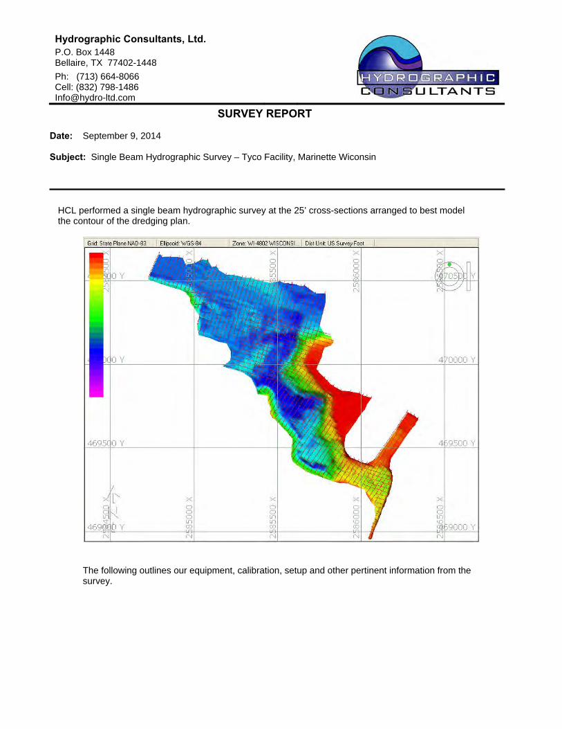
SURVEY REPORT Date: September 9, 2014 Subject: Single Beam Hydrographic Survey – Tyco Facility, Marinette Wiconsin
HCL performed a single beam hydrographic survey at the 25’ cross-sections arranged to best model the contour of the dredging plan.
The following outlines our equipment, calibration, setup and other pertinent information from the survey.

Hydrographic Consultants, Ltd. Tyco Report (2014)
9/10/2014
SURVEY REPORT: Tyco – 09/09/14
1) SURVEY CREW M. Becker K. Herwig D. Burger
2) EQUIPMENT
Single Beam Survey Boat - “Pontoon” RTK – Trimble R8 Rover Echo Sounder - Odom CV100: 200 KHz narrow beam (3 degree) transducer Data Acquisition/Processing - Hypack Software Tide - Tide Staff provided by Sevenson located on Tyco Bulkhead. “Top of Gauge Elevation: 581’
3) BOAT SETUP
Single Beam Position Service - Trimble R8 Rover (RTK Tide Corrections) Depth - Odom CVM Software – Hypack Antenna Ht: -9.75’ (Determined by RTK water elevation)
Antenna was on pipe directly over transducer and located near the bow of the boat. Transducer mount was checked with level to ensure that RTK antenna and transducer were plumb. Hypack tide reading was compared to tide staff. Antenna height was adjusted to make the two tide readings match.
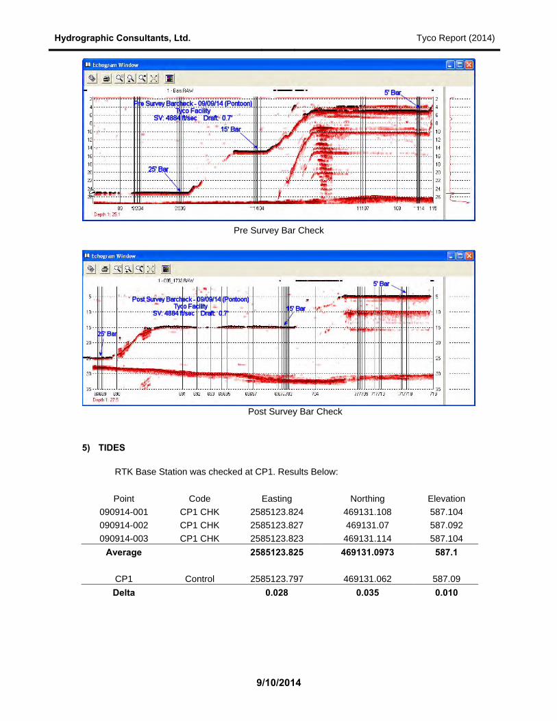
4) ECHO SOUNDER CALIBRATIONS Single Beam (Surveyza) 09/09/14
Draft: 0.7’ Sound Velocity: 4884 ft/sec Pre and Post Survey Bar Checks were performed on 09/09/14 – below are results.
Hydrographic Consultants, Ltd. Tyco Report (2014)
9/10/2014
Pre Survey Bar Check
Post Survey Bar Check
5) TIDES
RTK Base Station was checked at CP1. Results Below: Point Code Easting Northing Elevation
090914-001 CP1 CHK 2585123.824 469131.108 587.104 090914-002 CP1 CHK 2585123.827 469131.07 587.092 090914-003 CP1 CHK 2585123.823 469131.114 587.104
Average 2585123.825 469131.0973 587.1
CP1 Control 2585123.797 469131.062 587.09 Delta 0.028 0.035 0.010

Hydrographic Consultants, Ltd. Tyco Report (2014)
9/10/2014
Tide Staff provided by Sevenson. Top of staff Elevation (RTK): 581’ NAVD88
Tide Measured at staff on 09/09/14 Time Tide 8:00 581 - 1.3 = 579.7’ 17:40 581 - 1.3 = 579.7’

Hydrographic Consultants, Ltd.
P.O. Box 1448 Bellaire, TX 77402-1448
Ph: (713) 664-8066 Cell: (832) 798-1486 [email protected]
SURVEY REPORT Date: September 12, 2014 Subject: Single Beam Hydrographic Survey – Tyco Facility, Marinette Wisconsin
HCL performed a single beam hydrographic survey at the 25’ cross-sections arranged to best model the contour of the dredging plan.
The following outlines our equipment, calibration, setup and other pertinent information from the survey.

Hydrographic Consultants, Ltd. Tyco Report (2014)
9/12/2014
SURVEY REPORT: Tyco – 09/11/14
1) SURVEY CREW M. Becker D. Burger
2) EQUIPMENT
Single Beam Survey Boat - “Pontoon” RTK – Trimble R8 Rover Echo Sounder - Odom CV100: 200 KHz narrow beam (3 degree) transducer Data Acquisition/Processing - Hypack Software Tide - Tide Staff provided by Sevenson located on Tyco Bulkhead. “Top of Gauge Elevation: 581’
3) BOAT SETUP
Single Beam Position Service - Trimble R8 Rover (RTK Tide Corrections) Depth - Odom CVM Software – Hypack Antenna Ht: -9.75’ (Determined by RTK water elevation)
Antenna was on pipe directly over transducer and located near the bow of the boat. Transducer mount was checked with level to ensure that RTK antenna and transducer were plumb. Hypack tide reading was compared to tide staff. Antenna height was adjusted to make the two tide readings match.
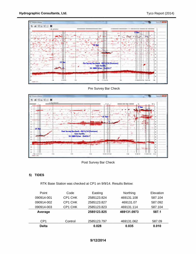
4) ECHO SOUNDER CALIBRATIONS Single Beam (Pontoon) 09/11/14
Draft: 0.7’ Sound Velocity: 4884 ft/sec Pre and Post Survey Bar Checks were performed on 09/11/14 – below are results.
Hydrographic Consultants, Ltd. Tyco Report (2014)
9/12/2014
Pre Survey Bar Check
Post Survey Bar Check
5) TIDES
RTK Base Station was checked at CP1 on 9/9/14. Results Below: Point Code Easting Northing Elevation
090914-001 CP1 CHK 2585123.824 469131.108 587.104 090914-002 CP1 CHK 2585123.827 469131.07 587.092 090914-003 CP1 CHK 2585123.823 469131.114 587.104
Average 2585123.825 469131.0973 587.1
CP1 Control 2585123.797 469131.062 587.09 Delta 0.028 0.035 0.010

Hydrographic Consultants, Ltd. Tyco Report (2014)
9/12/2014
Tide Staff provided by Sevenson. Top of staff Elevation (RTK): 581’ NAVD88
Tide Measured at staff on 09/11/14 Time Tide 8:10 581 - 1.05 = 579.95’ 12:01 581 - 1.5 = 579.5’


Hydrographic Consultants, Ltd.
P.O. Box 1448 Bellaire, TX 77402-1448
Ph: (713) 664-8066 Cell: (832) 798-1486 [email protected]
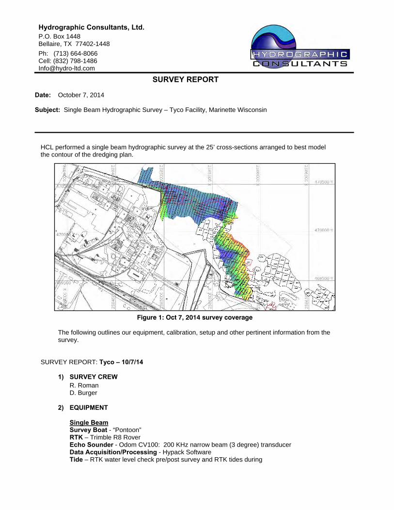
SURVEY REPORT Date: October 7, 2014 Subject: Single Beam Hydrographic Survey – Tyco Facility, Marinette Wisconsin
HCL performed a single beam hydrographic survey at the 25’ cross-sections arranged to best model the contour of the dredging plan.
The following outlines our equipment, calibration, setup and other pertinent information from the survey.
SURVEY REPORT: Tyco – 10/7/14
1) SURVEY CREW R. Roman D. Burger
2) EQUIPMENT
Single Beam Survey Boat - “Pontoon” RTK – Trimble R8 Rover Echo Sounder - Odom CV100: 200 KHz narrow beam (3 degree) transducer Data Acquisition/Processing - Hypack Software Tide – RTK water level check pre/post survey and RTK tides during
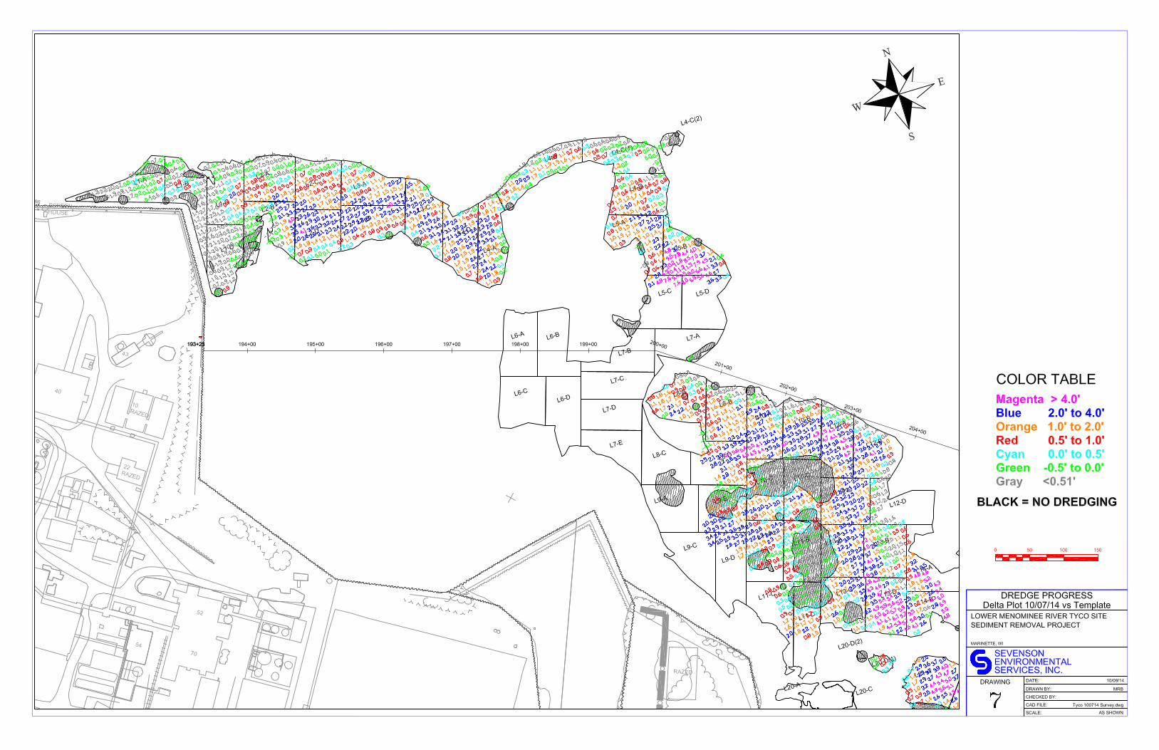
Figure 1: Oct 7, 2014 survey coverage
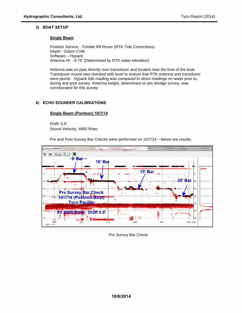
Hydrographic Consultants, Ltd. Tyco Report (2014)
10/8/2014
3) BOAT SETUP Single Beam Position Service - Trimble R8 Rover (RTK Tide Corrections) Depth - Odom CVM Software – Hypack Antenna Ht: -9.75’ (Determined by RTK water elevation)
Antenna was on pipe directly over transducer and located near the bow of the boat. Transducer mount was checked with level to ensure that RTK antenna and transducer were plumb. Hypack tide reading was compared to direct readings on water prior to, during and post survey. Antenna height, determined on pre dredge survey, was corroborated for this survey
4) ECHO SOUNDER CALIBRATIONS Single Beam (Pontoon) 10/7/14
Draft: 0.8’ Sound Velocity: 4800 ft/sec Pre and Post Survey Bar Checks were performed on 10/7/14 – below are results.
Pre Survey Bar Check

Hydrographic Consultants, Ltd. Tyco Report (2014)
10/8/2014
Post Survey Bar Check
5) TIDES
RTK Base Station was checked at CP1 on 10/7/14. Results Below:
Point Code Easting Northing Elevation
100714‐1 chk 2,585,123.81 469,131.13 587.07
100714‐02 chk 2,585,123.80 469,131.12 587.10
Average 2,585,123.81 469,131.12 587.08
CP1 Control 2,585,123.80 469,131.06 587.09
Delta 0.01 0.06 ‐0.01
TIDE CHECK via RTK
Point Code Easting Northing Elevation
100714‐1 chk 2,585,123.81 469,131.13 587.07
100714‐02 chk 2,585,123.80 469,131.12 587.10
Average 2,585,123.81 469,131.12 587.08
CP1 Control 2,585,123.80 469,131.06 587.09
Delta 0.01 0.06 ‐0.01
Point Code TIDE
100714‐04 tide 0910 579.6
100714‐07 tide 1411 579.4
100714‐10 tide 1626 579.6


Hydrographic Consultants, Ltd.
P.O. Box 1448 Bellaire, TX 77402-1448
Ph: (713) 664-8066 Cell: (832) 798-1486 [email protected]
SURVEY REPORT Date: April 28, 2015 Subject: Single Beam Pre Fill Hydrographic Survey – Tyco Facility, Marinette Wisconsin
HCL performed a single beam hydrographic survey at the 25’ cross-sections arranged to best model the contour of the fill area (CYAN HATCHED).
The following outlines our equipment, calibration, setup and other pertinent information from the survey.
SURVEY REPORT: Tyco – 4/28/15
1) SURVEY CREW R. Roman SES -Employee
2) EQUIPMENT
Single Beam Survey Boat - “Pontoon” RTK – BASE SPS 855, BOAT – SPS 461 w/PPS box for timing Echo Sounder - Odom CV100: 200 KHz narrow beam (3 degree) transducer Data Acquisition/Processing - Hypack Software Tide – RTK water level check pre/post survey and RTK tides during
Figure 1: April 28, 2015 survey coverage

Hydrographic Consultants, Ltd. Tyco Report – PRE FILL (04/28/15)
6/5/2015
3) BOAT SETUP Single Beam Position Service - Trimble R8 Rover (RTK Tide Corrections) Depth - Odom CVM Software – Hypack Antenna Ht: -9.90’ (Determined by RTK water elevation)
Antenna was on pipe directly over transducer and located near the bow of the boat. Transducer mount was checked with level to ensure that RTK antenna and transducer were plumb. Hypack tide reading was compared to direct readings on water prior to, during and post survey.
4) ECHO SOUNDER CALIBRATIONS Single Beam (Pontoon) 4/28/15
Draft: 0.9’ Sound Velocity: 4720 ft/sec
Pre Survey Bar check was performed on 2 different sets due to wind See below:

Hydrographic Consultants, Ltd. Tyco Report – PRE FILL (04/28/15)
6/5/2015
ECHO SOUNDER CALIBRATIONS (CONT’d) Post Survey Bar Check – closed with a maximum difference of 0.2’ This delta is in compliance with USACE standards for accuracy. See USACE document EM 1110-2-1003 “Hydrographic Surveying” Table 9-6. Due to agreement with the 5’ bar. Draft is considered to be static. Any changes in agreement with the 20’, 15’ and 10’ bar are due to changes in the speed of sound velocity during the time of survey. Post Survey Bar check shown below:
5) TIDES
RTK Base Station was checked at CP1 on 4/28/15. Results Below:
Point Code Easting Northing Elevation
042815‐1 chk 2,585,123.90 469,131.21 587.09
042815‐2 chk 2,585,123.90 469,131.21 587.10
042815‐3 chk 2,585,123.97 469,131.16 587.12
042815‐4 chk 2,585,123.93 469,131.18 587.10
Average 2,585,123.92 469,131.19 587.10
CP1 Control 2,585,123.80 469,131.06 587.09
Delta 0.13 0.13 0.01
TIDE CHECK via RTK
Point Code TIDE
042815‐6 tide 09:00 579.7
042815‐8 tide 10:50 579.6
042815‐10 tide 18:04 579.9

Remedial Action Completion Report Environmental Quality Management, Inc. Great Lakes Legacy Act Lower Menominee River Tyco Site
December 14, 2015
APPENDIX F
DEBRIS CALCULATIONS

Final YTD Debris Daily Weights
Date Total Loads Date Total Loads10/27/2014 180.96 8 11/4/2014 78.71 510/30/2014 25.03 1 11/7/2014 169.1 1410/31/2014 79.77 4 11/12/2014 32.95 6
285.76 13 280.76 25
YTD Total Tons YTD Total Loads566.52 38

Remedial Action Completion Report Environmental Quality Management, Inc. Great Lakes Legacy Act Lower Menominee River Tyco Site
December 14, 2015
APPENDIX G
INVASIVE SPECIES CONTROL PROJECT REPORT
NOTE: THE FINAL INVASIVE SPECIES REPORT WILL BE INCLUDED WITH THE
FINAL RACR DOCUMENT AFTER THE DRAFT INVASICE SPECIES REPORT HAS
BEEN FINALIZED PER EPA COMMENTS

Remedial Action Completion Report Environmental Quality Management, Inc. Great Lakes Legacy Act Lower Menominee River Tyco Site
December 14, 2015
APPENDIX H
DAILY REPORTS

Remedial Action Completion Report Environmental Quality Management, Inc. Great Lakes Legacy Act Lower Menominee River Tyco Site
December 14, 2015
APPENDIX I
INSPECTIONS


Remedial Action Completion Report Environmental Quality Management, Inc. Great Lakes Legacy Act Lower Menominee River Tyco Site
December 14, 2015
APPENDIX J
PUNCHLIST
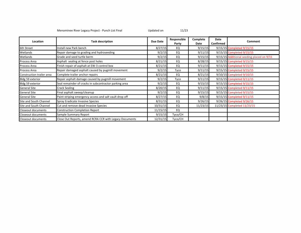
Menominee River Legacy Project - Punch List Final Updated on 11/23
Location Task description Due DateResponsible
PartyComplete
DateDate
ConfirmedComment
6th Street Install new Park bench 8/27/15 EQ 9/15/15 9/15/15 Completed 9/15/15Wetlands Repair damage to grading and hydroseeding 9/2/15 EQ 9/11/15 9/15/15 Completed 9/15/15Wetlands Grade and seed turtle berm 9/2/15 EQ 9/15/15 9/15/15 Additional seeding placed on 9/11Process Area Asphalt sealing at fence post holes 8/21/15 EQ 8/28/15 9/15/15 Completed 9/15/15Process Area Finish repair of asphalt at EW-3 control box 8/21/15 EQ 9/11/15 9/15/15 Completed 9/15/15Process Area Repair damaged asphalt caused by pugmill movement 9/2/15 Tyco 9/11/15 9/15/15 Completed 9/15/15Construction trailer area Complete trailer anchor repairs 8/21/15 EQ 8/21/15 9/10/15 Completed 9/10/15Bldg 59 exterior Repair asphalt damage caused by pugmill movement 9/2/15 Tyco 9/11/15 9/15/15 Completed 9/11/15Bldg 59 exterior Seal remainder of cracks in subcontractor parking area 9/2/15 EQ 9/15/15 9/15/15 Completed 9/15/15General Site Crack Sealing 8/20/15 EQ 9/11/15 9/15/15 Completed 9/11/15General Site Final asphalt sweep/cleanup 9/2/15 EQ 9/15/15 9/15/15 Completed 9/15/15General Site Paint striping emergency access and salt vault drop off 8/27/15 EQ 9/8/15 9/15/15 Completed 9/11/15Site and South Channel Spray Eradicate Invasive Species 8/31/15 EQ 9/26/15 9/26/15 Completed 9/26/15Site and South Channel Cut and remove dead Invasive Species 10/31/15 EQ 11/23/15 11/23/15 Completed 11/23/15Closeout documents Construction Completion Report 11/15/15 EQCloseout documents Sample Summary Report 9/15/15 Tyco/CHCloseout documents Close Out Reports, amend RCRA CCR with Legacy Documents 12/31/15 Tyco/CH