Embed Size (px)
Citation preview

Record of Decision 2
North I-25 | 120TH AVENUE TO SH 7 Appendix C
Appendix C. Noise Impact Assessment (HDR, 2015)


FINAL September 28, 2015

Noise Impact Assessment
FINAL September 28, 2015
North I-25 Record of Decision 2 TOC-i 120TH AVENUE TO SH 7
CONTENTS
Page No.
Introduction and Study Area ....................................................................................................... 2
Noise Basics and Applicable Guidelines .................................................................................... 2
Measurement Procedures and Model Validation ........................................................................ 3
Model Input Data ........................................................................................................................ 3
Impact Analysis .........................................................................................................................14
Mitigation Analysis and Evaluation ............................................................................................15
Mitigation Recommendation and Statement of Likelihood .........................................................29
References ...............................................................................................................................33
Appendices
Appendix A. Noise Abatement Determination Worksheets (CDOT Form 1209) Appendix B. Results of Benefited Receptor Surveys
Tables
Table 1. CDOT Noise Abatement Criteria ............................................................................. 2 Table 2. Traffic Noise Model Validation Results .................................................................... 3 Table 3. Noise Model Traffic Volumes (vehicles per hour)1 ................................................... 4 Table 4. I-25 Vehicle Mix and Directional Split ...................................................................... 5 Table 5. Noise Model Results—128th Avenue to SH 7 ........................................................16 Table 6. Noise Model Results—120th Avenue to 128th Avenue ..........................................18 Table 7. Barrier Evaluation Summary ...................................................................................22 Table 8. Barrier Evaluation for Thorncreek Village Development .........................................23 Table 9. Tanglewood North Noise Barrier Cost Evaluation Summary1 .................................26 Table 10. Barrier Evaluation for Tanglewood Multifamily Development ..................................26 Table 11. Barrier Evaluation for Tanglewood South Development .........................................30 Table 12. Barrier Evaluation for Bannock Barrier ...................................................................31 Table 13. Bannock Barrier Cost Evaluation Summary1 ..........................................................31
Figures
Figure 1. Noise Model Receptors ........................................................................................... 6 Figure 2. Noise Model Receptors ........................................................................................... 7 Figure 3. Noise Model Receptors ........................................................................................... 8 Figure 4. Noise Model Receptors ........................................................................................... 9 Figure 5. Noise Model Receptors ..........................................................................................10 Figure 6. Noise Model Receptors ..........................................................................................11 Figure 7. Trails in the North I-25 ROD2 Study Area ...............................................................12 Figure 8. I-25/Tanglewood Creek Trail (constructed 2013–2014) ..........................................13

Noise Impact Assessment
FINAL September 28, 2015
North I-25 Record of Decision 2 Page 2 120TH AVENUE TO SH 7
INTRODUCTION AND STUDY AREA The proposed project is located north of Denver, Colorado, on Interstate 25 (I-25) between 120th Avenue and SH 7. The project includes the addition of an Express Lane in each direction between the project limits and minor ramp modifications at 120th Avenue, 136th Avenue, and 144th Avenue to accommodate the Express Lane. This document updates the noise impact analyses that were prepared as part of the North I-25 Final Environmental Impact Statement (2011 FEIS) (CDOT, 2011) for a second Record of Decision (ROD2) in this segment of the I-25 corridor. This report updates existing land uses, traffic volumes, and noise abatement measures that were considered in the 2011 FEIS. This report also updates noise abatement evaluations considered in the 2011 FEIS using the most current version of the Colorado Department of Transportation’s (CDOT) Noise Analysis and Abatement Guidelines (CDOT, 2013). The format of this report follows Appendix B (Noise Technical Report Requirements) of the 2013 CDOT guidelines.
NOISE BASICS AND APPLICABLE GUIDELINES According to CDOT’s guidelines, a review of acoustic fundamentals and noise is required for noise technical reports. This information was provided previously in the 2011 FEIS and, for brevity, is not repeated in this report. The impact thresholds of concern for this analysis are the CDOT noise abatement criteria (NAC), which are shown in Table 1. Under CDOT guidelines, a noise level equaling or exceeding the NAC is considered a noise impact and triggers the requirement for consideration and evaluation of noise abatement measures. In addition, a “substantial” noise increase is defined by CDOT as an increase of 10 dBA or more over existing noise levels. Traffic volumes used in this evaluation have been updated since the 2011 FEIS (CDM-Smith, 2013). The baseline year in the updated traffic assessment was 2015 and that baseline year is used in this report to represent the “existing condition” even though it is in the future.
Table 1. CDOT Noise Abatement Criteria
Activity Category
Leq Noise Levels (dBA)
Description of Activity Category
A 56 (exterior) Lands on which serenity and quiet are of extraordinary significance and serve an important public need, and where the preservation of those qualities is essential if the area is to continue to serve its intended purpose.
B 66 (exterior) Residential.
C 66 (exterior)
Active sports areas, amphitheaters, auditoriums, campgrounds, cemeteries, day care centers, hospitals, libraries, medical facilities, parks, picnic areas, places of worship, playgrounds, public meeting rooms, public or nonprofit institutional structures, radio studios, recording studios, recreation areas, Section 4(f) sites, schools, television studios, trails and trail crossings.
D 51 (interior) Auditoriums, day care centers, hospitals, libraries, medical facilities, places of worship, public meeting room, public or nonprofit institutional structures, radio studios, recording studios, schools, and television studios.

Noise Impact Assessment
FINAL September 28, 2015
North I-25 Record of Decision 2 Page 3 120TH AVENUE TO SH 7
Table 1. CDOT Noise Abatement Criteria
Activity Category
Leq Noise Levels (dBA)
Description of Activity Category
E 71 (exterior) Hotels, motels, offices, restaurants/bars, and other undeveloped lands, properties, or activities not included in categories A–D or F.
F —
Agriculture, airports, bus yards, emergency services, industrial, logging, maintenance facilities, manufacturing, mining, rail yards, retail facilities, shipyards, utilities (water resources, water treatment, electrical), and warehousing.
G — Undeveloped lands that are not permitted. Source: CDOT Noise Analysis and Abatement Guidelines, February 8, 2013
MEASUREMENT PROCEDURES AND MODEL VALIDATION A Larson-Davis 820 Sound Level Meter was used to measure existing noise levels. Noise monitoring was conducted at two locations on April 10, 2014, to field-verify the traffic noise model. Traffic volumes were videotaped during each 10-minute measurement period, counted, classified (as cars, medium trucks, or heavy trucks), normalized to a 1-hour period, and used as input to the noise model. Model validation results are shown in Table 2.
Table 2. Traffic Noise Model Validation Results
Location Measured Leq (dBA) Modeled Leq (dBA) Difference (dBA)
Tanglewood Multifamily Development 72.0 73.4 1.4
Thorncreek Village Development 68.2 68.0 0.2
As discussed in CDOT’s guidelines, if the difference between the measured and modeled noise levels is less than 3 dBA (which is the case as noted in Table 2), then the traffic noise model is acceptable and demonstrates the validity of the model results.
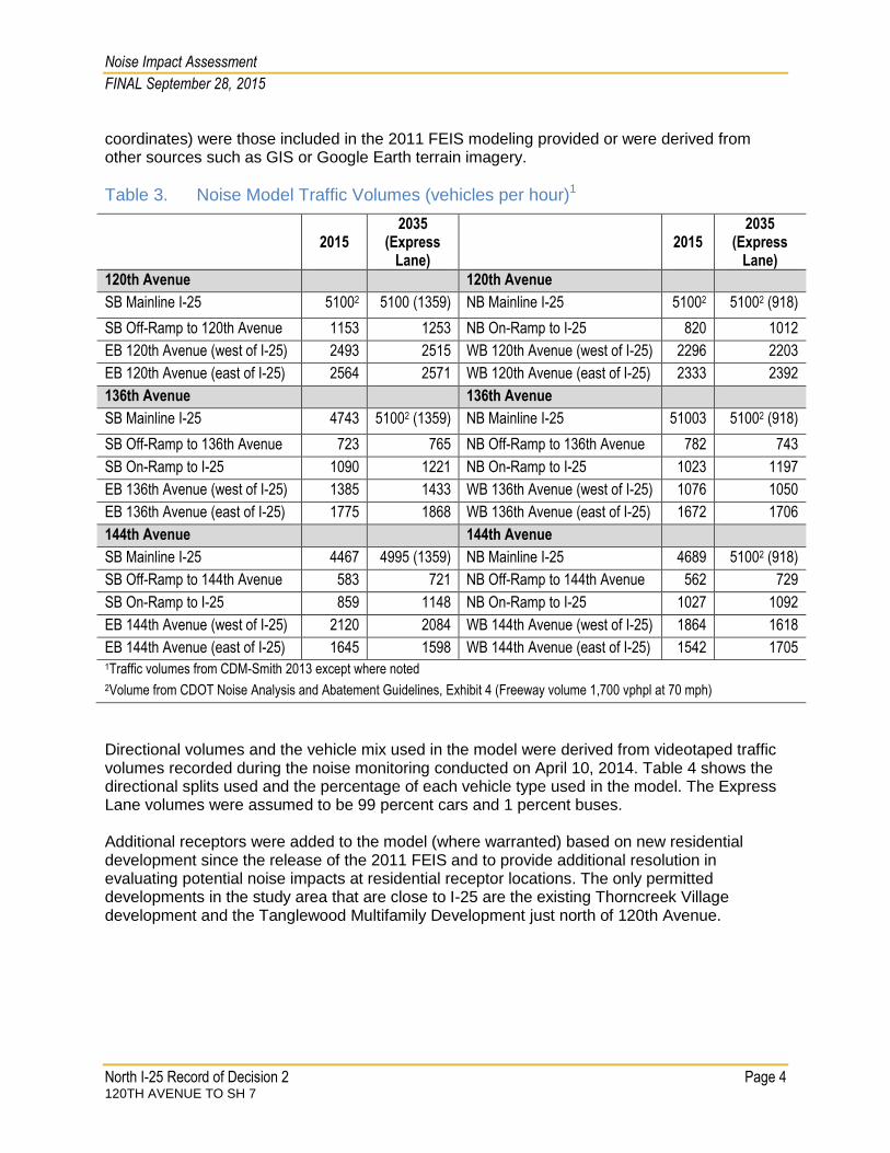
MODEL INPUT DATA Table 3 shows the hourly traffic volumes used in the noise modeling for 2015 and 2035. This technical memorandum uses 2035 volumes. A comparison was conducted to 2040 volumes and only minor differences were noted. The final design noise analysis will use 2040 volumes. For each roadway in the model, the highest hourly volume (AM or PM peak-hour) was used to represent a worst-case (that is, more conservative) modeling scenario. Where the traffic volumes provided by CDM-Smith were greater than the 5,100 vehicles per hour (1,700 vehicles per hour per lane in the 3 general purpose lanes), the recommended traffic volumes from Exhibit 4 of the CDOT noise guidelines were used to reflect free-flowing traffic volumes at posted speed limits when traffic noise levels would be loudest. The Express Lane was modeled as a separate road and the 2035 volumes ranged from 918 vph to 1359 vph as shown in Table 3. Interchange ramps and the major arterials at 120th Avenue, 136th Avenue, and 144th Avenue were also included in the model. Model coordinates (including receptor elevations and barrier
Noise Impact Assessment
FINAL September 28, 2015
North I-25 Record of Decision 2 Page 4 120TH AVENUE TO SH 7
coordinates) were those included in the 2011 FEIS modeling provided or were derived from other sources such as GIS or Google Earth terrain imagery.
Table 3. Noise Model Traffic Volumes (vehicles per hour)1
2015
2035 (Express
Lane)
2015 2035
(Express Lane)
120th Avenue 120th Avenue
SB Mainline I-25 51002 5100 (1359) NB Mainline I-25 51002 51002 (918)
SB Off-Ramp to 120th Avenue 1153 1253 NB On-Ramp to I-25 820 1012
EB 120th Avenue (west of I-25) 2493 2515 WB 120th Avenue (west of I-25) 2296 2203
EB 120th Avenue (east of I-25) 2564 2571 WB 120th Avenue (east of I-25) 2333 2392
136th Avenue 136th Avenue
SB Mainline I-25 4743 51002 (1359) NB Mainline I-25 51003 51002 (918)
SB Off-Ramp to 136th Avenue 723 765 NB Off-Ramp to 136th Avenue 782 743
SB On-Ramp to I-25 1090 1221 NB On-Ramp to I-25 1023 1197
EB 136th Avenue (west of I-25) 1385 1433 WB 136th Avenue (west of I-25) 1076 1050
EB 136th Avenue (east of I-25) 1775 1868 WB 136th Avenue (east of I-25) 1672 1706
144th Avenue 144th Avenue
SB Mainline I-25 4467 4995 (1359) NB Mainline I-25 4689 51002 (918)
SB Off-Ramp to 144th Avenue 583 721 NB Off-Ramp to 144th Avenue 562 729
SB On-Ramp to I-25 859 1148 NB On-Ramp to I-25 1027 1092
EB 144th Avenue (west of I-25) 2120 2084 WB 144th Avenue (west of I-25) 1864 1618
EB 144th Avenue (east of I-25) 1645 1598 WB 144th Avenue (east of I-25) 1542 1705 1Traffic volumes from CDM-Smith 2013 except where noted
2Volume from CDOT Noise Analysis and Abatement Guidelines, Exhibit 4 (Freeway volume 1,700 vphpl at 70 mph)
Directional volumes and the vehicle mix used in the model were derived from videotaped traffic volumes recorded during the noise monitoring conducted on April 10, 2014. Table 4 shows the directional splits used and the percentage of each vehicle type used in the model. The Express Lane volumes were assumed to be 99 percent cars and 1 percent buses. Additional receptors were added to the model (where warranted) based on new residential development since the release of the 2011 FEIS and to provide additional resolution in evaluating potential noise impacts at residential receptor locations. The only permitted developments in the study area that are close to I-25 are the existing Thorncreek Village development and the Tanglewood Multifamily Development just north of 120th Avenue.
Noise Impact Assessment
FINAL September 28, 2015
North I-25 Record of Decision 2 Page 5 120TH AVENUE TO SH 7
Table 4. I-25 Vehicle Mix and Directional Split
Vehicle Type Northbound (%) Southbound (%)
120th Avenue to 136th Avenue
Cars 89 91
Medium Trucks 5 3
Heavy Trucks 6 6
136th Avenue to 144th Avenue
Cars 85 89
Medium Trucks 6 4
Heavy Trucks 9 7
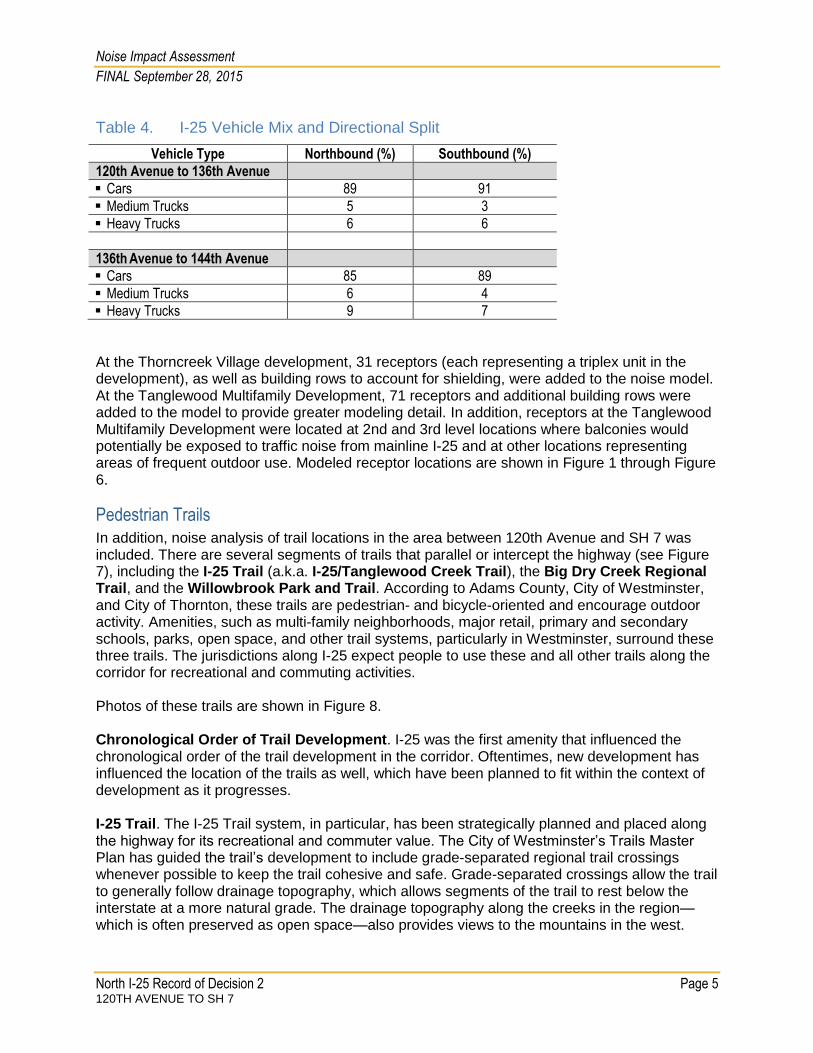
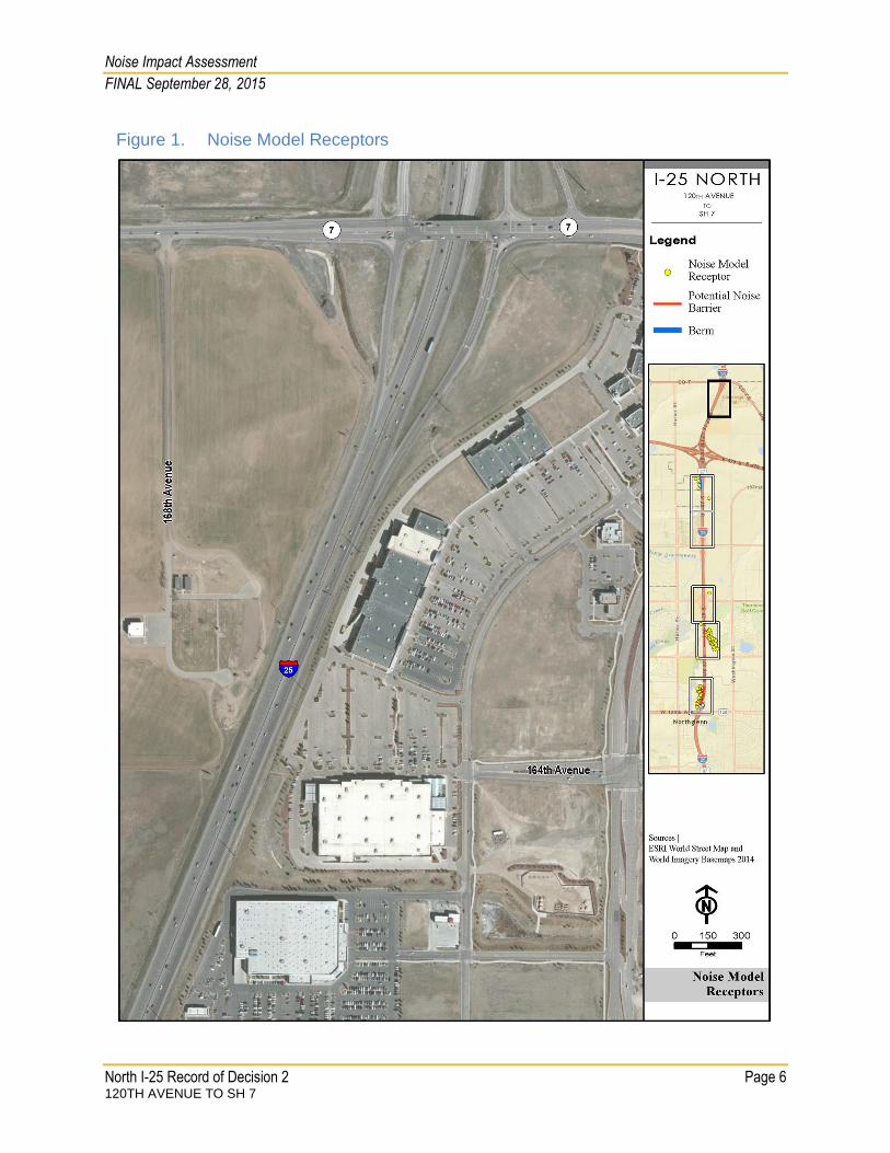
At the Thorncreek Village development, 31 receptors (each representing a triplex unit in the development), as well as building rows to account for shielding, were added to the noise model. At the Tanglewood Multifamily Development, 71 receptors and additional building rows were added to the model to provide greater modeling detail. In addition, receptors at the Tanglewood Multifamily Development were located at 2nd and 3rd level locations where balconies would potentially be exposed to traffic noise from mainline I-25 and at other locations representing areas of frequent outdoor use. Modeled receptor locations are shown in Figure 1 through Figure 6.
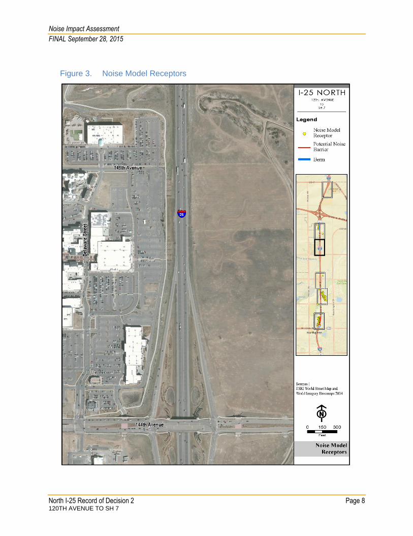
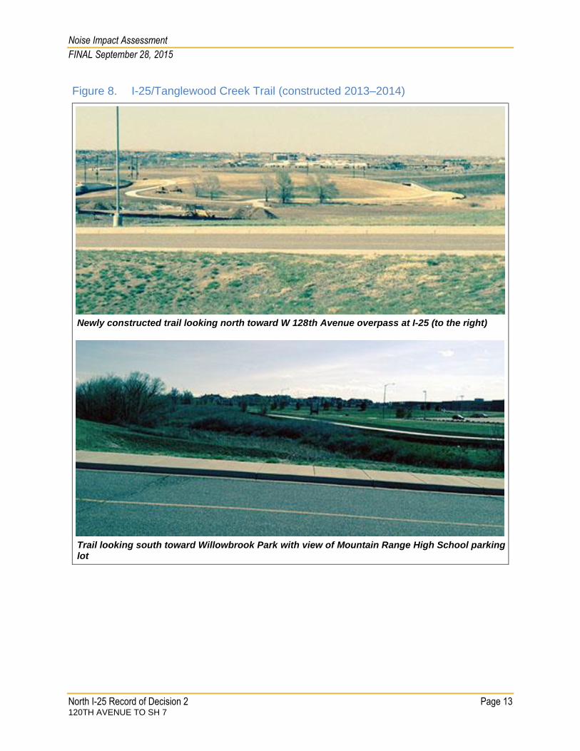
Pedestrian Trails In addition, noise analysis of trail locations in the area between 120th Avenue and SH 7 was included. There are several segments of trails that parallel or intercept the highway (see Figure 7), including the I-25 Trail (a.k.a. I-25/Tanglewood Creek Trail), the Big Dry Creek Regional Trail, and the Willowbrook Park and Trail. According to Adams County, City of Westminster, and City of Thornton, these trails are pedestrian- and bicycle-oriented and encourage outdoor activity. Amenities, such as multi-family neighborhoods, major retail, primary and secondary schools, parks, open space, and other trail systems, particularly in Westminster, surround these three trails. The jurisdictions along I-25 expect people to use these and all other trails along the corridor for recreational and commuting activities. Photos of these trails are shown in Figure 8. Chronological Order of Trail Development. I-25 was the first amenity that influenced the chronological order of the trail development in the corridor. Oftentimes, new development has influenced the location of the trails as well, which have been planned to fit within the context of development as it progresses. I-25 Trail. The I-25 Trail system, in particular, has been strategically planned and placed along the highway for its recreational and commuter value. The City of Westminster’s Trails Master Plan has guided the trail’s development to include grade-separated regional trail crossings whenever possible to keep the trail cohesive and safe. Grade-separated crossings allow the trail to generally follow drainage topography, which allows segments of the trail to rest below the interstate at a more natural grade. The drainage topography along the creeks in the region—which is often preserved as open space—also provides views to the mountains in the west.
Noise Impact Assessment
FINAL September 28, 2015
North I-25 Record of Decision 2 Page 6 120TH AVENUE TO SH 7
Figure 1. Noise Model Receptors

Noise Impact Assessment
FINAL September 28, 2015
North I-25 Record of Decision 2 Page 7 120TH AVENUE TO SH 7
Figure 2. Noise Model Receptors
Noise Impact Assessment
FINAL September 28, 2015
North I-25 Record of Decision 2 Page 8 120TH AVENUE TO SH 7
Figure 3. Noise Model Receptors

Noise Impact Assessment
FINAL September 28, 2015
North I-25 Record of Decision 2 Page 9 120TH AVENUE TO SH 7
Figure 4. Noise Model Receptors

Noise Impact Assessment
FINAL September 28, 2015
North I-25 Record of Decision 2 Page 10 120TH AVENUE TO SH 7
Figure 5. Noise Model Receptors

Noise Impact Assessment
FINAL September 28, 2015
North I-25 Record of Decision 2 Page 11 120TH AVENUE TO SH 7
Figure 6. Noise Model Receptors
Noise Impact Assessment
FINAL September 28, 2015
North I-25 Record of Decision 2 Page 12 120TH AVENUE TO SH 7
Figure 7. Trails in the North I-25 ROD2 Study Area
Noise Impact Assessment
FINAL September 28, 2015
North I-25 Record of Decision 2 Page 13 120TH AVENUE TO SH 7
Figure 8. I-25/Tanglewood Creek Trail (constructed 2013–2014)
Newly constructed trail looking north toward W 128th Avenue overpass at I-25 (to the right)
Trail looking south toward Willowbrook Park with view of Mountain Range High School parking lot

Noise Impact Assessment
FINAL September 28, 2015
North I-25 Record of Decision 2 Page 14 120TH AVENUE TO SH 7
The City of Westminster has already connected the I-25 Trail to Huron Street at several locations. Future plans will connect it to the Quail Creek Trail and Big Dry Creek Trail system west and east of I-25. A grade separation currently exists for these trails under I-25, south of 136th Avenue, to provide future connections to the Regional Big Dry Creek Trail System east of I-25. The Regional Big Dry Creek Trail System will traverse the City of Thornton and Adams County, in addition to the City of Westminster. The volume of use on Westminster’s I-25 Trail is anticipated to be high. Data was collected in September 2012 by a trail usage counter along Westminster’s existing segment of the Big Dry Creek Regional Trail, and the City of Westminster expects daily use of the I-25 Trail to exceed 500 trips/day. Big Dry Creek Trail System. The City of Thornton reports that some of the Big Dry Creek Trail facilities (e.g. pedestrian and bicycle underpasses) were installed near I-25 ahead of the trail connections themselves, on both sides of I-25, when the 136th Avenue and 144th Avenue interchanges were constructed. These grade separations were installed for non-recreational and recreational uses. The City of Thornton reports that the volume of use on trails in general is difficult to obtain is and seldom recorded. Most trail and sidewalk use (in general) is seasonal with very little use in the winter. As days get warmer, more activity takes place. The trail uses are more recreational than destination-driven. Two locations for the noise analysis were chosen along the trail system. These locations which are illustrated in Figure 7 as yellow dots, were selected because of the following factors:
Volume of recreational and/or commuting users.
Connection to activities along the trail.
Scenic view or other geographic feature provided to the trail user in that section of trail.
The northernmost noise receptor is at the confluence of Westminster’s existing Quail Creek, Big Dry Creek and the future connection of the I-25 Trail. This location meets all of the criteria above and connects to many activities on each side of the interstate. The southernmost noise receptor is at West 128th Avenue. This location is close to Mountain Range High School (with its many activities) and offers scenic views along the I-25/Tanglewood Creek Trail.
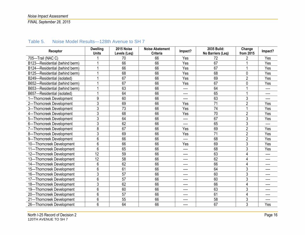
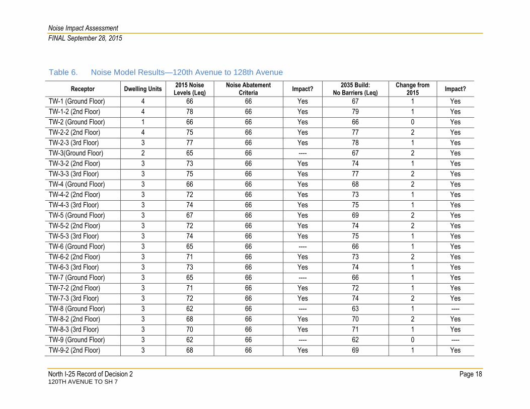
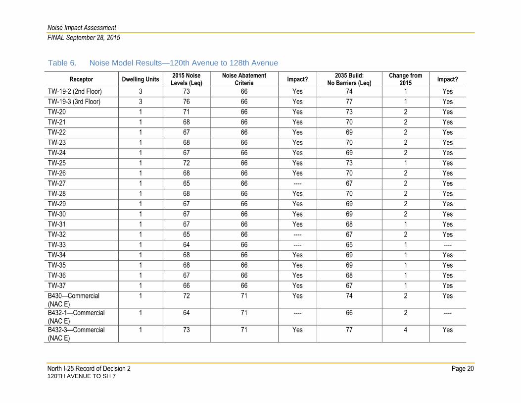
IMPACT ANALYSIS Table 5 and Table 6 show the noise model results and noise impacts at receptors between 120th Avenue and SH 7 with the updated existing 2015 conditions, and in 2035 following completion of the project (but without consideration of noise abatement measures). Table 5 includes receptors at the Thorncreek Village residential development and others that are north of 128th Avenue (see Figure 1 through Figure 5). Table 6 includes receptors from the southern project limit at 120th Avenue to 128th Avenue including the Tanglewood Multifamily Development (see Figure 6). As shown in Table 5, modeled noise levels in 2035 range from about 58 dBA to 80 dBA depending on the proximity of the receptor to I-25 (and other roads), as well as terrain effects. In general, modeled noise at receptors increase by about 2 dBA to 4 dBA at most receptors because of increased traffic volumes in 2035 and the addition of the Express Lane, which

Noise Impact Assessment
FINAL September 28, 2015
North I-25 Record of Decision 2 Page 15 120TH AVENUE TO SH 7
moves the general purpose lanes closer to residential receptors. Table 5 also shows those receptors exceeding the residential or commercial NAC (66 dBA for NAC B and 71 dBA for NAC E, as appropriate based on the activity category). Table 6 shows modeled noise levels at receptors in the vicinity of the Tanglewood Multifamily Development north of 120th Avenue. As shown in Table 6, model noise levels in the vicinity of 120th Avenue range from about 61 dBA to 79 dBA and increase by about 1 dBA to 4 dBA depending on the receptor location relative to I-25. There are no substantial noise increases (that is, a 10 dBA or greater increase over existing baseline noise levels) due to the project.
MITIGATION ANALYSIS AND EVALUATION All impacted receptors identified in the impact analysis between 120th Avenue to E 470/ Northwest Parkway were considered for noise abatement. All abatement measures recommended for final design were analyzed for feasibility and reasonableness by addressing constructability, acoustic feasibility, CDOT design goals and cost-effectiveness, respectively. All abatement measures meeting these criteria will be re-evaluated at final design (prior to construction). CDOT defines the noise-reduction goal as the insertion loss that is predicted to result from a barrier that results in a 7 dBA noise reduction for at least one benefited receptor. A benefited receptor (whether it exceeds the residential NAC or not) is one that receives at least 5 dBA of noise reduction. This section focuses on consideration of noise barriers in those residential locations where the residential density is such that noise barriers could meet both the technical criteria and cost requirements as specified in the CDOT guidelines. Other noise abatement options, such as traffic management measures and horizontal or vertical alignment adjustments, were described in the 2011 FEIS and were determined to be impractical. Those measures are not repeated in this report. Each barrier was evaluated to determine the barrier height (if any) that met CDOT’s design goal of a 7 dBA insertion loss for at least one receptor. After the appropriate barrier height was determined, the acoustic benefit from the barrier was calculated and compared to the overall cost of the wall to determine the cost-benefit index (that is, whether the cost per receptor was less than CDOT’s threshold of $6,800 per benefitting receptor). The overall feasibility and reasonableness of each barrier determined whether the barrier was recommended for the project. When these conditions are met, an abatement action can be recommended. As noted above, final decisions on barrier size, placement, feasibility, reasonableness, and materials will be made during final design. As noted above, two residential locations were evaluated for consideration of noise barriers: the Thorncreek Village development (see Figure 5) and the Tanglewood Multifamily Development (see Figure 6).
Noise Impact Assessment
FINAL September 28, 2015
North I-25 Record of Decision 2 Page 16 120TH AVENUE TO SH 7
Table 5. Noise Model Results—128th Avenue to SH 7
Receptor Dwelling
Units 2015 Noise
Levels (Leq) Noise Abatement
Criteria Impact?
2035 Build: No Barriers (Leq)
Change from 2015
Impact?
705—Trail (NAC C) 1 70 66 Yes 72 2 Yes
B123—Residential (behind berm) 1 66 66 Yes 67 1 Yes
B124—Residential (behind berm) 1 66 66 Yes 67 1 Yes
B125—Residential (behind berm) 1 68 66 Yes 68 0 Yes
B249—Residential (isolated) 1 67 66 Yes 69 2 Yes
B652—Residential (behind berm) 1 67 66 Yes 67 0 Yes
B653—Residential (behind berm) 1 63 66 ---- 64 1 ----
B657—Residential (isolated) 1 64 66 ---- 65 1 ----
1—Thorncreek Development 9 60 66 ---- 63 3 ----
2—Thorncreek Development 3 69 66 Yes 71 2 Yes
3—Thorncreek Development 3 73 66 Yes 74 1 Yes
4—Thorncreek Development 3 68 66 Yes 70 2 Yes
5—Thorncreek Development 3 64 66 ---- 67 3 Yes
6—Thorncreek Development 3 62 66 ---- 65 3 ----
7—Thorncreek Development 8 67 66 Yes 69 2 Yes
8—Thorncreek Development 3 69 66 Yes 71 2 Yes
9—Thorncreek Development 6 66 66 ---- 68 2 Yes
10—Thorncreek Development 6 66 66 Yes 69 3 Yes
11—Thorncreek Development 6 65 66 ---- 68 3 Yes
12—Thorncreek Development 12 59 66 ---- 63 4 ----
13—Thorncreek Development 12 58 66 ---- 62 4 ----
14—Thorncreek Development 6 62 66 ---- 66 4 ----
15—Thorncreek Development 6 61 66 ---- 64 3 ----
16—Thorncreek Development 3 57 66 ---- 60 3 ----
17—Thorncreek Development 6 57 66 ---- 60 3 ----
18—Thorncreek Development 3 62 66 ---- 66 4 ----
19—Thorncreek Development 6 60 66 ---- 63 3 ----
20—Thorncreek Development 6 57 66 ---- 61 4 ----
21—Thorncreek Development 6 55 66 ---- 58 3 ----
26—Thorncreek Development 6 64 66 ---- 67 3 Yes

Noise Impact Assessment
FINAL September 28, 2015
North I-25 Record of Decision 2 Page 17 120TH AVENUE TO SH 7
Table 5. Noise Model Results—128th Avenue to SH 7
Receptor Dwelling
Units 2015 Noise
Levels (Leq) Noise Abatement
Criteria Impact?
2035 Build: No Barriers (Leq)
Change from 2015
Impact?
27—Thorncreek Development 6 61 66 ---- 65 4 ----
28—Thorncreek Development 6 60 66 ---- 64 4 ----
29—Thorncreek Development 6 60 66 ---- 62 2 ----
30—Thorncreek Development 6 59 66 ---- 61 2 ----
31—Thorncreek Development 3 58 66 ---- 60 2 ----
32—Thorncreek Development 6 58 66 ---- 59 1 ----
35—Thorncreek Development 6 58 66 ---- 60 2 ----
36—Thorncreek Development 6 58 66 ---- 58 0 ----
38—Thorncreek Development 3 57 66 ---- 58 1 ----
Trail Receptor 1 1 62 66 ---- 63 1 ----
Trail Receptor 2 1 70 66 Yes 72 2 Yes
Noise Impact Assessment
FINAL September 28, 2015
North I-25 Record of Decision 2 Page 18 120TH AVENUE TO SH 7
Table 6. Noise Model Results—120th Avenue to 128th Avenue
Receptor Dwelling Units 2015 Noise
Levels (Leq) Noise Abatement
Criteria Impact?
2035 Build: No Barriers (Leq)
Change from 2015
Impact?
TW-1 (Ground Floor) 4 66 66 Yes 67 1 Yes
TW-1-2 (2nd Floor) 4 78 66 Yes 79 1 Yes
TW-2 (Ground Floor) 1 66 66 Yes 66 0 Yes
TW-2-2 (2nd Floor) 4 75 66 Yes 77 2 Yes
TW-2-3 (3rd Floor) 3 77 66 Yes 78 1 Yes
TW-3(Ground Floor) 2 65 66 ---- 67 2 Yes
TW-3-2 (2nd Floor) 3 73 66 Yes 74 1 Yes
TW-3-3 (3rd Floor) 3 75 66 Yes 77 2 Yes
TW-4 (Ground Floor) 3 66 66 Yes 68 2 Yes
TW-4-2 (2nd Floor) 3 72 66 Yes 73 1 Yes
TW-4-3 (3rd Floor) 3 74 66 Yes 75 1 Yes
TW-5 (Ground Floor) 3 67 66 Yes 69 2 Yes
TW-5-2 (2nd Floor) 3 72 66 Yes 74 2 Yes
TW-5-3 (3rd Floor) 3 74 66 Yes 75 1 Yes
TW-6 (Ground Floor) 3 65 66 ---- 66 1 Yes
TW-6-2 (2nd Floor) 3 71 66 Yes 73 2 Yes
TW-6-3 (3rd Floor) 3 73 66 Yes 74 1 Yes
TW-7 (Ground Floor) 3 65 66 ---- 66 1 Yes
TW-7-2 (2nd Floor) 3 71 66 Yes 72 1 Yes
TW-7-3 (3rd Floor) 3 72 66 Yes 74 2 Yes
TW-8 (Ground Floor) 3 62 66 ---- 63 1 ----
TW-8-2 (2nd Floor) 3 68 66 Yes 70 2 Yes
TW-8-3 (3rd Floor) 3 70 66 Yes 71 1 Yes
TW-9 (Ground Floor) 3 62 66 ---- 62 0 ----
TW-9-2 (2nd Floor) 3 68 66 Yes 69 1 Yes

Noise Impact Assessment
FINAL September 28, 2015
North I-25 Record of Decision 2 Page 19 120TH AVENUE TO SH 7
Table 6. Noise Model Results—120th Avenue to 128th Avenue
Receptor Dwelling Units 2015 Noise
Levels (Leq) Noise Abatement
Criteria Impact?
2035 Build: No Barriers (Leq)
Change from 2015
Impact?
TW-9-3 (3rd Floor) 3 69 66 Yes 70 1 Yes
TW-10 (Ground Floor) 3 64 66 Yes 66 2 Yes
TW-10-2 (2nd Floor) 4 75 66 Yes 76 1 Yes
TW-11 (Ground Floor) 4 63 66 ---- 65 2 ----
TW-11-2 (2nd Floor) 3 71 66 Yes 73 2 Yes
TW-11-3 (3rd Floor) 3 76 66 Yes 78 2 Yes
TW-12 (Ground Floor) 3 63 66 ---- 64 1 ----
TW-12-2 (2nd Floor) 3 69 66 Yes 71 2 Yes
TW-12-3 (3rd Floor) 3 75 66 Yes 76 1 Yes
TW-13(Ground Floor) 3 61 66 ---- 62 1 ----
TW-13-2 (2nd Floor) 3 66 66 Yes 67 1 Yes
TW-13-3 (3rd Floor) 3 71 66 Yes 72 1 Yes
TW-14 (Ground Floor) 3 60 66 ---- 61 1 ----
TW-14-2 (2nd Floor) 3 65 66 ---- 66 1 Yes
TW-14-3 (3rd Floor) 3 69 66 Yes 71 2 Yes
TW-15(Ground Floor) 3 61 66 ---- 62 1 ----
TW-15-2 (2nd Floor) 3 66 66 Yes 67 1 Yes
TW-15-3 (3rd Floor) 3 72 66 Yes 73 1 Yes
TW-16 (Ground Floor) 3 62 66 ---- 63 1 ----
TW-16-2 (2nd Floor) 3 69 66 Yes 71 2 Yes
TW-16-3 (3rd Floor) 3 76 66 Yes 78 2 Yes
TW-17 (Ground Floor) 3 63 66 ---- 65 2 ----
TW-17-2 (2nd Floor) 4 73 66 Yes 75 2 Yes
TW-18 (Ground Floor) 4 65 66 ---- 67 2 Yes
TW-18-2 (2nd Floor) 4 77 66 Yes 78 1 Yes
TW-19 (Ground Floor) 4 64 66 ---- 65 1 ----
Noise Impact Assessment
FINAL September 28, 2015
North I-25 Record of Decision 2 Page 20 120TH AVENUE TO SH 7
Table 6. Noise Model Results—120th Avenue to 128th Avenue
Receptor Dwelling Units 2015 Noise
Levels (Leq) Noise Abatement
Criteria Impact?
2035 Build: No Barriers (Leq)
Change from 2015
Impact?
TW-19-2 (2nd Floor) 3 73 66 Yes 74 1 Yes
TW-19-3 (3rd Floor) 3 76 66 Yes 77 1 Yes
TW-20 1 71 66 Yes 73 2 Yes
TW-21 1 68 66 Yes 70 2 Yes
TW-22 1 67 66 Yes 69 2 Yes
TW-23 1 68 66 Yes 70 2 Yes
TW-24 1 67 66 Yes 69 2 Yes
TW-25 1 72 66 Yes 73 1 Yes
TW-26 1 68 66 Yes 70 2 Yes
TW-27 1 65 66 ---- 67 2 Yes
TW-28 1 68 66 Yes 70 2 Yes
TW-29 1 67 66 Yes 69 2 Yes
TW-30 1 67 66 Yes 69 2 Yes
TW-31 1 67 66 Yes 68 1 Yes
TW-32 1 65 66 ---- 67 2 Yes
TW-33 1 64 66 ---- 65 1 ----
TW-34 1 68 66 Yes 69 1 Yes
TW-35 1 68 66 Yes 69 1 Yes
TW-36 1 67 66 Yes 68 1 Yes
TW-37 1 66 66 Yes 67 1 Yes
B430—Commercial (NAC E)
1 72 71 Yes 74 2 Yes
B432-1—Commercial (NAC E)
1 64 71 ---- 66 2 ----
B432-3—Commercial (NAC E)
1 73 71 Yes 77 4 Yes
Noise Impact Assessment
FINAL September 28, 2015
North I-25 Record of Decision 2 Page 21 120TH AVENUE TO SH 7
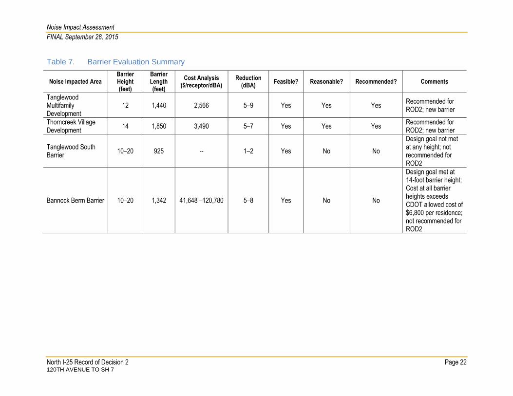
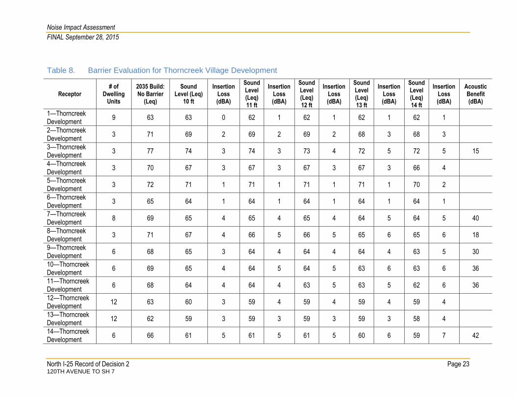
Table 7 shows a summary of the barrier evaluations for the project and Table 8 and Table 9 show barrier evaluation details for the Thorncreek Village and Tanglewood Multifamily Development, respectively.
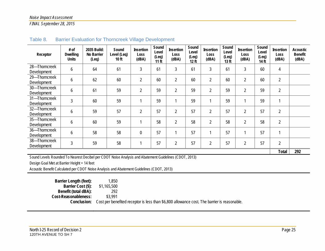
Thorncreek Village Noise Barrier A noise barrier at Thorncreek Village was recommended in the 2011 FEIS but was not included as part of the 2011 Record of Decision. This analysis confirms the preliminary barrier configuration from the 2011 FEIS after evaluating the barrier with additional receptors not included in the 2011 FEIS, incorporating building rows in the model, and using updated traffic volumes. This updated analysis also evaluates that barrier using the most recent 2013 CDOT guidelines. As shown in Table 8, a noise barrier about 1,850 feet long and 14 feet high would meet CDOT’s design goal and would provide about 292 dBA of acoustic benefit at residences in the development at a cost of $3,991 per benefitting residence. The cost per benefitting residence would be less than CDOT’s allowance cost of $6,800; therefore, the barrier is reasonable and feasible.
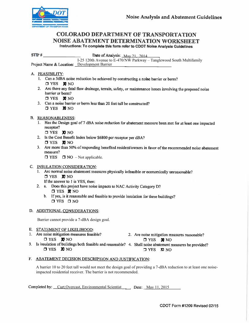
Tanglewood Multifamily Development Noise Barriers Two noise barriers were considered in the vicinity of the Tanglewood Multifamily Development. For the 2011 FEIS, no noise barrier was recommended at either location. The Tanglewood North barrier would be located from a point about 300 feet south of the Tanglewood Multifamily Development extending north about 1,440 feet as shown in Figure 6. A noise barrier at this location was modeled between heights of 8 feet and 16 feet. As shown in Table 9, several barrier heights meet CDOT guidelines for feasibility and reasonableness. A 10-foot-high barrier would meet CDOT’s 7-dBA design goal and would provide about 146 decibels of acoustic benefit at a cost of $4,428 per residence. However, increasing the barrier height to 12 feet would more than double the acoustic benefit provided by the barrier to about 303 decibels of benefit while reducing the cost per benefitted residence to $2,568 (a 36 percent decrease compared to the 10-foot barrier height). Table 10 provides additional details concerning the barrier evaluation at the Tanglewood North location. Because of the substantially greater acoustic benefit provided by the 12-foot-high barrier, the 12-foot barrier is recommended. However, as noted above, final decisions about barrier size, placement, feasibility, reasonableness, and materials will be made during final design of the project. The Tanglewood South barrier begins where the Tanglewood North barrier ends and would be located adjacent to an existing row of garages that extend south and wrap around the remainder of the complex as shown in Figure 6. At this location, the barrier would be at-grade with residences behind the garage. The garage complex provides some noise abatement because it blocks some traffic noise from I-25. The Tanglewood South barrier was modeled directly adjacent to the garage complex at barrier heights of 10 feet to 20 feet to determine if, in combination with the existing row of garages, CDOT’s design goal could be met.
Noise Impact Assessment
FINAL September 28, 2015
North I-25 Record of Decision 2 Page 22 120TH AVENUE TO SH 7
Table 7. Barrier Evaluation Summary
Noise Impacted Area Barrier Height (feet)
Barrier Length (feet)
Cost Analysis ($/receptor/dBA)
Reduction (dBA)
Feasible? Reasonable? Recommended? Comments
Tanglewood Multifamily Development
12 1,440 2,566 5–9 Yes Yes Yes Recommended for ROD2; new barrier
Thorncreek Village Development
14 1,850 3,490 5–7 Yes Yes Yes Recommended for ROD2; new barrier
Tanglewood South Barrier
10–20 925 -- 1–2 Yes No No
Design goal not met at any height; not recommended for ROD2
Bannock Berm Barrier 10–20 1,342 41,648 –120,780 5–8 Yes No No
Design goal met at 14-foot barrier height; Cost at all barrier heights exceeds CDOT allowed cost of $6,800 per residence; not recommended for ROD2
Noise Impact Assessment
FINAL September 28, 2015
North I-25 Record of Decision 2 Page 23 120TH AVENUE TO SH 7
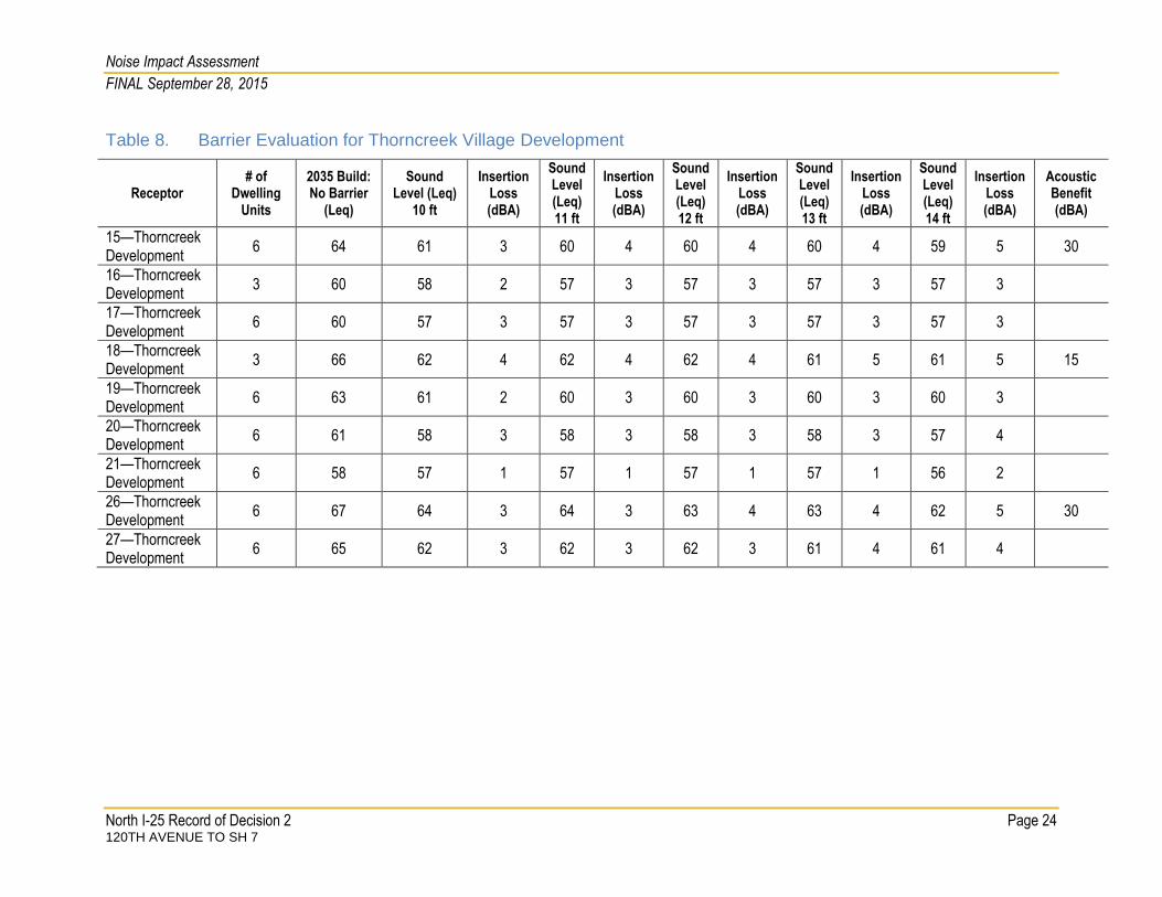
Table 8. Barrier Evaluation for Thorncreek Village Development
Receptor # of
Dwelling Units
2035 Build: No Barrier
(Leq)
Sound Level (Leq)
10 ft
Insertion Loss (dBA)
Sound Level (Leq) 11 ft
Insertion Loss (dBA)
Sound Level (Leq) 12 ft
Insertion Loss (dBA)
Sound Level (Leq) 13 ft
Insertion Loss (dBA)
Sound Level (Leq) 14 ft
Insertion Loss (dBA)
Acoustic Benefit (dBA)
1—Thorncreek Development
9 63 63 0 62 1 62 1 62 1 62 1
2—Thorncreek Development
3 71 69 2 69 2 69 2 68 3 68 3
3—Thorncreek Development
3 77 74 3 74 3 73 4 72 5 72 5 15
4—Thorncreek Development
3 70 67 3 67 3 67 3 67 3 66 4
5—Thorncreek Development
3 72 71 1 71 1 71 1 71 1 70 2
6—Thorncreek Development
3 65 64 1 64 1 64 1 64 1 64 1
7—Thorncreek Development
8 69 65 4 65 4 65 4 64 5 64 5 40
8—Thorncreek Development
3 71 67 4 66 5 66 5 65 6 65 6 18
9—Thorncreek Development
6 68 65 3 64 4 64 4 64 4 63 5 30
10—Thorncreek Development
6 69 65 4 64 5 64 5 63 6 63 6 36
11—Thorncreek Development
6 68 64 4 64 4 63 5 63 5 62 6 36
12—Thorncreek Development
12 63 60 3 59 4 59 4 59 4 59 4
13—Thorncreek Development
12 62 59 3 59 3 59 3 59 3 58 4
14—Thorncreek Development
6 66 61 5 61 5 61 5 60 6 59 7 42
Noise Impact Assessment
FINAL September 28, 2015
North I-25 Record of Decision 2 Page 24 120TH AVENUE TO SH 7
Table 8. Barrier Evaluation for Thorncreek Village Development
Receptor # of
Dwelling Units
2035 Build: No Barrier
(Leq)
Sound Level (Leq)
10 ft
Insertion Loss (dBA)
Sound Level (Leq) 11 ft
Insertion Loss (dBA)
Sound Level (Leq) 12 ft
Insertion Loss (dBA)
Sound Level (Leq) 13 ft
Insertion Loss (dBA)
Sound Level (Leq) 14 ft
Insertion Loss (dBA)
Acoustic Benefit (dBA)
15—Thorncreek Development
6 64 61 3 60 4 60 4 60 4 59 5 30
16—Thorncreek Development
3 60 58 2 57 3 57 3 57 3 57 3
17—Thorncreek Development
6 60 57 3 57 3 57 3 57 3 57 3
18—Thorncreek Development
3 66 62 4 62 4 62 4 61 5 61 5 15
19—Thorncreek Development
6 63 61 2 60 3 60 3 60 3 60 3
20—Thorncreek Development
6 61 58 3 58 3 58 3 58 3 57 4
21—Thorncreek Development
6 58 57 1 57 1 57 1 57 1 56 2
26—Thorncreek Development
6 67 64 3 64 3 63 4 63 4 62 5 30
27—Thorncreek Development
6 65 62 3 62 3 62 3 61 4 61 4
Noise Impact Assessment FINAL September 28, 2015
North I-25 Record of Decision 2 Page 25 120TH AVENUE TO SH 7
Table 8. Barrier Evaluation for Thorncreek Village Development
Receptor # of
Dwelling Units
2035 Build: No Barrier
(Leq)
Sound Level (Leq)
10 ft
Insertion Loss (dBA)
Sound Level (Leq) 11 ft
Insertion Loss (dBA)
Sound Level (Leq) 12 ft
Insertion Loss (dBA)
Sound Level (Leq) 13 ft
Insertion Loss (dBA)
Sound Level (Leq) 14 ft
Insertion Loss (dBA)
Acoustic Benefit (dBA)
28—Thorncreek Development 6 64 61 3 61 3 61 3 61 3 60 4 29—Thorncreek Development 6 62 60 2 60 2 60 2 60 2 60 2 30—Thorncreek Development 6 61 59 2 59 2 59 2 59 2 59 2 31—Thorncreek Development 3 60 59 1 59 1 59 1 59 1 59 1 32—Thorncreek Development 6 59 57 2 57 2 57 2 57 2 57 2 35—Thorncreek Development 6 60 59 1 58 2 58 2 58 2 58 2 36—Thorncreek Development 6 58 58 0 57 1 57 1 57 1 57 1 38—Thorncreek Development 3 59 58 1 57 2 57 2 57 2 57 2 Total 292 Sound Levels Rounded To Nearest Decibel per CDOT Noise Analysis and Abatement Guidelines (CDOT, 2013) Design Goal Met at Barrier Height = 14 feet Acoustic Benefit Calculated per CDOT Noise Analysis and Abatement Guidelines (CDOT, 2013)
Barrier Length (feet): 1,850 Barrier Cost ($): $1,165,500
Benefit (total dBA): 292 Cost-Reasonableness: $3,991
Conclusion: Cost per benefited receptor is less than $6,800 allowance cost. The barrier is reasonable.

Noise Impact Assessment
FINAL September 28, 2015
North I-25 Record of Decision 2 Page 26 120TH AVENUE TO SH 7
Table 9. Tanglewood North Noise Barrier Cost Evaluation Summary1
Barrier Height (feet) Barrier Cost ($) Acoustic Benefit (dBA) Cost Per Residence ($)
10 648,000 146 4,438
11 712,800 216 3,300
12 776,600 303 2,566 1Barrier costs calculated per CDOT Noise Analysis and Abatement Guidelines (CDOT, 2013)
Table 10. Barrier Evaluation for Tanglewood Multifamily Development
Receptor Number of Dwelling
Units
2035 Build—No Barrier
(Leq)
Sound Level (Leq)
10 ft
Insertion Loss (dBA)
Acoustic Benefit (dBA)
Sound Level (Leq) 11 ft
Insertion Loss (dBA)
Acoustic Benefit (dBA)
Sound Level (Leq) 12 ft
Insertion Loss (dBA)
Acoustic Benefit (dBA)
TW-1 (Ground Floor) 4 67 62 5 20 62 5 20 62 5 20
TW-1-2 (2nd Floor) 4 79 73 6 24 72 7 28 71 8 32
TW-2 (Ground Floor) 3 66 63 3 63 3 63 3
TW-2-2 (2nd Floor) 3 77 70 7 21 70 7 21 68 9 27
TW-2-3 (3rd Floor) 3 78 77 1 76 2 76 2
TW-3(Ground Floor) 3 67 63 4 63 4 63 4
TW-3-2 (2nd Floor) 3 74 69 5 15 68 6 18 67 7 21
TW-3-3 (3rd Floor) 3 77 74 3 74 3 74 3
TW-4 (Ground Floor) 3 68 64 4 63 5 15 63 5 15
TW-4-2 (2nd Floor) 3 73 68 5 15 68 5 15 68 5 15
TW-4-3 (3rd Floor) 3 75 73 2 73 2 73 2
TW-5 (Ground Floor) 3 69 65 4 64 5 15 63 6 18
TW-5-2 (2nd Floor) 3 74 69 5 15 68 6 18 68 6 18
TW-5-3 (3rd Floor) 3 75 73 2 73 2 73 2
TW-6 (Ground Floor) 3 66 63 3 62 4 62 4
TW-6-2 (2nd Floor) 3 73 67 6 18 67 6 18 66 7 21
TW-6-3 (3rd Floor) 3 74 71 3 70 4 70 4
TW-7 (Ground Floor) 3 66 63 3 62 4 62 4
TW-7-2 (2nd Floor) 3 72 67 6 18 67 6 18 66 7 21
TW-7-3 (3rd Floor) 3 74 70 4 69 5 15 69 5 15

Noise Impact Assessment
FINAL September 28, 2015
North I-25 Record of Decision 2 Page 27 120TH AVENUE TO SH 7
Table 10. Barrier Evaluation for Tanglewood Multifamily Development
Receptor Number of Dwelling
Units
2035 Build—No Barrier
(Leq)
Sound Level (Leq)
10 ft
Insertion Loss (dBA)
Acoustic Benefit (dBA)
Sound Level (Leq) 11 ft
Insertion Loss (dBA)
Acoustic Benefit (dBA)
Sound Level (Leq) 12 ft
Insertion Loss (dBA)
Acoustic Benefit (dBA)
TW-8 (Ground Floor) 3 63 60 4 59 4 59 4
TW-8-2 (2nd Floor) 3 70 66 4 66 4 65 5 15
TW-8-3 (3rd Floor) 3 71 67 4 67 5 15 67 5 15
TW-9 (Ground Floor) 4 62 60 2 59 3 59 3
TW-9-2 (2nd Floor) 3 69 66 3 65 4 65 4
TW-9-3 (3rd Floor) 3 70 67 3 67 3 66 4
TW-10(Ground Floor) 3 66 62 4 62 4 61 5 15
TW-10-2 (2nd Floor) 4 76 74 2 74 2 72 4
TW-11 (Ground Floor) 3 65 61 4 61 4 60 5 15
TW-11-2 (2nd Floor) 3 73 69 4 69 4 69 4
TW-11-3 (3rd Floor) 3 78 76 2 75 3 75 3
TW-12 (Ground Floor) 3 64 61 3 60 4 60 4
TW-12-2 (2nd Floor) 3 71 67 4 67 4 67 4
TW-12-3 (3rd Floor) 3 76 74 2 74 2 74 2
TW-13(Ground Floor) 3 62 60 2 59 3 58 3
TW-13-2 (2nd Floor) 3 67 64 3 64 3 64 3
TW-13-3 (3rd Floor) 3 72 71 1 69 3 69 3
TW-14 (Ground Floor) 3 61 60 1 60 1 59 2
TW-14-2 (2nd Floor) 3 66 63 3 63 0 63 0
TW-14-3 (3rd Floor) 3 71 68 3 68 3 68 3
TW-15(Ground Floor) 3 62 60 2 59 3 58 4
TW-15-2 (2nd Floor) 3 67 64 3 64 3 64 3
TW-15-3 (3rd Floor) 3 73 72 1 71 2 70 3
TW-16 (Ground Floor) 4 63 60 3 59 4 59 4
TW-16-2 (2nd Floor) 3 71 68 3 68 3 68 3
TW-16-3 (3rd Floor) 3 78 75 3 75 3 75 3
TW-17 (Ground Floor) 4 65 62 3 61 4 61 4
TW-17-2 (2nd Floor) 4 75 72 3 72 3 72 3
TW-18 (Ground Floor) 3 67 63 4 63 4 63 4

Noise Impact Assessment
FINAL September 28, 2015
North I-25 Record of Decision 2 Page 28 120TH AVENUE TO SH 7
Table 10. Barrier Evaluation for Tanglewood Multifamily Development
Receptor Number of Dwelling
Units
2035 Build—No Barrier
(Leq)
Sound Level (Leq)
10 ft
Insertion Loss (dBA)
Acoustic Benefit (dBA)
Sound Level (Leq) 11 ft
Insertion Loss (dBA)
Acoustic Benefit (dBA)
Sound Level (Leq) 12 ft
Insertion Loss (dBA)
Acoustic Benefit (dBA)
TW-18-2 (2nd Floor) 4 78 74 4 74 4 73 5 20
TW-19 (Ground Floor) 1 65 61 4 61 4 61 4
TW-19-2 (2nd Floor) 3 74 69 4 69 4 69 4
TW-19-3 (3rd Floor) 3 77 75 2 75 2 75 2
Barrier Cost: Acoustic Benefit Cost per Benefitting Residence ($)
10 feet ($648,000) 146 4,438
11 feet ($712,800) 216 3,300
12 feet ($776,600) 303 2,566

Noise Impact Assessment
FINAL September 28, 2015
North I-25 Record of Decision 2 Page 29 120TH AVENUE TO SH 7
Table 11 shows the barrier analysis for a barrier located adjacent to the existing garage complex. As shown in Table 11, a barrier at this location would not meet CDOT’s design goal of 7 dBA; therefore, a barrier at this location is not recommended. Table 12 and Table 13 show the barrier evaluation and cost evaluation summary, respectively, for the Bannock barrier where there is an existing berm (see Figure 2). There are five residences behind the berm. A barrier was modeled at this location at heights of 10 feet to 20 feet (1,342 feet long). As shown in Table 12, CDOT’s design goal of a 7 dBA insertion loss would be met at a height of 14 feet. At a barrier height of 20 feet, three receptors would receive an 8 dBA insertion loss and one receptor would receive a 5 dBA insertion loss. As shown in Table 13, however, the allowed cost at all barrier heights would exceed CDOT’s allowed cost of $6,800 per benefitted receptor. A barrier at this location is not recommended.
Commercial Noise Barriers (NAC E) There is one commercial receptor that is considered an area of frequent outdoor use. Just north of the I-25 on-ramp from 120th Avenue there is an outdoor patio dining area associated with the Double Tree Inn (receptor B430 in Figure 6). The modeled noise level at this receptor was 73 dBA and exceeded the NAC E threshold of 71 dBA. A noise barrier about 950 feet long was modeled adjacent to the I-25 on ramp to determine if the CDOT design goal could be met with a barrier at this location. A barrier 14 feet high would meet the design goal of providing a 7 dBA insertion loss at the outdoor dining patio at a cost of about $598,500. The cost of the barrier would exceed the CDOT’s allowance cost of $6,800 and is not reasonable. Appendix A of this document contains noise abatement determination worksheets for the noise-impacted areas evaluated in the ROD2.
MITIGATION RECOMMENDATION AND STATEMENT OF LIKELIHOOD The items needed for the Statement of Likelihood have been described throughout this report. The locations where noise impacts are predicted to occur are shown in Table 5. The locations with feasible and reasonable noise abatement measures are discussed under Mitigation Analysis and Evaluation, and the locations of feasible and reasonable noise abatement measures are shown in Figure 5 and Figure 6.
An optimized noise barrier of 1,850 feet by 14 feet was evaluated at the Thorncreek Village development and found to meet feasibility and reasonableness criteria. The barrier at Thorncreek Village is recommended for construction pending final design.
An optimized noise barrier of 1,440 feet by 12 feet was evaluated at the Tanglewood Multifamily Development and found to meet feasibility and reasonableness criteria. The barrier at the Tanglewood Multifamily Development is recommended for construction pending final design.

Noise Impact Assessment FINAL September 28, 2015
North I-25 Record of Decision 2 Page 30 120TH AVENUE TO SH 7
Table 11. Barrier Evaluation for Tanglewood South Development
Receptor Number
of Dwelling
Units
2035 Build–No
Barrier (Leq)
Sound Level (Leq)–10 ft
Insertion Loss (dBA)
Sound Level (Leq)–
11ft
Insertion Loss (dBA)
Sound Level (Leq)–12 ft
Insertion Loss (dBA)
Sound Level (Leq)–13 ft
Insertion Loss (dBA)
Sound Level (Leq)–14 ft
Insertion Loss (dBA)
Sound Level (Leq)–15 ft
Insertion Loss (dBA)
Sound Level (Leq)–16 ft
Insertion Loss (dBA)
Sound Level (Leq)–17 ft
Insertion Loss (dBA)
Sound Level (Leq)–18 ft
Insertion Loss (dBA)
Sound Level (Leq)–19 ft
Insertion Loss (dBA)
Sound Level (Leq)–20 ft
Insertion Loss (dBA)
TW-20 1 68 68 0 68 0 68 0 68 0 68 0 68 0 68 0 68 0 68 0 67 1 67 1 TW-21 1 68 68 0 68 0 68 0 68 0 68 0 68 0 68 0 68 0 67 1 66 1 66 2 TW-22 1 67 67 0 67 0 67 0 67 0 67 0 67 0 67 0 66 0 66 0 66 1 65 1 TW-23 1 67 67 0 67 0 67 0 67 0 67 0 67 0 67 0 67 0 67 0 67 0 67 1 TW-24 1 66 66 0 66 0 66 0 66 0 66 0 66 0 66 0 66 0 66 0 65 1 65 1 TW-25 1 66 66 0 66 0 66 0 66 0 66 0 66 0 66 0 66 0 66 0 66 1 66 1 TW-26 1 63 63 0 63 0 63 0 63 0 63 0 63 0 63 0 63 0 63 0 63 1 63 1 TW-27 1 60 60 0 60 0 60 0 60 0 60 0 60 0 60 0 60 0 60 0 60 0 60 1 TW-28 1 67 67 0 67 0 67 0 67 0 67 0 67 0 67 0 67 0 66 0 66 1 65 2 TW-29 1 67 67 0 67 0 67 0 67 0 67 0 67 0 67 0 67 0 66 0 66 0 66 0 TW-30 1 67 67 0 67 0 67 0 67 0 67 0 67 0 67 0 67 0 66 0 66 1 65 2 TW-31 1 66 66 0 66 0 66 0 66 0 66 0 66 0 66 0 66 0 67 -1 66 0 66 0 TW-32 1 65 65 0 65 0 65 0 65 0 65 0 65 0 65 0 65 0 65 1 64 1 64 1 TW-33 1 64 64 0 64 0 64 0 64 0 64 0 64 0 63 0 64 0 63 0 63 1 63 1 TW-34 1 67 67 0 67 0 67 0 67 0 67 0 67 0 67 0 67 0 66 0 66 0 66 1 TW-35 1 69 69 0 69 0 69 0 69 0 69 0 69 0 69 0 68 0 68 1 67 1 67 2 TW-36 1 68 68 0 68 0 68 0 68 0 68 0 68 0 67 1 67 0 67 1 66 1 66 2 TW-37 1 67 67 0 67 0 67 0 67 0 67 0 67 0 65 1 66 1 66 1 65 2 65 2

Noise Impact Assessment FINAL September 28, 2015
North I-25 Record of Decision 2 Page 31 120TH AVENUE TO SH 7
Table 12. Barrier Evaluation for Bannock Barrier
Receptor # of Dwelling Units
2035 Build: No Barrier
(Leq)
Sound Level (Leq)– 13 ft
Insertion Loss (dBA)
Sound Level (Leq)–14 ft
Insertion Loss (dBA)
Sound Level (Leq)– 15 ft
Insertion Loss (dBA)
Sound Level (Leq)– 16 ft
Insertion Loss (dBA)
Sound Level (Leq)– 17 ft
Insertion Loss (dBA)
Sound Level (Leq)– 18 ft
Insertion Loss (dBA)
Sound Level (Leq)– 19 ft
Insertion Loss (dBA)
Sound Level (Leq)– 20 ft
Insertion Loss (dBA)
B125 1 75 72 3 72 4 71 4 71 4 71 5 70 5 70 5 70 5 B124 1 73 66 6 66 7 66 7 65 7 65 8 65 8 65 8 64 8 B123 1 75 72 3 71 4 70 5 69 6 69 7 68 7 67 8 67 8 B652 1 75 72 3 72 4 71 5 70 5 69 6 68 7 68 8 67 8 B653 1 67 64 3 64 3 64 3 64 4 63 4 63 4 63 4 63 4
Table 13. Bannock Barrier Cost Evaluation Summary1
Barrier Height (feet) Barrier Cost ($) Acoustic Benefit (dBA) Cost Per Residence ($) Reasonable per CDOT
Guidelines? 14 845,560 7 120,780 No 15 905,850 17 53,285 No 16 966,240 18 53,680 No 17 1,026,630 19 54,033 No 18 1,087,020 27 40,260 No 19 1,147,410 29 39,566 No 20 1,207,800 29 41,348 No
1Barrier costs calculated per CDOT Noise Analysis and Abatement Guidelines (CDOT, 2013)

Noise Impact Assessment
FINAL September 28, 2015
North I-25 Record of Decision 2 Page 32 120TH AVENUE TO SH 7
A benefited receptor preference survey was conducted in December 2014 and January 2015. The results of this survey showed that a majority of those responding desired a noise wall (see Appendix B of this document for details). All noise mitigation will be reanalyzed during the final design process.
Construction Noise Adjoining properties in the project area would be exposed to noise from construction activities when the project is built. Construction noise differs from traffic noise in several ways:
Construction noise lasts only for the duration of the construction event, with most construction activities in noise-sensitive areas being conducted during (daytime) hours that are less disturbing to adjacent and nearby residents.
Construction activities generally are short term and, depending on the nature of the construction operations, could last from seconds (for example, a truck passing by) to months (for example, constructing a bridge).
Construction noise also is intermittent and depends on the type of operation, the location and function of the equipment, and the equipment usage cycle. Traffic noise, on the other hand, is present in a more continuous fashion after construction activities are completed.
To address the temporary elevated noise levels that might be experienced during construction, standard abatement measures should be incorporated into construction contracts. These would include:
Exhaust systems on equipment will be in good working order. Equipment will be maintained on a regular basis, and equipment may be subject to inspection by the project manager to ensure maintenance.
Properly designed engine enclosures and intake silencers will be used where appropriate.
New equipment will be subject to new product noise emission standards.
Stationary equipment will be located as far from sensitive receptors as feasible.
Most construction activities in noise-sensitive areas will be conducted during (daytime) hours that are less disturbing to adjacent and nearby residents.
Construction noise from future project activities must comply with any applicable local noise regulations. Construction noise that complies with such noise regulations is viewed as not having an impact on neighboring properties. When construction is imminent, potential conflicts because of construction noise can be better determined. Individualized construction noise abatement strategies, where needed, will be developed to address specific construction noise issues.

Noise Impact Assessment
FINAL September 28, 2015
North I-25 Record of Decision 2 Page 33 120TH AVENUE TO SH 7
REFERENCES CDM-Smith. 2013. I-25 Traffic and Revenue Assessment. November.
Colorado Department of Transportation. 2011. North I-25 Final Environmental Impact Statement. August.
—. 2013. CDOT Noise Analysis and Abatement Guidelines. February.
Noise Impact Assessment
North I-25 Record of Decision 2 Appendix A 120TH AVENUE TO SH 7
Appendix A.
Noise Abatement Determination Worksheets
(CDOT Form 1209)

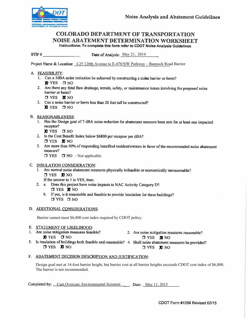
May 21, 2014
I-25 120th Avenue to E-470/NW Parkway – Bannock Road Barrier
Barrier cannot meet $6,800 cost index required by CDOT policy.
Curt Overcast, Environmental Scientist May 11, 2015
X
X
X
X
X
X
X
X
X
X
X
– Not applicable.
Design goal met at 14-foot barrier height, but barrier cost at all barrier heights escceeds CDOT cost index of $6,800.The barrier is not recommended.

May 21, 2014
I-25 120th Avenue to E-470/NW Parkway – Tanglewood Multifamily Development Barrier
Curt Overcast, Environmental Scientist May 11, 2015
X
X
X
X
X
X
X
X
X
X
X
A barrier 12 feet tall and about 1,440 feet long would provide a 7-dBA reduction to at least one noise-impacted residence at a cost index of $2,566. The barrier is recommended.
X
May 21, 2014I-25 120th Avenue to E-470/NW Parkway – Tanglewood South Multifamily Development Barrier
Barrier cannot provide a 7-dBA design goal.
Curt Overcast, Environmental Scientist May 11, 2015
X
X
X
X
X
X
X
X
X
X
X
– Not applicable.
A barrier 10 to 20 feet tall would not meet the design goal of providing a 7-dBA reduction to at least one noise-impacted residential receiver. The barrier is not recommended.

May 21, 2014
I-25 120th Avenue to E-470/NW Parkway – Thorncreek Village Barrier
Curt Overcast, Environmental Scientist May 11, 2015
X
X
X
X
X
X
X
X
X
X
X
A barrier 14 feet tall and about 1,850 feet long would provide a 7-dBA reduction to at least one noise-impacted residence at a cost index of $3,490. The barrier is recommended.
X

Noise Impact Assessment
North I-25 Record of Decision 2 Appendix B 120TH AVENUE TO SH 7
Appendix B.
Results of Benefited Receptor Surveys


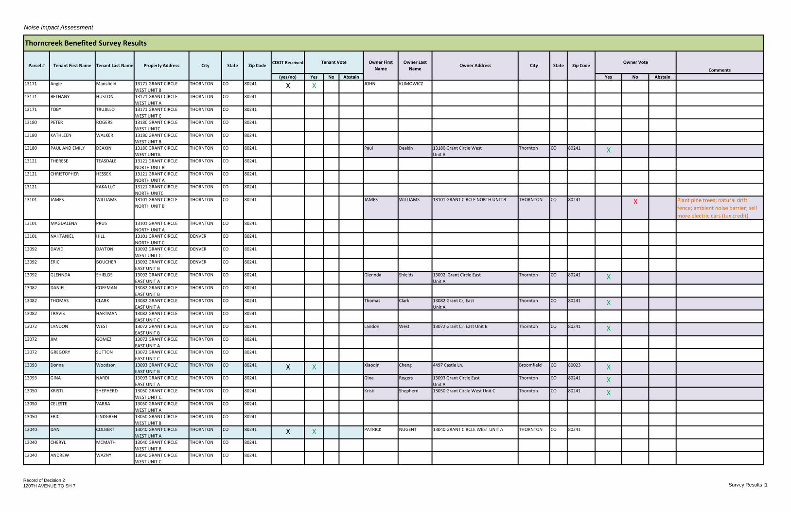
North I-25 Benefited Receptor Survey Results
Thorncreek Village
Mailings sent out: 48
Owner mailings received: 20
Tenant mailings received: 5
Homeowner/Tenant Yes No
Homeowner 19 1*
Tenant 5 0
*The homeowner who voted “No” commented that he would prefer a natural barrier, such as trees, rather
than a wall.
Noise barrier voting packets were created that included a letter, a survey, and a return envelope
addressed to HDR. The letter detailed the North I-25 project and how select Thorncreek homes
met the eligibility requirements to receive a noise barrier. The survey asked the tenant or owner
to vote “yes” or “no” on whether a noise barrier built along I-25 was desired. The original 48
Thorncreek mailings were sent out via USPS on December 3, 2014. Tenants and owners were
asked to return the surveys no later than January 12, 2015. Thirteen mailings were returned by
the post office as “undeliverable as addressed.” These were re-addressed as “Occupant” and
sent again. The second round of mailings was delivered successfully and tenants and owners
were given until January 30, 2015 to return their surveys.
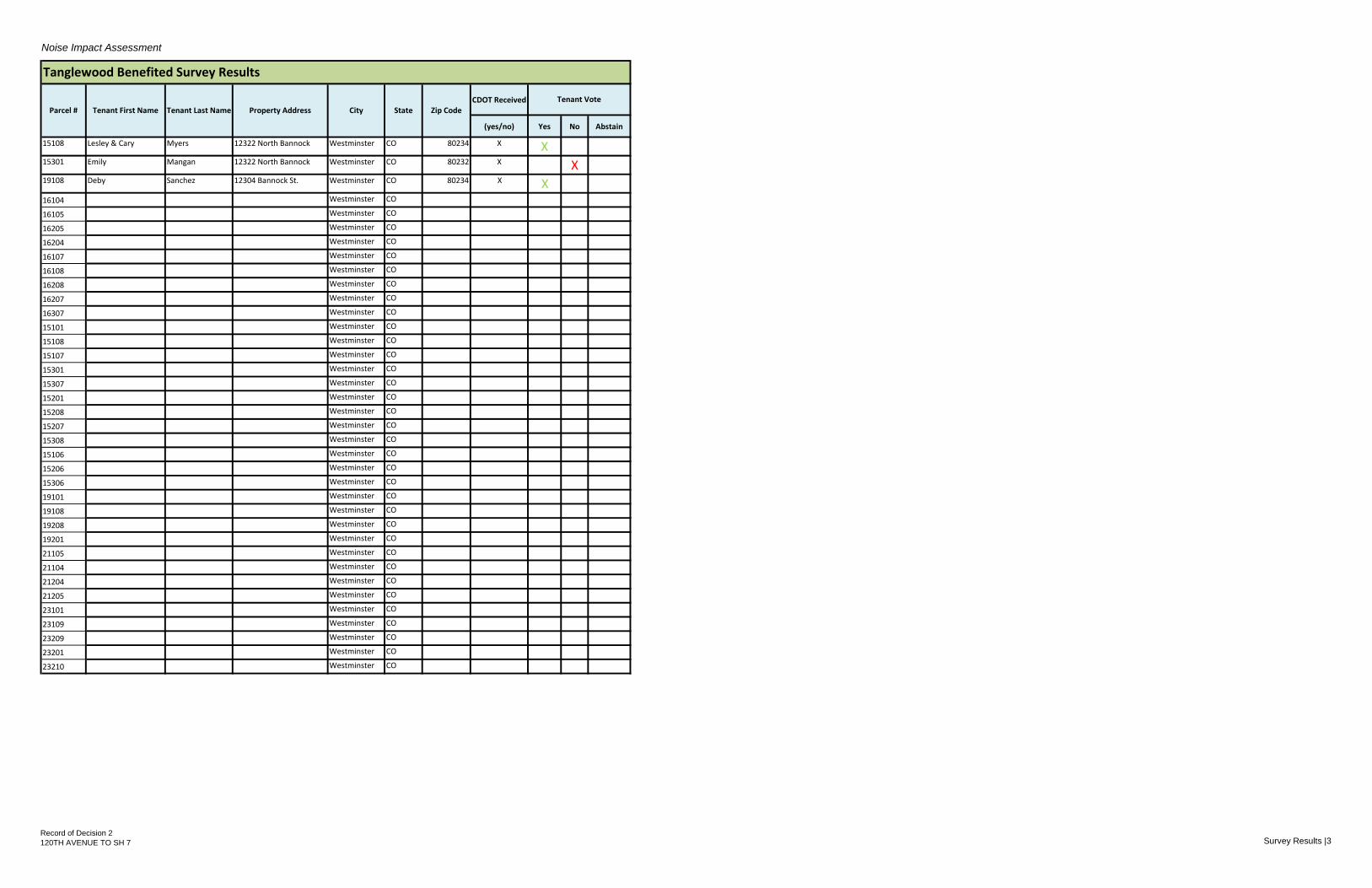
Tanglewood Multifamily Development
Mailings sent out: 38
Owner mailings received: N/A
Tenant mailings received: 3
Homeowner/Tenant Yes No
Tenant 2 1
Noise barrier voting packets were created that included a letter, a survey, and a return envelope
addressed to HDR. The letter detailed the North I-25 project and how select Tanglewood
Multifamily Development met the eligibility requirements to receive a noise barrier. The surveys
asked the tenant to vote “yes” or “no” on whether a noise barrier built along I-25 was desired.
The packets were hand delivered on January 8, 2015. Packets were taped to the front door of
all impacted units. Tenants were asked to return their surveys no later than January 30, 2015.

Noise Impact Assessment
CDOT Received
Comments
(yes/no) Yes No Abstain Yes No Abstain
13171 Angie Mansfield 13171 GRANT CIRCLE
WEST UNIT B
THORNTON CO 80241 X X JOHN KLIMOWICZ
13171 BETHANY HUSTON 13171 GRANT CIRCLE
WEST UNIT A
THORNTON CO 80241
13171 TOBY TRUJILLO 13171 GRANT CIRCLE
WEST UNIT C
THORNTON CO 80241
13180 PETER ROGERS 13180 GRANT CIRCLE
WEST UNITC
THORNTON CO 80241
13180 KATHLEEN WALKER 13180 GRANT CIRCLE
WEST UNIT B
THORNTON CO 80241
13180 PAUL AND EMILY DEAKIN 13180 GRANT CIRCLE
WEST UNITA
THORNTON CO 80241 Paul Deakin 13180 Grant Circle West
Unit A
Thornton CO 80241 X
13121 THERESE TEASDALE 13121 GRANT CIRCLE
NORTH UNIT B
THORNTON CO 80241
13121 CHRISTOPHER HESSEK 13121 GRANT CIRCLE
NORTH UNIT A
THORNTON CO 80241
13121 KAKA LLC 13121 GRANT CIRCLE
NORTH UNITC
THORNTON CO 80241
13101 JAMES WILLIAMS 13101 GRANT CIRCLE
NORTH UNIT B
THORNTON CO 80241 JAMES WILLIAMS 13101 GRANT CIRCLE NORTH UNIT B THORNTON CO 80241 X Plant pine trees; natural drift
fence; ambient noise barrier; sell
more electric cars (tax credit)13101 MAGDALENA PRUS 13101 GRANT CIRCLE
NORTH UNIT A
THORNTON CO 80241
13101 NAHTANIEL HILL 13101 GRANT CIRCLE
NORTH UNIT C
DENVER CO 80241
13092 DAVID DAYTON 13092 GRANT CIRCLE
WEST UNIT C
DENVER CO 80241
13092 ERIC BOUCHER 13092 GRANT CIRCLE
EAST UNIT B
DENVER CO 80241
13092 GLENNDA SHIELDS 13092 GRANT CIRCLE
EAST UNIT A
THORNTON CO 80241 Glennda Shields 13092 Grant Circle East
Unit A
Thornton CO 80241 X
13082 DANIEL COFFMAN 13082 GRANT CIRCLE
EAST UNIT B
THORNTON CO 80241
13082 THOMAS CLARK 13082 GRANT CIRCLE
EAST UNIT A
THORNTON CO 80241 Thomas Clark 13082 Grant Cr, East
Unit A
Thornton CO 80241 X
13082 TRAVIS HARTMAN 13082 GRANT CIRCLE
EAST UNIT C
THORNTON CO 80241
13072 LANDON WEST 13072 GRANT CIRCLE
EAST UNIT B
THORNTON CO 80241 Landon West 13072 Grant Cr. East Unit B Thornton CO 80241 X
13072 JIM GOMEZ 13072 GRANT CIRCLE
EAST UNIT A
THORNTON CO 80241
13072 GREGORY SUTTON 13072 GRANT CIRCLE
EAST UNIT C
THORNTON CO 80241
13093 Donna Woodson 13093 GRANT CIRCLE
EAST UNIT B
THORNTON CO 80241 X X Xiaoqin Cheng 4497 Castle Ln. Broomfield CO 80023 X
13093 GINA NARDI 13093 GRANT CIRCLE
EAST UNIT A
THORNTON CO 80241 Gina Rogers 13093 Grant Circle East
Unit A
Thornton CO 80241 X
13050 KRISTI SHEPHERD 13050 GRANT CIRCLE
WEST UNIT C
THORNTON CO 80241 Kristi Shepherd 13050 Grant Circle West Unit C Thornton CO 80241 X
13050 CELESTE VARRA 13050 GRANT CIRCLE
WEST UNIT A
THORNTON CO 80241
13050 ERIC LINDGREN 13050 GRANT CIRCLE
WEST UNIT B
THORNTON CO 80241
13040 DAN COLBERT 13040 GRANT CIRCLE
WEST UNIT A
THORNTON CO 80241 X X PATRICK NUGENT 13040 GRANT CIRCLE WEST UNIT A THORNTON CO 80241
13040 CHERYL MCMATH 13040 GRANT CIRCLE
WEST UNIT B
THORNTON CO 80241
13040 ANDREW WAZNY 13040 GRANT CIRCLE
WEST UNIT C
THORNTON CO 80241
Owner First
NameOwner Address
Thorncreek Benefited Survey Results
CityParcel # Tenant First Name Tenant Last Name Property Address City State Zip CodeOwner Vote
State Zip CodeTenant Vote Owner Last
Name
Record of Decision 2
120TH AVENUE TO SH 7 Survey Results |1


Noise Impact Assessment
CDOT Received
Comments
(yes/no) Yes No Abstain Yes No Abstain
Owner First
NameOwner Address
Thorncreek Benefited Survey Results
CityParcel # Tenant First Name Tenant Last Name Property Address City State Zip CodeOwner Vote
State Zip CodeTenant Vote Owner Last
Name
13030 13030 GRANT CIRCLE
WEST UNIT A
THORNTON CO 80241 ERIK WELLS 13030 GRANT CIRCLE WEST UNIT A THORNTON CO 80241 X
13030 JENNIFER BECK 13030 GRANT CIRCLE
WEST UNIT C
THORNTON CO 80241 Fidenzio Zertache 13030 Grant Circle West Unit C Thornton CO 80241 X
13030 Johnson 13030 GRANT CIRCLE
WEST UNIT B
THORNTON CO 80241 X X THOMAS TURECHEK
13020 LINDA ERLINGER 13020 GRANT CIRCLE
WEST UNIT A
THORNTON CO 80241 Linda Erlinger 13020 Grant Circle W Thornton CO 80241 X
13020 DUSTIN WICHAEL 13020 GRANT CIRCLE
WEST UNIT B
THORNTON CO 80241
13020 HERMAN GUTIERREZ 13020 GRANT CIRCLE
WEST UNIT C
THORNTON CO 80241 Herman and
Gay
Gutierrez 13020 Grant Circle West Unit C Thornton CO 80241 X
13001 Alexander LE 13001 GRANT CIRCLE
WEST UNIT C
DENVER CO 80241 Alexander Le 13001 Grant Circle West Unit C Denver CO 80241 X
13001 PHILLIP MEDINA 13001 GRANT CIRCLE
WEST UNIT B
THORNTON CO 80241
13001 MAKAILA CHAHAN 13001 GRANT CIRCLE
WEST UNIT A
THORNTON CO 80241 MAKAILA CHAHAN 13001 GRANT CIRCLE WEST UNIT A THORNTON CO 80241 X
12991 DANIEL RANDALL 12991 GRANT CIRCLE
WEST UNIT B
THORNTON CO 80241
12991 PENNY LALONDE 12991 GRANT CIRCLE
WEST UNIT A
THORNTON CO 80241
12991 LINDA EDDLEMAN 12991 GRANT CIRCLE
WEST UNIT C
THORNTON CO 80241 Linda Eddleman 12991 GRANT CIRCLE WEST UNIT C Thornton CO 80241 X
12981 EDWIN TAYLOR 12981 GRANT CIRCLE
WEST UNIT B
THORNTON CO 80241 Ed & Carol Taylor 12981 Grant Circle West Unit B Thornton CO 80241 X Mom's Condo LLC
12981 REAL ESTATE
RETURNS LLC
12981 GRANT CIRCLE
WEST UNIT A
THORNTON CO 80241 Paul Deakin 13180 Grant Circle West
Unit A
Thornton CO 80241 X
12981 MOMS CONDO
LLC
12981 GRANT CIRCLE
WEST UNIT C
THORNTON CO 80241 X X Angela Ray 3321 W 147th Court Broomfield CO 80023 X
12971 MARTA BLACKHURST 12971 GRANT CIRCLE
WEST UNIT C
THORNTON CO 80241 Marta Blackhurst 12971 Grant Circle West Unit C Thornton CO 80241 X
12971 ANN DAIGLE 12971 GRANT CIRCLE
WEST UNIT A
DENVER CO 80241 Ann Daigle 12971 Grant Circle West Denver CO 80241 X
12971 CAROLYN FOWLER 12971 GRANT CIRCLE
WEST UNIT B
DENVER CO 80241
Record of Decision 2
120TH AVENUE TO SH 7 Survey Results |2

Noise Impact Assessment
CDOT Received
(yes/no) Yes No Abstain
15108 Lesley & Cary Myers 12322 North Bannock Westminster CO 80234 X X15301 Emily Mangan 12322 North Bannock Westminster CO 80232 X X19108 Deby Sanchez 12304 Bannock St. Westminster CO 80234 X X16104 Westminster CO
16105 Westminster CO
16205 Westminster CO
16204 Westminster CO
16107 Westminster CO
16108 Westminster CO
16208 Westminster CO
16207 Westminster CO
16307 Westminster CO
15101 Westminster CO
15108 Westminster CO
15107 Westminster CO
15301 Westminster CO
15307 Westminster CO
15201 Westminster CO
15208 Westminster CO
15207 Westminster CO
15308 Westminster CO
15106 Westminster CO
15206 Westminster CO
15306 Westminster CO
19101 Westminster CO
19108 Westminster CO
19208 Westminster CO
19201 Westminster CO
21105 Westminster CO
21104 Westminster CO
21204 Westminster CO
21205 Westminster CO
23101 Westminster CO
23109 Westminster CO
23209 Westminster CO
23201 Westminster CO
23210 Westminster CO
Tanglewood Benefited Survey Results
Parcel # Tenant First Name Tenant Last Name Property Address City State Zip Code
Tenant Vote
Record of Decision 2
120TH AVENUE TO SH 7 Survey Results |3


1420 – 2nd Street, Greeley, CO 80631 P 970.350.2103 F 970.XXX.XXXX www.coloradodot.Info
December 3, 2014 Your Vote Counts! Noise Barrier Preference Decision North I-25 120th Avenue to State Highway 7 Managed Lanes Proposed Tanglewood Noise Wall Dear Property Owner or Resident What’s going on? The Colorado Department of Transportation (CDOT) is currently conducting a study called the North I-25 Record of Decision (ROD) No.2 for the 120th Avenue to State Highway (SH) 7 Managed Lanes Project. The purpose of the project is to re-evaluate the benefits and impacts of adding a managed lane to the I-25 corridor between the 120th Avenue interchange and SH 7.
As a part of the North I-25 Corridor Final Environmental Impact Statement published in 2011, traffic noise was evaluated for the proposed roadway improvements. However, as of December 2011 available funding for work commitments outlined in the first ROD was insufficient to include the highway improvements for this segment of the project.
The second ROD, due to be published in late 2014, aims to augment the original ROD with new funding for construction of the managed lane between 120th and SH 7. Project construction is anticipated to begin during the summer of 2015 and last until late 2016.
As a part of this second ROD, the traffic noise study was re-evaluated to incorporate new homes and development that has occurred in the affected area since the issuance of the first ROD. The results of this new noise study show an increased traffic noise impact to the Tanglewood neighborhood, resulting in a recommendation for a noise wall 10 feet tall and 1,440 feet long for the northern half of your neighborhood. The wall is recommended for only those residential buildings that can achieve sufficient noise reduction from the wall to meet federal and state warrants for noise abatement. These warrants include acoustic and engineering feasibility, noise reductions sufficient to meet a 7 decibel design goal for at least one receptor, and cost-effectiveness.
What does CDOT need from you?
CDOT would like to know your preference for the noise barrier proposed near your location. This letter has been provided to all “benefitted” property owners and tenants in your neighborhood, i.e. those residents for whom a noise barrier would result in a noise reduction of 5 decibels or more.
Please return the enclosed survey ballot using the included self-addressed-stamped envelope by January 12, 2015. Please include your full name and address, whether you are the property owner or a tenant, and check off whether or not your wish to have a noise barrier constructed in your area. CDOT will consider one tenant vote and also one owner vote per address if the property is not owner occupied. If the property is owner occupied, that ballot will count as 2 votes. A simple majority of received yea or nay votes for the “benefited” residents in your neighborhood will decide the
1420 2nd Street Greeley, CO 80631 (970) 350-2146 (Fax) 350-2198

1420 – 2nd Street, Greeley, CO 80631 P 970.350.2103 F 970.XXX.XXXX www.coloradodot.Info
recommendation. All votes must be received by the close of business on January 12, 2015. CDOT will notify you the results of the survey later in 2015.
If you have additional questions please call the North I-25 Project Manager, Jennifer Gorek, at (970)350-2264. For additional information regarding traffic noise, regulations and policy, noise analyses, or noise abatement, we encourage you to access CDOT’s Noise Analysis and Abatement Guidelines at http://www.coloradodot.info/programs/environmental/noise. For additional North I-25 120th Avenue to SH 7 Managed Lanes Project information you can access the project website at http://www.coloradodot.info/projects/north-i-25-eis.
We appreciate your opinion and look forward to hearing from you. Sincerely,
Jennifer Gorek North I-25 NEPA Project Manager
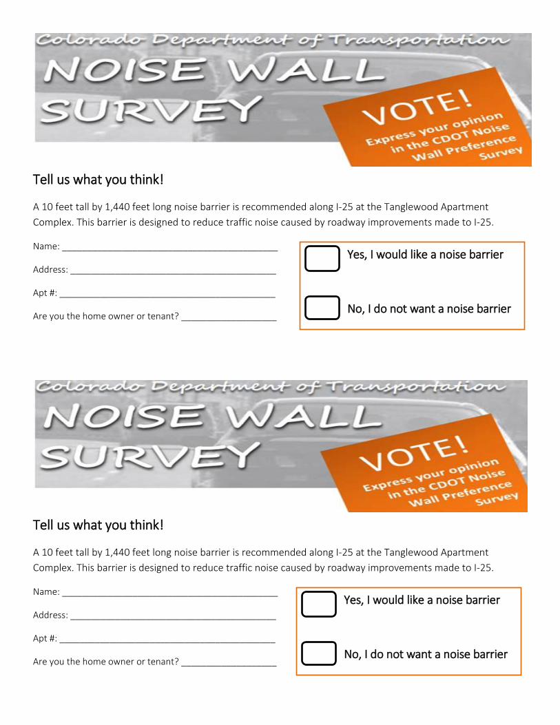
Tell us what you think!
A 10 feet tall by 1,440 feet long noise barrier is recommended along I-25 at the Tanglewood Apartment Complex. This barrier is designed to reduce traffic noise caused by roadway improvements made to I-25.
Name: ___________________________________________
Address: _________________________________________
Apt #: ___________________________________________
Are you the home owner or tenant? ___________________
Yes, I would like a noise barrier
No, I do not want a noise barrier
Yes, I would like a noise barrier
No, I do not want a noise barrier


December 3, 2014 Your Vote Counts! Noise Barrier Preference Decision North I-25 120th Avenue to State Highway 7 Managed Lanes Proposed Thorncreek Village Noise Wall Dear Property Owner or Resident:
What’s going on?
The Colorado Department of Transportation (CDOT) is currently conducting a study called the North I-25 Record of Decision (ROD) No.2 for the 120th Avenue to State Highway (SH) 7 Managed Lanes Project. The purpose of the project is to re-evaluate the benefits and impacts of adding a managed lane to the I-25 corridor between the 120th Avenue interchange and SH 7.
As a part of the North I-25 Corridor Final Environmental Impact Statement published in 2011, traffic noise was evaluated for the proposed roadway improvements. However, as of December 2011 available funding for work commitments outlined in the first ROD was insufficient to include the highway improvements for this segment of the project.
The second ROD, due to be published in late 2014, aims to augment the original ROD with new funding for construction of the managed lane between 120th Avenue and SH 7. Project construction is anticipated to begin during the summer of 2015 and last until late 2016.
As a part of this second ROD, the traffic noise study was re-evaluated to incorporate new homes and development that has occurred in the affected area since the issuance of the first ROD. The results of this new noise study show an increased traffic noise impact in the Thorncreek Village neighborhood, resulting in a recommendation for a noise wall 14 feet tall and 1,850 feet long to be located along the highway right-of-way. The wall is recommended for only those residential buildings that can achieve sufficient noise reduction from the wall to meet federal and state warrants for noise abatement. These warrants include acoustic and engineering feasibility, noise reductions sufficient to meet a 7 decibel design goal for at least one receptor, and cost-effectiveness.
What does CDOT need from you?
CDOT would like to know your preference for the noise barrier proposed near your location. This letter has been provided to all “benefitted” property owners and tenants in your neighborhood, i.e. those residents for whom a noise barrier would result in a noise reduction of 5 decibels or more.

Please return the enclosed survey ballot using the included self-addressed-stamped envelope by January 30, 2015. Please include your full name and address, whether you are the property owner or a tenant, and check off whether or not your wish to have a noise barrier constructed in your area. CDOT will consider one tenant vote and also one owner vote per address if the property is not owner occupied. If the property is owner occupied, that ballot will count as 2 votes. A simple majority of received yea or nay votes for the “benefited” residents in your neighborhood will decide the recommendation. All votes must be received by the close of business on January 30, 2015. CDOT will notify you the results of the survey later in 2015.
If you have additional questions please call the North I-25 Project Manager, Jennifer Gorek, at (970)350-2264. For additional information regarding traffic noise, regulations and policy, noise analyses, or noise abatement, we encourage you to access CDOT’s Noise Analysis and Abatement Guidelines at http://www.coloradodot.info/programs/environmental/noise. For additional North I-25 120th Avenue to SH 7 Managed Lanes Project information you can access the project website at http://www.coloradodot.info/projects/north-i-25-eis.
We appreciate your opinion and look forward to hearing from you. Sincerely,
Jennifer Gorek
North I-25 NEPA Project Manager

Tell us what you think!
A 14 feet tall by 1,850 feet long noise barrier is recommended along I-25 at Thorncreek Village. This barrier is designed to reduce traffic noise caused by roadway improvements made to I-25.
Name: ___________________________________________
Address: _________________________________________
Apt #: ___________________________________________
Are you the home owner or tenant? ___________________
Yes, I would like a noise barrier
No, I do not want a noise barrier
Yes, I would like a noise barrier
No, I do not want a noise barrier