Embed Size (px)
Citation preview

........................................................................................................................
APPENDIX C: CULTURAL RESOURCES C.1 Historical Assessments and Supporting Data C.2 Archaeological Resources Survey C.3 AB 52 Tribal Consultation

........................................................................................................................

........................................................................................................................
APPENDIX C.1: Historical Assessments and Supporting Data

........................................................................................................................

Tom Origer & Associates Archaeology / Historical Research
www.origer.com P.O. Box 1531, Rohnert Park, California 94927 (707) 584-8200
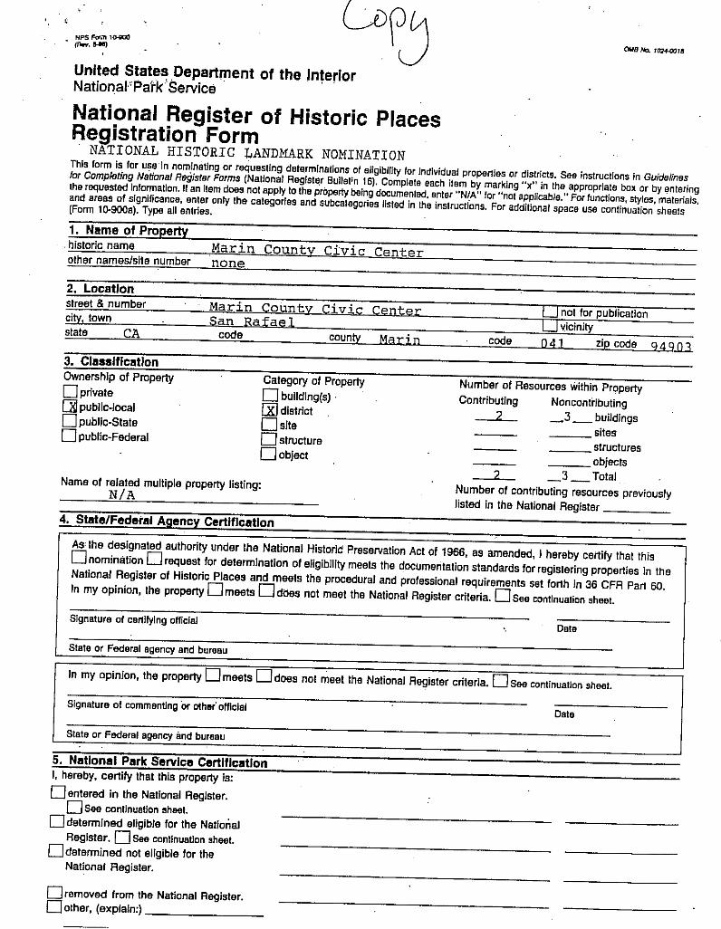
November 11, 2015
Paul A. Jensen, AICP
Community Development Director
City of San Rafael
1400 5th Avenue, 3
rd Floor
San Rafael, CA 94901
Re: Marin Civic Center Fire Station - architectural historical assessment
Dear Mr. Jensen:
The City of San Rafael is in the process of planning the demolition and reconstruction of Fire Station 57,
located at 3530 Civic Center Drive, San Rafael, Marin County, California. The fire station lies within the
boundaries of the Marin County Civic Center National Register District. This letter serves as the results of
our review to determine:
Will removal of the existing fire station affect the Marin County Civic Center National Register District
(and/or local register's) status?
Will the replacement fire station building affect the Marin County Civic Center National Register District
(and/or local register's) status?
Does the existing fire station have architectural or historical value?
To answer these questions, archival research and a site visit were conducted.
History/Background
The fire station was designed by Richard Graham of Backen, Arrigoni, and Ross Architects, and
constructed in 1977. Although the land is owned by the County of Marin, the City of San Rafael leases it
and contracted the design and construction of the building (City of San Rafael Building/Fire Prevention
Records 1977; Graham 1977; Sinnott, R. personal communication 2015).
Building Description
The fire station is a single story building on an L-shaped plan with a flat roof. Approximately half of the
building consists of two bays for the fire truck, and the remainder of the building is used for living, office,
and mechanic space. An enclosed patio is on the southwest corner. The only decorative feature of the
building is located on the east side, facing Civic Center Drive and the Marin County Civic Center. The
decorative feature consists of an arched overhang and rounded wedge-shaped window that visually
references the arches of the Marin County Civic Center.
Recommendations
Based on our archival research and site visit, the three questions outlined above can be answered.
Will removal of the existing fire station affect the Marin County Civic Center National Register
District (and/or local register's) status?

Paul A. Jensen
Page 2
November 11, 2015
When the Marin County Civic Center National Register District was created only the Hall of
Justice/Administration Building and the Post Office were found to be contributors to the district. The
nearby Veterans Auditorium, the exhibit hall adjacent to the Veterans Auditorium, and the what was
described as a garage but is now a building used by the Department of Public Works were found to be
non-contributors to the district (Woodbridge 1991). Since the district was created, the County Jail and the
Fire Station 57 were constructed within the district's boundaries. Fire Station 57 is a non-contributor to
the Marin County Civic Center National Register District because it was; 1) constructed after the period
of significance (1960-1970); and 2) was not designed by Frank Lloyd Wright. Because Fire Station 57 is
not a contributor to the Marin County Civic Center National Register District, demolishing it will not be
an adverse effect (significant impact) on the historic property (historical resource).
Will the replacement fire station building affect the Marin County Civic Center National Register
District (and/or local register's) status?
Construction of a new fire station within the Marin Civic Center National Register District should follow
the Secretary of the Interior's Standards (Weeks and Grimmer 1995) and the Marin County Civic Center
Master Design (Royston Hanamoto Alley & Abey 2005) guidelines.
The new fire station building should be designed to reflect the same architectural design and materials as
those designed by Frank Lloyd Wright for the Marin Civic Center. Wright's design principals are outlined
in the Marin County Civic Center Master Design (Royston Hanamoto Alley & Abey 2005) guidelines.
Does the existing fire station have architectural or historical value?
For purposes of the National Register, the importance of a historic resource is evaluated in terms of
criteria put forth in 36CFR60 (see below). Eligibility criteria for the California Register of Historical
Resources (CRHR) (Title 14 CCR, §4852) are very similar and will not be presented here.
The quality of significance is present in properties that possess integrity of location, design, setting,
materials, workmanship, feeling, and association, and:
A. That are associated with events that have made a significant contribution to the broad
patterns of our history; or
B. That are associated with the lives of persons significant in our past; or
C. That embody the distinct characteristics of a type, period, or method of construction, or
that represent the work of a master, or that possess high artistic values, or that represent a
significant and distinguishable entity whose components may lack individual distinction;
or
D. That have yielded or may be likely to yield, information important in prehistory or
history.
Additionally, the OHP advocates that all historical resources over 45 years old be recorded for inclusion
in the OHP filing system (OHP 1995:2), although professional judgment is urged in determining whether
a resource warrants documentation.
Per the criteria for inclusion on the National Register of Historic Places and the California Register of
Historical Resources, Fire Station 57 does not exhibit architectural features or characteristics that would

Paul A. Jensen
Page 3
November 11, 2015
make it eligible for inclusion in the Marin Civic Center National Register District nor as an independent
building. It does not have any historical importance. Because Fire Station 57 is not a contributor to the
Marin County Civic Center National Register District, and does not meet criteria for inclusion in the
National Register or the California Register, demolishing it will not be an adverse effect (significant
impact) on the historic property (historical resource). If the new station design is compatible with the
design philosophies of Frank Lloyd Wright, complies with the Secretary of the Interior’s Standards and
Guidelines, and the Marin County Civic Center Master Design guidelines, it will not be an adverse effect
(significant impact) on the historic property (historical resource).
Please contact us if you have any questions or need additional information.
Sincerely,
Eileen Barrow
Senior Associate

Paul A. Jensen
Page 4
November 11, 2015
Materials Consulted
City of San Rafael Building/Fire Prevention Records
1977 Building Permit for Assessor's Parcel Number 17927012. On file with the City of San Rafael,
San Rafael, California.
Graham, R.
1977 Construction Plans for San Rafael Civic Center Fire Station. On file with the City of San Rafael,
San Rafael, California.
Office of Historic Preservation (OHP)
1995 Instructions for Recording Historic Resources. Office of Historic Preservation, Sacramento.
Royston Hanamoto Alley & Abey
2005 Marin County Civic Center Master Design Guidelines. Document on file with the County of
Marin, San Rafael, California.
Weeks, K. and A. Grimmer
1995 The Secretary of the Interior’s standards for the treatment of historic properties: with guidelines
for preserving, rehabilitating, restoring & reconstructing historic buildings. U.S. Department of
the Interior National Park Service Cultural Resource Stewardship and Partnerships Heritage
Preservation Services, Washington, D.C.
Woodbridge, S.
1991 National Register of Historic Places Form #91002055 for the Marin County Civic Center.
Document on file at the Northwest Information Center, Sonoma State University, Rohnert Park,
California.


31 ■
EE
E
E
!
Edward Ave
MeriamDr
Mark Twain Ave
McInnis
Pkw
y
Las Gallinas Ave
El Prado Ave
LosR
anchit osR
d Garden
Ave
Civic Center Dr
NSan
Pedro
Rd
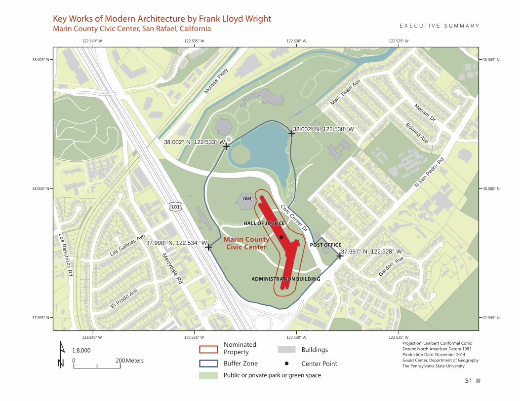
Marin CountyCivic Center37.998° N, 122.534° W
37.997° N, 122.528° W
38.002° N, 122.530° W
38.002° N, 122.533° W
£101
Merrydale Rd
1:8,000
0 200Meters
Projection: Lambert Conformal ConicDatum: North American Datum 1983Production Date: November 2014Gould Center, Department of GeographyThe Pennsylvania State University¹
122.525° W
122.525° W
122.530° W
122.530° W
122.535° W
122.535° W
122.540° W
122.540° W
38.005° N 38.005° N
38.000° N 38.000° N
37.995° N 37.995° N
NominatedProperty
Buffer Zone
Buildings
! Center Point
E X E C U T I V E S U M M A R Y
JAIL
HALL OF JUSTICE
ADMINISTRATION BUILDING
Key Works of Modern Architecture by Frank Lloyd WrightMarin County Civic Center, San Rafael, California
POST OFFICE
Public or private park or green space

For Immediate Release
January 30, 2015
Civic Center Nominated as World Heritage Site Inclusion pending for list of most significant cultural and natural places
San Rafael, CA – The Marin County Civic Center is one of 10 structures
designed by Frank Lloyd Wright nominated today for inclusion on the World Heritage List of the most significant cultural and natural sites on
the planet.
The U.S. Secretary of the Interior, Sally Jewell, announced the nomination of the Wright-designed buildings on Friday, and the UNESCO World
Heritage Committee will consider all nominations in the summer of 2016. If approved, the Marin County Civic Center would join 31 other American locations and more than 1,000 locations worldwide on the list, including
the Taj Mahal, Stonehenge, the Statue of Liberty, Independence Hall, Monticello, the Grand Canyon, and Yosemite and Yellowstone national
parks.
Sandra Fawn, Vice Chair of the Marin County Civic Center Conservancy Commission, called it a “monumental achievement and honor” for the Civic Center and the other 10 sites to be nominated. “The recognition of
the creative genius and vision of Frank Lloyd Wright is so well-deserved,” Fawn said. “We are extremely fortunate to have this architectural
masterpiece, our Marin County Civic Center, which illuminates the brilliance of Mr. Wright.”
The Wright group included in the nomination consists of the Marin County Civic Center; Unity Temple in Oak Park, Illinois; Frederick C. Robie House in Chicago; Taliesin in Spring Green, Wis.; Hollyhock House in Los
Angeles; Fallingwater in Mill Run, Pa.; Herbert and Katherine Jacobs House in Madison, Wis.; Taliesin West in Scottsdale, Ariz.; Solomon R.
Guggenheim Museum in New York City; Price Tower in Bartlesville, Okla. All were built between 1906-1969 and chosen for their significance in the development of modern architecture. They are considered the most iconic
and innovative of more than 400 existing Wright works.
The nomination will be submitted through the U.S. Department of State to the offices of the World Heritage Centre in Paris, then be reviewed by
-more-
Contact:
David Speer FACILITIES PLANNING
& DEVELOPMENT
MANAGER
Marin County Civic Center
3501 Civic Center Drive
Suite 325
San Rafael, CA 94903
415 473-6016 T
CRS Dial 711
[email protected] www.marincounty.org
PG. 2 OF 2 World Heritage Centre staff and by the International Council for Monuments and Sites. The Wright group would be the first World Heritage
listing for the United States in the field of modern architecture.
Wright is widely considered to be the greatest American architect of the 20th century. He died before he could see completion of the Marin County Civic Center, the only municipal building he ever designed (along with the
nearby post office on Civic Center Drive). The design work began in 1957 and was completed by Wright disciples William Wesley Peters and Aaron
Green in 1962. The County of Marin celebrated the golden anniversary of the building in 2012-13 with a year’s worth of special events.
See the nomination document and find more information on the U.S. nomination to the World Heritage List from the U.S. Department of the
Interior. ###

FOR IMMEDIATE RELEASE CONTACT: Janet Halstead Joel Hoglund Executive Director Communications Manager Frank Lloyd Wright Building Conservancy Frank Lloyd Wright Building Conservancy [email protected] / 312.663.5500 [email protected] / 312.663.5500
Key Works of Modern Architecture by Frank Lloyd Wright Nominated to the
UNESCO World Heritage List The collection of 10 buildings in seven states represents the first
modern architecture nomination from the United States to the World Heritage List.
A group of 10 buildings designed by Frank Lloyd Wright (1867-1959), widely considered to be the greatest American architect of the 20th century, have become the first works of modern architecture nominated by the United States to the United Nations Educational, Scientific and Cultural Organization (UNESCO) World Heritage List. The buildings—Unity Temple in Oak Park, Illinois; Frederick C. Robie House in Chicago, Illinois; Taliesin in Spring Green, Wisconsin; Hollyhock House in Los Angeles, California; Fallingwater in Mill Run, Pennsylvania; Herbert and Katherine Jacobs House in Madison, Wisconsin; Taliesin West in Scottsdale, Arizona; Solomon R. Guggenheim Museum in New York City; Price Tower in Bartlesville, Oklahoma; and Marin County Civic Center in San Rafael, California—were built between 1906–1969 and chosen for their significance in the development of modern architecture. They are the most iconic, fully realized and innovative of more than 400 existing works by Frank Lloyd Wright. Each is a masterwork and together they show varied illustrations of “organic architecture” in their abstraction of form, use of new technologies and masterful

2
integration of space, materials and site. All have been designated U.S. National Historic Landmarks. Throughout his career, Wright expressed organic architecture by integrating buildings with the natural world, melding form with space to create spatial drama. Inspired by nature and technology and seeking an alternative to European models, he used materials and structural forms in often new and innovative ways that relate to the geographically diverse United States. “Wright was the father of modern architecture, fundamentally redefining the nature of form and space during the early 20th century in ways that would have enduring impact on modern architecture worldwide,” says Richard Longstreth, director of the graduate program in historic preservation at George Washington University and president of the Frank Lloyd Wright Building Conservancy. The Conservancy, an organization dedicated to preserving the extant work of Wright, appointed an advisory committee of experts in 2003 to select the group of Wright buildings. It prepared the nomination through intensive collaboration with representatives from each of the 10 Wright sites and in consultation with the Office of International Affairs of the National Park Service. Lynda Waggoner, director of Wright’s internationally acclaimed Fallingwater, coordinated all aspects of preparation of the nomination dossier, entitled Key Works Modern Architecture by Frank Lloyd Wright. “It is a complex nomination that explains the significance of each building and its outstanding universal value,” says Waggoner. “We had to demonstrate how each represents a masterpiece of human creative genius and is an extraordinary contribution to modern architecture and culture.” Inscription to the List, which will be considered by UNESCO’S World Heritage Committee, could be decided in the summer of 2016 after a series of site visits during 2015. Inclusion in the List would mean the buildings and their sites are identified as being of outstanding value not only in their own country but to the global community and therefore must be preserved as part of the world heritage of mankind as a whole. The UNESCO honor would provide no specific protections but the designation draws international attention to these sites. Only 22 of the more than 1,000 World Heritage Sites worldwide are located in the United States, where the few inscribed works of architecture include Independence Hall and Monticello. The Wright works would join the Sydney Opera House, the city of Brasilia, the Bauhaus School in Germany and the works of Antoni Gaudí as some of the examples of modern architecture recognized on the international list. The nomination document is available for download at savewright.wordpress.com. More information on the U.S. nomination to the World Heritage List can be found at the U.S. Department of the Interior: http://www.doi.gov/news/pressreleases/index.cfm
3
About the buildings Unity Temple (1905, Oak Park, Illinois) Unity Temple is Frank Lloyd Wright’s only surviving public building from his Prairie period. Limited by a modest budget and an urban site, Wright created a bold design and used unconventional materials to produce a groundbreaking building. Constructed of exposed, poured-in-place reinforced concrete, Unity Temple was one of the earliest uses of the low-cost, revolutionary new material in a public, non-industrial building. While the unpainted concrete exterior is presented as a solid cubic mass, the interior is its opposite—spaces are floating, colored planes held together by lighting from above. Today, its auditorium/worship space is still used for religious services, performance, assembly and as a meeting hall. Frederick C. Robie House (1908, Chicago, Illinois) The Robie House is the most famous and most influential of Frank Lloyd Wright’s Prairie houses. Its brilliance lies in the use of horizontal lines to dramatically reflect the United States’ Midwestern prairie landscape, which the house came to signify for the world at large. At the time of its creation, the dynamic and open flow of space forming the living and dining rooms was a radical conception of modern living space. Equally significant is the dissolution of more traditional solid walls into intersecting and floating planes that define, rather than contain, interior space. In the ’40s and ’50s the house was threatened with demolition. Today, the house is owned by the University of Chicago and operated as a museum by the Frank Lloyd Wright Trust. Taliesin (begun 1911, Spring Green, Wisconsin) Taliesin was designed as a home and studio for Frank Lloyd Wright. Rebuilt and expanded after two major fires, it grew and evolved over half a century under Wright’s direction. Most of the rooms are entered at a corner, resulting in dynamic diagonal sight lines that emphasize the interior space and extend the view through horizontal bands of windows beyond the house and out to the landscape. The careful, sensitive site planning and the use of many native materials reinforce Taliesin’s integration of building and landscape, making it a supreme expression of domestic architecture in the United States in its openness to nature. The Taliesin estate remains in the ownership of the Frank Lloyd Wright Foundation and has continued to be used by the Taliesin Fellowship and the Frank Lloyd Wright School of Architecture as a summer residence and campus. Taliesin Preservation, Inc. conducts public tours of the estate April–November. Hollyhock House (1918, Los Angeles, California) Frank Lloyd Wright’s first southern California commission, Hollyhock House works with a vocabulary of forms referring broadly to the histories of Spanish California and pre-Columbian Mexico. Wright created a unique expression of southern California, reflecting regionalism in a truly modern form through sculpture and other decorative art forms, including an abstraction of a hollyhock flower. All spaces open into the central patio, making it “half house and half garden” with multilevel rooftop terraces that encircle the patio court linked together with bridges and stairways. Client Aline Barnsdall wanted Wright to create an arts complex that would include a theater for the production of

4
avant-garde plays, a cinema, studios for artists, housing for actors and directors, and a personal residence. Today Hollyhock House is open for tours as a house museum and also contains exhibition space. Fallingwater (1935, Mill Run, Pennsylvania) Fallingwater is among the world’s best-known private residences. An astonishing construction and a consummate example of the union of architecture and nature, the house was designed as a series of three horizontal trays (floors), stacked one upon the other that appear to soar with no support, outward over a 30-foot waterfall below. Fallingwater masterfully integrates reinforced concrete, steel, and glass—along with the natural materials of wood and native stone—to create a unique building whose daring cantilevered construction stretched the limits of design and technology of the period. Fallingwater is also an astonishing expression of its physical site: the house cascades down the hillside like the water over the rocks below. Today the house is a museum operated by the Western Pennsylvania Conservancy. Herbert and Katherine Jacobs House (1936, Madison, Wisconsin) Ranked by the American Institute of Architects as one of the 20 most important residential designs of the 20th century, the Jacobs House was designed and built for a family of ordinary means, a response to the evolving economic and social conditions of the country during the Great Depression and the era of expanding suburbs in the United States. It uses the most basic geometric forms and materials to create economical, small spaces and elegant but minimalist design. The efficient spatial design is warmed by the reliable, simple materials of brick and gleaming wood. In the living room a comparatively high ceiling and series of full-height glazed doors open onto a terrace and garden, creating a continuous in-and-out flow and offering a sense of spaciousness rarely found in houses of its size. The house is privately owned and maintained as a private residence; it is open by appointment for public tours. Taliesin West (begun 1938, Scottsdale, Arizona) The building of Taliesin West, Frank Lloyd Wright’s winter home and studio, occupied the last 20 years of his life. In the numerous structures of Taliesin West, the architect explored new construction techniques and design concepts and experimented with new materials—all specific to the desert context—which he later used in designs for clients. Primitive feeling “desert rubble stone” masonry is created from small boulders and stones found at the site that are consolidated with concrete to create a mosaic-like surface for the masonry walls. The ensemble of structures can be likened to a vast outdoor home whose strong angular shapes echo the landscape. Taliesin West continues to house the offices of the Frank Lloyd Wright Foundation, the site’s owner; a small group of members of the Taliesin Fellowship, the resident staff and students who live and work at Taliesin and Taliesin West; and the Frank Lloyd Wright School of Architecture. The site is open year-round for public tours. Solomon R. Guggenheim Museum (1943, New York, New York) The Solomon R. Guggenheim Museum is among the most visited sites in New York City, with more than 1 million visitors annually. While the building has undergone some

5
modifications, including an addition, it nonetheless remains an internationally recognized icon of modern architecture that follows Wright’s design as it was at completion in 1959. The Guggenheim established and continues to set the standard of the idea that a modern museum would, by its form, characterize the art it was intended to house and create a new type of space for new types of art. Indeed the building itself is a sculptural form. Its spiral ramp and interlocking forms create a unique design on the exterior and an unprecedented interior space under a sky-lit dome. Its modern aesthetic and sculptural qualities boldly distinguish the Guggenheim from its more traditionally styled neighbors. Price Tower (1952, Bartlesville, Oklahoma) Price Tower, Frank Lloyd Wright’s only realized freestanding skyscraper, redefined the form, releasing the tower from the constraints of the more common four-sided, minimally ornamented “glass box” format of the 1950s. The building, whose 19 floors are cantilevered and taper outward like tree branches with embossed, patinated copper cladding and sun louvers, has changed little since its 1956 completion. The building was conceived and designed to serve as a multipurpose tower for commercial as well as residential uses. It is currently home to owner the Price Tower Arts Center, as well as a hotel, the Inn at Price Tower, museum space and offices. Marin County Civic Center (1957, San Rafael, California) The Marin County Civic Center is one of the last major works of Frank Lloyd Wright’s career and his only realized project for a government entity. An innovative design that simultaneously houses in one structure all of the functions of county government and serves as a focal point for civic and cultural engagement, it dramatically illustrates the kinship of architecture to the surrounding landscape with long horizontal buildings that gracefully link the crowns of three separate hills. Wright boldly projected the main government building as a bridge joining one hill to the next with a series of graceful arches sheltered under barrel-vaulted roofs. Its forms and colors relate it to surrounding hills and to the mountains of the Coastal Range in the distance. The building combines multiple elements into a unified structure linked by an internal, sky-lit, and multistory galleria.
###

This page intentionally blank

........................................................................................................................
APPENDIX C.2: Archaeological Resources Survey

........................................................................................................................

An Archaeological Resources Survey of the
Marin Civic Center Fire Station
Novato, Marin County, California
Rachel Hennessy
and
Janine Origer, M.A. / R.P.A.
January 14, 2016
An Archaeological Resources Survey of the
Marin Civic Center Fire Station
Novato, Marin County, California
Prepared by:
__________________________________
Rachel Hennessy
and
Janine Origer, M.A. / R.P.A.
Tom Origer & Associates
Post Office Box 1531
Rohnert Park, California 94927
(707) 584-8200
Prepared for:
Paul A. Jensen, AICP
Community Development Director
City of San Rafael
1400 5th Avenue, 3
rd Floor
San Rafael, CA 94901
January 14, 2016

i
ABSTRACT
Tom Origer & Associates conducted an archaeological survey for the Marin Civic Center Fire Station
in San Rafael, Marin County, California. A review of the built environment within the study area was
completed separately (Barrow 2015). The study was prepared at the request of Paul A. Jensen, Com-
munity Development Director of the City of San Rafael and was designed to satisfy requirements of
the California Environmental Quality Act (CEQA). The City proposes to replace the existing fire sta-
tion with a more effective facility. Field survey found no prehistoric or historical resources within the
study area. Documentation pertaining to this study is on file at the offices of Tom Origer & Associates
(File No. 16-004S).
This study included archival research at the Northwest Information Center, Sonoma State University
(NWIC File No. 15-0599), examination of the library and files of Tom Origer & Associates, contact
with Native American representatives, and field inspection of the study area.
Synopsis
Project: Marin Civic Center Fire Station
Location: 3530 Civic Center Drive, Marin County, California
Quadrangle: San Rafael, California 7.5’ series
Study Type: Intensive survey
Scope: ~1-acre
Finds: None

ii
CONTENTS
ABSTRACT ............................................................................................................................................I Synopsis .............................................................................................................................................. i
INTRODUCTION .................................................................................................................................. 1
REGULATORY CONTEXT .................................................................................................................. 1 Resource Definitions .......................................................................................................................... 1 Significance Criteria ........................................................................................................................... 2
PROJECT SETTING .............................................................................................................................. 3 Study Area Location and Description ................................................................................................ 3 Cultural Setting .................................................................................................................................. 3
STUDY PROCEDURES AND FINDINGS ........................................................................................... 4 Native American Contact ................................................................................................................... 5 Paleontological Research ................................................................................................................... 5 Archival Study Procedures ................................................................................................................. 5 Archival Study Findings ..................................................................................................................... 5 Field Survey Procedures ..................................................................................................................... 6 Field Survey Findings ........................................................................................................................ 6
RECOMMENDATIONS ........................................................................................................................ 6 Known Resources ............................................................................................................................... 6 Accidental Discovery ......................................................................................................................... 6
SUMMARY ............................................................................................................................................ 7
MATERIALS CONSULTED ................................................................................................................. 7
FIGURES
Figure 1. Project vicinity ........................................................................................................................ 1 Figure 2. Study location ......................................................................................................................... 4

INTRODUCTION
Tom Origer & Associates conducted an archaeological resources survey for the Marin Civic Center Fire
Station in San Rafael, Marin County, California (Figure 1). The study was completed at the request of
Paul A. Jensen, Community Development Director of the City of San Rafael. The City of San Rafael pro-
poses to replace the existing station with a more modern and effective facility. The study was designed to
satisfy requirements of the California Environmental Quality Act (CEQA). Documentation pertaining to
this study is on file at Tom Origer & Associates (File No. 16-004S).
REGULATORY CONTEXT
The California Environmental Quality Act (CEQA) requires that cultural resources be considered during
the environmental review process. This is accomplished by an inventory of resources within a study area
and by assessing the potential that cultural resources could be affected by development.
This cultural resources survey was designed to satisfy environmental issues specified in the CEQA and its
guidelines (Title 14 CCR §15064.5) by: (1) identifying all cultural resources within the project area; (2)
offering a preliminary significance evaluation of the identified cultural resources; (3) assessing resource
vulnerability to effects that could arise from project activities; and (4) offering suggestions designed to
protect resource integrity, as warranted.
Figure 1. Project vicinity (adapted from the 1970 Santa Rosa 1:250,000-scale USGS map).
Resource Definitions
Cultural resources are classified by the State Office of Historic Preservation (OHP) as sites, buildings,
structures, objects and districts, and each is described by OHP (1995) as follows.

Site. A site is the location of a significant event, a prehistoric or historic occupation or activi-
ty, or a building or structure, whether standing, ruined, or vanished, where the location itself
possesses historic, cultural, or archaeological value regardless of the value of any existing
structure.
Building. A building, such as a house, barn, church, hotel, or similar construction, is created
principally to shelter any form of human activity. "Building" may also be used to refer to a
historically and functionally related unit, such as a courthouse and jail, or a house and barn.
Structure. The term "structure" is used to distinguish from buildings those functional con-
structions made usually for purposes other than creating human shelter.
Object. The term "object" is used to distinguish from buildings and structures those construc-
tions that are primarily artistic in nature or are relatively small in scale and simply construct-
ed. Although it may be, by nature or design, movable, an object is associated with a specific
setting or environment.
District. A district possesses a significant concentration, linkage, or continuity of sites, build-
ings, structures, or objects united historically or aesthetically by plan or physical develop-
ment.
Significance Criteria
When a project might affect a cultural resource, the project proponent is required to conduct an assess-
ment to determine whether the effect may be one that is significant. Consequently, it is necessary to de-
termine the importance of resources that could be affected. The importance of a resource is measured in
terms of criteria for inclusion on the California Register of Historical Resources (Title 14 CCR, §4852) as
listed below. A resource may be important if it meets any one of the criteria below, or if it is already listed
on the California Register of Historical Resources or a local register of historical resources.
An important historical resource is one which:
1. Is associated with events that have made a significant contribution to the broad patterns of lo-
cal or regional history, or the cultural heritage of California or the United States.
2. Is associated with the lives of persons important to local, California, or national history.
3. Embodies the distinctive characteristics of a type, period, region or method of construction, or
represents the work of a master or possesses high artistic values.
4. It has yielded, or may be likely to yield, information important to the pre-history or history of
the local area, California, or the nation.
In addition to meeting one or more of the above criteria, eligibility for the California Register requires
that a resource retains sufficient integrity to convey a sense of its significance or importance. Seven ele-
ments are considered key in considering a property’s integrity: location, design, setting, materials, work-
manship, feeling, and association.

The OHP advocates that all historical resources over 45 years old be recorded for inclusion in the OHP
filing system (OHP 1995:2), although the use of professional judgment is urged in determining whether a
resource warrants documentation.
PROJECT SETTING
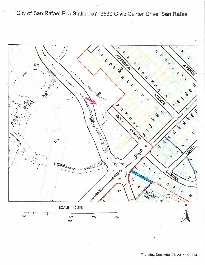
Study Area Location and Description
The study area is located in southeast Marin County, as shown on the San Rafael and Novato, California
7.5’ USGS topographic map (Figure 2). The study area consists of approximately one acre of developed,
flat land. Two fresh water sources are within a half mile of the study area. A seasonal creek is located a
quarter mile east and an unnamed creek is located half a mile west of the study area. At present there is
one building on the parcel.
Soils mapped within the study area are of the Xerorthents-Urban land complex (Kashiwagi 1985:Sheet
12). These soil complexes are typically found on valley floors, cut toe slopes, and on tide lands or in bay
areas covered with fill (Kashiwagi 1985:78-79). Xerorthents soils are cut/fill areas that vary greatly in
depth and drainage, which are commonly intermixed with development debris (Kashiwagi 1985:78-79).
Urban land consists of areas covered by roads, houses, and other similar development. Parcels consisting
of these soils have been used historically for urban development.
The geology of the study area is Holocene alluvium (QaL), consisting of sand, silt, gravel, and clay
(Blake et al. 2000).
Cultural Setting
Archaeological evidence indicates that human occupation of California began at least 11,000 years ago
(Erlandson et al. 2007:59). Early occupants in the San Francisco Bay Area appear to have had an econo-
my based largely on hunting, with limited exchange, and social structures based on extended family units
(Milliken et al. 2007:99-123). Later, milling technology (e.g., mortars and pestles) and an inferred acorn
economy were introduced. This diversification of economy appears coeval with the development of
sedentism, population growth, and expansion. Sociopolitical complexity and status distinctions based on
wealth are also observable in the archaeological record, as evidenced by an increased range and distribu-
tion of trade goods (e.g., shell beads, obsidian tool stone), which are possible indicators of both status and
increasingly complex exchange systems.
At the time of European settlement, the study area was included in the territory controlled by the Coast
Miwok (Kelly 1978:414). The Coast Miwok were hunter-gatherers who lived in rich environments that
allowed for dense populations with complex social structures (Barrett 1908; Kroeber 1925). They settled
in large, permanent villages about which were distributed seasonal camps and task-specific sites. Primary
village sites were occupied throughout the year, and other sites were visited in order to procure particular
resources that were especially abundant or available only during certain seasons. Sites often were situated
near fresh water sources and in ecotones where plant life and animal life were diverse and abundant.

Figure 2. Study location (adapted from the USGS 1995 San Rafael and 1954 [photorevised 1980] Novato 7.5’ map).

STUDY PROCEDURES AND FINDINGS
Native American Contact
The City of San Rafael consulted the Federated Indians of Graton Rancheria in compliance with AB52.
Paleontological Research
A paleontological review was completed at the University of California Museum of Paleontology
(UCMP) at the University of California, Berkeley. Results concluded no vertebrae localities were present
within six miles of the study area.
Archival Study Procedures
Archival research included examination of the library and project files at Tom Origer & Associates. A
review (NWIC File No. 15-0599) was completed of the archaeological site base maps and records, survey
reports, and other materials on file at the Northwest Information Center (NWIC), Sonoma State Universi-
ty, Rohnert Park. Sources of information included but were not limited to the current listings of properties
on the National Register of Historic Places (National Register), California Historical Landmarks, Califor-
nia Register of Historical Resources (California Register), and California Points of Historical Interest as
listed in the Office of Historic Preservation’s Historic Property Directory (OHP 2012).
The Office of Historic Preservation has determined that structures older than 45 years should be consid-
ered potentially important historical resources, and former building and structure locations could be po-
tentially important historic archaeological sites. Archival research included an examination of historical
maps to gain insight into the nature and extent of historical development in the general vicinity, and espe-
cially within the study area. Maps ranged from hand-drawn maps of the 1800s (e.g., GLO plats) to topo-
graphic maps issued by the United States Geological Survey (USGS) and the Army Corps of Engineers
(USACE) from the early to the middle 20th century.
In addition, ethnographic literature that describes appropriate Native American groups, county histories,
and other primary and secondary sources were reviewed. Sources reviewed are listed in the "Materials
Consulted" section of this report.
Archival Study Findings
Archival research found that four studies have been conducted within a quarter-mile of the study area
(Holman 1976; Koenig 2010; Kelley 2012; Darko 2014). There are two recorded cultural resources within
a quarter-mile of the study area (Nelson 1907). Base maps at the NWIC show that site P-21-540 is located
approximately 400 feet west of the study area; however, the record is missing from their files. Neither site
has the potential to extend into the study area.
The ethnographic village of Awa'niwī was reported as being located in the northern part of the town of
San Rafael (Barrett 1908). This places the village of Awa'niwī one mile and one-quarter south of the
study area.
Review of historical maps found no buildings within the study area (General Land Office 1871, 1923;
USGS 1897, 1941, 1954, 1950). The fire station was constructed in 1977 and designed by Richard Gra-
ham of Backen, Arrigoni, and Ross Architects. By 1980, the fire station appears on USGS maps (USGS
1980).

Field Survey Procedures
A field survey investigation was completed by Rachel M. Hennessy and Thomas M. Origer. The approx-
imately one-acre study area was examined intensively by walking in a zigzag pattern within corridors 20
meters wide. Surface visibility was good. Three auger borings were conducted within the study area. The
first boring was done in the western corner of the study area, yielding a hole of approximately four feet
below ground surface. The second boring was done in the northern corner of the study area, yielding a
hole of approximately two feet below ground surface. The third boring was done in the southern portion
of the study area near the employee parking lot, yielding a hole of approximately three feet below ground
surface.
Based on the distribution of known cultural resources and their environmental settings, it was anticipated
that prehistoric archaeological sites could be found within the study area. Prehistoric archaeological site
indicators expected to be found in the region include but are not limited to: obsidian and chert flakes and
chipped stone tools; grinding and mashing implements such as slabs and handstones, and mortars and
pestles; bedrock outcrops and boulders with mortar cups; and locally darkened midden soils containing
some of the previously listed items plus fragments of bone, shellfish, and fire affected stones. Historic
period site indicators generally include: fragments of glass, ceramic, and metal objects; milled and split
lumber; and structure and feature remains such as building foundations and discrete trash deposits (e.g.,
wells, privy pits, dumps).
Field Survey Findings
No prehistoric or historical archaeological sites were found within the study area.
RECOMMENDATIONS
Known Resources
No prehistoric or historical archaeological sites were found within the study area, and no resource-
specific recommendations are made.
Accidental Discovery
Based on geology and distance to near water sources, the potential for buried prehistoric archaeological
sites is low, as established by Meyer and Rosenthal (1997).
Although there is a low possibility that buried archaeological deposits could be present, there is the slight
possibility that buried archaeological deposits could be present, and accidental discovery could occur. In
keeping with the CEQA guidelines, if archaeological remains are uncovered, work at the place of discov-
ery should be halted immediately until a qualified archaeologist can evaluate the finds (§15064.5 [f]).
Prehistoric archaeological site indicators include: obsidian and chert flakes and chipped stone tools;
grinding and mashing implements (e.g., slabs and handstones, and mortars and pestles); bedrock outcrops
and boulders with mortar cups; and locally darkened midden soils. Midden soils may contain a combina-
tion of any of the previously listed items with the possible addition of bone and shell remains, and fire
affected stones. Historic period site indicators generally include: fragments of glass, ceramic, and metal
objects; milled and split lumber; and structure and feature remains such as building foundations and dis-
crete trash deposits (e.g., wells, privy pits, dumps).

The following actions are promulgated in Public Resources Code 5097.98 and Health and Human Safety
Code 7050.5, and pertain to the discovery of human remains. If human remains are encountered, excava-
tion or disturbance of the location must be halted in the vicinity of the find, and the county coroner con-
tacted. If the coroner determines the remains are Native American, the coroner will contact the Native
American Heritage Commission. The Native American Heritage Commission will identify the person or
persons believed to be most likely descended from the deceased Native American. The most likely de-
scendent makes recommendations regarding the treatment of the remains with appropriate dignity.
SUMMARY
Tom Origer & Associates conducted a cultural resources survey for the Marin Civic Center Fire Station in
San Rafael, Marin County, California. The study was completed at the request of Paul A. Jensen, Com-
munity Development Director of the City of San Rafael. Survey found no prehistoric or historical re-
sources within the study area and no resources-specific recommendations were warranted.
MATERIALS CONSULTED
Barrett, S.
1908 The Ethno-Geography of the Pomo and Neighboring Indians. University of California Publica-
tions in American Archaeology and Ethnology Vol. 6(1). University of California Press, Berke-
ley.
Blake, M., R. Graymer, and D. Jones
2000 Geologic Map and Map Database of Parts of Marin, San Francisco, Alameda, Contra Costa, and
Sonoma Counties, California. http://ngmdb.usgs.gov/Prodesc/proddesc_23459.htm accessed
online December 21, 2015.
City of San Rafael Building/Fire Prevention Records
1977 Building Permit for Assessor's Parcel Number 17927012. On file with the City of San Rafael,
San Rafael, California.
Darko, E.
2014 Archaeological Survey Report for the Proposed Freeway Performance Initiative Project. Marin
County, California. 04-MRN-101, PM 0.0/27.6. 04-MRN-580, PM 2.4/4.5. EA 151600. Docu-
ment S-44351 on file at the Northwest Information Center, Sonoma State University, Rohnert
Park.
Dodge, G.
1892 Official Map of Marin County, California. Schmidt Label & Lith. Co., San Francisco.
Erlandson, J. T. Rick, T. Jones, J. Porcasi
2007 One if by Land, Two if by Sea: Who Were the First Californians? In: California Prehistory: Col-
onization, Culture, and Complexity. (pp 53-62) T. Jones and K. Klar, editors. AltaMira Press.
Lanham, MD.
Fredrickson, D.
1984 The North Coastal Region. In California Archaeology, edited by M. Moratto. Academic Press,
San Francisco.

General Land Office
1862 Plat of the Rancho San Jose (Pacheco). Department of the Interior, Washington, D.C.
Holmon, P.
1976 Cultural Resources Survey Report Archaeology - Las Gallinas Valley Wastewater Reclamation
Project. Document S-12946 on file at the Northwest Information Center, Sonoma State Universi-
ty, Rohnert Park.
Hoover, M., H. Rensch, E. Rensch, W. Abeloe
1966 Historic Spots in California. 3rd ed., Stanford University Press. Stanford.
Hoover, M., H. Rensch, E. Rensch, W. Abeloe, and D. Kyle
1990 Historic Spots in California. 4th ed., Stanford University Press. Stanford.
2002 Historic Spots in California. 5th edition, Stanford University Press. Stanford.
Kashiwagi, J.
1985 Soil Survey of Marin County, California. United States Department of Agriculture Soil Conserva-
tion Service in cooperation with the University of California Agricultural Experiment Station.
Kelly, I.
1978 Coast Miwok. In California, edited by R. Heizer, pp. 414-425. Handbook of North American In-
dians, Vol. 8, W. Sturtevant, general editor. Smithsonian Institution, Washington, D.C.
Kelley, J.
2012 Archaeological Survey Report for the Venetia Valley Pedestrian Improvements Project, San Ra-
fael, Marin County, California. Document S-39183 on file at the Northwest Information Center,
Sonoma State University, Rohnert Park.
Koenig, H.
2011 Emergency Operating Facility Project. San Rafael, Marin County, California. Document S-
37738 on file at the Northwest Information Center, Sonoma State University, Rohnert Park.
Kroeber, A.
1925 Handbook of the Indians of California. Bureau of American Ethnology, Bulletin 78, Smithsonian
Institution, Washington, D.C.
Meighan, C.
1955 Archaeology of the North Coast Ranges, California. Reports of the University of California Ar-
chaeological Survey No. 30. Berkeley.
Meyer, J. and J. Rosenthal
1997 Archaeological and Geoarchaeological Investigations at Eight Prehistoric Sites in the Los
Vaqueros Reservoir Area, Contra Costa County, California. Anthropological Studies Center,
Sonoma State University Academic Foundation, Rohnert Park, California.

Milliken, R., R. Fitzgerald, M. Hylkema, R. Groza, T. Origer, D. Bieling, A. Leventhal, R. Wiberg, A.
Gottsfield, D. Gillette, V. Bellifemmine, E. Strother, R. Cartier, and D. Fredrickson.
2007 Punctuated Culture Change in the San Francisco Bay Area. In: California Prehistory: Coloniza-
tion, Culture, and Complexity. (pp 99-123) T. Jones and K. Klar, editors. AltaMira Press. Lan-
ham, MD.
Moratto, M.
1984 California Archaeology. Academic Press, San Francisco.
Office of Historic Preservation
1995 Instructions for Recording Historic Resources. Office of Historic Preservation, Sacramento.
2012 Historic Property Directory. Office of Historic Preservation, Sacramento.
State of California Department of Parks and Recreation
1976 California Inventory of Historic Resources. Department of Parks and Recreation, Sacramento.
United States Army Corps of Engineers
1941 Mt. Tamalpais, California. 15' map. Geological Survey, Washington, D.C.
United States Geological Survey
1897 Mt. Tamalpais, California. 15' map. Geological Survey, Washington, D.C.
1950 Mt. Tamalpais, California. 15' map. Geological Survey, Washington, D.C.
1954 San Rafael, California. 7.5' map. Geological Survey, Washington, D.C.
1980 San Rafael, California. 7.5' map. Geological Survey, Washington, D.C.
1993 San Rafael, California. 7.5' map. Geological Survey, Washington, D.C.
1995 San Rafael, California. 7.5' map. Geological Survey, Washington, D.C.

This page intentionally blank

........................................................................................................................
APPENDIX C.3: AB 52 Tribal Consultation

........................................................................................................................


This page intentionally blank