Embed Size (px)
Citation preview

Appendix C-2 Survey of habitats, weeds & observations on red
goshawk nest sites for Andranangoo haul road

MATILDA MINERALS PTY LTD
TIWI ISLANDS PROJECT —ANDRANANGOO PROSPECT
SURVEY OF HABITATS, WEEDS & OBSERVATIONS ON RED GOSHAWK NEST SITES
for ANDRANANGOO HAUL ROAD
May 2005
Prepared for
by …………………………………………...……………………….……….… KRISTIN METCALFE CONSULTANT ENVIRONMENTAL SCIENTIST

Matilda Minerals – Tiwi Islands Project SUMMARY
KRISTIN METCALFE CONSULTANT ENVIRONMENTAL SCIENTIST 2
MATILDA MINERALS – TIWI ISLANDS PROJECT
ANDRANANGOO HAUL ROAD
FIELD REPORT - SUMMARY
• Field surveys, including weed assessment, of habitats occurring along the
proposed haul road to the Andranangoo Prospect on Melville Island were conducted on 27th to 29th May 2005
• The proposed road corridor, particularly those areas in which vegetation clearing will occur, was surveyed for the presence of nests of the Red Goshawk. This bird is considered an endangered species, but is unusually common on Melville Island (36% of the 330 birds in the NT occur there).
• The proposed 64 km haul road alignment was traversed four times with key sections of the route (total of 30.8 km) surveyed on foot)
• Potential environmental impacts of construction of the haul road are discussed in relation to these key issues- Red Goshawks, weed introduction and spread and habitats
Red Goshawk • No Red Goshawks (Erythrotriorchis radiatus), which are formally classified
as vulnerable under NT and Commonwealth conservation laws, were sighted during the field survey
• Two species of raptor were observed soaring over the survey area—the Brown Goshawk and the Brown Falcon, but these species are common and do not have special conservation status.
• No raptor nests were observed in trees occurring within aproximately 20m to either side of the proposed haul road alignment
• Vegetation in the coastal section of the alignment has been quite severely damaged by Cyclone Ingrid in January 2005 and any existing nests would have been destroyed. Consequently the focus of the bird survey was within the first 42 kilometers, which experienced less intense cyclone damage.
Other Bird Species • Bird surveys were conducted along the road corridor with a total of 40
species observed. • The birds recorded were typical of species commonly occurring in savannah
woodland habitats across the Top End • One bird species the Partridge Pidgeon (recorded in the central section of the
route) is classified as near threatened in the NT (Territory Parks and

Matilda Minerals – Tiwi Islands Project SUMMARY
KRISTIN METCALFE CONSULTANT ENVIRONMENTAL SCIENTIST 3
Wildlife Conservation Act,2000) and vulnerable under commonwealth legislation (Environment Protection and Biodiversity Conservation Act,1999). However, construction of the haul road is unlikely to have a significant impact on the population of this species, whose habitat and home range is highly unlikely to be confined to the road corridor.
Weeds • The 64 km haul road alignment (and also tracks in the Pickertaramoor area)
were surveyed for the presence of weeds. All tracks were divided into 1 kilometer sections and any introduced species present within these sections were recorded
• A total of 17 species of weeds were observed during the survey, 3 of which are declared Class B noxious speices (growth and spread to be controlled by landholders).
• The proposed haul road alignment is currently almost weed free • Only 5 weed species were recorded along the entire route and these were
present in extremely low densities – typically only associated with the increased moisture occurring along drainage ways
• The proposed rutile extraction area and the mining camp are currently weed free but local disturbance makes this area highly vulnerable to weed invasion
• The Pickertaramoor area (the site of an abandoned settlement) is heavily infested with weeds, indicating previous disturbance to the site
• Several introduced species found in cultivation eg Rain Tree, Bougainvillea and Heliconias are also found at Pickertaramoor
• The current haul road does not pass through this area and mine traffic should avoid the area to prevent the spread of weeds
• Weed introductions are most likely to occur by the spread of seed by increased vehicular traffic from areas such as Pickertaramoor and the surrounding communities with existing dense weed infestations.
• No Gamba Grass (Andropogon gayanus) or Mission Grass (Pennisetum polystachion) were observed. Preventing the introduction and spread of these serious environmental weeds should be given high priority
• Regular weed surveys and implementation of a weed management plan for the site can prevent introductions which is more cost-effective than control
Habitats • The vegetation traversed by the proposed haul road is very uniform,
comprising mainly Eucalyptus-dominated communities. • Small areas of mixed species shrubland are traversed by the route typically
indicating areas of poor seasonal drainage • No vegetation communities of conservation significance are traversed by the
road alignment • Vegetation structure varies from open woodland (trees widely spaced),
woodland (mid-dense trees) to open forest (dense trees)

Matilda Minerals – Tiwi Islands Project SUMMARY
KRISTIN METCALFE CONSULTANT ENVIRONMENTAL SCIENTIST 4
• Cyclone damage to canopy trees increases in intensity closer to the coast, with moderate to severe damage observed from km 52 and with the most intense damage from kilometer 60 onwards
• Trees on the ridges experienced the most severe damage with the highest proportion of windthrown trees, bole breakage and branch loss.
• An area of black-soil occurs in association with a small drainage line between kilometer 47 and kilometer 48. This area is likely to be seasonally inundated or boggy for extended periods of the year. It is recommended that the road alignment be relocated slightly to the east of this area of black soil to avoid the environmental and drainage issues associated traversing a drainage way.
• The final 4 kilometers of the haul road (not marked or cleared at the time of the survey) traversed cyclone-damaged upland Eucalypt dominated open forest habitat.
• Environmentally, this alignment for the access road to the mining camp is preferable to the existing track (to the west of the mine site) which traverses seasonal wetland habitats including Lophostemon woodland and Melaleuca (Paperbark) communities.
• Overall, the potential for environmental degradation (from erosion, changes in drainage, pollution, weed introduction) is higher in wetland areas and they should be avoided for these reasons.

Matilda Minerals – Tiwi Islands Project
KRISTIN METCALFE CONSULTANT ENVIRONMENTAL SCIENTIST 5
MATILDA MINERALS – TIWI ISLANDS PROJECT
ANDRANANGOO HAUL ROAD 1. INTRODUCTION................................................................................................................................. 6
2. METHODOLOGY ................................................................................................................................ 6
3. THE EXISTING ENVIRONMENT - HABITATS .......................................................................... 6
3.1. VEGETATION COMMUNITIES TRAVERSED BY THE HAUL ROAD ..................... 6 3.1.1. UPLAND COMMUNITIES.................................................................................................. 8 3.1.2. LOWLAND COMMUNITIES.............................................................................................. 8 3.1.3. COASTAL COMMUNITIES ................................................................................................ 9
4. PLANT SPECIES AND VEGETATION COMMUNITIES OF CONSERVATION SIGNIFICANCE............................................................................................................................................ 10
5. ENVIRONMENTAL IMPACT ASSESSMENT -NOTES........................................................... 12
5.1. ACCESS ROAD – ANDRANANGOO WEST PROSPECT................................... 12 5.2. MINING CAMP.............................................................................................. 12
6. WEEDS .................................................................................................................................................. 12
7. BIRD SPECIES OF CONSERVATION SIGNIFICANCE .......................................................... 13
7.1. RED GOSHAWK ............................................................................................. 14 7.2. PARTRIDGE PIGEON ..................................................................................... 14

Matilda Minerals – Tiwi Islands Project
KRISTIN METCALFE CONSULTANT ENVIRONMENTAL SCIENTIST 6
MATILDA MINERALS – TIWI ISLANDS PROJECT
ANDRANANGOO HAUL ROAD
1. INTRODUCTION Matilda Minerals Pty Ltd is investigating the feasibility of extracting zircon and rutile from sand plains occurring on the northern coastline of Melville Island. As part of this process, an EPBC referral is being prepared. This survey was commissioned to provide environmental information for the referral on the proposed haul road alignment leading to the Andranangoo prospect. The specific aims of the survey where to: • Map the habitats (vegetation communities) traversed by the haul road • Note the distribution and density of weeds • Examine the trees along the proposed road corridor for nests of the Red Goshawk
(Erythrotriorchis radiatus), an endangered species under NT Legislation
2. METHODOLOGY Fieldwork was conducted from 27th to 29th May 2005. In all, the road was traversed four times during the survey with the key sections of the route (km 16 to 42, and km 60 to 64) being surveyed on foot. Habitat types within the road corridor were mapped at 1: 50,000 scale using existing topographic maps as a baseline. Photographs of the proposed haul road alignment were taken at regular intervals along the route. The weed species present within each 1kilometer section of the alignment were noted and their density recorded. Trees occurring within a distance of approximately 10m on either side of the existing track were examined for the conspicuous, basket-shaped stick nests of the Red Goshawk. Bird species observed within the road corridor were also noted and the location and identity of any raptors observed was recorded. Fieldwork and preparation of results was undertaken by Kristin Metcalfe (Consultant Environmental Scientist) and report compilation was completed by URS Australia.
3. THE EXISTING ENVIRONMENT - HABITATS
3.1. VEGETATION COMMUNITIES TRAVERSED BY THE HAUL ROAD
The characteristics of these vegetation types and several other communities that occur adjacent to the haul road and/or at the mine site are summarised in Table 1: Although 3 distinct vegetation communities were traversed by the 64 km haul road (Figures 1 and 2) the majority of the alignment lies within a single vegetation type- Eucalyptus-dominated forest. This community varies subtly in structure from dense open forests and mid-dense woodland to more sparse open woodland. Dominance also varies between several eucalypt species, changing with variations in topography, soils and drainage. However, the overall appearance and floristic composition is relatively uniform along the majority of the road corridor. Only minor areas of other vegetation types occur along the proposed haul road alignment as follows.

Matilda Minerals – Tiwi Islands Project
KRISTIN METCALFE CONSULTANT ENVIRONMENTAL SCIENTIST 7
Table 1 : Summary table of the major vegetation types traversed by the haul road and the Andranangoo mining lease areas
MAP UNIT
VEGETATION COMMUNITY and STRUCTURE
KEY FEATURES
UPLAND COMMUNITIES 1 Eucalypt –dominated communities
Open forest, woodland and open woodland
Typical of savanna woodland across the Top End with Eucalyptus miniata /E. tetrodonta and Corymbia nesophila as dominant tree species. This habitat is subject to regular, often annual, fires. Very widely distributed along well-drained upland areas of the haul road
2 Mixed species shrubland Shrubs and low trees amongst grassland.
Relatively small areas of treeless habitat indicating changes in soil and drainage– typically seasonal waterlogging. Variable species composition but typically including Grevillea pteridifolia, Acacia spp., Persoonia falcata, Planchonia careya and Melaleuca viridiflora
LOWLAND COMMUNITIES 3 Black soil floodplain
Open woodland to grassland
Low trees (typically Lophostemon lactifluus) amongst dense grassland (Eriachne burkitii) and sedgeland. Of limited distribution along haul road – associated with drainage area at km 48. Seasonal waterlogging.
4 Melaleuca woodland Woodland to open forest with Melaleuca spp. the dominant canopy species.
Covers extensive areas of the coastal sand plain habitat. Species composition variable but Melaleuca leucadendra and M. cajuputhi are typically dominant with Corymbia polycarpa and Acacia auriculiformis locally common to co-dominant. Not traversed by haul road but overlies rutile deposits
5 Brackish swamp Extensive swamps occur at the western end of the Lethbridge lease and east of Andranangoo
Fringed with a narrow band of mangrove species .Dense reeds (Schaenoplectus sp.) occur in the shallow sections. Not traversed by haul road but occurs adjacent to area to be mined
COASTAL COMMUNITIES 6 Strand (beach) & Dune
Sparse vegetation on the primary beach dunes, typically comprising occasional trees and grass. Substantial cyclone damage.
Strand vegetation is the narrow strip of vegetation on the main sand dune at the back of the beach. Dominant species include Sheoaks (Casuarina equisitifolia) and beach spinifex (Spinifex longifolius). Dune vegetation includes extensive bare sand and small areas of vine-thicket vegetation on high dunes and swales, extends up to 100m inland from beach. Strand and dunes are not traversed by current haul road alignment but occurs adjacent to area to be mined
7 Mangrove Dense mangrove forests in intertidal areas
Extensive mangroves occur in association with tidal creeks adjacent to the mining lease Rhizophora stylosa typically occurs on the seaward fringe and Ceriops australis in the mid to upper mangrove zones. Salt flats occur in areas too saline for mangroves. Not traversed by current haul road alignment but occurs adjacent to area to be mined

Matilda Minerals – Tiwi Islands Project
KRISTIN METCALFE CONSULTANT ENVIRONMENTAL SCIENTIST 8
3.1.1. UPLAND COMMUNITIES
Upland vegetation comprising woodland to open forests dominated by Eucalypts (and Corymbia) species occupies the majority of hinterland areas. Typical of large areas across the Top End, these communities are common and have a widespread distribution. Small patches of other vegetation types were traversed by the haul road alignment, particularly in swampy areas or close to drainage lines, but the most common and widespread vegetation type was Eucalyptus –dominated woodland.
Eucalypt-dominated communities (Map Unit 1)
Eucalytpus miniata (Darwin Woolybutt), Corymbia nesophila (Melville Island Bloodwood) and E. tetradonta (Darwin Stringybark) were the dominant species with canopy height varying from 18 to 30 m. Eucalyptus miniata is dominant in some areas but usually occurs as a co-dominant with Corymbia nesophila or E. tetrodonta. On ridges or in areas with rocky outcrop, Eucalyptus bleeseri may be locally dominant. This community covers approximately 75% of the Tiwi Islands area (Woinarski et al., 2003a). Common secondary trees including juvenile Eucalypts, Erythrophleum chlorostachys and Eucalyptus confertiflora are patchily distributed through the upland forests. Mid-stratum species including Acacia spp., Terminalia ferdiandiana, Buchanania obovata and Planchonia careya formed a sparse to mid-dense understorey layer 6-8 m high. Other common mid-stratum species included the Sand Palm (Livistona humilis), Acacia oncinocarpa and the shrubs Flueggia virosa and Acacia difficilis. Species dominance varied with changes in local topography and drainage. Mixed species shrubland (Map unit 2) Relatively small areas of treeless habitat occur along the haul road route, typically indicating changes in soil and drainage. The species present are indicative of slow drainage and seasonal waterlogging. Species composition in these areas is variable but typically includes Grevillea pteridifolia, Acacia spp., Persoonia falcata, Planchonia careya and Melaleuca viridiflora. Other low trees and shrubs included Syzygium eucalyptoides spp. bleeseri, Lophostemon lactifluus and Grevillea decurrens. The ground layer was typically densely grassed with areas of dense regrowth of Eucalypt and/or Acacia saplings. The majority of low trees on the fringes of these areas were less than 4m high.
3.1.2. LOWLAND COMMUNITIES
Black soil floodplain (Map unit 3) A small section of the haul road (approximately 0.5km between km 47 and 48) traverses an area of floodplain with black soil. This community is characterised by low trees (typically Lophostemon lactifluus) amongst dense grassland (Eriachne burkitii) and sedgeland. This community is associated with the upper section of a small tributary creek that drains to the west of the haul road and black soil is indicative of areas subject to seasonal waterlogging. Similar to other drainage areas it is recommended that the haul road alignment avoid these habitats where possible – both for environmental and engineering considerations.

Matilda Minerals – Tiwi Islands Project
KRISTIN METCALFE CONSULTANT ENVIRONMENTAL SCIENTIST 9
Melaleuca woodland (Map unit 4) Melaleuca woodland (to open forest) communities dominate the coastal sand plains that comprise the majority of the mining lease area. Several Paperbark species occur including Melaleuca leucadendra, Melaleuca nervosa and Melaleuca viridiflora often forming mixed communities in association with Long-fruited Bloodwood (Corymbia polycarpa), Bush Apple (Syzygium suborbiculare f.coastal) and Black Wattle (Acacia auriculiformis. Stands were typically between 12 and 18m high with forests of Melaleuca nervosa of low stature occurring on infertile, extensive sand sheets and taller Melaleuca leucadendra in drainage ways and on the fringes of brackish swamps. The most common co-dominant species was the Pink Bush Apple Sysygium suborbiculare (f.coastal) which typically occurs on the low dunes of the extensive coastal sand plains while Melaleuca spp. occurs in the swales, or minor depressions. This community is not traversed by current haul road alignment but overlies much of the area to be mined Brackish swamp (Map unit 5)
See previous report (January 2005 for description)
This community is not traversed by current haul road alignment but occurs adjacent to area to be mined
3.1.3. COASTAL COMMUNITIES
Strand and dune vegetation (Map unit 6) A distinctive band of coastal vegetation occurs on the primary beach dune immediately behind the beach at the Andranangoo prospect. The upper stratum is almost exclusively Casuarina equisitifolia (Coastal Sheoak) and the mid- and ground layers are often sparse. Large areas of bare sand are common and where present, the ground layer is likely to comprise Beach Spinifex (Spinifex longifolius) and Fimbristylis sericea. Scattered shrubs include Scaveola taccada and coastal vines such as Ipomoea pes-caprae and Carnavalia rosea may be locally common. To landward of the strand vegetation at Andranangoo Beach is a system of high sand dunes (from 2 to 6 m) that support pockets of vegetation, particularly in the swales. Tree species are typically mixed and include Melaleuca leucadendra, Acacia auriculiformis, Pouteria sericea, Sysygium suborbiculare and Corymbia polycarpa. Species are overall characteristic of vine-thicket communities but grow in disjunct patches separated by large areas of bare, relatively steep sand dunes. Vines are particularly common and often trail thickly over pockets of dune vegetation. The vines Tinospora smilacina, Marsdenia glandulifera and Cayratia maritima are particularly prolific amongst dune vegetation. The pattern of distribution of coastal communities at Andranangoo is shown in Figure x. This community is not traversed by current haul road alignment but occurs adjacent to area to be mined

Matilda Minerals – Tiwi Islands Project
KRISTIN METCALFE CONSULTANT ENVIRONMENTAL SCIENTIST 10
Figure 1: Vegetation communities on the coastal sand plains, Andranangoo prospect. The mining camp and processing facility will be located in upland Eucalyptus forests.
Mangrove (Map unit 7)
See previous report (January 2005 for description)
Mangroves are not traversed by current haul road alignment but occurs adjacent to area to be mined
4. PLANT SPECIES AND VEGETATION COMMUNITIES OF CONSERVATION SIGNIFICANCE
The Tiwi Islands are known for their high floristic diversity which includes an exceptional number of recognised rare and threatened species (Woinarski et al., 2003a). Twenty plant taxa are listed as Endangered or Vulnerable under NT legislation while a further 44 are listed as Data Deficient; a category generally synonymous with rarity. Furthermore a high proportion of the rare and threatened species are also endemic to the Tiwi Islands in the NT. Overall, the most significant habitat for rare and endangered species on the Tiwi Islands is rainforest but rare and threatened plants have been recorded from most other habitat types. The main plant communities to be affected by the mining of mineral sands at Lethbridge Bay and West Andranangoo will be Melaleuca woodland / open forest, coastal vine thicket and minor areas of strand communities on coastal dunes. Some areas of Eucalypt open forest will also be disturbed or cleared for camp areas, access tracks and haul roads. There are 25 rare and endangered plant species listed under NT legislation that are known from these environments on the Tiwi Islands.

Matilda Minerals – Tiwi Islands Project
KRISTIN METCALFE CONSULTANT ENVIRONMENTAL SCIENTIST 11
Only one of these species, Cycas armstongii was recorded during this survey of the haul raod – where they are relatively abundant along the last 4 kilometers of the route. The previous survey of the mine site was conducted in the early part of the wet season. The sites were still quite dry and the majority of the threatened species known from the area (see Table 3, previous report) are herbaceous and were unlikely to have germinated or grown to recognisable proportions at that time. Thus we attempted a post-wet season follow-up survey in the operations areas to try and confirm the absence of threatened taxa. However the site was relatively dry and it was not possible to determine whether herbaceous species had already completed their life cycle or were absent from the site. A search for a Tiwi Island endemic plant species, Lindernia cowiei, in the spring area at Andranangoo (described p.19 of the previous report) was unproductive. This species is known only from the type collection found in a brackish wetland in the Andranangoo area. However, a search of a wetland approximately 500m to the east of the haul road at km 55.2 resulted in a number of Lindernia ‘Melville Island’ D28769. This species is only common on the Tiwi Islands, and although it is not an endemic, it is rarely found elsewhere (see p. 51 Woinarski et. Al, 2003). The swamp is currently bypassed by the proposed road alignment and the area should not be impacted by construction and operation of the haul road.
Figure 2: Lindernia ‘Melville Island’ D28769, recorded in a swamp adjacent to the haul road at km 55.3. The swamp is currently bypassed by the proposed road alignment.

Matilda Minerals – Tiwi Islands Project
KRISTIN METCALFE CONSULTANT ENVIRONMENTAL SCIENTIST 12
5. ENVIRONMENTAL IMPACT ASSESSMENT -NOTES
5.1. ACCESS ROAD – ANDRANANGOO WEST PROSPECT
The alignment of the access road to the mining camp at Andranangoo passes mainly through Eucalyptus -dominated woodland habitat. The Andranangoo access track does not traverse any habitats of potential conservation significance (eg vine-forest or wetlands) but where possible it should remain within well-drained upland areas. For example, it is recommended that the area of black soil at km 47-48 be avoided by deviation of the route to the east.
5.2. MINING CAMP
The site selected for the mining camp and processing facility is located on relatively flat, well-drained upland area amongst quite dense Eucalypt forest (Figure 24). Camp construction will require that the forest be cleared around the perimeter of the camp as a firebreak, leading to some loss of habitat. No weed species were observed at the proposed locations for the mining camp and environmental management of the site should maintain these sites in this condition.
6. WEEDS A total of 17 weed species (Appendix 1) were recorded during this survey with 3 additional exotic species associated with abandoned gardens in the Pickertaramoor area (Rain Tree, Heliconia and Bougainvillea). The haul road alignment, once it leaves the existing road at km 16 is completely free of weeds and the existing road is also remarkably weed-free (Appendix 2). Only the Pickertaramoor area is heavily infested with introduced species including 3 class B species Sida acuta, Sida cordifolia and Hyptis suaveolens. Consequently the vehicles travelling to the mine site should not travel via the Pickertaramoor area to avoid spreading weeds from this area along the haul road corridor. By law, the growth and spread of Class B noxious species has to be controlled by landholders, so it is in the interests of the proponents to ensure the exclusion of these species. It is recommended that the Weed Management Plan prepared for the development area include strict weed control measures to prevent the introduction of weeds already present on the island and more important, that weeds be introduced from elsewhere. One of the most common methods of weed introduction is on vehicles and machinery that has not been washed down prior to commencing work in a new area – these measures must be incorporated into the contract for the construction of the haul road and for the WMP relating to the mining area at Andranangoo.

Matilda Minerals – Tiwi Islands Project
KRISTIN METCALFE CONSULTANT ENVIRONMENTAL SCIENTIST 13
7. BIRD SPECIES OF CONSERVATION SIGNIFICANCE A total of 40 bird species were recorded during surveys of the haul road (Table 1). Birds were listed according to particular sections of the route (Appendix 2) and appear to be most numerous in the forests fringing Section 2 of the haul road. Birds were not surveyed in Section 1 of the haul road as this is an existing dirt road that traverses the area from west to east, that is unlikely to require substantial widening or upgrading (see photograhs 95-111). Only one bird species observed during this survey, the Partridge Pigeon (Geophaps smithii smithii) has special conservation status (Woinarski et al., 2003b), as outlined below. Table 1: Bird species recorded within the proposed Andranangoo haul road corridor
Bar-shouldered Dove Black-faced Cuckoo-shrike Blue-faced Honeyeater Blue-winged Kookaburra Brown Falcon Brown Goshawk Brown Honeyeater Brown Quail Common Bronzewing Forest Kingfisher Grey Shrike-thrush Grey-crowned Babbler Leaden Flycatcher Little Friarbird Mistletoe Bird Northern Fantail Northern Rosella Olive-backed Oriole Owlet Nightjar Partridge Pigeon Peaceful Dove Pheasant Coucal Pied Butcherbird Rainbow Bee-eater Rainbow Lorikeet Red-collared Lorikeet Red-winged Parrot Red-tailed Black Cockatoo Rufous Whistler Silver-crowned Friarbird Spangled Drongo Striated Pardalote

Matilda Minerals – Tiwi Islands Project
KRISTIN METCALFE CONSULTANT ENVIRONMENTAL SCIENTIST 14
Sulphur-crested Cockatoo Torresian Crow Varied Lorikeet Varied Sitella Weebill White- bellied Cuckoo-shrike White-throated Honeyeater Yellow-throated Miner
7.1. RED GOSHAWK
No Red Goshawks were observed during this survey nor were any raptor nests observed within the road corridor. All tall trees were scanned visually for nests on foot in section 2 and from a slow moving vehicle in sections 1 and 3 of the haul road. Given the severity of damage to trees in the more coastal section of the route it is highly unlikely that any existing nest sites would have survived the cyclone intact. Consequently the survey for nests focussed on the forests of the second section of the route, where trees will need to be felled to widen the track. All raptors observed during this survey are listed in Table 2. However, given the wary nature and rarity of this species a more comprehensive survey would be required to assess the distribution or the presence of Red Goshawks in this section of Melville Island. Nesting in this species occurs later in the year and upgrading of the haul road is likely to have been completed by this time. Thus it is considered unlikely that nesting of this species will be directly affected by the haul road construction. Table 2 – Sightings of raptors, Andranangoo Haul Road Survey
Species of Raptor
Date Location
Brown Falcon 27th May 05 0707102 E 8722414 N – km 39, haul road Brown Falcon 28th May 05 0709010 E 8717258 N – km 33 haul road Brown Goshawk 28th May 05 0708490 E 8717476N – km 34 haul road Brown Falcon (x2)
29th May 05 0705974 E 8698302N – Talamprimili Ck
See pages 79-81 of Woinarski 2003 - Part B, Fauna for discussion of ecology and conservation status of this species
7.2. PARTRIDGE PIGEON
Several sightings of Partridge Pigeons were observed foraging on the vicinity of the access road, including a flock of four birds at kilometer 24. See pages 82-84 of Woinarski 2003- Part B, Fauna for discussion of ecology and conservation status of this species

KRISTIN METCALFE CONSULTANT ENVIRONMENTAL SCIENTIST
15
APPENDICES
Matilda Minerals – Tiwi Islands Project
KRISTIN METCALFE CONSULTANT ENVIRONMENTAL SCIENTIST 16
APPENDIX 1: WEED SPECIES LIST
WEED SPECIES RECORDED DURING SURVEY OF PICKERTARAMOOR AREA & PROPOSED HAUL ROAD
FAMILY SPECIES COMMON NAME CLASS
ACANTHACEAE Andrographis paniculata ASTERACEAE Synedrella nodiflora CONVOLVULACEAE Evolvulus nummularis FABACEAE Aeschynomene americana FABACEAE Calopogonium mucunoides Calopo FABACEAE Crotalaria goreensis Gambia Pea FABACEAE Stylosanthes hamata Stylo FABACEAE Stylosanthes humilis Stylo FABACEAE Stylosanthes scabra Stylo LAMIACEAE Hyptis suaveolens Hyptis, Horehound B MALVACEAE Sida acuta Spinyhead Sida B MALVACEAE Sida cordifolia B MALVACEAE Sida rhombifolia Paddyʹs Lucerne POACEAE Pennisetum pedicellatum Annual Mission Grass RUBIACEAE Mitracarpus hirtus SCROPHULARIACEAE Scoparia dulcis SOLANACEAE Physalis minima

Matilda Minerals – Tiwi Islands Project
KRISTIN METCALFE CONSULTANT ENVIRONMENTAL SCIENTIST 17
APPENDIX 2: BIRD SPECIES LIST
BIRD SPECIES OBSERVED ALONG KEY SECTIONS OF PROPOSED HAUL ROAD ALIGNMENT
27-29TH MAY, 2005
Km 16- 21
Rainbow Lorikeet Peaceful Dove
Grey-crowned Babbler Blue-faced Honeyeater Bar-shouldered Dove
Pied Butcherbird Weebill
Rufous Whistler Striated Pardalote
Silver-crowned Friarbird White-bellied Cuckoo-shrike
Varied Lorikeet Little Friarbird
Rainbow Bee-eater Spangled Drongo Northern Fantail
White-throated Honeyeater Mistletoe Bird Varied Sitella
Black-faced Cuckoo-shrike Grey Shrike-thrush
Yellow-throated Miner Sulphur-crested Cockatoo
Red-winged Parrot Partridge Pigeon
Km 21-26
Leaden Flycatcher Red-collared Lorikeet
Rufous Whistler Black-faced Cuckoo-shrike
Grey-crowned Babbler Silver-crowned Friarbird
White-bellied Cuckoo-shrike Blue-faced Honeyeater

Matilda Minerals – Tiwi Islands Project
KRISTIN METCALFE CONSULTANT ENVIRONMENTAL SCIENTIST 18
Brown Honeyeater Blue-winged Kookaburra
Bar-shouldered Dove Australian Raven Spangled Drongo
Little Friarbird Striated Pardalote Pied Butcherbird Varied Lorikeet
White-throated honeyeater Northern Rosella
Common Bronzewing Partridge Pigeon Kilometer 26- 36
Mistletoe Bird Rufous Whistler Pied Butcherbird Varied Lorikeet
Weebill White- bellied Cuckoo-shrike
Northern Fantail Striated Pardalote
Black-faced Cuckoo-shrike Silver-crowned Friarbird
Brown Honeyeater Spangled Drongo
Olive-backed Oriole Grey-crowned Babbler Blue-faced Honeyeater
Blue-winged Kookaburra Rainbow Lorikeet
Brown Falcon White-throated Honeyeater
Brown Goshawk Peaceful Dove
Yellow-throated Miner Kilometer 36-42
Rufous Whistler Black-faced Cuckoo-shrike
White-bellied Cuckoo-shrike Brown Quail
Forest Kingfisher Striated Pardalote Rainbow Bee-eater Brown Honeyeater
Grey-crowned Babbler

Matilda Minerals – Tiwi Islands Project
KRISTIN METCALFE CONSULTANT ENVIRONMENTAL SCIENTIST 19
Pheasant Coucal Weebill
Pied Butcherbird White-throated Honeyeater
Owlet Nightjar Leaden Flycatcher
Little Friarbird Spangled Drongo
White-throated Honeyeater Kilometer 42-64
Grey Shrike-thrush Peaceful Dove
White-throated Honeyeater Rufous Whistler
Bar-shouldered Dove Rainbow Bee-eater
White-bellied Cuckoo-shrike Brown Quail
Weebill Black-faced Cuckoo-shrike
Pheasant Coucal Forest Kingfisher Pied Butcherbird

KRISTIN METCALFE CONSULTANT ENVIRONMENTAL SCIENTIST
20
APPENDIX 3:
WEED SPECIES OBSERVED ALONG PROPOSED HAUL ROAD ALIGNMENT, 27-29TH MAY, 2005 DISTANCE (1 KILOMETER SECTIONS ALONG HAUL ROAD) SECTION 1 SECTION 2 WEED SPECIES 1 2 3 4 5 6 7 8 9 10 11 12 13 14 15 16 17 18 19 20 21 Crotalaria goreensis ● Stylosanthes hamata Stylosanthes humilis Stylosanthes scabra Hyptis suaveolens ● Sida acuta ● Sida cordifolia Sida rhombifolia ● ● Pennisetum pedicellatum Mitracarpus hirtus ● Scoparia dulcis Andrographis paniculata Synedrella nodiflora Evolvulus nummularis
Photo No.’s: 95, 96
97, 98
99 100,101, 102, 103
104,105,106,107
108,109,110,111
29, 112,113, 114
30, 31
32, 33
Weed Density: Sparse weeds only at
Junction
One patch only
No weeds
Sparse on drainage
way
No weeds
No weeds
No weeds
No weeds
No weeds
No weeds
No weeds
No weeds
No weeds
One patch on drainage
way
No weeds
No weeds
No weeds
No weeds
No weeds
No weeds
No weeds
Matilda Minerals – Tiwi Islands Project
KRISTIN METCALFE CONSULTANT ENVIRONMENTAL SCIENTIST 21
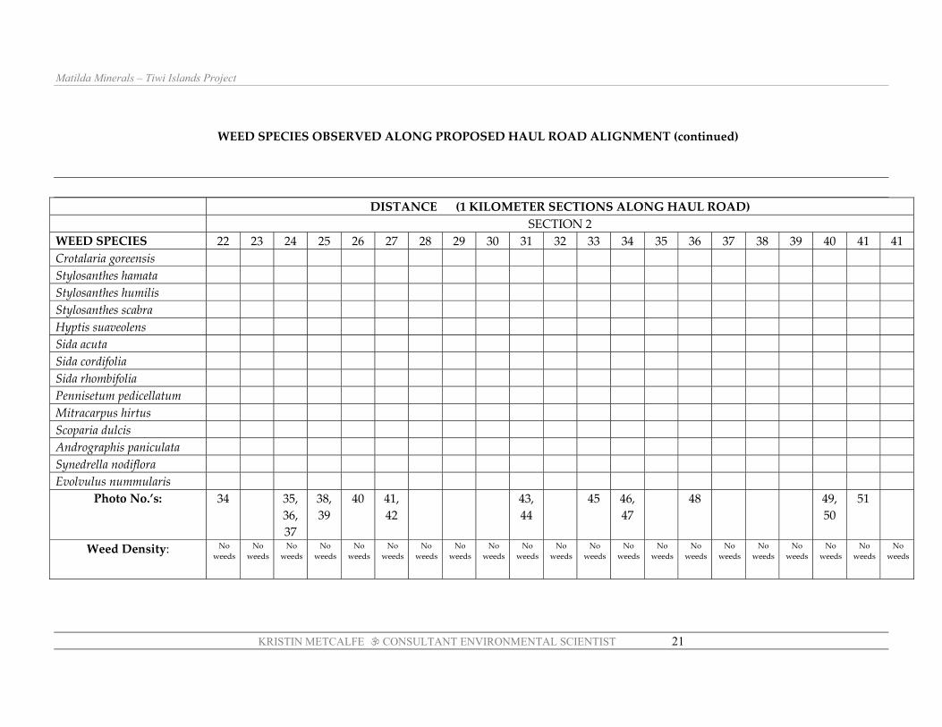
WEED SPECIES OBSERVED ALONG PROPOSED HAUL ROAD ALIGNMENT (continued)
DISTANCE (1 KILOMETER SECTIONS ALONG HAUL ROAD) SECTION 2 WEED SPECIES 22 23 24 25 26 27 28 29 30 31 32 33 34 35 36 37 38 39 40 41 41 Crotalaria goreensis Stylosanthes hamata Stylosanthes humilis Stylosanthes scabra Hyptis suaveolens Sida acuta Sida cordifolia Sida rhombifolia Pennisetum pedicellatum Mitracarpus hirtus Scoparia dulcis Andrographis paniculata Synedrella nodiflora Evolvulus nummularis
Photo No.’s: 34 35, 36, 37
38, 39
40 41, 42
43, 44
45 46, 47
48 49, 50
51
Weed Density: No weeds
No weeds
No weeds
No weeds
No weeds
No weeds
No weeds
No weeds
No weeds
No weeds
No weeds
No weeds
No weeds
No weeds
No weeds
No weeds
No weeds
No weeds
No weeds
No weeds
No weeds
Matilda Minerals – Tiwi Islands Project
KRISTIN METCALFE CONSULTANT ENVIRONMENTAL SCIENTIST 22
WEED SPECIES OBSERVED ALONG PROPOSED HAUL ROAD ALIGNMENT (continued)
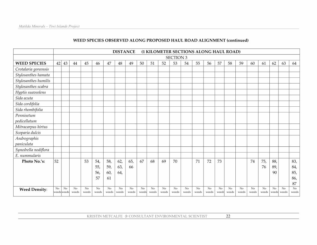
DISTANCE (1 KILOMETER SECTIONS ALONG HAUL ROAD) SECTION 3 WEED SPECIES 42 43 44 45 46 47 48 49 50 51 52 53 54 55 56 57 58 59 60 61 62 63 64 Crotalaria goreensis Stylosanthes hamata Stylosanthes humilis Stylosanthes scabra Hyptis suaveolens Sida acuta Sida cordifolia Sida rhombifolia Pennisetum pedicellatum
Mitracarpus hirtus Scoparia dulcis Andrographis paniculata
Synedrella nodiflora E. nummularis
Photo No.’s: 52 53 54, 55, 56, 57
58, 59, 60, 61
62, 63, 64,
65, 66
67 68 69 70 71 72 73 74 75, 76
88, 89, 90
83, 84, 85, 86, 87
Weed Density: No weeds
No weeds
No weeds
No weeds
No weeds
No weeds
No weeds
No weeds
No weeds
No weeds
No weeds
No weeds
No weeds
No weeds
No weeds
No weeds
No weeds
No weeds
No weeds
No weeds
No weeds
No weeds
No weeds

KRISTIN METCALFE CONSULTANT ENVIRONMENTAL SCIENTIST
23
PICKERTARA MOOR TO HAUL ROAD (WEST) - ROADSIDE WEEDS
(Track A – on accompanying map)
WEED SPECIES DISTANCE ( ONE KILOMETER SECTIONS)
Distance 0-1 km 1-2 km 2-3 km 4-5 km 5-6 km Section No.
& Location
1 Pickertar-amoor
2 3 4 5 T –
intersection with haul
road Crotalaria goreensis ● ● ● Stylosanthes hamata ● Stylosanthes humilis ● Stylosanthes scabra ● ● Hyptis suaveolens ● ● ●
Sida acuta ● ● ● Sida cordifolia ● ●
Sida rhombifolia ● ● ● ● Pennisetum pedicellatum ● ● ●
Mitracarpus hirtus ● ● ● Scoparia dulcis
Andrographis paniculata ● Synedrella nodiflora ●
Evolvulus nummularis ● Aeschynomene americana ●
Calopogonium mucunoides ● Physalis minima
Photo No.’s: 90,91,92,93,94
Weed Density: Extremely dense to
dense
Dense to very sparse
Sparse to very sparse
Very sparse
Sparse to mid-dense

Matilda Minerals – Tiwi Islands Project
KRISTIN METCALFE CONSULTANT ENVIRONMENTAL SCIENTIST 24
HAUL ROAD to PICKERTARAMOOR (EAST) - ROADSIDE WEEDS (Track B – see map)
WEED SPECIES DISTANCE ( ONE KILOMETER SECTIONS) Distance 0-1 km 1-2 km 2-3 km 4-5 km 5-6 km 6-7 km 7-8 km
Section No. &
Location
1 T –
intersection with haul
road
2 3 4 5 6 Intersection near creek
7 Pickert-aramoor
Crotalaria goreensis ● ● ● ● Stylosanthes hamata ● Stylosanthes humilis Stylosanthes scabra Hyptis suaveolens ●
Sida acuta ● Sida cordifolia ●
Sida rhombifolia ● ● ● Pennisetum pedicellatum
Mitracarpus hirtus ● Scoparia dulcis
Andrographis paniculata Synedrella nodiflora
Evolvulus nummularis ● ● Aeschynomene americana ●
Calopogonium mucunoides
●
Physalis minima
Photo No.’s: 115 116 117,118,119
Weed Density: Nil Nil Nil Very sparse
– 2 small
patches
Very sparse, occasio
nal plant
Becoming
more dense
Very dense

Matilda Minerals – Tiwi Islands Project
KRISTIN METCALFE CONSULTANT ENVIRONMENTAL SCIENTIST 25
APPENDIX 4: SELECTION OF SITE PHOTOGRAPHS
Please see CD with site photos, presented in separate folders
for each of the key sections of the haul road

KRISTIN METCALFE CONSULTANT ENVIRONMENTAL SCIENTIST
26
REFERENCES
Metcalfe, K (unpublished report). Flora Survey, Lethbridge and Andranangoo Prospects,
Tiwi Islands Project, Matilda Minerals Pty. Ltd. Prepared for URS, January 2005. 31pp
Woinarski, J., Brennan, K., Cowie, I.D., Kerrigan, R. and Hempel, C., 2003a. Biodiversity Conservation on the Tiwi Islands, Northern Territory, Department of Infrastructure, Planning and Environment, Northern Territory Government, Darwin, NT.
Woinarski, J.C.Z. et al., 2003b. Biodiversity conservation on the Tiwi Islands, Northern Territory: Part 2. Fauna, Department of Infrastructure Planning and Environment, Darwin, Northern Territory.