Embed Size (px)
Citation preview
©JBS&G Australia Pty Ltd T/A Strategen-JBS&G | WER-HSE-REP-006 118
Appendix B West Erregulla Exploration Program, Targeted Flora Survey
Client Report Title Report Title
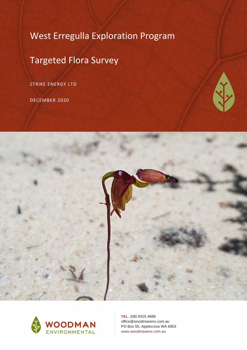
West Erregulla Exploration Program Targeted Flora Survey
STRIKE ENERGY LTD
DECEMBER 2020
TEL. (08) 9315 4688
PO Box 50, Applecross WA 6953
www.woodmanenv.com.au
Strike Energy Ltd West Erregulla Exploration Program Targeted Flora Survey
West Erregulla Exploration Program Targeted Flora Survey
Prepared for: Strike Energy Ltd
Job Number: Strike20-30
Report Number: Strike20-30-01
Cover Photograph: Paracaleana dixonii (T) at West Erregulla Study Area (photo: Woodman Environmental)
DOCUMENT REVISION AND STATUS
Revision Status Originator Internal Reviewer
Internal Review Date
Client Reviewer
Client Review Date
A Draft Report LF CG/GW 8/12/2020 GH 15/01/2021
0 Final LF GW 18/01/2021
DISCLAIMER
This document is prepared in accordance with and subject to an agreement between Woodman Environmental Consulting Pty Ltd (“Woodman Environmental”) and the client for whom it has been prepared (“Strike Energy Ltd”) and is restricted to those issues that have been raised by the Client in its engagement of Woodman Environmental and prepared using the standard of skill and care ordinarily exercised by Environmental Scientists in the preparation of such Documents. Any organisation or person that relies on or uses this document for purposes or reasons other than those agreed by Woodman Environmental and the Client without first obtaining the prior written consent of Woodman Environmental, does so entirely at their own risk and Woodman Environmental denies all liability in tort, contract or otherwise for any loss, damage or injury of any kind whatsoever (whether in negligence or otherwise) that may be suffered as a consequence of relying on this document for any purpose other than that agreed with the Client.
Strike Energy Ltd West Erregulla Exploration Program Targeted Flora Survey
TABLE OF CONTENTS
EXECUTIVE SUMMARY .................................................................................... i
1. INTRODUCTION ........................................................................................ 1
1.1 PROJECT OVERVIEW ............................................................................................ 1
1.2 STUDY AND PROJECT AREA DEFINITION ............................................................. 1
1.3 AIM AND OBJECTIVES .......................................................................................... 3
1.4 LEVEL OF SURVEY................................................................................................. 3
1.5 CLIMATE ............................................................................................................... 3
2. METHODS ................................................................................................ 5
2.1 TARGETED SURVEY .............................................................................................. 5
2.1.1 Desktop Review .................................................................................................. 5
2.1.2 Field Survey Methods ......................................................................................... 5
2.1.3 Personnel and Licensing ..................................................................................... 8
2.1.4 Plant Collection and Identification ..................................................................... 8
3. SURVEY LIMITATIONS .............................................................................. 9
4. RESULTS AND DISCUSSION ..................................................................... 10
4.1 DESKTOP REVIEW .............................................................................................. 10
4.2 FIELD SURVEY..................................................................................................... 15
4.2.1 Threatened Taxa .............................................................................................. 15
4.2.2 Priority 1 and 2 Taxa......................................................................................... 19
4.2.3 Priority 3 Taxa .................................................................................................. 25
4.2.4 Priority 4 Taxa .................................................................................................. 34
5. RECOMMENDATIONS FOR MITIGATION AND AVOIDANCE ..................... 38
6. REFERENCES ........................................................................................... 47
Strike Energy Ltd West Erregulla Exploration Program Targeted Flora Survey
FIGURES
Figure 1: West Erregulla Study Area ...................................................................................... 2
Figure 2: Monthly Maximum Temperature Jan-Oct 2020 and Long-Term Monthly Maximum Temperature (°C) for Morawa, and Long-Term Monthly Precipitation Jan – Sep 2020 (mm) and Monthly Precipitation 2020 for Green Grove (Bureau of Meteorology 2020) ................................................................................................. 4
Figure 3: West Erregulla Survey GPS Track Logs – October 2020 .......................................... 6
Figure 4: West Erregulla Survey GPS Track Logs – November 2020 ...................................... 7
Figure 5: West Erregulla Historical Significant Flora Locations ........................................... 14
Figure 6: West Erregulla Survey Threatened Flora Locations .............................................. 18
Figure 7: West Erregulla Survey Priority 1 and 2 Flora Locations ........................................ 24
Figure 8: West Erregulla Survey Priority 3 Flora Locations .................................................. 33
Figure 9: West Erregulla Survey Priority 4 Flora Locations .................................................. 37
TABLES
Table 1: Personnel and Licensing Information ..................................................................... 8
Table 2: Limitations of the Flora and Vegetation Survey of the Study Area ........................ 9
Table 3: Summary of Flora and Vegetation Surveys and Desktop Assessments Previously Conducted at West Erregulla ................................................................................ 10
Table 4: Significant Taxa Recorded in Study Area .............................................................. 16
Table 5: Recommendations for Avoidance and Mitigation of Impacts to Significant Flora Taxa ....................................................................................................................... 40
APPENDICES
Appendix A: Significant Flora Taxa Known from within 20 km of the Study Area
Appendix B: GPS Locations of Significant Flora Recorded within the Study Area
Strike Energy Ltd West Erregulla Exploration Program Targeted Flora Survey
i
EXECUTIVE SUMMARY
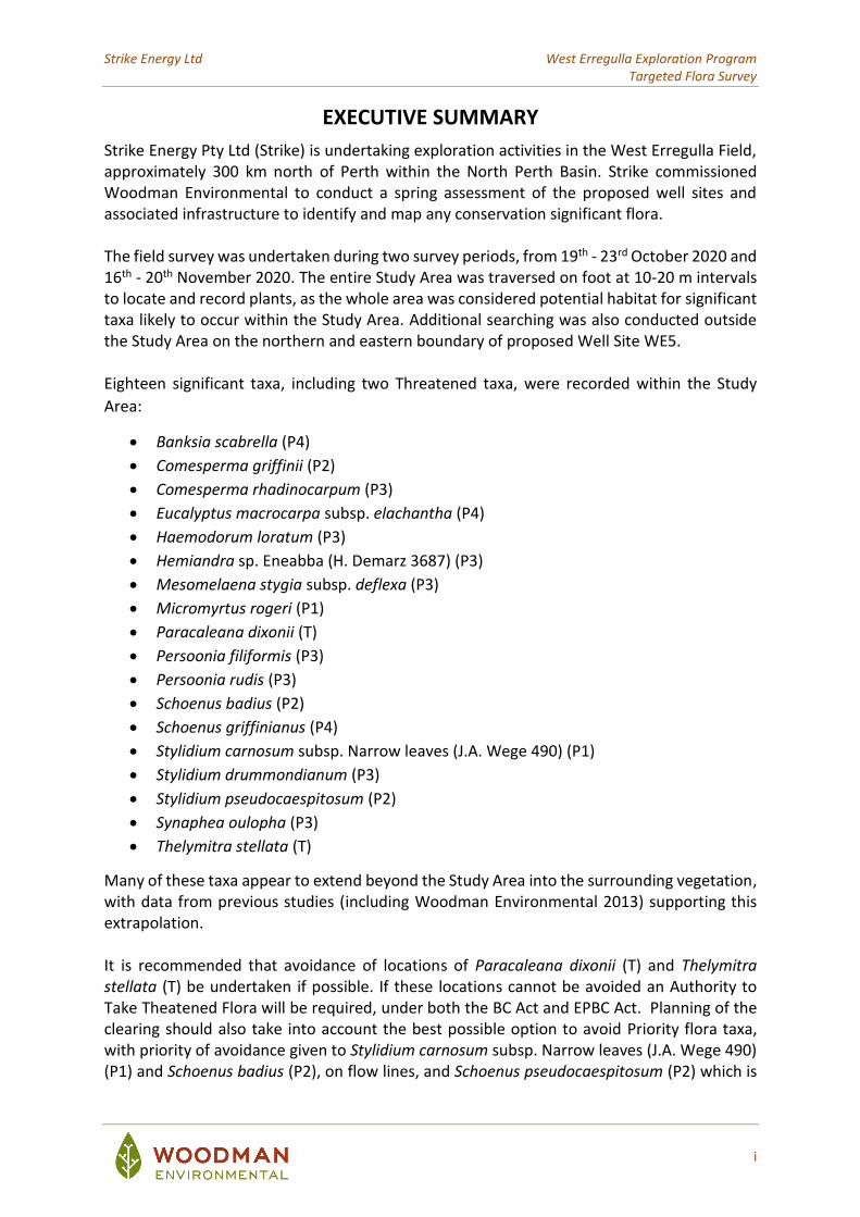
Strike Energy Pty Ltd (Strike) is undertaking exploration activities in the West Erregulla Field, approximately 300 km north of Perth within the North Perth Basin. Strike commissioned Woodman Environmental to conduct a spring assessment of the proposed well sites and associated infrastructure to identify and map any conservation significant flora. The field survey was undertaken during two survey periods, from 19th - 23rd October 2020 and 16th - 20th November 2020. The entire Study Area was traversed on foot at 10-20 m intervals to locate and record plants, as the whole area was considered potential habitat for significant taxa likely to occur within the Study Area. Additional searching was also conducted outside the Study Area on the northern and eastern boundary of proposed Well Site WE5. Eighteen significant taxa, including two Threatened taxa, were recorded within the Study
Area:
• Banksia scabrella (P4)
• Comesperma griffinii (P2)
• Comesperma rhadinocarpum (P3)
• Eucalyptus macrocarpa subsp. elachantha (P4)
• Haemodorum loratum (P3)
• Hemiandra sp. Eneabba (H. Demarz 3687) (P3)
• Mesomelaena stygia subsp. deflexa (P3)
• Micromyrtus rogeri (P1)
• Paracaleana dixonii (T)
• Persoonia filiformis (P3)
• Persoonia rudis (P3)
• Schoenus badius (P2)
• Schoenus griffinianus (P4)
• Stylidium carnosum subsp. Narrow leaves (J.A. Wege 490) (P1)
• Stylidium drummondianum (P3)
• Stylidium pseudocaespitosum (P2)
• Synaphea oulopha (P3)
• Thelymitra stellata (T)
Many of these taxa appear to extend beyond the Study Area into the surrounding vegetation, with data from previous studies (including Woodman Environmental 2013) supporting this extrapolation. It is recommended that avoidance of locations of Paracaleana dixonii (T) and Thelymitra stellata (T) be undertaken if possible. If these locations cannot be avoided an Authority to Take Theatened Flora will be required, under both the BC Act and EPBC Act. Planning of the clearing should also take into account the best possible option to avoid Priority flora taxa, with priority of avoidance given to Stylidium carnosum subsp. Narrow leaves (J.A. Wege 490) (P1) and Schoenus badius (P2), on flow lines, and Schoenus pseudocaespitosum (P2) which is

Strike Energy Ltd West Erregulla Exploration Program Targeted Flora Survey
ii
on the eastern boundary of J well pad where possible. An Environmental Management Plan (EMP) will be required to control clearing and other impacts to significant flora taxa.
Strike Energy Ltd West Erregulla Exploration Program Targeted Flora Survey
1
1. INTRODUCTION
1.1 Project Overview
Strike Energy Pty Ltd (Strike) is undertaking exploration activities in the West Erregulla Field, approximately 300 km north of Perth within the North Perth Basin. Strike has taken over as operator for Warrego Energy’s West Erregulla Exploration Program (the Project) which comprised a three dimensional (3D) onshore seismic survey (completed) and an exploration well drilling program within Exploration Permit 469 (ongoing). Woodman Environmental Consulting Pty Ltd (Woodman Environmental) conducted a Detailed flora and vegetation assessment for the West Erregulla project for Warrego Resources during spring of 2011 and 2012 (Woodman Environmental 2013). Strike intend to develop up to three additional Wells and associated access tracks, flowlines and a tie-in point within the unallocated Crown Land (uCL), in native vegetation in the area previously subject to three-dimensional seismic survey, during 2020/2021. A desktop review of potential constraints at two well sites (West Erregulla 4 and 5) identified the requirement for survey during the appropriate time of year for the region, to determine whether conservation significant flora species are present on the sites, and over the unallocated Crown Land (uCL) area of remnant native vegetation in general (Woodman Environmental 2020). Strike commissioned Woodman Environmental to conduct a spring assessment of the proposed well sites and associated infrastructure to identify and map any conservation significant flora. The assessment will facilitate the environmental approvals process for the wells and inform the development and implementation of impact mitigation processes.
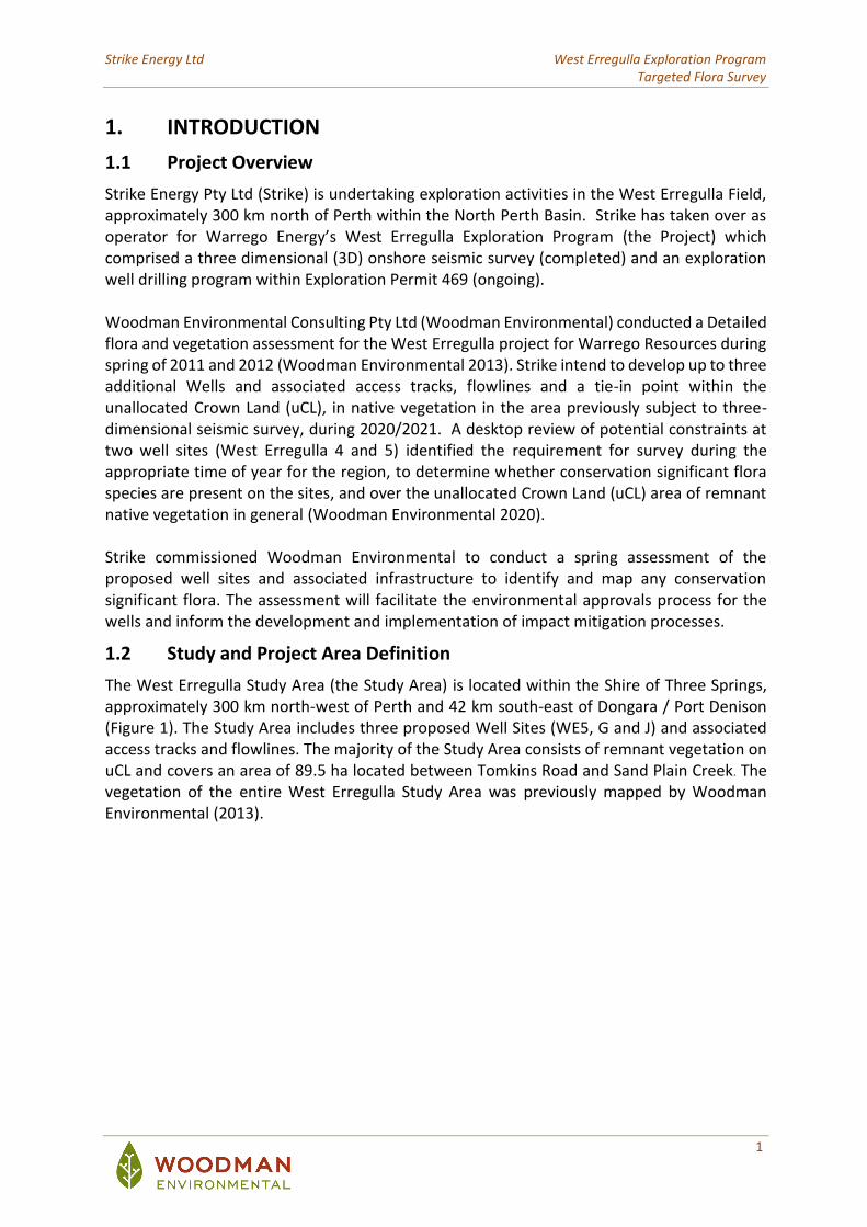
1.2 Study and Project Area Definition
The West Erregulla Study Area (the Study Area) is located within the Shire of Three Springs, approximately 300 km north-west of Perth and 42 km south-east of Dongara / Port Denison (Figure 1). The Study Area includes three proposed Well Sites (WE5, G and J) and associated access tracks and flowlines. The majority of the Study Area consists of remnant vegetation on uCL and covers an area of 89.5 ha located between Tomkins Road and Sand Plain Creek. The vegetation of the entire West Erregulla Study Area was previously mapped by Woodman Environmental (2013).
J
G
F
WE4
WE2
WE3
WE5
NA
TT
A R
D
CAREY RD
CAREY RD
NA
TT
A R
D
335000
335000
336000
336000
337000
337000
338000
338000
339000
3390006743
000
6743
000
6744
000
6744
000
6745
000
6745
000
6746
000
6746
000
6747
000
6747
000
6748
000
6748
000
6749
000
6749
000
WEC Ref: Strike20-30
Filename: Strike20-30-f01
Author: Leah Firth
FigureO
Scale: 1:27,000 (A4)
1
This map should only be used in conjunction with WEC project Strike20-30. Revision: A - 03 December 2020
West Erregulla Study Area
Projection: GDA 1994 MGA Zone 50
!(
!(
!(
!(
!(
!(
!(
!(
!(
!(IRWIN
ENEABBA
DONGARA
ARRINO
ILLAWONG
COOLIMBA
YANDANOOKA
THREE SPRINGS
PORT DENISON
MINGENEW
LegendStudy_Area
Roads
Strike Energy Ltd West Erregulla Exploration Program Targeted Flora Survey
3
1.3 Aim and Objectives
The primary aim of this assessment was to conduct a targeted flora survey of the proposed Well Sites and associated access tracks and flowlines. The overall objectives of the assessment were to:
• Identify locations and determine the extent of populations of vascular flora taxa occurring within the Study Area that are one of the following (hereafter referred to as significant flora taxa), to provide context for impact assessment:
o Listed Threatened Species (T) under the Environment Protection and Biodiversity Conservation Act 1999 (EPBC Act) (Commonwealth);
o Threatened Flora (T) under the Biodiversity Conservation Act 2016 (BC Act) (WA);
o Priority Flora taxa (P) as classified by the Western Australian Department of Biodiversity, Conservation and Attractions (DBCA); and
o Other significant flora taxa as defined by the Environmental Protection Authority (EPA) (2016a; b).
The survey and reporting works comply with the following documents:
• Technical Guidance – Flora and Vegetation Surveys for Environmental Impact Assessment (EPA 2016a); and
• Environmental Factor Guideline – Flora and Vegetation (EPA 2016b).
1.4 Level of Survey
This assessment included a Targeted Survey as defined in Section 4.2 of the ‘Technical Guidance for Flora and Vegetation Surveys for Environmental Impact Assessment’ (EPA 2016a). This level of assessment is considered appropriate given the level of disturbance proposed and the amount of existing previous data available for the proposed disturbance area.
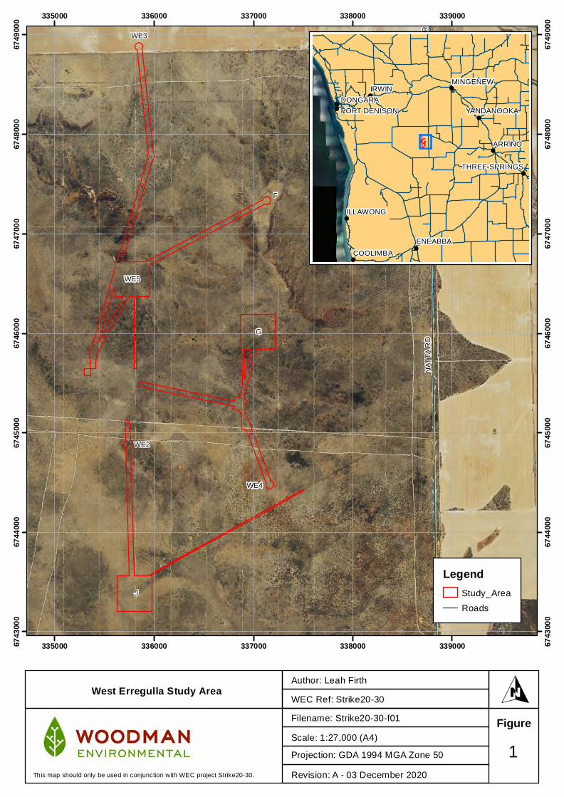
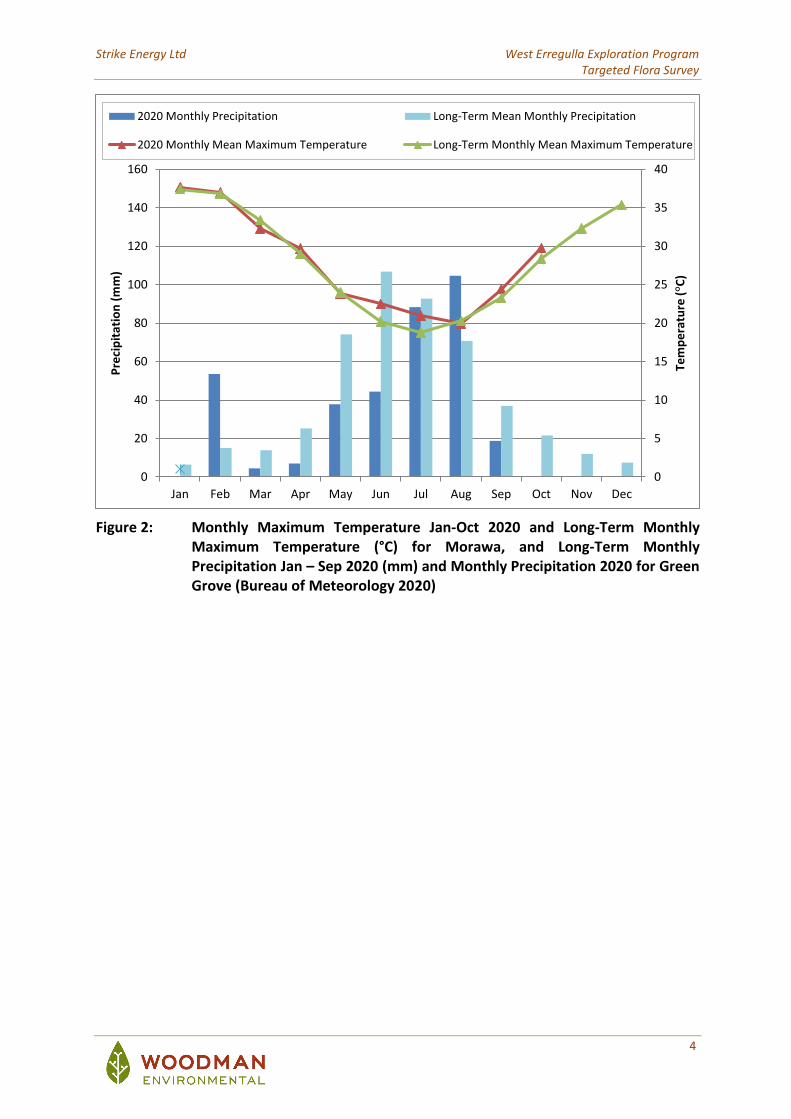
1.5 Climate
The Study Area is located in the Northern Sandplains region (Beard 1990), which is equivalent to the Geraldton Sandplains Interim Biogeographic Regionalisation for Australia (IBRA) region (Commonwealth of Australia 2012). The area experiences a dry, warm Mediterranean climate with predominantly winter rainfall (300 – 500 mm) and 7 to 8 dry months per year (Beard 1990). Figure 2 displays 2020 and long-term average monthly precipitation for Green Grove, and average monthly maximum temperatures for Morawa, the nearest meteorological stations that record these data (Bureau of Meteorology 2020). Precipitation recorded prior to the field survey (January to September 2020) was 359 mm (Figure 2). This total is below the long-term average precipitation for that period (442 mm). Average monthly maximum temperatures were generally higher from June to October 2020 then the long-term monthly maximum temperatures for that period, with June and July recording temperatures more than 2°C warmer than the long-term average.
Strike Energy Ltd West Erregulla Exploration Program Targeted Flora Survey
4
Figure 2: Monthly Maximum Temperature Jan-Oct 2020 and Long-Term Monthly Maximum Temperature (°C) for Morawa, and Long-Term Monthly Precipitation Jan – Sep 2020 (mm) and Monthly Precipitation 2020 for Green Grove (Bureau of Meteorology 2020)
0
5
10
15
20
25
30
35
40
0
20
40
60
80
100
120
140
160
Jan Feb Mar Apr May Jun Jul Aug Sep Oct Nov Dec
Tem
pe
ratu
re (°C
)
Pre
cip
itat
ion
(m
m)
2020 Monthly Precipitation Long-Term Mean Monthly Precipitation
2020 Monthly Mean Maximum Temperature Long-Term Monthly Mean Maximum Temperature
Strike Energy Ltd West Erregulla Exploration Program Targeted Flora Survey
5
2. METHODS
2.1 Targeted Survey
2.1.1 Desktop Review
Prior to commencement of the field survey, a review of all publicly available flora and vegetation data relevant to the Study Area was undertaken (Woodman 2020). This included obtaining and reviewing copies of reports of previous biological surveys carried out within the vicinity of the area (where available) and interrogation of all relevant databases and other sources including:
• Department of Biodiversity, Conservation and Attractions (DBCA) Threatened and Priority Ecological Communities Database (DBCA 2020b);
• DBCA TEC and PEC lists (DBCA 2018; DBCA 2020d);
• DBCA Significant Flora Databases (WA Herbarium Specimen database and Threatened and Priority Flora (TPFL) database) (DBCA 2020a);
• Department of Agriculture, Water and the Environment (DAWE) Species Profile and Threats (SPRAT) Database (interrogated using the Protected Matters Search Tool) (DAWE 2020); and
• 2018 Statewide Vegetation Statistics incorporating the CAR Reserve Analysis (Government of Western Australia 2019).
2.1.2 Field Survey Methods
The field survey was undertaken during two survey periods:
• 19th - 23rd October 2020 and
• 16th - 20th November 2020
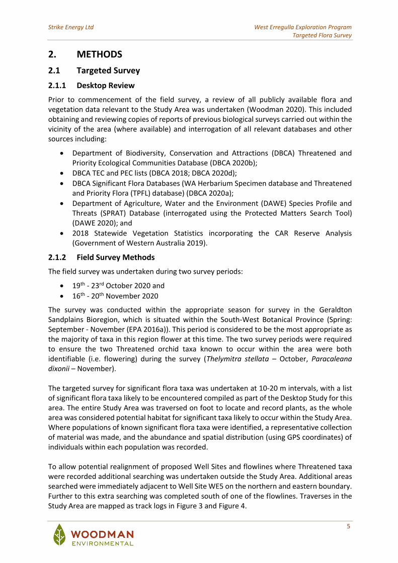
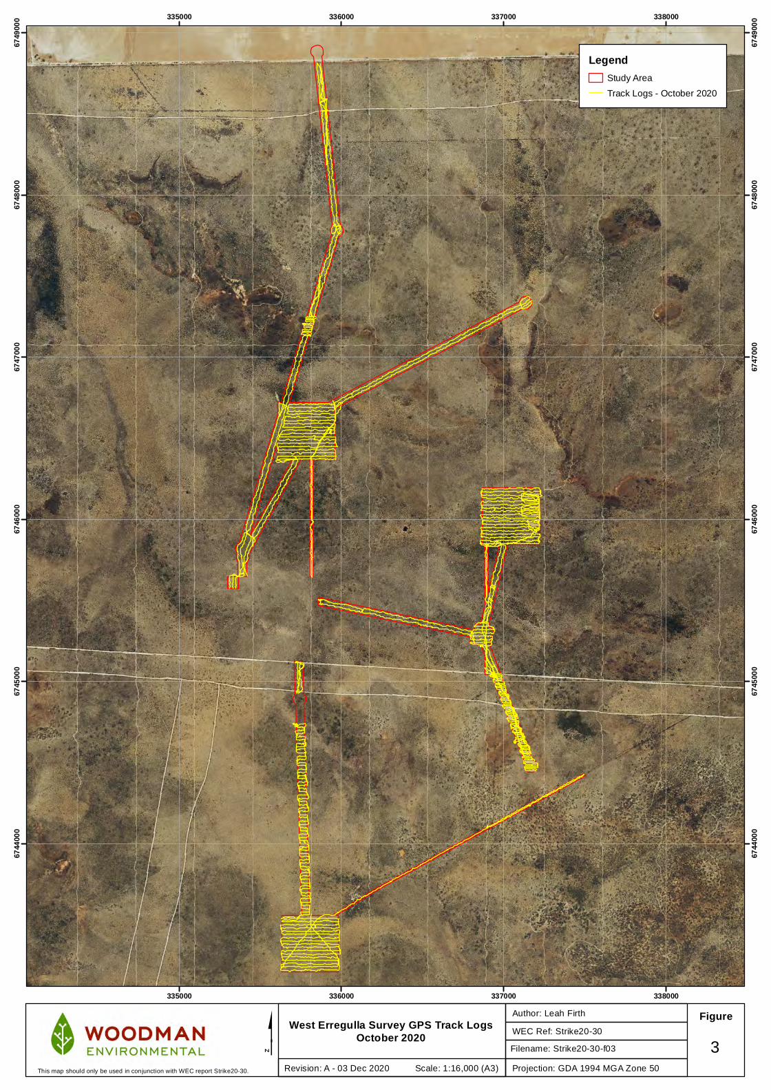
The survey was conducted within the appropriate season for survey in the Geraldton Sandplains Bioregion, which is situated within the South-West Botanical Province (Spring: September - November (EPA 2016a)). This period is considered to be the most appropriate as the majority of taxa in this region flower at this time. The two survey periods were required to ensure the two Threatened orchid taxa known to occur within the area were both identifiable (i.e. flowering) during the survey (Thelymitra stellata – October, Paracaleana dixonii – November). The targeted survey for significant flora taxa was undertaken at 10-20 m intervals, with a list of significant flora taxa likely to be encountered compiled as part of the Desktop Study for this area. The entire Study Area was traversed on foot to locate and record plants, as the whole area was considered potential habitat for significant taxa likely to occur within the Study Area. Where populations of known significant flora taxa were identified, a representative collection of material was made, and the abundance and spatial distribution (using GPS coordinates) of individuals within each population was recorded. To allow potential realignment of proposed Well Sites and flowlines where Threatened taxa were recorded additional searching was undertaken outside the Study Area. Additional areas searched were immediately adjacent to Well Site WE5 on the northern and eastern boundary. Further to this extra searching was completed south of one of the flowlines. Traverses in the Study Area are mapped as track logs in Figure 3 and Figure 4.
335000
335000
336000
336000
337000
337000
338000
338000
6744
000
6744
000
6745
000
6745
000
6746
000
6746
000
6747
000
6747
000
6748
000
6748
000
6749
000
6749
000
West Erregulla Survey GPS Track LogsOctober 2020 WEC Ref: Strike20-30
Author: Leah Firth Figure
$Projection: GDA 1994 MGA Zone 50
3Revision: A - 03 Dec 2020 Scale: 1:16,000 (A3)This map should only be used in conjunction with WEC report Strike20-30.
LegendStudy Area
Track Logs - October 2020
Filename: Strike20-30-f03
335000
335000
336000
336000
337000
337000
338000
338000
6744
000
6744
000
6745
000
6745
000
6746
000
6746
000
6747
000
6747
000
6748
000
6748
000
6749
000
6749
000
West Erregulla Survey GPS Track LogsNovember 2020 WEC Ref: Strike20-30
Author: Leah Firth Figure
$Projection: GDA 1994 MGA Zone 50
4Revision: A - 03 Dec 2020 Scale: 1:16,000 (A3)This map should only be used in conjunction with WEC report Strike20-30.
LegendStudy Area
Track Logs - November 2020
Filename: Strike20-30-f04
Strike Energy Ltd West Erregulla Exploration Program Targeted Flora Survey
8
2.1.3 Personnel and Licensing
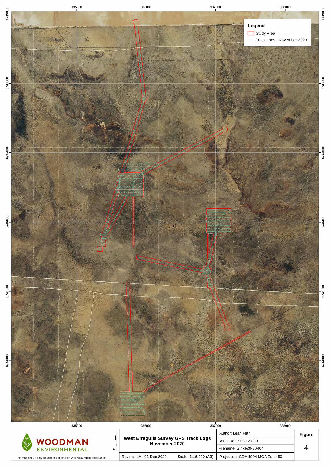
Table 1 lists the personnel involved in both fieldwork and plant identifications for the targeted survey. The Field Managers (David Coultas; Leah Firth) have previous experience (> 10 years and 2 years respectively) in conducting similar flora surveys in the Geraldton Sandplains Bioregion. Plant identifications were conducted by David Coultas, who has extensive previous experience in undertaking plant identifications of flora from the Geraldton Sandplains Bioregion. All plant material was collected under the Flora Taking (Biological Assessment) licences and Authorisation to Take or Disturb Threatened Species pursuant to the Biodiversity Conservation Act 2016, sections 40, 274 and 275, as listed in Table 1. Table 1: Personnel and Licensing Information
Personnel Flora Collecting Permit (BC Act)
Role
Leah Firth BSc (Conservation biology)
FB62000055
TFL145-1920 Project Manager/ Field Manager
David Coultas BSc (Environmental Biology) (Hons)
FB62000051 TFL23-1819
Field Manager / Plant identifications
Emma Marsh BSc (Biology and Conservation Science)
FB62000233 Field survey
Emalyn Loudon BAg (Agribusiness and Farm Management) (Hons)
- Field survey
Diana Barrie BSc (Conservation Biology, Agricultural Science)
- Field survey
2.1.4 Plant Collection and Identification
Specimens of any unknown taxa were collected and were pressed for later identification at the WA Herbarium. External experts of particular families or genera were consulted for any specimens considered to be difficult to identify or of taxonomic interest.
Taxon nomenclature generally follows FloraBase (WA Herbarium 1998-) with all names checked against the current DBCA Max database to ensure their validity. However, in cases where names of plant taxa have been published recently in scientific literature but have not yet been adopted on FloraBase due to time and/or resource constraints, nomenclature in the published literature is followed. The conservation status of each taxon was checked against FloraBase, which provides the most up-to-date information regarding the conservation status of flora taxa in Western Australia. Specimens of interest, including significant flora taxa, range extensions of taxa and potential new taxa, will be sent to the WA Herbarium for consideration for vouchering as soon as practicable. However, this process is via donation, and the WA Herbarium may not voucher all specimens, in accordance with its own requirements. The specimen vouchering will be supported by completed Threatened and Priority Flora Report Forms submitted to DBCA (Species and Communities Branch) in the case of listed significant flora (e.g. Threatened and Priority flora taxa).
Strike Energy Ltd West Erregulla Exploration Program Targeted Flora Survey
9
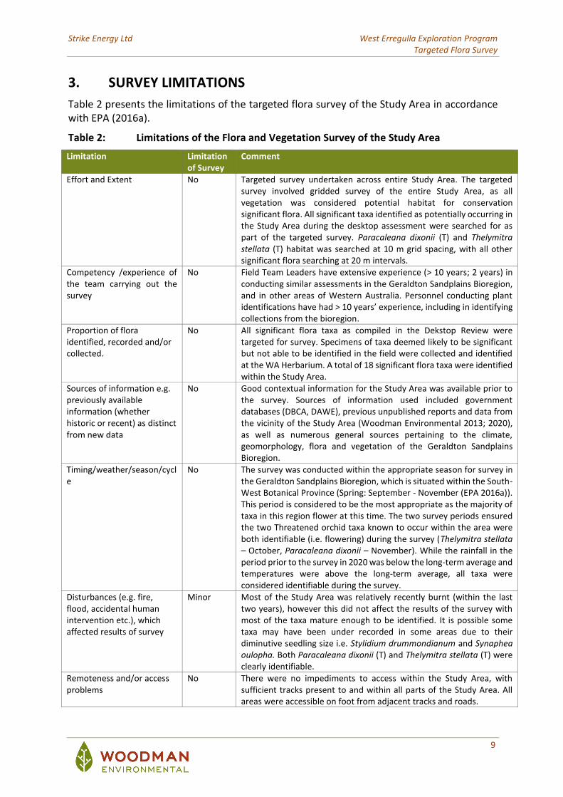
3. SURVEY LIMITATIONS
Table 2 presents the limitations of the targeted flora survey of the Study Area in accordance with EPA (2016a).
Table 2: Limitations of the Flora and Vegetation Survey of the Study Area
Limitation Limitation of Survey
Comment
Effort and Extent No Targeted survey undertaken across entire Study Area. The targeted survey involved gridded survey of the entire Study Area, as all vegetation was considered potential habitat for conservation significant flora. All significant taxa identified as potentially occurring in the Study Area during the desktop assessment were searched for as part of the targeted survey. Paracaleana dixonii (T) and Thelymitra stellata (T) habitat was searched at 10 m grid spacing, with all other significant flora searching at 20 m intervals.
Competency /experience of the team carrying out the survey
No Field Team Leaders have extensive experience (> 10 years; 2 years) in conducting similar assessments in the Geraldton Sandplains Bioregion, and in other areas of Western Australia. Personnel conducting plant identifications have had > 10 years’ experience, including in identifying collections from the bioregion.
Proportion of flora identified, recorded and/or collected.
No All significant flora taxa as compiled in the Dekstop Review were targeted for survey. Specimens of taxa deemed likely to be significant but not able to be identified in the field were collected and identified at the WA Herbarium. A total of 18 significant flora taxa were identified within the Study Area.
Sources of information e.g. previously available information (whether historic or recent) as distinct from new data
No Good contextual information for the Study Area was available prior to the survey. Sources of information used included government databases (DBCA, DAWE), previous unpublished reports and data from the vicinity of the Study Area (Woodman Environmental 2013; 2020), as well as numerous general sources pertaining to the climate, geomorphology, flora and vegetation of the Geraldton Sandplains Bioregion.
Timing/weather/season/cycle
No The survey was conducted within the appropriate season for survey in the Geraldton Sandplains Bioregion, which is situated within the South-West Botanical Province (Spring: September - November (EPA 2016a)). This period is considered to be the most appropriate as the majority of taxa in this region flower at this time. The two survey periods ensured the two Threatened orchid taxa known to occur within the area were both identifiable (i.e. flowering) during the survey (Thelymitra stellata – October, Paracaleana dixonii – November). While the rainfall in the period prior to the survey in 2020 was below the long-term average and temperatures were above the long-term average, all taxa were considered identifiable during the survey.
Disturbances (e.g. fire, flood, accidental human intervention etc.), which affected results of survey
Minor Most of the Study Area was relatively recently burnt (within the last two years), however this did not affect the results of the survey with most of the taxa mature enough to be identified. It is possible some taxa may have been under recorded in some areas due to their diminutive seedling size i.e. Stylidium drummondianum and Synaphea oulopha. Both Paracaleana dixonii (T) and Thelymitra stellata (T) were clearly identifiable.
Remoteness and/or access problems
No There were no impediments to access within the Study Area, with sufficient tracks present to and within all parts of the Study Area. All areas were accessible on foot from adjacent tracks and roads.
Strike Energy Ltd West Erregulla Exploration Program Targeted Flora Survey
10
4. RESULTS AND DISCUSSION
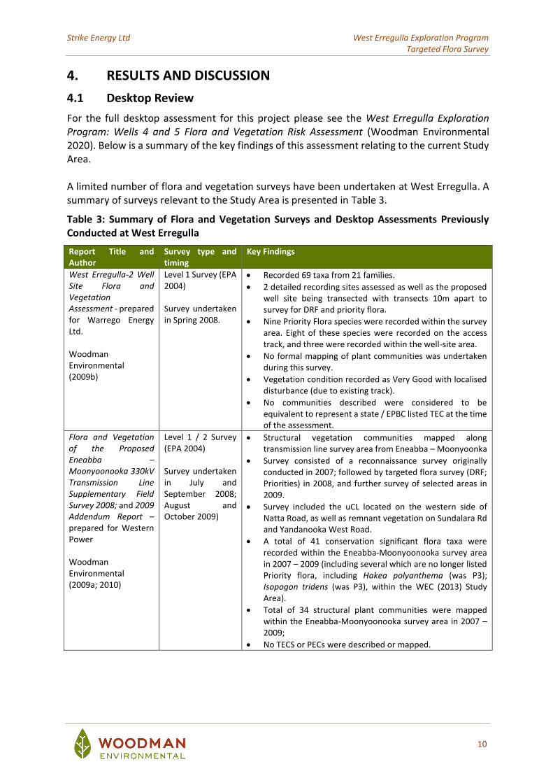
4.1 Desktop Review
For the full desktop assessment for this project please see the West Erregulla Exploration Program: Wells 4 and 5 Flora and Vegetation Risk Assessment (Woodman Environmental 2020). Below is a summary of the key findings of this assessment relating to the current Study Area. A limited number of flora and vegetation surveys have been undertaken at West Erregulla. A summary of surveys relevant to the Study Area is presented in Table 3.
Table 3: Summary of Flora and Vegetation Surveys and Desktop Assessments Previously Conducted at West Erregulla
Report Title and Author
Survey type and timing
Key Findings
West Erregulla-2 Well Site Flora and Vegetation Assessment - prepared for Warrego Energy Ltd. Woodman Environmental (2009b)
Level 1 Survey (EPA 2004) Survey undertaken in Spring 2008.
• Recorded 69 taxa from 21 families.
• 2 detailed recording sites assessed as well as the proposed well site being transected with transects 10m apart to survey for DRF and priority flora.
• Nine Priority Flora species were recorded within the survey area. Eight of these species were recorded on the access track, and three were recorded within the well-site area.
• No formal mapping of plant communities was undertaken during this survey.
• Vegetation condition recorded as Very Good with localised disturbance (due to existing track).
• No communities described were considered to be equivalent to represent a state / EPBC listed TEC at the time of the assessment.
Flora and Vegetation of the Proposed Eneabba – Moonyoonooka 330kV Transmission Line Supplementary Field Survey 2008; and 2009 Addendum Report – prepared for Western Power Woodman Environmental (2009a; 2010)
Level 1 / 2 Survey (EPA 2004) Survey undertaken in July and September 2008; August and October 2009)
• Structural vegetation communities mapped along transmission line survey area from Eneabba – Moonyoonka
• Survey consisted of a reconnaissance survey originally conducted in 2007; followed by targeted flora survey (DRF; Priorities) in 2008, and further survey of selected areas in 2009.
• Survey included the uCL located on the western side of Natta Road, as well as remnant vegetation on Sundalara Rd and Yandanooka West Road.
• A total of 41 conservation significant flora taxa were recorded within the Eneabba-Moonyoonooka survey area in 2007 – 2009 (including several which are no longer listed Priority flora, including Hakea polyanthema (was P3); Isopogon tridens (was P3), within the WEC (2013) Study Area).
• Total of 34 structural plant communities were mapped within the Eneabba-Moonyoonooka survey area in 2007 – 2009;
• No TECS or PECs were described or mapped.
Strike Energy Ltd West Erregulla Exploration Program Targeted Flora Survey
11
Report Title and Author
Survey type and timing
Key Findings
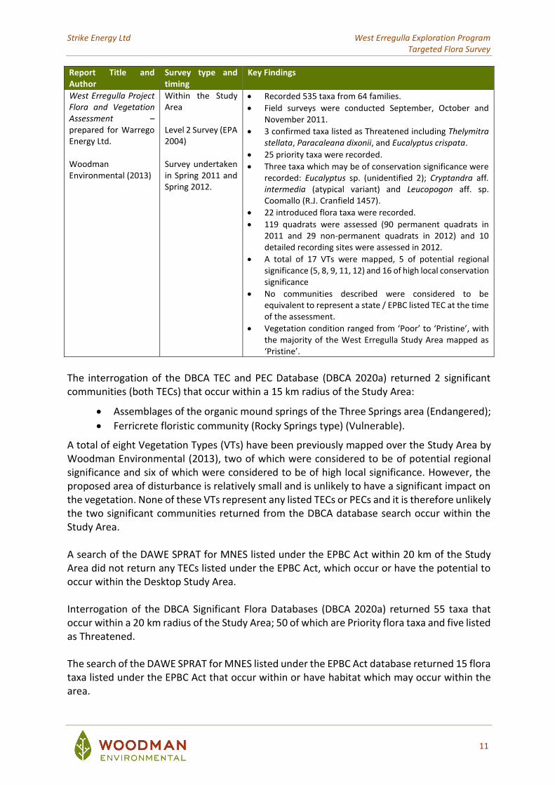
West Erregulla Project Flora and Vegetation Assessment – prepared for Warrego Energy Ltd. Woodman Environmental (2013)
Within the Study Area Level 2 Survey (EPA 2004) Survey undertaken in Spring 2011 and Spring 2012.
• Recorded 535 taxa from 64 families.
• Field surveys were conducted September, October and November 2011.
• 3 confirmed taxa listed as Threatened including Thelymitra stellata, Paracaleana dixonii, and Eucalyptus crispata.
• 25 priority taxa were recorded.
• Three taxa which may be of conservation significance were recorded: Eucalyptus sp. (unidentified 2); Cryptandra aff. intermedia (atypical variant) and Leucopogon aff. sp. Coomallo (R.J. Cranfield 1457).
• 22 introduced flora taxa were recorded.
• 119 quadrats were assessed (90 permanent quadrats in 2011 and 29 non-permanent quadrats in 2012) and 10 detailed recording sites were assessed in 2012.
• A total of 17 VTs were mapped, 5 of potential regional significance (5, 8, 9, 11, 12) and 16 of high local conservation significance
• No communities described were considered to be equivalent to represent a state / EPBC listed TEC at the time of the assessment.
• Vegetation condition ranged from ‘Poor’ to ‘Pristine’, with the majority of the West Erregulla Study Area mapped as ‘Pristine’.
The interrogation of the DBCA TEC and PEC Database (DBCA 2020a) returned 2 significant communities (both TECs) that occur within a 15 km radius of the Study Area:
• Assemblages of the organic mound springs of the Three Springs area (Endangered);
• Ferricrete floristic community (Rocky Springs type) (Vulnerable).
A total of eight Vegetation Types (VTs) have been previously mapped over the Study Area by Woodman Environmental (2013), two of which were considered to be of potential regional significance and six of which were considered to be of high local significance. However, the proposed area of disturbance is relatively small and is unlikely to have a significant impact on the vegetation. None of these VTs represent any listed TECs or PECs and it is therefore unlikely the two significant communities returned from the DBCA database search occur within the Study Area.
A search of the DAWE SPRAT for MNES listed under the EPBC Act within 20 km of the Study Area did not return any TECs listed under the EPBC Act, which occur or have the potential to occur within the Desktop Study Area. Interrogation of the DBCA Significant Flora Databases (DBCA 2020a) returned 55 taxa that occur within a 20 km radius of the Study Area; 50 of which are Priority flora taxa and five listed as Threatened. The search of the DAWE SPRAT for MNES listed under the EPBC Act database returned 15 flora taxa listed under the EPBC Act that occur within or have habitat which may occur within the area.
Strike Energy Ltd West Erregulla Exploration Program Targeted Flora Survey
12
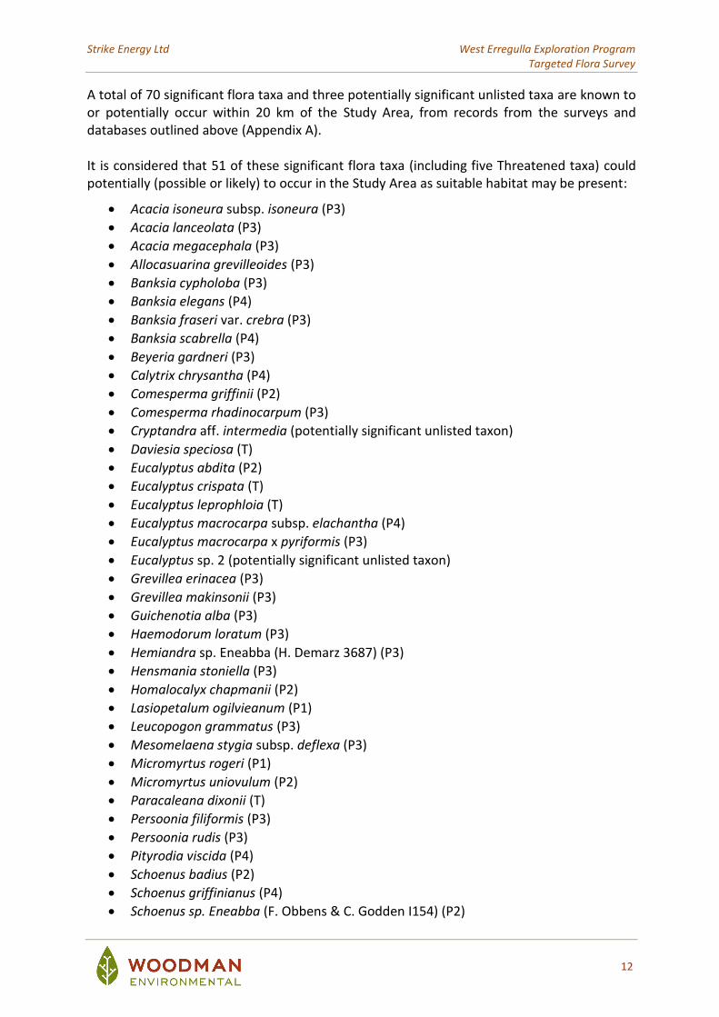
A total of 70 significant flora taxa and three potentially significant unlisted taxa are known to or potentially occur within 20 km of the Study Area, from records from the surveys and databases outlined above (Appendix A). It is considered that 51 of these significant flora taxa (including five Threatened taxa) could potentially (possible or likely) to occur in the Study Area as suitable habitat may be present:
• Acacia isoneura subsp. isoneura (P3)
• Acacia lanceolata (P3)
• Acacia megacephala (P3)
• Allocasuarina grevilleoides (P3)
• Banksia cypholoba (P3)
• Banksia elegans (P4)
• Banksia fraseri var. crebra (P3)
• Banksia scabrella (P4)
• Beyeria gardneri (P3)
• Calytrix chrysantha (P4)
• Comesperma griffinii (P2)
• Comesperma rhadinocarpum (P3)
• Cryptandra aff. intermedia (potentially significant unlisted taxon)
• Daviesia speciosa (T)
• Eucalyptus abdita (P2)
• Eucalyptus crispata (T)
• Eucalyptus leprophloia (T)
• Eucalyptus macrocarpa subsp. elachantha (P4)
• Eucalyptus macrocarpa x pyriformis (P3)
• Eucalyptus sp. 2 (potentially significant unlisted taxon)
• Grevillea erinacea (P3)
• Grevillea makinsonii (P3)
• Guichenotia alba (P3)
• Haemodorum loratum (P3)
• Hemiandra sp. Eneabba (H. Demarz 3687) (P3)
• Hensmania stoniella (P3)
• Homalocalyx chapmanii (P2)
• Lasiopetalum ogilvieanum (P1)
• Leucopogon grammatus (P3)
• Mesomelaena stygia subsp. deflexa (P3)
• Micromyrtus rogeri (P1)
• Micromyrtus uniovulum (P2)
• Paracaleana dixonii (T)
• Persoonia filiformis (P3)
• Persoonia rudis (P3)
• Pityrodia viscida (P4)
• Schoenus badius (P2)
• Schoenus griffinianus (P4)
• Schoenus sp. Eneabba (F. Obbens & C. Godden I154) (P2)
Strike Energy Ltd West Erregulla Exploration Program Targeted Flora Survey
13
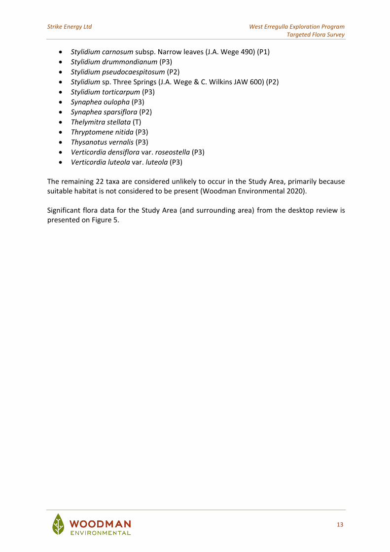
• Stylidium carnosum subsp. Narrow leaves (J.A. Wege 490) (P1)
• Stylidium drummondianum (P3)
• Stylidium pseudocaespitosum (P2)
• Stylidium sp. Three Springs (J.A. Wege & C. Wilkins JAW 600) (P2)
• Stylidium torticarpum (P3)
• Synaphea oulopha (P3)
• Synaphea sparsiflora (P2)
• Thelymitra stellata (T)
• Thryptomene nitida (P3)
• Thysanotus vernalis (P3)
• Verticordia densiflora var. roseostella (P3)
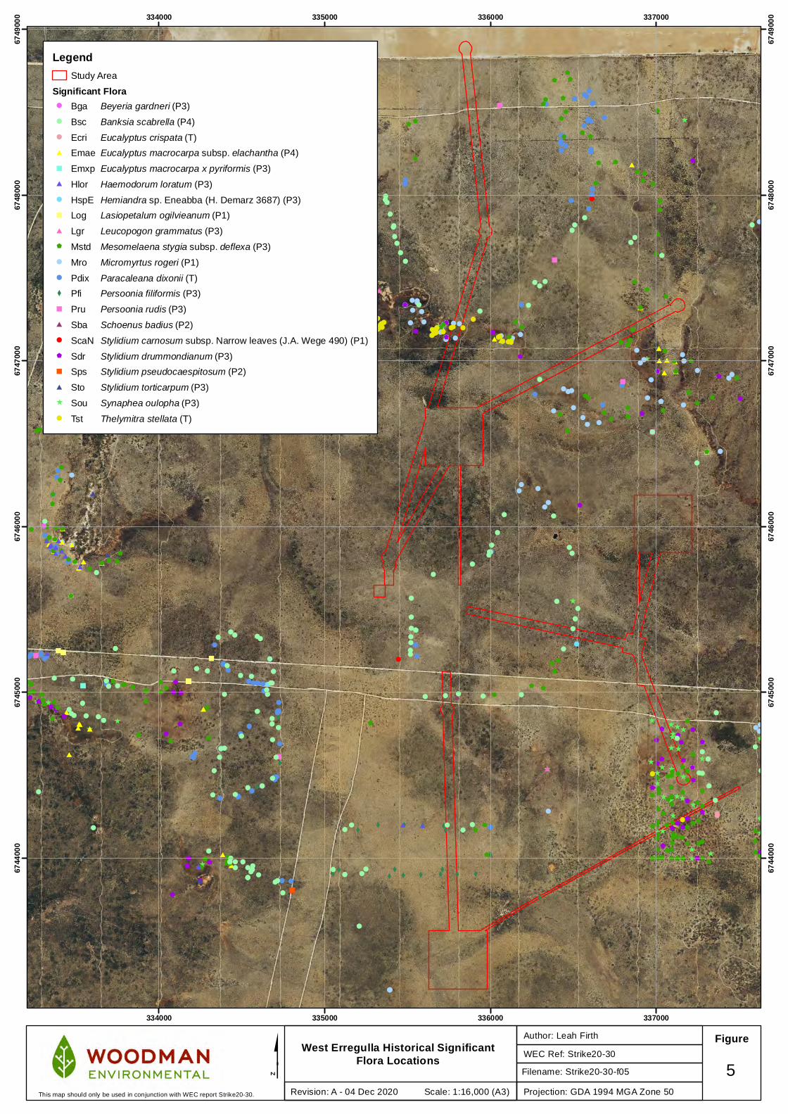
• Verticordia luteola var. luteola (P3) The remaining 22 taxa are considered unlikely to occur in the Study Area, primarily because suitable habitat is not considered to be present (Woodman Environmental 2020). Significant flora data for the Study Area (and surrounding area) from the desktop review is presented on Figure 5.
$
$#
$X
!
$
!$
$
!
#
#
!
!
#̂#
!
!
$!
$
$! $
#
#
$
!#
$
!
$
!
$
!
!
!
!
!
!
!
#
#
#
#
#
""
^
^
^
^
^
^
^
^
^^
^^
^
^
^
^
^
^
^
^
^
^
^
^^^
^
^
^
^
^
^
^
^
^
^
^
^
^
^^
^
^
^
^
^ ^
^^
^
^
^
^̂
^^
^
^
^^
^
^
^̂
^
^
^̂
!
^
^
^
!
!
!!
!!!!
!!
!!
!
!!
!!
!
!
!
!
!
! !
!
! !
!
!
!
!
!
!
!
! !
!
!
!
!!
!
!
!
!
!!
!
!
!!
!
!
!
!!!
!
!
!
!
!
! !
!
!
!
X X
X X X
X
XX X
X X X X X
X
XX
X XX
X
X
X
X
!
X
!
!
!
!!!
!!
!
!
!
!
!
!!
!
!!
!!
! !
!
!
!
!!
!!
!
!
!
!
!
!
!
!!!!
!
!
!!
!
!!!
!!!
!
!!
! !!!
!!
! !
!
!
! !
!!!
!
!!!!
!!
!!
!!
!
!
!!
!!
!!
!!
!!!!
!
!!
!!
!
!!!!
!
!
#
#
#
##
!
#
#
##
###
#
#
#
#
#
##
#
#
#
#
#
#
#
#
## #
!!
#
!!
$
$
$$
$
$
$
$
$
$
$
$
$
$$
$
$
$
$
$
$
$
$
$
$
$
$
$$
$
$
$
$
$
$
$
$
$
$
$
$
$
$
$
$
$
$
$$
$
$
$
$
$
$
$
$
$
$
$
$
$
$
$$
$
$$
$
$
$$
$
$$
$
$
$
$ $$
$
$
$$
$
$
$
$
$
$
$
$
$
$$
$
$
$
$
$$
$
$
$
$
$
$
$
$ $
$$
$
$ $
$
$
$
$
$$
$
$
$
$
$
$
$
$
$
$
$
$$
$
$
$ $
$
$
$
$
$
$
$$$
$
$
$
$
$
$
$
$
$
$
$
$
$
$
$$
$
$ $
$
$
$
$
$
$
$
$
$ $
$
$
$
$
$
$
$
$
$ $$
$
$
$
$
$
$
$
$$
$$
$
$
$
$
$
$
$$
$$
$
$
$
$
$
$
$
$
$
$
$
$$
$
$
$
$
$
$
$
$
$
$
$
$
$
$
$
$
$
$
$ $
$
$$
$
$
$
$
$
$$
$
$
$
$
!
!!!!!!!!
!
!! !!! !
!!!
!!
!
!
!!!!!!!!
!!!!
!
""
"""""
""
"
!!
""
"
"
"
"
"
"
!
!
! !
!
!
!
!
!
!
!
!
!
!!
! !
!
!
!
!
!
!
!
!
! !
!
!
!!
!
!
!!!
!
!
!
!
!
!
!
!
! ! !!
!
!
!!!!!
!
!!
!
!
!
!
!
!!
!
!
!!!
!
!
!
! !
! ! !
!
!
!
!!!
!
!
!
! !!
!
!
!
!
!
!
!
!
!
!
!
!
!
!
!
!!
!!
!
!
!
!
!
!
!
!!
!
!
!
!
!!
!
!
!
!
!
!
! !
!!!
!
!
!
!
!!
!
!
##
##
##
##
#
##
#
#
#
334000
334000
335000
335000
336000
336000
337000
337000
6744
000
6744
000
6745
000
6745
000
6746
000
6746
000
6747
000
6747
000
6748
000
6748
000
6749
000
6749
000
West Erregulla Historical Significant Flora Locations WEC Ref: Strike20-30
Author: Leah Firth Figure
$Projection: GDA 1994 MGA Zone 50
5Revision: A - 04 Dec 2020 Scale: 1:16,000 (A3)This map should only be used in conjunction with WEC report Strike20-30.
LegendStudy Area
Significant Flora! Bga Beyeria gardneri (P3)
! Bsc Banksia scabrella (P4)
! Ecri Eucalyptus crispata (T)
# Emae Eucalyptus macrocarpa subsp. elachantha (P4)
" Emxp Eucalyptus macrocarpa x pyriformis (P3)
# Hlor Haemodorum loratum (P3)
! HspE Hemiandra sp. Eneabba (H. Demarz 3687) (P3)
" Log Lasiopetalum ogilvieanum (P1)
# Lgr Leucopogon grammatus (P3)
$ Mstd Mesomelaena stygia subsp. deflexa (P3)
! Mro Micromyrtus rogeri (P1)
! Pdix Paracaleana dixonii (T)
X Pfi Persoonia filiformis (P3)
" Pru Persoonia rudis (P3)
# Sba Schoenus badius (P2)
! ScaN Stylidium carnosum subsp. Narrow leaves (J.A. Wege 490) (P1)
$ Sdr Stylidium drummondianum (P3)
" Sps Stylidium pseudocaespitosum (P2)
# Sto Stylidium torticarpum (P3)
^ Sou Synaphea oulopha (P3)
! Tst Thelymitra stellata (T)
Filename: Strike20-30-f05

Strike Energy Ltd West Erregulla Exploration Program Targeted Flora Survey
15
4.2 Field Survey
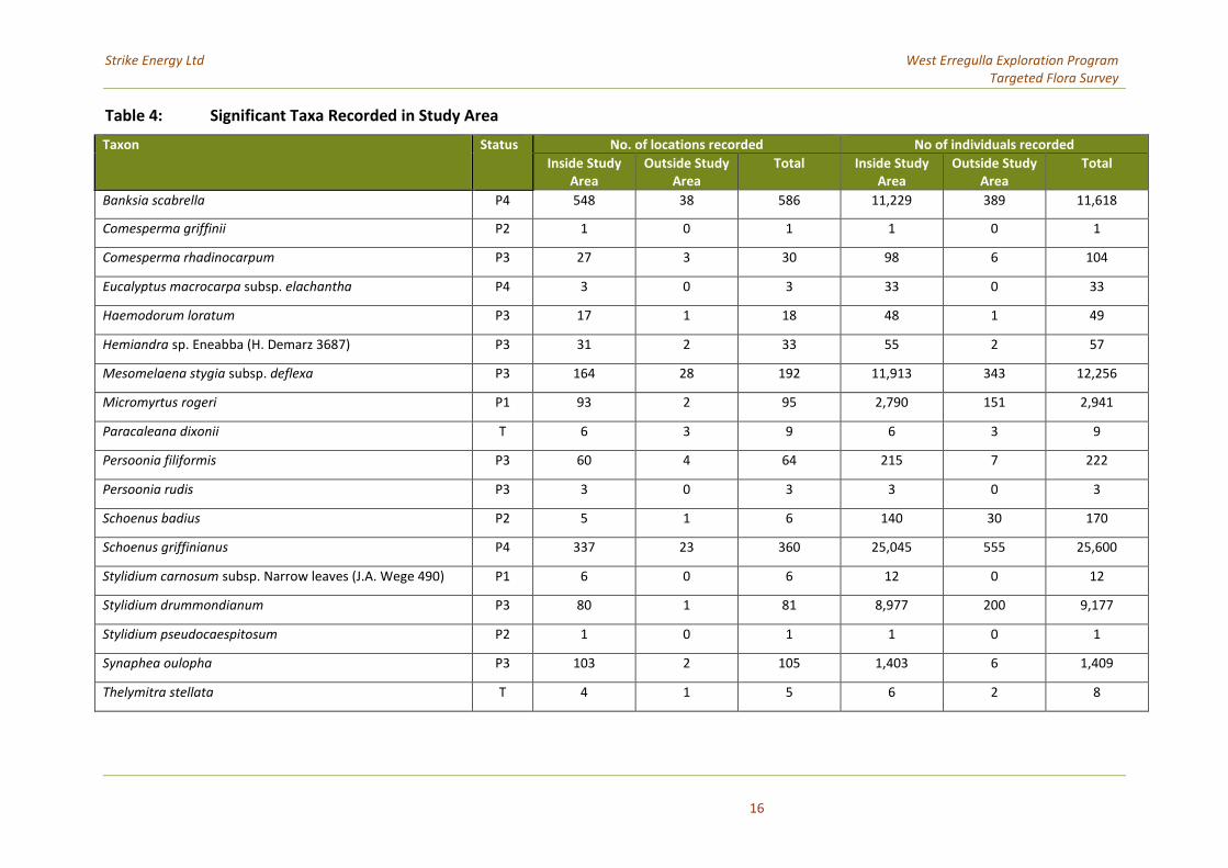
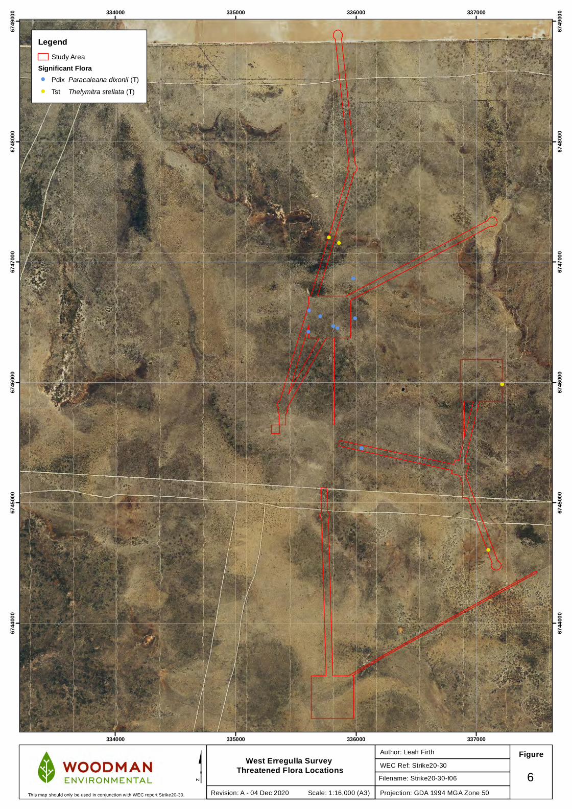
Two threatened flora taxa (Paracaleana dixonii and Thelymitra stellata) and 16 priority taxa were recorded within or in close proximity to the Study Area during this survey (Table 4). Locations of significant flora taxa recorded are presented in Appendix B and on Figure 6, Figure 7, Figure 8 and Figure 9.
4.2.1 Threatened Taxa
Paracaleana dixonii (T) Paracaleana dixonii (T) is a tuberous perennial herb (orchid) growing up to 0.2 m high (Plate 1) and occurs on sand (WA Herbarium 1998-). This taxon is listed as Vulnerable under the BC Act and Endangered under the EPBC Act (DBCA 2018, DAWE 2020). It is known to occur over a range of approximately 191 km in Western Australia (where it is endemic), from Arrowsmith East (30 km south of Dongara) in the north to 36 km east of Lancelin in the south (DBCA 2007-); the Study Area is within the known range of this taxon. This taxon is known from 74 records, 17 of which occur within DBCA-managed tenure (South Eneabba Nature Reserve, Lake Logue Nature Reserve, Lesueur National Park, Coomallo Nature Reserve, Moore River National Park and Unnamed Reserve 39744) (DBCA 2007-). This taxon has been recorded by previous surveys within proximity to the Study Area (Woodman Environmental 2020). Paracaleana dixonii (T) was recorded at six locations in the Study Area with a total of six individuals recorded. These locations were in the central part of the Study Area within and adjacent to WE5 and along one of the flowlines. This taxon was also observed as extending beyond the Study Area during the survey with an additional three individuals at three locations recorded outside the Study Area associated with WE5 (Figure 6). It is possible there are further individuals in the Study Area but were undetectable during the survey, as not all plants flower every year.
Plate 1: Paracaleana dixonii (T) (Photo: Woodman Environmental)
Strike Energy Ltd West Erregulla Exploration Program Targeted Flora Survey
16
Table 4: Significant Taxa Recorded in Study Area
Taxon Status No. of locations recorded No of individuals recorded
Inside Study Area
Outside Study Area
Total Inside Study Area
Outside Study Area
Total
Banksia scabrella P4 548 38 586 11,229 389 11,618
Comesperma griffinii P2 1 0 1 1 0 1
Comesperma rhadinocarpum P3 27 3 30 98 6 104
Eucalyptus macrocarpa subsp. elachantha P4 3 0 3 33 0 33
Haemodorum loratum P3 17 1 18 48 1 49
Hemiandra sp. Eneabba (H. Demarz 3687) P3 31 2 33 55 2 57
Mesomelaena stygia subsp. deflexa P3 164 28 192 11,913 343 12,256
Micromyrtus rogeri P1 93 2 95 2,790 151 2,941
Paracaleana dixonii T 6 3 9 6 3 9
Persoonia filiformis P3 60 4 64 215 7 222
Persoonia rudis P3 3 0 3 3 0 3
Schoenus badius P2 5 1 6 140 30 170
Schoenus griffinianus P4 337 23 360 25,045 555 25,600
Stylidium carnosum subsp. Narrow leaves (J.A. Wege 490) P1 6 0 6 12 0 12
Stylidium drummondianum P3 80 1 81 8,977 200 9,177
Stylidium pseudocaespitosum P2 1 0 1 1 0 1
Synaphea oulopha P3 103 2 105 1,403 6 1,409
Thelymitra stellata T 4 1 5 6 2 8
Strike Energy Ltd West Erregulla Exploration Program Targeted Flora Survey
17
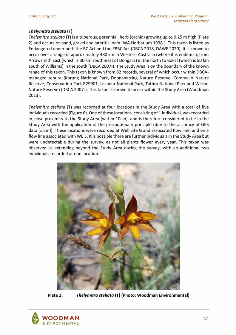
Thelymitra stellata (T) Thelymitra stellata (T) is a tuberous, perennial, herb (orchid) growing up to 0.25 m high (Plate 2) and occurs on sand, gravel and lateritic loam (WA Herbarium 1998-). This taxon is listed as Endangered under both the BC Act and the EPBC Act (DBCA 2018, DAWE 2020). It is known to occur over a range of approximately 480 km in Western Australia (where it is endemic), from Arrowsmith East (which is 30 km south-east of Dongara) in the north to Bokal (which is 50 km south of Williams) in the south (DBCA 2007-). The Study Area is on the boundary of the known range of this taxon. This taxon is known from 82 records, several of which occur within DBCA-managed tenure (Korung National Park, Doonanarring Nature Reserve, Commallo Nature Reserve, Conservation Park R29901, Lesueur National Park, Tathra National Park and Wilson Nature Reserve) (DBCA 2007-). This taxon is known to occur within the Study Area (Woodman 2013). Thelymitra stellata (T) was recorded at four locations in the Study Area with a total of five individuals recorded (Figure 6). One of these locations, consisting of 1 individual, was recorded in close proximity to the Study Area (within 10cm), and is therefore considered to be in the Study Area with the application of the precautionary principle (due to the accuracy of GPS data (± 5m)). These locations were recorded at Well Site G and associated flow line, and on a flow line associated with WE 5. It is possible there are further individuals in the Study Area but were undetectable during the survey, as not all plants flower every year. This taxon was observed as extending beyond the Study Area during the survey, with an additional two individuals recorded at one location.
Plate 2: Thelymitra stellata (T) (Photo: Woodman Environmental)
!!
!
!
!
!
!
!!
!
!!
!!
334000
334000
335000
335000
336000
336000
337000
337000
6744
000
6744
000
6745
000
6745
000
6746
000
6746
000
6747
000
6747
000
6748
000
6748
000
6749
000
6749
000
West Erregulla Survey Threatened Flora Locations WEC Ref: Strike20-30
Author: Leah Firth Figure
$Projection: GDA 1994 MGA Zone 50
6Revision: A - 04 Dec 2020 Scale: 1:16,000 (A3)This map should only be used in conjunction with WEC report Strike20-30.
LegendStudy Area
Significant Flora! Pdix Paracaleana dixonii (T)
! Tst Thelymitra stellata (T)
Filename: Strike20-30-f06
Strike Energy Ltd West Erregulla Exploration Program Targeted Flora Survey
19
4.2.2 Priority 1 and 2 Taxa
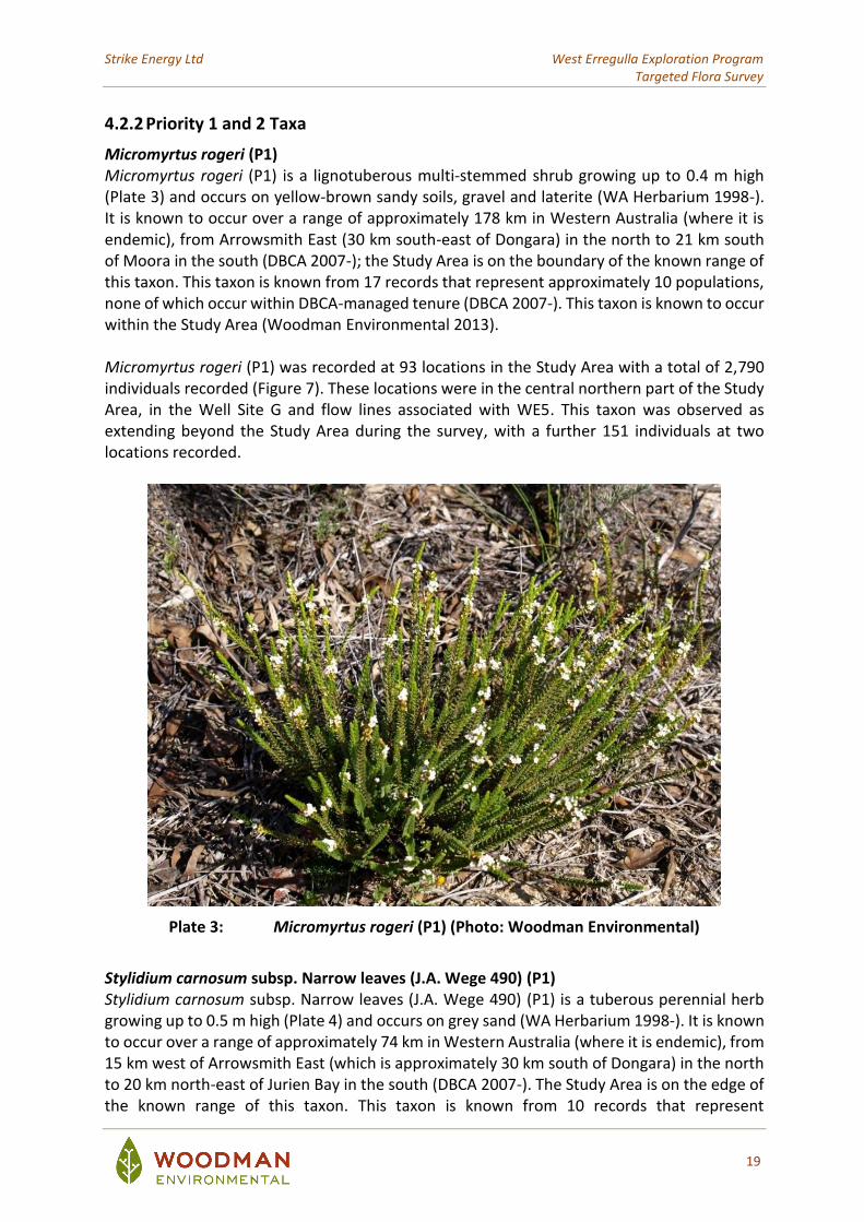
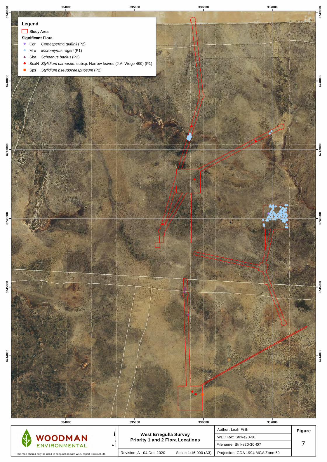
Micromyrtus rogeri (P1) Micromyrtus rogeri (P1) is a lignotuberous multi-stemmed shrub growing up to 0.4 m high (Plate 3) and occurs on yellow-brown sandy soils, gravel and laterite (WA Herbarium 1998-). It is known to occur over a range of approximately 178 km in Western Australia (where it is endemic), from Arrowsmith East (30 km south-east of Dongara) in the north to 21 km south of Moora in the south (DBCA 2007-); the Study Area is on the boundary of the known range of this taxon. This taxon is known from 17 records that represent approximately 10 populations, none of which occur within DBCA-managed tenure (DBCA 2007-). This taxon is known to occur within the Study Area (Woodman Environmental 2013). Micromyrtus rogeri (P1) was recorded at 93 locations in the Study Area with a total of 2,790 individuals recorded (Figure 7). These locations were in the central northern part of the Study Area, in the Well Site G and flow lines associated with WE5. This taxon was observed as extending beyond the Study Area during the survey, with a further 151 individuals at two locations recorded.
Plate 3: Micromyrtus rogeri (P1) (Photo: Woodman Environmental)
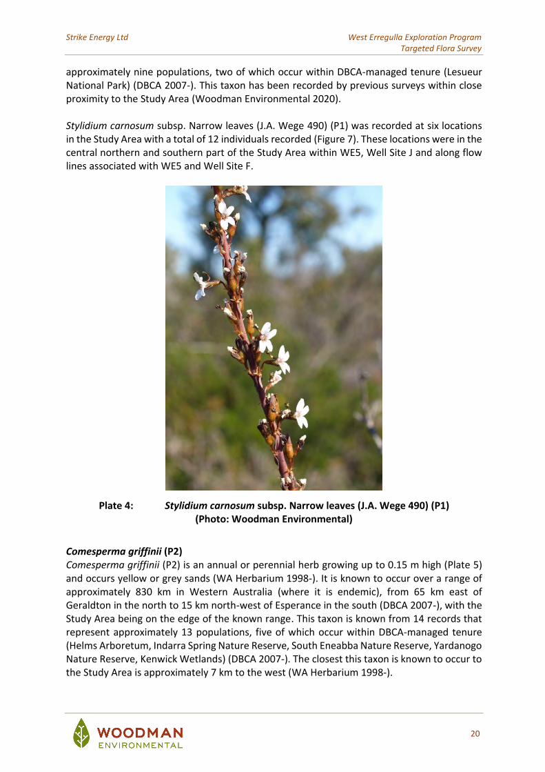
Stylidium carnosum subsp. Narrow leaves (J.A. Wege 490) (P1) Stylidium carnosum subsp. Narrow leaves (J.A. Wege 490) (P1) is a tuberous perennial herb growing up to 0.5 m high (Plate 4) and occurs on grey sand (WA Herbarium 1998-). It is known to occur over a range of approximately 74 km in Western Australia (where it is endemic), from 15 km west of Arrowsmith East (which is approximately 30 km south of Dongara) in the north to 20 km north-east of Jurien Bay in the south (DBCA 2007-). The Study Area is on the edge of the known range of this taxon. This taxon is known from 10 records that represent
Strike Energy Ltd West Erregulla Exploration Program Targeted Flora Survey
20
approximately nine populations, two of which occur within DBCA-managed tenure (Lesueur National Park) (DBCA 2007-). This taxon has been recorded by previous surveys within close proximity to the Study Area (Woodman Environmental 2020). Stylidium carnosum subsp. Narrow leaves (J.A. Wege 490) (P1) was recorded at six locations in the Study Area with a total of 12 individuals recorded (Figure 7). These locations were in the central northern and southern part of the Study Area within WE5, Well Site J and along flow lines associated with WE5 and Well Site F.
Plate 4: Stylidium carnosum subsp. Narrow leaves (J.A. Wege 490) (P1) (Photo: Woodman Environmental)
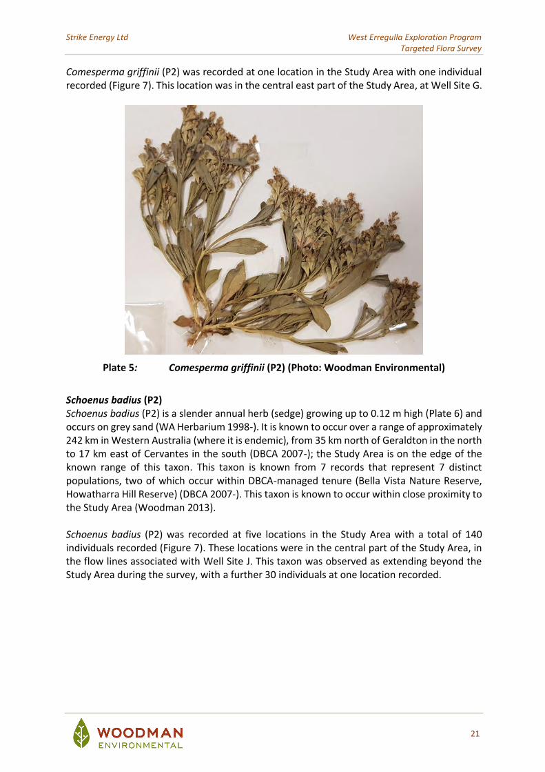
Comesperma griffinii (P2) Comesperma griffinii (P2) is an annual or perennial herb growing up to 0.15 m high (Plate 5) and occurs yellow or grey sands (WA Herbarium 1998-). It is known to occur over a range of approximately 830 km in Western Australia (where it is endemic), from 65 km east of Geraldton in the north to 15 km north-west of Esperance in the south (DBCA 2007-), with the Study Area being on the edge of the known range. This taxon is known from 14 records that represent approximately 13 populations, five of which occur within DBCA-managed tenure (Helms Arboretum, Indarra Spring Nature Reserve, South Eneabba Nature Reserve, Yardanogo Nature Reserve, Kenwick Wetlands) (DBCA 2007-). The closest this taxon is known to occur to the Study Area is approximately 7 km to the west (WA Herbarium 1998-).
Strike Energy Ltd West Erregulla Exploration Program Targeted Flora Survey
21
Comesperma griffinii (P2) was recorded at one location in the Study Area with one individual recorded (Figure 7). This location was in the central east part of the Study Area, at Well Site G.
Plate 5: Comesperma griffinii (P2) (Photo: Woodman Environmental)
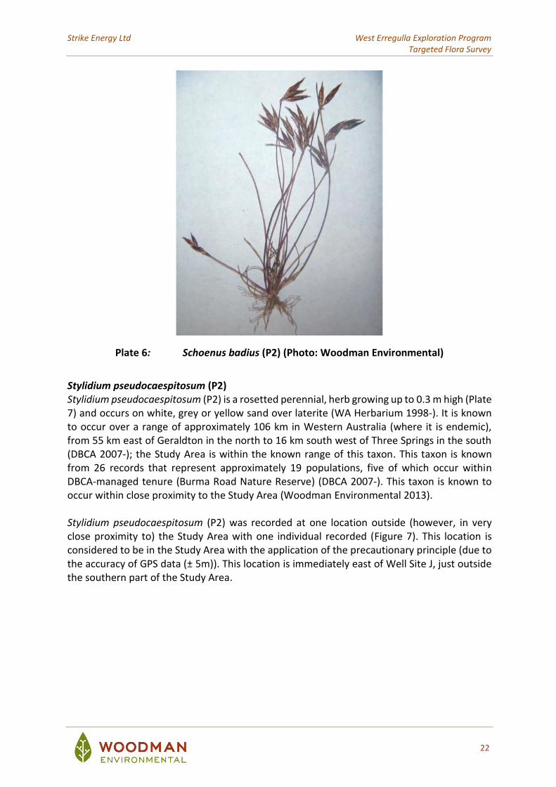
Schoenus badius (P2) Schoenus badius (P2) is a slender annual herb (sedge) growing up to 0.12 m high (Plate 6) and occurs on grey sand (WA Herbarium 1998-). It is known to occur over a range of approximately 242 km in Western Australia (where it is endemic), from 35 km north of Geraldton in the north to 17 km east of Cervantes in the south (DBCA 2007-); the Study Area is on the edge of the known range of this taxon. This taxon is known from 7 records that represent 7 distinct populations, two of which occur within DBCA-managed tenure (Bella Vista Nature Reserve, Howatharra Hill Reserve) (DBCA 2007-). This taxon is known to occur within close proximity to the Study Area (Woodman 2013). Schoenus badius (P2) was recorded at five locations in the Study Area with a total of 140 individuals recorded (Figure 7). These locations were in the central part of the Study Area, in the flow lines associated with Well Site J. This taxon was observed as extending beyond the Study Area during the survey, with a further 30 individuals at one location recorded.
Strike Energy Ltd West Erregulla Exploration Program Targeted Flora Survey
22
Plate 6: Schoenus badius (P2) (Photo: Woodman Environmental)
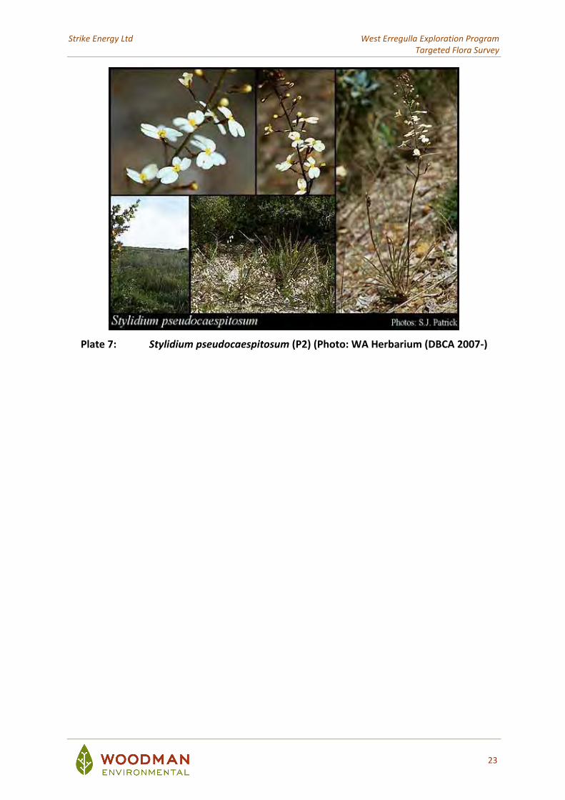
Stylidium pseudocaespitosum (P2) Stylidium pseudocaespitosum (P2) is a rosetted perennial, herb growing up to 0.3 m high (Plate 7) and occurs on white, grey or yellow sand over laterite (WA Herbarium 1998-). It is known to occur over a range of approximately 106 km in Western Australia (where it is endemic), from 55 km east of Geraldton in the north to 16 km south west of Three Springs in the south (DBCA 2007-); the Study Area is within the known range of this taxon. This taxon is known from 26 records that represent approximately 19 populations, five of which occur within DBCA-managed tenure (Burma Road Nature Reserve) (DBCA 2007-). This taxon is known to occur within close proximity to the Study Area (Woodman Environmental 2013). Stylidium pseudocaespitosum (P2) was recorded at one location outside (however, in very close proximity to) the Study Area with one individual recorded (Figure 7). This location is considered to be in the Study Area with the application of the precautionary principle (due to the accuracy of GPS data (± 5m)). This location is immediately east of Well Site J, just outside the southern part of the Study Area.
Strike Energy Ltd West Erregulla Exploration Program Targeted Flora Survey
23
Plate 7: Stylidium pseudocaespitosum (P2) (Photo: WA Herbarium (DBCA 2007-)
!
!
!
!
!!
#
##
##
#
!!!!
!!!!
!
!!!!!
!
!! !!! !!!
!!
!
! !!!!!
!!!!
!
!
!!!!!
!
!! !!!
!
!!!!! !
!!
!
!!!
!! !!
!!
!!!!
!!
! !! !! !!!!
!!!
!!!! ! !
!!!!
"
334000
334000
335000
335000
336000
336000
337000
337000
6744
000
6744
000
6745
000
6745
000
6746
000
6746
000
6747
000
6747
000
6748
000
6748
000
6749
000
6749
000
West Erregulla Survey Priority 1 and 2 Flora Locations WEC Ref: Strike20-30
Author: Leah Firth Figure
$Projection: GDA 1994 MGA Zone 50
7Revision: A - 04 Dec 2020 Scale: 1:16,000 (A3)This map should only be used in conjunction with WEC report Strike20-30.
LegendStudy Area
Significant Flora! Cgr Comesperma griffinii (P2)
! Mro Micromyrtus rogeri (P1)
# Sba Schoenus badius (P2)
! ScaN Stylidium carnosum subsp. Narrow leaves (J.A. Wege 490) (P1)
" Sps Stylidium pseudocaespitosum (P2)
Filename: Strike20-30-f07
Strike Energy Ltd West Erregulla Exploration Program Targeted Flora Survey
25
4.2.3 Priority 3 Taxa
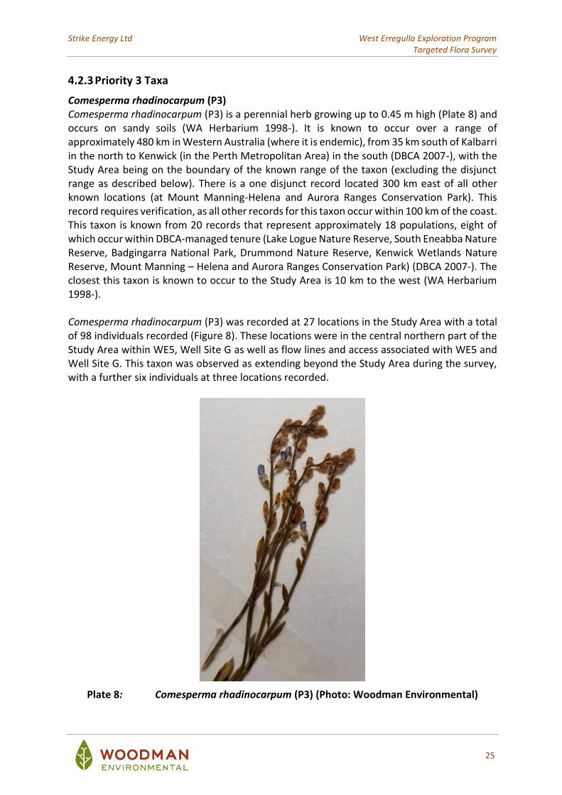
Comesperma rhadinocarpum (P3) Comesperma rhadinocarpum (P3) is a perennial herb growing up to 0.45 m high (Plate 8) and occurs on sandy soils (WA Herbarium 1998-). It is known to occur over a range of approximately 480 km in Western Australia (where it is endemic), from 35 km south of Kalbarri in the north to Kenwick (in the Perth Metropolitan Area) in the south (DBCA 2007-), with the Study Area being on the boundary of the known range of the taxon (excluding the disjunct range as described below). There is a one disjunct record located 300 km east of all other known locations (at Mount Manning-Helena and Aurora Ranges Conservation Park). This record requires verification, as all other records for this taxon occur within 100 km of the coast. This taxon is known from 20 records that represent approximately 18 populations, eight of which occur within DBCA-managed tenure (Lake Logue Nature Reserve, South Eneabba Nature Reserve, Badgingarra National Park, Drummond Nature Reserve, Kenwick Wetlands Nature Reserve, Mount Manning – Helena and Aurora Ranges Conservation Park) (DBCA 2007-). The closest this taxon is known to occur to the Study Area is 10 km to the west (WA Herbarium 1998-). Comesperma rhadinocarpum (P3) was recorded at 27 locations in the Study Area with a total of 98 individuals recorded (Figure 8). These locations were in the central northern part of the Study Area within WE5, Well Site G as well as flow lines and access associated with WE5 and Well Site G. This taxon was observed as extending beyond the Study Area during the survey, with a further six individuals at three locations recorded.
Plate 8: Comesperma rhadinocarpum (P3) (Photo: Woodman Environmental)

Strike Energy Ltd West Erregulla Exploration Program Targeted Flora Survey
26
Haemodorum loratum (P3) Haemodorum loratum (P3) is a bulbaceous, perennial, herb growing up to 1.2 m high (Plate 9) and occurs on grey or yellow sand and gravel (WA Herbarium 1998-). It is known to occur over a range of approximately 250 km in Western Australia (where it is endemic), from Eneabba in the north to Wattle Grove (in Perth Metropolitan Area) in the south (DBCA 2007-); the Study Area is on the boundary of the known range for this taxon. This taxon is known from 33 records that represent approximately 20 populations, nine of which occur within DBCA-managed tenure (South Eneabba Nature Reserve, Lesueur National Park, Coomallo Nature Reserve, Moore River National Park and Unnamed Nature Reserve 46899) (DBCA 2007-). This taxon has been recorded by previous surveys within close proximity to the Study Area (Woodman Environmental 2020). Haemodorum loratum (P3) was recorded at 17 locations in the Study Area with a total of 48 individuals recorded (Figure 8). These locations were in the central northern part of the Study Area within WE5, Well Site J and flow lines associated with Well Site J. This taxon was observed as extending beyond the Study Area during the survey, with one individual at one location recorded.
Plate 9: Haemodorum loratum (P3) (Photo: Woodman Environmental)
Strike Energy Ltd West Erregulla Exploration Program Targeted Flora Survey
27
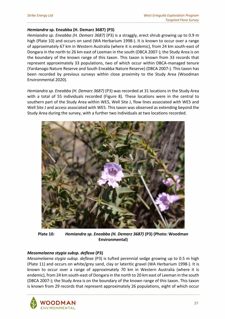
Hemiandra sp. Eneabba (H. Demarz 3687) (P3) Hemiandra sp. Eneabba (H. Demarz 3687) (P3) is a straggly, erect shrub growing up to 0.9 m high (Plate 10) and occurs on sand (WA Herbarium 1998-). It is known to occur over a range of approximately 67 km in Western Australia (where it is endemic), from 24 km south-east of Dongara in the north to 26 km east of Leeman in the south (DBCA 2007-); the Study Area is on the boundary of the known range of this taxon. This taxon is known from 33 records that represent approximately 33 populations, two of which occur within DBCA-managed tenure (Yardanogo Nature Reserve and South Eneabba Nature Reserve) (DBCA 2007-). This taxon has been recorded by previous surveys within close proximity to the Study Area (Woodman Environmental 2020). Hemiandra sp. Eneabba (H. Demarz 3687) (P3) was recorded at 31 locations in the Study Area with a total of 55 individuals recorded (Figure 8). These locations were in the central to southern part of the Study Area within WE5, Well Site J, flow lines associated with WE5 and Well Site J and access associated with WE5. This taxon was observed as extending beyond the Study Area during the survey, with a further two individuals at two locations recorded.
Plate 10: Hemiandra sp. Eneabba (H. Demarz 3687) (P3) (Photo: Woodman Environmental)
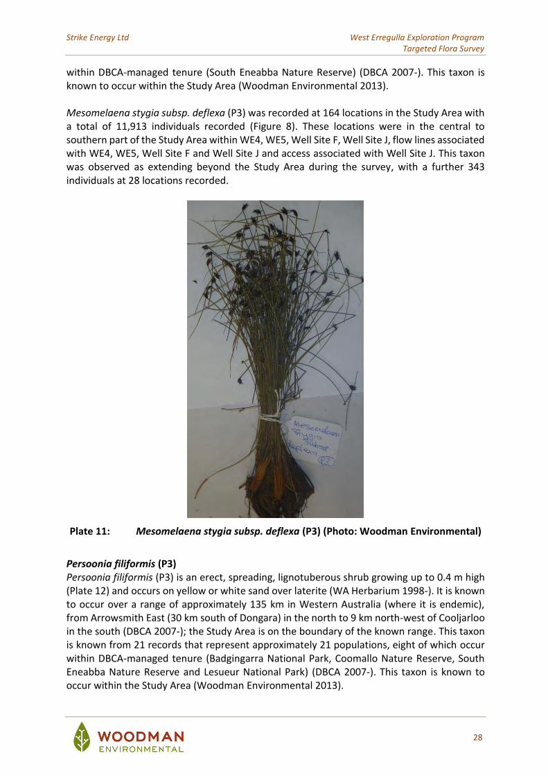
Mesomelaena stygia subsp. deflexa (P3) Mesomelaena stygia subsp. deflexa (P3) is tufted perennial sedge growing up to 0.5 m high (Plate 11) and occurs on white/grey sand, clay or lateritic gravel (WA Herbarium 1998-). It is known to occur over a range of approximately 70 km in Western Australia (where it is endemic), from 24 km south-east of Dongara in the north to 20 km east of Leeman in the south (DBCA 2007-); the Study Area is on the boundary of the known range of this taxon. This taxon is known from 29 records that represent approximately 26 populations, eight of which occur
Strike Energy Ltd West Erregulla Exploration Program Targeted Flora Survey
28
within DBCA-managed tenure (South Eneabba Nature Reserve) (DBCA 2007-). This taxon is known to occur within the Study Area (Woodman Environmental 2013). Mesomelaena stygia subsp. deflexa (P3) was recorded at 164 locations in the Study Area with a total of 11,913 individuals recorded (Figure 8). These locations were in the central to southern part of the Study Area within WE4, WE5, Well Site F, Well Site J, flow lines associated with WE4, WE5, Well Site F and Well Site J and access associated with Well Site J. This taxon was observed as extending beyond the Study Area during the survey, with a further 343 individuals at 28 locations recorded.
Plate 11: Mesomelaena stygia subsp. deflexa (P3) (Photo: Woodman Environmental)
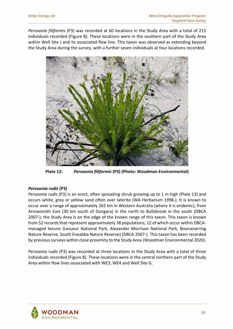
Persoonia filiformis (P3) Persoonia filiformis (P3) is an erect, spreading, lignotuberous shrub growing up to 0.4 m high (Plate 12) and occurs on yellow or white sand over laterite (WA Herbarium 1998-). It is known to occur over a range of approximately 135 km in Western Australia (where it is endemic), from Arrowsmith East (30 km south of Dongara) in the north to 9 km north-west of Cooljarloo in the south (DBCA 2007-); the Study Area is on the boundary of the known range. This taxon is known from 21 records that represent approximately 21 populations, eight of which occur within DBCA-managed tenure (Badgingarra National Park, Coomallo Nature Reserve, South Eneabba Nature Reserve and Lesueur National Park) (DBCA 2007-). This taxon is known to occur within the Study Area (Woodman Environmental 2013).
Strike Energy Ltd West Erregulla Exploration Program Targeted Flora Survey
29
Persoonia filiformis (P3) was recorded at 60 locations in the Study Area with a total of 215 individuals recorded (Figure 8). These locations were in the southern part of the Study Area within Well Site J and its associated flow line. This taxon was observed as extending beyond the Study Area during the survey, with a further seven individuals at four locations recorded.
Plate 12: Persoonia filiformis (P3) (Photo: Woodman Environmental)
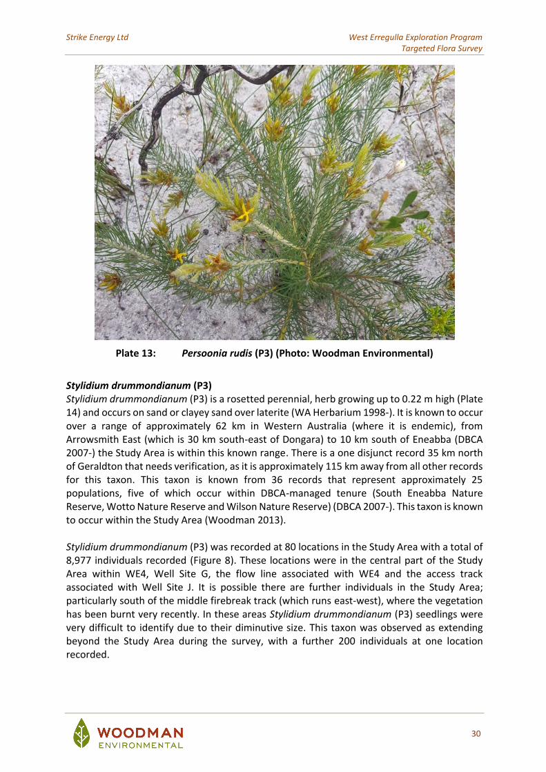
Persoonia rudis (P3) Persoonia rudis (P3) is an erect, often spreading shrub growing up to 1 m high (Plate 13) and occurs white, grey or yellow sand often over laterite (WA Herbarium 1998-). It is known to occur over a range of approximately 262 km in Western Australia (where it is endemic), from Arrowsmith East (30 km south of Dongara) in the north to Bullsbrook in the south (DBCA 2007-); the Study Area is on the edge of the known range of this taxon. This taxon is known from 52 records that represent approximately 38 populations, 12 of which occur within DBCA-managed tenure (Lesueur National Park, Alexander Morrison National Park, Boonanarring Nature Reserve, South Eneabba Nature Reserve) (DBCA 2007-). This taxon has been recorded by previous surveys within close proximity to the Study Area (Woodman Environmental 2020). Persoonia rudis (P3) was recorded at three locations in the Study Area with a total of three individuals recorded (Figure 8). These locations were in the central northern part of the Study Area within flow lines associated with WE3, WE4 and Well Site G.
Strike Energy Ltd West Erregulla Exploration Program Targeted Flora Survey
30
Plate 13: Persoonia rudis (P3) (Photo: Woodman Environmental)
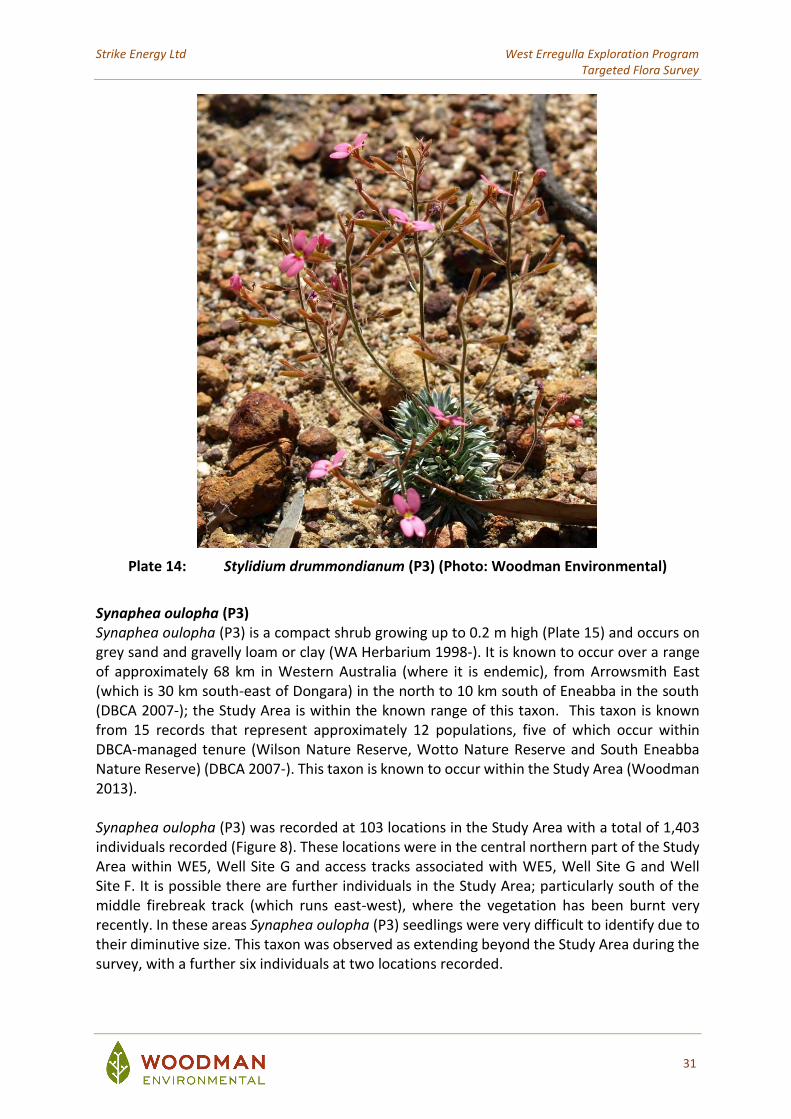
Stylidium drummondianum (P3) Stylidium drummondianum (P3) is a rosetted perennial, herb growing up to 0.22 m high (Plate 14) and occurs on sand or clayey sand over laterite (WA Herbarium 1998-). It is known to occur over a range of approximately 62 km in Western Australia (where it is endemic), from Arrowsmith East (which is 30 km south-east of Dongara) to 10 km south of Eneabba (DBCA 2007-) the Study Area is within this known range. There is a one disjunct record 35 km north of Geraldton that needs verification, as it is approximately 115 km away from all other records for this taxon. This taxon is known from 36 records that represent approximately 25 populations, five of which occur within DBCA-managed tenure (South Eneabba Nature Reserve, Wotto Nature Reserve and Wilson Nature Reserve) (DBCA 2007-). This taxon is known to occur within the Study Area (Woodman 2013). Stylidium drummondianum (P3) was recorded at 80 locations in the Study Area with a total of 8,977 individuals recorded (Figure 8). These locations were in the central part of the Study Area within WE4, Well Site G, the flow line associated with WE4 and the access track associated with Well Site J. It is possible there are further individuals in the Study Area; particularly south of the middle firebreak track (which runs east-west), where the vegetation has been burnt very recently. In these areas Stylidium drummondianum (P3) seedlings were very difficult to identify due to their diminutive size. This taxon was observed as extending beyond the Study Area during the survey, with a further 200 individuals at one location recorded.
Strike Energy Ltd West Erregulla Exploration Program Targeted Flora Survey
31
Plate 14: Stylidium drummondianum (P3) (Photo: Woodman Environmental)
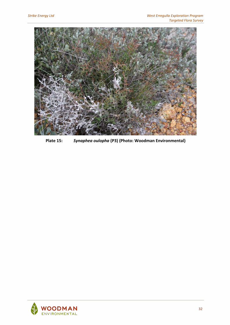
Synaphea oulopha (P3) Synaphea oulopha (P3) is a compact shrub growing up to 0.2 m high (Plate 15) and occurs on grey sand and gravelly loam or clay (WA Herbarium 1998-). It is known to occur over a range of approximately 68 km in Western Australia (where it is endemic), from Arrowsmith East (which is 30 km south-east of Dongara) in the north to 10 km south of Eneabba in the south (DBCA 2007-); the Study Area is within the known range of this taxon. This taxon is known from 15 records that represent approximately 12 populations, five of which occur within DBCA-managed tenure (Wilson Nature Reserve, Wotto Nature Reserve and South Eneabba Nature Reserve) (DBCA 2007-). This taxon is known to occur within the Study Area (Woodman 2013). Synaphea oulopha (P3) was recorded at 103 locations in the Study Area with a total of 1,403 individuals recorded (Figure 8). These locations were in the central northern part of the Study Area within WE5, Well Site G and access tracks associated with WE5, Well Site G and Well Site F. It is possible there are further individuals in the Study Area; particularly south of the middle firebreak track (which runs east-west), where the vegetation has been burnt very recently. In these areas Synaphea oulopha (P3) seedlings were very difficult to identify due to their diminutive size. This taxon was observed as extending beyond the Study Area during the survey, with a further six individuals at two locations recorded.
Strike Energy Ltd West Erregulla Exploration Program Targeted Flora Survey
32
Plate 15: Synaphea oulopha (P3) (Photo: Woodman Environmental)
!
! !
!
!
!
! !
!!
! !
!
!!
!
!
!
!
!
!
!!
!
!
!
!
!
!!
!
!
!
^^̂^^ ^^
^^̂
^^̂
^^
^
^^^̂^̂
^^^̂ ^
^
^̂^̂̂
^
^̂^̂̂
^
^̂
^
^̂̂
^̂
^
^
^
^
^̂^̂
^̂
^^^
^^ ^
^
^̂^^̂^^
^^^̂
^̂^
^̂
^
^̂̂̂
^
^
^̂^
^^̂
^̂
^
^
^
^^
^^
^
^
X
XX
XX
X
X
XX
XXXX
XX
X
XX
XXX
XX
XX
XXX X
X
XXX
XX
X
XX
X
XX
X
XX
XX
X
X
XX
XXXX
X
X
XX
X
X
XX
X
X
$$
$
$
$$$
$$
$
$$$$$
$
$$$$$$
$$$$$
$
$
$$$$$
$
$
$$$$
$$$$$
$
$
$$$$$
$$$$$$
$
$$$$$
$$
$$
$
$
$$$$
$$
$
$
$
$
$
$$
$$$$$$
$$
$$
$$
$$$$
$
$
$$
$
$$$
$
$
$$$ $
$
$$$
$
$
$$$$$$
$$$$$ $
$$ $ $ $$
$
$$$
$
$$$
$$
$
$$$$$
$
$ $ $$$
$ $ $$$$
$ $
$
$$
$
$
$$
$
$ $
$$$$$
$$ $$$$$
$$$$$
$
$$$$$ $$$$$$$
$ $$$$$
$$$
$$$
$$$$
$$
$
$
$
$$$
$$$
$
$$
$$
$$
$ $
$$$$$
$
$$$$
$$
$$$
$
$
$
$$$$
$$
$
$$
$
$$
#
#
#
#
#
#
###
#
#
#
#
#
#
#
##
#
##
#
##
## #
#
#
#
"
"
"
##
##
##
##
##
## #
#
#
##
#
334000
334000
335000
335000
336000
336000
337000
337000
6744
000
6744
000
6745
000
6745
000
6746
000
6746
000
6747
000
6747
000
6748
000
6748
000
6749
000
6749
000
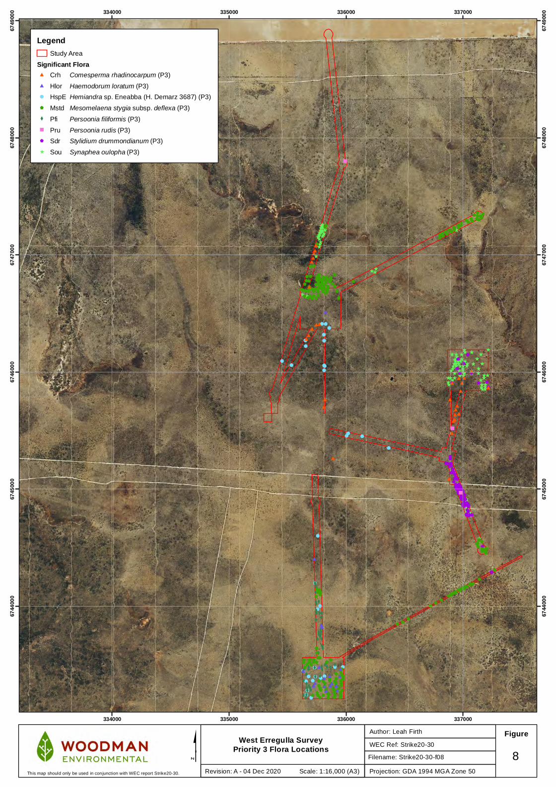
West Erregulla Survey Priority 3 Flora Locations WEC Ref: Strike20-30
Author: Leah Firth Figure
$Projection: GDA 1994 MGA Zone 50
8Revision: A - 04 Dec 2020 Scale: 1:16,000 (A3)This map should only be used in conjunction with WEC report Strike20-30.
LegendStudy Area
Significant Flora# Crh Comesperma rhadinocarpum (P3)
# Hlor Haemodorum loratum (P3)
! HspE Hemiandra sp. Eneabba (H. Demarz 3687) (P3)
$ Mstd Mesomelaena stygia subsp. deflexa (P3)
X Pfi Persoonia filiformis (P3)
" Pru Persoonia rudis (P3)
$ Sdr Stylidium drummondianum (P3)
^ Sou Synaphea oulopha (P3)
Filename: Strike20-30-f08
Strike Energy Ltd West Erregulla Exploration Program Targeted Flora Survey
34
4.2.4 Priority 4 Taxa
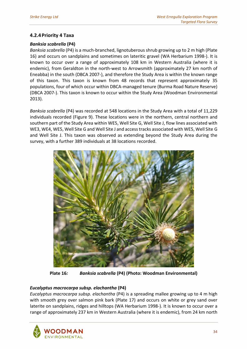
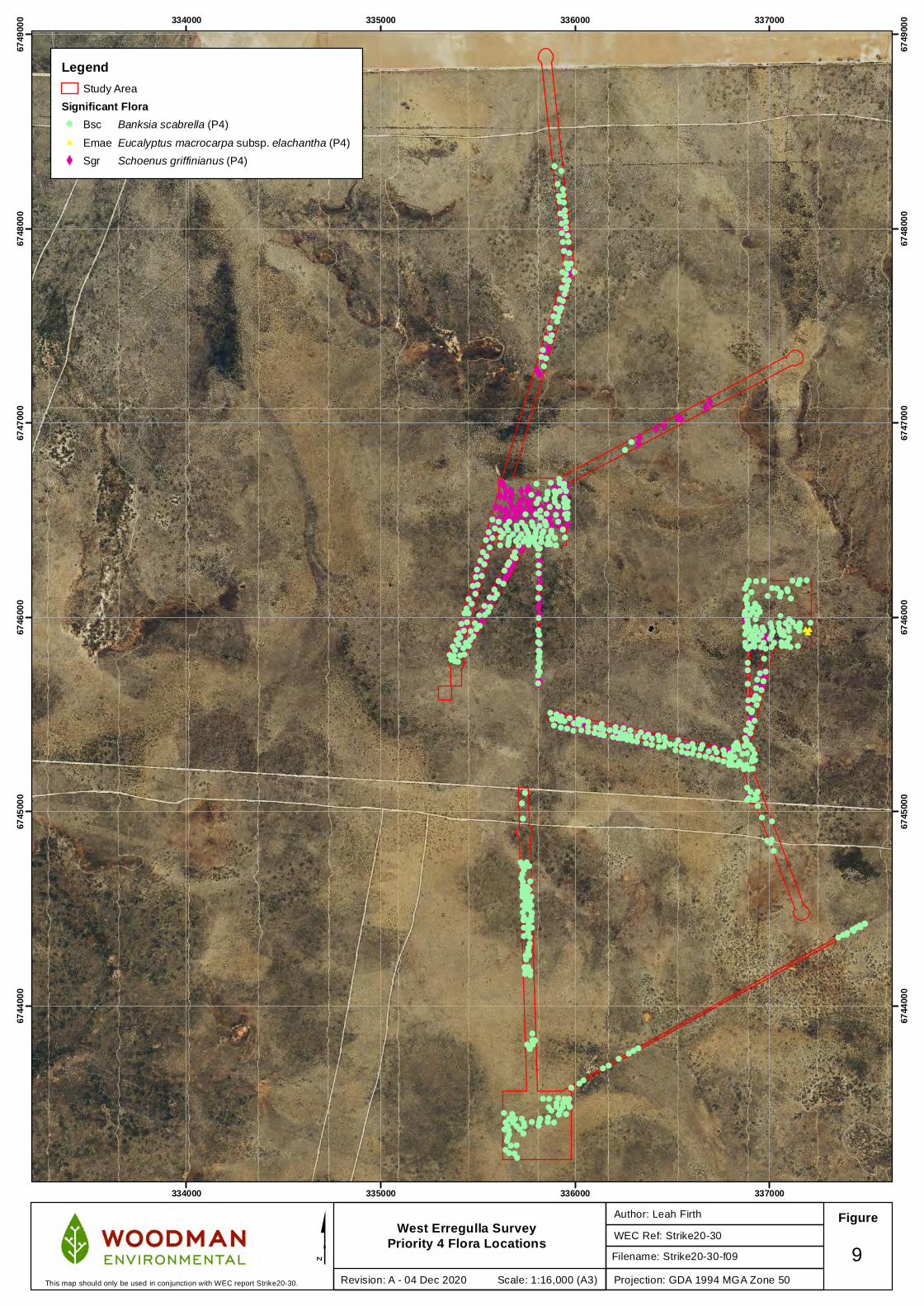
Banksia scabrella (P4) Banksia scabrella (P4) is a much-branched, lignotuberous shrub growing up to 2 m high (Plate 16) and occurs on sandplains and sometimes on lateritic gravel (WA Herbarium 1998-). It is known to occur over a range of approximately 108 km in Western Australia (where it is endemic), from Geraldton in the north-west to Arrowsmith (approximately 27 km north of Eneabba) in the south (DBCA 2007-), and therefore the Study Area is within the known range of this taxon. This taxon is known from 48 records that represent approximately 35 populations, four of which occur within DBCA-managed tenure (Burma Road Nature Reserve) (DBCA 2007-). This taxon is known to occur within the Study Area (Woodman Environmental 2013). Banksia scabrella (P4) was recorded at 548 locations in the Study Area with a total of 11,229 individuals recorded (Figure 9). These locations were in the northern, central northern and southern part of the Study Area within WE5, Well Site G, Well Site J, flow lines associated with WE3, WE4, WE5, Well Site G and Well Site J and access tracks associated with WE5, Well Site G and Well Site J. This taxon was observed as extending beyond the Study Area during the survey, with a further 389 individuals at 38 locations recorded.
Plate 16: Banksia scabrella (P4) (Photo: Woodman Environmental)
Eucalyptus macrocarpa subsp. elachantha (P4) Eucalyptus macrocarpa subsp. elachantha (P4) is a spreading mallee growing up to 4 m high with smooth grey over salmon pink bark (Plate 17) and occurs on white or grey sand over laterite on sandplains, ridges and hilltops (WA Herbarium 1998-). It is known to occur over a range of approximately 237 km in Western Australia (where it is endemic), from 24 km north
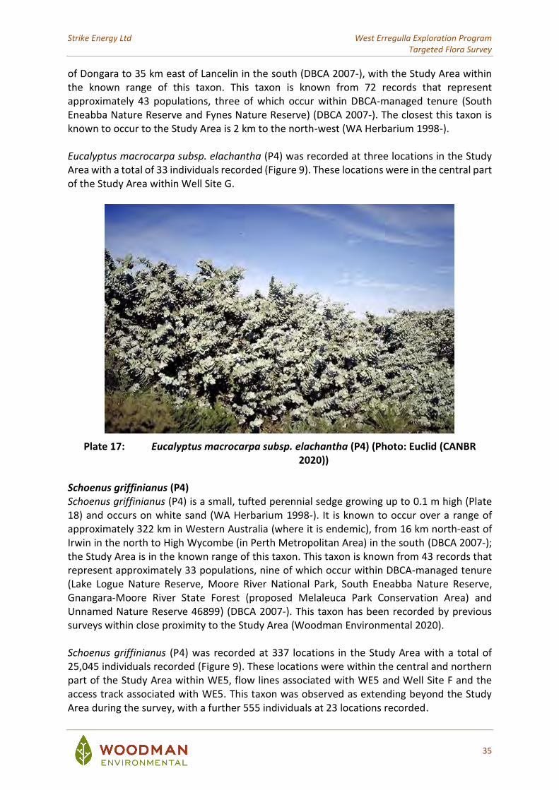
Strike Energy Ltd West Erregulla Exploration Program Targeted Flora Survey
35
of Dongara to 35 km east of Lancelin in the south (DBCA 2007-), with the Study Area within the known range of this taxon. This taxon is known from 72 records that represent approximately 43 populations, three of which occur within DBCA-managed tenure (South Eneabba Nature Reserve and Fynes Nature Reserve) (DBCA 2007-). The closest this taxon is known to occur to the Study Area is 2 km to the north-west (WA Herbarium 1998-). Eucalyptus macrocarpa subsp. elachantha (P4) was recorded at three locations in the Study Area with a total of 33 individuals recorded (Figure 9). These locations were in the central part of the Study Area within Well Site G.
Plate 17: Eucalyptus macrocarpa subsp. elachantha (P4) (Photo: Euclid (CANBR 2020))
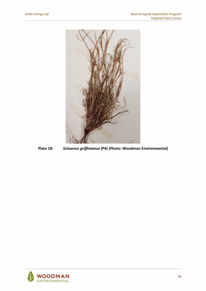
Schoenus griffinianus (P4) Schoenus griffinianus (P4) is a small, tufted perennial sedge growing up to 0.1 m high (Plate 18) and occurs on white sand (WA Herbarium 1998-). It is known to occur over a range of approximately 322 km in Western Australia (where it is endemic), from 16 km north-east of Irwin in the north to High Wycombe (in Perth Metropolitan Area) in the south (DBCA 2007-); the Study Area is in the known range of this taxon. This taxon is known from 43 records that represent approximately 33 populations, nine of which occur within DBCA-managed tenure (Lake Logue Nature Reserve, Moore River National Park, South Eneabba Nature Reserve, Gnangara-Moore River State Forest (proposed Melaleuca Park Conservation Area) and Unnamed Nature Reserve 46899) (DBCA 2007-). This taxon has been recorded by previous surveys within close proximity to the Study Area (Woodman Environmental 2020). Schoenus griffinianus (P4) was recorded at 337 locations in the Study Area with a total of 25,045 individuals recorded (Figure 9). These locations were within the central and northern part of the Study Area within WE5, flow lines associated with WE5 and Well Site F and the access track associated with WE5. This taxon was observed as extending beyond the Study Area during the survey, with a further 555 individuals at 23 locations recorded.
Strike Energy Ltd West Erregulla Exploration Program Targeted Flora Survey
36
Plate 18: Schoenus griffinianus (P4) (Photo: Woodman Environmental)
X XX XXXXX XX X
XXXXXXX X
XXXX
XXXXXX
XX X
XXX
XX
XXX
X
X
XX
XX
X
XX
XX
XX
XXXXXXXXX
XXX
XX XXXX
XXX
X XX
XXXX
X
X
XX
XXX
X
XX
XX
XX
X
XX
XXX
XXX
XX
X
X
X
XX
X
X
X
X
X
XXX
XX
XX
XX
XXX
X
X
X
XXXXXX
X
XXXXX
XXXX
X
X
XX
XX
XX
X
X
XX
XX
X X XXXX
XXXXX
X
XXX
XX
X
X
X
XXX
X
X
XX
XX
X
X
XX
XX
X
X
X
XX
XX
X
XXXXX
X XXXX
XXXX
XX X
XXX XX X
XXXXXX
XX
XXXX
X
XX
XX
X
XX
XX
XX
XXX
X
XX
XX
X
XX
X
X
XX
X
X
X
X
X
XX
X
X
X
XXX XX
XX
XX
XX
XXXX
XX
X
XXXX
X
XXXXXX
XXXXXX
XX XX
XX
X XXX
XX
X
XX XX X XXXXX
X
XX
X
X
X
X
X
XX
XX
XXXXX
X
XXXX
X
XX
X
###
!!!!!
!!!!!!
!!!
!!!
!!!!!!
!
!
!!!!
!!!!!
!
!!
!
!!
!
!!!
!
!!
!!!!
!
!
!!!!!!
!!!!!!
!!
!!!!
!
!
!!
!
!
!! !!!
!
!!!!!
!
!!!!
! !
!!!!!
!
!!!
!! !
! ! !!!!
! !
!
!!!!!!!!!
! ! ! !!!
!!!! !!
!!!
!
!!
!!
!!
!!
!!!
!!
!
!!!
!
!
!
!
!
!
!
!!
!
!
!
!
!!
!!
!!
!!
!
!!!
!!
!
!
!
!!
!
!
!!!
!!
!!!!!!
!!!!!!
!
!
!
!!!
!!!
!!
!
!!!
!
! !
!!
!
!!!
!!!!!
!
!!!
!!
!
!!!!!!
!!!!!!
!!!!!!
!! !!!!
!
!!!! !
!!!!!
!
!! !!!
!
!!!!!!
!!!!
!
!!!!! !!
!!!!!!
!!!
!
!!
!!
!
! ! !
!!!!!
!
!
!
!!!!
!!!!! !
!!!
!!
!
!!
!!!!
! !
!!!!
!!!!
!!
!!!!!!
!
!!!!!
!
!!
!!!
!!!!!
!
!!
!!!!
!
!!
!
!
!
!
!
!!!!
!!!!
!
!
!!!
!
!!
!
!
!!
!!
!!!!
!!
!!!
!
!
!
! !!!!!
! ! !!!!!!!!!!
!
!
!!
! !
!!! !!!
!!!!!
!
!!!!!!
!!
!!!
!
!!!!
!!
! !!
!!
!
!!!!!
!
!
! !!!!
!!
!!
!!
!!!!!!
!!! !!!
!!
!
!!!
!!
!!!
!
!
!!!!
!
!!
!!!
!
!!!!!!
!!
!!!!
!!!
!!!
!
!
!
!! !
!!!!!!
!
! !
!!
334000
334000
335000
335000
336000
336000
337000
337000
6744
000
6744
000
6745
000
6745
000
6746
000
6746
000
6747
000
6747
000
6748
000
6748
000
6749
000
6749
000
West Erregulla Survey Priority 4 Flora Locations WEC Ref: Strike20-30
Author: Leah Firth Figure
$Projection: GDA 1994 MGA Zone 50
9Revision: A - 04 Dec 2020 Scale: 1:16,000 (A3)This map should only be used in conjunction with WEC report Strike20-30.
LegendStudy Area
Significant Flora! Bsc Banksia scabrella (P4)
# Emae Eucalyptus macrocarpa subsp. elachantha (P4)
X Sgr Schoenus griffinianus (P4)
Filename: Strike20-30-f09
Strike Energy Ltd West Erregulla Exploration Program Targeted Flora Survey
38
5. RECOMMENDATIONS FOR MITIGATION AND AVOIDANCE
Table 5 presents the recommendations for avoidance and/or mitigation of potential impact to significant flora taxa of the Study Area. These recommendations are based on the extent of distribution for each taxon within the Study area against the known extent and distribution in contiguous vegetation outside the Study Area, and according to conservation status. The extent outside of the Study Area is based on survey findings from the current survey, findings from the desktop review (including historical results from Woodman Environmental (2013)), known regional range of the taxa and the location of the Study Area within this range. Avoidance It is recommended that all locations of Threatened flora taxa (Paracaleana dixonii and Thelymitra stellata) be avoided if possible. This will include the movement of WE5 well pad northwards to avoid Paracaleana dixonii, and a reduction of the G well pad on the eastern boundary to avoid Thelymitra stellata. Several flow lines will also require modification to avoid known locations of these taxa, including the flow line north of WE5; the flow line north of WE4 and the flow line located west of the junction of G and WE4 well pad flowlines. Where possible, plants should be avoided by 50m surrounding each known location, to minimise the potential impact to appropriate habitat for the taxon. If avoidance of these locations cannot be achieved, an Authority to Take Threatened Flora under the BC Act should be applied for. Both of these Threatened flora taxa are classified as Endangered under the EPBC Act, and therefore will require authority under the EPBC Act to clear these locations in addition to the BC Act requirement. There are also recommendations made to avoid locations of Priority flora on flow lines (and J well pad) made in Table 5. It will be impossible to avoid all locations of Priority flora on both well pads and flow line areas due to the extensive distribution of many taxa recorded during the survey. However, planning of the clearing should take into account the best possible option to avoid such flora taxa, with priority of avoidance given to Stylidium carnosum subsp. Narrow leaves (J.A. Wege 490) (P1) and Schoenus badius (P2), on flow lines, and Schoenus pseudocaespitosum (P2) which is on the eastern boundary of J well pad. These taxa are of higher conservation status and the population extents of each are poorly known in the general area. It is recommended that the total area of impact is minimised as far as possible, due to the numerous significant flora taxa which are known from the area, and their distribution within the Study Area. Mitigation Some level of impact to the known locations of significant flora taxa will be unavoidable by the project, even after the above avoidance strategies. An approved construction and rehabilitation Environmental Management Plan (EMP) is essential to be tailored to control the extent of impact to significant flora taxa by the project, as well as reduce indirect impacts to the flora (for example, introduction of Phytophthora dieback and weeds, spills due to hydrocarbons, fire prevention etc.). The plan will also need to consider the re-establishment of significant flora during rehabilitation activities.
Strike Energy Ltd West Erregulla Exploration Program Targeted Flora Survey
39
The EMP should cover all construction, operation and rehabilitation activities, including but not limited to:
• Definition of clearing boundaries;
• Clearing methods, including appropriate stripping and placement and storage of topsoil and vegetative matter;
• Construction Access and risk assessment of works which may indirectly impact flora;
• Weed control (ongoing through construction and beyond);
• Rehabilitation strategies, including respread of topsoil and stored vegetative matter on appropriate areas defined by vegetation type; seeding lists and rates and appropriate strategies to include significant flora taxa into rehabilitation areas; and
• Monitoring and evaluation of rehabilitation, and strategies to combat potential lack of performance of rehabilitation.
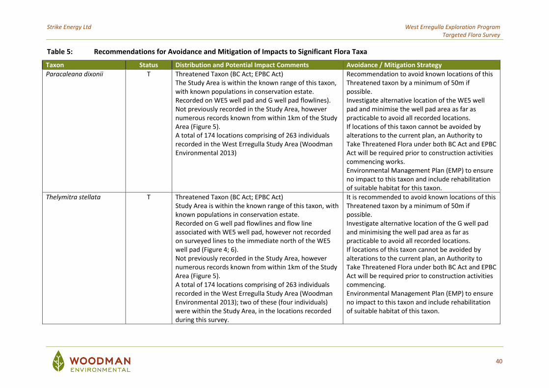
Strike Energy Ltd West Erregulla Exploration Program Targeted Flora Survey
40
Table 5: Recommendations for Avoidance and Mitigation of Impacts to Significant Flora Taxa
Taxon Status Distribution and Potential Impact Comments Avoidance / Mitigation Strategy
Paracaleana dixonii T Threatened Taxon (BC Act; EPBC Act) The Study Area is within the known range of this taxon, with known populations in conservation estate. Recorded on WE5 well pad and G well pad flowlines). Not previously recorded in the Study Area, however numerous records known from within 1km of the Study Area (Figure 5). A total of 174 locations comprising of 263 individuals recorded in the West Erregulla Study Area (Woodman Environmental 2013)
Recommendation to avoid known locations of this Threatened taxon by a minimum of 50m if possible. Investigate alternative location of the WE5 well pad and minimise the well pad area as far as practicable to avoid all recorded locations. If locations of this taxon cannot be avoided by alterations to the current plan, an Authority to Take Threatened Flora under both BC Act and EPBC Act will be required prior to construction activities commencing works. Environmental Management Plan (EMP) to ensure no impact to this taxon and include rehabilitation of suitable habitat for this taxon.
Thelymitra stellata T Threatened Taxon (BC Act; EPBC Act) Study Area is within the known range of this taxon, with known populations in conservation estate. Recorded on G well pad flowlines and flow line associated with WE5 well pad, however not recorded on surveyed lines to the immediate north of the WE5 well pad (Figure 4; 6). Not previously recorded in the Study Area, however numerous records known from within 1km of the Study Area (Figure 5). A total of 174 locations comprising of 263 individuals recorded in the West Erregulla Study Area (Woodman Environmental 2013); two of these (four individuals) were within the Study Area, in the locations recorded during this survey.
It is recommended to avoid known locations of this Threatened taxon by a minimum of 50m if possible. Investigate alternative location of the G well pad and minimising the well pad area as far as practicable to avoid all recorded locations. If locations of this taxon cannot be avoided by alterations to the current plan, an Authority to Take Threatened Flora under both BC Act and EPBC Act will be required prior to construction activities commencing. Environmental Management Plan (EMP) to ensure no impact to this taxon and include rehabilitation of suitable habitat of this taxon.
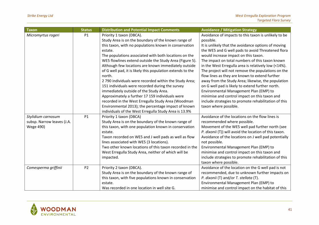
Strike Energy Ltd West Erregulla Exploration Program Targeted Flora Survey
41
Taxon Status Distribution and Potential Impact Comments Avoidance / Mitigation Strategy
Micromyrtus rogeri P1 Priority 1 taxon (DBCA). Study Area is on the boundary of the known range of this taxon, with no populations known in conservation estate. The populations associated with both locations on the WE5 flowlines extend outside the Study Area (Figure 5). Although few locations are known immediately outside of G well pad, it is likely this population extends to the north. 2 790 individuals were recorded within the Study Area; 151 individuals were recorded during the survey immediately outside of the Study Area. Approximately a further 17 159 individuals were recorded in the West Erregulla Study Area (Woodman Environmental 2013); the percentage impact of known individuals of the West Erregulla Study Area is 13.9%
Avoidance of impacts to this taxon is unlikely to be possible. It is unlikely that the avoidance options of moving the WE5 and G well pads to avoid Threatened flora would increase impact on this taxon. The impact on total numbers of this taxon known in the West Erregulla area is relatively low (<14%). The project will not remove the populations on the flow lines as they are known to extend further away from the Study Area; likewise, the population on G well pad is likely to extend further north. Environmental Management Plan (EMP) to minimise and control impact on this taxon and include strategies to promote rehabilitation of this taxon where possible.
Stylidium carnosum subsp. Narrow leaves (J.A. Wege 490)
P1 Priority 1 taxon (DBCA) Study Area is on the boundary of the known range of this taxon, with one population known in conservation estate. Taxon recorded on WE5 and J well pads as well as flow lines associated with WE5 (3 locations). Two other known locations of this taxon recorded in the West Erregulla Study Area, neither of which will be impacted.
Avoidance of the locations on the flow lines is recommended where possible. Movement of the WE5 well pad further north (see P. dixonii (T)) will avoid the location of this taxon. Avoidance of the locations on J well pad potentially not possible. Environmental Management Plan (EMP) to minimise and control impact on this taxon and include strategies to promote rehabilitation of this taxon where possible.
Comesperma griffinii P2 Priority 2 taxon (DBCA). Study Area is on the boundary of the known range of this taxon, with five populations known in conservation estate. Was recorded in one location in well site G.
Avoidance of the location on the G well pad is not recommended, due to unknown further impacts on P. dixonii (T) and/or T. stellata (T). Environmental Management Plan (EMP) to minimise and control impact on the habitat of this
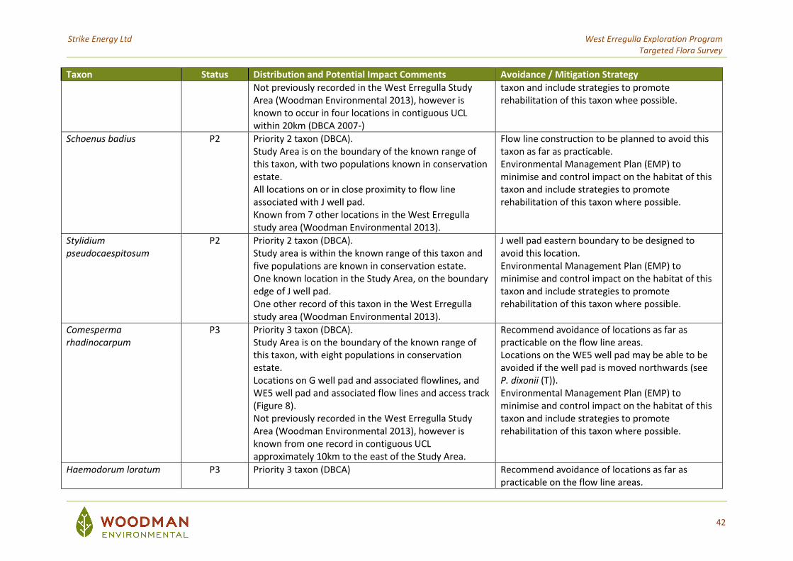
Strike Energy Ltd West Erregulla Exploration Program Targeted Flora Survey
42
Taxon Status Distribution and Potential Impact Comments Avoidance / Mitigation Strategy
Not previously recorded in the West Erregulla Study Area (Woodman Environmental 2013), however is known to occur in four locations in contiguous UCL within 20km (DBCA 2007-)
taxon and include strategies to promote rehabilitation of this taxon whee possible.
Schoenus badius P2 Priority 2 taxon (DBCA). Study Area is on the boundary of the known range of this taxon, with two populations known in conservation estate. All locations on or in close proximity to flow line associated with J well pad. Known from 7 other locations in the West Erregulla study area (Woodman Environmental 2013).
Flow line construction to be planned to avoid this taxon as far as practicable. Environmental Management Plan (EMP) to minimise and control impact on the habitat of this taxon and include strategies to promote rehabilitation of this taxon where possible.
Stylidium pseudocaespitosum
P2 Priority 2 taxon (DBCA). Study area is within the known range of this taxon and five populations are known in conservation estate. One known location in the Study Area, on the boundary edge of J well pad. One other record of this taxon in the West Erregulla study area (Woodman Environmental 2013).
J well pad eastern boundary to be designed to avoid this location. Environmental Management Plan (EMP) to minimise and control impact on the habitat of this taxon and include strategies to promote rehabilitation of this taxon where possible.
Comesperma rhadinocarpum
P3 Priority 3 taxon (DBCA). Study Area is on the boundary of the known range of this taxon, with eight populations in conservation estate. Locations on G well pad and associated flowlines, and WE5 well pad and associated flow lines and access track (Figure 8). Not previously recorded in the West Erregulla Study Area (Woodman Environmental 2013), however is known from one record in contiguous UCL approximately 10km to the east of the Study Area.
Recommend avoidance of locations as far as practicable on the flow line areas. Locations on the WE5 well pad may be able to be avoided if the well pad is moved northwards (see P. dixonii (T)). Environmental Management Plan (EMP) to minimise and control impact on the habitat of this taxon and include strategies to promote rehabilitation of this taxon where possible.
Haemodorum loratum P3 Priority 3 taxon (DBCA) Recommend avoidance of locations as far as practicable on the flow line areas.
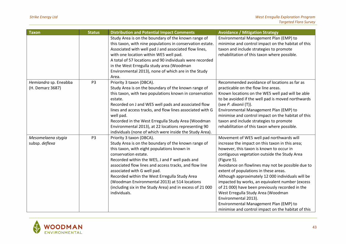
Strike Energy Ltd West Erregulla Exploration Program Targeted Flora Survey
43
Taxon Status Distribution and Potential Impact Comments Avoidance / Mitigation Strategy
Study Area is on the boundary of the known range of this taxon, with nine populations in conservation estate. Associated with well pad J and associated flow lines, with one location within WE5 well pad. A total of 57 locations and 90 individuals were recorded in the West Erregulla study area (Woodman Environmental 2013), none of which are in the Study Area.
Environmental Management Plan (EMP) to minimise and control impact on the habitat of this taxon and include strategies to promote rehabilitation of this taxon where possible.
Hemiandra sp. Eneabba (H. Demarz 3687)
P3 Priority 3 taxon (DBCA). Study Area is on the boundary of the known range of this taxon, with two populations known in conservation estate. Recorded on J and WE5 well pads and associated flow lines and access tracks, and flow lines associated with G well pad. Recorded in the West Erregulla Study Area (Woodman Environmental 2013), at 22 locations representing 90 individuals (none of which were inside the Study Area).
Recommended avoidance of locations as far as practicable on the flow line areas. Known locations on the WE5 well pad will be able to be avoided if the well pad is moved northwards (see P. dixonii (T)). Environmental Management Plan (EMP) to minimise and control impact on the habitat of this taxon and include strategies to promote rehabilitation of this taxon where possible.
Mesomelaena stygia subsp. deflexa
P3 Priority 3 taxon (DBCA). Study Area is on the boundary of the known range of this taxon, with eight populations known in conservation estate. Recorded within the WE5, J and F well pads and associated flow lines and access tracks, and flow line associated with G well pad. Recorded within the West Erregulla Study Area (Woodman Environmental 2013) at 514 locations (including six in the Study Area) and in excess of 21 000 individuals.
Movement of WE5 well pad northwards will increase the impact on this taxon in this area; however, this taxon is known to occur in contiguous vegetation outside the Study Area (Figure 5). Avoidance on flowlines may not be possible due to extent of populations in these areas. Although approximately 12 000 individuals will be impacted by works, an equivalent number (excess of 21 000) have been previously recorded in the West Erregulla Study Area (Woodman Environmental 2013). Environmental Management Plan (EMP) to minimise and control impact on the habitat of this
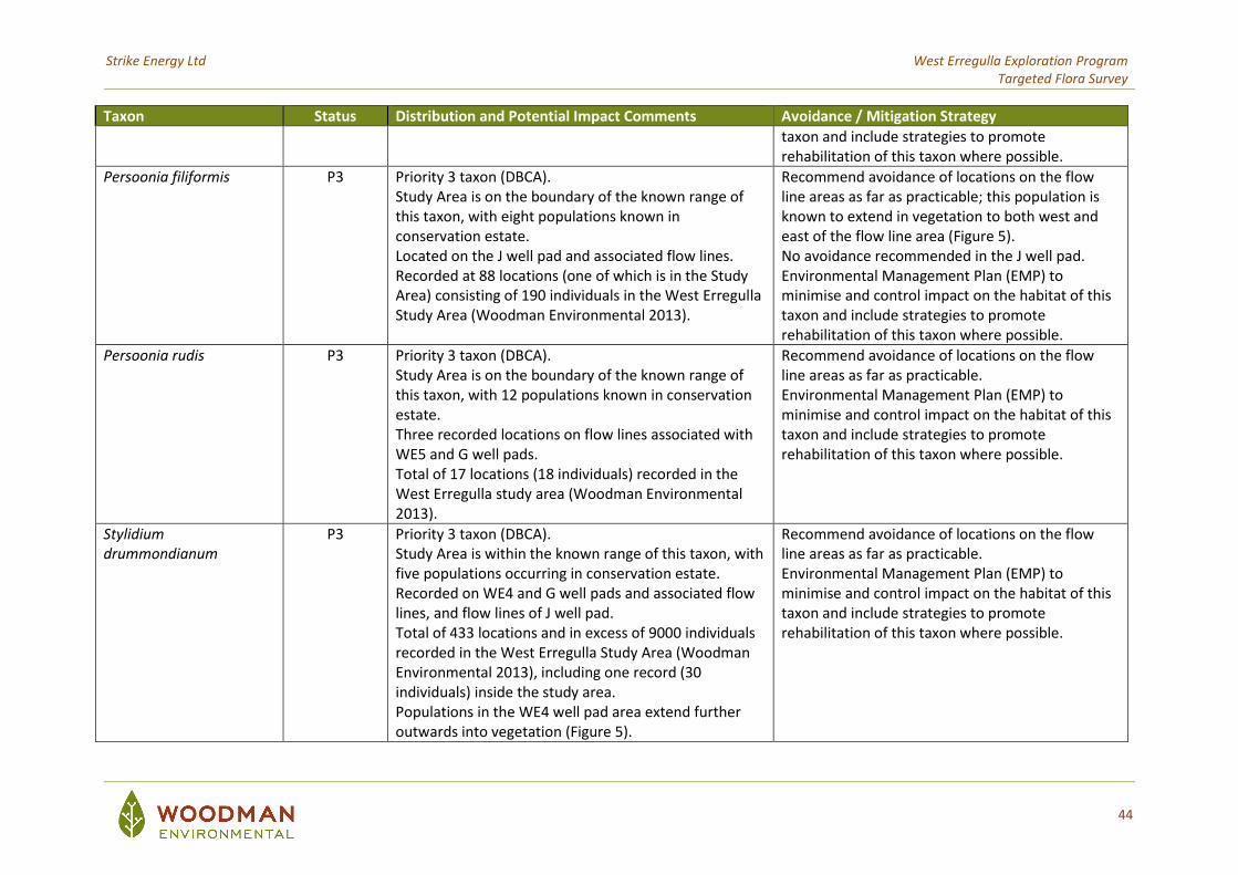
Strike Energy Ltd West Erregulla Exploration Program Targeted Flora Survey
44
Taxon Status Distribution and Potential Impact Comments Avoidance / Mitigation Strategy
taxon and include strategies to promote rehabilitation of this taxon where possible.
Persoonia filiformis P3 Priority 3 taxon (DBCA). Study Area is on the boundary of the known range of this taxon, with eight populations known in conservation estate. Located on the J well pad and associated flow lines. Recorded at 88 locations (one of which is in the Study Area) consisting of 190 individuals in the West Erregulla Study Area (Woodman Environmental 2013).
Recommend avoidance of locations on the flow line areas as far as practicable; this population is known to extend in vegetation to both west and east of the flow line area (Figure 5). No avoidance recommended in the J well pad. Environmental Management Plan (EMP) to minimise and control impact on the habitat of this taxon and include strategies to promote rehabilitation of this taxon where possible.
Persoonia rudis P3 Priority 3 taxon (DBCA). Study Area is on the boundary of the known range of this taxon, with 12 populations known in conservation estate. Three recorded locations on flow lines associated with WE5 and G well pads. Total of 17 locations (18 individuals) recorded in the West Erregulla study area (Woodman Environmental 2013).
Recommend avoidance of locations on the flow line areas as far as practicable. Environmental Management Plan (EMP) to minimise and control impact on the habitat of this taxon and include strategies to promote rehabilitation of this taxon where possible.
Stylidium drummondianum
P3 Priority 3 taxon (DBCA). Study Area is within the known range of this taxon, with five populations occurring in conservation estate. Recorded on WE4 and G well pads and associated flow lines, and flow lines of J well pad. Total of 433 locations and in excess of 9000 individuals recorded in the West Erregulla Study Area (Woodman Environmental 2013), including one record (30 individuals) inside the study area. Populations in the WE4 well pad area extend further outwards into vegetation (Figure 5).
Recommend avoidance of locations on the flow line areas as far as practicable. Environmental Management Plan (EMP) to minimise and control impact on the habitat of this taxon and include strategies to promote rehabilitation of this taxon where possible.
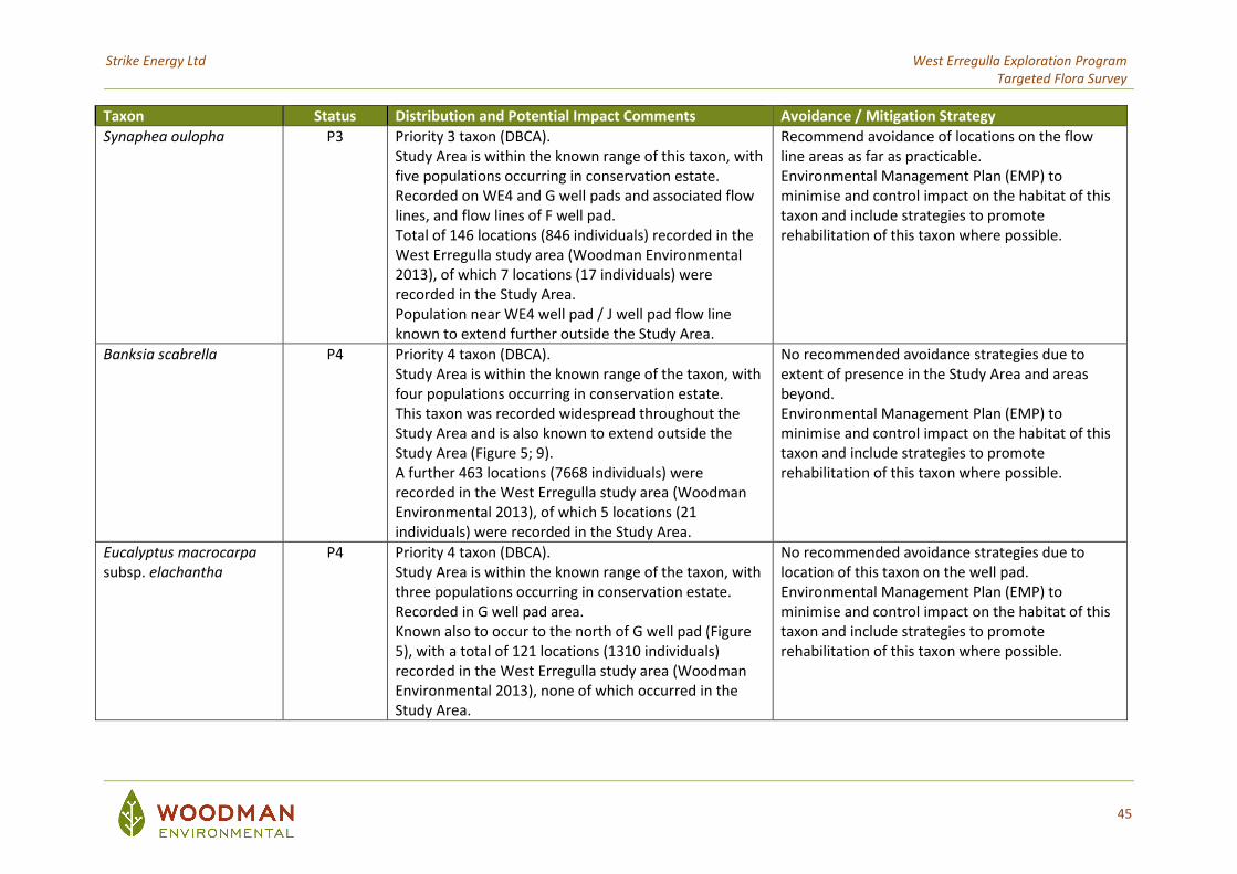
Strike Energy Ltd West Erregulla Exploration Program Targeted Flora Survey
45
Taxon Status Distribution and Potential Impact Comments Avoidance / Mitigation Strategy
Synaphea oulopha P3 Priority 3 taxon (DBCA). Study Area is within the known range of this taxon, with five populations occurring in conservation estate. Recorded on WE4 and G well pads and associated flow lines, and flow lines of F well pad. Total of 146 locations (846 individuals) recorded in the West Erregulla study area (Woodman Environmental 2013), of which 7 locations (17 individuals) were recorded in the Study Area. Population near WE4 well pad / J well pad flow line known to extend further outside the Study Area.
Recommend avoidance of locations on the flow line areas as far as practicable. Environmental Management Plan (EMP) to minimise and control impact on the habitat of this taxon and include strategies to promote rehabilitation of this taxon where possible.
Banksia scabrella P4 Priority 4 taxon (DBCA). Study Area is within the known range of the taxon, with four populations occurring in conservation estate. This taxon was recorded widespread throughout the Study Area and is also known to extend outside the Study Area (Figure 5; 9). A further 463 locations (7668 individuals) were recorded in the West Erregulla study area (Woodman Environmental 2013), of which 5 locations (21 individuals) were recorded in the Study Area.
No recommended avoidance strategies due to extent of presence in the Study Area and areas beyond. Environmental Management Plan (EMP) to minimise and control impact on the habitat of this taxon and include strategies to promote rehabilitation of this taxon where possible.
Eucalyptus macrocarpa subsp. elachantha
P4 Priority 4 taxon (DBCA). Study Area is within the known range of the taxon, with three populations occurring in conservation estate. Recorded in G well pad area. Known also to occur to the north of G well pad (Figure 5), with a total of 121 locations (1310 individuals) recorded in the West Erregulla study area (Woodman Environmental 2013), none of which occurred in the Study Area.
No recommended avoidance strategies due to location of this taxon on the well pad. Environmental Management Plan (EMP) to minimise and control impact on the habitat of this taxon and include strategies to promote rehabilitation of this taxon where possible.
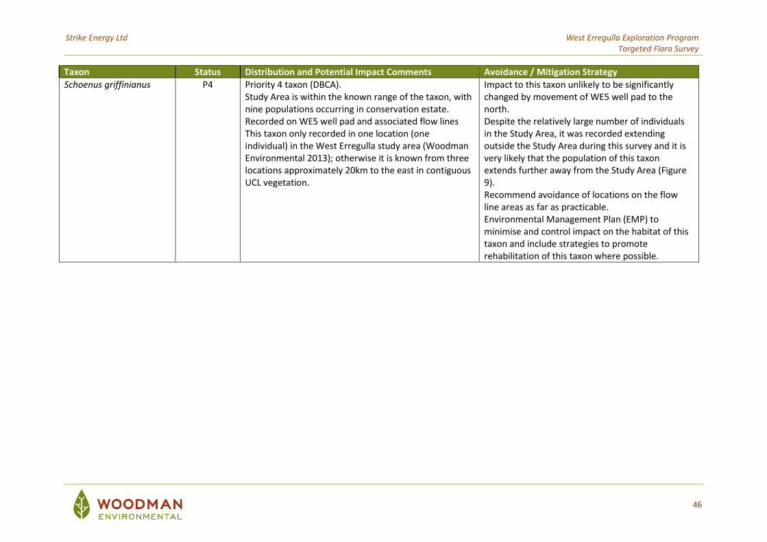
Strike Energy Ltd West Erregulla Exploration Program Targeted Flora Survey
46
Taxon Status Distribution and Potential Impact Comments Avoidance / Mitigation Strategy
Schoenus griffinianus P4 Priority 4 taxon (DBCA). Study Area is within the known range of the taxon, with nine populations occurring in conservation estate. Recorded on WE5 well pad and associated flow lines This taxon only recorded in one location (one individual) in the West Erregulla study area (Woodman Environmental 2013); otherwise it is known from three locations approximately 20km to the east in contiguous UCL vegetation.
Impact to this taxon unlikely to be significantly changed by movement of WE5 well pad to the north. Despite the relatively large number of individuals in the Study Area, it was recorded extending outside the Study Area during this survey and it is very likely that the population of this taxon extends further away from the Study Area (Figure 9). Recommend avoidance of locations on the flow line areas as far as practicable. Environmental Management Plan (EMP) to minimise and control impact on the habitat of this taxon and include strategies to promote rehabilitation of this taxon where possible.
Strike Energy Ltd West Erregulla Exploration Program Targeted Flora Survey
47
6. REFERENCES
Beard, J.S. (1990) Plant Life of Western Australia. Kangaroo Press, Perth.
Bureau of Meteorology (BoM) (2020)
Climate Data Online: Monthly Rainfall – Green Grove, Monthly Temperature – Morawa. Available: http://www.bom.gov.au/climate/data. Sourced November 2020.
Centre for Australian National Biodiversity Research (CANBR) (2020)
EUCLID: Eucalypts of Australia, Fourth edition. https://apps.lucidcentral.org/euclid/text/intro/about.htm
Commonwealth of Australia (2012)
Interim Biogeographic Regionalisation for Australia, Version 7. Department of Sustainability, Environment, Water, Population and Communities. Available: http://www.environment.gov.au/parks/nrs/science/bioregion-framework/ibra/index.html#ibra
Department of Agriculture, Water and the Environment (2020)
Interrogation of Species Profile and Threats (SPRAT) Database using Protected Matters Search Tool. Queried 13/02/2020. URL: https://www.environment.gov.au/epbc/protected-matters-search-tool
Department of Biodiversity, Conservation and Attractions (DBCA) (2007-)
NatureMap: Mapping Western Australia's Biodiversity. Available: https://naturemap.dpaw.wa.gov.au/. Accessed November 2020.
Department of Biodiversity, Conservation and Attractions (DBCA) (2018a) List of Threatened Ecological Communities (TECs) endorsed by the Western Australian Minister for Environment. Species and Communities Branch, 28th June 2018
Department of Biodiversity, Conservation and Attractions (as Department of Parks and Wildlife) (2018b)
Threatened and Priority Flora List – December 2018. Available: https://www.dpaw.wa.gov.au/plants-and-animals/threatened-species-and-communities/threatened-plants. Species and Communities Branch, Department of Parks and Wildlife.
Department of Biodiversity, Conservation and Attractions (DBCA) (2020c)
Interrogation of the DBCA Threatened Ecological Communities and Priority Ecological Communities database, performed 25/02/2020. Reference: 24-0220EC.
Department of Biodiversity, Conservation and Attractions (DBCA) (2020b)
Priority Ecological Communities for Western Australia Version 30. Species and Communities Branch, 28th July 2020.
Strike Energy Ltd West Erregulla Exploration Program Targeted Flora Survey
48
Department of Biodiversity, Conservation and Attractions (DBCA) (2020c) Interrogation of the DBCA Western Australian Herbarium specimen database, Threatened and Priority Flora database and Threatened and Priority Flora List, performed 14/02/2020. Reference: 20-0220FL.
Department of Biodiversity, Conservation and Attractions (DBCA) (2020b)
Interrogation of the DBCA Threatened Ecological Communities and Priority Ecological Communities database, performed 25/02/2020. Reference: 24-0220EC.
Environmental Protection Authority (EPA) (2016a)
Technical Guidance – Flora and Vegetation Surveys for Environmental Impact Assessment. EPA, Western Australia, December 2016.
Environmental Protection Authority (EPA) (2016b)
Environmental Factor Guideline – Flora and Vegetation. Published 13th December 2016 (www.epa.wa.gov.au/).
Government of Western Australia (2019)
2018 Statewide Vegetation Statistics incorporating the CAR Reserve Analysis (Full Report). Current as of March 2019. WA Department of Biodiversity, Conservation and Attractions. Available: https://catalogue.data.wa.gov.au/dataset/dbca-statewide-vegetation-statistics
WA Herbarium (1998-)
Florabase. Available: https://florabase.dpaw.wa.gov.au/. Accessed November 2020. Woodman Environmental Consulting Pty Ltd (Woodman Environmental) (2009a)
Flora and Vegetation of the Proposed Eneabba-Moonyoonooka 330kV Transmission Line Supplementary Field Survey 2008. Unpublished report (WP08-21-01 Rev 0) February 2009.
Woodman Environmental Consulting Pty Ltd (Woodman Environmental) (2009b)
West Erregulla-2 Well Site Flora and Vegetation Assessment. Unpublished report (Warrego08-46-01) prepared for Warrego Energy Ltd., April 2009.
Woodman Environmental Consulting Pty Ltd (Woodman Environmental) (2010)
Flora and Vegetation of the Proposed Eneabba-Moonyoonooka 330kV Transmission Line Supplementary Field Survey 2008 2009 Survey Addendum report. Unpublished report (WP09-46-01 Rev 0) February 2010.
Woodman Environmental Consulting Pty Ltd (Woodman Environmental) (2013)
West Erregulla Project Area Flora and Vegetation Assessment. Unpublished report (Rev 3) prepared for Warrego Resources, September 2013.
Woodman Environmental Consulting Pty Ltd (2020)
West Erregulla Exploration Program – Wells 4 and 5 Flora and Vegetation Risk Assessment. Unpublished report (Rev 0) prepared for Strike Energy Ltd, March 2020.