Embed Size (px)
Citation preview
APPENDIX B
Site Data Worksheets

LA-RICS LTE System
Appendix B: Supplemental Environmental Assessment
Site ID: AZPD001
Facility Name: Azusa PD
LA-RICS System Supplemental Environmental Assessment AZPD001 - 1
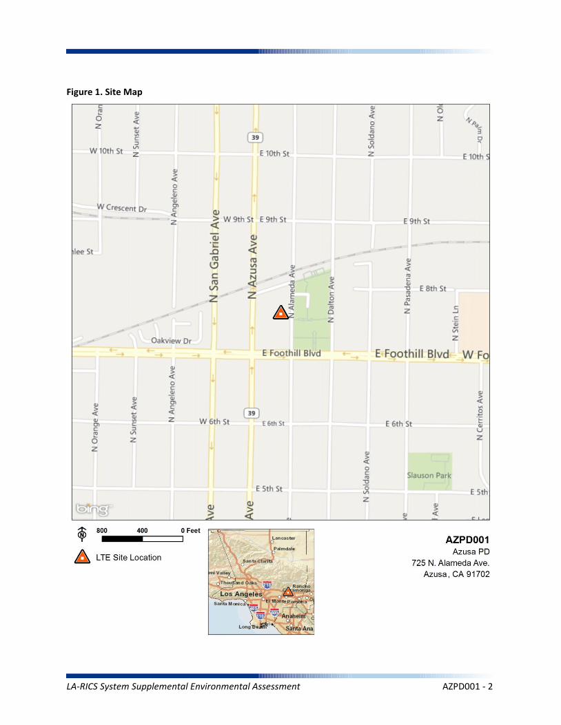
Figure 1. Site Map
LA-RICS System Supplemental Environmental Assessment AZPD001 - 2
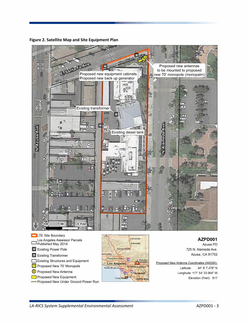
Figure 2. Satellite Map and Site Equipment Plan
LA-RICS System Supplemental Environmental Assessment AZPD001 - 3
1.0 PROJECT DESCRIPTION
The Azusa Police Department site (Site AZPD001, Figure 1) is a public safety facility, owned and administered by the City of Azusa and occupied by the Asuza Police Department. The site is in an urban area in the basin region of Los Angeles County.
Site AZPD001 was evaluated in the Final LA-RICS LTE EA and the corresponding FONSI (October 2014). The site was evaluated for installation of a new monopole, plus supporting infrastructure. Design changes made since the Final LA-RICS LTE EA (Figure 2) include trenching up to 500 linear feet into adjacent right(s) of way to accommodate electrical and/or fiber upgrades. All other design features, equipment and vehicle use, utility requirements, ground disturbance would be as described in the Final LA-RICS LTE EA.
Maximum Facility Height: N/A
Proposed Tower Type: N/A-trenching in adjacent area only
Proposed Tower Height: N/A
Proposed FAA lighting: N/A
Anticipated Disturbance: Up to 1,000 square feet of additional ground disturbance while trenching for power/fiber adjacent to site previously analyzed.
Power Requirements:
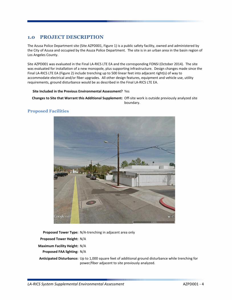
Proposed Facilities
Site Included in the Previous Environmental Assessment? Yes
Changes to Site that Warrant this Additional Supplement: Off-site work is outside previously analyzed site boundary.
LA-RICS System Supplemental Environmental Assessment AZPD001 - 4
Power Requirements: No new power requirements identified.
No Action Alternative: Under the No Action Alternative, this site would remain unchanged and no new LTE telecommunication infrastructure or related infrastructure would be installed. No direct, indirect, or cumulative impacts are anticipated.
LA-RICS System Supplemental Environmental Assessment AZPD001 - 5
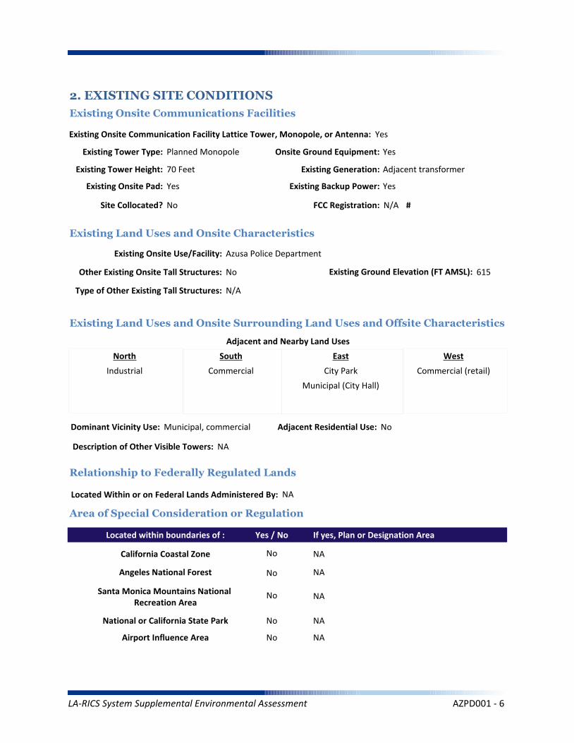
2. EXISTING SITE CONDITIONS
Existing Onsite Communications Facilities
Existing Onsite Communication Facility Lattice Tower, Monopole, or Antenna: Yes
Existing Tower Type: Planned Monopole
Existing Tower Height: 70 Feet
Existing Onsite Pad: Yes
Onsite Ground Equipment: Yes
Existing Generation: Adjacent transformer
Existing Backup Power: Yes
Existing Onsite Use/Facility: Azusa Police Department
Other Existing Onsite Tall Structures: No
Type of Other Existing Tall Structures: N/A
Existing Ground Elevation (FT AMSL): 615
Industrial Commercial City Park
Municipal (City Hall)
Commercial (retail)
Dominant Vicinity Use: Municipal, commercial Adjacent Residential Use: No
Located Within or on Federal Lands Administered By: NA
NA
NA
NA
NA
NA
Existing Land Uses and Onsite Characteristics
Existing Land Uses and Onsite Surrounding Land Uses and Offsite Characteristics
Adjacent and Nearby Land Uses
North South East West
Description of Other Visible Towers: NA
Relationship to Federally Regulated Lands
Area of Special Consideration or Regulation
Located within boundaries of :
California Coastal Zone
Angeles National Forest
Santa Monica Mountains National Recreation Area
National or California State Park
Airport Influence Area
Yes / No If yes, Plan or Designation Area
Site Collocated? No FCC Registration: N/A #
No
No
No
No
No
LA-RICS System Supplemental Environmental Assessment AZPD001 - 6
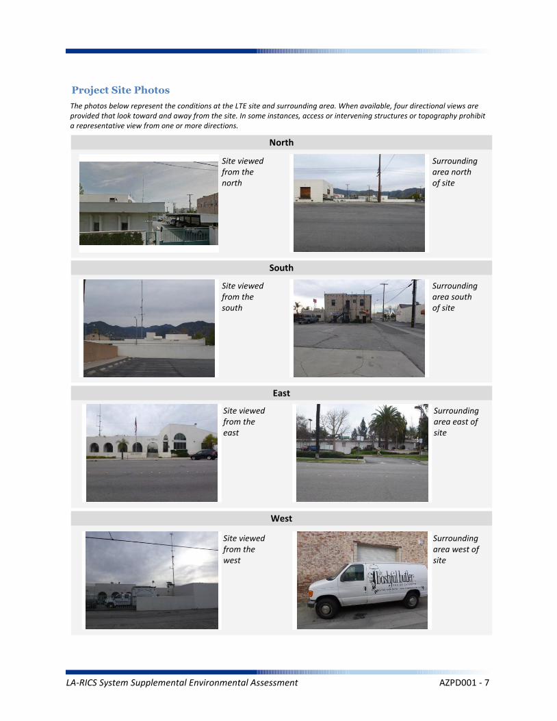
Project Site Photos
The photos below represent the conditions at the LTE site and surrounding area. When available, four directional views are provided that look toward and away from the site. In some instances, access or intervening structures or topography prohibit a representative view from one or more directions.
Site viewed from the north
Site viewed from the south
Site viewed from the east
Site viewed from the west
Surrounding area north of site
Surrounding area south of site
Surrounding area east of site
Surrounding area west of site
North
South
East
West
LA-RICS System Supplemental Environmental Assessment AZPD001 - 7
Operation Noise
Construction Vibration
Summary Impact Statement
Construction Noise
3. NOISE
Affected Environment Technical Analysis
Environmental Consequences and Impact Overview
Applicable Noise Standards Source: Azusa Municipal Code Azusa, Article IX, Section 46-409
Ambient Noise Setting: Urban
Local Residential Exterior Noise Exposure Limit: 55
Surrounding Walls/Structures Serve as Potential Noise Barrier? No
Vibration Sensitive Buildings Located within 50 feet of Site? No
Nearest Off-Site Sensitive Receiver Type: 300 feet
Sensitive Noise Receiver #1: City Park
Sensitive Noise Receiver #2: N/A
Sensitive Noise Receiver #3: N/A
Construction Projects are Exempt from Noise Regulations? No
7:00am - 6:00pm 7:00am - 6:00pm By Approval By Approval
Construction Noise Exempt During Normal Construction Hours? No
Construction Allowed During Extended Hours with Approval or Permit? Yes
Not Significant None None
Not Significant None None
Not Significant None None
Noise and vibration from construction activity would be short term and localized. Noise from operation not expected to be perceptible off-site.
Ambient Noise Factors and Conditions
Off-Site Sensitive Noise Receivers
Construction Noise Regulations
Monday-Friday Saturday Sunday HolidayAllowedConstruction
Hours
Intensity of Impact
Direct Indirect Cumulative
Discussion/Reference:
LA-RICS System Supplemental Environmental Assessment AZPD001 - 8

CEQ’s GHG Annual Emission Threshold
Operation Emissions of Criteria Pollutants
Summary Impact Statement
Construction Emissions of Criteria Pollutants
4. AIR QUALITY AND GREENHOUSE GASES
Affected Environment Technical Analysis
Environmental Consequences and Impact Overview
Not Significant Not Significant
Not Significant Not Significant None
Not Significant Not Significant None
Emissions generated from construction activity and long-term operation of the Proposed Action would not exceed regulatory or guideline thresholds.
Intensity of Impact
Direct Indirect Cumulative
Discussion/Reference:
Nearest Monitoring Station: 803 N. Loren Ave., Azusa
Sensitive Receptor 1: City Park
Sensitive Receptor 2: N/A
Sensitive Receptor 3: N/A
None
Within Local Conformity Plan: N/A
Air Basin: South Coast Air Basin
AirQuaMgmtDist: South Coast Air Quality Management District
LA-RICS System Supplemental Environmental Assessment AZPD001 - 9

Prime or Unique Farmland
Soil Erosion
Summary Impact Statement
Seismic Hazards
5. GEOLOGY AND SOILS
Affected Environment Technical Analysis
Environmental Consequences and Impact Overview
Not Significant None
None None None
None None None
Best management practices (BMPs) utilized during construction and operation of the Proposed Action would control runoff and minimize erosion.
Intensity of Impact
Direct Indirect Cumulative
Discussion/Reference:
US Geological Survey 7.5-Minute Quadrangle: Azusa (75)
Is the site located within an Alquist-Priolo Earthquake Fault Zone? No
If yes, please explain: N/A
Geological Province: Peninsular Ranges
Surface Geological Formation: Q - Quaternary alluvium and marine deposits
USDA Soil Classification: Zamora-Urban land-Ramona Association
None
Geologic Characteristics
Farmland
Site occurs within Prime or Unique Farmland of Statewide or Local Importance: No
LA-RICS System Supplemental Environmental Assessment AZPD001 - 10

Flood Hazard
Summary Impact Statement
Stormwater and non-storm waterdischarges on surface water resources
6. WATER RESOURCES
Affected Environment Technical Analysis
Environmental Consequences and Impact Overview
Regional Water Quality Control Board Hydrologic Region: Los Angeles RWQCB
Hydrologic Sub-Basin or Watershed: San Gabriel
Is a Surface Water Feature Located in Immediate Site Vicinity? No
If yes, please explain: N/A
Does the Project Site Affect a Wild or Scenic River? No
Name of the Groundwater Basin in which the Project Site Lies: San Gabriel Valley
Not Significant None None
None None None
Best management practices identified in BIO CMR 18 would preclude runoff from the site, and thereby avoid potential sediment and pollutant runoff.
Hydrologic Region
Surface Water (as defined by US Geological Survey)
Groundwater
Intensity of Impact
Direct Indirect Cumulative
Discussion/Reference:
If yes, please explain: N/A
Does the Project Site Affect an “Impaired Waterbody”? No
If yes, please explain: N/A
Flood Plain
If yes, please explain: N/A
Is the project site located within a designated 100-year flood plain, or an area designated as hillside, or other known flood-prone areas? No
LA-RICS System Supplemental Environmental Assessment AZPD001 - 11

7. BIOLOGICAL RESOURCES
Affected Environment Technical Analysis
Dominant Onsite Habitat Type: Urban or Build-up Land/Ornamental
Site within 500 feet or within an Essential Fish Habitat (EFH): No
If yes, please explain: N/A
Site within 500 feet or within a Habitat Conservation Plan (HCP): No
Locational Context
Wetlands (as defined by US Geological Survey or US Fish Wildlife Service)
Special-Status Species and Habitats
If yes, please explain: N/A
Are wetlands present on site or within 500 feet of site? No
If yes, please explain: N/A
USFWS critical habitat present on site or within 500 feet of the site: No
If yes, please explain: N/A
Endangered Species Act (ESA)-listed species expected to occur on or within 500 feet of the site: No
If yes, please explain: N/A
Site within 500 feet or within a Federal/State Critical Habitat: No
If yes, please explain: N/A
Bald/Golden Eagle nest present on site or within 500 feet of the site: No
LA-RICS System Supplemental Environmental Assessment AZPD001 - 12

Marine Mammal Protection Act (MMPA)
Summary Impact Statement
Federal Endangered Species Act (ESA) None None None
None None None
No special-status species have been identified near the site and no impacts to special-status species are anticipated. Implementation of BIO CMR-1 would preclude potential impacts to MBTA species. This requirement would identify nesting birds and prohibit construction if nesting activity is identified.
Intensity of Impact
Direct Indirect Cumulative
Discussion/Reference:
Bald/Golden Eagle Protection Act (BGEPA) None None None
Effects on special status species
State/ Federal Listed Species
Migratory Bird Treaty Act (MBTA) None None None
None None None
California Fully Protected (CFP) None None None
California Endangered Species Act (CESA) None None None
Essential Fish Habitat
Summary Impact Statement
Critical Habitat None None None
None None None
No sensitive habitats have been identified at or near the site. No impacts are anticipated.
Intensity of Impact
Direct Indirect Cumulative
Discussion/Reference:
Wetlands Waters None None None
Effects on Important or Critical Habitat
Habitat Conservation Plan (HCP)Management Areas
None None None
Invasive Plant Species
Summary Impact Statement
Vegetation/Land Cover
Environmental Consequences and Impact Overview
None None None
None None None
The site is highly urbanized, and no native habitats occur. Common wildlife associated with urban areas (e.g., rodents, rabbits) could potentially be impacted during trenching activities or when construction equipment is used at the site. Potential impacts to common wildlife would be avoided through implementation of the following CMRs:
BIO CMR 1 - Preconstruction Surveys for Nesting Birds; BIO CMR 8 - Open Trenches and Ditches.
Intensity of Impact
Direct Indirect Cumulative
Discussion/Reference:
Common Native Wildlife None None None
California Native Plant Protection Act (NPPA) None None None
LA-RICS System Supplemental Environmental Assessment AZPD001 - 13
Architectural Resources
Summary Impact Statement
Archaeological Resources
8. HISTORIC AND CULTURAL RESOURCES
Affected Environment Technical Analysis
Environmental Consequences and Impact Overview
None None None
None None None
This site was evaluated via FCC Form 620. A no effects finding was made in that evaluation and SHPO concurred with this finding, by letter dated January 8, 2015.
Intensity of Impact
Direct Indirect Cumulative
Discussion/Reference:
Proposed antenna at a listed or eligible National Register of Historic Places (NRHP) site: No
If yes, relationship of antennas to NRHP structure: N/A
Native American Resources None None None
Archaeological historic property in direct APE: No
If yes, identify the historic property: N/A
Archaeological historic property within indirect APE: No
If yes, identify the historic property: N/A
Architectural historic property in direct APE: No
If yes, identify the historic property: N/A
Architectural historic property (NRHP listed or eligible) within indirect APE: N/A
If yes, identify the historic property: N/A
Sacred Lands File site on site: No
If yes, the Sacred Lands File: N/A
Sacred Lands File site within ½ mile of indirect APE: No
If yes, the Sacred Lands File: N/A
Area having high sensitivity for paleontological resources: No
If yes, the Paleontological Site: N/A
Geological formation with a high potential for vertebrate paleontological resources: No
If yes, type of geological formation: N/A
Paleontological Resources None None None
LA-RICS System Supplemental Environmental Assessment AZPD001 - 14
Summary Impact Statement
Construction effects
9. AESTHETIC AND VISUAL RESOURCES
Affected Environment Technical Analysis
Environmental Consequences and Impact Overview
None None None
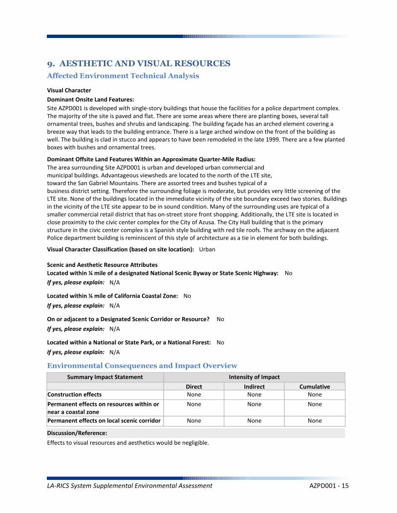
Effects to visual resources and aesthetics would be negligible.
Intensity of Impact
Direct Indirect Cumulative
Discussion/Reference:
Dominant Onsite Land Features:
Site AZPD001 is developed with single-story buildings that house the facilities for a police department complex. The majority of the site is paved and flat. There are some areas where there are planting boxes, several tall ornamental trees, bushes and shrubs and landscaping. The building façade has an arched element covering a breeze way that leads to the building entrance. There is a large arched window on the front of the building as well. The building is clad in stucco and appears to have been remodeled in the late 1999. There are a few planted boxes with bushes and ornamental trees.
Dominant Offsite Land Features Within an Approximate Quarter-Mile Radius:
The area surrounding Site AZPD001 is urban and developed urban commercial andmunicipal buildings. Advantageous viewsheds are located to the north of the LTE site,toward the San Gabriel Mountains. There are assorted trees and bushes typical of abusiness district setting. Therefore the surrounding foliage is moderate, but provides very little screening of the LTE site. None of the buildings located in the immediate vicinity of the site boundary exceed two stories. Buildings in the vicinity of the LTE site appear to be in sound condition. Many of the surrounding uses are typical of a smaller commercial retail district that has on-street store front shopping. Additionally, the LTE site is located in close proximity to the civic center complex for the City of Azusa. The City Hall building that is the primary structure in the civic center complex is a Spanish style building with red tile roofs. The archway on the adjacent Police department building is reminiscent of this style of architecture as a tie in element for both buildings.
Located within ¼ mile of a designated National Scenic Byway or State Scenic Highway: No
If yes, please explain: N/A
Scenic and Aesthetic Resource Attributes
Located within a National or State Park, or a National Forest: No
If yes, please explain: N/A
Visual Character Classification (based on site location): Urban
Located within ¼ mile of California Coastal Zone: No
If yes, please explain: N/A
Visual Character
Permanent effects on resources within ornear a coastal zone
None None None
Permanent effects on local scenic corridor None None None
On or adjacent to a Designated Scenic Corridor or Resource? No
If yes, please explain: N/A
LA-RICS System Supplemental Environmental Assessment AZPD001 - 15

Coastal Act and Local Coastal Plan
Summary Impact Statement
Federally administered lands
10. LAND USE
Affected Environment Technical Analysis
Environmental Consequences and Impact Overview
None None None
None None None
The Proposed Action would be consistent with applicable land use plans and policies at this location.
Intensity of Impact
Direct Indirect Cumulative
Discussion/Reference:
Is the site on federally owned or administered land? No
If yes, please explain: N/A
Comprehensive Plan or General Plan Local Agency: City of Azuza
Local Land Use Policy
Local Agency Jurisdiction: City of Azuza
General Plan Designation: Public
Is the site located within the Coastal Management Zone? No
If yes, please explain: N/A
Regulatory Setting
Los Angeles County General Plans
Airport Land Use Plans None None None
None None None
Other local land use plans, policies, and regulations
None None None
Is the site located within the Airport Land Use Plan area? No
If yes, name of airfield/airport: N/A
If yes, name of applicable Airport Land Use Plan: N/A
Zoning: Downtown - Civic Center
Los Angeles County Community or Area Plan: East Gabriel Valley Planning Area
City of Los Angeles Community or Area Plan: N/A
Other Special District, Area or Specific Plan: N/A
LA-RICS System Supplemental Environmental Assessment AZPD001 - 16
Solid Waste (construction)
Summary Impact Statement
Electrical Supply
11. INFRASTRUCTURE
Affected Environment Technical Analysis
Environmental Consequences and Impact Overview
Nearest Highway: Interstate 210
Site Served by Solid Waste Disposal Provider: Los Angeles County Sanitation District #22
Not Significant None Not Significant
Not Significant None Not Significant
Utility use would be well within existing capacities. Implementation of TRANS MM-1 would minimize potential traffic impacts during construction. Public safety impact would be beneficial.
Traffic
Electrical
Disposal
Intensity of Impact
Direct Indirect Cumulative
Discussion/Reference:
Water Supply (construction)
Solid Waste (operation) None None None
Not Significant None Not Significant
Traffic (construction)
Water Supply (operation) None None None
Not Significant None None
Public Safety
Traffic (operation) None None None
Beneficial None None
Nearest Arterial: East Foothill Boulevard
Distance (Miles): 1
Distance (Miles): 0.1
Access to the Project Site Provided Via: East Santa Fe Avenue
Electricity Service Provider: Azusa Light and Power
Site Served by or has Available Access to Domestic Water System: City of Azusa Water Services
Water Service
Electricity On Site or to Be Brought to Site? Electricity on site
LA-RICS System Supplemental Environmental Assessment AZPD001 - 17

Summary Impact Statement
12. SOCIOECONOMIC
Affected Environment Technical Analysis
Environmental Consequences and Impact Overview
The Proposed Action would benefit all populations in Los Angeles County, regardless of income, race or ethnicity.Temporary and localized effects from the Proposed Action would not result in disproportionately high adverseeffects on EJ populations.
Intensity of Impact
Direct Indirect Cumulative
Discussion/Reference:
Income
Disproportionately high effects onenvironmental justice (EJ) populations
None None None
Races Ethnicity
Hispanic/Latino
47.90%
62.0%
Other*
23.50%
40.58%
Asian Pacific Islander
14.20%
8.51%
American Indian/
Alaskan Native
0.50%
0.9%
Black/ AfricanAmerican
8.40%
2.6%
White
53.30%
47.38%
Within:
* “Other” includes U.S. Census race categories “Some other race” and “Two or more race,” which make up the total percentage of the race categories but are not race categories mandated by the Office of Management and Budget’s (OMB) 1997 standards.** Data was gathered from American Community Survey (ACS) 2009-2013
EJ Population Present Based on Minority Population Threshold? Yes
If yes, please explain: Minority population is greater than 10% above Los Angeles County percentage
Within CountyJurisdiction
17.80%
$55,909
Within City Jurisdiction,CDP or Zip Code
10.6%
$52,001
Within Census Block Groups of the Project Site**
13.4%
$59,782
EJ population present based on income thresholds? No
If yes, please explain: N/A
Census Block Groups of
Project Site**:County
Jurisdiction
Median Household Income
Families Below Poverty
** Data was gathered from American Community Survey (ACS) 2009-2013
LA-RICS System Supplemental Environmental Assessment AZPD001 - 18
Worker Safety
Summary Impact Statement
Hazardous Materials
13. Human Health and Safety
Affected Environment Technical Analysis
Environmental Consequences and Impact Overview
None None None
None None None
Intensity of Impact
Direct Indirect Cumulative
Discussion/Reference:
Site located on land listed as a hazardous materials site? No
If yes, please explain: N/A
Aeronautical Hazards None None None
Located within 1 mile of National Priority List (Superfund) site? No
If yes, please explain: N/A
Within ¼ mile of listed Cortese, Leaking Underground Storage Tank, permitted Underground Storage Tank, or Brownfield site? YesIf yes, please explain: 5 permitted UST sites, 12 open LUST cleanup sites, and 5 closed LUST cleanup sites are
located with 0.25 mile of the LTE site
Site located within 1,000 feet of a landfill? No
If yes, please explain: N/A
Potential for methane exposure? No
If yes, please explain: N/A
Site located in a methane hazard zone? No
If yes, please explain: N/A
Site located within 200 feet of an oil or gas well? No
If yes, please explain: N/A
Wildland Fires None None None
Methane Hazard None None None
Hazardous Materials
Hazards
Site located in a Local fire hazard zone? No
If yes, please explain: N/A
Site located in a State fire hazard zone? No
If yes, please explain: N/A
Federal Aviation Administration (FAA) Part 77 Notification Required? N/A
FCC TOWAIR Results: N/A
LA-RICS System Supplemental Environmental Assessment AZPD001 - 19
Project construction activities will not encounter the reported LUST sites. There will be no impact to worker safety and/or the potential to encounter hazardous materials and/or impacted groundwater from these sites.
Reference: LA RICS Long Term Evolution (LTE), ASTM 1528-14 Transaction Screen Report, Azusa PD / AZPD001, dated November 12, 2014, Prepared by EBI Consulting.
Discussion/Reference:
LA-RICS System Supplemental Environmental Assessment AZPD001 - 20
LA-RICS LTE System
Appendix B: Supplemental Environmental Assessment
Site ID: BURPD01
Facility Name: Burbank Police Department
LA-RICS System Supplemental Environmental Assessment BURPD01 - 1
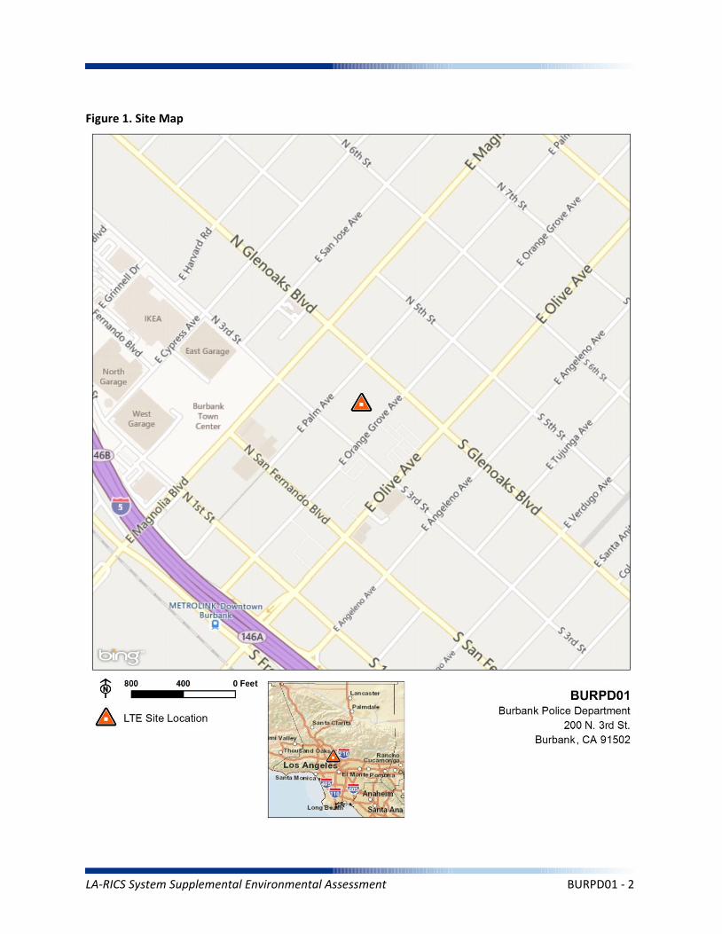
Figure 1. Site Map
LA-RICS System Supplemental Environmental Assessment BURPD01 - 2
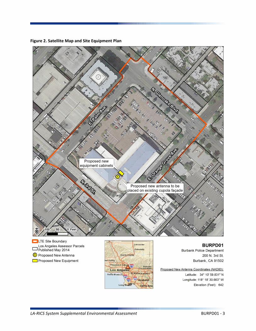
Figure 2. Satellite Map and Site Equipment Plan
LA-RICS System Supplemental Environmental Assessment BURPD01 - 3
1.0 PROJECT DESCRIPTION
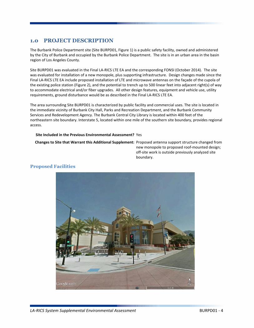
The Burbank Police Department site (Site BURPD01, Figure 1) is a public safety facility, owned and administered by the City of Burbank and occupied by the Burbank Police Department. The site is in an urban area in the basin region of Los Angeles County.
Site BURPD01 was evaluated in the Final LA-RICS LTE EA and the corresponding FONSI (October 2014). The site was evaluated for installation of a new monopole, plus supporting infrastructure. Design changes made since the Final LA-RICS LTE EA include proposed installation of LTE and microwave antennas on the façade of the cupola of the existing police station (Figure 2), and the potential to trench up to 500 linear feet into adjacent right(s) of way to accommodate electrical and/or fiber upgrades. All other design features, equipment and vehicle use, utility requirements, ground disturbance would be as described in the Final LA-RICS LTE EA.
The area surrounding Site BURPD01 is characterized by public facility and commercial uses. The site is located in the immediate vicinity of Burbank City Hall, Parks and Recreation Department, and the Burbank Community Services and Redevelopment Agency. The Burbank Central City Library is located within 400 feet of the northeastern site boundary. Interstate 5, located within one mile of the southern site boundary, provides regional access.
Proposed Tower Type: Existing building
Proposed Facilities
Site Included in the Previous Environmental Assessment? Yes
Changes to Site that Warrant this Additional Supplement: Proposed antenna support structure changed from new monopole to proposed roof-mounted design; off-site work is outside previously analyzed site boundary.
LA-RICS System Supplemental Environmental Assessment BURPD01 - 4
Maximum Facility Height: N/A
Proposed Tower Type: Existing building
Proposed Tower Height: N/A
Proposed FAA lighting: N/A
Anticipated Disturbance: Up to 1,000 square feet of additional ground disturbance while trenching for power/fiber adjacent to site previously analyzed.
Power Requirements: No new power requirements identified.
No Action Alternative: Under the No Action Alternative, this site would remain unchanged and no new LTE telecommunication infrastructure or related infrastructure would be installed. No direct, indirect, or cumulative impacts are anticipated.
LA-RICS System Supplemental Environmental Assessment BURPD01 - 5
2. EXISTING SITE CONDITIONS
Existing Onsite Communications Facilities
Existing Onsite Communication Facility Lattice Tower, Monopole, or Antenna: Yes
Existing Tower Type: Building
Existing Tower Height: 50 Feet
Existing Onsite Pad: Yes
Onsite Ground Equipment: Yes
Existing Generation: Adjacent transformer
Existing Backup Power: Yes
Existing Onsite Use/Facility: Burbank Police Department
Other Existing Onsite Tall Structures: Yes
Type of Other Existing Tall Structures: Existing 90 foot police department lobby tower
Existing Ground Elevation (FT AMSL): 642
Commercial
Commercial Office
NA
Commercial
Commercial Office
NA
Public Administrative
NA
NA
Commercial Office
Parking Structure
NA
Dominant Vicinity Use: Mixed Urban Adjacent Residential Use: No
Located Within or on Federal Lands Administered By: No
N/A
N/A
N/A
N/A
N/A
Existing Land Uses and Onsite Characteristics
Existing Land Uses and Onsite Surrounding Land Uses and Offsite Characteristics
Adjacent and Nearby Land Uses
North South East West
Description of Other Visible Towers: City Hall
Relationship to Federally Regulated Lands
Area of Special Consideration or Regulation
Located within boundaries of :
California Coastal Zone
Angeles National Forest
Santa Monica Mountains National Recreation Area
National or California State Park
Airport Influence Area
Yes / No If yes, Plan or Designation Area
Site Collocated? No FCC Registration: N/A # N/A
No
No
No
No
No
LA-RICS System Supplemental Environmental Assessment BURPD01 - 6
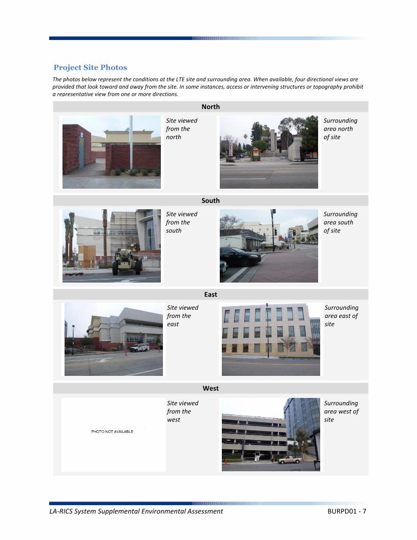
Project Site Photos
The photos below represent the conditions at the LTE site and surrounding area. When available, four directional views are provided that look toward and away from the site. In some instances, access or intervening structures or topography prohibit a representative view from one or more directions.
Site viewed from the north
Site viewed from the south
Site viewed from the east
Site viewed from the west
Surrounding area north of site
Surrounding area south of site
Surrounding area east of site
Surrounding area west of site
North
South
East
West
LA-RICS System Supplemental Environmental Assessment BURPD01 - 7

Operation Noise
Construction Vibration
Summary Impact Statement
Construction Noise
3. NOISE
Affected Environment Technical Analysis
Environmental Consequences and Impact Overview
Applicable Noise Standards Source: Burbank Municipal Code, 9-3-201
Ambient Noise Setting: Urban
Local Residential Exterior Noise Exposure Limit: 65
Surrounding Walls/Structures Serve as Potential Noise Barrier? No
Vibration Sensitive Buildings Located within 50 feet of Site? No
Nearest Off-Site Sensitive Receiver Type: None
Sensitive Noise Receiver #1: N/A
Sensitive Noise Receiver #2: N/A
Sensitive Noise Receiver #3: N/A
Construction Projects are Exempt from Noise Regulations? No
7:00am-7:00pm 8:00am-5:00pm None None
Construction Noise Exempt During Normal Construction Hours? Yes
Construction Allowed During Extended Hours with Approval or Permit? Yes
Not Significant None None
Not Significant None None
Not Significant None None
Noise and vibration from construction activity would be short term and localized. Noise from operation not expected to be perceptible off-site.
Ambient Noise Factors and Conditions
Off-Site Sensitive Noise Receivers
Construction Noise Regulations
Monday-Friday Saturday Sunday HolidayAllowedConstruction
Hours
Intensity of Impact
Direct Indirect Cumulative
Discussion/Reference:
LA-RICS System Supplemental Environmental Assessment BURPD01 - 8

CEQ’s GHG Annual Emission Threshold
Operation Emissions of Criteria Pollutants
Summary Impact Statement
Construction Emissions of Criteria Pollutants
4. AIR QUALITY AND GREENHOUSE GASES
Affected Environment Technical Analysis
Environmental Consequences and Impact Overview
Not Significant Not SignIficant
Not Significant Not Significant None
Not Significant Not Significant None
Emissions generated from construction activity and long-term operation of the Proposed Action would not exceed regulatory or guideline thresholds.
Intensity of Impact
Direct Indirect Cumulative
Discussion/Reference:
Nearest Monitoring Station: Burbank-W Palm Avenue
Sensitive Receptor 1: N/A
Sensitive Receptor 2: N/A
Sensitive Receptor 3: N/A
None
Within Local Conformity Plan: N/A
Air Basin: South Coast Air Basin
AirQuaMgmtDist: South Coast Air Quality Management District
LA-RICS System Supplemental Environmental Assessment BURPD01 - 9
Prime or Unique Farmland
Soil Erosion
Summary Impact Statement
Seismic Hazards
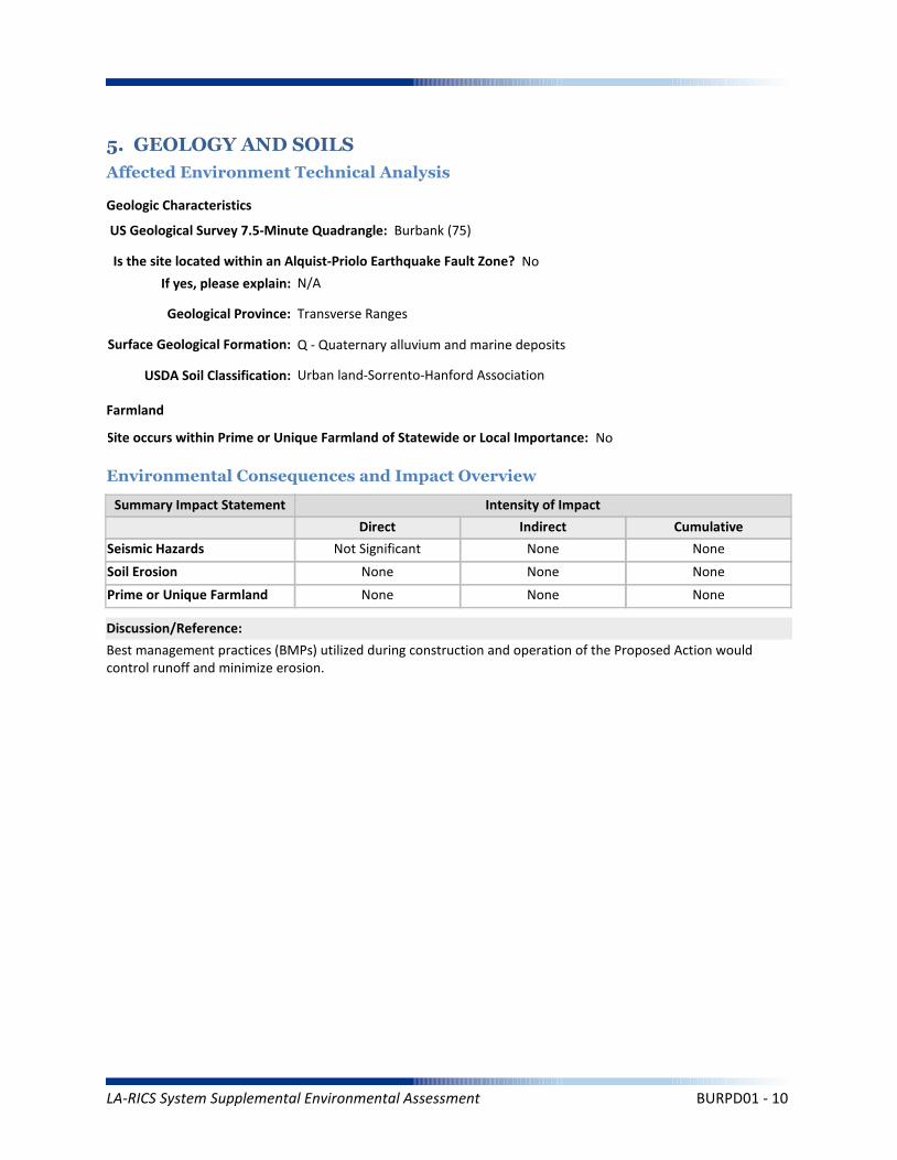
5. GEOLOGY AND SOILS
Affected Environment Technical Analysis
Environmental Consequences and Impact Overview
Not Significant None
None None None
None None None
Best management practices (BMPs) utilized during construction and operation of the Proposed Action would control runoff and minimize erosion.
Intensity of Impact
Direct Indirect Cumulative
Discussion/Reference:
US Geological Survey 7.5-Minute Quadrangle: Burbank (75)
Is the site located within an Alquist-Priolo Earthquake Fault Zone? No
If yes, please explain: N/A
Geological Province: Transverse Ranges
Surface Geological Formation: Q - Quaternary alluvium and marine deposits
USDA Soil Classification: Urban land-Sorrento-Hanford Association
None
Geologic Characteristics
Farmland
Site occurs within Prime or Unique Farmland of Statewide or Local Importance: No
LA-RICS System Supplemental Environmental Assessment BURPD01 - 10
Flood Hazard
Summary Impact Statement
Stormwater and non-storm waterdischarges on surface water resources
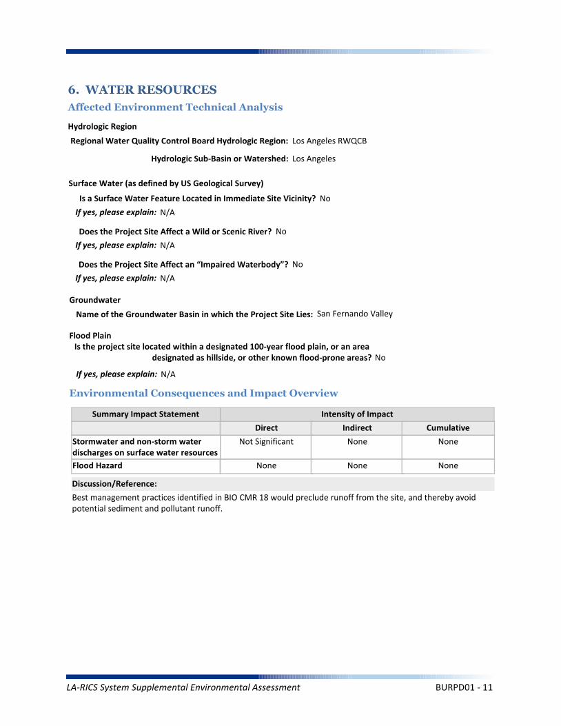
6. WATER RESOURCES
Affected Environment Technical Analysis
Environmental Consequences and Impact Overview
Regional Water Quality Control Board Hydrologic Region: Los Angeles RWQCB
Hydrologic Sub-Basin or Watershed: Los Angeles
Is a Surface Water Feature Located in Immediate Site Vicinity? No
If yes, please explain: N/A
Does the Project Site Affect a Wild or Scenic River? No
Name of the Groundwater Basin in which the Project Site Lies: San Fernando Valley
Not Significant None None
None None None
Best management practices identified in BIO CMR 18 would preclude runoff from the site, and thereby avoid potential sediment and pollutant runoff.
Hydrologic Region
Surface Water (as defined by US Geological Survey)
Groundwater
Intensity of Impact
Direct Indirect Cumulative
Discussion/Reference:
If yes, please explain: N/A
Does the Project Site Affect an “Impaired Waterbody”? No
If yes, please explain: N/A
Flood Plain
If yes, please explain: N/A
Is the project site located within a designated 100-year flood plain, or an area designated as hillside, or other known flood-prone areas? No
LA-RICS System Supplemental Environmental Assessment BURPD01 - 11

7. BIOLOGICAL RESOURCES
Affected Environment Technical Analysis
Dominant Onsite Habitat Type: Urban or Built-up Land/Ornamental
Site within 500 feet or within an Essential Fish Habitat (EFH): No
If yes, please explain: N/A
Site within 500 feet or within a Habitat Conservation Plan (HCP): No
Locational Context
Wetlands (as defined by US Geological Survey or US Fish Wildlife Service)
Special-Status Species and Habitats
If yes, please explain: N/A
Are wetlands present on site or within 500 feet of site? No
If yes, please explain: N/A
USFWS critical habitat present on site or within 500 feet of the site: No
If yes, please explain: N/A
Endangered Species Act (ESA)-listed species expected to occur on or within 500 feet of the site: No
If yes, please explain: N/A
Site within 500 feet or within a Federal/State Critical Habitat: No
If yes, please explain: N/A
Bald/Golden Eagle nest present on site or within 500 feet of the site: No
LA-RICS System Supplemental Environmental Assessment BURPD01 - 12
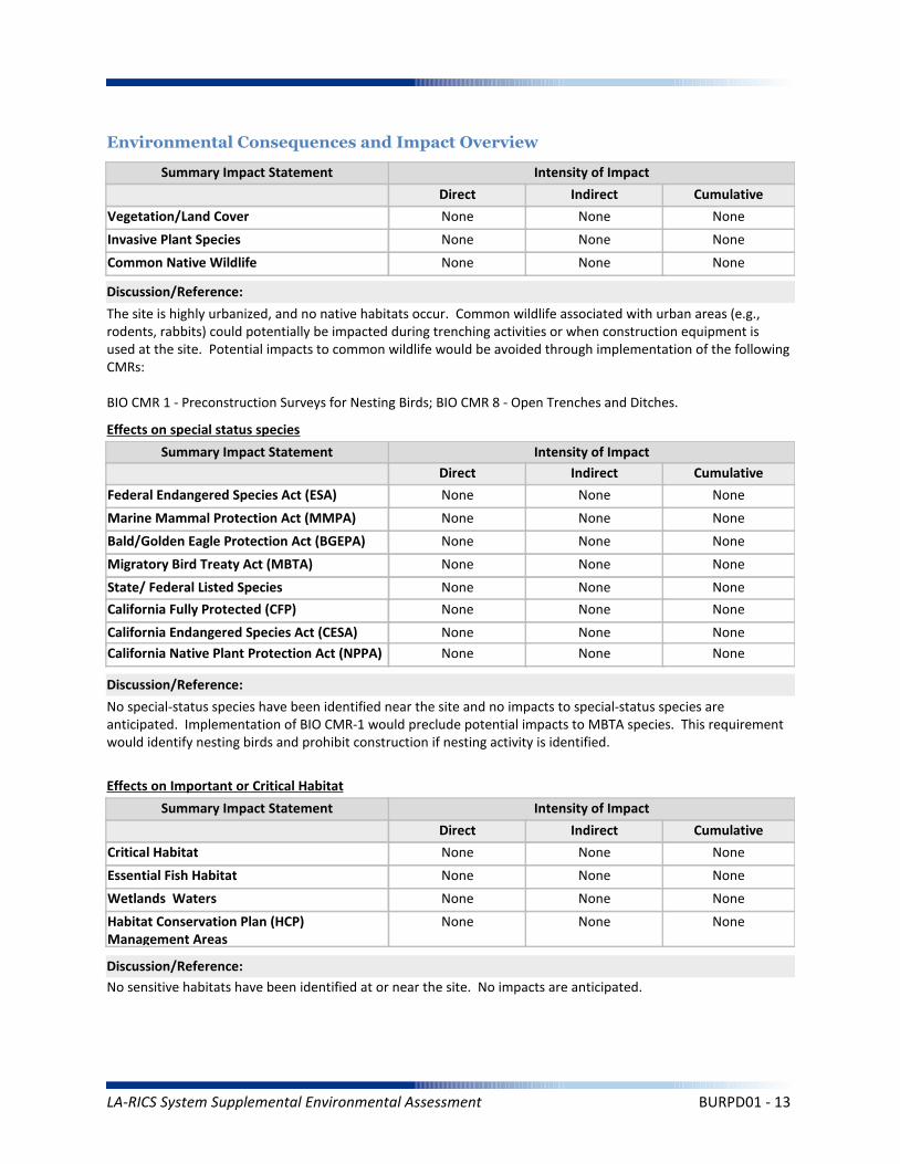
Marine Mammal Protection Act (MMPA)
Summary Impact Statement
Federal Endangered Species Act (ESA) None None None
None None None
No special-status species have been identified near the site and no impacts to special-status species are anticipated. Implementation of BIO CMR-1 would preclude potential impacts to MBTA species. This requirement would identify nesting birds and prohibit construction if nesting activity is identified.
Intensity of Impact
Direct Indirect Cumulative
Discussion/Reference:
Bald/Golden Eagle Protection Act (BGEPA) None None None
Effects on special status species
State/ Federal Listed Species
Migratory Bird Treaty Act (MBTA) None None None
None None None
California Fully Protected (CFP) None None None
California Endangered Species Act (CESA) None None None
Essential Fish Habitat
Summary Impact Statement
Critical Habitat None None None
None None None
No sensitive habitats have been identified at or near the site. No impacts are anticipated.
Intensity of Impact
Direct Indirect Cumulative
Discussion/Reference:
Wetlands Waters None None None
Effects on Important or Critical Habitat
Habitat Conservation Plan (HCP)Management Areas
None None None
Invasive Plant Species
Summary Impact Statement
Vegetation/Land Cover
Environmental Consequences and Impact Overview
None None None
None None None
The site is highly urbanized, and no native habitats occur. Common wildlife associated with urban areas (e.g., rodents, rabbits) could potentially be impacted during trenching activities or when construction equipment is used at the site. Potential impacts to common wildlife would be avoided through implementation of the following CMRs:
BIO CMR 1 - Preconstruction Surveys for Nesting Birds; BIO CMR 8 - Open Trenches and Ditches.
Intensity of Impact
Direct Indirect Cumulative
Discussion/Reference:
Common Native Wildlife None None None
California Native Plant Protection Act (NPPA) None None None
LA-RICS System Supplemental Environmental Assessment BURPD01 - 13
Architectural Resources
Summary Impact Statement
Archaeological Resources
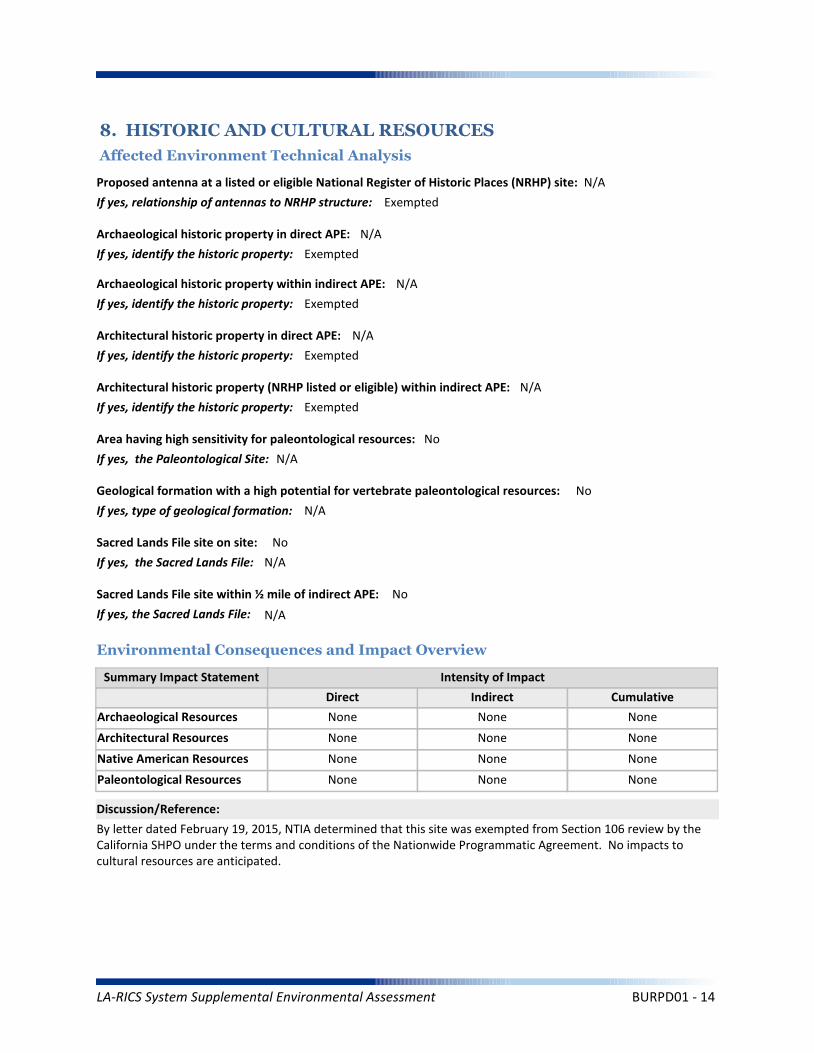
8. HISTORIC AND CULTURAL RESOURCES
Affected Environment Technical Analysis
Environmental Consequences and Impact Overview
None None None
None None None
By letter dated February 19, 2015, NTIA determined that this site was exempted from Section 106 review by the California SHPO under the terms and conditions of the Nationwide Programmatic Agreement. No impacts to cultural resources are anticipated.
Intensity of Impact
Direct Indirect Cumulative
Discussion/Reference:
Proposed antenna at a listed or eligible National Register of Historic Places (NRHP) site: N/A
If yes, relationship of antennas to NRHP structure: Exempted
Native American Resources None None None
Archaeological historic property in direct APE: N/A
If yes, identify the historic property: Exempted
Archaeological historic property within indirect APE: N/A
If yes, identify the historic property: Exempted
Architectural historic property in direct APE: N/A
If yes, identify the historic property: Exempted
Architectural historic property (NRHP listed or eligible) within indirect APE: N/A
If yes, identify the historic property: Exempted
Sacred Lands File site on site: No
If yes, the Sacred Lands File: N/A
Sacred Lands File site within ½ mile of indirect APE: No
If yes, the Sacred Lands File: N/A
Area having high sensitivity for paleontological resources: No
If yes, the Paleontological Site: N/A
Geological formation with a high potential for vertebrate paleontological resources: No
If yes, type of geological formation: N/A
Paleontological Resources None None None
LA-RICS System Supplemental Environmental Assessment BURPD01 - 14
Summary Impact Statement
Construction effects
9. AESTHETIC AND VISUAL RESOURCES
Affected Environment Technical Analysis
Environmental Consequences and Impact Overview
None None None
Effects to visual resources and aesthetics would be negligible.
Intensity of Impact
Direct Indirect Cumulative
Discussion/Reference:
Dominant Onsite Land Features:
Site BURPD01 is developed and located within the city civic center that contains a four story building that contains the administrative and functional facilities for a police department complex. The majority of the site is paved and flat. There are some areas where there are planting boxes, several tall ornamental trees, bushes and shrubs and landscaping.
Dominant Offsite Land Features Within an Approximate Quarter-Mile Radius:
The area surrounding the Site BURPD01 is developed with a mix of commercial andresidential buildings. Distant advantageous viewsheds are located to the north of the LTE site. The surrounding foliage, consisting of assorted trees and bushes, is dense tomoderate coverage and very typical of an urban business center. There are buildingslocated in the immediate vicinity of the LTE site that exceed three stories. Buildings in the vicinity of the project appear to be in good condition. Most of the civic buildings located in this area are either renovated historic architecture, or ultra modern new construction. Specifically, the Police Department complex was newly constructed and is a concrete panel clad geometric structure which appears to have been constructed in early 2000's.
Located within ¼ mile of a designated National Scenic Byway or State Scenic Highway: No
If yes, please explain: N/A
Scenic and Aesthetic Resource Attributes
Located within a National or State Park, or a National Forest: No
If yes, please explain: N/A
Visual Character Classification (based on site location): Urban
Located within ¼ mile of California Coastal Zone: No
If yes, please explain: N/A
Visual Character
Permanent effects on resources within ornear a coastal zone
None None None
Permanent effects on local scenic corridor None None None
On or adjacent to a Designated Scenic Corridor or Resource? No
If yes, please explain: N/A
LA-RICS System Supplemental Environmental Assessment BURPD01 - 15

Coastal Act and Local Coastal Plan
Summary Impact Statement
Federally administered lands
10. LAND USE
Affected Environment Technical Analysis
Environmental Consequences and Impact Overview
None None None
None None None
The Proposed Action would be consistent with applicable land use plans and policies at this location.
Intensity of Impact
Direct Indirect Cumulative
Discussion/Reference:
Is the site on federally owned or administered land? No
If yes, please explain: N/A
Comprehensive Plan or General Plan Local Agency: City of Burbank
Local Land Use Policy
Local Agency Jurisdiction: City of Burbank
General Plan Designation: Mixed Commercial/Office/Industrial
Is the site located within the Coastal Management Zone? No
If yes, please explain: N/A
Regulatory Setting
Los Angeles County General Plans
Airport Land Use Plans None None None
None None None
Other local land use plans, policies, and regulations
None None None
Is the site located within the Airport Land Use Plan area? No
If yes, name of airfield/airport: N/A
If yes, name of applicable Airport Land Use Plan: N/A
Zoning: Burbank Center Commercial
Los Angeles County Community or Area Plan: San Fernando Valley Planning Area
City of Los Angeles Community or Area Plan: N/A
Other Special District, Area or Specific Plan: N/A
LA-RICS System Supplemental Environmental Assessment BURPD01 - 16
Solid Waste (construction)
Summary Impact Statement
Electrical Supply
11. INFRASTRUCTURE
Affected Environment Technical Analysis
Environmental Consequences and Impact Overview
Nearest Highway: Interstate 5
Site Served by Solid Waste Disposal Provider: City Of Burbank
Not Significant None Not Significant
Not Significant None Not Significant
Utility use would be well within existing capacities. Implementation of TRANS MM-1 would minimize potential traffic impacts during construction. Public safety impact would be beneficial.
Traffic
Electrical
Disposal
Intensity of Impact
Direct Indirect Cumulative
Discussion/Reference:
Water Supply (construction)
Solid Waste (operation) None None None
Not Significant None Not Significant
Traffic (construction)
Water Supply (operation) None None None
Not Significant None None
Public Safety
Traffic (operation) None None None
Not Significant None None
Nearest Arterial: North Glenoaks Boulevard
Distance (Miles): 0.32
Distance (Miles): 0
Access to the Project Site Provided Via: North Glenoaks Boulevard
Electricity Service Provider: Burbank Water and Power
Site Served by or has Available Access to Domestic Water System: Burbank Water and Power
Water Service
Electricity On Site or to Be Brought to Site? Electricity on site
LA-RICS System Supplemental Environmental Assessment BURPD01 - 17

Summary Impact Statement
12. SOCIOECONOMIC
Affected Environment Technical Analysis
Environmental Consequences and Impact Overview
The Proposed Action would benefit all populations in Los Angeles County, regardless of income, race or ethnicity.Temporary and localized effects from the Proposed Action would not result in disproportionately high adverseeffects on EJ populations.
Intensity of Impact
Direct Indirect Cumulative
Discussion/Reference:
Income
Disproportionately high effects onenvironmental justice (EJ) populations
None None None
Races Ethnicity
Hispanic/Latino
47.90%
24.85%
Other*
23.50%
11.07%
Asian Pacific Islander
14.20%
11.31%
American Indian/
Alaskan Native
0.50%
3.05%
Black/ AfricanAmerican
8.40%
1.71%
White
53.30%
75.58%
Within:
* “Other” includes U.S. Census race categories “Some other race” and “Two or more race,” which make up the total percentage of the race categories but are not race categories mandated by the Office of Management and Budget’s (OMB) 1997 standards.** Data was gathered from American Community Survey (ACS) 2009-2013
EJ Population Present Based on Minority Population Threshold? No
If yes, please explain: N/A
Within CountyJurisdiction
17.80%
$55,909
Within City Jurisdiction,CDP or Zip Code
9.4%
$66,240
Within Census Block Groups of the Project Site**
8.4%
$67,508
EJ population present based on income thresholds? No
If yes, please explain: N/A
Census Block Groups of
Project Site**:County
Jurisdiction
Median Household Income
Families Below Poverty
** Data was gathered from American Community Survey (ACS) 2009-2013
LA-RICS System Supplemental Environmental Assessment BURPD01 - 18
Worker Safety
Summary Impact Statement
Hazardous Materials
13. Human Health and Safety
Affected Environment Technical Analysis
Environmental Consequences and Impact Overview
None None None
None None None
Intensity of Impact
Direct Indirect Cumulative
Discussion/Reference:
Site located on land listed as a hazardous materials site? No
If yes, please explain: N/A
Aeronautical Hazards None None None
Located within 1 mile of National Priority List (Superfund) site? No
If yes, please explain: N/A
Within ¼ mile of listed Cortese, Leaking Underground Storage Tank, permitted Underground Storage Tank, or Brownfield site? YesIf yes, please explain: 3 open LUST sites, 6 closed LUST cleanup sites, and 4 permitted UST
Site located within 1,000 feet of a landfill? No
If yes, please explain: N/A
Potential for methane exposure? No
If yes, please explain: N/A
Site located in a methane hazard zone? No
If yes, please explain: N/A
Site located within 200 feet of an oil or gas well? No
If yes, please explain: N/A
Wildland Fires None None None
Methane Hazard None None None
Hazardous Materials
Hazards
Site located in a Local fire hazard zone? No
If yes, please explain: N/A
Site located in a State fire hazard zone? No
If yes, please explain: N/A
Federal Aviation Administration (FAA) Part 77 Notification Required? N/A
FCC TOWAIR Results: N/A
LA-RICS System Supplemental Environmental Assessment BURPD01 - 19

Project construction activities would not encounter the reported LUST sites. They are geographically distant from the LTE site and the depth of proposed construction (i.e., trenching to 36 inches) would not result in contact with groundwater.
Reference: LA RICS Long Term Evolution (LTE), Phase I System Design, ASTM 1528-14 Transaction Screen Report, Burbank PD / BURPD01 , dated November 25, 2014, Prepared by EBI Consulting.
Discussion/Reference:
LA-RICS System Supplemental Environmental Assessment BURPD01 - 20
LA-RICS LTE System
Appendix B: Supplemental Environmental Assessment
Site ID: LAPD077
Facility Name: 77TH Street Area Complex
LA-RICS System Supplemental Environmental Assessment LAPD077 - 1
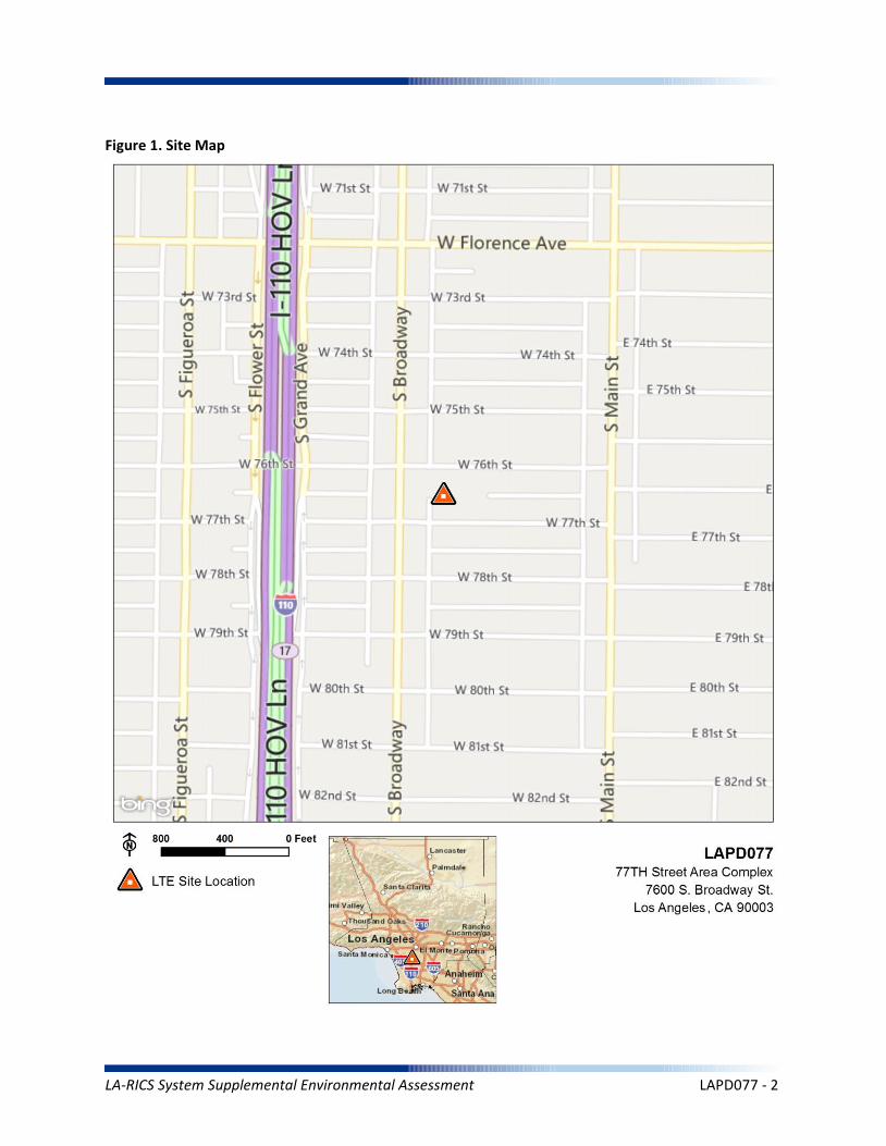
Figure 1. Site Map
LA-RICS System Supplemental Environmental Assessment LAPD077 - 2
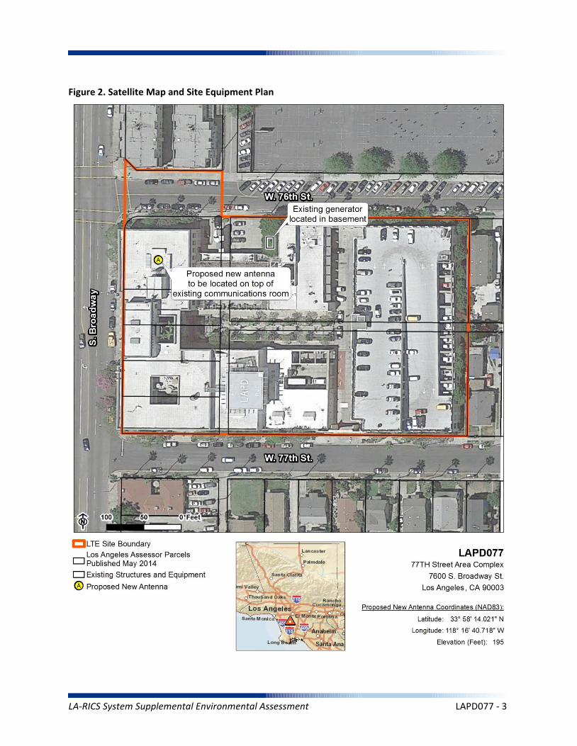
Figure 2. Satellite Map and Site Equipment Plan
LA-RICS System Supplemental Environmental Assessment LAPD077 - 3
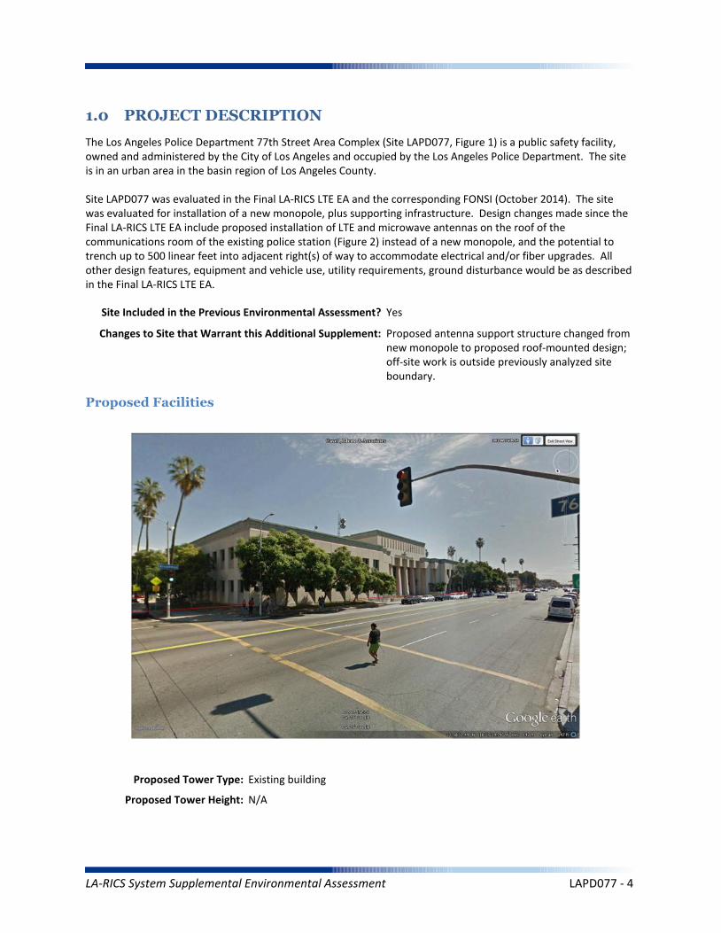
1.0 PROJECT DESCRIPTION
The Los Angeles Police Department 77th Street Area Complex (Site LAPD077, Figure 1) is a public safety facility, owned and administered by the City of Los Angeles and occupied by the Los Angeles Police Department. The site is in an urban area in the basin region of Los Angeles County.
Site LAPD077 was evaluated in the Final LA-RICS LTE EA and the corresponding FONSI (October 2014). The site was evaluated for installation of a new monopole, plus supporting infrastructure. Design changes made since the Final LA-RICS LTE EA include proposed installation of LTE and microwave antennas on the roof of the communications room of the existing police station (Figure 2) instead of a new monopole, and the potential to trench up to 500 linear feet into adjacent right(s) of way to accommodate electrical and/or fiber upgrades. All other design features, equipment and vehicle use, utility requirements, ground disturbance would be as described in the Final LA-RICS LTE EA.
Maximum Facility Height: N/A
Proposed Tower Type: Existing building
Proposed Tower Height: N/A
Proposed Facilities
Site Included in the Previous Environmental Assessment? Yes
Changes to Site that Warrant this Additional Supplement: Proposed antenna support structure changed from new monopole to proposed roof-mounted design; off-site work is outside previously analyzed site boundary.
LA-RICS System Supplemental Environmental Assessment LAPD077 - 4

Maximum Facility Height: N/A
Proposed FAA lighting: N/A
Anticipated Disturbance: Up to 1,000 square feet of additional ground disturbance while trenching for power/fiber adjacent to site previously analyzed.
Power Requirements: No new power requirements identified.
No Action Alternative: Under the No Action Alternative, this site would remain unchanged and no new LTE telecommunication infrastructure or related infrastructure would be installed. No direct, indirect, or cumulative impacts are anticipated.
LA-RICS System Supplemental Environmental Assessment LAPD077 - 5
2. EXISTING SITE CONDITIONS
Existing Onsite Communications Facilities
Existing Onsite Communication Facility Lattice Tower, Monopole, or Antenna: Yes
Existing Tower Type: Building
Existing Tower Height: 40 feet
Existing Onsite Pad: Yes
Onsite Ground Equipment: Yes
Existing Generation: Adjacent transformer
Existing Backup Power: Yes
Existing Onsite Use/Facility: Police Station
Other Existing Onsite Tall Structures: No
Type of Other Existing Tall Structures: N/A
Existing Ground Elevation (FT AMSL): 135
Residential
School
Residential Residential Residential
Commercial
Dominant Vicinity Use: Residential Adjacent Residential Use: Yes
Located Within or on Federal Lands Administered By: No
N/A
N/A
N/A
N/A
N/A
Existing Land Uses and Onsite Characteristics
Existing Land Uses and Onsite Surrounding Land Uses and Offsite Characteristics
Adjacent and Nearby Land Uses
North South East West
Description of Other Visible Towers: Electrical distribution poles
Relationship to Federally Regulated Lands
Area of Special Consideration or Regulation
Located within boundaries of :
California Coastal Zone
Angeles National Forest
Santa Monica Mountains National Recreation Area
National or California State Park
Airport Influence Area
Yes / No If yes, Plan or Designation Area
Site Collocated? Yes FCC Registration: N/A #
No
No
No
No
No
LA-RICS System Supplemental Environmental Assessment LAPD077 - 6
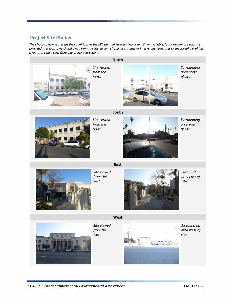
Project Site Photos
The photos below represent the conditions at the LTE site and surrounding area. When available, four directional views are provided that look toward and away from the site. In some instances, access or intervening structures or topography prohibit a representative view from one or more directions.
Site viewed from the north
Site viewed from the south
Site viewed from the east
Site viewed from the west
Surrounding area north of site
Surrounding area south of site
Surrounding area east of site
Surrounding area west of site
North
South
East
West
LA-RICS System Supplemental Environmental Assessment LAPD077 - 7

Operation Noise
Construction Vibration
Summary Impact Statement
Construction Noise
3. NOISE
Affected Environment Technical Analysis
Environmental Consequences and Impact Overview
Applicable Noise Standards Source: City of Los Angeles Municipal Code, Chapter IV, Article 1, Section 41.40
Ambient Noise Setting: Urban
Local Residential Exterior Noise Exposure Limit: 50
Surrounding Walls/Structures Serve as Potential Noise Barrier? No
Vibration Sensitive Buildings Located within 50 feet of Site? No
Nearest Off-Site Sensitive Receiver Type: 150 feet
Sensitive Noise Receiver #1: Residence
Sensitive Noise Receiver #2: Residence
Sensitive Noise Receiver #3: Residence
Construction Projects are Exempt from Noise Regulations? No
7:00am-9:00pm 8:00am-6:00pm None None
Construction Noise Exempt During Normal Construction Hours? No
Construction Allowed During Extended Hours with Approval or Permit? No
Not Significant None None
Not Significant None None
Not Significant None None
Noise and vibration from construction activity would be short term and localized. Noise from operation not expected to be perceptible off-site.
Ambient Noise Factors and Conditions
Off-Site Sensitive Noise Receivers
Construction Noise Regulations
Monday-Friday Saturday Sunday HolidayAllowedConstruction
Hours
Intensity of Impact
Direct Indirect Cumulative
Discussion/Reference:
LA-RICS System Supplemental Environmental Assessment LAPD077 - 8
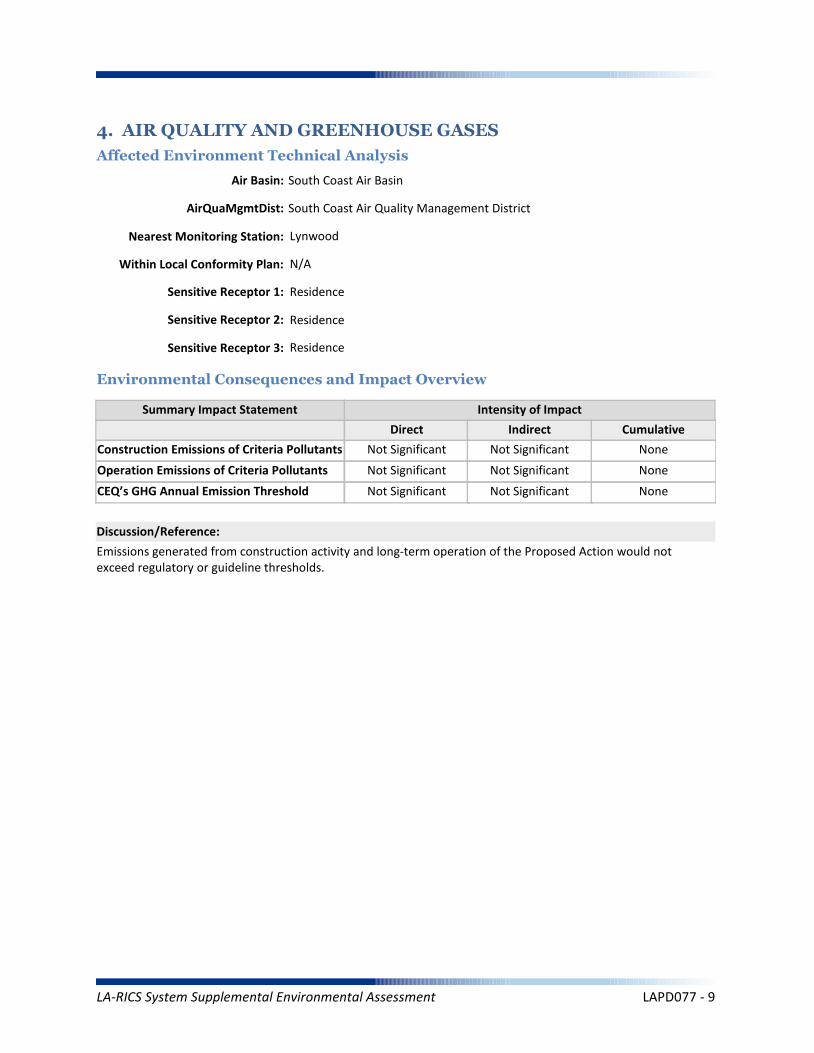
CEQ’s GHG Annual Emission Threshold
Operation Emissions of Criteria Pollutants
Summary Impact Statement
Construction Emissions of Criteria Pollutants
4. AIR QUALITY AND GREENHOUSE GASES
Affected Environment Technical Analysis
Environmental Consequences and Impact Overview
Not Significant Not Significant
Not Significant Not Significant None
Not Significant Not Significant None
Emissions generated from construction activity and long-term operation of the Proposed Action would not exceed regulatory or guideline thresholds.
Intensity of Impact
Direct Indirect Cumulative
Discussion/Reference:
Nearest Monitoring Station: Lynwood
Sensitive Receptor 1: Residence
Sensitive Receptor 2: Residence
Sensitive Receptor 3: Residence
None
Within Local Conformity Plan: N/A
Air Basin: South Coast Air Basin
AirQuaMgmtDist: South Coast Air Quality Management District
LA-RICS System Supplemental Environmental Assessment LAPD077 - 9

Prime or Unique Farmland
Soil Erosion
Summary Impact Statement
Seismic Hazards
5. GEOLOGY AND SOILS
Affected Environment Technical Analysis
Environmental Consequences and Impact Overview
Not Significant None
None None None
None None None
Best Management Practices (BMP's) utilized during construction and operation of the Proposed Action would control runoff and minimize erosion.
Intensity of Impact
Direct Indirect Cumulative
Discussion/Reference:
US Geological Survey 7.5-Minute Quadrangle: Inglewood (82)
Is the site located within an Alquist-Priolo Earthquake Fault Zone? No
If yes, please explain: N/A
Geological Province: Peninsular Ranges
Surface Geological Formation: Quaternary alluvium and marine deposits
USDA Soil Classification: Urban land-Sorrento-Hanford Association
none
Geologic Characteristics
Farmland
Site occurs within Prime or Unique Farmland of Statewide or Local Importance: No
LA-RICS System Supplemental Environmental Assessment LAPD077 - 10
Flood Hazard
Summary Impact Statement
Stormwater and non-storm waterdischarges on surface water resources
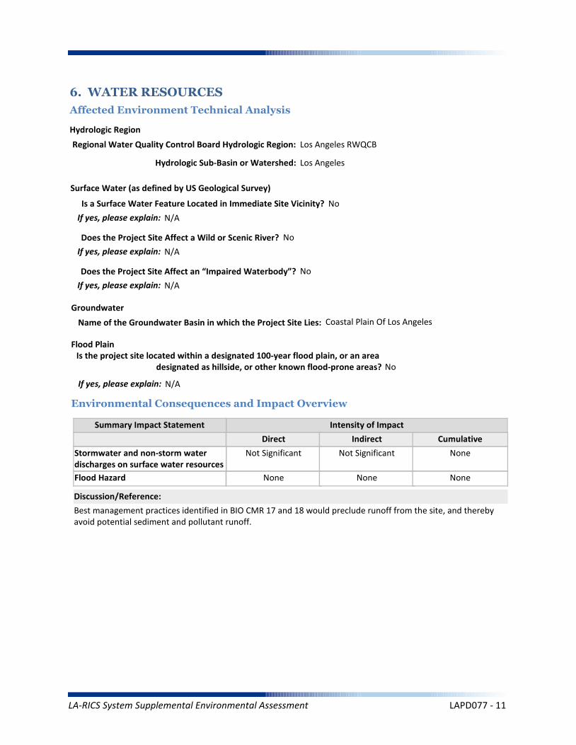
6. WATER RESOURCES
Affected Environment Technical Analysis
Environmental Consequences and Impact Overview
Regional Water Quality Control Board Hydrologic Region: Los Angeles RWQCB
Hydrologic Sub-Basin or Watershed: Los Angeles
Is a Surface Water Feature Located in Immediate Site Vicinity? No
If yes, please explain: N/A
Does the Project Site Affect a Wild or Scenic River? No
Name of the Groundwater Basin in which the Project Site Lies: Coastal Plain Of Los Angeles
Not Significant Not Significant None
None None None
Best management practices identified in BIO CMR 17 and 18 would preclude runoff from the site, and thereby avoid potential sediment and pollutant runoff.
Hydrologic Region
Surface Water (as defined by US Geological Survey)
Groundwater
Intensity of Impact
Direct Indirect Cumulative
Discussion/Reference:
If yes, please explain: N/A
Does the Project Site Affect an “Impaired Waterbody”? No
If yes, please explain: N/A
Flood Plain
If yes, please explain: N/A
Is the project site located within a designated 100-year flood plain, or an area designated as hillside, or other known flood-prone areas? No
LA-RICS System Supplemental Environmental Assessment LAPD077 - 11

7. BIOLOGICAL RESOURCES
Affected Environment Technical Analysis
Dominant Onsite Habitat Type: Urban or Built-up Land/Ornamental
Site within 500 feet or within an Essential Fish Habitat (EFH): No
If yes, please explain: N/A
Site within 500 feet or within a Habitat Conservation Plan (HCP): No
Locational Context
Wetlands (as defined by US Geological Survey or US Fish Wildlife Service)
Special-Status Species and Habitats
If yes, please explain: N/A
Are wetlands present on site or within 500 feet of site? No
If yes, please explain: N/A
USFWS critical habitat present on site or within 500 feet of the site: No
If yes, please explain: N/A
Endangered Species Act (ESA)-listed species expected to occur on or within 500 feet of the site: No
If yes, please explain: N/A
Site within 500 feet or within a Federal/State Critical Habitat: No
If yes, please explain: N/A
Bald/Golden Eagle nest present on site or within 500 feet of the site: No
LA-RICS System Supplemental Environmental Assessment LAPD077 - 12
Marine Mammal Protection Act (MMPA)
Summary Impact Statement
Federal Endangered Species Act (ESA) None None None
None None None
No special-status species have been identified near the site and no impacts to special-status species are anticipated. Implementation of BIO CMR-1 would preclude potential impacts to MBTA species. This requirement would identify nesting birds and prohibit construction if nesting activity is identified.
Intensity of Impact
Direct Indirect Cumulative
Discussion/Reference:
Bald/Golden Eagle Protection Act (BGEPA) None None None
Effects on special status species
State/ Federal Listed Species
Migratory Bird Treaty Act (MBTA) None None None
None None None
California Fully Protected (CFP) None None None
California Endangered Species Act (CESA) None None None
Essential Fish Habitat
Summary Impact Statement
Critical Habitat None None None
None None None
No sensitive habitats have been identified at or near the site. No impacts are anticipated.
Intensity of Impact
Direct Indirect Cumulative
Discussion/Reference:
Wetlands Waters None None None
Effects on Important or Critical Habitat
Habitat Conservation Plan (HCP)Management Areas
None None None
Invasive Plant Species
Summary Impact Statement
Vegetation/Land Cover
Environmental Consequences and Impact Overview
None None None
None None None
The site is highly urbanized, and no native habitats occur. Common wildlife associated with urban areas (e.g., rodents, rabbits) could potentially be impacted during trenching activities or when construction equipment is used at the site. Potential impacts to common wildlife would be avoided through implementation of the following CMRs:
BIO CMR 1 - Preconstruction Surveys for Nesting Birds; BIO CMR 8 - Open Trenches and Ditches.
Intensity of Impact
Direct Indirect Cumulative
Discussion/Reference:
Common Native Wildlife None None None
California Native Plant Protection Act (NPPA) None None None
LA-RICS System Supplemental Environmental Assessment LAPD077 - 13

Architectural Resources
Summary Impact Statement
Archaeological Resources
8. HISTORIC AND CULTURAL RESOURCES
Affected Environment Technical Analysis
Environmental Consequences and Impact Overview
None None None
None None None
By letter dated February 19, 2015, NTIA determined that this site was exempted from Section 106 review by the California SHPO under the terms and conditions of the Nationwide Programmatic Agreement. No impacts to cultural resources are anticipated.
Intensity of Impact
Direct Indirect Cumulative
Discussion/Reference:
Proposed antenna at a listed or eligible National Register of Historic Places (NRHP) site: N/A
If yes, relationship of antennas to NRHP structure: Exempted
Native American Resources None None None
Archaeological historic property in direct APE: N/A
If yes, identify the historic property: Exempted
Archaeological historic property within indirect APE: N/A
If yes, identify the historic property: Exempted
Architectural historic property in direct APE: N/A
If yes, identify the historic property: Exempted
Architectural historic property (NRHP listed or eligible) within indirect APE: N/A
If yes, identify the historic property: Exempted
Sacred Lands File site on site: No
If yes, the Sacred Lands File: N/A
Sacred Lands File site within ½ mile of indirect APE: No
If yes, the Sacred Lands File: N/A
Area having high sensitivity for paleontological resources: No
If yes, the Paleontological Site: N/A
Geological formation with a high potential for vertebrate paleontological resources: No
If yes, type of geological formation: N/A
Paleontological Resources None None None
LA-RICS System Supplemental Environmental Assessment LAPD077 - 14
Summary Impact Statement
Construction effects
9. AESTHETIC AND VISUAL RESOURCES
Affected Environment Technical Analysis
Environmental Consequences and Impact Overview
None None None
Effects to visual resources and aesthetics would be negligible.
Intensity of Impact
Direct Indirect Cumulative
Discussion/Reference:
Dominant Onsite Land Features:
Site LAPD077 is developed with buildings appropriate to facilitate the operational activities for a police department. The majority of the site is paved and flat. There are some areas where there are planting boxes, several ornamental trees and landscaping. No building on the site is taller than three stories. A few approximately 10-foot high antennas are fixed to the roof of the building.
Dominant Offsite Land Features Within an Approximate Quarter-Mile Radius:
The area surrounding Site LAPD077 is urban and developed with a mix of commercial and residential buildings. No significant viewsheds are located in close proximity to the project site. The surrounding foliage is moderate and consists of assorted trees and bushes. The surrounding area consists of low rise buildings and none of the buildings located in the immediate vicinity of the project site exceed three stories. Buildings in the vicinity of the project appear to be in good condition.
Located within ¼ mile of a designated National Scenic Byway or State Scenic Highway: No
If yes, please explain: N/A
Scenic and Aesthetic Resource Attributes
Located within a National or State Park, or a National Forest: No
If yes, please explain: N/A
Visual Character Classification (based on site location): Urban
Located within ¼ mile of California Coastal Zone: No
If yes, please explain: N/A
Visual Character
Permanent effects on resources within ornear a coastal zone
None None None
Permanent effects on local scenic corridor None None None
On or adjacent to a Designated Scenic Corridor or Resource? No
If yes, please explain: N/A
LA-RICS System Supplemental Environmental Assessment LAPD077 - 15
Coastal Act and Local Coastal Plan
Summary Impact Statement
Federally administered lands
10. LAND USE
Affected Environment Technical Analysis
Environmental Consequences and Impact Overview
None None None
None None None
The Proposed Action would be consistent with applicable land use plans and practices at this location.
Intensity of Impact
Direct Indirect Cumulative
Discussion/Reference:
Is the site on federally owned or administered land? No
If yes, please explain: N/A
Comprehensive Plan or General Plan Local Agency: City of Los Angeles
Local Land Use Policy
Local Agency Jurisdiction: City of Los Angeles
General Plan Designation: General Commercial
Is the site located within the Coastal Management Zone? No
If yes, please explain: N/A
Regulatory Setting
Los Angeles County General Plans
Airport Land Use Plans None None None
None None None
Other local land use plans, policies, and regulations
None None None
Is the site located within the Airport Land Use Plan area? No
If yes, name of airfield/airport: N/A
If yes, name of applicable Airport Land Use Plan: N/A
Zoning: Commercial
Los Angeles County Community or Area Plan: Metro Planning Area
City of Los Angeles Community or Area Plan: Southeast Los Angeles
Other Special District, Area or Specific Plan: South Los Angeles Alcohol Sales
LA-RICS System Supplemental Environmental Assessment LAPD077 - 16
Solid Waste (construction)
Summary Impact Statement
Electrical Supply
11. INFRASTRUCTURE
Affected Environment Technical Analysis
Environmental Consequences and Impact Overview
Nearest Highway: Interstate 110
Site Served by Solid Waste Disposal Provider: City of Los Angeles Bureau of Sanitation
Not Significant None Not Significant
Not Significant None Not Significant
Utility use would be well within existing capacities. Implementation of TRANS MM-1 would minimize potential traffic impacts during construction. Public safety impact would be beneficial.
Traffic
Electrical
Disposal
Intensity of Impact
Direct Indirect Cumulative
Discussion/Reference:
Water Supply (construction)
Solid Waste (operation) None None None
Not Significant None Not Significant
Traffic (construction)
Water Supply (operation) None None None
Not Significant None None
Public Safety
Traffic (operation) None None None
Not Significant None None
Nearest Arterial: South Broadway
Distance (Miles): 0.16
Distance (Miles): 0
Access to the Project Site Provided Via: South Broadway
Electricity Service Provider: Los Angeles Department of Water and Power
Site Served by or has Available Access to Domestic Water System: Los Angeles Dept. of Water and Power
Water Service
Electricity On Site or to Be Brought to Site? Electricity on site
LA-RICS System Supplemental Environmental Assessment LAPD077 - 17
Summary Impact Statement
12. SOCIOECONOMIC
Affected Environment Technical Analysis
Environmental Consequences and Impact Overview
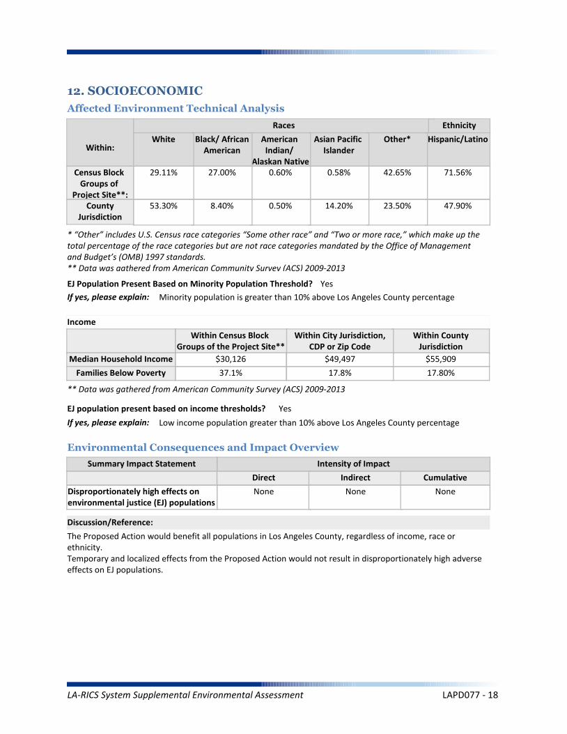
The Proposed Action would benefit all populations in Los Angeles County, regardless of income, race or ethnicity.Temporary and localized effects from the Proposed Action would not result in disproportionately high adverseeffects on EJ populations.
Intensity of Impact
Direct Indirect Cumulative
Discussion/Reference:
Income
Disproportionately high effects onenvironmental justice (EJ) populations
None None None
Races Ethnicity
Hispanic/Latino
47.90%
71.56%
Other*
23.50%
42.65%
Asian Pacific Islander
14.20%
0.58%
American Indian/
Alaskan Native
0.50%
0.60%
Black/ AfricanAmerican
8.40%
27.00%
White
53.30%
29.11%
Within:
* “Other” includes U.S. Census race categories “Some other race” and “Two or more race,” which make up the total percentage of the race categories but are not race categories mandated by the Office of Management and Budget’s (OMB) 1997 standards.** Data was gathered from American Community Survey (ACS) 2009-2013
EJ Population Present Based on Minority Population Threshold? Yes
If yes, please explain: Minority population is greater than 10% above Los Angeles County percentage
Within CountyJurisdiction
17.80%
$55,909
Within City Jurisdiction,CDP or Zip Code
17.8%
$49,497
Within Census Block Groups of the Project Site**
37.1%
$30,126
EJ population present based on income thresholds? Yes
If yes, please explain: Low income population greater than 10% above Los Angeles County percentage
Census Block Groups of
Project Site**:County
Jurisdiction
Median Household Income
Families Below Poverty
** Data was gathered from American Community Survey (ACS) 2009-2013
LA-RICS System Supplemental Environmental Assessment LAPD077 - 18

Worker Safety
Summary Impact Statement
Hazardous Materials
13. Human Health and Safety
Affected Environment Technical Analysis
Environmental Consequences and Impact Overview
None None None
None None None
Intensity of Impact
Direct Indirect Cumulative
Discussion/Reference:
Site located on land listed as a hazardous materials site? No
If yes, please explain: N/A
Aeronautical Hazards None None None
Located within 1 mile of National Priority List (Superfund) site? No
If yes, please explain: N/A
Within ¼ mile of listed Cortese, Leaking Underground Storage Tank, permitted Underground Storage Tank, or Brownfield site? NoIf yes, please explain: N/A
Site located within 1,000 feet of a landfill? No
If yes, please explain: N/A
Potential for methane exposure? No
If yes, please explain: N/A
Site located in a methane hazard zone? No
If yes, please explain: N/A
Site located within 200 feet of an oil or gas well? No
If yes, please explain: N/A
Wildland Fires None None None
Methane Hazard None None None
Hazardous Materials
Hazards
Site located in a Local fire hazard zone? No
If yes, please explain: N/A
Site located in a State fire hazard zone? No
If yes, please explain: N/A
Federal Aviation Administration (FAA) Part 77 Notification Required? N/A
FCC TOWAIR Results: N/A
LA-RICS System Supplemental Environmental Assessment LAPD077 - 19
No hazardous waste sites have been identified, therefore no impacts are anticipated.
Reference: LA RICS Long Term Evolution (LTE), ASTM 1528-14 Transaction Screen Report, 77th Street Area Complex / LAPD077, dated October 20, 2014, Prepared by EBI Consulting.
Discussion/Reference:
LA-RICS System Supplemental Environmental Assessment LAPD077 - 20
LA-RICS LTE System
Appendix B: Supplemental Environmental Assessment
Site ID: LAPDVNS
Facility Name: Van Nuys Area Station
LA-RICS System Supplemental Environmental Assessment LAPDVNS - 1
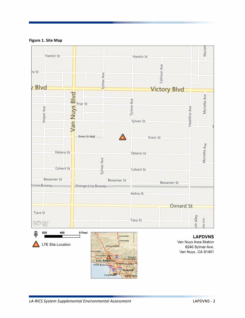
Figure 1. Site Map
LA-RICS System Supplemental Environmental Assessment LAPDVNS - 2
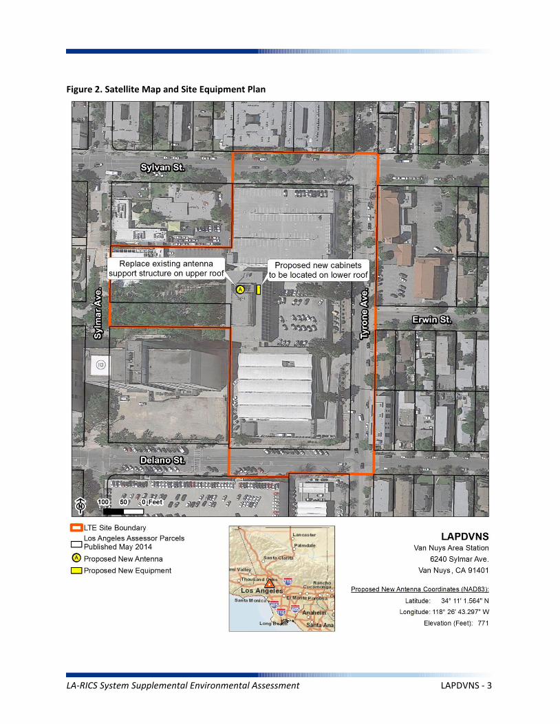
Figure 2. Satellite Map and Site Equipment Plan
LA-RICS System Supplemental Environmental Assessment LAPDVNS - 3
1.0 PROJECT DESCRIPTION
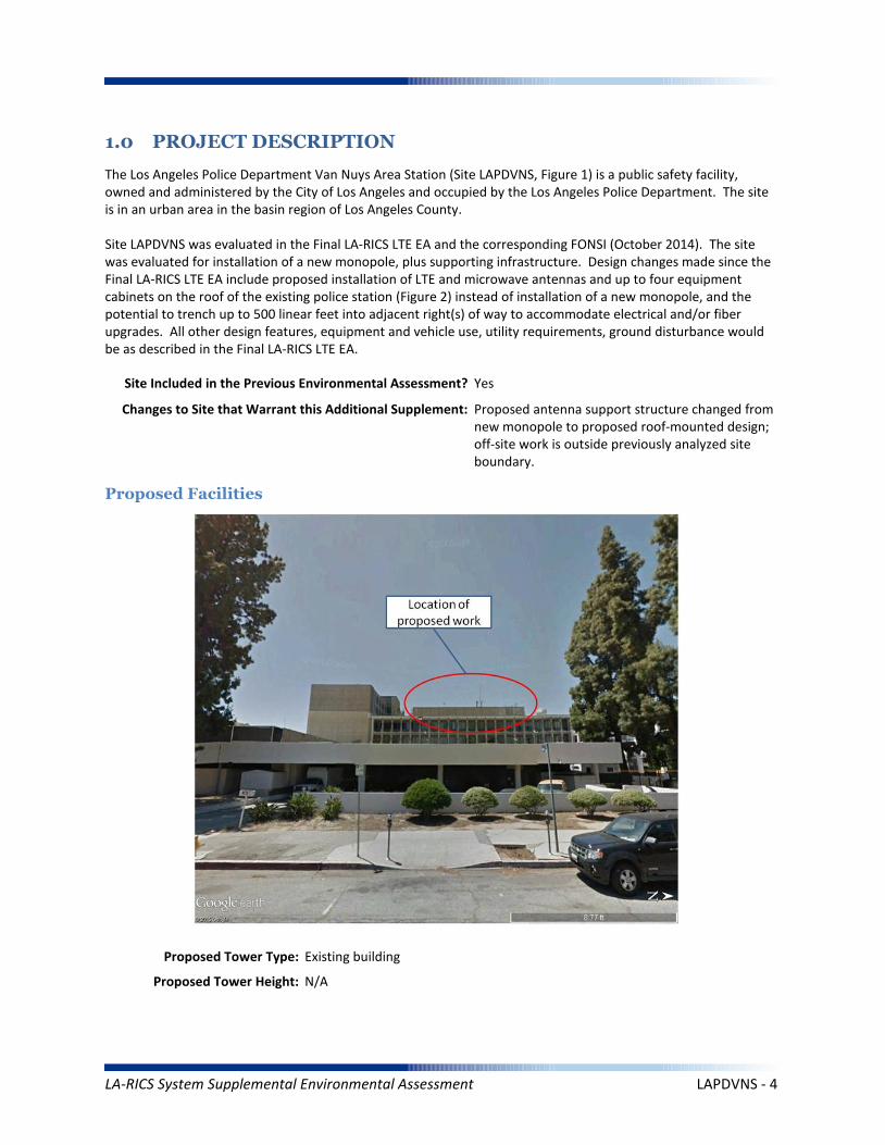
The Los Angeles Police Department Van Nuys Area Station (Site LAPDVNS, Figure 1) is a public safety facility, owned and administered by the City of Los Angeles and occupied by the Los Angeles Police Department. The site is in an urban area in the basin region of Los Angeles County.
Site LAPDVNS was evaluated in the Final LA-RICS LTE EA and the corresponding FONSI (October 2014). The site was evaluated for installation of a new monopole, plus supporting infrastructure. Design changes made since the Final LA-RICS LTE EA include proposed installation of LTE and microwave antennas and up to four equipment cabinets on the roof of the existing police station (Figure 2) instead of installation of a new monopole, and the potential to trench up to 500 linear feet into adjacent right(s) of way to accommodate electrical and/or fiber upgrades. All other design features, equipment and vehicle use, utility requirements, ground disturbance would be as described in the Final LA-RICS LTE EA.
Maximum Facility Height: N/A
Proposed Tower Type: Existing building
Proposed Tower Height: N/A
Proposed Facilities
Site Included in the Previous Environmental Assessment? Yes
Changes to Site that Warrant this Additional Supplement: Proposed antenna support structure changed from new monopole to proposed roof-mounted design; off-site work is outside previously analyzed site boundary.
LA-RICS System Supplemental Environmental Assessment LAPDVNS - 4
Maximum Facility Height: N/A
Proposed FAA lighting: N/A
Anticipated Disturbance: Up to 1,000 square feet of additional ground disturbance while trenching for power/fiber adjacent to site previously analyzed.
Power Requirements: No new power requirements identified.
No Action Alternative: Under the No Action Alternative, this site would remain unchanged and no new LTE telecommunication infrastructure or related infrastructure would be installed. No direct, indirect, or cumulative impacts are anticipated.
LA-RICS System Supplemental Environmental Assessment LAPDVNS - 5
2. EXISTING SITE CONDITIONS
Existing Onsite Communications Facilities
Existing Onsite Communication Facility Lattice Tower, Monopole, or Antenna: Yes
Existing Tower Type: Building
Existing Tower Height: 70 feet
Existing Onsite Pad: Yes
Onsite Ground Equipment: Yes
Existing Generation: Adjacent transformer
Existing Backup Power: Yes
Existing Onsite Use/Facility: Police station
Other Existing Onsite Tall Structures: No
Type of Other Existing Tall Structures: N/A
Existing Ground Elevation (FT AMSL): 715
Residential Municipal Parking Residential
Church
Public Administrative
Dominant Vicinity Use: Administrative Adjacent Residential Use: Yes
Located Within or on Federal Lands Administered By: No
N/A
N/A
N/A
N/A
N/A
Existing Land Uses and Onsite Characteristics
Existing Land Uses and Onsite Surrounding Land Uses and Offsite Characteristics
Adjacent and Nearby Land Uses
North South East West
Description of Other Visible Towers: None
Relationship to Federally Regulated Lands
Area of Special Consideration or Regulation
Located within boundaries of :
California Coastal Zone
Angeles National Forest
Santa Monica Mountains National Recreation Area
National or California State Park
Airport Influence Area
Yes / No If yes, Plan or Designation Area
Site Collocated? No FCC Registration: N/A #
No
No
No
No
No
LA-RICS System Supplemental Environmental Assessment LAPDVNS - 6
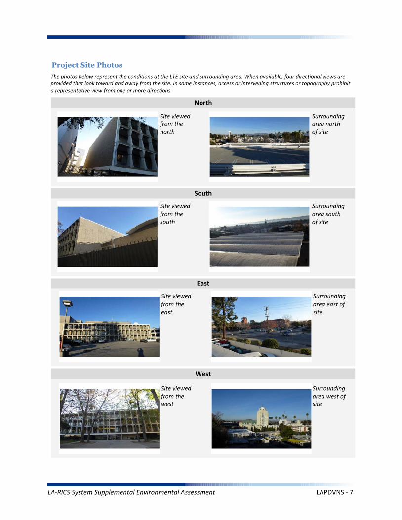
Project Site Photos
The photos below represent the conditions at the LTE site and surrounding area. When available, four directional views are provided that look toward and away from the site. In some instances, access or intervening structures or topography prohibit a representative view from one or more directions.
Site viewed from the north
Site viewed from the south
Site viewed from the east
Site viewed from the west
Surrounding area north of site
Surrounding area south of site
Surrounding area east of site
Surrounding area west of site
North
South
East
West
LA-RICS System Supplemental Environmental Assessment LAPDVNS - 7
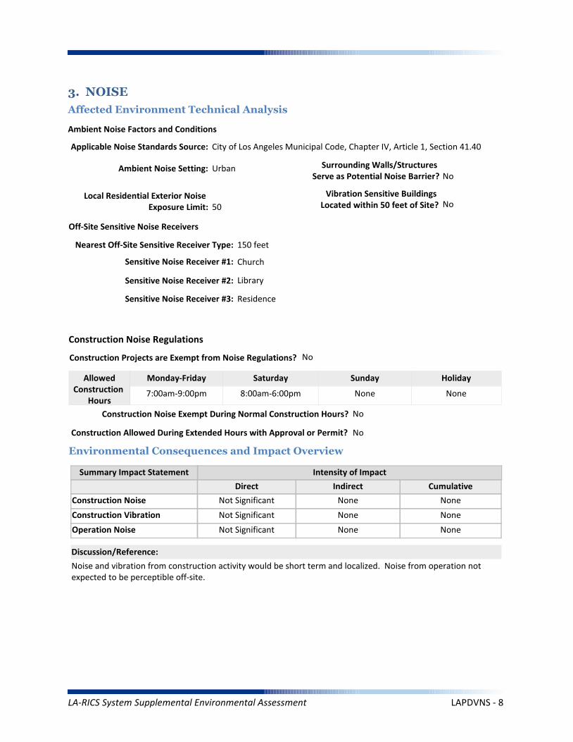
Operation Noise
Construction Vibration
Summary Impact Statement
Construction Noise
3. NOISE
Affected Environment Technical Analysis
Environmental Consequences and Impact Overview
Applicable Noise Standards Source: City of Los Angeles Municipal Code, Chapter IV, Article 1, Section 41.40
Ambient Noise Setting: Urban
Local Residential Exterior Noise Exposure Limit: 50
Surrounding Walls/Structures Serve as Potential Noise Barrier? No
Vibration Sensitive Buildings Located within 50 feet of Site? No
Nearest Off-Site Sensitive Receiver Type: 150 feet
Sensitive Noise Receiver #1: Church
Sensitive Noise Receiver #2: Library
Sensitive Noise Receiver #3: Residence
Construction Projects are Exempt from Noise Regulations? No
7:00am-9:00pm 8:00am-6:00pm None None
Construction Noise Exempt During Normal Construction Hours? No
Construction Allowed During Extended Hours with Approval or Permit? No
Not Significant None None
Not Significant None None
Not Significant None None
Noise and vibration from construction activity would be short term and localized. Noise from operation not expected to be perceptible off-site.
Ambient Noise Factors and Conditions
Off-Site Sensitive Noise Receivers
Construction Noise Regulations
Monday-Friday Saturday Sunday HolidayAllowedConstruction
Hours
Intensity of Impact
Direct Indirect Cumulative
Discussion/Reference:
LA-RICS System Supplemental Environmental Assessment LAPDVNS - 8

CEQ’s GHG Annual Emission Threshold
Operation Emissions of Criteria Pollutants
Summary Impact Statement
Construction Emissions of Criteria Pollutants
4. AIR QUALITY AND GREENHOUSE GASES
Affected Environment Technical Analysis
Environmental Consequences and Impact Overview
Not Significant Not Significant
Not Significant Not Significant None
Not Significant Not Significant None
Emissions generated from construction activity and long-term operation of the Proposed Action would not exceed regulatory or guideline thresholds.
Intensity of Impact
Direct Indirect Cumulative
Discussion/Reference:
Nearest Monitoring Station: Reseda
Sensitive Receptor 1: Church
Sensitive Receptor 2: Library
Sensitive Receptor 3: Residence
None
Within Local Conformity Plan: N/A
Air Basin: South Coast Air Basin
AirQuaMgmtDist: South Coast Air Quality Management District
LA-RICS System Supplemental Environmental Assessment LAPDVNS - 9

Prime or Unique Farmland
Soil Erosion
Summary Impact Statement
Seismic Hazards
5. GEOLOGY AND SOILS
Affected Environment Technical Analysis
Environmental Consequences and Impact Overview
Not Significant None
None None None
None None None
Best Management Practices (BMP's) utilized during construction and operation of the Proposed Action would control runoff and minimize erosion.
Intensity of Impact
Direct Indirect Cumulative
Discussion/Reference:
US Geological Survey 7.5-Minute Quadrangle: Van Nuys (80)
Is the site located within an Alquist-Priolo Earthquake Fault Zone? No
If yes, please explain: N/A
Geological Province: Transverse Ranges
Surface Geological Formation: Quaternary alluvium and marine deposits
USDA Soil Classification: Urban land-Sorrento-Hanford Association
None
Geologic Characteristics
Farmland
Site occurs within Prime or Unique Farmland of Statewide or Local Importance: No
LA-RICS System Supplemental Environmental Assessment LAPDVNS - 10

Flood Hazard
Summary Impact Statement
Stormwater and non-storm waterdischarges on surface water resources
6. WATER RESOURCES
Affected Environment Technical Analysis
Environmental Consequences and Impact Overview
Regional Water Quality Control Board Hydrologic Region: Los Angeles RWQCB
Hydrologic Sub-Basin or Watershed: Los Angeles
Is a Surface Water Feature Located in Immediate Site Vicinity? No
If yes, please explain: N/A
Does the Project Site Affect a Wild or Scenic River? No
Name of the Groundwater Basin in which the Project Site Lies: San Fernando Valley
Not Significant None None
None None None
Best management practices identified in BIO CMR 17 and 18 would preclude runoff from the site, and thereby avoid potential sediment and pollutant runoff.
Hydrologic Region
Surface Water (as defined by US Geological Survey)
Groundwater
Intensity of Impact
Direct Indirect Cumulative
Discussion/Reference:
If yes, please explain: N/A
Does the Project Site Affect an “Impaired Waterbody”? No
If yes, please explain: N/A
Flood Plain
If yes, please explain: N/A
Is the project site located within a designated 100-year flood plain, or an area designated as hillside, or other known flood-prone areas? No
LA-RICS System Supplemental Environmental Assessment LAPDVNS - 11

7. BIOLOGICAL RESOURCES
Affected Environment Technical Analysis
Dominant Onsite Habitat Type: Urban or Built-up Land/Ornamental
Site within 500 feet or within an Essential Fish Habitat (EFH): No
If yes, please explain: N/A
Site within 500 feet or within a Habitat Conservation Plan (HCP): No
Locational Context
Wetlands (as defined by US Geological Survey or US Fish Wildlife Service)
Special-Status Species and Habitats
If yes, please explain: N/A
Are wetlands present on site or within 500 feet of site? No
If yes, please explain: N/A
USFWS critical habitat present on site or within 500 feet of the site: No
If yes, please explain: N/A
Endangered Species Act (ESA)-listed species expected to occur on or within 500 feet of the site: No
If yes, please explain: N/A
Site within 500 feet or within a Federal/State Critical Habitat: No
If yes, please explain: N/A
Bald/Golden Eagle nest present on site or within 500 feet of the site: No
LA-RICS System Supplemental Environmental Assessment LAPDVNS - 12

Marine Mammal Protection Act (MMPA)
Summary Impact Statement
Federal Endangered Species Act (ESA) None None None
None None None
No special-status species have been identified near the site and no impacts to special-status species are anticipated. Implementation of BIO CMR-1 would preclude potential impacts to MBTA species. This requirement would identify nesting birds and prohibit construction if nesting activity is identified.
Intensity of Impact
Direct Indirect Cumulative
Discussion/Reference:
Bald/Golden Eagle Protection Act (BGEPA) None None None
Effects on special status species
State/ Federal Listed Species
Migratory Bird Treaty Act (MBTA) None None None
None None None
California Fully Protected (CFP) None None None
California Endangered Species Act (CESA) None None None
Essential Fish Habitat
Summary Impact Statement
Critical Habitat None None None
None None None
No sensitive habitats have been identified at or near the site. No impacts are anticipated.
Intensity of Impact
Direct Indirect Cumulative
Discussion/Reference:
Wetlands Waters None None None
Effects on Important or Critical Habitat
Habitat Conservation Plan (HCP)Management Areas
None None None
Invasive Plant Species
Summary Impact Statement
Vegetation/Land Cover
Environmental Consequences and Impact Overview
None None None
None None None
The site is highly urbanized, and no native habitats occur. Common wildlife associated with urban areas (e.g., rodents, rabbits) could potentially be impacted during trenching activities or when construction equipment is used at the site. Potential impacts to common wildlife would be avoided through implementation of the following CMRs:
BIO CMR 1 - Preconstruction Surveys for Nesting Birds; BIO CMR 8 - Open Trenches and Ditches.
Intensity of Impact
Direct Indirect Cumulative
Discussion/Reference:
Common Native Wildlife None None None
California Native Plant Protection Act (NPPA) None None None
LA-RICS System Supplemental Environmental Assessment LAPDVNS - 13
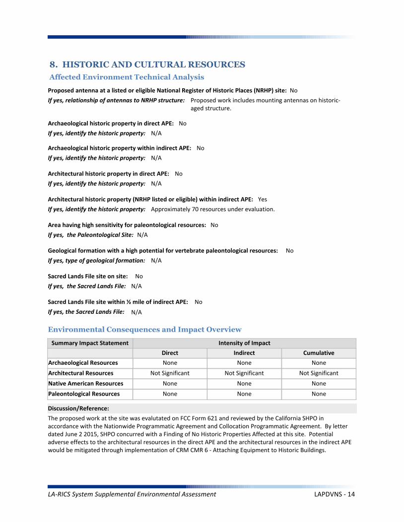
Architectural Resources
Summary Impact Statement
Archaeological Resources
8. HISTORIC AND CULTURAL RESOURCES
Affected Environment Technical Analysis
Environmental Consequences and Impact Overview
None None None
Not Significant Not Significant Not Significant
The proposed work at the site was evalutated on FCC Form 621 and reviewed by the California SHPO in accordance with the Nationwide Programmatic Agreement and Collocation Programmatic Agreement. By letter dated June 2 2015, SHPO concurred with a Finding of No Historic Properties Affected at this site. Potential adverse effects to the architectural resources in the direct APE and the architectural resources in the indirect APE would be mitigated through implementation of CRM CMR 6 - Attaching Equipment to Historic Buildings.
Intensity of Impact
Direct Indirect Cumulative
Discussion/Reference:
Proposed antenna at a listed or eligible National Register of Historic Places (NRHP) site: No
If yes, relationship of antennas to NRHP structure: Proposed work includes mounting antennas on historic-aged structure.
Native American Resources None None None
Archaeological historic property in direct APE: No
If yes, identify the historic property: N/A
Archaeological historic property within indirect APE: No
If yes, identify the historic property: N/A
Architectural historic property in direct APE: No
If yes, identify the historic property: N/A
Architectural historic property (NRHP listed or eligible) within indirect APE: Yes
If yes, identify the historic property: Approximately 70 resources under evaluation.
Sacred Lands File site on site: No
If yes, the Sacred Lands File: N/A
Sacred Lands File site within ½ mile of indirect APE: No
If yes, the Sacred Lands File: N/A
Area having high sensitivity for paleontological resources: No
If yes, the Paleontological Site: N/A
Geological formation with a high potential for vertebrate paleontological resources: No
If yes, type of geological formation: N/A
Paleontological Resources None None None
LA-RICS System Supplemental Environmental Assessment LAPDVNS - 14
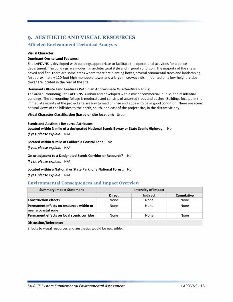
Summary Impact Statement
Construction effects
9. AESTHETIC AND VISUAL RESOURCES
Affected Environment Technical Analysis
Environmental Consequences and Impact Overview
None None None
Effects to visual resources and aesthetics would be negligible.
Intensity of Impact
Direct Indirect Cumulative
Discussion/Reference:
Dominant Onsite Land Features:
Site LAPDVNS is developed with buildings appropriate to facilitate the operational activities for a police department. The buildings are modern in architectural style and in good condition. The majority of the site is paved and flat. There are some areas where there are planting boxes, several ornamental trees and landscaping. An approximately 120-foot high monopole tower and a large microwave dish mounted on a low-height lattice tower are located in the rear of the site.
Dominant Offsite Land Features Within an Approximate Quarter-Mile Radius:
The area surrounding Site LAPDVNS is urban and developed with a mix of commercial, public, and residential buildings. The surrounding foliage is moderate and consists of assorted trees and bushes. Buildings located in the immediate vicinity of the project site are low to medium rise and appear to be in good condition. There are scenic natural views of the hillsides to the north, south, and east of the project site, in the distant vicinity.
Located within ¼ mile of a designated National Scenic Byway or State Scenic Highway: No
If yes, please explain: N/A
Scenic and Aesthetic Resource Attributes
Located within a National or State Park, or a National Forest: No
If yes, please explain: N/A
Visual Character Classification (based on site location): Urban
Located within ¼ mile of California Coastal Zone: No
If yes, please explain: N/A
Visual Character
Permanent effects on resources within ornear a coastal zone
None None None
Permanent effects on local scenic corridor None None None
On or adjacent to a Designated Scenic Corridor or Resource? No
If yes, please explain: N/A
LA-RICS System Supplemental Environmental Assessment LAPDVNS - 15
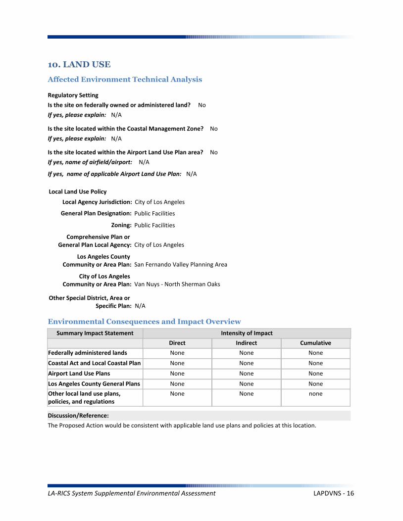
Coastal Act and Local Coastal Plan
Summary Impact Statement
Federally administered lands
10. LAND USE
Affected Environment Technical Analysis
Environmental Consequences and Impact Overview
None None None
None None None
The Proposed Action would be consistent with applicable land use plans and policies at this location.
Intensity of Impact
Direct Indirect Cumulative
Discussion/Reference:
Is the site on federally owned or administered land? No
If yes, please explain: N/A
Comprehensive Plan or General Plan Local Agency: City of Los Angeles
Local Land Use Policy
Local Agency Jurisdiction: City of Los Angeles
General Plan Designation: Public Facilities
Is the site located within the Coastal Management Zone? No
If yes, please explain: N/A
Regulatory Setting
Los Angeles County General Plans
Airport Land Use Plans None None None
None None None
Other local land use plans, policies, and regulations
None None none
Is the site located within the Airport Land Use Plan area? No
If yes, name of airfield/airport: N/A
If yes, name of applicable Airport Land Use Plan: N/A
Zoning: Public Facilities
Los Angeles County Community or Area Plan: San Fernando Valley Planning Area
City of Los Angeles Community or Area Plan: Van Nuys - North Sherman Oaks
Other Special District, Area or Specific Plan: N/A
LA-RICS System Supplemental Environmental Assessment LAPDVNS - 16

Solid Waste (construction)
Summary Impact Statement
Electrical Supply
11. INFRASTRUCTURE
Affected Environment Technical Analysis
Environmental Consequences and Impact Overview
Nearest Highway: Interstate 405
Site Served by Solid Waste Disposal Provider: City of Los Angeles Bureau of Sanitation
Not Significant None Not Significant
Not Significant None Not Significant
Utility use would be well within existing capacities. Implementation of TRANS MM-1 would minimize potential traffic impacts during construction. Public safety impact would be beneficial.
Traffic
Electrical
Disposal
Intensity of Impact
Direct Indirect Cumulative
Discussion/Reference:
Water Supply (construction)
Solid Waste (operation) None None None
Not Significant None Not Significant
Traffic (construction)
Water Supply (operation) None None None
Not Significant None None
Public Safety
Traffic (operation) None None None
Not Significant None None
Nearest Arterial: Van Nuys Boulevard
Distance (Miles): 1.6
Distance (Miles): 0.23
Access to the Project Site Provided Via: Tyrone Avenue
Electricity Service Provider: Los Angeles Department of Water and Power
Site Served by or has Available Access to Domestic Water System: Los Angeles Dept. of Water and Power
Water Service
Electricity On Site or to Be Brought to Site? Electricity on site
LA-RICS System Supplemental Environmental Assessment LAPDVNS - 17

Summary Impact Statement
12. SOCIOECONOMIC
Affected Environment Technical Analysis
Environmental Consequences and Impact Overview
The Proposed Action would benefit all populations in Los Angeles County, regardless of income, race or ethnicity.Temporary and localized effects from the Proposed Action would not result in disproportionately high adverseeffects on EJ populations.
Intensity of Impact
Direct Indirect Cumulative
Discussion/Reference:
Income
Disproportionately high effects onenvironmental justice (EJ) populations
None None None
Races Ethnicity
Hispanic/Latino
47.90%
53.02%
Other*
23.50%
29.59%
Asian Pacific Islander
14.20%
5.68%
American Indian/
Alaskan Native
0.50%
0.35%
Black/ AfricanAmerican
8.40%
4.81%
White
53.30%
59.50%
Within:
* “Other” includes U.S. Census race categories “Some other race” and “Two or more race,” which make up the total percentage of the race categories but are not race categories mandated by the Office of Management and Budget’s (OMB) 1997 standards.** Data was gathered from American Community Survey (ACS) 2009-2013
EJ Population Present Based on Minority Population Threshold? No
If yes, please explain: N/A
Within CountyJurisdiction
17.80%
$55,909
Within City Jurisdiction,CDP or Zip Code
17.8%
$49,497
Within Census Block Groups of the Project Site**
19.7%
$45,874
EJ population present based on income thresholds? No
If yes, please explain: N/A
Census Block Groups of
Project Site**:County
Jurisdiction
Median Household Income
Families Below Poverty
** Data was gathered from American Community Survey (ACS) 2009-2013
LA-RICS System Supplemental Environmental Assessment LAPDVNS - 18
Worker Safety
Summary Impact Statement
Hazardous Materials
13. Human Health and Safety
Affected Environment Technical Analysis
Environmental Consequences and Impact Overview
None None None
None None None
Intensity of Impact
Direct Indirect Cumulative
Discussion/Reference:
Site located on land listed as a hazardous materials site? No
If yes, please explain:
Aeronautical Hazards None None None
Located within 1 mile of National Priority List (Superfund) site? No
If yes, please explain: N/A
Within ¼ mile of listed Cortese, Leaking Underground Storage Tank, permitted Underground Storage Tank, or Brownfield site? NoIf yes, please explain: N/A
Site located within 1,000 feet of a landfill? No
If yes, please explain: N/A
Potential for methane exposure? No
If yes, please explain: N/A
Site located in a methane hazard zone? No
If yes, please explain: N/A
Site located within 200 feet of an oil or gas well? No
If yes, please explain: N/A
Wildland Fires None None None
Methane Hazard None None None
Hazardous Materials
Hazards
Site located in a Local fire hazard zone? No
If yes, please explain: N/A
Site located in a State fire hazard zone? No
If yes, please explain: N/A
Federal Aviation Administration (FAA) Part 77 Notification Required? N/A
FCC TOWAIR Results: N/A
LA-RICS System Supplemental Environmental Assessment LAPDVNS - 19

No hazardous waste sites have been identified, therefore no impacts are anticipated. Potential for RF exposures at the site are mitigated by HAZ MM 5, no significant impacts are anticipated.
Reference: LA RICS Long Term Evolution (LTE), ASTM 1528-14 Transaction Screen Report, Van Nuys Area Station, dated October 22, 2014, Prepared by EBI Consulting.
Discussion/Reference:
LA-RICS System Supplemental Environmental Assessment LAPDVNS - 20
LA-RICS LTE System
Appendix B: Supplemental Environmental Assessment
Site ID: LBECOC
Facility Name: Long Beach Emergency Comm. & Op. Center
LA-RICS System Supplemental Environmental Assessment LBECOC - 1
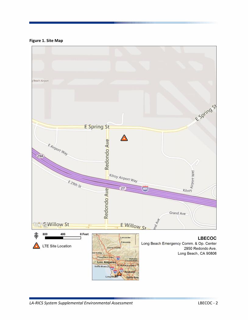
Figure 1. Site Map
LA-RICS System Supplemental Environmental Assessment LBECOC - 2
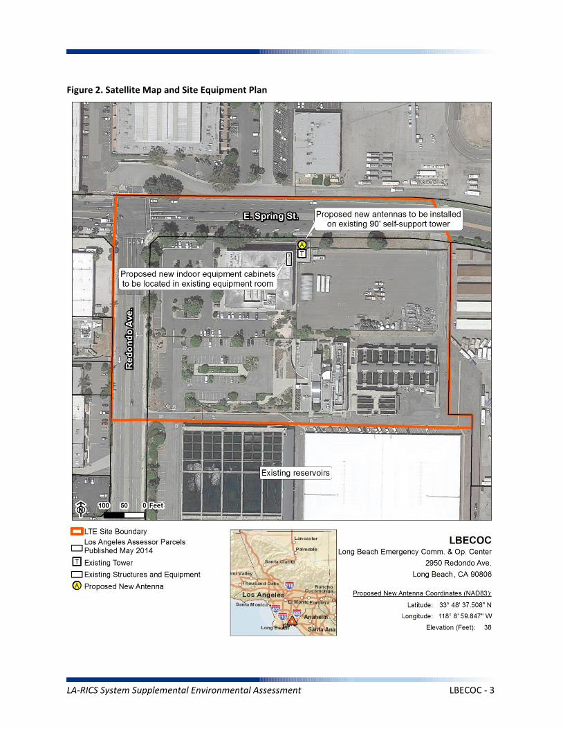
Figure 2. Satellite Map and Site Equipment Plan
LA-RICS System Supplemental Environmental Assessment LBECOC - 3
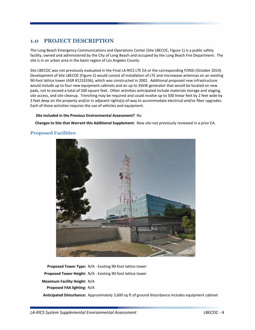
1.0 PROJECT DESCRIPTION
The Long Beach Emergency Communications and Operations Center (Site LBECOC, Figure 1) is a public safety facility, owned and administered by the City of Long Beach and occupied by the Long Beach Fire Department. The site is in an urban area in the basin region of Los Angeles County.
Site LBECOC was not previously evaluated in the Final LA-RICS LTE EA or the corresponding FONSI (October 2014). Development of Site LBECOC (Figure 2) would consist of installation of LTE and microwave antennas on an existing 90-foot lattice tower (ASR #1233336), which was constructed in 2002. Additional proposed new infrastructure would include up to four new equipment cabinets and an up to 35kW generator that would be located on new pads, not to exceed a total of 500 square feet. Other activities anticipated include materials storage and staging, site access, and site cleanup. Trenching may be required and could involve up to 500 linear feet by 2 feet wide by 3 feet deep on the property and/or in adjacent rights(s)-of-way to accommodate electrical and/or fiber upgrades. Each of these activities requires the use of vehicles and equipment.
Maximum Facility Height: N/A
Proposed Tower Type: N/A - Existing 90-foot lattice tower
Proposed Tower Height: N/A - Existing 90-foot lattice tower
Proposed FAA lighting: N/A
Anticipated Disturbance: Approximately 3,600 sq ft of ground disturbance includes equipment cabinet
Proposed Facilities
Site Included in the Previous Environmental Assessment? No
Changes to Site that Warrant this Additional Supplement: New site not previously reviewed in a prior EA.
LA-RICS System Supplemental Environmental Assessment LBECOC - 4
and generator foundations, trenching, and miscellaneous disturbance.
Power Requirements: Primary power up to 12.5 kW would draw from existing transformer to proposed meter. Backup power includes batteries and 35 kW diesel generator with integrated belly tank – attenuated to 65 decibel rating.
No Action Alternative: Under the No Action Alternative, this site would remain unchanged and no new LTE telecommunication infrastructure or related infrastructure would be installed. No direct, indirect, or cumulative impacts are anticipated.
LA-RICS System Supplemental Environmental Assessment LBECOC - 5
2. EXISTING SITE CONDITIONS
Existing Onsite Communications Facilities
Existing Onsite Communication Facility Lattice Tower, Monopole, or Antenna: Yes
Existing Tower Type: Lattice tower
Existing Tower Height: 90 feet
Existing Onsite Pad: Yes
Onsite Ground Equipment: Yes
Existing Generation: Adjacent transformer
Existing Backup Power: Yes
Existing Onsite Use/Facility: Emergency operations center
Other Existing Onsite Tall Structures: No
Type of Other Existing Tall Structures: N/A
Existing Ground Elevation (FT AMSL): 50
Commercial Airport Industrial Municipal Parking Commercial
Dominant Vicinity Use: Industrial Adjacent Residential Use: No
Located Within or on Federal Lands Administered By: No
N/A
N/A
N/A
N/A
Long Beach Airport
Existing Land Uses and Onsite Characteristics
Existing Land Uses and Onsite Surrounding Land Uses and Offsite Characteristics
Adjacent and Nearby Land Uses
North South East West
Description of Other Visible Towers: Control tower and runway markers at Long Beach Airport
Relationship to Federally Regulated Lands
Area of Special Consideration or Regulation
Located within boundaries of :
California Coastal Zone
Angeles National Forest
Santa Monica Mountains National Recreation Area
National or California State Park
Airport Influence Area
Yes / No If yes, Plan or Designation Area
Site Collocated? Yes FCC Registration: ASR # 1233336
No
No
No
No
Yes
LA-RICS System Supplemental Environmental Assessment LBECOC - 6
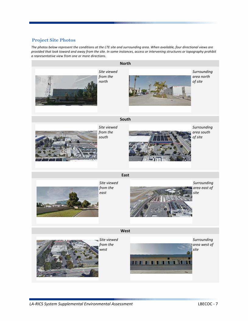
Project Site Photos
The photos below represent the conditions at the LTE site and surrounding area. When available, four directional views are provided that look toward and away from the site. In some instances, access or intervening structures or topography prohibit a representative view from one or more directions.
Site viewed from the north
Site viewed from the south
Site viewed from the east
Site viewed from the west
Surrounding area north of site
Surrounding area south of site
Surrounding area east of site
Surrounding area west of site
North
South
East
West
LA-RICS System Supplemental Environmental Assessment LBECOC - 7

Operation Noise
Construction Vibration
Summary Impact Statement
Construction Noise
3. NOISE
Affected Environment Technical Analysis
Environmental Consequences and Impact Overview
Applicable Noise Standards Source: City of Long Beach Municipal Code, Section 8.80. Section 8.80.202
Ambient Noise Setting: Urban
Local Residential Exterior Noise Exposure Limit: 50
Surrounding Walls/Structures Serve as Potential Noise Barrier? Yes
Vibration Sensitive Buildings Located within 50 feet of Site? No
Nearest Off-Site Sensitive Receiver Type: None
Sensitive Noise Receiver #1: N/A
Sensitive Noise Receiver #2: N/A
Sensitive Noise Receiver #3: N/A
Construction Projects are Exempt from Noise Regulations? No
7:00am - 7:00pm 9:00am- 6:00pm None None
Construction Noise Exempt During Normal Construction Hours? Yes
Construction Allowed During Extended Hours with Approval or Permit? Yes
Not Significant None None
Not Significant None None
Not Significant None None
Noise and vibration from construction activity would be short term and localized. Noise from operation not expected to be perceptible off-site.
Ambient Noise Factors and Conditions
Off-Site Sensitive Noise Receivers
Construction Noise Regulations
Monday-Friday Saturday Sunday HolidayAllowedConstruction
Hours
Intensity of Impact
Direct Indirect Cumulative
Discussion/Reference:
LA-RICS System Supplemental Environmental Assessment LBECOC - 8
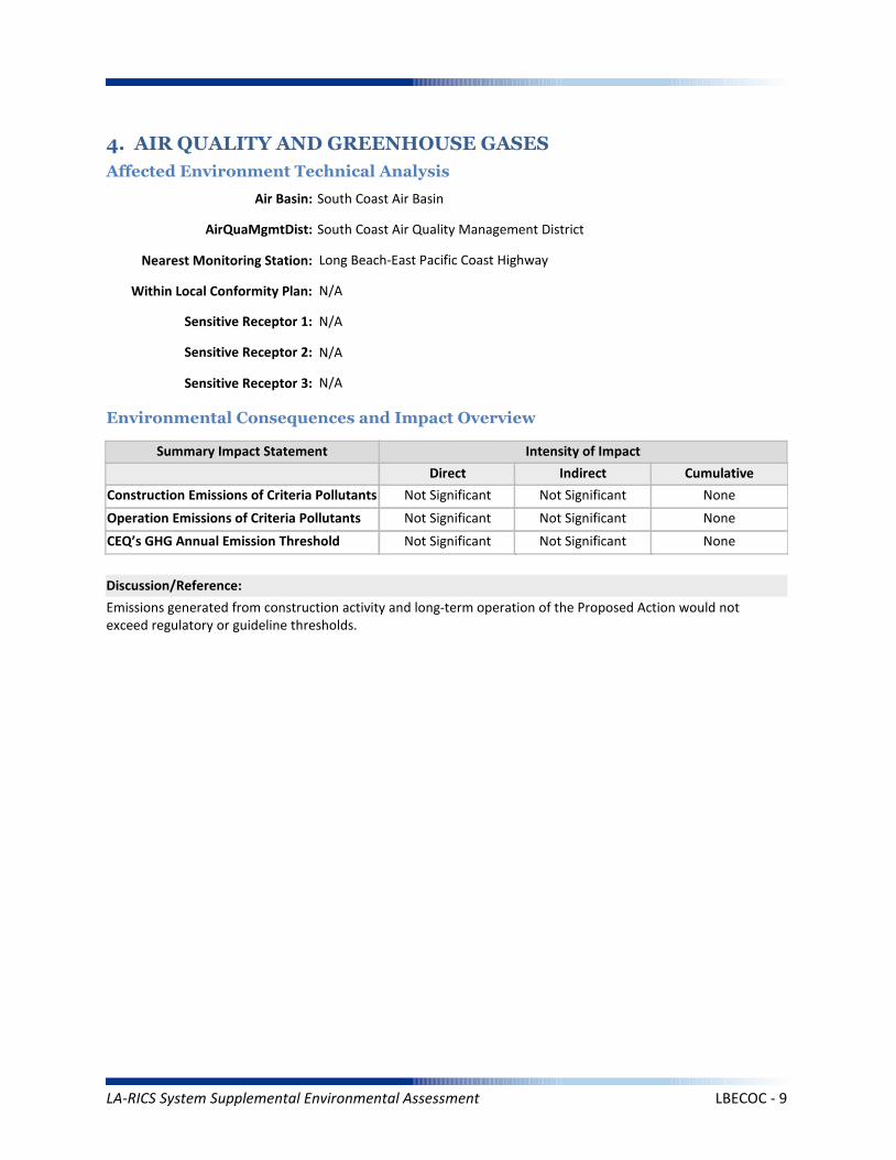
CEQ’s GHG Annual Emission Threshold
Operation Emissions of Criteria Pollutants
Summary Impact Statement
Construction Emissions of Criteria Pollutants
4. AIR QUALITY AND GREENHOUSE GASES
Affected Environment Technical Analysis
Environmental Consequences and Impact Overview
Not Significant Not Significant
Not Significant Not Significant None
Not Significant Not Significant None
Emissions generated from construction activity and long-term operation of the Proposed Action would not exceed regulatory or guideline thresholds.
Intensity of Impact
Direct Indirect Cumulative
Discussion/Reference:
Nearest Monitoring Station: Long Beach-East Pacific Coast Highway
Sensitive Receptor 1: N/A
Sensitive Receptor 2: N/A
Sensitive Receptor 3: N/A
None
Within Local Conformity Plan: N/A
Air Basin: South Coast Air Basin
AirQuaMgmtDist: South Coast Air Quality Management District
LA-RICS System Supplemental Environmental Assessment LBECOC - 9

Prime or Unique Farmland
Soil Erosion
Summary Impact Statement
Seismic Hazards
5. GEOLOGY AND SOILS
Affected Environment Technical Analysis
Environmental Consequences and Impact Overview
Not Significant None
None None None
None None None
Best management practices (BMPs) utilized during construction and operation of the Proposed Action would control runoff and minimize erosion.
Intensity of Impact
Direct Indirect Cumulative
Discussion/Reference:
US Geological Survey 7.5-Minute Quadrangle: Long Beach (82)
Is the site located within an Alquist-Priolo Earthquake Fault Zone? No
If yes, please explain: N/A
Geological Province: Peninsular Ranges
Surface Geological Formation: Quaternary alluvium and marine deposits
USDA Soil Classification: Urban land-Sorrento-Hanford Association
None
Geologic Characteristics
Farmland
Site occurs within Prime or Unique Farmland of Statewide or Local Importance: No
LA-RICS System Supplemental Environmental Assessment LBECOC - 10

Flood Hazard
Summary Impact Statement
Stormwater and non-storm waterdischarges on surface water resources
6. WATER RESOURCES
Affected Environment Technical Analysis
Environmental Consequences and Impact Overview
Regional Water Quality Control Board Hydrologic Region: Los Angeles RWQCB
Hydrologic Sub-Basin or Watershed: San Gabriel
Is a Surface Water Feature Located in Immediate Site Vicinity? Yes
If yes, please explain: Above ground ponds associated with industrial use exist south of the site.
Does the Project Site Affect a Wild or Scenic River? No
Name of the Groundwater Basin in which the Project Site Lies: Coastal Plain Of Los Angeles
Not Significant None None
None None None
Best management practices identified in BIO CMR 17 and 18 would preclude runoff from the site, and thereby avoid potential sediment and pollutant runoff.
Hydrologic Region
Surface Water (as defined by US Geological Survey)
Groundwater
Intensity of Impact
Direct Indirect Cumulative
Discussion/Reference:
If yes, please explain: N/A
Does the Project Site Affect an “Impaired Waterbody”? No
If yes, please explain: N/A
Flood Plain
If yes, please explain: N/A
Is the project site located within a designated 100-year flood plain, or an area designated as hillside, or other known flood-prone areas? No
LA-RICS System Supplemental Environmental Assessment LBECOC - 11

7. BIOLOGICAL RESOURCES
Affected Environment Technical Analysis
Dominant Onsite Habitat Type: Urban or Built-up Land/Ornamental
Site within 500 feet or within an Essential Fish Habitat (EFH): No
If yes, please explain: N/A
Site within 500 feet or within a Habitat Conservation Plan (HCP): No
Locational Context
Wetlands (as defined by US Geological Survey or US Fish Wildlife Service)
Special-Status Species and Habitats
If yes, please explain: N/A
Are wetlands present on site or within 500 feet of site? No
If yes, please explain: N/A
USFWS critical habitat present on site or within 500 feet of the site: No
If yes, please explain: N/A
Endangered Species Act (ESA)-listed species expected to occur on or within 500 feet of the site: No
If yes, please explain: N/A
Site within 500 feet or within a Federal/State Critical Habitat: No
If yes, please explain: N/A
Bald/Golden Eagle nest present on site or within 500 feet of the site: No
LA-RICS System Supplemental Environmental Assessment LBECOC - 12
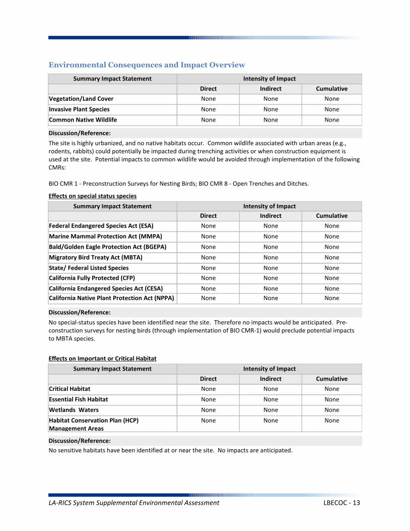
Marine Mammal Protection Act (MMPA)
Summary Impact Statement
Federal Endangered Species Act (ESA) None None None
None None None
No special-status species have been identified near the site. Therefore no impacts would be anticipated. Pre-construction surveys for nesting birds (through implementation of BIO CMR-1) would preclude potential impacts to MBTA species.
Intensity of Impact
Direct Indirect Cumulative
Discussion/Reference:
Bald/Golden Eagle Protection Act (BGEPA) None None None
Effects on special status species
State/ Federal Listed Species
Migratory Bird Treaty Act (MBTA) None None None
None None None
California Fully Protected (CFP) None None None
California Endangered Species Act (CESA) None None None
Essential Fish Habitat
Summary Impact Statement
Critical Habitat None None None
None None None
No sensitive habitats have been identified at or near the site. No impacts are anticipated.
Intensity of Impact
Direct Indirect Cumulative
Discussion/Reference:
Wetlands Waters None None None
Effects on Important or Critical Habitat
Habitat Conservation Plan (HCP)Management Areas
None None None
Invasive Plant Species
Summary Impact Statement
Vegetation/Land Cover
Environmental Consequences and Impact Overview
None None None
None None None
The site is highly urbanized, and no native habitats occur. Common wildlife associated with urban areas (e.g., rodents, rabbits) could potentially be impacted during trenching activities or when construction equipment is used at the site. Potential impacts to common wildlife would be avoided through implementation of the following CMRs:
BIO CMR 1 - Preconstruction Surveys for Nesting Birds; BIO CMR 8 - Open Trenches and Ditches.
Intensity of Impact
Direct Indirect Cumulative
Discussion/Reference:
Common Native Wildlife None None None
California Native Plant Protection Act (NPPA) None None None
LA-RICS System Supplemental Environmental Assessment LBECOC - 13
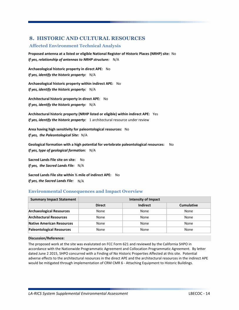
Architectural Resources
Summary Impact Statement
Archaeological Resources
8. HISTORIC AND CULTURAL RESOURCES
Affected Environment Technical Analysis
Environmental Consequences and Impact Overview
None None None
None None None
The proposed work at the site was evalutated on FCC Form 621 and reviewed by the California SHPO in accordance with the Nationwide Programmatic Agreement and Collocation Programmatic Agreement. By letter dated June 2 2015, SHPO concurred with a Finding of No Historic Properties Affected at this site. Potential adverse effects to the architectural resources in the direct APE and the architectural resources in the indirect APE would be mitigated through implementation of CRM CMR 6 - Attaching Equipment to Historic Buildings.
Intensity of Impact
Direct Indirect Cumulative
Discussion/Reference:
Proposed antenna at a listed or eligible National Register of Historic Places (NRHP) site: No
If yes, relationship of antennas to NRHP structure: N/A
Native American Resources None None None
Archaeological historic property in direct APE: No
If yes, identify the historic property: N/A
Archaeological historic property within indirect APE: No
If yes, identify the historic property: N/A
Architectural historic property in direct APE: No
If yes, identify the historic property: N/A
Architectural historic property (NRHP listed or eligible) within indirect APE: Yes
If yes, identify the historic property: 1 architectural resource under review
Sacred Lands File site on site: No
If yes, the Sacred Lands File: N/A
Sacred Lands File site within ½ mile of indirect APE: No
If yes, the Sacred Lands File: N/A
Area having high sensitivity for paleontological resources: No
If yes, the Paleontological Site: N/A
Geological formation with a high potential for vertebrate paleontological resources: No
If yes, type of geological formation: N/A
Paleontological Resources None None None
LA-RICS System Supplemental Environmental Assessment LBECOC - 14
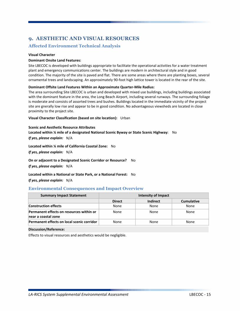
Summary Impact Statement
Construction effects
9. AESTHETIC AND VISUAL RESOURCES
Affected Environment Technical Analysis
Environmental Consequences and Impact Overview
None None None
Effects to visual resources and aesthetics would be negligible.
Intensity of Impact
Direct Indirect Cumulative
Discussion/Reference:
Dominant Onsite Land Features:
Site LBECOC is developed with buildings appropriate to facilitate the operational activities for a water treatment plant and emergency communications center. The buildings are modern in architectural style and in good condition. The majority of the site is paved and flat. There are some areas where there are planting boxes, several ornamental trees and landscaping. An approximately 90-foot high lattice tower is located in the rear of the site.
Dominant Offsite Land Features Within an Approximate Quarter-Mile Radius:
The area surrounding Site LBECOC is urban and developed with mixed use buildings, including buildings associated with the dominant feature in the area, the Long Beach Airport, including several runways. The surrounding foliage is moderate and consists of assorted trees and bushes. Buildings located in the immediate vicinity of the project site are gnerally low rise and appear to be in good condition. No advantageous viewsheds are located in close proximity to the project site.
Located within ¼ mile of a designated National Scenic Byway or State Scenic Highway: No
If yes, please explain: N/A
Scenic and Aesthetic Resource Attributes
Located within a National or State Park, or a National Forest: No
If yes, please explain: N/A
Visual Character Classification (based on site location): Urban
Located within ¼ mile of California Coastal Zone: No
If yes, please explain: N/A
Visual Character
Permanent effects on resources within ornear a coastal zone
None None None
Permanent effects on local scenic corridor None None None
On or adjacent to a Designated Scenic Corridor or Resource? No
If yes, please explain: N/A
LA-RICS System Supplemental Environmental Assessment LBECOC - 15

Coastal Act and Local Coastal Plan
Summary Impact Statement
Federally administered lands
10. LAND USE
Affected Environment Technical Analysis
Environmental Consequences and Impact Overview
None None None
None None None
The Proposed Action would be consistent with applicable land use plans and policies at this location.
Intensity of Impact
Direct Indirect Cumulative
Discussion/Reference:
Is the site on federally owned or administered land? No
If yes, please explain: N/A
Comprehensive Plan or General Plan Local Agency: City of Long Beach
Local Land Use Policy
Local Agency Jurisdiction: City of Long Beach
General Plan Designation: Mixed Use
Is the site located within the Coastal Management Zone? No
If yes, please explain: N/A
Regulatory Setting
Los Angeles County General Plans
Airport Land Use Plans None None None
None None None
Other local land use plans, policies, and regulations
None None None
Is the site located within the Airport Land Use Plan area? No
If yes, name of airfield/airport: N/A
If yes, name of applicable Airport Land Use Plan: N/A
Zoning: Planned Development 18 - Kilroy Airport Center
Los Angeles County Community or Area Plan: Gateway Planning Area
City of Los Angeles Community or Area Plan: N/A
Other Special District, Area or Specific Plan: N/A
LA-RICS System Supplemental Environmental Assessment LBECOC - 16
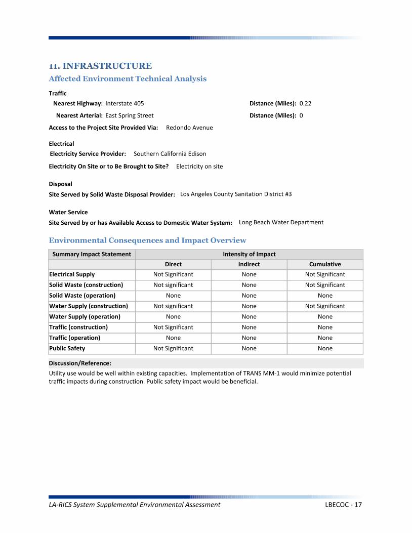
Solid Waste (construction)
Summary Impact Statement
Electrical Supply
11. INFRASTRUCTURE
Affected Environment Technical Analysis
Environmental Consequences and Impact Overview
Nearest Highway: Interstate 405
Site Served by Solid Waste Disposal Provider: Los Angeles County Sanitation District #3
Not Significant None Not Significant
Not significant None Not Significant
Utility use would be well within existing capacities. Implementation of TRANS MM-1 would minimize potential traffic impacts during construction. Public safety impact would be beneficial.
Traffic
Electrical
Disposal
Intensity of Impact
Direct Indirect Cumulative
Discussion/Reference:
Water Supply (construction)
Solid Waste (operation) None None None
Not significant None Not Significant
Traffic (construction)
Water Supply (operation) None None None
Not Significant None None
Public Safety
Traffic (operation) None None None
Not Significant None None
Nearest Arterial: East Spring Street
Distance (Miles): 0.22
Distance (Miles): 0
Access to the Project Site Provided Via: Redondo Avenue
Electricity Service Provider: Southern California Edison
Site Served by or has Available Access to Domestic Water System: Long Beach Water Department
Water Service
Electricity On Site or to Be Brought to Site? Electricity on site
LA-RICS System Supplemental Environmental Assessment LBECOC - 17

Summary Impact Statement
12. SOCIOECONOMIC
Affected Environment Technical Analysis
Environmental Consequences and Impact Overview
The Proposed Action would benefit all populations in Los Angeles County, regardless of income, race or ethnicity.Temporary and localized effects from the Proposed Action would not result in disproportionately high adverseeffects on EJ populations.
Intensity of Impact
Direct Indirect Cumulative
Discussion/Reference:
Income
Disproportionately high effects onenvironmental justice (EJ) populations
None None None
Races Ethnicity
Hispanic/Latino
47.90%
26.29%
Other*
23.50%
12.39%
Asian Pacific Islander
14.20%
17.06%
American Indian/
Alaskan Native
0.50%
8.02%
Black/ AfricanAmerican
8.40%
8.71%
White
53.30%
60.99%
Within:
* “Other” includes U.S. Census race categories “Some other race” and “Two or more race,” which make up the total percentage of the race categories but are not race categories mandated by the Office of Management and Budget’s (OMB) 1997 standards.** Data was gathered from American Community Survey (ACS) 2009-2013
EJ Population Present Based on Minority Population Threshold? No
If yes, please explain: N/A
Within CountyJurisdiction
17.80%
$55,909
Within City Jurisdiction,CDP or Zip Code
20.2%
$52,711
Within Census Block Groups of the Project Site**
3.7%
$77,026
EJ population present based on income thresholds? No
If yes, please explain: N/A
Census Block Groups of
Project Site**:County
Jurisdiction
Median Household Income
Families Below Poverty
** Data was gathered from American Community Survey (ACS) 2009-2013
LA-RICS System Supplemental Environmental Assessment LBECOC - 18
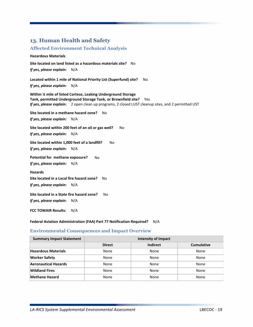
Worker Safety
Summary Impact Statement
Hazardous Materials
13. Human Health and Safety
Affected Environment Technical Analysis
Environmental Consequences and Impact Overview
None None None
None None None
Intensity of Impact
Direct Indirect Cumulative
Discussion/Reference:
Site located on land listed as a hazardous materials site? No
If yes, please explain: N/A
Aeronautical Hazards None None None
Located within 1 mile of National Priority List (Superfund) site? No
If yes, please explain: N/A
Within ¼ mile of listed Cortese, Leaking Underground Storage Tank, permitted Underground Storage Tank, or Brownfield site? YesIf yes, please explain: 2 open clean up programs, 2 closed LUST cleanup sites, and 2 permitted UST
Site located within 1,000 feet of a landfill? No
If yes, please explain: N/A
Potential for methane exposure? No
If yes, please explain: N/A
Site located in a methane hazard zone? No
If yes, please explain: N/A
Site located within 200 feet of an oil or gas well? No
If yes, please explain: N/A
Wildland Fires None None None
Methane Hazard None None None
Hazardous Materials
Hazards
Site located in a Local fire hazard zone? No
If yes, please explain: N/A
Site located in a State fire hazard zone? No
If yes, please explain: N/A
Federal Aviation Administration (FAA) Part 77 Notification Required? N/A
FCC TOWAIR Results: N/A
LA-RICS System Supplemental Environmental Assessment LBECOC - 19

The 2 open clean-up programs are located approximately 1/4 mile to the east of the LTE site. Both sites are under investigation, media impacted is groundwater. Depth of proposed excavation for the project (36 inches), would not encounter groundwater.
Reference: Hazardous material information was downloaded from: www:geotracker.waterboards.ca.gov.
Discussion/Reference:
LA-RICS System Supplemental Environmental Assessment LBECOC - 20
LA-RICS LTE System
Appendix B: Supplemental Environmental Assessment
Site ID: LBFD012(N)
Facility Name: Long Beach Fire Station 12(N)
LA-RICS System Supplemental Environmental Assessment LBFD012(N) - 1
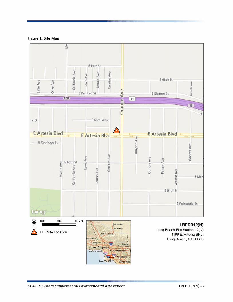
Figure 1. Site Map
LA-RICS System Supplemental Environmental Assessment LBFD012(N) - 2
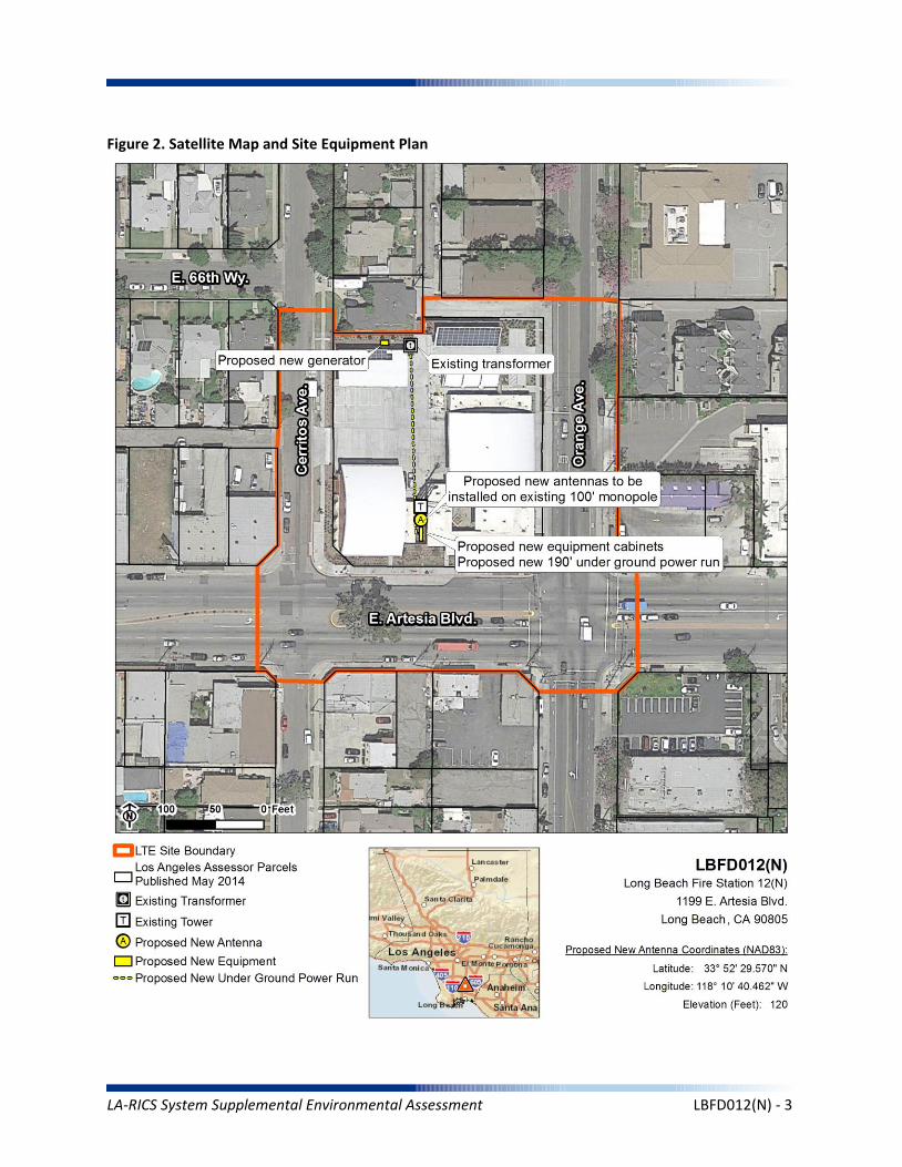
Figure 2. Satellite Map and Site Equipment Plan
LA-RICS System Supplemental Environmental Assessment LBFD012(N) - 3
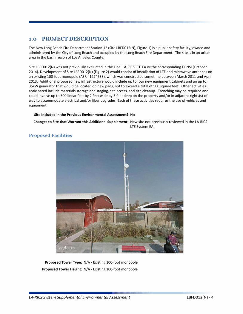
1.0 PROJECT DESCRIPTION
The New Long Beach Fire Department Station 12 (Site LBFD012(N), Figure 1) is a public safety facility, owned and administered by the City of Long Beach and occupied by the Long Beach Fire Department. The site is in an urban area in the basin region of Los Angeles County.
Site LBFD012(N) was not previously evaluated in the Final LA-RICS LTE EA or the corresponding FONSI (October 2014). Development of Site LBFD012(N) (Figure 2) would consist of installation of LTE and microwave antennas on an existing 100-foot monopole (ASR #1274633), which was constructed sometime between March 2011 and April 2013. Additional proposed new infrastructure would include up to four new equipment cabinets and an up to 35kW generator that would be located on new pads, not to exceed a total of 500 square feet. Other activities anticipated include materials storage and staging, site access, and site cleanup. Trenching may be required and could involve up to 500 linear feet by 2 feet wide by 3 feet deep on the property and/or in adjacent rights(s)-of-way to accommodate electrical and/or fiber upgrades. Each of these activities requires the use of vehicles and equipment.
Maximum Facility Height: N/A
Proposed Tower Type: N/A - Existing 100-foot monopole
Proposed Tower Height: N/A - Existing 100-foot monopole
Proposed Facilities
Site Included in the Previous Environmental Assessment? No
Changes to Site that Warrant this Additional Supplement: New site not previously reviewed in the LA-RICS LTE System EA.
LA-RICS System Supplemental Environmental Assessment LBFD012(N) - 4
Maximum Facility Height: N/A
Proposed FAA lighting: N/A
Anticipated Disturbance: Up to 3,600 square feet of new disturbance (grading and trenching) to accommodate new infrastructure, power and fiber.
Power Requirements: Primary power up to 12.5 kW would draw from existing transformer to proposed meter. Backup power includes batteries and 35 kW diesel generator with integrated belly tank – attenuated to 65 decibel rating.
No Action Alternative: Under the No Action Alternative, this site would remain unchanged and no new LTE telecommunication infrastructure or related infrastructure would be installed. No direct, indirect, or cumulative impacts are anticipated.
LA-RICS System Supplemental Environmental Assessment LBFD012(N) - 5

2. EXISTING SITE CONDITIONS
Existing Onsite Communications Facilities
Existing Onsite Communication Facility Lattice Tower, Monopole, or Antenna: Yes
Existing Tower Type: Monopole
Existing Tower Height: 100 feet
Existing Onsite Pad: No
Onsite Ground Equipment: Yes
Existing Generation: Adjacent transformer
Existing Backup Power: No
Existing Onsite Use/Facility: Fire Station
Other Existing Onsite Tall Structures: No
Type of Other Existing Tall Structures: N/A
Existing Ground Elevation (FT AMSL): 50
Residential Commercial Commercial
Residential
Commercial
Residential
Dominant Vicinity Use: Mixed Urban Adjacent Residential Use: Yes
Located Within or on Federal Lands Administered By: No
N/A
N/A
N/A
N/A
N/A
Existing Land Uses and Onsite Characteristics
Existing Land Uses and Onsite Surrounding Land Uses and Offsite Characteristics
Adjacent and Nearby Land Uses
North South East West
Description of Other Visible Towers: Sub-transmission power lines adjacent
Relationship to Federally Regulated Lands
Area of Special Consideration or Regulation
Located within boundaries of :
California Coastal Zone
Angeles National Forest
Santa Monica Mountains National Recreation Area
National or California State Park
Airport Influence Area
Yes / No If yes, Plan or Designation Area
Site Collocated? Yes FCC Registration: ASR # 1274633
No
No
No
No
No
LA-RICS System Supplemental Environmental Assessment LBFD012(N) - 6
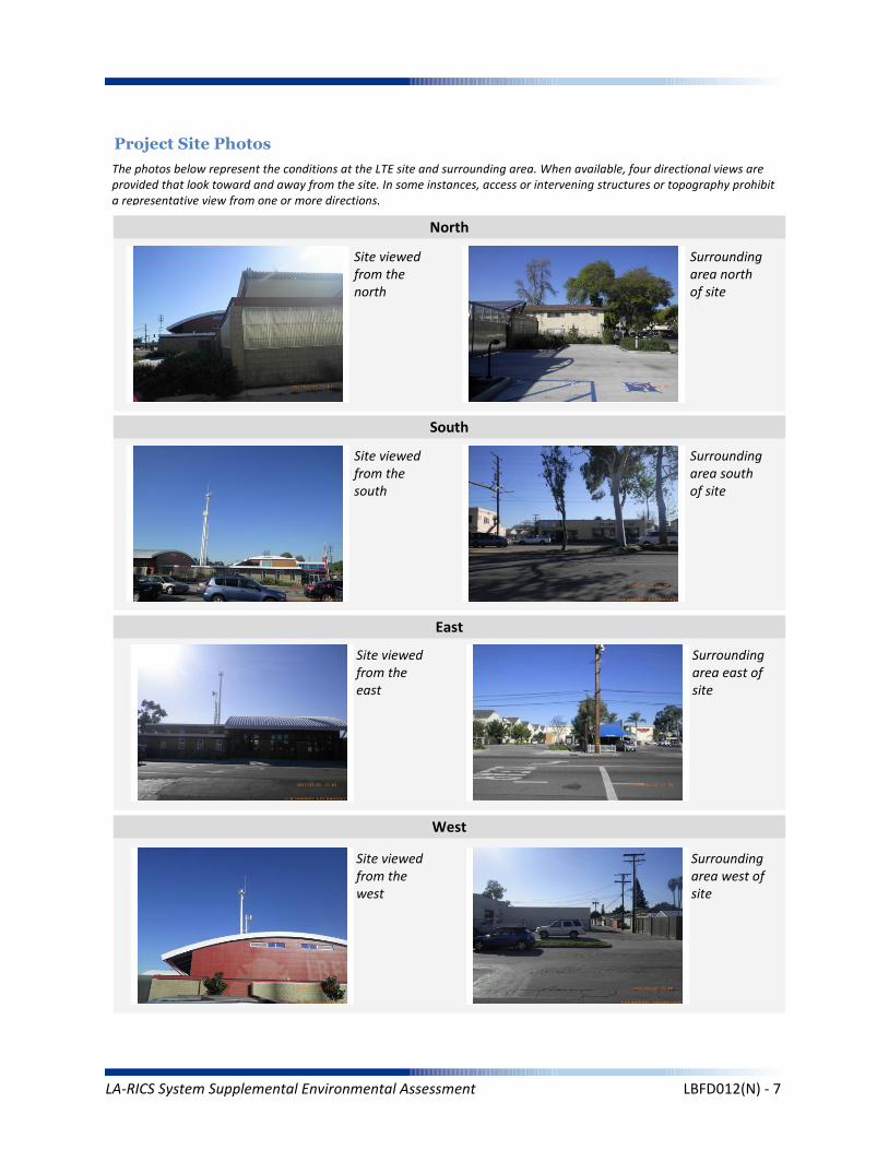
Project Site Photos
The photos below represent the conditions at the LTE site and surrounding area. When available, four directional views are provided that look toward and away from the site. In some instances, access or intervening structures or topography prohibit a representative view from one or more directions.
Site viewed from the north
Site viewed from the south
Site viewed from the east
Site viewed from the west
Surrounding area north of site
Surrounding area south of site
Surrounding area east of site
Surrounding area west of site
North
South
East
West
LA-RICS System Supplemental Environmental Assessment LBFD012(N) - 7

Operation Noise
Construction Vibration
Summary Impact Statement
Construction Noise
3. NOISE
Affected Environment Technical Analysis
Environmental Consequences and Impact Overview
Applicable Noise Standards Source: City of Long Beach Municipal Code, Section 8.80. Section 8.80.202
Ambient Noise Setting: Urban
Local Residential Exterior Noise Exposure Limit: 50
Surrounding Walls/Structures Serve as Potential Noise Barrier? Yes
Vibration Sensitive Buildings Located within 50 feet of Site? No
Nearest Off-Site Sensitive Receiver Type: 150 feet
Sensitive Noise Receiver #1: Residence
Sensitive Noise Receiver #2: Residence
Sensitive Noise Receiver #3: Residence
Construction Projects are Exempt from Noise Regulations?
7:00am - 7:00pm 9:00am- 6:00pm None None
Construction Noise Exempt During Normal Construction Hours? Yes
Construction Allowed During Extended Hours with Approval or Permit? Yes
Not Significant None None
Not Significant None None
Not Significant None None
Noise and vibration from construction activity would be short term and localized. Noise from operation not expected to be perceptible off-site.
Ambient Noise Factors and Conditions
Off-Site Sensitive Noise Receivers
Construction Noise Regulations
Monday-Friday Saturday Sunday HolidayAllowedConstruction
Hours
Intensity of Impact
Direct Indirect Cumulative
Discussion/Reference:
LA-RICS System Supplemental Environmental Assessment LBFD012(N) - 8
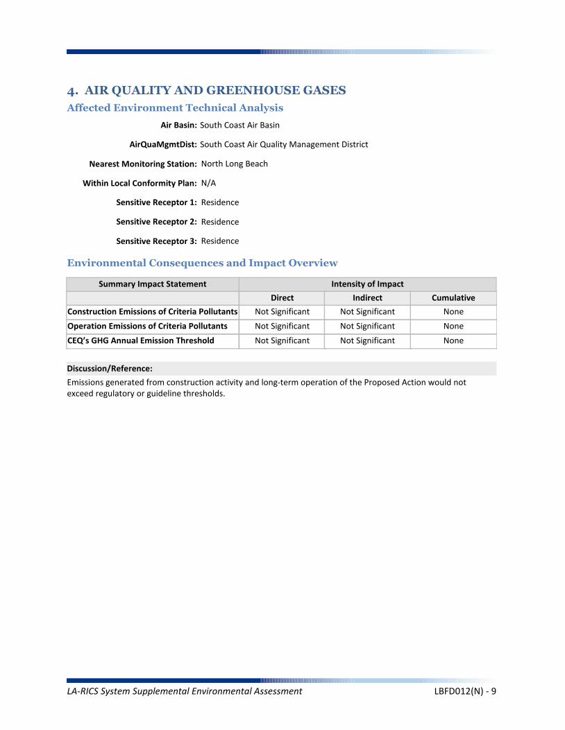
CEQ’s GHG Annual Emission Threshold
Operation Emissions of Criteria Pollutants
Summary Impact Statement
Construction Emissions of Criteria Pollutants
4. AIR QUALITY AND GREENHOUSE GASES
Affected Environment Technical Analysis
Environmental Consequences and Impact Overview
Not Significant Not Significant
Not Significant Not Significant None
Not Significant Not Significant None
Emissions generated from construction activity and long-term operation of the Proposed Action would not exceed regulatory or guideline thresholds.
Intensity of Impact
Direct Indirect Cumulative
Discussion/Reference:
Nearest Monitoring Station: North Long Beach
Sensitive Receptor 1: Residence
Sensitive Receptor 2: Residence
Sensitive Receptor 3: Residence
None
Within Local Conformity Plan: N/A
Air Basin: South Coast Air Basin
AirQuaMgmtDist: South Coast Air Quality Management District
LA-RICS System Supplemental Environmental Assessment LBFD012(N) - 9
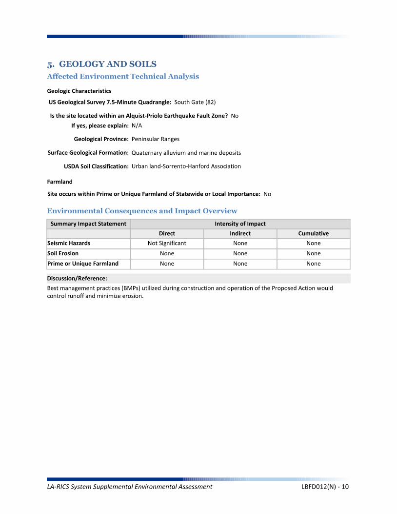
Prime or Unique Farmland
Soil Erosion
Summary Impact Statement
Seismic Hazards
5. GEOLOGY AND SOILS
Affected Environment Technical Analysis
Environmental Consequences and Impact Overview
Not Significant None
None None None
None None None
Best management practices (BMPs) utilized during construction and operation of the Proposed Action would control runoff and minimize erosion.
Intensity of Impact
Direct Indirect Cumulative
Discussion/Reference:
US Geological Survey 7.5-Minute Quadrangle: South Gate (82)
Is the site located within an Alquist-Priolo Earthquake Fault Zone? No
If yes, please explain: N/A
Geological Province: Peninsular Ranges
Surface Geological Formation: Quaternary alluvium and marine deposits
USDA Soil Classification: Urban land-Sorrento-Hanford Association
None
Geologic Characteristics
Farmland
Site occurs within Prime or Unique Farmland of Statewide or Local Importance: No
LA-RICS System Supplemental Environmental Assessment LBFD012(N) - 10

Flood Hazard
Summary Impact Statement
Stormwater and non-storm waterdischarges on surface water resources
6. WATER RESOURCES
Affected Environment Technical Analysis
Environmental Consequences and Impact Overview
Regional Water Quality Control Board Hydrologic Region: Los Angeles RWQCB
Hydrologic Sub-Basin or Watershed: Los Angeles
Is a Surface Water Feature Located in Immediate Site Vicinity? No
If yes, please explain: N/A
Does the Project Site Affect a Wild or Scenic River? No
Name of the Groundwater Basin in which the Project Site Lies: Coastal Plain Of Los Angeles
Not Significant None None
None None None
Best management practices identified in BIO CMR 17 and 18 would preclude runoff from the site, and thereby avoid potential sediment and pollutant runoff.
Hydrologic Region
Surface Water (as defined by US Geological Survey)
Groundwater
Intensity of Impact
Direct Indirect Cumulative
Discussion/Reference:
If yes, please explain: N/A
Does the Project Site Affect an “Impaired Waterbody”? No
If yes, please explain: N/A
Flood Plain
If yes, please explain: N/A
Is the project site located within a designated 100-year flood plain, or an area designated as hillside, or other known flood-prone areas? No
LA-RICS System Supplemental Environmental Assessment LBFD012(N) - 11
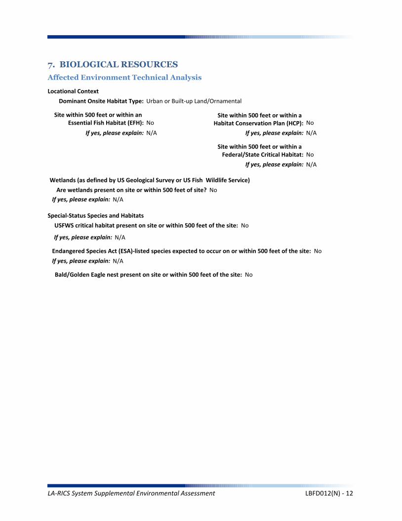
7. BIOLOGICAL RESOURCES
Affected Environment Technical Analysis
Dominant Onsite Habitat Type: Urban or Built-up Land/Ornamental
Site within 500 feet or within an Essential Fish Habitat (EFH): No
If yes, please explain: N/A
Site within 500 feet or within a Habitat Conservation Plan (HCP): No
Locational Context
Wetlands (as defined by US Geological Survey or US Fish Wildlife Service)
Special-Status Species and Habitats
If yes, please explain: N/A
Are wetlands present on site or within 500 feet of site? No
If yes, please explain: N/A
USFWS critical habitat present on site or within 500 feet of the site: No
If yes, please explain: N/A
Endangered Species Act (ESA)-listed species expected to occur on or within 500 feet of the site: No
If yes, please explain: N/A
Site within 500 feet or within a Federal/State Critical Habitat: No
If yes, please explain: N/A
Bald/Golden Eagle nest present on site or within 500 feet of the site: No
LA-RICS System Supplemental Environmental Assessment LBFD012(N) - 12
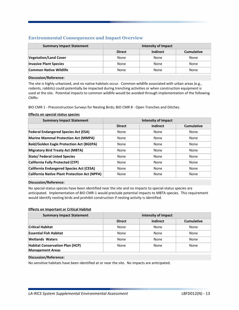
Marine Mammal Protection Act (MMPA)
Summary Impact Statement
Federal Endangered Species Act (ESA) None None None
None None None
No special-status species have been identified near the site and no impacts to special-status species are anticipated. Implementation of BIO CMR-1 would preclude potential impacts to MBTA species. This requirement would identify nesting birds and prohibit construction if nesting activity is identified.
Intensity of Impact
Direct Indirect Cumulative
Discussion/Reference:
Bald/Golden Eagle Protection Act (BGEPA) None None None
Effects on special status species
State/ Federal Listed Species
Migratory Bird Treaty Act (MBTA) None None None
None None None
California Fully Protected (CFP) None None None
California Endangered Species Act (CESA) None None None
Essential Fish Habitat
Summary Impact Statement
Critical Habitat None None None
None None None
No sensitive habitats have been identified at or near the site. No impacts are anticipated.
Intensity of Impact
Direct Indirect Cumulative
Discussion/Reference:
Wetlands Waters None None None
Effects on Important or Critical Habitat
Habitat Conservation Plan (HCP)Management Areas
None None None
Invasive Plant Species
Summary Impact Statement
Vegetation/Land Cover
Environmental Consequences and Impact Overview
None None None
None None None
The site is highly urbanized, and no native habitats occur. Common wildlife associated with urban areas (e.g., rodents, rabbits) could potentially be impacted during trenching activities or when construction equipment is used at the site. Potential impacts to common wildlife would be avoided through implementation of the following CMRs:
BIO CMR 1 - Preconstruction Surveys for Nesting Birds; BIO CMR 8 - Open Trenches and Ditches.
Intensity of Impact
Direct Indirect Cumulative
Discussion/Reference:
Common Native Wildlife None None None
California Native Plant Protection Act (NPPA) None None None
LA-RICS System Supplemental Environmental Assessment LBFD012(N) - 13
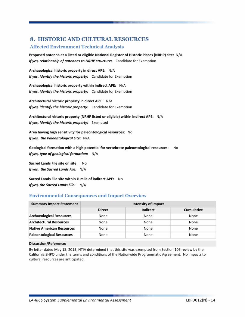
Architectural Resources
Summary Impact Statement
Archaeological Resources
8. HISTORIC AND CULTURAL RESOURCES
Affected Environment Technical Analysis
Environmental Consequences and Impact Overview
None None None
None None None
By letter dated May 15, 2015, NTIA determined that this site was exempted from Section 106 review by the California SHPO under the terms and conditions of the Nationwide Programmatic Agreement. No impacts to cultural resources are anticipated.
Intensity of Impact
Direct Indirect Cumulative
Discussion/Reference:
Proposed antenna at a listed or eligible National Register of Historic Places (NRHP) site: N/A
If yes, relationship of antennas to NRHP structure: Candidate for Exemption
Native American Resources None None None
Archaeological historic property in direct APE: N/A
If yes, identify the historic property: Candidate for Exemption
Archaeological historic property within indirect APE: N/A
If yes, identify the historic property: Candidate for Exemption
Architectural historic property in direct APE: N/A
If yes, identify the historic property: Candidate for Exemption
Architectural historic property (NRHP listed or eligible) within indirect APE: N/A
If yes, identify the historic property: Exempted
Sacred Lands File site on site: No
If yes, the Sacred Lands File: N/A
Sacred Lands File site within ½ mile of indirect APE: No
If yes, the Sacred Lands File: N/A
Area having high sensitivity for paleontological resources: No
If yes, the Paleontological Site: N/A
Geological formation with a high potential for vertebrate paleontological resources: No
If yes, type of geological formation: N/A
Paleontological Resources None None None
LA-RICS System Supplemental Environmental Assessment LBFD012(N) - 14
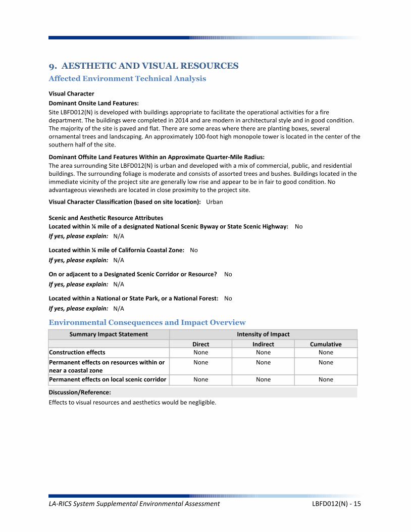
Summary Impact Statement
Construction effects
9. AESTHETIC AND VISUAL RESOURCES
Affected Environment Technical Analysis
Environmental Consequences and Impact Overview
None None None
Effects to visual resources and aesthetics would be negligible.
Intensity of Impact
Direct Indirect Cumulative
Discussion/Reference:
Dominant Onsite Land Features:
Site LBFD012(N) is developed with buildings appropriate to facilitate the operational activities for a fire department. The buildings were completed in 2014 and are modern in architectural style and in good condition. The majority of the site is paved and flat. There are some areas where there are planting boxes, several ornamental trees and landscaping. An approximately 100-foot high monopole tower is located in the center of the southern half of the site.
Dominant Offsite Land Features Within an Approximate Quarter-Mile Radius:
The area surrounding Site LBFD012(N) is urban and developed with a mix of commercial, public, and residential buildings. The surrounding foliage is moderate and consists of assorted trees and bushes. Buildings located in the immediate vicinity of the project site are generally low rise and appear to be in fair to good condition. No advantageous viewsheds are located in close proximity to the project site.
Located within ¼ mile of a designated National Scenic Byway or State Scenic Highway: No
If yes, please explain: N/A
Scenic and Aesthetic Resource Attributes
Located within a National or State Park, or a National Forest: No
If yes, please explain: N/A
Visual Character Classification (based on site location): Urban
Located within ¼ mile of California Coastal Zone: No
If yes, please explain: N/A
Visual Character
Permanent effects on resources within ornear a coastal zone
None None None
Permanent effects on local scenic corridor None None None
On or adjacent to a Designated Scenic Corridor or Resource? No
If yes, please explain: N/A
LA-RICS System Supplemental Environmental Assessment LBFD012(N) - 15

Coastal Act and Local Coastal Plan
Summary Impact Statement
Federally administered lands
10. LAND USE
Affected Environment Technical Analysis
Environmental Consequences and Impact Overview
None None None
None None None
The Proposed Action would be consistent with applicable land use plans and policies at this location.
Intensity of Impact
Direct Indirect Cumulative
Discussion/Reference:
Is the site on federally owned or administered land? No
If yes, please explain: N/A
Comprehensive Plan or General Plan Local Agency: City of Long Beach
Local Land Use Policy
Local Agency Jurisdiction: City of Long Beach
General Plan Designation: Institutional and School District
Is the site located within the Coastal Management Zone? No
If yes, please explain: N/A
Regulatory Setting
Los Angeles County General Plans
Airport Land Use Plans None None None
None None None
Other local land use plans, policies, and regulations
None None None
Is the site located within the Airport Land Use Plan area? No
If yes, name of airfield/airport: N/A
If yes, name of applicable Airport Land Use Plan: N/A
Zoning: Institutional
Los Angeles County Community or Area Plan: Gateway Planning Area
City of Los Angeles Community or Area Plan: N/A
Other Special District, Area or Specific Plan: N/A
LA-RICS System Supplemental Environmental Assessment LBFD012(N) - 16

Solid Waste (construction)
Summary Impact Statement
Electrical Supply
11. INFRASTRUCTURE
Affected Environment Technical Analysis
Environmental Consequences and Impact Overview
Nearest Highway: Artesia Frwy
Site Served by Solid Waste Disposal Provider: Los Angeles County Sanitation District #3
Not Significant None Not Significant
Not Significant None Not Significant
Utility use would be well within existing capacities. Implementation of TRANS MM-1 would minimize potential traffic impacts during construction. Public safety impact would be beneficial.
Traffic
Electrical
Disposal
Intensity of Impact
Direct Indirect Cumulative
Discussion/Reference:
Water Supply (construction)
Solid Waste (operation) None None None
Not Significant None Not Significant
Traffic (construction)
Water Supply (operation) None None None
Not Significant None None
Public Safety
Traffic (operation) None None None
Not Significant None None
Nearest Arterial: East Artesia Boulevard
Distance (Miles): 0.13
Distance (Miles): 0
Access to the Project Site Provided Via: East Artesia Boulevard
Electricity Service Provider: Southern California Edison
Site Served by or has Available Access to Domestic Water System: Long Beach Water Department
Water Service
Electricity On Site or to Be Brought to Site? Electricity on site
LA-RICS System Supplemental Environmental Assessment LBFD012(N) - 17
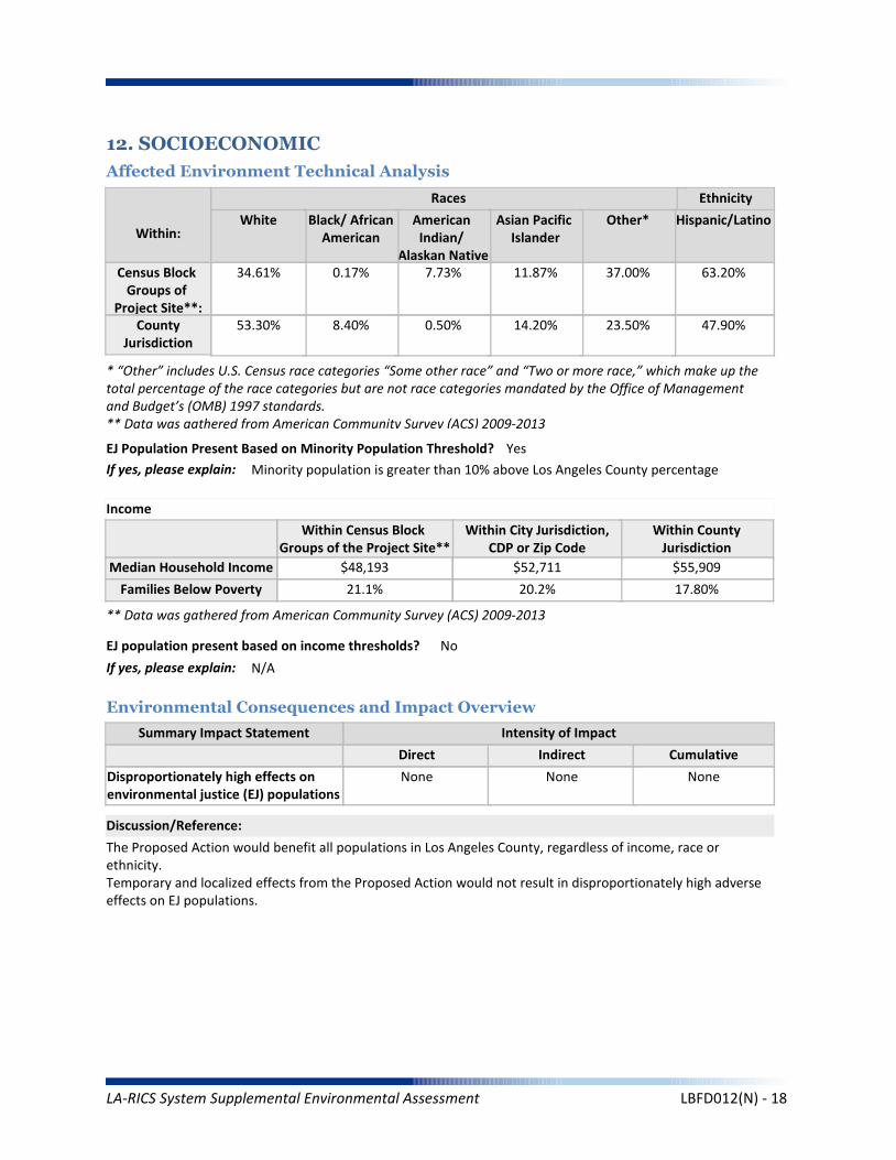
Summary Impact Statement
12. SOCIOECONOMIC
Affected Environment Technical Analysis
Environmental Consequences and Impact Overview
The Proposed Action would benefit all populations in Los Angeles County, regardless of income, race or ethnicity.Temporary and localized effects from the Proposed Action would not result in disproportionately high adverseeffects on EJ populations.
Intensity of Impact
Direct Indirect Cumulative
Discussion/Reference:
Income
Disproportionately high effects onenvironmental justice (EJ) populations
None None None
Races Ethnicity
Hispanic/Latino
47.90%
63.20%
Other*
23.50%
37.00%
Asian Pacific Islander
14.20%
11.87%
American Indian/
Alaskan Native
0.50%
7.73%
Black/ AfricanAmerican
8.40%
0.17%
White
53.30%
34.61%
Within:
* “Other” includes U.S. Census race categories “Some other race” and “Two or more race,” which make up the total percentage of the race categories but are not race categories mandated by the Office of Management and Budget’s (OMB) 1997 standards.** Data was gathered from American Community Survey (ACS) 2009-2013
EJ Population Present Based on Minority Population Threshold? Yes
If yes, please explain: Minority population is greater than 10% above Los Angeles County percentage
Within CountyJurisdiction
17.80%
$55,909
Within City Jurisdiction,CDP or Zip Code
20.2%
$52,711
Within Census Block Groups of the Project Site**
21.1%
$48,193
EJ population present based on income thresholds? No
If yes, please explain: N/A
Census Block Groups of
Project Site**:County
Jurisdiction
Median Household Income
Families Below Poverty
** Data was gathered from American Community Survey (ACS) 2009-2013
LA-RICS System Supplemental Environmental Assessment LBFD012(N) - 18

Worker Safety
Summary Impact Statement
Hazardous Materials
13. Human Health and Safety
Affected Environment Technical Analysis
Environmental Consequences and Impact Overview
None None None
None None None
Intensity of Impact
Direct Indirect Cumulative
Discussion/Reference:
Site located on land listed as a hazardous materials site? No
If yes, please explain: N/A
Aeronautical Hazards None None None
Located within 1 mile of National Priority List (Superfund) site? No
If yes, please explain: N/A
Within ¼ mile of listed Cortese, Leaking Underground Storage Tank, permitted Underground Storage Tank, or Brownfield site? YesIf yes, please explain: Clean up program site, under assessment and interim remedial action
Site located within 1,000 feet of a landfill? No
If yes, please explain: N/A
Potential for methane exposure? No
If yes, please explain: N/A
Site located in a methane hazard zone? No
If yes, please explain: N/A
Site located within 200 feet of an oil or gas well? No
If yes, please explain: N/A
Wildland Fires None None None
Methane Hazard None None None
Hazardous Materials
Hazards
Site located in a Local fire hazard zone? No
If yes, please explain: N/A
Site located in a State fire hazard zone? No
If yes, please explain: N/A
Federal Aviation Administration (FAA) Part 77 Notification Required? N/A
FCC TOWAIR Results: N/A
LA-RICS System Supplemental Environmental Assessment LBFD012(N) - 19

Project construction activities would not encounter the reported clean-up program site. It is geographically distant from the LTE site and the depth of proposed construction (i.e., trenching to 36 inches) would not result in contact with groundwater.
Reference: Hazardous material information was downloaded from: www:geotracker.waterboards.ca.gov.
Discussion/Reference:
LA-RICS System Supplemental Environmental Assessment LBFD012(N) - 20
LA-RICS LTE System
Appendix B: Supplemental Environmental Assessment
Site ID: PASDNPD
Facility Name: Pasadena Police
LA-RICS System Supplemental Environmental Assessment PASDNPD - 1
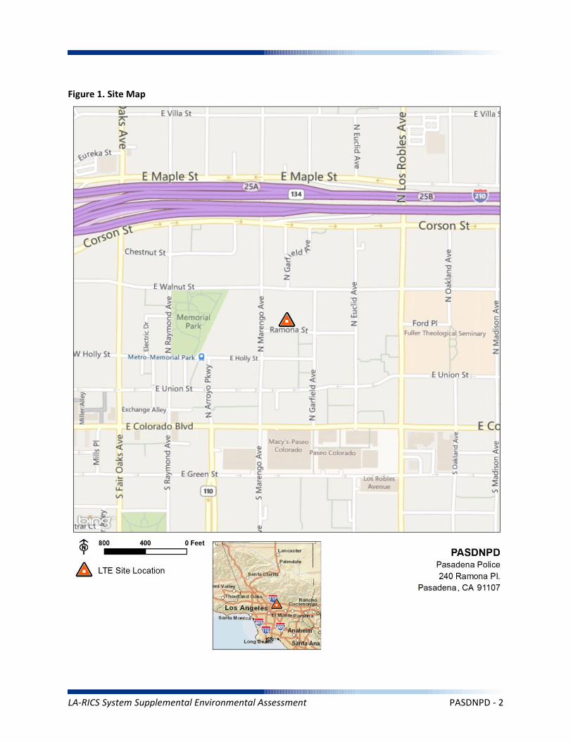
Figure 1. Site Map
LA-RICS System Supplemental Environmental Assessment PASDNPD - 2
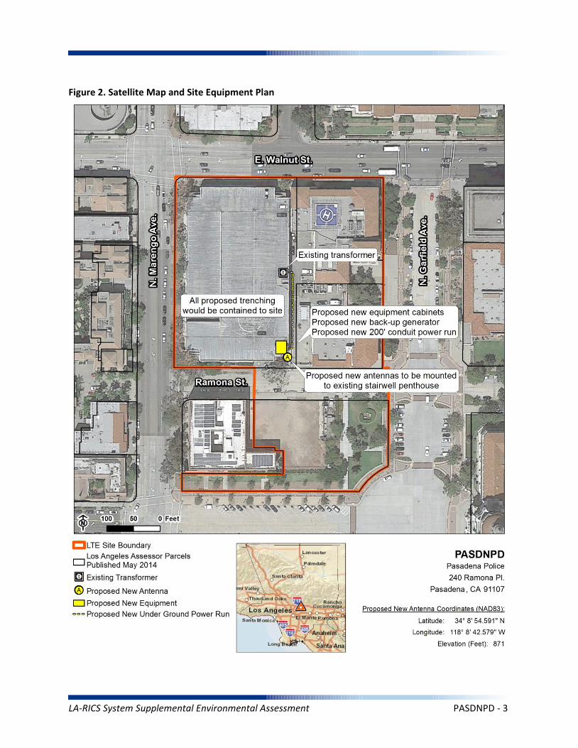
Figure 2. Satellite Map and Site Equipment Plan
LA-RICS System Supplemental Environmental Assessment PASDNPD - 3
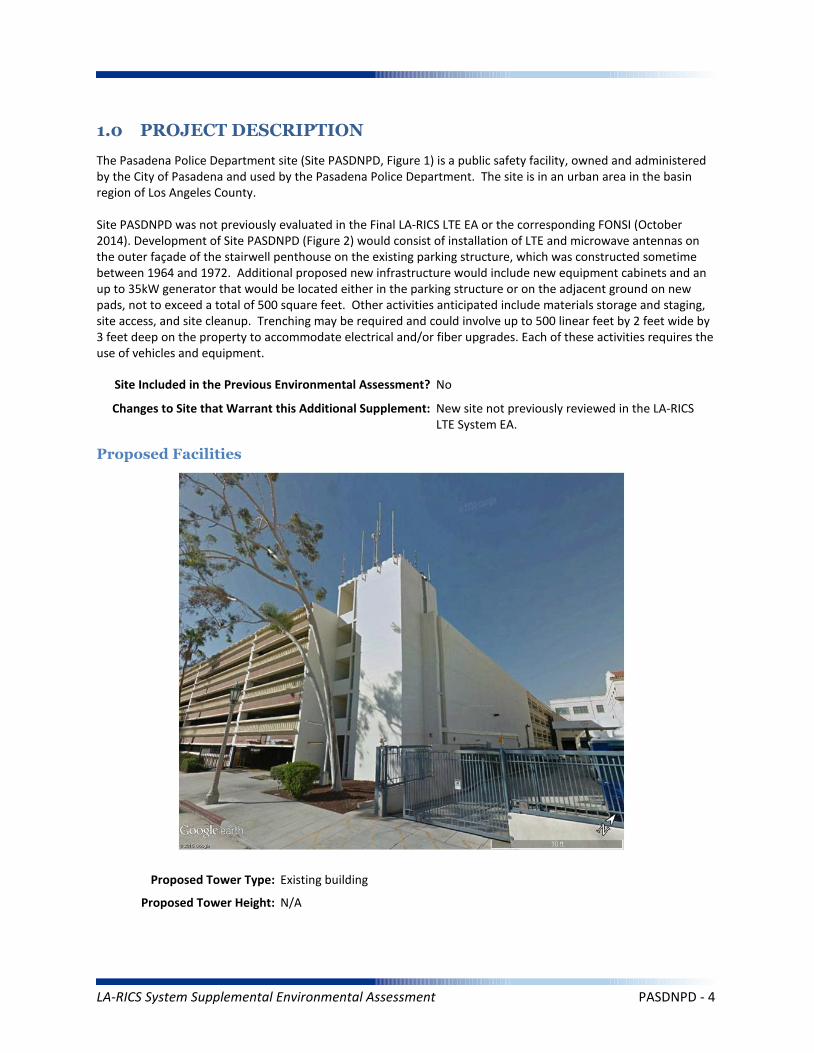
1.0 PROJECT DESCRIPTION
The Pasadena Police Department site (Site PASDNPD, Figure 1) is a public safety facility, owned and administered by the City of Pasadena and used by the Pasadena Police Department. The site is in an urban area in the basin region of Los Angeles County.
Site PASDNPD was not previously evaluated in the Final LA-RICS LTE EA or the corresponding FONSI (October 2014). Development of Site PASDNPD (Figure 2) would consist of installation of LTE and microwave antennas on the outer façade of the stairwell penthouse on the existing parking structure, which was constructed sometime between 1964 and 1972. Additional proposed new infrastructure would include new equipment cabinets and an up to 35kW generator that would be located either in the parking structure or on the adjacent ground on new pads, not to exceed a total of 500 square feet. Other activities anticipated include materials storage and staging, site access, and site cleanup. Trenching may be required and could involve up to 500 linear feet by 2 feet wide by 3 feet deep on the property to accommodate electrical and/or fiber upgrades. Each of these activities requires the use of vehicles and equipment.
Maximum Facility Height: N/A
Proposed Tower Type: Existing building
Proposed Tower Height: N/A
Proposed Facilities
Site Included in the Previous Environmental Assessment? No
Changes to Site that Warrant this Additional Supplement: New site not previously reviewed in the LA-RICS LTE System EA.
LA-RICS System Supplemental Environmental Assessment PASDNPD - 4
Maximum Facility Height: N/A
Proposed FAA lighting: N/A
Anticipated Disturbance: Up to 500 square feet of new impervious surface for equipment cabinets and generator pad. Up to 1,000 square feet of additional on site ground disturbance while trenching for power/fiber.
Power Requirements: Primary power up to 12.5 kW would draw from existing transformer to proposed meter. Backup power includes batteries and 35 kW diesel generator with integrated belly tank – attenuated to 65 decibel rating.
No Action Alternative: Under the No Action Alternative, this site would remain unchanged and no new LTE telecommunication infrastructure or related infrastructure would be installed. No direct, indirect, or cumulative impacts are anticipated.
LA-RICS System Supplemental Environmental Assessment PASDNPD - 5
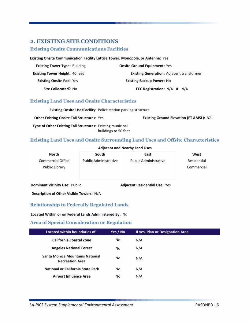
2. EXISTING SITE CONDITIONS
Existing Onsite Communications Facilities
Existing Onsite Communication Facility Lattice Tower, Monopole, or Antenna: Yes
Existing Tower Type: Building
Existing Tower Height: 40 feet
Existing Onsite Pad: Yes
Onsite Ground Equipment: Yes
Existing Generation: Adjacent transformer
Existing Backup Power: No
Existing Onsite Use/Facility: Police station parking structure
Other Existing Onsite Tall Structures: Yes
Type of Other Existing Tall Structures: Existing municipal buildings to 50 feet
Existing Ground Elevation (FT AMSL): 871
Commercial Office
Public Library
Public Administrative Public Administrative Residential
Commercial
Dominant Vicinity Use: Public Adjacent Residential Use: Yes
Located Within or on Federal Lands Administered By: No
N/A
N/A
N/A
N/A
N/A
Existing Land Uses and Onsite Characteristics
Existing Land Uses and Onsite Surrounding Land Uses and Offsite Characteristics
Adjacent and Nearby Land Uses
North South East West
Description of Other Visible Towers: N/A
Relationship to Federally Regulated Lands
Area of Special Consideration or Regulation
Located within boundaries of :
California Coastal Zone
Angeles National Forest
Santa Monica Mountains National Recreation Area
National or California State Park
Airport Influence Area
Yes / No If yes, Plan or Designation Area
Site Collocated? No FCC Registration: N/A # N/A
No
No
No
No
No
LA-RICS System Supplemental Environmental Assessment PASDNPD - 6
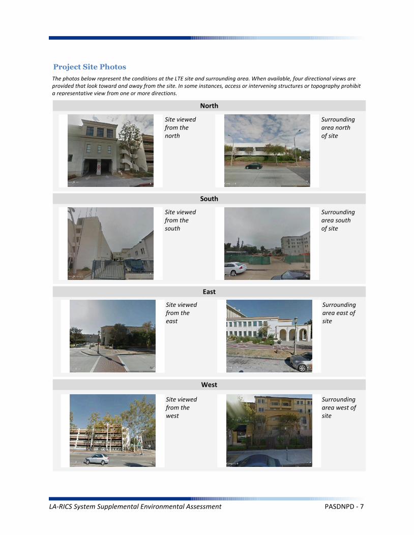
Project Site Photos
The photos below represent the conditions at the LTE site and surrounding area. When available, four directional views are provided that look toward and away from the site. In some instances, access or intervening structures or topography prohibit a representative view from one or more directions.
Site viewed from the north
Site viewed from the south
Site viewed from the east
Site viewed from the west
Surrounding area north of site
Surrounding area south of site
Surrounding area east of site
Surrounding area west of site
North
South
East
West
LA-RICS System Supplemental Environmental Assessment PASDNPD - 7
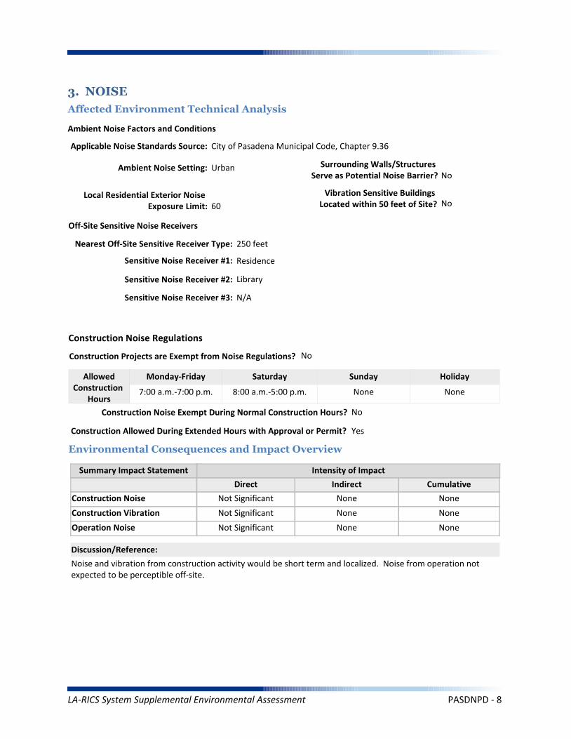
Operation Noise
Construction Vibration
Summary Impact Statement
Construction Noise
3. NOISE
Affected Environment Technical Analysis
Environmental Consequences and Impact Overview
Applicable Noise Standards Source: City of Pasadena Municipal Code, Chapter 9.36
Ambient Noise Setting: Urban
Local Residential Exterior Noise Exposure Limit: 60
Surrounding Walls/Structures Serve as Potential Noise Barrier? No
Vibration Sensitive Buildings Located within 50 feet of Site? No
Nearest Off-Site Sensitive Receiver Type: 250 feet
Sensitive Noise Receiver #1: Residence
Sensitive Noise Receiver #2: Library
Sensitive Noise Receiver #3: N/A
Construction Projects are Exempt from Noise Regulations? No
7:00 a.m.-7:00 p.m. 8:00 a.m.-5:00 p.m. None None
Construction Noise Exempt During Normal Construction Hours? No
Construction Allowed During Extended Hours with Approval or Permit? Yes
Not Significant None None
Not Significant None None
Not Significant None None
Noise and vibration from construction activity would be short term and localized. Noise from operation not expected to be perceptible off-site.
Ambient Noise Factors and Conditions
Off-Site Sensitive Noise Receivers
Construction Noise Regulations
Monday-Friday Saturday Sunday HolidayAllowedConstruction
Hours
Intensity of Impact
Direct Indirect Cumulative
Discussion/Reference:
LA-RICS System Supplemental Environmental Assessment PASDNPD - 8
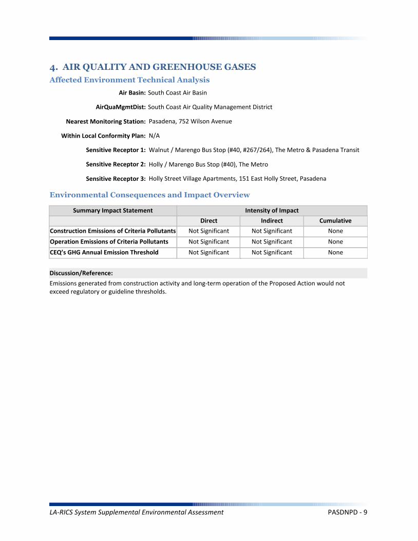
CEQ’s GHG Annual Emission Threshold
Operation Emissions of Criteria Pollutants
Summary Impact Statement
Construction Emissions of Criteria Pollutants
4. AIR QUALITY AND GREENHOUSE GASES
Affected Environment Technical Analysis
Environmental Consequences and Impact Overview
Not Significant Not Significant
Not Significant Not Significant None
Not Significant Not Significant None
Emissions generated from construction activity and long-term operation of the Proposed Action would not exceed regulatory or guideline thresholds.
Intensity of Impact
Direct Indirect Cumulative
Discussion/Reference:
Nearest Monitoring Station: Pasadena, 752 Wilson Avenue
Sensitive Receptor 1: Walnut / Marengo Bus Stop (#40, #267/264), The Metro & Pasadena Transit
Sensitive Receptor 2: Holly / Marengo Bus Stop (#40), The Metro
Sensitive Receptor 3: Holly Street Village Apartments, 151 East Holly Street, Pasadena
None
Within Local Conformity Plan: N/A
Air Basin: South Coast Air Basin
AirQuaMgmtDist: South Coast Air Quality Management District
LA-RICS System Supplemental Environmental Assessment PASDNPD - 9

Prime or Unique Farmland
Soil Erosion
Summary Impact Statement
Seismic Hazards
5. GEOLOGY AND SOILS
Affected Environment Technical Analysis
Environmental Consequences and Impact Overview
Not Significant None
None None None
None None None
Best management practices (BMPs) utilized during construction and operation of the Proposed Action would control runoff and minimize erosion.
Intensity of Impact
Direct Indirect Cumulative
Discussion/Reference:
US Geological Survey 7.5-Minute Quadrangle: Pasadena (75)
Is the site located within an Alquist-Priolo Earthquake Fault Zone? No
If yes, please explain: N/A
Geological Province: Transverse Range
Surface Geological Formation: Q-Pliocene to Holocene alluvium and terrace
USDA Soil Classification: Zamora-Urban land-Ramona Association
None
Geologic Characteristics
Farmland
Site occurs within Prime or Unique Farmland of Statewide or Local Importance: No
LA-RICS System Supplemental Environmental Assessment PASDNPD - 10

Flood Hazard
Summary Impact Statement
Stormwater and non-storm waterdischarges on surface water resources
6. WATER RESOURCES
Affected Environment Technical Analysis
Environmental Consequences and Impact Overview
Regional Water Quality Control Board Hydrologic Region: Los Angeles RWQCB
Hydrologic Sub-Basin or Watershed: Los Angeles
Is a Surface Water Feature Located in Immediate Site Vicinity? No
If yes, please explain: N/A
Does the Project Site Affect a Wild or Scenic River? No
Name of the Groundwater Basin in which the Project Site Lies: San Gabriel Valley
Not significant None None
None None None
Best management practices identified in BIO CMR 17 and 18 would preclude runoff from the site, and thereby avoid potential sediment and pollutant runoff.
Hydrologic Region
Surface Water (as defined by US Geological Survey)
Groundwater
Intensity of Impact
Direct Indirect Cumulative
Discussion/Reference:
If yes, please explain: N/A
Does the Project Site Affect an “Impaired Waterbody”? No
If yes, please explain: N/A
Flood Plain
If yes, please explain: N/A
Is the project site located within a designated 100-year flood plain, or an area designated as hillside, or other known flood-prone areas? No
LA-RICS System Supplemental Environmental Assessment PASDNPD - 11

7. BIOLOGICAL RESOURCES
Affected Environment Technical Analysis
Dominant Onsite Habitat Type: Urban or Built-up Land/Ornamental
Site within 500 feet or within an Essential Fish Habitat (EFH): No
If yes, please explain: N/A
Site within 500 feet or within a Habitat Conservation Plan (HCP): No
Locational Context
Wetlands (as defined by US Geological Survey or US Fish Wildlife Service)
Special-Status Species and Habitats
If yes, please explain: N/A
Are wetlands present on site or within 500 feet of site? No
If yes, please explain: N/A
USFWS critical habitat present on site or within 500 feet of the site: No
If yes, please explain: N/A
Endangered Species Act (ESA)-listed species expected to occur on or within 500 feet of the site: No
If yes, please explain: N/A
Site within 500 feet or within a Federal/State Critical Habitat: No
If yes, please explain: N/A
Bald/Golden Eagle nest present on site or within 500 feet of the site: No
LA-RICS System Supplemental Environmental Assessment PASDNPD - 12

Marine Mammal Protection Act (MMPA)
Summary Impact Statement
Federal Endangered Species Act (ESA) None None None
None None None
No special-status species have been identified near the site and no impacts to special-status species are anticipated. Implementation of BIO CMR-1 would preclude potential impacts to MBTA species. This requirement would identify nesting birds and prohibit construction if nesting activity is identified.
Intensity of Impact
Direct Indirect Cumulative
Discussion/Reference:
Bald/Golden Eagle Protection Act (BGEPA) None None None
Effects on special status species
State/ Federal Listed Species
Migratory Bird Treaty Act (MBTA) None None None
None None None
California Fully Protected (CFP) None None None
California Endangered Species Act (CESA) None None None
Essential Fish Habitat
Summary Impact Statement
Critical Habitat None None None
None None None
No sensitive habitats have been identified at or near the site. No impacts are anticipated.
Intensity of Impact
Direct Indirect Cumulative
Discussion/Reference:
Wetlands Waters None None None
Effects on Important or Critical Habitat
Habitat Conservation Plan (HCP)Management Areas
None None None
Invasive Plant Species
Summary Impact Statement
Vegetation/Land Cover
Environmental Consequences and Impact Overview
None None None
None None None
The site is highly urbanized, and no native habitats occur. Common wildlife associated with urban areas (e.g., rodents, rabbits) could potentially be impacted during trenching activities or when construction equipment is used at the site. Potential impacts to common wildlife would be avoided through implementation of the following CMRs:
BIO CMR 1 - Preconstruction Surveys for Nesting Birds; BIO CMR 8 - Open Trenches and Ditches.
Intensity of Impact
Direct Indirect Cumulative
Discussion/Reference:
Common Native Wildlife None None None
California Native Plant Protection Act (NPPA) None None None
LA-RICS System Supplemental Environmental Assessment PASDNPD - 13
Architectural Resources
Summary Impact Statement
Archaeological Resources
8. HISTORIC AND CULTURAL RESOURCES
Affected Environment Technical Analysis
Environmental Consequences and Impact Overview
None None None
Not Significant Not Significant Not Significant
The proposed work at the site was evalutated on FCC Form 621 and reviewed by the California SHPO in accordance with the Nationwide Programmatic Agreement and Collocation Programmatic Agreement. By letter dated June 4 2015, SHPO concurred with a Finding of No Adverse Effects at this site. Potential adverse effects to the architectural resources in the direct APE and the architectural resources in the indirect APE would be mitigated through implementation of CRM CMR 6 - Attaching Equipment to Historic Buildings.
Intensity of Impact
Direct Indirect Cumulative
Discussion/Reference:
Proposed antenna at a listed or eligible National Register of Historic Places (NRHP) site: Yes
If yes, relationship of antennas to NRHP structure: Site lies within an Historic District. One additional resource within LTE site boundary.
Native American Resources None None None
Archaeological historic property in direct APE: No
If yes, identify the historic property: N/A
Archaeological historic property within indirect APE: No
If yes, identify the historic property: N/A
Architectural historic property in direct APE: Yes
If yes, identify the historic property: Old Town Pasadena Historic District
Architectural historic property (NRHP listed or eligible) within indirect APE: Yes
If yes, identify the historic property: Approximately 109 recorded resources, including individual resources and an Historic District.
Sacred Lands File site on site: No
If yes, the Sacred Lands File: N/A
Sacred Lands File site within ½ mile of indirect APE: No
If yes, the Sacred Lands File: N/A
Area having high sensitivity for paleontological resources: No
If yes, the Paleontological Site: N/A
Geological formation with a high potential for vertebrate paleontological resources: No
If yes, type of geological formation: N/A
Paleontological Resources None None None
LA-RICS System Supplemental Environmental Assessment PASDNPD - 14
No archaeological resources, paleontological resources, or Sacred Lands File sites have been identified in the direct or indirect APE. Some remote potential exists to encounter buried resources. Implementation of the following CMRs would preclude potential impacts associated with inadvertent encounters with these resources:
CRM CMR 3 - Archaeological Materials Encountered; CRM CMR 4 - Human Remains.
LA-RICS System Supplemental Environmental Assessment PASDNPD - 15
Summary Impact Statement
Construction effects
9. AESTHETIC AND VISUAL RESOURCES
Affected Environment Technical Analysis
Environmental Consequences and Impact Overview
None None None
Effects to visual resources and aesthetics would be negligible.
Intensity of Impact
Direct Indirect Cumulative
Discussion/Reference:
Dominant Onsite Land Features:
Site PASDNPD is developed with a four-story parking garage and two 3-story buildings. One building houses the police department and jail, and the other building houses City of Pasadena city services. The majority of the site is paved and flat. Minimal landscaping is present and consists primarily of large ornamental trees. The buildings are primarily a symmetrical modern design, constructed in concrete and stucco, with large clerestory-style windows.
Dominant Offsite Land Features Within an Approximate Quarter-Mile Radius:
The area surrounding project site PASDNPD is urban and developed with adjacent civic and commercial urban uses. The site is located in the civic center portion of the city. No advantageous viewsheds are located in close proximity to the project site. Assorted trees and bushes are present. The surrounding foliage is moderate and typical of a civic center. None of the buildings located in the immediate vicinity of the project site exceed six stories. Buildings in the vicinity of the project appear to be in good condition.
Located within ¼ mile of a designated National Scenic Byway or State Scenic Highway: Yes
If yes, please explain: Arroyo Seco Historic Parkway - Route 110
Scenic and Aesthetic Resource Attributes
Located within a National or State Park, or a National Forest: No
If yes, please explain: N/A
Visual Character Classification (based on site location): Urban
Located within ¼ mile of California Coastal Zone: No
If yes, please explain: N/A
Visual Character
Permanent effects on resources within ornear a coastal zone
None None None
Permanent effects on local scenic corridor None None None
On or adjacent to a Designated Scenic Corridor or Resource? No
If yes, please explain: N/A
LA-RICS System Supplemental Environmental Assessment PASDNPD - 16
Coastal Act and Local Coastal Plan
Summary Impact Statement
Federally administered lands
10. LAND USE
Affected Environment Technical Analysis
Environmental Consequences and Impact Overview
None None None
None None None
The Proposed Action would be consistent with applicable land use plans and policies at this location.
Intensity of Impact
Direct Indirect Cumulative
Discussion/Reference:
Is the site on federally owned or administered land? No
If yes, please explain: N/A
Comprehensive Plan or General Plan Local Agency: City of Pasadena
Local Land Use Policy
Local Agency Jurisdiction: City of Pasadena
General Plan Designation: Specific Plan
Is the site located within the Coastal Management Zone? No
If yes, please explain: N/A
Regulatory Setting
Los Angeles County General Plans
Airport Land Use Plans None None None
None None None
Other local land use plans, policies, and regulations
None None None
Is the site located within the Airport Land Use Plan area? No
If yes, name of airfield/airport: N/A
If yes, name of applicable Airport Land Use Plan: N/A
Zoning: CD-2 (Central District)
Los Angeles County Community or Area Plan: West San Gabriel Valley Planning Area
City of Los Angeles Community or Area Plan: N/A
Other Special District, Area or Specific Plan: Central District Specific Plan
LA-RICS System Supplemental Environmental Assessment PASDNPD - 17

Solid Waste (construction)
Summary Impact Statement
Electrical Supply
11. INFRASTRUCTURE
Affected Environment Technical Analysis
Environmental Consequences and Impact Overview
Nearest Highway: Arroyo Parkway
Site Served by Solid Waste Disposal Provider: Los Angeles County Sanitation District #16
Not Significant None Not Significant
Not Significant None Not Significant
Utility use would be well within existing capacities. Implementation of TRANS MM-1 would minimize potential traffic impacts during construction. Public safety impact would be beneficial.
Traffic
Electrical
Disposal
Intensity of Impact
Direct Indirect Cumulative
Discussion/Reference:
Water Supply (construction)
Solid Waste (operation) None None None
Not Significant None Not Significant
Traffic (construction)
Water Supply (operation) None None None
Not Significant None None
Public Safety
Traffic (operation) None None None
Not Significant None None
Nearest Arterial: East Walnut Street
Distance (Miles): 0.23
Distance (Miles): 0.7
Access to the Project Site Provided Via: Ramona Street
Electricity Service Provider: Pasadena Water and Power
Site Served by or has Available Access to Domestic Water System: Pasadena Water and Power
Water Service
Electricity On Site or to Be Brought to Site? Electricity on site
LA-RICS System Supplemental Environmental Assessment PASDNPD - 18
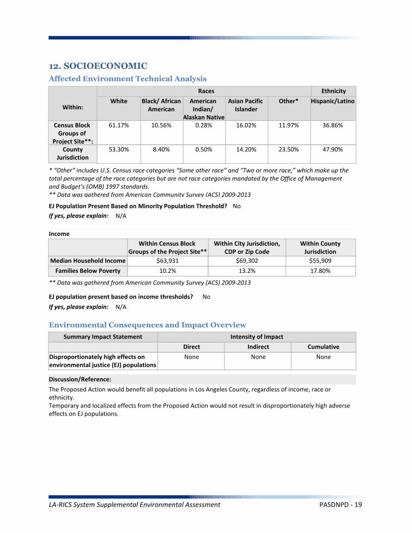
Summary Impact Statement
12. SOCIOECONOMIC
Affected Environment Technical Analysis
Environmental Consequences and Impact Overview
The Proposed Action would benefit all populations in Los Angeles County, regardless of income, race or ethnicity.Temporary and localized effects from the Proposed Action would not result in disproportionately high adverseeffects on EJ populations.
Intensity of Impact
Direct Indirect Cumulative
Discussion/Reference:
Income
Disproportionately high effects onenvironmental justice (EJ) populations
None None None
Races Ethnicity
Hispanic/Latino
47.90%
36.86%
Other*
23.50%
11.97%
Asian Pacific Islander
14.20%
16.02%
American Indian/
Alaskan Native
0.50%
0.28%
Black/ AfricanAmerican
8.40%
10.56%
White
53.30%
61.17%
Within:
* “Other” includes U.S. Census race categories “Some other race” and “Two or more race,” which make up the total percentage of the race categories but are not race categories mandated by the Office of Management and Budget’s (OMB) 1997 standards.** Data was gathered from American Community Survey (ACS) 2009-2013
EJ Population Present Based on Minority Population Threshold? No
If yes, please explain: N/A
Within CountyJurisdiction
17.80%
$55,909
Within City Jurisdiction,CDP or Zip Code
13.2%
$69,302
Within Census Block Groups of the Project Site**
10.2%
$63,931
EJ population present based on income thresholds? No
If yes, please explain: N/A
Census Block Groups of
Project Site**:County
Jurisdiction
Median Household Income
Families Below Poverty
** Data was gathered from American Community Survey (ACS) 2009-2013
LA-RICS System Supplemental Environmental Assessment PASDNPD - 19
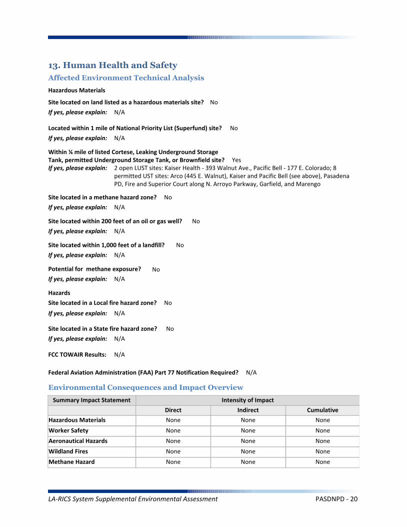
Worker Safety
Summary Impact Statement
Hazardous Materials
13. Human Health and Safety
Affected Environment Technical Analysis
Environmental Consequences and Impact Overview
None None None
None None None
Intensity of Impact
Direct Indirect Cumulative
Discussion/Reference:
Site located on land listed as a hazardous materials site? No
If yes, please explain: N/A
Aeronautical Hazards None None None
Located within 1 mile of National Priority List (Superfund) site? No
If yes, please explain: N/A
Within ¼ mile of listed Cortese, Leaking Underground Storage Tank, permitted Underground Storage Tank, or Brownfield site? YesIf yes, please explain: 2 open LUST sites: Kaiser Health - 393 Walnut Ave., Pacific Bell - 177 E. Colorado; 8
permitted UST sites: Arco (445 E. Walnut), Kaiser and Pacific Bell (see above), Pasadena PD, Fire and Superior Court along N. Arroyo Parkway, Garfield, and Marengo
Site located within 1,000 feet of a landfill? No
If yes, please explain: N/A
Potential for methane exposure? No
If yes, please explain: N/A
Site located in a methane hazard zone? No
If yes, please explain: N/A
Site located within 200 feet of an oil or gas well? No
If yes, please explain: N/A
Wildland Fires None None None
Methane Hazard None None None
Hazardous Materials
Hazards
Site located in a Local fire hazard zone? No
If yes, please explain: N/A
Site located in a State fire hazard zone? No
If yes, please explain: N/A
Federal Aviation Administration (FAA) Part 77 Notification Required? N/A
FCC TOWAIR Results: N/A
LA-RICS System Supplemental Environmental Assessment PASDNPD - 20
Project construction activities would not encounter the reported LUST sites. They are geographically distant from the LTE site and the depth of proposed construction (i.e., trenching to 36 inches) would not result in contact with groundwater.
Reference: LA RICS Long Term Evolution (LTE), Phase I System Design, ASTM 1528-14 Transaction Screen Report, Pasadena PD - Formerly PASFD33 - Pasadena Replacement Site PASDNPD, dated February 11, 2015, Prepared by EBI Consulting.
Discussion/Reference:
LA-RICS System Supplemental Environmental Assessment PASDNPD - 21

LA-RICS LTE System
Appendix B: Supplemental Environmental Assessment
Site ID: RANCHO
Facility Name: LAC/Rancho Los Amigos National Rehab
LA-RICS System Supplemental Environmental Assessment RANCHO - 1
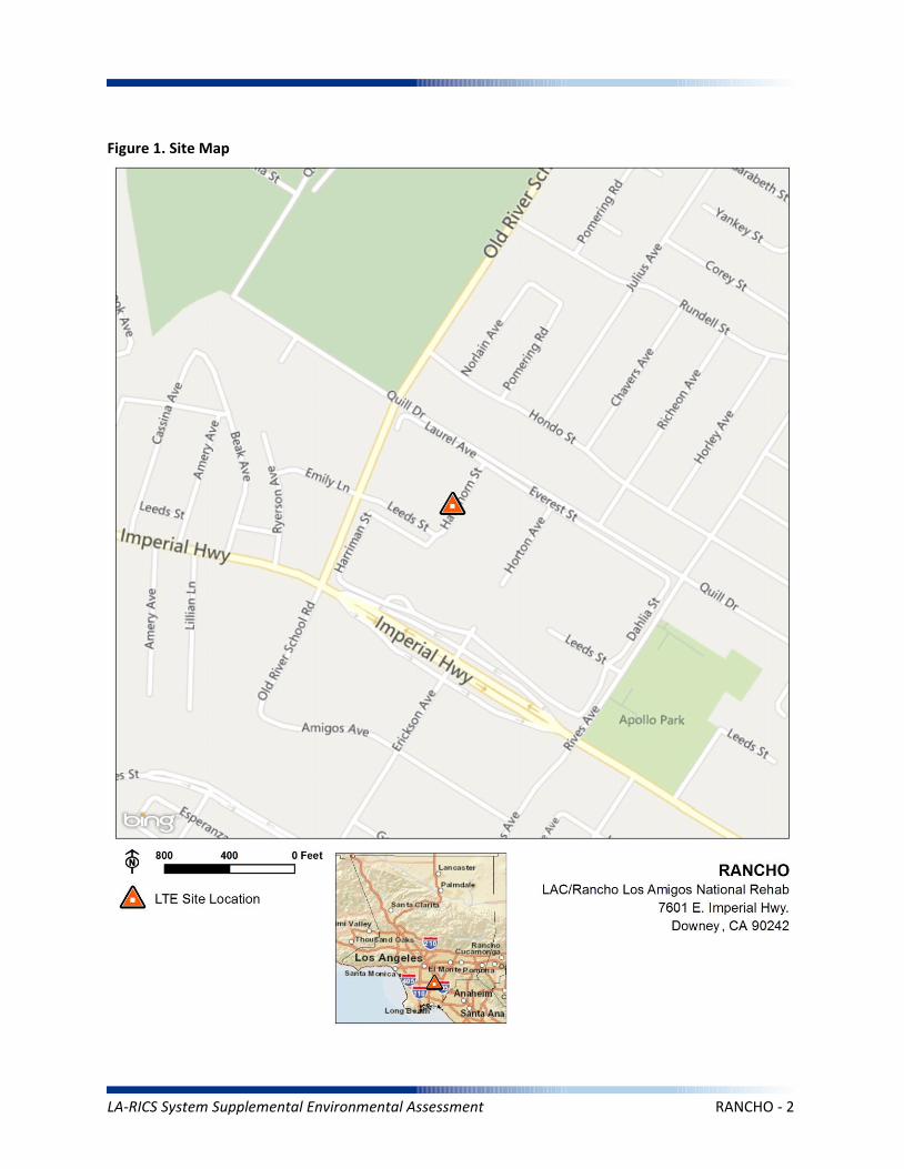
Figure 1. Site Map
LA-RICS System Supplemental Environmental Assessment RANCHO - 2
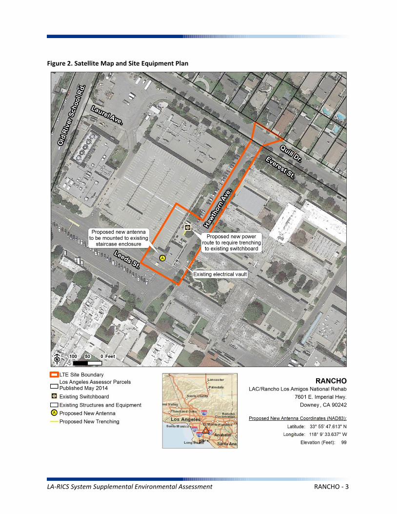
Figure 2. Satellite Map and Site Equipment Plan
LA-RICS System Supplemental Environmental Assessment RANCHO - 3
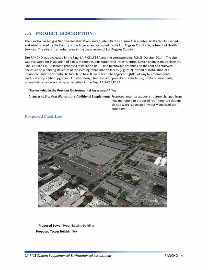
1.0 PROJECT DESCRIPTION
The Rancho Los Amigos National Rehabilitation Center (Site RANCHO, Figure 1) is a public safety facility, owned and administered by the County of Los Angeles and occupied by the Los Angeles County Department of Health Services. The site is in an urban area in the basin region of Los Angeles County.
Site RANCHO was evaluated in the Final LA-RICS LTE EA and the corresponding FONSI (October 2014). The site was evaluated for installation of a new monopole, plus supporting infrastructure. Design changes made since the Final LA-RICS LTE EA include proposed installation of LTE and microwave antennas on the roof of a stairwell enclosure on a parking structure at the existing rehabilitation facility (Figure 2) instead of installation of a monopole, and the potential to trench up to 700 linear feet into adjacent right(s) of way to accommodate electrical and/or fiber upgrades. All other design features, equipment and vehicle use, utility requirements, ground disturbance would be as described in the Final LA-RICS LTE EA.
Maximum Facility Height: N/A
Proposed Tower Type: Existing building
Proposed Tower Height: N/A
Proposed Facilities
Site Included in the Previous Environmental Assessment? Yes
Changes to Site that Warrant this Additional Supplement: Proposed antenna support structure changed from new monopole to proposed roof-mounted design; off-site work is outside previously analyzed site boundary.
LA-RICS System Supplemental Environmental Assessment RANCHO - 4

Maximum Facility Height: N/A
Proposed FAA lighting: N/A
Anticipated Disturbance: Up to 1,400 square feet of additional ground disturbance while trenching for power/fiber adjacent to site previously analyzed.
Power Requirements: No new power requirements identified.
No Action Alternative: Under the No Action Alternative, this site would remain unchanged and no new LTE telecommunication infrastructure or related infrastructure would be installed. No direct, indirect, or cumulative impacts are anticipated.
LA-RICS System Supplemental Environmental Assessment RANCHO - 5
2. EXISTING SITE CONDITIONS
Existing Onsite Communications Facilities
Existing Onsite Communication Facility Lattice Tower, Monopole, or Antenna: Yes
Existing Tower Type: Building
Existing Tower Height: 30 feet
Existing Onsite Pad: Yes
Onsite Ground Equipment: Yes
Existing Generation: Adjacent transformer
Existing Backup Power: Yes
Existing Onsite Use/Facility: LA County/Rancho Los Amigos National Rehabilitation Center
Other Existing Onsite Tall Structures: No
Type of Other Existing Tall Structures: N/A
Existing Ground Elevation (FT AMSL): 98
Parking Garage
Residential
Institutional (medical office)
Institutional (medical office) Institutional (medical office)
Residential
Dominant Vicinity Use: Educational Adjacent Residential Use: Yes
Located Within or on Federal Lands Administered By: No
N/A
N/A
N/A
N/A
N/A
Existing Land Uses and Onsite Characteristics
Existing Land Uses and Onsite Surrounding Land Uses and Offsite Characteristics
Adjacent and Nearby Land Uses
North South East West
Description of Other Visible Towers: N/A
Relationship to Federally Regulated Lands
Area of Special Consideration or Regulation
Located within boundaries of :
California Coastal Zone
Angeles National Forest
Santa Monica Mountains National Recreation Area
National or California State Park
Airport Influence Area
Yes / No If yes, Plan or Designation Area
Site Collocated? No FCC Registration: N/A #
No
No
No
No
No
LA-RICS System Supplemental Environmental Assessment RANCHO - 6
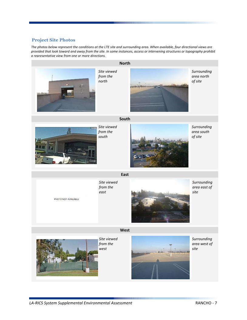
Project Site Photos
The photos below represent the conditions at the LTE site and surrounding area. When available, four directional views are provided that look toward and away from the site. In some instances, access or intervening structures or topography prohibit a representative view from one or more directions.
Site viewed from the north
Site viewed from the south
Site viewed from the east
Site viewed from the west
Surrounding area north of site
Surrounding area south of site
Surrounding area east of site
Surrounding area west of site
North
South
East
West
LA-RICS System Supplemental Environmental Assessment RANCHO - 7

Operation Noise
Construction Vibration
Summary Impact Statement
Construction Noise
3. NOISE
Affected Environment Technical Analysis
Environmental Consequences and Impact Overview
Applicable Noise Standards Source: Downey Municipal Code, Section 4606.5
Ambient Noise Setting: Urban
Local Residential Exterior Noise Exposure Limit: 55
Surrounding Walls/Structures Serve as Potential Noise Barrier? No
Vibration Sensitive Buildings Located within 50 feet of Site? No
Nearest Off-Site Sensitive Receiver Type: 100 feet
Sensitive Noise Receiver #1: Medical office
Sensitive Noise Receiver #2: N/A
Sensitive Noise Receiver #3: N/A
Construction Projects are Exempt from Noise Regulations? No
7:00am-9:00pm 7:00am-9:00pm 7:00am-9:00pm None
Construction Noise Exempt During Normal Construction Hours? Yes, provided 85 dBA threshold is met
Construction Allowed During Extended Hours with Approval or Permit? No
Not Significant None None
Not Significant None None
Not Significant None None
Noise and vibration from construction activity would be short term and localized. Noise from operation not expected to be perceptible off-site.
Ambient Noise Factors and Conditions
Off-Site Sensitive Noise Receivers
Construction Noise Regulations
Monday-Friday Saturday Sunday HolidayAllowedConstruction
Hours
Intensity of Impact
Direct Indirect Cumulative
Discussion/Reference:
LA-RICS System Supplemental Environmental Assessment RANCHO - 8

CEQ’s GHG Annual Emission Threshold
Operation Emissions of Criteria Pollutants
Summary Impact Statement
Construction Emissions of Criteria Pollutants
4. AIR QUALITY AND GREENHOUSE GASES
Affected Environment Technical Analysis
Environmental Consequences and Impact Overview
Not Significant Not Significant
Not Significant Not Significant None
Not Significant Not Significant None
Emissions generated from construction activity and long-term operation of the Proposed Action would not exceed regulatory or guideline thresholds.
Intensity of Impact
Direct Indirect Cumulative
Discussion/Reference:
Nearest Monitoring Station: Lynwood
Sensitive Receptor 1: Medical office
Sensitive Receptor 2: N/A
Sensitive Receptor 3: N/A
None
Within Local Conformity Plan: N/A
Air Basin: South Coast Air Basin
AirQuaMgmtDist: South Coast Air Quality Management District
LA-RICS System Supplemental Environmental Assessment RANCHO - 9

Prime or Unique Farmland
Soil Erosion
Summary Impact Statement
Seismic Hazards
5. GEOLOGY AND SOILS
Affected Environment Technical Analysis
Environmental Consequences and Impact Overview
Not Significant None
None None None
None None None
Best management practices (BMPs) utilized during construction and operation of the Proposed Action would control runoff and minimize erosion.
Intensity of Impact
Direct Indirect Cumulative
Discussion/Reference:
US Geological Survey 7.5-Minute Quadrangle: South Gate (82)
Is the site located within an Alquist-Priolo Earthquake Fault Zone? No
If yes, please explain: N/A
Geological Province: Peninsular Ranges
Surface Geological Formation: Q Quaternary alluvium and marine deposits
USDA Soil Classification: Urban land-Sorrento-Hanford Association
None
Geologic Characteristics
Farmland
Site occurs within Prime or Unique Farmland of Statewide or Local Importance: No
LA-RICS System Supplemental Environmental Assessment RANCHO - 10

Flood Hazard
Summary Impact Statement
Stormwater and non-storm waterdischarges on surface water resources
6. WATER RESOURCES
Affected Environment Technical Analysis
Environmental Consequences and Impact Overview
Regional Water Quality Control Board Hydrologic Region: Los Angeles RWQCB
Hydrologic Sub-Basin or Watershed: Los Angeles
Is a Surface Water Feature Located in Immediate Site Vicinity? No
If yes, please explain: N/A
Does the Project Site Affect a Wild or Scenic River? No
Name of the Groundwater Basin in which the Project Site Lies: Coastal Plain Of Los Angeles
Not Significant None None
None None None
Best management practices identified in BIO CMR 17 and 18 would preclude runoff from the site, and thereby avoid potential sediment and pollutant runoff.
Hydrologic Region
Surface Water (as defined by US Geological Survey)
Groundwater
Intensity of Impact
Direct Indirect Cumulative
Discussion/Reference:
If yes, please explain: N/A
Does the Project Site Affect an “Impaired Waterbody”? No
If yes, please explain: N/A
Flood Plain
If yes, please explain: N/A
Is the project site located within a designated 100-year flood plain, or an area designated as hillside, or other known flood-prone areas? No
LA-RICS System Supplemental Environmental Assessment RANCHO - 11

7. BIOLOGICAL RESOURCES
Affected Environment Technical Analysis
Dominant Onsite Habitat Type: Urban or Built-up Land/Ornamental
Site within 500 feet or within an Essential Fish Habitat (EFH): No
If yes, please explain: N/A
Site within 500 feet or within a Habitat Conservation Plan (HCP): No
Locational Context
Wetlands (as defined by US Geological Survey or US Fish Wildlife Service)
Special-Status Species and Habitats
If yes, please explain: N/A
Are wetlands present on site or within 500 feet of site? No
If yes, please explain: N/A
USFWS critical habitat present on site or within 500 feet of the site: No
If yes, please explain: N/A
Endangered Species Act (ESA)-listed species expected to occur on or within 500 feet of the site: No
If yes, please explain: N/A
Site within 500 feet or within a Federal/State Critical Habitat: No
If yes, please explain: N/A
Bald/Golden Eagle nest present on site or within 500 feet of the site: No
LA-RICS System Supplemental Environmental Assessment RANCHO - 12

Marine Mammal Protection Act (MMPA)
Summary Impact Statement
Federal Endangered Species Act (ESA) None None None
None None None
No special-status species have been identified near the site and no impacts to special-status species are anticipated. Implementation of BIO CMR-1 would preclude potential impacts to MBTA species. This requirement would identify nesting birds and prohibit construction if nesting activity is identified.
Intensity of Impact
Direct Indirect Cumulative
Discussion/Reference:
Bald/Golden Eagle Protection Act (BGEPA) None None None
Effects on special status species
State/ Federal Listed Species
Migratory Bird Treaty Act (MBTA) None None None
None None None
California Fully Protected (CFP) None None None
California Endangered Species Act (CESA) None None None
Essential Fish Habitat
Summary Impact Statement
Critical Habitat None None None
None None None
No sensitive habitats have been identified at or near the site. No impacts are anticipated.
Intensity of Impact
Direct Indirect Cumulative
Discussion/Reference:
Wetlands Waters None None None
Effects on Important or Critical Habitat
Habitat Conservation Plan (HCP)Management Areas
None None None
Invasive Plant Species
Summary Impact Statement
Vegetation/Land Cover
Environmental Consequences and Impact Overview
None None None
None None None
The site is highly urbanized, and no native habitats occur. Common wildlife associated with urban areas (e.g., rodents, rabbits) could potentially be impacted during trenching activities or when construction equipment is used at the site. Potential impacts to common wildlife would be avoided through implementation of the following CMRs:
BIO CMR 1 - Preconstruction Surveys for Nesting Birds; BIO CMR 8 - Open Trenches and Ditches.
Intensity of Impact
Direct Indirect Cumulative
Discussion/Reference:
Common Native Wildlife None None None
California Native Plant Protection Act (NPPA) None None None
LA-RICS System Supplemental Environmental Assessment RANCHO - 13

Architectural Resources
Summary Impact Statement
Archaeological Resources
8. HISTORIC AND CULTURAL RESOURCES
Affected Environment Technical Analysis
Environmental Consequences and Impact Overview
None None None
None None None
By letter dated February 19, 2015, NTIA determined that this site was exempted from Section 106 review by the California SHPO under the terms and conditions of the Nationwide Programmatic Agreement. No impacts to cultural resources are anticipated.
Intensity of Impact
Direct Indirect Cumulative
Discussion/Reference:
Proposed antenna at a listed or eligible National Register of Historic Places (NRHP) site: N/A
If yes, relationship of antennas to NRHP structure: Exempted
Native American Resources None None None
Archaeological historic property in direct APE: N/A
If yes, identify the historic property: Exempted
Archaeological historic property within indirect APE: N/A
If yes, identify the historic property: Exempted
Architectural historic property in direct APE: N/A
If yes, identify the historic property: Exempted
Architectural historic property (NRHP listed or eligible) within indirect APE: N/A
If yes, identify the historic property: Exempted
Sacred Lands File site on site: No
If yes, the Sacred Lands File: N/A
Sacred Lands File site within ½ mile of indirect APE: No
If yes, the Sacred Lands File: N/A
Area having high sensitivity for paleontological resources: No
If yes, the Paleontological Site: N/A
Geological formation with a high potential for vertebrate paleontological resources: No
If yes, type of geological formation: N/A
Paleontological Resources None None None
LA-RICS System Supplemental Environmental Assessment RANCHO - 14
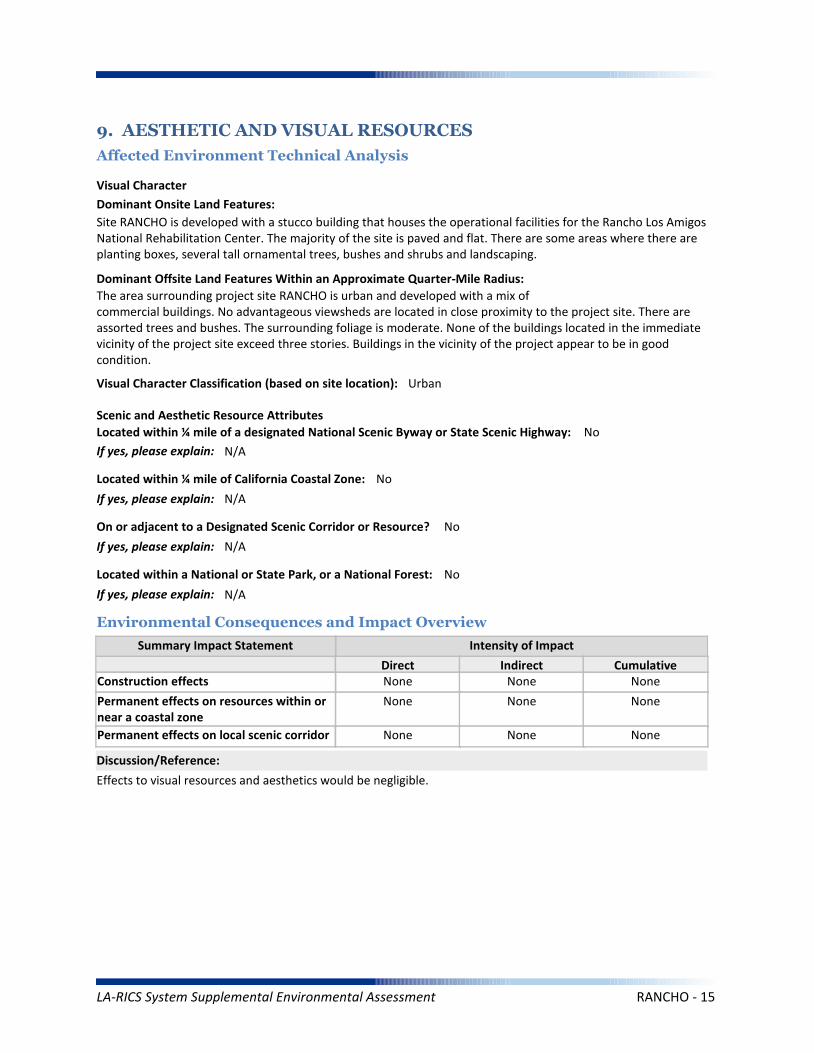
Summary Impact Statement
Construction effects
9. AESTHETIC AND VISUAL RESOURCES
Affected Environment Technical Analysis
Environmental Consequences and Impact Overview
None None None
Effects to visual resources and aesthetics would be negligible.
Intensity of Impact
Direct Indirect Cumulative
Discussion/Reference:
Dominant Onsite Land Features:
Site RANCHO is developed with a stucco building that houses the operational facilities for the Rancho Los Amigos National Rehabilitation Center. The majority of the site is paved and flat. There are some areas where there are planting boxes, several tall ornamental trees, bushes and shrubs and landscaping.
Dominant Offsite Land Features Within an Approximate Quarter-Mile Radius:
The area surrounding project site RANCHO is urban and developed with a mix ofcommercial buildings. No advantageous viewsheds are located in close proximity to the project site. There are assorted trees and bushes. The surrounding foliage is moderate. None of the buildings located in the immediate vicinity of the project site exceed three stories. Buildings in the vicinity of the project appear to be in good condition.
Located within ¼ mile of a designated National Scenic Byway or State Scenic Highway: No
If yes, please explain: N/A
Scenic and Aesthetic Resource Attributes
Located within a National or State Park, or a National Forest: No
If yes, please explain: N/A
Visual Character Classification (based on site location): Urban
Located within ¼ mile of California Coastal Zone: No
If yes, please explain: N/A
Visual Character
Permanent effects on resources within ornear a coastal zone
None None None
Permanent effects on local scenic corridor None None None
On or adjacent to a Designated Scenic Corridor or Resource? No
If yes, please explain: N/A
LA-RICS System Supplemental Environmental Assessment RANCHO - 15
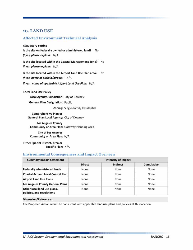
Coastal Act and Local Coastal Plan
Summary Impact Statement
Federally administered lands
10. LAND USE
Affected Environment Technical Analysis
Environmental Consequences and Impact Overview
None None None
None None None
The Proposed Action would be consistent with applicable land use plans and policies at this location.
Intensity of Impact
Direct Indirect Cumulative
Discussion/Reference:
Is the site on federally owned or administered land? No
If yes, please explain: N/A
Comprehensive Plan or General Plan Local Agency: City of Downey
Local Land Use Policy
Local Agency Jurisdiction: City of Downey
General Plan Designation: Public
Is the site located within the Coastal Management Zone? No
If yes, please explain: N/A
Regulatory Setting
Los Angeles County General Plans
Airport Land Use Plans None None None
None None None
Other local land use plans, policies, and regulations
None None None
Is the site located within the Airport Land Use Plan area? No
If yes, name of airfield/airport: N/A
If yes, name of applicable Airport Land Use Plan: N/A
Zoning: Single-Family Residential
Los Angeles County Community or Area Plan: Gateway Planning Area
City of Los Angeles Community or Area Plan: N/A
Other Special District, Area or Specific Plan: N/A
LA-RICS System Supplemental Environmental Assessment RANCHO - 16
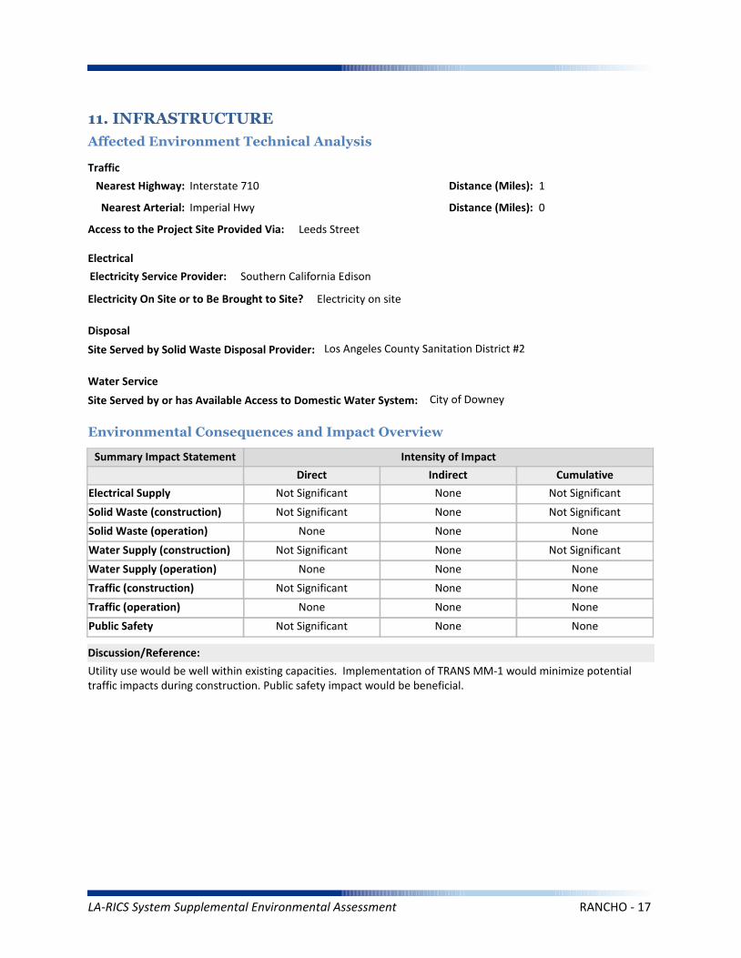
Solid Waste (construction)
Summary Impact Statement
Electrical Supply
11. INFRASTRUCTURE
Affected Environment Technical Analysis
Environmental Consequences and Impact Overview
Nearest Highway: Interstate 710
Site Served by Solid Waste Disposal Provider: Los Angeles County Sanitation District #2
Not Significant None Not Significant
Not Significant None Not Significant
Utility use would be well within existing capacities. Implementation of TRANS MM-1 would minimize potential traffic impacts during construction. Public safety impact would be beneficial.
Traffic
Electrical
Disposal
Intensity of Impact
Direct Indirect Cumulative
Discussion/Reference:
Water Supply (construction)
Solid Waste (operation) None None None
Not Significant None Not Significant
Traffic (construction)
Water Supply (operation) None None None
Not Significant None None
Public Safety
Traffic (operation) None None None
Not Significant None None
Nearest Arterial: Imperial Hwy
Distance (Miles): 1
Distance (Miles): 0
Access to the Project Site Provided Via: Leeds Street
Electricity Service Provider: Southern California Edison
Site Served by or has Available Access to Domestic Water System: City of Downey
Water Service
Electricity On Site or to Be Brought to Site? Electricity on site
LA-RICS System Supplemental Environmental Assessment RANCHO - 17

Summary Impact Statement
12. SOCIOECONOMIC
Affected Environment Technical Analysis
Environmental Consequences and Impact Overview
The Proposed Action would benefit all populations in Los Angeles County, regardless of income, race or ethnicity.Temporary and localized effects from the Proposed Action would not result in disproportionately high adverseeffects on EJ populations.
Intensity of Impact
Direct Indirect Cumulative
Discussion/Reference:
Income
Disproportionately high effects onenvironmental justice (EJ) populations
None None None
Races Ethnicity
Hispanic/Latino
47.90%
74.40%
Other*
23.50%
33.62%
Asian Pacific Islander
14.20%
5.50%
American Indian/
Alaskan Native
0.50%
5.11%
Black/ AfricanAmerican
8.40%
4.87%
White
53.30%
55.43%
Within:
* “Other” includes U.S. Census race categories “Some other race” and “Two or more race,” which make up the total percentage of the race categories but are not race categories mandated by the Office of Management and Budget’s (OMB) 1997 standards.** Data was gathered from American Community Survey (ACS) 2009-2013
EJ Population Present Based on Minority Population Threshold? No
If yes, please explain: N/A
Within CountyJurisdiction
17.80%
$55,909
Within City Jurisdiction,CDP or Zip Code
11.8%
$60,939
Within Census Block Groups of the Project Site**
13.9%
$55,047
EJ population present based on income thresholds? No
If yes, please explain: N/A
Census Block Groups of
Project Site**:County
Jurisdiction
Median Household Income
Families Below Poverty
** Data was gathered from American Community Survey (ACS) 2009-2013
LA-RICS System Supplemental Environmental Assessment RANCHO - 18
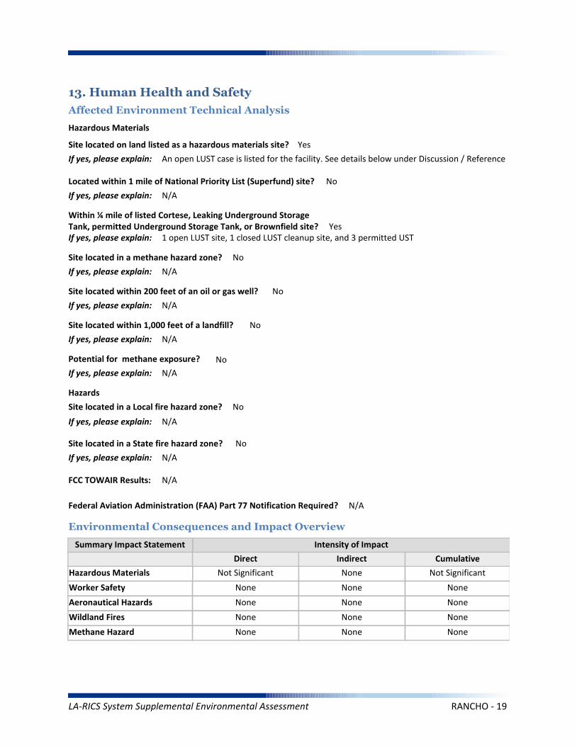
Worker Safety
Summary Impact Statement
Hazardous Materials
13. Human Health and Safety
Affected Environment Technical Analysis
Environmental Consequences and Impact Overview
Not Significant None Not Significant
None None None
Intensity of Impact
Direct Indirect Cumulative
Discussion/Reference:
Site located on land listed as a hazardous materials site? Yes
If yes, please explain: An open LUST case is listed for the facility. See details below under Discussion / Reference
Aeronautical Hazards None None None
Located within 1 mile of National Priority List (Superfund) site? No
If yes, please explain: N/A
Within ¼ mile of listed Cortese, Leaking Underground Storage Tank, permitted Underground Storage Tank, or Brownfield site? YesIf yes, please explain: 1 open LUST site, 1 closed LUST cleanup site, and 3 permitted UST
Site located within 1,000 feet of a landfill? No
If yes, please explain: N/A
Potential for methane exposure? No
If yes, please explain: N/A
Site located in a methane hazard zone? No
If yes, please explain: N/A
Site located within 200 feet of an oil or gas well? No
If yes, please explain: N/A
Wildland Fires None None None
Methane Hazard None None None
Hazardous Materials
Hazards
Site located in a Local fire hazard zone? No
If yes, please explain: N/A
Site located in a State fire hazard zone? No
If yes, please explain: N/A
Federal Aviation Administration (FAA) Part 77 Notification Required? N/A
FCC TOWAIR Results: N/A
LA-RICS System Supplemental Environmental Assessment RANCHO - 19
The open LUST is located more than 1200 feet east of the proposed work area and is currently recommend for closure by the regional water quality control board and has impacted the groundwater below the facility. Project construction activities would not encounter the reported LUST site. It is geographically distant from the LTE site and the depth of proposed construction (i.e., trenching to 36 inches) would not result in contact with groundwater.
Reference: LA RICS Long Term Evolution (LTE), ASTM 1528-14 Transaction Screen Report, LAC / RANCHO Los Amigos National Rehab CRT / RANCHO, dated November 17, 2014, Prepared by EBI Consulting.
Discussion/Reference:
LA-RICS System Supplemental Environmental Assessment RANCHO - 20
LA-RICS LTE System
Appendix B: Supplemental Environmental Assessment
Site ID: VPC
Facility Name: Verdugo Peak
LA-RICS System Supplemental Environmental Assessment VPC - 1
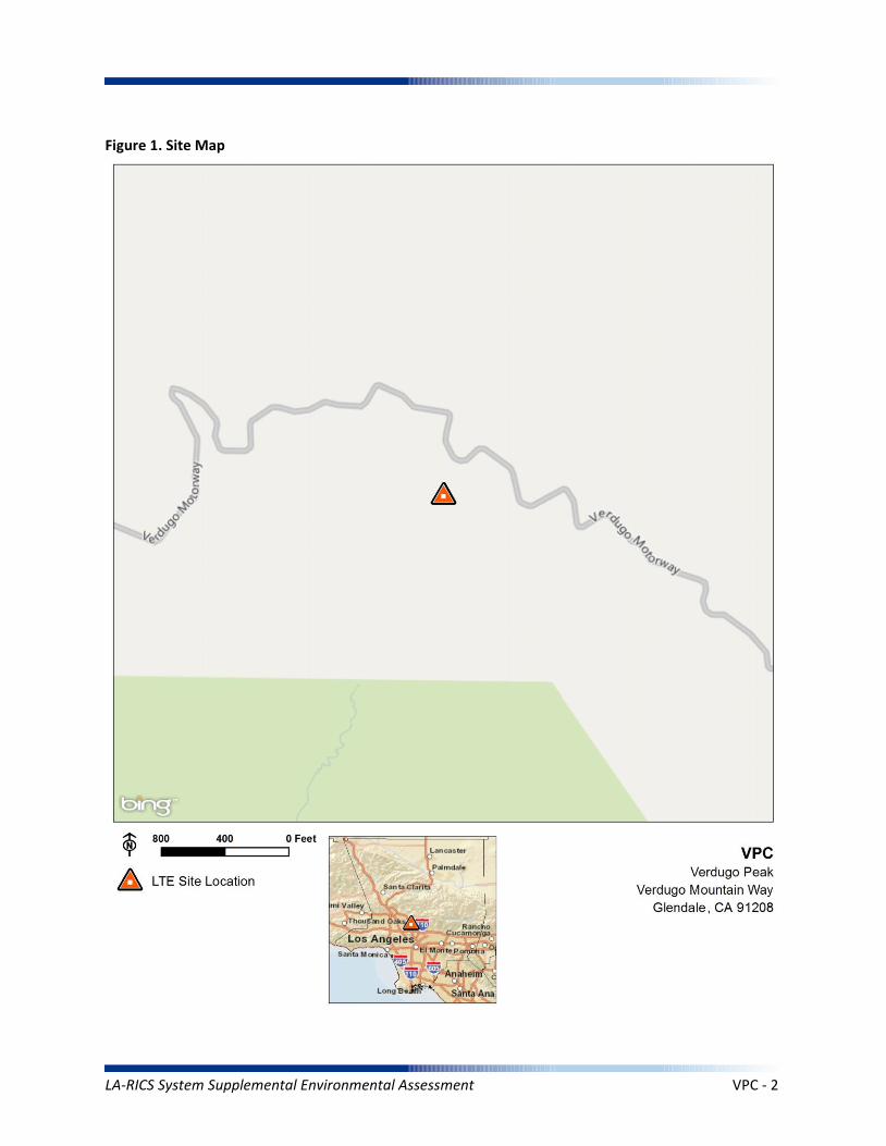
Figure 1. Site Map
LA-RICS System Supplemental Environmental Assessment VPC - 2
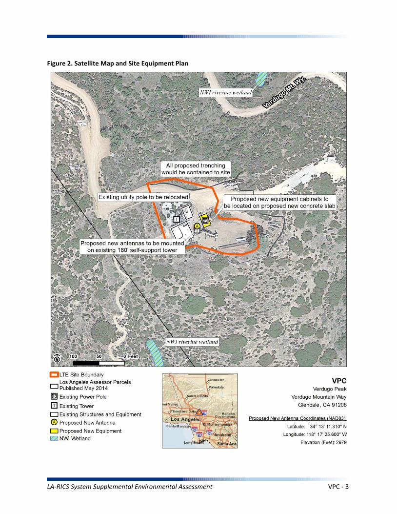
Figure 2. Satellite Map and Site Equipment Plan
LA-RICS System Supplemental Environmental Assessment VPC - 3
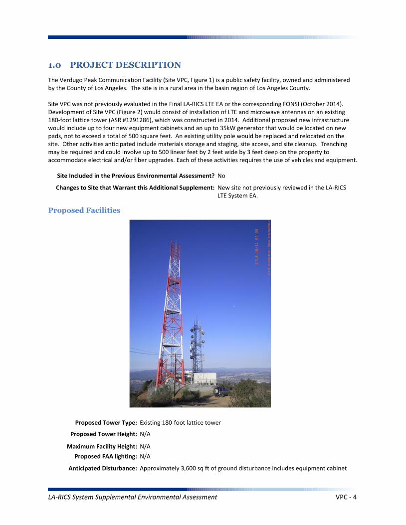
1.0 PROJECT DESCRIPTION
The Verdugo Peak Communication Facility (Site VPC, Figure 1) is a public safety facility, owned and administered by the County of Los Angeles. The site is in a rural area in the basin region of Los Angeles County.
Site VPC was not previously evaluated in the Final LA-RICS LTE EA or the corresponding FONSI (October 2014). Development of Site VPC (Figure 2) would consist of installation of LTE and microwave antennas on an existing 180-foot lattice tower (ASR #1291286), which was constructed in 2014. Additional proposed new infrastructure would include up to four new equipment cabinets and an up to 35kW generator that would be located on new pads, not to exceed a total of 500 square feet. An existing utility pole would be replaced and relocated on the site. Other activities anticipated include materials storage and staging, site access, and site cleanup. Trenching may be required and could involve up to 500 linear feet by 2 feet wide by 3 feet deep on the property to accommodate electrical and/or fiber upgrades. Each of these activities requires the use of vehicles and equipment.
Maximum Facility Height: N/A
Proposed Tower Type: Existing 180-foot lattice tower
Proposed Tower Height: N/A
Proposed FAA lighting: N/A
Anticipated Disturbance: Approximately 3,600 sq ft of ground disturbance includes equipment cabinet
Proposed Facilities
Site Included in the Previous Environmental Assessment? No
Changes to Site that Warrant this Additional Supplement: New site not previously reviewed in the LA-RICS LTE System EA.
LA-RICS System Supplemental Environmental Assessment VPC - 4
and generator foundations, trenching, and miscellaneous disturbance.
Power Requirements: Primary power up to 12.5 kW would draw from existing transformer to proposed meter. Backup power includes batteries and 35 kW diesel generator with integrated belly tank – attenuated to 65 decibel rating.
No Action Alternative: Under the No Action Alternative, this site would remain unchanged and no new LTE telecommunication infrastructure or related infrastructure would be installed. No direct, indirect, or cumulative impacts are anticipated.
LA-RICS System Supplemental Environmental Assessment VPC - 5
2. EXISTING SITE CONDITIONS
Existing Onsite Communications Facilities
Existing Onsite Communication Facility Lattice Tower, Monopole, or Antenna: Yes
Existing Tower Type: Lattice tower
Existing Tower Height: 180 feet
Existing Onsite Pad: Yes
Onsite Ground Equipment: Yes
Existing Generation: On site transformer
Existing Backup Power: Yes
Existing Onsite Use/Facility: Communication facility
Other Existing Onsite Tall Structures: Yes
Type of Other Existing Tall Structures: Existing 85-foot lattice tower
Existing Ground Elevation (FT AMSL): 2980
Open Space Open Space Open Space Open Space
Dominant Vicinity Use: Open space - recreation Adjacent Residential Use: No
Located Within or on Federal Lands Administered By: No
N/A
N/A
N/A
N/A
N/A
Existing Land Uses and Onsite Characteristics
Existing Land Uses and Onsite Surrounding Land Uses and Offsite Characteristics
Adjacent and Nearby Land Uses
North South East West
Description of Other Visible Towers: Additional communication towers on ridge in distance
Relationship to Federally Regulated Lands
Area of Special Consideration or Regulation
Located within boundaries of :
California Coastal Zone
Angeles National Forest
Santa Monica Mountains National Recreation Area
National or California State Park
Airport Influence Area
Yes / No If yes, Plan or Designation Area
Site Collocated? Yes FCC Registration: ASR # 1291286
No
No
No
No
No
LA-RICS System Supplemental Environmental Assessment VPC - 6
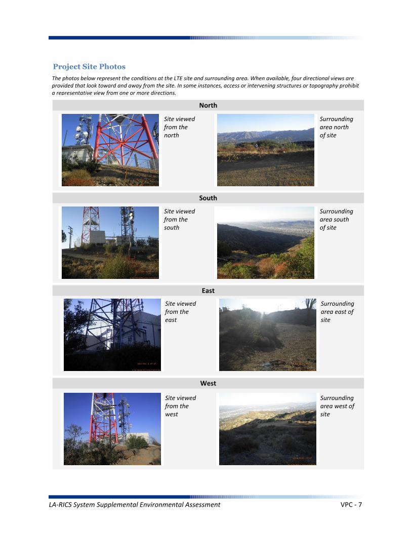
Project Site Photos
The photos below represent the conditions at the LTE site and surrounding area. When available, four directional views are provided that look toward and away from the site. In some instances, access or intervening structures or topography prohibit a representative view from one or more directions.
Site viewed from the north
Site viewed from the south
Site viewed from the east
Site viewed from the west
Surrounding area north of site
Surrounding area south of site
Surrounding area east of site
Surrounding area west of site
North
South
East
West
LA-RICS System Supplemental Environmental Assessment VPC - 7

Operation Noise
Construction Vibration
Summary Impact Statement
Construction Noise
3. NOISE
Affected Environment Technical Analysis
Environmental Consequences and Impact Overview
Applicable Noise Standards Source: Glendale Municipal Code, Title 8, Chapter 36
Ambient Noise Setting: Open Space
Local Residential Exterior Noise Exposure Limit: 65
Surrounding Walls/Structures Serve as Potential Noise Barrier? No
Vibration Sensitive Buildings Located within 50 feet of Site? No
Nearest Off-Site Sensitive Receiver Type: None
Sensitive Noise Receiver #1: N/A
Sensitive Noise Receiver #2: N/A
Sensitive Noise Receiver #3: N/A
Construction Projects are Exempt from Noise Regulations? No
7:00am-7:00pm 7:00am-7:00pm None None
Construction Noise Exempt During Normal Construction Hours? No
Construction Allowed During Extended Hours with Approval or Permit? Yes
Not Significant None None
Not Significant None None
Not Significant None None
Noise and vibration from construction activity would be short term and localized. Noise from operation not expected to be perceptible off-site.
Ambient Noise Factors and Conditions
Off-Site Sensitive Noise Receivers
Construction Noise Regulations
Monday-Friday Saturday Sunday HolidayAllowedConstruction
Hours
Intensity of Impact
Direct Indirect Cumulative
Discussion/Reference:
LA-RICS System Supplemental Environmental Assessment VPC - 8

CEQ’s GHG Annual Emission Threshold
Operation Emissions of Criteria Pollutants
Summary Impact Statement
Construction Emissions of Criteria Pollutants
4. AIR QUALITY AND GREENHOUSE GASES
Affected Environment Technical Analysis
Environmental Consequences and Impact Overview
Not Significant Not Significant
Not Significant Not Significant None
Not Significant Not Significant None
Emissions generated from construction activity and long-term operation of the Proposed Action would not exceed regulatory or guideline thresholds.
Intensity of Impact
Direct Indirect Cumulative
Discussion/Reference:
Nearest Monitoring Station: Burbank-W Palm Avenue
Sensitive Receptor 1: N/A
Sensitive Receptor 2: N/A
Sensitive Receptor 3: N/A
None
Within Local Conformity Plan: N/A
Air Basin: South Coast Air Basin
AirQuaMgmtDist: South Coast Air Quality Management District
LA-RICS System Supplemental Environmental Assessment VPC - 9
Prime or Unique Farmland
Soil Erosion
Summary Impact Statement
Seismic Hazards
5. GEOLOGY AND SOILS
Affected Environment Technical Analysis
Environmental Consequences and Impact Overview
Not Significant None
None None None
None None None
Best management practices (BMPs) utilized during construction and operation of the Proposed Action would control runoff and minimize erosion.
Intensity of Impact
Direct Indirect Cumulative
Discussion/Reference:
US Geological Survey 7.5-Minute Quadrangle: Burbank (75)
Is the site located within an Alquist-Priolo Earthquake Fault Zone? No
If yes, please explain: N/A
Geological Province: Transverse Ranges
Surface Geological Formation: Precambrian rocks, undivided, unit 2 (Mojave Desert and Transverse Ranges)
USDA Soil Classification: Urban land-Lithic Xerorthents-Hambright-Castaic Association
None
Geologic Characteristics
Farmland
Site occurs within Prime or Unique Farmland of Statewide or Local Importance: No
LA-RICS System Supplemental Environmental Assessment VPC - 10
Flood Hazard
Summary Impact Statement
Stormwater and non-storm waterdischarges on surface water resources
6. WATER RESOURCES
Affected Environment Technical Analysis
Environmental Consequences and Impact Overview
Regional Water Quality Control Board Hydrologic Region: Los Angeles RWQCB
Hydrologic Sub-Basin or Watershed: Los Angeles
Is a Surface Water Feature Located in Immediate Site Vicinity? Yes
If yes, please explain: Two intermittent drainages have been identified via National Wetlands Inventory near this hilltop site.
Does the Project Site Affect a Wild or Scenic River? No
Name of the Groundwater Basin in which the Project Site Lies: Unnamed
Not Significant None None
None None None
Best management practices identified in BIO CMR 17 and 18 would preclude runoff from the site, and thereby avoid potential sediment and pollutant runoff.
Hydrologic Region
Surface Water (as defined by US Geological Survey)
Groundwater
Intensity of Impact
Direct Indirect Cumulative
Discussion/Reference:
If yes, please explain: N/A
Does the Project Site Affect an “Impaired Waterbody”? No
If yes, please explain: N/A
Flood Plain
If yes, please explain: N/A
Is the project site located within a designated 100-year flood plain, or an area designated as hillside, or other known flood-prone areas? No
LA-RICS System Supplemental Environmental Assessment VPC - 11
7. BIOLOGICAL RESOURCES
Affected Environment Technical Analysis
Dominant Onsite Habitat Type: Urban or Built-up Land, Ruderal
Site within 500 feet or within an Essential Fish Habitat (EFH): No
If yes, please explain: N/A
Site within 500 feet or within a Habitat Conservation Plan (HCP): No
Locational Context
Wetlands (as defined by US Geological Survey or US Fish Wildlife Service)
Special-Status Species and Habitats
If yes, please explain: N/A
Are wetlands present on site or within 500 feet of site? Yes
If yes, please explain: Dry canyons identified as Riverine wetlands have been identified 200 feet south and 300 feet north of this site.
USFWS critical habitat present on site or within 500 feet of the site: No
If yes, please explain: N/A
Endangered Species Act (ESA)-listed species expected to occur on or within 500 feet of the site: No
If yes, please explain: N/A
Site within 500 feet or within a Federal/State Critical Habitat: No
If yes, please explain: N/A
Bald/Golden Eagle nest present on site or within 500 feet of the site: No
LA-RICS System Supplemental Environmental Assessment VPC - 12
Marine Mammal Protection Act (MMPA)
Summary Impact Statement
Federal Endangered Species Act (ESA) None None None
None None None
There is a low potential for this site to provide nesting habitat for the golden eagle, although eagles may pass the site while foraging. Golden eagles are listed under BGEPA and are CFP species. No special-status species have been identified near the site and no impacts to special-status species are anticipated. Implementation of BIO CMR-1 would preclude potential impacts to MBTA species. This requirement would identify nesting birds and prohibit construction if nesting activity is identified.
Intensity of Impact
Direct Indirect Cumulative
Discussion/Reference:
Bald/Golden Eagle Protection Act (BGEPA) Not Significant Not Significant Not Significant
Effects on special status species
State/ Federal Listed Species
Migratory Bird Treaty Act (MBTA) Not Significant Not Significant Not Significant
None None None
California Fully Protected (CFP) Not Significant Not Significant Not Significant
California Endangered Species Act (CESA) None None None
Invasive Plant Species
Summary Impact Statement
Vegetation/Land Cover
Environmental Consequences and Impact Overview
None None None
None None None
The workable (fenced) areas of the site consist of Urban or Built-up Land with some ruderal areas, surrounded by Malosma laurina Chaparral. The fenced area and surrounding areas of the site are bladed (unpaved) and/or ruderal. Available access to the site is via a gated dirt road that traverses to the site through approximately 2.5 miles of native habitat. The work area for the site is fenced, and is completely paved, and a monitor would be onsite to prevent inadvertent disturbance to adjacent areas. The permanent addition of concrete pads for equipment cabinets and a generator would not create an impact to vegetation at the site. Construction activities (i.e., setting antennas, concrete pad installation, trenching) would have a potential to impact wildlife.
Potential impacts to native vegetation and common wildlife and the potential for spread of invasive plant species would be avoided through implementation of the following CMRs:
BIO CMR 1 - Preconstruction Surveys for Nesting Birds; BIO CMR 6 - Construction Monitoring; BIO CMR 7 - Non-listed Amphibians, Reptiles, and Small Mammals; BIO CMR 8 - Open Trenches and Ditches; BIO CMR 9 - Establish Habitat Protection Zones; BIO CMR 10 - Protect Native Vegetation; BIO CMR 11 - Limit the Sread of Invasive Plants; BIO CMR 12 - Post-construction Noxious Weed Survey; BIO CMR 18 - Hazardous Substance Management.
Intensity of Impact
Direct Indirect Cumulative
Discussion/Reference:
Common Native Wildlife None None None
California Native Plant Protection Act (NPPA) None None None
LA-RICS System Supplemental Environmental Assessment VPC - 13
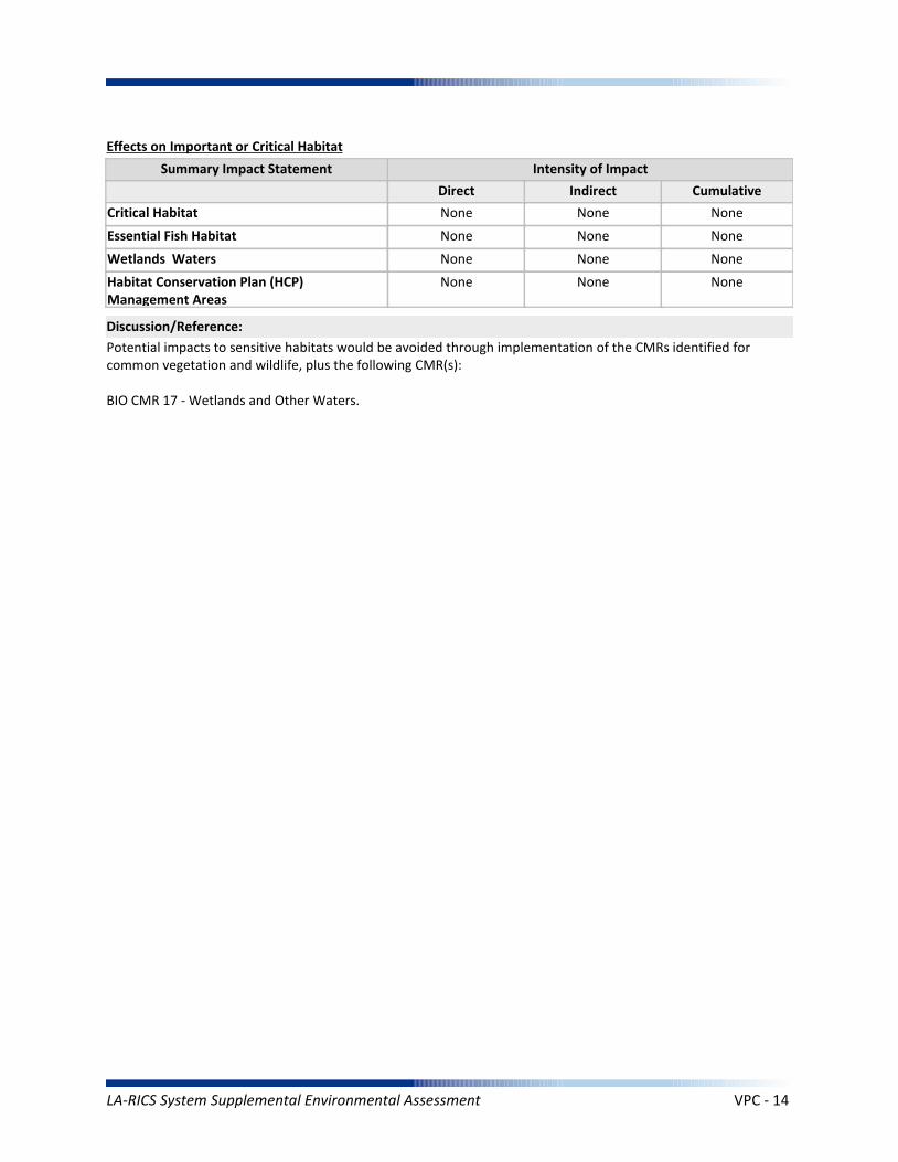
Essential Fish Habitat
Summary Impact Statement
Critical Habitat None None None
None None None
Potential impacts to sensitive habitats would be avoided through implementation of the CMRs identified for common vegetation and wildlife, plus the following CMR(s):
BIO CMR 17 - Wetlands and Other Waters.
Intensity of Impact
Direct Indirect Cumulative
Discussion/Reference:
Wetlands Waters None None None
Effects on Important or Critical Habitat
Habitat Conservation Plan (HCP)Management Areas
None None None
LA-RICS System Supplemental Environmental Assessment VPC - 14

Architectural Resources
Summary Impact Statement
Archaeological Resources
8. HISTORIC AND CULTURAL RESOURCES
Affected Environment Technical Analysis
Environmental Consequences and Impact Overview
None None None
None None None
By letter dated May 15, 2015, NTIA determined that this site was exempted from Section 106 review by the California SHPO under the terms and conditions of the Nationwide Programmatic Agreement. No impacts to cultural resources are anticipated.
Intensity of Impact
Direct Indirect Cumulative
Discussion/Reference:
Proposed antenna at a listed or eligible National Register of Historic Places (NRHP) site: N/A
If yes, relationship of antennas to NRHP structure: Candidate for Exemption
Native American Resources None None None
Archaeological historic property in direct APE: N/A
If yes, identify the historic property: Candidate for Exemption
Archaeological historic property within indirect APE: N/A
If yes, identify the historic property: Candidate for Exemption
Architectural historic property in direct APE: N/A
If yes, identify the historic property: Candidate for Exemption
Architectural historic property (NRHP listed or eligible) within indirect APE: N/A
If yes, identify the historic property: Exempted
Sacred Lands File site on site: No
If yes, the Sacred Lands File: N/A
Sacred Lands File site within ½ mile of indirect APE: No
If yes, the Sacred Lands File: N/A
Area having high sensitivity for paleontological resources: No
If yes, the Paleontological Site: N/A
Geological formation with a high potential for vertebrate paleontological resources: No
If yes, type of geological formation: N/A
Paleontological Resources None None None
LA-RICS System Supplemental Environmental Assessment VPC - 15
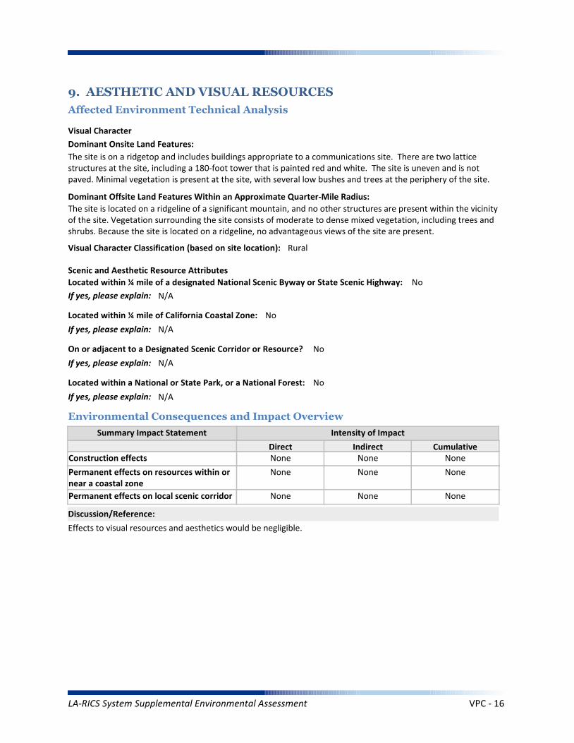
Summary Impact Statement
Construction effects
9. AESTHETIC AND VISUAL RESOURCES
Affected Environment Technical Analysis
Environmental Consequences and Impact Overview
None None None
Effects to visual resources and aesthetics would be negligible.
Intensity of Impact
Direct Indirect Cumulative
Discussion/Reference:
Dominant Onsite Land Features:
The site is on a ridgetop and includes buildings appropriate to a communications site. There are two lattice structures at the site, including a 180-foot tower that is painted red and white. The site is uneven and is not paved. Minimal vegetation is present at the site, with several low bushes and trees at the periphery of the site.
Dominant Offsite Land Features Within an Approximate Quarter-Mile Radius:
The site is located on a ridgeline of a significant mountain, and no other structures are present within the vicinity of the site. Vegetation surrounding the site consists of moderate to dense mixed vegetation, including trees and shrubs. Because the site is located on a ridgeline, no advantageous views of the site are present.
Located within ¼ mile of a designated National Scenic Byway or State Scenic Highway: No
If yes, please explain: N/A
Scenic and Aesthetic Resource Attributes
Located within a National or State Park, or a National Forest: No
If yes, please explain: N/A
Visual Character Classification (based on site location): Rural
Located within ¼ mile of California Coastal Zone: No
If yes, please explain: N/A
Visual Character
Permanent effects on resources within ornear a coastal zone
None None None
Permanent effects on local scenic corridor None None None
On or adjacent to a Designated Scenic Corridor or Resource? No
If yes, please explain: N/A
LA-RICS System Supplemental Environmental Assessment VPC - 16
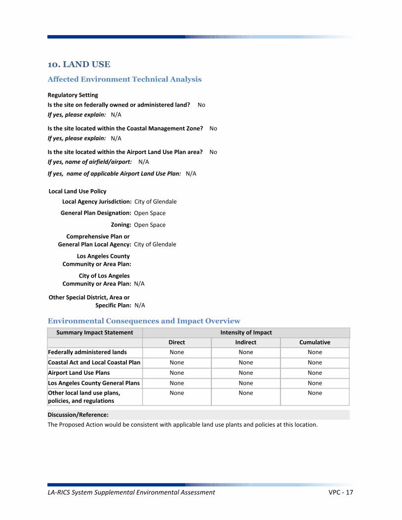
Coastal Act and Local Coastal Plan
Summary Impact Statement
Federally administered lands
10. LAND USE
Affected Environment Technical Analysis
Environmental Consequences and Impact Overview
None None None
None None None
The Proposed Action would be consistent with applicable land use plants and policies at this location.
Intensity of Impact
Direct Indirect Cumulative
Discussion/Reference:
Is the site on federally owned or administered land? No
If yes, please explain: N/A
Comprehensive Plan or General Plan Local Agency: City of Glendale
Local Land Use Policy
Local Agency Jurisdiction: City of Glendale
General Plan Designation: Open Space
Is the site located within the Coastal Management Zone? No
If yes, please explain: N/A
Regulatory Setting
Los Angeles County General Plans
Airport Land Use Plans None None None
None None None
Other local land use plans, policies, and regulations
None None None
Is the site located within the Airport Land Use Plan area? No
If yes, name of airfield/airport: N/A
If yes, name of applicable Airport Land Use Plan: N/A
Zoning: Open Space
Los Angeles County Community or Area Plan:
City of Los Angeles Community or Area Plan: N/A
Other Special District, Area or Specific Plan: N/A
LA-RICS System Supplemental Environmental Assessment VPC - 17

Solid Waste (construction)
Summary Impact Statement
Electrical Supply
11. INFRASTRUCTURE
Affected Environment Technical Analysis
Environmental Consequences and Impact Overview
Nearest Highway: Interstate 210
Site Served by Solid Waste Disposal Provider: City of Glendale
Not Significant None Not Significant
Not Significant None Not Significant
Utility use would be well within existing capacities. Implementation of TRANS MM-1 would minimize potential traffic impacts during construction. Public safety impact would be beneficial.
Traffic
Electrical
Disposal
Intensity of Impact
Direct Indirect Cumulative
Discussion/Reference:
Water Supply (construction)
Solid Waste (operation) None None None
Not Significant None Not Significant
Traffic (construction)
Water Supply (operation) None None None
Not Significant None None
Public Safety
Traffic (operation) None None None
Not Significant None None
Nearest Arterial: La Tuna Canyon Road
Distance (Miles): 1
Distance (Miles): 1
Access to the Project Site Provided Via: Verdugo Mountainway
Electricity Service Provider: Glendale Water and Power
Site Served by or has Available Access to Domestic Water System: Glendale Water and Power
Water Service
Electricity On Site or to Be Brought to Site? Electricity on site
LA-RICS System Supplemental Environmental Assessment VPC - 18
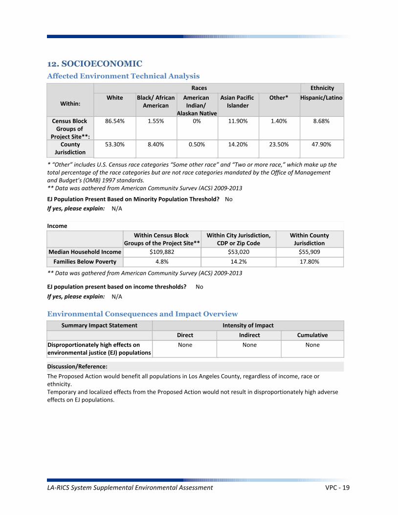
Summary Impact Statement
12. SOCIOECONOMIC
Affected Environment Technical Analysis
Environmental Consequences and Impact Overview
The Proposed Action would benefit all populations in Los Angeles County, regardless of income, race or ethnicity.Temporary and localized effects from the Proposed Action would not result in disproportionately high adverseeffects on EJ populations.
Intensity of Impact
Direct Indirect Cumulative
Discussion/Reference:
Income
Disproportionately high effects onenvironmental justice (EJ) populations
None None None
Races Ethnicity
Hispanic/Latino
47.90%
8.68%
Other*
23.50%
1.40%
Asian Pacific Islander
14.20%
11.90%
American Indian/
Alaskan Native
0.50%
0%
Black/ AfricanAmerican
8.40%
1.55%
White
53.30%
86.54%
Within:
* “Other” includes U.S. Census race categories “Some other race” and “Two or more race,” which make up the total percentage of the race categories but are not race categories mandated by the Office of Management and Budget’s (OMB) 1997 standards.** Data was gathered from American Community Survey (ACS) 2009-2013
EJ Population Present Based on Minority Population Threshold? No
If yes, please explain: N/A
Within CountyJurisdiction
17.80%
$55,909
Within City Jurisdiction,CDP or Zip Code
14.2%
$53,020
Within Census Block Groups of the Project Site**
4.8%
$109,882
EJ population present based on income thresholds? No
If yes, please explain: N/A
Census Block Groups of
Project Site**:County
Jurisdiction
Median Household Income
Families Below Poverty
** Data was gathered from American Community Survey (ACS) 2009-2013
LA-RICS System Supplemental Environmental Assessment VPC - 19
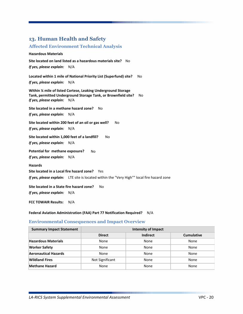
Worker Safety
Summary Impact Statement
Hazardous Materials
13. Human Health and Safety
Affected Environment Technical Analysis
Environmental Consequences and Impact Overview
None None None
None None None
Intensity of Impact
Direct Indirect Cumulative
Discussion/Reference:
Site located on land listed as a hazardous materials site? No
If yes, please explain: N/A
Aeronautical Hazards None None None
Located within 1 mile of National Priority List (Superfund) site? No
If yes, please explain: N/A
Within ¼ mile of listed Cortese, Leaking Underground Storage Tank, permitted Underground Storage Tank, or Brownfield site? NoIf yes, please explain: N/A
Site located within 1,000 feet of a landfill? No
If yes, please explain: N/A
Potential for methane exposure? No
If yes, please explain: N/A
Site located in a methane hazard zone? No
If yes, please explain: N/A
Site located within 200 feet of an oil or gas well? No
If yes, please explain: N/A
Wildland Fires Not Significant None None
Methane Hazard None None None
Hazardous Materials
Hazards
Site located in a Local fire hazard zone? Yes
If yes, please explain: LTE site is located within the "Very High"" local fire hazard zone
Site located in a State fire hazard zone? No
If yes, please explain: N/A
Federal Aviation Administration (FAA) Part 77 Notification Required? N/A
FCC TOWAIR Results: N/A
LA-RICS System Supplemental Environmental Assessment VPC - 20
The site is located in a very high fire hazard severity zone, and governed by the approved LA-RICS LTE fire management plan. No hazardous waste sites have been identified, therefore no impacts are anticipated.
Discussion/Reference:
LA-RICS System Supplemental Environmental Assessment VPC - 21