Embed Size (px)
Citation preview
APPENDIX B (PLANNING MAPS)
CITY OF AUCKLAND - DISTRICT PLANISTHMUS SECTION - OPERATIVE 1999 Section E7 - Page 1updated 01/06/2016
See key on last page of this section
APPENDIX B (PLANNING MAPS)
AREA 1
DISCRETIONARY ACTIVITIES
• Community welfare facility
• Education facility#
• Funeral parlour#
• Garden centres
• Healthcare services
• Hospital
• Laboratories
• Offices
• Place of assembly#
• Restaurants, cafes and other eating places#
• Tourist complex#
• Accessory buildings and ancillary activities for any of the foregoing activities
Note: For those activities identified with a #, refer Criteria for Assessing Applications for Resource Consent.
AREA 2
PERMITTED ACTIVITIES
• Tourist complex with a maximum of 218 guest rooms
DISCRETIONARY ACTIVITIES
• Tourist complex with more than 218 guest rooms#
• Accessory buildings and ancillary activities for any of the foregoing activities
AREA 3
PERMITTED ACTIVITIES
• Healthcare services
• Hospital with a minimum of 55 beds
RESTRICTED CONTROLLED ACTIVITIES
• Healthcare services and/or hospitals in buildings up to a maximum height of 21m
Note: For the purpose of this rule the height limit of 21 m shall include any chimney, plant room, water tower, crane, satellite receiving dish, radio or television aerial or other structure or equipment located on the roof of the building.
Except as provided for in Section 94(5) of the Resource Management Act 1991, the above controlled activities will
be considered without notification or the need to obtain the written approval of affected persons, in accordance with Section 94(1)(b) of the Act.
DISCRETIONARY ACTIVITIES
• Accessory buildings and ancillary activities for any of the foregoing activities
DEVELOPMENT CONTROLS
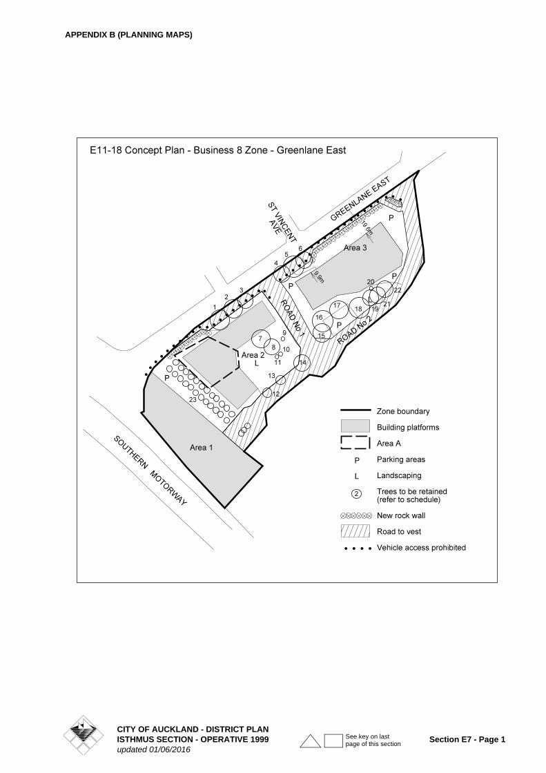
1. Building Platforms
Buildings may be constructed or relocated and parking located within the building platforms shown on Concept Plan E11-18 provided development is in accordance with development controls and special controls for the site.
2. Maximum Permitted Height
15m
16 m in area denoted A on Concept Plan.
3. Maximum Building Coverage
Areas 1 and 3: 35%
Area 2: 30%
4. Maximum GFA
Area 1: Subject to discretionary consent
Area 2: 13,000m²
Area 3: 11,000m²
5. Yards
All Areas: 6m from site boundary
6. Landscaping
Areas 1 and 3: 30%
Area 2: 35%
Trees to be retained
The following is a list of trees which are required to be retained during any development and subsequent activity within the zone. The trees are identified by separate numbers on Concept Plan E11-18. All other trees other than those located on building platforms, parking areas and roads shall be subject to the provisions of Clause 5C.7.3 TREES.
During the construction period works in the vicinity of trees including on, above or under the dripline (branch spread) of any tree described below or under the provisions of Clause 5C.7.3 shall be in accordance with accepted arboricultural practice.
E11-18 CONCEPT PLAN - BUSINESS 8 ZONE - GREENLANE EAST
CITY OF AUCKLAND - DISTRICT PLANSection E7 - Page 2 ISTHMUS SECTION - OPERATIVE 1999
updated 01/06/2016
See key on last page of this section
APPENDIX B (PLANNING MAPS)
Note: The palms listed as Plan ref. no. 23 above are part of a large group of palms scheduled in the District Plan for protection (see Clause 5C.7.3.3 RULES : TREES).
Rock Wall
A rock wall currently runs along the Greenlane East frontage of the site. This wall is required to be rebuilt along a portion of the new (widened) road boundary adjoining Areas 2 and 3. If it is identified that it is not feasible in engineering terms or because of concern about the impact on the trees to rebuild the rock wall, this matter shall be brought back to the Council for further consideration as a restricted discretionary activity.
7. Parking
The parking rules of PART 12 - TRANSPORTATION of the Plan shall apply to all activities and development. Due to the use and nature of the adjoining Ellerslie Racecourse land, opportunities may arise for the sharing of parking spaces between the activities on the site subject to this Concept Plan and the activities on the Ellerslie Racecourse land. Any proposal to share parking for up to 379 spaces will require a restricted discretionary activity resource consent and will be assessed against the criteria of Clause 12.9.1.2 CRITERIA FOR ASSESSING DISCRETIONARY ACTIVITIES of the District Plan.
8. Access and Roads
The following works are required to be funded and carried out by the land owner or nominee prior to the commencement of any on site activity. (Note - this will not prevent the construction of buildings on any site but will affect the subsequent use or commissioning of such buildings).
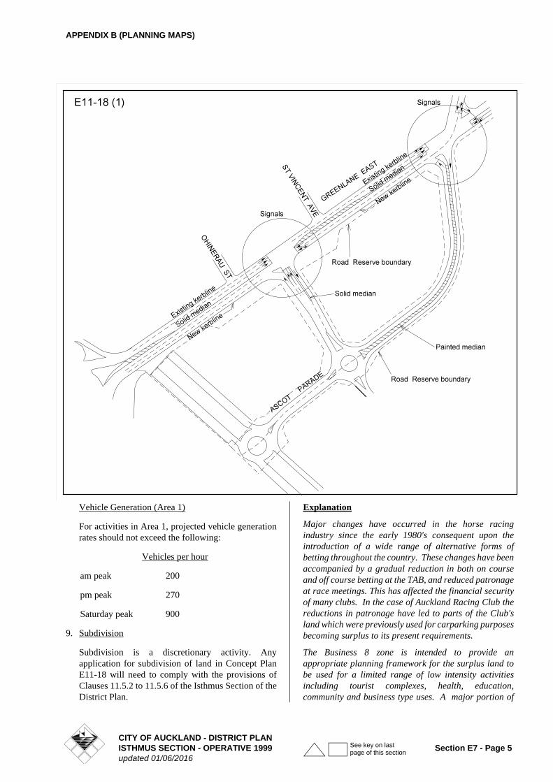
The nature of the works required to be carried out is illustrated on Figures E11-18(1) and is described more particularly as follows.
(a) The physical widening of Greenlane East to an overall carriageway width of
- not less than 19m from the motorway interchange to mid block between Ohinerau Street and St Vincents Avenue so as to provide for a total of 6 lanes of moving traffic
- not less than 16m from mid block between Ohinerau Street and St Vincents Avenue through to Ascot Avenue
(b) Providing and vesting the necessary additional land for road widening purposes along the south eastern frontage of Greenlane East.
(c) The construction and vesting of the new 'internal' roads identified as road nos. 1 and 2 in general accordance with the details shown in Figures E11-18(1).
(d) The closing of the existing main entry to the race course (at the south western end of the Greenlane frontage of Area 2)
Plan ref. no.
Botanical name Common name
1 Platanus acerifolia London plane
2 Platanus acerifolia London plane
3 Ulmus sp Elm
4 Ulmus sp Elm
5 Ulmus sp Elm
6 Ulmus sp Elm
7 Ulmus sp Elm
8 Ulmus sp Elm
9 Liquidambar styraciflua
Sweet gum
10 Cordyline australia Cabbage tree
11 Ulmus sp Elm
12 Catalpa bignoniodes Indian bean tree
13 Platanus acerifolia London plane
14 Quercus canariensis Algerian oak
15 Ulmus sp Elm
16 Platanus acerifolia London plane
17 Platanus acerifolia London plane
18 Quercux robur English oak
19 Quercus canariensis Algerian oak
20 Corynocarpus laevigatus
Karaka
21 Quercus canariensis Algerian oak
22 Platanus acerifolia London plane
23 Phoenix canariensis Canary Island palm (total 26)
CITY OF AUCKLAND - DISTRICT PLANISTHMUS SECTION - OPERATIVE 1999 Section E7 - Page 3updated 01/06/2016
See key on last page of this section
APPENDIX B (PLANNING MAPS)
(e) The construction of a new footpath on the south eastern side of Greenlane Road between the existing tree line and new (widened) road boundary
(f) The installation of traffic signals at the intersections of Greenlane East and road no. 1, and Greenlane East and road no. 2.
(g) The construction of a solid median and installation of ancillary pavement markings east of the Southern Motorway as shown in Figure E11-18(1)
(h) The provision of adequate crossing facilities for pedestrians and cyclists on Greenlane East.
Vehicle Generation (Areas 2 and 3)
For activities in Areas 2 and 3 total projected vehicle generation rates should not exceed the following:
In order to establish compliance with this development control, the permitted, controlled or discretionary activities listed must be assessed in terms of the following matrix. This test, which applies only when a project is being considered for consent, will indicate whether the projected vehicle generation total of the proposal is likely to exceed the above limiting figures for the weekday am and pm peaks, and the Saturday peak. Any permitted activities failing this test shall be a discretionary activity in terms of this Concept Plan.
TRAFFIC GENERATION FACTORS (VEHICLES PER HOUR)
Area 2 Vehicles per hour
am peakpm peakSaturday peak
13015040
Area 3 Vehicles per hour
am peakpm peakSaturday peak
160200200
ACTIVITY WEEKDAY AM PEAK WEEKDAY PM PEAK SATURDAY PEAK
HEALTHCARE AND HOSPITAL
Consulting rooms 3 per 100m² GFA. 4.4 per 100m² GFA. 4 per 100m² GFA.
Ward beds 1 per bed 1 per bed 1 per bed
Support facilities associated with the above consulting rooms and ward beds such as theatres, staff offices, laboratory, radiology, pharmacy, dentist, cafe, childcare and public circulation
Nil Nil Nil
Accessory buildings and ancillary activities
Nil Nil Nil
TOURIST COMPLEX
Hotel 0.61 per bedroom 0.67 per bedroom 0.2 per bedroom
Accessory buildings and ancillary activities
Nil Nil Nil
CITY OF AUCKLAND - DISTRICT PLANSection E7 - Page 4 ISTHMUS SECTION - OPERATIVE 1999
updated 01/06/2016
See key on last page of this section
APPENDIX B (PLANNING MAPS)
Vehicle Generation (Area 1)
For activities in Area 1, projected vehicle generation rates should not exceed the following:
Vehicles per hour
am peak 200
pm peak 270
Saturday peak 900
9. Subdivision
Subdivision is a discretionary activity. Any application for subdivision of land in Concept Plan E11-18 will need to comply with the provisions of Clauses 11.5.2 to 11.5.6 of the Isthmus Section of the District Plan.
Explanation
Major changes have occurred in the horse racing industry since the early 1980's consequent upon the introduction of a wide range of alternative forms of betting throughout the country. These changes have been accompanied by a gradual reduction in both on course and off course betting at the TAB, and reduced patronage at race meetings. This has affected the financial security of many clubs. In the case of Auckland Racing Club the reductions in patronage have led to parts of the Club's land which were previously used for carparking purposes becoming surplus to its present requirements.
The Business 8 zone is intended to provide an appropriate planning framework for the surplus land to be used for a limited range of low intensity activities including tourist complexes, health, education, community and business type uses. A major portion of
CITY OF AUCKLAND - DISTRICT PLANISTHMUS SECTION - OPERATIVE 1999 Section E7 - Page 5updated 01/06/2016
See key on last page of this section
APPENDIX B (PLANNING MAPS)
land in the zone will be used for activities which are commonly found in residential areas.
The planning controls have been specifically designed for the land to accommodate two known development proposals on Areas 2 and 3 as permitted activities, extension to maximum building height as a restricted controlled activity and activities on Area 1 as discretionary activities.
Criteria for Assessing Applications for Resource Consent
The controlled activity assessment criteria should address the following matters -
1. The form, colour and materials of buildings should be designed to ensure any adverse effects on the visual amenity of the area are, as far as practicable, avoided or mitigated.
2. Landscaping on the site should be designed to provide screening of the building and to promote the overall visual amenities of the area. A high quality landscape frontage will be required to enable mature specimen trees to be established along Greenlane East compatible with surrounding vegetation.
The general criteria to be addressed in assessing any application for a discretionary activity in Area 1 shall be the same as those contained in Clause 8.7.3.2 GENERAL CRITERIA FOR ASSESSING DISCRETIONARY ACTIVITIES items (a), (b), (c), (d), (f), (i), (l) and (o) which refer to traffic generation; parking access; buildings; development controls; infrastructural constraints; pedestrian safety and convenience; and site amenity. Particular attention will be given to matters relating to traffic generation and appearance of buildings. The appearance of buildings should be compatible with the local environment, the character of adjacent sites and surrounding residential neighbourhood.
Activities marked # which have a gross floor area in excess of 2000m² must demonstrate to the satisfaction of the Council that any significant adverse effects on existing centres zoned Business 2, 3, or 8 can be avoided by mitigation measures and/or by positive effects arising from the proposed development. The matters to be taken into account in assessing the effects on existing commercial centres are set out in Clause 8.4.4 EXISTING CENTRES of the Plan.
DOMINANT ACTIVITY: RETAIL
PERMITTED ACTIVITIES
• Carparking areas and carparking buildings (including joint use of such facilities by two or more activities)
• Retail premises
• All other activities listed as permitted activities in the Business 2 zone as set out in Rule 8.7.1 ACTIVITIES IN BUSINESS 1,2,3,4,5,5A AND 6 ZONES
CONTROLLED ACTIVITIES AND RESTRICTED CONTROLLED ACTIVITIES
• All activities not being permitted activities and scheduled as controlled or restricted controlled activities in the Business 2 zone as set out in Rule 8.7.1 ACTIVITIES IN BUSINESS 1,2,3,4,5,5A AND 6 ZONES.
DISCRETIONARY ACTIVITIES AND RESTRICTED DISCRETIONARY ACTIVITIES
• All activities not being permitted activities and listed as discretionary or restricted discretionary activities in the Business 2 zone as set out in Rule 8.7.1.
DEVELOPMENT CONTROLS
All development is subject to the development controls of Clause 8.8.1 DEVELOPMENT CONTROLS IN BUSINESS 1, 2, 3, 4, 5, 5A AND 6 ZONES as they apply to the Business 2 zone except where specified otherwise on this Concept Plan.
1. Building Platform
Building development is limited to the building platform illustrated on the Concept Plan.
2. Landscaping
The full extent of landscaping required on the site is indicated on the Concept Plan, and is to be provided and maintained to the satisfaction of the Council.
3. Tree to be Retained
The Vitex lucens tree (puriri) is to be retained. The requirements of Rule 5C.7.3.3A SCHEDULED TREESshall apply as if this was a scheduled tree.
4. Pylon Sign
One pylon sign is permitted in the general location shown on the Concept Plan.
The sign is not to exceed the maximum height for the Business 2 zone, or exceed a total sign area of 15m2.
5. Parking
Parking shall be provided for any additional gross floor area or new development in accordance with PART 12 - TRANSPORTATION of the Plan.
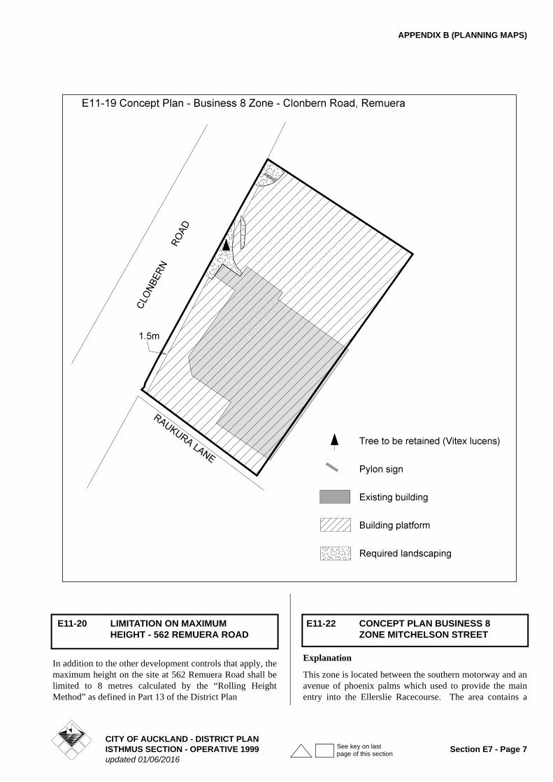
E11-19 CONCEPT PLAN - BUSINESS 8 ZONE - CLONBERN ROAD, REMUERA
CITY OF AUCKLAND - DISTRICT PLANSection E7 - Page 6 ISTHMUS SECTION - OPERATIVE 1999
updated 01/06/2016
See key on last page of this section
APPENDIX B (PLANNING MAPS)
In addition to the other development controls that apply, the maximum height on the site at 562 Remuera Road shall be limited to 8 metres calculated by the “Rolling Height Method” as defined in Part 13 of the District Plan
Explanation
This zone is located between the southern motorway and an avenue of phoenix palms which used to provide the main entry into the Ellerslie Racecourse. The area contains a
E11-20 LIMITATION ON MAXIMUM HEIGHT - 562 REMUERA ROAD
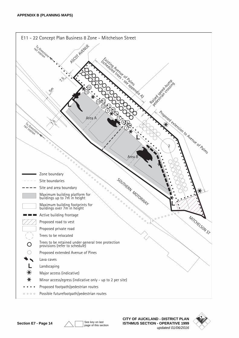
E11-22 CONCEPT PLAN BUSINESS 8 ZONE MITCHELSON STREET
CITY OF AUCKLAND - DISTRICT PLANISTHMUS SECTION - OPERATIVE 1999 Section E7 - Page 7updated 01/06/2016
See key on last page of this section
APPENDIX B (PLANNING MAPS)
mixture of pervious and impervious surfaces which were once used frequently for carparking in conjunction with race meetings.
The land is physically separated from the main racecourse activity, and is now only used infrequently for race meetings on public holidays. The adjoining area to the northwest is zoned Business 8 and is substantially developed with activities which physically complement, but which are fundamentally unrelated to, the racecourse.
The Concept Plan area is particularly well located with respect to the existing arterial roading network (Southern Motorway, Greenlane Road and Great South Road) and public transport system (Greenlane and Ellerslie Railway Stations and major bus routes). These facilities have particular significance in terms of potential future commuting patterns.
The objective of the Business 8 zoning is to enable the area to be developed for a limited range of low intensity business and/or residential activities which will be complementary to the existing Business 8 zone to the north west; will not have any noticeable impact on the vitality of the Ellerslie Town Centre; and which will generate relatively modest vehicle traffic with varied distribution characteristics.
The allowed activities include all of those uses within the adjoining Business 8 zone to the north west plus residential units, care centres, and retail premises up to 300m2 total combined floor area within the Concept Plan area. Concept Plan E11-22 may be viewed as an extension to the zoning on the adjoining Concept Plan E11-18.
An area of active building frontage has been included which is required to be occupied by activities that contribute towards pedestrian amenity and passive surveillance of the adjoining street.
Good urban design is a key outcome for this plan change. Given that the site is highly 'public', being able to be viewed from the southern motorway, within the racecourse grounds, as well as surrounding sites the Concept Plan controls (as a Restricted Discretionary Activity) the built form of new buildings and alterations to existing buildings on the site.
The assessment criteria for the zone focus on: good urban design, design and appearance, landscaping, stormwater and traffic effects.
Those activities that have the potential to generate a significant amount of traffic have also been classified as Restricted Discretionary Activities. This will enable an appropriate assessment to be made with respect to traffic effects.
A higher building coverage has been allowed for those parts of any buildings less than 7m in height so as to enable the development of above ground carparking, thereby substantially avoiding the need for underground parking and
the potential damage that this form of development could have on the underground lava caves that exist in this area.
PERMITTED ACTIVITIES
• Community Welfare Facilities
• Funeral Parlours
• Laboratories
• Offices
• Car Parking
• Retail activity not exceeding 300m2 total combined floor area within the Concept Plan area
• Restaurants, cafes and other eating places which have a combined floor area not exceeding 400m2 within the Concept Plan area
• Ancillary activities for any of the foregoing
Note: Development Control 7 places restrictions on what activities are permitted within the Active Building Frontage (at South Eastern end of extended Avenue of Palms)
RESTRICTED CONTROLLED ACTIVITIES
• The use and modification of the private road (Avenue of Palms) for public access.
Note: Any application for subdivision consent which involves the creation of the private road shown on concept plan E11 - 22 shall be accompanied by an application for restricted controlled activity consent for the use and modification of the private road. The latter application shall be assessed in terms of the potential effects set out in the section entitled MATTERS TO WHICH DISCRETION IS LIMITED.
RESTRICTED DISCRETIONARY ACTIVITIES
• All new buildings, including any external additions or alterations to existing buildings#
• Care Centres*
• Educational Facilities*
• Healthcare Services*
• Hospitals*
• Places of Assembly*
• Tourist Complexes*
• Residential units complying with the rules applying to the residential 8(a) zone (apart from maximum building height)*
• Restaurants, cafes and other eating places which exceed 400m2 combined floorspace within the Concept Plan area*
Notes - those activities marked with an * will be assessed in terms of traffic effects only, as set out in criterion (a) of the
CITY OF AUCKLAND - DISTRICT PLANSection E7 - Page 8 ISTHMUS SECTION - OPERATIVE 1999
updated 01/06/2016
See key on last page of this section

APPENDIX B (PLANNING MAPS)
rule - RESTRICTED DISCRETIONARY ACTIVITY ASSESSMENT CRITERIA except for Residential units which shall also be assessed in terms of criterion (d) of that rule.
Those activities marked with a # will be assessed only in terms of criteria (b), (c) and (e) of the RESTRICTED DISCRETIONARY ACTIVITY ASSESSMENT CRITERIA which relate to building design and appearance, landscaping and stormwater.
DEVELOPMENT CONTROLS
All permitted and restricted discretionary activities must comply with the following development controls.
If the following development controls are not complied with, a discretionary activity consent may be sought under Rule 4.3.1.2B.
1. Maximum F.A.R.
The maximum allowable F.A.R. within each site shown on the Concept Plan is 1.25:1 (exclusive of basement and/or podium level parking).
Explanation
The total area covered by the Concept Plan exclusive of private road is 13,419m2. The total maximum floor area allowed to be constructed under this control is therefore 16,773m2 ranging from approximately 4,000m2 on sites 1-3 to 4,400m2 on site 4.
2. Definition of Site Areas
The Concept Plan identifies 4 site areas which include 3 sites of approximately 3,200m2 each and one site of approximately 3,500m2. Each of these sites may be modified in area by up to plus or minus 10% and the side boundaries moved by up to 15m in either direction as of right.
Explanation
The purpose of dividing the Concept Plan into 4 separate site areas is to ensure that the Concept Plan area is not developed with a single large building structure and also to enable the maximum height controls to be effectively implemented.
The effect of the provision will also be to require at least four separate buildings to be constructed within the Concept Plan area if the maximum F.A.R. for the area is to be achieved. The objective of the control, coupled with the maximum height and side yard requirements is to reduce the potential visual impact of any individual building or group of buildings, and ensure a minimum 15m gap between adjacent buildings thereby avoiding the creation of a wall effect when viewed from the motorway (and to a lesser extent from the housing on the western side of the motorway).
3. Maximum Permitted Height
• The maximum building height, including residential units otherwise built in accordance with the residential 8(a) zoning controls, shall be 18 m in Area A and 21m in Area B.
4. Maximum Building Coverage for any site (exclusive of private road area)
• 80% for that part of any building up to 7m in height
• 35% for that part of any building between 7m and the maximum building height prescribed in rule 3 above
5. Building Platform
Buildings may only be constructed within the building platform shown on Concept Plan E11-22.
6. Minimum Yard Setbacks from Site Area Boundaries
No part of any building above 7m in height above ground level shall be located closer than 7.5m from the nearest site boundary, and 15m from any part of another building above 7m in height.
In addition those parts of any buildings which are above 7m in height shall be set back a minimum distance of 10m from the motorway boundary.
Explanation
The purpose of this control is to avoid any issues relating to potential building dominance and achieve compatibility, in terms of building bulk and massing, between any proposed buildings within Concept Plan E11-22, and Area 1 on Concept Plan E11-18.
7. Activities Within Active Building Frontage (at South Eastern End of Extended Avenue of Palms)
The front 6m (minimum) depth of any building within the nominated active buildings frontage area shall not be used for any activity other than one or more of the following
• Retail premises not exceeding 300m2 total combined floor area within the Concept Plan area
• Restaurants, Cafes, and other eating places
Any building or part thereof located within the active building frontage area shall comply with the following rules:
a) The maximum allowable building set back from the private road frontage shall be 6m.
Any building that fronts onto the active building frontage shall be contiguous with the private road for a minimum of 80% of the overall length of that part of the site that adjoins the active building frontage.
b) Where any part of a building is set back from the pri-vate road frontage, the space between the building
CITY OF AUCKLAND - DISTRICT PLANISTHMUS SECTION - OPERATIVE 1999 Section E7 - Page 9updated 01/06/2016
See key on last page of this section
APPENDIX B (PLANNING MAPS)
and private road frontage shall incorporate land-scaped areas, pedestrian amenity areas, outdoor eat-ing areas, or the like.
c) The minimum height of any building within 6m of any private road shall be 6m.
d) Windows with clear glazing and/or pedestrian entrances shall comprise not less than 60% of the surface area of the building façade at ground floor level, and not less than 40% of the building façade at any upper levels. This glazing should be distributed as evenly as possible along the active building front-age, and in no case shall there be any continuous blank walls longer than 6m.
e) The ground level floor of buildings at the private road frontage shall be no higher nor lower than 1.0m above or below the immediately abutting private road frontage.
f) Access ways to parking and service areas shall occupy no more than 10% of the private road front-age of any site.
Explanation
The purpose of the foregoing controls is to provide an area in which to concentrate leisure and service uses (e.g. cafes.) for nearby employees and racecourse patrons; create a good relationship between the private road and future buildings; provide easy pedestrian access to adjacent buildings and services; provide visual interest for pedestrians; and enhance the vitality and security of the pedestrian environment by providing opportunities for improved security (through informal surveillance).
The controls on building setback are intended to provide a nearly continuous edge of activities fronting onto the private road.
A minimum height has been applied to the building frontage to provide a sense of containment and enhance pedestrian amenity values.
8. Landscaping
Minimum 15% of the site.
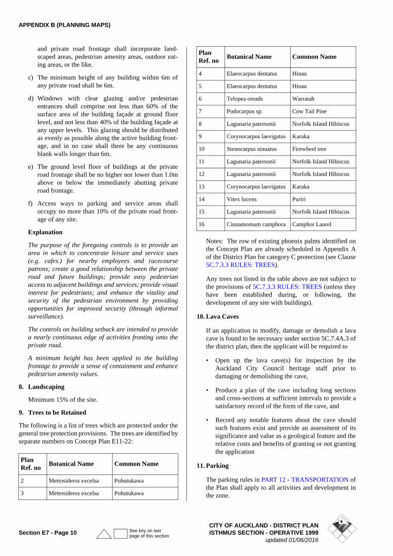
9. Trees to be Retained
The following is a list of trees which are protected under the general tree protection provisions. The trees are identified by separate numbers on Concept Plan E11-22:
Notes: The row of existing phoenix palms identified on the Concept Plan are already scheduled in Appendix A of the District Plan for category C protection (see Clause 5C.7.3.3 RULES: TREES).
Any trees not listed in the table above are not subject to the provisions of 5C.7.3.3 RULES: TREES (unless they have been established during, or following, the development of any site with buildings).
10. Lava Caves
If an application to modify, damage or demolish a lava cave is found to be necessary under section 5C.7.4A.3 of the district plan, then the applicant will be required to
• Open up the lava cave(s) for inspection by the Auckland City Council heritage staff prior to damaging or demolishing the cave,
• Produce a plan of the cave including long sections and cross-sections at sufficient intervals to provide a satisfactory record of the form of the cave, and
• Record any notable features about the cave should such features exist and provide an assessment of its significance and value as a geological feature and the relative costs and benefits of granting or not granting the application
11. Parking
The parking rules in PART 12 - TRANSPORTATION of the Plan shall apply to all activities and development in the zone.
Plan Ref. no
Botanical Name Common Name
2 Mettosideros excelsa Pohutukawa
3 Mettosideros excelsa Pohutukawa
4 Elaeocarpus dentatus Hinau
5 Elaeocarpus dentatus Hinau
6 Telopea oreads Warratah
7 Podocarpus sp. Cow Tail Pine
8 Lagunaria patersonii Norfolk Island Hibiscus
9 Corynocarpus laevigatus Karaka
10 Stenocarpus sinuatus Firewheel tree
11 Lagunaria patersonii Norfolk Island Hibiscus
12 Lagunaria patersonii Norfolk Island Hibiscus
13 Corynocarpus laevigatus Karaka
14 Vitex lucens Puriri
15 Lagunaria patersonii Norfolk Island Hibiscus
16 Cinnamomum camphora Camphor Laurel
Plan Ref. no
Botanical Name Common Name
CITY OF AUCKLAND - DISTRICT PLANSection E7 - Page 10 ISTHMUS SECTION - OPERATIVE 1999
updated 01/06/2016
See key on last page of this section
APPENDIX B (PLANNING MAPS)
MATTERS TO WHICH DISCRETION IS LIMITED
The Council's discretion is limited to the following matters:
• Whether the road may be closed to public through traffic on a temporary basis for large scale events associated with the Ellerslie Racecourse.
Note: It may be appropriate to allow temporary closure of the private road for large scale events associated with the Ellerslie Racecourse.
• The monitoring required to assess the effects of public through traffic (using the Avenue of Palms) on Morrin Road, Somerfield Street, and Kentucky Streets which connect with the Tecoma Street motorway ramps, Mitchelson Street and Walpole Street, Wairakei Street and Woodbine Avenue.
• Traffic management measures that may be necessary to deal with any adverse effects identified by the monitoring, including the temporary or permanent closure of the Avenue of Palms to through traffic and associated road design changes.
Note: These traffic management measures can only be identified following commencement of the restricted controlled activity.
• The process to be followed, for consultation with Transit New Zealand, Auckland City Council (in its road controlling authority capacity) and the residents of the surrounding streets, on the results of the monitoring and the identification and implementation of any necessary traffic management measures.
RESTRICTED DISCRETIONARY ACTIVITY ASSESSMENT CRITERIA
The Council's discretion is limited to the matters addressed in the following assessment criteria.
(a) Traffic
• Whether the proposal will result in significant traffic effects on Green Lane East, Green Lane interchange, Great South Road and the surrounding street network.
• Whether the Avenue of Palms (including extension to it) has been upgraded to public road standards by the landowner and if this has not occurred whether it will occur prior to the occupation of any proposed building.
(b) Building Design and Appearance
• Whether the building incorporates architectural relief in terms of its articulation and building mass, and the inclusion of recesses, pilasters, entrances, windows, balconies, and changes in surface texture, colour and other architectural detailing.
• Whether any rooftop projections including towers, turrets, chimneys, lift towers, machinery rooms and water towers which exceed the parapet or roof height,
are compatible with the overall architectural form and detailing of the building. As a general rule rooftop projections should be enclosed in a single structure and avoid a plain box like appearance.
• Whether good quality, durable exterior cladding materials are used and highly reflective cladding or glazing avoided.
• Continuity of architectural form in the various facades of a building, especially those visible from adjacent public and private roads. (This criterion is intended to ensure that all of a building's facades are designed to a similar standard).
• Whether on site parking areas, whether at grade or on elevated decks, are softened by planting, paving patterns or other architectural / landscaping elements, so as to provide visual relief when viewed from adjacent buildings.
• Whether windows of buildings are designed to overlook adjacent public and private roads, pedestrian routes and entrances.
• The extent to which the landscape and streetscape enhances individual sites, adjacent private roads, and any public roads being vested in the Council.
• The extent to which the design treatment of the building edge (with a particular emphasis on the ground level) and any landscape work adjacent to it within the proposed 7.5m setback along that part of the Avenue of Palms that is not classified as 'active building frontage', contributes to the quality and safety of the proposed pedestrian route by:
- incorporating enhanced building entrances, glazed entry foyers, offices or other ground level activities (where possible) facing the road;
- employing design techniques to mitigate any 'blank wall' effect;
- providing quality landscape design and appropriate lighting that are consistent with 'personal safety' (CPTED) principles; and
- ensuring that the space within the setback (between the building edge and road boundary) is not used for surface carparking (apart from delivery bays).
(c) Landscaping
• Whether the proposed landscaping will enhance the visual amenity of the building(s) when viewed from the Southern Motorway, from within the grounds of the Ellerslie Racecourse and surrounding residential areas.
Notes: The landscaping alongside the motorway boundary will be expected to include a significant number of substantial trees capable of growing to a
CITY OF AUCKLAND - DISTRICT PLANISTHMUS SECTION - OPERATIVE 1999 Section E7 - Page 11updated 01/06/2016
See key on last page of this section
APPENDIX B (PLANNING MAPS)
height of at least 8m above the nearest adjoining motorway carriageway.
• Whether the proposed landscaping protects or utilises the existing rock wall located between the subject site and the Avenue of Palms (apart from those sections which need to be demolished for vehicle or pedestrian access purposes).
• Whether the proposed landscaping is 'in-keeping' with the character of the site and Ellerslie Racecourse in general.
• The extent to which any on site carparking is screened from view from the motorway and the Avenue of Palms by existing and proposed planting.
(d) Residential Units
• The extent to which the proposed development satisfies the intent of the criteria in rule 7.7.5.2C Criteria for Controlled Activities in Residential 8(a), 8(b) and 8(c) zones and the Design Guidelines in Appendix 10.
When applying the above criterion, it should be noted that the locational context of Concept Plan E11-22 is different from the norm. In particular, Concept Plan E11-22 is abutted on one side by a highly trafficked motorway and on the other side by a low intensity park-like area containing a series of widely scattered free standing buildings. The setting of the Concept Plan is not comparable with that of a busy, high intensity, town centre or regional road and the assessment criteria should be interpreted accordingly.
(e) Stormwater
• Whether any increase in the area of impervious surface as a result of development increases stormwater discharges from the land which result in additional adverse downstream effects and the measures proposed to mitigate such additional adverse effects in the short and long term.
• Whether the proposal incorporates elements of "low impact design" such as rain gardens, on site retention and re-cycling.
Note: Any low impact stormwater design proposals which involve the use of pervious areas of land (such as rain gardens) shall be included within the minimum 15% site landscaping requirement (and not be in addition to this requirement).
CONTROLLED ACTIVITY CONDITIONS
Conditions may be imposed in respect of any of the matters outlined under the heading MATTERS TO WHICH DISCRETION IS LIMITED. Notwithstanding this discretion, to provide certainty to local residents, a condition to the following effect shall be placed on any restricted controlled activity consent for the use or modification of the private road (Avenue of Palms):
Monitoring
The consent holder shall monitor the extent to which the private road is used by through traffic travelling between Greenlane East/Ascot Avenue and Morrin Road, Somerfield Street, and Kentucky Street which connect with the Tecoma Street motorway ramps, and, Mitchelson Street and Walpole Street, Wairakei Street and Woodbine Avenue.
The monitoring shall be carried out prior to the opening of the Avenue of Palms to through traffic and within 1 month of the following times or events - 12 months after the opening of the Avenue of Palms to through traffic (or a shorter period if deemed appropriate by the Council following the opening of the Avenue of Palms to through traffic) and 12 months, 24 months, and 36 months after substantial completion and occupation of the development provided for on the concept plan (as determined by the Auckland City Council).
The monitoring shall be carried out by an independent traffic engineer engaged by the Auckland Racing Club, and the results of the foregoing monitoring shall be submitted in a report to the Council within 2 months of completion of each of the monitoring surveys.
If the monitoring identifies that traffic management measures are required to address the effects of through traffic which passes along the Avenue of Palms between Greenlane East/Ascot Avenue and the residential streets referred to in the first paragraph above then the most appropriate form of traffic management measures and the period in which to implement these measures shall be determined by the Auckland City Council.
Explanation
One potential effect of extending the Avenue of Palms through to Mitchelson Street is an increase in the volume of "rat-running" traffic travelling between Greenlane East/Ascot Avenue and the residential streets to the south. The extent of this possible increase in traffic is difficult to predict. The proposed monitoring condition therefore is a mechanism which provides for the monitoring and measurement of rat-running traffic to be accurately determined and its effects on residential streets to be properly assessed. It will also enable the identification and implementation of appropriate traffic management measures to mitigate any such effects including, if necessary, the full or partial closure of the Avenue of Palms to eliminate through traffic movements. The adoption of this technique will ensure a soundly based outcome is achieved in terms of managing the public and private roading resources in the area.
In order to implement any required traffic mitigation measures it may be necessary to review and change the resource consent conditions. Where appropriate, therefore, the conditions may include a condition allowing such a review under section 128 of the RMA.
CITY OF AUCKLAND - DISTRICT PLANSection E7 - Page 12 ISTHMUS SECTION - OPERATIVE 1999
updated 01/06/2016
See key on last page of this section
APPENDIX B (PLANNING MAPS)
RESTRICTED DISCRETIONARY ACTIVITY CONDITIONS
Conditions may be imposed in respect of any of the matters outlined under the RESTRICTED DISCRETIONARY ACTIVITY ASSESSMENT CRITERIA.
SUBDIVISION
Subdivision is a discretionary activity. Any application for the subdivision of land in Concept Plan E11-22 will be required to comply with the provisions of Clauses 11.5.2 to 11.5.6 of the Isthmus Section of the District Plan.
In addition to the foregoing any application for subdivision consent shall be assessed against the following criteria.
SPECIAL SUBDIVISION ASSESSMENT CRITERIA
• The extent to which the layout of the private road is in general accordance with Concept Plan E11 - 22.
• Whether the Avenue of Palms (including its proposed extension) will be upgraded to public road standards and include the following works:
1. A traffic roundabout part way along the Avenue of Palms and another at its intersection with Mitchelson St.
2. The provision of footpaths along each side of the proposed private road together with connections to the existing and proposed footpaths in Ascot Ave. and Mitchelson St.
• Whether the proposed footpaths will link into the footpaths/pedestrian accessways on the adjoining site(s) so as to facilitate access to Greenlane Rd. and the Greenlane rail station.
• Whether the area shown as proposed road on Concept Plan E11 - 22 is intended to be vested in the Council.
For the avoidance of doubt it is acknowledged that the land within the zone is likely to be subdivided into a series of allotments with frontage onto a private road similar to the sites identified on the Concept Plan, with potential for shared car parking and access arrangements.
Note: Any application for subdivision consent which involves the creation of the private road shown on concept plan E11 - 22 shall be accompanied by an application for restricted controlled activity consent for the use and modification of the private road. The latter application shall be assessed in terms of the potential effects set out in the section entitled MATTERS TO WHICH DISCRETION IS LIMITED.
CITY OF AUCKLAND - DISTRICT PLANISTHMUS SECTION - OPERATIVE 1999 Section E7 - Page 13updated 01/06/2016
See key on last page of this section
APPENDIX B (PLANNING MAPS)
CITY OF AUCKLAND - DISTRICT PLANSection E7 - Page 14 ISTHMUS SECTION - OPERATIVE 1999
updated 01/06/2016
See key on last page of this section
APPENDIX B (PLANNING MAPS)
Refer to diagram E11-23
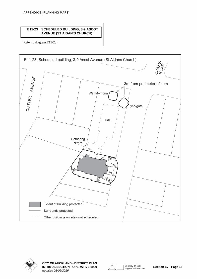
E11-23 SCHEDULED BUILDING, 3-9 ASCOT AVENUE (ST AIDAN’S CHURCH)
CITY OF AUCKLAND - DISTRICT PLANISTHMUS SECTION - OPERATIVE 1999 Section E7 - Page 15updated 01/06/2016
See key on last page of this section
APPENDIX B (PLANNING MAPS)
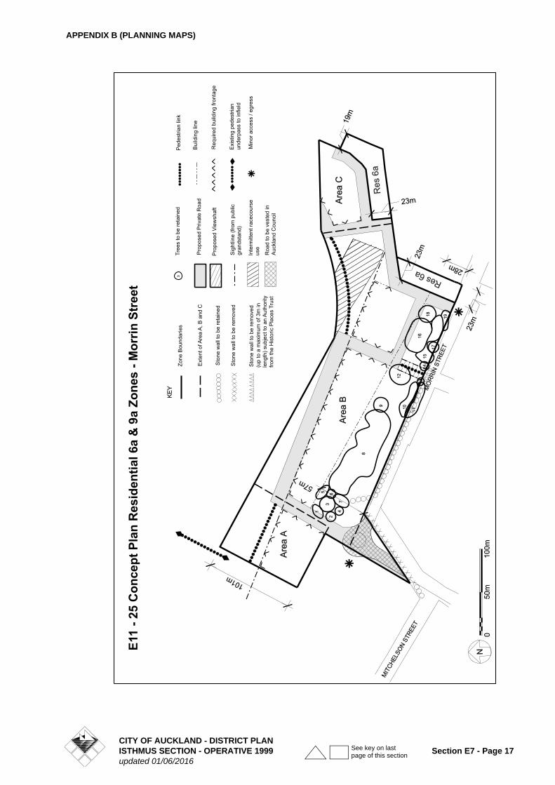
1. STRATEGY
Zoning:
Concept Plan E11-25 covers 5.9 ha of land which is owned by the Auckland Racing Club most of which is not currently used for racing activities. The area extends along the north eastern side of Morrin Street and backs onto an existing residential 6a zone that is accessed from The Oaks (private way) and Lonsdale Street.
The concept plan divides the area into 2 residential zones. These include a 23m deep strip of residential 6a zoning which runs along the southern boundary of the concept plan area and which is a natural extension of the existing residential 6a zone, and a residential 9a zone which abuts this latter new residential 6a zone and extends eastwards from Morrin St. around the southern side of the racetrack to a small local reserve (Derby Downs Domain) at the end of Derby Downs Place.
The residential 9a zone is a site specific zoning which takes into account the particular features of the land concerned while at the same time optimising allowable residential densities consistent with the Auckland Regional Growth Strategy and Auckland Growth Management Strategy.
The area which is suitable for development within the residential 9a zone is physically separated and substantially screened from existing housing by existing trees (along the Morrin Street frontage) and the proposed strip of new residential 6a zoning.
2. ACTIVITIES
2.1 PERMITTED ACTIVITIES
• Restoration, repair and alteration of any existing building fabric or detailing thereof.
• Any wall, fence or other structure no higher than 1.2m within the frontage areas created by the required frontages in development control 4.9.
• Home occupations.
• Overflow parking associated with events on the adjoining Ellerslie Racecourse land.
• Horse racing (including accessory television towers) within areas identified for this purpose on the concept plan diagram.
• Temporary activities associated with horse racing provided that any accompanying temporary facilities (such as marquees, and mobile toilets etc.) are erected within 30m of the open space 5 zone boundary.
• The trimming of the canopy of any tree listed in Development Control 4.16 which does not damage its
health. Such works shall be limited to no more than 20% of live growth removal in any one year and must be in accordance with currently accepted arboricultural practice, ensuring that the natural form and branch habit of the tree species is maintained.
• The trimming of any tree listed in Development Control 4.16 undertaken by a qualified arborist or arboriculturalist, where the trimming of the canopy is no more than 30% of live growth removal in any one year and is in accordance with currently accepted arboricultural practice, ensuring that the natural form and branch habit of the tree species is maintained.
2.2 RESTRICTED CONTROLLED ACTIVITIES
• Modifications to the existing stone walls on the Morrin Street and Mitchelson Street frontages to the extent identified on concept diagram E11-25.
2.3 RESTRICTED DISCRETIONARY ACTIVITIES
1. New buildings
a) Construction of new buildings (including external additions or alterations to existing buildings) and use of these buildings for:
• Planned Residential Developments (refer definition that follows).
• Retirement villages.
b) New buildings for retirement villages are required to comply with the development controls for Planned Residential Developments:
• With the exception of development controls 4.1, 4.12, 4.13 and 4.17, and
• Subject to an application for development control modification under section 4.3.1.2B of the Plan.
2. Tree modification or removal
a) Cutting, damaging, altering, injuring, destroying or partially destroying, or removing any of the trees listed in development control 4.16 and identified by separate numbers on Concept Plan diagram E11-25: or
b) Carrying on, conducting or undertaking any use, excavation, deposition of material, construction, work, emplacement of services, storage or other activity in, on, above or under, the dripline (branch spread), which in the opinion of Council endangers or is likely to endanger, any of the trees listed in development control 15 and identified by separate numbers on Concept Plan diagram E11-25.
For the avoidance of doubt, this rule will apply to the exclusion of the general tree protection rules contained in Clause 5C.7.3.3C of the District Plan.
E11-25 ELLERSLIE RACECOURSE RESIDENTIAL 9A ZONE
CITY OF AUCKLAND - DISTRICT PLANSection E7 - Page 16 ISTHMUS SECTION - OPERATIVE 1999
updated 01/06/2016
See key on last page of this section
APPENDIX B (PLANNING MAPS)
(up
to a
max
imum
of 3
m in
le
ngth
) sub
ject
to a
n A
utho
rity
from
the
His
toric
Pla
ces
Trus
tR
oad
to b
e ve
sted
in
Auc
klan
d C
ounc
il
Sto
ne w
all t
o be
rem
oved
Zone
Bou
ndar
ies
Ext
ent o
f Are
a A
, B a
nd C
Sto
ne w
all t
o be
reta
ined
Sto
ne w
all t
o be
rem
oved
Tree
s to
be
reta
ined
Pro
pose
d P
rivat
e R
oad
Pro
pose
d Vi
ewsh
aft
Sig
htlin
e (fr
om p
ublic
gr
ands
tand
)
Inte
rmitt
ent r
acec
ours
eus
e
Ped
estri
an li
nk
Bui
ldin
g lin
e
Req
uire
d bu
ildin
g fro
ntag
e
Exi
stin
g pe
dest
rian
unde
rpas
s to
infie
ld
Min
or a
cces
s / e
gres
s
E11
- 25
Con
cept
Pla
n R
esid
entia
l 6a
& 9
a Zo
nes
- Mor
rin S
tree
t
CITY OF AUCKLAND - DISTRICT PLANISTHMUS SECTION - OPERATIVE 1999 Section E7 - Page 17updated 01/06/2016
See key on last page of this section
APPENDIX B (PLANNING MAPS)
2.4 DISCRETIONARY ACTIVITIES WITHIN AREAS A, B AND C
1. The construction and use of buildings (including any external additions or alterations to existing buildings) for the following purposes:
• Care centres.
• Educational facilities.
• Housing developments for the elderly or disabled.
• Healthcare services.
• Places of assembly.
• Rest homes.
• Visitor accommodation.
Discretionary activities will be assessed against the Assessment Criteria for Restricted Discretionary Activities, to the extent that they can reasonably be applied to the Discretionary Activity in question. It is expected that, in the case of the criterion requiring the Residential Design Guide in Appendix 10a to be satisfactorily addressed, it will be appropriate to assess Discretionary Activities against the following Sections of the Residential Design Guide:
Sections 2.1, 2.2, 2.7 (i), (iii), (iv) and (vi), 2.8, 2.9, 2.10 (ii) and (iii), 3.1, 3.2, 3.3, 3.4, 3.6 (i), (ii) and (iv), 3.9 (ii), (iii) and (iv), 3.14(ii), (iii), (iv), (v), (vii) and (viii), 3.15 and 3.18.
2.5 ADDITIONAL DISCRETIONARY ACTIVITIES WITHIN AREA A
1. The construction and use of buildings (including any external additions or alterations to existing buildings) for the following purposes:
• Tourist complexes.
• Restaurants and cafes.
• Entertainment facilities.
• Parking areas and parking buildings.
• Conference facilities.
• Facilities for indoor and outdoor recreation.
• Places of assembly operated for profit.
• Accessory buildings and auxiliary activities for any of the foregoing.
2. All discretionary activities are required to comply with the development controls for Planned Residential Developments:
a) With the exception of Development Controls 4.1, 4.12 and 4.13, and
b) Subject to an application for development control modification under section 4.3.1.2B of the Plan.
Explanation
Area A is considered a suitable location for a number of transitional uses between the Racecourse activities to the north and adjoining residential activities to the south. The area is surrounded on three sides by open space 5 zoning (EIIerslie Racecourse) and on the fourth side by the balance of the residential 9a zone and is an appropriate location in which to allow a wider range of mixed uses than allowed for elsewhere within the residential 9a zone. All of the additional uses provided for (apart from parking buildings and places of assembly operated for profit) are allowed in the adjoining open space 5 zone (Ellerslie Racecourse) and were a/so previously allowed within Area A.
2.6 NON-COMPLYING ACTIVITIES
1. Residential development which is not a Planned Residential Development or retirement village and is not otherwise provided for as a discretionary activity.
2.7 NOTIFICATION
Except as provided for by Section 95A(4) of the Act, those activities that are listed as restricted controlled or restricted discretionary activities under rules 2.2 and 2.3 will be considered without public notification or the need to obtain the written approval of, or for service of notice on, affected persons and will be assessed according to matters the Council has reserved control or discretion over in the Plan.
3.0 PLANNED RESIDENTIAL DEVELOPMENT
1. Definition
Planned Residential Development means development on land zoned residential 9a which comprises not less than 25 residential units where the total land area subject to such development includes either the whole of area A or area C or covers an area (including access roads) of not less than 1.0ha within, or comprises the residue area of, area B.
3.2 OTHER REQUIREMENTS
1. Planned Residential Developments are required to comply with all of the relevant development controls for the residential 9a zone unless accompanied by application(s) for development control modification under section 4.3.1.2B of the Plan.
2. All applications for Planned Residential Developments must be accompanied by a development plan that shows:
• the proposed lot and road boundaries together with the intended roading layout showing the positions of carriageways, traffic calming devices (where needed), onstreet parking areas, footpaths, berms and the like.
• the building plans and elevations of the residential units to be built within the development.
CITY OF AUCKLAND - DISTRICT PLANSection E7 - Page 18 ISTHMUS SECTION - OPERATIVE 1999
updated 01/06/2016
See key on last page of this section
APPENDIX B (PLANNING MAPS)
• the locations of communal and private open space areas.
• the locations of off road carparking areas, manoeuvring areas and ingress/egress points.
• the primary landscape elements including areas to be planted.
• the locations of any proposed footpaths (other than those included with the roads).
• the proposed mitigation works to be undertaken on the surrounding roading network as identified in the applicant's traffic assessment.
3. In assessing the merits of any application for Planned Residential Development the Council shall have regard to the objectives, policies and strategies for the zone and relevant assessment criteria listed for "Planned Residential Developments and Retirement Villages".
4.0 DEVELOPMENT CONTROLS
For the purpose of the Development Controls below, the net site area shall be the area of the site excluding the area of an adjoining private road. For avoidance of doubt, the net site area in Areas A, B and C shall be those areas marked A, B and C respectively on Plan E11-25a.
4.1 Density
The maximum number of residential units allowed within the residential 9a zone shall not exceed 1 unit per 110m2 net site area.
Explanation
The Morrin Street residential 9a zone lends itself to higher intensity residential development than (for example) the residential 8a zone due to its unique location close to major nodes and transport routes, its open character, its proximity to the adjoining extensive Ellerslie Racecourse private open space 5 zone, and its relationship to other existing residential zones. The final number of residential units allowed within the residential 9a zone, taking into account the associated rules and design criteria, is approx. 300 (exclusive of Area A).
4.2 MAXIMUM AND MINIMUM BUILDING HEIGHTS
a) Maximum building heights
In area A - 26m (max. 8 storeys excluding basement carparking).
In area 8 - 20m (max. 6 storeys excluding basement carparking).
In area C - 14m (max. 4 storeys excluding basement carparking).
For the purpose of calculating compliance with the maximum building height control, account shall be taken
of parapets but not of radio and television aerials, chimneys, lift towers, machinery rooms, water towers or finials where:
(i) the maximum heights prescribed for areas A, B and C above are not exceeded by more than 3m, and
(ii) the cumulative area of such projections does not exceed 10% of the area of the roof to the storey immediately below such structures.
(b) Minimum Building Heights
In areas A and B - 14m (min. 4 storeys excluding basement carparking).
In area C - 12m (min. 3 storeys excluding basement carparking).
4.3 HEIGHT IN RELATION TO BOUNDARY
1. Where the residential 9a zone is separated from residential 6a zoned land by a public or private road.
The maximum allowable building height shall not extend through a recession plane of 6m plus 450 measured from the nearest public or private road boundary which provides frontage or access to land zoned residential 6a on its opposite side, provided that the measuring point at the eastern end of Area B shall be the private road boundary or the building line shown on the Concept Plan, whichever is the more restrictive.
2. Where the residential 9a zone abuts other land zoned residential 9a which is not in the same Planned Residential Development.
A building setback of 7.5m shall be required from the boundary of the Planned Residential Development unless a dispensation is consented to under rule 4.3.1.2 (Development Control Modifications).
3. Where the residential 9a zone is separated from land zoned Open Space 5 by a private road or private way, or immediately adjoins land zoned Open Space.
No recession plane is required.
Explanation
The western end of the residential 9a zone is substantially screened from the nearby residential properties on the south western side of Morrin St. by a series of 10-18m high protected trees. In addition a building line is defined along the north eastern side of these trees (refer clause 5 below). The combined effect of these two features will be to require any new buildings to be set back between 28- 56m from the Morrin Street frontage. This is well in excess of the setback requirement for any maximum height building arising from the recession plane control in paragraph (1) above.
The southern and south eastern parts of the residential 9a zone are separated from the existing adjoining residential 6a zoning to the south by a 19-23m deep strip of new residential
CITY OF AUCKLAND - DISTRICT PLANISTHMUS SECTION - OPERATIVE 1999 Section E7 - Page 19updated 01/06/2016
See key on last page of this section
APPENDIX B (PLANNING MAPS)
6a zoning and a 12m (minimum) wide private road (total separation 31-35m). These provisions coupled with the minimum allowable building setback and recession plane requirements in both zones will avoid any potentially adverse environmental impacts such as building dominance, shading, or loss of privacy on both the existing properties to the south and also future properties within the residential 6a zone contained in concept plan E11-25.
The recession plane control within the residential 9a zone opposite the strip of new residential 6a zoning is the same as that which is applied to buildings of up to 5 storeys height in the residential 8c zone.
The 7.5m building setback (recession plane) control which applies from the common boundary of any Planned Residential Developments is intended to ensure that the 15m
minimum (2 x 7.5m) building separation requirement in rule 10 will be met in the case of two adjoining Planned Residential Developments.
No building setback is required from the open space 5 zone boundary as this could tend to counter the objective of achieving a semi continuous series of building facades around the periphery of the adjoining racetrack and internal private roads in a manner consistent with the zone's over-arching urban design strategy. Notwithstanding this consideration, the buildings will be set back a minimum of 18m from that part of the open space 5 zone boundary that generally coincides with the outer rail of the racecourse as a result of other requirements. The absence of any set back requirement from the open space 5 zone boundary is also justified when taking into account that the Auckland Racing Club (the owner of the adjoining land) approves of the revised control, and the fact that the absence of such a control will not have any adverse effects on the Club's continuing racing operations.
4.4 MAXIMUM BUILDING COVERAGE
a) Area B- 35% of net site area.
b) Areas A and C - 55% of net site area.
4.5 MAXIMUM IMPERVIOUS SURFACE
a) Area B - not more that 25% of the net site area shall be covered in paved impervious surfaces, or up to 35% of the net area where any increase in excess of 25% is offset by a corresponding decrease in building coverage (so that the total combined building coverage and impervious surface areas do not exceed 60% of the net site area).
b) Areas A and C - not more than 5% of the net site area shall be covered in paved impervious surfaces, or up to 25% of the net area where any increase in excess of 5% is offset by a corresponding decrease in building coverage (so that the total combined building coverage and impervious surface areas do not exceed 60% of the net site area).
4.6 MINIMUM LANDSCAPED AREA
Not less than 40% of the net site area shall be landscaped.
4.7 SIGHT LINE FROM EXISTING GRANDSTAND TO 2,400M START LINE
No part of any building shall extend north east of the sight line illustrated on Concept Plan E11-25.
Explanation
The purpose of this control is to preserve the views to the starting line of the 2,400m track (which is located within the concept plan area) from the upper seats of the grandstand in the adjoining racecourse.
4.8 BUILDING LINE
No buildings shall be allowed to be constructed south west of the building line which runs near parallel with Morrin Street, nor east of the building line which runs in a northerly direction towards the 2,400m start chute.
Explanation
The purpose of the first building line is to ensure that any buildings within the residential 9a zone are set well back from the Morrin Street frontage so as to provide a more than adequate buffer with the existing residential 6a zoning on its south western side, and also provide added indirect protection to the trees along the Morrin Street frontage. The purpose of the second building line is to protect the existing housing on the adjoining land from being potentially dominated by new building development.
4.9 REQUIRED BUILDING FRONTAGE
In those areas of the concept plan which are denoted "required building frontage" the adjoining building facades shall be set back no less than 3m and no more than 5m from the nearest private road boundary and also no less than 3m and no more than 5m from the building line that is located in close proximity to the 2,400m race start chute.
4.10 MAXIMUM BUILDING LENGTH AND MINIMUM BUILDING SEPARATION
The maximum length of any building in Area B which adjoins a required building frontage shall be no greater than 70m, and the minimum separation distance between buildings shall be no less than 15m.
Explanation
The in Area B to the north west of Kentucky St. extension, which is located between the building line and site line, is some 185m long. It would be inappropriate from an urban design perspective to develop a single building of this length in the area. The intent of the foregoing control is to provide at least two "breaks" or gaps between adjoining buildings so as to avoid creating a wall effect when viewed from the area of protected trees to the south west, while at the same time
CITY OF AUCKLAND - DISTRICT PLANSection E7 - Page 20 ISTHMUS SECTION - OPERATIVE 1999
updated 01/06/2016
See key on last page of this section
APPENDIX B (PLANNING MAPS)
providing two potential vistas into the racecourse to the north east.
4.11 DISTANCE TO EXISTING BUILDINGS WITHIN ADJOINING OPEN SPACE 5 ZONE
A minimum 15m separation will be required between any new buildings within the residential 9a zone and any existing buildings within the adjoining open space 5 zone.
Explanation
The purpose of this control is to ensure that there is adequate separation between the existing stables and grandstand within the existing racecourse (to the west and north west of concept plan E11-25) and any new buildings within the residential 9a zone.
4.12 PRIVATE OPEN SPACE
All residential units shall have outdoor living areas consisting of either:
• an exclusive area at ground floor level having a minimum area of 20m2 and a minimum width of 3m which has convenient access from a living room, or
• a balcony with a minimum area of 10m2 and a minimum width of 2.4m which has convenient access from a living room, or
• a rooftop space which has a minimum area of 10m2 and a minimum width of 2.4m which has convenient access from a living room.
4.13 NOISE
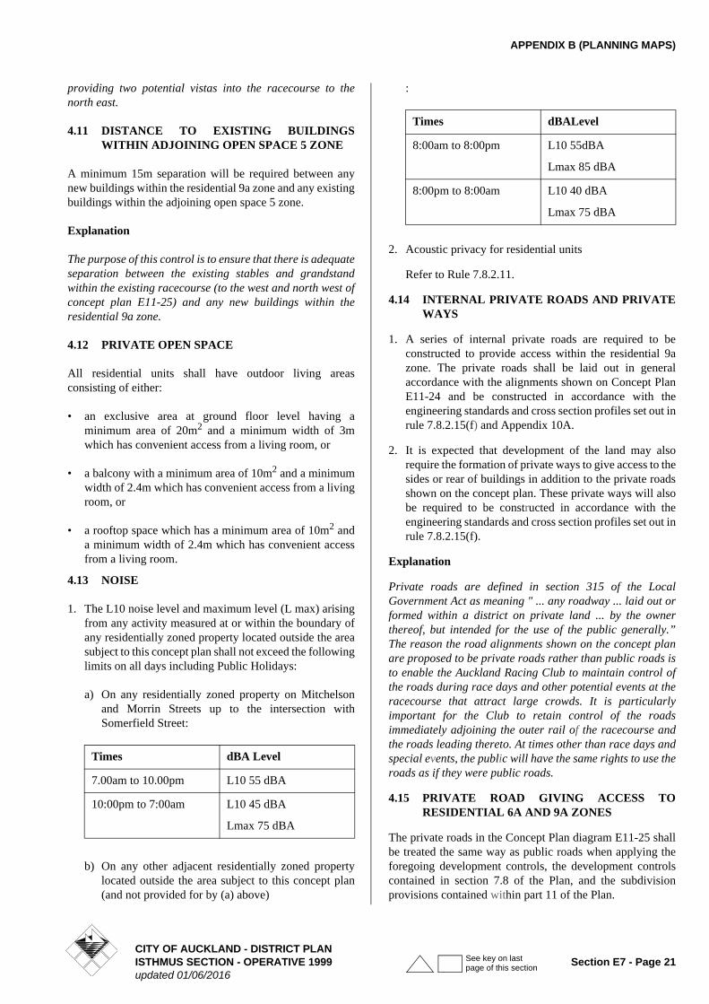
1. The L10 noise level and maximum level (L max) arising from any activity measured at or within the boundary of any residentially zoned property located outside the area subject to this concept plan shall not exceed the following limits on all days including Public Holidays:
a) On any residentially zoned property on Mitchelson and Morrin Streets up to the intersection with Somerfield Street:
b) On any other adjacent residentially zoned property located outside the area subject to this concept plan (and not provided for by (a) above)
:
2. Acoustic privacy for residential units
Refer to Rule 7.8.2.11.
4.14 INTERNAL PRIVATE ROADS AND PRIVATE WAYS
1. A series of internal private roads are required to be constructed to provide access within the residential 9a zone. The private roads shall be laid out in general accordance with the alignments shown on Concept Plan E11-24 and be constructed in accordance with the engineering standards and cross section profiles set out in rule 7.8.2.15(f) and Appendix 10A.
2. It is expected that development of the land may also require the formation of private ways to give access to the sides or rear of buildings in addition to the private roads shown on the concept plan. These private ways will also be required to be constructed in accordance with the engineering standards and cross section profiles set out in rule 7.8.2.15(f).
Explanation
Private roads are defined in section 315 of the Local Government Act as meaning " ... any roadway ... laid out or formed within a district on private land ... by the owner thereof, but intended for the use of the public generally.” The reason the road alignments shown on the concept plan are proposed to be private roads rather than public roads is to enable the Auckland Racing Club to maintain control of the roads during race days and other potential events at the racecourse that attract large crowds. It is particularly important for the Club to retain control of the roads immediately adjoining the outer rail of the racecourse and the roads leading thereto. At times other than race days and special events, the public will have the same rights to use the roads as if they were public roads.
4.15 PRIVATE ROAD GIVING ACCESS TO RESIDENTIAL 6A AND 9A ZONES
The private roads in the Concept Plan diagram E11-25 shall be treated the same way as public roads when applying the foregoing development controls, the development controls contained in section 7.8 of the Plan, and the subdivision provisions contained within part 11 of the Plan.
Times dBA Level
7.00am to 10.00pm L10 55 dBA
10:00pm to 7:00am L10 45 dBA
Lmax 75 dBA
Times dBALevel
8:00am to 8:00pm L10 55dBA
Lmax 85 dBA
8:00pm to 8:00am L10 40 dBA
Lmax 75 dBA
CITY OF AUCKLAND - DISTRICT PLANISTHMUS SECTION - OPERATIVE 1999 Section E7 - Page 21updated 01/06/2016
See key on last page of this section
APPENDIX B (PLANNING MAPS)
4.16 LANDSCAPING AREA
The area between Morrin Street and the building line running roughly parallel to it within the residential 9a zone is required to be maintained as an informal open space with the trees listed below protected under the tree modification or removal rule.
The trees are identified by separate numbers on Concept Plan diagram E11-25.
4.17 CARPARKING AND ACCESS THERETO
1. Parking spaces required for residential activities.
One bedroom unit- minimum 1 carpark per unit.
Two or more bedroom units - minimum 2 carparks per unit.
Visitor spaces - minimum 1 space per 5 units.
Loading spaces - nil.
2. Parking requirements for non residential activities.
Refer Part 12.
3. Parking dimensions and access for residential activities.
Shall be in accordance with rules 7.8.2.15 (b) (c) (d) (e) (f) and (g)- Driveways and Carparking.
4. Parking dimensions and access for non residential activities.
Refer Part 12.
Explanation
Although it is expected that an increasing proportion of commuter trips will be by public transport (thereby reducing the total average annual vehicle mileage per residential unit) this does not necessarily translate into lower per unit car ownership figures. It is expected that current average car ownership rates per unit will remain in the foreseeable future so long as the occupants seek to maintain their own flexible travel arrangements. The carparking requirements reflect these considerations.
The dimensions of the required residential carparking and access carriageways are the same as for the residential 8 zone.
5.0 MATTERS TO WHICH DISCRETION IS RESTRICTED
RESTRICTED CONTROLLED ACTIVITIES.
The Council's discretion is limited to the following matters:
• The length of stone wall to be removed
• The extent and manner in which the removed stone is proposed to be reused.
RESTRICTED DISCRETIONARY ACTIVITIES.
1. New buildings
The Council's discretion is limited to the following matters:
• Building layout
• Building design
• Energy efficiency
Plan Ref. No. Botanical Name
Common Name
1 Quercus robur English Oak
2 English Oakpalustris
Pin Oak
3 Platanus x acerifolia
LondonPlane
4 Quercuspalustris
Pin Oak
5 Ulmus sp. Elm
6 Ulmus sp. Elm
7 Removed
8 Platanus x acerifolia (x11)
LondonPlane
9 Ulmus sp. Elm
10 Corynocarpus laevigatus (x5)
Karaka
11 Ulmus sp. (x7) Elm
12 Platanus x acerifolia
LondonPlane
13 Quercus robur Oak
14 Corynocarpus laevigatus
Karaka
15 Acmena smithii (x11)
Lilly Pilly
16 Platanus x acerifolia (x2)
London Plane
17 Corynocarpus laevigatus
Karaka
18 Populus yunnanensis
Yunnan Poplar
19 Corynocarpuslaevigatus
Karaka
CITY OF AUCKLAND - DISTRICT PLANSection E7 - Page 22 ISTHMUS SECTION - OPERATIVE 1999
updated 01/06/2016
See key on last page of this section
APPENDIX B (PLANNING MAPS)
• Visual privacy
• Acoustic privacy
• Landscaping
• Private open space
• Carparking and access thereto
• Rubbish disposal
• Traffic and roading
• Pedestrian access
• Infrastructure
• Construction effects
• Potential effects on lava cavities
2. Tree modification or removal
a) The Council's discretion is limited to the following matters:
• The number of trees to be removed
• Amenity values of the residential 9a zone
• Amenity values of neighbourhood
• Alternative methods and locations available to the applicant for carrying out the work or activities
• Health and condition of remaining trees in the residential 9a zone
• Ground stability
b) Conditions may be imposed as part of any consent to an application; and may include the following:
• The requirement to pay a bond to ensure that a tree is not damaged or destroyed during the carrying out of pruning and maintenance or works or activities in the dripline area;
• The requirement to provide a replacement tree where a tree is removed or destroyed, where it is appropriate having regard to the amenity of the area.
For the avoidance of doubt, this section will apply to the exclusion of the general tree protection provisions contained in Clause 5C.7.3.3C of the District Plan.
6.0 ASSESSMENT CRITERIA
6.1 RESTRICTED CONTROLLED ACTIVITIES
1. Modifications to Stone Walls
• Whether the length of stone wall to be removed is consistent with the concept plan diagram or otherwise appropriate to achieve the purpose for which it is being demolished.
• Whether the removed stones are proposed to be reused to form wall returns or “gateways” in the vicinity of where the stone originated.
• Whether the style of any proposed new stone walls are intended to be the same or similar to the existing walls.
• Whether (in the case of the walls to be removed in the vicinity of the Mitchelson St./Morrin St. intersection) the residual stone walls provide adequate sight lines for traffic using the newly aligned road.
6.2 RESTRICTED DISCRETIONARY ACTIVITIES
1. Planned Residential Developments and Retirement Villages
Whether the proposal:
a) is in general accordance with Concept Plan diagram E11-25
b) is in general accordance with Figure 7.5A
c) provides views into the open space 5 zone from both the surrounding and internal roads,
d) will result in a semi continuous series of medium rise building facades which front onto, and have minimal setbacks from, the internal private road running generally parallel to the outer rail of the adjoining racetrack, and integrate closely with other existing and likely future developments within the zone,
e) will result in a variety of building heights both within and between areas A, B, and C,
f) provides access to any basement or outdoor car parking facilities from the sides or rear of buildings rather than their trackside faces,
g) provides adequately signposted public pedestrian access within the area, including a well formed route on the racecourse side of the private road paralleling the race track, and also pedestrian connections to public transport including between Derby Downs Place and the Greenlane railway station (via Mitchelson St. and The Avenue of Palms), and the Ellerslie Town Centre and railway station (via Morrin St.),
h) provides for the area between the open space 5 zone boundary (which coincides with the outer rail of the racecourse) and the adjoining parallel private road to remain visually unimpeded so as to preserve views from the carriageway and footpath within the private road into the racecourse,
(i) provides for at least one publicly accessible footpath to be constructed between the private road and outer racecourse rail in the event of an at-grade pedestrian crossing to the infield eventuating,
CITY OF AUCKLAND - DISTRICT PLANISTHMUS SECTION - OPERATIVE 1999 Section E7 - Page 23updated 01/06/2016
See key on last page of this section
APPENDIX B (PLANNING MAPS)
j) achieves a layout that substantially avoids adverse shadowing effects on existing residential properties within adjoining or nearby residential 6a zones between 0900-1500hrs in midwinter,
k) complies with the development controls specified for the zone or demonstrates that the purpose of the rules can be achieved by alternative means,
l) contains buildings which incorporate architectural relief in terms of their articulation and mass using elements such as recesses, pilasters, entrances, windows, balconies, and changes in surface texture, colour or other architectural detailing,
m) ensures that any rooftop projections - including towers, turrets, chimneys, lift towers, machinery rooms and water towers - are compatible with the basic architectural form of the building. (As a general rule any such rooftop projections should be enclosed in a single structure which is not box like in appearance),
n) incorporates good quality, durable exterior cladding materials and avoids highly reflective cladding,
o) maintains continuity of architectural form within each individual building and also between separate buildings both within the planned residential development and elsewhere within the zone. (Note - this criterion is not intended to encourage the development of identical building forms but to promote buildings which complement, rather than sharply contrast with one another),
p) incorporates windows which look across or overlook publicly accessible areas,
q) contains landscaping that will enhance the residential buildings, parking areas and adjacent private roads,
r) satisfactorily addresses the guidelines contained in Appendix 10A (Residential Design Guide for Developments in Residential 9 Zones).
s) includes a method of stormwater disposal to the satisfaction of the Council.
t) includes the detailed design of, or any necessary design change to, the following parts of the adjacent roading network identified on Concept Plan diagram E11-25:
• the T -intersection on the northern side of Morrin Street in the vicinity of Somerfield Street
• The realignment of Mitchelson Street
• The roundabout at the intersection of Mitchelson Street and Morrin Street
u) adequately assesses whether and to what extent works may be required in order to upgrade or modify intersections based on the extent to which traffic
modelling shows upgrading or modifying is required to accommodate the traffic flows arising from the proposed development. These intersections may include:
• Great South Road and Woodbine Avenue
• Great South Road and Kalmia Street
• Mitchelson Street and Walpole Street
• Main Highway and Walpole Street
• Ellerslie Racecourse Drive/Greenlane East intersection
• Greenlane and Ellerslie Panmure Interchanges
Note: if any of these intersections are included in council's programme of works, development contributions will be sought to assist in the funding of those works instead of conditions being imposed requiring works and services or financial contributions.
v) demonstrates that the traffic generated by the development can be safely and efficiently accommodated by the surrounding road network. In satisfying this criterion and criterion (u), the applicant must seek the views of NZTA and Auckland Transport, and provide those to the Council, and the Council must have regard to those views.
w) provides a travel plan, prepared in consultation with the NZTA and Auckland Transport, and to the Council's satisfaction, which includes measures to promote walking, cycling and public transport use and to reduce private car travel.
x) demonstrates that construction effects will be managed appropriately.
y) includes a protocol (to council's satisfaction) that sets out a suitable response to be followed in the event that lava cavity(ies) are discovered during construction.
2. Tree modification or removal
In assessing an application the Council shall consider the guidelines for the carrying out of works in the vicinity of trees contained in Annexure 5 and the following:
a) The residential 9a zone objective and first policy and in particular the extent to which the tree to be removed contributes to the existing amenities of the residential 9a zone and protects the surrounding environment from the adverse effects of development:
b) The necessity for carrying out the works;
c) Any alternative methods and locations available to the applicant for carrying out the work or activities;
CITY OF AUCKLAND - DISTRICT PLANSection E7 - Page 24 ISTHMUS SECTION - OPERATIVE 1999
updated 01/06/2016
See key on last page of this section
APPENDIX B (PLANNING MAPS)
d) The extent to which the tree or a part of the tree is, in the opinion of a Council arborist, structurally unsound;
e) Whether removal of the tree would be beneficial to the health and growth of existing, more appropriate trees on the site, taking into account the size, appearance, health and condition of those existing trees;
f) The impact of the tree on ground stability;
g) Whether or not the proposed activities within the dripline are in the opinion of the Council likely to damage the tree or endanger its health.
For the avoidance of doubt, this section will apply to the exclusion of the general tree protection provisions contained in Clause 5C. 7.3.3C of the District Plan.
7.0 SUBDIVISION
STATUS OF ACTIVITY
Subdivision is a discretionary activity within the residential 9a zone.
RULES
1. Part 11 applies to subdivisions within the residential 9a zone subject to the following.
2. Any application for the subdivision of land within the residential 9a zone in concept plan E11-25 will be required to be lodged no later than the application for building consent on the subject land, and preferably contemporaneously with the application for planning consent.
3. There are no minimum allotment sizes or frontage requirements within the residential 9a zone and the main factors to be taken into consideration when assessing any application for subdivision consent will be
a) the proposed means of providing legal and practical access to the allotment(s),
b) the way in which the proposed boundaries relate to the intended buildings and other features on the land (after taking into account the applicable development controls),
c) the extent to which the layout of any private road is in general accordance with concept plan diagram E11-25 (taking into account the relevant provisions of clause 11 of the Plan),
d) whether the proposed footpaths will link into the existing or proposed footpath/pedestrian network to ultimately provide continuous public pedestrian access between Derby Downs Place and the Greenlane railway station (via the reserve at the western end of Derby Downs Place, Mitchelson St. and The Avenue of Palms), and Ellerslie railway
station (via. the reserve at the end of Derby Downs Place and Morrin Street).
e) whether the proposed private road adjoining the racetrack includes a footpath of generous width on its outer (racetrack) side,
f) whether the proposed allotment(s) include sufficient private open space (including areas attached to individual units and jointly usable land) to meet the needs of residents, and
g) the extent to which the proposed subdivision helps achieve the overall objectives for the zone.
8.0 OTHER PROVISIONS
CONTAMINATION
The contamination provisions in clause 5E.7.4.2 of the Plan apply to the Concept Plan.
Development to be in accordance with the following -
1. All activities, works and buildings not fully described in the notice of requirement shall be the subject of either:
(a) a new notice of requirement, which shall be publicly notified, pursuant to Section 168A of the Resource Management Act; or
(b) a notice to alter the designation, pursuant to Section 181 of the Resource Management Act, which notice shall be publicly notified unless the alteration is minor and affected persons agree in accordance with the provisions of Section 181(3) of the Act.
2. Unless lapsed prior to 15 June 2010, the expiry date of this designation was extended to 1 November 2015, by S78 of the Local Government (Auckland Transitional Provisions) Act 2010.
See Diagram E12-06
Refer also APPENDIX 1 to the District Plan Text, “Schedule of Buildings, Objects, Heritage Properties or Places of Special Value, and those Subject to Heritage Orders.”
E12-03 COUNCIL CARPARK, REMUERA ROAD
E12-06 SCHEDULED BUILDING, 4 UPLAND RD, REMUERA
CITY OF AUCKLAND - DISTRICT PLANISTHMUS SECTION - OPERATIVE 1999 Section E7 - Page 25updated 01/06/2016
See key on last page of this section
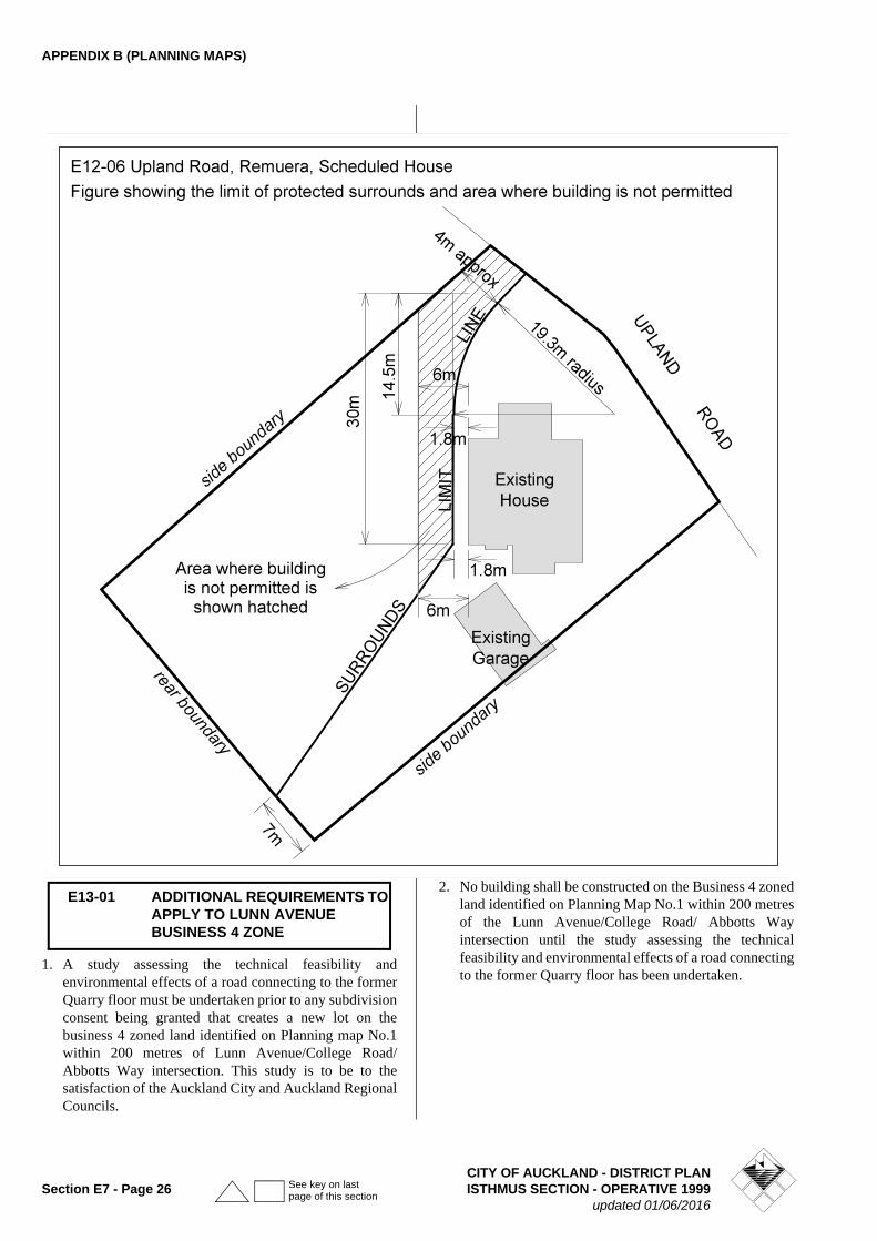
APPENDIX B (PLANNING MAPS)
1. A study assessing the technical feasibility and environmental effects of a road connecting to the former Quarry floor must be undertaken prior to any subdivision consent being granted that creates a new lot on the business 4 zoned land identified on Planning map No.1 within 200 metres of Lunn Avenue/College Road/Abbotts Way intersection. This study is to be to the satisfaction of the Auckland City and Auckland Regional Councils.
2. No building shall be constructed on the Business 4 zoned land identified on Planning Map No.1 within 200 metres of the Lunn Avenue/College Road/ Abbotts Way intersection until the study assessing the technical feasibility and environmental effects of a road connecting to the former Quarry floor has been undertaken.
E13-01 ADDITIONAL REQUIREMENTS TO APPLY TO LUNN AVENUE BUSINESS 4 ZONE
CITY OF AUCKLAND - DISTRICT PLANSection E7 - Page 26 ISTHMUS SECTION - OPERATIVE 1999
updated 01/06/2016
See key on last page of this section
APPENDIX B (PLANNING MAPS)
Development in this identified area to be in accordance with the rules that apply to the Residential 6b zone except as modified or added to by the following -
1 MAXIMUM HEIGHT: 8M.
(This limitation substitutes for the provisions of rule 7.8.1 .2A Maximum Height).
2 BUILDING IN RELATION TO BOUNDARY
(This rule substitutes for rule 7.81.3(b) Residential 6 Zones - Building in Relation to Boundary. Rule 7.8.1.3(d) continues to apply).
No part of any building shall be built so that it fails to comply with the following:
(i) All boundaries of a Residential 6b zoned site adjoining other Residential 6b zoned land shall comply with the following:
(a) The maximum height of a building on a boundary shall not exceed 3.6m.
(b) If not located on the boundary a 1m setback of any building from the boundary is required.
(c) Between the height 3.6m and 6.9m a building shall not exceed 0.3m for every 1 metre of height;
(d) Any part of a building over 6.9m in height shall not exceed a 45° recession plane, illustrated in Figure 7.6.
(ii) Where the boundary of the site abuts Open Space zoned land:
The maximum height of a building shall not exceed 3m and a 45° recession plane illustrated in Figure 7.4.
ExplanationAdmission of light to living and work areas is fundamental to our existence. It is an amenity, which we are not able to forego without compromising health and a sense of well being. In addition, admission of sunlight to sites gives property owners the opportunity to use sunlight as a renewable energy source. Access to sunlight can enable sunny outdoor spaces to be created or provide a means of passively heating homes. If sunlight is available it can also be used actively by solar receptors and water heaters.
Almost any development on a site will have an effect on the adjacent site in terms of access to light and the prospect of over dominance.
The extent of this effect will differ depending on the proximity of buildings to boundaries in relation to their size.
Within this identified area relatively liberal building in relation to boundary provisions have been offset by a reduced maximum height limit in order to achieve adequate protection of sites in relation to neighbouring building bulk and the admission of daylight and sunlight.
3 MAXIMUM BUILDING COVERAGE AND IMPERMEABLE SURFACE
(This control substitutes for rules 7.8.1.4 and 7.8.1.6)
The maximum percentage of net site area, which can be covered in buildings and impermeable surfaces, is 60%.
Explanation
The maximum building coverage and impermeable surface control limits the intensity and scale of development on a site, and is an important factor in ensuring that the city’s stormwater system can adequately cope with the development.
In this residential area, the building coverage and impermeable surface controls have been combined in order to give greater flexibility in building form and layout.
The maximum Building Coverage and Impermeable Surface control works in conjunction with the stormwater management requirements included in the subdivision assessment criteria to ensure that there is sufficient permeable surface on a site to slow down surface water runoff, and promote on-site stormwater management.
4 FRONTAGE LANDSCAPING
Planting in the required landscaping area under Rule 7.8.1.7A shall include a minimum of one specimen tree with a minimum mature height of at least 8m per lot. (Refer rule 7- subdivision)
5 EXTERNAL DESIGN OF BUILDINGS
• On sites fronting to an arterial road, buildings shall be designed so that:
a. No blank walls face the street;
b. Where a garage extends forward of the main façade by 3m or more, garage doors shall be located so that they do not face directly to the street.
• The maximum height of a front fence or wall shall not exceed 1.2 metres in height if solid or up to 2.0 metres in height if more than 50% transparent.
6 DEVELOPMENT CONTROL MODIFICATION
The foregoing rules (1 - 3) are development controls for the purposes of rules 4.2.1.3B Development Control Modifications and 4.3.1.2B, Development Control Modification.
E13-02 RESIDENTIAL 6 B ZONED LAND ADJACENT TO NGAHUE DRIVE
CITY OF AUCKLAND - DISTRICT PLANISTHMUS SECTION - OPERATIVE 1999 Section E7 - Page 27updated 01/06/2016
See key on last page of this section
APPENDIX B (PLANNING MAPS)
7 SUBDIVISION
Overall Design
• The design of the subdivision and development shall recognise:
- The dominant position of this block of land on the western rim of the former quarry.
- The transition this block of land forms between the residential and recreation zoned land to the west; and the comprehensive redeveloped former quarry to the east.
- The need to carefully design the layout of the subdivision and locate building platforms so as to promote high amenity standards within the completed development.
- The visual impact of the former quarry face.
Subdivision shall comply with the following additional design criteria:
A Open Space
• To the extent practicable, Public Open Space is to be overlooked by adjacent developments and be bounded by streets to ensure a high degree of personal safety;
• Public Open Space is to be designed to achieve well-defined active edges.
• Tree planting to be undertaken in accordance with the planting themes agreed with the Council.
B Connectivity
• Roading shall be designed as part of a logical and integrated structure of connected routes that are convenient and easy to understand, but which minimizes the number of new intersections with arterial and connector roads;
• Inter-connected pedestrian pathways are to be provided along roads with surrounding development designed to overlook them to ensure a high degree of convenience and personal safety.
C Amenity/Streetscape
• A comprehensive landscape plan shall be submitted for approval with the application.
• Street layouts are to be designed to promote visual interest and amenity of streetscapes in balance with provision for a safe and efficient transport function;
• Use of curves and the provision of grass berms at widths suitable for tree planting in addition to the standard requirements for footpaths and carriageways to Council requirement (except on College Road - quarry side a minimum berm of 1500mm will be required for planting)
• Applications for subdivision consent shall be accompanied by a landscape plan providing for street planting to be undertaken at the cost of the developer.
• Planting on sites created, as a result of the subdivision (required in rule 4) shall be undertaken to complement the landscape plan.
Note:The landscape plan should ensure that the choice of species shall be in accordance with the planting themes agreed with Council and will include one tree per frontage, that street planting should be of a minimum, size of pb95 and should be undertaken in the planting season prior to commencement of development of the residential sites - if this cannot be achieved then larger trees will be expected to be planted. The landscape plan should also address the provision of appropriate protection to ensure that the trees are protected during development - this may include the need for a bond and the provision for 2 years maintenance.
D Land Use
• Subdivision layout shall promote the achievement of development to the density levels provided for in the Residential 6b zone;
• Subdivision layouts shall be designed to achieve high standards of privacy, safety and security, and to facilitate developments with high standards of private open space and visual character.
E Roading Upgrades
• Any roads created or widened as a consequence of the subdivision must have a minimum 3.3 metre wide berm (including a 1.5m footpath) and a landscape or planting plan for the grass berm.
• College Road to be widened to provide a uniform 4.5 metre wide berm from the existing kerb line.
• A flush median of 2.8m width will be provided on College Road between Lunn Avenue and north of Norman Lesser Drive to facilitate right turning traffic movements.
Note:The cost of the above roading improvements must be met by the applicant.
F Wastewater
Wastewater management shall be achieved either:
• Through disposal to the quarry in the manner specified in an approved Overall Stormwater and Wastewater Management Plan for the whole quarry land area,
Or in the absence of an approved plan,
• A comprehensive design for a wastewater pump station and associated reticulation for the
CITY OF AUCKLAND - DISTRICT PLANSection E7 - Page 28 ISTHMUS SECTION - OPERATIVE 1999
updated 01/06/2016
See key on last page of this section
APPENDIX B (PLANNING MAPS)
development will be required for approval by the Council. This system shall be of sufficient capability and adaptability to suit the ultimate development of the entire quarry catchment.
Note:The Council will ensure that consent notices or other instru-ments if necessary shall be registered against the titles to the new lots created by subdivision and the title or titles to the remaining quarry land to ensure that wastewater is received and managed in an appropriate manner on an ongoing basis for the whole quarry land.
G Stormwater Management
Stormwater management shall be achieved either:
• through disposal to the quarry in the manner specified in an approved Overall Stormwater and Wastewater Management Plan for the whole quarry land area,
Or in the absence of an approved plan,
• a Low Impact Urban Stormwater Management Plan for the land covered by E13-02 consistent with Auckland Regional Council’s TP 124, is required to be submitted for approval by the Council.
Both the Low Impact Urban Stormwater Management Plan and the approved Overall Stormwater and Wastewater Management Plan for the whole quarry will, as a minimum, achieve the following objectives:-
• Minimise stormwater flows that are directed into public stormwater infrastructure, through the incorporation of private flow attenuation devices, consistent with Auckland City Council’s On Site Stormwater Management Manual (e.g. rainwater tanks, raingardens), on each site such that the peak stormwater flow is no greater than that from a site with 30% impervious coverage. The Council will not however require soakage in a Low Impact Urban Stormwater Plan where it can be shown that there may be geotechnical effects on the land concerned.
• Provide for the reuse of stormwater in residential households in a manner that is consistent with Auckland City Council’s On Site Stormwater Management Manual.
• Provide for the removal of 75% of suspended solids from stormwater runoff from roads and overland flow, including the removal of gross pollutants. (i.e street litter)
• The Overall Stormwater and Wastewater Management Plan, which will be developed for subsequent stages of development of the quarry floor, shall include treatment and removal measures for sediments and contaminants. The Overall Stormwater and Wastewater Management Plan shall
ensure that a minimum flow rate of 60 litres/second will be pumped to the Waiatarua Reserve, at current or improved water quality levels.
• The approval of either the Low Impact Urban Stormwater Management Plan for the area covered by E13-02 or the approved Overall Stormwater and Wastewater Management Plan for the whole quarry is required prior to any earthworks and/or building consents being lodged.
Note:The Council will ensure that consent notices or other instru-ments if necessary shall be registered against the titles to the new lots created by subdivision and the title or titles to the remaining quarry land to ensure that stormwater is received and managed in an appropriate manner on an ongoing basis for the whole quarry land.
Soakage will not be considered as an approved method of stormwater disposal on this land without a report from a chartered professional engineer on the effects of any pro-posed soakage disposal method showing that it will have no significant environmental impacts.
ExplanationThe former Mt Wellington Quarry is recognized as a major new development opportunity for which high standards of subdivision design should be required. At the College Road end of the former Quarry, development may be seen as an extension of the high amenity St John’s suburb. The area subject to these additional controls adjacent to College Road is a relatively narrow but long band of land, which sits at a higher level than the main Quarry area. It is for that reason that the Residential 6b zone intensity of development is considered to be appropriate. Nonetheless, it will be seen as an early stage of the wider redevelopment of the former Quarry and for this reason additional subdivision design criteria are proposed to ensure that design and amenity standards are high.
Because of its prominent situation here, Residential 6b zone development has potential to set design standards for future housing in the quarry redevelopment. Accordingly, the Council’s Urban Design Panel will assess the development as part of the planning process. Compliance with the foregoing additional design criteria will also ensure that development is visually integrated with existing development in the locality.
8 MINIMUM SITE AREA
(This control substitutes for rule 11.5.2.6A(i)).
• The minimum site area for new vacant site subdivision shall be as follows:-
(a) Front Corner or Through site (gross site area)300m2
CITY OF AUCKLAND - DISTRICT PLANISTHMUS SECTION - OPERATIVE 1999 Section E7 - Page 29updated 01/06/2016
See key on last page of this section
APPENDIX B (PLANNING MAPS)
(b) Rear site complying with the shape factor in rule 11.5.2.6.A(ii) (net site area)300m2
(c) Site not in compliance with the shape factor in rule 11.5.2.6 A (ii) (net site area)400m2
Redevelopment of the consented retirement village on the site located at 69-71 Ballarat Street, Ellerslie, legally described as Lot 1 DP 136033, by intensifying the building configuration within the area identified as Future Redevelopment Precinct A on Concept Plan (E13-04) and constructing buildings within the area identified as Future Redevelopment Precinct B on Concept Plan (E13-04) shall be a restricted discretionary activity
All the conditions of the existing resource consent for the retirement village on the site located at 69-71 Ballarat Street (granted by consent order of the Environment Court dated 7 April 2003) will be imposed on any new consent to redevelop the retirement village, with any modifications necessary or appropriate to reflect the increased development within the Future Redevelopment Precincts.
Note: The imposition of the existing conditions of consent (with any necessary or appropriate modifications) on the new resource consent to redevelop the retirement village will enable the new consent to replace the existing consent. It is expected that conditions including but not limited to Condition 1A(vi) - construction staging plan and Condition 1A(i) - architectural drawings will require modification.
An application for a restricted discretionary activity consent to redevelop the retirement village shall be assessed in terms of the additional site-specific assessment criteria set out below. The Council has reserved its discretion in respect of the matters covered by the assessment criteria below in terms of section 104C of the Resource Management Act 1991.
(a) Matters Covered in Conditions of Existing Consent
• The extent to which the conditions of the existing consent for the retirement village, which was granted by the Environment Court on 7 April 2003, require modification in light of the proposed development within the Future Redevelopment Precincts.
• Any matters covered by the conditions of consent for the retirement village granted on 7 April 2003 which require reassessment in light of the proposed development within the Future Redevelopment Precincts.
(b) Site Amenity
• A landscaping plan should be provided with the application.
• Any land not covered by buildings, pedestrian or vehicular access shall be landscaped and maintained to create and preserve a good standard of visual amenity and privacy for both the residents of the retirement village and for the surrounding residential properties. The development shall include suitable areas of open space available for the use and enjoyment of the users of the site that will also assist with this.
(c) Building Scale, Form and Layout
• The site layout and access to the on-site communal facilities/services should be designed having regard to the particular mobility restrictions and needs of the elderly and disabled.
• Concept Plan (E13-04) to apply to any proposed retirement village redevelopment.
(d) Carparking
• The location of parking and vehicle circulation areas should ensure that the effects of the proposal are internalised on the site and minimise impact on adjoining residentially zoned sites.
• The internal circulation of parking areas should be designed for safe and efficient vehicle circulation on-site.
(e) Location and design of vehicular and pedestrian access
• Vehicular and pedestrian access to and from the site must:
- Ensure adequate site distances;
- Prevent congestion caused by the ingress and egress of vehicles.
• Pedestrian access to and from the site should be sufficiently separated from the vehicle access to ensure the safety of pedestrians - this may be through segregated access, use of different paving or signage. Consideration should be given to the location of entry and exit points to the site and their relationship with existing pedestrian linkages, the existing road network, and any nearby public transport network/route such as bus stops.
• Consideration should be given to the provision and location of suitable traffic calming devices on the vehicle access ways, such as speed bumps, near the site boundary with the road reserve to ensure that vehicles are travelling at a slow speed when crossing the footpath.
E13-04 CONCEPT PLAN - 69-71 BALLARAT STREET, ELLERSLIE
CITY OF AUCKLAND - DISTRICT PLANSection E7 - Page 30 ISTHMUS SECTION - OPERATIVE 1999
updated 01/06/2016
See key on last page of this section
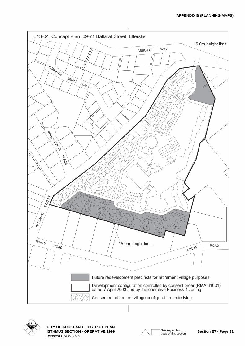
APPENDIX B (PLANNING MAPS)
CITY OF AUCKLAND - DISTRICT PLANISTHMUS SECTION - OPERATIVE 1999 Section E7 - Page 31updated 01/06/2016
See key on last page of this section
APPENDIX B (PLANNING MAPS)
(f) Reverse Sensitivity
• Whether the redevelopment or expansion of the retirement village is designed, and will be constructed and operated to minimise the potential for land use conflict between activities on adjoining or nearby Business 4 or Business 5 zoned land and the retirement village. In particular:
- The provision of appropriate separation and/or screening/landscaping between adjoining noxious or potentially hazardous activities on Business 4 or Business 5 land and sensitive activities within the retirement village.
- The design and materials are such that the internal noise levels will not exceed 35dBA (L10) in bedrooms and 45dBA (L10) in other habitable rooms, based on an external noise level of 70 dBA (L10) at the boundary of the site where it adjoins the Business 5 zone and 60 dBA (L10) where it adjoins the Business 4 zone. Where these noise levels can not be achieved in conjunction with open windows, an alternative source of ventilation is provided, so as to meet the internal noise levels specified in this criterion.
- The incorporation of suitable noise mitigation measures on the site to ensure that noise levels in new outdoor living and recreation areas associated with new retirement village housing do not exceed 55dBA (L10) (based on a level of 70dBA (L10) at the boundary of the site where it adjoins the Business 5 zone and 60dBA (L10) where it adjoins the Business 4 zone.
Note: reference may need to be made to Part 5E Hazardous Facilities in considering any development proposal on the site.
DOMINANT ACTIVITIES:
AREA A
PERMITTED ACTIVITIES
• Buildings used for recreation including clubrooms, changing rooms, first aid and toilet facilities
• Car parking areas
• Maintenance and storage facilities associated with permitted activities
• Organised sports and recreation, and associated grounds and playing fields
CONTROLLED ACTIVITIES
• Any permitted, controlled or discretionary activity which includes the construction of additional parking and where the total number of parking spaces on the site will exceed 615 but will not exceed 1250.
DISCRETIONARY ACTIVITIES
• Any permitted, controlled or discretionary activity which includes the construction of additional parking and where the total number of parking spaces on the site will exceed 1250.
AREA B
PERMITTED ACTIVITIES
• Education facilities(Note: see definition of education facilities later
below)
• Laboratories and research facilities
• Sport and health clinics
• Buildings or parts of buildings used for recreation and community purposes
• Office, workshop, factory and warehouse activities associated with education, community purposes, laboratories and research facilities
• Carparking areas and Carparking buildings
• Boarding houses / hostels for students attending the educational facilities
• Glasshouses, windmills, vineyards associated with education, community purposes, laboratories and research facilities
• Stormwater retention devices and tanks, vertical composting units
• Restaurants, cafes and eating places serving predominantly people working or studying at the educational facilities
• Healthcare services which
(a) serve predominantly people working or studying at the educational facilities
and / or
(b) are associated with research or training activities
• Community welfare facilities which
(a) serve predominantly people working or studying at the educational facilities
and / or
(b) are associated with research and training activities
• Childcare centres serving predominantly people working or studying at the educational facilities
E14-02 CONCEPT PLAN
CITY OF AUCKLAND - DISTRICT PLANSection E7 - Page 32 ISTHMUS SECTION - OPERATIVE 1999
updated 01/06/2016
See key on last page of this section
APPENDIX B (PLANNING MAPS)
Definition of education facilities
For the purposes of this concept plan, education facilities means land and / or buildings used to provide regular instruction or training in accordance with a systematic curriculum by suitably qualified instructors and includes ancillary administrative, cultural, health, retail and communal facilities. Ancillary retail may include sale of books, computers, and stationery where these are sold predominantly to staff and students.
CONTROLLED ACTIVITIES
• Construction of internal road and installation of services infrastructure. Assessed below and in terms of the criteria in Clause 10.7.2.2 CONTROLLED ACTIVITIES
• Overbridge as shown on the Concept Plan
• Any permitted, controlled or discretionary activity which includes the construction of additional parking and where the total number of parking spaces on the site will exceed 615 but will not exceed 1250
• Construction of new buildings, or external alterations and additions to existing buildings, located within 20m of the Morrin Road boundary.
DISCRETIONARY ACTIVITIES
• Any permitted, controlled or discretionary activity which includes the construction of additional parking and where the total number of parking spaces will exceed 1250
AREA C – EDUCATIONAL FACILITIES OVAL
PERMITTED ACTIVITIES
• Buildings used for recreation including clubrooms, changing rooms, first aid and toilet facilities
• Car parking areas
• Maintenance and storage facilities associated with permitted activities
• Organised sports and recreation, and associated grounds and playing fields
CONTROLLED ACTIVITIES
• Construction of new buildings, or external alterations and additions to existing buildings, located within 20m of the Morrin Road boundary.
• Any permitted, controlled or discretionary activity which includes the construction of additional parking and where the total number of parking spaces will exceed 1230 but will not exceed 2500
DISCRETIONARY ACTIVITIES
• Any permitted, controlled or discretionary activity which includes the construction of additional parking
and where the total number of parking spaces will exceed 1250
DEVELOPMENT CONTROLS
All development is subject to the development controls contained in Clause 10.8.1 ALL SITES SUBJECT TO CONCEPT PLANS IN THE SPECIAL PURPOSE 1 AND 2 ZONES of the Plan, except where otherwise specified below:
AREA A
The provisions of the Open Space 3 zone shall apply except:
1. Maximum Permitted Height
12m.
2. Special Height Limit
Subject to Volcanic Cone view protection controls.
3. Minimum Landscaped Permeable Surface
Not less than 90% of Area A shall comprise of landscaped permeable surface.
AREA B
1. Site Intensity
Overall Gross Floor Area Limitation
The maximum total gross floor area within Area B shall be 80,000m2.
Equivalent Full Time Student Limitation The maximum number of students shall not exceed 3,000 EFTS.
2. Front Yard
A 6-metre front yard is applied to the building platforms in Area B fronting Merton and Morrin Roads. (refer Concept Plan).
3. Maximum Permitted Height
12m.
4. Special Height Limit
Subject to Volcanic Cone view protection controls.
5. Landscaped Permeable Surface
Not less than 50% of Area B shall comprise of landscaped permeable surface.
6 Building development
Building development will be limited to Area B as recorded on the concept plan excluding the future road, the identified parking and stormwater detention areas and the required yards.
7. Building Coverage
No more than 30% of Area B shall be covered in buildings.
CITY OF AUCKLAND - DISTRICT PLANISTHMUS SECTION - OPERATIVE 1999 Section E7 - Page 33updated 01/06/2016
See key on last page of this section
APPENDIX B (PLANNING MAPS)
8. Landscaping
No less than 60% of the 6-metre front yard shall comprise landscaped permeable surface. This landscaping requirement shall apply separately to each road frontage.
A detailed landscape plan, including implementation and maintenance, shall be submitted to the Council with any proposal to undertake development on the site.
(i) The plan shall include details of plant sizes at the time of planting and intended species.
(ii) The landscaping shall be implemented and maintained in accordance with the approved landscaping plan within the first planting season following the completion of the subject development.
(iii)The planting shall be in accordance with the following standards:
• Specimen trees are to be planted in the immediate vicinity of buildings to provide human scale and to reduce the visual impact of the buildings .
• Clear sight lines from (pedestrian and vehicular) access routes to buildings are to be retained and incorporated into planting design.
• All areas not identified as building platform, access, road, parking areas, path or hard landscape spaces (quadrangles or courtyards) are to be lawn, groundcover, shrubs or specimen trees.
• Planting shall comprise species that are tolerant to the local conditions and climate and shall be predominantly native species. Unifying planting shall be used to define pedestrian and vehicle routes.
• Planting shall be designed and laid out, having regard to pedestrian safety, particularly in terms of visibility (including at night).
• Specimen trees shall be provided for in spaces between carparks to a minimum density of one tree per 10 carparks.
• Linkages to the open space network shall be retained and enhanced.
9. Parking
One space for every 3 Equivalent Full Time Students (EFTS) and 1 space for every 2 fulltime equivalent staff members or other personnel employed within Area B.
Parking spaces and carparking buildings may be located in the parking areas shown in the Concept Plan and in any other part of the building platform.
Clause 12.9.1.1A Rule: Controlled activities shall not apply.
10. Tree Protection
Trees are protected in accordance with the provisions of Clause 5C.7.3.3C.
11. Stormwater Disposal
Stormwater runoff from parking and vehicle trafficked areas shall be collected and treated in stormwater detention / on-site management facilities before it enters the public stormwater reticulation system. Grass swales may also be used where practicable for treatment purposes. Stormwater may be collected for redistribution on site for irrigation and other purposes.
12. Internal noise levels for boarding houses / hostels
The internal noise levels should not exceed 35dBA (L10) in bedrooms and 45dBA (L10) in other habitable rooms, assuming that outside noise levels measured 1m from the façade of the building is 65dBA (L10).
These levels shall be achieved whilst adequate ventilation (to the requirements of the Building Regulations 1992) is achieved.
The noise shall be measured with a sound level meter complying at least with the International Standard IEC 651 (1979): Sound Level Meter, Type 1.
Developments will be required to meet Clause G6 of the Building Code.
AREA C - EDUCATIONAL FACILITIES OVAL
The provisions of the Open Space 3 zone shall apply except:
1. Maximum Permitted Height
12m.
2. Special Height Limit
Subject to Volcanic Cones View Protection
3. Tree Protection
Trees are protected in accordance with the provisions of Clause 5C.7.3.3C except that the removal of trees for the establishment of the proposed open space shall be a permitted activity.
4. Minimum Permeable Surface
Not less than 90% of Area C shall comprise of landscaped permeable surface.
CONTROLLED AND DISCRETIONARY ACTIVITY ASSESSMENT CRITERIA
Criteria for assessment of construction of internal road and installation of services infrastructure:
The following matters will be considered:
(a) The provision of a Construction Management Plan relating to the construction of the proposed internal ring road.
CITY OF AUCKLAND - DISTRICT PLANSection E7 - Page 34 ISTHMUS SECTION - OPERATIVE 1999
updated 01/06/2016
See key on last page of this section
APPENDIX B (PLANNING MAPS)
The plan shall include but not be limited to:
(i) Details of the site manager, including contact details;
(ii) The location of a large notice board on the site that clearly identifies the name, telephone number and address for service of the site manager;
(iii)Means for the protection of trees and services to ensure that no damage occurs during the construction period;
(iv)Measures to be adopted to maintain the site in a tidy condition in terms of disposal and storage of rubbish, storage and unloading of building materials and similar construction activities;
(v) Measures to be adopted to ensure that pedestrian access past the site on the public footpaths is the same and is not obstructed during construction works;
(vi) Location of workers conveniences;
(vii) Ingress and egress to and from the site for vehicles during the construction period.
(b) The applicant shall provide details for the design and treatment of stormwater runoff from the proposed internal road.
The following matters will be considered:
(i) The extent to which one or more of the following methods are employed:
• The on-site treatment of stormwater;
• The use of grass swales, permeable paving surfaces and other techniques to reduce stormwater discharged from the site;
• The collection of stormwater for redistribution on the site for irrigation purposes.
Refer also Clause 10.7.2.2 for additional assessment criteria for controlled activities within the Concept Plan area.
Criteria for ‘any permitted, controlled or discretionary activity which includes the construction of additional parking and where the total number of parking spaces will exceed 615 but will not exceed 1250’ and for ‘any permitted, controlled or discretionary activity which includes the construction of additional parking and where the total number of parking spaces will exceed 1250’
(a) The extent to which adequate measures are provided to avoid, remedy or mitigate adverse effects from traffic generated by activities on the site. This may include road upgrading measures such as:
(i) signalisation of the site entrances
(ii) signalisation of the roundabout at the intersection of Merton Road and Morrin Roads
(iii)work at any other intersections. For example work may be required at the following intersections:
• Merton Road / College Road
• Merton Road / Apirana Avenue / Pt England Road
• Merton Road / Howard Hunter Avenue
• College Road / Abbotts Way / Lunn Ave
• Abbotts Way / Grand Drive
• Morrin Road / Jellicoe Road
(b) The Council may impose conditions on the resource consent requiring the applicant to undertake or make a financial contribution to the road upgrading works outlined in (a) above. This is subject to the following:
(i) the cost of signalising or otherwise upgrading site intersections on Morrin and Merton Road will be fully met by the applicant
(ii) other financial contributions imposed on the applicant for road upgrading will be a portion of the cost of the work based on the proportionate volume of educational facilities traffic using the particular road or intersection.
(c) The Council may impose conditions on the resource consent requiring the applicant to undertake an ongoing review of the traffic effects arising from the use of the site. This may include a requirement for the applicant to undertake regular traffic surveys at its own expense. The surveys would be based on the volume, delay and accident warrants for traffic signals as contained in NZS 5431 or such other surveys as may be approved by the Council.
(d) Refer also to clause 12.9.1.2A Criteria for assessing controlled activities.
Criteria for the assessment of construction of new buildings, or external alterations and additions to existing buildings, located within 20m of the Morrin Road boundary .
The Council has restricted its control to ensuring that:
(a) The building has been designed with a positive orientation to Morrin Road
(b) The building design visually reinforces the major access points (both vehicular and pedestrian)
(c) The building façade fronting Morrin Road is articulated to provide a varied and interesting frontage
(d) Sufficient glazing is incorporated in the building façade fronting Morrin Road to achieve a positive relationship between the building and the street
(e) Planting within the front yard is used to complement the building frontage and its relationship to the street.
CITY OF AUCKLAND - DISTRICT PLANISTHMUS SECTION - OPERATIVE 1999 Section E7 - Page 35updated 01/06/2016
See key on last page of this section
APPENDIX B (PLANNING MAPS)
Conditions may be imposed in respect of the above matters.
Explanation
E14-02 was a concept plan tailored to guide development and use of the University of Auckland’s Tamaki Campus. The University’s landholdings included land on the western and eastern side of Morrin Road. The western land has been purchased by Auckland Council for public open space and is known as Colin Maiden Park. The University signaled its intention to dispose of the eastern land from which its Tamaki Campus operates via a private plan change request which introduced a new overlay to AppendixB Additional Limitations, Controls and Diagrams, refer E14-10.
CITY OF AUCKLAND - DISTRICT PLANSection E7 - Page 36 ISTHMUS SECTION - OPERATIVE 1999
updated 01/06/2016
See key on last page of this section
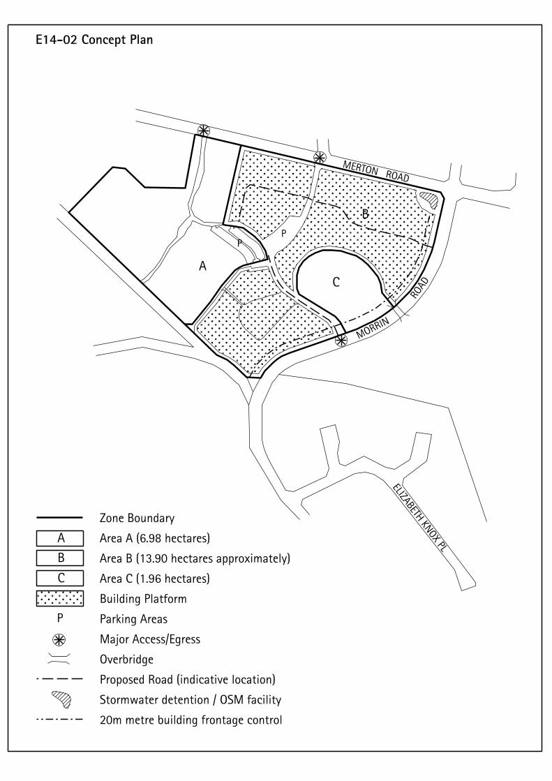
APPENDIX B (PLANNING MAPS)
CITY OF AUCKLAND - DISTRICT PLANSection E7 - Page 37 ISTHMUS SECTION - OPERATIVE 1999
updated 01/06/2016
See key on last page of this section
APPENDIX B (PLANNING MAPS)
The following provisions apply to the part of the former Mt Wellington Quarry rezoned by order of the Environment Court in August 2007. As identified on the planning maps, this includes approximately 50 ha of land within the former quarry floor, to the south and north east of the site. Provisions E14-07 apply to the rest of the quarry.
A. Specific Considerations
The former Mt Wellington Quarry is a 110-hectare block being the largest brown field site in the Auckland City area. It has been identified by the Regional Growth Strategy and by council as a strategic site in terms of managing the City's growth.
Development of the overall site has been occurring in stages since 2001 and the following provisions provide the development framework for approximately 60 hectares of land within the former quarry floor.
Further development of the quarry will continue to be staged and includes the following features:
• a mix of housing styles from stand alone housing typologies to 5-6 storey apartment buildings;
• a small scale town centre, with an upper limit of 12,000m² gfa of non-residential activity (including a limit of 4500m² for retail activities comprising 4000m² for retail activities and 500m² for a superette type activity);
• two major boulevards providing a particular focus within a roading hierarchy that range from minor local roads to collector road levels and which provides for vehicles, cyclists and pedestrians;
• a primary school;
• a public open space and reserve network that provides for a range of recreational opportunities and integrates with other spaces outside the site; and
• a lake system adjacent to the cliff faces that will treat stormwater within the sites, as well as allowing the reticulated non-potable use of lake water and provide a long-term viable habitat for a range of bird species.
It is anticipated that the proposed redevelopment of the whole quarry floor will bring a population of around 6,000 persons into the area.
A Structure Plan has been developed to illustrate the broad development patterns for the site. All subdivision and development must be in accordance with that Structure Plan, or be considered and assessed as a discretionary activity. A Master Plan has also been developed to provide greater detail in implementing development. The Master Plan will evolve
as development occurs, while the Structure Plan has been included within the District Plan to provide certainty to the community as whole with respect to the general form of development.
The built form and subdivision of private land in the quarry will result from both the residential design guide that is applied to areas zoned Residential 8 (the zone that will be applied to the bulk of the land under the District Plan), a building design guide for the Business 2 zoned land and through the Master Plan specifically developed for the quarry.
Each new application for consent for subdivision or development will be required to supply a Master Plan report which describes how the proposal is in accordance with the current version of the Master Plan. Where there are inconsistencies between the proposed subdivision or development and the current version of the Master Plan, the Council may impose conditions of consent to address any potential effects as a result of those inconsistencies.
Subdivision and development of the quarry will be undertaken in such a way to ensure that the Residential 8 zoned land will integrate with the land not zoned Residential 8. The tools for achieving this include the Master Plan (which includes a streetscape plan and design guidelines) that will provide guidance when developing the public areas in the quarry and the Mt Wellington Quarry Code of subdivision and development. In addition, the Council will also have development and subdivision proposals assessed by the Urban Design Panel - an independent group of design professionals.
Roading standards have been included in the subdivision assessment criteria to ensure that a balance is achieved between providing for the movement of people and vehicles (i.e. pedestrians and cyclists are catered for in addition to vehicles) and to facilitate the introduction of public transport into the quarry area. The Council may seek to impose conditions that require review of parking and traffic generation from the land after development is occupied. This will occur when the Council accepts narrower road widths in residential areas that are a departure from the Council's traditional approach to roading.
Where possible, the Council will work with landowners, the Auckland Regional Transport Authority (ARTA) and the Auckland Regional Council (ARC) to develop opportunities for increased use of public transport and other transport initiatives to reduce reliance on the car. However, provision is also made through financial contributions for mitigation of off-site roading effects that are directly attributable to the development.
Open space standards are also included in the subdivision assessment criteria to ensure that the future residents have access to a range of high standard open space areas. Other criteria address issues related to the quality of other public assets in the area - namely road berms and walkways.
E14-03 MT WELLINGTON QUARRY - NORTH EAST AND SOUTH
CITY OF AUCKLAND - DISTRICT PLANSection E7 - Page 38 ISTHMUS SECTION - OPERATIVE 1999
updated 01/06/2016
See key on last page of this section
APPENDIX B (PLANNING MAPS)
Quarrying the land has resulted in irreversible changes to natural processes such as ground water flow and has resulted in impacts on the Maungarei /Mt Wellington cone of significance for iwi and the community as a whole. Additional criteria are in place to reflect a management approach to minimise further adverse effects on these key elements and to address the potential impacts of future development that will occur in the quarry floor on the surrounding area.
As a consequence of the quarrying activity the land receives ground water from the neighbourhood (higher ground) and the quarry has historically been required to provide stormwater quality improvement before the water is pumped to Waiatarua. This water is of use to the Waiatarua wetland and the Remuera golf course. It is therefore critical to ensure that any development within the former quarry area does not adversely impact on the availability of recycled stormwater for these areas.
Council has information that identifies the potentially widespread impact if pumping of the ground water from the quarry ceased. This includes the potential for land within the quarry floor below RL 27 m to be flooded and also substantial flooding that could result in Ellerslie, Panmure and Penrose.
Prior to any subdivision, earthworks and/or building consents being approved and development occurring in any area of the quarry, the Council must be satisfied that:
• pumping to Waiatarua wetland and the Remuera Golf Course will continue; and
• any disposal of stormwater from recontoured higher areas to the lower levels of the quarry and beyond will occur in an approved manner.
B. Additional Requirements
1. Development (Land Use)
General Rules for Development
a) In addition to meeting the requirements of the Residential 8 zone, development will be required to demonstrate that it is in accordance with the Structure Plan (Figure E14-03(a)).
Development that is not in accordance with the Structure Plan is a Discretionary activity.
b) Every application for land use consent shall include a report which describes the extent to which the proposed development is in accordance with the current version of the Master Plan.
General Assessment Criteria for Development
a) The extent to which the proposal is in accordance with the current version of the Master Plan.
b) Where the Structure Plan provides for changes in the permitted height of residential buildings at street frontages, building design solutions should be found to ensure a satisfactory streetscape outcome.
Note: Where further iterations of the Master Plan are proposed consideration should be given to creating changes in building height at the back of blocks rather than along street frontages as one factor in the Master Plan design process.
2. Minimum Site Area (This rule substitutes for rule 11.5.2.6A(i))
a) The minimum site area for a new vacant site shall be 160m2 unless previously approved by the appropriate land use consent pursuant to Rule 7.7.5.3.Subdivision
General Rules for Subdivision
a) All subdivision is a Restricted Discretionary activity where it is in accordance with the Structure Plan.
Except as provided for by section 94C(2) of the Act, all applications for Restricted Discretionary subdivision consents will be considered without public notice or the need to obtain the written approval of or serve notice on affected persons.
Subdivision that is not in accordance with the Structure Plan is a Discretionary activity.
b) Every application for subdivision consent shall include a report which describes the extent to which the proposed subdivision is in accordance with the current version of the Master Plan.
General Assessment Criteria for Subdivision
Every application for subdivision consent shall be assessed in light of:
a) The additional requirements and assessment criteria set out in clauses 3.1-3.7 below;
b) The extent to which the proposal is in accordance with the latest version of the Master Plan; and
c) The criteria in Part 11 of the Plan - Subdivision, the Mt Wellington Quarry Code of subdivision and development and Elements 1-4 of the Residential Design Guideline for Developments in Residential zones in Specified Growth Areas (Refer Appendix 10).
3.1. Stormwater
3.1.1 Rules in Relation to Stormwater
a) Each subdivision proposal shall be consistent with and give effect to the Stormwater Concept Plan at Figure E14-03(c), the provisions of any relevant Comprehensive Catchment Permit to Discharge
CITY OF AUCKLAND - DISTRICT PLANISTHMUS SECTION - OPERATIVE 1999 Section E7 - Page 39updated 01/06/2016
See key on last page of this section
APPENDIX B (PLANNING MAPS)
Stormwater from and within the Ellerslie-Waiatarua Catchment (currently, ARC Consent No. 9610854), any Overall Stormwater and Wastewater Management Plan for the quarry approved by the Council and relevant provisions of the Code of subdivision and development for the quarry. Each subdivision proposal shall also be consistent with the obligations of the Grantor under Easement E16791278.18 dated 14 March 2006, and any subsequent variations or relevant new easements in favour of the Council or its agencies.
b) The s.224 certificate for any subdivision that creates individual titles for residential activities (including stand alone residential units, terraced housing or apartments, except for the areas set out in the Stormwater Trigger Exemption Plan at Figure E14-03(d)) in respect of land to which this provision applies will not be issued until the stormwater control/treatment pond and pumping system shown on Figure E14-03(c) has been constructed and made operational and a transition plan (which may include temporary pumping measures) to transfer detention from the temporary (existing) detention area to the new stormwater control treatment pond and pumping system has been prepared to Council's satisfaction. Until the stormwater control/treatment pond and pumping system shown on Figure E14-03(c) has been constructed and made operational, no development shall encroach within the area inundated by the 1% AEP flood level measured from the temporary (existing) ponds.
c) Stormwater runoff from the site shall be fed to and treated by a stormwater control pond. This pond, together with allied treatment measures, shall be capable of the following:
i) Absorbing the runoff in a 1% AEP storm event without any flooding of habitable floors within the development;
ii) Treating the stormwater to a standard which ensures that there are no adverse effects on the performance of the Waiatarua wetland, in terms of both water quantity and quality and that ARC TP10 is complied with;
iii) Avoiding any water quality problems under hot or dry weather conditions;
iv) Being pumped-out to be completely empty, in the event that this may be needed; and
v) Adequately safeguarding public health issues which arise with access to the pond.
d) Each application for subdivision consent shall incorporate a reticulated non-potable water supply system serving all of the lots, using water drawn from
the stormwater pond. This system shall be approved by the Medical Officer of Health and Metrowater.
Note• The water sensitive design features shown on
Figure E14-03(c) (comprising the likes of swales and areas of roof water separation) are an integral component of the development of the quarry land.
• The provision of water to Waiatarua wetland is also an integral component of the development of the quarry land and a key element of the stormwater control/treatment pond and pumping system shown on Figure E14-03(c).
3.1.2 Assessment Criteria in Relation to Stormwater
a) Every application for subdivision consent shall be accompanied by a comprehensive assessment of the stormwater disposal requirements for the subdivision and shall address:
i) The extent to which the proposal is consistent with the General Requirements in relation to Stormwater set out in Clause 3.1.1 above;
ii) The measures to ensure that the area containing the existing stormwater control/treatment pond and pumping system will be protected from adverse effects including sediment runoff from any earthworks and development occurring in its vicinity during construction , including earthworks and development required to construct and operate the pond and pumping system;
iii) The measures to ensure that the existing pond/pumping arrangement will remain in operation and continue to perform effectively while the new stormwater conveyance systems and the new pond/pump station are constructed;
iv) The measures to ensure that the "switch over" from the existing pond/pumping arrangement to the new pond/pump station will not put at risk the ability to maintain the groundwater levels and the flood and water quality control standards;
v) The measures to ensure that water quality and flow consistent with existing ARC discharge consents will be maintained during construction. In this respect, sediment generated during the construction phase shall be controlled according to the provisions of both the consent issued by the Auckland Regional Council (currently ARC Consent No. 31510) and the provisions of ARC TP90;
CITY OF AUCKLAND - DISTRICT PLANSection E7 - Page 40 ISTHMUS SECTION - OPERATIVE 1999
updated 01/06/2016
See key on last page of this section
APPENDIX B (PLANNING MAPS)
vi) The measures to ensure the removal of 75% of suspended solids from stormwater runoff from roads and overland flow, including the removal of gross pollutants. (i.e. street litter) prior to leaving the quarry;
vii) The measures to ensure that sites to be developed within the former quarry land will be protected from flooding if pumping fails. In this respect, the pumping system delivering water from the pond to Waiatarua wetland should be designed with provision for back-up generation to power the pumps so as to ensure that flooding in extreme events does not extend beyond the confines of the pond area and put at risk habitable dwellings in the pond vicinity. The stormwater control system is reliant on pumping, therefore an emergency evacuation plan will be required as a condition of any subdivision consent for land in the quarry floor covered by the section 293 application.
viii) The measures to ensure the provision of water to Waiatarua wetland;
ix) All buildings to be developed on the site shall have covenants registered against the certificates of title forbidding the use of roofing materials containing copper or zinc; and
x) As a condition of any subdivision consent for land in the quarry floor covered by the section 293 application, a groundwater control/monitoring system shall be required to ensure that any contaminants in groundwater that could have adverse effects on the performance of the stormwater control/treatment pond and pumping system are detected and controlled.
Note
• The Council will ensure that consent notices or other instruments if necessary shall be registered against the titles to the new lots created by the subdivision and the title or titles to the remaining quarry land to ensure that stormwater is collected and managed in an appropriate manner on an ongoing basis for the whole quarry land. Easement E16791278.18 dated 14 March 2006 in favour of the Council and Metrowater achieves this in part.
• Soakage will not be considered as an approved method of stormwater disposal on this land.
3.2. Utilities
a) Any above ground utility structures should comply with the provisions of the District Plan and be consistent with the Mt Wellington Quarry code of subdivision and development.
b) The provision of underground infrastructure is required to demonstrate how on-going maintenance and upgrading will be undertaken with minimal physical disruption.
3.3. Street planting and landscape
a) Each application for subdivision of the quarry land being considered by Council shall be accompanied by a detailed and comprehensive landscape plan for the streetscape for approval by the Council. This landscape plan shall be consistent with the Code of subdivision and development for the quarry.
This plan shall include:
i) details of plant species, locations, and planting regime;
ii) an assessment of any linkages and themes required for an overall approach to street planting within the former quarry;
iii) innovative solutions which fit with streetscape typologies (eg planting within parking build outs, permeable surfaces, medians etc);
iv) an implementation and maintenance programme for a two year period.
b) Street planting is to be in accordance with minimum distances set out in Table 1 below. In addition there is to be a minimum of one specimen tree per residential property frontage planted as close as possible to the front boundary. Indication of the location and width of vehicle crossings is to be made in conjunction with proposed planting.
Table 1: Minimum Distances between Street Trees
Note: Landscaping and planting plans should only be developed following further consultation with interested local iwi and seek to enhance ecological linkages.
3.4. Subdivision Layout
a) Specific engineering assessment shall be undertaken for lots created for building and reserve purposes within 20 metres of former quarried rock faces within the former quarry floor area. Such assessment shall take into account how the buildings will achieve defensive building design and still achieve good urban design outcomes, appropriate building and amenity area setback distances from the quarry face,
1.2 Road Type District Arterial
Connector Collector Local
Minimum distance between trees
12.0m 12.0m 12.0m 10.0m
CITY OF AUCKLAND - DISTRICT PLANISTHMUS SECTION - OPERATIVE 1999 Section E7 - Page 41updated 01/06/2016
See key on last page of this section
APPENDIX B (PLANNING MAPS)
the potential hazard from rock falls as well as long-term stability of the rock face behind and above development and public open space areas. The information required, for approval by Council, includes:
i) detailed geotechnical information on stability and recommended set-backs from the quarry walls. This could include further exploratory holes to determine the nature and depth of materials overlying the basalt rock that is exposed in the quarry faces;
ii) detailed geotechnical/geological mapping of faces and an assessment of jointing patterns as they may affect the stability of individual rock pieces together with a risk assessment and specific recommendations for remediation of any potential hazards.
b) Pedestrian linkages outside of the street network (excluding the pedestrian trail along the former quarry faces) should be minimised. Where they are necessary they shall:
i) clearly demonstrate why the walkway is necessary and why this link can not be made as part of the street network;
ii) have a minimum width of 3.0m;
iii) not exceed 50 metres in length;
iv) be designed to have neighbouring lots fronting and overlooking the pedestrian access way;
v) restrict the height of fences on neighbouring lots to 1.2 metres.
c) No sites, other than corner sites, shall have vehicle access from more than 1 road (road in this case includes mews or laneways).
d) Whether sites that are created to allow development of multi-unit development are designed in enable compliance with the Residential 8 urban design rules and assessment criteria, including those relating to buildings fronting the road.
e) It is recognised that there will be a mix of housing types within the quarry. There is a place for detached dwellings on single sites under the Residential 8a zone but these will be assessed to ensure that design and appearance considerations are adequately addressed.
f) Whether the alignment of streets and location of open spaces reinforces key views to Maungarei (Mt Wellington) from both within the former quarry and from the surrounding area. This shall be demonstrated with photomontages.
g) Whether the site layout of the subdivision is integrated with the neighbourhood and adjoining uses to ensure:
i) continuity of the built fabric, particularly in relation to streetscape;
ii) energy efficient and environmental sensitive layouts;
iii) safe functional environments within developments;
iv) landscaping that provides a pleasant, safe and attractive living environment;
v) safe and convenient vehicle and pedestrian access to buildings on a site;
vi) parking areas do not intrude on the character of the streetscape;
vii) internal circulation within the development provides safe and efficient use of the site;
viii) adequate and convenient parking is provided for residential, visitor and service vehicles.
Note: Detailed specification will be required, for approval by Council at Building Consent stage, of all earthworks and for those areas with non-engineered fill a plan of how these are to be treated (either removed or re-compacted) are to be lodged with the Building Consent application.
3.5. Parks and Reserves
All public open space created as a consequence of subdivision should be consistent with the open space network plan for the quarry to be agreed with Council and lodged as part of the first application for subdivision of land within the quarry floor covered by the section 293 application. This plan will consider the following:
a) Provision of public open space at a level of frequency to provide neighbourhood amenity. One way of achieving this could be that all lots created should be within 400 metres walking distance from an area of public open space.
b) Residents shall have direct, clear and simple pedestrian access to a range of different sized and type of areas of public open space within their neighbourhood.
c) Wherever possible, lots intended for residential units shall not have a rear or side yard adjoining land intended to be vested as reserves.
d) Unless determined otherwise with a Private Development Agreement, financial contributions from residential development are as specified in Part 4B of the District Plan. In the case of the Mt Wellington Quarry the contribution will be sought in the form of land to be vested as reserve is preferred as
CITY OF AUCKLAND - DISTRICT PLANSection E7 - Page 42 ISTHMUS SECTION - OPERATIVE 1999
updated 01/06/2016
See key on last page of this section
APPENDIX B (PLANNING MAPS)
the contribution, however the Council will consider cash in certain circumstances.
e) Any land that it is proposed to vest in Council as reserve should meet the appropriate assessment criteria for suitability for reserve purposes as set out in section 9.9.2 of the Plan (Particular Criteria for the Acquisition of Reserves). In addition any such land proposed as reserve should be assessed against the following criteria:
i) Shall be consistent with the open space network plan for the quarry;
ii) Whether the land adds to proposed open space network within the quarry and is useable for a variety of public recreation and leisure activities;
iii) Whether the land provides any flexibility to accommodate changing community needs;
iv) Whether active edges to all public spaces are promoted;
v) Whether the land is visible from and well connected to the street network and significant features of the quarry;
vi) Whether the scale and configuration of the land is appropriate to the intended reserve function;
vii) Whether the land contours, aspect and level of shelter are compatible with the intended use;
viii) Whether the land contributes to the open space network by maintaining and enhancing the existing cultural, environmental and landscape values of the area and providing a means of protecting areas of natural significance;
ix) Whether the development complies with Auckland City Crime Prevention through Environmental Design Guidelines including having clear visibility along their entire length with entrance and exit points visible at all points along the route.
Note: Landscaping and planting plans should only be developed following further consultation with interested local iwi and seek to enhance ecological linkages.
3.6. Wastewater
Refer to rule 11.5.4 of the District Plan
3.7. Roading and Parking
3.7.1 General Requirements in Relation to Roading and Parking
a) Roads shall be provided in accordance with the Road Classification Plan in Figure E14-03(b). Any subdivision which includes roads not in accordance
with the Road Classification Plan is a discretionary activity.
b) All roads shall be constructed in a manner consistent with the relevant standards contained in Table 2 "Cross section standards for roads within the former Mt Wellington Quarry" of the Plan and relevant provisions of the Mt Wellington Quarry code of subdivision and development. Bus stops shall be provided at the locations outlined in the "Public Transport Demand Modelling Supplementary Report" dated February 2006.
c) Every application for subdivision consent shall include a report by an engineer(s) which demonstrates the consistency of the roading works proposed as part of that subdivision with the Road Classification Plan, Table 2 and the Mt Wellington Quarry code of subdivision and development.
d) The following roads as shown on the Road Classification Plan shall be constructed prior to the issuing of a code of compliance certificate for any building within the Business 2 zoned town centre:
i) Road 7 to the intersection of Roads 22 and 57;
ii) Roads 22, 23, 56 and 57; and
iii) Road 47 to the intersection with Road 57.
e) Prior to the issuing of a code of compliance certificate for any building within the Business 2 zoned town centre, the design of the indicative roading network shown on the Road Classification Plan shall be further developed to mitigate any effects of the town centre relocation, especially in respect to ingress and egress from Roads 23 and 56 and right turn access off Roads 22 and 57 into carparks, to the satisfaction of the Council.
f) The following upgrades will be required to be implemented to mitigate the identified effects of the development:
i) Improvements to the Lunn Avenue/Ellerslie Panmure Highway intersection;
ii) Upgrading of the Ladies Mile/Abbotts Way intersection;
iii) Upgrading of the St Johns Road/College Road intersection;
iv) Upgrading of the College Road/Norman Lesser Drive intersection;
v) Upgrading and signalisation of the College Road/ Abbotts Way/Lunn Avenue intersection; and
vi) Upgrading and widening of the College Road carriageway between Norman Lesser Drive and the Lunn Avenue/Abbotts Way intersections to
CITY OF AUCKLAND - DISTRICT PLANISTHMUS SECTION - OPERATIVE 1999 Section E7 - Page 43updated 01/06/2016
See key on last page of this section
APPENDIX B (PLANNING MAPS)
two 3 metres wide traffic lanes in each direction, plus a flush median of 2. 8 metres within the existing road reserve.
Note: The Council will construct a combined cycleway and pedestrian way along College Road.
g) The upgrade works set out in (f) above shall be constructed no later than the completion of 2000m² of retail activity, 4000m² of non-residential activity or 300 residential units/lots, whichever occurs first, unless otherwise provided for in a subdivision or land use resource consent.
Note: Future safety audits associated with the works at the College Road/Merton Road intersection and College Road/St Johns Road intersection, should include an assessment of the property access on the section of College Road between St Johns Road and Merton Road and particularly those properties without reverse manoeuvring on site.
The safety audits shall also consider the use/function and safety of the auxiliary lane on the section of College Road between St Johns Road and Merton Road in relation to the property accesses.
3.7.2 Assessment Criteria
Every application for subdivision consent shall be accompanied by a comprehensive assessment of the following matters:
a) The extent to which the proposal is consistent with the General Requirements in relation to Roading and Parking set out above;
b) Whether the roading system is designed to:
i) provide a logical structure of connected routes providing a high level of connectivity within the site;
ii) ensure that no more than 5% of roads, by number, for the quarry as a whole shall be cul de sacs; and that no one cul de sac is longer than 80 metres;
iii) ensure that the maximum percentage of rear lots for the quarry as a whole shall be 10%; and
iv) achieve a balance between providing for the movement of people and vehicles (i.e. pedestrians and cyclists are catered for in addition to vehicles) and provide for the introduction of passenger transport into the quarry area.
c) Whether roads and intersections are designed for vehicular, cycle and pedestrian safety including consideration of:
i) The three types of intersection (T, cross and staggered) and their appropriate design to ensure management of speed;
ii) The target street speed of between 20-40 km/hr by restricting length and width of streets and the introduction of slow points (bends, minimum kerb radii, chicanes, intersections); and
iii) Providing for the safe and convenient movement of pedestrians across the mainstreet (Road 7, as identified on the Road Classification Plan) within the proposed town centre, while managing any consequential impacts on traffic flows in and around the centre.
d) Whether a high amenity streetscape/pedestrian environment will be achieved.
e) Whether innovative stormwater solutions are provided for within road reserves.
f) Whether and to what extent the following works may be required to mitigate the identified effects of the development. Upgrades which may be included in this assessment include:
i) Upgrading of the Lunn Avenue/Marua Road/Harding Avenue intersection;
ii) Meeting the cost of signalising or other control measures at the intersection of any new roads that link the quarry to existing roads in the area.
3.7.3 Conditions of consent
Unless inconsistent with the express terms of any Private Development Agreement, the Council may impose conditions on resource consents requiring the applicant to upgrade the capacity of existing roads in the area to mitigate the identified effects of the development at the applicant's cost, or requiring the applicant to contribute towards the cost of roading upgrades based on the extent to which traffic modelling shows the upgrading is required due to the development. In such cases, the Council will cost the works in accordance with an approved and safety audited design using current rates for similar works.
3.7.4 Financial Contributions, Works and Services Conditions and Development Contributions in relation to Transport
3.7.4.1Financial contributions or works and services conditions may be imposed as a condition of subdivision or land use consent, for other road and intersection upgrades, based on the extent to which traffic modelling shows the upgrading is required due to the development authorised by the consent. In such cases, the Council will cost the works in accordance with an approved and safety audited design using
CITY OF AUCKLAND - DISTRICT PLANSection E7 - Page 44 ISTHMUS SECTION - OPERATIVE 1999
updated 01/06/2016
See key on last page of this section
APPENDIX B (PLANNING MAPS)
current rates for similar works. These upgrades are likely to include:
i) Improvements to the Abbott's Way/Grand Drive intersection;
ii) Improvements to the Merton Road/Morrin Road intersection;
iii) Improvements to the Apirana Avenue/Merton Road intersection;
iv) Improvements to the Ladies Mile/Peach Parade intersection; and
v) Improvements to the Jellico Road/Morrin Road intersection.
Note: If any of the upgrades listed in 3.7.4.1(i)-(v) above are included in the Council's programme of works, development contributions will be sought to assist in the funding of those works instead of conditions being imposed requiring works and services or financial contributions.
3.7.4.2 Transport development contributions will be sought to assist in the funding of new transport infrastructure and widening of existing roads included within the Council's programme of works which are either directly or cumulatively with other developments related to the quarry development, except that this provision does not apply to the works listed in 3.7.1 (f) or 3.7.2 (f).
Note• The Council may impose conditions on any
subdivision consent granted requiring the applicant to undertake reviews one year and five years after development in that subdivision is completed of the effects of the development within the quarry on traffic flows and parking in and around the quarry. This may include:
• A requirement for the applicant to undertake regular traffic surveys at its own expense. Any such surveys should be based on the volume, delay and accident warrants for traffic signals as contained in NZS 5431 or such other surveys as may be approved by the Council; and
• A requirement for the applicant at its own expense to provide a regular report on the effectiveness of the traffic calming measures constructed within the quarry land and, if necessary, suggestions for the implementation of further measures designed to reduce the speed of vehicle travel within the quarry to achieve a sustainable high amenity liveable community environment. This is considered essential for the promotion of passenger transport, walking and cycling.
Explanation
The above additional assessment criteria have been formed as a comprehensive set of guidelines for development within the former quarry floor. They are intended to ensure a quality development that will retain and enhance amenity. Specific consideration is to be given to the co-ordination of the public open space and street network as well as recognising those important features located outside of the site.
Mt Wellington Quarry - Business 2 - Town Centre
The provisions of the Business 2 zone will apply to the town centre except in relation to the following additional/ varied requirements:Additional Requirements - Business 2 zoned Town Centre
1. Activities (This rule is in addition to rule 8.7.1)
a) The combined gfa of non-residential activity within the zone shall not exceed 12,000m2;
b) The combined gfa of the retail activities within the zone shall not exceed 4,500m2;
c) The combined gfa of any dairy or superette activity shall be no more than 500m2;
d) Infringements of this control are to be considered as non-complying activities.
2. Development (Land Use)
Additional Rules
a) All new development in the Business 2 zoned town centre is a Restricted Discretionary activity provided that it is in accordance with the Structure Plan.
Except as provided for by section 94C(2) of the Act, all applications for Restricted Discretionary land use consents for development in the Business 2 zoned town centre will be considered without public notice or the need to obtain the written approval of or serve notice on affected persons.
Any development in the Business 2 zoned town centre that is not in accordance with the Structure Plan is a discretionary activity.
b) Every application for land use consent in the Business 2 zoned town centre shall include a report which describes the extent to which the proposed development is in accordance with the current version of the Master Plan.
Additional Assessment Criteria
a) The first application for land use consent in the Business 2 zoned town centre should include a Town Centre Design Guide. This Guide will be subject to an urban design review.
CITY OF AUCKLAND - DISTRICT PLANISTHMUS SECTION - OPERATIVE 1999 Section E7 - Page 45updated 01/06/2016
See key on last page of this section
APPENDIX B (PLANNING MAPS)
b) Every subsequent application for land use consent in the Business 2 zoned town centre will be assessed to see if it is in accordance with the Town Centre Design Guide as part of an urban design review.
c) The extent to which the proposal is in accordance with the latest version of the Master Plan.
2. Height (This rule replaces 8.8.1.1)
• The maximum height for the zone shall be 22.5 metres.
3. Site Intensity
• Rule 8.8.1.2 does not apply
4. Noise (The following replaces rule 8.8.1.4)
• The L10 noise level and maximum level (Lmax) arising from any activity measured at or within the boundary of any residential zoned property shall not exceed the following limits:
5. Building in Relation to Boundary
• Rule 8.8.1.12 does not apply.
Note: The design of all new buildings and additions will be referred to Council's Urban Design Panel for their consideration.
Mt Wellington Quarry - Open Space 1 zone - Lake System
Additional Requirements
Prior to Council accepting long-term maintenance of the lake system and associated pumping facilities:
a) The Council must be satisfied that appropriate measures (planting, maintenance, access etc) have been implemented to sustain a viable bird population life in the former quarry and that there is safe and appropriate public access to the lake area.
b) The Council must be satisfied that appropriate facilities have been installed to minimise long-term maintenance costs.
Mt Wellington Quarry - Special Purpose 2 zone - School
Additional Requirements
a) The playing fields of the school shall be available for public use outside of school hours when not required for school activities.
b) The school playing fields will not be considered as part of the development contributions for the development unless they are vested in Auckland City Council ownership.
Monday to Saturday
7.00am -12.00 midnight
L10 50dBA
Sunday & Public Holidays
9.00am -12.00 midnight
L10 50dBA
At all other times L10 40dBA Lmax 75dBA, or background (L95) plus 30 dBA, whichever is the lower
CITY OF AUCKLAND - DISTRICT PLANSection E7 - Page 46 ISTHMUS SECTION - OPERATIVE 1999
updated 01/06/2016
See key on last page of this section
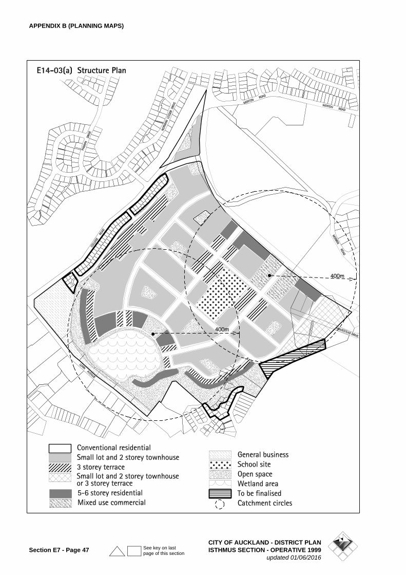
APPENDIX B (PLANNING MAPS)
CITY OF AUCKLAND - DISTRICT PLANSection E7 - Page 47 ISTHMUS SECTION - OPERATIVE 1999
updated 01/06/2016
See key on last page of this section
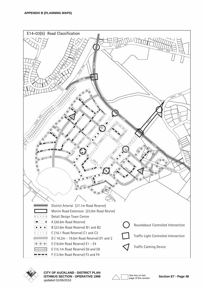
APPENDIX B (PLANNING MAPS)
CITY OF AUCKLAND - DISTRICT PLANISTHMUS SECTION - OPERATIVE 1999 Section E7 - Page 48updated 01/06/2016
See key on last page of this section
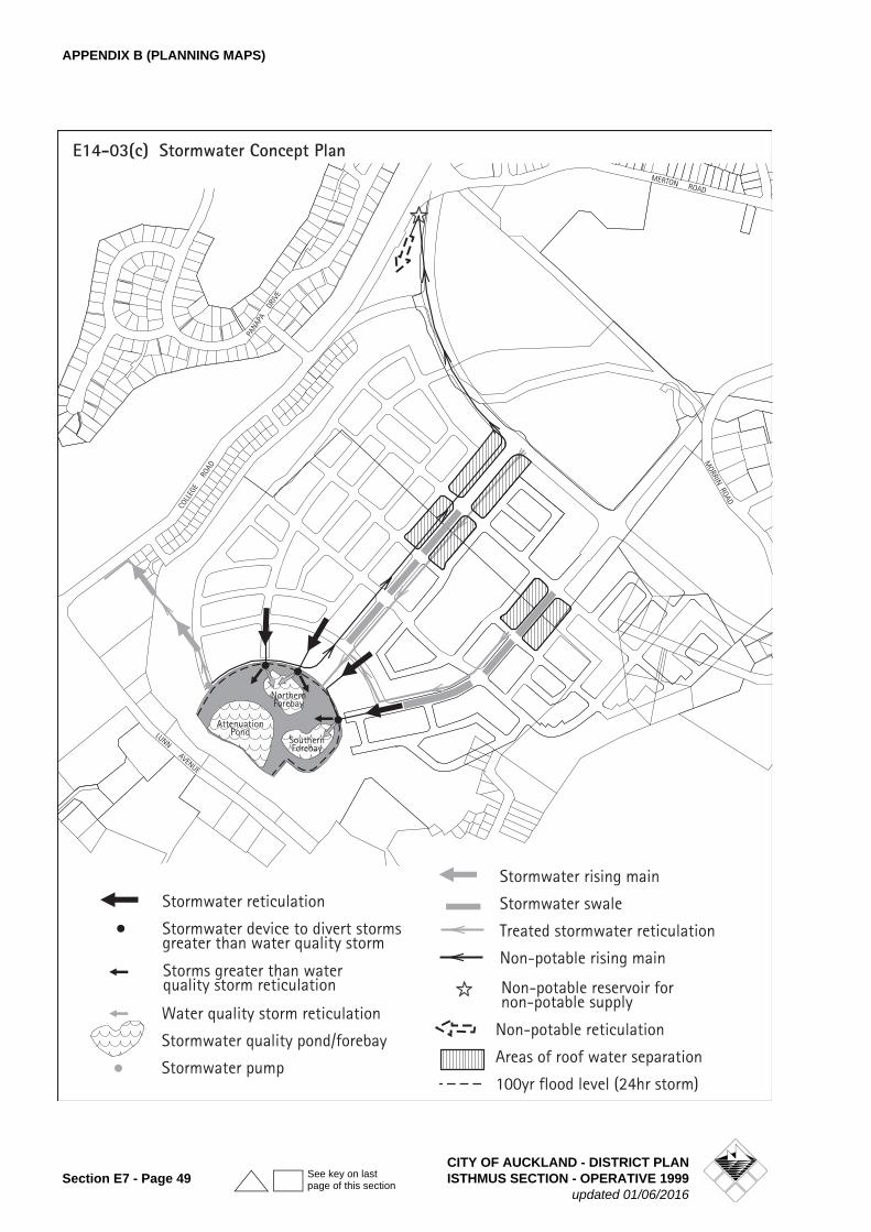
APPENDIX B (PLANNING MAPS)
CITY OF AUCKLAND - DISTRICT PLANSection E7 - Page 49 ISTHMUS SECTION - OPERATIVE 1999
updated 01/06/2016
See key on last page of this section
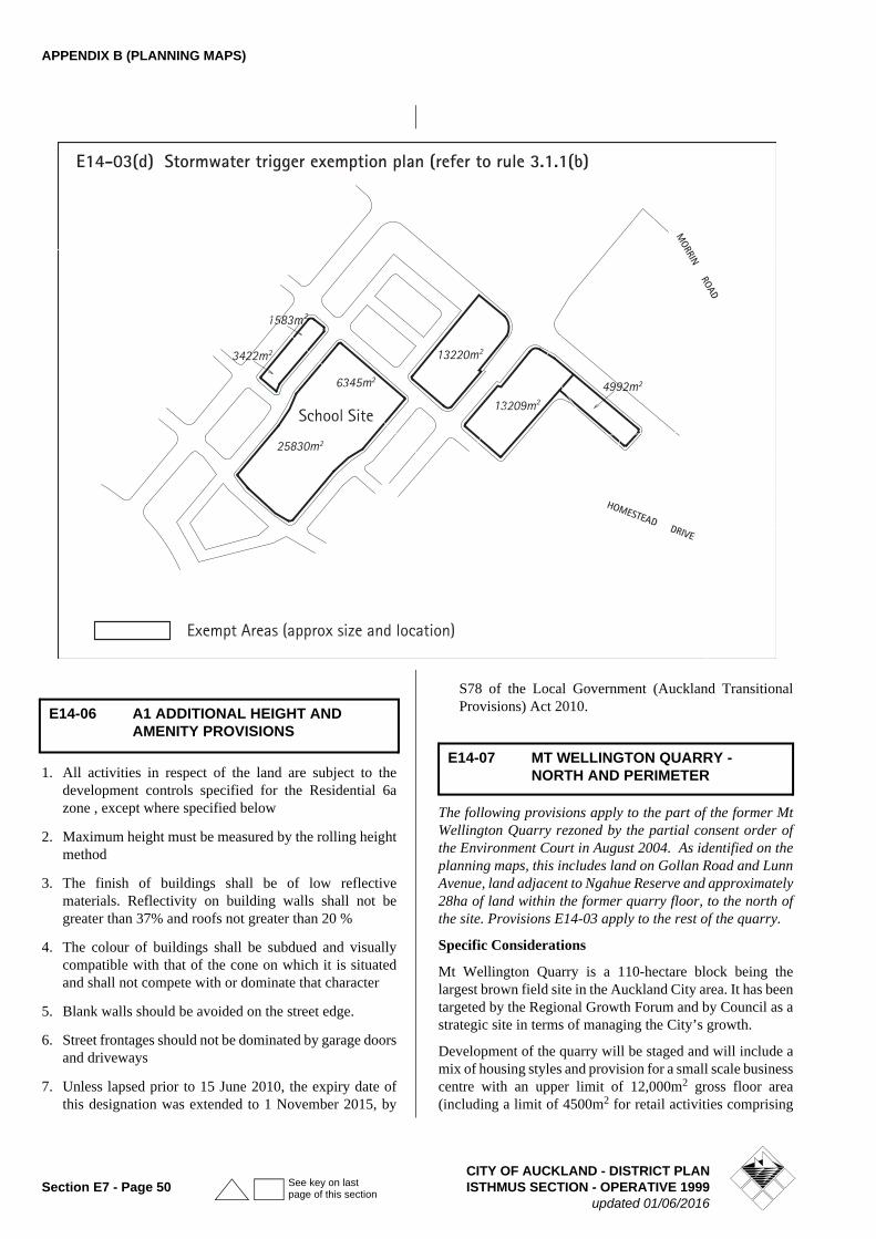
APPENDIX B (PLANNING MAPS)
1. All activities in respect of the land are subject to the development controls specified for the Residential 6a zone , except where specified below
2. Maximum height must be measured by the rolling height method
3. The finish of buildings shall be of low reflective materials. Reflectivity on building walls shall not be greater than 37% and roofs not greater than 20 %
4. The colour of buildings shall be subdued and visually compatible with that of the cone on which it is situated and shall not compete with or dominate that character
5. Blank walls should be avoided on the street edge.
6. Street frontages should not be dominated by garage doors and driveways
7. Unless lapsed prior to 15 June 2010, the expiry date of this designation was extended to 1 November 2015, by
S78 of the Local Government (Auckland Transitional Provisions) Act 2010.
The following provisions apply to the part of the former Mt Wellington Quarry rezoned by the partial consent order of the Environment Court in August 2004. As identified on the planning maps, this includes land on Gollan Road and Lunn Avenue, land adjacent to Ngahue Reserve and approximately 28ha of land within the former quarry floor, to the north of the site. Provisions E14-03 apply to the rest of the quarry.
Specific Considerations
Mt Wellington Quarry is a 110-hectare block being the largest brown field site in the Auckland City area. It has been targeted by the Regional Growth Forum and by Council as a strategic site in terms of managing the City’s growth.
Development of the quarry will be staged and will include a mix of housing styles and provision for a small scale business centre with an upper limit of 12,000m2 gross floor area (including a limit of 4500m2 for retail activities comprising
E14-06 A1 ADDITIONAL HEIGHT AND AMENITY PROVISIONS
E14-07 MT WELLINGTON QUARRY - NORTH AND PERIMETER
CITY OF AUCKLAND - DISTRICT PLANSection E7 - Page 50 ISTHMUS SECTION - OPERATIVE 1999
updated 01/06/2016
See key on last page of this section
APPENDIX B (PLANNING MAPS)
4000m2 for retail activities and 500m2 for a superette type activity) and other community infrastructure - roads, walkways, cycleway and reserves. It is anticipated that the proposed redevelopment of the whole quarry floor will bring a population of around 8,000 persons into the area.
The built form of private land in the quarry will be primarily managed through the residential design guide that is applied to areas zoned residential 8 (the zone that will be applied to the bulk of the land) and through the Design Guidelines specifically developed for the quarry. In addition the Mt Wellington Quarry Streetscape Plan and Design Guidelines for Mt Wellington Quarry will provide guidance when developing the public areas in the quarry. The Council will also have development and subdivisions proposals assessed by the Urban Design Panel - an independent group of design professionals.
Roading standards have been included in the subdivision assessment criteria to ensure that a balance is achieved between providing for the movement of people and vehicles (i.e. pedestrians and cycles are catered for in addition to vehicles) and for the introduction of public transport into the quarry area. The Council may seek to impose conditions that require review of parking and traffic generation from the Quarry Floor land after development is occupied. This will occur when the Council accepts narrower road widths in residential areas that are a departure from the Councilís traditional approach to roading.
Where possible the Council will work with landowners and the ARC to develop opportunities for increased use of public transport and other transport initiatives to reduce reliance on the car. However, provision is also made through financial contribution for mitigation of off-site roading effects that might be generated by the development.
Open space standards are also included in the subdivision assessment criteria to ensure that the future residents have access to a range of high standard open space areas. Other criteria address issues related to the quality of other public spaces in the area - namely road berms and walkways.
Quarrying the land has resulted in irreversible changes to the landform and natural processes such as ground water flow. Additional criteria are in place to address the potential impacts of future development that will occur in the quarry floor on the surrounding area.
As a consequence of the quarrying activity the land receives ground water from the neighborhood (higher ground) and the quarry has historically been required to provide stormwater quality improvement before the water is pumped to Waiatarua wetland. This water is invaluable to the Waiatarua wetland at times of low flow. It is therefore appropriate to ensure that any development within the former quarry area does not adversely impact on the wetland.
Land within the quarry will flood without on-going off-site disposal of stormwater and influent groundwater.There is
also the potential for substantial flooding in Ellerslie, Panmure and Penrose. There is therefore to be appropriate off-site disposal of groundwater, and effective management of stormwater (including disposal and reuse) from, recontoured higher areas, the lower levels of the quarry and beyond.
Additional Requirements
1. Development
• In addition to meeting the requirements of the Residential 8b zone development will be required to demonstrate that it meets "Design Guidelines for Mt Wellington Quarry".
2. Minimum Site Area (This rule substitutes for rule 11.5.2.6A(i))
• The minimum site area for new vacant site subdivision shall be 300m2 unless previously approved by a Planned Unit Development.
3. Subdivision
• All subdivision is a Restricted Discretionary activity not requiring notification where compliance with the following additional assessment criteria is demonstrated
Note: The following assessment criteria are in addition to those set out in Part 11 of the Plan - Subdivision
Stormwater
The Council must be satisfied that :
• Pending an approved overall stormwater catchment management plan for the Quarry, all available groundwater, without importation or diversion (to a maximum of 600 litres per second), will be pumped by the quarry owner into the Waiatarua wetland (this may involve an upgrade of the pump station and rising main to approved standards or the provision of a cash bond in lieu thereof). In addition a stormwater quality treatment system operated by the quarry owner must be capable of meeting the requirements of the last discharge consent applicable to the former quarrying activity (a chartered professional engineer must certify this); and
• Any disposal of stormwater to the lower levels of the quarry and beyond will occur in the manner anticipated in the current comprehensive consent for discharge of stormwater from and within the Ellerslie-Waiatarua catchment approved by the ARC and any subsequent discharge consent that applies to the whole quarry land area; and
• The stormwater management system is adequate to protect all land zoned residential from flooding in a 2% AEP rainfall event
CITY OF AUCKLAND - DISTRICT PLANISTHMUS SECTION - OPERATIVE 1999 Section E7 - Page 51updated 01/06/2016
See key on last page of this section
APPENDIX B (PLANNING MAPS)
Each application for subdivision shall be accompanied by a comprehensive assessment of the stormwater disposal requirements for the subdivision and shall address: -
• Minimising stormwater flows that are directed into public stormwater infrastructure, through the incorporation of private flow attenuation devices, consistent with Auckland City Council’s On Site Stormwater Management Manual (e.g. rainwater tanks, rain gardens), on each site.
• The reuse of stormwater in residential households in a manner that is consistent with Auckland City Council’s On Site Stormwater Management Manual.
• The preparation of a Low Impact Urban Stormwater Management Plan.
• The measures to ensure the area containing the existing stormwater quality system will be protected from earthworks and development occurring in its vicinity during construction
• The water quality and flow consistent with existing ARC discharge consents will be maintained during construction
• Protection of sites that will be developed within the former quarry area from flooding if pumping fails. This may include provision of contingency plans.
• The removal of 75% of suspended solids from stormwater runoff from roads and overland flow, and the removal of gross pollutants (i.e. street litter) prior to leaving the quarry.
• The provision of water to Waiatarua wetland.
Note: The Council will ensure that consent notices or other instruments if necessary shall be registered, against the titles to the new lots created by the subdivision and the title or titles to the remaining quarry land to ensure that stormwater is received and managed in an appropriate manner on an ongoing basis for the whole quarry land
Soakage will not be considered as an approved method of stormwater disposal on this land without a report from a chartered professional engineer on the effects of any proposed soakage disposal method that confirms the adequacy of the soakage system and showing that it will have no significant environmental impacts.
Utilities
• Where possible all services must be provided underground in a single, combined service duct below the footpath. The Council should approve any alternative form of provision.
• Any above ground utility structures should comply with the provisions of the District Plan.
• The provision of underground infrastructure is required to demonstrate how on-going maintenance and
upgrading will be undertaken with minimal physical disruption.
Street planting
Prior to any subdivision of the quarry land being considered by Council a detailed and comprehensive landscape plan for the streetscape shall be submitted for approval by the Council.
This plan shall include:
• details of plant species, locations, and planting regime
• an assessment of any linkages and themes required for an overall approach to street planting in the quarry
• an implementation and maintenance programme for a two year period
Landscaping plans shall be required for any area to be subdivided and shall be assessed against the Mt Wellington Quarry Streetscape plan.
Street planting is to be in accordance with minimum distances set out in Table 1 below. Notwithstanding this there is to be a minimum of one specimen tree per residential property frontage. Identification of the location and width of vehicle crossings is to be made in conjunction with proposed planting.
Note: Landscaping and planting plans should only be developed following further consultation with interested local iwi and seek to enhance ecological linkages.
Subdivision Layout
1. Specific engineering assessment shall be undertaken for lots created for building and reserve purposes within 20 metres of former quarried rock faces within the former quarry floor area. Such assessment shall take into account defensive building design, appropriate building and amenity area setback distances from the quarry face, the potential hazard from rock falls as well as long term stability of the rock face behind and above development and public open space areas.
The information required, for approval by Council, includes:
• detailed geotechnical information on stability and recommended set-backs from the quarry walls. This could include further exploratory holes to determine the nature and depth of materials overlying the basalt
Table 1: Minimum Distances between Street Trees
Road TypeDistrict Arterial
Connector Collector Local
Minimum Distance between street trees
12.0m 12.0m 12.0m 10.0m
CITY OF AUCKLAND - DISTRICT PLANSection E7 - Page 52 ISTHMUS SECTION - OPERATIVE 1999
updated 01/06/2016
See key on last page of this section
APPENDIX B (PLANNING MAPS)
rock that is exposed in the quarry faces.
• detailed geotechnical/geological mapping of faces and an assessment of jointing patterns as they may affect the stability of individual rock pieces together with a risk assessment and specific recommendations for remediation of any potential hazards
2. All pedestrian linkages created outside the public road network shall:
• have a minimum width of 3.0m
• not exceed 60 metres in length
3. No sites, other than corner sites, shall have access from more than 1 road.
4. Whether sites that are created to allow development of multi-unit development are designed to enable compliance with the Residential 8 urban design rules and assessment criteria, including those relating to buildings fronting the road.
5. It is recognised that there will be a mix of housing types within the quarry. There is a place for detached dwellings on single sites as small as 300 m2 under the Residential 8b zone but these will be assessed to ensure that design and appearance considerations are adequately addressed.
6. Whether the alignment of streets and location of open spaces reinforces key views to Maungarei (Mt Wellington) from both within the former quarry and from the surrounding area.
7. Whether visual linkages are provided through to representative sections of the rock faces created by former quarrying activity;
8. Whether the site layout of the subdivision is integrated with the neighbourhood and adjoining uses to ensure:
• continuity of the built fabric, particularly in relation to streetscape
• energy efficient and environmental sensitive layouts
• safe functional environments within developments
• landscaping that provides a pleasant, safe and attractive living environment
• safe and convenient vehicle and pedestrian access to buildings on a site
• parking areas do not intrude on the character of the streetscape
• internal circulation within the development provides safe and efficient use of the site
• adequate and convenient parking is provided for residential, visitor and service vehicles.
Note: Detailed specification will be required, for approval by Council at Building Consent stage, of all earthworks and for
those areas with non-engineered fill a plan of how these are to be treated (either removed or re-compacted) should be lodged.
Parks and Reserves
All lots created should be within 400 metres walking distance from an area of public open space.
Lots intended for development of a single residential unit shall not have a rear yard adjoining land intended to be vested as reserve.
Financial contributions from residential development are as specified in Part 4B of the District Plan. In the case of the Mt Wellington Quarry land to be vested as reserve is preferred as the contribution however the Council will consider cash in certain circumstances.
Any land that it is proposed to vest in Council as reserve should meet the appropriate assessment criteria for suitability for reserve purposes as set out in section 9.9.2 of the Plan (Particular Criteria for the Acquisition of Reserves). In addition any such land proposed as reserve should be assessed against the following criteria:
• Whether the land adds to proposed open space network within the quarry and is useable for a variety of public recreation and leisure activities
• Whether the land provides any flexibility to accommodate changing community needs.
• Whether active edges to all public spaces are promoted.
• Whether the land is visible from and well connected to the street network and significant features of the quarry. This may include pedestrian linkages between streets.
• Whether the scale and configuration of the land is appropriate to the intended reserve function.
• Whether the land contours, aspect and level of shelter are compatible with the intended use.
• Whether the land contributes to the open space network by maintaining and enhancing the existing cultural, environmental ands landscape values of the area and providing a means of protecting areas of natural significance
• Whether the development complies with Auckland City Crime Prevention through Environmental Design Guidelines including having clear visibility along their entire length with entrance and exit points visible at all points along the route.
Note: Landscaping and planting plans should only be developed following further consultation with interested local iwi and seek to enhance ecological linkages.
Ecological
• A plan showing the location of any existing identified ecological values and how any impacts on these values
CITY OF AUCKLAND - DISTRICT PLANISTHMUS SECTION - OPERATIVE 1999 Section E7 - Page 53updated 01/06/2016
See key on last page of this section
APPENDIX B (PLANNING MAPS)
are to be mitigated is to be submitted for approval by the Council.
Archaeological
• A plan showing any identified archaeological sites or areas that have been identified as requiring further archaeological investigation or monitoring and the scope of archaeological work required to be undertaken is to be submitted to Council for approval.
Wastewater
• Refer to rule 11.5.4 of the District Plan
Roading and Parking
Roads shall be provided in general accordance with the alignments in Figure E14-03(b) and shall be constructed in a manner consistent with the standards contained in Table 2 “Construction standards for roads within the former Mt Wellington Quarry.”
Whether the roading system is designed to:
• provide a logical structure of connected routes providing a high level of connectivity within the site. No cul de sacs of greater than 80 metres and no more than 5% of roads shall be cul de sacs;
• achieve a balance between providing for the movement of people and vehicles (i.e. pedestrians and cycles are catered for in addition to vehicles) and for the introduction of public transport into the quarry area. The Council may impose conditions on each subdivision consent requiring the applicant to undertake a review one year and five years after development in that subdivision is completed, of the traffic and parking effects of the development occurring in and around the quarry. This may include a requirement for the applicant to undertake regular traffic surveys at its own expense. The surveys would be based on the volume, delay and accident warrants for traffic signals as contained in NZS 5431 or such other surveys as may be approved by the Council.
• The maximum percentage of rear lots shall be 10%
• Whether roads are designed for safety including consideration of:
- the three types of intersection (T, cross and staggered) and their appropriate design to ensure management of speed
- the target street speed of between 20-40 km/hr by restricting length and width of streets and the introduction of slow points (bends, minimum kerb radii, chicanes, intersections)
The Council may impose conditions on resource consents requiring the applicant to undertake or make a financial contribution to upgrade the capacity of existing roads in the area, as provided for in Part 4B of the District Plan. This includes:
(i) improvements to the Lunn Avenue/Ellerslie Panmure Highway intersection
(ii) upgrade of the College Road/ Abbotts Way roundabout
(iii)meeting the cost of signalising or otherwise at the intersection of any new roads that link the quarry to existing roads in the area
(iv) other financial contributions imposed on the applicant for road upgrading will be a portion of the cost of the work based on the proportionate volume of quarry traffic using the particular road or intersection. This may include the reconfiguration of College Road and Lunn Avenue
(v) upgrade of Ladies Mile/Abbotts Way intersection.
Explanation
The above additional assessment criteria have been formed as a comprehensive set of guidelines for development within the former quarry floor. They are intended to ensure a quality development that will retain continuing amenity. Specific consideration is to be given to the co-ordination of the public open space and street network as well as recognising those important features located outside of the site
CITY OF AUCKLAND - DISTRICT PLANSection E7 - Page 54 ISTHMUS SECTION - OPERATIVE 1999
updated 01/06/2016
See key on last page of this section
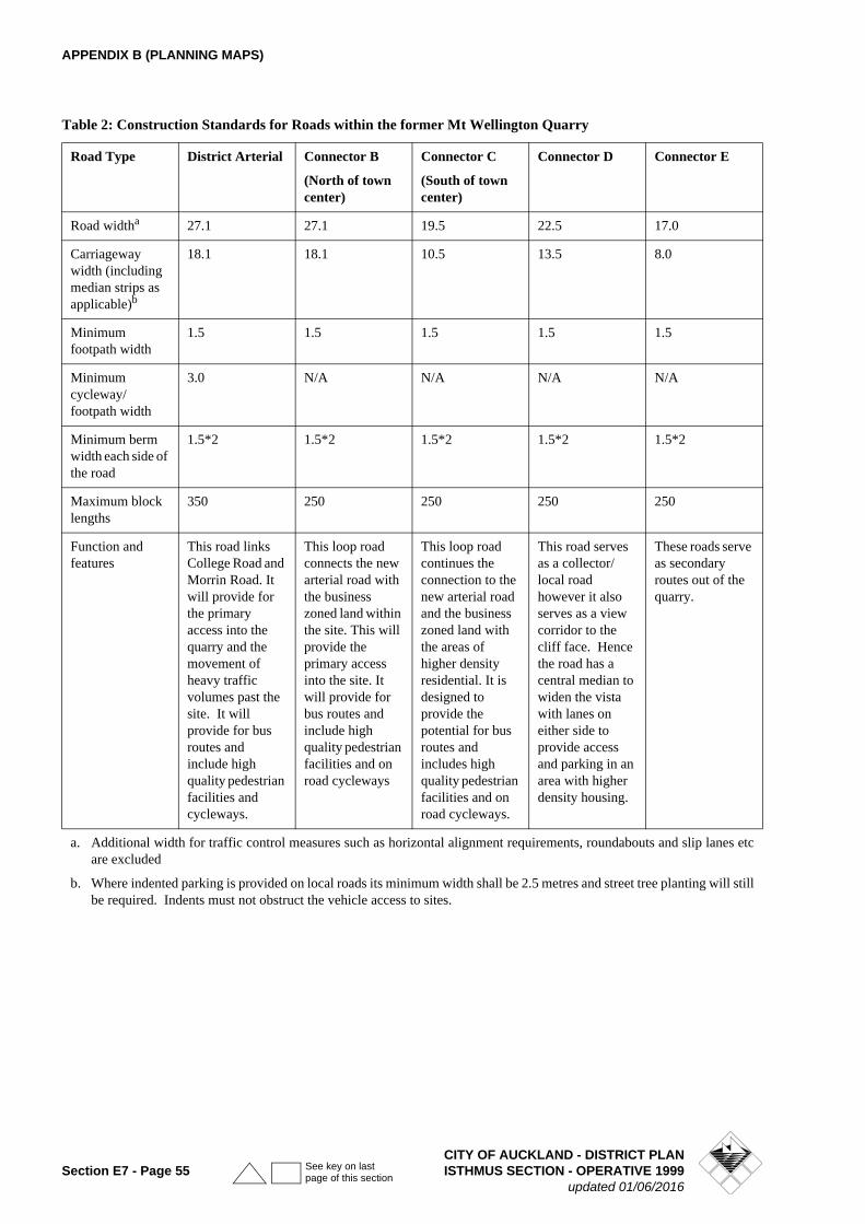
APPENDIX B (PLANNING MAPS)
Table 2: Construction Standards for Roads within the former Mt Wellington Quarry
Road Type District Arterial Connector B
(North of town center)
Connector C
(South of town center)
Connector D Connector E
Road widtha
a.
27.1 27.1 19.5 22.5 17.0
Carriageway width (including median strips as applicable)b
b.
18.1 18.1 10.5 13.5 8.0
Minimum footpath width
1.5 1.5 1.5 1.5 1.5
Minimum cycleway/footpath width
3.0 N/A N/A N/A N/A
Minimum berm width each side of the road
1.5*2 1.5*2 1.5*2 1.5*2 1.5*2
Maximum block lengths
350 250 250 250 250
Function and features
This road links College Road and Morrin Road. It will provide for the primary access into the quarry and the movement of heavy traffic volumes past the site. It will provide for bus routes and include high quality pedestrian facilities and cycleways.
This loop road connects the new arterial road with the business zoned land within the site. This will provide the primary access into the site. It will provide for bus routes and include high quality pedestrian facilities and on road cycleways
This loop road continues the connection to the new arterial road and the business zoned land with the areas of higher density residential. It is designed to provide the potential for bus routes and includes high quality pedestrian facilities and on road cycleways.
This road serves as a collector/local road however it also serves as a view corridor to the cliff face. Hence the road has a central median to widen the vista with lanes on either side to provide access and parking in an area with higher density housing.
These roads serve as secondary routes out of the quarry.
a. Additional width for traffic control measures such as horizontal alignment requirements, roundabouts and slip lanes etc are excluded
b. Where indented parking is provided on local roads its minimum width shall be 2.5 metres and street tree planting will still be required. Indents must not obstruct the vehicle access to sites.
CITY OF AUCKLAND - DISTRICT PLANSection E7 - Page 55 ISTHMUS SECTION - OPERATIVE 1999
updated 01/06/2016
See key on last page of this section
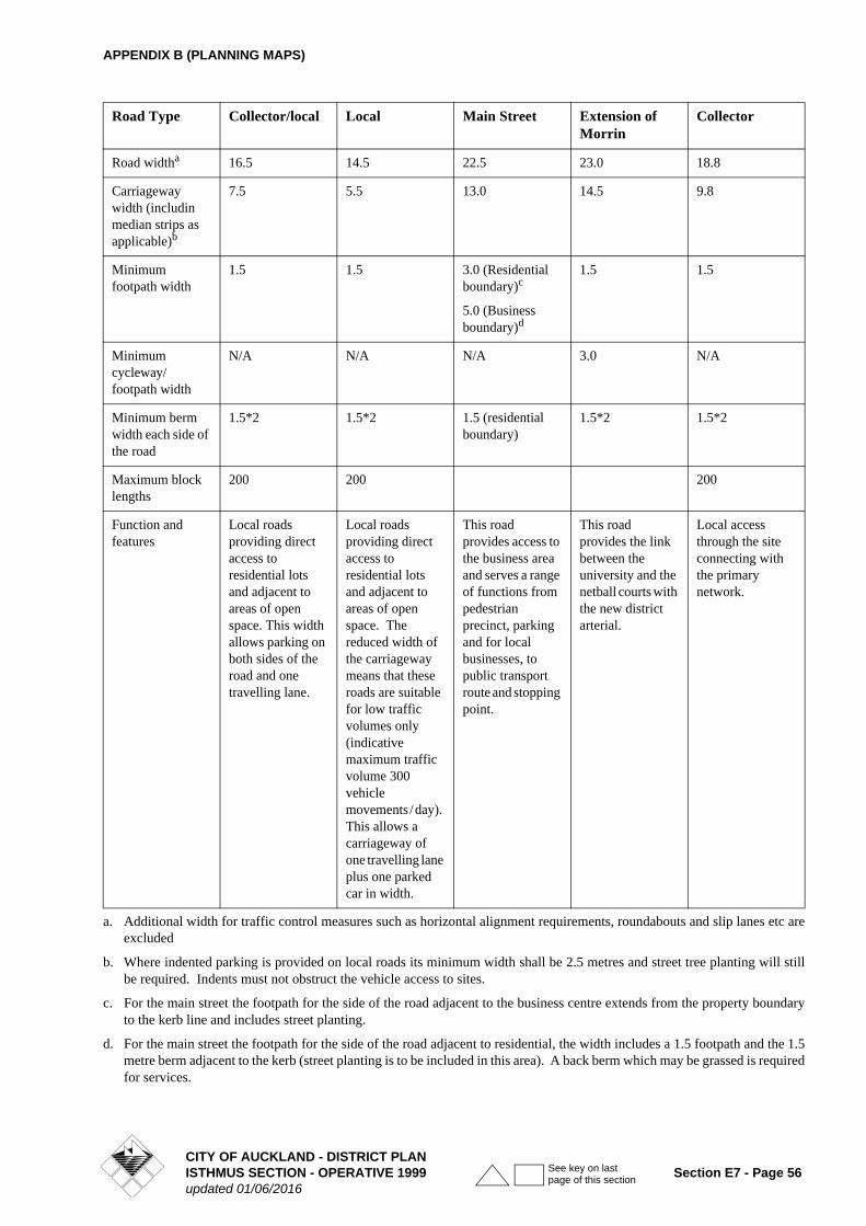
APPENDIX B (PLANNING MAPS)
Road Type Collector/local Local Main Street Extension of Morrin
Collector
Road widtha 16.5 14.5 22.5 23.0 18.8
Carriageway width (includin median strips as applicable)b
7.5 5.5 13.0 14.5 9.8
Minimum footpath width
1.5 1.5 3.0 (Residential boundary)c
5.0 (Business boundary)d
1.5 1.5
Minimum cycleway/footpath width
N/A N/A N/A 3.0 N/A
Minimum berm width each side of the road
1.5*2 1.5*2 1.5 (residential boundary)
1.5*2 1.5*2
Maximum block lengths
200 200 200
Function and features
Local roads providing direct access to residential lots and adjacent to areas of open space. This width allows parking on both sides of the road and one travelling lane.
Local roads providing direct access to residential lots and adjacent to areas of open space. The reduced width of the carriageway means that these roads are suitable for low traffic volumes only (indicative maximum traffic volume 300 vehicle movements / day). This allows a carriageway of one travelling lane plus one parked car in width.
This road provides access to the business area and serves a range of functions from pedestrian precinct, parking and for local businesses, to public transport route and stopping point.
This road provides the link between the university and the netball courts with the new district arterial.
Local access through the site connecting with the primary network.
a. Additional width for traffic control measures such as horizontal alignment requirements, roundabouts and slip lanes etc are excluded
b. Where indented parking is provided on local roads its minimum width shall be 2.5 metres and street tree planting will still be required. Indents must not obstruct the vehicle access to sites.
c. For the main street the footpath for the side of the road adjacent to the business centre extends from the property boundary to the kerb line and includes street planting.
d. For the main street the footpath for the side of the road adjacent to residential, the width includes a 1.5 footpath and the 1.5 metre berm adjacent to the kerb (street planting is to be included in this area). A back berm which may be grassed is required for services.
CITY OF AUCKLAND - DISTRICT PLANISTHMUS SECTION - OPERATIVE 1999 Section E7 - Page 56updated 01/06/2016
See key on last page of this section
APPENDIX B (PLANNING MAPS)
PERMITTED ACTIVITIES
• Accessory buildings for the reserve including maintenance, storage, workshops, toilet and changing facilities.
• Ancillary administration offices.
• Ancillary activities and facilities for education and training, including gymnasiums, pools and, saunas.
• Buildings within the areas prescribed on the Concept Plan.
• Carparking areas ancillary to the dominant activity to a maximum of 820 cars, areas for access, vehicle drop off, buses, and ambulances.
• Conferences, exhibitions, meetings and receptions for up to a maximum of 1000 persons for any single event or combination of events occurring on the site at any one time, provided that such events are held on the site when there is no sports tournament being accommodated at the same time.
• Facilities designed to cater for visitors and spectators to sports events (including changing rooms, toilets, first aid and medical rooms, food and sporting goods sales, scoreboards and display screens, kitchens, committee and officials rooms).
• Facilities designed to assist in broadcasting sporting events (including production facilities, technical services and facilities, and transmission equipment).
• Grandstands, viewing platforms and terraces.
• Fences within and/or outside the building platform.
• Open-air galas and special events associated with the use of the site.
• Organised sports and recreation and associated grounds and playing fields (not including motorised sports).
• Places of assembly to a maximum capacity permitted by compliance with the parking requirements set out in Clause 12.8.1.1 of the District Plan.
• Stormwater retention devices and tanks.
RESTRICTED CONTROLLED ACTIVITIES
• Earthworks to a maximum volume of 205,000 cubic metres within one 12 month period which relate to the re-contouring of the land including the importation of fill and site rehabilitation
• Retaining walls over 1m in height.
• Use of artificial lighting producing an illuminance in excess of 150 lux, measured at any point on the site containing the light source, in a horizontal or vertical plane at ground level.
CONTROLLED ACTIVITIES
• Carparking ancillary to the dominant activity in excess of 820 cars.
RESTRICTED DISCRETIONARY ACTIVITIES
• A care centre for up to a maximum of 50 children.
• Restaurants, cafes, bars and eating places in conjunction with and ancillary to permitted activities.
DISCRETIONARY ACTIVITIES
• Activities where the noise controls of the concept plan will be exceeded.
• Conferences, exhibitions, meetings and receptions designed to cater for more than 1000 persons not provided for as a permitted activity.
• Open-air fairs and markets not associated with the use of the site.
• Restaurants, cafes and other eating places not provided for as a restricted discretionary activity.
DEVELOPMENT CONTROLS
1. Building Platform
Building development is restricted to the building platform shown on the Concept Plan diagram, except that:
Accessory buildings for netball and the reserve including buildings used for maintenance, storage, workshops and toilet and changing facilities to a maximum floor area per building of 50m2 or 150m2 where two or more of these functions are combined. To a maximum of two (2) accessory buildings outside the building platform and retaining walls, water storage tanks, fences and light poles (including speaker and camera supporting poles) may be erected outside the nominated building platform.
2. Building Design
Buildings shall be designed to reduce apparent bulk in relation to views from Ngahue Reserve, adjoining public land and the street. This can be achieved while still allowing buildings to achieve permitted height, building platform areas and height in relation to boundary by:
• Buildings being architecturally designed
• Avoiding flat roofs
• The inclusion and/or use of building elements such as windows, doors, structural elements, porticos etc to break up the massing/scale and form
E14-08 CONCEPT PLAN- AUCKLAND NETBALL CENTRE- NGAHUE RESERVE
CITY OF AUCKLAND - DISTRICT PLANISTHMUS SECTION - OPERATIVE 1999 Section E7 - Page 57updated 01/06/2016
See key on last page of this section
APPENDIX B (PLANNING MAPS)
• Use of colour scheme which modulates and integrates buildings
• Avoidance of bland blank walls
• The finish of the buildings shall be of low reflective materials and subdued colouring. Reflectivity on building walls shall not exceed 37% and on building rooves shall not exceed 20%.
3. Height
A: Maximum height
Buildings within the building platform shown on the Concept Plan diagram shall not exceed: 12m.
Accessory buildings permitted outside the building platform shown on the Concept Plan diagram shall not exceed 5m
Light poles to serve playing (outdoor court) area only: 12m
Other light, speaker or camera poles: 8m
Fences 3.6m
B: Special height limits
The special height limit in Clause 5C.7.6 VIEWS shall apply where relevant.
For the purposes of this control height shall be measured from the spot levels indicated on the Concept Plan. These spot levels relate to the anticipated ground level of the nominated activity areas after completion of site formation. Should the actual finished ground levels differ from those shown on the Concept Plan, height shall be measured from the actual finished ground levels or the level shown on the Concept Plan which ever is the lower.
4. Height in Relation to Boundary
Clause 9.8.2.3 shall apply
5. Noise Controls
No activity shall be permitted to create any noise which results in the following standards being exceeded:
(i) The L10 noise level and maximum level (Lmax) arising from any activity measured at or within the boundary of any residentially zoned property shall not exceed the following limits
Crowd noise shall not be included in any assessment of noise levels.
The above noise levels shall be measured and assessed in accordance with the requirements of the NZS 6081: 1991 ìMeasurement of Soundî and NZS 6802:1991 ìAssessment of Environmental Soundî.
The noise shall be measured with a sound level meter complying at least with the International Standard IEC 651 (1979): Sound Level Meters Type 1.
(ii) Where a recreational activity is to be undertaken on any open space land/or where buildings are to be constructed, altered or used in relation to the recreational activity, the Council may require certification from an acoustic engineer to confirm that the activity and the use of the building will not exceed the noise levels set out in (i).
6. Landscaping Design
A combination of tree and shrub planting shall be provided on all street boundaries and/or in the areas described as landscaping on the Concept Plan diagram, except areas used for ingress and egress.
Staging: Planting will be established on site as soon as practicable as development progresses. It is anticipated that the landscaping of the periphery of the site to adjoining open space land will take place in the first stage when 28 courts will be developed, with planting of the landscaped areas adjoining the possible future roads taking place as site works permit but so as to establish an attractive presentation to the existing public street views. Areas that have been established to their finished levels that are not required for immediate development will be grassed (or metalled) as a temporary surface for informal recreation and open space.
A detailed landscape plan, including implementation and maintenance, shall be submitted to the Council with any proposal to undertake development on the site.
(i) The plan shall include details of plant sizes at the time of planting and intended species.
(ii) The landscaping shall be implemented and maintained in accordance with the approved landscaping plan within the first planting season following the formation of final ground levels.
(iii)The planting shall be in accordance with the following standards:
• Specimen trees to be planted in immediate vicinity of buildings and any street frontage to reduce visual impact of the buildings and to soften large areas of hard surface (asphalt and paving).
• Clear sight lines from (pedestrian and vehicular) access routes to buildings are to be retained and incorporated into planting design.
• Permeable paving for paths in carpark.
Monday to Saturday
7.00am-10.00pm 55 dBA
Sunday & Public Holidays
9.00am-6.00pm 55 dBA
At all other times L10 40 dBA
Lmax 75 dBA
CITY OF AUCKLAND - DISTRICT PLANSection E7 - Page 58 ISTHMUS SECTION - OPERATIVE 1999
updated 01/06/2016
See key on last page of this section
APPENDIX B (PLANNING MAPS)
• All areas not designated for sport, building platform, or access or parking and path or road to be in lawn, groundcover, shrubs or specimen trees.
• All planting on boundaries to be predominantly native species.
• Planting shall be designed and laid out, having regard to pedestrian safety, particularly in terms of visibility (including at night).
• Consideration of passive surveillance opportunities from adjoining areas and existing / future roads.
• Specimen trees should be provided for in spaces between carparks to a minimum density of one tree per 10 carparks.
• Linkages to the open space and vegetation cover of adjacent sites shall be retained and enhanced.
7. Parking and loading
All activities, apart from netball courts, must provide parking to the standards required in Part 12 of the Plan. Parking shall be provided at the ratio of 16 parking spaces per court up to 28 courts and thereafter at a ratio of 14 parking spaces per court. These standards apply to both indoor and outdoor courts but warm-up (half courts) will not be assessed for required parking.
In addition, bus drop off and loading facilities shall be provided within the site so that there is no reverse manoeuvring required onto the roads and there is safe pedestrian access to the sports facilities.
Consideration shall be given to the use of different surface materials/styles to minimise the monotony of hard surface (e.g. Gobi block or similar could be used for formation of parking spaces, while access aisles and heavier trafficked areas could be tar sealed).
8. Access
Access shall be formed to the site in accordance with the two access points indicated on the Concept Plan (one through Ngahue Reserve from College Road and one from Morrin Road at the eastern corner of the site). Each of these access points shall provide for both ingress and egress. A Flush Median to provide for right hand turns into and out of the site will be provided at College Road and a 3-legged roundabout will be installed at Morrin Road to facilitate access to and egress from the site.
The Concept Plan provides the opportunity for the access to the netball complex to be changed to connect to indicative roads outside the site extending from the existing network, should these be constructed. If such roads along this general formation do eventuate at some time in the future, the access through the Ngahue Reserve will be superfluous and should be removed. It is noted
that the Concept Plan allows for the creation of a perimeter road around the complex so that all parking areas are connected. If the access way from College Road through Ngahue Reserve is removed in the future, the perimeter road is required to maintain good traffic circulation between the parking areas and every part of the complex as well as to that part of the reserve which falls outside the Concept Plan boundary.
All access shall be formed in accordance with the requirements of Part 12 of the District Plan.
9. Refuse Disposal
Outdoor storage, refuse disposal and service areas shall be screened to avoid, mitigate or remedy adverse visual impacts as viewed from beyond the site.
10. Stormwater
Stormwater runoff from parking and vehicle trafficked areas shall be collected and treated at source before this water enters the public stormwater reticulation system. Grass swales shall be used where practicable for this purpose. Stormwater runoff from all other areas may discharge directly into the public stormwater reticulation system and/or may be collected for redistribution on site for irrigation purposes.
11. Exception
Clause 5E7.4 shall not apply as earthworks are provided for in this Concept Plan under Restricted Controlled Activities.
SPECIFIC CONSIDERATIONS
The dominant activity in this site is netball and associated activities. The Concept Plan provides a planned approach to the development of the site for a comprehensive netball facility. It is envisaged that up to 46 outdoor and 8 indoor netball courts will be established on the site when it is fully developed. There will also be some warm-up courts (generally half court size). The built facilities will provide for uses consistent with netball. Provision for community uses and some multi purpose ancillary facilities will assist in supporting the viability of the complex for netball and represents a good use of resources as additional facilities do not need to be constructed.
The character of the immediate neighbourhood is influenced by the significant organised recreation facilities located here, the Tamaki Campus of the Auckland University and the medium scale lighter industrial activities as well as the residential neighbourhood located towards Remuera and Glen Innes. The netball centre should compliment and augment these existing resources.
Multiple use of facilities for other sporting codes is encouraged. In addition, the location of the facilities is ideal for interaction and sharing of facilities between sporting codes such as tennis and rugby/soccer taking place on
CITY OF AUCKLAND - DISTRICT PLANISTHMUS SECTION - OPERATIVE 1999 Section E7 - Page 59updated 01/06/2016
See key on last page of this section
APPENDIX B (PLANNING MAPS)
adjacent land. Toilets and viewing areas as well as access and parking will facilitate passive recreational pursuits provided for in the northern part of Ngahue Reserve.
It is anticipated that the development will be carried out over a number of years with the first stage consisting of approximately 28 courts. Considerable site preparation works are required. Consents have been in place for some time which relate to site reinstatement as a result of the quarrying which has taken place in the past.
Since the full development of the site will not occur all at once, peripheral planting on the site boundaries (and potential future road frontages) can be established prior to full development of the facility. As areas are brought to their finished land formation for the expansion of the netball centre but not developed these will be either grassed or metalled. The treatment of the parts of the site which await expansion of the netball complex should be such that they are left tidy and in a manner which mitigates against a dust nuisance, and where practicable these areas can be used for (interim) informal public recreation.
The adjoining quarry land will be redeveloped in the future. At the time these resource management provisions were prepared an extension of Morrin Road and College Road was uncertain but this concept was being considered by the current quarry land owner. What ever the future shape of the roading system required to support the redevelopment of the quarry, the netball centre can rely on the access regime currently available as shown on the Concept Plan. Both access drives will be required to support the initial stages of the development (i.e. first 28 courts).
The Concept Plan allows for access to new roads should these eventuate in the future. That situation would permit the access through the reserve to College Road to be removed to free up land in the reserve for recreational activities.
Criteria for Assessing Applications for Resource Consent
RESTRICTED CONTROLLED ACTIVITIES
1. Artificial Lighting
Any artificial lighting requiring resource consent shall be assessed against the relevant criteria contained in Clause 7.7.4.3G.
Artificial lighting shall comply with the control of glare standards recommended in Table 2.1 & 2.2 of AS4282 (1997) and the Auckland City Council Consolidated Bylaw 1998, Clause 13.3.4. Lights on the outdoor courts producing levels over 150 lux shall be fitted with automatic timers to ensure they are switched off between 10.00pm and 7.00am on any day.
2. Earthworks
Prior to commencement of any earthworks (not otherwise covered by a resource consent) on the site, the consent
holder shall submit a Construction Management Plan to the satisfaction of the Team Leader, Compliance Monitoring, Auckland City Environments. The Construction Management Plan shall include specific details relating to the rehabilitation, construction and management of all works associated with the development.
The Plan shall include but not be limited to:
i) Details of the site manager, including their contact details (phone, facsimile, postal address;
ii) The location of a large notice board on the site that clearly identifies the name, telephone number and address for service of the site manager;
iii) Any means, such as a restriction on the size of construction vehicles and machinery accessing the site, required to ensure that no damage occurs to street trees throughout the construction period;
iv) Any means of protection of services such as pipes and watermains within the road reserve;
v) Measures to be adopted to maintain the site in a tidy condition in terms of disposal/storage of rubbish, storage and unloading of building materials and similar construction activities;
vi) Measures to be adopted to ensure that pedestrian access past the site on the public footpaths is the same and not obstructed during construction works;
vii) Location of workers conveniences (e.g. portaloos);
viii) Ingress and egress to and from the site for vehicles during site works period;
ix) Proposed numbers and timing of truck movements throughout the day and the proposed routes;
x) Procedures for controlling sediment runoff, dust and the removal of soil, debris and demolition and construction materials from public roads or places;
xi) Proposed hours and days during each week over which activities may take place on the site;
xii) Location of vehicle and construction machinery access during the period of site works;
xiii) An assessment of the extent to which the site is contaminated;
xiv) A Health and Safety Plan for those persons carrying out the development work;
xv) A description of any measures by which the site will be rehabilitated/remedied and restored;
xvi) Methodology for the excavation generally, and particularly the handling and disposal of any contaminated material. The methodology shall include the use of gas meters (at all times) to
CITY OF AUCKLAND - DISTRICT PLANSection E7 - Page 60 ISTHMUS SECTION - OPERATIVE 1999
updated 01/06/2016
See key on last page of this section
APPENDIX B (PLANNING MAPS)
determine the presence of any fugitive landfill gases and the control of stormwater at all times so that it does not flow into any potentially contaminated excavated area, such control shall include adequate surface drainage. Special care shall be taken in addressing the northern portion of the site which has been the subject of landfill operations in the past any cutting near the clay capping should be protected with a compacted 1.0m thick clay capping and diversion drain with bunding to the high side of the cutting;
xvii) A validation exercise, to be undertaken following any remediation.
The approved Construction Management Plan shall be implemented and maintained throughout the entire demolition and construction period.
Any commercial earthmoving equipment of similar shall be stored or parked on site at all times and not on surrounding streets.
All storage of materials and loading and unloading of equipment associated with the site works shall take place within the site boundaries.
Safe and clear pedestrian access and thoroughfare shall be maintained on all roads and footpaths adjacent to the site at all times.
Temporary protection shall be installed to prevent vehicles from damaging drains, footpaths, berms, kerbs, vehicle crossings and the road during the site preparation and construction phase of development. Any damage to the drains, footpaths, berms, kerbs, vehicle crossings and the road attributable to any vehicle associated with construction activities on the site shall be repaired by the developer to the same or similar standard as existed prior to such damage. Any restoration work shall be undertaken before the commencement of the proposed activity, to the satisfaction of the Council, and all costs to be borne by the developer.
Retaining walls over 1m in height
The appearance of the retaining walls shall be assessed in terms of their compatibility with the overall landscape treatment of the site and development of fencing and walls established or to be established on the site. The objective is to achieve a consistent style of built form so that that development integrates well within its landscape setting. Consideration should be given to the use of bluestone faced retaining walls where appropriate. This material is a feature of the local area.
2. Controlled Activities
Car Parking in excess of 820 cars
Refer assessment criteria in Clause 12.9.1.A.
3. Restricted Discretionary Activities
A care centre for up to a maximum of 50 children.
Any application shall be assessed against the following criteria:
• Location and design of parking and vehicular and pedestrian access to and from the site
The activity and the parking and access required for this activity must be located away from adjacent sites so as to protect the aural and visual privacy of those sites
• Noise and hours of operation
Noise arising from the congregation of people, and their vehicles must be controlled. To that end attention will be paid to any adverse effects that may result from the activity outside the hours of 7.30am and 6.00pm.
Restaurants, cafes, bars and eating places in conjunction with and ancillary to permitted activities.
Any application shall be assessed against the following criteria:
• Location and design of parking and vehicular and pedestrian access to and from the site
The activity and the parking and access required for this activity must be located away from adjacent sites in order to prevent adverse aural and visual impacts on adjacent properties.
• Noise and hours of operation
Noise arising from the congregation of people and their vehicles must be controlled. To that end the hours of operation may be restricted during the hours of darkness.
4. Discretionary Activities
Refer Clause 9.7.2.2.
CITY OF AUCKLAND - DISTRICT PLANISTHMUS SECTION - OPERATIVE 1999 Section E7 - Page 61updated 01/06/2016
See key on last page of this section
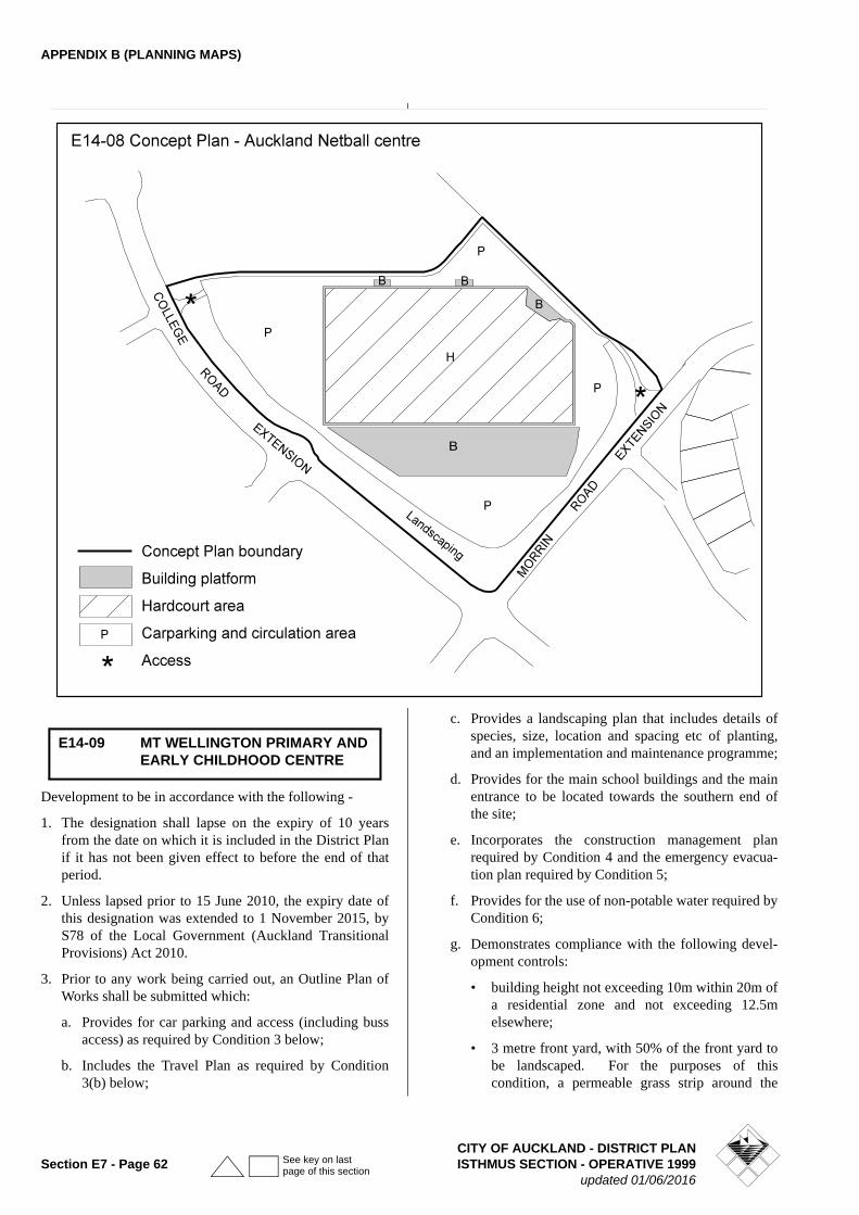
APPENDIX B (PLANNING MAPS)
Development to be in accordance with the following -
1. The designation shall lapse on the expiry of 10 years from the date on which it is included in the District Plan if it has not been given effect to before the end of that period.
2. Unless lapsed prior to 15 June 2010, the expiry date of this designation was extended to 1 November 2015, by S78 of the Local Government (Auckland Transitional Provisions) Act 2010.
3. Prior to any work being carried out, an Outline Plan of Works shall be submitted which:
a. Provides for car parking and access (including buss access) as required by Condition 3 below;
b. Includes the Travel Plan as required by Condition 3(b) below;
c. Provides a landscaping plan that includes details of species, size, location and spacing etc of planting, and an implementation and maintenance programme;
d. Provides for the main school buildings and the main entrance to be located towards the southern end of the site;
e. Incorporates the construction management plan required by Condition 4 and the emergency evacua-tion plan required by Condition 5;
f. Provides for the use of non-potable water required by Condition 6;
g. Demonstrates compliance with the following devel-opment controls:
• building height not exceeding 10m within 20m of a residential zone and not exceeding 12.5m elsewhere;
• 3 metre front yard, with 50% of the front yard to be landscaped. For the purposes of this condition, a permeable grass strip around the
E14-09 MT WELLINGTON PRIMARY AND EARLY CHILDHOOD CENTRE
CITY OF AUCKLAND - DISTRICT PLANSection E7 - Page 62 ISTHMUS SECTION - OPERATIVE 1999
updated 01/06/2016
See key on last page of this section
APPENDIX B (PLANNING MAPS)
sports/playing fields shall be deemed to comply with this condition;
• Maximum building coverage of 35%;
• Minimum permeable surface of 30%
h. Includes details of any signage to be provided for the school;
i. Includes details of any external lighting to be pro-vided.
4. The proposed development be subject to the following conditions regarding traffic and parking:
a. Parking shall be provided on a staged basis at a rate of two parking spaces per classroom for the primary school, and one per staff member and one per ten children for the early childhood centre, to a maxi-mum of 58 in total for all activities on the site. This shall also include any short term parking spaces for pick up and drop off. The maximum of 58 spaces may be reduced to 55 spaces only if public transport (bus) services have been provided to the Stonefields development area, in general accordance with the proposals illustrated in the Integrated Traffic Assess-ment v3, dated November 2008 prepared by SKM Consultants.
b. The school shall develop a Travel Plan which pro-vides specifically for measures to reduce vehicle dependence, including measures for walking school buses, car pooling, the encouragement of the use of public transport, where possible the development and use of remote pick up/drop off points, and the encouragement of walking, cycling and the use of public transport. This Plan shall be developed in consultation with relevant staff at Auckland City Council, and submitted as part of the Outline Plan of Works for any development stage increasing the number of people on the site. The Travel Plan shall be maintained and regularly updated while the school is operating under this designation.
c. The design of the car parking and access (including provision for pedestrian access) shall have regard to the recommendations of the Integrated Traffic Assessment, Version 3, dated November 2008, pre-pared by SKM Consultants. In particular it should provide for a dedicated area for pick up/drop off facilities which is also to accommodate a bus when required.
5. Prior to any construction activity being carried out, a construction management plan shall be submitted, as part of an Outline Plan of Works, for consideration by the Council. This plan shall demonstrate compliance with relevant construction noise standards, shall include a construction traffic management plan (which includes provision for parking of tradesmen's vehicles off the
road during the construction process) and shall demonstrate, in respect of site works, site management proposals to manage sedimentation and erosion control.
6. An emergency evacuation plan for the site will be prepared and submitted to the Council as part of the Outline Plan of Works, addressing procedures for dealing with any significant flooding in the quarry that may result from any storm water pumping station failure in a major storm event.
7. The school shall have a connection to the non-potable water reticulation network provided that it is available, and use such water for toilet flushing and playing field irrigation (if provided).
8. The L10 noise level and maximum level (Lmax) arising from any activity measured at or within the boundary of any residential zone shall not exceed the following limits
These levels shall not apply to the noise from normal school recreation activities occurring between 8.00 am and 6.00 pm
IntroductionThe Tamaki Mixed Use Zone Overlay applies to land
and buildings located at 231 and 261 Morrin Road,
Glen Innes (being Lots 1 and 2 DP 328428). The site is
over 12 hectares in area. It has been owned by the
University of Auckland since 1944 and was developed
as its’ Tamaki Innovation Campus. The University will
be exiting the site in the short to medium term. The
purpose of the overlay is to enable the land to be used
for other uses than those provided for in the Mixed Use
zone along with on-going use for a range of teaching,
research and associated activities. In addition to
development of the site for future uses, possible
changes to the existing buildings may be necessary
until the University exits the site.
Monday to Saturday
(7am - 10pm) L10 50dBA
Sunday and public holidays
(9am - 6pm) L10 50dBA
All other times L10 40dBA
Lmax 75dBA or background (L95) plus 30dBA, whichever is lower
E14-10 TAMAKI MIXED USE ZONE OVERLAY
CITY OF AUCKLAND - DISTRICT PLANISTHMUS SECTION - OPERATIVE 1999 Section E7 - Page 63updated 01/06/2016
See key on last page of this section
APPENDIX B (PLANNING MAPS)
The land is located adjacent to the Glen Innes Town
Centre, has excellent access to a range of transport modes
(rail station, AMETI, cycling and bus routes), is in close
proximity to amenities and community facilities, and is
surrounded by a range of commercial, light industrial and
recreation uses but does not adjoin any residentially
zoned land. The strategic location and other
characteristics of this land and existing buildings
provide an opportunity for the establishment of a wide
range of commercial, health, education, residential, and
limited retail uses. The site also presents an opportunity
for substantial new buildings, including more intensive
uses having regard to its large size and locational
attributes. The site characteristics support a maximum
height limit of 24m.
To ensure integrated development of this large land area
in a comprehensive manner, the applicant is required to
produce design guidelines and an overall plan for all the
land included in E14-10 as part of the first land use or
subdivision resource consent on the site to demonstrate
how the land would be developed. The first and
subsequent land use and subdivision consent applications
are required to be consistent with the design guidelines
and overall plan approved as part of the first land use or
subdivision resource consent on the site, or any approved
variation.
New buildings, including additions to existing buildingsand accessory buildings will be assessed against specifiedurban design matters in a comprehensive manner, inaddition to assessment criteria already set out in Rule8.7.7.2.1 of the Operative District Plan to achieve qualityurban design outcomes and ensure that the land is usedefficiently.
Site-specific controls are set out below with regards to
height, the front yard along Morrin Road and Merton
Road, height in relation to boundary for buildings near
public open space boundaries, a vehicle access
restriction to Merton Road and site-specific noise
controls. The special height limits set out in Clause
5C.7.6 Volcanic Cones continue to apply, where relevant.
To avoid adverse effects on existing centres including the adjacent Glen Innes town centre, additional controls are provided for retail comprising a maximum floor area of 500m2 per site. To ensure appropriate site development and support the amenity outcomes sought by the 6m yard to Merton Road and Morrin Road, motor vehicles sales, drive-through facilities with entry/exits
onto Merton Road or Morrin Road, as well as service stations fronting onto Merton Road or Morrin Road are non- complying activities.
A requirement for the preparation of a comprehensivestormwater management plan prior to any development and/or subdivision of the site will ensure that appropriatemeasures are put in place to manage water quality andquantity.
Car parking maximums apply to the land included in E14-10and these will ensure an efficient use of the land andencourage patronage of public transportation, given the closeproximity of the site to the Glen Innes bus and rail stationfacilities. A car parking limit, including a maximum numberof 1530 office spaces which are required to be marked out atall times, is intended to mitigate congestion in the wider roadnetwork.
Rules - Activities
1.All activities in respect of the site are subject to Rule8.7.7 Mixed Use Activities, except where specifiedbelow:
New buildings, including additions to existing buildingsand accessory buildings (excluding additions to buildingsthat are less than 10 per cent of the existing GFA of thebuilding) RD Community use of education and tertiary educationfacilities PHospitals (with up to 50 beds) PInformal recreation PInnovation and research facilities POrganised sport and recreation PRetirement villages PStudent accommodation PRetail premises with a maximum cumulative floor areaover 500m2 per site NC Motor vehicle sales NCDrive-through facility with entry/exit on Merton Road orMorrin Road NCService Stations fronting Merton Road or Morrin Road
NCAdditional Assessment Criteria – New Buildings andAdditions to Existing Buildings
2. New buildings, including additions to existing buildingsand accessory buildings (as provided for in clause 1 as aRestricted Discretionary Activity) will be subject to theassessment criteria set out in Rule 8.7.7.2.1 ControlledActivities.
3. In addition to the matters in clause 2 above, discretionis retained in terms of the following additional urbandesign matters, which shall be applied in a holisticand comprehensive manner to form a part of this overallconsideration:
CITY OF AUCKLAND - DISTRICT PLANSection E7 - Page 64 ISTHMUS SECTION - OPERATIVE 1999
updated 01/06/2016
See key on last page of this section
APPENDIX B (PLANNING MAPS)
a) Relationship of buildings to the street edges
b) Height of development
c) Sustainability (reuse of existing buildings, passivesolar design)
d) Quality and adaptability of buildings
e) Orientation of buildings to roads and public spaces(existing and future)
f) Any provision of fences and walls, frontages andpublic spaces including adjacent to the reserve
g) Provision of active frontages and continuity offrontages
h) Provision of clear and legible entrances tobuildings (including for vehicles) and to enhancesense of pedestrian access and minimise conflict
i) Integration of car parking ideally underground orwithin buildings but not highly visible fromstreet, and minimising any new areas of at-gradeparking areas other than kerbside.
Definitions
4. “Community use of education and tertiary educationfacilities” as it applies to the land in E14-10 means:
The use of any school or tertiary education facility for
community purposes not directly associated with the
primary education function of the school facility.
Includes:
•classes
•meetings of community groups
•church services
•places of worship
•private functions
•social, leisure and recreational use
•licensed premises
•associated parking
5. “Informal recreation” as it applies to the land in E14-10means:
A pastime, leisure, sport or exercise activity that occurs
ad-hoc or irregularly and contributes to a person’s
enjoyment and/or relaxation. Includes:
•play
•picnicking
•walking
•jogging and running
•fitness activities
•casual mountain biking
•orienteering
•casual skateboarding
•casual ball games
•socialising
•casual land-based water-related activities.
Excludes:•regular organised sport and recreation.
6. Innovation and research facilities” as it applies to theland in E14-10 means:
Technology-based business and services and associatedfacilities which support all stages of research andinnovation development.
7. “Organised sport and recreation” as it applies to the landin E14-10 means:
Activities that require physical effort and skills, are
competitive, occur on a regular basis, have formal rules,
referees and officials, and are organised within formal
structures.
The activity typically involves the following:
•use of sport and recreation structures
•exclusive use of public open space during the courseof the activity
•participants and spectators
•use of clubrooms, changing facilities
•training and practice sessions
•payment of money to conduct activity
•organised by a club, sporting body or group
•booking and recording system of scheduled hours perweek of each sports filed by the owner oradministrator of the sports field.
Includes, but is not limited to:•team sports•competitive sports.
8. “Student accommodation” as it applies to the land inE14-10 means:
Living accommodation, primarily used or designed to beused by registered students or guests of a tertiaryeducation facility and which is served by one or morecommunal living areas, including kitchens.
Rules – Development Controls9. All activities in respect of the land are subject to the
development controls of the Mixed Use zone in Clause8.8.10 and Transportation in Part 12, except where speci-fied below.
10. The permitted maximum height on the land is 24m.
CITY OF AUCKLAND - DISTRICT PLANISTHMUS SECTION - OPERATIVE 1999 Section E7 - Page 65updated 01/06/2016
See key on last page of this section
APPENDIX B (PLANNING MAPS)
The special height limits set out in Clause 5C.7.6Views shall apply where relevant.
11. A 6m front yard is required adjoining the road bound-ary of Merton and Morrin Roads. No less than 60% ofthe front yard shall be landscaped and maintained to thesatisfaction of the Council at all times and in such amanner as to create and preserve a good standard ofamenity. Café decks and patios are eligible to count aslandscaping. Individual site entries, car manoeuvringareas or carpark areas shall not exceed 8 metres in widthwithin the yard.
12. Buildings on the site shall not project beyond a 45degree recession plane measured from a point 8.5m ver-tically above ground level of the Open Space zoneboundaries
13 Part 12 shall apply with the exception that in place ofthe parking standards in 12.8.1.1 and 8.8.10.10 the fol-lowing shall apply:
a)The maximum number of parking spaces shall not exceed the following:
b) Parking may either be provided on the same site as the activity to which it relates, or on another site within E14-10.
c) There are no minimum parking requirements for the land within E14-10.
d) Permitted parking on the land within E14-10 is restricted to:
A maximum of 3,780 spaces overall and, of that quan-tum, a maximum of 1,530 parking spaces for office activ-ity, unless parking spaces for office activity are 1000 or less in which case a maximum of 4,250 spaces overall; and
iiAll parking spaces for office activity shall beclearly marked as such.
e) Restricted discretionary resource consent is required for a greater number of spaces than provided for in clause 13d)i Assessment of this matter will be subject to criteria requiring consideration of the extent to which measures are provided to increase accessibil-ity, in particular:
i) The provision of facilities on site sufficient toaccommodate the expected numbers ofpedestrians, cyclists, moped, motorbike and publictransport users.
ii) The extent to which the proposal achievesgreater accessibility to existing or new pedestrianand cycle and public transport networks.
iii)The integration with, and avoidance of adverseeffects on the safety and efficiency of, the transport network of the surrounding area,including any necessary upgrades to the surrounding road network;
iv) For the avoidance of doubt, the matters ofdiscretion and assessment criteria under 8.7.7.3and 8.7.7.3.1(a) Traffic Generation, (b) Parking,(c) Access and the criteria in clause 12.9.1.2(a)bullet points three and four also apply
14 There shall be no vehicle ingress or egress to the land inE14-10 from Merton Road.
15 The following noise standards apply instead of Rule8.8.10.6:
a External Sound Insulation
Buildings within E14-10 shall be designed andconstructed to ensure the following noise limitsshall not be exceeded:
Sound insulation calculations shall be based onexternal noise levels of Rule 8.8.10(6)(b).
b At the same time and under the same physicalconditions as the above internal noise levels willbe achieved, all bedrooms and other habitablespaces will be adequately ventilated or airconditioned. Adequately ventilated or air
ActivityMaximum permitted
Parking
Residential One space per residential unit up to one bedroom (incl uding one bedroom units plus study).
Two spaces per residen-tial unit two bedrooms or more
Offices One space per 60m2 of gross floor area.
Retail One space per 40m2 of gross floor area.
All other activities One space per 60m2 of gross floor area.
Receiving Environment LAeg
1 Hour
Residential - Bedroom 35bB
Residential- Habitable Rooms
40dB
Commercial -Offices 40dB
Commercial -Retail 45dB
CITY OF AUCKLAND - DISTRICT PLANSection E7 - Page 66 ISTHMUS SECTION - OPERATIVE 1999
updated 01/06/2016
See key on last page of this section
APPENDIX B (PLANNING MAPS)
conditioned shall be determined by a suitablyqualified mechanical engineer to achievereasonable internal temperatures during allbut the extreme summer conditions and atleast to the requirements of Clause G4 of theBuilding Regulations 1992.
16 The following applies to land use consent appli-cations or subdivision resource consent applica-tions for the land in E14-10:
a As part of the first land use consent application (excluding additions to buildings that are lessthan 10 per cent of the existing GFA of thebuilding) or subdivision resource consentapplication (excluding any boundaryadjustment or subdivision to provide for theLandcare parking shortfall; and thesubdivision from the parent site (Lot 1 DP328428) of a new title sufficient to containthe existing Data Centre building and thenecessary curtilage, car parking and siteaccess), a comprehensive StormwaterManagement Plan which considers theappropriateness of any identified stormwaterquality and quantity management devices toservice the development shall be preparedfor all the land in E14-10 as a ControlledActivity in accordance with the additionalassessment criteria set out in clause 16c)below.
b All development and/or subdivision of theland in E14-10 shall be consistent with theapproved Stormwater Management Plan.
c Applications that are not consistent with theapproved Stormwater Management Plan willbe considered as a Restricted DiscretionaryActivity in accordance with the additionalassessment criteria set out below:
Matters of discretion
The council will restrict its discretion to thematters below for the activities listed below,unless otherwise stated.
Development and/or subdivision not consistentwith the Stormwater Management Plan required by Rule E14-10 (16):
i)The design, location and capacity ofinfrastructure servicing
ii)Integration of development withneighbouring areas
iii)Staging of development
iv)Water Sensitive Design
v) Water Quality outcomesvi)Potential impact on overland flow pathsincluding•obstruction of flows•any change to location and capacity•any change to overland flow on otherproperties
vii) Effects on existing infrastructure
viii)Potential changes in flood depth andfrequency upstream and downstream of thesite and potential flooding of habitablefloors
ix)The treatment of stormwater and qualitybefore discharge from the site
x)Ongoing access and maintenancerequirements
xi)Methods of providing for long termmaintenance and protection such aseasements
Assessment criteria
The council will consider the relevant assessmentcriteria below for a Stormwater ManagementPlan, amendments to a Stormwater ManagementPlan, a replacement Stormwater ManagementPlan or departures from an approved StormwaterManagement Plan.
iThe location and capacity of infrastructureservicing
•Adequate infrastructure which hasregard to council’s standards should beprovided to service all the land in E14-10, including the proposed development
ii) Stormwater management devices
•Whether the design of the device hasregard to council standards formanagement of quality, volume anddischarge and achieves appropriate waterquality outcomes
•Whether appropriate access to the devicefor maintenance and maintenance plansare provided
iii) Consistency with any relevant networkdischarge consent or publicly availableand current council stormwatermanagement plans and analysis.
iv) The extent to which the stormwatermanagement plan has achieved integrated
CITY OF AUCKLAND - DISTRICT PLANSection E7 - Page 67 ISTHMUS SECTION - OPERATIVE 1999
updated 01/06/2016
See key on last page of this section
APPENDIX B (PLANNING MAPS)
and effective stormwater managementacross all the land in E14-10.
v) Whether there is clear identification ofthose elements that are to be vested incouncil and that they meet the councilrequirements for vested infrastructure.
vi) The extent to which adverse effects ofstormwater diversions and discharges areprevented or mitigated, includingcumulative effects, to the extent possiblehaving regard to:•The nature, volume and peak flow of thestormwater discharge•Avoiding the creation or increase offlood risk to other properties•Options to manage stormwater on-site orthe use of communal stormwatermanagement measures
vii) The extent to which floodplains anddevelopment are managed and whetheroverland flow paths have been identifiedand protected.
17 Prior to implementing the first land use consent(excluding additions to buildings that are less than 10per cent of the existing GFA of the building) or subdi-vision resource consent (excluding any boundaryadjustment or subdivision to provide for the Landcareparking shortfall; and the subdivision from the parentsite (Lot 1 DP 328428) of a new title sufficient tocontain the existing Data Centre building and the nec-essary curtilage, car parking and site access), anyrequired flood mitigation works as identified in theapproved Stormwater Management Plan required byclause 16a are to be constructed to council’s stand-ards:
a Public communal stormwater devices are tobe located on public land.
b Private communal devices are to bemanaged by a body corporate which willtake responsibility for the maintenance of thedevice.
c An operations and maintenance plan isrequired for any communal devices.
18 The following applies to land use consent applicationsor subdivision resource consent applications for theland in E14-10:
1.As part of the first land use consent application (excluding additions to buildings that are less than 10 per cent of the existing GFA of the building) or subdi-vision resource consent application (excluding any boundary adjustment or subdivision to provide for the Landcare parking shortfall; and the subdivision from the parent site (Lot 1 DP 328428) of a new title suffi-cient to contain the existing Data Centre building and
the necessary curtilage, car parking and site access), the applicant is required to produce design guidelines and an overall plan for all the land in E14-10 that address the matters in paragraphs (a) to (m) below.
a Site layout and circulation;
b The number and location of vehicle accesspoints;
c Building platforms;
d Proposed new roads and intersections;
e Internal pedestrian and cycle network andconnection to existing and future publicpedestrian and cycle networks;
f Providing for the safe movement ofpedestrians and cyclists across Merton Roadto connect to the Glen Innes to Tamaki DriveShared Path;
g Maximum block size;
h The relationship with the AMETI project;
i The form and location of roads and streets;
j The location of any open space;
k Travel demand management;
l Infrastructure servicing;
m Staging of development and infrastructureprovision.
2)The first and subsequent land use and/or subdivisionconsent applications shall be consistent with thedesign guidelines and overall plan approved as part ofthe first land use or subdivision resource consent, orany approved variation.
3)The design guidelines and overall plan, and anyproposed change to the approved design guidelinesand plan shall be assessed in terms of the followingmatters:
a Site layout
- The extent to which the layout of all the land inE14-10 will achieve an urban structure that ad-dresses the following matters:
•A network of roads, intersections andconnections providing for safe and efficientvehicle, pedestrian and cycle circulationthrough the site
•Provision for convenient and directpedestrian and cycle access to the Glen Innestown centre and public transport services
•The layout of blocks and building platformshaving regard to the circulation network andany open space
CITY OF AUCKLAND - DISTRICT PLANISTHMUS SECTION - OPERATIVE 1999 Section E7 - Page 68updated 01/06/2016
See key on last page of this section
APPENDIX B (PLANNING MAPS)
-The relationship of the urban structure to surroundingdevelopment including Morrin Reserve, Colin Maid-en Park and the AMETI project
-The number and location of vehicle access points, theform of roads, streets and intersections, and the extentto which proposed new access points, roads, streetsand intersections integrate with existing transportationinfrastructure.
b Travel Demand Management
-The measures provided as part of the development tomanage traffic demand, alternative transport options,including a travel management plan, and connectionsto public transport and key connections to and withinthe wider area.
-Any travel management plan for the purposes of en-couraging increased use of public transport and activemodes (such as walking and cycling) as a means oftravel to the site designed to discourage low occupan-cy private vehicle use for most users of the offices,and to meet or exceed the desired travel mode splits,would need to be finalised as a condition of consent.
c Open Space
- Any provision within the site for open space, and anyconnections to the public open space network (parks,reserves and streets).
d Infrastructure Servicing
- The availability of infrastructure and/or the abilityto install and/or upgrade infrastructure to service theproposed development for stormwater, wastewaterand water supply.
- The extent to which the proposal is consistent withthe requirements set out in the approved StormwaterManagement Plan required by clause 16.
e Integration of Development and Use
- The extent to which the proposed development anduse on the land in E14-10, including any provision forthe transport network or open space, integrates into acoherent form and function with any intended or con-sented use or development of the balance of the site.Consideration of the nature of frontages of the devel-opment adjacent to the future AMETI route is demon-strated.
f Staging of Development, Infrastructure andServices
- The timing of infrastructure should coincide and becoordinated with the expected staging of developmentto facilitate integrated transport and land use planning.
Note: The staging of development of the land subject toE14-10 should be linked with the timing ofinfrastructure upgrades and where development is
proposed ahead of upgrades the developer will berequired to make development contributions or payinfrastructure growth charges to contribute towardsthe cost of any necessary infrastructure upgrades inthe local area, resulting from the associated growthimpacts resulting from development of the land.
Conditions may be applied to avoid, remedy or mitigate anyadverse effects relating to the above matters.
Additional Assessment Criteria - Subdivision
19 In addition to the matters in section 11.5.5.2, applicationsfor subdivision shall be assessed against the followingadditional criteria:
• The extent to which it would enable, on its ownor in conjunction with other subdivision, theaccumulative establishment of retail and as aconsequence, having regard to the matters insection 8.7.3.3.1, effects on existing commercialcentres zoned Business 2; and
• The matters in clause 18 above.
Conditions may be applied to avoid, remedy or mitigate anyadverse effects relating to the above matters
Development to be in accordance with the following -
1. That at the time of detailed design an assessment of environmental effects be undertaken to determine effects the work will have on the environment and the most appropriate means of mitigating these effects. (This assessment to include the protection of the geological and archaeological precinct surrounding Mt Wellington).
2. That as part of the future analysis of the eastern corridor the Council review this regional road designation with a view to avoiding or mitigating the potential effects on the Mt Wellington Domain and in recognition of concerns expressed by iwi.
3. That consultation with iwi be undertaken as part of the review process at the time of detailed design.
4. That a landscape plan be submitted to the Council at the time of detailed design including fencing and planting which will be implemented at the boundary of the road reserve and any land zoned open space to minimise noise effects and provide screening.
5. That vehicle access along Panmure Road, Mountain Road, Morrin Road, Tamaki Station Road and Tainui Road be maintained when construction is completed.
6. The short term construction effects including noise, visual effects and dust be reduced through appropriate construction methods.
E15-01 LAND REQUIRED FOR REGIONAL ROAD
CITY OF AUCKLAND - DISTRICT PLANISTHMUS SECTION - OPERATIVE 1999 Section E7 - Page 69updated 01/06/2016
See key on last page of this section
APPENDIX B (PLANNING MAPS)
7. The term for implementation of this designation shall be 12 years from the inclusion of the designation in the District Plan.
8. Unless lapsed prior to 15 June 2010, the expiry date of this designation was extended to 1 November 2015, by S78 of the Local Government (Auckland Transitional Provisions) Act 2010.
Development to be in accordance with the following -
1 The following trees shall not be cut, damaged, altered, injured, destroyed or partly destroyed other than in accordance with an outline plan submitted and processed in terms of Section 176A of the Resource Management Act 1991:
• indigenous trees (including the roots) over 6m in height or with a girth (measured at 1.4m above the ground) greater than 600mm;
• exotic trees (including the roots) over 8m in height or with a girth (measured at 1.4m above the ground) greater than 800mm.
In the case of a tree with multiple trunks (such as pohutukawa) the girth measurement shall be the aggregate or collective measurement of all trunks which have a circumference of 250mm or more.
Provided that regular minor trimming or maintenance effected by hand operated secateurs or pruning shears, may be undertaken in accordance with accepted arboricultural practice, and that removal or trimming required to safeguard life and property is permitted without an outline plan.
2. No works shall be carried out within the dripline of the following trees other than in accordance with an outline plan submitted and processed in terms of Section 176A of the Resource Management Act 1991:
• indigenous trees (including the roots) over 6m in height or with a girth (measured at 1.4m above the ground) greater than 600mm;
• exotic trees (including the roots) over 8m in height or with a girth (measured at 1.4m above the ground) greater than 800mm.
In the case of a tree with multiple trunks (such as pohutukawa) the girth measurement shall be the aggregate or collective measurement of all trunks which have a circumference of 250mm or more.
3. Carparking shall be provided at the rate of two carparks per classroom, except where the Council accepts, on the basis of a specifically commissioned parking study by an
appropriately qualified engineer, that a lesser level is appropriate.
4. Unless lapsed prior to 15 June 2010, the expiry date of this designation was extended to 1 November 2015, by S78 of the Local Government (Auckland Transitional Provisions) Act 2010.
Development to be in accordance with the following:
1. The following trees shall not be cut, damaged, altered, injured, destroyed or partly destroyed other than in accordance with an outline plan submitted and processed in terms of Section 176A of the Resource Management Act 1991:
• indigenous trees (including the roots) over 6m in height or with a girth (measured at 1.4m above the ground) greater than 600mm;
• exotic trees (including the roots) over 8m in height or with a girth (measured at 1.4m above the ground) greater than 800mm.
In the case of a tree with multiple trunks (such as pohutukawa) the girth measurement shall be the aggregate or collective measurement of all trunks which have a circumference of 250mm or more.
Provided that regular minor trimming or maintenance effected by hand operated secateurs or pruning shears, may be undertaken in accordance with accepted arboricultural practice, and that removal or trimming required to safeguard life and property is permitted without an outline plan.
2. No works shall be carried out within the dripline of the following trees other than in accordance with an outline plan submitted and processed in terms of Section 176A of the Resource Management Act 1991:
• indigenous trees (including the roots) over 6m in height or with a girth (measured at 1.4m above the ground) greater than 600mm;
• exotic trees (including the roots) over 8m in height or with a girth (measured at 1.4m above the ground) greater than 800mm.
In the case of a tree with multiple trunks (such as pohutukawa) the girth measurement shall be the aggregate or collective measurement of all trunks which have a circumference of 250mm or more.
3. Carparking shall be provided at the rate of two carparks per classroom, except where the Council accepts, on the basis of a specifically commissioned parking study by an
E15-07 RUAPOTAKA PRIMARY SCHOOL, TRIPOLI ROAD
E15-08 POINT ENGLAND PRIMARY SCHOOL, POINT ENGLAND ROAD
CITY OF AUCKLAND - DISTRICT PLANSection E7 - Page 70 ISTHMUS SECTION - OPERATIVE 1999
updated 01/06/2016
See key on last page of this section
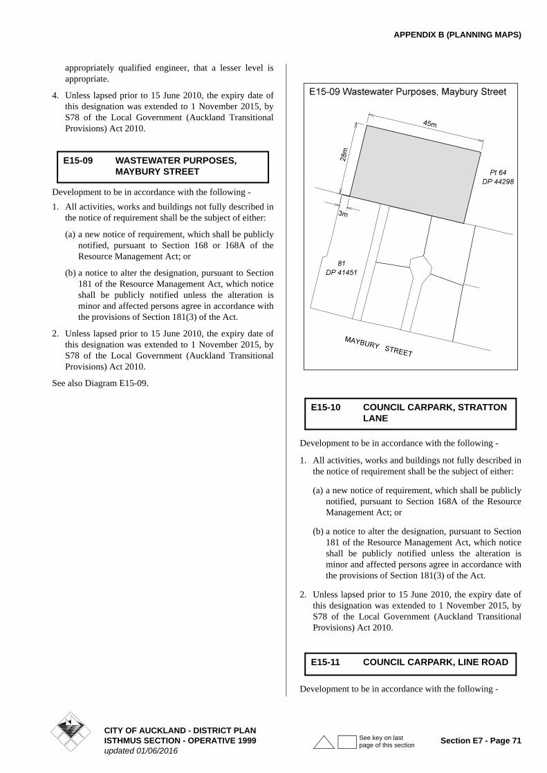
APPENDIX B (PLANNING MAPS)
appropriately qualified engineer, that a lesser level is appropriate.
4. Unless lapsed prior to 15 June 2010, the expiry date of this designation was extended to 1 November 2015, by S78 of the Local Government (Auckland Transitional Provisions) Act 2010.
Development to be in accordance with the following -
1. All activities, works and buildings not fully described in the notice of requirement shall be the subject of either:
(a) a new notice of requirement, which shall be publicly notified, pursuant to Section 168 or 168A of the Resource Management Act; or
(b) a notice to alter the designation, pursuant to Section 181 of the Resource Management Act, which notice shall be publicly notified unless the alteration is minor and affected persons agree in accordance with the provisions of Section 181(3) of the Act.
2. Unless lapsed prior to 15 June 2010, the expiry date of this designation was extended to 1 November 2015, by S78 of the Local Government (Auckland Transitional Provisions) Act 2010.
See also Diagram E15-09.
Development to be in accordance with the following -
1. All activities, works and buildings not fully described in the notice of requirement shall be the subject of either:
(a) a new notice of requirement, which shall be publicly notified, pursuant to Section 168A of the Resource Management Act; or
(b) a notice to alter the designation, pursuant to Section 181 of the Resource Management Act, which notice shall be publicly notified unless the alteration is minor and affected persons agree in accordance with the provisions of Section 181(3) of the Act.
2. Unless lapsed prior to 15 June 2010, the expiry date of this designation was extended to 1 November 2015, by S78 of the Local Government (Auckland Transitional Provisions) Act 2010.
Development to be in accordance with the following -
E15-09 WASTEWATER PURPOSES, MAYBURY STREET
E15-10 COUNCIL CARPARK, STRATTON LANE
E15-11 COUNCIL CARPARK, LINE ROAD
CITY OF AUCKLAND - DISTRICT PLANISTHMUS SECTION - OPERATIVE 1999 Section E7 - Page 71updated 01/06/2016
See key on last page of this section
APPENDIX B (PLANNING MAPS)
1. All activities, works and buildings not fully described in the notice of requirement shall be the subject of either:
(a) a new notice of requirement, which shall be publicly notified, pursuant to Section 168A of the Resource Management Act; or
(b) a notice to alter the designation, pursuant to Section 181 of the Resource Management Act, which notice shall be publicly notified unless the alteration is minor and affected persons agree in accordance with the provisions of Section 181(3) of the Act.
2. Unless lapsed prior to 15 June 2010, the expiry date of this designation was extended to 1 November 2015, by S78 of the Local Government (Auckland Transitional Provisions) Act 2010.
In addition to the other development controls that apply:
1. The maximum height on the Talbot Park Precinct, Glen Innes shall be limited to 11 metres and 3 storeys; and
2. At the time of design of roading and services for the Talbot Park Precinct, Glen Innes an integrated design will be undertaken to protect the overland flow path and allow for a continuous movement of overland stormwater flow through the site in the event of the reticulation becoming overloaded.
A maximum height of 14m and 4 storeys and a maximum height of 17m and 5 storeys shall apply in the areas illustrated in diagram E15-16.
The Special Height Limits illustrated in Diagram E15-16 will only apply if the site is developed as a retirement village.
Any deviation from Diagram E15-16 will require a discretionary activity resource consent.
(a) No housing, communal residential or communal non-residential buildings shall be constructed in any area identified as a flood risk area, flood plain area or overland flow path on the Council's Geographical Information System, without a report from an approved drainage engineer showing that the land on which any such
building will be placed will not be flooded by a 2% Annual Exceedance Probability storm (1 in 50 year flood).
Note: Housing, communal residential or communal non-residential buildings are defined by the New Zealand Building Code. Housing includes detached dwellings, multi-unit dwellings and group dwellings such as communes and marae. Communal residential buildings include hotels, motels, retirement villages, hospitals. Communal non-residential buildings include halls, churches, cinemas, theatres, whare runanga, schools, kindergartens.
(b) No development shall occur in any area identified as E15-17, if it will increase the level of flooding of any adjacent, upstream or downstream property.
Development to be in accordance with the following -
1. All activities, works and buildings not fully described in the notice of requirement shall be the subject of either:
(a) a new notice of requirement, which shall be publicly notified, pursuant to Section 168 or 168A of the Resource Management Act; or
(b) a notice to alter the designation, pursuant to Section 181 of the Resource Management Act, which notice shall be publicly notified unless the alteration is minor and affected persons agree in accordance with the provisions of Section 181(3) of the Act.
2. Unless lapsed prior to 15 June 2010, the expiry date of this designation was extended to 1 November 2015, by S78 of the Local Government (Auckland Transitional Provisions) Act 2010.
E15-15 LIMITATION ON MAXIMUM HEIGHT AND DEVELOPMENT WITHIN THE EXISTING STORMWATER OVERLAND FLOW PATH - TALBOT PARK PRECINCT, GLEN INNES
E15-16 SPECIAL HEIGHT LIMIT
E15-17 ADDITIONAL LIMITATIONS FOR FLOOD RISK
E16-01 WASTEWATER PURPOSES, RIVERSIDE AVENUE AND DUNKIRK ROAD
CITY OF AUCKLAND - DISTRICT PLANSection E7 - Page 72 ISTHMUS SECTION - OPERATIVE 1999
updated 01/06/2016
See key on last page of this section
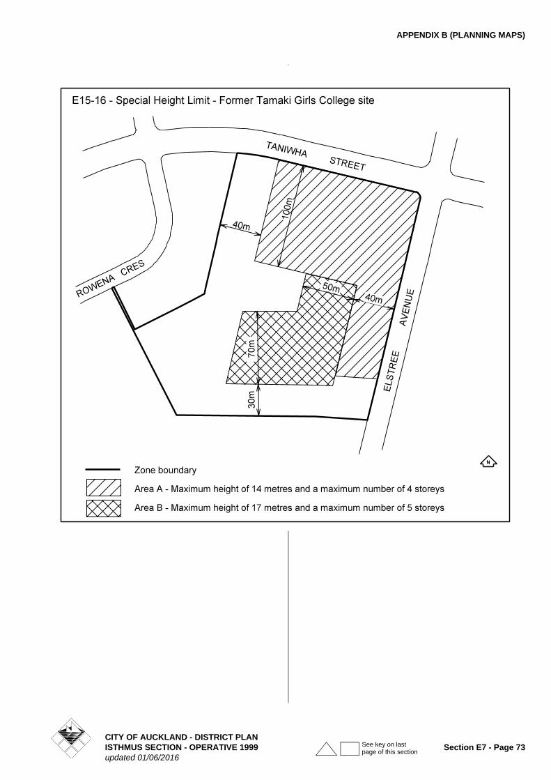
APPENDIX B (PLANNING MAPS)
CITY OF AUCKLAND - DISTRICT PLANISTHMUS SECTION - OPERATIVE 1999 Section E7 - Page 73updated 01/06/2016
See key on last page of this section
APPENDIX B (PLANNING MAPS)
1
Plan change annotations - key
Indicates where content is affected by proposed plan modification x.Refer to plan modification folder or website for details.
Indicates where the content is part of plan modification x, which is subject to appeal.
Underlined content to be inserted.
Struck through content to be deleted.
x
x
CITY OF AUCKLAND - DISTRICT PLANSection E7 - Page 74 ISTHMUS SECTION - OPERATIVE 1999
updated 01/06/2016
See key on last page of this section