Embed Size (px)
Citation preview

TBG111513013814SCO
APPENDIX A.1
Current Boring Logs
MH
BRIDGE NUMBER NA
PREPARED BY DATE
PROJECT OR BRIDGE NAMESR 710 North Study
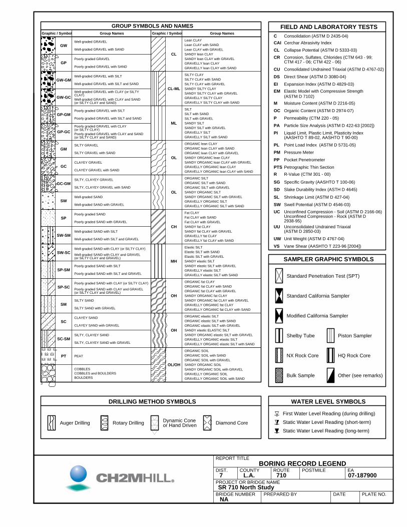
SAMPLER GRAPHIC SYMBOLS
REPORT TITLEBORING RECORD LEGEND
OL
OL
CH
SILTY GRAVEL
CL
CL-ML
ML
COBBLES and BOULDERSBOULDERS
PT
GW
SC
CLAYEY GRAVEL
SILTY, CLAYEY GRAVEL
SILTY SAND
CLAYEY SAND
SILTY CLAYSILTY CLAY with SANDSILTY CLAY with GRAVELSANDY SILTY CLAY
GRAVELLY ORGANIC SOIL
OH
OL/OH
ORGANIC SOILORGANIC SOIL with SANDORGANIC SOIL with GRAVEL
GW-GM
SANDY ORGANIC SOIL with GRAVEL
PLATE NO.
GRAVELLY ORGANIC SOIL with SAND
OH
SM
SANDY ORGANIC SOIL
GRAVELLY ORGANIC elastic SILT
Well-graded SAND with CLAY (or SILTY CLAY)
Poorly graded GRAVEL
Poorly graded GRAVEL with CLAY(or SILTY CLAY)
Poorly graded SAND with SILT
Poorly graded SAND with CLAY (or SILTY CLAY)
Poorly graded SAND with CLAY and GRAVEL(or SILTY CLAY and GRAVEL)
Lean CLAY
Well-graded GRAVEL with SILT
SANDY ORGANIC elastic SILT with GRAVEL
Well-graded GRAVEL with SAND
GRAVELLY ORGANIC elastic SILT with SAND
GW-GC
GP-GM
GP-GC
GM
ORGANIC elastic SILT with SAND
SILTY SAND with GRAVEL
EADIST.7
COUNTYL.A.
ROUTE710
POSTMILE07-187900
Well-graded GRAVEL with CLAY and SAND(or SILTY CLAY and SAND)
CLAYEY SAND with GRAVEL
COBBLES
Standard Penetration Test (SPT)
SILTY, CLAYEY SAND with GRAVEL
Diamond CoreRotary DrillingStatic Water Level Reading (long-term)
Shelby Tube
NX Rock Core
Bulk Sample
WATER LEVEL SYMBOLS
HQ Rock Core
FIELD AND LABORATORY TESTS
Other (see remarks)
Static Water Level Reading (short-term)
First Water Level Reading (during drilling)
Piston Sampler
GROUP SYMBOLS AND NAMES
Dynamic Coneor Hand Driven
GRAVELLY SILTY CLAY with SAND
DRILLING METHOD SYMBOLS
Auger Drilling
CL
UC
PIParticle Size Analysis (ASTM D 422-63 [2002])
Point Load Index (ASTM D 5731-05)
Petrographic Thin Section
Specific Gravity (AASHTO T 100-06)
Shrinkage Limit (ASTM D 427-04)
Swell Potential (ASTM D 4546-03)GRAVELLY ORGANIC SILT with SAND
Unconfined Compression - Soil (ASTM D 2166-06)Unconfined Compression - Rock (ASTM D2938-95)
GRAVELLY ORGANIC SILT
CU
PLPressure MeterPMPocket Penetrometer
SG
SW
SANDY SILTY CLAY with GRAVEL
GRAVELLY ORGANIC lean CLAY with SAND
ORGANIC SILT with SANDORGANIC SILT with GRAVELSANDY ORGANIC SILT
C
Consolidated Undrained Triaxial (ASTM D 4767-02)
Lean CLAY with SANDLean CLAY with GRAVEL
SANDY lean CLAY with GRAVEL
ORGANIC SILT
GRAVELLY ORGANIC lean CLAY
Well-graded SAND with CLAY and GRAVEL(or SILTY CLAY and GRAVEL)
Fat CLAY
Elastic SILT with GRAVELSANDY elastic SILTSANDY elastic SILT with GRAVELGRAVELLY elastic SILTGRAVELLY elastic SILT with SAND
ORGANIC elastic SILT
SANDY ORGANIC SILT with GRAVEL
ORGANIC lean CLAY
Moisture Content (ASTM D 2216-05)
PPPTS
R-Value (CTM 301 - 00)R
SL
Slake Durability Index (ASTH D 4645)SD
CR
Direct Shear (ASTM D 3080-04)DS
VS
EI
Vane Shear (AASHTO T 223-96 [2004])
MOC Organic Content (ASTM D 2974-07)
Permeability (CTM 220 - 05)PPA
Well-graded GRAVEL
Poorly graded GRAVEL with SILT
Expansion Index (ASTM D 4829-03)EM Elastic Model with Compressive Strength
(ASTM D 7102)
ORGANIC fat CLAY
ORGANIC lean CLAY with SANDORGANIC lean CLAY with GRAVELSANDY ORGANIC lean CLAYSANDY ORGANIC lean CLAY with GRAVEL
Fat CLAY with SANDFat CLAY with GRAVELSANDY fat CLAYSANDY fat CLAY with GRAVEL
GRAVELLY fat CLAY with SAND
GRAVELLY SILT
ORGANIC fat CLAY with SANDORGANIC fat CLAY with GRAVELSANDY ORGANIC fat CLAY
Elastic SILT with SAND
UU Unconsolidated Undrained Triaxial(ASTM D 2850-03)
UW Unit Weight (ASTM D 4767-04)GRAVELLY fat CLAY
Graphic / Symbol
SILT
GRAVELLY ORGANIC fat CLAY with SAND
Elastic SILT
ORGANIC elastic SILT with GRAVELSANDY elastic ELASTIC SILT
SILTY, CLAYEY SAND
Group Names
SANDY ORGANIC fat CLAY with GRAVEL
SC-SM
GRAVELLY lean CLAY
Graphic / Symbol Group Names
GC
Well-graded SAND with GRAVEL
GRAVELLY lean CLAY with SAND
SILT with SANDSILT with GRAVELSANDY SILTSANDY SILT with GRAVEL
PEAT
Well-graded GRAVEL with SILT and SAND
GRAVELLY ORGANIC fat CLAY
Well-graded SAND
SP-SC
Well-graded SAND with SILT and GRAVEL
Poorly graded GRAVEL with SAND
Poorly graded GRAVEL with SILT and SAND
Poorly graded GRAVEL with CLAY and SAND(or SILTY CLAY and SAND)
Poorly graded SAND
Poorly graded SAND with GRAVEL
Poorly graded SAND with SILT and GRAVEL
SANDY lean CLAY
Well-graded GRAVEL with CLAY (or SILTYCLAY)
Corrosion, Sulfates, Chlorides (CTM 643 - 99;CTM 417 - 06; CTM 422 - 06)
SW-SC
SP-SM
Consolidation (ASTM D 2435-04)
Liquid Limit, Plastic Limit, Plasticity Index(AASHTO T 89-02, AASHTO T 90-00)
GP
Well-graded SAND with SILT
GRAVELLY SILTY CLAY
Collapse Potential (ASTM D 5333-03)
CAI Cerchar Abrasivity Index
GRAVELLY SILT with SAND
SW
SP
SW-SM
SILTY, CLAYEY GRAVEL with SAND
CLAYEY GRAVEL with SAND
SILTY GRAVEL with SAND
Standard California Sampler
Modified California Sampler
GC-GM
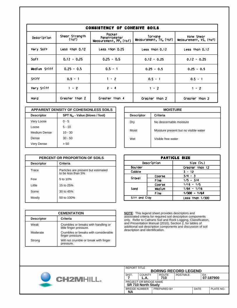
Descriptor Criteria
Very Dense > 50Wet
ERUTSIOMSLIOSSSELNOISEHOCFOYTISNEDTNERAPPA
BRIDGE NUMBER NA
Moist
30 - 50
0 - 5
10 - 30
5 - 10
Medium Dense
Dense
Descriptor
EA
REPORT TITLEBORING RECORD LEGEND
Visible free water
No descernable moisture
Moisture present but no visible water
SPT N60 - Value (blows / foot)
Very Loose
PROJECT OR BRIDGE NAME
POSTMILEROUTECOUNTYDIST.
Loose
PREPARED BY
Dry
Weak Crumbles or breaks with handling orlittle finger pressure.
Will not crumble or break with fingerpressure.
Particles are present but estimatedto be less than 5%
PLATE NO.
Crumbles or breaks with considerablefinger pressure.
Moderate
Strong
NOTE: This legend sheet provides descriptors andassociated criteria for required soil description componentsonly. Refer to Caltrans Soil and Rock Logging, Classification,and Presentation Manual (2010), Section 2, for tables ofadditional soil description components and discussion of soildescription and identification.
CriteriaDescriptorCEMENTATION
Trace
CriteriaPERCENT OR PROPORTION OF SOILS
DATE
Mostly
Descriptor
Some 30 to 45%
Little 15 to 25%
Few 5 to 10%
50 to 100%
SR 710 North Study
009781-70017.A.L7
PROJECT OR BRIDGE NAME
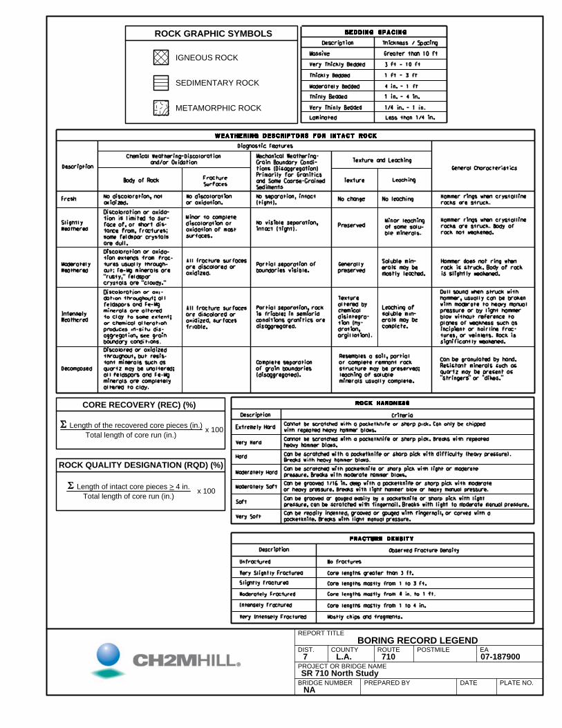
ROCK GRAPHIC SYMBOLS
POSTMILEROUTECOUNTY AE.TSID
METAMORPHIC ROCK
SEDIMENTARY ROCK
IGNEOUS ROCK
CORE RECOVERY (REC) (%)
ROCK QUALITY DESIGNATION (RQD) (%)
x 100Length of the recovered core pieces (in.)
Total length of core run (in.)
PREPARED BY
Length of intact core pieces > 4 in.
Total length of core run (in.)
x 100
BRIDGE NUMBER NA
REPORT TITLEBORING RECORD LEGEND
PLATE NO.DATESR 710 North Study
009781-70017.A.L7
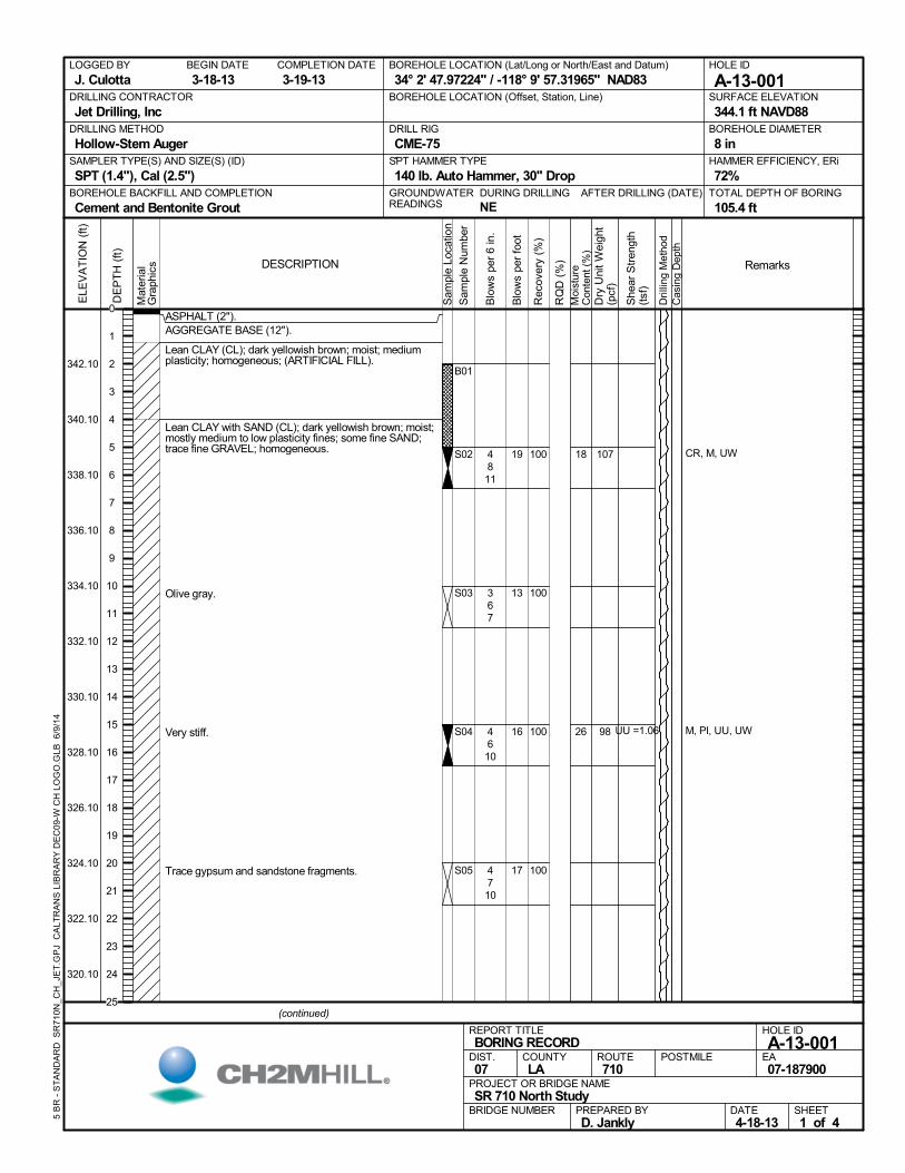
ASPHALT (2").AGGREGATE BASE (12").
Lean CLAY (CL); dark yellowish brown; moist; mediumplasticity; homogeneous; (ARTIFICIAL FILL).
Lean CLAY with SAND (CL); dark yellowish brown; moist;mostly medium to low plasticity fines; some fine SAND;trace fine GRAVEL; homogeneous.
Olive gray.
Very stiff.
Trace gypsum and sandstone fragments.
100
100
100
100
B01
S02
S03
S04
S05
18
26
CR, M, UW
M, PI, UU, UW
4811
367
4610
4710
107
98 UU =1.06
AFTER DRILLING (DATE)DURING DRILLING
NE
SURFACE ELEVATION
344.1 ft NAVD88DRILLING METHOD
Hollow-Stem AugerDRILL RIG
CME-75SPT HAMMER TYPE
140 lb. Auto Hammer, 30" DropBOREHOLE BACKFILL AND COMPLETION
Cement and Bentonite GroutGROUNDWATERREADINGS
BEGIN DATE
3-18-13COMPLETION DATE
3-19-13LOGGED BY
J. CulottaBOREHOLE LOCATION (Lat/Long or North/East and Datum)
34° 2' 47.97224" / -118° 9' 57.31965" NAD83HOLE ID
A-13-001DRILLING CONTRACTOR
Jet Drilling, Inc
HAMMER EFFICIENCY, ERi
72%SAMPLER TYPE(S) AND SIZE(S) (ID)
SPT (1.4"), Cal (2.5")TOTAL DEPTH OF BORING
105.4 ft
BOREHOLE DIAMETER
8 in
BOREHOLE LOCATION (Offset, Station, Line)
.M
ater
ial
Gra
phic
s
Sam
ple
Loca
tion
COUNTYLA
DESCRIPTION
Rec
over
y (%
)
Dri
lling
Met
hod
Cas
ing
Dep
th
PREPARED BYD. Jankly
DATE4-18-13
PROJECT OR BRIDGE NAMESR 710 North Study
BRIDGE NUMBER
HOLE ID
A-13-001EA07-187900
REPORT TITLEBORING RECORD
DIST.07
ROUTE710
POSTMILE
(continued)
SHEET1 of 4
RQ
D (
%)
Sam
ple
Num
ber
Moi
stur
eC
onte
nt (
%)
Remarks
Blo
ws
per
6 in
.
ELE
VA
TIO
N (
ft)
342.10
340.10
338.10
336.10
334.10
332.10
330.10
328.10
326.10
324.10
322.10
320.10
DE
PT
H (
ft)
Dry
Uni
t W
eigh
t(p
cf)
She
ar S
tren
gth
(tsf
)
Blo
ws
per
foot
5 B
R -
ST
AN
DA
RD
SR
710
N_C
H_J
ET
.GP
J C
ALT
RA
NS
LIB
RA
RY
DE
C09
-W C
H L
OG
O.G
LB 6
/9/1
4
19
13
16
17
0
1
2
3
4
5
6
7
8
9
10
11
12
13
14
15
16
17
18
19
20
21
22
23
24
25
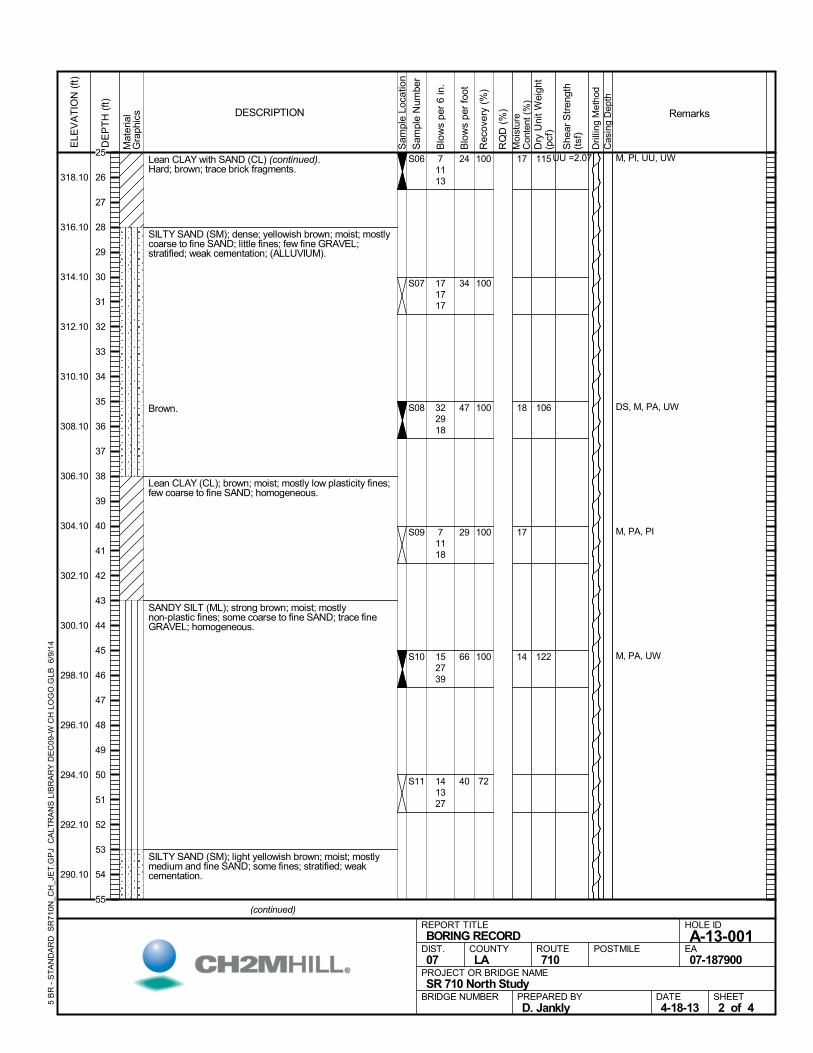
Lean CLAY with SAND (CL) (continued).Hard; brown; trace brick fragments.
SILTY SAND (SM); dense; yellowish brown; moist; mostlycoarse to fine SAND; little fines; few fine GRAVEL;stratified; weak cementation; (ALLUVIUM).
Brown.
Lean CLAY (CL); brown; moist; mostly low plasticity fines;few coarse to fine SAND; homogeneous.
SANDY SILT (ML); strong brown; moist; mostlynon-plastic fines; some coarse to fine SAND; trace fineGRAVEL; homogeneous.
SILTY SAND (SM); light yellowish brown; moist; mostlymedium and fine SAND; some fines; stratified; weakcementation.
100
100
100
100
100
72
S06
S07
S08
S09
S10
S11
17
18
17
14
M, PI, UU, UW
DS, M, PA, UW
M, PA, PI
M, PA, UW
71113
171717
322918
71118
152739
141327
115
106
122
UU =2.07
Mat
eria
lG
raph
ics
Sam
ple
Loca
tion
COUNTYLA
DESCRIPTION
Rec
over
y (%
)
Dri
lling
Met
hod
Cas
ing
Dep
th
PREPARED BYD. Jankly
DATE4-18-13
PROJECT OR BRIDGE NAMESR 710 North Study
BRIDGE NUMBER
HOLE ID
A-13-001EA07-187900
REPORT TITLEBORING RECORD
DIST.07
ROUTE710
POSTMILE
(continued)
SHEET2 of 4
RQ
D (
%)
Sam
ple
Num
ber
Moi
stur
eC
onte
nt (
%)
Remarks
Blo
ws
per
6 in
.
ELE
VA
TIO
N (
ft)
318.10
316.10
314.10
312.10
310.10
308.10
306.10
304.10
302.10
300.10
298.10
296.10
294.10
292.10
290.10
DE
PT
H (
ft)
Dry
Uni
t W
eigh
t(p
cf)
She
ar S
tren
gth
(tsf
)
Blo
ws
per
foot
5 B
R -
ST
AN
DA
RD
SR
710
N_C
H_J
ET
.GP
J C
ALT
RA
NS
LIB
RA
RY
DE
C09
-W C
H L
OG
O.G
LB 6
/9/1
4
24
34
47
29
66
40
25
26
27
28
29
30
31
32
33
34
35
36
37
38
39
40
41
42
43
44
45
46
47
48
49
50
51
52
53
54
55
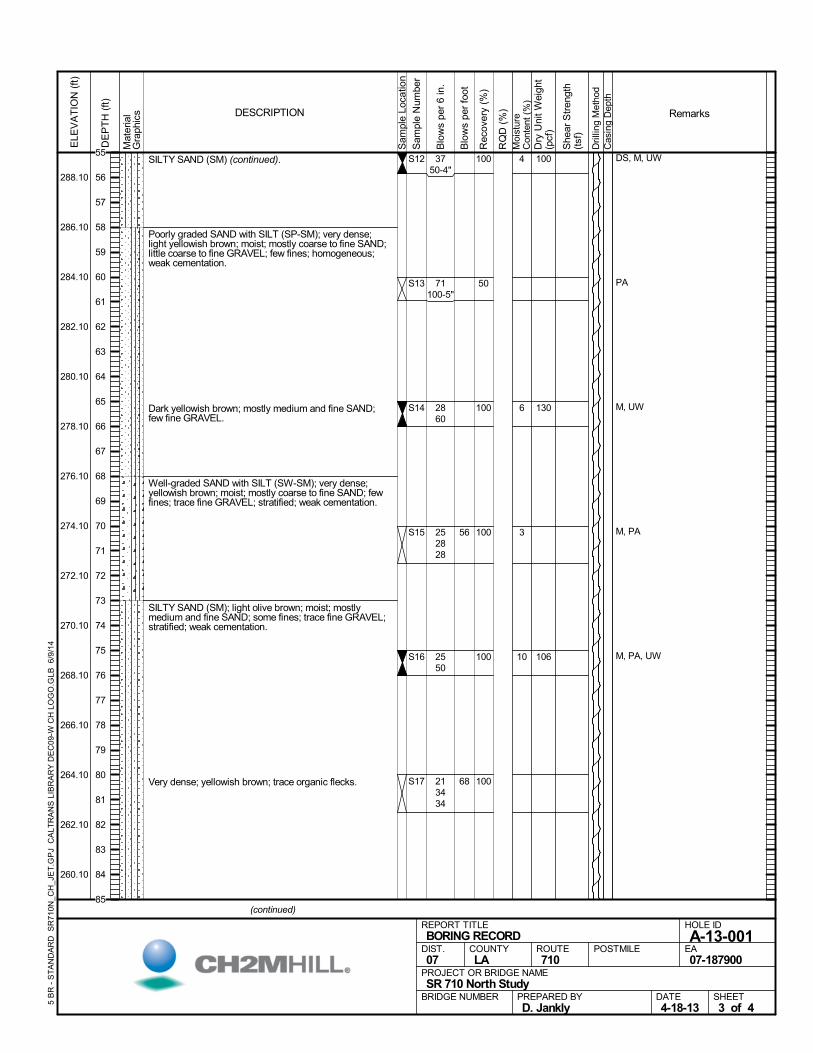
SILTY SAND (SM) (continued).
Poorly graded SAND with SILT (SP-SM); very dense;light yellowish brown; moist; mostly coarse to fine SAND;little coarse to fine GRAVEL; few fines; homogeneous;weak cementation.
Dark yellowish brown; mostly medium and fine SAND;few fine GRAVEL.
Well-graded SAND with SILT (SW-SM); very dense;yellowish brown; moist; mostly coarse to fine SAND; fewfines; trace fine GRAVEL; stratified; weak cementation.
SILTY SAND (SM); light olive brown; moist; mostlymedium and fine SAND; some fines; trace fine GRAVEL;stratified; weak cementation.
Very dense; yellowish brown; trace organic flecks.
100
50
100
100
100
100
S12
S13
S14
S15
S16
S17
4
6
3
10
DS, M, UW
PA
M, UW
M, PA
M, PA, UW
3750-4"
71100-5"
2860
252828
2550
213434
100
130
106
Mat
eria
lG
raph
ics
Sam
ple
Loca
tion
COUNTYLA
DESCRIPTION
Rec
over
y (%
)
Dri
lling
Met
hod
Cas
ing
Dep
th
PREPARED BYD. Jankly
DATE4-18-13
PROJECT OR BRIDGE NAMESR 710 North Study
BRIDGE NUMBER
HOLE ID
A-13-001EA07-187900
REPORT TITLEBORING RECORD
DIST.07
ROUTE710
POSTMILE
(continued)
SHEET3 of 4
RQ
D (
%)
Sam
ple
Num
ber
Moi
stur
eC
onte
nt (
%)
Remarks
Blo
ws
per
6 in
.
ELE
VA
TIO
N (
ft)
288.10
286.10
284.10
282.10
280.10
278.10
276.10
274.10
272.10
270.10
268.10
266.10
264.10
262.10
260.10
DE
PT
H (
ft)
Dry
Uni
t W
eigh
t(p
cf)
She
ar S
tren
gth
(tsf
)
Blo
ws
per
foot
5 B
R -
ST
AN
DA
RD
SR
710
N_C
H_J
ET
.GP
J C
ALT
RA
NS
LIB
RA
RY
DE
C09
-W C
H L
OG
O.G
LB 6
/9/1
4
56
68
55
56
57
58
59
60
61
62
63
64
65
66
67
68
69
70
71
72
73
74
75
76
77
78
79
80
81
82
83
84
85
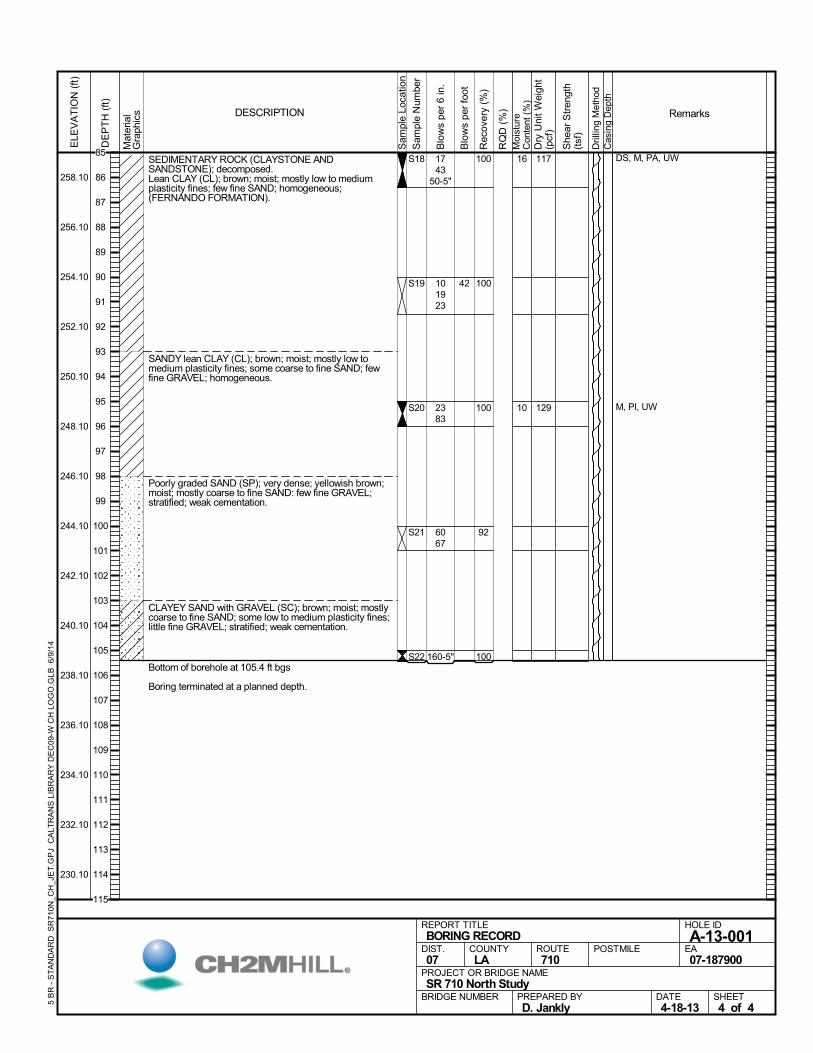
SEDIMENTARY ROCK (CLAYSTONE ANDSANDSTONE); decomposed.Lean CLAY (CL); brown; moist; mostly low to mediumplasticity fines; few fine SAND; homogeneous;(FERNANDO FORMATION).
SANDY lean CLAY (CL); brown; moist; mostly low tomedium plasticity fines; some coarse to fine SAND; fewfine GRAVEL; homogeneous.
Poorly graded SAND (SP); very dense; yellowish brown;moist; mostly coarse to fine SAND: few fine GRAVEL;stratified; weak cementation.
CLAYEY SAND with GRAVEL (SC); brown; moist; mostlycoarse to fine SAND; some low to medium plasticity fines;little fine GRAVEL; stratified; weak cementation.
Bottom of borehole at 105.4 ft bgs
Boring terminated at a planned depth.
100
100
100
92
100
S18
S19
S20
S21
S22
16
10
DS, M, PA, UW
M, PI, UW
1743
50-5"
101923
2383
6067
160-5"
117
129
Mat
eria
lG
raph
ics
Sam
ple
Loca
tion
COUNTYLA
DESCRIPTION
Rec
over
y (%
)
Dri
lling
Met
hod
Cas
ing
Dep
th
PREPARED BYD. Jankly
DATE4-18-13
PROJECT OR BRIDGE NAMESR 710 North Study
BRIDGE NUMBER
HOLE ID
A-13-001EA07-187900
REPORT TITLEBORING RECORD
DIST.07
ROUTE710
POSTMILE
SHEET4 of 4
RQ
D (
%)
Sam
ple
Num
ber
Moi
stur
eC
onte
nt (
%)
Remarks
Blo
ws
per
6 in
.
ELE
VA
TIO
N (
ft)
258.10
256.10
254.10
252.10
250.10
248.10
246.10
244.10
242.10
240.10
238.10
236.10
234.10
232.10
230.10
DE
PT
H (
ft)
Dry
Uni
t W
eigh
t(p
cf)
She
ar S
tren
gth
(tsf
)
Blo
ws
per
foot
5 B
R -
ST
AN
DA
RD
SR
710
N_C
H_J
ET
.GP
J C
ALT
RA
NS
LIB
RA
RY
DE
C09
-W C
H L
OG
O.G
LB 6
/9/1
4
42
85
86
87
88
89
90
91
92
93
94
95
96
97
98
99
100
101
102
103
104
105
106
107
108
109
110
111
112
113
114
115
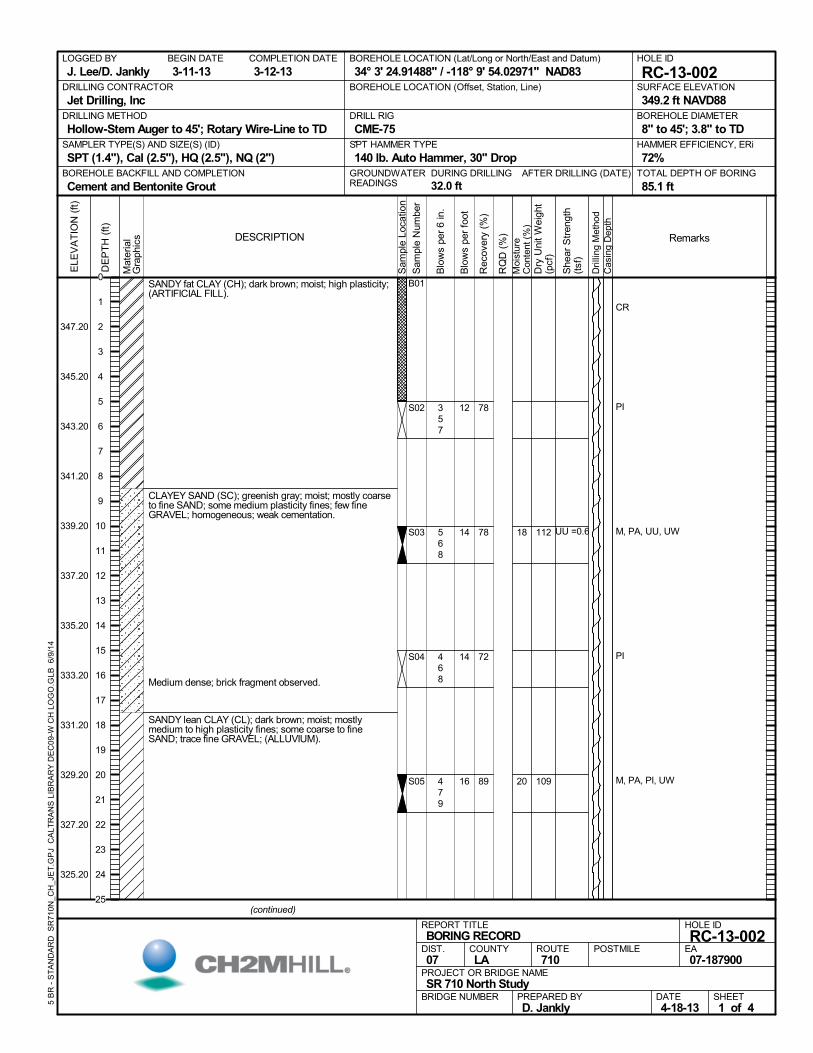
SANDY fat CLAY (CH); dark brown; moist; high plasticity;(ARTIFICIAL FILL).
CLAYEY SAND (SC); greenish gray; moist; mostly coarseto fine SAND; some medium plasticity fines; few fineGRAVEL; homogeneous; weak cementation.
Medium dense; brick fragment observed.
SANDY lean CLAY (CL); dark brown; moist; mostlymedium to high plasticity fines; some coarse to fineSAND; trace fine GRAVEL; (ALLUVIUM).
78
78
72
89
B01
S02
S03
S04
S05
18
20
CR
PI
M, PA, UU, UW
PI
M, PA, PI, UW
357
568
468
479
112
109
UU =0.6
AFTER DRILLING (DATE)DURING DRILLING
32.0 ft
SURFACE ELEVATION
349.2 ft NAVD88DRILLING METHOD
Hollow-Stem Auger to 45'; Rotary Wire-Line to TDDRILL RIG
CME-75SPT HAMMER TYPE
140 lb. Auto Hammer, 30" DropBOREHOLE BACKFILL AND COMPLETION
Cement and Bentonite GroutGROUNDWATERREADINGS
BEGIN DATE
3-11-13COMPLETION DATE
3-12-13LOGGED BY
J. Lee/D. JanklyBOREHOLE LOCATION (Lat/Long or North/East and Datum)
34° 3' 24.91488" / -118° 9' 54.02971" NAD83HOLE ID
RC-13-002DRILLING CONTRACTOR
Jet Drilling, Inc
HAMMER EFFICIENCY, ERi
72%SAMPLER TYPE(S) AND SIZE(S) (ID)
SPT (1.4"), Cal (2.5"), HQ (2.5"), NQ (2")TOTAL DEPTH OF BORING
85.1 ft
BOREHOLE DIAMETER
8" to 45'; 3.8" to TD
BOREHOLE LOCATION (Offset, Station, Line)
.M
ater
ial
Gra
phic
s
Sam
ple
Loca
tion
COUNTYLA
DESCRIPTION
Rec
over
y (%
)
Dri
lling
Met
hod
Cas
ing
Dep
th
PREPARED BYD. Jankly
DATE4-18-13
PROJECT OR BRIDGE NAMESR 710 North Study
BRIDGE NUMBER
HOLE ID
RC-13-002EA07-187900
REPORT TITLEBORING RECORD
DIST.07
ROUTE710
POSTMILE
(continued)
SHEET1 of 4
RQ
D (
%)
Sam
ple
Num
ber
Moi
stur
eC
onte
nt (
%)
Remarks
Blo
ws
per
6 in
.
ELE
VA
TIO
N (
ft)
347.20
345.20
343.20
341.20
339.20
337.20
335.20
333.20
331.20
329.20
327.20
325.20
DE
PT
H (
ft)
Dry
Uni
t W
eigh
t(p
cf)
She
ar S
tren
gth
(tsf
)
Blo
ws
per
foot
5 B
R -
ST
AN
DA
RD
SR
710
N_C
H_J
ET
.GP
J C
ALT
RA
NS
LIB
RA
RY
DE
C09
-W C
H L
OG
O.G
LB 6
/9/1
4
12
14
14
16
0
1
2
3
4
5
6
7
8
9
10
11
12
13
14
15
16
17
18
19
20
21
22
23
24
25
SANDY lean CLAY (CL) (continued).
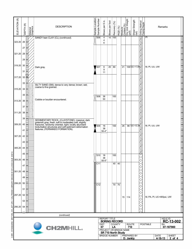
Dark gray.
SILTY SAND (SM); dense to very dense; brown; wet;coarse to fine grained.
Cobble or boulder encountered.
SEDIMENTARY ROCK, (CLAYSTONE); massive; darkgreenish gray; fresh; soft to moderately soft; slightlyfractured, randomly oriented, tight; locally abundantbioturbation structures and soft sediment deformationfeatures; (FERNANDO FORMATION).
100
80
100
100
100
40
70
C11
C12
40
70
S06
S07
S08
S09
S10
21
26
15
PI
M, PI, UU, UW
M, PI, UU, UW
M, PA, PI, UC=465psi, UW
446
6911
3650
1638
50-4"
1838
50-5"
106
98
114
UU =1.09
UU =3.35
Mat
eria
lG
raph
ics
Sam
ple
Loca
tion
COUNTYLA
DESCRIPTION
Rec
over
y (%
)
Dri
lling
Met
hod
Cas
ing
Dep
th
PREPARED BYD. Jankly
DATE4-18-13
PROJECT OR BRIDGE NAMESR 710 North Study
BRIDGE NUMBER
HOLE ID
RC-13-002EA07-187900
REPORT TITLEBORING RECORD
DIST.07
ROUTE710
POSTMILE
(continued)
SHEET2 of 4
RQ
D (
%)
Sam
ple
Num
ber
Moi
stur
eC
onte
nt (
%)
Remarks
Blo
ws
per
6 in
.
ELE
VA
TIO
N (
ft)
323.20
321.20
319.20
317.20
315.20
313.20
311.20
309.20
307.20
305.20
303.20
301.20
299.20
297.20
295.20
DE
PT
H (
ft)
Dry
Uni
t W
eigh
t(p
cf)
She
ar S
tren
gth
(tsf
)
Blo
ws
per
foot
5 B
R -
ST
AN
DA
RD
SR
710
N_C
H_J
ET
.GP
J C
ALT
RA
NS
LIB
RA
RY
DE
C09
-W C
H L
OG
O.G
LB 6
/9/1
4
10
20
25
26
27
28
29
30
31
32
33
34
35
36
37
38
39
40
41
42
43
44
45
46
47
48
49
50
51
52
53
54
55
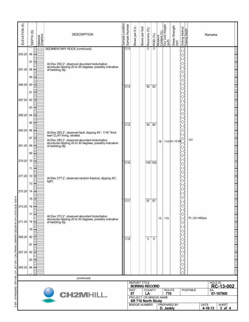
SEDIMENTARY ROCK (continued).
At Elev 292.2', observed abundant bioturbationstructures dipping 20 to 30 degrees, possibly indicativeof bedding dip.
At Elev 283.2', observed fault, dipping 40°, 1/16" thicklean CLAY lining, striated.
At Elev 282.2', observed abundant bioturbationstructures dipping 20 to 30 degrees, possibly indicativeof bedding dip.
At Elev 277.2', observed random fracture, dipping 40°,tight.
At Elev 272.2', observed abundant bioturbationstructures dipping 20 to 30 degrees, possibly indicativeof bedding dip.
0
92
93
100
97
0
C13
C14
C15
C16
C17
C18
0
92
80
100
97
0
18
13
UU
PI, UC=482psi
114
115
UU =0.99
Mat
eria
lG
raph
ics
Sam
ple
Loca
tion
COUNTYLA
DESCRIPTION
Rec
over
y (%
)
Dri
lling
Met
hod
Cas
ing
Dep
th
PREPARED BYD. Jankly
DATE4-18-13
PROJECT OR BRIDGE NAMESR 710 North Study
BRIDGE NUMBER
HOLE ID
RC-13-002EA07-187900
REPORT TITLEBORING RECORD
DIST.07
ROUTE710
POSTMILE
(continued)
SHEET3 of 4
RQ
D (
%)
Sam
ple
Num
ber
Moi
stur
eC
onte
nt (
%)
Remarks
Blo
ws
per
6 in
.
ELE
VA
TIO
N (
ft)
293.20
291.20
289.20
287.20
285.20
283.20
281.20
279.20
277.20
275.20
273.20
271.20
269.20
267.20
265.20
DE
PT
H (
ft)
Dry
Uni
t W
eigh
t(p
cf)
She
ar S
tren
gth
(tsf
)
Blo
ws
per
foot
5 B
R -
ST
AN
DA
RD
SR
710
N_C
H_J
ET
.GP
J C
ALT
RA
NS
LIB
RA
RY
DE
C09
-W C
H L
OG
O.G
LB 6
/9/1
4
55
56
57
58
59
60
61
62
63
64
65
66
67
68
69
70
71
72
73
74
75
76
77
78
79
80
81
82
83
84
85
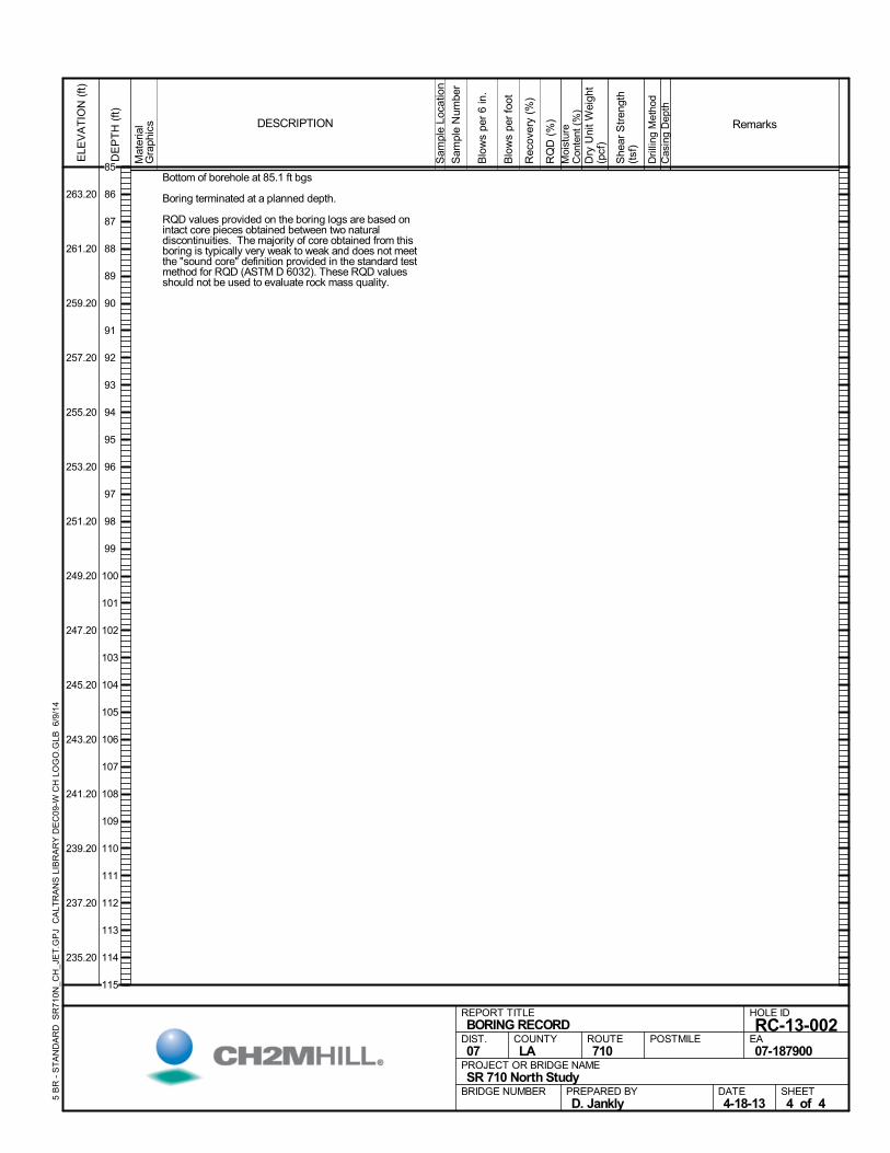
Bottom of borehole at 85.1 ft bgs
Boring terminated at a planned depth.
RQD values provided on the boring logs are based onintact core pieces obtained between two naturaldiscontinuities. The majority of core obtained from thisboring is typically very weak to weak and does not meetthe "sound core" definition provided in the standard testmethod for RQD (ASTM D 6032). These RQD valuesshould not be used to evaluate rock mass quality.
Mat
eria
lG
raph
ics
Sam
ple
Loca
tion
COUNTYLA
DESCRIPTION
Rec
over
y (%
)
Dri
lling
Met
hod
Cas
ing
Dep
th
PREPARED BYD. Jankly
DATE4-18-13
PROJECT OR BRIDGE NAMESR 710 North Study
BRIDGE NUMBER
HOLE ID
RC-13-002EA07-187900
REPORT TITLEBORING RECORD
DIST.07
ROUTE710
POSTMILE
SHEET4 of 4
RQ
D (
%)
Sam
ple
Num
ber
Moi
stur
eC
onte
nt (
%)
Remarks
Blo
ws
per
6 in
.
ELE
VA
TIO
N (
ft)
263.20
261.20
259.20
257.20
255.20
253.20
251.20
249.20
247.20
245.20
243.20
241.20
239.20
237.20
235.20
DE
PT
H (
ft)
Dry
Uni
t W
eigh
t(p
cf)
She
ar S
tren
gth
(tsf
)
Blo
ws
per
foot
5 B
R -
ST
AN
DA
RD
SR
710
N_C
H_J
ET
.GP
J C
ALT
RA
NS
LIB
RA
RY
DE
C09
-W C
H L
OG
O.G
LB 6
/9/1
4
85
86
87
88
89
90
91
92
93
94
95
96
97
98
99
100
101
102
103
104
105
106
107
108
109
110
111
112
113
114
115
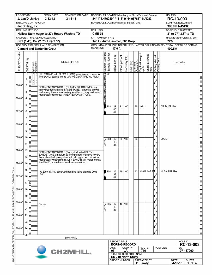
SILTY SAND with GRAVEL (SM); gray; moist; coarse tofine SAND; coarse to fine GRAVEL; (ARTIFICIAL FILL).
SEDIMENTARY ROCK, (CLAYEY SILTSTONE) verythinly bedded with fine SANDSTONE; light olive brownand strong brown; moderately weathered; very soft to soft;moderately fractured; (PUENTE FORMATION).
SEDIMENTARY ROCK, (Poorly Indurated SILTYSANDSTONE); medium to fine grained; massive to verythickly bedded; pale yellow with strong brown oxidation;moderately weathered; (SILTY SAND (SM); moist; mostlyfine SAND; some fines; weak cementation).
At Elev 373.8', observed bedding joint, dipping 90 to85°.
Dense.
100
100
100
100
B01
S02
S03
S04
S05
25
26
22
DS, M, PI, UW
CR, M
M, PA, UU, UW
184041
121821
193247
121927
93
105UU =2.15
AFTER DRILLING (DATE)DURING DRILLING
17.0 ft
SURFACE ELEVATION
388.8 ft NAVD88DRILLING METHOD
Hollow-Stem Auger to 27'; Rotary Wash to TDDRILL RIG
CME-75SPT HAMMER TYPE
140 lb. Auto Hammer, 30" DropBOREHOLE BACKFILL AND COMPLETION
Cement and Bentonite GroutGROUNDWATERREADINGS
BEGIN DATE
3-13-13COMPLETION DATE
3-14-13LOGGED BY
J. Lee/D. JanklyBOREHOLE LOCATION (Lat/Long or North/East and Datum)
34° 4' 8.476249" / -118° 9' 44.95765" NAD83HOLE ID
RC-13-003DRILLING CONTRACTOR
Jet Drilling, Inc
HAMMER EFFICIENCY, ERi
72%SAMPLER TYPE(S) AND SIZE(S) (ID)
SPT (1.4"), Cal (2.5"), HQ (2.5")TOTAL DEPTH OF BORING
100.5 ft
BOREHOLE DIAMETER
8" to 27'; 3.8" to TD
BOREHOLE LOCATION (Offset, Station, Line)
.M
ater
ial
Gra
phic
s
Sam
ple
Loca
tion
COUNTYLA
DESCRIPTION
Rec
over
y (%
)
Dri
lling
Met
hod
Cas
ing
Dep
th
PREPARED BYD. Jankly
DATE4-18-13
PROJECT OR BRIDGE NAMESR 710 North Study
BRIDGE NUMBER
HOLE ID
RC-13-003EA07-187900
REPORT TITLEBORING RECORD
DIST.07
ROUTE710
POSTMILE
(continued)
SHEET1 of 4
RQ
D (
%)
Sam
ple
Num
ber
Moi
stur
eC
onte
nt (
%)
Remarks
Blo
ws
per
6 in
.
ELE
VA
TIO
N (
ft)
386.80
384.80
382.80
380.80
378.80
376.80
374.80
372.80
370.80
368.80
366.80
364.80
DE
PT
H (
ft)
Dry
Uni
t W
eigh
t(p
cf)
She
ar S
tren
gth
(tsf
)
Blo
ws
per
foot
5 B
R -
ST
AN
DA
RD
SR
710
N_C
H_J
ET
.GP
J C
ALT
RA
NS
LIB
RA
RY
DE
C09
-W C
H L
OG
O.G
LB 6
/9/1
4
81
39
79
46
0
1
2
3
4
5
6
7
8
9
10
11
12
13
14
15
16
17
18
19
20
21
22
23
24
25
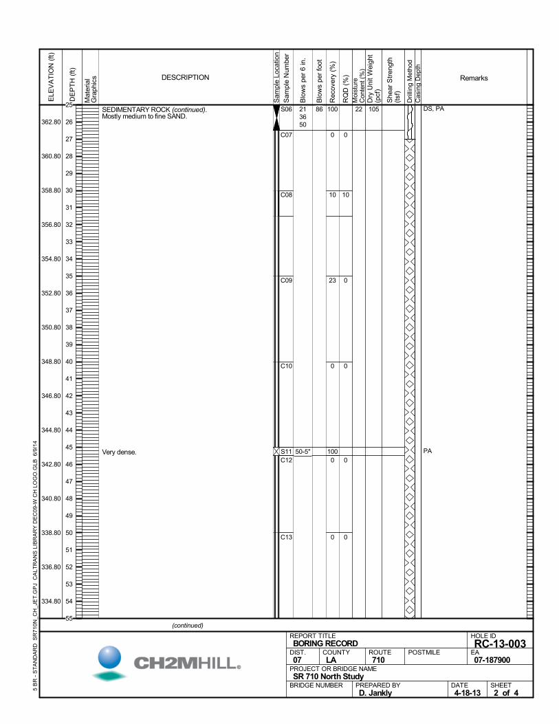
SEDIMENTARY ROCK (continued).Mostly medium to fine SAND.
Very dense.
100
100
0
10
23
0
0
0
C07
C08
C09
C10
C12
C13
0
10
0
0
0
0
S06
S11
22 DS, PA
PA
213650
50-5"
105
Mat
eria
lG
raph
ics
Sam
ple
Loca
tion
COUNTYLA
DESCRIPTION
Rec
over
y (%
)
Dri
lling
Met
hod
Cas
ing
Dep
th
PREPARED BYD. Jankly
DATE4-18-13
PROJECT OR BRIDGE NAMESR 710 North Study
BRIDGE NUMBER
HOLE ID
RC-13-003EA07-187900
REPORT TITLEBORING RECORD
DIST.07
ROUTE710
POSTMILE
(continued)
SHEET2 of 4
RQ
D (
%)
Sam
ple
Num
ber
Moi
stur
eC
onte
nt (
%)
Remarks
Blo
ws
per
6 in
.
ELE
VA
TIO
N (
ft)
362.80
360.80
358.80
356.80
354.80
352.80
350.80
348.80
346.80
344.80
342.80
340.80
338.80
336.80
334.80
DE
PT
H (
ft)
Dry
Uni
t W
eigh
t(p
cf)
She
ar S
tren
gth
(tsf
)
Blo
ws
per
foot
5 B
R -
ST
AN
DA
RD
SR
710
N_C
H_J
ET
.GP
J C
ALT
RA
NS
LIB
RA
RY
DE
C09
-W C
H L
OG
O.G
LB 6
/9/1
4
8625
26
27
28
29
30
31
32
33
34
35
36
37
38
39
40
41
42
43
44
45
46
47
48
49
50
51
52
53
54
55
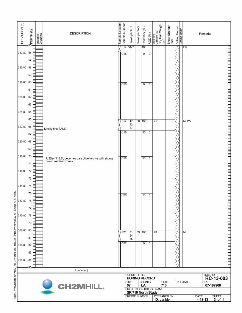
Mostly fine SAND.
At Elev 318.8', becomes pale olive to olive with strongbrown oxidized zones.
100
100
100
0
0
50
50
15
0
C15
C16
C18
C19
C20
C22
0
0
0
0
0
0
S14
S17
S21
21
23
PA
M, PA
M
50-3"
172337
313435
Mat
eria
lG
raph
ics
Sam
ple
Loca
tion
COUNTYLA
DESCRIPTION
Rec
over
y (%
)
Dri
lling
Met
hod
Cas
ing
Dep
th
PREPARED BYD. Jankly
DATE4-18-13
PROJECT OR BRIDGE NAMESR 710 North Study
BRIDGE NUMBER
HOLE ID
RC-13-003EA07-187900
REPORT TITLEBORING RECORD
DIST.07
ROUTE710
POSTMILE
(continued)
SHEET3 of 4
RQ
D (
%)
Sam
ple
Num
ber
Moi
stur
eC
onte
nt (
%)
Remarks
Blo
ws
per
6 in
.
ELE
VA
TIO
N (
ft)
332.80
330.80
328.80
326.80
324.80
322.80
320.80
318.80
316.80
314.80
312.80
310.80
308.80
306.80
304.80
DE
PT
H (
ft)
Dry
Uni
t W
eigh
t(p
cf)
She
ar S
tren
gth
(tsf
)
Blo
ws
per
foot
5 B
R -
ST
AN
DA
RD
SR
710
N_C
H_J
ET
.GP
J C
ALT
RA
NS
LIB
RA
RY
DE
C09
-W C
H L
OG
O.G
LB 6
/9/1
4
60
69
55
56
57
58
59
60
61
62
63
64
65
66
67
68
69
70
71
72
73
74
75
76
77
78
79
80
81
82
83
84
85
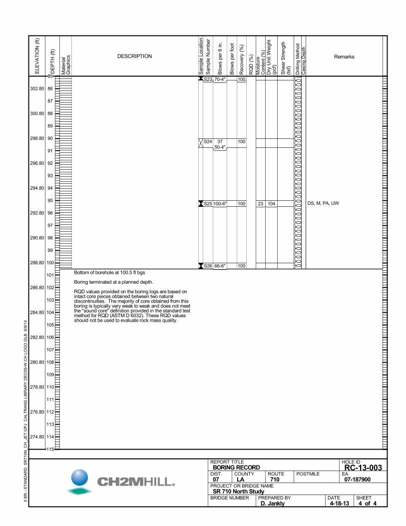
Bottom of borehole at 100.5 ft bgs
Boring terminated at a planned depth.
RQD values provided on the boring logs are based onintact core pieces obtained between two naturaldiscontinuities. The majority of core obtained from thisboring is typically very weak to weak and does not meetthe "sound core" definition provided in the standard testmethod for RQD (ASTM D 6032). These RQD valuesshould not be used to evaluate rock mass quality.
100
100
100
100
S23
S24
S25
S26
23 DS, M, PA, UW
70-4"
3750-4"
100-6"
66-6"
104
Mat
eria
lG
raph
ics
Sam
ple
Loca
tion
COUNTYLA
DESCRIPTION
Rec
over
y (%
)
Dri
lling
Met
hod
Cas
ing
Dep
th
PREPARED BYD. Jankly
DATE4-18-13
PROJECT OR BRIDGE NAMESR 710 North Study
BRIDGE NUMBER
HOLE ID
RC-13-003EA07-187900
REPORT TITLEBORING RECORD
DIST.07
ROUTE710
POSTMILE
SHEET4 of 4
RQ
D (
%)
Sam
ple
Num
ber
Moi
stur
eC
onte
nt (
%)
Remarks
Blo
ws
per
6 in
.
ELE
VA
TIO
N (
ft)
302.80
300.80
298.80
296.80
294.80
292.80
290.80
288.80
286.80
284.80
282.80
280.80
278.80
276.80
274.80
DE
PT
H (
ft)
Dry
Uni
t W
eigh
t(p
cf)
She
ar S
tren
gth
(tsf
)
Blo
ws
per
foot
5 B
R -
ST
AN
DA
RD
SR
710
N_C
H_J
ET
.GP
J C
ALT
RA
NS
LIB
RA
RY
DE
C09
-W C
H L
OG
O.G
LB 6
/9/1
4
85
86
87
88
89
90
91
92
93
94
95
96
97
98
99
100
101
102
103
104
105
106
107
108
109
110
111
112
113
114
115
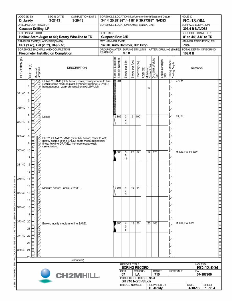
CLAYEY SAND (SC); brown; moist; mostly coarse to fineSAND; some medium plasticity fines; few fine GRAVEL;homogeneous; weak cementation (ALLUVIUM).
Loose.
SILTY, CLAYEY SAND (SC-SM); brown; moist to wet;mostly coarse to fine SAND; some medium plasticityfines; few fine GRAVEL; homogeneous; weakcementation.
Medium dense; Lacks GRAVEL.
Brown; mostly medium to fine SAND.
100
67
44
56
B01
S02
S03
S04
S05
17
12
20
CR, M
PA, PI
M, DS, PA, PI, UW
M, DS, PA, UW
223
5814
479
458
125
106
AFTER DRILLING (DATE)DURING DRILLING
9.5 ft
SURFACE ELEVATION
393.4 ft NAVD88DRILLING METHOD
Hollow-Stem Auger to 44'; Rotary Wire-line to TDDRILL RIG
Guspech Brut 22RSPT HAMMER TYPE
140 lb. Auto Hammer, 30" DropBOREHOLE BACKFILL AND COMPLETION
Piezometer Installed on CompletionGROUNDWATERREADINGS
BEGIN DATE
3-27-13COMPLETION DATE
3-29-13LOGGED BY
D. JanklyBOREHOLE LOCATION (Lat/Long or North/East and Datum)
34° 4' 20.38198" / -118° 9' 39.77389" NAD83HOLE ID
RC-13-004DRILLING CONTRACTOR
Cascade Drilling, LP
HAMMER EFFICIENCY, ERi
78%SAMPLER TYPE(S) AND SIZE(S) (ID)
SPT (1.4"), Cal (2.5"), HQ (2.5")TOTAL DEPTH OF BORING
109.0 ft
BOREHOLE DIAMETER
8" to 44'; 3.8" to TD
BOREHOLE LOCATION (Offset, Station, Line)
.M
ater
ial
Gra
phic
s
Sam
ple
Loca
tion
COUNTYLA
DESCRIPTION
Rec
over
y (%
)
Dri
lling
Met
hod
Cas
ing
Dep
th
PREPARED BYD. Jankly
DATE4-18-13
PROJECT OR BRIDGE NAMESR 710 North Study
BRIDGE NUMBER
HOLE ID
RC-13-004EA07-187900
REPORT TITLEBORING RECORD
DIST.07
ROUTE710
POSTMILE
(continued)
SHEET1 of 4
RQ
D (
%)
Sam
ple
Num
ber
Moi
stur
eC
onte
nt (
%)
Remarks
Blo
ws
per
6 in
.
ELE
VA
TIO
N (
ft)
391.40
389.40
387.40
385.40
383.40
381.40
379.40
377.40
375.40
373.40
371.40
369.40
DE
PT
H (
ft)
Dry
Uni
t W
eigh
t(p
cf)
She
ar S
tren
gth
(tsf
)
Blo
ws
per
foot
5 B
R -
ST
AN
DA
RD
SR
710
N_C
H_C
AS
CA
DE
.GP
J C
ALT
RA
NS
LIB
RA
RY
DE
C09
-W C
H L
OG
O.G
LB 6
/9/1
4
5
22
16
13
0
1
2
3
4
5
6
7
8
9
10
11
12
13
14
15
16
17
18
19
20
21
22
23
24
25
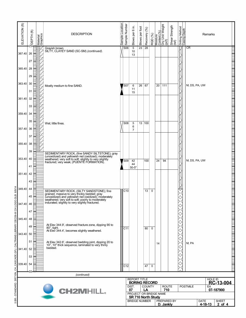
Grayish brown.SILTY, CLAYEY SAND (SC-SM) (continued).
Mostly medium to fine SAND.
Wet; little fines.
SEDIMENTARY ROCK, (fine SANDY SILTSTONE); gray(unoxidized) and yellowish red (oxidized); moderatelyweathered; very soft to soft; slightly to very slightlyfractured; very weak; (PUENTE FORMATION).
SEDIMENTARY ROCK, (SILTY SANDSTONE); finegrained; massive to very thickly bedded; gray(unoxidized) and yellowish red (oxidized); moderatelyweathered; very soft to soft; poorly to moderatelyindurated; slightly to very slightly fractured.
At Elev 344.9', observed fracture zone, dipping 90 to80°, tight.
At Elev 344.4', becomes slightly weathered.
At Elev 342.6', observed bedding joint, dipping 20 to10°, 10" thick sequence, laminated to very thinlybedded.
28
67
100
100
13
80
47
C10
C11
C12
0
0
0
S06
S07
S08
S09
20
24
14
CR
M, DS, PA, UW
M, DS, PA, UW
M, PA
51013
61115
567
4244
50-5"
111
94
Mat
eria
lG
raph
ics
Sam
ple
Loca
tion
COUNTYLA
DESCRIPTION
Rec
over
y (%
)
Dri
lling
Met
hod
Cas
ing
Dep
th
PREPARED BYD. Jankly
DATE4-18-13
PROJECT OR BRIDGE NAMESR 710 North Study
BRIDGE NUMBER
HOLE ID
RC-13-004EA07-187900
REPORT TITLEBORING RECORD
DIST.07
ROUTE710
POSTMILE
(continued)
SHEET2 of 4
RQ
D (
%)
Sam
ple
Num
ber
Moi
stur
eC
onte
nt (
%)
Remarks
Blo
ws
per
6 in
.
ELE
VA
TIO
N (
ft)
367.40
365.40
363.40
361.40
359.40
357.40
355.40
353.40
351.40
349.40
347.40
345.40
343.40
341.40
339.40
DE
PT
H (
ft)
Dry
Uni
t W
eigh
t(p
cf)
She
ar S
tren
gth
(tsf
)
Blo
ws
per
foot
5 B
R -
ST
AN
DA
RD
SR
710
N_C
H_C
AS
CA
DE
.GP
J C
ALT
RA
NS
LIB
RA
RY
DE
C09
-W C
H L
OG
O.G
LB 6
/9/1
4
23
26
13
25
26
27
28
29
30
31
32
33
34
35
36
37
38
39
40
41
42
43
44
45
46
47
48
49
50
51
52
53
54
55
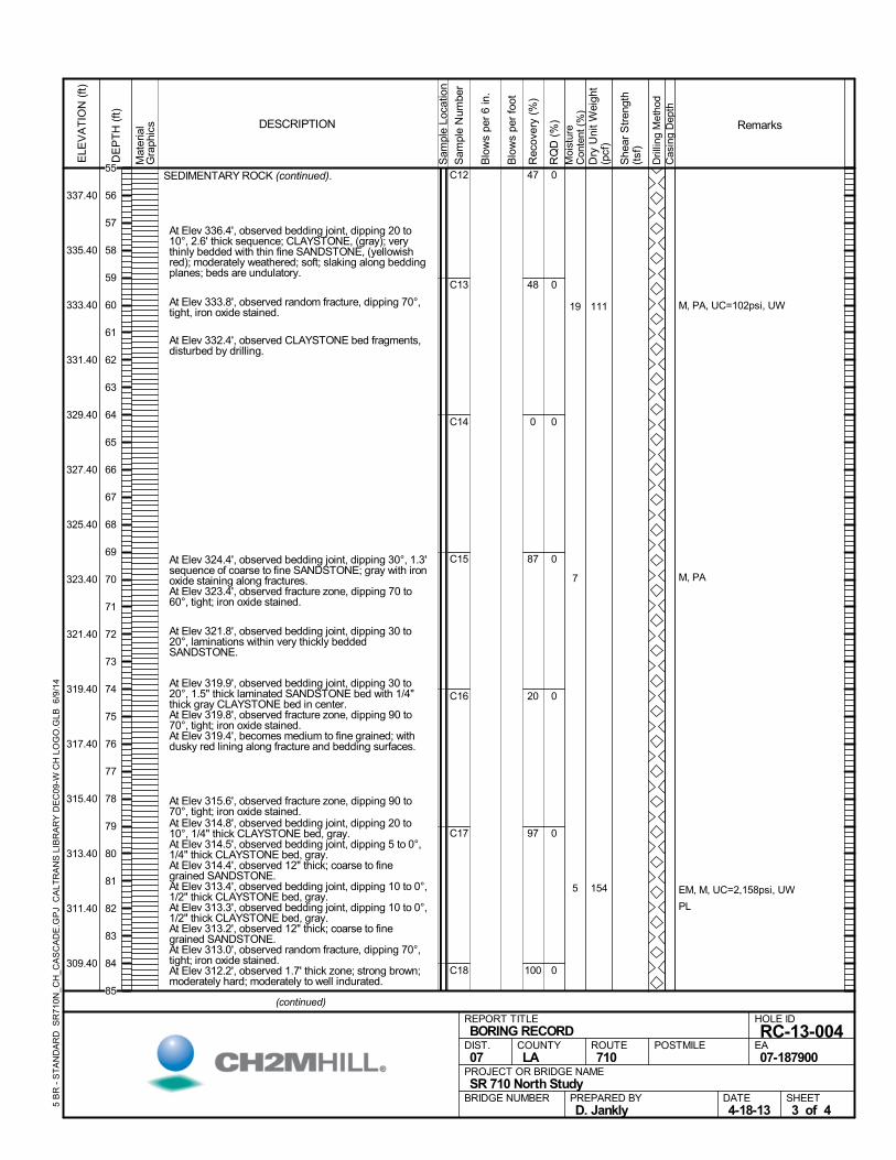
SEDIMENTARY ROCK (continued).
At Elev 336.4', observed bedding joint, dipping 20 to10°, 2.6' thick sequence; CLAYSTONE, (gray); verythinly bedded with thin fine SANDSTONE, (yellowishred); moderately weathered; soft; slaking along beddingplanes; beds are undulatory.
At Elev 333.8', observed random fracture, dipping 70°,tight, iron oxide stained.
At Elev 332.4', observed CLAYSTONE bed fragments,disturbed by drilling.
At Elev 324.4', observed bedding joint, dipping 30°, 1.3'sequence of coarse to fine SANDSTONE; gray with ironoxide staining along fractures.
At Elev 323.4', observed fracture zone, dipping 70 to60°, tight; iron oxide stained.
At Elev 321.8', observed bedding joint, dipping 30 to20°, laminations within very thickly beddedSANDSTONE.
At Elev 319.9', observed bedding joint, dipping 30 to20°, 1.5" thick laminated SANDSTONE bed with 1/4"thick gray CLAYSTONE bed in center.
At Elev 319.8', observed fracture zone, dipping 90 to70°, tight; iron oxide stained.
At Elev 319.4', becomes medium to fine grained; withdusky red lining along fracture and bedding surfaces.
At Elev 315.6', observed fracture zone, dipping 90 to70°, tight; iron oxide stained.
At Elev 314.8', observed bedding joint, dipping 20 to10°, 1/4" thick CLAYSTONE bed, gray.
At Elev 314.5', observed bedding joint, dipping 5 to 0°,1/4" thick CLAYSTONE bed, gray.
At Elev 314.4', observed 12" thick; coarse to finegrained SANDSTONE.
At Elev 313.4', observed bedding joint, dipping 10 to 0°,1/2" thick CLAYSTONE bed, gray.
At Elev 313.3', observed bedding joint, dipping 10 to 0°,1/2" thick CLAYSTONE bed, gray.
At Elev 313.2', observed 12" thick; coarse to finegrained SANDSTONE.
At Elev 313.0', observed random fracture, dipping 70°,tight; iron oxide stained.
At Elev 312.2', observed 1.7' thick zone; strong brown;moderately hard; moderately to well indurated.
47
48
0
87
20
97
100
C12
C13
C14
C15
C16
C17
C18
0
0
0
0
0
0
0
19
7
5
M, PA, UC=102psi, UW
M, PA
EM, M, UC=2,158psi, UW
PL
111
154
Mat
eria
lG
raph
ics
Sam
ple
Loca
tion
COUNTYLA
DESCRIPTION
Rec
over
y (%
)
Dri
lling
Met
hod
Cas
ing
Dep
th
PREPARED BYD. Jankly
DATE4-18-13
PROJECT OR BRIDGE NAMESR 710 North Study
BRIDGE NUMBER
HOLE ID
RC-13-004EA07-187900
REPORT TITLEBORING RECORD
DIST.07
ROUTE710
POSTMILE
(continued)
SHEET3 of 4
RQ
D (
%)
Sam
ple
Num
ber
Moi
stur
eC
onte
nt (
%)
Remarks
Blo
ws
per
6 in
.
ELE
VA
TIO
N (
ft)
337.40
335.40
333.40
331.40
329.40
327.40
325.40
323.40
321.40
319.40
317.40
315.40
313.40
311.40
309.40
DE
PT
H (
ft)
Dry
Uni
t W
eigh
t(p
cf)
She
ar S
tren
gth
(tsf
)
Blo
ws
per
foot
5 B
R -
ST
AN
DA
RD
SR
710
N_C
H_C
AS
CA
DE
.GP
J C
ALT
RA
NS
LIB
RA
RY
DE
C09
-W C
H L
OG
O.G
LB 6
/9/1
4
55
56
57
58
59
60
61
62
63
64
65
66
67
68
69
70
71
72
73
74
75
76
77
78
79
80
81
82
83
84
85
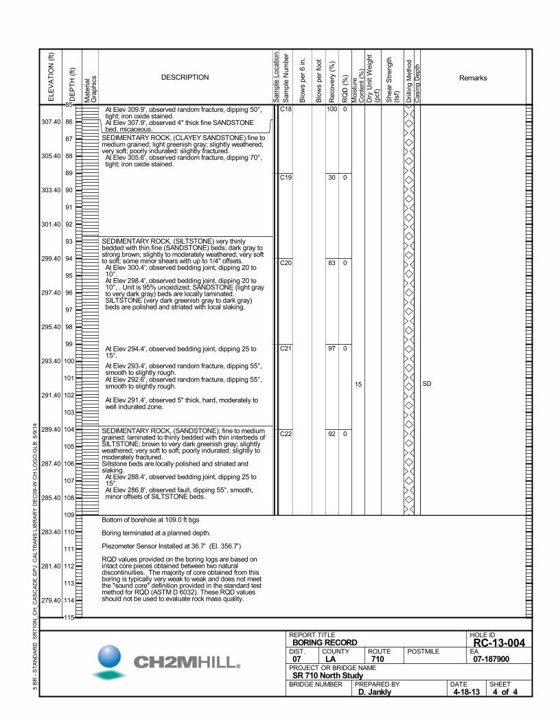
At Elev 309.9', observed random fracture, dipping 50°,tight; iron oxide stained.
At Elev 307.9', observed 4" thick fine SANDSTONEbed, micaceous.
SEDIMENTARY ROCK, (CLAYEY SANDSTONE) fine tomedium grained; light greenish gray; slightly weathered;very soft; poorly indurated: slightly fractured. At Elev 305.6', observed random fracture, dipping 70°,tight; iron oxide stained.
SEDIMENTARY ROCK, (SILTSTONE) very thinlybedded with thin fine (SANDSTONE) beds; dark gray tostrong brown; slightly to moderately weathered; very softto soft; some minor shears with up to 1/4" offsets. At Elev 300.4', observed bedding joint, dipping 20 to10°.
At Elev 298.4', observed bedding joint, dipping 20 to10°, . Unit is 95% unoxidized; SANDSTONE (light grayto very dark gray) beds are locally laminated.SILTSTONE (very dark greenish gray to dark gray)beds are polished and striated with local slaking.
At Elev 294.4', observed bedding joint, dipping 25 to15°.
At Elev 293.4', observed random fracture, dipping 55°,smooth to slightly rough.
At Elev 292.6', observed random fracture, dipping 55°,smooth to slightly rough.
At Elev 291.4', observed 5" thick, hard, moderately towell indurated zone.
SEDIMENTARY ROCK, (SANDSTONE); fine to mediumgrained; laminated to thinly bedded with thin interbeds ofSILTSTONE; brown to very dark greenish gray; slightlyweathered; very soft to soft; poorly indurated; slightly tomoderately fractured.Siltstone beds are locally polished and striated andslaking. At Elev 288.4', observed bedding joint, dipping 25 to15°.
At Elev 286.8', observed fault, dipping 55°, smooth,minor offsets of SILTSTONE beds.
Bottom of borehole at 109.0 ft bgs
Boring terminated at a planned depth.
Piezometer Sensor Installed at 36.7' (El. 356.7')
RQD values provided on the boring logs are based onintact core pieces obtained between two naturaldiscontinuities. The majority of core obtained from thisboring is typically very weak to weak and does not meetthe "sound core" definition provided in the standard testmethod for RQD (ASTM D 6032). These RQD valuesshould not be used to evaluate rock mass quality.
100
30
83
97
92
C18
C19
C20
C21
C22
0
0
0
0
0
15 SD
Mat
eria
lG
raph
ics
Sam
ple
Loca
tion
COUNTYLA
DESCRIPTION
Rec
over
y (%
)
Dri
lling
Met
hod
Cas
ing
Dep
th
PREPARED BYD. Jankly
DATE4-18-13
PROJECT OR BRIDGE NAMESR 710 North Study
BRIDGE NUMBER
HOLE ID
RC-13-004EA07-187900
REPORT TITLEBORING RECORD
DIST.07
ROUTE710
POSTMILE
SHEET4 of 4
RQ
D (
%)
Sam
ple
Num
ber
Moi
stur
eC
onte
nt (
%)
Remarks
Blo
ws
per
6 in
.
ELE
VA
TIO
N (
ft)
307.40
305.40
303.40
301.40
299.40
297.40
295.40
293.40
291.40
289.40
287.40
285.40
283.40
281.40
279.40
DE
PT
H (
ft)
Dry
Uni
t W
eigh
t(p
cf)
She
ar S
tren
gth
(tsf
)
Blo
ws
per
foot
5 B
R -
ST
AN
DA
RD
SR
710
N_C
H_C
AS
CA
DE
.GP
J C
ALT
RA
NS
LIB
RA
RY
DE
C09
-W C
H L
OG
O.G
LB 6
/9/1
4
85
86
87
88
89
90
91
92
93
94
95
96
97
98
99
100
101
102
103
104
105
106
107
108
109
110
111
112
113
114
115
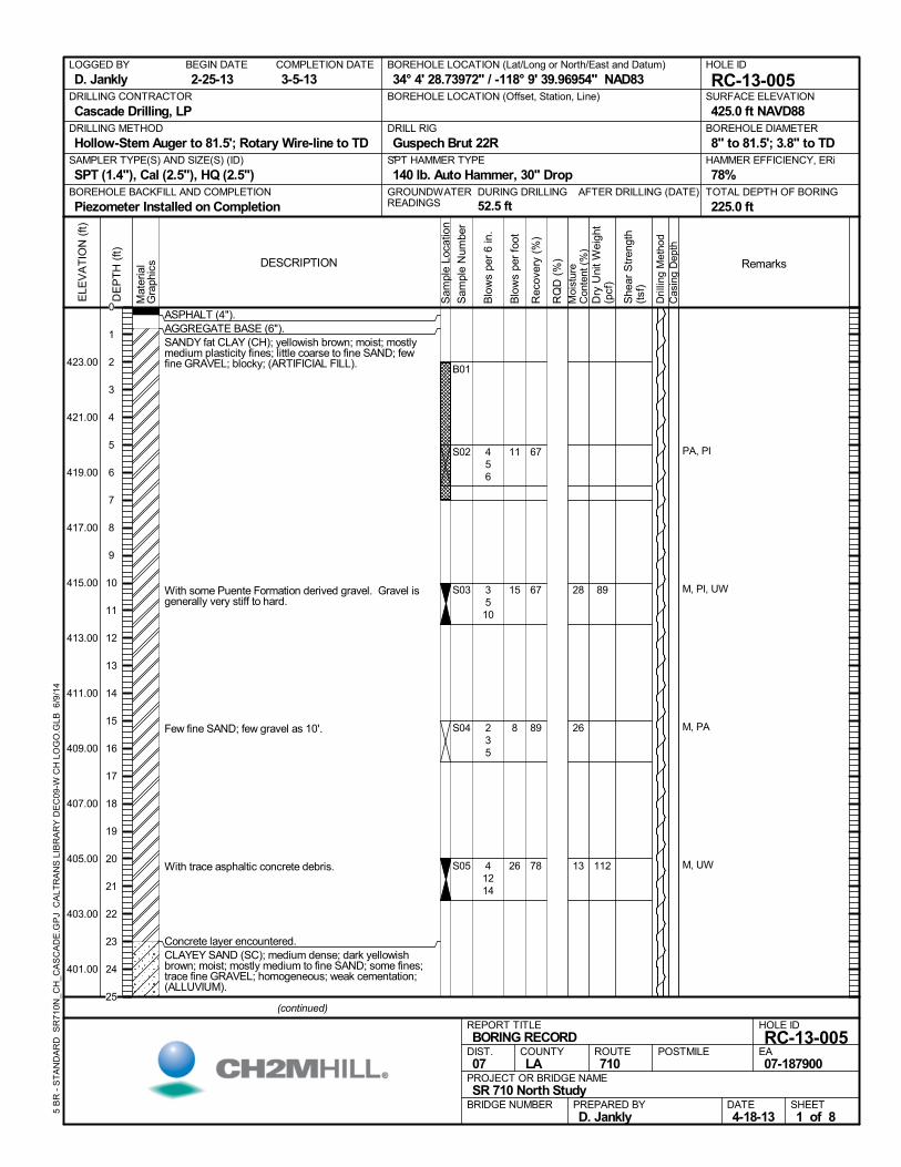
ASPHALT (4").AGGREGATE BASE (6").SANDY fat CLAY (CH); yellowish brown; moist; mostlymedium plasticity fines; little coarse to fine SAND; fewfine GRAVEL; blocky; (ARTIFICIAL FILL).
With some Puente Formation derived gravel. Gravel isgenerally very stiff to hard.
Few fine SAND; few gravel as 10'.
With trace asphaltic concrete debris.
Concrete layer encountered.CLAYEY SAND (SC); medium dense; dark yellowishbrown; moist; mostly medium to fine SAND; some fines;trace fine GRAVEL; homogeneous; weak cementation;(ALLUVIUM).
67
67
89
78
B01
S02
S03
S04
S05
28
26
13
PA, PI
M, PI, UW
M, PA
M, UW
456
3510
235
41214
89
112
AFTER DRILLING (DATE)DURING DRILLING
52.5 ft
SURFACE ELEVATION
425.0 ft NAVD88DRILLING METHOD
Hollow-Stem Auger to 81.5'; Rotary Wire-line to TDDRILL RIG
Guspech Brut 22RSPT HAMMER TYPE
140 lb. Auto Hammer, 30" DropBOREHOLE BACKFILL AND COMPLETION
Piezometer Installed on CompletionGROUNDWATERREADINGS
BEGIN DATE
2-25-13COMPLETION DATE
3-5-13LOGGED BY
D. JanklyBOREHOLE LOCATION (Lat/Long or North/East and Datum)
34° 4' 28.73972" / -118° 9' 39.96954" NAD83HOLE ID
RC-13-005DRILLING CONTRACTOR
Cascade Drilling, LP
HAMMER EFFICIENCY, ERi
78%SAMPLER TYPE(S) AND SIZE(S) (ID)
SPT (1.4"), Cal (2.5"), HQ (2.5")TOTAL DEPTH OF BORING
225.0 ft
BOREHOLE DIAMETER
8" to 81.5'; 3.8" to TD
BOREHOLE LOCATION (Offset, Station, Line)
.M
ater
ial
Gra
phic
s
Sam
ple
Loca
tion
COUNTYLA
DESCRIPTION
Rec
over
y (%
)
Dri
lling
Met
hod
Cas
ing
Dep
th
PREPARED BYD. Jankly
DATE4-18-13
PROJECT OR BRIDGE NAMESR 710 North Study
BRIDGE NUMBER
HOLE ID
RC-13-005EA07-187900
REPORT TITLEBORING RECORD
DIST.07
ROUTE710
POSTMILE
(continued)
SHEET1 of 8
RQ
D (
%)
Sam
ple
Num
ber
Moi
stur
eC
onte
nt (
%)
Remarks
Blo
ws
per
6 in
.
ELE
VA
TIO
N (
ft)
423.00
421.00
419.00
417.00
415.00
413.00
411.00
409.00
407.00
405.00
403.00
401.00
DE
PT
H (
ft)
Dry
Uni
t W
eigh
t(p
cf)
She
ar S
tren
gth
(tsf
)
Blo
ws
per
foot
5 B
R -
ST
AN
DA
RD
SR
710
N_C
H_C
AS
CA
DE
.GP
J C
ALT
RA
NS
LIB
RA
RY
DE
C09
-W C
H L
OG
O.G
LB 6
/9/1
4
11
15
8
26
0
1
2
3
4
5
6
7
8
9
10
11
12
13
14
15
16
17
18
19
20
21
22
23
24
25
CLAYEY SAND (SC) (continued).
Poorly graded SAND with SILT and GRAVEL (SP-SM);dark yellowish brown; moist; some coarse to fine SAND;some coarse to fine GRAVEL; few fines; homogeneous;moderate cementation.
SILTY SAND (SM); medium dense; dark yellowish brown;moist to wet; mostly coarse to fine SAND; some fines;trace fine GRAVEL; homogeneous; weak cementation;micaceous.
Moist; mostly fine SAND.
SANDY fat CLAY (CH); light olive brown; moist; mostlymedium plasticity fines; little fine SAND; homogeneous.
Light yellowish brown; mostly fine SAND; some fines;micaceous.
33
78
89
78
100
89
S06
S07
S08
S09
S10
S11
6
13
21
19
PA
M, DS, PA, UW
PA
M, PA, UW
CR, M, PI
M, DS, PA, UW
785
132629
654
21216
6911
2919
118
95
107
Mat
eria
lG
raph
ics
Sam
ple
Loca
tion
COUNTYLA
DESCRIPTION
Rec
over
y (%
)
Dri
lling
Met
hod
Cas
ing
Dep
th
PREPARED BYD. Jankly
DATE4-18-13
PROJECT OR BRIDGE NAMESR 710 North Study
BRIDGE NUMBER
HOLE ID
RC-13-005EA07-187900
REPORT TITLEBORING RECORD
DIST.07
ROUTE710
POSTMILE
(continued)
SHEET2 of 8
RQ
D (
%)
Sam
ple
Num
ber
Moi
stur
eC
onte
nt (
%)
Remarks
Blo
ws
per
6 in
.
ELE
VA
TIO
N (
ft)
399.00
397.00
395.00
393.00
391.00
389.00
387.00
385.00
383.00
381.00
379.00
377.00
375.00
373.00
371.00
DE
PT
H (
ft)
Dry
Uni
t W
eigh
t(p
cf)
She
ar S
tren
gth
(tsf
)
Blo
ws
per
foot
5 B
R -
ST
AN
DA
RD
SR
710
N_C
H_C
AS
CA
DE
.GP
J C
ALT
RA
NS
LIB
RA
RY
DE
C09
-W C
H L
OG
O.G
LB 6
/9/1
4
13
55
9
28
20
28
25
26
27
28
29
30
31
32
33
34
35
36
37
38
39
40
41
42
43
44
45
46
47
48
49
50
51
52
53
54
55
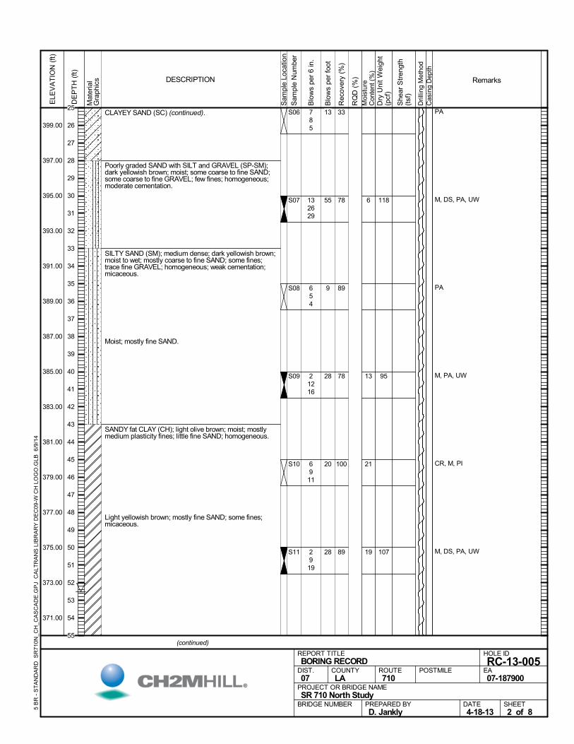
SANDY fat CLAY (CH) (continued).Wet; trace fine GRAVEL.
Lean CLAY with SAND (CL); light olive brown; moist;mostly medium plasticity fines; little fine SAND;homogeneous.
Hard.
Yellowish brown; moist to wet.
Strong brown; little medium to fine SAND; iron oxide andmanganese staining.
SEDIMENTARY ROCK, (SILTSTONE andCLAYSTONE); thinly to very thinly bedded with thininterbeds of fine SANDSTONE: white to dark grayishbrown; moderately weathered; very soft; moderately tointensely fractured; iron oxide stained: (PUENTEFORMATION).
67
89
100
89
78
67
40C18 0
S12
S13
S14
S15
S16
S17
20
20
26
M, PI, UU, UW
M, DS, PA, PI, UW
PA, PI
M, PI, UU, UW
141836
91528
91320
71630
61015
71525
110
110
99
UU =2.31
UU =2.01
Mat
eria
lG
raph
ics
Sam
ple
Loca
tion
COUNTYLA
DESCRIPTION
Rec
over
y (%
)
Dri
lling
Met
hod
Cas
ing
Dep
th
PREPARED BYD. Jankly
DATE4-18-13
PROJECT OR BRIDGE NAMESR 710 North Study
BRIDGE NUMBER
HOLE ID
RC-13-005EA07-187900
REPORT TITLEBORING RECORD
DIST.07
ROUTE710
POSTMILE
(continued)
SHEET3 of 8
RQ
D (
%)
Sam
ple
Num
ber
Moi
stur
eC
onte
nt (
%)
Remarks
Blo
ws
per
6 in
.
ELE
VA
TIO
N (
ft)
369.00
367.00
365.00
363.00
361.00
359.00
357.00
355.00
353.00
351.00
349.00
347.00
345.00
343.00
341.00
DE
PT
H (
ft)
Dry
Uni
t W
eigh
t(p
cf)
She
ar S
tren
gth
(tsf
)
Blo
ws
per
foot
5 B
R -
ST
AN
DA
RD
SR
710
N_C
H_C
AS
CA
DE
.GP
J C
ALT
RA
NS
LIB
RA
RY
DE
C09
-W C
H L
OG
O.G
LB 6
/9/1
4
54
43
33
46
25
40
55
56
57
58
59
60
61
62
63
64
65
66
67
68
69
70
71
72
73
74
75
76
77
78
79
80
81
82
83
84
85
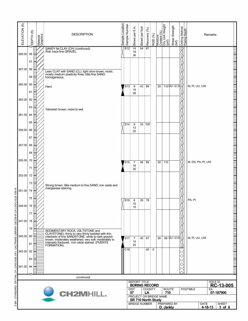
SEDIMENTARY ROCK (continued).
Bedding joint dipping 70°, slightly rough.
At Elev 335.0', becomes soft.
At Elev 334.0', observed fracture zone, dipping 90 to40°, 1/16" thick manganese and iron oxide staining;rough.
At Elev 333.0', observed bedding joint, dipping 80°,slightly rough.
At Elev 331.0', becomes siliceous; light gray to gray. At Elev 330.5', observed fracture zone, dipping 40 to 0°,1/16"-1/4" thick CLAYEY SAND infill; slightly rough.
At Elev 329.0', observed bedding joint, dipping 80 to70°.
At Elev 328.6', observed random fracture, dipping 90 to40°, 1/8" thick lean CLAY lining; slightly rough.
At Elev 328.0', observed 1' thick zone, very soft.
At Elev 325.0', becomes grayish brown to strong brown(where oxidized); moderately to slightly weathered;.
At Elev 324.0', observed bedding joint, dipping 70 to60°.
At Elev 320.0', becomes moderately weathered; partingsurfaces are generally moderately rough.
At Elev 319.5', observed 6" thick very intensely fracturedzone.
12" thick very intensely fractured zone.
At Elev 316.0', observed bedding joint, dipping 90°,tight.
Gray to strong brown (where oxidized).
At Elev 313.8', observed fault, dipping 65°, 1/16" thick,lean CLAY lining; polished and striated.
At Elev 313.0', observed random fracture, dipping 20°,tight.
At Elev 312.7', observed random fracture, dipping 20°,tight.
72
83
83
82
62
93
47
C19
C20
C21
C22
C23
C24
C25
30
28
27
0
0
17
0
2 M, PL, UW
CR
158
Mat
eria
lG
raph
ics
Sam
ple
Loca
tion
COUNTYLA
DESCRIPTION
Rec
over
y (%
)
Dri
lling
Met
hod
Cas
ing
Dep
th
PREPARED BYD. Jankly
DATE4-18-13
PROJECT OR BRIDGE NAMESR 710 North Study
BRIDGE NUMBER
HOLE ID
RC-13-005EA07-187900
REPORT TITLEBORING RECORD
DIST.07
ROUTE710
POSTMILE
(continued)
SHEET4 of 8
RQ
D (
%)
Sam
ple
Num
ber
Moi
stur
eC
onte
nt (
%)
Remarks
Blo
ws
per
6 in
.
ELE
VA
TIO
N (
ft)
339.00
337.00
335.00
333.00
331.00
329.00
327.00
325.00
323.00
321.00
319.00
317.00
315.00
313.00
311.00
DE
PT
H (
ft)
Dry
Uni
t W
eigh
t(p
cf)
She
ar S
tren
gth
(tsf
)
Blo
ws
per
foot
5 B
R -
ST
AN
DA
RD
SR
710
N_C
H_C
AS
CA
DE
.GP
J C
ALT
RA
NS
LIB
RA
RY
DE
C09
-W C
H L
OG
O.G
LB 6
/9/1
4
85
86
87
88
89
90
91
92
93
94
95
96
97
98
99
100
101
102
103
104
105
106
107
108
109
110
111
112
113
114
115
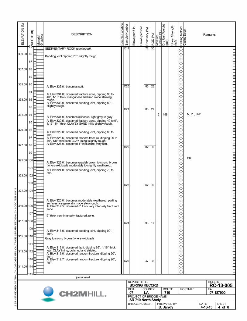
At Elev 310.0', observed bedding joint, dipping 70 to60°, tight. Few iron oxide stained beds.
At Elev 308.4', observed fracture zone, dipping 90 to60°, tight; moderately rough.
At Elev 305.0', observed bedding joint, dipping 90°, 1"thick SANDSTONE bed.
At Elev 303.0', observed bedding joint, dipping 90 to70°, overturned bedding. Local lean CLAY lining alongbeds and random fractures.
At Elev 302.0', observed fracture zone, dipping 60°,1/16" thick lean CLAY lining, tight.
At Elev 301.0', observed little fine SANDSTONE bedsup to 1.5" thick. Numerous minor, tight shears with upto 1/16" thick lean CLAY lining.
At Elev 300.0', observed bedding joint, dipping 80°.
At Elev 296.7', observed fracture zone, dipping 65°,tight.
At Elev 296.0', observed bedding joint, dipping 90°.
At Elev 295.0', becomes dark olive gray to very darkgrayish brown; slightly weathered; locally slaking,polished and striated bedding planes.
At Elev 294.9', observed bedding joint, dipping 90 to70°.
At Elev 293.0', observed random fracture, dipping 65 to55°, 1/16" thick lean CLAY lining; slightly rough.
At Elev 289.0', observed bedding joint, dipping 80°,tight. Scarce iron oxide staining along SANDSTONEbeds; slight slaking along SILTSTONE bedding planes.
At Elev 287.0', observed random fracture, dipping 30 to70°, tight.
At Elev 285.0', becomes slightly weathered to fresh;dark greenish gray (SANDSTONE) to very darkgreenish gray (SILTSTONE).
PTS: Feldspathic wacke; 50% biotite, 20% quartz; 15%muscovite; 15% plagioclase.
47
90
87
97
97
100
80
C25
C26
C27
C28
C29
C30
C31
0
0
20
33
53
100
10
30
29
27
EM, M, SD, UC=137psi
M, PL, SD
M, PL, PTS, SD, UW102
Mat
eria
lG
raph
ics
Sam
ple
Loca
tion
COUNTYLA
DESCRIPTION
Rec
over
y (%
)
Dri
lling
Met
hod
Cas
ing
Dep
th
PREPARED BYD. Jankly
DATE4-18-13
PROJECT OR BRIDGE NAMESR 710 North Study
BRIDGE NUMBER
HOLE ID
RC-13-005EA07-187900
REPORT TITLEBORING RECORD
DIST.07
ROUTE710
POSTMILE
(continued)
SHEET5 of 8
RQ
D (
%)
Sam
ple
Num
ber
Moi
stur
eC
onte
nt (
%)
Remarks
Blo
ws
per
6 in
.
ELE
VA
TIO
N (
ft)
309.00
307.00
305.00
303.00
301.00
299.00
297.00
295.00
293.00
291.00
289.00
287.00
285.00
283.00
281.00
DE
PT
H (
ft)
Dry
Uni
t W
eigh
t(p
cf)
She
ar S
tren
gth
(tsf
)
Blo
ws
per
foot
5 B
R -
ST
AN
DA
RD
SR
710
N_C
H_C
AS
CA
DE
.GP
J C
ALT
RA
NS
LIB
RA
RY
DE
C09
-W C
H L
OG
O.G
LB 6
/9/1
4
115
116
117
118
119
120
121
122
123
124
125
126
127
128
129
130
131
132
133
134
135
136
137
138
139
140
141
142
143
144
145
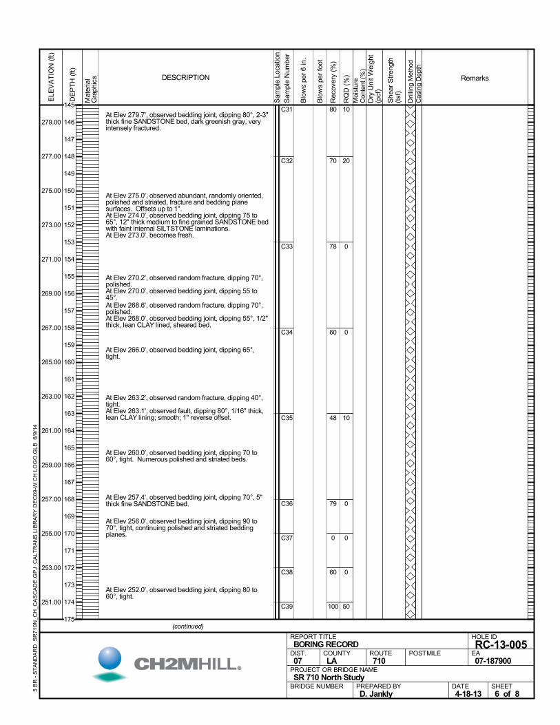
At Elev 279.7', observed bedding joint, dipping 80°, 2-3"thick fine SANDSTONE bed, dark greenish gray, veryintensely fractured.
At Elev 275.0', observed abundant, randomly oriented,polished and striated, fracture and bedding planesurfaces. Offsets up to 1".
At Elev 274.0', observed bedding joint, dipping 75 to65°, 12" thick medium to fine grained SANDSTONE bedwith faint internal SILTSTONE laminations.
At Elev 273.0', becomes fresh.
At Elev 270.2', observed random fracture, dipping 70°,polished.
At Elev 270.0', observed bedding joint, dipping 55 to45°.
At Elev 268.6', observed random fracture, dipping 70°,polished.
At Elev 268.0', observed bedding joint, dipping 55°, 1/2"thick, lean CLAY lined, sheared bed.
At Elev 266.0', observed bedding joint, dipping 65°,tight.
At Elev 263.2', observed random fracture, dipping 40°,tight.
At Elev 263.1', observed fault, dipping 80°, 1/16" thick,lean CLAY lining; smooth; 1" reverse offset.
At Elev 260.0', observed bedding joint, dipping 70 to60°, tight. Numerous polished and striated beds.
At Elev 257.4', observed bedding joint, dipping 70°, 5"thick fine SANDSTONE bed.
At Elev 256.0', observed bedding joint, dipping 90 to70°, tight, continuing polished and striated beddingplanes.
At Elev 252.0', observed bedding joint, dipping 80 to60°, tight.
80
70
78
60
48
79
0
60
100
C31
C32
C33
C34
C35
C36
C37
C38
C39
10
20
0
0
10
0
0
0
50
Mat
eria
lG
raph
ics
Sam
ple
Loca
tion
COUNTYLA
DESCRIPTION
Rec
over
y (%
)
Dri
lling
Met
hod
Cas
ing
Dep
th
PREPARED BYD. Jankly
DATE4-18-13
PROJECT OR BRIDGE NAMESR 710 North Study
BRIDGE NUMBER
HOLE ID
RC-13-005EA07-187900
REPORT TITLEBORING RECORD
DIST.07
ROUTE710
POSTMILE
(continued)
SHEET6 of 8
RQ
D (
%)
Sam
ple
Num
ber
Moi
stur
eC
onte
nt (
%)
Remarks
Blo
ws
per
6 in
.
ELE
VA
TIO
N (
ft)
279.00
277.00
275.00
273.00
271.00
269.00
267.00
265.00
263.00
261.00
259.00
257.00
255.00
253.00
251.00
DE
PT
H (
ft)
Dry
Uni
t W
eigh
t(p
cf)
She
ar S
tren
gth
(tsf
)
Blo
ws
per
foot
5 B
R -
ST
AN
DA
RD
SR
710
N_C
H_C
AS
CA
DE
.GP
J C
ALT
RA
NS
LIB
RA
RY
DE
C09
-W C
H L
OG
O.G
LB 6
/9/1
4
145
146
147
148
149
150
151
152
153
154
155
156
157
158
159
160
161
162
163
164
165
166
167
168
169
170
171
172
173
174
175
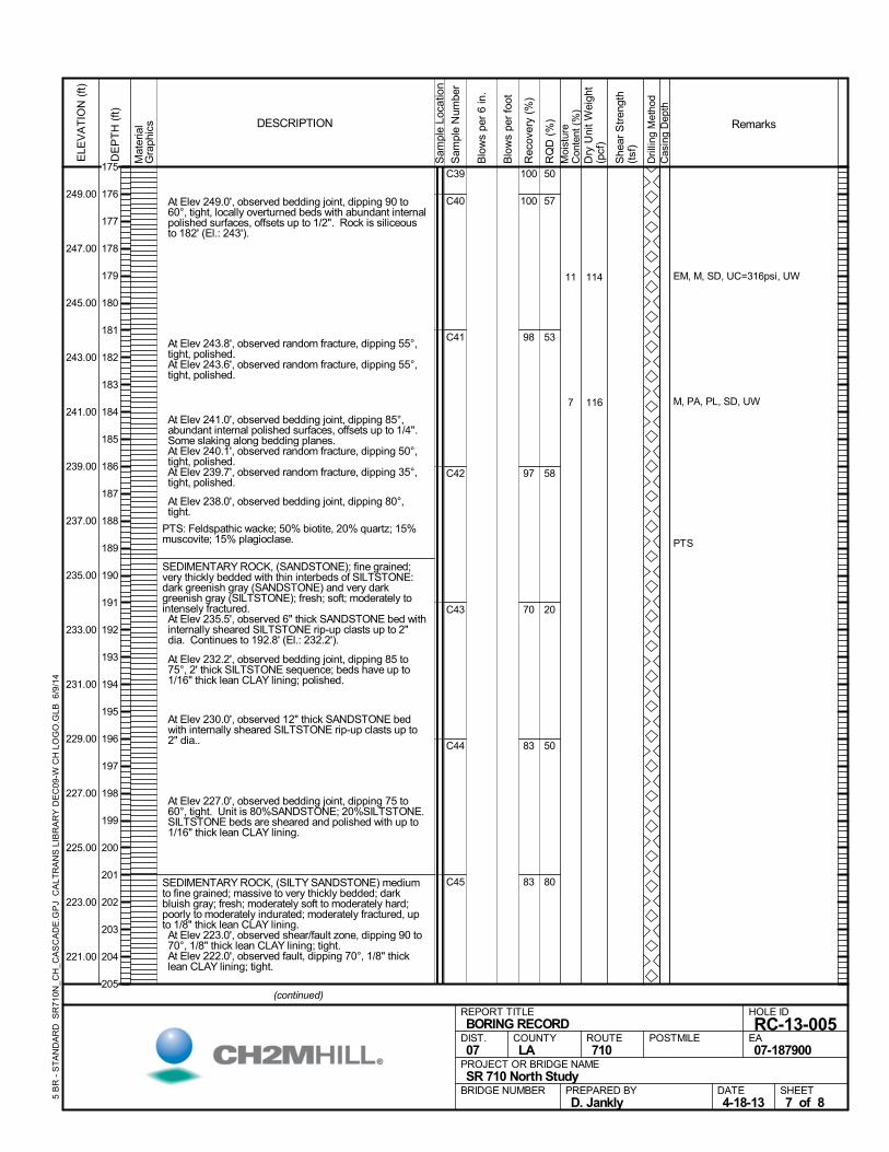
At Elev 249.0', observed bedding joint, dipping 90 to60°, tight, locally overturned beds with abundant internalpolished surfaces, offsets up to 1/2". Rock is siliceousto 182' (El.: 243').
At Elev 243.8', observed random fracture, dipping 55°,tight, polished.
At Elev 243.6', observed random fracture, dipping 55°,tight, polished.
At Elev 241.0', observed bedding joint, dipping 85°,abundant internal polished surfaces, offsets up to 1/4".Some slaking along bedding planes.
At Elev 240.1', observed random fracture, dipping 50°,tight, polished.
At Elev 239.7', observed random fracture, dipping 35°,tight, polished.
At Elev 238.0', observed bedding joint, dipping 80°,tight.
PTS: Feldspathic wacke; 50% biotite, 20% quartz; 15%muscovite; 15% plagioclase.
SEDIMENTARY ROCK, (SANDSTONE); fine grained;very thickly bedded with thin interbeds of SILTSTONE:dark greenish gray (SANDSTONE) and very darkgreenish gray (SILTSTONE); fresh; soft; moderately tointensely fractured. At Elev 235.5', observed 6" thick SANDSTONE bed withinternally sheared SILTSTONE rip-up clasts up to 2"dia. Continues to 192.8' (El.: 232.2').
At Elev 232.2', observed bedding joint, dipping 85 to75°, 2' thick SILTSTONE sequence; beds have up to1/16" thick lean CLAY lining; polished.
At Elev 230.0', observed 12" thick SANDSTONE bedwith internally sheared SILTSTONE rip-up clasts up to2" dia..
At Elev 227.0', observed bedding joint, dipping 75 to60°, tight. Unit is 80%SANDSTONE; 20%SILTSTONE.SILTSTONE beds are sheared and polished with up to1/16" thick lean CLAY lining.
SEDIMENTARY ROCK, (SILTY SANDSTONE) mediumto fine grained; massive to very thickly bedded; darkbluish gray; fresh; moderately soft to moderately hard;poorly to moderately indurated; moderately fractured, upto 1/8" thick lean CLAY lining. At Elev 223.0', observed shear/fault zone, dipping 90 to70°, 1/8" thick lean CLAY lining; tight.
At Elev 222.0', observed fault, dipping 70°, 1/8" thicklean CLAY lining; tight.
100
100
98
97
70
83
83
C39
C40
C41
C42
C43
C44
C45
50
57
53
58
20
50
80
11
7
EM, M, SD, UC=316psi, UW
M, PA, PL, SD, UW
PTS
114
116
Mat
eria
lG
raph
ics
Sam
ple
Loca
tion
COUNTYLA
DESCRIPTION
Rec
over
y (%
)
Dri
lling
Met
hod
Cas
ing
Dep
th
PREPARED BYD. Jankly
DATE4-18-13
PROJECT OR BRIDGE NAMESR 710 North Study
BRIDGE NUMBER
HOLE ID
RC-13-005EA07-187900
REPORT TITLEBORING RECORD
DIST.07
ROUTE710
POSTMILE
(continued)
SHEET7 of 8
RQ
D (
%)
Sam
ple
Num
ber
Moi
stur
eC
onte
nt (
%)
Remarks
Blo
ws
per
6 in
.
ELE
VA
TIO
N (
ft)
249.00
247.00
245.00
243.00
241.00
239.00
237.00
235.00
233.00
231.00
229.00
227.00
225.00
223.00
221.00
DE
PT
H (
ft)
Dry
Uni
t W
eigh
t(p
cf)
She
ar S
tren
gth
(tsf
)
Blo
ws
per
foot
5 B
R -
ST
AN
DA
RD
SR
710
N_C
H_C
AS
CA
DE
.GP
J C
ALT
RA
NS
LIB
RA
RY
DE
C09
-W C
H L
OG
O.G
LB 6
/9/1
4
175
176
177
178
179
180
181
182
183
184
185
186
187
188
189
190
191
192
193
194
195
196
197
198
199
200
201
202
203
204
205
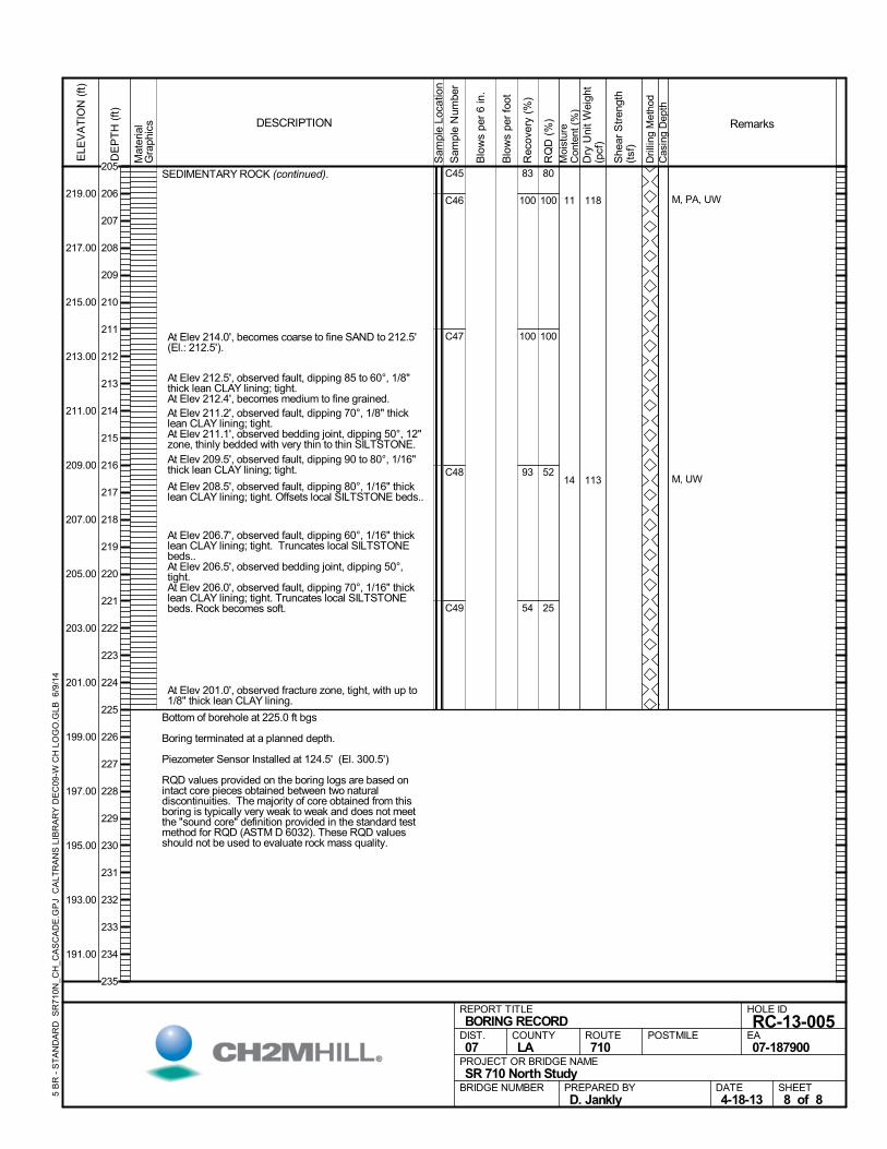
SEDIMENTARY ROCK (continued).
At Elev 214.0', becomes coarse to fine SAND to 212.5'(El.: 212.5').
At Elev 212.5', observed fault, dipping 85 to 60°, 1/8"thick lean CLAY lining; tight.
At Elev 212.4', becomes medium to fine grained. At Elev 211.2', observed fault, dipping 70°, 1/8" thicklean CLAY lining; tight.
At Elev 211.1', observed bedding joint, dipping 50°, 12"zone, thinly bedded with very thin to thin SILTSTONE.
At Elev 209.5', observed fault, dipping 90 to 80°, 1/16"thick lean CLAY lining; tight.
At Elev 208.5', observed fault, dipping 80°, 1/16" thicklean CLAY lining; tight. Offsets local SILTSTONE beds..
At Elev 206.7', observed fault, dipping 60°, 1/16" thicklean CLAY lining; tight. Truncates local SILTSTONEbeds..
At Elev 206.5', observed bedding joint, dipping 50°,tight.
At Elev 206.0', observed fault, dipping 70°, 1/16" thicklean CLAY lining; tight. Truncates local SILTSTONEbeds. Rock becomes soft.
At Elev 201.0', observed fracture zone, tight, with up to1/8" thick lean CLAY lining.
Bottom of borehole at 225.0 ft bgs
Boring terminated at a planned depth.
Piezometer Sensor Installed at 124.5' (El. 300.5')
RQD values provided on the boring logs are based onintact core pieces obtained between two naturaldiscontinuities. The majority of core obtained from thisboring is typically very weak to weak and does not meetthe "sound core" definition provided in the standard testmethod for RQD (ASTM D 6032). These RQD valuesshould not be used to evaluate rock mass quality.
83
100
100
93
54
C45
C46
C47
C48
C49
80
100
100
52
25
11
14
M, PA, UW
M, UW
118
113
Mat
eria
lG
raph
ics
Sam
ple
Loca
tion
COUNTYLA
DESCRIPTION
Rec
over
y (%
)
Dri
lling
Met
hod
Cas
ing
Dep
th
PREPARED BYD. Jankly
DATE4-18-13
PROJECT OR BRIDGE NAMESR 710 North Study
BRIDGE NUMBER
HOLE ID
RC-13-005EA07-187900
REPORT TITLEBORING RECORD
DIST.07
ROUTE710
POSTMILE
SHEET8 of 8
RQ
D (
%)
Sam
ple
Num
ber
Moi
stur
eC
onte
nt (
%)
Remarks
Blo
ws
per
6 in
.
ELE
VA
TIO
N (
ft)
219.00
217.00
215.00
213.00
211.00
209.00
207.00
205.00
203.00
201.00
199.00
197.00
195.00
193.00
191.00
DE
PT
H (
ft)
Dry
Uni
t W
eigh
t(p
cf)
She
ar S
tren
gth
(tsf
)
Blo
ws
per
foot
5 B
R -
ST
AN
DA
RD
SR
710
N_C
H_C
AS
CA
DE
.GP
J C
ALT
RA
NS
LIB
RA
RY
DE
C09
-W C
H L
OG
O.G
LB 6
/9/1
4
205
206
207
208
209
210
211
212
213
214
215
216
217
218
219
220
221
222
223
224
225
226
227
228
229
230
231
232
233
234
235
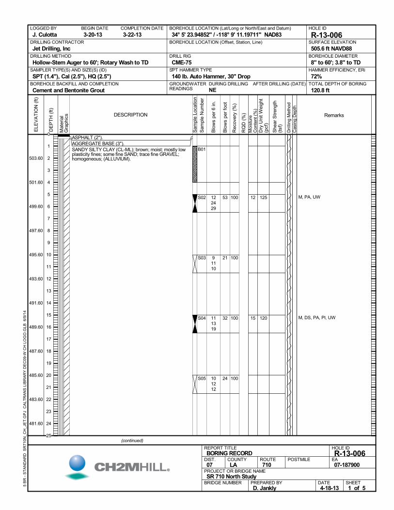
ASPHALT (2").AGGREGATE BASE (3").SANDY SILTY CLAY (CL-ML); brown; moist; mostly lowplasticity fines; some fine SAND; trace fine GRAVEL;homogeneous; (ALLUVIUM).
100
100
100
100
B01
S02
S03
S04
S05
12
15
M, PA, UW
M, DS, PA, PI, UW
122429
91110
111319
101212
125
120
AFTER DRILLING (DATE)DURING DRILLING
NE
SURFACE ELEVATION
505.6 ft NAVD88DRILLING METHOD
Hollow-Stem Auger to 60'; Rotary Wash to TDDRILL RIG
CME-75SPT HAMMER TYPE
140 lb. Auto Hammer, 30" DropBOREHOLE BACKFILL AND COMPLETION
Cement and Bentonite GroutGROUNDWATERREADINGS
BEGIN DATE
3-20-13COMPLETION DATE
3-22-13LOGGED BY
J. CulottaBOREHOLE LOCATION (Lat/Long or North/East and Datum)
34° 5' 23.94852" / -118° 9' 11.19711" NAD83HOLE ID
R-13-006DRILLING CONTRACTOR
Jet Drilling, Inc
HAMMER EFFICIENCY, ERi
72%SAMPLER TYPE(S) AND SIZE(S) (ID)
SPT (1.4"), Cal (2.5"), HQ (2.5")TOTAL DEPTH OF BORING
120.8 ft
BOREHOLE DIAMETER
8" to 60'; 3.8" to TD
BOREHOLE LOCATION (Offset, Station, Line)
.M
ater
ial
Gra
phic
s
Sam
ple
Loca
tion
COUNTYLA
DESCRIPTION
Rec
over
y (%
)
Dri
lling
Met
hod
Cas
ing
Dep
th
PREPARED BYD. Jankly
DATE4-18-13
PROJECT OR BRIDGE NAMESR 710 North Study
BRIDGE NUMBER
HOLE ID
R-13-006EA07-187900
REPORT TITLEBORING RECORD
DIST.07
ROUTE710
POSTMILE
(continued)
SHEET1 of 5
RQ
D (
%)
Sam
ple
Num
ber
Moi
stur
eC
onte
nt (
%)
Remarks
Blo
ws
per
6 in
.
ELE
VA
TIO
N (
ft)
503.60
501.60
499.60
497.60
495.60
493.60
491.60
489.60
487.60
485.60
483.60
481.60
DE
PT
H (
ft)
Dry
Uni
t W
eigh
t(p
cf)
She
ar S
tren
gth
(tsf
)
Blo
ws
per
foot
5 B
R -
ST
AN
DA
RD
SR
710
N_C
H_J
ET
.GP
J C
ALT
RA
NS
LIB
RA
RY
DE
C09
-W C
H L
OG
O.G
LB 6
/9/1
4
53
21
32
24
0
1
2
3
4
5
6
7
8
9
10
11
12
13
14
15
16
17
18
19
20
21
22
23
24
25
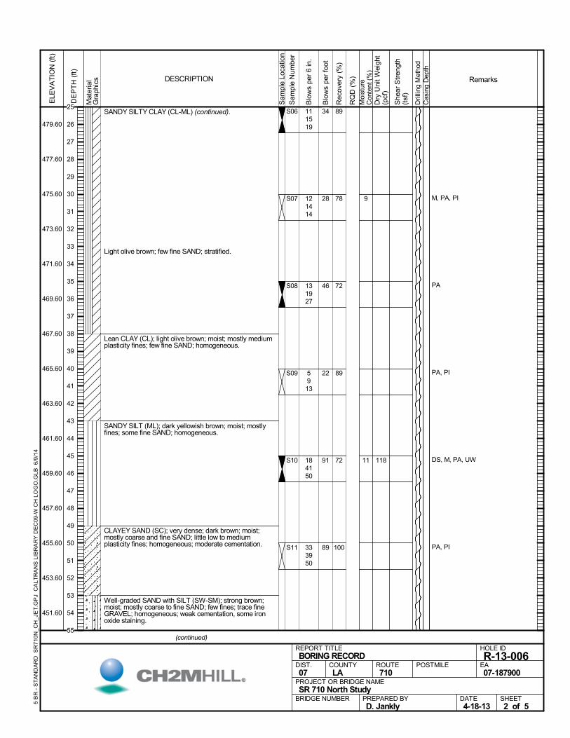
SANDY SILTY CLAY (CL-ML) (continued).
Light olive brown; few fine SAND; stratified.
Lean CLAY (CL); light olive brown; moist; mostly mediumplasticity fines; few fine SAND; homogeneous.
SANDY SILT (ML); dark yellowish brown; moist; mostlyfines; some fine SAND; homogeneous.
CLAYEY SAND (SC); very dense; dark brown; moist;mostly coarse and fine SAND; little low to mediumplasticity fines; homogeneous; moderate cementation.
Well-graded SAND with SILT (SW-SM); strong brown;moist; mostly coarse to fine SAND; few fines; trace fineGRAVEL; homogeneous; weak cementation, some ironoxide staining.
89
78
72
89
72
100
S06
S07
S08
S09
S10
S11
9
11
M, PA, PI
PA
PA, PI
DS, M, PA, UW
PA, PI
111519
121414
131927
5913
184150
333950
118
Mat
eria
lG
raph
ics
Sam
ple
Loca
tion
COUNTYLA
DESCRIPTION
Rec
over
y (%
)
Dri
lling
Met
hod
Cas
ing
Dep
th
PREPARED BYD. Jankly
DATE4-18-13
PROJECT OR BRIDGE NAMESR 710 North Study
BRIDGE NUMBER
HOLE ID
R-13-006EA07-187900
REPORT TITLEBORING RECORD
DIST.07
ROUTE710
POSTMILE
(continued)
SHEET2 of 5
RQ
D (
%)
Sam
ple
Num
ber
Moi
stur
eC
onte
nt (
%)
Remarks
Blo
ws
per
6 in
.
ELE
VA
TIO
N (
ft)
479.60
477.60
475.60
473.60
471.60
469.60
467.60
465.60
463.60
461.60
459.60
457.60
455.60
453.60
451.60
DE
PT
H (
ft)
Dry
Uni
t W
eigh
t(p
cf)
She
ar S
tren
gth
(tsf
)
Blo
ws
per
foot
5 B
R -
ST
AN
DA
RD
SR
710
N_C
H_J
ET
.GP
J C
ALT
RA
NS
LIB
RA
RY
DE
C09
-W C
H L
OG
O.G
LB 6
/9/1
4
34
28
46
22
91
89
25
26
27
28
29
30
31
32
33
34
35
36
37
38
39
40
41
42
43
44
45
46
47
48
49
50
51
52
53
54
55
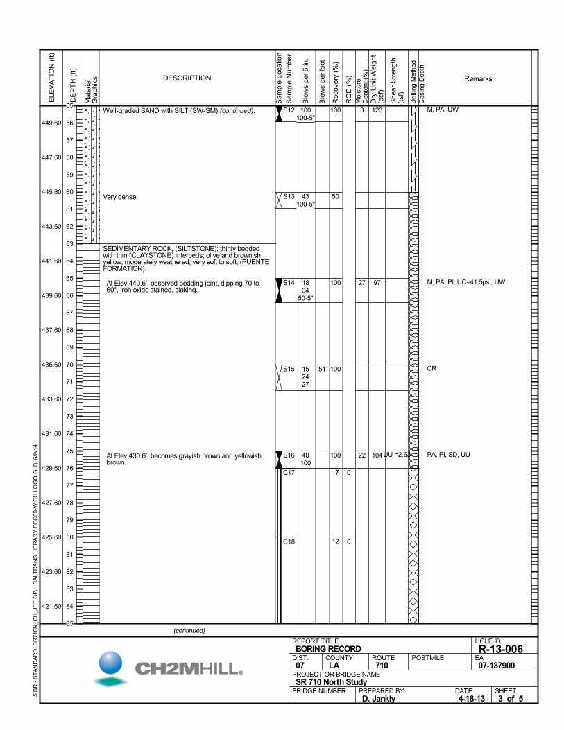
Well-graded SAND with SILT (SW-SM) (continued).
Very dense.
SEDIMENTARY ROCK, (SILTSTONE); thinly beddedwith thin (CLAYSTONE) interbeds; olive and brownishyellow; moderately weathered; very soft to soft; (PUENTEFORMATION).
At Elev 440.6', observed bedding joint, dipping 70 to60°, iron oxide stained, slaking.
At Elev 430.6', becomes grayish brown and yellowishbrown.
100
50
100
100
100
17
12
C17
C18
0
0
S12
S13
S14
S15
S16
3
27
22
M, PA, UW
M, PA, PI, UC=41.5psi, UW
CR
PA, PI, SD, UU
100100-5"
43100-5"
1834
50-5"
152427
40100
123
97
104UU =2.63
Mat
eria
lG
raph
ics
Sam
ple
Loca
tion
COUNTYLA
DESCRIPTION
Rec
over
y (%
)
Dri
lling
Met
hod
Cas
ing
Dep
th
PREPARED BYD. Jankly
DATE4-18-13
PROJECT OR BRIDGE NAMESR 710 North Study
BRIDGE NUMBER
HOLE ID
R-13-006EA07-187900
REPORT TITLEBORING RECORD
DIST.07
ROUTE710
POSTMILE
(continued)
SHEET3 of 5
RQ
D (
%)
Sam
ple
Num
ber
Moi
stur
eC
onte
nt (
%)
Remarks
Blo
ws
per
6 in
.
ELE
VA
TIO
N (
ft)
449.60
447.60
445.60
443.60
441.60
439.60
437.60
435.60
433.60
431.60
429.60
427.60
425.60
423.60
421.60
DE
PT
H (
ft)
Dry
Uni
t W
eigh
t(p
cf)
She
ar S
tren
gth
(tsf
)
Blo
ws
per
foot
5 B
R -
ST
AN
DA
RD
SR
710
N_C
H_J
ET
.GP
J C
ALT
RA
NS
LIB
RA
RY
DE
C09
-W C
H L
OG
O.G
LB 6
/9/1
4
51
55
56
57
58
59
60
61
62
63
64
65
66
67
68
69
70
71
72
73
74
75
76
77
78
79
80
81
82
83
84
85
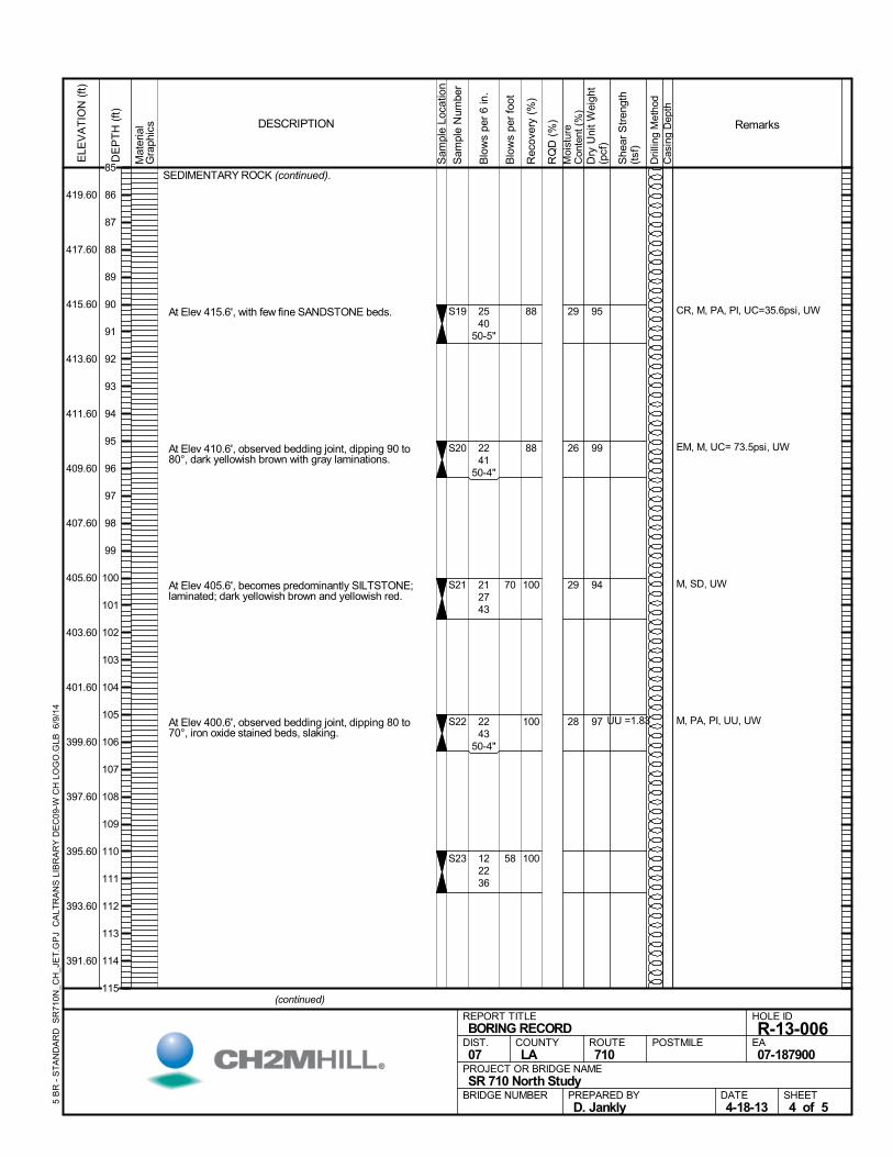
SEDIMENTARY ROCK (continued).
At Elev 415.6', with few fine SANDSTONE beds.
At Elev 410.6', observed bedding joint, dipping 90 to80°, dark yellowish brown with gray laminations.
At Elev 405.6', becomes predominantly SILTSTONE;laminated; dark yellowish brown and yellowish red.
At Elev 400.6', observed bedding joint, dipping 80 to70°, iron oxide stained beds, slaking.
88
88
100
100
100
S19
S20
S21
S22
S23
29
26
29
28
CR, M, PA, PI, UC=35.6psi, UW
EM, M, UC= 73.5psi, UW
M, SD, UW
M, PA, PI, UU, UW
2540
50-5"
2241
50-4"
212743
2243
50-4"
122236
95
99
94
97 UU =1.83
Mat
eria
lG
raph
ics
Sam
ple
Loca
tion
COUNTYLA
DESCRIPTION
Rec
over
y (%
)
Dri
lling
Met
hod
Cas
ing
Dep
th
PREPARED BYD. Jankly
DATE4-18-13
PROJECT OR BRIDGE NAMESR 710 North Study
BRIDGE NUMBER
HOLE ID
R-13-006EA07-187900
REPORT TITLEBORING RECORD
DIST.07
ROUTE710
POSTMILE
(continued)
SHEET4 of 5
RQ
D (
%)
Sam
ple
Num
ber
Moi
stur
eC
onte
nt (
%)
Remarks
Blo
ws
per
6 in
.
ELE
VA
TIO
N (
ft)
419.60
417.60
415.60
413.60
411.60
409.60
407.60
405.60
403.60
401.60
399.60
397.60
395.60
393.60
391.60
DE
PT
H (
ft)
Dry
Uni
t W
eigh
t(p
cf)
She
ar S
tren
gth
(tsf
)
Blo
ws
per
foot
5 B
R -
ST
AN
DA
RD
SR
710
N_C
H_J
ET
.GP
J C
ALT
RA
NS
LIB
RA
RY
DE
C09
-W C
H L
OG
O.G
LB 6
/9/1
4
70
58
85
86
87
88
89
90
91
92
93
94
95
96
97
98
99
100
101
102
103
104
105
106
107
108
109
110
111
112
113
114
115
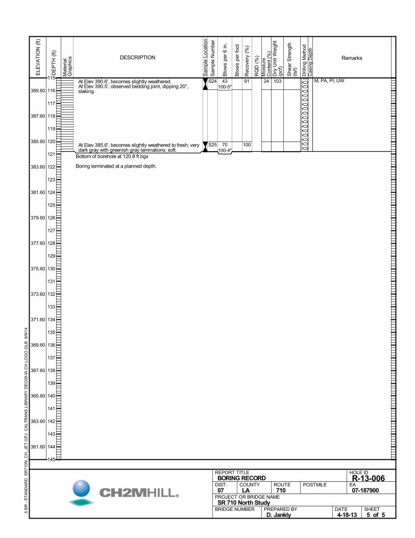
At Elev 390.6', becomes slightly weathered. At Elev 390.5', observed bedding joint, dipping 20°,slaking.
At Elev 385.6', becomes slightly weathered to fresh; verydark gray with greenish gray laminations; soft.
Bottom of borehole at 120.8 ft bgs
Boring terminated at a planned depth.
91
100
S24
S25
24 M, PA, PI, UW43100-5"
70100-4"
103
Mat
eria
lG
raph
ics
Sam
ple
Loca
tion
COUNTYLA
DESCRIPTION
Rec
over
y (%
)
Dri
lling
Met
hod
Cas
ing
Dep
th
PREPARED BYD. Jankly
DATE4-18-13
PROJECT OR BRIDGE NAMESR 710 North Study
BRIDGE NUMBER
HOLE ID
R-13-006EA07-187900
REPORT TITLEBORING RECORD
DIST.07
ROUTE710
POSTMILE
SHEET5 of 5
RQ
D (
%)
Sam
ple
Num
ber
Moi
stur
eC
onte
nt (
%)
Remarks
Blo
ws
per
6 in
.
ELE
VA
TIO
N (
ft)
389.60
387.60
385.60
383.60
381.60
379.60
377.60
375.60
373.60
371.60
369.60
367.60
365.60
363.60
361.60
DE
PT
H (
ft)
Dry
Uni
t W
eigh
t(p
cf)
She
ar S
tren
gth
(tsf
)
Blo
ws
per
foot
5 B
R -
ST
AN
DA
RD
SR
710
N_C
H_J
ET
.GP
J C
ALT
RA
NS
LIB
RA
RY
DE
C09
-W C
H L
OG
O.G
LB 6
/9/1
4
115
116
117
118
119
120
121
122
123
124
125
126
127
128
129
130
131
132
133
134
135
136
137
138
139
140
141
142
143
144
145
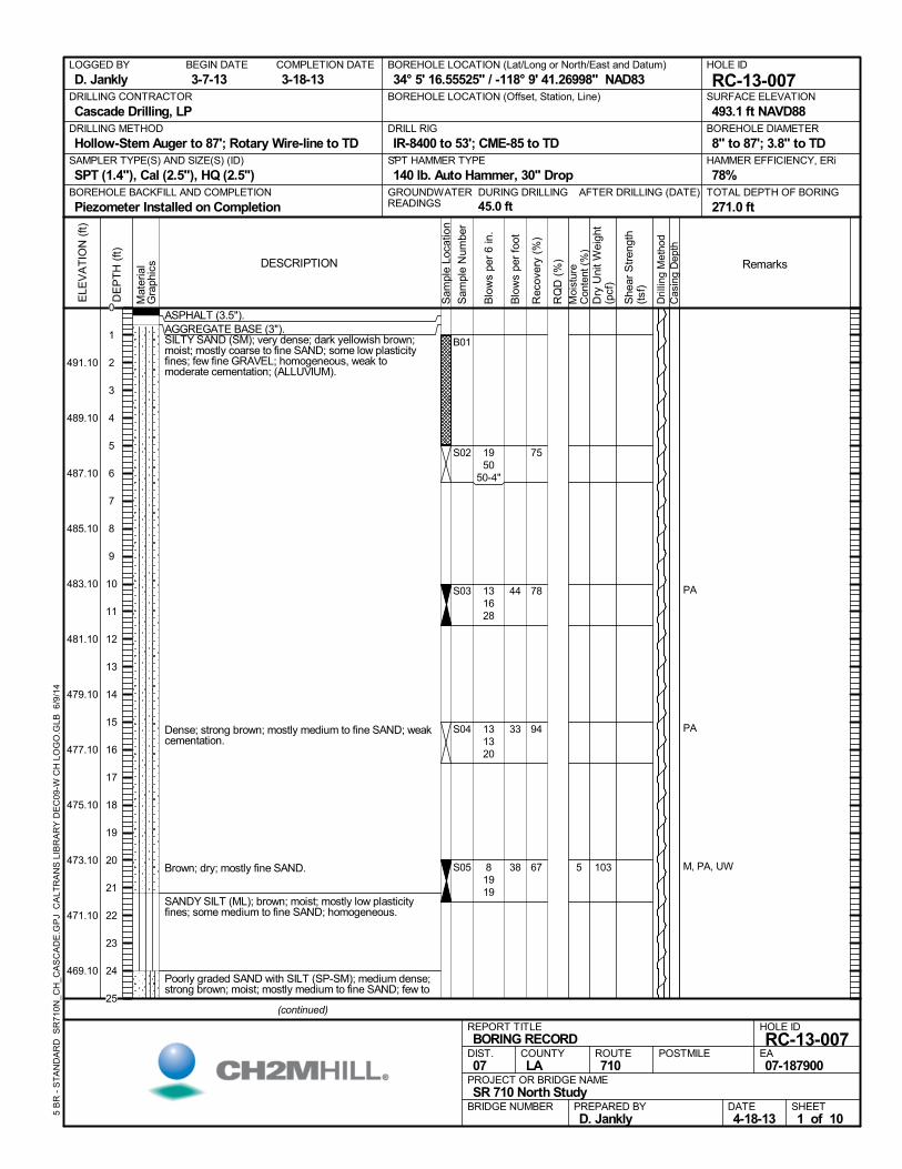
ASPHALT (3.5").AGGREGATE BASE (3").SILTY SAND (SM); very dense; dark yellowish brown;moist; mostly coarse to fine SAND; some low plasticityfines; few fine GRAVEL; homogeneous, weak tomoderate cementation; (ALLUVIUM).
Dense; strong brown; mostly medium to fine SAND; weakcementation.
Brown; dry; mostly fine SAND.
SANDY SILT (ML); brown; moist; mostly low plasticityfines; some medium to fine SAND; homogeneous.
Poorly graded SAND with SILT (SP-SM); medium dense;strong brown; moist; mostly medium to fine SAND; few to
75
78
94
67
B01
S02
S03
S04
S05 5
PA
PA
M, PA, UW
1950
50-4"
131628
131320
81919
103
AFTER DRILLING (DATE)DURING DRILLING
45.0 ft
SURFACE ELEVATION
493.1 ft NAVD88DRILLING METHOD
Hollow-Stem Auger to 87'; Rotary Wire-line to TDDRILL RIG
IR-8400 to 53'; CME-85 to TDSPT HAMMER TYPE
140 lb. Auto Hammer, 30" DropBOREHOLE BACKFILL AND COMPLETION
Piezometer Installed on CompletionGROUNDWATERREADINGS
BEGIN DATE
3-7-13COMPLETION DATE
3-18-13LOGGED BY
D. JanklyBOREHOLE LOCATION (Lat/Long or North/East and Datum)
34° 5' 16.55525" / -118° 9' 41.26998" NAD83HOLE ID
RC-13-007DRILLING CONTRACTOR
Cascade Drilling, LP
HAMMER EFFICIENCY, ERi
78%SAMPLER TYPE(S) AND SIZE(S) (ID)
SPT (1.4"), Cal (2.5"), HQ (2.5")TOTAL DEPTH OF BORING
271.0 ft
BOREHOLE DIAMETER
8" to 87'; 3.8" to TD
BOREHOLE LOCATION (Offset, Station, Line)
.M
ater
ial
Gra
phic
s
Sam
ple
Loca
tion
COUNTYLA
DESCRIPTION
Rec
over
y (%
)
Dri
lling
Met
hod
Cas
ing
Dep
th
PREPARED BYD. Jankly
DATE4-18-13
PROJECT OR BRIDGE NAMESR 710 North Study
BRIDGE NUMBER
HOLE ID
RC-13-007EA07-187900
REPORT TITLEBORING RECORD
DIST.07
ROUTE710
POSTMILE
(continued)
SHEET1 of 10
RQ
D (
%)
Sam
ple
Num
ber
Moi
stur
eC
onte
nt (
%)
Remarks
Blo
ws
per
6 in
.
ELE
VA
TIO
N (
ft)
491.10
489.10
487.10
485.10
483.10
481.10
479.10
477.10
475.10
473.10
471.10
469.10
DE
PT
H (
ft)
Dry
Uni
t W
eigh
t(p
cf)
She
ar S
tren
gth
(tsf
)
Blo
ws
per
foot
5 B
R -
ST
AN
DA
RD
SR
710
N_C
H_C
AS
CA
DE
.GP
J C
ALT
RA
NS
LIB
RA
RY
DE
C09
-W C
H L
OG
O.G
LB 6
/9/1
4
44
33
38
0
1
2
3
4
5
6
7
8
9
10
11
12
13
14
15
16
17
18
19
20
21
22
23
24
25
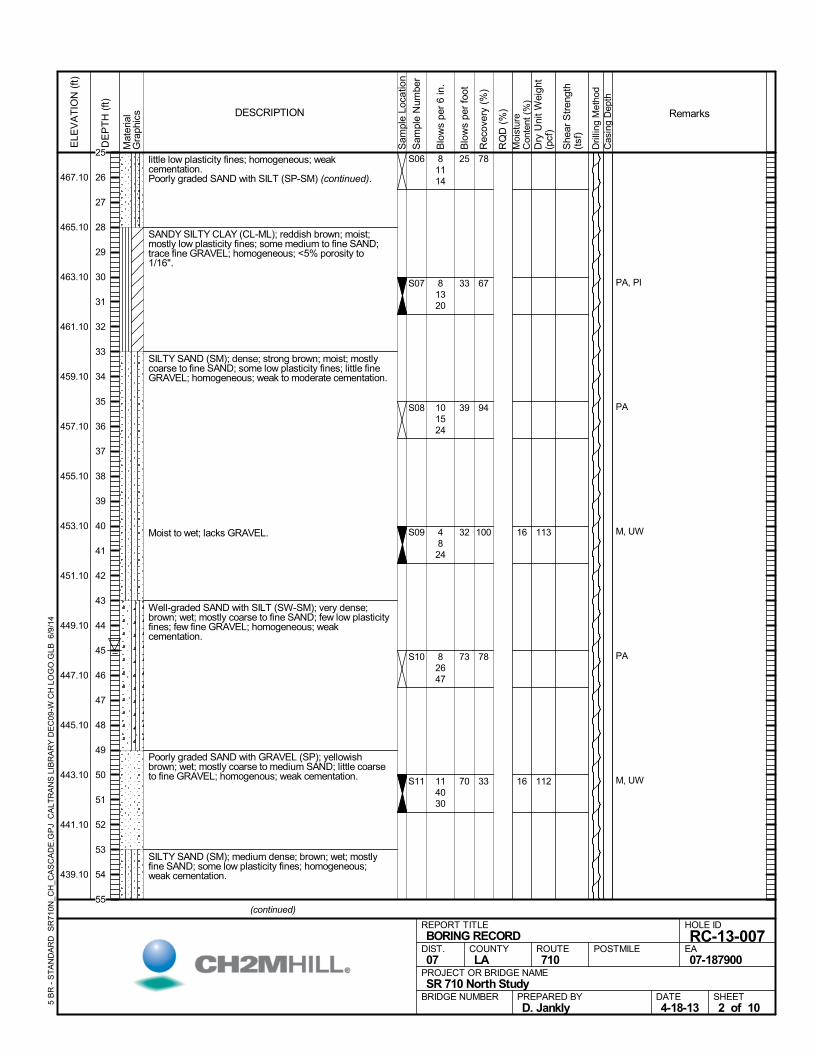
little low plasticity fines; homogeneous; weakcementation.Poorly graded SAND with SILT (SP-SM) (continued).
SANDY SILTY CLAY (CL-ML); reddish brown; moist;mostly low plasticity fines; some medium to fine SAND;trace fine GRAVEL; homogeneous; <5% porosity to1/16".
SILTY SAND (SM); dense; strong brown; moist; mostlycoarse to fine SAND; some low plasticity fines; little fineGRAVEL; homogeneous; weak to moderate cementation.
Moist to wet; lacks GRAVEL.
Well-graded SAND with SILT (SW-SM); very dense;brown; wet; mostly coarse to fine SAND; few low plasticityfines; few fine GRAVEL; homogeneous; weakcementation.
Poorly graded SAND with GRAVEL (SP); yellowishbrown; wet; mostly coarse to medium SAND; little coarseto fine GRAVEL; homogenous; weak cementation.
SILTY SAND (SM); medium dense; brown; wet; mostlyfine SAND; some low plasticity fines; homogeneous;weak cementation.
78
67
94
100
78
33
S06
S07
S08
S09
S10
S11
16
16
PA, PI
PA
M, UW
PA
M, UW
81114
81320
101524
4824
82647
114030
113
112
Mat
eria
lG
raph
ics
Sam
ple
Loca
tion
COUNTYLA
DESCRIPTION
Rec
over
y (%
)
Dri
lling
Met
hod
Cas
ing
Dep
th
PREPARED BYD. Jankly
DATE4-18-13
PROJECT OR BRIDGE NAMESR 710 North Study
BRIDGE NUMBER
HOLE ID
RC-13-007EA07-187900
REPORT TITLEBORING RECORD
DIST.07
ROUTE710
POSTMILE
(continued)
SHEET2 of 10
RQ
D (
%)
Sam
ple
Num
ber
Moi
stur
eC
onte
nt (
%)
Remarks
Blo
ws
per
6 in
.
ELE
VA
TIO
N (
ft)
467.10
465.10
463.10
461.10
459.10
457.10
455.10
453.10
451.10
449.10
447.10
445.10
443.10
441.10
439.10
DE
PT
H (
ft)
Dry
Uni
t W
eigh
t(p
cf)
She
ar S
tren
gth
(tsf
)
Blo
ws
per
foot
5 B
R -
ST
AN
DA
RD
SR
710
N_C
H_C
AS
CA
DE
.GP
J C
ALT
RA
NS
LIB
RA
RY
DE
C09
-W C
H L
OG
O.G
LB 6
/9/1
4
25
33
39
32
73
70
25
26
27
28
29
30
31
32
33
34
35
36
37
38
39
40
41
42
43
44
45
46
47
48
49
50
51
52
53
54
55
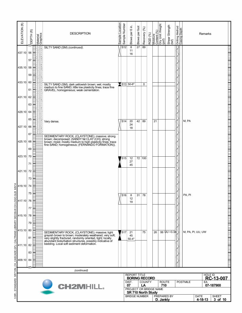
SILTY SAND (SM) (continued).
SILTY SAND (SM); dark yellowish brown; wet; mostlymedium to fine SAND; little low plasticity fines; trace fineGRAVEL; homogeneous; weak cementation.
Very dense.
SEDIMENTARY ROCK, (CLAYSTONE); massive; strongbrown; decomposed; (SANDY fat CLAY (CH); strongbrown; moist; mostly medium to high plasticity fines; tracefine SAND; homogeneous; (FERNANDO FORMATION)).
SEDIMENTARY ROCK, (CLAYSTONE); massive; lightgrayish brown to brown; moderately weathered; very soft;very slightly fractured, randomly oriented, tight; locallyabundant bioturbation structures, possibly indicative ofbedding. Local soft sediment deformation.
89
0
89
100
78
75
S12
S13
S14
S15
S16
S17
21
26
M, PA
PA, PI
M, PA, PI, UU, UW
81116
50-6"
202418
122745
81219
2145
50-4"
99 UU =3.34
Mat
eria
lG
raph
ics
Sam
ple
Loca
tion
COUNTYLA
DESCRIPTION
Rec
over
y (%
)
Dri
lling
Met
hod
Cas
ing
Dep
th
PREPARED BYD. Jankly
DATE4-18-13
PROJECT OR BRIDGE NAMESR 710 North Study
BRIDGE NUMBER
HOLE ID
RC-13-007EA07-187900
REPORT TITLEBORING RECORD
DIST.07
ROUTE710
POSTMILE
(continued)
SHEET3 of 10
RQ
D (
%)
Sam
ple
Num
ber
Moi
stur
eC
onte
nt (
%)
Remarks
Blo
ws
per
6 in
.
ELE
VA
TIO
N (
ft)
437.10
435.10
433.10
431.10
429.10
427.10
425.10
423.10
421.10
419.10
417.10
415.10
413.10
411.10
409.10
DE
PT
H (
ft)
Dry
Uni
t W
eigh
t(p
cf)
She
ar S
tren
gth
(tsf
)
Blo
ws
per
foot
5 B
R -
ST
AN
DA
RD
SR
710
N_C
H_C
AS
CA
DE
.GP
J C
ALT
RA
NS
LIB
RA
RY
DE
C09
-W C
H L
OG
O.G
LB 6
/9/1
4
27
42
72
31
55
56
57
58
59
60
61
62
63
64
65
66
67
68
69
70
71
72
73
74
75
76
77
78
79
80
81
82
83
84
85
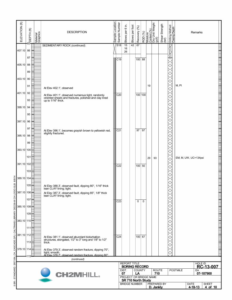
SEDIMENTARY ROCK (continued).
At Elev 402.1', observed
At Elev 401.1', observed numerous tight, randomlyoriented shears and fractures, polished and clay linedup to 1/16" thick.
At Elev 396.1', becomes grayish brown to yellowish red,slightly fractured.
At Elev 388.3', observed fault, dipping 80°, 1/16" thicklean CLAY lining; tight.
At Elev 387.3', observed fault, dipping 85°, 1/8" thicklean CLAY lining; tight.
At Elev 381.1', observed abundant bioturbationstructures, elongated, 1/2" to 3" long and 1/8" to 1/2"thick.
At Elev 379.3', observed random fracture, dipping 70°,tight; smooth.
At Elev 378.7', observed random fracture, dipping 80°,
67
100
100
97
100
0
100
C19
C20
C21
C22
C23
C24
88
100
97
50
0
67
S18
19
29
M, PI
EM, M, UW, UC=134psi
151626
93
Mat
eria
lG
raph
ics
Sam
ple
Loca
tion
COUNTYLA
DESCRIPTION
Rec
over
y (%
)
Dri
lling
Met
hod
Cas
ing
Dep
th
PREPARED BYD. Jankly
DATE4-18-13
PROJECT OR BRIDGE NAMESR 710 North Study
BRIDGE NUMBER
HOLE ID
RC-13-007EA07-187900
REPORT TITLEBORING RECORD
DIST.07
ROUTE710
POSTMILE
(continued)
SHEET4 of 10
RQ
D (
%)
Sam
ple
Num
ber
Moi
stur
eC
onte
nt (
%)
Remarks
Blo
ws
per
6 in
.
ELE
VA
TIO
N (
ft)
407.10
405.10
403.10
401.10
399.10
397.10
395.10
393.10
391.10
389.10
387.10
385.10
383.10
381.10
379.10
DE
PT
H (
ft)
Dry
Uni
t W
eigh
t(p
cf)
She
ar S
tren
gth
(tsf
)
Blo
ws
per
foot
5 B
R -
ST
AN
DA
RD
SR
710
N_C
H_C
AS
CA
DE
.GP
J C
ALT
RA
NS
LIB
RA
RY
DE
C09
-W C
H L
OG
O.G
LB 6
/9/1
4
4285
86
87
88
89
90
91
92
93
94
95
96
97
98
99
100
101
102
103
104
105
106
107
108
109
110
111
112
113
114
115
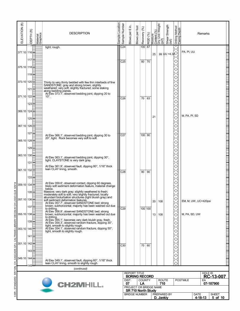
tight; rough.
Thinly to very thinly bedded with few thin interbeds of fineSANDSTONE: gray and strong brown; slightlyweathered; very soft; slightly fractured; some slakingalong bedding planes. At Elev 373.1', observed bedding joint, dipping 20 to10°.
At Elev 366.1', observed bedding joint, dipping 30 to20°, tight. Rock becomes very soft to soft.
At Elev 363.1', observed bedding joint, dipping 30°,tight. CLAYSTONE is very dark gray.
At Elev 361.9', observed fault, dipping 80°, 1/16" thicklean CLAY lining, smooth.
At Elev 359.6', observed contact, dipping 60 degrees,likely soft sediment deformation feature, material changebelow.
Massive; very dark gray; slightly weathered to fresh;moderately soft to soft; very slightly fractured; locallyabundant bioturbation structures (light bluish gray) andsoft sediment deformation features. At Elev 357.7', observed SANDSTONE bed; strongbrown; subhorizontal; majority has been washed out dueto drilling.
At Elev 356.9', observed SANDSTONE bed; strongbrown; subhorizontal; majority has been washed out dueto drilling.
At Elev 355.1', becomes very dark bluish gray, fresh. At Elev 354.3', observed random fracture, dipping 30°,tight, smooth to slightly rough.
At Elev 354.1', observed random fracture, dipping 50°,tight, smooth to slightly rough.
At Elev 349.1', observed fault, dipping 60°, 1/16" thicklean CLAY lining, smooth to slightly rough.
100
80
70
100
90
100
70
C24
C25
C26
C27
C28
C29
C30
67
70
63
90
90
100
60
25
21
20
13
PA, PI, UU
M, PA, PI, SD
EM, M, UW, UC=420psi
M, PA, SD, UW
99
108
108
UU =4.34
Mat
eria
lG
raph
ics
Sam
ple
Loca
tion
COUNTYLA
DESCRIPTION
Rec
over
y (%
)
Dri
lling
Met
hod
Cas
ing
Dep
th
PREPARED BYD. Jankly
DATE4-18-13
PROJECT OR BRIDGE NAMESR 710 North Study
BRIDGE NUMBER
HOLE ID
RC-13-007EA07-187900
REPORT TITLEBORING RECORD
DIST.07
ROUTE710
POSTMILE
(continued)
SHEET5 of 10
RQ
D (
%)
Sam
ple
Num
ber
Moi
stur
eC
onte
nt (
%)
Remarks
Blo
ws
per
6 in
.
ELE
VA
TIO
N (
ft)
377.10
375.10
373.10
371.10
369.10
367.10
365.10
363.10
361.10
359.10
357.10
355.10
353.10
351.10
349.10
DE
PT
H (
ft)
Dry
Uni
t W
eigh
t(p
cf)
She
ar S
tren
gth
(tsf
)
Blo
ws
per
foot
5 B
R -
ST
AN
DA
RD
SR
710
N_C
H_C
AS
CA
DE
.GP
J C
ALT
RA
NS
LIB
RA
RY
DE
C09
-W C
H L
OG
O.G
LB 6
/9/1
4
115
116
117
118
119
120
121
122
123
124
125
126
127
128
129
130
131
132
133
134
135
136
137
138
139
140
141
142
143
144
145
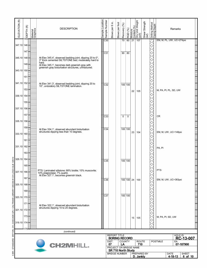
At Elev 345.4', observed bedding joint, dipping 20 to 0°,3" thick cemented SILTSTONE bed; moderately hard tohard.
At Elev 345.1', becomes dark greenish gray withgreenish gray bioturbation structures, unfractured.
At Elev 341.3', observed bedding joint, dipping 20 to10°, undulatory SILTSTONE lamination.
At Elev 334.1', observed abundant bioturbationstructures dipping less than 10 degrees.
PTS: Laminated siltstone; 68% biotite; 15% muscovite;10% plagioclase; 7% quartz. At Elev 327.1', becomes greenish black.
At Elev 322.1', observed abundant bioturbationstructures dipping 10 to 20 degrees.
70
90
100
0
100
100
100
100
C30
C31
C32
C33
C34
C35
C36
C37
60
80
100
0
100
100
100
100
21
22
23
24
15
EM, M, PL, UW, UC=274psi
M, PA, PI, PL, SD, UW
CR
EM, M, UW, UC=148psi
PA, PI
PTS
EM, M, UW, UC=383psi
M, PA, PI, SD, UW
107
105
104
100
105
Mat
eria
lG
raph
ics
Sam
ple
Loca
tion
COUNTYLA
DESCRIPTION
Rec
over
y (%
)
Dri
lling
Met
hod
Cas
ing
Dep
th
PREPARED BYD. Jankly
DATE4-18-13
PROJECT OR BRIDGE NAMESR 710 North Study
BRIDGE NUMBER
HOLE ID
RC-13-007EA07-187900
REPORT TITLEBORING RECORD
DIST.07
ROUTE710
POSTMILE
(continued)
SHEET6 of 10
RQ
D (
%)
Sam
ple
Num
ber
Moi
stur
eC
onte
nt (
%)
Remarks
Blo
ws
per
6 in
.
ELE
VA
TIO
N (
ft)
347.10
345.10
343.10
341.10
339.10
337.10
335.10
333.10
331.10
329.10
327.10
325.10
323.10
321.10
319.10
DE
PT
H (
ft)
Dry
Uni
t W
eigh
t(p
cf)
She
ar S
tren
gth
(tsf
)
Blo
ws
per
foot
5 B
R -
ST
AN
DA
RD
SR
710
N_C
H_C
AS
CA
DE
.GP
J C
ALT
RA
NS
LIB
RA
RY
DE
C09
-W C
H L
OG
O.G
LB 6
/9/1
4
145
146
147
148
149
150
151
152
153
154
155
156
157
158
159
160
161
162
163
164
165
166
167
168
169
170
171
172
173
174
175
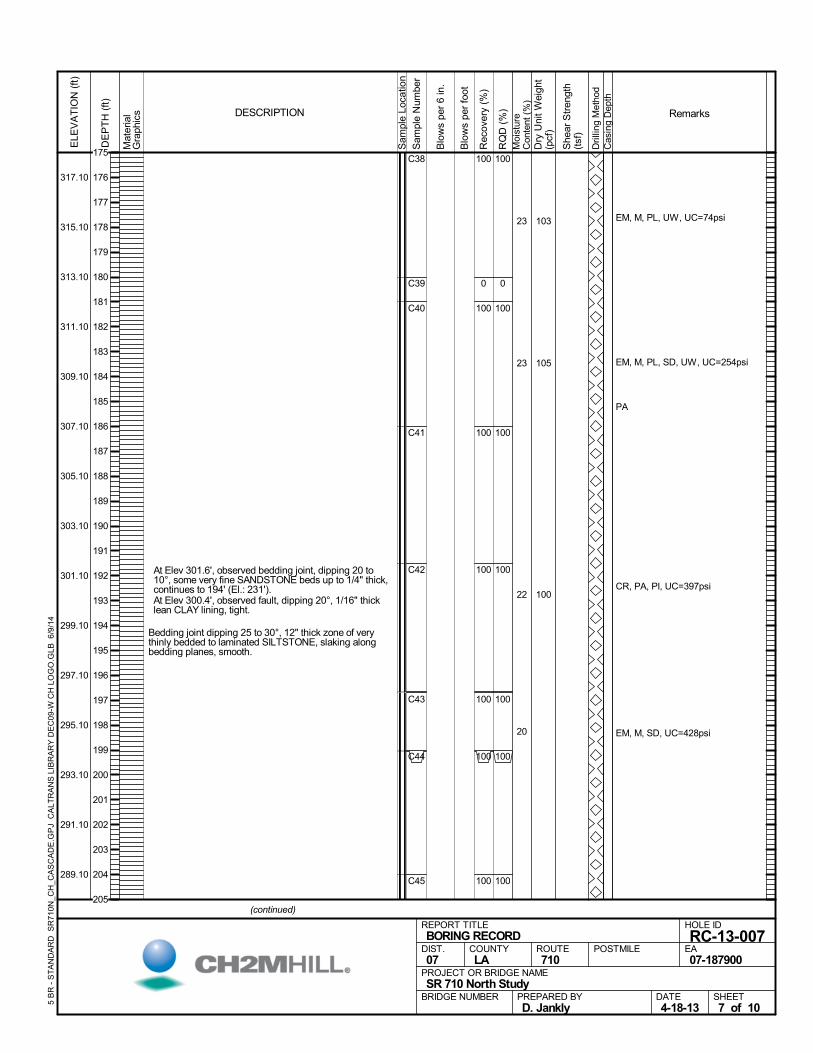
At Elev 301.6', observed bedding joint, dipping 20 to10°, some very fine SANDSTONE beds up to 1/4" thick,continues to 194' (El.: 231').
At Elev 300.4', observed fault, dipping 20°, 1/16" thicklean CLAY lining, tight.
Bedding joint dipping 25 to 30°, 12" thick zone of verythinly bedded to laminated SILTSTONE, slaking alongbedding planes, smooth.
100
0
100
100
100
100
100
100
C38
C39
C40
C41
C42
C43
C44
C45
100
0
100
100
100
100
100
100
23
23
22
20
EM, M, PL, UW, UC=74psi
EM, M, PL, SD, UW, UC=254psi
PA
CR, PA, PI, UC=397psi
EM, M, SD, UC=428psi
103
105
100
Mat
eria
lG
raph
ics
Sam
ple
Loca
tion
COUNTYLA
DESCRIPTION
Rec
over
y (%
)
Dri
lling
Met
hod
Cas
ing
Dep
th
PREPARED BYD. Jankly
DATE4-18-13
PROJECT OR BRIDGE NAMESR 710 North Study
BRIDGE NUMBER
HOLE ID
RC-13-007EA07-187900
REPORT TITLEBORING RECORD
DIST.07
ROUTE710
POSTMILE
(continued)
SHEET7 of 10
RQ
D (
%)
Sam
ple
Num
ber
Moi
stur
eC
onte
nt (
%)
Remarks
Blo
ws
per
6 in
.
ELE
VA
TIO
N (
ft)
317.10
315.10
313.10
311.10
309.10
307.10
305.10
303.10
301.10
299.10
297.10
295.10
293.10
291.10
289.10
DE
PT
H (
ft)
Dry
Uni
t W
eigh
t(p
cf)
She
ar S
tren
gth
(tsf
)
Blo
ws
per
foot
5 B
R -
ST
AN
DA
RD
SR
710
N_C
H_C
AS
CA
DE
.GP
J C
ALT
RA
NS
LIB
RA
RY
DE
C09
-W C
H L
OG
O.G
LB 6
/9/1
4
175
176
177
178
179
180
181
182
183
184
185
186
187
188
189
190
191
192
193
194
195
196
197
198
199
200
201
202
203
204
205
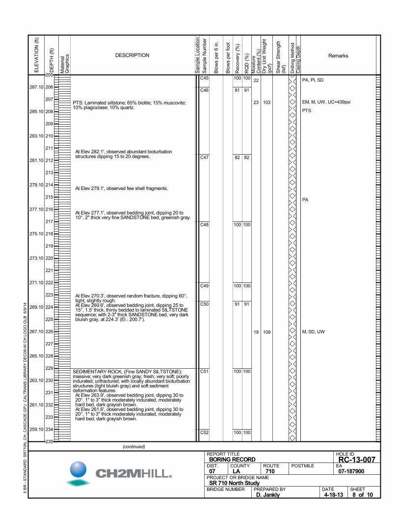
PTS: Laminated siltstone; 65% biotite; 15% muscovite;10% plagioclase; 10% quartz.
At Elev 282.1', observed abundant bioturbationstructures dipping 15 to 20 degrees.
At Elev 279.1', observed few shell fragments.
At Elev 277.1', observed bedding joint, dipping 20 to10°, 2" thick very fine SANDSTONE bed, greenish gray.
At Elev 270.3', observed random fracture, dipping 60°,tight, slightly rough.
At Elev 269.6', observed bedding joint, dipping 25 to15°, 1.5' thick, thinly bedded to laminated SILTSTONEsequence; with 2-3" thick SANDSTONE bed, very darkbluish gray, at 224.3' (El.: 200.7').
SEDIMENTARY ROCK, (Fine SANDY SILTSTONE);massive; very dark greenish gray; fresh; very soft; poorlyindurated; unfractured; with locally abundant bioturbationstructures (light bluish gray) and soft sedimentdeformation features. At Elev 263.9', observed bedding joint, dipping 30 to20°, 1" to 3" thick moderately indurated, moderatelyhard bed, dark grayish brown.
At Elev 261.6', observed bedding joint, dipping 30 to20°, 1" to 3" thick moderately indurated, moderatelyhard bed, dark grayish brown.
100
91
82
100
100
91
100
100
C45
C46
C47
C48
C49
C50
C51
C52
100
91
82
100
100
91
100
100
22
23
19
PA, PI, SD
EM, M, UW, UC=439psi
PTS
PA
M, SD, UW
103
109
Mat
eria
lG
raph
ics
Sam
ple
Loca
tion
COUNTYLA
DESCRIPTION
Rec
over
y (%
)
Dri
lling
Met
hod
Cas
ing
Dep
th
PREPARED BYD. Jankly
DATE4-18-13
PROJECT OR BRIDGE NAMESR 710 North Study
BRIDGE NUMBER
HOLE ID
RC-13-007EA07-187900
REPORT TITLEBORING RECORD
DIST.07
ROUTE710
POSTMILE
(continued)
SHEET8 of 10
RQ
D (
%)
Sam
ple
Num
ber
Moi
stur
eC
onte
nt (
%)
Remarks
Blo
ws
per
6 in
.
ELE
VA
TIO
N (
ft)
287.10
285.10
283.10
281.10
279.10
277.10
275.10
273.10
271.10
269.10
267.10
265.10
263.10
261.10
259.10
DE
PT
H (
ft)
Dry
Uni
t W
eigh
t(p
cf)
She
ar S
tren
gth
(tsf
)
Blo
ws
per
foot
5 B
R -
ST
AN
DA
RD
SR
710
N_C
H_C
AS
CA
DE
.GP
J C
ALT
RA
NS
LIB
RA
RY
DE
C09
-W C
H L
OG
O.G
LB 6
/9/1
4
205
206
207
208
209
210
211
212
213
214
215
216
217
218
219
220
221
222
223
224
225
226
227
228
229
230
231
232
233
234
235
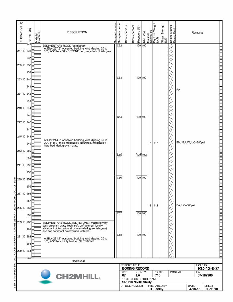
SEDIMENTARY ROCK (continued). At Elev 257.8', observed bedding joint, dipping 20 to10°, 2-3" thick SANDSTONE bed, very dark bluish gray.
At Elev 244.9', observed bedding joint, dipping 30 to20°, 1" to 3" thick moderately indurated, moderatelyhard bed, dark grayish gray.
SEDIMENTARY ROCK, (SILTSTONE); massive; verydark greenish gray; fresh; soft; unfractured; locallyabundant bioturbation structures (dark greenish gray)and soft sediment deformation features.
At Elev 231.1', observed bedding joint, dipping 20 to10°, 2-3" thick thinly bedded SILTSTONE.
100
100
100
100
100
100
100
C52
C53
C54
C55
C56
C57
C58
100
100
100
100
100
100
100
17
18
PA
EM, M, UW, UC=285psi
PA, UC=363psi
117
112
Mat
eria
lG
raph
ics
Sam
ple
Loca
tion
COUNTYLA
DESCRIPTION
Rec
over
y (%
)
Dri
lling
Met
hod
Cas
ing
Dep
th
PREPARED BYD. Jankly
DATE4-18-13
PROJECT OR BRIDGE NAMESR 710 North Study
BRIDGE NUMBER
HOLE ID
RC-13-007EA07-187900
REPORT TITLEBORING RECORD
DIST.07
ROUTE710
POSTMILE
(continued)
SHEET9 of 10
RQ
D (
%)
Sam
ple
Num
ber
Moi
stur
eC
onte
nt (
%)
Remarks
Blo
ws
per
6 in
.
ELE
VA
TIO
N (
ft)
257.10
255.10
253.10
251.10
249.10
247.10
245.10
243.10
241.10
239.10
237.10
235.10
233.10
231.10
229.10
DE
PT
H (
ft)
Dry
Uni
t W
eigh
t(p
cf)
She
ar S
tren
gth
(tsf
)
Blo
ws
per
foot
5 B
R -
ST
AN
DA
RD
SR
710
N_C
H_C
AS
CA
DE
.GP
J C
ALT
RA
NS
LIB
RA
RY
DE
C09
-W C
H L
OG
O.G
LB 6
/9/1
4
235
236
237
238
239
240
241
242
243
244
245
246
247
248
249
250
251
252
253
254
255
256
257
258
259
260
261
262
263
264
265
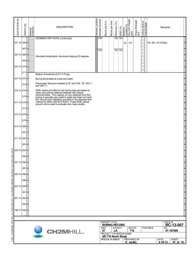
SEDIMENTARY ROCK (continued).
Abundant bioturbation structures dipping 20 degrees.
Bottom of borehole at 271.0 ft bgs
Boring terminated at a planned depth.
Piezometer Sensors Installed at 52' and 200' (El. 493.1',and 293.1')
RQD values provided on the boring logs are based onintact core pieces obtained between two naturaldiscontinuities. The majority of core obtained from thisboring is typically very weak to weak and does not meetthe "sound core" definition provided in the standard testmethod for RQD (ASTM D 6032). These RQD valuesshould not be used to evaluate rock mass quality.
100
100
C58
C59
100
100
20 PA, SD, UC=533psi107
Mat
eria
lG
raph
ics
Sam
ple
Loca
tion
COUNTYLA
DESCRIPTION
Rec
over
y (%
)
Dri
lling
Met
hod
Cas
ing
Dep
th
PREPARED BYD. Jankly
DATE4-18-13
PROJECT OR BRIDGE NAMESR 710 North Study
BRIDGE NUMBER
HOLE ID
RC-13-007EA07-187900
REPORT TITLEBORING RECORD
DIST.07
ROUTE710
POSTMILE
SHEET10 of 10
RQ
D (
%)
Sam
ple
Num
ber
Moi
stur
eC
onte
nt (
%)
Remarks
Blo
ws
per
6 in
.
ELE
VA
TIO
N (
ft)
227.10
225.10
223.10
221.10
219.10
217.10
215.10
213.10
211.10
209.10
207.10
205.10
203.10
201.10
199.10
DE
PT
H (
ft)
Dry
Uni
t W
eigh
t(p
cf)
She
ar S
tren
gth
(tsf
)
Blo
ws
per
foot
5 B
R -
ST
AN
DA
RD
SR
710
N_C
H_C
AS
CA
DE
.GP
J C
ALT
RA
NS
LIB
RA
RY
DE
C09
-W C
H L
OG
O.G
LB 6
/9/1
4
265
266
267
268
269
270
271
272
273
274
275
276
277
278
279
280
281
282
283
284
285
286
287
288
289
290
291
292
293
294
295

ASPHALT (3").AGGREGATE BASE (9").SILTY SAND (SM); yellowish brown; moist; mostly coarseto fine SAND; little fines; few fine GRAVEL;homogeneous; weak cementation (ALLUVIUM).
Loose.
Light olive brown; mostly medium to fine SAND.
Very dense; trace GRAVEL, stratified.
100
100
100
100
B01
S02
S03
S04
S05
10
4
M, PI, UW
PA
DS, PA
578
444
81828
223843
114
115
AFTER DRILLING (DATE)DURING DRILLING
NE
SURFACE ELEVATION
615.5 ft NAVD88DRILLING METHOD
Hollow-Stem AugerDRILL RIG
CME-75SPT HAMMER TYPE
140 lb. Auto Hammer, 30" DropBOREHOLE BACKFILL AND COMPLETION
Cement and Bentonite GroutGROUNDWATERREADINGS
BEGIN DATE
3-25-13COMPLETION DATE
3-25-13LOGGED BY
J. CulottaBOREHOLE LOCATION (Lat/Long or North/East and Datum)
34° 6' 39.83764" / -118° 9' 3.307107" NAD83HOLE ID
A-13-008DRILLING CONTRACTOR
Jet Drilling, Inc
HAMMER EFFICIENCY, ERi
72%SAMPLER TYPE(S) AND SIZE(S) (ID)
SPT (1.4"), Cal (2.5")TOTAL DEPTH OF BORING
96.5 ft
BOREHOLE DIAMETER
8 in
BOREHOLE LOCATION (Offset, Station, Line)
.M
ater
ial
Gra
phic
s
Sam
ple
Loca
tion
COUNTYLA
DESCRIPTION
Rec
over
y (%
)
Dri
lling
Met
hod
Cas
ing
Dep
th
PREPARED BYD. Jankly
DATE4-18-13
PROJECT OR BRIDGE NAMESR 710 North Study
BRIDGE NUMBER
HOLE ID
A-13-008EA07-187900
REPORT TITLEBORING RECORD
DIST.07
ROUTE710
POSTMILE
(continued)
SHEET1 of 4
RQ
D (
%)
Sam
ple
Num
ber
Moi
stur
eC
onte
nt (
%)
Remarks
Blo
ws
per
6 in
.
ELE
VA
TIO
N (
ft)
613.50
611.50
609.50
607.50
605.50
603.50
601.50
599.50
597.50
595.50
593.50
591.50
DE
PT
H (
ft)
Dry
Uni
t W
eigh
t(p
cf)
She
ar S
tren
gth
(tsf
)
Blo
ws
per
foot
5 B
R -
ST
AN
DA
RD
SR
710
N_C
H_J
ET
.GP
J C
ALT
RA
NS
LIB
RA
RY
DE
C09
-W C
H L
OG
O.G
LB 6
/9/1
4
15
8
46
81
0
1
2
3
4
5
6
7
8
9
10
11
12
13
14
15
16
17
18
19
20
21
22
23
24
25
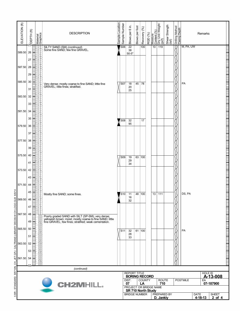
SILTY SAND (SM) (continued).Some fine SAND; few fine GRAVEL.
Very dense; mostly coarse to fine SAND; little fineGRAVEL; little fines; stratified.
Mostly fine SAND; some fines.
Poorly graded SAND with SILT (SP-SM); very dense;yellowish brown; moist; mostly coarse to fine SAND; littlefine GRAVEL; few fines; stratified; weak cementation.
100
78
17
100
100
100
S06
S07
S08
S09
S10
S11
10
13
M, PA, UW
PA
DS, PA
PA
2238
50-5"
182025
3295
192934
111632
322833
119
111
Mat
eria
lG
raph
ics
Sam
ple
Loca
tion
COUNTYLA
DESCRIPTION
Rec
over
y (%
)
Dri
lling
Met
hod
Cas
ing
Dep
th
PREPARED BYD. Jankly
DATE4-18-13
PROJECT OR BRIDGE NAMESR 710 North Study
BRIDGE NUMBER
HOLE ID
A-13-008EA07-187900
REPORT TITLEBORING RECORD
DIST.07
ROUTE710
POSTMILE
(continued)
SHEET2 of 4
RQ
D (
%)
Sam
ple
Num
ber
Moi
stur
eC
onte
nt (
%)
Remarks
Blo
ws
per
6 in
.
ELE
VA
TIO
N (
ft)
589.50
587.50
585.50
583.50
581.50
579.50
577.50
575.50
573.50
571.50
569.50
567.50
565.50
563.50
561.50
DE
PT
H (
ft)
Dry
Uni
t W
eigh
t(p
cf)
She
ar S
tren
gth
(tsf
)
Blo
ws
per
foot
5 B
R -
ST
AN
DA
RD
SR
710
N_C
H_J
ET
.GP
J C
ALT
RA
NS
LIB
RA
RY
DE
C09
-W C
H L
OG
O.G
LB 6
/9/1
4
45
63
48
61
25
26
27
28
29
30
31
32
33
34
35
36
37
38
39
40
41
42
43
44
45
46
47
48
49
50
51
52
53
54
55

Poorly graded SAND with SILT (SP-SM) (continued).
Well-graded SAND with SILT (SW-SM); very dense;yellowish brown; moist; mostly medium to fine SAND; fewfines; trace fine GRAVEL; homogeneous; weakcementation.
Mostly coarse to fine SAND; little fine GRAVEL; few fines.
SILTY SAND (SM); very dense; yellowish brown; moist;mostly coarse to fine SAND; little fines; trace GRAVEL;homogeneous; weak cementation.
Well-graded SAND with SILT (SW-SM); yellowish brown;moist; mostly coarse to fine SAND; little coarse to fineGRAVEL; few fines; homogeneous; weak cementation.
Very dense; few GRAVEL, stratified.
73
100
83
100
67
50
S12
S13
S14
S15
S16
S17
3
2
2
2
M, PA, UW
PA
M, DS, PA, UW
CR, M
DS, M, PA, UW
4550-5"
182026
70100
3569
7992
3071
114
108
105
Mat
eria
lG
raph
ics
Sam
ple
Loca
tion
COUNTYLA
DESCRIPTION
Rec
over
y (%
)
Dri
lling
Met
hod
Cas
ing
Dep
th
PREPARED BYD. Jankly
DATE4-18-13
PROJECT OR BRIDGE NAMESR 710 North Study
BRIDGE NUMBER
HOLE ID
A-13-008EA07-187900
REPORT TITLEBORING RECORD
DIST.07
ROUTE710
POSTMILE
(continued)
SHEET3 of 4
RQ
D (
%)
Sam
ple
Num
ber
Moi
stur
eC
onte
nt (
%)
Remarks
Blo
ws
per
6 in
.
ELE
VA
TIO
N (
ft)
559.50
557.50
555.50
553.50
551.50
549.50
547.50
545.50
543.50
541.50
539.50
537.50
535.50
533.50
531.50
DE
PT
H (
ft)
Dry
Uni
t W
eigh
t(p
cf)
She
ar S
tren
gth
(tsf
)
Blo
ws
per
foot
5 B
R -
ST
AN
DA
RD
SR
710
N_C
H_J
ET
.GP
J C
ALT
RA
NS
LIB
RA
RY
DE
C09
-W C
H L
OG
O.G
LB 6
/9/1
4
46
55
56
57
58
59
60
61
62
63
64
65
66
67
68
69
70
71
72
73
74
75
76
77
78
79
80
81
82
83
84
85
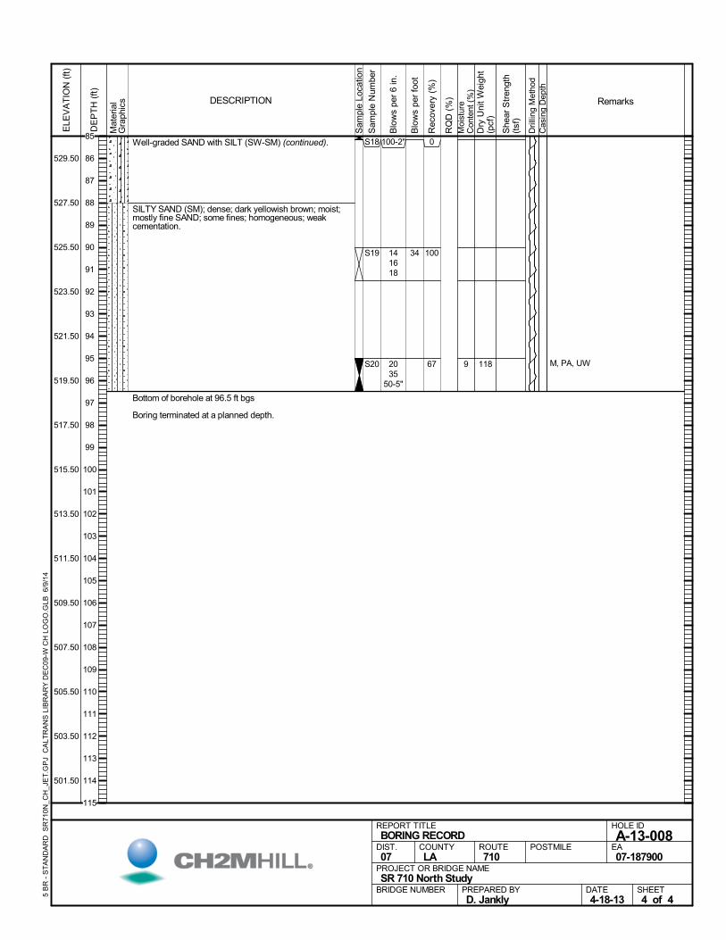
Well-graded SAND with SILT (SW-SM) (continued).
SILTY SAND (SM); dense; dark yellowish brown; moist;mostly fine SAND; some fines; homogeneous; weakcementation.
Bottom of borehole at 96.5 ft bgs
Boring terminated at a planned depth.
0
100
67
S18
S19
S20 9 M, PA, UW
100-2"
141618
2035
50-5"
118
Mat
eria
lG
raph
ics
Sam
ple
Loca
tion
COUNTYLA
DESCRIPTION
Rec
over
y (%
)
Dri
lling
Met
hod
Cas
ing
Dep
th
PREPARED BYD. Jankly
DATE4-18-13
PROJECT OR BRIDGE NAMESR 710 North Study
BRIDGE NUMBER
HOLE ID
A-13-008EA07-187900
REPORT TITLEBORING RECORD
DIST.07
ROUTE710
POSTMILE
SHEET4 of 4
RQ
D (
%)
Sam
ple
Num
ber
Moi
stur
eC
onte
nt (
%)
Remarks
Blo
ws
per
6 in
.
ELE
VA
TIO
N (
ft)
529.50
527.50
525.50
523.50
521.50
519.50
517.50
515.50
513.50
511.50
509.50
507.50
505.50
503.50
501.50
DE
PT
H (
ft)
Dry
Uni
t W
eigh
t(p
cf)
She
ar S
tren
gth
(tsf
)
Blo
ws
per
foot
5 B
R -
ST
AN
DA
RD
SR
710
N_C
H_J
ET
.GP
J C
ALT
RA
NS
LIB
RA
RY
DE
C09
-W C
H L
OG
O.G
LB 6
/9/1
4
34
85
86
87
88
89
90
91
92
93
94
95
96
97
98
99
100
101
102
103
104
105
106
107
108
109
110
111
112
113
114
115
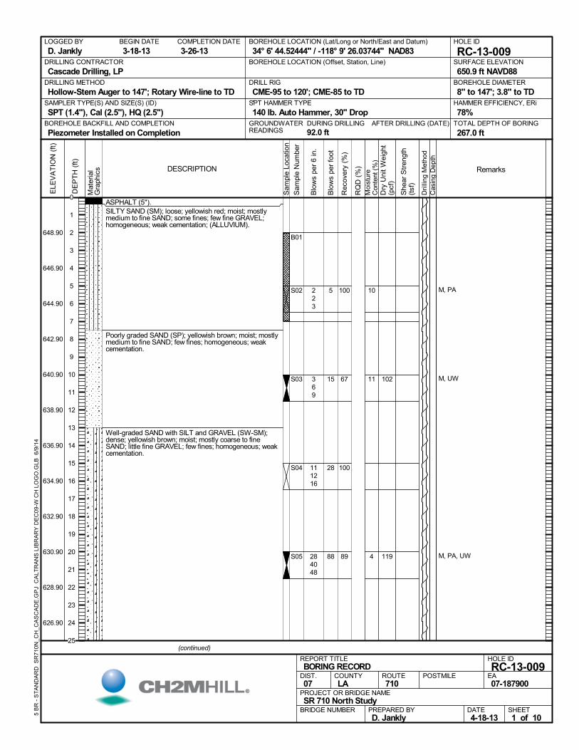
ASPHALT (5").SILTY SAND (SM); loose; yellowish red; moist; mostlymedium to fine SAND; some fines; few fine GRAVEL;homogeneous; weak cementation; (ALLUVIUM).
Poorly graded SAND (SP); yellowish brown; moist; mostlymedium to fine SAND; few fines; homogeneous; weakcementation.
Well-graded SAND with SILT and GRAVEL (SW-SM);dense; yellowish brown; moist; mostly coarse to fineSAND; little fine GRAVEL; few fines; homogeneous; weakcementation.
100
67
100
89
B01
S02
S03
S04
S05
10
11
4
M, PA
M, UW
M, PA, UW
223
369
111216
284048
102
119
AFTER DRILLING (DATE)DURING DRILLING
92.0 ft
SURFACE ELEVATION
650.9 ft NAVD88DRILLING METHOD
Hollow-Stem Auger to 147'; Rotary Wire-line to TDDRILL RIG
CME-95 to 120'; CME-85 to TDSPT HAMMER TYPE
140 lb. Auto Hammer, 30" DropBOREHOLE BACKFILL AND COMPLETION
Piezometer Installed on CompletionGROUNDWATERREADINGS
BEGIN DATE
3-18-13COMPLETION DATE
3-26-13LOGGED BY
D. JanklyBOREHOLE LOCATION (Lat/Long or North/East and Datum)
34° 6' 44.52444" / -118° 9' 26.03744" NAD83HOLE ID
RC-13-009DRILLING CONTRACTOR
Cascade Drilling, LP
HAMMER EFFICIENCY, ERi
78%SAMPLER TYPE(S) AND SIZE(S) (ID)
SPT (1.4"), Cal (2.5"), HQ (2.5")TOTAL DEPTH OF BORING
267.0 ft
BOREHOLE DIAMETER
8" to 147'; 3.8" to TD
BOREHOLE LOCATION (Offset, Station, Line)
.M
ater
ial
Gra
phic
s
Sam
ple
Loca
tion
COUNTYLA
DESCRIPTION
Rec
over
y (%
)
Dri
lling
Met
hod
Cas
ing
Dep
th
PREPARED BYD. Jankly
DATE4-18-13
PROJECT OR BRIDGE NAMESR 710 North Study
BRIDGE NUMBER
HOLE ID
RC-13-009EA07-187900
REPORT TITLEBORING RECORD
DIST.07
ROUTE710
POSTMILE
(continued)
SHEET1 of 10
RQ
D (
%)
Sam
ple
Num
ber
Moi
stur
eC
onte
nt (
%)
Remarks
Blo
ws
per
6 in
.
ELE
VA
TIO
N (
ft)
648.90
646.90
644.90
642.90
640.90
638.90
636.90
634.90
632.90
630.90
628.90
626.90
DE
PT
H (
ft)
Dry
Uni
t W
eigh
t(p
cf)
She
ar S
tren
gth
(tsf
)
Blo
ws
per
foot
5 B
R -
ST
AN
DA
RD
SR
710
N_C
H_C
AS
CA
DE
.GP
J C
ALT
RA
NS
LIB
RA
RY
DE
C09
-W C
H L
OG
O.G
LB 6
/9/1
4
5
15
28
88
0
1
2
3
4
5
6
7
8
9
10
11
12
13
14
15
16
17
18
19
20
21
22
23
24
25
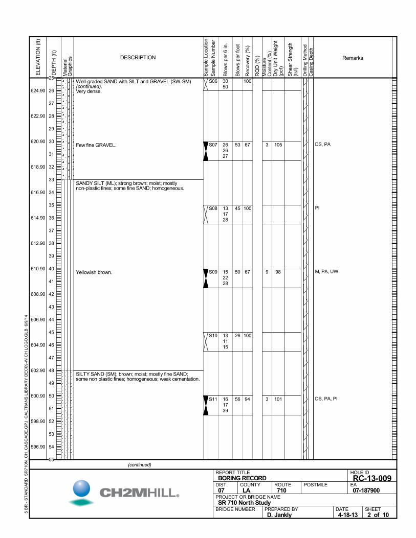
Well-graded SAND with SILT and GRAVEL (SW-SM)(continued).Very dense.
Few fine GRAVEL.
SANDY SILT (ML); strong brown; moist; mostlynon-plastic fines; some fine SAND; homogeneous.
Yellowish brown.
SILTY SAND (SM); brown; moist; mostly fine SAND;some non plastic fines; homogeneous; weak cementation.
100
67
100
67
100
94
S06
S07
S08
S09
S10
S11
3
9
3
DS, PA
PI
M, PA, UW
DS, PA, PI
3050
262627
131728
152228
131115
161739
105
98
101
Mat
eria
lG
raph
ics
Sam
ple
Loca
tion
COUNTYLA
DESCRIPTION
Rec
over
y (%
)
Dri
lling
Met
hod
Cas
ing
Dep
th
PREPARED BYD. Jankly
DATE4-18-13
PROJECT OR BRIDGE NAMESR 710 North Study
BRIDGE NUMBER
HOLE ID
RC-13-009EA07-187900
REPORT TITLEBORING RECORD
DIST.07
ROUTE710
POSTMILE
(continued)
SHEET2 of 10
RQ
D (
%)
Sam
ple
Num
ber
Moi
stur
eC
onte
nt (
%)
Remarks
Blo
ws
per
6 in
.
ELE
VA
TIO
N (
ft)
624.90
622.90
620.90
618.90
616.90
614.90
612.90
610.90
608.90
606.90
604.90
602.90
600.90
598.90
596.90
DE
PT
H (
ft)
Dry
Uni
t W
eigh
t(p
cf)
She
ar S
tren
gth
(tsf
)
Blo
ws
per
foot
5 B
R -
ST
AN
DA
RD
SR
710
N_C
H_C
AS
CA
DE
.GP
J C
ALT
RA
NS
LIB
RA
RY
DE
C09
-W C
H L
OG
O.G
LB 6
/9/1
4
53
45
50
26
56
25
26
27
28
29
30
31
32
33
34
35
36
37
38
39
40
41
42
43
44
45
46
47
48
49
50
51
52
53
54
55
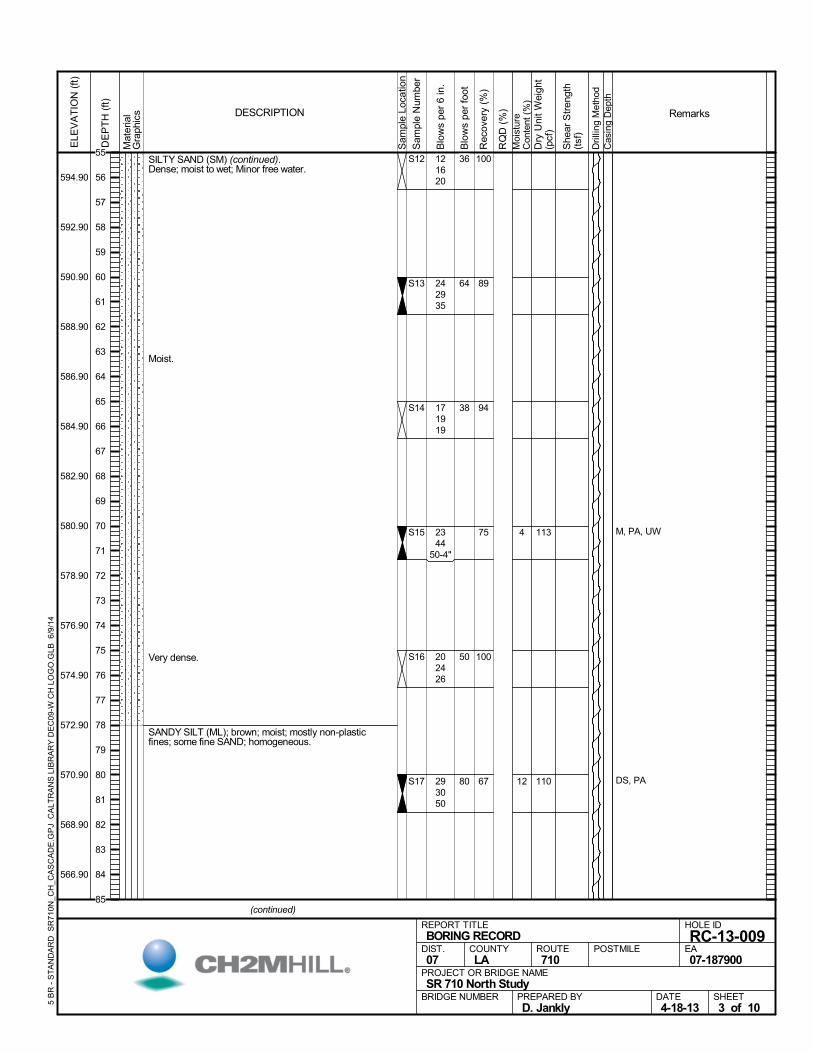
SILTY SAND (SM) (continued).Dense; moist to wet; Minor free water.
Moist.
Very dense.
SANDY SILT (ML); brown; moist; mostly non-plasticfines; some fine SAND; homogeneous.
100
89
94
75
100
67
S12
S13
S14
S15
S16
S17
4
12
M, PA, UW
DS, PA
121620
242935
171919
2344
50-4"
202426
293050
113
110
Mat
eria
lG
raph
ics
Sam
ple
Loca
tion
COUNTYLA
DESCRIPTION
Rec
over
y (%
)
Dri
lling
Met
hod
Cas
ing
Dep
th
PREPARED BYD. Jankly
DATE4-18-13
PROJECT OR BRIDGE NAMESR 710 North Study
BRIDGE NUMBER
HOLE ID
RC-13-009EA07-187900
REPORT TITLEBORING RECORD
DIST.07
ROUTE710
POSTMILE
(continued)
SHEET3 of 10
RQ
D (
%)
Sam
ple
Num
ber
Moi
stur
eC
onte
nt (
%)
Remarks
Blo
ws
per
6 in
.
ELE
VA
TIO
N (
ft)
594.90
592.90
590.90
588.90
586.90
584.90
582.90
580.90
578.90
576.90
574.90
572.90
570.90
568.90
566.90
DE
PT
H (
ft)
Dry
Uni
t W
eigh
t(p
cf)
She
ar S
tren
gth
(tsf
)
Blo
ws
per
foot
5 B
R -
ST
AN
DA
RD
SR
710
N_C
H_C
AS
CA
DE
.GP
J C
ALT
RA
NS
LIB
RA
RY
DE
C09
-W C
H L
OG
O.G
LB 6
/9/1
4
36
64
38
50
80
55
56
57
58
59
60
61
62
63
64
65
66
67
68
69
70
71
72
73
74
75
76
77
78
79
80
81
82
83
84
85
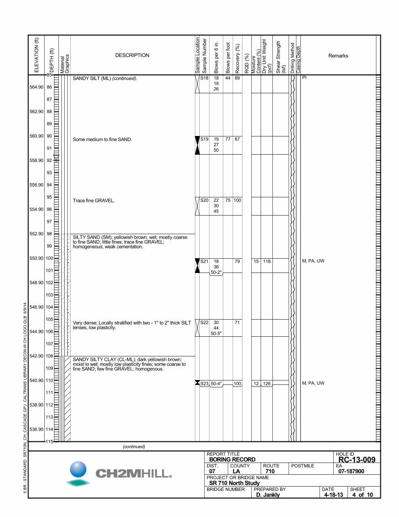
SANDY SILT (ML) (continued).
Some medium to fine SAND.
Trace fine GRAVEL.
SILTY SAND (SM); yellowish brown; wet; mostly coarseto fine SAND; little fines; trace fine GRAVEL;homogeneous; weak cementation.
Very dense; Locally stratified with two - 1" to 2" thick SILTlenses, low plasticity.
SANDY SILTY CLAY (CL-ML); dark yellowish brown;moist to wet; mostly low plasticity fines; some coarse tofine SAND; few fine GRAVEL; homogenous.
89
67
100
79
71
100
S18
S19
S20
S21
S22
S23
15
12
PI
M, PA, UW
M, PA, UW
181826
192750
223045
1836
50-2"
3044
50-5"
50-4"
118
126
Mat
eria
lG
raph
ics
Sam
ple
Loca
tion
COUNTYLA
DESCRIPTION
Rec
over
y (%
)
Dri
lling
Met
hod
Cas
ing
Dep
th
PREPARED BYD. Jankly
DATE4-18-13
PROJECT OR BRIDGE NAMESR 710 North Study
BRIDGE NUMBER
HOLE ID
RC-13-009EA07-187900
REPORT TITLEBORING RECORD
DIST.07
ROUTE710
POSTMILE
(continued)
SHEET4 of 10
RQ
D (
%)
Sam
ple
Num
ber
Moi
stur
eC
onte
nt (
%)
Remarks
Blo
ws
per
6 in
.
ELE
VA
TIO
N (
ft)
564.90
562.90
560.90
558.90
556.90
554.90
552.90
550.90
548.90
546.90
544.90
542.90
540.90
538.90
536.90
DE
PT
H (
ft)
Dry
Uni
t W
eigh
t(p
cf)
She
ar S
tren
gth
(tsf
)
Blo
ws
per
foot
5 B
R -
ST
AN
DA
RD
SR
710
N_C
H_C
AS
CA
DE
.GP
J C
ALT
RA
NS
LIB
RA
RY
DE
C09
-W C
H L
OG
O.G
LB 6
/9/1
4
44
77
75
85
86
87
88
89
90
91
92
93
94
95
96
97
98
99
100
101
102
103
104
105
106
107
108
109
110
111
112
113
114
115
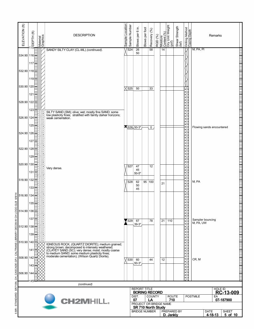
SANDY SILTY CLAY (CL-ML) (continued).
SILTY SAND (SM); olive; wet; mostly fine SAND; somelow plasticity fines; stratified with faintly darker horizons;weak cementation.
Very dense.
IGNEOUS ROCK, (QUARTZ DIORITE); medium grained;strong brown; decomposed to intensely weathered;(CLAYEY SAND (SC); very dense; moist; mostly coarseto medium SAND; some medium plasticity fines;moderate cementation); (Wilson Quartz Diorite).
58
33
0
12
100
78
44
S24
S25
S26
S27
S28
S29
S30
14
21
21
12
M, PA, PI
Flowing sands encountered
M, PA
Sampler bouncingM, PA, UW
CR, M
2650
50
50-3"
4745
50-5"
625045
6739-3"
6050-3"
110
Mat
eria
lG
raph
ics
Sam
ple
Loca
tion
COUNTYLA
DESCRIPTION
Rec
over
y (%
)
Dri
lling
Met
hod
Cas
ing
Dep
th
PREPARED BYD. Jankly
DATE4-18-13
PROJECT OR BRIDGE NAMESR 710 North Study
BRIDGE NUMBER
HOLE ID
RC-13-009EA07-187900
REPORT TITLEBORING RECORD
DIST.07
ROUTE710
POSTMILE
(continued)
SHEET5 of 10
RQ
D (
%)
Sam
ple
Num
ber
Moi
stur
eC
onte
nt (
%)
Remarks
Blo
ws
per
6 in
.
ELE
VA
TIO
N (
ft)
534.90
532.90
530.90
528.90
526.90
524.90
522.90
520.90
518.90
516.90
514.90
512.90
510.90
508.90
506.90
DE
PT
H (
ft)
Dry
Uni
t W
eigh
t(p
cf)
She
ar S
tren
gth
(tsf
)
Blo
ws
per
foot
5 B
R -
ST
AN
DA
RD
SR
710
N_C
H_C
AS
CA
DE
.GP
J C
ALT
RA
NS
LIB
RA
RY
DE
C09
-W C
H L
OG
O.G
LB 6
/9/1
4
95
115
116
117
118
119
120
121
122
123
124
125
126
127
128
129
130
131
132
133
134
135
136
137
138
139
140
141
142
143
144
145
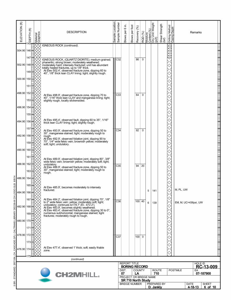
IGNEOUS ROCK (continued).
IGNEOUS ROCK, (QUARTZ DIORITE); medium grained;phaneritic; strong brown; moderately weathered;moderately hard; intensely fractured; unit has abundanttotally healed fractures, up to 1/8" thick. At Elev 502.4', observed fracture zone, dipping 60 to40°, 1/8" thick lean CLAY lining; tight; slightly rough.
At Elev 498.9', observed fracture zone, dipping 70 to40°, 1/16" thick lean CLAY and manganese lining; tight;slightly rough, locally slickensided.
At Elev 495.4', observed fault, dipping 60 to 35°, 1/16"thick lean CLAY lining; tight; slightly rough.
At Elev 493.9', observed fracture zone, dipping 50 to30°, manganese stained; tight; moderately rough torough.
At Elev 492.9', observed foliation joint, dipping 90 to70°, 1/4" wide felsic vein; brownish yellow; moderatelysoft; tight; undulatory.
At Elev 489.9', observed foliation joint, dipping 80°, 3/8"wide felsic vein; brownish yellow; moderately soft; tight;undulatory.
At Elev 488.9', observed fracture zone, dipping 50 to30°, manganese stained; tight; moderately rough torough.
At Elev 485.9', becomes moderately to intenselyfractured.
At Elev 484.2', observed foliation joint, dipping 70°, 1/8"to 2" wide felsic vein; yellow; moderately soft; tight;undulatory; continues to178.7' (El.: 472.2').
At Elev 483.9', becomes slightly weathered. At Elev 483.4', observed fracture zone, dipping 30 to 0°,numerous subhorizontal; manganese stained; tightfractures; moderately rough to rough.
At Elev 477.4', observed 1' thick; soft; easily friablezone.
86
64
92
94
100
100
C32
C33
C34
C35
C36
C37
0
0
0
20
40
0
5
6
M, PL, UW
EM, M, UC=436psi, UW
141
139
Mat
eria
lG
raph
ics
Sam
ple
Loca
tion
COUNTYLA
DESCRIPTION
Rec
over
y (%
)
Dri
lling
Met
hod
Cas
ing
Dep
th
PREPARED BYD. Jankly
DATE4-18-13
PROJECT OR BRIDGE NAMESR 710 North Study
BRIDGE NUMBER
HOLE ID
RC-13-009EA07-187900
REPORT TITLEBORING RECORD
DIST.07
ROUTE710
POSTMILE
(continued)
SHEET6 of 10
RQ
D (
%)
Sam
ple
Num
ber
Moi
stur
eC
onte
nt (
%)
Remarks
Blo
ws
per
6 in
.
ELE
VA
TIO
N (
ft)
504.90
502.90
500.90
498.90
496.90
494.90
492.90
490.90
488.90
486.90
484.90
482.90
480.90
478.90
476.90
DE
PT
H (
ft)
Dry
Uni
t W
eigh
t(p
cf)
She
ar S
tren
gth
(tsf
)
Blo
ws
per
foot
5 B
R -
ST
AN
DA
RD
SR
710
N_C
H_C
AS
CA
DE
.GP
J C
ALT
RA
NS
LIB
RA
RY
DE
C09
-W C
H L
OG
O.G
LB 6
/9/1
4
145
146
147
148
149
150
151
152
153
154
155
156
157
158
159
160
161
162
163
164
165
166
167
168
169
170
171
172
173
174
175
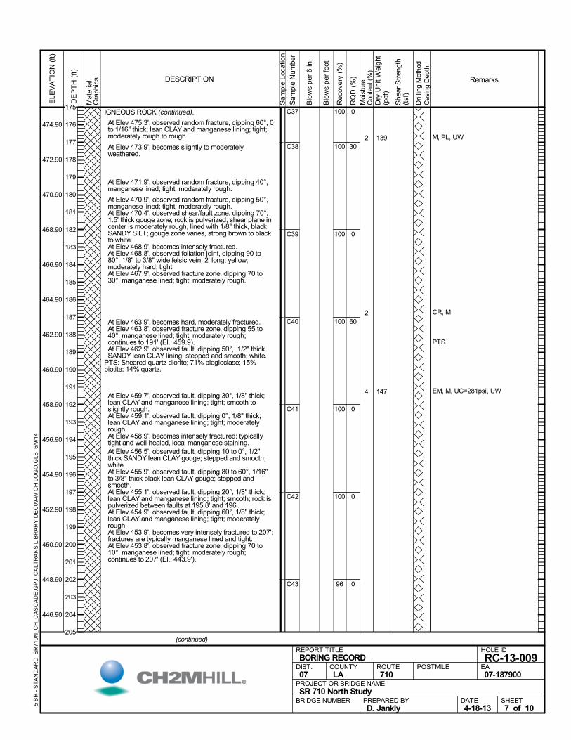
IGNEOUS ROCK (continued).
At Elev 475.3', observed random fracture, dipping 60°, 0to 1/16" thick; lean CLAY and manganese lining; tight;moderately rough to rough.
At Elev 473.9', becomes slightly to moderatelyweathered.
At Elev 471.9', observed random fracture, dipping 40°,manganese lined; tight; moderately rough.
At Elev 470.9', observed random fracture, dipping 50°,manganese lined; tight; moderately rough.
At Elev 470.4', observed shear/fault zone, dipping 70°,1.5' thick gouge zone; rock is pulverized; shear plane incenter is moderately rough, lined with 1/8" thick, blackSANDY SILT; gouge zone varies, strong brown to blackto white.
At Elev 468.9', becomes intensely fractured. At Elev 468.8', observed foliation joint, dipping 90 to80°, 1/8" to 3/8" wide felsic vein; 2' long; yellow;moderately hard; tight.
At Elev 467.9', observed fracture zone, dipping 70 to30°, manganese lined; tight; moderately rough.
At Elev 463.9', becomes hard, moderately fractured. At Elev 463.8', observed fracture zone, dipping 55 to40°, manganese lined; tight; moderately rough;continues to 191' (El.: 459.9).
At Elev 462.9', observed fault, dipping 50°, 1/2" thickSANDY lean CLAY lining; stepped and smooth; white.
PTS: Sheared quartz diorite; 71% plagioclase; 15%biotite; 14% quartz.
At Elev 459.7', observed fault, dipping 30°, 1/8" thick;lean CLAY and manganese lining; tight; smooth toslightly rough.
At Elev 459.1', observed fault, dipping 0°, 1/8" thick;lean CLAY and manganese lining; tight; moderatelyrough.
At Elev 458.9', becomes intensely fractured; typicallytight and well healed, local manganese staining.
At Elev 456.5', observed fault, dipping 10 to 0°, 1/2"thick SANDY lean CLAY gouge; stepped and smooth;white.
At Elev 455.9', observed fault, dipping 80 to 60°, 1/16"to 3/8" thick black lean CLAY gouge; stepped andsmooth.
At Elev 455.1', observed fault, dipping 20°, 1/8" thick;lean CLAY and manganese lining; tight; smooth; rock ispulverized between faults at 195.8' and 196'.
At Elev 454.9', observed fault, dipping 60°, 1/8" thick;lean CLAY and manganese lining; tight; moderatelyrough.
At Elev 453.9', becomes very intensely fractured to 207';fractures are typically manganese lined and tight.
At Elev 453.8', observed fracture zone, dipping 70 to10°, manganese lined; tight; moderately rough;continues to 207' (El.: 443.9').
100
100
100
100
100
100
96
C37
C38
C39
C40
C41
C42
C43
0
30
0
60
0
0
0
2
2
4
M, PL, UW
CR, M
PTS
EM, M, UC=281psi, UW
139
147
Mat
eria
lG
raph
ics
Sam
ple
Loca
tion
COUNTYLA
DESCRIPTION
Rec
over
y (%
)
Dri
lling
Met
hod
Cas
ing
Dep
th
PREPARED BYD. Jankly
DATE4-18-13
PROJECT OR BRIDGE NAMESR 710 North Study
BRIDGE NUMBER
HOLE ID
RC-13-009EA07-187900
REPORT TITLEBORING RECORD
DIST.07
ROUTE710
POSTMILE
(continued)
SHEET7 of 10
RQ
D (
%)
Sam
ple
Num
ber
Moi
stur
eC
onte
nt (
%)
Remarks
Blo
ws
per
6 in
.
ELE
VA
TIO
N (
ft)
474.90
472.90
470.90
468.90
466.90
464.90
462.90
460.90
458.90
456.90
454.90
452.90
450.90
448.90
446.90
DE
PT
H (
ft)
Dry
Uni
t W
eigh
t(p
cf)
She
ar S
tren
gth
(tsf
)
Blo
ws
per
foot
5 B
R -
ST
AN
DA
RD
SR
710
N_C
H_C
AS
CA
DE
.GP
J C
ALT
RA
NS
LIB
RA
RY
DE
C09
-W C
H L
OG
O.G
LB 6
/9/1
4
175
176
177
178
179
180
181
182
183
184
185
186
187
188
189
190
191
192
193
194
195
196
197
198
199
200
201
202
203
204
205
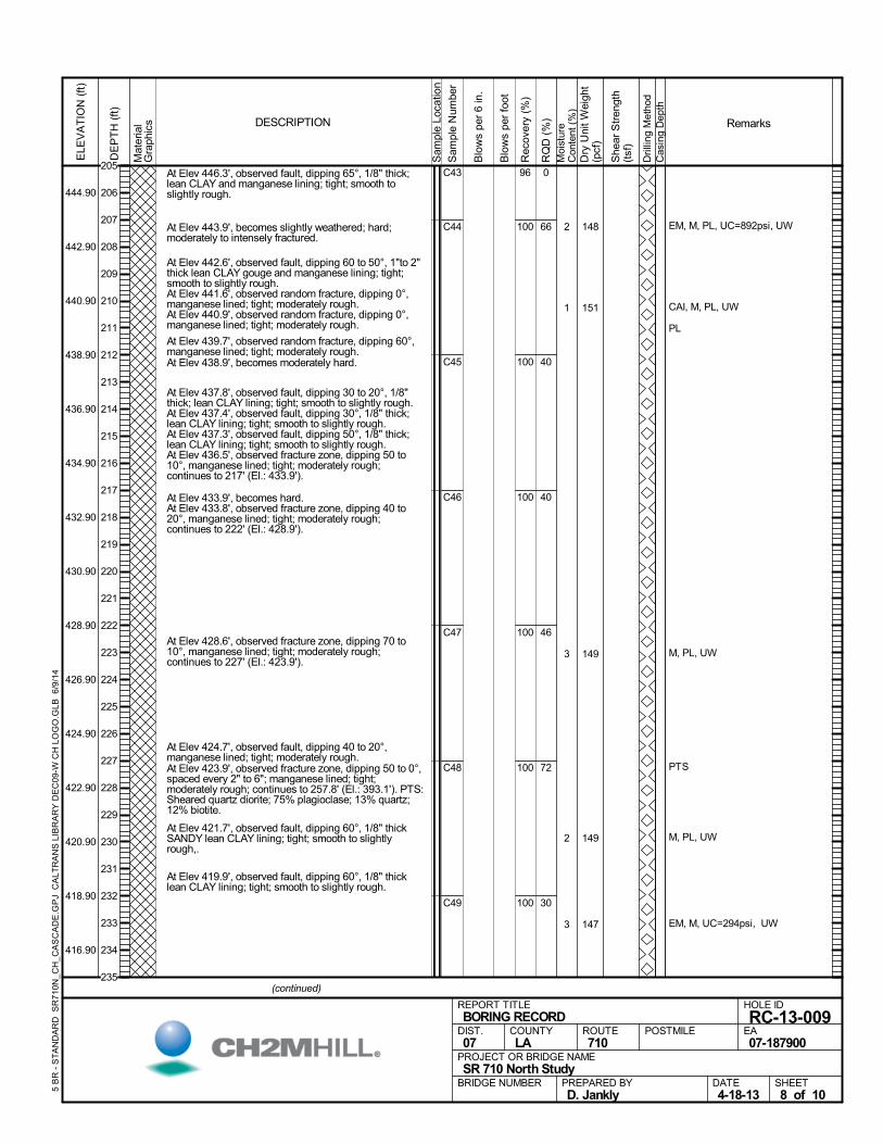
At Elev 446.3', observed fault, dipping 65°, 1/8" thick;lean CLAY and manganese lining; tight; smooth toslightly rough.
At Elev 443.9', becomes slightly weathered; hard;moderately to intensely fractured.
At Elev 442.6', observed fault, dipping 60 to 50°, 1"to 2"thick lean CLAY gouge and manganese lining; tight;smooth to slightly rough.
At Elev 441.6', observed random fracture, dipping 0°,manganese lined; tight; moderately rough.
At Elev 440.9', observed random fracture, dipping 0°,manganese lined; tight; moderately rough.
At Elev 439.7', observed random fracture, dipping 60°,manganese lined; tight; moderately rough.
At Elev 438.9', becomes moderately hard.
At Elev 437.8', observed fault, dipping 30 to 20°, 1/8"thick; lean CLAY lining; tight; smooth to slightly rough.
At Elev 437.4', observed fault, dipping 30°, 1/8" thick;lean CLAY lining; tight; smooth to slightly rough.
At Elev 437.3', observed fault, dipping 50°, 1/8" thick;lean CLAY lining; tight; smooth to slightly rough.
At Elev 436.5', observed fracture zone, dipping 50 to10°, manganese lined; tight; moderately rough;continues to 217' (El.: 433.9').
At Elev 433.9', becomes hard. At Elev 433.8', observed fracture zone, dipping 40 to20°, manganese lined; tight; moderately rough;continues to 222' (El.: 428.9').
At Elev 428.6', observed fracture zone, dipping 70 to10°, manganese lined; tight; moderately rough;continues to 227' (El.: 423.9').
At Elev 424.7', observed fault, dipping 40 to 20°,manganese lined; tight; moderately rough.
At Elev 423.9', observed fracture zone, dipping 50 to 0°,spaced every 2" to 6"; manganese lined; tight;moderately rough; continues to 257.8' (El.: 393.1'). PTS:Sheared quartz diorite; 75% plagioclase; 13% quartz;12% biotite.
At Elev 421.7', observed fault, dipping 60°, 1/8" thickSANDY lean CLAY lining; tight; smooth to slightlyrough,.
At Elev 419.9', observed fault, dipping 60°, 1/8" thicklean CLAY lining; tight; smooth to slightly rough.
96
100
100
100
100
100
100
C43
C44
C45
C46
C47
C48
C49
0
66
40
40
46
72
30
2
1
3
2
3
EM, M, PL, UC=892psi, UW
CAI, M, PL, UW
PL
M, PL, UW
PTS
M, PL, UW
EM, M, UC=294psi, UW
148
151
149
149
147
Mat
eria
lG
raph
ics
Sam
ple
Loca
tion
COUNTYLA
DESCRIPTION
Rec
over
y (%
)
Dri
lling
Met
hod
Cas
ing
Dep
th
PREPARED BYD. Jankly
DATE4-18-13
PROJECT OR BRIDGE NAMESR 710 North Study
BRIDGE NUMBER
HOLE ID
RC-13-009EA07-187900
REPORT TITLEBORING RECORD
DIST.07
ROUTE710
POSTMILE
(continued)
SHEET8 of 10
RQ
D (
%)
Sam
ple
Num
ber
Moi
stur
eC
onte
nt (
%)
Remarks
Blo
ws
per
6 in
.
ELE
VA
TIO
N (
ft)
444.90
442.90
440.90
438.90
436.90
434.90
432.90
430.90
428.90
426.90
424.90
422.90
420.90
418.90
416.90
DE
PT
H (
ft)
Dry
Uni
t W
eigh
t(p
cf)
She
ar S
tren
gth
(tsf
)
Blo
ws
per
foot
5 B
R -
ST
AN
DA
RD
SR
710
N_C
H_C
AS
CA
DE
.GP
J C
ALT
RA
NS
LIB
RA
RY
DE
C09
-W C
H L
OG
O.G
LB 6
/9/1
4
205
206
207
208
209
210
211
212
213
214
215
216
217
218
219
220
221
222
223
224
225
226
227
228
229
230
231
232
233
234
235
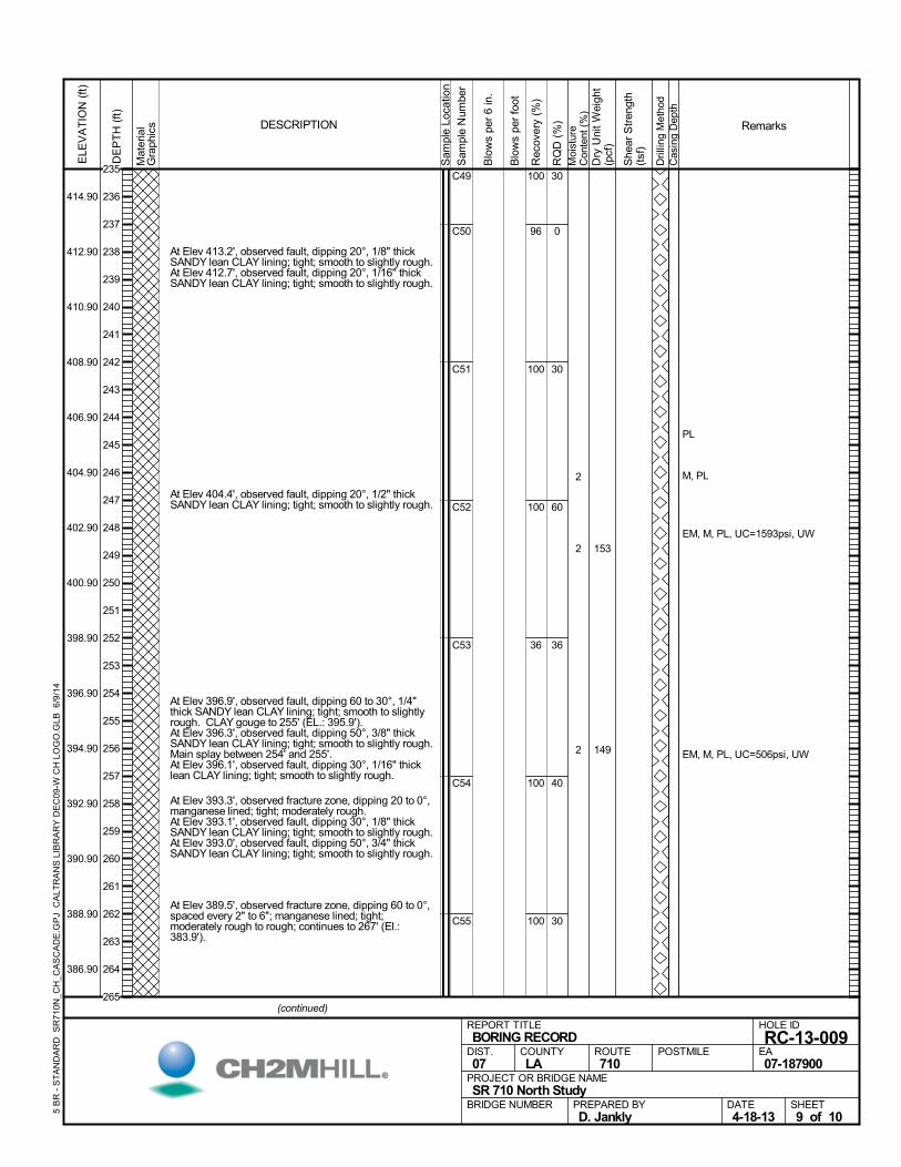
At Elev 413.2', observed fault, dipping 20°, 1/8" thickSANDY lean CLAY lining; tight; smooth to slightly rough.
At Elev 412.7', observed fault, dipping 20°, 1/16" thickSANDY lean CLAY lining; tight; smooth to slightly rough.
At Elev 404.4', observed fault, dipping 20°, 1/2" thickSANDY lean CLAY lining; tight; smooth to slightly rough.
At Elev 396.9', observed fault, dipping 60 to 30°, 1/4"thick SANDY lean CLAY lining; tight; smooth to slightlyrough. CLAY gouge to 255' (EL.: 395.9').
At Elev 396.3', observed fault, dipping 50°, 3/8" thickSANDY lean CLAY lining; tight; smooth to slightly rough.Main splay between 254' and 255'.
At Elev 396.1', observed fault, dipping 30°, 1/16" thicklean CLAY lining; tight; smooth to slightly rough.
At Elev 393.3', observed fracture zone, dipping 20 to 0°,manganese lined; tight; moderately rough.
At Elev 393.1', observed fault, dipping 30°, 1/8" thickSANDY lean CLAY lining; tight; smooth to slightly rough.
At Elev 393.0', observed fault, dipping 50°, 3/4" thickSANDY lean CLAY lining; tight; smooth to slightly rough.
At Elev 389.5', observed fracture zone, dipping 60 to 0°,spaced every 2" to 6"; manganese lined; tight;moderately rough to rough; continues to 267' (El.:383.9').
100
96
100
100
36
100
100
C49
C50
C51
C52
C53
C54
C55
30
0
30
60
36
40
30
2
2
2
PL
M, PL
EM, M, PL, UC=1593psi, UW
EM, M, PL, UC=506psi, UW
153
149
Mat
eria
lG
raph
ics
Sam
ple
Loca
tion
COUNTYLA
DESCRIPTION
Rec
over
y (%
)
Dri
lling
Met
hod
Cas
ing
Dep
th
PREPARED BYD. Jankly
DATE4-18-13
PROJECT OR BRIDGE NAMESR 710 North Study
BRIDGE NUMBER
HOLE ID
RC-13-009EA07-187900
REPORT TITLEBORING RECORD
DIST.07
ROUTE710
POSTMILE
(continued)
SHEET9 of 10
RQ
D (
%)
Sam
ple
Num
ber
Moi
stur
eC
onte
nt (
%)
Remarks
Blo
ws
per
6 in
.
ELE
VA
TIO
N (
ft)
414.90
412.90
410.90
408.90
406.90
404.90
402.90
400.90
398.90
396.90
394.90
392.90
390.90
388.90
386.90
DE
PT
H (
ft)
Dry
Uni
t W
eigh
t(p
cf)
She
ar S
tren
gth
(tsf
)
Blo
ws
per
foot
5 B
R -
ST
AN
DA
RD
SR
710
N_C
H_C
AS
CA
DE
.GP
J C
ALT
RA
NS
LIB
RA
RY
DE
C09
-W C
H L
OG
O.G
LB 6
/9/1
4
235
236
237
238
239
240
241
242
243
244
245
246
247
248
249
250
251
252
253
254
255
256
257
258
259
260
261
262
263
264
265
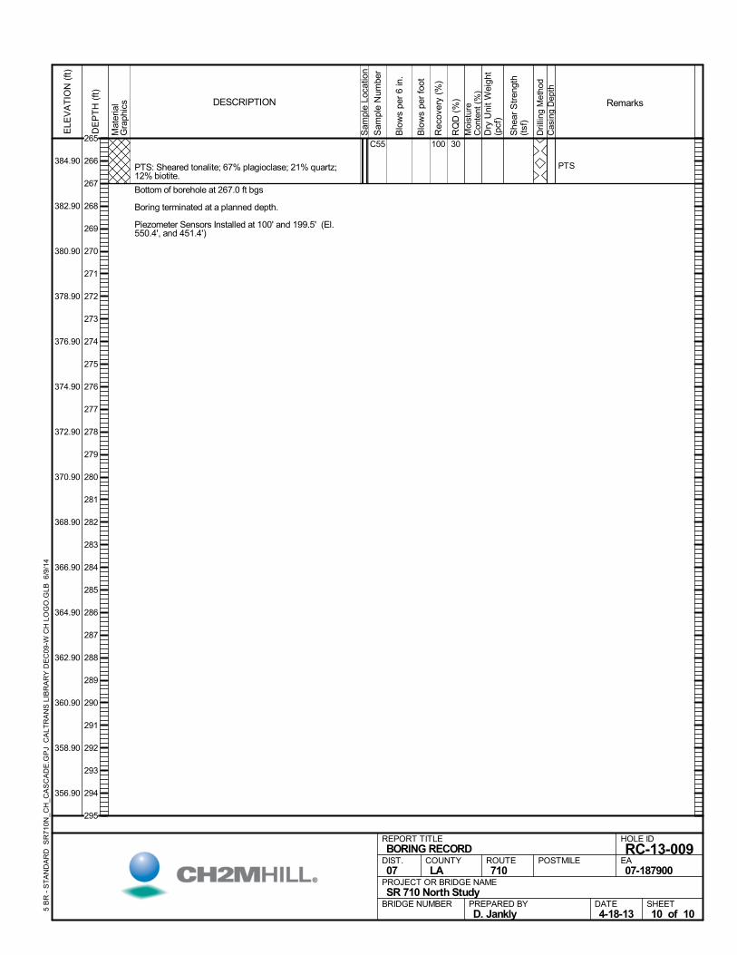
PTS: Sheared tonalite; 67% plagioclase; 21% quartz;12% biotite.
Bottom of borehole at 267.0 ft bgs
Boring terminated at a planned depth.
Piezometer Sensors Installed at 100' and 199.5' (El.550.4', and 451.4')
100C55 30
PTS
Mat
eria
lG
raph
ics
Sam
ple
Loca
tion
COUNTYLA
DESCRIPTION
Rec
over
y (%
)
Dri
lling
Met
hod
Cas
ing
Dep
th
PREPARED BYD. Jankly
DATE4-18-13
PROJECT OR BRIDGE NAMESR 710 North Study
BRIDGE NUMBER
HOLE ID
RC-13-009EA07-187900
REPORT TITLEBORING RECORD
DIST.07
ROUTE710
POSTMILE
SHEET10 of 10
RQ
D (
%)
Sam
ple
Num
ber
Moi
stur
eC
onte
nt (
%)
Remarks
Blo
ws
per
6 in
.
ELE
VA
TIO
N (
ft)
384.90
382.90
380.90
378.90
376.90
374.90
372.90
370.90
368.90
366.90
364.90
362.90
360.90
358.90
356.90
DE
PT
H (
ft)
Dry
Uni
t W
eigh
t(p
cf)
She
ar S
tren
gth
(tsf
)
Blo
ws
per
foot
5 B
R -
ST
AN
DA
RD
SR
710
N_C
H_C
AS
CA
DE
.GP
J C
ALT
RA
NS
LIB
RA
RY
DE
C09
-W C
H L
OG
O.G
LB 6
/9/1
4
265
266
267
268
269
270
271
272
273
274
275
276
277
278
279
280
281
282
283
284
285
286
287
288
289
290
291
292
293
294
295
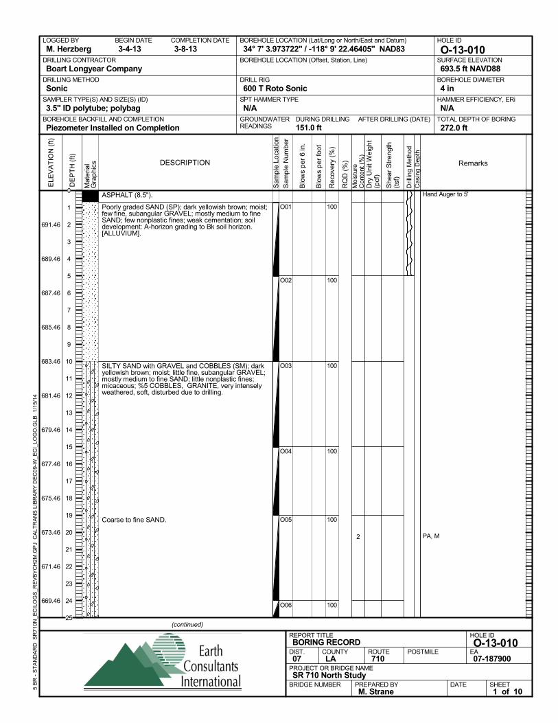
ASPHALT (8.5").
Poorly graded SAND (SP); dark yellowish brown; moist;few fine, subangular GRAVEL; mostly medium to fineSAND; few nonplastic fines; weak cementation; soildevelopment: A-horizon grading to Bk soil horizon.[ALLUVIUM].
SILTY SAND with GRAVEL and COBBLES (SM); darkyellowish brown; moist; little fine, subangular GRAVEL;mostly medium to fine SAND; little nonplastic fines;micaceous; %5 COBBLES, GRANITE, very intenselyweathered, soft, disturbed due to drilling.
Coarse to fine SAND.
100
100
100
100
100
100
O01
O02
O03
O04
O05
O06
2
Hand Auger to 5'
PA, M
AFTER DRILLING (DATE)DURING DRILLING151.0 ft
SURFACE ELEVATION
693.5 ft NAVD88DRILLING METHOD
SonicDRILL RIG
600 T Roto SonicSPT HAMMER TYPE
N/ABOREHOLE BACKFILL AND COMPLETION
Piezometer Installed on CompletionGROUNDWATERREADINGS
BEGIN DATE
3-4-13COMPLETION DATE
3-8-13LOGGED BY
M. HerzbergBOREHOLE LOCATION (Lat/Long or North/East and Datum)
34° 7' 3.973722" / -118° 9' 22.46405" NAD83HOLE ID
O-13-010DRILLING CONTRACTOR
Boart Longyear Company
HAMMER EFFICIENCY, ERi
N/ASAMPLER TYPE(S) AND SIZE(S) (ID)
3.5" ID polytube; polybagTOTAL DEPTH OF BORING
272.0 ft
BOREHOLE DIAMETER
4 in
BOREHOLE LOCATION (Offset, Station, Line)
.
Sam
ple
Loca
tion
COUNTYLA
DESCRIPTION
Rec
over
y (%
)
Dril
ling
Met
hod
Cas
ing
Dep
th
PREPARED BYM. Strane
DATE
PROJECT OR BRIDGE NAMESR 710 North Study
BRIDGE NUMBER
HOLE ID
O-13-010EA07-187900
REPORT TITLEBORING RECORD
DIST.07
ROUTE710
POSTMILE
(continued)
SHEET1 of 10
RQ
D (
%)
Sam
ple
Num
ber
Moi
stur
eC
onte
nt (
%)
Remarks
Blo
ws
per
6 in
.
ELE
VA
TIO
N (
ft)
691.46
689.46
687.46
685.46
683.46
681.46
679.46
677.46
675.46
673.46
671.46
669.46
DE
PT
H (
ft)
Dry
Uni
t Wei
ght
(pcf
)
She
ar S
tren
gth
(tsf
)
Blo
ws
per
foot
Mat
eria
lG
rap
hics
5 B
R -
ST
AN
DA
RD
SR
710N
_EC
ILO
GS
_RE
VB
YC
H2M
.GP
J C
ALT
RA
NS
LIB
RA
RY
DE
C09
-W_E
CI_
LOG
O.G
LB
1/1
5/14
0
1
2
3
4
5
6
7
8
9
10
11
12
13
14
15
16
17
18
19
20
21
22
23
24
25
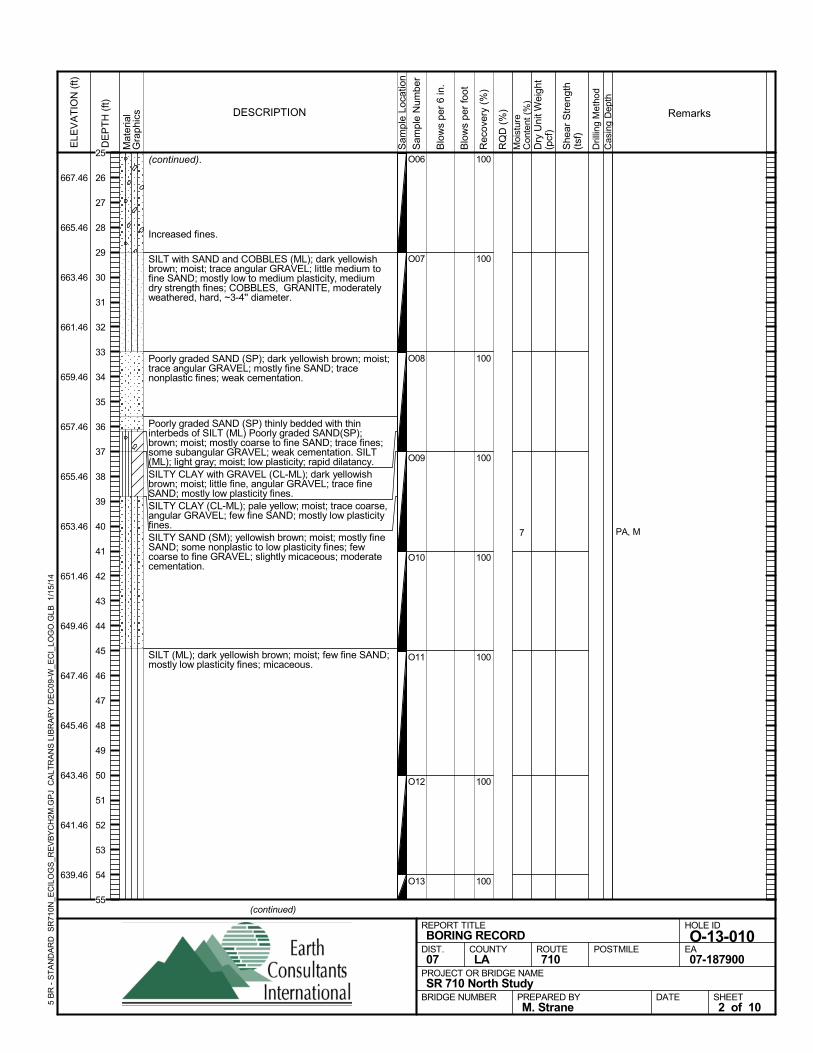
(continued).
Increased fines.
SILT with SAND and COBBLES (ML); dark yellowishbrown; moist; trace angular GRAVEL; little medium tofine SAND; mostly low to medium plasticity, mediumdry strength fines; COBBLES, GRANITE, moderatelyweathered, hard, ~3-4'' diameter.
Poorly graded SAND (SP); dark yellowish brown; moist;trace angular GRAVEL; mostly fine SAND; tracenonplastic fines; weak cementation.
Poorly graded SAND (SP) thinly bedded with thininterbeds of SILT (ML) Poorly graded SAND(SP);brown; moist; mostly coarse to fine SAND; trace fines;some subangular GRAVEL; weak cementation. SILT(ML); light gray; moist; low plasticity; rapid dilatancy.SILTY CLAY with GRAVEL (CL-ML); dark yellowishbrown; moist; little fine, angular GRAVEL; trace fineSAND; mostly low plasticity fines.SILTY CLAY (CL-ML); pale yellow; moist; trace coarse,angular GRAVEL; few fine SAND; mostly low plasticityfines.SILTY SAND (SM); yellowish brown; moist; mostly fineSAND; some nonplastic to low plasticity fines; fewcoarse to fine GRAVEL; slightly micaceous; moderatecementation.
SILT (ML); dark yellowish brown; moist; few fine SAND;mostly low plasticity fines; micaceous.
100
100
100
100
100
100
100
100
O06
O07
O08
O09
O10
O11
O12
O13
7 PA, M
Sam
ple
Loca
tion
COUNTYLA
DESCRIPTION
Rec
over
y (%
)
Dril
ling
Met
hod
Cas
ing
Dep
th
PREPARED BYM. Strane
DATE
PROJECT OR BRIDGE NAMESR 710 North Study
BRIDGE NUMBER
HOLE ID
O-13-010EA07-187900
REPORT TITLEBORING RECORD
DIST.07
ROUTE710
POSTMILE
(continued)
SHEET2 of 10
RQ
D (
%)
Sam
ple
Num
ber
Moi
stur
eC
onte
nt (
%)
Remarks
Blo
ws
per
6 in
.
ELE
VA
TIO
N (
ft)
667.46
665.46
663.46
661.46
659.46
657.46
655.46
653.46
651.46
649.46
647.46
645.46
643.46
641.46
639.46
DE
PT
H (
ft)
Dry
Uni
t Wei
ght
(pcf
)
She
ar S
tren
gth
(tsf
)
Blo
ws
per
foot
Mat
eria
lG
rap
hics
5 B
R -
ST
AN
DA
RD
SR
710N
_EC
ILO
GS
_RE
VB
YC
H2M
.GP
J C
ALT
RA
NS
LIB
RA
RY
DE
C09
-W_E
CI_
LOG
O.G
LB
1/1
5/14
25
26
27
28
29
30
31
32
33
34
35
36
37
38
39
40
41
42
43
44
45
46
47
48
49
50
51
52
53
54
55
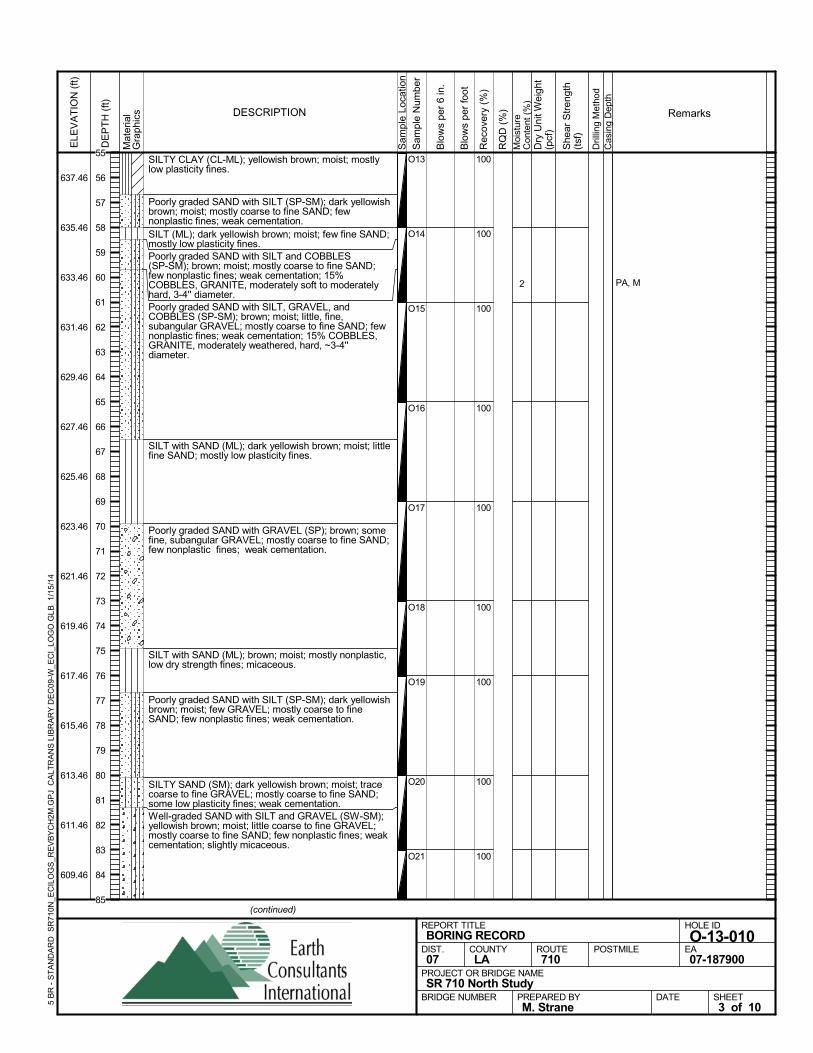
SILTY CLAY (CL-ML); yellowish brown; moist; mostlylow plasticity fines.
Poorly graded SAND with SILT (SP-SM); dark yellowishbrown; moist; mostly coarse to fine SAND; fewnonplastic fines; weak cementation.SILT (ML); dark yellowish brown; moist; few fine SAND;mostly low plasticity fines.Poorly graded SAND with SILT and COBBLES(SP-SM); brown; moist; mostly coarse to fine SAND;few nonplastic fines; weak cementation; 15%COBBLES, GRANITE, moderately soft to moderatelyhard, 3-4'' diameter.Poorly graded SAND with SILT, GRAVEL, andCOBBLES (SP-SM); brown; moist; little, fine,subangular GRAVEL; mostly coarse to fine SAND; fewnonplastic fines; weak cementation; 15% COBBLES,GRANITE, moderately weathered, hard, ~3-4''diameter.
SILT with SAND (ML); dark yellowish brown; moist; littlefine SAND; mostly low plasticity fines.
Poorly graded SAND with GRAVEL (SP); brown; somefine, subangular GRAVEL; mostly coarse to fine SAND;few nonplastic fines; weak cementation.
SILT with SAND (ML); brown; moist; mostly nonplastic,low dry strength fines; micaceous.
Poorly graded SAND with SILT (SP-SM); dark yellowishbrown; moist; few GRAVEL; mostly coarse to fineSAND; few nonplastic fines; weak cementation.
SILTY SAND (SM); dark yellowish brown; moist; tracecoarse to fine GRAVEL; mostly coarse to fine SAND;some low plasticity fines; weak cementation.Well-graded SAND with SILT and GRAVEL (SW-SM);yellowish brown; moist; little coarse to fine GRAVEL;mostly coarse to fine SAND; few nonplastic fines; weakcementation; slightly micaceous.
100
100
100
100
100
100
100
100
100
O13
O14
O15
O16
O17
O18
O19
O20
O21
2 PA, M
Sam
ple
Loca
tion
COUNTYLA
DESCRIPTION
Rec
over
y (%
)
Dril
ling
Met
hod
Cas
ing
Dep
th
PREPARED BYM. Strane
DATE
PROJECT OR BRIDGE NAMESR 710 North Study
BRIDGE NUMBER
HOLE ID
O-13-010EA07-187900
REPORT TITLEBORING RECORD
DIST.07
ROUTE710
POSTMILE
(continued)
SHEET3 of 10
RQ
D (
%)
Sam
ple
Num
ber
Moi
stur
eC
onte
nt (
%)
Remarks
Blo
ws
per
6 in
.
ELE
VA
TIO
N (
ft)
637.46
635.46
633.46
631.46
629.46
627.46
625.46
623.46
621.46
619.46
617.46
615.46
613.46
611.46
609.46
DE
PT
H (
ft)
Dry
Uni
t Wei
ght
(pcf
)
She
ar S
tren
gth
(tsf
)
Blo
ws
per
foot
Mat
eria
lG
rap
hics
5 B
R -
ST
AN
DA
RD
SR
710N
_EC
ILO
GS
_RE
VB
YC
H2M
.GP
J C
ALT
RA
NS
LIB
RA
RY
DE
C09
-W_E
CI_
LOG
O.G
LB
1/1
5/14
55
56
57
58
59
60
61
62
63
64
65
66
67
68
69
70
71
72
73
74
75
76
77
78
79
80
81
82
83
84
85
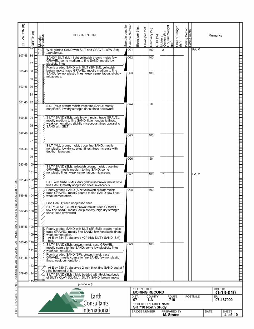
Well-graded SAND with SILT and GRAVEL (SW-SM)(continued).
SANDY SILT (ML); light yellowish brown; moist; fewGRAVEL; some medium to fine SAND; mostly lowplasticity fines.Poorly graded SAND with SILT (SP-SM); yellowishbrown; moist; trace GRAVEL; mostly medium to fineSAND; few nonplastic fines; weak cementation; slightlymicaceous.
SILT (ML); brown; moist; trace fine SAND; mostlynonplastic, low dry strength fines; fines downward.
SILTY SAND (SM); pale brown; moist; trace GRAVEL;mostly medium to fine SAND; little nonplastic fines;weak cementation; slightly micaceous; fines upward toSAND with SILT.
SILT (ML); brown; moist; trace fine SAND; mostlynonplastic, low dry strength fines; fines increase withdepth, micaceous.
SILTY SAND (SM); yellowish brown; moist; trace fineGRAVEL; mostly medium to fine SAND; somenonplastic fines; weak cementation; micaceous.
SILT with SAND (ML); dark yellowish brown; moist; littlefine SAND; mostly nonplastic fines; micaceous.
Poorly graded SAND (SP); yellowish brown; moist;trace GRAVEL; mostly coarse to fine SAND; few fines;weak cementation.
Fine SAND; trace nonplastic fines.SILTY CLAY (CL-ML); brown; moist; trace GRAVEL;few fine SAND; mostly low plasticity, high dry strengthfines; fines downward.
Poorly graded SAND with SILT (SP-SM); brown; moist;trace GRAVEL; mostly fine SAND; few nonplastic fines;weak cementation. At Elev 584.5', observed ~2'' thick SILTY SAND (SM)bed.
SILTY SAND (SM); brown; moist; trace GRAVEL;mostly coarse to fine SAND; some low plasticity fines;weak cementation.Poorly graded SAND (SP); brown; moist; traceGRAVEL; mostly coarse to fine SAND; few nonplasticfines; weak cementation.
At Elev 580.5', observed 2 inch thick fine SAND bed atthe bottom of unit.
SILTY SAND (SM) thickly bedded with thick interbedsof SILTY CLAY (CL-ML). SILTY SAND; brown; moist;
100
100
100
50
100
50
100
100
100
O21
O22
O23
O24
O25
O26
O27
O28
O29
2
7
PA, M
PA, M
Sam
ple
Loca
tion
COUNTYLA
DESCRIPTION
Rec
over
y (%
)
Dril
ling
Met
hod
Cas
ing
Dep
th
PREPARED BYM. Strane
DATE
PROJECT OR BRIDGE NAMESR 710 North Study
BRIDGE NUMBER
HOLE ID
O-13-010EA07-187900
REPORT TITLEBORING RECORD
DIST.07
ROUTE710
POSTMILE
(continued)
SHEET4 of 10
RQ
D (
%)
Sam
ple
Num
ber
Moi
stur
eC
onte
nt (
%)
Remarks
Blo
ws
per
6 in
.
ELE
VA
TIO
N (
ft)
607.46
605.46
603.46
601.46
599.46
597.46
595.46
593.46
591.46
589.46
587.46
585.46
583.46
581.46
579.46
DE
PT
H (
ft)
Dry
Uni
t Wei
ght
(pcf
)
She
ar S
tren
gth
(tsf
)
Blo
ws
per
foot
Mat
eria
lG
rap
hics
5 B
R -
ST
AN
DA
RD
SR
710N
_EC
ILO
GS
_RE
VB
YC
H2M
.GP
J C
ALT
RA
NS
LIB
RA
RY
DE
C09
-W_E
CI_
LOG
O.G
LB
1/1
5/14
85
86
87
88
89
90
91
92
93
94
95
96
97
98
99
100
101
102
103
104
105
106
107
108
109
110
111
112
113
114
115
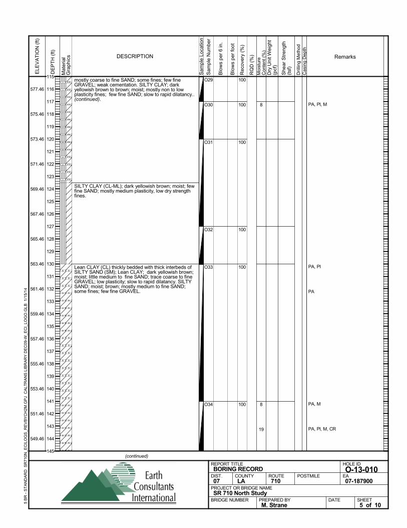
mostly coarse to fine SAND; some fines; few fineGRAVEL; weak cementation. SILTY CLAY; darkyellowish brown to brown; moist; mostly non to lowplasticity fines; few fine SAND; slow to rapid dilatancy..(continued).
SILTY CLAY (CL-ML); dark yellowish brown; moist; fewfine SAND; mostly medium plasticity, low dry strengthfines.
Lean CLAY (CL) thickly bedded with thick interbeds ofSILTY SAND (SM); Lean CLAY; dark yellowish brown;moist; little medium to fine SAND; trace coarse to fineGRAVEL; low plasticity; slow to rapid dilatancy. SILTYSAND; moist; brown; mostly medium to fine SAND;some fines; few fine GRAVEL.
100
100
100
100
100
100
O29
O30
O31
O32
O33
O34
8
8
19
PA, Pl, M
PA, PI
PA
PA, M
PA, Pl, M, CR
Sam
ple
Loca
tion
COUNTYLA
DESCRIPTION
Rec
over
y (%
)
Dril
ling
Met
hod
Cas
ing
Dep
th
PREPARED BYM. Strane
DATE
PROJECT OR BRIDGE NAMESR 710 North Study
BRIDGE NUMBER
HOLE ID
O-13-010EA07-187900
REPORT TITLEBORING RECORD
DIST.07
ROUTE710
POSTMILE
(continued)
SHEET5 of 10
RQ
D (
%)
Sam
ple
Num
ber
Moi
stur
eC
onte
nt (
%)
Remarks
Blo
ws
per
6 in
.
ELE
VA
TIO
N (
ft)
577.46
575.46
573.46
571.46
569.46
567.46
565.46
563.46
561.46
559.46
557.46
555.46
553.46
551.46
549.46
DE
PT
H (
ft)
Dry
Uni
t Wei
ght
(pcf
)
She
ar S
tren
gth
(tsf
)
Blo
ws
per
foot
Mat
eria
lG
rap
hics
5 B
R -
ST
AN
DA
RD
SR
710N
_EC
ILO
GS
_RE
VB
YC
H2M
.GP
J C
ALT
RA
NS
LIB
RA
RY
DE
C09
-W_E
CI_
LOG
O.G
LB
1/1
5/14
115
116
117
118
119
120
121
122
123
124
125
126
127
128
129
130
131
132
133
134
135
136
137
138
139
140
141
142
143
144
145
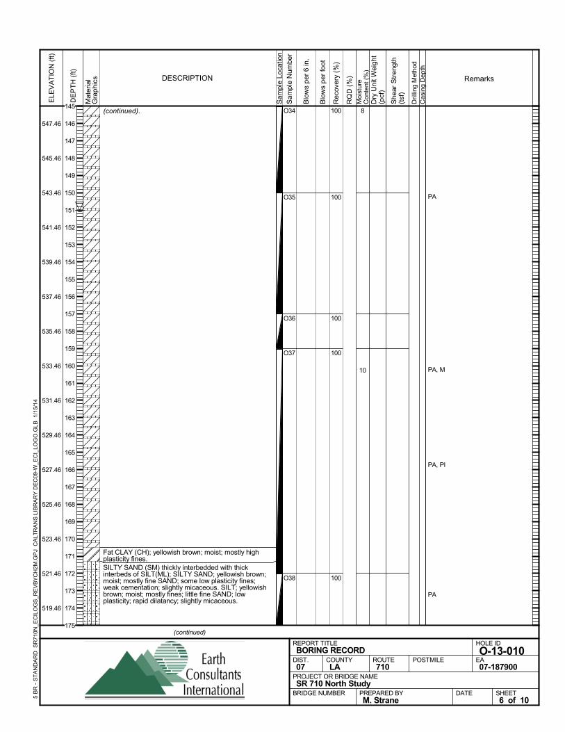
(continued).
Fat CLAY (CH); yellowish brown; moist; mostly highplasticity fines.SILTY SAND (SM) thickly interbedded with thickinterbeds of SILT(ML); SILTY SAND; yellowish brown;moist; mostly fine SAND; some low plasticity fines;weak cementation; slightly micaceous. SILT; yellowishbrown; moist; mostly fines; little fine SAND; lowplasticity; rapid dilatancy; slightly micaceous.
100
100
100
100
100
O34
O35
O36
O37
O38
8
10
PA
PA, M
PA, PI
PA
Sam
ple
Loca
tion
COUNTYLA
DESCRIPTION
Rec
over
y (%
)
Dril
ling
Met
hod
Cas
ing
Dep
th
PREPARED BYM. Strane
DATE
PROJECT OR BRIDGE NAMESR 710 North Study
BRIDGE NUMBER
HOLE ID
O-13-010EA07-187900
REPORT TITLEBORING RECORD
DIST.07
ROUTE710
POSTMILE
(continued)
SHEET6 of 10
RQ
D (
%)
Sam
ple
Num
ber
Moi
stur
eC
onte
nt (
%)
Remarks
Blo
ws
per
6 in
.
ELE
VA
TIO
N (
ft)
547.46
545.46
543.46
541.46
539.46
537.46
535.46
533.46
531.46
529.46
527.46
525.46
523.46
521.46
519.46
DE
PT
H (
ft)
Dry
Uni
t Wei
ght
(pcf
)
She
ar S
tren
gth
(tsf
)
Blo
ws
per
foot
Mat
eria
lG
rap
hics
5 B
R -
ST
AN
DA
RD
SR
710N
_EC
ILO
GS
_RE
VB
YC
H2M
.GP
J C
ALT
RA
NS
LIB
RA
RY
DE
C09
-W_E
CI_
LOG
O.G
LB
1/1
5/14
145
146
147
148
149
150
151
152
153
154
155
156
157
158
159
160
161
162
163
164
165
166
167
168
169
170
171
172
173
174
175
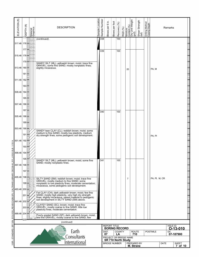
(continued).
SANDY SILT (ML); yellowish brown; moist; trace fineGRAVEL; some fine SAND; mostly nonplastic fines;slightly micaceous.
SANDY lean CLAY (CL); reddish brown; moist; somemedium to fine SAND; mostly low plasticity, mediumdry strength fines; some pedogenic soil development.
SANDY SILT (ML); yellowish brown; moist; some fineSAND; mostly nonplastic fines.
SILTY SAND (SM); reddish brown; moist; trace fineGRAVEL; mostly medium to fine SAND; somenonplastic to low plasticity fines; moderate cementation;micaceous, some pedogenic soil development.
Fat CLAY (CH); dark yellowish brown; moist; few fineSAND; mostly high plasticity, very high dry strengthfines; slightly micaceous, parent material to pedogenicsoil development in SILTY SAND (SM) above.
CLAYEY SAND (SC); brown; moist; trace fineGRAVEL; mostly coarse to fine SAND; little lowplasticity fines; moderate cementation.
Poorly graded SAND (SP); dark yellowish brown; moist;few fine GRAVEL; mostly coarse to fine SAND; few
100
100
100
100
O38
O39
O40
O41
20
7
PA, M
PA, PI
PA, Pl, M, CR
Sam
ple
Loca
tion
COUNTYLA
DESCRIPTION
Rec
over
y (%
)
Dril
ling
Met
hod
Cas
ing
Dep
th
PREPARED BYM. Strane
DATE
PROJECT OR BRIDGE NAMESR 710 North Study
BRIDGE NUMBER
HOLE ID
O-13-010EA07-187900
REPORT TITLEBORING RECORD
DIST.07
ROUTE710
POSTMILE
(continued)
SHEET7 of 10
RQ
D (
%)
Sam
ple
Num
ber
Moi
stur
eC
onte
nt (
%)
Remarks
Blo
ws
per
6 in
.
ELE
VA
TIO
N (
ft)
517.46
515.46
513.46
511.46
509.46
507.46
505.46
503.46
501.46
499.46
497.46
495.46
493.46
491.46
489.46
DE
PT
H (
ft)
Dry
Uni
t Wei
ght
(pcf
)
She
ar S
tren
gth
(tsf
)
Blo
ws
per
foot
Mat
eria
lG
rap
hics
5 B
R -
ST
AN
DA
RD
SR
710N
_EC
ILO
GS
_RE
VB
YC
H2M
.GP
J C
ALT
RA
NS
LIB
RA
RY
DE
C09
-W_E
CI_
LOG
O.G
LB
1/1
5/14
175
176
177
178
179
180
181
182
183
184
185
186
187
188
189
190
191
192
193
194
195
196
197
198
199
200
201
202
203
204
205
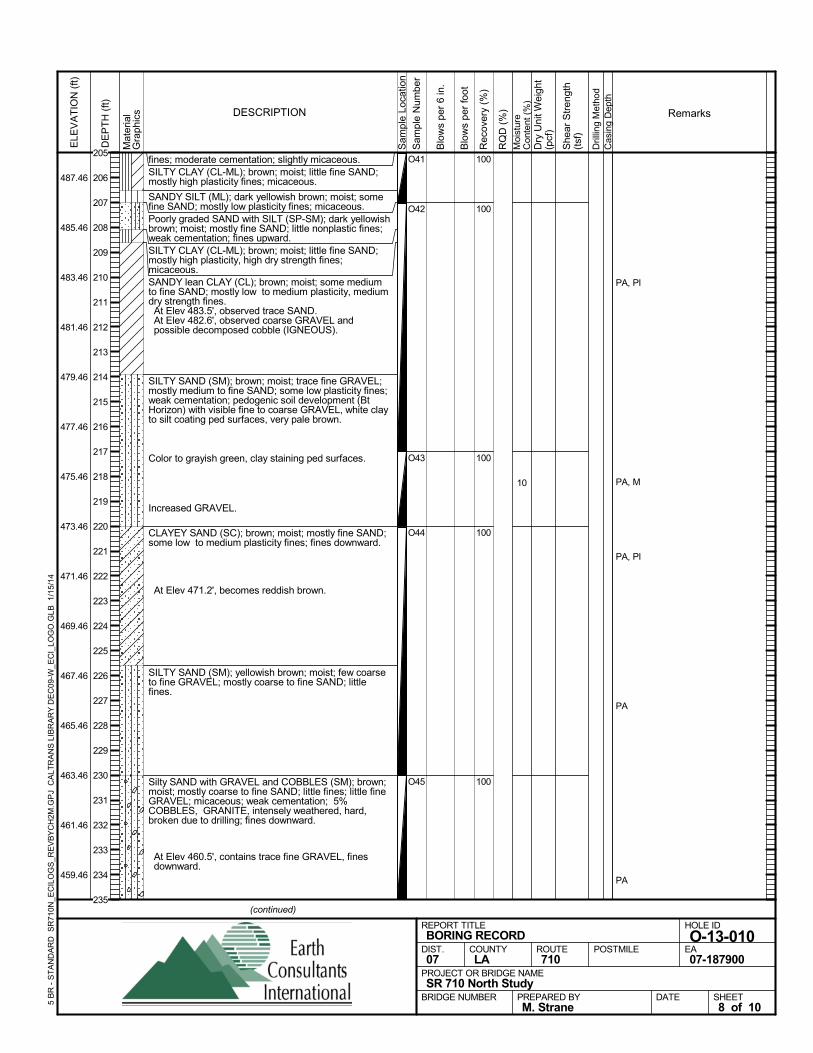
fines; moderate cementation; slightly micaceous.SILTY CLAY (CL-ML); brown; moist; little fine SAND;mostly high plasticity fines; micaceous.
SANDY SILT (ML); dark yellowish brown; moist; somefine SAND; mostly low plasticity fines; micaceous.Poorly graded SAND with SILT (SP-SM); dark yellowishbrown; moist; mostly fine SAND; little nonplastic fines;weak cementation; fines upward.SILTY CLAY (CL-ML); brown; moist; little fine SAND;mostly high plasticity, high dry strength fines;micaceous.SANDY lean CLAY (CL); brown; moist; some mediumto fine SAND; mostly low to medium plasticity, mediumdry strength fines. At Elev 483.5', observed trace SAND. At Elev 482.6', observed coarse GRAVEL andpossible decomposed cobble (IGNEOUS).
SILTY SAND (SM); brown; moist; trace fine GRAVEL;mostly medium to fine SAND; some low plasticity fines;weak cementation; pedogenic soil development (BtHorizon) with visible fine to coarse GRAVEL, white clayto silt coating ped surfaces, very pale brown.
Color to grayish green, clay staining ped surfaces.
Increased GRAVEL.
CLAYEY SAND (SC); brown; moist; mostly fine SAND;some low to medium plasticity fines; fines downward.
At Elev 471.2', becomes reddish brown.
SILTY SAND (SM); yellowish brown; moist; few coarseto fine GRAVEL; mostly coarse to fine SAND; littlefines.
Silty SAND with GRAVEL and COBBLES (SM); brown;moist; mostly coarse to fine SAND; little fines; little fineGRAVEL; micaceous; weak cementation; 5%COBBLES, GRANITE, intensely weathered, hard,broken due to drilling; fines downward.
At Elev 460.5', contains trace fine GRAVEL, finesdownward.
100
100
100
100
100
O41
O42
O43
O44
O45
10
PA, PI
PA, M
PA, PI
PA
PA
Sam
ple
Loca
tion
COUNTYLA
DESCRIPTION
Rec
over
y (%
)
Dril
ling
Met
hod
Cas
ing
Dep
th
PREPARED BYM. Strane
DATE
PROJECT OR BRIDGE NAMESR 710 North Study
BRIDGE NUMBER
HOLE ID
O-13-010EA07-187900
REPORT TITLEBORING RECORD
DIST.07
ROUTE710
POSTMILE
(continued)
SHEET8 of 10
RQ
D (
%)
Sam
ple
Num
ber
Moi
stur
eC
onte
nt (
%)
Remarks
Blo
ws
per
6 in
.
ELE
VA
TIO
N (
ft)
487.46
485.46
483.46
481.46
479.46
477.46
475.46
473.46
471.46
469.46
467.46
465.46
463.46
461.46
459.46
DE
PT
H (
ft)
Dry
Uni
t Wei
ght
(pcf
)
She
ar S
tren
gth
(tsf
)
Blo
ws
per
foot
Mat
eria
lG
rap
hics
5 B
R -
ST
AN
DA
RD
SR
710N
_EC
ILO
GS
_RE
VB
YC
H2M
.GP
J C
ALT
RA
NS
LIB
RA
RY
DE
C09
-W_E
CI_
LOG
O.G
LB
1/1
5/14
205
206
207
208
209
210
211
212
213
214
215
216
217
218
219
220
221
222
223
224
225
226
227
228
229
230
231
232
233
234
235
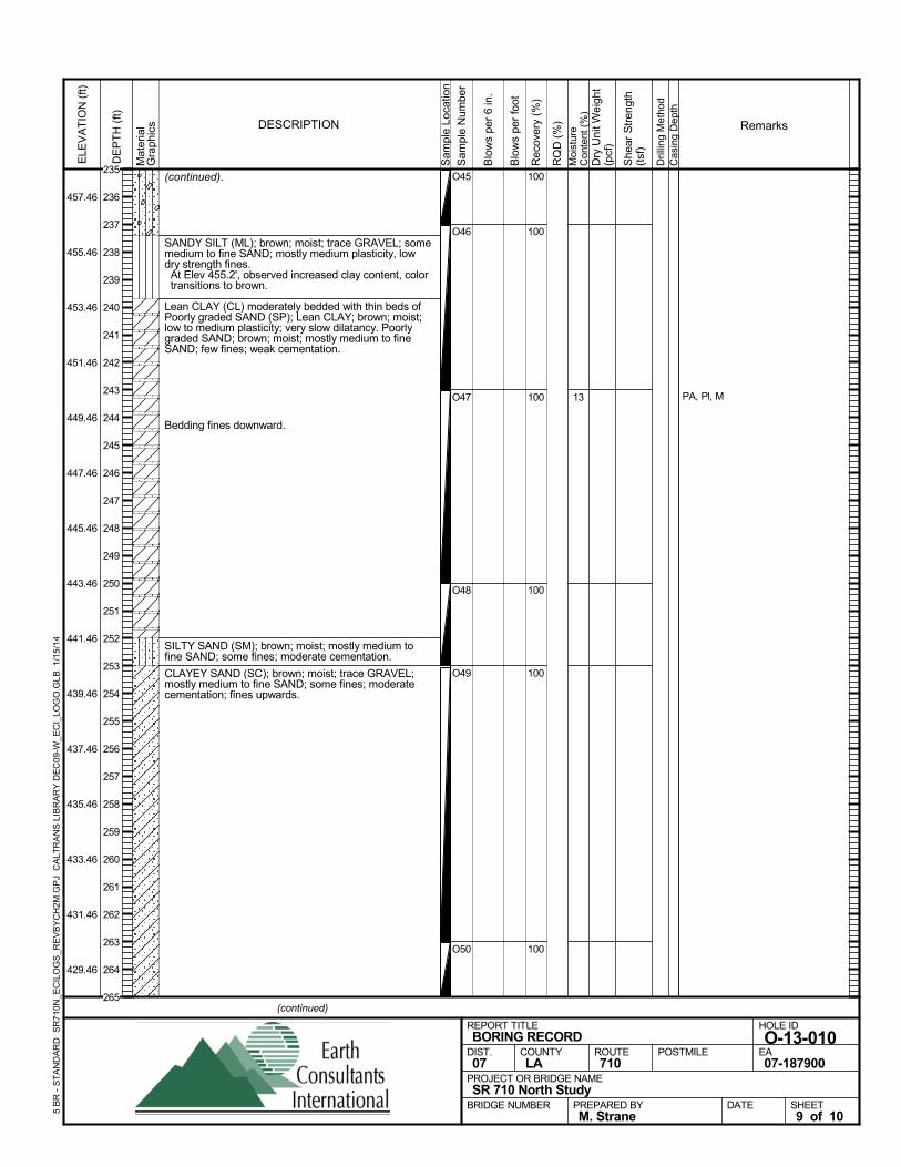
(continued).
SANDY SILT (ML); brown; moist; trace GRAVEL; somemedium to fine SAND; mostly medium plasticity, lowdry strength fines. At Elev 455.2', observed increased clay content, colortransitions to brown.
Lean CLAY (CL) moderately bedded with thin beds ofPoorly graded SAND (SP); Lean CLAY; brown; moist;low to medium plasticity; very slow dilatancy. Poorlygraded SAND; brown; moist; mostly medium to fineSAND; few fines; weak cementation.
Bedding fines downward.
SILTY SAND (SM); brown; moist; mostly medium tofine SAND; some fines; moderate cementation.
CLAYEY SAND (SC); brown; moist; trace GRAVEL;mostly medium to fine SAND; some fines; moderatecementation; fines upwards.
100
100
100
100
100
100
O45
O46
O47
O48
O49
O50
13 PA, Pl, M
Sam
ple
Loca
tion
COUNTYLA
DESCRIPTION
Rec
over
y (%
)
Dril
ling
Met
hod
Cas
ing
Dep
th
PREPARED BYM. Strane
DATE
PROJECT OR BRIDGE NAMESR 710 North Study
BRIDGE NUMBER
HOLE ID
O-13-010EA07-187900
REPORT TITLEBORING RECORD
DIST.07
ROUTE710
POSTMILE
(continued)
SHEET9 of 10
RQ
D (
%)
Sam
ple
Num
ber
Moi
stur
eC
onte
nt (
%)
Remarks
Blo
ws
per
6 in
.
ELE
VA
TIO
N (
ft)
457.46
455.46
453.46
451.46
449.46
447.46
445.46
443.46
441.46
439.46
437.46
435.46
433.46
431.46
429.46
DE
PT
H (
ft)
Dry
Uni
t Wei
ght
(pcf
)
She
ar S
tren
gth
(tsf
)
Blo
ws
per
foot
Mat
eria
lG
rap
hics
5 B
R -
ST
AN
DA
RD
SR
710N
_EC
ILO
GS
_RE
VB
YC
H2M
.GP
J C
ALT
RA
NS
LIB
RA
RY
DE
C09
-W_E
CI_
LOG
O.G
LB
1/1
5/14
235
236
237
238
239
240
241
242
243
244
245
246
247
248
249
250
251
252
253
254
255
256
257
258
259
260
261
262
263
264
265
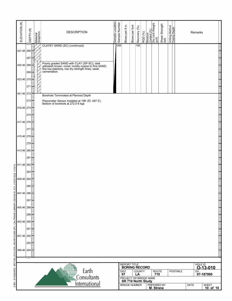
CLAYEY SAND (SC) (continued).
Poorly graded SAND with CLAY (SP-SC); darkyellowish brown; moist; mostly coarse to fine SAND;few low plasticity, low dry strength fines; weakcementation.
Borehole Terminated at Planned Depth
Piezometer Sensor Installed at 196' (El. 497.5').Bottom of borehole at 272.0 ft bgs
100O50
Sam
ple
Loca
tion
COUNTYLA
DESCRIPTION
Rec
over
y (%
)
Dril
ling
Met
hod
Cas
ing
Dep
th
PREPARED BYM. Strane
DATE
PROJECT OR BRIDGE NAMESR 710 North Study
BRIDGE NUMBER
HOLE ID
O-13-010EA07-187900
REPORT TITLEBORING RECORD
DIST.07
ROUTE710
POSTMILE
SHEET10 of 10
RQ
D (
%)
Sam
ple
Num
ber
Moi
stur
eC
onte
nt (
%)
Remarks
Blo
ws
per
6 in
.
ELE
VA
TIO
N (
ft)
427.46
425.46
423.46
421.46
419.46
417.46
415.46
413.46
411.46
409.46
407.46
405.46
403.46
401.46
399.46
DE
PT
H (
ft)
Dry
Uni
t Wei
ght
(pcf
)
She
ar S
tren
gth
(tsf
)
Blo
ws
per
foot
Mat
eria
lG
rap
hics
5 B
R -
ST
AN
DA
RD
SR
710N
_EC
ILO
GS
_RE
VB
YC
H2M
.GP
J C
ALT
RA
NS
LIB
RA
RY
DE
C09
-W_E
CI_
LOG
O.G
LB
1/1
5/14
265
266
267
268
269
270
271
272
273
274
275
276
277
278
279
280
281
282
283
284
285
286
287
288
289
290
291
292
293
294
295
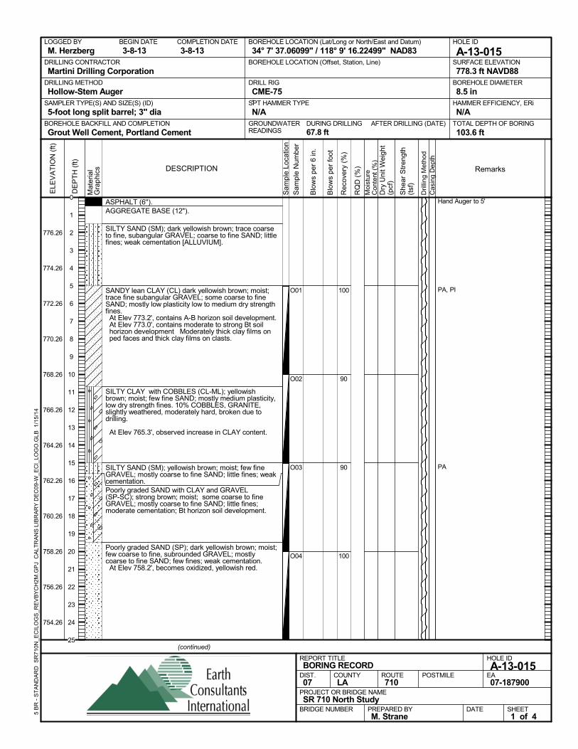
ASPHALT (6'').AGGREGATE BASE (12").
SILTY SAND (SM); dark yellowish brown; trace coarseto fine, subangular GRAVEL; coarse to fine SAND; littlefines; weak cementation [ALLUVIUM].
SANDY lean CLAY (CL) dark yellowish brown; moist;trace fine subangular GRAVEL; some coarse to fineSAND; mostly low plasticity low to medium dry strengthfines. At Elev 773.2', contains A-B horizon soil development. At Elev 773.0', contains moderate to strong Bt soilhorizon development Moderately thick clay films onped faces and thick clay films on clasts.
SILTY CLAY with COBBLES (CL-ML); yellowishbrown; moist; few fine SAND; mostly medium plasticity,low dry strength fines. 10% COBBLES, GRANITE,slightly weathered, moderately hard, broken due todrilling.
At Elev 765.3', observed increase in CLAY content.
SILTY SAND (SM); yellowish brown; moist; few fineGRAVEL; mostly coarse to fine SAND; little fines; weakcementation.Poorly graded SAND with CLAY and GRAVEL(SP-SC); strong brown; moist; some coarse to fineGRAVEL; mostly coarse to fine SAND; little fines;moderate cementation; Bt horizon soil development.
Poorly graded SAND (SP); dark yellowish brown; moist;few coarse to fine, subrounded GRAVEL; mostlycoarse to fine SAND; few fines; weak cementation. At Elev 758.2', becomes oxidized, yellowish red.
100
90
90
100
O01
O02
O03
O04
Hand Auger to 5'
PA, PI
PA
AFTER DRILLING (DATE)DURING DRILLING67.8 ft
SURFACE ELEVATION
778.3 ft NAVD88DRILLING METHOD
Hollow-Stem AugerDRILL RIG
CME-75SPT HAMMER TYPE
N/ABOREHOLE BACKFILL AND COMPLETION
Grout Well Cement, Portland CementGROUNDWATERREADINGS
BEGIN DATE
3-8-13COMPLETION DATE
3-8-13LOGGED BY
M. HerzbergBOREHOLE LOCATION (Lat/Long or North/East and Datum)
34° 7' 37.06099" / 118° 9' 16.22499" NAD83HOLE ID
A-13-015DRILLING CONTRACTOR
Martini Drilling Corporation
HAMMER EFFICIENCY, ERi
N/ASAMPLER TYPE(S) AND SIZE(S) (ID)
5-foot long split barrel; 3" diaTOTAL DEPTH OF BORING
103.6 ft
BOREHOLE DIAMETER
8.5 in
BOREHOLE LOCATION (Offset, Station, Line)
.
Sam
ple
Loca
tion
COUNTYLA
DESCRIPTION
Rec
over
y (%
)
Dril
ling
Met
hod
Cas
ing
Dep
th
PREPARED BYM. Strane
DATE
PROJECT OR BRIDGE NAMESR 710 North Study
BRIDGE NUMBER
HOLE ID
A-13-015EA07-187900
REPORT TITLEBORING RECORD
DIST.07
ROUTE710
POSTMILE
(continued)
SHEET1 of 4
RQ
D (
%)
Sam
ple
Num
ber
Moi
stur
eC
onte
nt (
%)
Remarks
Blo
ws
per
6 in
.
ELE
VA
TIO
N (
ft)
776.26
774.26
772.26
770.26
768.26
766.26
764.26
762.26
760.26
758.26
756.26
754.26
DE
PT
H (
ft)
Dry
Uni
t Wei
ght
(pcf
)
She
ar S
tren
gth
(tsf
)
Blo
ws
per
foot
Mat
eria
lG
rap
hics
5 B
R -
ST
AN
DA
RD
SR
710N
_EC
ILO
GS
_RE
VB
YC
H2M
.GP
J C
ALT
RA
NS
LIB
RA
RY
DE
C09
-W_E
CI_
LOG
O.G
LB
1/1
5/14
0
1
2
3
4
5
6
7
8
9
10
11
12
13
14
15
16
17
18
19
20
21
22
23
24
25
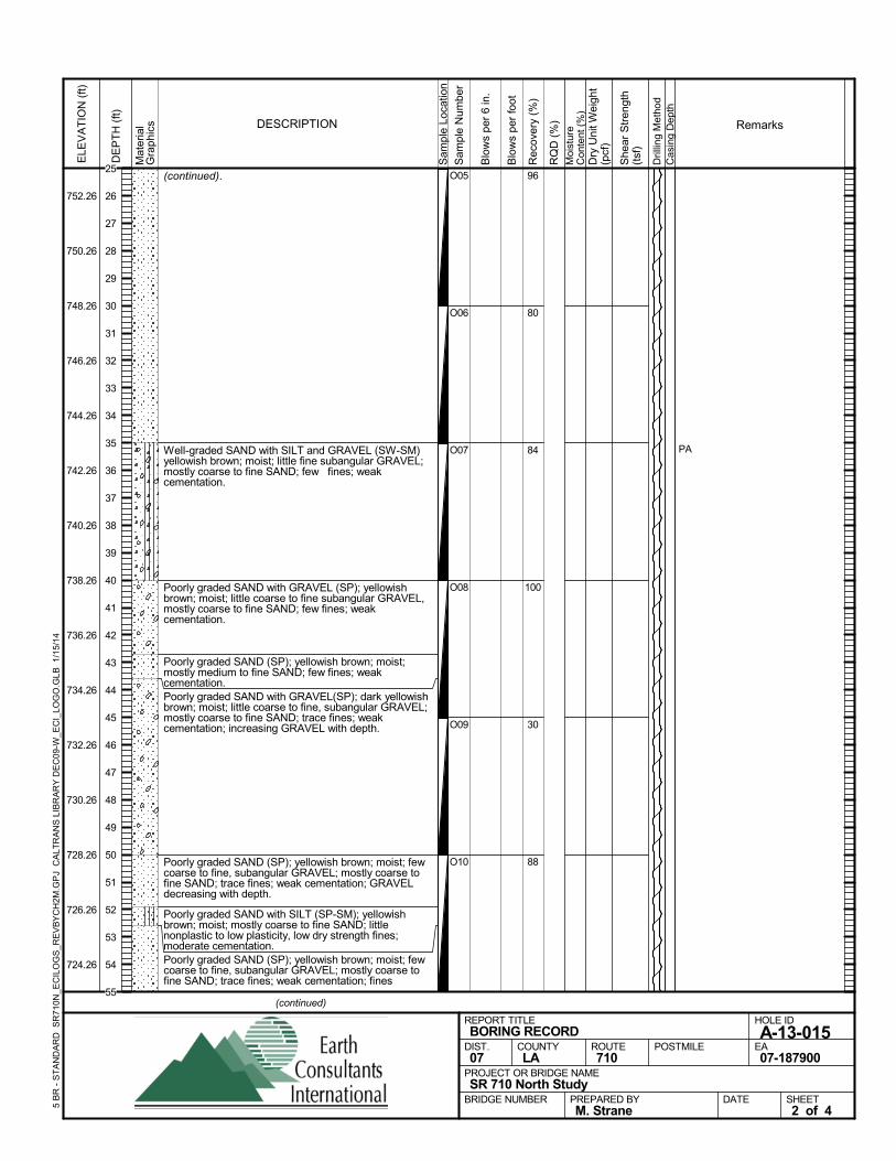
(continued).
Well-graded SAND with SILT and GRAVEL (SW-SM)yellowish brown; moist; little fine subangular GRAVEL;mostly coarse to fine SAND; few fines; weakcementation.
Poorly graded SAND with GRAVEL (SP); yellowishbrown; moist; little coarse to fine subangular GRAVEL,mostly coarse to fine SAND; few fines; weakcementation.
Poorly graded SAND (SP); yellowish brown; moist;mostly medium to fine SAND; few fines; weakcementation.Poorly graded SAND with GRAVEL(SP); dark yellowishbrown; moist; little coarse to fine, subangular GRAVEL;mostly coarse to fine SAND; trace fines; weakcementation; increasing GRAVEL with depth.
Poorly graded SAND (SP); yellowish brown; moist; fewcoarse to fine, subangular GRAVEL; mostly coarse tofine SAND; trace fines; weak cementation; GRAVELdecreasing with depth.
Poorly graded SAND with SILT (SP-SM); yellowishbrown; moist; mostly coarse to fine SAND; littlenonplastic to low plasticity, low dry strength fines;moderate cementation.Poorly graded SAND (SP); yellowish brown; moist; fewcoarse to fine, subangular GRAVEL; mostly coarse tofine SAND; trace fines; weak cementation; fines
96
80
84
100
30
88
O05
O06
O07
O08
O09
O10
PAS
ampl
e Lo
catio
n
COUNTYLA
DESCRIPTION
Rec
over
y (%
)
Dril
ling
Met
hod
Cas
ing
Dep
th
PREPARED BYM. Strane
DATE
PROJECT OR BRIDGE NAMESR 710 North Study
BRIDGE NUMBER
HOLE ID
A-13-015EA07-187900
REPORT TITLEBORING RECORD
DIST.07
ROUTE710
POSTMILE
(continued)
SHEET2 of 4
RQ
D (
%)
Sam
ple
Num
ber
Moi
stur
eC
onte
nt (
%)
Remarks
Blo
ws
per
6 in
.
ELE
VA
TIO
N (
ft)
752.26
750.26
748.26
746.26
744.26
742.26
740.26
738.26
736.26
734.26
732.26
730.26
728.26
726.26
724.26
DE
PT
H (
ft)
Dry
Uni
t Wei
ght
(pcf
)
She
ar S
tren
gth
(tsf
)
Blo
ws
per
foot
Mat
eria
lG
rap
hics
5 B
R -
ST
AN
DA
RD
SR
710N
_EC
ILO
GS
_RE
VB
YC
H2M
.GP
J C
ALT
RA
NS
LIB
RA
RY
DE
C09
-W_E
CI_
LOG
O.G
LB
1/1
5/14
25
26
27
28
29
30
31
32
33
34
35
36
37
38
39
40
41
42
43
44
45
46
47
48
49
50
51
52
53
54
55
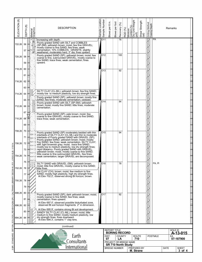
increasing with depth.Poorly graded SAND with SILT and COBBLES(SP-SM); yellowish brown; moist; few fine GRAVEL;mostly coarse to fine SAND; few fines; weakcementation; 10% COBBLES, GRANITE, slightlyweathered, moderately hard, 3" dia; fines upward.Poorly graded SAND (SP); yellowish brown; moist; fewcoarse to fine, subrounded GRAVEL; mostly coarse tofine SAND; trace fines; weak cementation; finesupward.
SILTY CLAY (CL-ML); yellowish brown; few fine SAND;mostly low to medium plasticity, low dry strength fines.
Poorly graded SAND (SP); yellowish brown; mostly fineSAND; few fines; moderate cementation; oxidized.Poorly graded SAND with SILT (SP-SM); yellowishbrown; moist; mostly fine SAND; little fines; moderatecementation.
Poorly graded SAND (SP); pale brown; moist; fewcoarse to fine GRAVEL; mostly coarse to fine SAND;trace fines; weak cementation.
Poorly graded SAND (SP) moderately bedded with thininterbeds of SILTY CLAY (CL-ML) and thin to moderateinterbeds of Poorly graded SAND with GRAVEL (SP);Poorly graded SAND; yellowish brown; moist; mostlyfine SAND; few fines; weak cementation. SILTY CLAY;stiff; light brownish gray; moist; trace fine SAND;mostly low to medium plasticity, low dry strength fines;rapid dilatancy. Poorly graded SAND with GRAVEL,yellowish brown; moist, mostly coarse to fine SAND;little coarse to fine subrounded GRAVEL; few fines;weak cementation; larger GRAVEL are decomposed.
SILTY SAND with GRAVEL (SM); yellowish brown;moist; little fine GRAVEL; mostly coarse to fine SAND;little fines.Fat CLAY (CH); brown; moist; few medium to fineSAND; mostly high plasticity, high dry strength fines. At Elev 702.2', observed strong Bt horizon, brown.
Poorly graded SAND (SP); dark yellowish brown; moist;mostly coarse to fine SAND; few fines; weakcementation; fines upward. At Elev 697.0', observed possible bioturbated zone,observed Bt soil horizon fragments 2'' in dimension.
At Elev 695.9', contains strong Bt soil development.SANDY SILTY CLAY (CL-ML); brown; moist; littlemedium to fine SAND; mostly medium plasticity, lowdry strength fines; fines downward. At Elev 694.3', contains 1'' clay lens.
76
100
92
94
94
78
92
O11
O12
O13
O14
O15
O16
O17
PA
PA, Pl
Sam
ple
Loca
tion
COUNTYLA
DESCRIPTION
Rec
over
y (%
)
Dril
ling
Met
hod
Cas
ing
Dep
th
PREPARED BYM. Strane
DATE
PROJECT OR BRIDGE NAMESR 710 North Study
BRIDGE NUMBER
HOLE ID
A-13-015EA07-187900
REPORT TITLEBORING RECORD
DIST.07
ROUTE710
POSTMILE
(continued)
SHEET3 of 4
RQ
D (
%)
Sam
ple
Num
ber
Moi
stur
eC
onte
nt (
%)
Remarks
Blo
ws
per
6 in
.
ELE
VA
TIO
N (
ft)
722.26
720.26
718.26
716.26
714.26
712.26
710.26
708.26
706.26
704.26
702.26
700.26
698.26
696.26
694.26
DE
PT
H (
ft)
Dry
Uni
t Wei
ght
(pcf
)
She
ar S
tren
gth
(tsf
)
Blo
ws
per
foot
Mat
eria
lG
rap
hics
5 B
R -
ST
AN
DA
RD
SR
710N
_EC
ILO
GS
_RE
VB
YC
H2M
.GP
J C
ALT
RA
NS
LIB
RA
RY
DE
C09
-W_E
CI_
LOG
O.G
LB
1/1
5/14
55
56
57
58
59
60
61
62
63
64
65
66
67
68
69
70
71
72
73
74
75
76
77
78
79
80
81
82
83
84
85
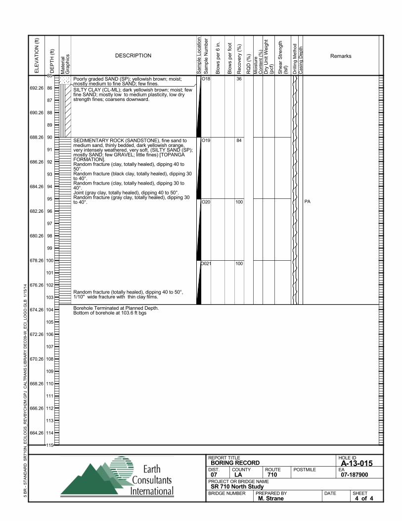
Poorly graded SAND (SP); yellowish brown; moist;mostly medium to fine SAND; few fines.SILTY CLAY (CL-ML); dark yellowish brown; moist; fewfine SAND; mostly low to medium plasticity, low drystrength fines; coarsens downward.
SEDIMENTARY ROCK (SANDSTONE), fine sand tomedium sand, thinly bedded, dark yellowish orange,very intensely weathered, very soft, (SILTY SAND (SP);mostly SAND; few GRAVEL; little fines) [TOPANGAFORMATION].Random fracture (clay, totally healed), dipping 40 to50°.Random fracture (black clay, totally healed), dipping 30to 40°.Random fracture (clay, totally healed), dipping 30 to40°.Joint (gray clay, totally healed), dipping 40 to 50°.Random fracture (gray clay, totally healed), dipping 30to 40°.
Random fracture (totally healed), dipping 40 to 50°,1/10'' wide fracture with thin clay films.
Borehole Terminated at Planned Depth.Bottom of borehole at 103.6 ft bgs
36
84
100
100
O18
O19
O20
O021
PAS
ampl
e Lo
catio
n
COUNTYLA
DESCRIPTION
Rec
over
y (%
)
Dril
ling
Met
hod
Cas
ing
Dep
th
PREPARED BYM. Strane
DATE
PROJECT OR BRIDGE NAMESR 710 North Study
BRIDGE NUMBER
HOLE ID
A-13-015EA07-187900
REPORT TITLEBORING RECORD
DIST.07
ROUTE710
POSTMILE
SHEET4 of 4
RQ
D (
%)
Sam
ple
Num
ber
Moi
stur
eC
onte
nt (
%)
Remarks
Blo
ws
per
6 in
.
ELE
VA
TIO
N (
ft)
692.26
690.26
688.26
686.26
684.26
682.26
680.26
678.26
676.26
674.26
672.26
670.26
668.26
666.26
664.26
DE
PT
H (
ft)
Dry
Uni
t Wei
ght
(pcf
)
She
ar S
tren
gth
(tsf
)
Blo
ws
per
foot
Mat
eria
lG
rap
hics
5 B
R -
ST
AN
DA
RD
SR
710N
_EC
ILO
GS
_RE
VB
YC
H2M
.GP
J C
ALT
RA
NS
LIB
RA
RY
DE
C09
-W_E
CI_
LOG
O.G
LB
1/1
5/14
85
86
87
88
89
90
91
92
93
94
95
96
97
98
99
100
101
102
103
104
105
106
107
108
109
110
111
112
113
114
115
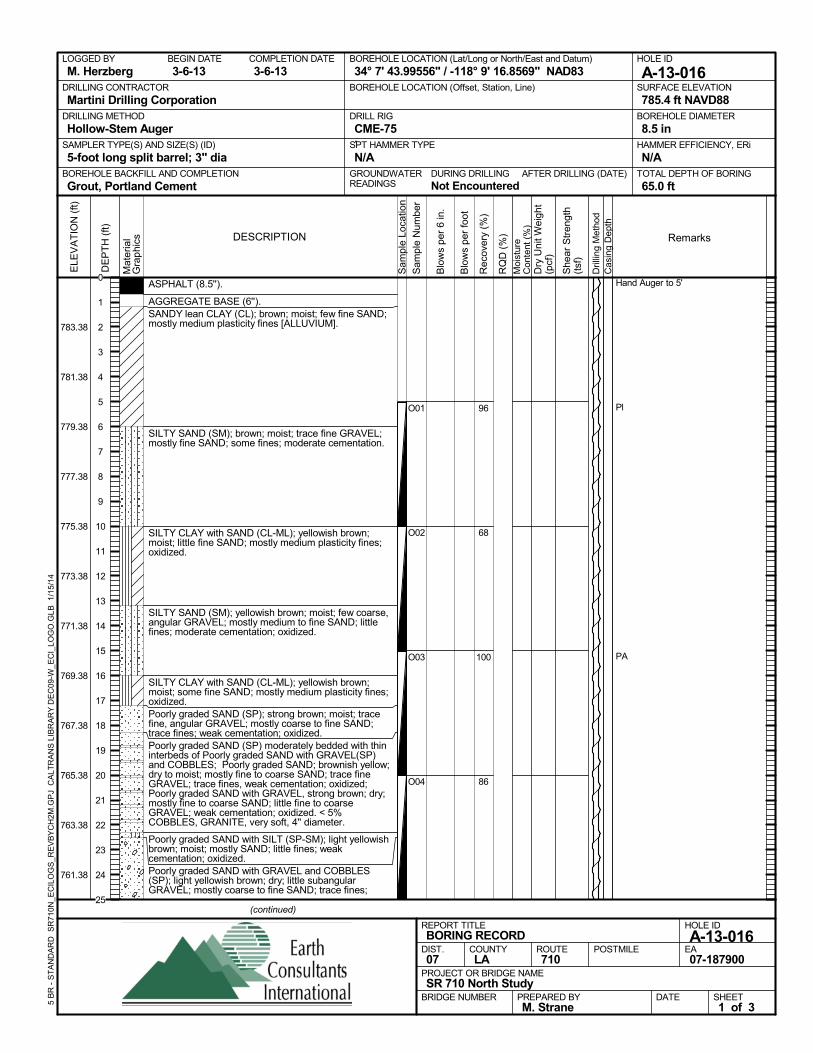
ASPHALT (8.5'').
AGGREGATE BASE (6'').SANDY lean CLAY (CL); brown; moist; few fine SAND;mostly medium plasticity fines [ALLUVIUM].
SILTY SAND (SM); brown; moist; trace fine GRAVEL;mostly fine SAND; some fines; moderate cementation.
SILTY CLAY with SAND (CL-ML); yellowish brown;moist; little fine SAND; mostly medium plasticity fines;oxidized.
SILTY SAND (SM); yellowish brown; moist; few coarse,angular GRAVEL; mostly medium to fine SAND; littlefines; moderate cementation; oxidized.
SILTY CLAY with SAND (CL-ML); yellowish brown;moist; some fine SAND; mostly medium plasticity fines;oxidized.Poorly graded SAND (SP); strong brown; moist; tracefine, angular GRAVEL; mostly coarse to fine SAND;trace fines; weak cementation; oxidized.Poorly graded SAND (SP) moderately bedded with thininterbeds of Poorly graded SAND with GRAVEL(SP)and COBBLES; Poorly graded SAND; brownish yellow;dry to moist; mostly fine to coarse SAND; trace fineGRAVEL; trace fines, weak cementation; oxidized;Poorly graded SAND with GRAVEL, strong brown; dry;mostly fine to coarse SAND; little fine to coarseGRAVEL; weak cementation; oxidized. < 5%COBBLES, GRANITE, very soft, 4'' diameter.
Poorly graded SAND with SILT (SP-SM); light yellowishbrown; moist; mostly SAND; little fines; weakcementation; oxidized.Poorly graded SAND with GRAVEL and COBBLES(SP); light yellowish brown; dry; little subangularGRAVEL; mostly coarse to fine SAND; trace fines;
96
68
100
86
O01
O02
O03
O04
Hand Auger to 5'
Pl
PA
AFTER DRILLING (DATE)DURING DRILLINGNot Encountered
SURFACE ELEVATION
785.4 ft NAVD88DRILLING METHOD
Hollow-Stem AugerDRILL RIG
CME-75SPT HAMMER TYPE
N/ABOREHOLE BACKFILL AND COMPLETION
Grout, Portland CementGROUNDWATERREADINGS
BEGIN DATE
3-6-13COMPLETION DATE
3-6-13LOGGED BY
M. HerzbergBOREHOLE LOCATION (Lat/Long or North/East and Datum)
34° 7' 43.99556" / -118° 9' 16.8569" NAD83HOLE ID
A-13-016DRILLING CONTRACTOR
Martini Drilling Corporation
HAMMER EFFICIENCY, ERi
N/ASAMPLER TYPE(S) AND SIZE(S) (ID)
5-foot long split barrel; 3" diaTOTAL DEPTH OF BORING
65.0 ft
BOREHOLE DIAMETER
8.5 in
BOREHOLE LOCATION (Offset, Station, Line)
.
Sam
ple
Loca
tion
COUNTYLA
DESCRIPTION
Rec
over
y (%
)
Dril
ling
Met
hod
Cas
ing
Dep
th
PREPARED BYM. Strane
DATE
PROJECT OR BRIDGE NAMESR 710 North Study
BRIDGE NUMBER
HOLE ID
A-13-016EA07-187900
REPORT TITLEBORING RECORD
DIST.07
ROUTE710
POSTMILE
(continued)
SHEET1 of 3
RQ
D (
%)
Sam
ple
Num
ber
Moi
stur
eC
onte
nt (
%)
Remarks
Blo
ws
per
6 in
.
ELE
VA
TIO
N (
ft)
783.38
781.38
779.38
777.38
775.38
773.38
771.38
769.38
767.38
765.38
763.38
761.38
DE
PT
H (
ft)
Dry
Uni
t Wei
ght
(pcf
)
She
ar S
tren
gth
(tsf
)
Blo
ws
per
foot
Mat
eria
lG
rap
hics
5 B
R -
ST
AN
DA
RD
SR
710N
_EC
ILO
GS
_RE
VB
YC
H2M
.GP
J C
ALT
RA
NS
LIB
RA
RY
DE
C09
-W_E
CI_
LOG
O.G
LB
1/1
5/14
0
1
2
3
4
5
6
7
8
9
10
11
12
13
14
15
16
17
18
19
20
21
22
23
24
25
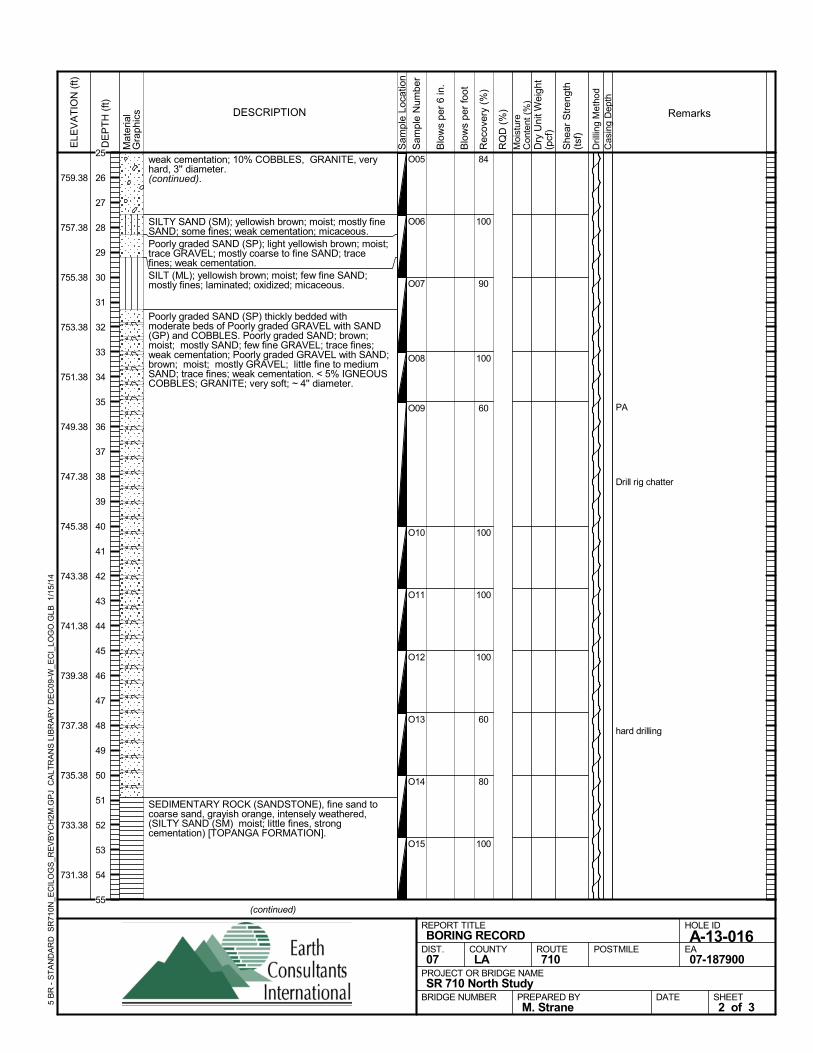
weak cementation; 10% COBBLES, GRANITE, veryhard, 3'' diameter.(continued).
SILTY SAND (SM); yellowish brown; moist; mostly fineSAND; some fines; weak cementation; micaceous.Poorly graded SAND (SP); light yellowish brown; moist;trace GRAVEL; mostly coarse to fine SAND; tracefines; weak cementation.SILT (ML); yellowish brown; moist; few fine SAND;mostly fines; laminated; oxidized; micaceous.
Poorly graded SAND (SP) thickly bedded withmoderate beds of Poorly graded GRAVEL with SAND(GP) and COBBLES. Poorly graded SAND; brown;moist; mostly SAND; few fine GRAVEL; trace fines;weak cementation; Poorly graded GRAVEL with SAND;brown; moist; mostly GRAVEL; little fine to mediumSAND; trace fines; weak cementation. < 5% IGNEOUSCOBBLES; GRANITE; very soft; ~ 4'' diameter.
SEDIMENTARY ROCK (SANDSTONE), fine sand tocoarse sand, grayish orange, intensely weathered,(SILTY SAND (SM) moist; little fines, strongcementation) [TOPANGA FORMATION].
84
100
90
100
60
100
100
100
60
80
100
O05
O06
O07
O08
O09
O10
O11
O12
O13
O14
O15
PA
Drill rig chatter
hard drilling
Sam
ple
Loca
tion
COUNTYLA
DESCRIPTION
Rec
over
y (%
)
Dril
ling
Met
hod
Cas
ing
Dep
th
PREPARED BYM. Strane
DATE
PROJECT OR BRIDGE NAMESR 710 North Study
BRIDGE NUMBER
HOLE ID
A-13-016EA07-187900
REPORT TITLEBORING RECORD
DIST.07
ROUTE710
POSTMILE
(continued)
SHEET2 of 3
RQ
D (
%)
Sam
ple
Num
ber
Moi
stur
eC
onte
nt (
%)
Remarks
Blo
ws
per
6 in
.
ELE
VA
TIO
N (
ft)
759.38
757.38
755.38
753.38
751.38
749.38
747.38
745.38
743.38
741.38
739.38
737.38
735.38
733.38
731.38
DE
PT
H (
ft)
Dry
Uni
t Wei
ght
(pcf
)
She
ar S
tren
gth
(tsf
)
Blo
ws
per
foot
Mat
eria
lG
rap
hics
5 B
R -
ST
AN
DA
RD
SR
710N
_EC
ILO
GS
_RE
VB
YC
H2M
.GP
J C
ALT
RA
NS
LIB
RA
RY
DE
C09
-W_E
CI_
LOG
O.G
LB
1/1
5/14
25
26
27
28
29
30
31
32
33
34
35
36
37
38
39
40
41
42
43
44
45
46
47
48
49
50
51
52
53
54
55
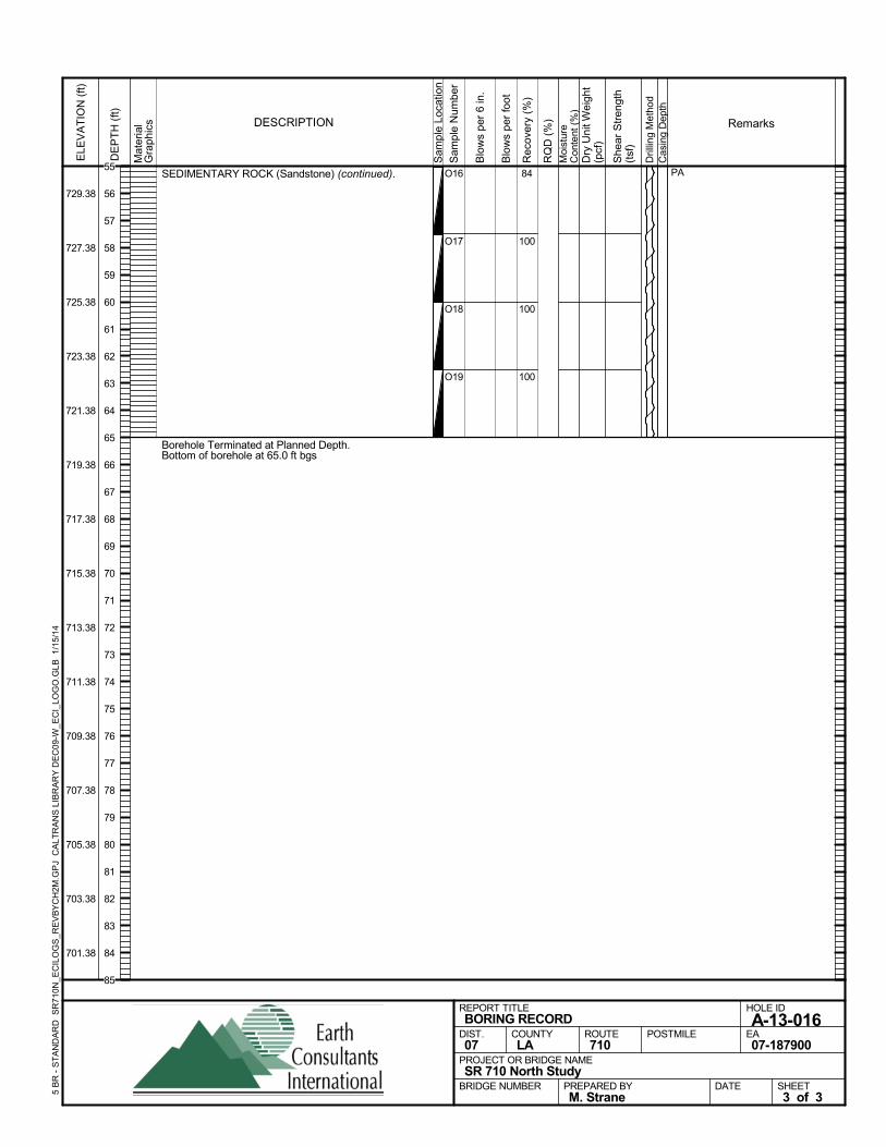
SEDIMENTARY ROCK (Sandstone) (continued).
Borehole Terminated at Planned Depth.Bottom of borehole at 65.0 ft bgs
84
100
100
100
O16
O17
O18
O19
PA
Sam
ple
Loca
tion
COUNTYLA
DESCRIPTION
Rec
over
y (%
)
Dril
ling
Met
hod
Cas
ing
Dep
th
PREPARED BYM. Strane
DATE
PROJECT OR BRIDGE NAMESR 710 North Study
BRIDGE NUMBER
HOLE ID
A-13-016EA07-187900
REPORT TITLEBORING RECORD
DIST.07
ROUTE710
POSTMILE
SHEET3 of 3
RQ
D (
%)
Sam
ple
Num
ber
Moi
stur
eC
onte
nt (
%)
Remarks
Blo
ws
per
6 in
.
ELE
VA
TIO
N (
ft)
729.38
727.38
725.38
723.38
721.38
719.38
717.38
715.38
713.38
711.38
709.38
707.38
705.38
703.38
701.38
DE
PT
H (
ft)
Dry
Uni
t Wei
ght
(pcf
)
She
ar S
tren
gth
(tsf
)
Blo
ws
per
foot
Mat
eria
lG
rap
hics
5 B
R -
ST
AN
DA
RD
SR
710N
_EC
ILO
GS
_RE
VB
YC
H2M
.GP
J C
ALT
RA
NS
LIB
RA
RY
DE
C09
-W_E
CI_
LOG
O.G
LB
1/1
5/14
55
56
57
58
59
60
61
62
63
64
65
66
67
68
69
70
71
72
73
74
75
76
77
78
79
80
81
82
83
84
85
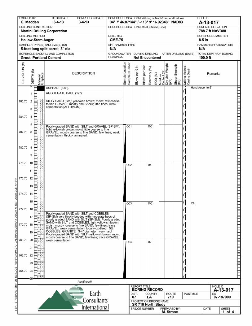
ASPHALT (8.5'').
AGGREGATE BASE (12").
SILTY SAND (SM); yellowish brown; moist; few coarseto fine GRAVEL; mostly fine SAND; little fines; weakcementation [ALLUVIUM].
Poorly graded SAND with SILT and GRAVEL (SP-SM);light yellowish brown; moist; little coarse to fineGRAVEL; mostly coarse to fine SAND; few fines; weakcementation; thickly laminated.
Poorly graded SAND with SILT and COBBLES(SP-SM) very thickly bedded with moderate beds ofpoorly graded SAND with SILT (SP-SM). Poorly gradedSAND with SILT and COBBLES; light yellowish brown;moist; mostly coarse to fine SAND; few fines; traceGRAVEL; weak cementation; locally oxidized; 5%COBBLES, GRANITE, 3-4'' diameter, very hard.Poorly graded SAND with SILT; yellowish brown; moist;mostly coarse to fine SAND; few fines; trace GRAVEL;weak cementation.
100
84
100
82
O01
O02
O03
O04
Hand Auger to 5'
PA
AFTER DRILLING (DATE)DURING DRILLINGNot Encountered
SURFACE ELEVATION
788.7 ft NAVD88DRILLING METHOD
Hollow-Stem AugerDRILL RIG
CME-75SPT HAMMER TYPE
N/ABOREHOLE BACKFILL AND COMPLETION
Grout, Portland CementGROUNDWATERREADINGS
BEGIN DATE
3-4-13COMPLETION DATE
3-4-13LOGGED BY
C. MaddenBOREHOLE LOCATION (Lat/Long or North/East and Datum)
34° 7' 46.87144" / -118° 9' 16.92348" NAD83HOLE ID
A-13-017DRILLING CONTRACTOR
Martini Drilling Corporation
HAMMER EFFICIENCY, ERi
N/ASAMPLER TYPE(S) AND SIZE(S) (ID)
5-foot long split barrel; 3" diaTOTAL DEPTH OF BORING
100.0 ft
BOREHOLE DIAMETER
8.5 in
BOREHOLE LOCATION (Offset, Station, Line)
.
Sam
ple
Loca
tion
COUNTYLA
DESCRIPTION
Rec
over
y (%
)
Dril
ling
Met
hod
Cas
ing
Dep
th
PREPARED BYM. Strane
DATE
PROJECT OR BRIDGE NAMESR 710 North Study
BRIDGE NUMBER
HOLE ID
A-13-017EA07-187900
REPORT TITLEBORING RECORD
DIST.07
ROUTE710
POSTMILE
(continued)
SHEET1 of 4
RQ
D (
%)
Sam
ple
Num
ber
Moi
stur
eC
onte
nt (
%)
Remarks
Blo
ws
per
6 in
.
ELE
VA
TIO
N (
ft)
786.70
784.70
782.70
780.70
778.70
776.70
774.70
772.70
770.70
768.70
766.70
764.70
DE
PT
H (
ft)
Dry
Uni
t Wei
ght
(pcf
)
She
ar S
tren
gth
(tsf
)
Blo
ws
per
foot
Mat
eria
lG
rap
hics
5 B
R -
ST
AN
DA
RD
SR
710N
_EC
ILO
GS
_RE
VB
YC
H2M
.GP
J C
ALT
RA
NS
LIB
RA
RY
DE
C09
-W_E
CI_
LOG
O.G
LB
1/1
5/14
0
1
2
3
4
5
6
7
8
9
10
11
12
13
14
15
16
17
18
19
20
21
22
23
24
25
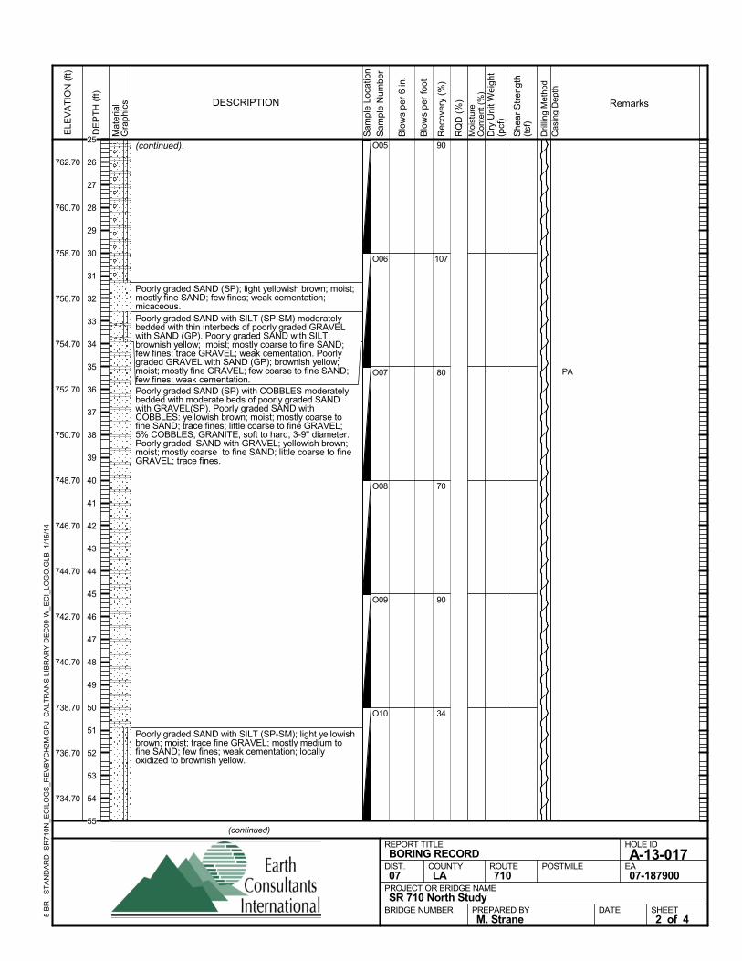
(continued).
Poorly graded SAND (SP); light yellowish brown; moist;mostly fine SAND; few fines; weak cementation;micaceous.Poorly graded SAND with SILT (SP-SM) moderatelybedded with thin interbeds of poorly graded GRAVELwith SAND (GP). Poorly graded SAND with SILT;brownish yellow; moist; mostly coarse to fine SAND;few fines; trace GRAVEL; weak cementation. Poorlygraded GRAVEL with SAND (GP); brownish yellow;moist; mostly fine GRAVEL; few coarse to fine SAND;few fines; weak cementation.Poorly graded SAND (SP) with COBBLES moderatelybedded with moderate beds of poorly graded SANDwith GRAVEL(SP). Poorly graded SAND withCOBBLES: yellowish brown; moist; mostly coarse tofine SAND; trace fines; little coarse to fine GRAVEL;5% COBBLES, GRANITE, soft to hard, 3-9'' diameter.Poorly graded SAND with GRAVEL; yellowish brown;moist; mostly coarse to fine SAND; little coarse to fineGRAVEL; trace fines.
Poorly graded SAND with SILT (SP-SM); light yellowishbrown; moist; trace fine GRAVEL; mostly medium tofine SAND; few fines; weak cementation; locallyoxidized to brownish yellow.
90
107
80
70
90
34
O05
O06
O07
O08
O09
O10
PAS
ampl
e Lo
catio
n
COUNTYLA
DESCRIPTION
Rec
over
y (%
)
Dril
ling
Met
hod
Cas
ing
Dep
th
PREPARED BYM. Strane
DATE
PROJECT OR BRIDGE NAMESR 710 North Study
BRIDGE NUMBER
HOLE ID
A-13-017EA07-187900
REPORT TITLEBORING RECORD
DIST.07
ROUTE710
POSTMILE
(continued)
SHEET2 of 4
RQ
D (
%)
Sam
ple
Num
ber
Moi
stur
eC
onte
nt (
%)
Remarks
Blo
ws
per
6 in
.
ELE
VA
TIO
N (
ft)
762.70
760.70
758.70
756.70
754.70
752.70
750.70
748.70
746.70
744.70
742.70
740.70
738.70
736.70
734.70
DE
PT
H (
ft)
Dry
Uni
t Wei
ght
(pcf
)
She
ar S
tren
gth
(tsf
)
Blo
ws
per
foot
Mat
eria
lG
rap
hics
5 B
R -
ST
AN
DA
RD
SR
710N
_EC
ILO
GS
_RE
VB
YC
H2M
.GP
J C
ALT
RA
NS
LIB
RA
RY
DE
C09
-W_E
CI_
LOG
O.G
LB
1/1
5/14
25
26
27
28
29
30
31
32
33
34
35
36
37
38
39
40
41
42
43
44
45
46
47
48
49
50
51
52
53
54
55
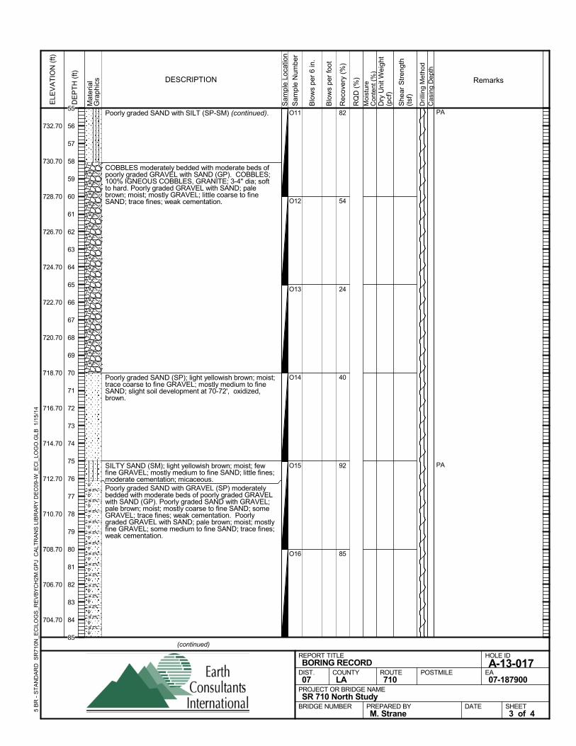
Poorly graded SAND with SILT (SP-SM) (continued).
COBBLES moderately bedded with moderate beds ofpoorly graded GRAVEL with SAND (GP). COBBLES;100% IGNEOUS COBBLES, GRANITE; 3-4" dia; softto hard. Poorly graded GRAVEL with SAND; palebrown; moist; mostly GRAVEL; little coarse to fineSAND; trace fines; weak cementation.
Poorly graded SAND (SP); light yellowish brown; moist;trace coarse to fine GRAVEL; mostly medium to fineSAND; slight soil development at 70-72', oxidized,brown.
SILTY SAND (SM); light yellowish brown; moist; fewfine GRAVEL; mostly medium to fine SAND; little fines;moderate cementation; micaceous.Poorly graded SAND with GRAVEL (SP) moderatelybedded with moderate beds of poorly graded GRAVELwith SAND (GP). Poorly graded SAND with GRAVEL;pale brown; moist; mostly coarse to fine SAND; someGRAVEL; trace fines; weak cementation. Poorlygraded GRAVEL with SAND; pale brown; moist; mostlyfine GRAVEL; some medium to fine SAND; trace fines;weak cementation.
82
54
24
40
92
85
O11
O12
O13
O14
O15
O16
PA
PA
Sam
ple
Loca
tion
COUNTYLA
DESCRIPTION
Rec
over
y (%
)
Dril
ling
Met
hod
Cas
ing
Dep
th
PREPARED BYM. Strane
DATE
PROJECT OR BRIDGE NAMESR 710 North Study
BRIDGE NUMBER
HOLE ID
A-13-017EA07-187900
REPORT TITLEBORING RECORD
DIST.07
ROUTE710
POSTMILE
(continued)
SHEET3 of 4
RQ
D (
%)
Sam
ple
Num
ber
Moi
stur
eC
onte
nt (
%)
Remarks
Blo
ws
per
6 in
.
ELE
VA
TIO
N (
ft)
732.70
730.70
728.70
726.70
724.70
722.70
720.70
718.70
716.70
714.70
712.70
710.70
708.70
706.70
704.70
DE
PT
H (
ft)
Dry
Uni
t Wei
ght
(pcf
)
She
ar S
tren
gth
(tsf
)
Blo
ws
per
foot
Mat
eria
lG
rap
hics
5 B
R -
ST
AN
DA
RD
SR
710N
_EC
ILO
GS
_RE
VB
YC
H2M
.GP
J C
ALT
RA
NS
LIB
RA
RY
DE
C09
-W_E
CI_
LOG
O.G
LB
1/1
5/14
55
56
57
58
59
60
61
62
63
64
65
66
67
68
69
70
71
72
73
74
75
76
77
78
79
80
81
82
83
84
85
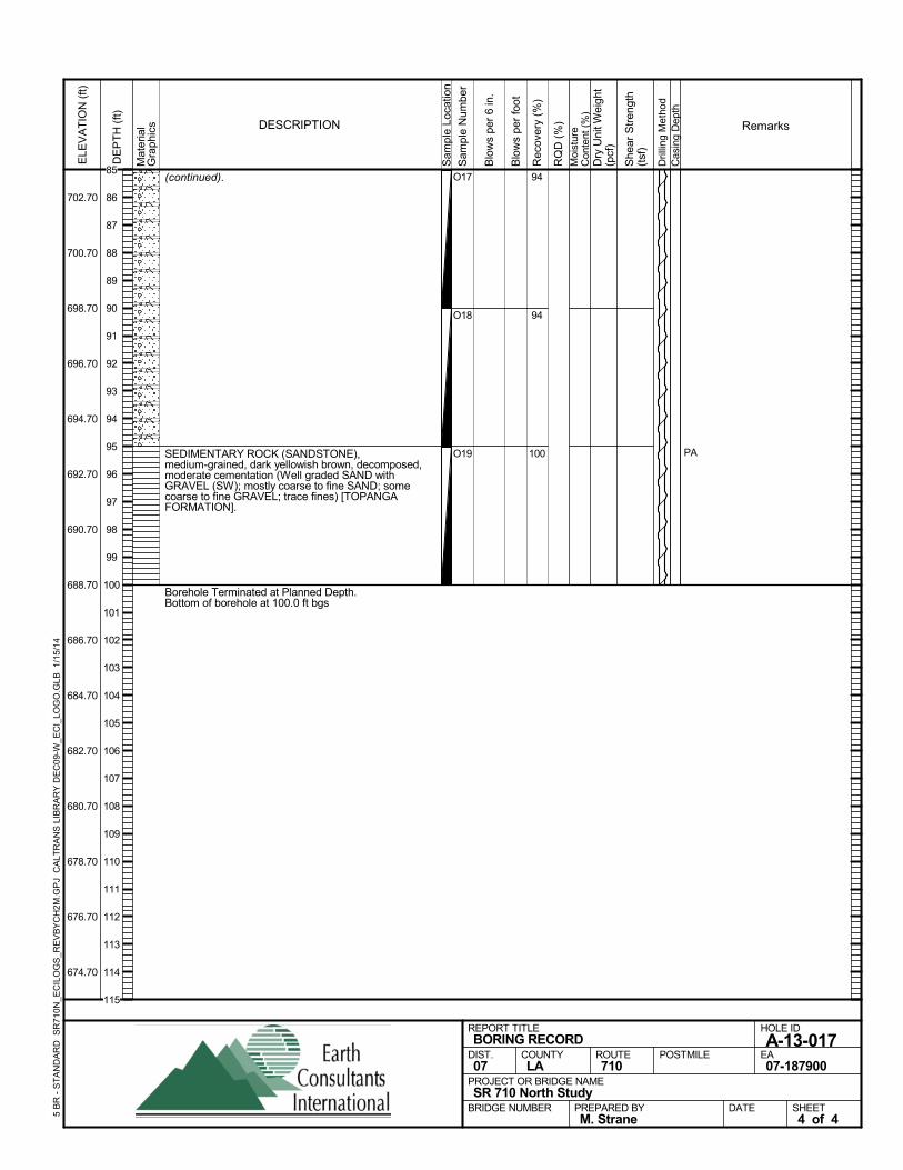
(continued).
SEDIMENTARY ROCK (SANDSTONE),medium-grained, dark yellowish brown, decomposed,moderate cementation (Well graded SAND withGRAVEL (SW); mostly coarse to fine SAND; somecoarse to fine GRAVEL; trace fines) [TOPANGAFORMATION].
Borehole Terminated at Planned Depth.Bottom of borehole at 100.0 ft bgs
94
94
100
O17
O18
O19 PAS
ampl
e Lo
catio
n
COUNTYLA
DESCRIPTION
Rec
over
y (%
)
Dril
ling
Met
hod
Cas
ing
Dep
th
PREPARED BYM. Strane
DATE
PROJECT OR BRIDGE NAMESR 710 North Study
BRIDGE NUMBER
HOLE ID
A-13-017EA07-187900
REPORT TITLEBORING RECORD
DIST.07
ROUTE710
POSTMILE
SHEET4 of 4
RQ
D (
%)
Sam
ple
Num
ber
Moi
stur
eC
onte
nt (
%)
Remarks
Blo
ws
per
6 in
.
ELE
VA
TIO
N (
ft)
702.70
700.70
698.70
696.70
694.70
692.70
690.70
688.70
686.70
684.70
682.70
680.70
678.70
676.70
674.70
DE
PT
H (
ft)
Dry
Uni
t Wei
ght
(pcf
)
She
ar S
tren
gth
(tsf
)
Blo
ws
per
foot
Mat
eria
lG
rap
hics
5 B
R -
ST
AN
DA
RD
SR
710N
_EC
ILO
GS
_RE
VB
YC
H2M
.GP
J C
ALT
RA
NS
LIB
RA
RY
DE
C09
-W_E
CI_
LOG
O.G
LB
1/1
5/14
85
86
87
88
89
90
91
92
93
94
95
96
97
98
99
100
101
102
103
104
105
106
107
108
109
110
111
112
113
114
115
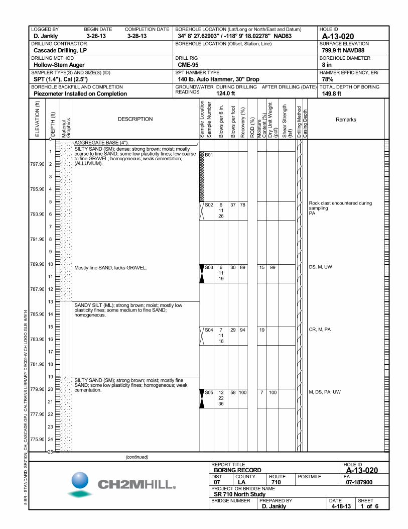
AGGREGATE BASE (4").SILTY SAND (SM); dense; strong brown; moist; mostlycoarse to fine SAND; some low plasticity fines; few coarseto fine GRAVEL; homogeneous; weak cementation;(ALLUVIUM).
Mostly fine SAND; lacks GRAVEL.
SANDY SILT (ML); strong brown; moist; mostly lowplasticity fines; some medium to fine SAND;homogeneous.
SILTY SAND (SM); strong brown; moist; mostly fineSAND; some low plasticity fines; homogeneous; weakcementation.
78
89
94
100
B01
S02
S03
S04
S05
15
19
7
Rock clast encountered duringsamplingPA
DS, M, UW
CR, M, PA
M, DS, PA, UW
61126
61119
71118
122236
99
100
AFTER DRILLING (DATE)DURING DRILLING
124.0 ft
SURFACE ELEVATION
799.9 ft NAVD88DRILLING METHOD
Hollow-Stem AugerDRILL RIG
CME-95SPT HAMMER TYPE
140 lb. Auto Hammer, 30" DropBOREHOLE BACKFILL AND COMPLETION
Piezometer Installed on CompletionGROUNDWATERREADINGS
BEGIN DATE
3-26-13COMPLETION DATE
3-28-13LOGGED BY
D. JanklyBOREHOLE LOCATION (Lat/Long or North/East and Datum)
34° 8' 27.62903" / -118° 9' 18.02278" NAD83HOLE ID
A-13-020DRILLING CONTRACTOR
Cascade Drilling, LP
HAMMER EFFICIENCY, ERi
78%SAMPLER TYPE(S) AND SIZE(S) (ID)
SPT (1.4"), Cal (2.5")TOTAL DEPTH OF BORING
149.8 ft
BOREHOLE DIAMETER
8 in
BOREHOLE LOCATION (Offset, Station, Line)
.M
ater
ial
Gra
phic
s
Sam
ple
Loca
tion
COUNTYLA
DESCRIPTION
Rec
over
y (%
)
Dri
lling
Met
hod
Cas
ing
Dep
th
PREPARED BYD. Jankly
DATE4-18-13
PROJECT OR BRIDGE NAMESR 710 North Study
BRIDGE NUMBER
HOLE ID
A-13-020EA07-187900
REPORT TITLEBORING RECORD
DIST.07
ROUTE710
POSTMILE
(continued)
SHEET1 of 6
RQ
D (
%)
Sam
ple
Num
ber
Moi
stur
eC
onte
nt (
%)
Remarks
Blo
ws
per
6 in
.
ELE
VA
TIO
N (
ft)
797.90
795.90
793.90
791.90
789.90
787.90
785.90
783.90
781.90
779.90
777.90
775.90
DE
PT
H (
ft)
Dry
Uni
t W
eigh
t(p
cf)
She
ar S
tren
gth
(tsf
)
Blo
ws
per
foot
5 B
R -
ST
AN
DA
RD
SR
710
N_C
H_C
AS
CA
DE
.GP
J C
ALT
RA
NS
LIB
RA
RY
DE
C09
-W C
H L
OG
O.G
LB 6
/9/1
4
37
30
29
58
0
1
2
3
4
5
6
7
8
9
10
11
12
13
14
15
16
17
18
19
20
21
22
23
24
25
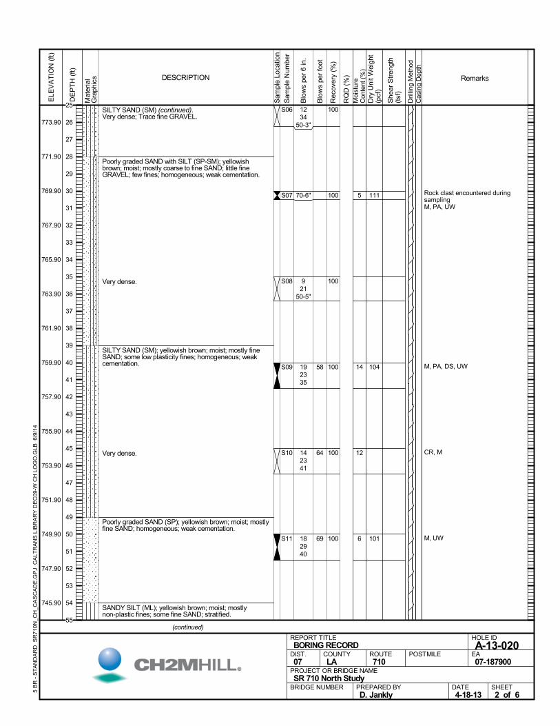
SILTY SAND (SM) (continued).Very dense; Trace fine GRAVEL.
Poorly graded SAND with SILT (SP-SM); yellowishbrown; moist; mostly coarse to fine SAND; little fineGRAVEL; few fines; homogeneous; weak cementation.
Very dense.
SILTY SAND (SM); yellowish brown; moist; mostly fineSAND; some low plasticity fines; homogeneous; weakcementation.
Very dense.
Poorly graded SAND (SP); yellowish brown; moist; mostlyfine SAND; homogeneous; weak cementation.
SANDY SILT (ML); yellowish brown; moist; mostlynon-plastic fines; some fine SAND; stratified.
100
100
100
100
100
100
S06
S07
S08
S09
S10
S11
5
14
12
6
Rock clast encountered duringsamplingM, PA, UW
M, PA, DS, UW
CR, M
M, UW
1234
50-3"
70-6"
921
50-5"
192335
142341
182940
111
104
101
Mat
eria
lG
raph
ics
Sam
ple
Loca
tion
COUNTYLA
DESCRIPTION
Rec
over
y (%
)
Dri
lling
Met
hod
Cas
ing
Dep
th
PREPARED BYD. Jankly
DATE4-18-13
PROJECT OR BRIDGE NAMESR 710 North Study
BRIDGE NUMBER
HOLE ID
A-13-020EA07-187900
REPORT TITLEBORING RECORD
DIST.07
ROUTE710
POSTMILE
(continued)
SHEET2 of 6
RQ
D (
%)
Sam
ple
Num
ber
Moi
stur
eC
onte
nt (
%)
Remarks
Blo
ws
per
6 in
.
ELE
VA
TIO
N (
ft)
773.90
771.90
769.90
767.90
765.90
763.90
761.90
759.90
757.90
755.90
753.90
751.90
749.90
747.90
745.90
DE
PT
H (
ft)
Dry
Uni
t W
eigh
t(p
cf)
She
ar S
tren
gth
(tsf
)
Blo
ws
per
foot
5 B
R -
ST
AN
DA
RD
SR
710
N_C
H_C
AS
CA
DE
.GP
J C
ALT
RA
NS
LIB
RA
RY
DE
C09
-W C
H L
OG
O.G
LB 6
/9/1
4
58
64
69
25
26
27
28
29
30
31
32
33
34
35
36
37
38
39
40
41
42
43
44
45
46
47
48
49
50
51
52
53
54
55
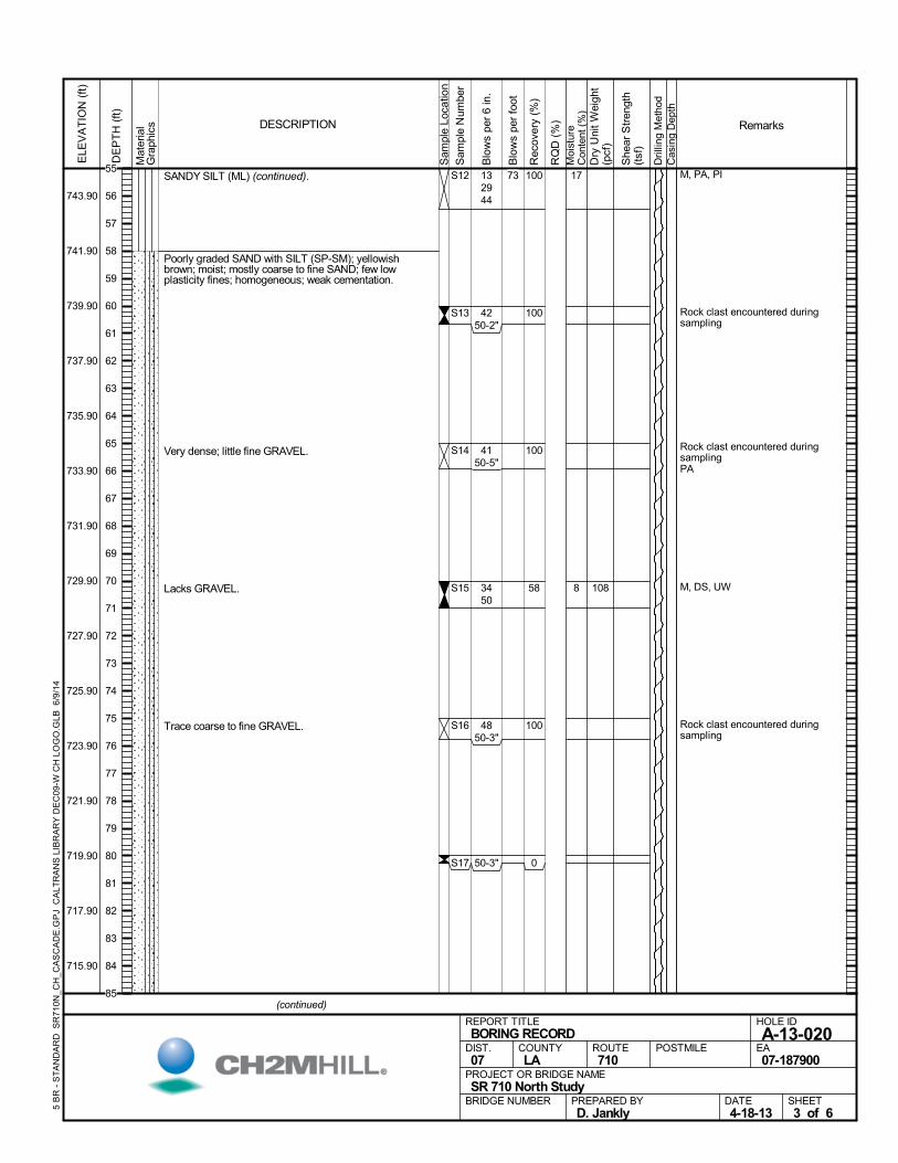
SANDY SILT (ML) (continued).
Poorly graded SAND with SILT (SP-SM); yellowishbrown; moist; mostly coarse to fine SAND; few lowplasticity fines; homogeneous; weak cementation.
Very dense; little fine GRAVEL.
Lacks GRAVEL.
Trace coarse to fine GRAVEL.
100
100
100
58
100
0
S12
S13
S14
S15
S16
S17
17
8
M, PA, PI
Rock clast encountered duringsampling
Rock clast encountered duringsamplingPA
M, DS, UW
Rock clast encountered duringsampling
132944
4250-2"
4150-5"
3450
4850-3"
50-3"
108
Mat
eria
lG
raph
ics
Sam
ple
Loca
tion
COUNTYLA
DESCRIPTION
Rec
over
y (%
)
Dri
lling
Met
hod
Cas
ing
Dep
th
PREPARED BYD. Jankly
DATE4-18-13
PROJECT OR BRIDGE NAMESR 710 North Study
BRIDGE NUMBER
HOLE ID
A-13-020EA07-187900
REPORT TITLEBORING RECORD
DIST.07
ROUTE710
POSTMILE
(continued)
SHEET3 of 6
RQ
D (
%)
Sam
ple
Num
ber
Moi
stur
eC
onte
nt (
%)
Remarks
Blo
ws
per
6 in
.
ELE
VA
TIO
N (
ft)
743.90
741.90
739.90
737.90
735.90
733.90
731.90
729.90
727.90
725.90
723.90
721.90
719.90
717.90
715.90
DE
PT
H (
ft)
Dry
Uni
t W
eigh
t(p
cf)
She
ar S
tren
gth
(tsf
)
Blo
ws
per
foot
5 B
R -
ST
AN
DA
RD
SR
710
N_C
H_C
AS
CA
DE
.GP
J C
ALT
RA
NS
LIB
RA
RY
DE
C09
-W C
H L
OG
O.G
LB 6
/9/1
4
7355
56
57
58
59
60
61
62
63
64
65
66
67
68
69
70
71
72
73
74
75
76
77
78
79
80
81
82
83
84
85
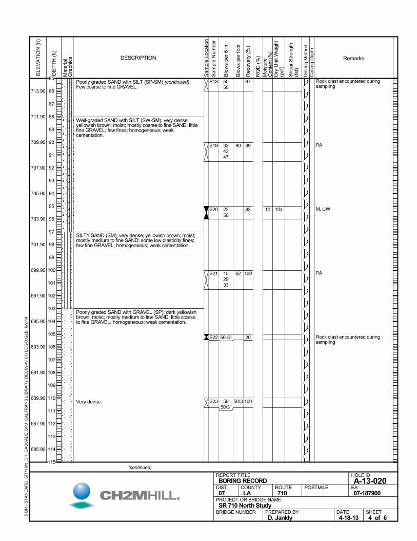
Poorly graded SAND with SILT (SP-SM) (continued).Few coarse to fine GRAVEL.
Well-graded SAND with SILT (SW-SM); very dense;yellowish brown; moist; mostly coarse to fine SAND; littlefine GRAVEL; few fines; homogeneous; weakcementation.
SILTY SAND (SM); very dense; yellowish brown; moist;mostly medium to fine SAND; some low plasticity fines;few fine GRAVEL; homogeneous; weak cementation.
Poorly graded SAND with GRAVEL (SP); dark yellowishbrown; moist; mostly medium to fine SAND; little coarseto fine GRAVEL; homogeneous; weak cementation.
Very dense.
67
89
83
100
20
100
S18
S19
S20
S21
S22
S23
10
Rock clast encountered duringsampling
PA
M, UW
PA
Rock clast encountered duringsampling
5050
324347
2250
152933
50-5"
5050/3"
104
Mat
eria
lG
raph
ics
Sam
ple
Loca
tion
COUNTYLA
DESCRIPTION
Rec
over
y (%
)
Dri
lling
Met
hod
Cas
ing
Dep
th
PREPARED BYD. Jankly
DATE4-18-13
PROJECT OR BRIDGE NAMESR 710 North Study
BRIDGE NUMBER
HOLE ID
A-13-020EA07-187900
REPORT TITLEBORING RECORD
DIST.07
ROUTE710
POSTMILE
(continued)
SHEET4 of 6
RQ
D (
%)
Sam
ple
Num
ber
Moi
stur
eC
onte
nt (
%)
Remarks
Blo
ws
per
6 in
.
ELE
VA
TIO
N (
ft)
713.90
711.90
709.90
707.90
705.90
703.90
701.90
699.90
697.90
695.90
693.90
691.90
689.90
687.90
685.90
DE
PT
H (
ft)
Dry
Uni
t W
eigh
t(p
cf)
She
ar S
tren
gth
(tsf
)
Blo
ws
per
foot
5 B
R -
ST
AN
DA
RD
SR
710
N_C
H_C
AS
CA
DE
.GP
J C
ALT
RA
NS
LIB
RA
RY
DE
C09
-W C
H L
OG
O.G
LB 6
/9/1
4
90
62
50/3
85
86
87
88
89
90
91
92
93
94
95
96
97
98
99
100
101
102
103
104
105
106
107
108
109
110
111
112
113
114
115
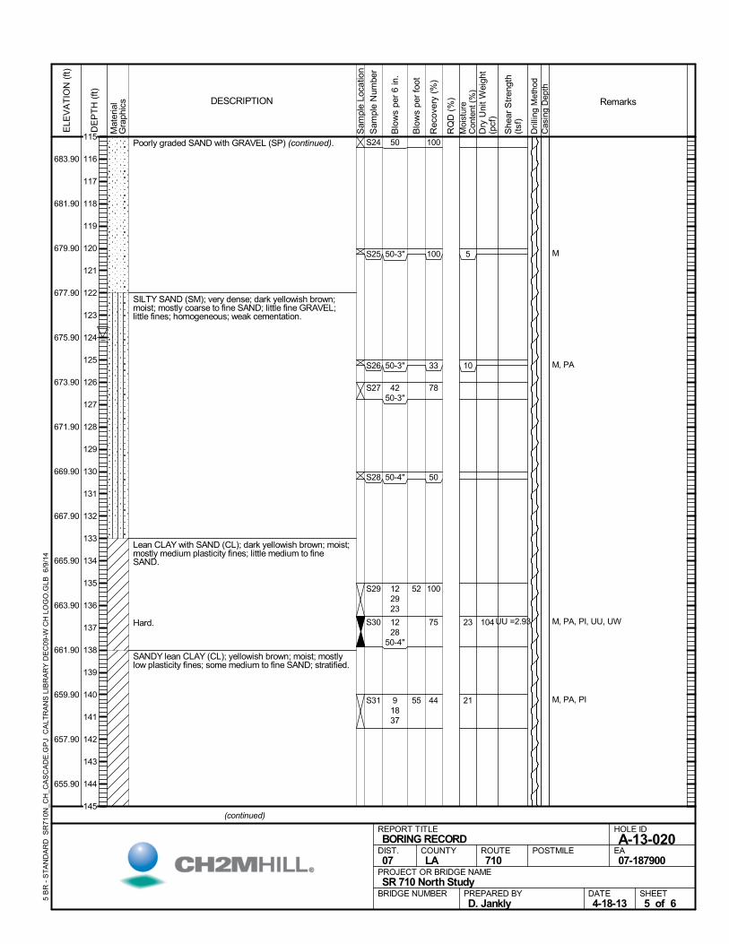
Poorly graded SAND with GRAVEL (SP) (continued).
SILTY SAND (SM); very dense; dark yellowish brown;moist; mostly coarse to fine SAND; little fine GRAVEL;little fines; homogeneous; weak cementation.
Lean CLAY with SAND (CL); dark yellowish brown; moist;mostly medium plasticity fines; little medium to fineSAND.
Hard.
SANDY lean CLAY (CL); yellowish brown; moist; mostlylow plasticity fines; some medium to fine SAND; stratified.
100
100
33
78
50
100
75
44
S24
S25
S26
S27
S28
S29
S30
S31
5
10
23
21
M
M, PA
M, PA, PI, UU, UW
M, PA, PI
50
50-3"
50-3"
4250-3"
50-4"
122923
1228
50-4"
91837
104UU =2.93
Mat
eria
lG
raph
ics
Sam
ple
Loca
tion
COUNTYLA
DESCRIPTION
Rec
over
y (%
)
Dri
lling
Met
hod
Cas
ing
Dep
th
PREPARED BYD. Jankly
DATE4-18-13
PROJECT OR BRIDGE NAMESR 710 North Study
BRIDGE NUMBER
HOLE ID
A-13-020EA07-187900
REPORT TITLEBORING RECORD
DIST.07
ROUTE710
POSTMILE
(continued)
SHEET5 of 6
RQ
D (
%)
Sam
ple
Num
ber
Moi
stur
eC
onte
nt (
%)
Remarks
Blo
ws
per
6 in
.
ELE
VA
TIO
N (
ft)
683.90
681.90
679.90
677.90
675.90
673.90
671.90
669.90
667.90
665.90
663.90
661.90
659.90
657.90
655.90
DE
PT
H (
ft)
Dry
Uni
t W
eigh
t(p
cf)
She
ar S
tren
gth
(tsf
)
Blo
ws
per
foot
5 B
R -
ST
AN
DA
RD
SR
710
N_C
H_C
AS
CA
DE
.GP
J C
ALT
RA
NS
LIB
RA
RY
DE
C09
-W C
H L
OG
O.G
LB 6
/9/1
4
52
55
115
116
117
118
119
120
121
122
123
124
125
126
127
128
129
130
131
132
133
134
135
136
137
138
139
140
141
142
143
144
145
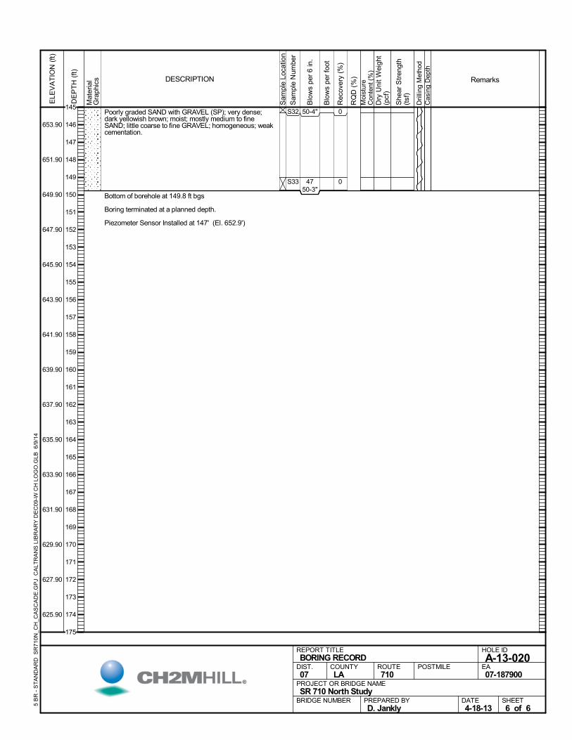
Poorly graded SAND with GRAVEL (SP); very dense;dark yellowish brown; moist; mostly medium to fineSAND; little coarse to fine GRAVEL; homogeneous; weakcementation.
Bottom of borehole at 149.8 ft bgs
Boring terminated at a planned depth.
Piezometer Sensor Installed at 147' (El. 652.9')
0
0
S32
S33
50-4"
4750-3"
Mat
eria
lG
raph
ics
Sam
ple
Loca
tion
COUNTYLA
DESCRIPTION
Rec
over
y (%
)
Dri
lling
Met
hod
Cas
ing
Dep
th
PREPARED BYD. Jankly
DATE4-18-13
PROJECT OR BRIDGE NAMESR 710 North Study
BRIDGE NUMBER
HOLE ID
A-13-020EA07-187900
REPORT TITLEBORING RECORD
DIST.07
ROUTE710
POSTMILE
SHEET6 of 6
RQ
D (
%)
Sam
ple
Num
ber
Moi
stur
eC
onte
nt (
%)
Remarks
Blo
ws
per
6 in
.
ELE
VA
TIO
N (
ft)
653.90
651.90
649.90
647.90
645.90
643.90
641.90
639.90
637.90
635.90
633.90
631.90
629.90
627.90
625.90
DE
PT
H (
ft)
Dry
Uni
t W
eigh
t(p
cf)
She
ar S
tren
gth
(tsf
)
Blo
ws
per
foot
5 B
R -
ST
AN
DA
RD
SR
710
N_C
H_C
AS
CA
DE
.GP
J C
ALT
RA
NS
LIB
RA
RY
DE
C09
-W C
H L
OG
O.G
LB 6
/9/1
4
145
146
147
148
149
150
151
152
153
154
155
156
157
158
159
160
161
162
163
164
165
166
167
168
169
170
171
172
173
174
175
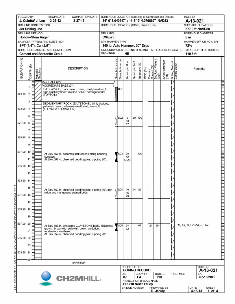
ASPHALT (2").AGGREGATE BASE (2").Fat CLAY (CH); dark brown; moist; mostly medium tohigh plasticity fines; few fine SAND; homogeneous;(TOPSOIL).
SEDIMENTARY ROCK, (SILTSTONE); thinly bedded;yellowish brown; intensely weathered; very soft.(TOPANGA FORMATION).
At Elev 567.9', becomes soft; caliche along beddingsurfaces.
At Elev 567.4', observed bedding joint, dipping 20°.
At Elev 562.9', observed bedding joint, dipping 30°, ironoxide and manganese stained beds.
At Elev 557.9', with some CLAYSTONE beds. Becomesgrayish brown with yellowish brown oxidation;moderately weathered.
At Elev 557.4', observed bedding joint, dipping 20°.
100
100
89
67
B01
S02
S03
S04
S05 21 M, PA, PI, UC=54psi, UW
91317
2042
50-5"
101529
2472
99
AFTER DRILLING (DATE)DURING DRILLING
NE
SURFACE ELEVATION
577.9 ft NAVD88DRILLING METHOD
Hollow-Stem AugerDRILL RIG
CME-75SPT HAMMER TYPE
140 lb. Auto Hammer, 30" DropBOREHOLE BACKFILL AND COMPLETION
Cement and Bentonite GroutGROUNDWATERREADINGS
BEGIN DATE
3-26-13COMPLETION DATE
3-27-13LOGGED BY
J. Culotta/ J. LeeBOREHOLE LOCATION (Lat/Long or North/East and Datum)
34° 6' 8.040517" / -118° 9' 4.076669" NAD83HOLE ID
A-13-021DRILLING CONTRACTOR
Jet Drilling, Inc
HAMMER EFFICIENCY, ERi
72%SAMPLER TYPE(S) AND SIZE(S) (ID)
SPT (1.4"), Cal (2.5")TOTAL DEPTH OF BORING
110.8 ft
BOREHOLE DIAMETER
8 in
BOREHOLE LOCATION (Offset, Station, Line)
.M
ater
ial
Gra
phic
s
Sam
ple
Loca
tion
COUNTYLA
DESCRIPTION
Rec
over
y (%
)
Dri
lling
Met
hod
Cas
ing
Dep
th
PREPARED BYD. Jankly
DATE4-18-13
PROJECT OR BRIDGE NAMESR 710 North Study
BRIDGE NUMBER
HOLE ID
A-13-021EA07-187900
REPORT TITLEBORING RECORD
DIST.07
ROUTE710
POSTMILE
(continued)
SHEET1 of 4
RQ
D (
%)
Sam
ple
Num
ber
Moi
stur
eC
onte
nt (
%)
Remarks
Blo
ws
per
6 in
.
ELE
VA
TIO
N (
ft)
575.90
573.90
571.90
569.90
567.90
565.90
563.90
561.90
559.90
557.90
555.90
553.90
DE
PT
H (
ft)
Dry
Uni
t W
eigh
t(p
cf)
She
ar S
tren
gth
(tsf
)
Blo
ws
per
foot
5 B
R -
ST
AN
DA
RD
SR
710
N_C
H_J
ET
.GP
J C
ALT
RA
NS
LIB
RA
RY
DE
C09
-W C
H L
OG
O.G
LB 6
/9/1
4
30
44
0
1
2
3
4
5
6
7
8
9
10
11
12
13
14
15
16
17
18
19
20
21
22
23
24
25
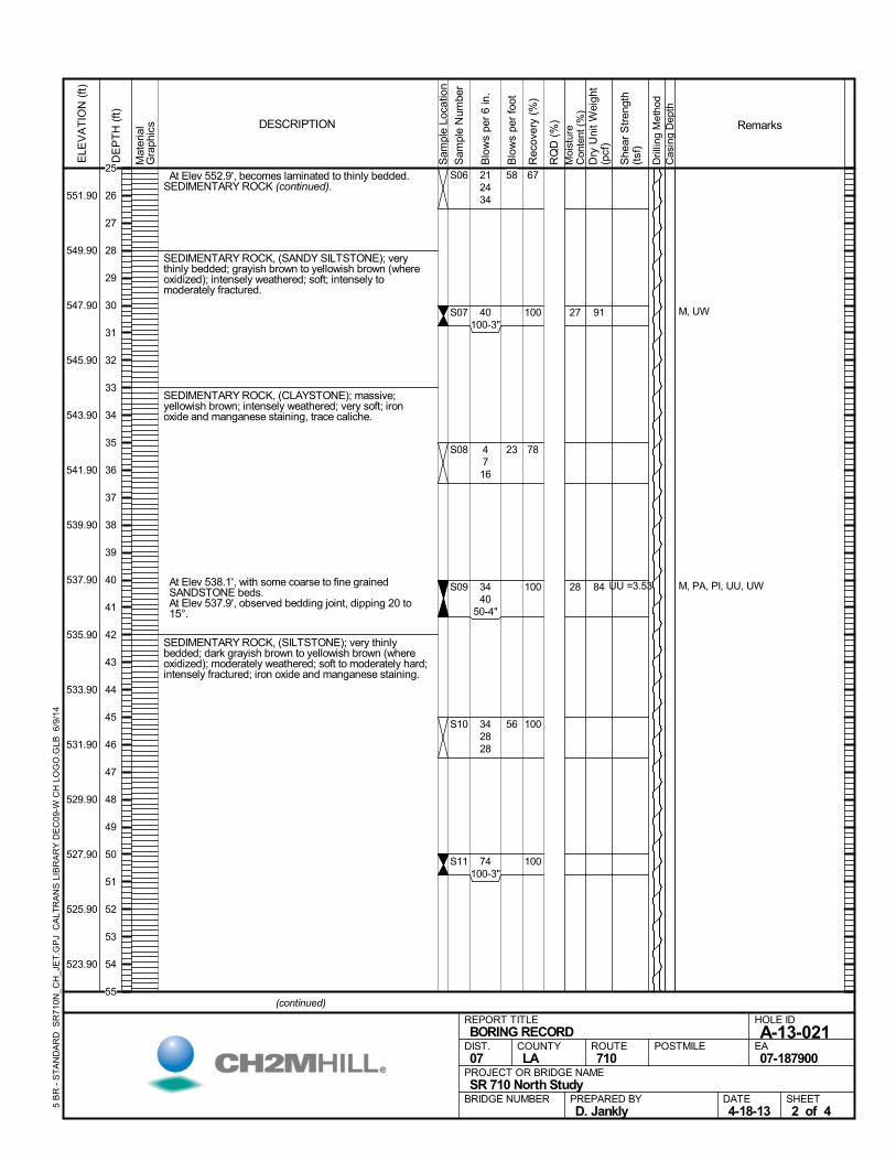
At Elev 552.9', becomes laminated to thinly bedded.SEDIMENTARY ROCK (continued).
SEDIMENTARY ROCK, (SANDY SILTSTONE); verythinly bedded; grayish brown to yellowish brown (whereoxidized); intensely weathered; soft; intensely tomoderately fractured.
SEDIMENTARY ROCK, (CLAYSTONE); massive;yellowish brown; intensely weathered; very soft; ironoxide and manganese staining, trace caliche.
At Elev 538.1', with some coarse to fine grainedSANDSTONE beds.
At Elev 537.9', observed bedding joint, dipping 20 to15°.
SEDIMENTARY ROCK, (SILTSTONE); very thinlybedded; dark grayish brown to yellowish brown (whereoxidized); moderately weathered; soft to moderately hard;intensely fractured; iron oxide and manganese staining.
67
100
78
100
100
100
S06
S07
S08
S09
S10
S11
27
28
M, UW
M, PA, PI, UU, UW
212434
40100-3"
4716
3440
50-4"
342828
74100-3"
91
84 UU =3.53
Mat
eria
lG
raph
ics
Sam
ple
Loca
tion
COUNTYLA
DESCRIPTION
Rec
over
y (%
)
Dri
lling
Met
hod
Cas
ing
Dep
th
PREPARED BYD. Jankly
DATE4-18-13
PROJECT OR BRIDGE NAMESR 710 North Study
BRIDGE NUMBER
HOLE ID
A-13-021EA07-187900
REPORT TITLEBORING RECORD
DIST.07
ROUTE710
POSTMILE
(continued)
SHEET2 of 4
RQ
D (
%)
Sam
ple
Num
ber
Moi
stur
eC
onte
nt (
%)
Remarks
Blo
ws
per
6 in
.
ELE
VA
TIO
N (
ft)
551.90
549.90
547.90
545.90
543.90
541.90
539.90
537.90
535.90
533.90
531.90
529.90
527.90
525.90
523.90
DE
PT
H (
ft)
Dry
Uni
t W
eigh
t(p
cf)
She
ar S
tren
gth
(tsf
)
Blo
ws
per
foot
5 B
R -
ST
AN
DA
RD
SR
710
N_C
H_J
ET
.GP
J C
ALT
RA
NS
LIB
RA
RY
DE
C09
-W C
H L
OG
O.G
LB 6
/9/1
4
58
23
56
25
26
27
28
29
30
31
32
33
34
35
36
37
38
39
40
41
42
43
44
45
46
47
48
49
50
51
52
53
54
55
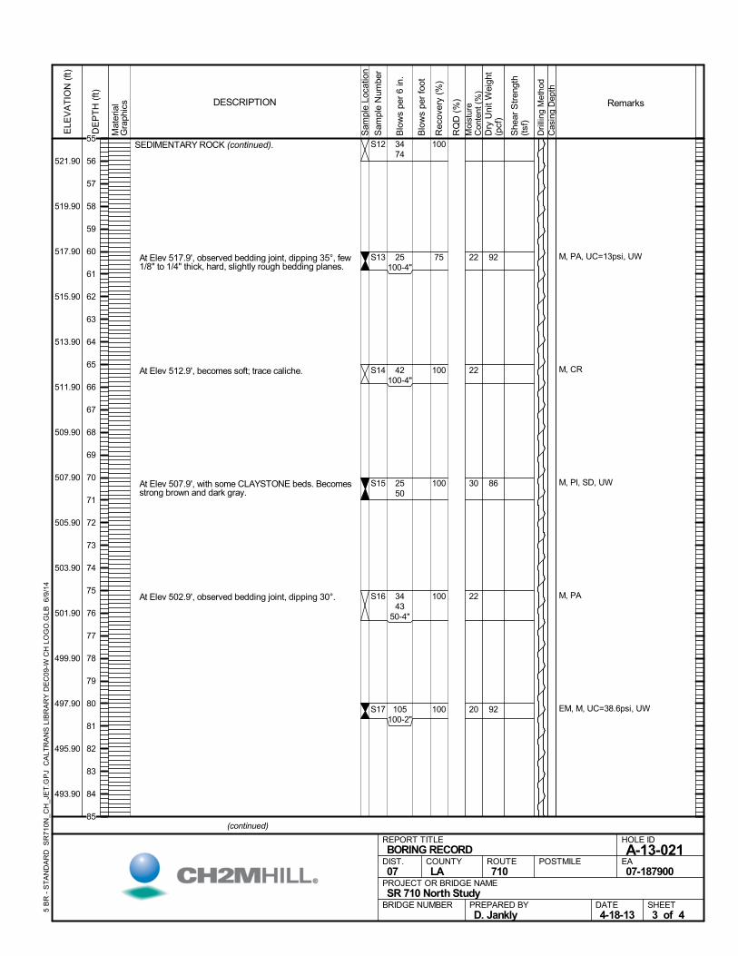
SEDIMENTARY ROCK (continued).
At Elev 517.9', observed bedding joint, dipping 35°, few1/8" to 1/4" thick, hard, slightly rough bedding planes.
At Elev 512.9', becomes soft; trace caliche.
At Elev 507.9', with some CLAYSTONE beds. Becomesstrong brown and dark gray.
At Elev 502.9', observed bedding joint, dipping 30°.
100
75
100
100
100
100
S12
S13
S14
S15
S16
S17
22
22
30
22
20
M, PA, UC=13psi, UW
M, CR
M, PI, SD, UW
M, PA
EM, M, UC=38.6psi, UW
3474
25100-4"
42100-4"
2550
3443
50-4"
105100-2"
92
86
92
Mat
eria
lG
raph
ics
Sam
ple
Loca
tion
COUNTYLA
DESCRIPTION
Rec
over
y (%
)
Dri
lling
Met
hod
Cas
ing
Dep
th
PREPARED BYD. Jankly
DATE4-18-13
PROJECT OR BRIDGE NAMESR 710 North Study
BRIDGE NUMBER
HOLE ID
A-13-021EA07-187900
REPORT TITLEBORING RECORD
DIST.07
ROUTE710
POSTMILE
(continued)
SHEET3 of 4
RQ
D (
%)
Sam
ple
Num
ber
Moi
stur
eC
onte
nt (
%)
Remarks
Blo
ws
per
6 in
.
ELE
VA
TIO
N (
ft)
521.90
519.90
517.90
515.90
513.90
511.90
509.90
507.90
505.90
503.90
501.90
499.90
497.90
495.90
493.90
DE
PT
H (
ft)
Dry
Uni
t W
eigh
t(p
cf)
She
ar S
tren
gth
(tsf
)
Blo
ws
per
foot
5 B
R -
ST
AN
DA
RD
SR
710
N_C
H_J
ET
.GP
J C
ALT
RA
NS
LIB
RA
RY
DE
C09
-W C
H L
OG
O.G
LB 6
/9/1
4
55
56
57
58
59
60
61
62
63
64
65
66
67
68
69
70
71
72
73
74
75
76
77
78
79
80
81
82
83
84
85
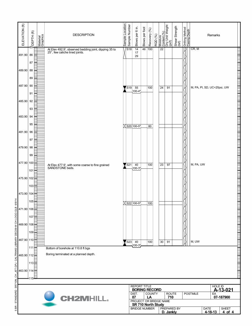
At Elev 492.9', observed bedding joint, dipping 35 to25°, few caliche lined joints.
At Elev 477.9', with some coarse to fine grainedSANDSTONE beds.
Bottom of borehole at 110.8 ft bgs
Boring terminated at a planned depth.
100
100
80
100
100
100
S18
S19
S20
S21
S22
S23
22
24
23
30
CR, M
M, PA, PI, SD, UC=20psi, UW
M, PA, UW
M, UW
141729
55100-4"
100-5"
40100-3"
100-5"
40100-3"
91
97
91
Mat
eria
lG
raph
ics
Sam
ple
Loca
tion
COUNTYLA
DESCRIPTION
Rec
over
y (%
)
Dri
lling
Met
hod
Cas
ing
Dep
th
PREPARED BYD. Jankly
DATE4-18-13
PROJECT OR BRIDGE NAMESR 710 North Study
BRIDGE NUMBER
HOLE ID
A-13-021EA07-187900
REPORT TITLEBORING RECORD
DIST.07
ROUTE710
POSTMILE
SHEET4 of 4
RQ
D (
%)
Sam
ple
Num
ber
Moi
stur
eC
onte
nt (
%)
Remarks
Blo
ws
per
6 in
.
ELE
VA
TIO
N (
ft)
491.90
489.90
487.90
485.90
483.90
481.90
479.90
477.90
475.90
473.90
471.90
469.90
467.90
465.90
463.90
DE
PT
H (
ft)
Dry
Uni
t W
eigh
t(p
cf)
She
ar S
tren
gth
(tsf
)
Blo
ws
per
foot
5 B
R -
ST
AN
DA
RD
SR
710
N_C
H_J
ET
.GP
J C
ALT
RA
NS
LIB
RA
RY
DE
C09
-W C
H L
OG
O.G
LB 6
/9/1
4
4685
86
87
88
89
90
91
92
93
94
95
96
97
98
99
100
101
102
103
104
105
106
107
108
109
110
111
112
113
114
115
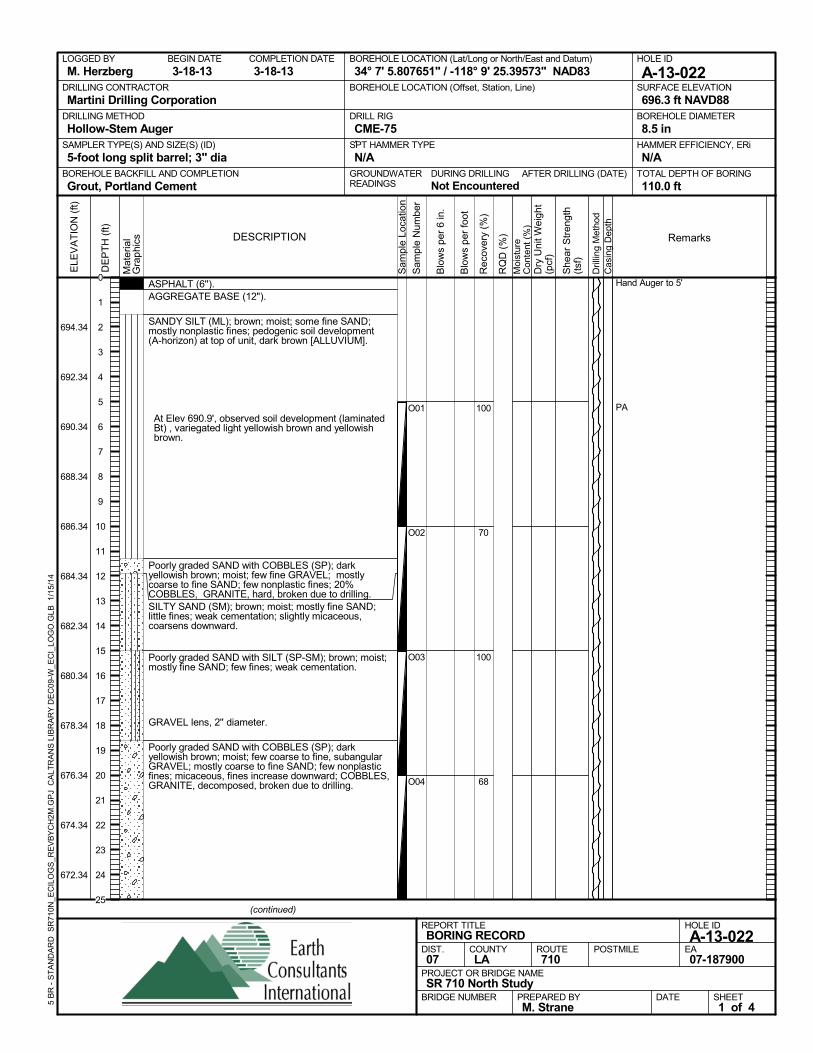
ASPHALT (6'').AGGREGATE BASE (12").
SANDY SILT (ML); brown; moist; some fine SAND;mostly nonplastic fines; pedogenic soil development(A-horizon) at top of unit, dark brown [ALLUVIUM].
At Elev 690.9', observed soil development (laminatedBt) , variegated light yellowish brown and yellowishbrown.
Poorly graded SAND with COBBLES (SP); darkyellowish brown; moist; few fine GRAVEL; mostlycoarse to fine SAND; few nonplastic fines; 20%COBBLES, GRANITE, hard, broken due to drilling.SILTY SAND (SM); brown; moist; mostly fine SAND;little fines; weak cementation; slightly micaceous,coarsens downward.
Poorly graded SAND with SILT (SP-SM); brown; moist;mostly fine SAND; few fines; weak cementation.
GRAVEL lens, 2'' diameter.
Poorly graded SAND with COBBLES (SP); darkyellowish brown; moist; few coarse to fine, subangularGRAVEL; mostly coarse to fine SAND; few nonplasticfines; micaceous, fines increase downward; COBBLES,GRANITE, decomposed, broken due to drilling.
100
70
100
68
O01
O02
O03
O04
Hand Auger to 5'
PA
AFTER DRILLING (DATE)DURING DRILLINGNot Encountered
SURFACE ELEVATION
696.3 ft NAVD88DRILLING METHOD
Hollow-Stem AugerDRILL RIG
CME-75SPT HAMMER TYPE
N/ABOREHOLE BACKFILL AND COMPLETION
Grout, Portland CementGROUNDWATERREADINGS
BEGIN DATE
3-18-13COMPLETION DATE
3-18-13LOGGED BY
M. HerzbergBOREHOLE LOCATION (Lat/Long or North/East and Datum)
34° 7' 5.807651" / -118° 9' 25.39573" NAD83HOLE ID
A-13-022DRILLING CONTRACTOR
Martini Drilling Corporation
HAMMER EFFICIENCY, ERi
N/ASAMPLER TYPE(S) AND SIZE(S) (ID)
5-foot long split barrel; 3" diaTOTAL DEPTH OF BORING
110.0 ft
BOREHOLE DIAMETER
8.5 in
BOREHOLE LOCATION (Offset, Station, Line)
.
Sam
ple
Loca
tion
COUNTYLA
DESCRIPTION
Rec
over
y (%
)
Dril
ling
Met
hod
Cas
ing
Dep
th
PREPARED BYM. Strane
DATE
PROJECT OR BRIDGE NAMESR 710 North Study
BRIDGE NUMBER
HOLE ID
A-13-022EA07-187900
REPORT TITLEBORING RECORD
DIST.07
ROUTE710
POSTMILE
(continued)
SHEET1 of 4
RQ
D (
%)
Sam
ple
Num
ber
Moi
stur
eC
onte
nt (
%)
Remarks
Blo
ws
per
6 in
.
ELE
VA
TIO
N (
ft)
694.34
692.34
690.34
688.34
686.34
684.34
682.34
680.34
678.34
676.34
674.34
672.34
DE
PT
H (
ft)
Dry
Uni
t Wei
ght
(pcf
)
She
ar S
tren
gth
(tsf
)
Blo
ws
per
foot
Mat
eria
lG
rap
hics
5 B
R -
ST
AN
DA
RD
SR
710N
_EC
ILO
GS
_RE
VB
YC
H2M
.GP
J C
ALT
RA
NS
LIB
RA
RY
DE
C09
-W_E
CI_
LOG
O.G
LB
1/1
5/14
0
1
2
3
4
5
6
7
8
9
10
11
12
13
14
15
16
17
18
19
20
21
22
23
24
25
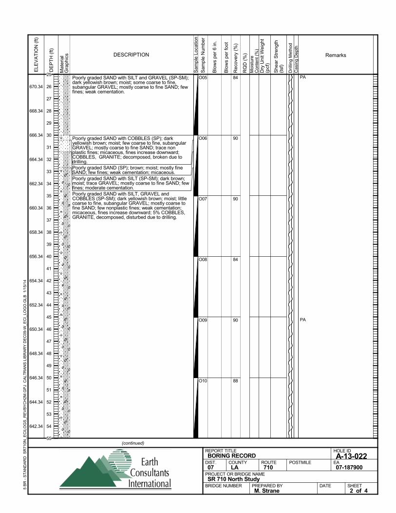
Poorly graded SAND with SILT and GRAVEL (SP-SM);dark yellowish brown; moist; some coarse to fine,subangular GRAVEL; mostly coarse to fine SAND; fewfines; weak cementation.
Poorly graded SAND with COBBLES (SP); darkyellowish brown; moist; few coarse to fine, subangularGRAVEL; mostly coarse to fine SAND; trace nonplastic fines; micaceous, fines increase downward;COBBLES, GRANITE; decomposed, broken due todrilling.Poorly graded SAND (SP); brown; moist; mostly fineSAND; few fines; weak cementation; micaceous.Poorly graded SAND with SILT (SP-SM); dark brown;moist; trace GRAVEL; mostly coarse to fine SAND; fewfines; moderate cementation.Poorly graded SAND with SILT, GRAVEL andCOBBLES (SP-SM); dark yellowish brown; moist; littlecoarse to fine, subangular GRAVEL; mostly coarse tofine SAND; few nonplastic fines; weak cementation;micaceous, fines increase downward; 5% COBBLES,GRANITE, decomposed, disturbed due to drilling.
84
90
90
84
90
88
O05
O06
O07
O08
O09
O10
PA
PA
Sam
ple
Loca
tion
COUNTYLA
DESCRIPTION
Rec
over
y (%
)
Dril
ling
Met
hod
Cas
ing
Dep
th
PREPARED BYM. Strane
DATE
PROJECT OR BRIDGE NAMESR 710 North Study
BRIDGE NUMBER
HOLE ID
A-13-022EA07-187900
REPORT TITLEBORING RECORD
DIST.07
ROUTE710
POSTMILE
(continued)
SHEET2 of 4
RQ
D (
%)
Sam
ple
Num
ber
Moi
stur
eC
onte
nt (
%)
Remarks
Blo
ws
per
6 in
.
ELE
VA
TIO
N (
ft)
670.34
668.34
666.34
664.34
662.34
660.34
658.34
656.34
654.34
652.34
650.34
648.34
646.34
644.34
642.34
DE
PT
H (
ft)
Dry
Uni
t Wei
ght
(pcf
)
She
ar S
tren
gth
(tsf
)
Blo
ws
per
foot
Mat
eria
lG
rap
hics
5 B
R -
ST
AN
DA
RD
SR
710N
_EC
ILO
GS
_RE
VB
YC
H2M
.GP
J C
ALT
RA
NS
LIB
RA
RY
DE
C09
-W_E
CI_
LOG
O.G
LB
1/1
5/14
25
26
27
28
29
30
31
32
33
34
35
36
37
38
39
40
41
42
43
44
45
46
47
48
49
50
51
52
53
54
55
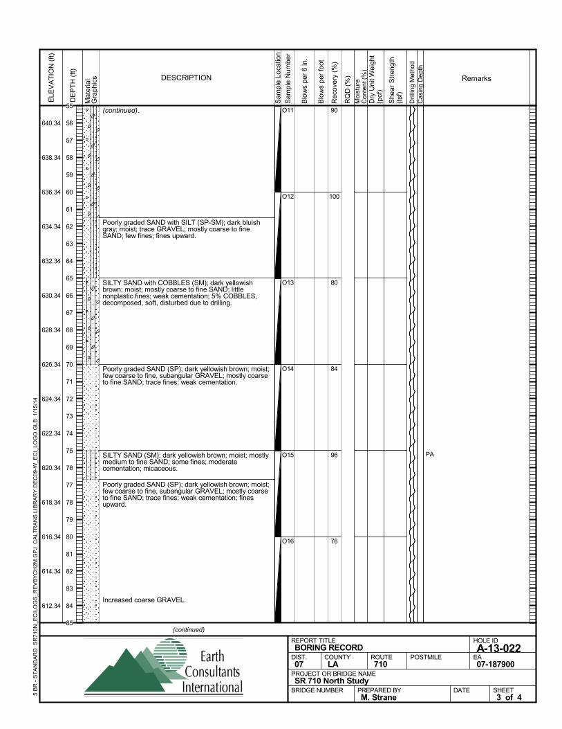
(continued).
Poorly graded SAND with SILT (SP-SM); dark bluishgray; moist; trace GRAVEL; mostly coarse to fineSAND; few fines; fines upward.
SILTY SAND with COBBLES (SM); dark yellowishbrown; moist; mostly coarse to fine SAND; littlenonplastic fines; weak cementation; 5% COBBLES,decomposed, soft, disturbed due to drilling.
Poorly graded SAND (SP); dark yellowish brown; moist;few coarse to fine, subangular GRAVEL; mostly coarseto fine SAND; trace fines; weak cementation.
SILTY SAND (SM); dark yellowish brown; moist; mostlymedium to fine SAND; some fines; moderatecementation; micaceous.
Poorly graded SAND (SP); dark yellowish brown; moist;few coarse to fine, subangular GRAVEL; mostly coarseto fine SAND; trace fines; weak cementation; finesupward.
Increased coarse GRAVEL.
90
100
80
84
96
76
O11
O12
O13
O14
O15
O16
PA
Sam
ple
Loca
tion
COUNTYLA
DESCRIPTION
Rec
over
y (%
)
Dril
ling
Met
hod
Cas
ing
Dep
th
PREPARED BYM. Strane
DATE
PROJECT OR BRIDGE NAMESR 710 North Study
BRIDGE NUMBER
HOLE ID
A-13-022EA07-187900
REPORT TITLEBORING RECORD
DIST.07
ROUTE710
POSTMILE
(continued)
SHEET3 of 4
RQ
D (
%)
Sam
ple
Num
ber
Moi
stur
eC
onte
nt (
%)
Remarks
Blo
ws
per
6 in
.
ELE
VA
TIO
N (
ft)
640.34
638.34
636.34
634.34
632.34
630.34
628.34
626.34
624.34
622.34
620.34
618.34
616.34
614.34
612.34
DE
PT
H (
ft)
Dry
Uni
t Wei
ght
(pcf
)
She
ar S
tren
gth
(tsf
)
Blo
ws
per
foot
Mat
eria
lG
rap
hics
5 B
R -
ST
AN
DA
RD
SR
710N
_EC
ILO
GS
_RE
VB
YC
H2M
.GP
J C
ALT
RA
NS
LIB
RA
RY
DE
C09
-W_E
CI_
LOG
O.G
LB
1/1
5/14
55
56
57
58
59
60
61
62
63
64
65
66
67
68
69
70
71
72
73
74
75
76
77
78
79
80
81
82
83
84
85
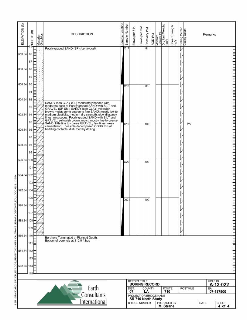
Poorly graded SAND (SP) (continued).
SANDY lean CLAY (CL) moderately bedded withmoderate beds of Poorly graded SAND with SILT andGRAVEL (SP-SM). SANDY lean CLAY; yellowishbrown; moist; some coarse to fine SAND; mostly low tomedium plasticity, medium dry strength, slow dilatancyfines; micaceous. Poorly graded SAND with SILT andGRAVEL: yellowish brown; moist; mostly fine to coarseSAND; little fine to coarse GRAVEL; few fines; weakcementation; possible decomposed COBBLES atbedding contacts, disturbed by drilling.
Borehole Terminated at Planned Depth.Bottom of borehole at 110.0 ft bgs
84
88
100
100
100
O17
O18
O19
O20
O021
PAS
ampl
e Lo
catio
n
COUNTYLA
DESCRIPTION
Rec
over
y (%
)
Dril
ling
Met
hod
Cas
ing
Dep
th
PREPARED BYM. Strane
DATE
PROJECT OR BRIDGE NAMESR 710 North Study
BRIDGE NUMBER
HOLE ID
A-13-022EA07-187900
REPORT TITLEBORING RECORD
DIST.07
ROUTE710
POSTMILE
SHEET4 of 4
RQ
D (
%)
Sam
ple
Num
ber
Moi
stur
eC
onte
nt (
%)
Remarks
Blo
ws
per
6 in
.
ELE
VA
TIO
N (
ft)
610.34
608.34
606.34
604.34
602.34
600.34
598.34
596.34
594.34
592.34
590.34
588.34
586.34
584.34
582.34
DE
PT
H (
ft)
Dry
Uni
t Wei
ght
(pcf
)
She
ar S
tren
gth
(tsf
)
Blo
ws
per
foot
Mat
eria
lG
rap
hics
5 B
R -
ST
AN
DA
RD
SR
710N
_EC
ILO
GS
_RE
VB
YC
H2M
.GP
J C
ALT
RA
NS
LIB
RA
RY
DE
C09
-W_E
CI_
LOG
O.G
LB
1/1
5/14
85
86
87
88
89
90
91
92
93
94
95
96
97
98
99
100
101
102
103
104
105
106
107
108
109
110
111
112
113
114
115
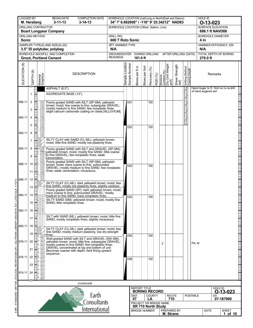
ASPHALT (8.5'').
AGGREGATE BASE (13'').
Poorly graded SAND with SILT (SP-SM); yellowishbrown; moist; few coarse to fine, subangular GRAVEL;mostly medium to fine SAND; few nonplastic fines;slight calcium carbonate coating on clasts [ALLUVIUM].
SILTY CLAY with SAND (CL-ML); yellowish brown;moist; little fine SAND; mostly low plasticity fines.
Poorly graded SAND with SILT and GRAVEL (SP-SM);yellowish brown; moist; mostly fine SAND; little coarseto fine GRAVEL; few nonplastic fines; weakcementation.Poorly graded SAND with SILT (SP-SM); yellowishbrown; moist; trace coarse to fine, subroundedGRAVEL; mostly medium to fine SAND; few nonplasticfines; weak cementation; micaceous.
SILTY CLAY (CL-ML); dark yellowish brown; moist; fewfine SAND; mostly low plasticity fines; slightly oxidized.Poorly graded SAND (SP); dark yellowish brown; moist;trace coarse to fine, subrounded GRAVEL; mostlymedium to fine SAND; trace nonplastic fines.SILTY SAND (SM); yellowish brown; moist; mostly fineSAND; little nonplastic fines.
SILT with SAND (ML); yellowish brown; moist; little fineSAND; mostly nonplastic fines; slightly micaceous.
SILTY CLAY (CL-ML); dark yellowish brown; moist; fewfine SAND; mostly medium plasticity, low dry strengthfines.Well-graded SAND with SILT and GRAVEL (SW-SM);yellowish brown; moist; little fine, subangular GRAVEL;mostly coarse to fine SAND; few nonplastic fines;GRAVEL concentrated at top and bottom of unitBecomes coarser with depth, faint fining upwardsequence.
100
100
100
100
100
100
O01
O02
O03
O04
O05
O06
2
Hand Auger to 5', first run is re-drillof hand augered soil
PA, M
AFTER DRILLING (DATE)DURING DRILLING161.0 ft
SURFACE ELEVATION
698.1 ft NAVD88DRILLING METHOD
SonicDRILL RIG
600 T Roto SonicSPT HAMMER TYPE
N/ABOREHOLE BACKFILL AND COMPLETION
Grout, Portland CementGROUNDWATERREADINGS
BEGIN DATE
3-11-13COMPLETION DATE
3-14-13LOGGED BY
M. HerzbergBOREHOLE LOCATION (Lat/Long or North/East and Datum)
34° 7' 6.682608" / -118° 9' 25.34212" NAD83HOLE ID
O-13-023DRILLING CONTRACTOR
Boart Longyear Company
HAMMER EFFICIENCY, ERi
N/ASAMPLER TYPE(S) AND SIZE(S) (ID)
3.5" ID polytube; polybagTOTAL DEPTH OF BORING
270.0 ft
BOREHOLE DIAMETER
4 in
BOREHOLE LOCATION (Offset, Station, Line)
.
Sam
ple
Loca
tion
COUNTYLA
DESCRIPTION
Rec
over
y (%
)
Dril
ling
Met
hod
Cas
ing
Dep
th
PREPARED BYM. Strane
DATE
PROJECT OR BRIDGE NAMESR 710 North Study
BRIDGE NUMBER
HOLE ID
O-13-023EA07-187900
REPORT TITLEBORING RECORD
DIST.07
ROUTE710
POSTMILE
(continued)
SHEET1 of 10
RQ
D (
%)
Sam
ple
Num
ber
Moi
stur
eC
onte
nt (
%)
Remarks
Blo
ws
per
6 in
.
ELE
VA
TIO
N (
ft)
696.11
694.11
692.11
690.11
688.11
686.11
684.11
682.11
680.11
678.11
676.11
674.11
DE
PT
H (
ft)
Dry
Uni
t Wei
ght
(pcf
)
She
ar S
tren
gth
(tsf
)
Blo
ws
per
foot
Mat
eria
lG
rap
hics
5 B
R -
ST
AN
DA
RD
SR
710N
_EC
ILO
GS
_RE
VB
YC
H2M
.GP
J C
ALT
RA
NS
LIB
RA
RY
DE
C09
-W_E
CI_
LOG
O.G
LB
1/1
5/14
0
1
2
3
4
5
6
7
8
9
10
11
12
13
14
15
16
17
18
19
20
21
22
23
24
25
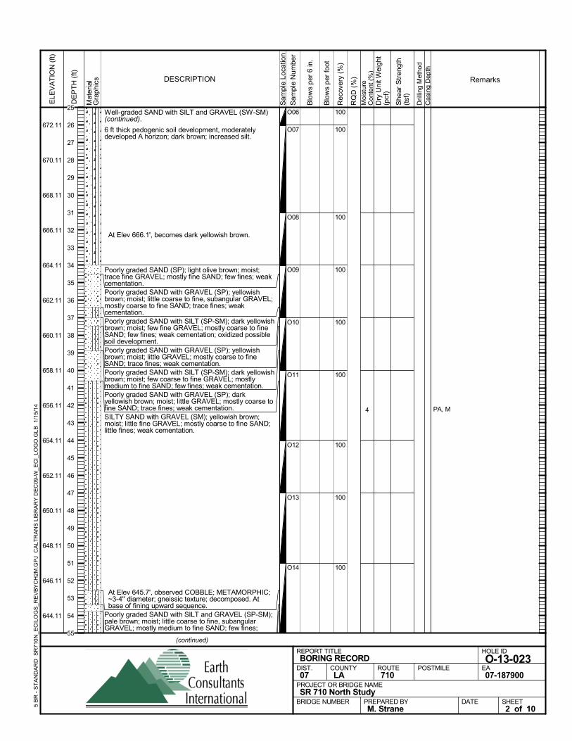
Well-graded SAND with SILT and GRAVEL (SW-SM)(continued).
6 ft thick pedogenic soil development, moderatelydeveloped A horizon; dark brown; increased silt.
At Elev 666.1', becomes dark yellowish brown.
Poorly graded SAND (SP); light olive brown; moist;trace fine GRAVEL; mostly fine SAND; few fines; weakcementation.Poorly graded SAND with GRAVEL (SP); yellowishbrown; moist; little coarse to fine, subangular GRAVEL;mostly coarse to fine SAND; trace fines; weakcementation.Poorly graded SAND with SILT (SP-SM); dark yellowishbrown; moist; few fine GRAVEL; mostly coarse to fineSAND; few fines; weak cementation; oxidized possiblesoil development.Poorly graded SAND with GRAVEL (SP); yellowishbrown; moist; little GRAVEL; mostly coarse to fineSAND; trace fines; weak cementation.Poorly graded SAND with SILT (SP-SM); dark yellowishbrown; moist; few coarse to fine GRAVEL; mostlymedium to fine SAND; few fines; weak cementation.Poorly graded SAND with GRAVEL (SP); darkyellowish brown; moist; little GRAVEL; mostly coarse tofine SAND; trace fines; weak cementation.SILTY SAND with GRAVEL (SM); yellowish brown;moist; little fine GRAVEL; mostly coarse to fine SAND;little fines; weak cementation.
At Elev 645.7', observed COBBLE; METAMORPHIC;~3-4'' diameter; gneissic texture; decomposed. Atbase of fining upward sequence.
Poorly graded SAND with SILT and GRAVEL (SP-SM);pale brown; moist; little coarse to fine, subangularGRAVEL; mostly medium to fine SAND; few fines;
100
100
100
100
100
100
100
100
100
O06
O07
O08
O09
O10
O11
O12
O13
O14
4 PA, M
Sam
ple
Loca
tion
COUNTYLA
DESCRIPTION
Rec
over
y (%
)
Dril
ling
Met
hod
Cas
ing
Dep
th
PREPARED BYM. Strane
DATE
PROJECT OR BRIDGE NAMESR 710 North Study
BRIDGE NUMBER
HOLE ID
O-13-023EA07-187900
REPORT TITLEBORING RECORD
DIST.07
ROUTE710
POSTMILE
(continued)
SHEET2 of 10
RQ
D (
%)
Sam
ple
Num
ber
Moi
stur
eC
onte
nt (
%)
Remarks
Blo
ws
per
6 in
.
ELE
VA
TIO
N (
ft)
672.11
670.11
668.11
666.11
664.11
662.11
660.11
658.11
656.11
654.11
652.11
650.11
648.11
646.11
644.11
DE
PT
H (
ft)
Dry
Uni
t Wei
ght
(pcf
)
She
ar S
tren
gth
(tsf
)
Blo
ws
per
foot
Mat
eria
lG
rap
hics
5 B
R -
ST
AN
DA
RD
SR
710N
_EC
ILO
GS
_RE
VB
YC
H2M
.GP
J C
ALT
RA
NS
LIB
RA
RY
DE
C09
-W_E
CI_
LOG
O.G
LB
1/1
5/14
25
26
27
28
29
30
31
32
33
34
35
36
37
38
39
40
41
42
43
44
45
46
47
48
49
50
51
52
53
54
55
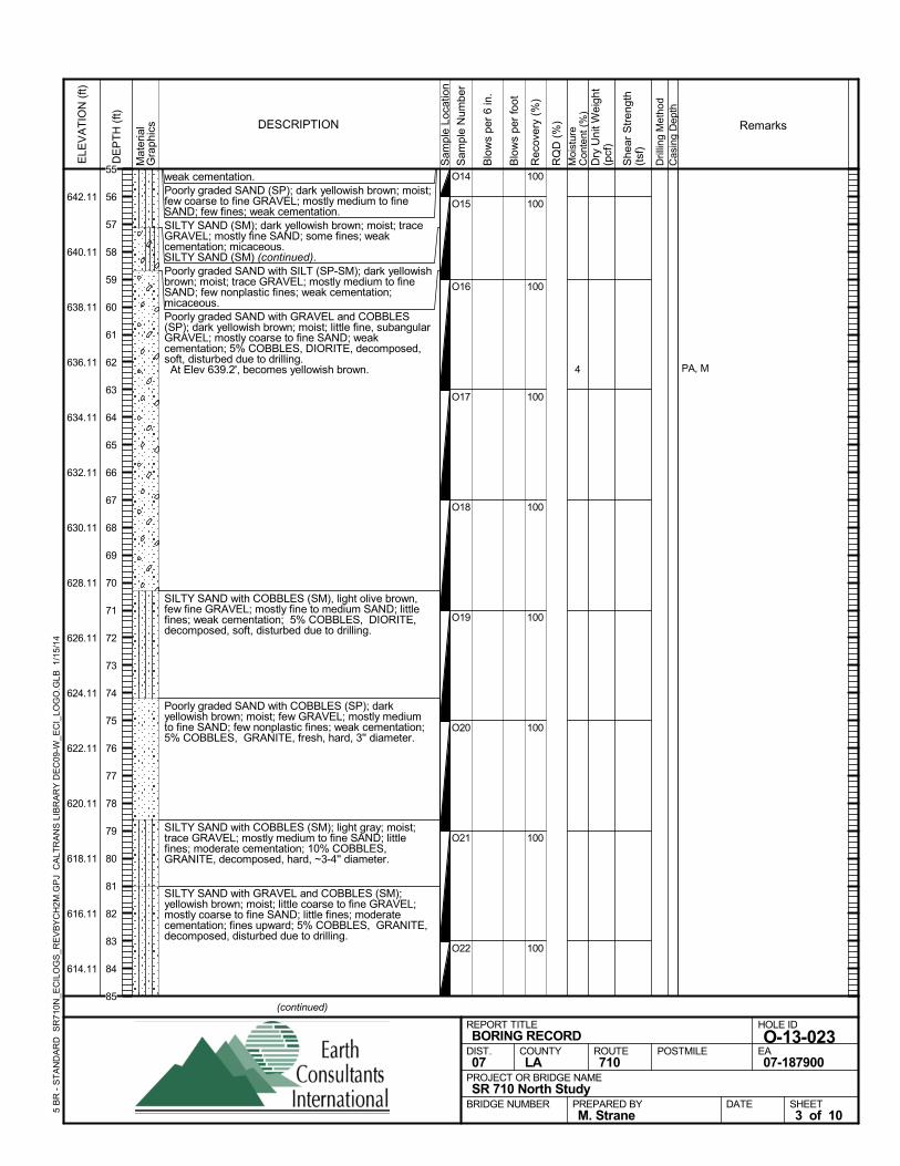
weak cementation.Poorly graded SAND (SP); dark yellowish brown; moist;few coarse to fine GRAVEL; mostly medium to fineSAND; few fines; weak cementation.SILTY SAND (SM); dark yellowish brown; moist; traceGRAVEL; mostly fine SAND; some fines; weakcementation; micaceous.SILTY SAND (SM) (continued).Poorly graded SAND with SILT (SP-SM); dark yellowishbrown; moist; trace GRAVEL; mostly medium to fineSAND; few nonplastic fines; weak cementation;micaceous.Poorly graded SAND with GRAVEL and COBBLES(SP); dark yellowish brown; moist; little fine, subangularGRAVEL; mostly coarse to fine SAND; weakcementation; 5% COBBLES, DIORITE, decomposed,soft, disturbed due to drilling. At Elev 639.2', becomes yellowish brown.
SILTY SAND with COBBLES (SM), light olive brown,few fine GRAVEL; mostly fine to medium SAND; littlefines; weak cementation; 5% COBBLES, DIORITE,decomposed, soft, disturbed due to drilling.
Poorly graded SAND with COBBLES (SP); darkyellowish brown; moist; few GRAVEL; mostly mediumto fine SAND; few nonplastic fines; weak cementation;5% COBBLES, GRANITE, fresh, hard, 3'' diameter.
SILTY SAND with COBBLES (SM); light gray; moist;trace GRAVEL; mostly medium to fine SAND; littlefines; moderate cementation; 10% COBBLES,GRANITE, decomposed, hard, ~3-4'' diameter.
SILTY SAND with GRAVEL and COBBLES (SM);yellowish brown; moist; little coarse to fine GRAVEL;mostly coarse to fine SAND; little fines; moderatecementation; fines upward; 5% COBBLES, GRANITE,decomposed, disturbed due to drilling.
100
100
100
100
100
100
100
100
100
O14
O15
O16
O17
O18
O19
O20
O21
O22
4 PA, M
Sam
ple
Loca
tion
COUNTYLA
DESCRIPTION
Rec
over
y (%
)
Dril
ling
Met
hod
Cas
ing
Dep
th
PREPARED BYM. Strane
DATE
PROJECT OR BRIDGE NAMESR 710 North Study
BRIDGE NUMBER
HOLE ID
O-13-023EA07-187900
REPORT TITLEBORING RECORD
DIST.07
ROUTE710
POSTMILE
(continued)
SHEET3 of 10
RQ
D (
%)
Sam
ple
Num
ber
Moi
stur
eC
onte
nt (
%)
Remarks
Blo
ws
per
6 in
.
ELE
VA
TIO
N (
ft)
642.11
640.11
638.11
636.11
634.11
632.11
630.11
628.11
626.11
624.11
622.11
620.11
618.11
616.11
614.11
DE
PT
H (
ft)
Dry
Uni
t Wei
ght
(pcf
)
She
ar S
tren
gth
(tsf
)
Blo
ws
per
foot
Mat
eria
lG
rap
hics
5 B
R -
ST
AN
DA
RD
SR
710N
_EC
ILO
GS
_RE
VB
YC
H2M
.GP
J C
ALT
RA
NS
LIB
RA
RY
DE
C09
-W_E
CI_
LOG
O.G
LB
1/1
5/14
55
56
57
58
59
60
61
62
63
64
65
66
67
68
69
70
71
72
73
74
75
76
77
78
79
80
81
82
83
84
85
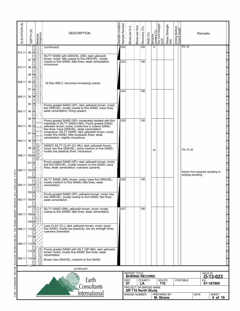
(continued).
SILTY SAND with GRAVEL (SM); dark yellowishbrown; moist; little coarse to fine GRAVEL; mostlycoarse to fine SAND; little fines; weak cementation;micaceous.
At Elev 608.2', becomes increasing coarse.
Poorly graded SAND (SP); dark yellowish brown; moist;few GRAVEL; mostly coarse to fine SAND; trace fines;weak cementation; fining upward.
Poorly graded SAND (SP); moderately bedded with thininterbeds of SILTY SAND (SM). Poorly graded SAND;yellowish brown; moist; mostly fine to coarse SAND;few fines; trace GRAVEL; weak cementation;micaceous. SILTY SAND; dark yellowish brown; moist;mostly fine SAND; little nonplastic fines; weakcementation; slightly micaceous.
SANDY SILTY CLAY (CL-ML); dark yellowish brown;moist; few fine GRAVEL; some medium to fine SAND;mostly low plasticity fines; micaceous.
Poorly graded SAND (SP); dark yellowish brown; moist;few fine GRAVEL; mostly medium to fine SAND; tracefines; weak cementation; coarsens upwards.
SILTY SAND (SM); brown; moist; trace fine GRAVEL;mostly medium to fine SAND; little fines; weakcementation.
Poorly graded SAND (SP); yellowish brown; moist; fewfine GRAVEL; mostly coarse to fine SAND; few fines;weak cementation.
SILTY SAND (SM); yellowish brown; moist; mostlycoarse to fine SAND; little fines; weak cementation.
Lean CLAY (CL); dark yellowish brown; moist; somefine SAND; mostly low plasticity, low dry strength fines;coarsens downward.
Poorly graded SAND with SILT (SP-SM); dark yellowishbrown; moist; mostly fine SAND; few fines; weakcementation.
Brown; few GRAVEL; medium to fine SAND.
100
100
100
100
100
100
O22
O23
O24
O25
O26
O27
5
16
PA, M
PA, Pl, M
Switch from polytube sampling topolybag sampling
Sam
ple
Loca
tion
COUNTYLA
DESCRIPTION
Rec
over
y (%
)
Dril
ling
Met
hod
Cas
ing
Dep
th
PREPARED BYM. Strane
DATE
PROJECT OR BRIDGE NAMESR 710 North Study
BRIDGE NUMBER
HOLE ID
O-13-023EA07-187900
REPORT TITLEBORING RECORD
DIST.07
ROUTE710
POSTMILE
(continued)
SHEET4 of 10
RQ
D (
%)
Sam
ple
Num
ber
Moi
stur
eC
onte
nt (
%)
Remarks
Blo
ws
per
6 in
.
ELE
VA
TIO
N (
ft)
612.11
610.11
608.11
606.11
604.11
602.11
600.11
598.11
596.11
594.11
592.11
590.11
588.11
586.11
584.11
DE
PT
H (
ft)
Dry
Uni
t Wei
ght
(pcf
)
She
ar S
tren
gth
(tsf
)
Blo
ws
per
foot
Mat
eria
lG
rap
hics
5 B
R -
ST
AN
DA
RD
SR
710N
_EC
ILO
GS
_RE
VB
YC
H2M
.GP
J C
ALT
RA
NS
LIB
RA
RY
DE
C09
-W_E
CI_
LOG
O.G
LB
1/1
5/14
85
86
87
88
89
90
91
92
93
94
95
96
97
98
99
100
101
102
103
104
105
106
107
108
109
110
111
112
113
114
115
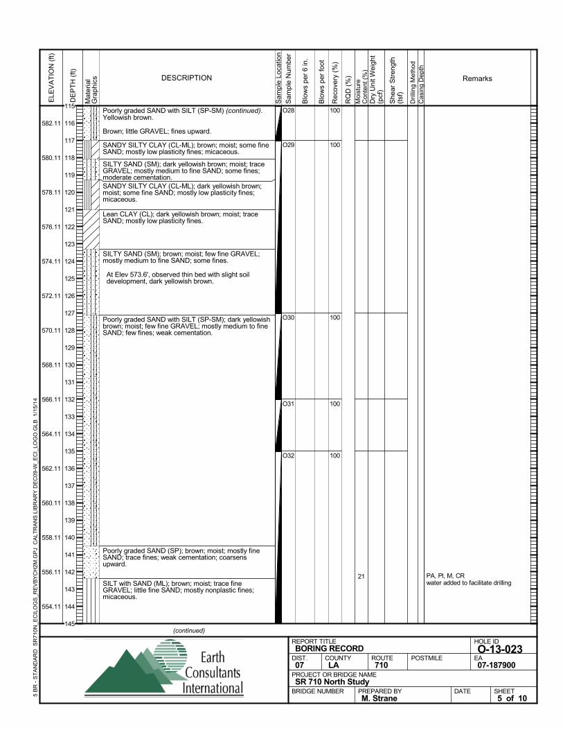
Poorly graded SAND with SILT (SP-SM) (continued).Yellowish brown.
Brown; little GRAVEL; fines upward.
SANDY SILTY CLAY (CL-ML); brown; moist; some fineSAND; mostly low plasticity fines; micaceous.
SILTY SAND (SM); dark yellowish brown; moist; traceGRAVEL; mostly medium to fine SAND; some fines;moderate cementation.SANDY SILTY CLAY (CL-ML); dark yellowish brown;moist; some fine SAND; mostly low plasticity fines;micaceous.
Lean CLAY (CL); dark yellowish brown; moist; traceSAND; mostly low plasticity fines.
SILTY SAND (SM); brown; moist; few fine GRAVEL;mostly medium to fine SAND; some fines.
At Elev 573.6', observed thin bed with slight soildevelopment, dark yellowish brown.
Poorly graded SAND with SILT (SP-SM); dark yellowishbrown; moist; few fine GRAVEL; mostly medium to fineSAND; few fines; weak cementation.
Poorly graded SAND (SP); brown; moist; mostly fineSAND; trace fines; weak cementation; coarsensupward.
SILT with SAND (ML); brown; moist; trace fineGRAVEL; little fine SAND; mostly nonplastic fines;micaceous.
100
100
100
100
100
O28
O29
O30
O31
O32
21 PA, Pl, M, CRwater added to facilitate drilling
Sam
ple
Loca
tion
COUNTYLA
DESCRIPTION
Rec
over
y (%
)
Dril
ling
Met
hod
Cas
ing
Dep
th
PREPARED BYM. Strane
DATE
PROJECT OR BRIDGE NAMESR 710 North Study
BRIDGE NUMBER
HOLE ID
O-13-023EA07-187900
REPORT TITLEBORING RECORD
DIST.07
ROUTE710
POSTMILE
(continued)
SHEET5 of 10
RQ
D (
%)
Sam
ple
Num
ber
Moi
stur
eC
onte
nt (
%)
Remarks
Blo
ws
per
6 in
.
ELE
VA
TIO
N (
ft)
582.11
580.11
578.11
576.11
574.11
572.11
570.11
568.11
566.11
564.11
562.11
560.11
558.11
556.11
554.11
DE
PT
H (
ft)
Dry
Uni
t Wei
ght
(pcf
)
She
ar S
tren
gth
(tsf
)
Blo
ws
per
foot
Mat
eria
lG
rap
hics
5 B
R -
ST
AN
DA
RD
SR
710N
_EC
ILO
GS
_RE
VB
YC
H2M
.GP
J C
ALT
RA
NS
LIB
RA
RY
DE
C09
-W_E
CI_
LOG
O.G
LB
1/1
5/14
115
116
117
118
119
120
121
122
123
124
125
126
127
128
129
130
131
132
133
134
135
136
137
138
139
140
141
142
143
144
145
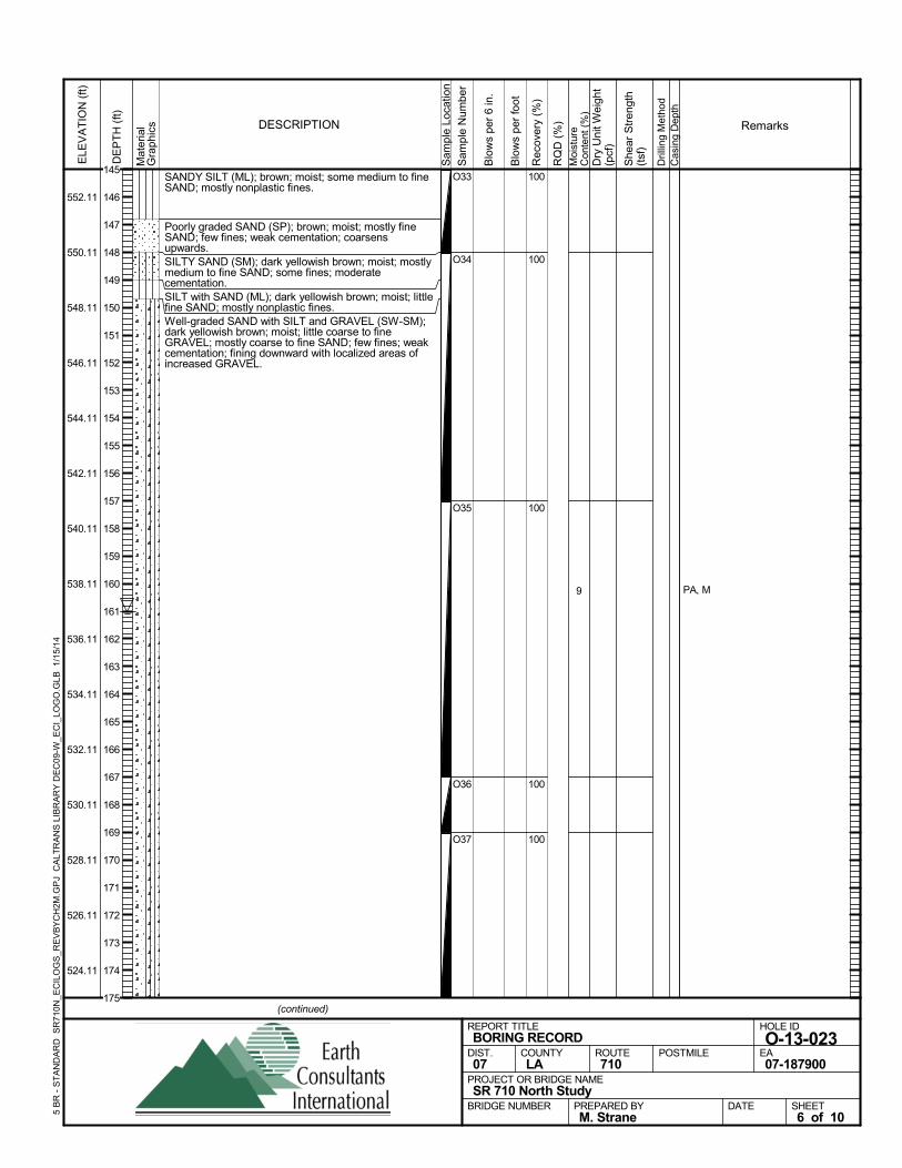
SANDY SILT (ML); brown; moist; some medium to fineSAND; mostly nonplastic fines.
Poorly graded SAND (SP); brown; moist; mostly fineSAND; few fines; weak cementation; coarsensupwards.SILTY SAND (SM); dark yellowish brown; moist; mostlymedium to fine SAND; some fines; moderatecementation.SILT with SAND (ML); dark yellowish brown; moist; littlefine SAND; mostly nonplastic fines.Well-graded SAND with SILT and GRAVEL (SW-SM);dark yellowish brown; moist; little coarse to fineGRAVEL; mostly coarse to fine SAND; few fines; weakcementation; fining downward with localized areas ofincreased GRAVEL.
100
100
100
100
100
O33
O34
O35
O36
O37
9 PA, M
Sam
ple
Loca
tion
COUNTYLA
DESCRIPTION
Rec
over
y (%
)
Dril
ling
Met
hod
Cas
ing
Dep
th
PREPARED BYM. Strane
DATE
PROJECT OR BRIDGE NAMESR 710 North Study
BRIDGE NUMBER
HOLE ID
O-13-023EA07-187900
REPORT TITLEBORING RECORD
DIST.07
ROUTE710
POSTMILE
(continued)
SHEET6 of 10
RQ
D (
%)
Sam
ple
Num
ber
Moi
stur
eC
onte
nt (
%)
Remarks
Blo
ws
per
6 in
.
ELE
VA
TIO
N (
ft)
552.11
550.11
548.11
546.11
544.11
542.11
540.11
538.11
536.11
534.11
532.11
530.11
528.11
526.11
524.11
DE
PT
H (
ft)
Dry
Uni
t Wei
ght
(pcf
)
She
ar S
tren
gth
(tsf
)
Blo
ws
per
foot
Mat
eria
lG
rap
hics
5 B
R -
ST
AN
DA
RD
SR
710N
_EC
ILO
GS
_RE
VB
YC
H2M
.GP
J C
ALT
RA
NS
LIB
RA
RY
DE
C09
-W_E
CI_
LOG
O.G
LB
1/1
5/14
145
146
147
148
149
150
151
152
153
154
155
156
157
158
159
160
161
162
163
164
165
166
167
168
169
170
171
172
173
174
175
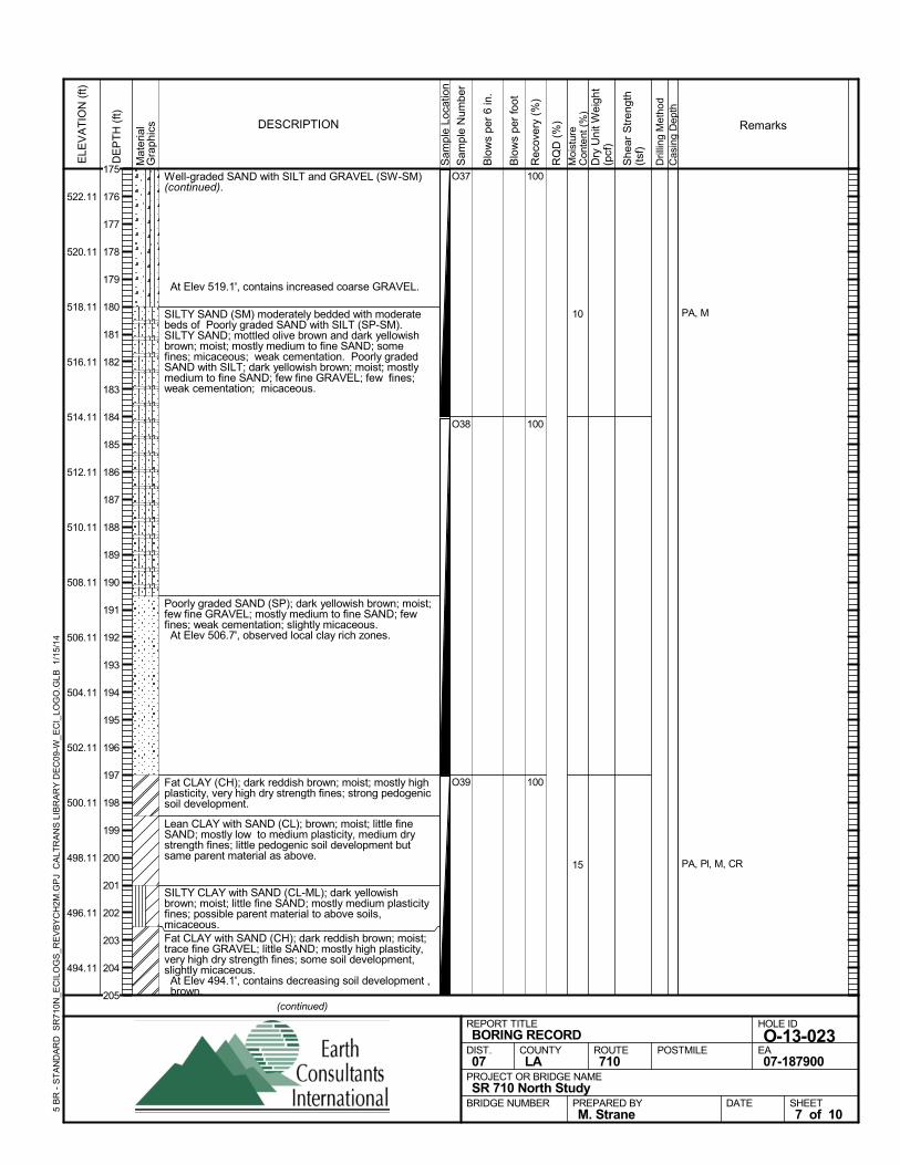
Well-graded SAND with SILT and GRAVEL (SW-SM)(continued).
At Elev 519.1', contains increased coarse GRAVEL.
SILTY SAND (SM) moderately bedded with moderatebeds of Poorly graded SAND with SILT (SP-SM).SILTY SAND; mottled olive brown and dark yellowishbrown; moist; mostly medium to fine SAND; somefines; micaceous; weak cementation. Poorly gradedSAND with SILT; dark yellowish brown; moist; mostlymedium to fine SAND; few fine GRAVEL; few fines;weak cementation; micaceous.
Poorly graded SAND (SP); dark yellowish brown; moist;few fine GRAVEL; mostly medium to fine SAND; fewfines; weak cementation; slightly micaceous. At Elev 506.7', observed local clay rich zones.
Fat CLAY (CH); dark reddish brown; moist; mostly highplasticity, very high dry strength fines; strong pedogenicsoil development.
Lean CLAY with SAND (CL); brown; moist; little fineSAND; mostly low to medium plasticity, medium drystrength fines; little pedogenic soil development butsame parent material as above.
SILTY CLAY with SAND (CL-ML); dark yellowishbrown; moist; little fine SAND; mostly medium plasticityfines; possible parent material to above soils,micaceous.Fat CLAY with SAND (CH); dark reddish brown; moist;trace fine GRAVEL; little SAND; mostly high plasticity,very high dry strength fines; some soil development,slightly micaceous. At Elev 494.1', contains decreasing soil development ,brown.
100
100
100
O37
O38
O39
10
15
PA, M
PA, Pl, M, CR
Sam
ple
Loca
tion
COUNTYLA
DESCRIPTION
Rec
over
y (%
)
Dril
ling
Met
hod
Cas
ing
Dep
th
PREPARED BYM. Strane
DATE
PROJECT OR BRIDGE NAMESR 710 North Study
BRIDGE NUMBER
HOLE ID
O-13-023EA07-187900
REPORT TITLEBORING RECORD
DIST.07
ROUTE710
POSTMILE
(continued)
SHEET7 of 10
RQ
D (
%)
Sam
ple
Num
ber
Moi
stur
eC
onte
nt (
%)
Remarks
Blo
ws
per
6 in
.
ELE
VA
TIO
N (
ft)
522.11
520.11
518.11
516.11
514.11
512.11
510.11
508.11
506.11
504.11
502.11
500.11
498.11
496.11
494.11
DE
PT
H (
ft)
Dry
Uni
t Wei
ght
(pcf
)
She
ar S
tren
gth
(tsf
)
Blo
ws
per
foot
Mat
eria
lG
rap
hics
5 B
R -
ST
AN
DA
RD
SR
710N
_EC
ILO
GS
_RE
VB
YC
H2M
.GP
J C
ALT
RA
NS
LIB
RA
RY
DE
C09
-W_E
CI_
LOG
O.G
LB
1/1
5/14
175
176
177
178
179
180
181
182
183
184
185
186
187
188
189
190
191
192
193
194
195
196
197
198
199
200
201
202
203
204
205
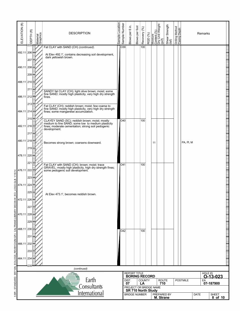
Fat CLAY with SAND (CH) (continued).
At Elev 492.1', contains decreasing soil development,dark yellowish brown.
SANDY fat CLAY (CH); light olive brown; moist; somefine SAND; mostly high plasticity, very high dry strengthfines.
Fat CLAY (CH); reddish brown; moist; few coarse tofine SAND; mostly high plasticity, very high dry strengthfines; some manganese accumulation.
CLAYEY SAND (SC); reddish brown; moist; mostlymedium to fine SAND; some low to medium plasticityfines; moderate cementation; strong soil pedogenicdevelopment.
Becomes strong brown; coarsens downward.
Fat CLAY with SAND (CH); brown; moist; traceGRAVEL; mostly high plasticity, high dry strength fines;some pedogenic soil development.
At Elev 473.1', becomes reddish brown.
100
100
100
100
O39
O40
O41
O42
11 PA, Pl, M
Sam
ple
Loca
tion
COUNTYLA
DESCRIPTION
Rec
over
y (%
)
Dril
ling
Met
hod
Cas
ing
Dep
th
PREPARED BYM. Strane
DATE
PROJECT OR BRIDGE NAMESR 710 North Study
BRIDGE NUMBER
HOLE ID
O-13-023EA07-187900
REPORT TITLEBORING RECORD
DIST.07
ROUTE710
POSTMILE
(continued)
SHEET8 of 10
RQ
D (
%)
Sam
ple
Num
ber
Moi
stur
eC
onte
nt (
%)
Remarks
Blo
ws
per
6 in
.
ELE
VA
TIO
N (
ft)
492.11
490.11
488.11
486.11
484.11
482.11
480.11
478.11
476.11
474.11
472.11
470.11
468.11
466.11
464.11
DE
PT
H (
ft)
Dry
Uni
t Wei
ght
(pcf
)
She
ar S
tren
gth
(tsf
)
Blo
ws
per
foot
Mat
eria
lG
rap
hics
5 B
R -
ST
AN
DA
RD
SR
710N
_EC
ILO
GS
_RE
VB
YC
H2M
.GP
J C
ALT
RA
NS
LIB
RA
RY
DE
C09
-W_E
CI_
LOG
O.G
LB
1/1
5/14
205
206
207
208
209
210
211
212
213
214
215
216
217
218
219
220
221
222
223
224
225
226
227
228
229
230
231
232
233
234
235
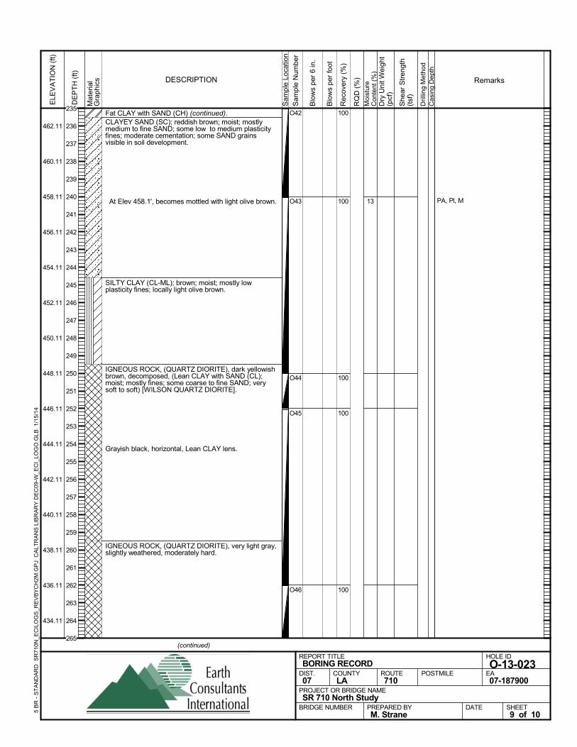
Fat CLAY with SAND (CH) (continued).CLAYEY SAND (SC); reddish brown; moist; mostlymedium to fine SAND; some low to medium plasticityfines; moderate cementation; some SAND grainsvisible in soil development.
At Elev 458.1', becomes mottled with light olive brown.
SILTY CLAY (CL-ML); brown; moist; mostly lowplasticity fines; locally light olive brown.
IGNEOUS ROCK, (QUARTZ DIORITE), dark yellowishbrown, decomposed, (Lean CLAY with SAND (CL);moist; mostly fines; some coarse to fine SAND; verysoft to soft) [WILSON QUARTZ DIORITE].
Grayish black, horizontal, Lean CLAY lens.
IGNEOUS ROCK, (QUARTZ DIORITE), very light gray,slightly weathered, moderately hard.
100
100
100
100
100
O42
O43
O44
O45
O46
13 PA, Pl, M
Sam
ple
Loca
tion
COUNTYLA
DESCRIPTION
Rec
over
y (%
)
Dril
ling
Met
hod
Cas
ing
Dep
th
PREPARED BYM. Strane
DATE
PROJECT OR BRIDGE NAMESR 710 North Study
BRIDGE NUMBER
HOLE ID
O-13-023EA07-187900
REPORT TITLEBORING RECORD
DIST.07
ROUTE710
POSTMILE
(continued)
SHEET9 of 10
RQ
D (
%)
Sam
ple
Num
ber
Moi
stur
eC
onte
nt (
%)
Remarks
Blo
ws
per
6 in
.
ELE
VA
TIO
N (
ft)
462.11
460.11
458.11
456.11
454.11
452.11
450.11
448.11
446.11
444.11
442.11
440.11
438.11
436.11
434.11
DE
PT
H (
ft)
Dry
Uni
t Wei
ght
(pcf
)
She
ar S
tren
gth
(tsf
)
Blo
ws
per
foot
Mat
eria
lG
rap
hics
5 B
R -
ST
AN
DA
RD
SR
710N
_EC
ILO
GS
_RE
VB
YC
H2M
.GP
J C
ALT
RA
NS
LIB
RA
RY
DE
C09
-W_E
CI_
LOG
O.G
LB
1/1
5/14
235
236
237
238
239
240
241
242
243
244
245
246
247
248
249
250
251
252
253
254
255
256
257
258
259
260
261
262
263
264
265
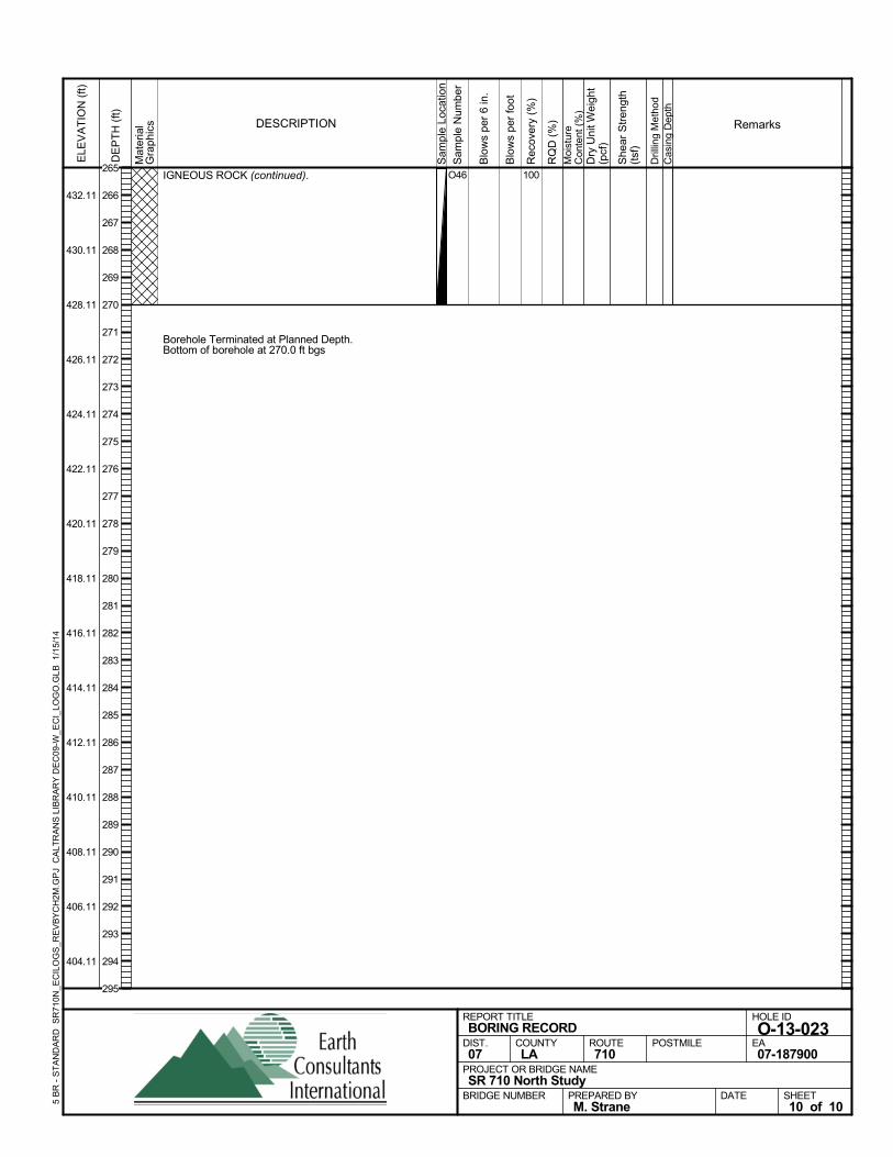
IGNEOUS ROCK (continued).
Borehole Terminated at Planned Depth.Bottom of borehole at 270.0 ft bgs
100O46
Sam
ple
Loca
tion
COUNTYLA
DESCRIPTION
Rec
over
y (%
)
Dril
ling
Met
hod
Cas
ing
Dep
th
PREPARED BYM. Strane
DATE
PROJECT OR BRIDGE NAMESR 710 North Study
BRIDGE NUMBER
HOLE ID
O-13-023EA07-187900
REPORT TITLEBORING RECORD
DIST.07
ROUTE710
POSTMILE
SHEET10 of 10
RQ
D (
%)
Sam
ple
Num
ber
Moi
stur
eC
onte
nt (
%)
Remarks
Blo
ws
per
6 in
.
ELE
VA
TIO
N (
ft)
432.11
430.11
428.11
426.11
424.11
422.11
420.11
418.11
416.11
414.11
412.11
410.11
408.11
406.11
404.11
DE
PT
H (
ft)
Dry
Uni
t Wei
ght
(pcf
)
She
ar S
tren
gth
(tsf
)
Blo
ws
per
foot
Mat
eria
lG
rap
hics
5 B
R -
ST
AN
DA
RD
SR
710N
_EC
ILO
GS
_RE
VB
YC
H2M
.GP
J C
ALT
RA
NS
LIB
RA
RY
DE
C09
-W_E
CI_
LOG
O.G
LB
1/1
5/14
265
266
267
268
269
270
271
272
273
274
275
276
277
278
279
280
281
282
283
284
285
286
287
288
289
290
291
292
293
294
295
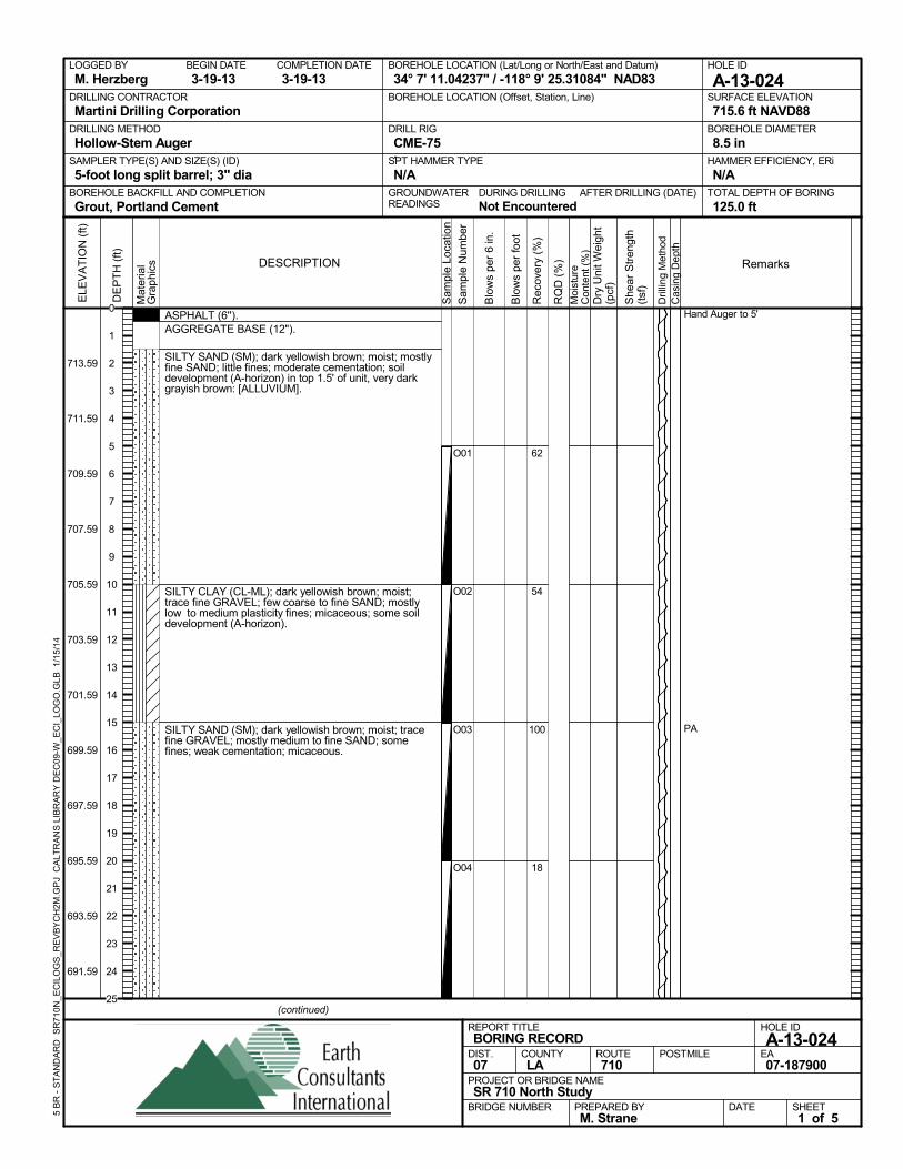
ASPHALT (6'').AGGREGATE BASE (12").
SILTY SAND (SM); dark yellowish brown; moist; mostlyfine SAND; little fines; moderate cementation; soildevelopment (A-horizon) in top 1.5' of unit, very darkgrayish brown: [ALLUVIUM].
SILTY CLAY (CL-ML); dark yellowish brown; moist;trace fine GRAVEL; few coarse to fine SAND; mostlylow to medium plasticity fines; micaceous; some soildevelopment (A-horizon).
SILTY SAND (SM); dark yellowish brown; moist; tracefine GRAVEL; mostly medium to fine SAND; somefines; weak cementation; micaceous.
62
54
100
18
O01
O02
O03
O04
Hand Auger to 5'
PA
AFTER DRILLING (DATE)DURING DRILLINGNot Encountered
SURFACE ELEVATION
715.6 ft NAVD88DRILLING METHOD
Hollow-Stem AugerDRILL RIG
CME-75SPT HAMMER TYPE
N/ABOREHOLE BACKFILL AND COMPLETION
Grout, Portland CementGROUNDWATERREADINGS
BEGIN DATE
3-19-13COMPLETION DATE
3-19-13LOGGED BY
M. HerzbergBOREHOLE LOCATION (Lat/Long or North/East and Datum)
34° 7' 11.04237" / -118° 9' 25.31084" NAD83HOLE ID
A-13-024DRILLING CONTRACTOR
Martini Drilling Corporation
HAMMER EFFICIENCY, ERi
N/ASAMPLER TYPE(S) AND SIZE(S) (ID)
5-foot long split barrel; 3" diaTOTAL DEPTH OF BORING
125.0 ft
BOREHOLE DIAMETER
8.5 in
BOREHOLE LOCATION (Offset, Station, Line)
.
Sam
ple
Loca
tion
COUNTYLA
DESCRIPTION
Rec
over
y (%
)
Dril
ling
Met
hod
Cas
ing
Dep
th
PREPARED BYM. Strane
DATE
PROJECT OR BRIDGE NAMESR 710 North Study
BRIDGE NUMBER
HOLE ID
A-13-024EA07-187900
REPORT TITLEBORING RECORD
DIST.07
ROUTE710
POSTMILE
(continued)
SHEET1 of 5
RQ
D (
%)
Sam
ple
Num
ber
Moi
stur
eC
onte
nt (
%)
Remarks
Blo
ws
per
6 in
.
ELE
VA
TIO
N (
ft)
713.59
711.59
709.59
707.59
705.59
703.59
701.59
699.59
697.59
695.59
693.59
691.59
DE
PT
H (
ft)
Dry
Uni
t Wei
ght
(pcf
)
She
ar S
tren
gth
(tsf
)
Blo
ws
per
foot
Mat
eria
lG
rap
hics
5 B
R -
ST
AN
DA
RD
SR
710N
_EC
ILO
GS
_RE
VB
YC
H2M
.GP
J C
ALT
RA
NS
LIB
RA
RY
DE
C09
-W_E
CI_
LOG
O.G
LB
1/1
5/14
0
1
2
3
4
5
6
7
8
9
10
11
12
13
14
15
16
17
18
19
20
21
22
23
24
25
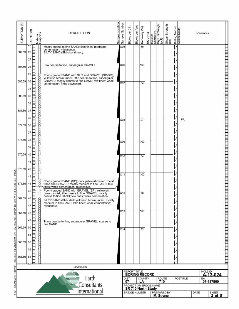
Mostly coarse to fine SAND; little fines; moderatecementation; micaceous.SILTY SAND (SM) (continued).
Few coarse to fine, subangular GRAVEL.
Poorly graded SAND with SILT and GRAVEL (SP-SM);yellowish brown; moist; little coarse to fine, subangularGRAVEL; mostly coarse to fine SAND; few fines; weakcementation; fines downward.
Poorly graded SAND (SP); dark yellowish brown; moist;trace fine GRAVEL; mostly medium to fine SAND; fewfines; weak cementation; micaceous.Poorly graded SAND with GRAVEL (SP); yellowishbrown; moist; little coarse to fine GRAVEL; mostlycoarse to fine SAND; few fines; weak cementation.
SILTY SAND (SM); dark yellowish brown; moist; mostlymedium to fine SAND; little fines; weak cementation;micaceous.
Trace coarse to fine, subangular GRAVEL; coarse tofine SAND.
80
100
64
27
100
64
100
68
100
82
O05
O06
O07
O08
O09
O10
O11
O12
O13
O14
PAS
ampl
e Lo
catio
n
COUNTYLA
DESCRIPTION
Rec
over
y (%
)
Dril
ling
Met
hod
Cas
ing
Dep
th
PREPARED BYM. Strane
DATE
PROJECT OR BRIDGE NAMESR 710 North Study
BRIDGE NUMBER
HOLE ID
A-13-024EA07-187900
REPORT TITLEBORING RECORD
DIST.07
ROUTE710
POSTMILE
(continued)
SHEET2 of 5
RQ
D (
%)
Sam
ple
Num
ber
Moi
stur
eC
onte
nt (
%)
Remarks
Blo
ws
per
6 in
.
ELE
VA
TIO
N (
ft)
689.59
687.59
685.59
683.59
681.59
679.59
677.59
675.59
673.59
671.59
669.59
667.59
665.59
663.59
661.59
DE
PT
H (
ft)
Dry
Uni
t Wei
ght
(pcf
)
She
ar S
tren
gth
(tsf
)
Blo
ws
per
foot
Mat
eria
lG
rap
hics
5 B
R -
ST
AN
DA
RD
SR
710N
_EC
ILO
GS
_RE
VB
YC
H2M
.GP
J C
ALT
RA
NS
LIB
RA
RY
DE
C09
-W_E
CI_
LOG
O.G
LB
1/1
5/14
25
26
27
28
29
30
31
32
33
34
35
36
37
38
39
40
41
42
43
44
45
46
47
48
49
50
51
52
53
54
55
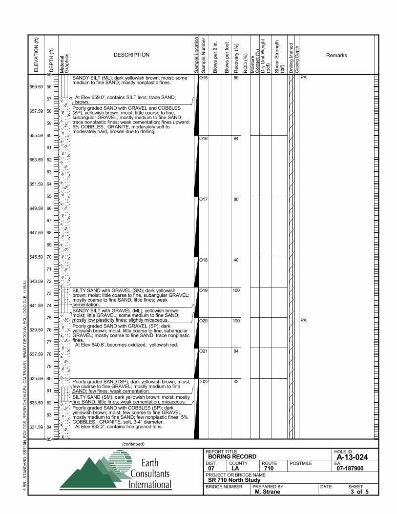
SANDY SILT (ML); dark yellowish brown; moist; somemedium to fine SAND; mostly nonplastic fines.
At Elev 659.0', contains SILT lens; trace SAND;brown.
Poorly graded SAND with GRAVEL and COBBLES(SP); yellowish brown; moist; little coarse to fine,subangular GRAVEL; mostly medium to fine SAND;trace nonplastic fines; weak cementation; fines upward;5% COBBLES, GRANITE, moderately soft tomoderately hard, broken due to drilling.
SILTY SAND with GRAVEL (SM); dark yellowishbrown; moist; little coarse to fine, subangular GRAVEL;mostly coarse to fine SAND; little fines; weakcementation.SANDY SILT with GRAVEL (ML); yellowish brown;moist; little GRAVEL; some medium to fine SAND;mostly low plasticity fines; slightly micaceous.Poorly graded SAND with GRAVEL (SP); darkyellowish brown; moist; little coarse to fine, subangularGRAVEL; mostly coarse to fine SAND; trace nonplasticfines. At Elev 640.6', becomes oxidized, yellowish red.
Poorly graded SAND (SP); dark yellowish brown; moist;few coarse to fine GRAVEL; mostly medium to fineSAND; few fines; weak cementation.SILTY SAND (SM); dark yellowish brown; moist; mostlyfine SAND; little fines; weak cementation; micaceous.Poorly graded SAND with COBBLES (SP); darkyellowish brown; moist; few coarse to fine GRAVEL;mostly medium to fine SAND; few nonplastic fines; 5%COBBLES, GRANITE, soft, 3-4'' diameter. At Elev 632.2', contains fine grained lens.
80
64
80
40
100
100
84
42
O15
O16
O17
O18
O19
O20
O21
O022
PA
PA
Sam
ple
Loca
tion
COUNTYLA
DESCRIPTION
Rec
over
y (%
)
Dril
ling
Met
hod
Cas
ing
Dep
th
PREPARED BYM. Strane
DATE
PROJECT OR BRIDGE NAMESR 710 North Study
BRIDGE NUMBER
HOLE ID
A-13-024EA07-187900
REPORT TITLEBORING RECORD
DIST.07
ROUTE710
POSTMILE
(continued)
SHEET3 of 5
RQ
D (
%)
Sam
ple
Num
ber
Moi
stur
eC
onte
nt (
%)
Remarks
Blo
ws
per
6 in
.
ELE
VA
TIO
N (
ft)
659.59
657.59
655.59
653.59
651.59
649.59
647.59
645.59
643.59
641.59
639.59
637.59
635.59
633.59
631.59
DE
PT
H (
ft)
Dry
Uni
t Wei
ght
(pcf
)
She
ar S
tren
gth
(tsf
)
Blo
ws
per
foot
Mat
eria
lG
rap
hics
5 B
R -
ST
AN
DA
RD
SR
710N
_EC
ILO
GS
_RE
VB
YC
H2M
.GP
J C
ALT
RA
NS
LIB
RA
RY
DE
C09
-W_E
CI_
LOG
O.G
LB
1/1
5/14
55
56
57
58
59
60
61
62
63
64
65
66
67
68
69
70
71
72
73
74
75
76
77
78
79
80
81
82
83
84
85
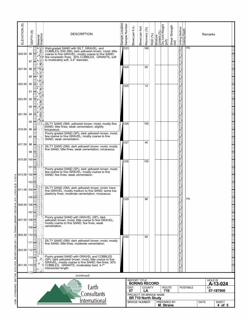
Well-graded SAND with SILT, GRAVEL, andCOBBLES (SW-SM); dark yellowish brown; moist; littlecoarse to fine GRAVEL; mostly coarse to fine SAND;few nonplastic fines; 30% COBBLES, GRANITE, softto moderately soft, 3-4'' diameter.
SILTY SAND (SM); yellowish brown; moist; mostly fineSAND; little fines; weak cementation; slightlymicaceous.Poorly graded SAND (SP); dark yellowish brown; moist;few coarse to fine GRAVEL; mostly coarse to fineSAND; weak cementation.
SILTY SAND (SM); dark yellowish brown; moist; mostlyfine SAND; little fines; weak cementation; micaceous.
Poorly graded SAND (SP); dark yellowish brown; moist;few coarse to fine GRAVEL; mostly coarse to fineSAND; few fines; weak cementation.
SILTY SAND (SM); dark yellowish brown; moist; tracefine GRAVEL; mostly medium to fine SAND; some lowplasticity fines; moderate cementation; micaceous.
Poorly graded SAND with GRAVEL (SP); darkyellowish brown; moist; little coarse to fine GRAVEL;mostly coarse to fine SAND; few fines; weakcementation.
SILTY SAND (SM); dark yellowish brown; moist; mostlyfine SAND; little fines; moderate cementation.
Poorly graded SAND with GRAVEL and COBBLES(SP); dark yellowish brown; moist; little coarse to fineGRAVEL; mostly coarse to fine SAND; few fines; 30%COBBLES, GRANITE, moderately hard, 4-7''intersected length.
168
60
14
100
40
100
86
94
O23
O24
O25
O26
O27
O28
O29
O30
PA
PA
Sam
ple
Loca
tion
COUNTYLA
DESCRIPTION
Rec
over
y (%
)
Dril
ling
Met
hod
Cas
ing
Dep
th
PREPARED BYM. Strane
DATE
PROJECT OR BRIDGE NAMESR 710 North Study
BRIDGE NUMBER
HOLE ID
A-13-024EA07-187900
REPORT TITLEBORING RECORD
DIST.07
ROUTE710
POSTMILE
(continued)
SHEET4 of 5
RQ
D (
%)
Sam
ple
Num
ber
Moi
stur
eC
onte
nt (
%)
Remarks
Blo
ws
per
6 in
.
ELE
VA
TIO
N (
ft)
629.59
627.59
625.59
623.59
621.59
619.59
617.59
615.59
613.59
611.59
609.59
607.59
605.59
603.59
601.59
DE
PT
H (
ft)
Dry
Uni
t Wei
ght
(pcf
)
She
ar S
tren
gth
(tsf
)
Blo
ws
per
foot
Mat
eria
lG
rap
hics
5 B
R -
ST
AN
DA
RD
SR
710N
_EC
ILO
GS
_RE
VB
YC
H2M
.GP
J C
ALT
RA
NS
LIB
RA
RY
DE
C09
-W_E
CI_
LOG
O.G
LB
1/1
5/14
85
86
87
88
89
90
91
92
93
94
95
96
97
98
99
100
101
102
103
104
105
106
107
108
109
110
111
112
113
114
115
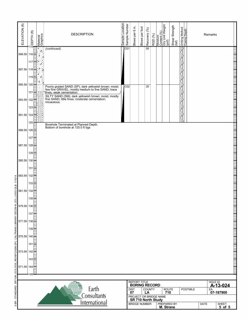
(continued).
Poorly graded SAND (SP); dark yellowish brown; moist;few fine GRAVEL; mostly medium to fine SAND; tracefines; weak cementation.SILTY SAND (SM); dark yellowish brown; moist; mostlyfine SAND; little fines; moderate cementation;micaceous.
Borehole Terminated at Planned Depth.Bottom of borehole at 125.0 ft bgs
50
20
O31
O32
Sam
ple
Loca
tion
COUNTYLA
DESCRIPTION
Rec
over
y (%
)
Dril
ling
Met
hod
Cas
ing
Dep
th
PREPARED BYM. Strane
DATE
PROJECT OR BRIDGE NAMESR 710 North Study
BRIDGE NUMBER
HOLE ID
A-13-024EA07-187900
REPORT TITLEBORING RECORD
DIST.07
ROUTE710
POSTMILE
SHEET5 of 5
RQ
D (
%)
Sam
ple
Num
ber
Moi
stur
eC
onte
nt (
%)
Remarks
Blo
ws
per
6 in
.
ELE
VA
TIO
N (
ft)
599.59
597.59
595.59
593.59
591.59
589.59
587.59
585.59
583.59
581.59
579.59
577.59
575.59
573.59
571.59
DE
PT
H (
ft)
Dry
Uni
t Wei
ght
(pcf
)
She
ar S
tren
gth
(tsf
)
Blo
ws
per
foot
Mat
eria
lG
rap
hics
5 B
R -
ST
AN
DA
RD
SR
710N
_EC
ILO
GS
_RE
VB
YC
H2M
.GP
J C
ALT
RA
NS
LIB
RA
RY
DE
C09
-W_E
CI_
LOG
O.G
LB
1/1
5/14
115
116
117
118
119
120
121
122
123
124
125
126
127
128
129
130
131
132
133
134
135
136
137
138
139
140
141
142
143
144
145
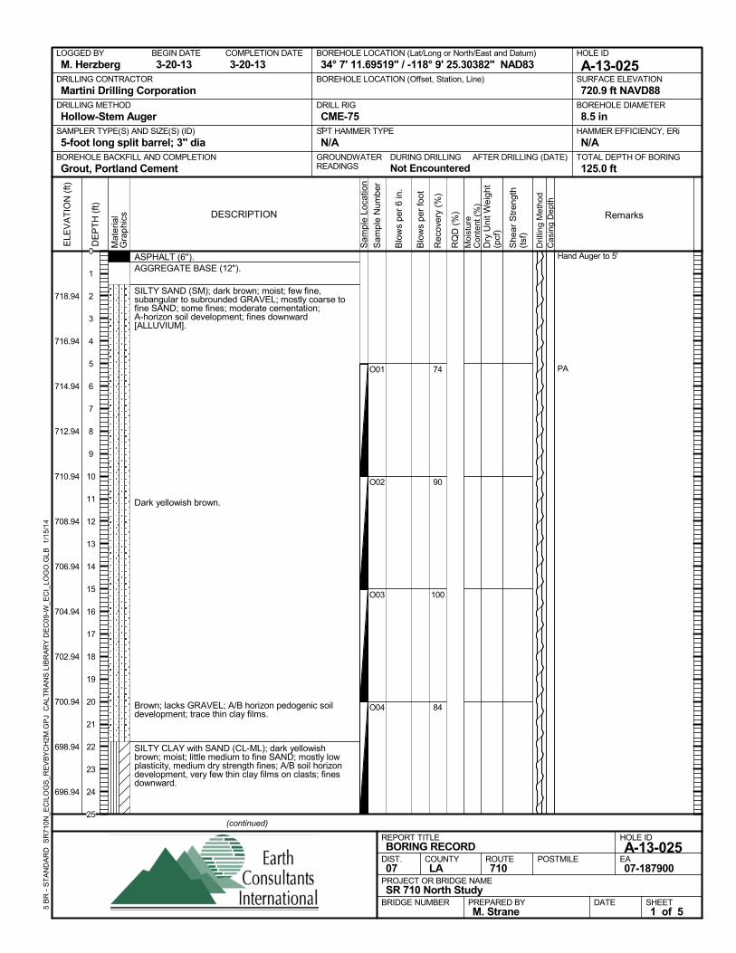
ASPHALT (6'').AGGREGATE BASE (12").
SILTY SAND (SM); dark brown; moist; few fine,subangular to subrounded GRAVEL; mostly coarse tofine SAND; some fines; moderate cementation;A-horizon soil development; fines downward[ALLUVIUM].
Dark yellowish brown.
Brown; lacks GRAVEL; A/B horizon pedogenic soildevelopment; trace thin clay films.
SILTY CLAY with SAND (CL-ML); dark yellowishbrown; moist; little medium to fine SAND; mostly lowplasticity, medium dry strength fines; A/B soil horizondevelopment, very few thin clay films on clasts; finesdownward.
74
90
100
84
O01
O02
O03
O04
Hand Auger to 5'
PA
AFTER DRILLING (DATE)DURING DRILLINGNot Encountered
SURFACE ELEVATION
720.9 ft NAVD88DRILLING METHOD
Hollow-Stem AugerDRILL RIG
CME-75SPT HAMMER TYPE
N/ABOREHOLE BACKFILL AND COMPLETION
Grout, Portland CementGROUNDWATERREADINGS
BEGIN DATE
3-20-13COMPLETION DATE
3-20-13LOGGED BY
M. HerzbergBOREHOLE LOCATION (Lat/Long or North/East and Datum)
34° 7' 11.69519" / -118° 9' 25.30382" NAD83HOLE ID
A-13-025DRILLING CONTRACTOR
Martini Drilling Corporation
HAMMER EFFICIENCY, ERi
N/ASAMPLER TYPE(S) AND SIZE(S) (ID)
5-foot long split barrel; 3" diaTOTAL DEPTH OF BORING
125.0 ft
BOREHOLE DIAMETER
8.5 in
BOREHOLE LOCATION (Offset, Station, Line)
.
Sam
ple
Loca
tion
COUNTYLA
DESCRIPTION
Rec
over
y (%
)
Dril
ling
Met
hod
Cas
ing
Dep
th
PREPARED BYM. Strane
DATE
PROJECT OR BRIDGE NAMESR 710 North Study
BRIDGE NUMBER
HOLE ID
A-13-025EA07-187900
REPORT TITLEBORING RECORD
DIST.07
ROUTE710
POSTMILE
(continued)
SHEET1 of 5
RQ
D (
%)
Sam
ple
Num
ber
Moi
stur
eC
onte
nt (
%)
Remarks
Blo
ws
per
6 in
.
ELE
VA
TIO
N (
ft)
718.94
716.94
714.94
712.94
710.94
708.94
706.94
704.94
702.94
700.94
698.94
696.94
DE
PT
H (
ft)
Dry
Uni
t Wei
ght
(pcf
)
She
ar S
tren
gth
(tsf
)
Blo
ws
per
foot
Mat
eria
lG
rap
hics
5 B
R -
ST
AN
DA
RD
SR
710N
_EC
ILO
GS
_RE
VB
YC
H2M
.GP
J C
ALT
RA
NS
LIB
RA
RY
DE
C09
-W_E
CI_
LOG
O.G
LB
1/1
5/14
0
1
2
3
4
5
6
7
8
9
10
11
12
13
14
15
16
17
18
19
20
21
22
23
24
25
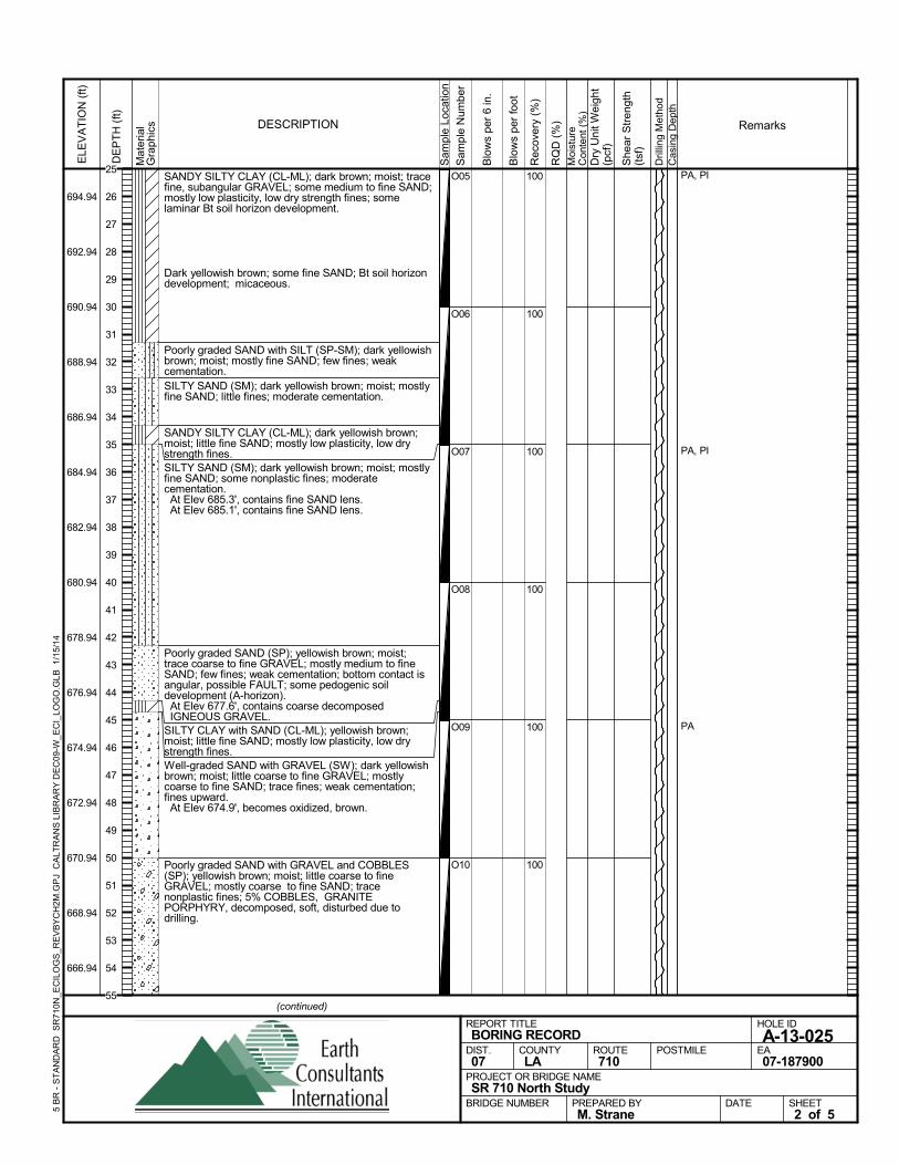
SANDY SILTY CLAY (CL-ML); dark brown; moist; tracefine, subangular GRAVEL; some medium to fine SAND;mostly low plasticity, low dry strength fines; somelaminar Bt soil horizon development.
Dark yellowish brown; some fine SAND; Bt soil horizondevelopment; micaceous.
Poorly graded SAND with SILT (SP-SM); dark yellowishbrown; moist; mostly fine SAND; few fines; weakcementation.SILTY SAND (SM); dark yellowish brown; moist; mostlyfine SAND; little fines; moderate cementation.
SANDY SILTY CLAY (CL-ML); dark yellowish brown;moist; little fine SAND; mostly low plasticity, low drystrength fines.SILTY SAND (SM); dark yellowish brown; moist; mostlyfine SAND; some nonplastic fines; moderatecementation. At Elev 685.3', contains fine SAND lens. At Elev 685.1', contains fine SAND lens.
Poorly graded SAND (SP); yellowish brown; moist;trace coarse to fine GRAVEL; mostly medium to fineSAND; few fines; weak cementation; bottom contact isangular, possible FAULT; some pedogenic soildevelopment (A-horizon). At Elev 677.6', contains coarse decomposedIGNEOUS GRAVEL.
SILTY CLAY with SAND (CL-ML); yellowish brown;moist; little fine SAND; mostly low plasticity, low drystrength fines.Well-graded SAND with GRAVEL (SW); dark yellowishbrown; moist; little coarse to fine GRAVEL; mostlycoarse to fine SAND; trace fines; weak cementation;fines upward. At Elev 674.9', becomes oxidized, brown.
Poorly graded SAND with GRAVEL and COBBLES(SP); yellowish brown; moist; little coarse to fineGRAVEL; mostly coarse to fine SAND; tracenonplastic fines; 5% COBBLES, GRANITEPORPHYRY, decomposed, soft, disturbed due todrilling.
100
100
100
100
100
100
O05
O06
O07
O08
O09
O10
PA, PI
PA, PI
PA
Sam
ple
Loca
tion
COUNTYLA
DESCRIPTION
Rec
over
y (%
)
Dril
ling
Met
hod
Cas
ing
Dep
th
PREPARED BYM. Strane
DATE
PROJECT OR BRIDGE NAMESR 710 North Study
BRIDGE NUMBER
HOLE ID
A-13-025EA07-187900
REPORT TITLEBORING RECORD
DIST.07
ROUTE710
POSTMILE
(continued)
SHEET2 of 5
RQ
D (
%)
Sam
ple
Num
ber
Moi
stur
eC
onte
nt (
%)
Remarks
Blo
ws
per
6 in
.
ELE
VA
TIO
N (
ft)
694.94
692.94
690.94
688.94
686.94
684.94
682.94
680.94
678.94
676.94
674.94
672.94
670.94
668.94
666.94
DE
PT
H (
ft)
Dry
Uni
t Wei
ght
(pcf
)
She
ar S
tren
gth
(tsf
)
Blo
ws
per
foot
Mat
eria
lG
rap
hics
5 B
R -
ST
AN
DA
RD
SR
710N
_EC
ILO
GS
_RE
VB
YC
H2M
.GP
J C
ALT
RA
NS
LIB
RA
RY
DE
C09
-W_E
CI_
LOG
O.G
LB
1/1
5/14
25
26
27
28
29
30
31
32
33
34
35
36
37
38
39
40
41
42
43
44
45
46
47
48
49
50
51
52
53
54
55
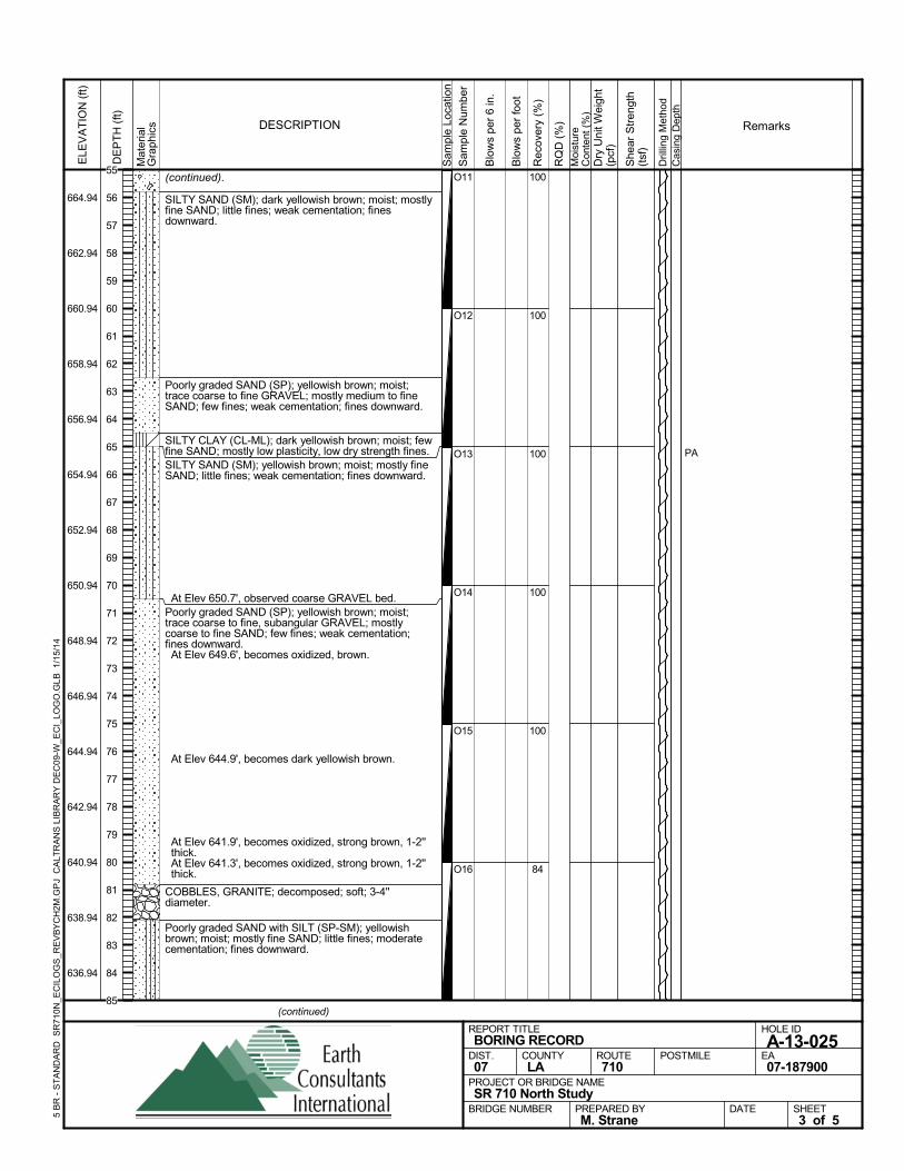
(continued).
SILTY SAND (SM); dark yellowish brown; moist; mostlyfine SAND; little fines; weak cementation; finesdownward.
Poorly graded SAND (SP); yellowish brown; moist;trace coarse to fine GRAVEL; mostly medium to fineSAND; few fines; weak cementation; fines downward.
SILTY CLAY (CL-ML); dark yellowish brown; moist; fewfine SAND; mostly low plasticity, low dry strength fines.SILTY SAND (SM); yellowish brown; moist; mostly fineSAND; little fines; weak cementation; fines downward.
At Elev 650.7', observed coarse GRAVEL bed.Poorly graded SAND (SP); yellowish brown; moist;trace coarse to fine, subangular GRAVEL; mostlycoarse to fine SAND; few fines; weak cementation;fines downward. At Elev 649.6', becomes oxidized, brown.
At Elev 644.9', becomes dark yellowish brown.
At Elev 641.9', becomes oxidized, strong brown, 1-2''thick.
At Elev 641.3', becomes oxidized, strong brown, 1-2''thick.
COBBLES, GRANITE; decomposed; soft; 3-4''diameter.
Poorly graded SAND with SILT (SP-SM); yellowishbrown; moist; mostly fine SAND; little fines; moderatecementation; fines downward.
100
100
100
100
100
84
O11
O12
O13
O14
O15
O16
PAS
ampl
e Lo
catio
n
COUNTYLA
DESCRIPTION
Rec
over
y (%
)
Dril
ling
Met
hod
Cas
ing
Dep
th
PREPARED BYM. Strane
DATE
PROJECT OR BRIDGE NAMESR 710 North Study
BRIDGE NUMBER
HOLE ID
A-13-025EA07-187900
REPORT TITLEBORING RECORD
DIST.07
ROUTE710
POSTMILE
(continued)
SHEET3 of 5
RQ
D (
%)
Sam
ple
Num
ber
Moi
stur
eC
onte
nt (
%)
Remarks
Blo
ws
per
6 in
.
ELE
VA
TIO
N (
ft)
664.94
662.94
660.94
658.94
656.94
654.94
652.94
650.94
648.94
646.94
644.94
642.94
640.94
638.94
636.94
DE
PT
H (
ft)
Dry
Uni
t Wei
ght
(pcf
)
She
ar S
tren
gth
(tsf
)
Blo
ws
per
foot
Mat
eria
lG
rap
hics
5 B
R -
ST
AN
DA
RD
SR
710N
_EC
ILO
GS
_RE
VB
YC
H2M
.GP
J C
ALT
RA
NS
LIB
RA
RY
DE
C09
-W_E
CI_
LOG
O.G
LB
1/1
5/14
55
56
57
58
59
60
61
62
63
64
65
66
67
68
69
70
71
72
73
74
75
76
77
78
79
80
81
82
83
84
85
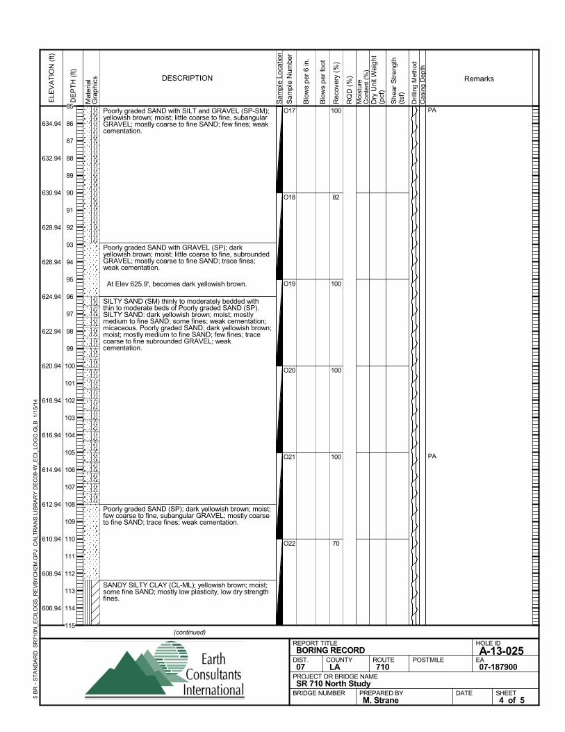
Poorly graded SAND with SILT and GRAVEL (SP-SM);yellowish brown; moist; little coarse to fine, subangularGRAVEL; mostly coarse to fine SAND; few fines; weakcementation.
Poorly graded SAND with GRAVEL (SP); darkyellowish brown; moist; little coarse to fine, subroundedGRAVEL; mostly coarse to fine SAND; trace fines;weak cementation.
At Elev 625.9', becomes dark yellowish brown.
SILTY SAND (SM) thinly to moderately bedded withthin to moderate beds of Poorly graded SAND (SP).SILTY SAND: dark yellowish brown; moist; mostlymedium to fine SAND; some fines; weak cementation;micaceous. Poorly graded SAND; dark yellowish brown;moist; mostly medium to fine SAND; few fines; tracecoarse to fine subrounded GRAVEL; weakcementation.
Poorly graded SAND (SP); dark yellowish brown; moist;few coarse to fine, subangular GRAVEL; mostly coarseto fine SAND; trace fines; weak cementation.
SANDY SILTY CLAY (CL-ML); yellowish brown; moist;some fine SAND; mostly low plasticity, low dry strengthfines.
100
82
100
100
100
70
O17
O18
O19
O20
O21
O22
PA
PA
Sam
ple
Loca
tion
COUNTYLA
DESCRIPTION
Rec
over
y (%
)
Dril
ling
Met
hod
Cas
ing
Dep
th
PREPARED BYM. Strane
DATE
PROJECT OR BRIDGE NAMESR 710 North Study
BRIDGE NUMBER
HOLE ID
A-13-025EA07-187900
REPORT TITLEBORING RECORD
DIST.07
ROUTE710
POSTMILE
(continued)
SHEET4 of 5
RQ
D (
%)
Sam
ple
Num
ber
Moi
stur
eC
onte
nt (
%)
Remarks
Blo
ws
per
6 in
.
ELE
VA
TIO
N (
ft)
634.94
632.94
630.94
628.94
626.94
624.94
622.94
620.94
618.94
616.94
614.94
612.94
610.94
608.94
606.94
DE
PT
H (
ft)
Dry
Uni
t Wei
ght
(pcf
)
She
ar S
tren
gth
(tsf
)
Blo
ws
per
foot
Mat
eria
lG
rap
hics
5 B
R -
ST
AN
DA
RD
SR
710N
_EC
ILO
GS
_RE
VB
YC
H2M
.GP
J C
ALT
RA
NS
LIB
RA
RY
DE
C09
-W_E
CI_
LOG
O.G
LB
1/1
5/14
85
86
87
88
89
90
91
92
93
94
95
96
97
98
99
100
101
102
103
104
105
106
107
108
109
110
111
112
113
114
115
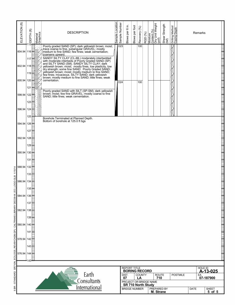
Poorly graded SAND (SP); dark yellowish brown; moist;trace coarse to fine, subangular GRAVEL; mostlymedium to fine SAND; few fines; weak cementation;coarsens upward.SANDY SILTY CLAY (CL-ML) moderately interbeddedwith moderate interbeds of Poorly Graded SAND (SP)and SILTY SAND (SM). SANDY SILTY CLAY; darkyellowish brown; moist; mostly fines, low plasticity, lowdry strength; some fine SAND. Poorly Graded SAND;yellowish brown; moist; mostly medium to fine SAND;few fines; micaceous. SILTY SAND; dark yellowishbrown; mostly medium to fine SAND; little fines; weakcementation.
Poorly graded SAND with SILT (SP-SM); dark yellowishbrown; moist; few fine GRAVEL; mostly coarse to fineSAND; little fines; weak cementation.
Borehole Terminated at Planned Depth.Bottom of borehole at 125.0 ft bgs
100
100
O23
O24
Sam
ple
Loca
tion
COUNTYLA
DESCRIPTION
Rec
over
y (%
)
Dril
ling
Met
hod
Cas
ing
Dep
th
PREPARED BYM. Strane
DATE
PROJECT OR BRIDGE NAMESR 710 North Study
BRIDGE NUMBER
HOLE ID
A-13-025EA07-187900
REPORT TITLEBORING RECORD
DIST.07
ROUTE710
POSTMILE
SHEET5 of 5
RQ
D (
%)
Sam
ple
Num
ber
Moi
stur
eC
onte
nt (
%)
Remarks
Blo
ws
per
6 in
.
ELE
VA
TIO
N (
ft)
604.94
602.94
600.94
598.94
596.94
594.94
592.94
590.94
588.94
586.94
584.94
582.94
580.94
578.94
576.94
DE
PT
H (
ft)
Dry
Uni
t Wei
ght
(pcf
)
She
ar S
tren
gth
(tsf
)
Blo
ws
per
foot
Mat
eria
lG
rap
hics
5 B
R -
ST
AN
DA
RD
SR
710N
_EC
ILO
GS
_RE
VB
YC
H2M
.GP
J C
ALT
RA
NS
LIB
RA
RY
DE
C09
-W_E
CI_
LOG
O.G
LB
1/1
5/14
115
116
117
118
119
120
121
122
123
124
125
126
127
128
129
130
131
132
133
134
135
136
137
138
139
140
141
142
143
144
145
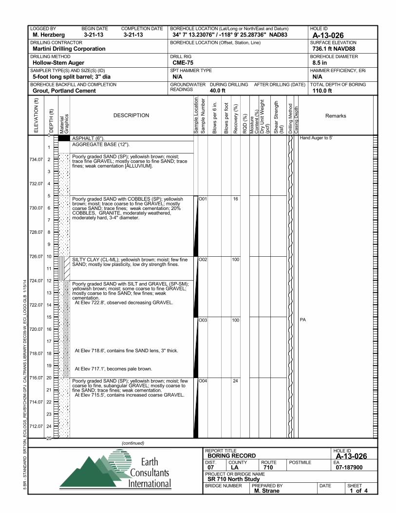
ASPHALT (6'').AGGREGATE BASE (12").
Poorly graded SAND (SP); yellowish brown; moist;trace fine GRAVEL; mostly coarse to fine SAND; tracefines; weak cementation [ALLUVIUM].
Poorly graded SAND with COBBLES (SP); yellowishbrown; moist; trace coarse to fine GRAVEL; mostlycoarse SAND; trace fines; weak cementation; 20%COBBLES, GRANITE, moderately weathered,moderately hard, 3-4'' diameter.
SILTY CLAY (CL-ML); yellowish brown; moist; few fineSAND; mostly low plasticity, low dry strength fines.
Poorly graded SAND with SILT and GRAVEL (SP-SM);yellowish brown; moist; some coarse to fine GRAVEL;mostly coarse to fine SAND; few fines; weakcementation. At Elev 722.8', observed decreasing GRAVEL.
At Elev 718.6', contains fine SAND lens, 3'' thick.
At Elev 717.1', becomes pale brown.
Poorly graded SAND (SP); yellowish brown; moist; fewcoarse to fine, subangular GRAVEL; mostly coarse tofine SAND; trace fines; weak cementation. At Elev 715.5', contains increased coarse GRAVEL.
16
100
100
24
O01
O02
O03
O04
Hand Auger to 5'
PA
AFTER DRILLING (DATE)DURING DRILLING40.0 ft
SURFACE ELEVATION
736.1 ft NAVD88DRILLING METHOD
Hollow-Stem AugerDRILL RIG
CME-75SPT HAMMER TYPE
N/ABOREHOLE BACKFILL AND COMPLETION
Grout, Portland CementGROUNDWATERREADINGS
BEGIN DATE
3-21-13COMPLETION DATE
3-21-13LOGGED BY
M. HerzbergBOREHOLE LOCATION (Lat/Long or North/East and Datum)
34° 7' 13.23076" / -118° 9' 25.28736" NAD83HOLE ID
A-13-026DRILLING CONTRACTOR
Martini Drilling Corporation
HAMMER EFFICIENCY, ERi
N/ASAMPLER TYPE(S) AND SIZE(S) (ID)
5-foot long split barrel; 3" diaTOTAL DEPTH OF BORING
110.0 ft
BOREHOLE DIAMETER
8.5 in
BOREHOLE LOCATION (Offset, Station, Line)
.
Sam
ple
Loca
tion
COUNTYLA
DESCRIPTION
Rec
over
y (%
)
Dril
ling
Met
hod
Cas
ing
Dep
th
PREPARED BYM. Strane
DATE
PROJECT OR BRIDGE NAMESR 710 North Study
BRIDGE NUMBER
HOLE ID
A-13-026EA07-187900
REPORT TITLEBORING RECORD
DIST.07
ROUTE710
POSTMILE
(continued)
SHEET1 of 4
RQ
D (
%)
Sam
ple
Num
ber
Moi
stur
eC
onte
nt (
%)
Remarks
Blo
ws
per
6 in
.
ELE
VA
TIO
N (
ft)
734.07
732.07
730.07
728.07
726.07
724.07
722.07
720.07
718.07
716.07
714.07
712.07
DE
PT
H (
ft)
Dry
Uni
t Wei
ght
(pcf
)
She
ar S
tren
gth
(tsf
)
Blo
ws
per
foot
Mat
eria
lG
rap
hics
5 B
R -
ST
AN
DA
RD
SR
710N
_EC
ILO
GS
_RE
VB
YC
H2M
.GP
J C
ALT
RA
NS
LIB
RA
RY
DE
C09
-W_E
CI_
LOG
O.G
LB
1/1
5/14
0
1
2
3
4
5
6
7
8
9
10
11
12
13
14
15
16
17
18
19
20
21
22
23
24
25
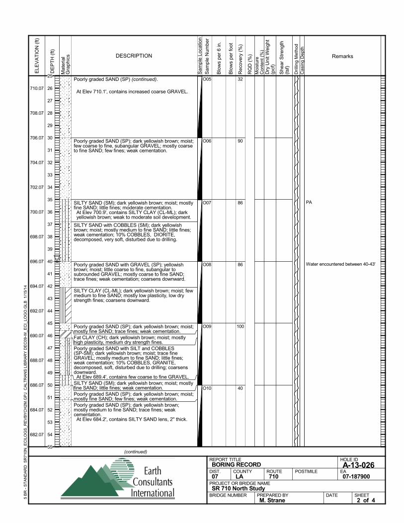
Poorly graded SAND (SP) (continued).
At Elev 710.1', contains increased coarse GRAVEL.
Poorly graded SAND (SP); dark yellowish brown; moist;few coarse to fine, subangular GRAVEL; mostly coarseto fine SAND; few fines; weak cementation.
SILTY SAND (SM); dark yellowish brown; moist; mostlyfine SAND; little fines; moderate cementation. At Elev 700.9', contains SILTY CLAY (CL-ML); darkyellowish brown; weak to moderate soil development.
SILTY SAND with COBBLES (SM); dark yellowishbrown; moist; mostly medium to fine SAND; little fines;weak cementation; 10% COBBLES, DIORITE,decomposed, very soft, disturbed due to drilling.
Poorly graded SAND with GRAVEL (SP); yellowishbrown; moist; little coarse to fine, subangular tosubrounded GRAVEL; mostly coarse to fine SAND;trace fines; weak cementation; coarsens downward.
SILTY CLAY (CL-ML); dark yellowish brown; moist; fewmedium to fine SAND; mostly low plasticity, low drystrength fines; coarsens downward.
Poorly graded SAND (SP); dark yellowish brown; moist;mostly fine SAND; trace fines; weak cementation.Fat CLAY (CH); dark yellowish brown; moist; mostlyhigh plasticity, medium dry strength fines.Poorly graded SAND with SILT and COBBLES(SP-SM); dark yellowish brown; moist; trace fineGRAVEL; mostly medium to fine SAND; little fines;weak cementation; 10% COBBLES, GRANITE,decomposed, soft, disturbed due to drilling; coarsensdownward. At Elev 689.4', contains few coarse to fine GRAVEL.SILTY SAND (SM); dark yellowish brown; moist; mostlyfine SAND; little fines; weak cementation.Poorly graded SAND (SP); dark yellowish brown; moist;mostly fine SAND; few fines; weak cementation.Poorly graded SAND (SP); dark yellowish brown;mostly medium to fine SAND; trace fines; weakcementation. At Elev 684.2', contains SILTY SAND lens, 2'' thick.
32
90
86
86
100
40
O05
O06
O07
O08
O09
O10
PA
Water encountered between 40-43'
Sam
ple
Loca
tion
COUNTYLA
DESCRIPTION
Rec
over
y (%
)
Dril
ling
Met
hod
Cas
ing
Dep
th
PREPARED BYM. Strane
DATE
PROJECT OR BRIDGE NAMESR 710 North Study
BRIDGE NUMBER
HOLE ID
A-13-026EA07-187900
REPORT TITLEBORING RECORD
DIST.07
ROUTE710
POSTMILE
(continued)
SHEET2 of 4
RQ
D (
%)
Sam
ple
Num
ber
Moi
stur
eC
onte
nt (
%)
Remarks
Blo
ws
per
6 in
.
ELE
VA
TIO
N (
ft)
710.07
708.07
706.07
704.07
702.07
700.07
698.07
696.07
694.07
692.07
690.07
688.07
686.07
684.07
682.07
DE
PT
H (
ft)
Dry
Uni
t Wei
ght
(pcf
)
She
ar S
tren
gth
(tsf
)
Blo
ws
per
foot
Mat
eria
lG
rap
hics
5 B
R -
ST
AN
DA
RD
SR
710N
_EC
ILO
GS
_RE
VB
YC
H2M
.GP
J C
ALT
RA
NS
LIB
RA
RY
DE
C09
-W_E
CI_
LOG
O.G
LB
1/1
5/14
25
26
27
28
29
30
31
32
33
34
35
36
37
38
39
40
41
42
43
44
45
46
47
48
49
50
51
52
53
54
55
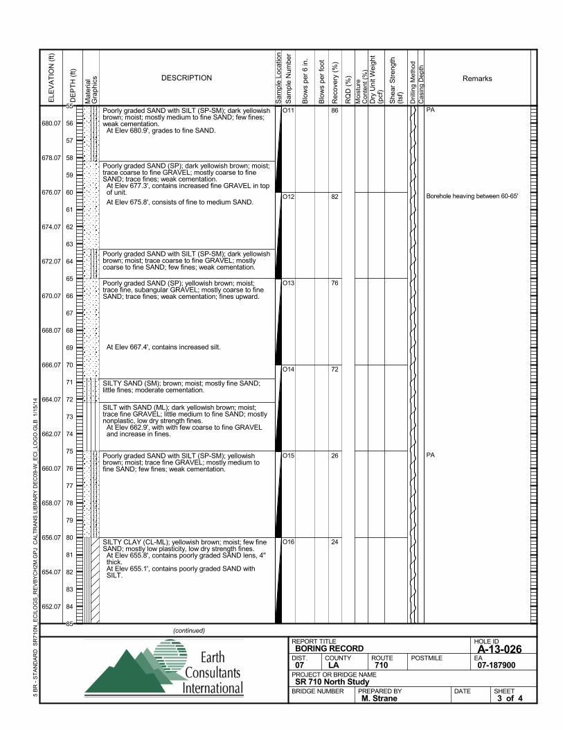
Poorly graded SAND with SILT (SP-SM); dark yellowishbrown; moist; mostly medium to fine SAND; few fines;weak cementation. At Elev 680.9', grades to fine SAND.
Poorly graded SAND (SP); dark yellowish brown; moist;trace coarse to fine GRAVEL; mostly coarse to fineSAND; trace fines; weak cementation. At Elev 677.3', contains increased fine GRAVEL in topof unit.
At Elev 675.8', consists of fine to medium SAND.
Poorly graded SAND with SILT (SP-SM); dark yellowishbrown; moist; trace coarse to fine GRAVEL; mostlycoarse to fine SAND; few fines; weak cementation.
Poorly graded SAND (SP); yellowish brown; moist;trace fine, subangular GRAVEL; mostly coarse to fineSAND; trace fines; weak cementation; fines upward.
At Elev 667.4', contains increased silt.
SILTY SAND (SM); brown; moist; mostly fine SAND;little fines; moderate cementation.
SILT with SAND (ML); dark yellowish brown; moist;trace fine GRAVEL; little medium to fine SAND; mostlynonplastic, low dry strength fines. At Elev 662.9', with with few coarse to fine GRAVELand increase in fines.
Poorly graded SAND with SILT (SP-SM); yellowishbrown; moist; trace fine GRAVEL; mostly medium tofine SAND; few fines; weak cementation.
SILTY CLAY (CL-ML); yellowish brown; moist; few fineSAND; mostly low plasticity, low dry strength fines. At Elev 655.8', contains poorly graded SAND lens, 4''thick.
At Elev 655.1', contains poorly graded SAND withSILT.
86
82
76
72
26
24
O11
O12
O13
O14
O15
O16
PA
Borehole heaving between 60-65'
PA
Sam
ple
Loca
tion
COUNTYLA
DESCRIPTION
Rec
over
y (%
)
Dril
ling
Met
hod
Cas
ing
Dep
th
PREPARED BYM. Strane
DATE
PROJECT OR BRIDGE NAMESR 710 North Study
BRIDGE NUMBER
HOLE ID
A-13-026EA07-187900
REPORT TITLEBORING RECORD
DIST.07
ROUTE710
POSTMILE
(continued)
SHEET3 of 4
RQ
D (
%)
Sam
ple
Num
ber
Moi
stur
eC
onte
nt (
%)
Remarks
Blo
ws
per
6 in
.
ELE
VA
TIO
N (
ft)
680.07
678.07
676.07
674.07
672.07
670.07
668.07
666.07
664.07
662.07
660.07
658.07
656.07
654.07
652.07
DE
PT
H (
ft)
Dry
Uni
t Wei
ght
(pcf
)
She
ar S
tren
gth
(tsf
)
Blo
ws
per
foot
Mat
eria
lG
rap
hics
5 B
R -
ST
AN
DA
RD
SR
710N
_EC
ILO
GS
_RE
VB
YC
H2M
.GP
J C
ALT
RA
NS
LIB
RA
RY
DE
C09
-W_E
CI_
LOG
O.G
LB
1/1
5/14
55
56
57
58
59
60
61
62
63
64
65
66
67
68
69
70
71
72
73
74
75
76
77
78
79
80
81
82
83
84
85
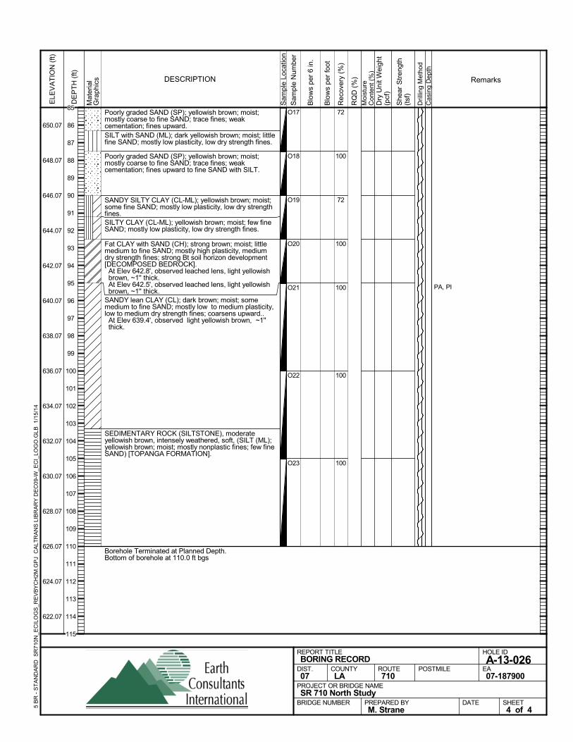
Poorly graded SAND (SP); yellowish brown; moist;mostly coarse to fine SAND; trace fines; weakcementation; fines upward.SILT with SAND (ML); dark yellowish brown; moist; littlefine SAND; mostly low plasticity, low dry strength fines.
Poorly graded SAND (SP); yellowish brown; moist;mostly coarse to fine SAND; trace fines; weakcementation; fines upward to fine SAND with SILT.
SANDY SILTY CLAY (CL-ML); yellowish brown; moist;some fine SAND; mostly low plasticity, low dry strengthfines.SILTY CLAY (CL-ML); yellowish brown; moist; few fineSAND; mostly low plasticity, low dry strength fines.
Fat CLAY with SAND (CH); strong brown; moist; littlemedium to fine SAND; mostly high plasticity, mediumdry strength fines; strong Bt soil horizon development[DECOMPOSED BEDROCK]. At Elev 642.8', observed leached lens, light yellowishbrown, ~1'' thick.
At Elev 642.5', observed leached lens, light yellowishbrown, ~1'' thick.
SANDY lean CLAY (CL); dark brown; moist; somemedium to fine SAND; mostly low to medium plasticity,low to medium dry strength fines; coarsens upward.. At Elev 639.4', observed light yellowish brown, ~1''thick.
SEDIMENTARY ROCK (SILTSTONE), moderateyellowish brown, intensely weathered, soft, (SILT (ML);yellowish brown; moist; mostly nonplastic fines; few fineSAND) [TOPANGA FORMATION].
Borehole Terminated at Planned Depth.Bottom of borehole at 110.0 ft bgs
72
100
72
100
100
100
100
O17
O18
O19
O20
O21
O22
O23
PA, PIS
ampl
e Lo
catio
n
COUNTYLA
DESCRIPTION
Rec
over
y (%
)
Dril
ling
Met
hod
Cas
ing
Dep
th
PREPARED BYM. Strane
DATE
PROJECT OR BRIDGE NAMESR 710 North Study
BRIDGE NUMBER
HOLE ID
A-13-026EA07-187900
REPORT TITLEBORING RECORD
DIST.07
ROUTE710
POSTMILE
SHEET4 of 4
RQ
D (
%)
Sam
ple
Num
ber
Moi
stur
eC
onte
nt (
%)
Remarks
Blo
ws
per
6 in
.
ELE
VA
TIO
N (
ft)
650.07
648.07
646.07
644.07
642.07
640.07
638.07
636.07
634.07
632.07
630.07
628.07
626.07
624.07
622.07
DE
PT
H (
ft)
Dry
Uni
t Wei
ght
(pcf
)
She
ar S
tren
gth
(tsf
)
Blo
ws
per
foot
Mat
eria
lG
rap
hics
5 B
R -
ST
AN
DA
RD
SR
710N
_EC
ILO
GS
_RE
VB
YC
H2M
.GP
J C
ALT
RA
NS
LIB
RA
RY
DE
C09
-W_E
CI_
LOG
O.G
LB
1/1
5/14
85
86
87
88
89
90
91
92
93
94
95
96
97
98
99
100
101
102
103
104
105
106
107
108
109
110
111
112
113
114
115
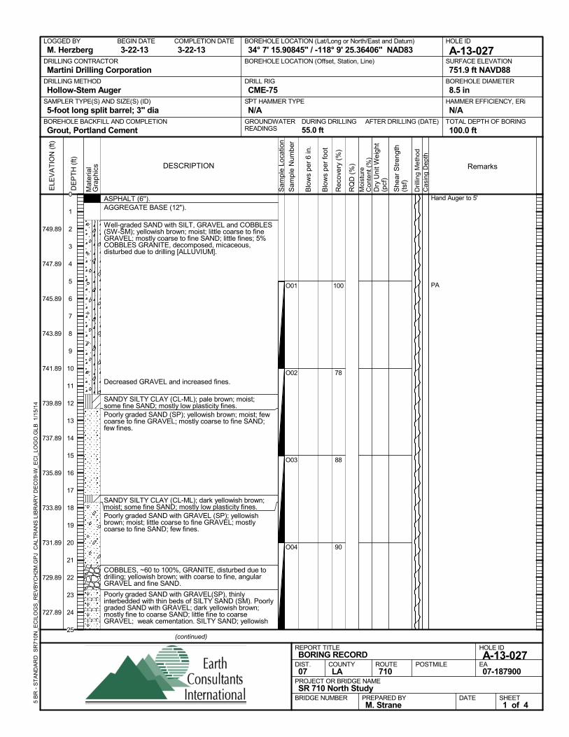
ASPHALT (6'').AGGREGATE BASE (12").
Well-graded SAND with SILT, GRAVEL and COBBLES(SW-SM); yellowish brown; moist; little coarse to fineGRAVEL; mostly coarse to fine SAND; little fines; 5%COBBLES GRANITE, decomposed, micaceous,disturbed due to drilling [ALLUVIUM].
Decreased GRAVEL and increased fines.
SANDY SILTY CLAY (CL-ML); pale brown; moist;some fine SAND; mostly low plasticity fines.Poorly graded SAND (SP); yellowish brown; moist; fewcoarse to fine GRAVEL; mostly coarse to fine SAND;few fines.
SANDY SILTY CLAY (CL-ML); dark yellowish brown;moist; some fine SAND; mostly low plasticity fines.Poorly graded SAND with GRAVEL (SP); yellowishbrown; moist; little coarse to fine GRAVEL; mostlycoarse to fine SAND; few fines.
COBBLES, ~60 to 100%, GRANITE, disturbed due todrilling; yellowish brown; with coarse to fine, angularGRAVEL and fine SAND.
Poorly graded SAND with GRAVEL(SP), thinlyinterbedded with thin beds of SILTY SAND (SM). Poorlygraded SAND with GRAVEL; dark yellowish brown;mostly fine to coarse SAND; little fine to coarseGRAVEL; weak cementation. SILTY SAND; yellowish
100
78
88
90
O01
O02
O03
O04
Hand Auger to 5'
PA
AFTER DRILLING (DATE)DURING DRILLING55.0 ft
SURFACE ELEVATION
751.9 ft NAVD88DRILLING METHOD
Hollow-Stem AugerDRILL RIG
CME-75SPT HAMMER TYPE
N/ABOREHOLE BACKFILL AND COMPLETION
Grout, Portland CementGROUNDWATERREADINGS
BEGIN DATE
3-22-13COMPLETION DATE
3-22-13LOGGED BY
M. HerzbergBOREHOLE LOCATION (Lat/Long or North/East and Datum)
34° 7' 15.90845" / -118° 9' 25.36406" NAD83HOLE ID
A-13-027DRILLING CONTRACTOR
Martini Drilling Corporation
HAMMER EFFICIENCY, ERi
N/ASAMPLER TYPE(S) AND SIZE(S) (ID)
5-foot long split barrel; 3" diaTOTAL DEPTH OF BORING
100.0 ft
BOREHOLE DIAMETER
8.5 in
BOREHOLE LOCATION (Offset, Station, Line)
.
Sam
ple
Loca
tion
COUNTYLA
DESCRIPTION
Rec
over
y (%
)
Dril
ling
Met
hod
Cas
ing
Dep
th
PREPARED BYM. Strane
DATE
PROJECT OR BRIDGE NAMESR 710 North Study
BRIDGE NUMBER
HOLE ID
A-13-027EA07-187900
REPORT TITLEBORING RECORD
DIST.07
ROUTE710
POSTMILE
(continued)
SHEET1 of 4
RQ
D (
%)
Sam
ple
Num
ber
Moi
stur
eC
onte
nt (
%)
Remarks
Blo
ws
per
6 in
.
ELE
VA
TIO
N (
ft)
749.89
747.89
745.89
743.89
741.89
739.89
737.89
735.89
733.89
731.89
729.89
727.89
DE
PT
H (
ft)
Dry
Uni
t Wei
ght
(pcf
)
She
ar S
tren
gth
(tsf
)
Blo
ws
per
foot
Mat
eria
lG
rap
hics
5 B
R -
ST
AN
DA
RD
SR
710N
_EC
ILO
GS
_RE
VB
YC
H2M
.GP
J C
ALT
RA
NS
LIB
RA
RY
DE
C09
-W_E
CI_
LOG
O.G
LB
1/1
5/14
0
1
2
3
4
5
6
7
8
9
10
11
12
13
14
15
16
17
18
19
20
21
22
23
24
25
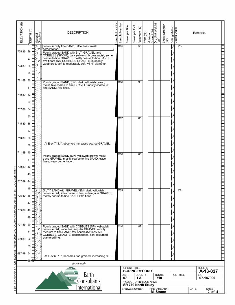
brown, mostly fine SAND; little fines; weakcementation.Poorly graded SAND with SILT, GRAVEL, andCOBBLES (SP-SM); dark yellowish brown; moist; somecoarse to fine GRAVEL; mostly coarse to fine SAND;few fines; 15% COBBLES, GRANITE, intenselyweathered, soft to moderately soft, ~3-4'' diameter.
Poorly graded SAND; (SP); dark yellowish brown;moist; few coarse to fine GRAVEL; mostly coarse tofine SAND; few fines.
At Elev 713.4', observed increased coarse GRAVEL.
Poorly graded SAND (SP); yellowish brown; moist;trace GRAVEL; mostly coarse to fine SAND; tracefines; weak cementation.
SILTY SAND with GRAVEL (SM); dark yellowishbrown; moist, little coarse to fine, subangular GRAVEL;mostly coarse to fine SAND; little fines.
Poorly graded SAND with COBBLES (SP); yellowishbrown; moist; trace fine, angular GRAVEL; mostlymedium to fine SAND; few nonplastic fines; 5%COBBLES, GRANITE, decomposed, soft, disturbeddue to drilling.
At Elev 697.8', becomes fine grained, increasing SILT.
50
90
80
88
34
88
O05
O06
O07
O08
O09
O10
PA
PA
Sam
ple
Loca
tion
COUNTYLA
DESCRIPTION
Rec
over
y (%
)
Dril
ling
Met
hod
Cas
ing
Dep
th
PREPARED BYM. Strane
DATE
PROJECT OR BRIDGE NAMESR 710 North Study
BRIDGE NUMBER
HOLE ID
A-13-027EA07-187900
REPORT TITLEBORING RECORD
DIST.07
ROUTE710
POSTMILE
(continued)
SHEET2 of 4
RQ
D (
%)
Sam
ple
Num
ber
Moi
stur
eC
onte
nt (
%)
Remarks
Blo
ws
per
6 in
.
ELE
VA
TIO
N (
ft)
725.89
723.89
721.89
719.89
717.89
715.89
713.89
711.89
709.89
707.89
705.89
703.89
701.89
699.89
697.89
DE
PT
H (
ft)
Dry
Uni
t Wei
ght
(pcf
)
She
ar S
tren
gth
(tsf
)
Blo
ws
per
foot
Mat
eria
lG
rap
hics
5 B
R -
ST
AN
DA
RD
SR
710N
_EC
ILO
GS
_RE
VB
YC
H2M
.GP
J C
ALT
RA
NS
LIB
RA
RY
DE
C09
-W_E
CI_
LOG
O.G
LB
1/1
5/14
25
26
27
28
29
30
31
32
33
34
35
36
37
38
39
40
41
42
43
44
45
46
47
48
49
50
51
52
53
54
55
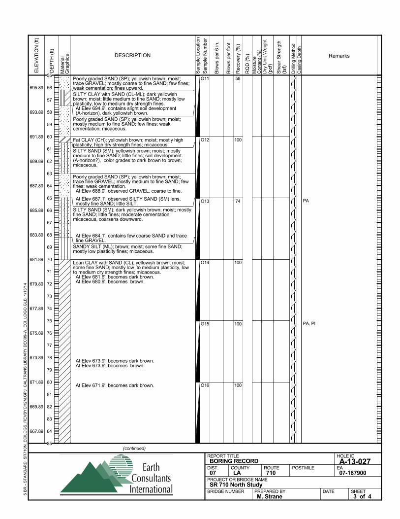
Poorly graded SAND (SP); yellowish brown; moist;trace GRAVEL; mostly coarse to fine SAND; few fines;weak cementation; fines upward.SILTY CLAY with SAND (CL-ML); dark yellowishbrown; moist; little medium to fine SAND; mostly lowplasticity, low to medium dry strength fines. At Elev 694.9', contains slight soil development(A-horizon), dark yellowish brown.
Poorly graded SAND (SP); yellowish brown; moist;mostly medium to fine SAND; few fines; weakcementation; micaceous.
Fat CLAY (CH); yellowish brown; moist; mostly highplasticity, high dry strength fines; micaceous.SILTY SAND (SM); yellowish brown; moist; mostlymedium to fine SAND; little fines; soil development(A-horizon?), color grades to dark brown to brown;micaceous.
Poorly graded SAND (SP); yellowish brown; moist;trace fine GRAVEL; mostly medium to fine SAND; fewfines; weak cementation. At Elev 688.0', observed GRAVEL, coarse to fine.
At Elev 687.1', observed SILTY SAND (SM) lens,mostly fine SAND; little SILT.
SILTY SAND (SM); dark yellowish brown; moist; mostlyfine SAND; little fines; moderate cementation;micaceous, coarsens downward.
At Elev 684.1', contains few coarse SAND and tracefine GRAVEL.
SANDY SILT (ML); brown; moist; some fine SAND;mostly low plasticity fines; micaceous.
Lean CLAY with SAND (CL); yellowish brown; moist;some fine SAND; mostly low to medium plasticity, lowto medium dry strength fines; micaceous. At Elev 681.6', becomes dark brown. At Elev 680.9', becomes brown.
At Elev 673.9', becomes dark brown. At Elev 673.6', becomes brown.
At Elev 671.9', becomes dark brown.
58
100
74
100
100
100
O11
O12
O13
O14
O15
O16
PA
PA, PI
Sam
ple
Loca
tion
COUNTYLA
DESCRIPTION
Rec
over
y (%
)
Dril
ling
Met
hod
Cas
ing
Dep
th
PREPARED BYM. Strane
DATE
PROJECT OR BRIDGE NAMESR 710 North Study
BRIDGE NUMBER
HOLE ID
A-13-027EA07-187900
REPORT TITLEBORING RECORD
DIST.07
ROUTE710
POSTMILE
(continued)
SHEET3 of 4
RQ
D (
%)
Sam
ple
Num
ber
Moi
stur
eC
onte
nt (
%)
Remarks
Blo
ws
per
6 in
.
ELE
VA
TIO
N (
ft)
695.89
693.89
691.89
689.89
687.89
685.89
683.89
681.89
679.89
677.89
675.89
673.89
671.89
669.89
667.89
DE
PT
H (
ft)
Dry
Uni
t Wei
ght
(pcf
)
She
ar S
tren
gth
(tsf
)
Blo
ws
per
foot
Mat
eria
lG
rap
hics
5 B
R -
ST
AN
DA
RD
SR
710N
_EC
ILO
GS
_RE
VB
YC
H2M
.GP
J C
ALT
RA
NS
LIB
RA
RY
DE
C09
-W_E
CI_
LOG
O.G
LB
1/1
5/14
55
56
57
58
59
60
61
62
63
64
65
66
67
68
69
70
71
72
73
74
75
76
77
78
79
80
81
82
83
84
85
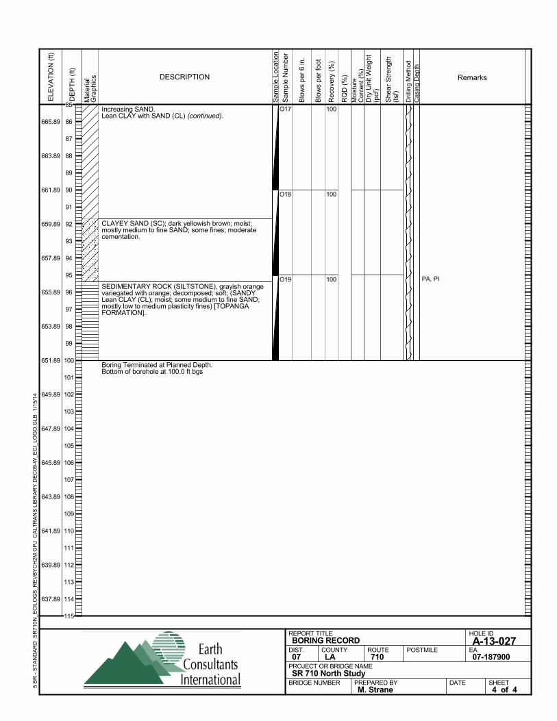
Increasing SAND.Lean CLAY with SAND (CL) (continued).
CLAYEY SAND (SC); dark yellowish brown; moist;mostly medium to fine SAND; some fines; moderatecementation.
SEDIMENTARY ROCK (SILTSTONE), grayish orangevariegated with orange; decomposed; soft; (SANDYLean CLAY (CL); moist; some medium to fine SAND;mostly low to medium plasticity fines) [TOPANGAFORMATION].
Boring Terminated at Planned Depth.Bottom of borehole at 100.0 ft bgs
100
100
100
O17
O18
O19 PA, PIS
ampl
e Lo
catio
n
COUNTYLA
DESCRIPTION
Rec
over
y (%
)
Dril
ling
Met
hod
Cas
ing
Dep
th
PREPARED BYM. Strane
DATE
PROJECT OR BRIDGE NAMESR 710 North Study
BRIDGE NUMBER
HOLE ID
A-13-027EA07-187900
REPORT TITLEBORING RECORD
DIST.07
ROUTE710
POSTMILE
SHEET4 of 4
RQ
D (
%)
Sam
ple
Num
ber
Moi
stur
eC
onte
nt (
%)
Remarks
Blo
ws
per
6 in
.
ELE
VA
TIO
N (
ft)
665.89
663.89
661.89
659.89
657.89
655.89
653.89
651.89
649.89
647.89
645.89
643.89
641.89
639.89
637.89
DE
PT
H (
ft)
Dry
Uni
t Wei
ght
(pcf
)
She
ar S
tren
gth
(tsf
)
Blo
ws
per
foot
Mat
eria
lG
rap
hics
5 B
R -
ST
AN
DA
RD
SR
710N
_EC
ILO
GS
_RE
VB
YC
H2M
.GP
J C
ALT
RA
NS
LIB
RA
RY
DE
C09
-W_E
CI_
LOG
O.G
LB
1/1
5/14
85
86
87
88
89
90
91
92
93
94
95
96
97
98
99
100
101
102
103
104
105
106
107
108
109
110
111
112
113
114
115
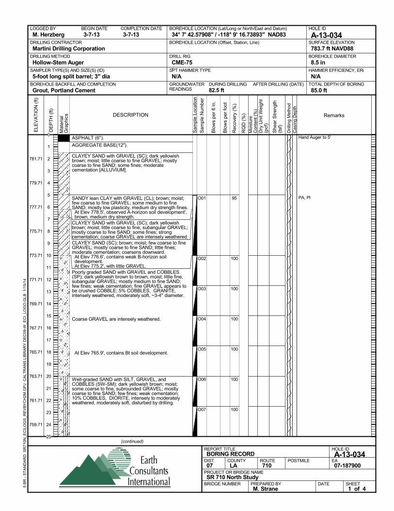
ASPHALT (6'').
AGGREGATE BASE(12").
CLAYEY SAND with GRAVEL (SC); dark yellowishbrown; moist; little coarse to fine GRAVEL; mostlycoarse to fine SAND; some fines; moderatecementation [ALLUVIUM].
SANDY lean CLAY with GRAVEL (CL); brown; moist;few coarse to fine GRAVEL; some medium to fineSAND; mostly low plasticity, medium dry strength fines. At Elev 778.5', observed A-horizon soil development',brown, medium dry strength.
CLAYEY SAND with GRAVEL (SC); dark yellowishbrown; moist; little coarse to fine, subangular GRAVEL;mostly coarse to fine SAND; some fines; strongcementation; coarse GRAVEL are intensely weathered.CLAYEY SAND (SC); brown; moist; few coarse to fineGRAVEL; mostly coarse to fine SAND; little fines;moderate cementation; coarsens downward. At Elev 776.6', contains weak B-horizon soildevelopment.
At Elev 775.2', with little GRAVEL.Poorly graded SAND with GRAVEL and COBBLES(SP); dark yellowish brown to brown; moist; little fine,subangular GRAVEL; mostly medium to fine SAND;few fines; weak cementation; fine GRAVEL appears tobe crushed COBBLE; 5% COBBLES, GRANITE,intensely weathered, moderately soft, ~3-4'' diameter.
Coarse GRAVEL are intensely weathered.
At Elev 765.9', contains Bt soil development.
Well-graded SAND with SILT, GRAVEL, andCOBBLES (SW-SM); dark yellowish brown; moist;some coarse to fine, subrounded GRAVEL; mostlycoarse to fine SAND; few fines; weak cementation;10% COBBLES, DIORITE, intensely to moderatelyweathered, moderately soft, disturbed by drilling.
95
100
100
100
100
100
100
O01
O02
O03
O04
O05
O06
O07
Hand Auger to 5'
PA, Pl
AFTER DRILLING (DATE)DURING DRILLING82.5 ft
SURFACE ELEVATION
783.7 ft NAVD88DRILLING METHOD
Hollow-Stem AugerDRILL RIG
CME-75SPT HAMMER TYPE
N/ABOREHOLE BACKFILL AND COMPLETION
Grout, Portland CementGROUNDWATERREADINGS
BEGIN DATE
3-7-13COMPLETION DATE
3-7-13LOGGED BY
M. HerzbergBOREHOLE LOCATION (Lat/Long or North/East and Datum)
34° 7' 42.57908" / -118° 9' 16.73893" NAD83HOLE ID
A-13-034DRILLING CONTRACTOR
Martini Drilling Corporation
HAMMER EFFICIENCY, ERi
N/ASAMPLER TYPE(S) AND SIZE(S) (ID)
5-foot long split barrel; 3" diaTOTAL DEPTH OF BORING
85.0 ft
BOREHOLE DIAMETER
8.5 in
BOREHOLE LOCATION (Offset, Station, Line)
.
Sam
ple
Loca
tion
COUNTYLA
DESCRIPTION
Rec
over
y (%
)
Dril
ling
Met
hod
Cas
ing
Dep
th
PREPARED BYM. Strane
DATE
PROJECT OR BRIDGE NAMESR 710 North Study
BRIDGE NUMBER
HOLE ID
A-13-034EA07-187900
REPORT TITLEBORING RECORD
DIST.07
ROUTE710
POSTMILE
(continued)
SHEET1 of 4
RQ
D (
%)
Sam
ple
Num
ber
Moi
stur
eC
onte
nt (
%)
Remarks
Blo
ws
per
6 in
.
ELE
VA
TIO
N (
ft)
781.71
779.71
777.71
775.71
773.71
771.71
769.71
767.71
765.71
763.71
761.71
759.71
DE
PT
H (
ft)
Dry
Uni
t Wei
ght
(pcf
)
She
ar S
tren
gth
(tsf
)
Blo
ws
per
foot
Mat
eria
lG
rap
hics
5 B
R -
ST
AN
DA
RD
SR
710N
_EC
ILO
GS
_RE
VB
YC
H2M
.GP
J C
ALT
RA
NS
LIB
RA
RY
DE
C09
-W_E
CI_
LOG
O.G
LB
1/1
5/14
0
1
2
3
4
5
6
7
8
9
10
11
12
13
14
15
16
17
18
19
20
21
22
23
24
25
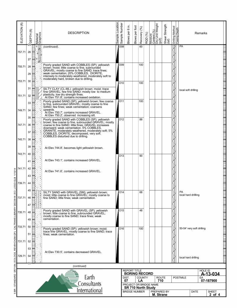
(continued).
Poorly graded SAND with COBBLES (SP); yellowishbrown; moist; little coarse to fine, subroundedGRAVEL; mostly coarse to fine SAND; trace fines;weak cementation; 20% COBBLES, DIORITE,intensely to moderately weathered, moderately soft tomoderately hard, broken due to drilling.
SILTY CLAY (CL-ML); yellowish brown; moist; tracefine GRAVEL; few fine SAND; mostly low to mediumplasticity, low dry strength fines. At Elev 751.8', contains increased oxidation.Poorly graded SAND (SP); yellowish brown; few coarseto fine, subrounded GRAVEL; mostly coarse to fineSAND; few fines; weak cementation; coarsensupwards. At Elev 750.7', contains increased GRAVEL. At Elev 750.2', observed increasing silt.
Poorly graded SAND with COBBLES (SP); yellowishbrown; few coarse to fine, subrounded GRAVEL; mostlycoarse to fine SAND; little fines; GRAVEL increasesdownward; weak cementation. 5% COBBLES,GRANITE, moderately weathered, moderately soft; 5%COBBLES, DIORITE, decomposed, very soft.COBBLES disturbed due to drilling.
At Elev 744.8', becomes light yellowish brown.
At Elev 743.1', contains increased GRAVEL.
At Elev 741.6', contains increased GRAVEL.
SILTY SAND with GRAVEL (SM); yellowish brown;moist; little coarse to fine GRAVEL; mostly coarse tofine SAND; little fines; weak cementation.
Poorly graded SAND with GRAVEL (SP); yellowishbrown; little coarse to fine, subrounded GRAVEL;mostly coarse to fine SAND; trace fines; weakcementation.
Poorly graded SAND (SP); yellowish brown; moist;trace fine GRAVEL; mostly coarse to fine SAND; tracefines; weak cementation.
At Elev 730.5', contains decreased GRAVEL.
60
100
100
100
88
90
68
48
100
O08
O09
O10
O11
O12
O13
O14
O15
O16
PA
local soft drilling
PAlocal hard drillling
50-54' very soft drilling
local hard drilling
Sam
ple
Loca
tion
COUNTYLA
DESCRIPTION
Rec
over
y (%
)
Dril
ling
Met
hod
Cas
ing
Dep
th
PREPARED BYM. Strane
DATE
PROJECT OR BRIDGE NAMESR 710 North Study
BRIDGE NUMBER
HOLE ID
A-13-034EA07-187900
REPORT TITLEBORING RECORD
DIST.07
ROUTE710
POSTMILE
(continued)
SHEET2 of 4
RQ
D (
%)
Sam
ple
Num
ber
Moi
stur
eC
onte
nt (
%)
Remarks
Blo
ws
per
6 in
.
ELE
VA
TIO
N (
ft)
757.71
755.71
753.71
751.71
749.71
747.71
745.71
743.71
741.71
739.71
737.71
735.71
733.71
731.71
729.71
DE
PT
H (
ft)
Dry
Uni
t Wei
ght
(pcf
)
She
ar S
tren
gth
(tsf
)
Blo
ws
per
foot
Mat
eria
lG
rap
hics
5 B
R -
ST
AN
DA
RD
SR
710N
_EC
ILO
GS
_RE
VB
YC
H2M
.GP
J C
ALT
RA
NS
LIB
RA
RY
DE
C09
-W_E
CI_
LOG
O.G
LB
1/1
5/14
25
26
27
28
29
30
31
32
33
34
35
36
37
38
39
40
41
42
43
44
45
46
47
48
49
50
51
52
53
54
55
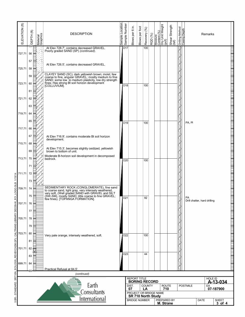
At Elev 728.7', contains decreased GRAVEL.Poorly graded SAND (SP) (continued).
At Elev 726.5', contains decreased GRAVEL.
CLAYEY SAND (SC); dark yellowish brown; moist; fewcoarse to fine, angular GRAVEL; mostly medium to fineSAND; some low to medium plasticity, low dry strengthfines; Has strong Bt soil horizon development[COLLUVIUM].
At Elev 716.9', contains moderate Bt soil horizondevelopment.
At Elev 715.3', becomes slightly oxidized, yellowishbrown to bottom of unit.
Moderate B-horizon soil development in decomposedbedrock.
SEDIMENTARY ROCK (CONGLOMERATE), fine sandto coarse sand, light gray, very intensely weathered,very soft, (Well graded SAND with GRAVEL and SILT(SW-SM), mostly SAND; little coarse to fine GRAVEL;few fines). [TOPANGA FORMATION].
Very pale orange, intensely weathered, soft.
Practical Refusal at 84.5'.
100
100
100
100
92
100
44
O17
O18
O19
O20
O21
O22
O23
PA, Pl
PADrill chatter, hard drilling
Sam
ple
Loca
tion
COUNTYLA
DESCRIPTION
Rec
over
y (%
)
Dril
ling
Met
hod
Cas
ing
Dep
th
PREPARED BYM. Strane
DATE
PROJECT OR BRIDGE NAMESR 710 North Study
BRIDGE NUMBER
HOLE ID
A-13-034EA07-187900
REPORT TITLEBORING RECORD
DIST.07
ROUTE710
POSTMILE
(continued)
SHEET3 of 4
RQ
D (
%)
Sam
ple
Num
ber
Moi
stur
eC
onte
nt (
%)
Remarks
Blo
ws
per
6 in
.
ELE
VA
TIO
N (
ft)
727.71
725.71
723.71
721.71
719.71
717.71
715.71
713.71
711.71
709.71
707.71
705.71
703.71
701.71
699.71
DE
PT
H (
ft)
Dry
Uni
t Wei
ght
(pcf
)
She
ar S
tren
gth
(tsf
)
Blo
ws
per
foot
Mat
eria
lG
rap
hics
5 B
R -
ST
AN
DA
RD
SR
710N
_EC
ILO
GS
_RE
VB
YC
H2M
.GP
J C
ALT
RA
NS
LIB
RA
RY
DE
C09
-W_E
CI_
LOG
O.G
LB
1/1
5/14
55
56
57
58
59
60
61
62
63
64
65
66
67
68
69
70
71
72
73
74
75
76
77
78
79
80
81
82
83
84
85
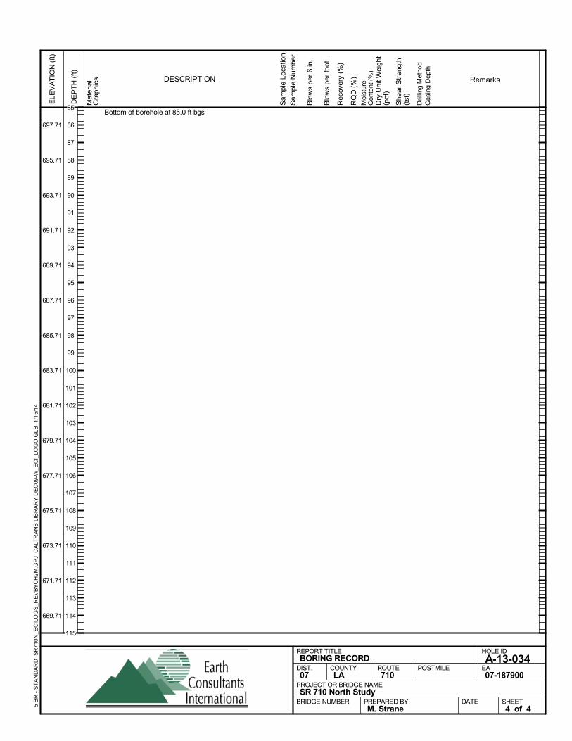
Bottom of borehole at 85.0 ft bgs
Sam
ple
Loca
tion
COUNTYLA
DESCRIPTION
Rec
over
y (%
)
Dril
ling
Met
hod
Cas
ing
Dep
th
PREPARED BYM. Strane
DATE
PROJECT OR BRIDGE NAMESR 710 North Study
BRIDGE NUMBER
HOLE ID
A-13-034EA07-187900
REPORT TITLEBORING RECORD
DIST.07
ROUTE710
POSTMILE
SHEET4 of 4
RQ
D (
%)
Sam
ple
Num
ber
Moi
stur
eC
onte
nt (
%)
Remarks
Blo
ws
per
6 in
.
ELE
VA
TIO
N (
ft)
697.71
695.71
693.71
691.71
689.71
687.71
685.71
683.71
681.71
679.71
677.71
675.71
673.71
671.71
669.71
DE
PT
H (
ft)
Dry
Uni
t Wei
ght
(pcf
)
She
ar S
tren
gth
(tsf
)
Blo
ws
per
foot
Mat
eria
lG
rap
hics
5 B
R -
ST
AN
DA
RD
SR
710N
_EC
ILO
GS
_RE
VB
YC
H2M
.GP
J C
ALT
RA
NS
LIB
RA
RY
DE
C09
-W_E
CI_
LOG
O.G
LB
1/1
5/14
85
86
87
88
89
90
91
92
93
94
95
96
97
98
99
100
101
102
103
104
105
106
107
108
109
110
111
112
113
114
115
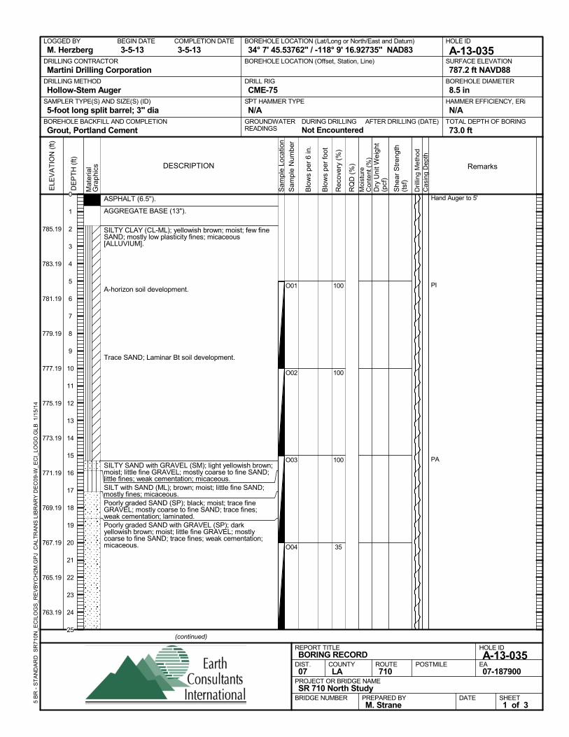
ASPHALT (6.5'').
AGGREGATE BASE (13").
SILTY CLAY (CL-ML); yellowish brown; moist; few fineSAND; mostly low plasticity fines; micaceous[ALLUVIUM].
A-horizon soil development.
Trace SAND; Laminar Bt soil development.
SILTY SAND with GRAVEL (SM); light yellowish brown;moist; little fine GRAVEL; mostly coarse to fine SAND;little fines; weak cementation; micaceous.SILT with SAND (ML); brown; moist; little fine SAND;mostly fines; micaceous.Poorly graded SAND (SP); black; moist; trace fineGRAVEL; mostly coarse to fine SAND; trace fines;weak cementation; laminated.Poorly graded SAND with GRAVEL (SP); darkyellowish brown; moist; little fine GRAVEL; mostlycoarse to fine SAND; trace fines; weak cementation;micaceous.
100
100
100
35
O01
O02
O03
O04
Hand Auger to 5'
PI
PA
AFTER DRILLING (DATE)DURING DRILLINGNot Encountered
SURFACE ELEVATION
787.2 ft NAVD88DRILLING METHOD
Hollow-Stem AugerDRILL RIG
CME-75SPT HAMMER TYPE
N/ABOREHOLE BACKFILL AND COMPLETION
Grout, Portland CementGROUNDWATERREADINGS
BEGIN DATE
3-5-13COMPLETION DATE
3-5-13LOGGED BY
M. HerzbergBOREHOLE LOCATION (Lat/Long or North/East and Datum)
34° 7' 45.53762" / -118° 9' 16.92735" NAD83HOLE ID
A-13-035DRILLING CONTRACTOR
Martini Drilling Corporation
HAMMER EFFICIENCY, ERi
N/ASAMPLER TYPE(S) AND SIZE(S) (ID)
5-foot long split barrel; 3" diaTOTAL DEPTH OF BORING
73.0 ft
BOREHOLE DIAMETER
8.5 in
BOREHOLE LOCATION (Offset, Station, Line)
.
Sam
ple
Loca
tion
COUNTYLA
DESCRIPTION
Rec
over
y (%
)
Dril
ling
Met
hod
Cas
ing
Dep
th
PREPARED BYM. Strane
DATE
PROJECT OR BRIDGE NAMESR 710 North Study
BRIDGE NUMBER
HOLE ID
A-13-035EA07-187900
REPORT TITLEBORING RECORD
DIST.07
ROUTE710
POSTMILE
(continued)
SHEET1 of 3
RQ
D (
%)
Sam
ple
Num
ber
Moi
stur
eC
onte
nt (
%)
Remarks
Blo
ws
per
6 in
.
ELE
VA
TIO
N (
ft)
785.19
783.19
781.19
779.19
777.19
775.19
773.19
771.19
769.19
767.19
765.19
763.19
DE
PT
H (
ft)
Dry
Uni
t Wei
ght
(pcf
)
She
ar S
tren
gth
(tsf
)
Blo
ws
per
foot
Mat
eria
lG
rap
hics
5 B
R -
ST
AN
DA
RD
SR
710N
_EC
ILO
GS
_RE
VB
YC
H2M
.GP
J C
ALT
RA
NS
LIB
RA
RY
DE
C09
-W_E
CI_
LOG
O.G
LB
1/1
5/14
0
1
2
3
4
5
6
7
8
9
10
11
12
13
14
15
16
17
18
19
20
21
22
23
24
25
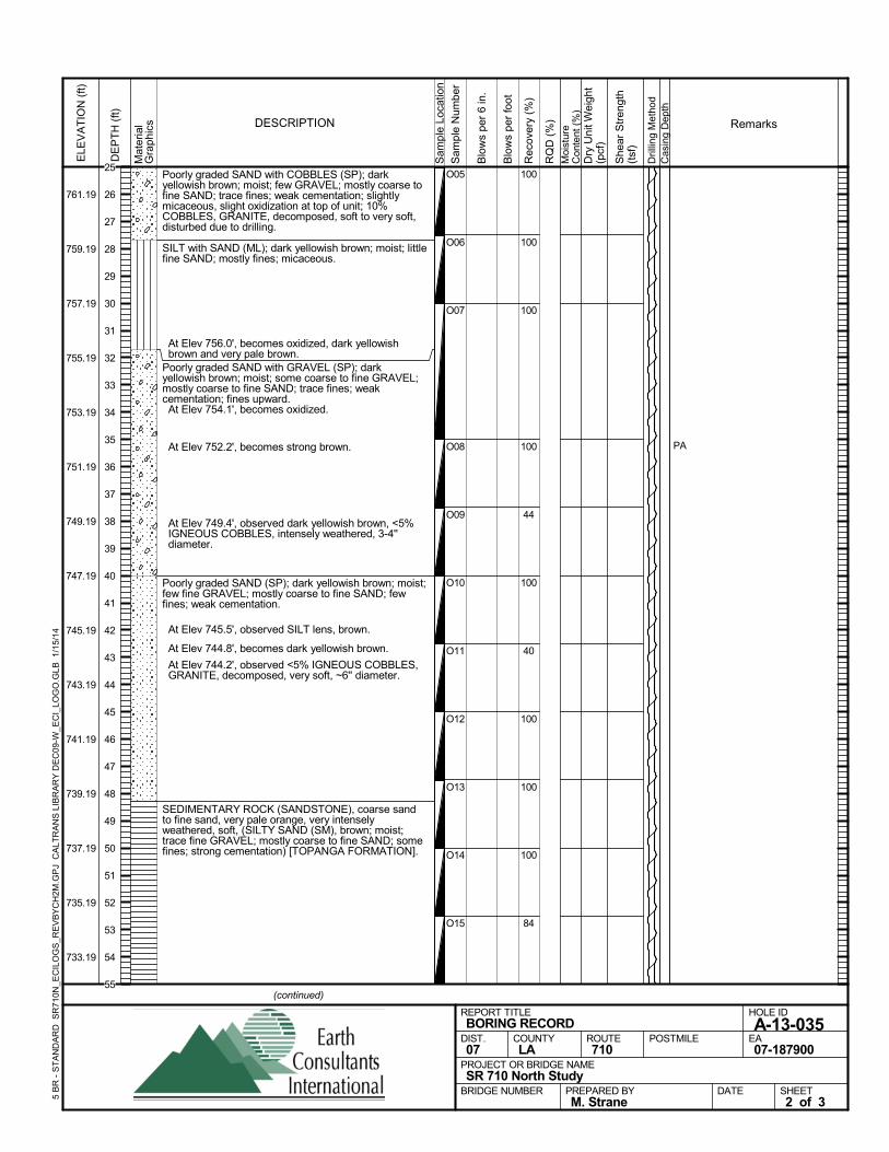
Poorly graded SAND with COBBLES (SP); darkyellowish brown; moist; few GRAVEL; mostly coarse tofine SAND; trace fines; weak cementation; slightlymicaceous, slight oxidization at top of unit; 10%COBBLES, GRANITE, decomposed, soft to very soft,disturbed due to drilling.
SILT with SAND (ML); dark yellowish brown; moist; littlefine SAND; mostly fines; micaceous.
At Elev 756.0', becomes oxidized, dark yellowishbrown and very pale brown.
Poorly graded SAND with GRAVEL (SP); darkyellowish brown; moist; some coarse to fine GRAVEL;mostly coarse to fine SAND; trace fines; weakcementation; fines upward. At Elev 754.1', becomes oxidized.
At Elev 752.2', becomes strong brown.
At Elev 749.4', observed dark yellowish brown, <5%IGNEOUS COBBLES, intensely weathered, 3-4''diameter.
Poorly graded SAND (SP); dark yellowish brown; moist;few fine GRAVEL; mostly coarse to fine SAND; fewfines; weak cementation.
At Elev 745.5', observed SILT lens, brown.
At Elev 744.8', becomes dark yellowish brown.
At Elev 744.2', observed <5% IGNEOUS COBBLES,GRANITE, decomposed, very soft, ~6'' diameter.
SEDIMENTARY ROCK (SANDSTONE), coarse sandto fine sand, very pale orange, very intenselyweathered, soft, (SILTY SAND (SM), brown; moist;trace fine GRAVEL; mostly coarse to fine SAND; somefines; strong cementation) [TOPANGA FORMATION].
100
100
100
100
44
100
40
100
100
100
84
O05
O06
O07
O08
O09
O10
O11
O12
O13
O14
O15
PAS
ampl
e Lo
catio
n
COUNTYLA
DESCRIPTION
Rec
over
y (%
)
Dril
ling
Met
hod
Cas
ing
Dep
th
PREPARED BYM. Strane
DATE
PROJECT OR BRIDGE NAMESR 710 North Study
BRIDGE NUMBER
HOLE ID
A-13-035EA07-187900
REPORT TITLEBORING RECORD
DIST.07
ROUTE710
POSTMILE
(continued)
SHEET2 of 3
RQ
D (
%)
Sam
ple
Num
ber
Moi
stur
eC
onte
nt (
%)
Remarks
Blo
ws
per
6 in
.
ELE
VA
TIO
N (
ft)
761.19
759.19
757.19
755.19
753.19
751.19
749.19
747.19
745.19
743.19
741.19
739.19
737.19
735.19
733.19
DE
PT
H (
ft)
Dry
Uni
t Wei
ght
(pcf
)
She
ar S
tren
gth
(tsf
)
Blo
ws
per
foot
Mat
eria
lG
rap
hics
5 B
R -
ST
AN
DA
RD
SR
710N
_EC
ILO
GS
_RE
VB
YC
H2M
.GP
J C
ALT
RA
NS
LIB
RA
RY
DE
C09
-W_E
CI_
LOG
O.G
LB
1/1
5/14
25
26
27
28
29
30
31
32
33
34
35
36
37
38
39
40
41
42
43
44
45
46
47
48
49
50
51
52
53
54
55
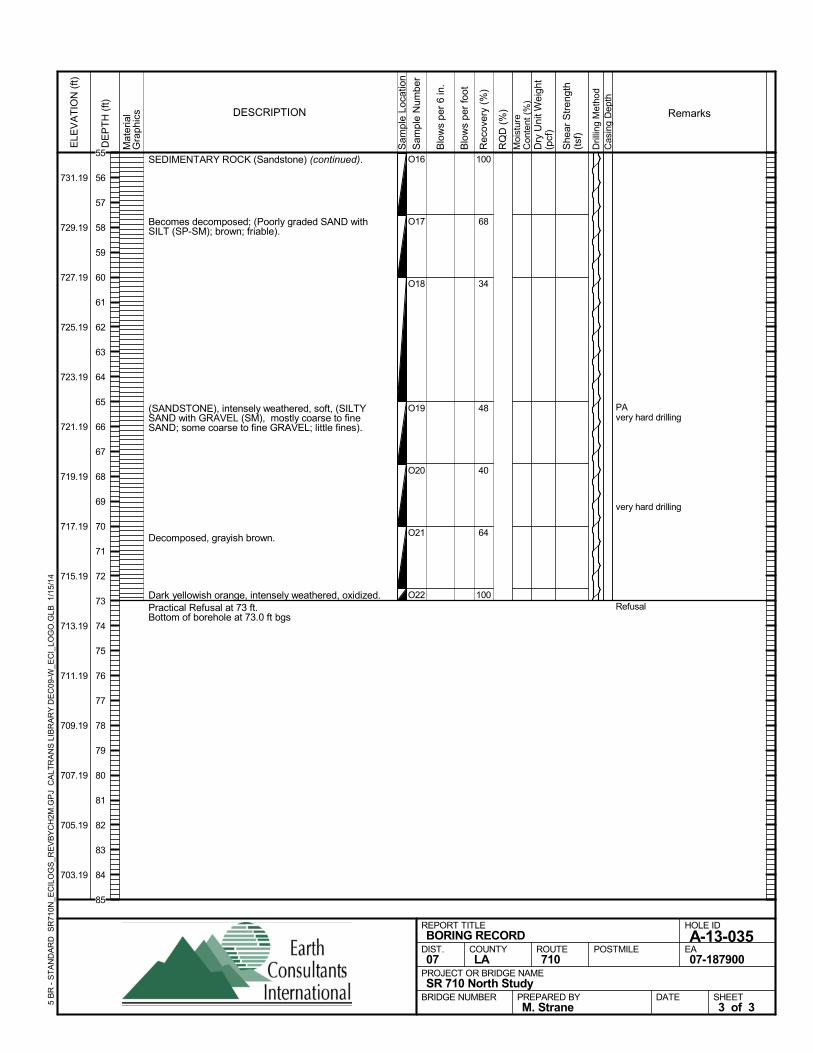
SEDIMENTARY ROCK (Sandstone) (continued).
Becomes decomposed; (Poorly graded SAND withSILT (SP-SM); brown; friable).
(SANDSTONE), intensely weathered, soft, (SILTYSAND with GRAVEL (SM), mostly coarse to fineSAND; some coarse to fine GRAVEL; little fines).
Decomposed, grayish brown.
Dark yellowish orange, intensely weathered, oxidized.Practical Refusal at 73 ft.Bottom of borehole at 73.0 ft bgs
100
68
34
48
40
64
100
O16
O17
O18
O19
O20
O21
O22
PAvery hard drilling
very hard drilling
Refusal
Sam
ple
Loca
tion
COUNTYLA
DESCRIPTION
Rec
over
y (%
)
Dril
ling
Met
hod
Cas
ing
Dep
th
PREPARED BYM. Strane
DATE
PROJECT OR BRIDGE NAMESR 710 North Study
BRIDGE NUMBER
HOLE ID
A-13-035EA07-187900
REPORT TITLEBORING RECORD
DIST.07
ROUTE710
POSTMILE
SHEET3 of 3
RQ
D (
%)
Sam
ple
Num
ber
Moi
stur
eC
onte
nt (
%)
Remarks
Blo
ws
per
6 in
.
ELE
VA
TIO
N (
ft)
731.19
729.19
727.19
725.19
723.19
721.19
719.19
717.19
715.19
713.19
711.19
709.19
707.19
705.19
703.19
DE
PT
H (
ft)
Dry
Uni
t Wei
ght
(pcf
)
She
ar S
tren
gth
(tsf
)
Blo
ws
per
foot
Mat
eria
lG
rap
hics
5 B
R -
ST
AN
DA
RD
SR
710N
_EC
ILO
GS
_RE
VB
YC
H2M
.GP
J C
ALT
RA
NS
LIB
RA
RY
DE
C09
-W_E
CI_
LOG
O.G
LB
1/1
5/14
55
56
57
58
59
60
61
62
63
64
65
66
67
68
69
70
71
72
73
74
75
76
77
78
79
80
81
82
83
84
85