Embed Size (px)
Citation preview

WAGGA WAGGA QUARRY REHABILITATION PLAN 2012 onwards
9
Appendix A
West side Rehabilitation Plan

Rehabilitation Plan
Lot B in DP 381991
Wagga Wagga N.S.W.
Prepared By: Hanson Construction Materials Pty. Ltd. A.C.N. 004 370 302 Ground Floor 601 Doncaster Road Doncaster, 3108 Date: April 2009

WAGGA WAGGA QUARRY REHABILITATION PLAN 2009 to 2011
1
TABLE OF CONTENTS
INTRODUCTION ..................................................................................................................................2 1.0 REHABILITATION OUTCOMES.................................................................................................2 2.0 REHABILITATION PRINCIPLES.................................................................................................2
2.1 Background.......................................................................................................................2 2.2 Redundant Roads and Tracks ...........................................................................................2 2.3 Bulk Earthworks ...............................................................................................................2 2.4 Sub-Soil Strata..................................................................................................................3 2.5 Surface Soil Layer ............................................................................................................3 2.6 Revegetation .....................................................................................................................3
2.7 BUSHFIRE CONTROL...............................................................................................................3 2.8 ENVIRONMENTAL MONITORING.............................................................................................3 2.9 PLAN ELEMENTS ....................................................................................................................3
3.0 STAGE DESCRIPTION..................................................................................................................4 3.1 STAGE 1..........................................................................................................................................4 3.2 STAGE 2..........................................................................................................................................4 3.3 STAGE 3..........................................................................................................................................5 3.4 STAGE 4..........................................................................................................................................5 3.5 POST CLOSURE................................................................................................................................5
4.0 TIME FRAME..................................................................................................................................6 5.0 PLAN AMENDMENTS...................................................................................................................6
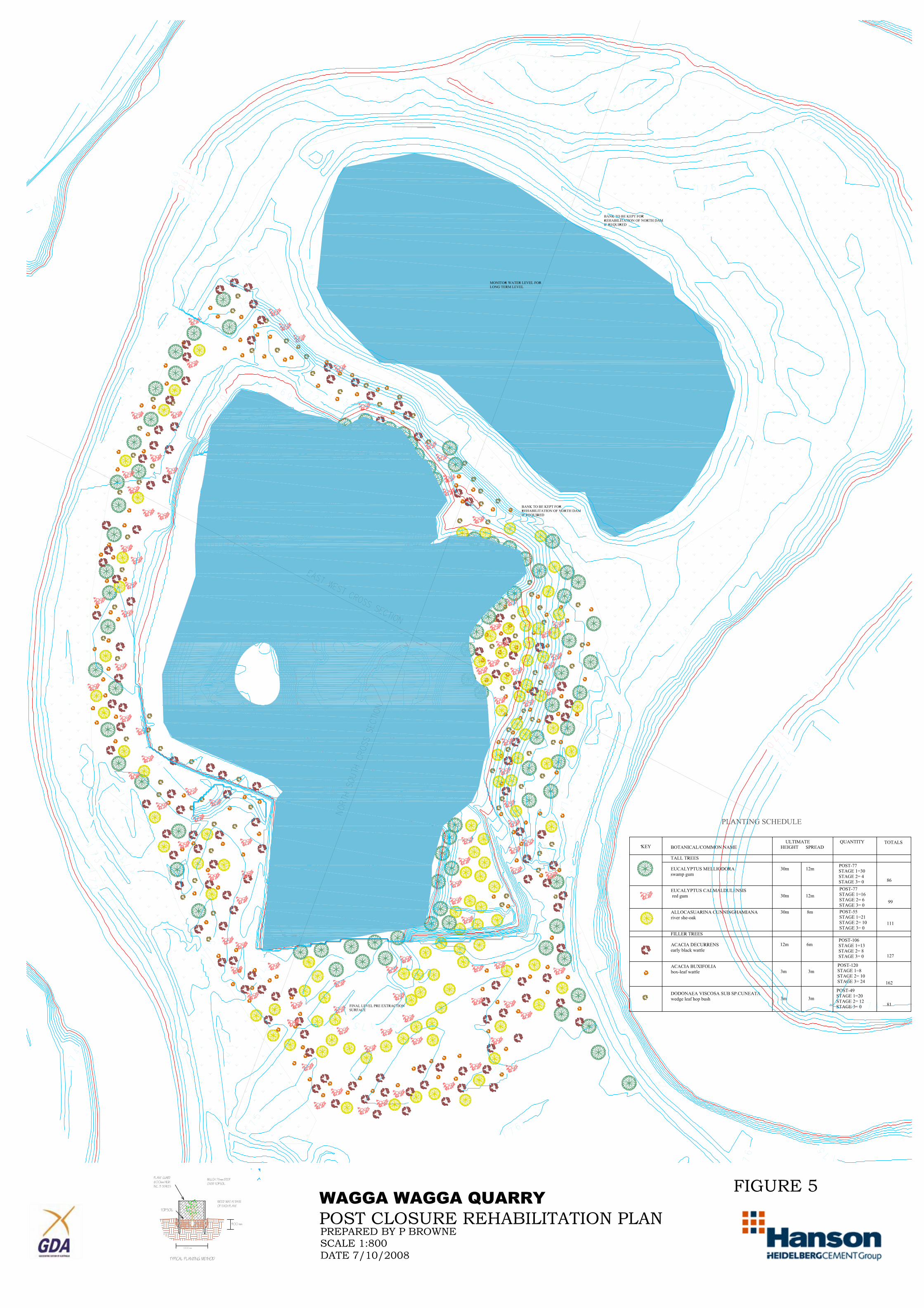
FIGURES Figure 1. Stage 1 Figure. 2. Stage 2 Figure. 3 Stage 3 Figure. 4 Stage 4 Figure. 5 Post closure Figure 6 Cross Sections

WAGGA WAGGA QUARRY REHABILITATION PLAN 2009 to 2011
2
Introduction The following plan describes the rehabilitation of the west side of the Wagga Wagga sand and gravel extraction site. The plan involves a description of the general principles of the rehabilitation, a description and plans of the rehabilitation staging and a time line of the works. The primary objective is to rehabilitate the site as a wetland, grassland and revegetated riparian zone. The extractive nature of the development means that a changed landform will result. Ecological, hydrological and geomorphological constraints have determined the extent of the extraction and the plan developed here takes these into consideration.
1.0 REHABILITATION OUTCOMES This rehabilitation plan has as it main outcome the reforming and re-vegetation of the southern pit on the west side of the site. The outcome is to have this southern pit re-graded and re-vegetated and filled with water to the identified standing water level of 168 metres. Ancillary works involve re-instatement of the land on the west currently under water, and stabilization of the hole. The eastern portion of the site is currently under application for extraction and, as such the water dams will form part of this operation. If that application does not proceed then the additional outcomes of this plan will be to remove the plant and stockpile areas and return the site to a grassed area with some additional infill planting of shade trees. The post closure plan would need to be subsequently amended to reflect these changes. In this case the final outcome would be large open grassed areas, two water filled pits with vegetation around the perimeter of these lakes,
2.0 REHABILITATION PRINCIPLES The following elements describe the way the reclamation will be achieved. 2.1 Background To attain the Primary Objectives will require planning, organisation and supervision. Throughout these phases, professional expertise will be sought as required and every effort will be made to incorporate the latest techniques available in the science of Land Rehabilitation. 2.2 Redundant Roads and Tracks Upon cessation of extraction and processing all redundant roads and tracks will be removed and scarified to a minimum of 75mm depth and prepared for revegetation. The access road may remain open and sealed as an access to the site. 2.3 Bulk Earthworks The re-shaping of the pit will include major earthworks to form the base for the final earth form. Slopes above the water table will be approximately 1m vertical and 3m horizontal. Material used in the rehabilitation will be overburden won from onsite. Machinery utilised for this purpose will include excavators and heavy dozers. At the end of the overburden backfilling the levee banks will be graded over the coarsely replaced material. The cross sections, (figure 6) show the bulk earthworks across the site

WAGGA WAGGA QUARRY REHABILITATION PLAN 2009 to 2011
3
2.4 Sub-Soil Strata Material suitable for the formation of a sub-soil will be placed by a "loose tipping" procedure above the water table carried out when the material is in a friable condition. Depth will be to 150mm below final finished surface levels. The essence of this operation will be to avoid soil compaction that severely inhibits growth. 2.5 Surface Soil Layer The naturally occurring surface soil in the area varies from 50-100mm in depth. Depth of soil will be 150mm. Material used will be topsoil from the mounds, stored onsite material and conditioning of sub-soils. Final conditioning techniques may include a 6 month procedure involving weed killing, tilling and planting of a crop for soil structure. 2.6 Revegetation The project seeks to recreate indigenous vegetation units similar to those on the surrounding area.. It is proposed to match the existing vegetation in both the upper canopy and understorey species. It will seek to achieve a similar percentage of foliage cover, litter depth, microbial activity and ultimately canopy height. The density and types of trees and scrubs used in the reclamation are shown on the stage rehabilitation plans attached (Figures 1 to 5). Each plan contains a table of the species, ultimate height and spread and the number required for each stage. The design is based on the final height and spread and does not have additional plantings that need to be thinned out at a later date. However, any dead trees will need to be replaced quickly to keep the overall progress of the re-vegetation maturity on track.
2.7 BUSHFIRE CONTROL Effective ‘ bushfire control depends upon available fuel, control of ignition sources and good access and water supplies; While the possibility of initiation of bushfire’s within the site is limited, the following fire management procedures will be adopted to assist with problems on neighbouring sites and, reduce the likelihood of an event at the quarry:-
Provision of access to strategic areas on the site Provision of water from the sedimentation dams Stockpiling of cleared vegetation with a minimum l0m cleared buffer zone Creating suitable located fire breaks
2.8 ENVIRONMENTAL MONITORING In conjunction with the high standard of safeguards to be incorporated in the design of the project, the Company will carry out regular monitoring of air quality, water quality, and noise. The results will be made available to Authorities for inspection and auditing.
2.9 PLAN ELEMENTS The rehabilitation plan shows how, with the above principles and safeguards for the extraction area, the site will be rehabilitated. The plan shows how rehabilitation will occur progressively. The east site has a buffer of 100 metres to the top of the river bank. Section 3 below details identified elements to be completed within each stage.

WAGGA WAGGA QUARRY REHABILITATION PLAN 2009 to 2011
4
3.0 Stage Description
3.1 STAGE 1 element bank re-establishment works dozed to slope of 1v to 3h materials required dozer element preparation of north bank works Isolation of power and water lines materials required none unless manual movement of large pipes is required element mound on quarry floor works flattening out mound sides to a flatter battered slope materials required dozer element floor of quarry works flattening out floor materials required dozer element west wall of quarry works repair of steep batter materials required excavator, haul truck and fill action fill in 1 metre lifts from the floor base This stage has been completed except for the west wall of quarry element.
3.2 STAGE 2 element north bank re-establishment works dozed to slope of 1v to 3h materials required dozer element planting of east bank works planting of trees and grassing of the bank materials required trees , tree guards, stakes, potting mix, mulch and digging tools. element placement of stripping from small extension works re-establishment of the east bank from current extraction area materials required excavator, haul truck and fill method pace overburden materials in 1 metre lifts and use machinery for compaction element west wall of quarry works repair of steep batter materials required excavator, haul truck and fill action fill in 1 metre lifts from the floor base Stage 2 is earthworks on the north wall are completed.

WAGGA WAGGA QUARRY REHABILITATION PLAN 2009 to 2011
5
3.3 STAGE 3 element planting of north bank works planting of trees and grassing of the bank materials required trees , tree guards, stakes, potting mix, mulch and digging tools. element placement of stripping from small extension works re-establishment of the east bank from current extraction area materials required excavator, haul truck and fill method pace overburden materials in I metre lifts and use machinery for compaction element west wall of quarry works repair of steep batter materials required excavator, haul truck and fill action fill in 1 metre lifts from the floor base
3.4 STAGE 4 element placement of stripping from east pit works re-fill of the small extraction area materials required excavator, haul truck and fill method pace overburden materials in 1 metre lifts and use machinery for compaction element west wall of quarry works removal of levee banks and placement on the west wall of the
quarry materials required excavator, haul truck and fill action fill in 1 metre lifts from the base
3.5 POST CLOSURE element placement of stripping from east pit works compete re-fill of the small extraction area to pre-existing
surface. materials required excavator, haul truck and fill method place overburden materials in 1 metre lifts and use machinery
for compaction element planting of balance of old works site works planting of trees and grassing of the bank materials required trees, tree guards, stakes, potting mix, mulch and digging tools. element maintenance of quarry walls works check walls for soaks and failure of newly placed material materials required excavator, haul truck and fill

WAGGA WAGGA QUARRY REHABILITATION PLAN 2009 to 2011
6
action fill in 1 metre lifts from the floor base element plant maintenance for two years works replacement of trees as required materials required trees, tree guards, stakes, potting mix, mulch and digging tools. element north pit (currently restored and water filled) works monitor water levels and banks action current levee banks to be remain if water level stays at cueent
level. If water level drops and banks are unstable the levees are to be removed and the material used to stabilise the banks.
4.0 Time frame An indicative timeframe for the works is attached. This time frame is based on extraction for a full year and some lag for establishment of the east extraction face. The time line will shorten based on how quickly the east side can be developed. 5.0 Plan Amendments It is anticipated that the post closure plan will be implemented within the time frame attached. However, if fill does not come from the east side development an amendment to the post closure plan will be required to fulfil the obligation to backfill the small extension to natural surface.


STA
GE
PE
RIO
D2/
07/2
009
1/10
/200
931
/12/
2009
1/04
/201
01/
07/2
010
30/0
9/20
1030
/12/
2010
31/0
3/20
1130
/06/
2011
29/0
9/20
1129
/12/
2011
29/0
3/20
1228
/06/
2012
27/0
9/20
1227
/12/
2012
28/0
3/20
131 2
FILL
FR
OM
SM
ALL
CU
T3
FILL
FR
OM
EA
ST
SID
E4
LEV
EE
S R
EM
OV
ED
AN
D P
LAC
ED
IN P
IT
PO
ST
CLO
SU
RE
VO
LUM
ES
FILL
ON
EA
ST
SID
E42
LEV
EE
VO
LUM
E35
SO
UTH
RE
FILL
111
NO
TE A
LL W
OR
KS
FIN
ISH
ED
BE
FOR
E 2
9/12
/201
1 W
ITH
TW
O Y
EA
R M
AIN
TEN
AN
CE
PE
RIO
D A
FTE
R T
HA
T TI
ME
EA
RTH
WO
RK
S D
OZE
RE
AR
THW
OR
KS
EX
CA
VA
TOR
TOP
SO
ILTR
EE
PLA
NTI
NG
TRE
E M
AIN
TEN
AN
CE

APPENDIX D
List of Properties
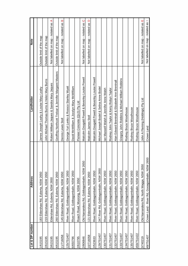
Lot &
DP
num
ber
Add
ress
Land
hold
erN
ote
1/61
5195
183
Eld
ersh
aw R
d, E
uber
ta, N
SW
265
0Ja
mes
Jos
eph
Leah
y &
Lou
ise
Mar
y Le
ahy
Out
side
lim
it of
the
map
2/61
5195
219
Eld
ersh
aw R
d, E
uber
ta, N
SW
265
0Jo
hn M
icha
el T
hom
as B
urns
& H
elen
Mar
y B
urns
Out
side
lim
it of
the
map
3/61
5195
Eld
ersh
aw R
d, E
uber
ta, N
SW
265
0R
ober
t Will
iam
Jaq
ues
& S
andr
a M
ary
Jaqu
esN
ot la
belle
d on
map
- no
tate
d as
A
4/61
5195
260
Eld
ersh
aw R
d, E
uber
ta, N
SW
265
0G
eoffr
ey N
orth
cott
Trel
oar &
Jen
nife
r Mar
gare
t Mas
ters
Out
side
lim
it of
the
map
11/7
1605
814
5 E
lder
shaw
Rd,
Eub
erta
, NS
W 2
650
Den
nis
Lew
is S
toll
Not
labe
lled
on m
ap -
nota
ted
as B
125/
7514
07R
iver
Roa
d, G
obba
gom
balin
, NS
W 2
650
Geo
rge
Yur
i Len
ko &
Ros
sco
Sta
nley
Wya
tt
6/65
0796
Riv
er R
oad,
Gob
bago
mba
lin, N
SW
265
0D
avid
McW
illia
m &
Joc
elyn
Mar
y M
cWill
iam
2/61
0795
Roa
ch R
oad,
Moo
rong
, NS
W 2
650
Pio
neer
Con
cret
e (Q
LD) P
ty L
td
2/80
6846
Old
Nar
rand
era
Rd,
Gob
bago
mba
lin, N
SW
265
0M
alco
lm D
ouga
ld P
owel
l & B
ever
ley
Loui
se P
owel
lN
ot la
belle
d on
map
- no
tate
d as
C
10/7
1605
812
1 E
lder
shaw
Rd,
Eub
erta
, NS
W 2
650
Mal
colm
Jam
es S
toll
Not
labe
lled
on m
ap -
nota
ted
as D
2/52
3633
Riv
er R
oad,
Gob
bago
mba
lin, N
SW
265
0M
alco
lm D
ouga
ld P
owel
l & B
ever
ley
Loui
se P
owel
l
129/
7514
0734
7 R
iver
Rd,
Gob
bago
mba
lin, N
SW
265
0M
icha
el J
osep
h B
odel
& S
elin
a A
nne
Bod
el
130/
7514
07R
iver
Roa
d, G
obba
gom
balin
, NS
W 2
650
Ian
Max
wel
l Wal
sh &
Jen
nife
r Ann
e W
alsh
131/
7514
07R
iver
Roa
d, G
obba
gom
balin
, NS
W 2
650
Rod
ney
John
Tay
lor &
Ker
ry R
obyn
Tay
lor
132/
7514
07R
iver
Roa
d, G
obba
gom
balin
, NS
W 2
650
Ala
n E
dwar
d B
rent
nall
& E
lizab
eth
Ann
Bre
ntna
ll
133/
7514
07R
iver
Roa
d, G
obba
gom
balin
, NS
W 2
650
Gre
gory
Joh
n R
obbi
ns &
Mic
hael
Will
iam
Rob
bins
134/
7514
07R
iver
Roa
d, G
obba
gom
balin
, NS
W 2
650
Rod
ney
Bru
ce W
oodh
ouse
135/
7514
07R
iver
Roa
d, G
obba
gom
balin
, NS
W 2
650
Rod
ney
Bru
ce W
oodh
ouse
459/
7514
22R
iver
Roa
d, G
obba
gom
balin
, NS
W 2
650
Rod
ney
Bru
ce W
oodh
ouse
3/74
0219
Old
Nar
rand
era
Rd,
Nor
th W
agga
, NS
W 2
650
John
A F
lem
ing
(Hol
ding
s) P
ty L
tdN
ot la
belle
d on
map
- no
tate
d as
E
49/7
5140
7C
row
n La
nd -
Riv
er R
d, G
ooag
omba
lin, N
SW
265
0C
row
n La
ndN
ot la
belle
d on
map
- no
tate
d as
I

Lot &
DP
num
ber
Add
ress
Land
hold
erN
ote
B/3
8199
123
0 R
oach
Rd,
Moo
rong
, NS
W 2
650
Pio
neer
Con
stru
ctio
n M
ater
ials
Pty
Lim
ited
92/1
0618
8819
2 R
oach
Rd,
Moo
rong
, NS
W 2
650
Dud
ley
Cha
rles
Che
ney
4/83
1298
146
Roa
ch R
d, M
ooro
ng, N
SW
265
0P
eter
Dud
ley
Men
z &
Car
olyn
Mar
y M
enz
3/83
1298
160
Roa
ch R
d, M
ooro
ng, N
SW
265
0F.
A D
elan
ey (Q
uarr
ies)
Pty
Lim
ited
Not
labe
lled
on m
ap -
nota
ted
as F
7/10
2503
586
Roa
ch R
d, M
ooro
ng, N
SW
265
0Ju
liann
e M
aree
Bou
rne
3/71
4462
133
Roa
ch R
d, M
ooro
ng, N
SW
265
0B
erriq
uin
See
ds P
ty L
imite
d
91/1
0618
8819
1 R
oach
Rd,
Moo
rong
, NS
W 2
650
War
ren
Ow
en F
ishe
r & T
erry
-Ann
Dris
coll
Not
labe
lled
on m
ap -
nota
ted
as G
304/
7572
4916
9 R
oach
Rd,
Moo
rong
, NS
W 2
650
Mar
gare
t Gra
nt L
ewis
1/71
8845
163
Roa
ch R
d, M
ooro
ng, N
SW
265
0P
eter
Mic
hael
Del
aney
Not
labe
lled
on m
ap -
nota
ted
as H
24/1
1082
68R
ural
sub
divi
sion
off
Roa
ch R
d, M
ooro
ng, N
SW
265
0F.
A D
elan
ey (Q
uarr
ies)
Pty
Lim
ited
13/1
1082
68R
ural
sub
divi
sion
off
Roa
ch R
d, M
ooro
ng, N
SW
265
0Te
renc
e Jo
hn R
auls
ton
& M
aure
en P
erpe
tua
Rau
lsto
n
12/1
1082
68R
ural
sub
divi
sion
off
Roa
ch R
d, M
ooro
ng, N
SW
265
0D
avid
Ros
s G
raha
m
11/1
1082
68R
ural
sub
divi
sion
off
Roa
ch R
d, M
ooro
ng, N
SW
265
0P
hilli
p A
ntho
ny A
rund
ell &
Cat
herin
e G
esin
a P
eter
s
14/1
1082
68R
ural
sub
divi
sion
off
Roa
ch R
d, M
ooro
ng, N
SW
265
0C
aroo
n P
ark
Pas
tora
l Pty
Lim
ited
15/1
1082
68R
ural
sub
divi
sion
off
Roa
ch R
d, M
ooro
ng, N
SW
265
0Ja
y M
cGea
chie
Jen
kins
& E
ve M
aree
Jen
kins
10/1
1082
68R
ural
sub
divi
sion
off
Roa
ch R
d, M
ooro
ng, N
SW
265
0Ti
mot
hy D
esm
ond
Goo
nan
16/1
1082
68R
ural
sub
divi
sion
off
Roa
ch R
d, M
ooro
ng, N
SW
265
0Jo
hn P
hilli
p D
are
& S
haro
n M
arga
ret D
are
17/1
1082
68R
ural
sub
divi
sion
off
Roa
ch R
d, M
ooro
ng, N
SW
265
0K
athr
yn C
lare
Ten
ison
18/1
1082
68R
ural
sub
divi
sion
off
Roa
ch R
d, M
ooro
ng, N
SW
265
0D
avid
Pet
er C
raw
ford
Tre
harn
e &
Kim
Tre
harn
e
9/11
0826
8R
ural
sub
divi
sion
off
Roa
ch R
d, M
ooro
ng, N
SW
265
0E
xpan
dit P
ty L
imite
d
8/11
0826
8R
ural
sub
divi
sion
off
Roa
ch R
d, M
ooro
ng, N
SW
265
0E
xpan
dit P
ty L
imite
d
7/11
0826
8R
ural
sub
divi
sion
off
Roa
ch R
d, M
ooro
ng, N
SW
265
0E
xpan
dit P
ty L
imite
d
6/11
0826
8R
ural
sub
divi
sion
off
Roa
ch R
d, M
ooro
ng, N
SW
265
0E
xpan
dit P
ty L
imite
d
5/11
0826
8R
ural
sub
divi
sion
off
Roa
ch R
d, M
ooro
ng, N
SW
265
0B
rian
Wilf
red
Man
son
4/11
0826
8R
ural
sub
divi
sion
off
Roa
ch R
d, M
ooro
ng, N
SW
265
0E
xpan
dit P
ty L
imite
d

Lot &
DP
num
ber
Add
ress
Land
hold
erN
ote
2/11
0826
8R
ural
sub
divi
sion
off
Roa
ch R
d, M
ooro
ng, N
SW
265
0P
eter
Edw
ard
Doo
ner &
Exp
andi
t Pty
Lim
ited
1/71
4462
51 R
oach
Rd,
Moo
rong
, NS
W 2
650
Pet
er E
dwar
d D
oone
rN
ot la
belle
d on
map
- no
tate
d as
I
311/
4114
6O
ff M
cNic
kle
Rd
- Fol
io n
ot c
reat
ed- c
row
n la
ndN
o fo
lio c
reat
ed
310/
4114
6O
ff M
cNic
kle
Rd
- ref
eren
ce n
ot h
eld
- par
t of g
olf c
ours
eN
o fo
lio c
reat
edN
ot la
belle
d on
map
- no
tate
d as
J
1/59
6695
17 M
cNic
kle
Rd,
Moo
rong
, NS
W 2
650
Sou
ther
n R
iver
ina
Cou
nty
Cou
ncil
Not
labe
lled
on m
ap -
nota
ted
as K
2/52
9399
Off
McN
ickl
e R
dTh
e C
omm
issi
oner
For
Mai
n R
oads
Not
labe
lled
on m
ap -
nota
ted
as L
1/52
9399
2 M
cNic
kle
Rd,
Moo
rong
, NS
W 2
650
Kat
hryn
Gem
mel
l Alle
nN
ot la
belle
d on
map
- no
tate
d as
M
1/23
5260
2 M
cNic
kle
Rd,
Moo
rong
, NS
W 2
650
Kat
hryn
Gem
mel
l Alle
nN
ot la
belle
d on
map
- no
tate
d as
N
1/60
2270
20 M
cNic
kle
Rd,
Moo
rong
, NS
W 2
650
Chr
isto
pher
Bru
ce C
abot
Not
labe
lled
on m
ap -
nota
ted
as O
2/60
2270
28 M
cNic
kle
Rd,
Moo
rong
, NS
W 2
650
Ang
elo
Pap
asid
ero
& R
ober
to P
apas
ider
oN
ot la
belle
d on
map
- no
tate
d as
P
3/60
2270
McN
ickl
e R
d, M
ooro
ng, N
SW
265
0M
arga
ret I
sobe
l Bel
ling
Not
labe
lled
on m
ap -
nota
ted
as Q
4/60
2270
432
McN
ickl
e R
d, M
ooro
ng, N
SW
265
0K
evin
Joh
n D
oone
r
1/65
3426
432
McN
ickl
e R
d, M
ooro
ng, N
SW
265
0K
evin
Joh
n D
oone
rN
ot la
belle
d on
map
- no
tate
d as
R
19/1
1082
68R
ural
sub
divi
sion
off
Roa
ch R
d, M
ooro
ng, N
SW
265
0Ti
mot
hy P
atric
k Fr
anci
s &
Ingr
id R
hoda
Fra
ncis
23/1
1082
68R
ural
sub
divi
sion
off
Roa
ch R
d, M
ooro
ng, N
SW
265
0D
avid
Joh
n M
ott &
Gen
evie
ve B
ae M
ott
22/1
1082
68R
ural
sub
divi
sion
off
Roa
ch R
d, M
ooro
ng, N
SW
265
0R
aym
ond
Bria
n C
owle
y &
Sho
na C
owle
y
21/1
1082
68R
ural
sub
divi
sion
off
Roa
ch R
d, M
ooro
ng, N
SW
265
0K
elly
Rac
hel L
ane
20/1
1082
68R
ural
sub
divi
sion
off
Roa
ch R
d, M
ooro
ng, N
SW
265
0Ju
dith
Ann
e G
affn
ey

APPENDIX E
Correspondence and Newsletter

1
Browne, Peter (Doncaster) AU
From: Hamilton, David (Fyshwick) AUSent: Tuesday, 24 October 2006 10:26To: Campbell, Ross (Wagga Wagga) AU; Browne, Peter (Doncaster) AU; Stark, Graeme
(Parramatta) AUSubject: Wagga EIS / DA Meeting 31st October
Hi Everyone
Colin Fough of Wagga Council has confirmed meeting date and time as Tuesday 31st October at 11.00am
I shall contact Darren Wallet of the DNR.
Regards
David HamiltonArea Manager Southern NSW
Hanson Construction MaterialsTel: 02 6239 1994Mob: 0418 627 990Fax: 02 6280 6318Email: [email protected]: www.hanson.biz
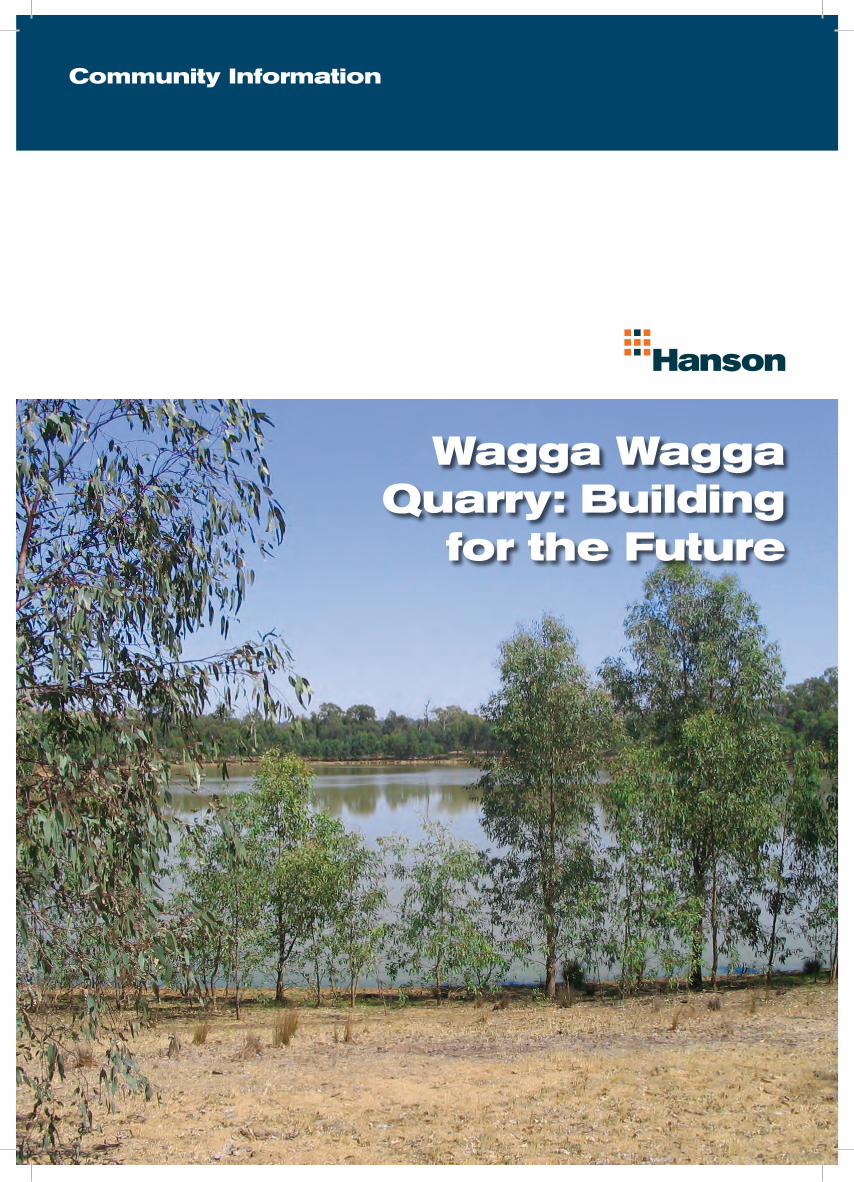
Wagga Wagga Quarry: Building
for the Future
Community Information

Long term local supplierHanson’s quarry, which is fi ve kilometres west of the Wagga township, has been operating continuously for over forty years, and is a major supplier to local customers. We are proposing to extend the life of the quarry by accessing further reserves of sand and gravel on our land. Utilising these additional reserves will provide another thirty years of supply for the local market, with volumes expected to be similar to current levels and possible short term peaks if large projects occur.
The quarry represents a valuable local resource as it produces a wide range of high quality sand and gravel products used for housing, commercial projects, roads and numerous other purposes. It is located on a river bend, bounded by private land to the south and the Murrumbidgee River on the other boundaries. Access to the site is, and will remain, via Roach Road off the Sturt Highway.
Hanson is one of the world’s leading heavy building materials companies. It is the largest producer of aggregates and one of
the largest producers of pre-mixed concrete in the world.
In Australia, Hanson employs more than 3,600 staff and permanent contractors and its products include aggregates, premixed
concrete, preformed concrete products, asphalt and cement.
For further information, or details on where you can view the project’s Environmental Assessment Report, please contact
Anthony Giannasca on 02 6239 1994, or 0417 066 273.
We propose to progressively rehabilitate the quarry to limit any long term visual impact of the operation. Reclamation of quarried areas will be carried out by completing earthworks, covering the reclaimed area with topsoil and planting indigenous fl ora, similar to existing vegetation. The photo on the front page shows an earlier rehabilitated area.
Trucking and deliveries
Deliveries will continue to be transported from the site via Roach Road, connecting to the Sturt Highway. Trucks will typically be truck and dog confi gurations and, possibly in the future, B-double vehicles may
be utilised. The haul routes will be either east or west along the Sturt Highway. The recent completion of the sealing of Roach Road, principally undertaken by Hanson, will minimise traffi c impact on local residents.
Employment
The continued operation of this quarry will provide direct employment for approximately ten to fi fteen local people and additional indirect employment opportunities.
Approval process
Following a formal application to the NSW Government Department of
Planning in 2007, reports from a series of required studies were compiled. These have been incorporated into an Environmental Assessment Report (EAR), which will shortly be submitted to relevant authorities. This document will then be placed on public exhibition, following which fi nal assessment will be undertaken by the NSW Department of Planning.
As part of the submission process, consultation is being undertaken with stakeholders, including relevant authorities and surrounding land owners. Responses from the stakeholders will be reviewed, with appropriate measures incorporated into the EAR.
Reclamation and rehabilitation
Environmental management procedures will continue to include the control of water runoff, soil erosion, waste disposal, sewage, noise, and vibration. Regular monitoring of air and water quality, noise and vibration will be conducted to ensure compliance with relevant legislation. A large buffer will be maintained between the river and the extraction area, as is currently practised.
No recognised, rare or endangered species of local fl ora or fauna will be affected by the proposed operations and any potential impact on vegetation and wildlife has been rated by consultants as low. There are no known Aboriginal or European heritage aspects associated with the site.
Environmental management
It is envisaged that the method of operating the quarry will not change from the way it currently works. After stripping grass and overburden (unusable material), raw feed will be removed by an excavator and then transferred to the processing plant by a dump truck. The processing plant equipment will crush and screen the raw feed, producing aggregates and sand products. A Front End Loader will fi ll road trucks from stockpiles for delivery to customers, as is done now.
Producing aggregate and sand

APPENDIX F
Existing Development Consents