Embed Size (px)
Citation preview
Procedural Guidelines for Implementing Travel Time on DMS in CHART
December 2008 A-1
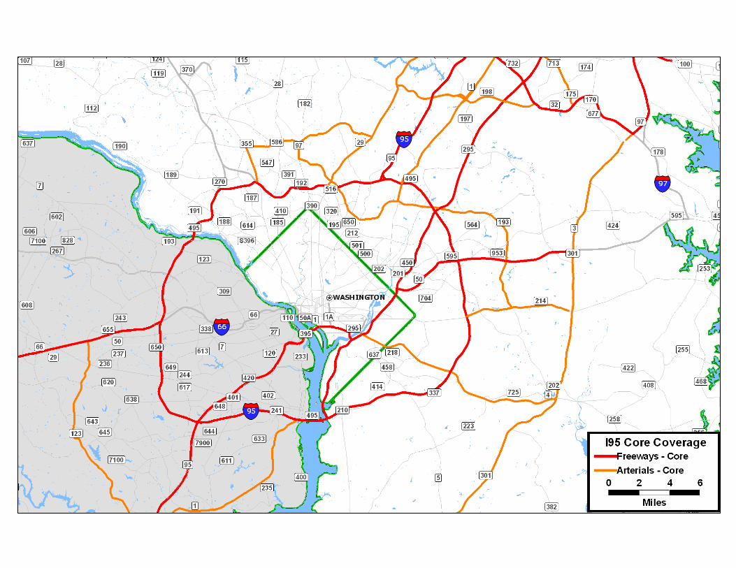
APPENDIX A: INRIX COVERAGE

$
$
BALTIMORE
BEL AIR SOUTH
896
40
40
301
43
279
40
95
95
895
95
695
13
310
299
2
83
150
45 40T29
151139
31
41542
1
147
146
145
562
138
23
439
24
157
395
20
73718
702
298514
213
297
292
1
161
7
155
588
7
316
700
15
25
587
152
165
763
273
24755
222
1B
924
2B
22
543
136
851
624
440
646
2080165
74
7136
4
301
159
715
132
330
156
462
213
282
277
272
7
313
623
276 275281
273
291 290544
444
286
6
285
313P
545
71
342
268
2274
472
95
95
0 2 4 6
Miles
Map layersWater AreaState (High)Interstate Highway
State (High) selection setsSelection
US Cities? State CapitalC U.S. Capital$ Over 250,000$ Under 250,000
CoreSystemFreewaysArterialsSuggested ExtensionsOther

$
?
BALTIMORE
ANNAPOLIS
193
43
40
1
29
198
355
175
29
301
3
895
695
295
97
95
100
32
195
495495295 595
95
70
95
97
586
390516
320
189
391
27
212
195
94
108
124
28
1
500
202
410
650
450
370
201
50
70
808
650
270
704
115
185
953
564
197
182
216
97
32
144
7
547187
186
732
191
99
40
188
190
108
103
614
123
424
178
450
2
665
309
170
713
176
174
652
995
104
114
122
166
7150
147
702
151
372
2
20718157
648270
10177
75
168
2
152
173
144
40T
26
26
129
83
171
710
3
1301
587
25
40
45
139
131
700
851
125
607
795
140
126
133
18
146
41
134
70
542
179
8
70
97
95
95
83
0 2 4 6
Miles
Map layersWater AreaState (High)Interstate Highway
State (High) selection setsSelection
US Cities? State CapitalC U.S. Capital$ Over 250,000$ Under 250,000
CoreSystemFreewaysArterialsSuggested ExtensionsOther
Procedural Guidelines for Implementing Travel Time on DMS in CHART
December 2008 B-1
APPENDIX B: NATIONAL GUIDANCE LITERATURE

National Guidance for Travel Time Message Display
MUTCD and FHWA
November 2008

MUTCD Guidance on DMS
Need to follow regular guidance for overhead signsA k l d DMS i l iAcknowledges DMS is evolving
2

MUTCD – Pertinent Guidance
SHALL– Centered within each line– No more than 2 messages on a 3-line sign– Can’t use display techniques (fading, exploding, etc), nor
animation, dynamic elements, etc.SHOULDSHOULD
– No more than 2 displays (i.e., pages, or phases) in one message cycle
– One thought per display– One thought per display– CONGESTION AHEAD – just by itself is vague; make it meaningful
by supplemental message, e.g., where, etc.– Limited to 3 lines and 20 characters per line
3– Letter size 18” (desired) , 10.6” (min)– Readable 2 times by a motorist
* Green indicates generic subject matter
National Guidance
FHWA
4

General Guidance
FHWA has no specific policy or position on T l Ti DMSTravel Time messages on DMSFHWA encourages following the MUTCDFHWA encourages each State to develop their own standard
5

DMS R d d ti &DMS Recommended practice & Guidance (Paniati, Jul-2004)
Adds value as supplemental information to incident or road constructionAdds value for special event trafficRecommended practice:
– Public awareness before travel time implementation– Public awareness before travel time implementation[Note: Media blitz, “Travel time coming in X days” on signs]
– Travel time display in a full autonomous way without any operator intervention
– Travel time may not be appropriate at all times/ for all DMSs– Add distance to destination – gives a good sense of
congestion
6

Amber, Emergency & Travel Time Messaging Guidance for Transp. Agencies 2004
Scan of the practice– Automated display– All agencies -- Information posted during AM &
PM peaksPM peaks– Opinion
Accuracy of travel time – important for credibilityMost interviewees – info geared for local commuters; however, others can be accommodated
7

Amber, Emergency & Travel Time Messaging Guidance for Transp. Agencies 2004 (Cont’d)
Lessons learnedPublic awareness and feedback needed– Public awareness and feedback needed
– Travel time must be dynamic– Needs to be treated differently than emergency messages
Should be well designed so that motorists get familiar quicklyShould be well designed so that motorists get familiar quickly and can read the message faster
– Same sign should not be used for TT for HOV and general purpose lanes
Too much infoIf needed, can provide the time savings between the two (Note: may apply to ETL).
8 * Red indicates an item that may require extra attention in this study

T l Ti B t P ti E t iTravel Time Best Practice – Enterprise Pooled Fund Program, 2007
Provides a good and updated nationwide scan f DMS T l Tiof DMS Travel Time
Seattle, WA– City as a destination (vs. routes)– Shorter distance – better feedback
Change messages every 2 mins– Change messages every 2 minsTwin Cities, MN
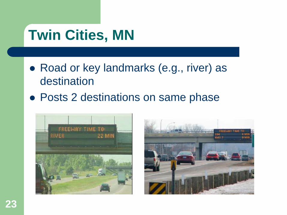
Road or key landmarks (e g river) as destination
9
– Road or key landmarks (e.g., river) as destination
* Red indicates an item that may require extra attention in this study

T l Ti B t P ti E t iTravel Time Best Practice – Enterprise Pooled Fund Program, 2007 (Cont’d)
Illinois State Toll Highway Authority– Uses both permanent and portable DMSs
Toronto, Canada– Uses range– Under free-flow, it uses speed limit
When it exceeds 40 minutes it displays:– When it exceeds 40 minutes, it displays:“Stop and Go Conditions”
10 * Red indicates an item that may require extra attention in this study
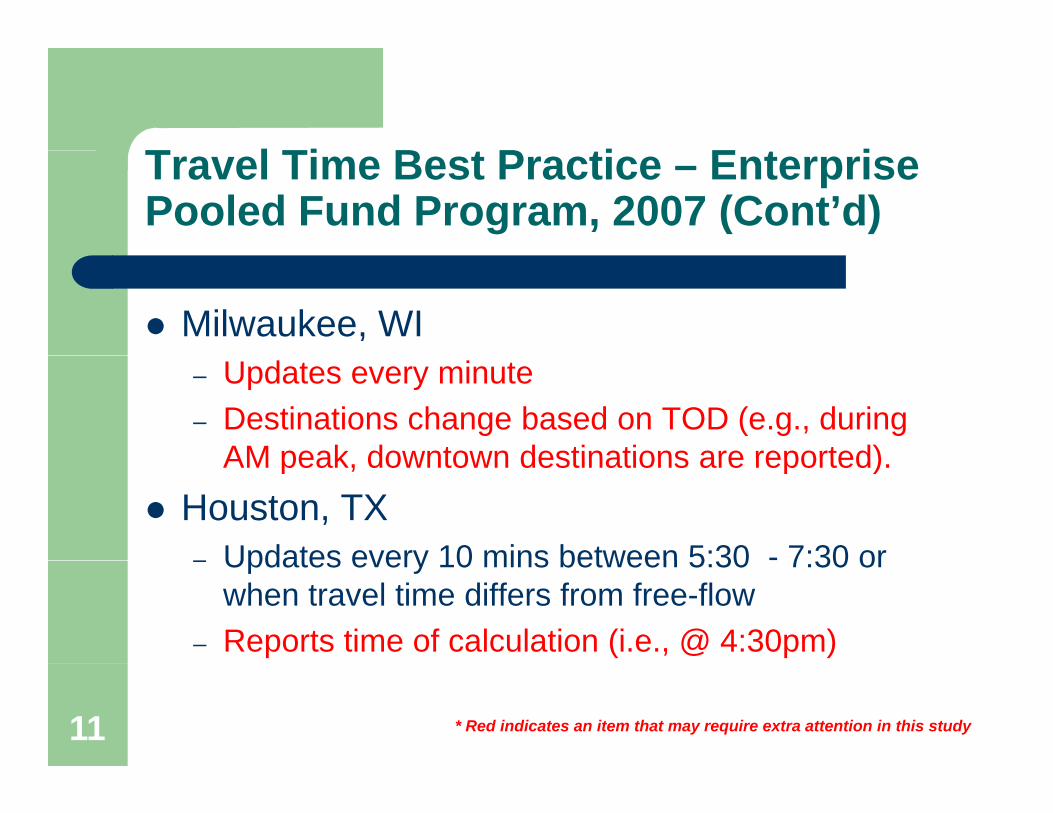
T l Ti B t P ti E t iTravel Time Best Practice – Enterprise Pooled Fund Program, 2007 (Cont’d)
Milwaukee, WI– Updates every minute– Destinations change based on TOD (e.g., during
AM peak downtown destinations are reported)AM peak, downtown destinations are reported).Houston, TX– Updates every 10 mins between 5:30 - 7:30 or– Updates every 10 mins between 5:30 7:30 or
when travel time differs from free-flow– Reports time of calculation (i.e., @ 4:30pm)
11 * Red indicates an item that may require extra attention in this study

T l Ti B t P ti E t iTravel Time Best Practice – Enterprise Pooled Fund Program, 2007 (Cont’d)
Nashville, TN– Destinations are less than 5 miles– Reports distance
R t– Reports range– Incident higher priority than travel time
12 * Red indicates an item that may require extra attention in this study
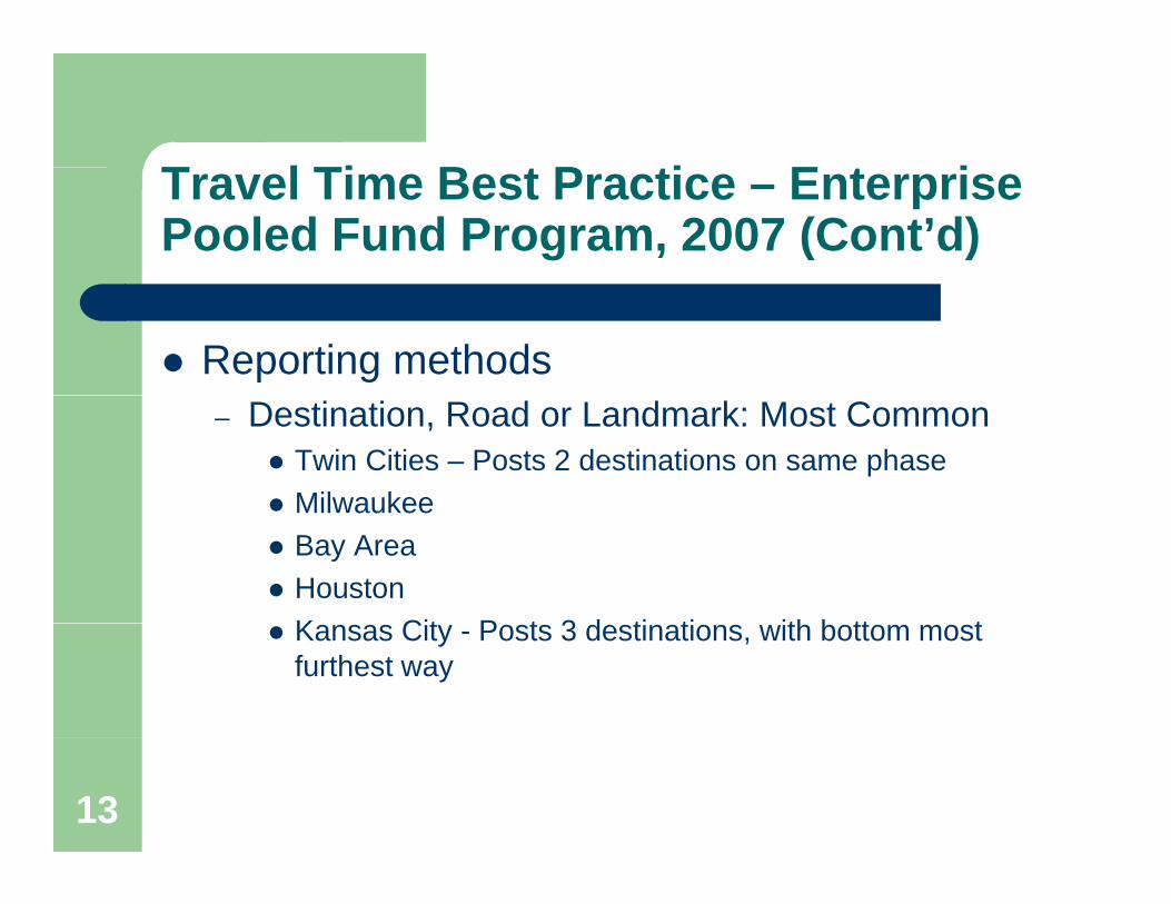
T l Ti B t P ti E t iTravel Time Best Practice – Enterprise Pooled Fund Program, 2007 (Cont’d)
Reporting methods– Destination, Road or Landmark: Most Common
Twin Cities – Posts 2 destinations on same phaseMilwaukeeMilwaukeeBay AreaHoustonK Cit P t 3 d ti ti ith b tt tKansas City - Posts 3 destinations, with bottom most furthest way
13

T l Ti B t P ti E t iTravel Time Best Practice – Enterprise Pooled Fund Program, 2007 (Cont’d)
Reporting methods (cont’d)Destination City– Destination, City
Seattle– Destination with Travel Time
NashvilleNashville– Travel time with time of calculation
Houston – Takes care of latency issue– Event description with travel timeEvent description with travel time
Toronto, Canada– In Ranges
Nashville
14

Procedural Guidelines for Implementing Travel Time on DMS in CHART
December 2008 C-1
APPENDIX C: STATE-OF-THE-PRACTICE SCAN

Atlanta, GA* Buffalo, NYChicago, ILCincinnati, OHDenver, Colorado* Fort Lauderdale, FLHouston, TXKansas City, MOMilwaukee, WINashville, TNOrlando, FLPortland, OregonSan Antonio, TXSan Francisco, CASeattle, WA* Toronto, Canada* Twin Cities, MN
Examples from Other States
* Not included in the list of 42 implementation cited in FHWA listNovember 2008

2
Other Implementations
Source: FHWA Website for Real Time Traveler Information Program

3
Other Implementations (Cont’d)
Source: FHWA Website for Real Time Traveler Information Program
Provide Travel Time Locations Atlanta, Georgia • Baton Rouge, Louisiana • Chicago, Illinois • Cincinnati, Ohio • Columbus, Ohio • Dallas, Texas • Denver, Colorado • Detroit, Michigan • Fort Worth, Texas • Hampton Roads, Virginia • Houston, Texas • Jacksonville, Florida • Kansas City, Missouri • Knoxville, Tennessee • Las Vegas, Nevada • Los
Angeles, California • Louisville, Kentucky • Miami, Florida • Milwaukee, Wisconsin • Minneapolis, Minnesota • Nashville, Tennessee • New Orleans, Louisiana • Newark, New Jersey • NW Indiana, Indiana • New York City bridge approach, New York, New York City Staten Island Expressway • Long Island, New
York • Orlando, Florida • Phoenix, Arizona • Portland, Oregon • Raleigh, North Carolina • Sacramento, California • Salisbury, Maryland • San Antonio, Texas • San Bernardino, California • San Diego, California • San Francisco, California • San Jose, California • Salt Lake City, Utah • Seattle, Washington • St. Louis,
Missouri • Tampa, Florida • Wilmington, Delaware
Plans to Provide Travel Time LocationsAlbuquerque, New Mexico • Austin, Texas • Baltimore, Maryland • Birmingham, Alabama • Boise, Idaho •
Charlotte, North Carolina • Des Moines, Iowa • Memphis, Tennessee • Northern Virginia (DC Metro), Virginia • Oklahoma City, Oklahoma • Philadelphia, Pennsylvania • Pittsburgh, Pennsylvania •
Providence, Rhode Island • Shreveport, Louisiana • Tallahassee, Florida
As of August 20, 2008

4
Atlanta (GDOT NaviGator)
Information collected from the VDS Provides travel times along interstateInformation provided between 6am - 9pmDistance information – Good practice (per FHWA)
5
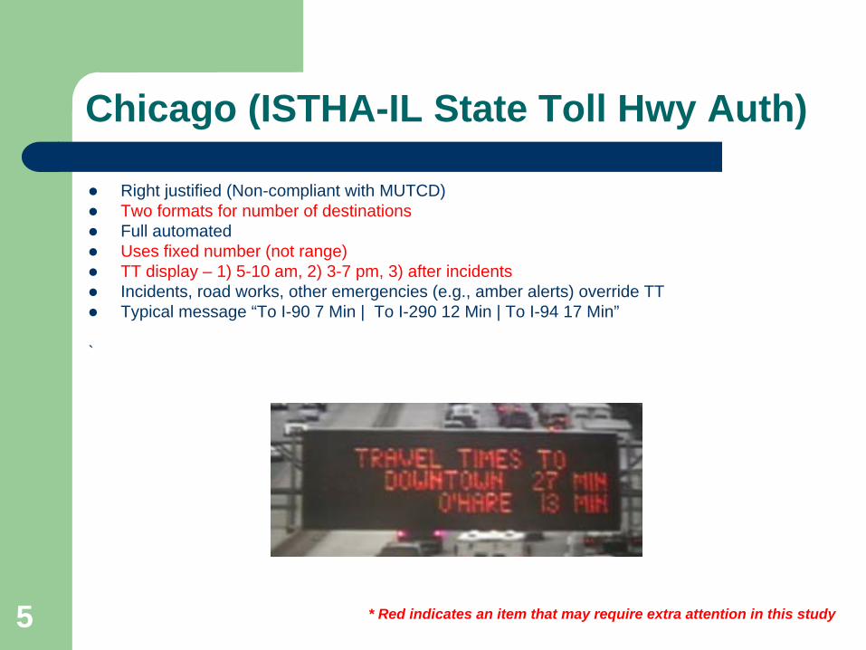
Chicago (ISTHA-IL State Toll Hwy Auth)
Right justified (Non-compliant with MUTCD)Two formats for number of destinationsFull automatedUses fixed number (not range)TT display – 1) 5-10 am, 2) 3-7 pm, 3) after incidentsIncidents, road works, other emergencies (e.g., amber alerts) override TTTypical message “To I-90 7 Min | To I-290 12 Min | To I-94 17 Min”
`
* Red indicates an item that may require extra attention in this study

6
Chicago [Chicago TMC (Not Toll)]
Full automated feedVerbiage different than Toll Facilities; No complaints from the public
* Red indicates an item that may require extra attention in this study

7
Cincinnati (ARTIMIS)
Type of Message– TT info on DMS is manual, not automatic– Destination– Incidents, road works, other emergencies (e.g., amber alerts)
override TT– 2-Min Ranges– Display only during 6 am – 8 pm M-F
* Red indicates an item that may require extra attention in this study
8
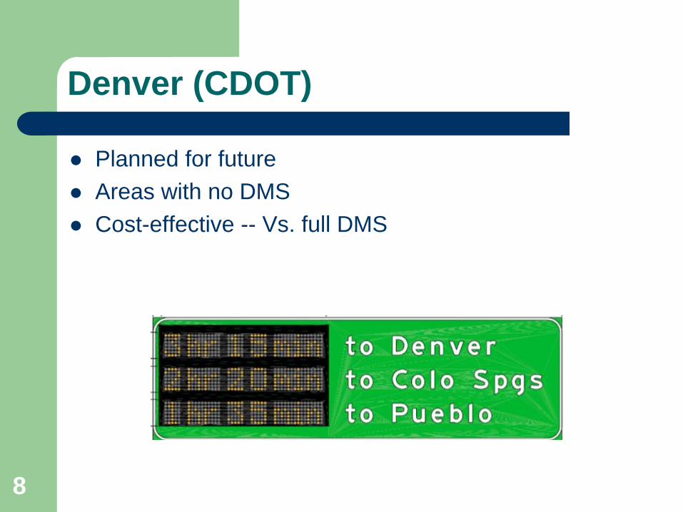
Denver (CDOT)
Planned for future Areas with no DMS Cost-effective -- Vs. full DMS

9
Houston (Houston TranStar)
– Updates every 10 mins betn 5:30 - 7:30 or when travel time differs from free-flow
– Reports time of calculation (i.e., @ 4:40pm)– Road or Landmark as Destination

10
Jacksonville, FL
– Fully automated process from sensor to DMS display– Incidents, road works, other emergencies (e.g., amber
alerts) override TT– Display in range– Display during 6 am – 8 pm
* Red indicates an item that may require extra attention in this study

11
Kansas City
Posts 3 destinations, with bottom most furthest wayRoad or Landmark as Destination
12
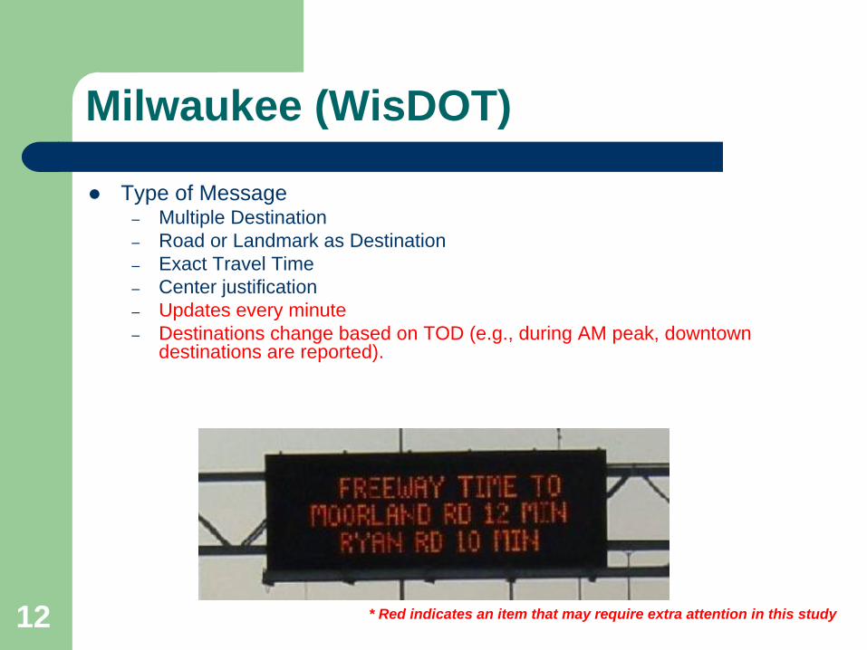
Milwaukee (WisDOT)
Type of Message– Multiple Destination– Road or Landmark as Destination– Exact Travel Time– Center justification– Updates every minute– Destinations change based on TOD (e.g., during AM peak, downtown
destinations are reported).
* Red indicates an item that may require extra attention in this study

13
Nashville (TDOT)
Type of Message– Multiple Destinations– Destinations are less than 5 miles– Distance– Travel Time Range – Incident higher priority than travel
time
Source: www.tdot.state.tn.us/tdotsmartway
Operating Agency: TDOT
ATMS System: Smartway
* Red indicates an item that may require extra attention in this study

14
Orlando (FDOT)
Type of Message– Destination– 2-Min Ranges– Two Phase Design

15
Portland (ODOT)
Up to 4-min ranges during congestion2-Min ranges at other times

16
San Antonio (TxDOT)
Type of Message– Multiple Destinations– 2-Min Range Travel Time

17
San Francisco (CalTrans)
Type of Message– Destination– Road or Landmark as Destination– Exact Travel Time– Multiple Destinations shown on one phase

18
Seattle, WA
City as a destination (vs. routes)Shorter distance – better feedbackChange messages every 2 mins
* Red indicates an item that may require extra attention in this study
19
Not Listed on FHWA Records
20
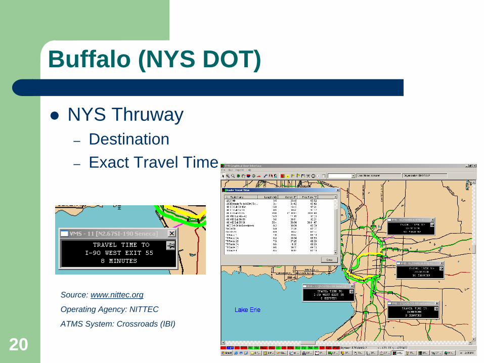
Buffalo (NYS DOT)
NYS Thruway– Destination– Exact Travel Time
Source: www.nittec.org
Operating Agency: NITTEC
ATMS System: Crossroads (IBI)

21
Fort Lauderdale (FDOT)
Type of Message– Destination– Distance– Range Travel Time
Source: www.smartsunguide.com
Operating Agency: FDOT Region 4
ATMS System: SunGuide (SWRI)
ATIS Website: SmartSunGuide (IBI)

22
Toronto, Canada
Uses rangeUnder free-flow, it uses speed limitWhen it exceeds 40 minutes (distance), it displays “Stop and go conditions”Event description with Travel Time
* Red indicates an item that may require extra attention in this study
23
Twin Cities, MN
Road or key landmarks (e.g., river) as destinationPosts 2 destinations on same phase

Procedural Guidelines for Implementing Travel Time on DMS in CHART
December 2008 D-1
APPENDIX D: INTERVIEW MATRIX

Disclaimer: These notes are working-level and have not been approved by the participants. This is for informational purposes for the intended audience only and is not be used for any other purposes; also this is not be quoted or referenced elsewhere.
PROCEDURAL GUIDELINES FOR IMPLEMENTING TRAVEL TIME ON DMS IN CHART
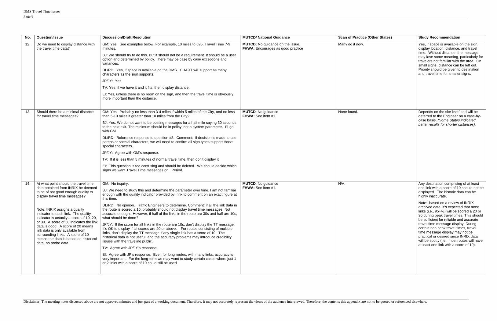
November-2008 Note: GM = Glenn McLaughlin; BJ = Bob Jordan; DL/RD = Dale Lineweaver / Rick Dye; JP/JY = Jean Yves Point-du-Jour / John Young; TV = Toby Valmas, EI = Egua Igbinosun No. Question/Issue Discussion/Draft Resolution MUTCD/ National Guidance Scan of Practice (Other States) Study Recommendation
A Messaging Questions
1 What will be the format of the travel time messages?
GM: See Item #2 MUTCD: Centered within the line No more than 2 phases FHWA: Per FHWA:
a. FHWA has no specific policy or position on Travel Time messages on DMS.
b. FHWA encourages following the MUTCD. c. FHWA encourages each State to develop its
own standard.
See the PowerPoint slide for illustrations.
Most - Destination with travel time (some with distance).
Toronto displays Event Description with travel time.
See Recommendation in #2 below.
2 Will the travel time message formats require a combination of left justification (say for the destinations) and right justification (say for the travel times) of different portions of the DMS message? (9/3/08 JAD)
GM: For single destination messages, each line will be centered and the destination will precede the time. For multiple destinations, data will be column oriented. Destinations will be listed on the left and will be left justified. Times will be on the right and will be right justified. Spaces will be added to align columns. See illustrations at the end of this document.
BJ: Good with above.
DL/RD: No opinion. Traffic Engineers to determine. CHART will support whatever is decided.
JP/JY: Good with GM’s response.
TV: Top line should always say “Travel Time To” or “Travel Time”. The policy is “what” (i.e., the item of interest) goes on the 1st line. Destination and time should go on the 2nd line. Distance can go on the same line or the third line.
EI: Good with Toby’s responses. Prefers what (1st line), location/distance (2nd line), and time (3rd line)
MUTCD: Fine as long as centered within the line FHWA: See item #1.
Two types were seen:
1. Fully centered.
2. Left column left justified; right column right justified.
The acceptable formats are as follows:
1) Text fully-centered for single destination travel time messages.
2) Left element (destination) left justified & right element (travel time) right justified. This can be used for single destination or multiple destination travel time messages.
Message content order should be as follows:
1) Heading (“Travel Time To”)
2) Destination
3) Distance (preferred),
4) Travel Time
See illustration.

DMS Travel Time Issues Page 2
Disclaimer: The meeting notes discussed above are not approved minutes and just part of a working document. Therefore, it may not accurately represent the views of the audience interviewed. Therefore, the contents this appendix are not to be quoted or referenced elsewhere.
No. Question/Issue Discussion/Draft Resolution MUTCD/ National Guidance Scan of Practice (Other States) Study Recommendation
3 Will multiple phases (pages) be used to display travel time and other information on DMS?
GM: No. Travel time priority is not high enough to do that. When incident messages or other msgs are displayed travel data will not be displayed.
BJ: Yes. Has to be. On the toll rate signs, TT data alternates with Toll Rate data. Other than that agree. No multi-phase except in this case.
DL/RD: Yes. In the future, incident messages may be combined with on-the-fly Travel Time data. CHART should provide the ability to do other things, such as “WIPERS ON” msgs on one phase and the travel time msg on the 2nd phase. CHART supports multiple message types on the same sign using 3 capabilities: 1) arbitration queue (set for each event); 2) # of phases allowed (per sign); 3) DMS Message Combination Rules (globals all signs). Rick: this topic also encroaches on the debate of whether travel time information should be displayed when there is an incident. There are 2 schools of thought: 1) some believe travelers demand for travel time information is the highest during incidents; 2) others believe incident information is enough and should take priority, because the TT data is much less accurate when there is an incident on the route.
JP/JY: Agree with GM’s response. 2 phase messages slow traffic and are hard to read. The TT data is also expected to be less accurate during incidents. JY: disagrees and believes TT data should be displayed as a 2nd phase during incidents.
TV: No. Travel Time messages themselves should only be single phase. During incidents, a 2nd phase (page) with Travel Time information would be acceptable, but only if there is an alternate route downstream. (System may have to be smart enough to discern which signs are capable of single destination only messages vs. multiple destination msgs.)
EI: Agree with TV’s response, but during an incident we shouldn’t require there to be an alternate route. It would be OK to just post travel time to a destination as the 2nd phase.
MUTCD: Up to 2 phases allowed FHWA: No addition
Some use 2-phase (e.g., Orlando). Travel Time messages themselves should only be single phase.
Short-Term Recommendation: During incidents, a 2nd phase with Travel Time information.
Long-Term Recommendation: During incidents, a 2nd phase with Travel Time information, along with alternate routes.
4 Will some signs provide travel times for multiple destinations?
GM: Yes, where applicable. Both single and multiple destinations will be displayed.
BJ: Agreed.
DL/RD: No opinion. Traffic Engineers to determine.
JP/JY: Yes.
TV: Yes. Absolutely.
EI: Yes.
MUTCD: No guidance FHWA: See item #1.
Common practice.
Kansas City even uses 3 destinations.
Yes.
5 How often will travel times be updated?
GM: Every 5 minutes, but dictated by the source, i.e., Inrix. (Note: Inrix updates data every 5-minutes). Operations feedback needed.
BJ: No inquiry.
DL/RD: Dependent on data the source. INRIX updates will be provided every 5 minutes. CHART polls for data every 5 minutes using an XML interface.
JP/JY: Agree with DL’s response.
TV: Depends on the data source. 5 minutes is good, but if more or less frequent updates are available, don’t need to change the message unless the Travel Time changes by 5 minutes or more.
EI: Agree with TV’s response.
MUTCD: No guidance. FHWA: See item #1.
Varies.
1 min (Milwaukee) -10 mins (Houston).
Depends on provider's frequency. Nominally a 5-minute update cycle should be provided to keep travel times accurate.
DMS Travel Time Issues Page 3
Disclaimer: The meeting notes discussed above are not approved minutes and just part of a working document. Therefore, it may not accurately represent the views of the audience interviewed. Therefore, the contents this appendix are not to be quoted or referenced elsewhere.
No. Question/Issue Discussion/Draft Resolution MUTCD/ National Guidance Scan of Practice (Other States) Study Recommendation
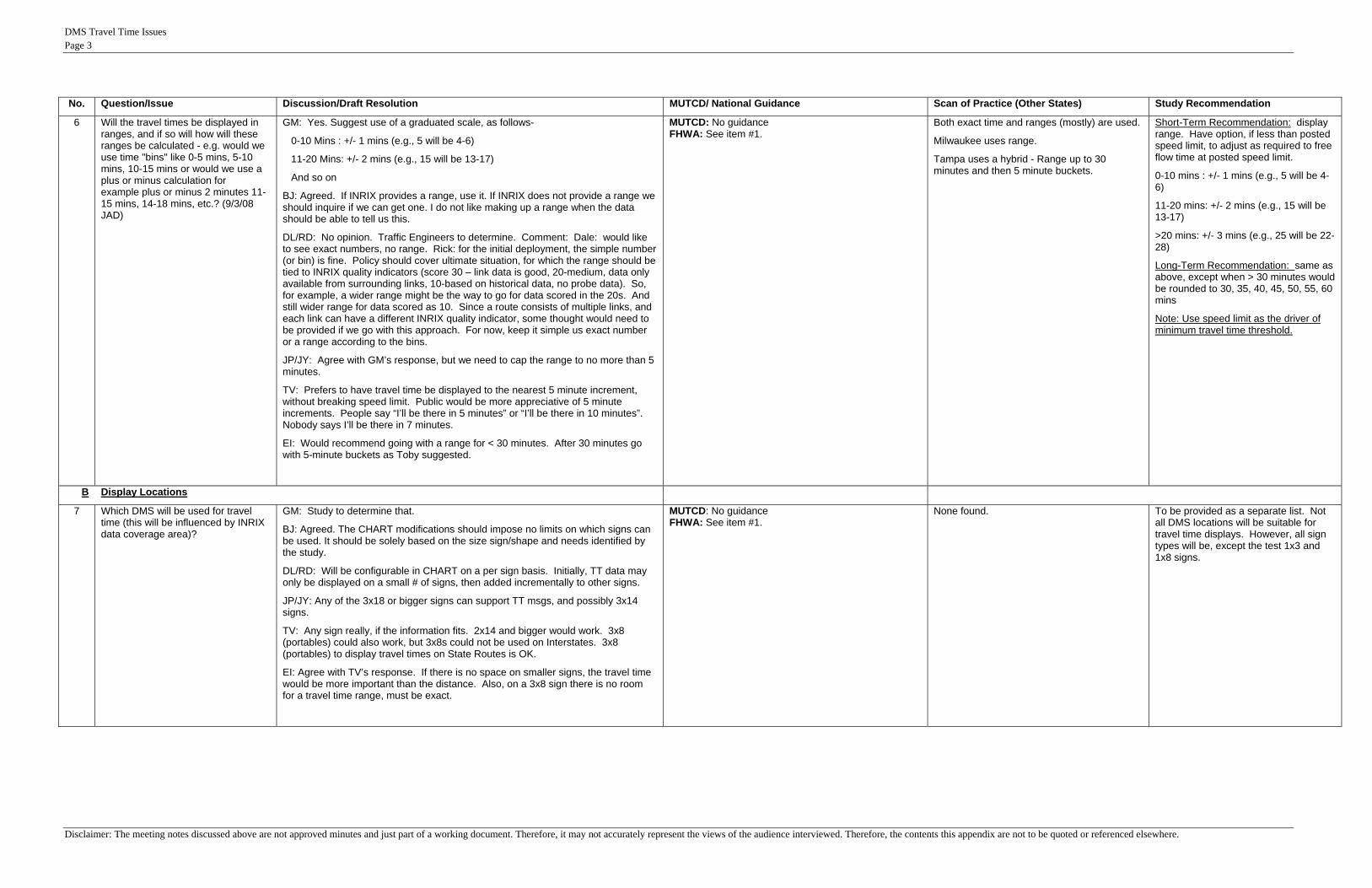
6 Will the travel times be displayed in ranges, and if so will how will these ranges be calculated - e.g. would we use time "bins" like 0-5 mins, 5-10 mins, 10-15 mins or would we use a plus or minus calculation for example plus or minus 2 minutes 11-15 mins, 14-18 mins, etc.? (9/3/08 JAD)
GM: Yes. Suggest use of a graduated scale, as follows-
0-10 Mins : +/- 1 mins (e.g., 5 will be 4-6)
11-20 Mins: +/- 2 mins (e.g., 15 will be 13-17)
And so on
BJ: Agreed. If INRIX provides a range, use it. If INRIX does not provide a range we should inquire if we can get one. I do not like making up a range when the data should be able to tell us this.
DL/RD: No opinion. Traffic Engineers to determine. Comment: Dale: would like to see exact numbers, no range. Rick: for the initial deployment, the simple number (or bin) is fine. Policy should cover ultimate situation, for which the range should be tied to INRIX quality indicators (score 30 – link data is good, 20-medium, data only available from surrounding links, 10-based on historical data, no probe data). So, for example, a wider range might be the way to go for data scored in the 20s. And still wider range for data scored as 10. Since a route consists of multiple links, and each link can have a different INRIX quality indicator, some thought would need to be provided if we go with this approach. For now, keep it simple us exact number or a range according to the bins.
JP/JY: Agree with GM’s response, but we need to cap the range to no more than 5 minutes.
TV: Prefers to have travel time be displayed to the nearest 5 minute increment, without breaking speed limit. Public would be more appreciative of 5 minute increments. People say “I’ll be there in 5 minutes” or “I’ll be there in 10 minutes”. Nobody says I’ll be there in 7 minutes.
EI: Would recommend going with a range for < 30 minutes. After 30 minutes go with 5-minute buckets as Toby suggested.
MUTCD: No guidance FHWA: See item #1.
Both exact time and ranges (mostly) are used.
Milwaukee uses range.
Tampa uses a hybrid - Range up to 30 minutes and then 5 minute buckets.
Short-Term Recommendation: display range. Have option, if less than posted speed limit, to adjust as required to free flow time at posted speed limit.
0-10 mins : +/- 1 mins (e.g., 5 will be 4-6)
11-20 mins: +/- 2 mins (e.g., 15 will be 13-17)
>20 mins: +/- 3 mins (e.g., 25 will be 22-28)
Long-Term Recommendation: same as above, except when > 30 minutes would be rounded to 30, 35, 40, 45, 50, 55, 60 mins
Note: Use speed limit as the driver of minimum travel time threshold.
B Display Locations
7 Which DMS will be used for travel time (this will be influenced by INRIX data coverage area)?
GM: Study to determine that.
BJ: Agreed. The CHART modifications should impose no limits on which signs can be used. It should be solely based on the size sign/shape and needs identified by the study.
DL/RD: Will be configurable in CHART on a per sign basis. Initially, TT data may only be displayed on a small # of signs, then added incrementally to other signs.
JP/JY: Any of the 3x18 or bigger signs can support TT msgs, and possibly 3x14 signs.
TV: Any sign really, if the information fits. 2x14 and bigger would work. 3x8 (portables) could also work, but 3x8s could not be used on Interstates. 3x8 (portables) to display travel times on State Routes is OK.
EI: Agree with TV’s response. If there is no space on smaller signs, the travel time would be more important than the distance. Also, on a 3x8 sign there is no room for a travel time range, must be exact.
MUTCD: No guidance FHWA: See item #1.
None found. To be provided as a separate list. Not all DMS locations will be suitable for travel time displays. However, all sign types will be, except the test 1x3 and 1x8 signs.
DMS Travel Time Issues Page 4
Disclaimer: The meeting notes discussed above are not approved minutes and just part of a working document. Therefore, it may not accurately represent the views of the audience interviewed. Therefore, the contents this appendix are not to be quoted or referenced elsewhere.
No. Question/Issue Discussion/Draft Resolution MUTCD/ National Guidance Scan of Practice (Other States) Study Recommendation
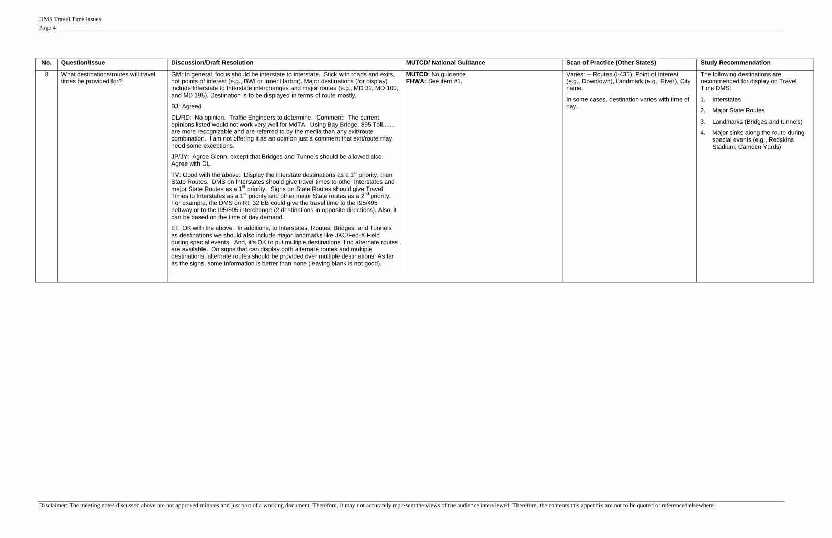
8 What destinations/routes will travel times be provided for?
GM: In general, focus should be interstate to interstate. Stick with roads and exits, not points of interest (e.g., BWI or Inner Harbor). Major destinations (for display) include Interstate to Interstate interchanges and major routes (e.g., MD 32, MD 100, and MD 195). Destination is to be displayed in terms of route mostly.
BJ: Agreed.
DL/RD: No opinion. Traffic Engineers to determine. Comment: The current opinions listed would not work very well for MdTA. Using Bay Bridge, 895 Toll....... are more recognizable and are referred to by the media than any exit/route combination. I am not offering it as an opinion just a comment that exit/route may need some exceptions.
JP/JY: Agree Glenn, except that Bridges and Tunnels should be allowed also. Agree with DL.
TV: Good with the above. Display the interstate destinations as a 1st priority, then State Routes. DMS on Interstates should give travel times to other Interstates and major State Routes as a 1st priority. Signs on State Routes should give Travel Times to Interstates as a 1st priority and other major State routes as a 2nd priority. For example, the DMS on Rt. 32 EB could give the travel time to the I95/495 beltway or to the I95/895 interchange (2 destinations in opposite directions). Also, it can be based on the time of day demand.
EI: OK with the above. In additions, to Interstates, Routes, Bridges, and Tunnels as destinations we should also include major landmarks like JKC/Fed-X Field during special events. And, it’s OK to put multiple destinations if no alternate routes are available. On signs that can display both alternate routes and multiple destinations, alternate routes should be provided over multiple destinations. As far as the signs, some information is better than none (leaving blank is not good).
MUTCD: No guidance FHWA: See item #1.
Varies: -- Routes (I-435), Point of Interest (e.g., Downtown), Landmark (e.g., River), City name.
In some cases, destination varies with time of day.
The following destinations are recommended for display on Travel Time DMS:
1. Interstates
2. Major State Routes
3. Landmarks (Bridges and tunnels)
4. Major sinks along the route during special events (e.g., Redskins Stadium, Camden Yards)

DMS Travel Time Issues Page 5
Disclaimer: The meeting notes discussed above are not approved minutes and just part of a working document. Therefore, it may not accurately represent the views of the audience interviewed. Therefore, the contents this appendix are not to be quoted or referenced elsewhere.
No. Question/Issue Discussion/Draft Resolution MUTCD/ National Guidance Scan of Practice (Other States) Study Recommendation
C Logistical Issues
9 Will travel times be shown that indicate speeds greater than the speed limit?
GM: No. Basically stay with Miles in Minutes range.
BJ: Disagree strongly. There is no law for this and ETLs require accurate Travel Times. If we limit the lower bound it could greatly influence demand (in a negative way) to use the ETL since the public will not see an accurate time savings. This would discourage use of ETL MLs. (For example, If travel times in the ETL’s are free-flowing and above posted speed, while GP’s are somewhat congested but still flowing near posted speed, this may be a 10 MPH speed difference. Limiting the travel times to posted speed would show no time savings at all between the GP’s and ETL’s.)
DL/RD: No opinion. Traffic Engineers to determine. Comment: preference would be to see actual times. However, CHART will be able to support upper and lower bounds on a per route (not link) basis. Rick: possible area of concern …. if travel times are posted that exceed speed limits it could be construed that the Government is acknowledging that laws are being broken. Political nightmare.
JP/JY: Emphatically no! Should not display any travel times that are lower than the posted speed limit. This could easily be interpreted that the Gov’t is condoning speeding.
TV: Stick with what is safe (meaning no travel times implying State Law is being broken).
EI: SHA should put nothing on the DMS to encourage people to go over the speed limit. If the Travel Time is less than what it should be if travelers were following the posted speed limit, CHART should display nothing less than the time it would take at the posted speed limit or display no delays. We can also perhaps show" Destination- Distance- Free Flow (instead of TT)".
MSP: MSP does not recommend that SHA list any travel times for traffic that would travel over the posted speed limit. Their suggestion would be to indicate "No delays" when traffic is traveling without obstructions. MSP suggests that when there are delays, the travel times that SHA lists should be the actual travel speed (assuming that the traffic's speed is at or under the posted speed limit). MSP cannot approve or condone traveling over the posted speed limit, nor should travel times indicate such approval.
MUTCD: No guidance on the issue. FHWA: Minimum should be posted speed limit (B. Jeffers)
Toronto uses Speed Limit as threshold. Not seen anything for others.
Provide the option to limit the bottom threshold by the speed limit derivative. Provide flexibility in the software to support changes in policy and potentially different needs between MdTA and SHA. For example, SHA may be more sensitive to, and want to prohibit display of travel times that imply traffic is moving faster than posted speed limit.
Whereas, MdTA may be more inclined to post the actual time, whatever it is, particularly in the managed/express toll lanes, as this can influence demand.

DMS Travel Time Issues Page 6
Disclaimer: The meeting notes discussed above are not approved minutes and just part of a working document. Therefore, it may not accurately represent the views of the audience interviewed. Therefore, the contents this appendix are not to be quoted or referenced elsewhere.
No. Question/Issue Discussion/Draft Resolution MUTCD/ National Guidance Scan of Practice (Other States) Study Recommendation
10 What constitutes "bad" data? (e.g., we don't want to display Travel Time: 999 minutes)?
GM: If the travel time exceeds some threshold (say 4 times the norm – from a table), we should switch to an incident or congestion message and pull down the travel time message. At 4x, there are 2 possibilities: a) bad data from INRIX or b) an incident (congestion or accident).
BJ: Would like to see an alert when it exceeds 4x the time it would take at the posted speed limit and disabling TT display all together at 10X. Really at 4x (or sooner), there should be some sort of incident msg to go up and Travel time estimates may be best done manually by operations.
DL/RD: CHART will support upper and lower limits by route. Currently there is only one number which is used to provide an alert (e.g., 4x). If another parameter is required (e.g., the 10x one which would automatically pull down the travel time message), CSC would need to know soon.
JP/JY: Agree with GM’s response. 4X is fine to alert. Do not prefer a second threshold. Would be up to the operator (default display cut off at 4x).
TV: 4x is a good idea for alert. Like having the flexibility for a 2nd parameter to stop TT message display automatically if a 2nd threshold is exceeded. 10x sounds okay.
EI: Agree with TV’s response. Keep the 2nd parameter as an option that may or may not be used.
[Note: CHART will support 2 threshold parameters. That is, to alert at 4x and stop displaying at 10x, can be handled]
MUTCD: No guidance FHWA: See item #1.
Toronto switches to Test Display " Stop and go conditions" if time hits a threshold.
Recommend two types of threshold:
1. Alert Operator Threshold: Recommend a configurable threshold (e.g., 4x nominal travel time) to alert the operator.
2. Pull Down Message Threshold: Recommend a configurable threshold (e.g., 10x nominal travel time) to switch to "Blank" or other message, such as "Stop and Go" or "Congestion Ahead".

DMS Travel Time Issues Page 7
Disclaimer: The meeting notes discussed above are not approved minutes and just part of a working document. Therefore, it may not accurately represent the views of the audience interviewed. Therefore, the contents this appendix are not to be quoted or referenced elsewhere.
No. Question/Issue Discussion/Draft Resolution MUTCD/ National Guidance Scan of Practice (Other States) Study Recommendation
11. Where does travel time come in the hierarchy of DMS messages?
GM: Low on the list. Maybe with Safety Messages. Operations feedback needed. Possible hierarchy is-
1. Urgent Messages (like Amber alerts)
2. Incident messages
3. Roadwork
4. Congestion
5. SHAZAM
6. Weather
7. Special
8. Action
9. Safety - Discretionary safety messages (e.g.,, Governor requested “Drive to Survive”), or Generic messages (e.g., “Drive to Survive” or “Set Your Clocks Back”)
BJ: No inquiry.
DL/RD: Same answer as #3: This will be handled using the arbitration queue, # phases allowed per sign; message combination rules.
JP/JY: Agree with GM’s response, but TT messages should have priority greater than Discretionary Safety Messages during peak travel time.
TV: Should be at the same level as congestion. At least 4 on the hierarchy.
EI: During peak travel agree with TV’s response. During non-peak should come after Safety (same as GM's).
MUTCD: No guidance FHWA: See item #1.
All seen to come after Incidents, Roadwork and other ad hoc preemptive messages (such as Amber Alert).
Short-Term Recommendation: The travel time message should be displayed before or in lieu of congestion messages. (Scan from other States are consistent with this recommendation).
The suggested priority is as follows: #1. Urgent, #2. Incident, #3. Planned Roadway Closure, #4. Toll Rate, #5. Travel Time, #6. Congestion, #7. Shazam, #8. Weather, #9. Special, #10. Action, #11. Safety Toll Rate priority justification is as follows: A. For the Toll Rate Signs (e.g.,
ETL) – CHART should configure the system so that only the MdTA centers can talk to these signs. They are for toll operations only.
B. For Shared Signs – these signs could possibly display incident messages, travel time messages or toll rate messages (like signs on I-695 near the I-95 interchange). For these signs, Toll Rate messages should be displayed after Travel time.
C. For Incident Management Signs – these signs would never display Toll Rate, but could display Travel time. Travel time messages should be after urgent, incident, and planned roadwork messages.
Long-Term Recommendation: During non-peak travel, the travel time message should come after Safety. (Scan from other States supports indirectly; a lot of states turn off travel time during off-peak time).
DMS Travel Time Issues Page 8
Disclaimer: The meeting notes discussed above are not approved minutes and just part of a working document. Therefore, it may not accurately represent the views of the audience interviewed. Therefore, the contents this appendix are not to be quoted or referenced elsewhere.
No. Question/Issue Discussion/Draft Resolution MUTCD/ National Guidance Scan of Practice (Other States) Study Recommendation
12. Do we need to display distance with the travel time data?
GM: Yes. See examples below. For example, 10 miles to 695, Travel Time 7-9 minutes.
BJ: We should try to do this. But it should not be a requirement. It should be a user option and determined by policy. There may be case by case exceptions and variances.
DL/RD: Yes, if space is available on the DMS. CHART will support as many characters as the sign supports.
JP/JY: Yes.
TV: Yes, if we have it and it fits, then display distance.
EI: Yes, unless there is no room on the sign, and then the travel time is obviously more important than the distance.
MUTCD: No guidance on the issue. FHWA: Encourages as good practice
Many do it now. Yes, if space is available on the sign, display location, distance, and travel time. Without distance, the message may lose some meaning, particularly for travelers not familiar with the area. On small signs, distance can be left out. Priority should be given to destination and travel time for smaller signs.
13. Should there be a minimal distance for travel time messages?
GM: Yes. Probably no less than 3-4 miles if within 5 miles of the City, and no less than 5-10 miles if greater than 10 miles from the City?
BJ: Yes. We do not want to be posting messages for a half mile saying 30 seconds to the next exit. The minimum should be in policy, not a system parameter. I’ll go with GM.
DL/RD: Reference response to question #8. Comment: if decision is made to use parens or special characters, we will need to confirm all sign types support those special characters.
JP/JY: Agree with GM’s response.
TV: If it is less than 5 minutes of normal travel time, then don’t display it.
EI: This question is too confusing and should be deleted. We should decide which signs we want Travel Time messages on. Period.
MUTCD: No guidance FHWA: See item #1.
None found. Depends on the site itself and will be deferred to the Engineer on a case-by-case basis. (Some States indicated better results for shorter distances).
14. At what point should the travel time data obtained from INRIX be deemed to be of not good enough quality to display travel time messages?
Note: INRIX assigns a quality indicator to each link. The quality indicator is actually a score of 10, 20, or 30. A score of 30 indicates the link data is good. A score of 20 means link data is only available from surrounding links. A score of 10 means the data is based on historical data, no probe data.
GM: No inquiry.
BJ: We need to study this and determine the parameter over time. I am not familiar enough with the quality indicator provided by Inrix to comment on an exact figure at this time.
DL/RD: No opinion. Traffic Engineers to determine. Comment: if all the link data in the route is scored a 10, probably should not display travel time messages. Not accurate enough. However, if half of the links in the route are 30s and half are 10s, what should be done?
JP/JY: If the score for all links in the route are 10s, don’t display the TT message. It’s OK to display if all scores are 20 or above. For routes consisting of multiple links, don’t display the TT message if any single link has a score of 10. The historical data is not useful, and the accuracy problems may introduce credibility issues with the traveling public.
TV: Agree with JP/JY’s response.
EI: Agree with JP’s response. Even for long routes, with many links, accuracy is very important. For the long-term we may want to study certain cases where just 1 or 2 links with a score of 10 could still be used.
MUTCD: No guidance FHWA: See item #1.
N/A. Any destination comprising of at least one link with a score of 10 should not be displayed. The historic data can be highly inaccurate.
Note: based on a review of INRIX archived data, it’s expected that most links (i.e., 95+%) will be scored a 20 or 30 during peak travel times. This should be sufficient for reliable and accurate travel time message display. During certain non peak travel times, travel time message display may not be practical or desired since INRIX data will be spotty (i.e., most routes will have at least one link with a score of 10).
DMS Travel Time Issues Page 9
Disclaimer: The meeting notes discussed above are not approved minutes and just part of a working document. Therefore, it may not accurately represent the views of the audience interviewed. Therefore, the contents this appendix are not to be quoted or referenced elsewhere.
ILLUSTRATIONS:
Some preferred illustrations were generated, as follows:
Single Destination.
1 2 3 4 5 6 7 8 9 10 11 12 13 14 15 16 17 18 19 20 21
T R A V E L T I M E T O
I - 8 9 5 1 0 M I A H E A D
1 0 - 1 5 M I N
1 2 3 4 5 6 7 8 9 10 11 12 13 14 15 16 17 18 19 20 21
T R A V E L T I M E T O
I - 8 9 5 1 0 M I A H E A D
1 0 - 1 5 M I N
1 2 3 4 5 6 7 8 9 10 11 12 13 14 15 16 17 18 19 20 21
T R A V E L T I M E T OI - 8 9 5 1 0 - 1 5 M I N
1 2 3 4 5 6 7 8 9 10 11 12 13 14 15 16 17 18 19 20 21
T R A V E L T I M E T OI - 8 9 5 1 0 - 1 5 M I N
Multiple Destinations
1 2 3 4 5 6 7 8 9 10 11 12 13 14 15 16 17 18 19 20 21
T R A V E L T I M E T O
I - 8 9 5 1 0 - 1 5 M I N
I - 3 9 5 2 0 - 2 5 M I N
1 2 3 4 5 6 7 8 9 10 11 12 13 14 15 16 17 18 19 20 21
T R A V E L T I M E T O
I - 8 9 5 1 0 - 1 5 M I N
I - 3 9 5 2 0 - 2 5 M I N

DMS Travel Time Issues Page 10
Disclaimer: The meeting notes discussed above are not approved minutes and just part of a working document. Therefore, it may not accurately represent the views of the audience interviewed. Therefore, the contents this appendix are not to be quoted or referenced elsewhere.
Sample MdTA Toll Rate Signs
Sample MdTA Branded Signs
Messages would be the same as a typical 3x21 & 3x15 sign.

Procedural Guidelines for Implementing Travel Time on DMS in CHART
APPENDIX E: ILLUSTRATIONS OF MESSAGE DISPLAYS FOR CHART DMSS
December 2008 E-1

Illustrations of CHARTIllustrations of CHARTTravel Time Message
Displays Using ExistingDisplays Using Existingand Future DMS
November 2008November 2008
1
Note: The messages shown here are for Illustration purposes and may not be displayed at some locations at the current time. For example, many signs at BWI are for parking uses.

DMS Inventory
Existing Sign Types Owner Planned Future Sign Types Owner
DMS TypeTotal
QuantityUse for
TT Msgs? SHA MdTA BWI1x3 (SHA test) 1 No 11x8 (SHA test) 1 No 1
2x12 20 Yes 14 6
Existing Sign Types Owner
DMS Type QuantityUse for TT Msgs? SHA MdTA BWI
1x3 0 No1x8 0 No2x12 0 Yes2x15 (Type III) 23 Yes 23
Planned Future Sign Types Owner
2x12 20 Yes 14 62x18 2 Yes 23x10 1 Yes 13x12 3 Yes 33x13 1 Yes 13x14 1 Yes 1
5 ( ype ) 3 es 32x18 0 Yes3x10 0 Yes3x12 0 Yes3x13 0 Yes3x14 0 Yes3x15 (Type II) 1 Yes 1
3x16 2 Yes 23x18 7 Yes 73x20 15 Yes 11 43x21 76 Yes 53 23
3x8 (Portable)* 63 Yes 59 44x15 (MdTA test) 1 No 1
3x16 0 Yes3x17 4 Yes 43x18 1 Yes 13x20 - 24 (Type 4) 6 Yes 63x20 0 Yes3x21 80 Yes 10 703 8 0 Y
= New Type= Existing Type
( )Total 194 11 136 46 12
* Among the SHA-owned portables shown, 23 of them are deployed at specific locations.
3x8 0 Yes4x15 0 NoTotal 115 15 11 104 0
2
g yp
Note: The inventory shown here are fused information and may not be accurate. The quantities obtained from different various sources did not always exactly match.

Recommendations (1 of 2)All DMS, except 1x3 and 1x8 can be used for DMS TT Displayp y15 characters required to allow for 5 character location, 2-digit distance and 2-digit start/end time range w/space before MI/MINrange, w/space before MI/MIN◦ I-XXXbYY-ZZbMIN◦ I-395 15-20 MIN
f f14 characters required if no space before MIN◦ I-XXXbYY-ZZMIN◦ I-395 15-20MIN
3

Recommendations (2 of 2)Abbreviations and Shortened Names◦ MI for MILES◦ MI for MILES◦ MIN for MINUTES◦ TIME TO for TRAVEL TIME TOUse Spaces before MI, MIN when possible◦ but be consistent, if space before MI, space before
MINMINFor Space Limitation, May Use Exact Time (exception from the guideline), but not ( p g ),indicate speeding.
4

1x3 DMS (1)1 2 3
1 8 DMS (1)1x8 DMS (1)
1 2 3 4 5 6 7 8
These signs can’t be used for Travel Times. These are test signs only, located in the Radio Shop and the SOC Backdoor.
5

2x12 DMS (20 MdTA & BWI Signs)1 2 3 4 5 6 7 8 9 10 11 12
T I M E T O
e D
est
Msg
Exceptions:1. No Distance2 No Time Range
I - 8 9 5 1 0 M I NSing
leTT
M 2. No Time Range
1 2 3 4 5 6 7 8 9 10 11 12
Does NOT Work
iple
Des
t T
MSG
or
Work
Mul
t TT or1 2 3 4 5 6 7 8 9 10 11 12
I - 8 9 5 1 0 M I NExceptions:1. No Heading2. No Time Range
6
I - 3 9 5 1 5 M I N

2x15 DMS (23 Future DMSs)( )1 2 3 4 5 6 7 8 9 10 11 12 13 14 15
T R A V E L T I M E T ODes
t sg T R A V E L T I M E T O
I - 8 9 5 1 0 - 1 5 M I NSing
le D
TT M
s
No Exceptions
1 2 3 4 5 6 7 8 9 10 11 12 13 14 15
Does NOT
ple
Des
t M
SG
Work
Mul
tip TT or 1 2 3 4 5 6 7 8 9 10 11 12 13 14 15
I - 8 9 5 1 0 - 1 5 M I N Exceptions:1. No Heading
7
I - 3 9 5 2 0 - 2 5 M I N

2x18 DMS (2 BWI)( )1 2 3 4 5 6 7 8 9 10 11 12 13 14 15 16 17 18
T R A V E L T I M E T ODes
t sg T R A V E L T I M E T O
I - 8 9 5 1 0 - 1 5 M I NSing
le D
TT M
s
No Exceptions
1 2 3 4 5 6 7 8 9 10 11 12 13 14 15 16 17 18
Des
t SG
Mul
tiple
TT
MS Does NOT
Work
1 2 3 4 5 6 7 8 9 10 11 12 13 14 15 16 17 18
I - 8 9 5 1 0 - 1 5 M I NDes
t SG
orExceptions:1 No Heading
8
I 8 9 5 1 0 1 5 M I N
I - 3 9 5 2 0 - 2 5 M I NMul
tiple
TT
MS 1. No Heading

3x10 DMS (1 BWI)1 2 3 4 5 6 7 8 9 10
T I M E T Ot Exceptions:T I M E T O
I - 8 9 5 1 0 M I
Sing
le D
est
TT M
sg
1. Truncate “TRAVEL”2. No space between # and Mile
1 0 - 1 5 M I NS
1 2 3 4 5 6 7 8 9 10
T I M E T O
Des
t SG Does NOT work - No room
I - 8 9 5 1 5 M I N
I - 3 9 5 2 5 M I NMul
tiple
TT
MS Does NOT work No room
for a space.
9
I 3 9 5 2 5 M I N

3x12 DMS (4 @ I-68)1 2 3 4 5 6 7 8 9 10 11 12
T I M E T O
st
E ti
I - 8 9 5 1 0 M I
1 0 - 1 5 M I NSing
le D
esTT
Msg
Exceptions:1. Truncate “TRAVEL”
1 0 - 1 5 M I N
1 2 3 4 5 6 7 8 9 10 11 121 2 3 4 5 6 7 8 9 10 11 12
T I M E T O
I 8 9 5 1 5 M I Ne D
est
SG
Exceptions:1. Truncate “TRAVEL”2. No Time Range
I - 8 9 5 1 5 M I N
I - 3 9 5 2 5 M I NMul
tiple
TT M
10

3x13 DMS (1 BWI)1 2 3 4 5 6 7 8 9 10 11 12 13
T I M E T Ost
I - 8 9 5 1 0 M I
1 0 1 5
Sing
le D
esTT
Msg
Exceptions:1. Truncate “TRAVEL”
1 0 - 1 5 M I N
1 2 3 4 5 6 7 8 9 10 11 12 13
T I M E T O
Des
t G
Exceptions:1. Truncate “TRAVEL”
I - 8 9 5 1 5 M I N
I 3 9 5 2 5 M I NMul
tiple
DTT
MSG 2. No Time Range
11
I - 3 9 5 2 5 M I N
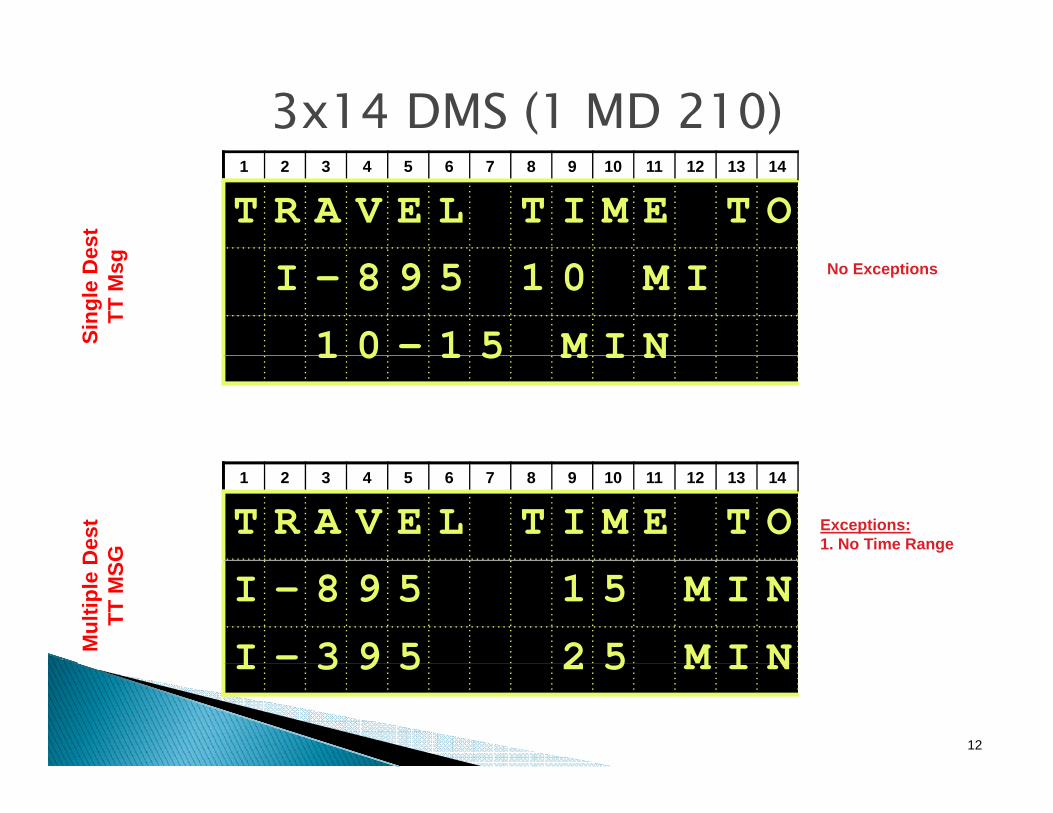
3x14 DMS (1 MD 210)1 2 3 4 5 6 7 8 9 10 11 12 13 14
T R A V E L T I M E T O
est
g
I - 8 9 5 1 0 M I
1 0 - 1 5 M I NSing
le D
eTT
Msg No Exceptions
1 0 1 5 M I N
1 2 3 4 5 6 7 8 9 10 11 12 13 14
T R A V E L T I M E T O
Des
t G
Exceptions:1. No Time Range
I - 8 9 5 1 5 M I N
I - 3 9 5 2 5 M I NMul
tiple
DTT
MSG
12
I 3 9 5 2 5 M I N

3x15 DMS (1-Future MdTA)1 2 3 4 5 6 7 8 9 10 11 12 13 14 15
T R A V E L T I M E T Ost
I - 8 9 5 1 0 M I
Sing
le D
esTT
Msg
No Exceptions
1 0 - 1 5 M I NS
1 2 3 4 5 6 7 8 9 10 11 12 13 14 15
T R A V E L T I M E T O
Des
t SG No Exceptions
I - 8 9 5 1 0 - 1 5 M I N
I - 3 9 5 2 0 - 2 5 M I NMul
tiple
TT
MS No Exceptions
13
I 3 9 5 2 0 2 5 M I N

3x16 DMS (2 @ BWI)1 2 3 4 5 6 7 8 9 10 11 12 13 14 15 16
T R A V E L T I M E T Ost
I - 8 9 5 1 0 M I
Sing
le D
esTT
Msg No Exceptions
1 0 - 1 5 M I N
S
1 2 3 4 5 6 7 8 9 10 11 12 13 14 15 16
T R A V E L T I M E T O
Des
t SG No Exceptions
I - 8 9 5 1 0 - 1 5 M I N
I - 3 9 5 2 0 - 2 5 M I NMul
tiple
TT
MS No Exceptions
14
I 3 9 5 2 0 2 5 M I N

3x17 DMS (4 Future MdTA)1 2 3 4 5 6 7 8 9 10 11 12 13 14 15 16 17
T R A V E L T I M E T O
st
I - 8 9 5 1 0 M I
1 0 1 5 M I NSing
le D
esTT
Msg
No Exceptions
1 0 - 1 5 M I N
1 2 3 4 5 6 7 8 9 10 11 12 13 14 15 16 171 2 3 4 5 6 7 8 9 10 11 12 13 14 15 16 17
T R A V E L T I M E T O
I 8 9 5 1 0 1 5 M I Ne D
est
MSG
No ExceptionsI - 8 9 5 1 0 - 1 5 M I N
I - 3 9 5 2 0 - 2 5 M I NMul
tipl
TT M No Exceptions
15

3x18 DMS (8 @ US 50/495/95)1 2 3 4 5 6 7 8 9 10 11 12 13 14 15 16 17 18
T R A V E L T I M E T O
st
I - 8 9 5 1 0 M I
1 0 1 5 M I NSing
le D
esTT
Msg No Exceptions
1 0 - 1 5 M I N
1 2 3 4 5 6 7 8 9 10 11 12 13 14 15 16 17 18
T R A V E L T I M E T O
I 8 9 5 1 0 1 5 M I Ne D
est
MSG
No ExceptionsI - 8 9 5 1 0 - 1 5 M I N
I - 3 9 5 2 0 - 2 5 M I NMul
tipl
TT M No Exceptions
16
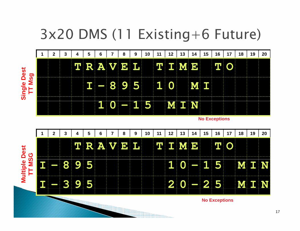
3x20 DMS (11 Existing+6 Future)1 2 3 4 5 6 7 8 9 10 11 12 13 14 15 16 17 18 19 20
T R A V E L T I M E T Ost
I - 8 9 5 1 0 M I
1 0 1 5
Sing
le D
esTT
Msg
1 0 - 1 5 M I NNo Exceptions
1 2 3 4 5 6 7 8 9 10 11 12 13 14 15 16 17 18 19 20
T R A V E L T I M E T O
Des
t SG I - 8 9 5 1 0 - 1 5 M I N
I - 3 9 5 2 0 - 2 5 M I NMul
tiple
TT
MS
17
No Exceptions

3x21 DMS (76 Existing + 70 Future)1 2 3 4 5 6 7 8 9 10 11 12 13 14 15 16 17 18 19 20 21
T R A V E L T I M E T O
est
g
I - 8 9 5 1 0 M I A H E A D
1 0 1 5 M I N
Sing
le D
eTT
Msg
1 0 - 1 5 M I NNo Exceptions
1 2 3 4 5 6 7 8 9 10 11 12 13 14 15 16 17 18 19 20 21
T R A V E L T I M E T OI - 8 9 5 1 0 - 1 5 M I N
18
No Exceptions

3x21 DMS (76 Existing + 70 Future)1 2 3 4 5 6 7 8 9 10 11 12 13 14 15 16 17 18 19 20 21
T R A V E L T I M E T O
Des
t G
I - 8 9 5 1 0 - 1 5 M I N
I 3 9 5 2 0 2 5 M I NMul
tiple
DTT
MSG
I - 3 9 5 2 0 - 2 5 M I NNo Exceptions
1 2 3 4 5 6 7 8 9 10 11 12 13 14 15 16 17 18 19 20 21
I - 8 9 5 1 0 - 1 5 M I N
TT
I - 6 9 5 1 3 - 1 8 M I N
I 3 9 5 2 0 2 5 M I N
3-D
est T
MSG
19
I - 3 9 5 2 0 - 2 5 M I NExceptions:1. No Heading

3x8 Portable DMS (63)1 2 3 4 5 6 7 8
T I M E T O
B A Y
B R I D G EB R I D G E
1 2 3 4 5 6 7 8
Exceptions:1. Requires a 2-Phase Message
4 5
M I N U T E SM I N U T E S
20
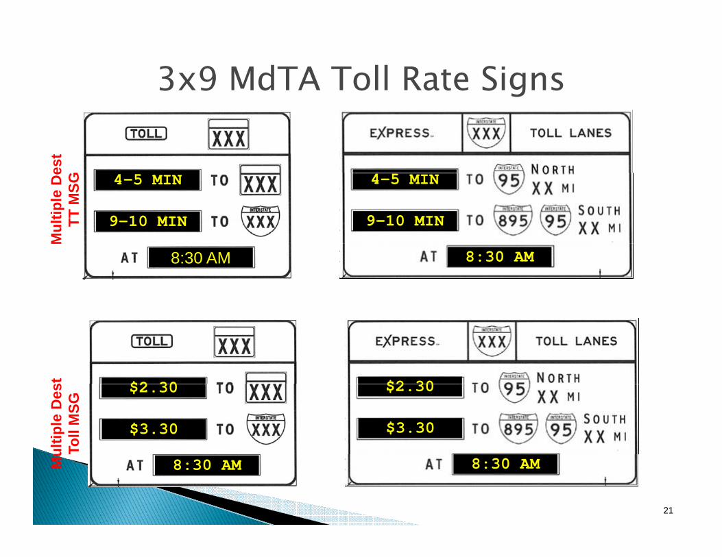
3x9 MdTA Toll Rate Signses
t G
Mul
tiple
De
TT M
SG 4-5 MIN
9-10 MIN
4-5 MIN
9-10 MIN
M
8:30 AM 8:30 AM
st
$2 30 $2 30
ultip
le D
esTo
ll M
SG
$2.30
$3.30
$2.30
$3.30
21
Mu
8:30 AM 8:30 AM

3x21 & 3x15 MdTA Branded Signs
To be treated the same as typical 3x21 & 3x15 signs
22
Procedural Guidelines for Implementing Travel Time on DMS in CHART
December 2008 F-1
APPENDIX F: CHART DMS FOR TRAVEL TIME DISPLAY AND CANDIDATE DESTINATIONS
Note: The following tables provide lists of Dynamic Message Signs (DMS's) available in the State of Maryland for displaying travel times, and recommended travel time destinations for each sign. These DMS - Destination pairings are subject to change as the travel time message program is implemented statewide.

# DEVICE LOCATION DESCRIPTION ROUTE DIRECTION DESTINATION 1* DISTANCE** TO DEST. 1 (MI) DESTINATION 2* DISTANCE** TO
DEST. 2 (MI)
1 N/A Radioshop US 40 @ I-695 N/A N/A N/A N/A N/A N/A2 1102 Eastbound US 50 East of Hall Road 50 EB NO INRIX COVERAGE NO INRIX COVERAGE3 1103 Westbound US 50 West of Friendship Road 50 WB NO INRIX COVERAGE NO INRIX COVERAGE4 1105 Eastbound US 50 East of MD 347 50 EB NO INRIX COVERAGE NO INRIX COVERAGE5 2204 Westbound US 50 East of Skipton Creek 50 WB NO INRIX COVERAGE NO INRIX COVERAGE6 2205 Eastbound US 50 West of Scottown Lane 50 EB NO INRIX COVERAGE NO INRIX COVERAGE7 2206 Eastbound US 50 West of Exit 40B 50 EB NO INRIX COVERAGE NO INRIX COVERAGE8 3301 I-495 (I/L) North of Exit 39, MD 190 495 I/L I-95 139 3302 I-270 (SB) prior to I-495 Split 270 SB NO INRIX COVERAGE NO INRIX COVERAGE
10 3303 I-270 (NB) prior to Exit 4, Montrose Road 270 NB NO INRIX COVERAGE NO INRIX COVERAGE11 3304 I-495 (O/L) West of Exit 33, MD 185 495 O/L LEG_BRG 812 3305 I-270 (SB) South of Exit 13, Middlebrook Road 270 SB NO INRIX COVERAGE NO INRIX COVERAGE13 3313 US 50 (EB) @ MD 950, Church Road 50 EB MD3 314 3314 US 50 (WB) prior to Exit 7, I-95/I-495 50 WB BW_PKWY 7 WW_BRG 1915 3315 US 50 (EB) prior to Exit 5, MD 410 50 EB MD3 916 3316 I-95/I-495 (O/L) @ Glenarden Parkway (prior to Exit 19, US 50) 95 O/L I-95 917 3317 I-95/I-495 (I/L) @ Good Luck Road (prior to Exit 20, MD 450) 95 I/L WW_BRG 2018 3318 I-95/I-495 (I/L) @ Old Auth Road (prior to Exit 7, MD 5) 95 I/L WW_BRG 719 3319 I-95 (SB) South of Exit 29, MD 212 95 SB LEG_BRG 17 WW_BRG 2720 3320 I-95 (SB) @ Brooklyn Bridge Road (prior to Exit 33, MD 198) 95 SB I-495 721 3321 I-95/I-495 (O/L) North of Exit 20, MD 450 95 O/L I-95 622 3322 I-495 (I/L) @ Northwest Branch Bridge (Prior to MD 650) 495 I/L BW_PKWY 723 3323 I-95/I-495 (I/L) North of MD 202 95 I/L WW_BRG 1624 3325 I-95/I-495 (O/L) North of Exit 23, MD 201 95 O/L I-270 1225 3326 I-95/I-495 (O/L) prior to Exit 15, MD 214 95 O/L I-95 1326 3327 I-95/I-495 (O/L) @ Temple Hill Road (North of Exit 4, MD 414) 95 O/L I-95 2127 3328 I-95/I-495 (I/L) South of Exit 4, MD 414 95 I/L WW_BRG 528 3331 MD 210 (NB) 0.5 mile prior to I-95/I-495 210 NB NO INRIX COVERAGE NO INRIX COVERAGE29 3332 MD 210 South, 1/4 Mile Prior to I-95 210 SB NO INRIX COVERAGE NO INRIX COVERAGE30 4401 I-695 (O/L) prior to Exit 12B, MD 372 (Wilkens Avenue) 695 O/L I-495 2431 4403 I-695 (O/L) @ Exit 10, Alt.US 1 (Washington Blvd.) 695 O/L I-97 332 4404 I-95 (NB) North of Exit 47, I-195 95 NB I-395 533 4405 I-695 (I/L) North of Exit 17, Security Blvd. 695 O/L I-795 3 I-83 1034 4406 I-95 (SB) North of Exit 50, Caton Avenue 95 SB I-195 3 I-495 2335 4407 I-695 (O/L) @ Windsor Mill Road (prior to Exit 17, Security Blvd.) 695 O/L I-95 736 4408 I-695 (I/L) @ Stevenson Road (East of Exit 21, Park Heights Avenue) 695 I/L I-95 1437 4409 I-695 (O/L) prior to Exit 28, Providence Road 695 O/L I-795 10 I-70 15
PRELIMINARY SHORT-LIST OF CANDIDATE DESTINATIONS FOR CHART AND MdTA DMS
Page 1 of 3
# DEVICE LOCATION DESCRIPTION ROUTE DIRECTION DESTINATION 1* DISTANCE** TO DEST. 1 (MI) DESTINATION 2* DISTANCE** TO
DEST. 2 (MI)
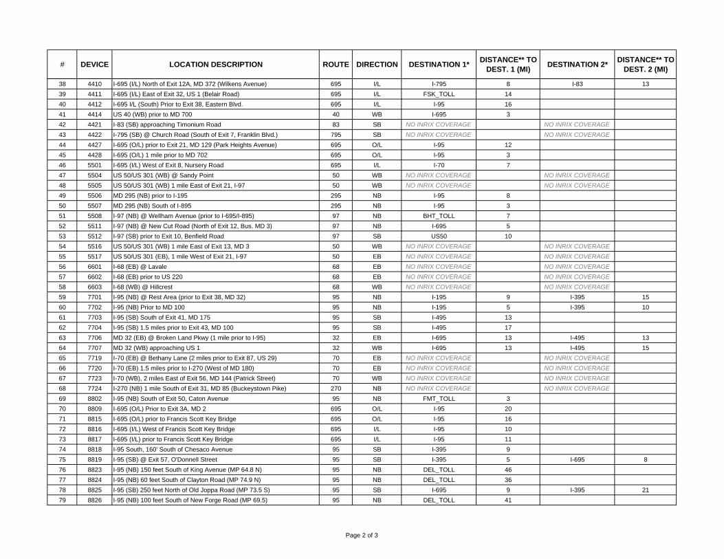
38 4410 I-695 (I/L) North of Exit 12A, MD 372 (Wilkens Avenue) 695 I/L I-795 8 I-83 1339 4411 I-695 (I/L) East of Exit 32, US 1 (Belair Road) 695 I/L FSK_TOLL 1440 4412 I-695 I/L (South) Prior to Exit 38, Eastern Blvd. 695 I/L I-95 1641 4414 US 40 (WB) prior to MD 700 40 WB I-695 342 4421 I-83 (SB) approaching Timonium Road 83 SB NO INRIX COVERAGE NO INRIX COVERAGE43 4422 I-795 (SB) @ Church Road (South of Exit 7, Franklin Blvd.) 795 SB NO INRIX COVERAGE NO INRIX COVERAGE44 4427 I-695 (O/L) prior to Exit 21, MD 129 (Park Heights Avenue) 695 O/L I-95 1245 4428 I-695 (O/L) 1 mile prior to MD 702 695 O/L I-95 346 5501 I-695 (I/L) West of Exit 8, Nursery Road 695 I/L I-70 747 5504 US 50/US 301 (WB) @ Sandy Point 50 WB NO INRIX COVERAGE NO INRIX COVERAGE48 5505 US 50/US 301 (WB) 1 mile East of Exit 21, I-97 50 WB NO INRIX COVERAGE NO INRIX COVERAGE49 5506 MD 295 (NB) prior to I-195 295 NB I-95 850 5507 MD 295 (NB) South of I-895 295 NB I-95 351 5508 I-97 (NB) @ Wellham Avenue (prior to I-695/I-895) 97 NB BHT_TOLL 752 5511 I-97 (NB) @ New Cut Road (North of Exit 12, Bus. MD 3) 97 NB I-695 553 5512 I-97 (SB) prior to Exit 10, Benfield Road 97 SB US50 1054 5516 US 50/US 301 (WB) 1 mile East of Exit 13, MD 3 50 WB NO INRIX COVERAGE NO INRIX COVERAGE55 5517 US 50/US 301 (EB), 1 mile West of Exit 21, I-97 50 EB NO INRIX COVERAGE NO INRIX COVERAGE56 6601 I-68 (EB) @ Lavale 68 EB NO INRIX COVERAGE NO INRIX COVERAGE57 6602 I-68 (EB) prior to US 220 68 EB NO INRIX COVERAGE NO INRIX COVERAGE58 6603 I-68 (WB) @ Hillcrest 68 WB NO INRIX COVERAGE NO INRIX COVERAGE59 7701 I-95 (NB) @ Rest Area (prior to Exit 38, MD 32) 95 NB I-195 9 I-395 1560 7702 I-95 (NB) Prior to MD 100 95 NB I-195 5 I-395 1061 7703 I-95 (SB) South of Exit 41, MD 175 95 SB I-495 1362 7704 I-95 (SB) 1.5 miles prior to Exit 43, MD 100 95 SB I-495 1763 7706 MD 32 (EB) @ Broken Land Pkwy (1 mile prior to I-95) 32 EB I-695 13 I-495 1364 7707 MD 32 (WB) approaching US 1 32 WB I-695 13 I-495 1565 7719 I-70 (EB) @ Bethany Lane (2 miles prior to Exit 87, US 29) 70 EB NO INRIX COVERAGE NO INRIX COVERAGE66 7720 I-70 (EB) 1.5 miles prior to I-270 (West of MD 180) 70 EB NO INRIX COVERAGE NO INRIX COVERAGE67 7723 I-70 (WB), 2 miles East of Exit 56, MD 144 (Patrick Street) 70 WB NO INRIX COVERAGE NO INRIX COVERAGE68 7724 I-270 (NB) 1 mile South of Exit 31, MD 85 (Buckeystown Pike) 270 NB NO INRIX COVERAGE NO INRIX COVERAGE69 8802 I-95 (NB) South of Exit 50, Caton Avenue 95 NB FMT_TOLL 370 8809 I-695 (O/L) Prior to Exit 3A, MD 2 695 O/L I-95 2071 8815 I-695 (O/L) prior to Francis Scott Key Bridge 695 O/L I-95 1672 8816 I-695 (I/L) West of Francis Scott Key Bridge 695 I/L I-95 1073 8817 I-695 (I/L) prior to Francis Scott Key Bridge 695 I/L I-95 1174 8818 I-95 South, 160' South of Chesaco Avenue 95 SB I-395 975 8819 I-95 (SB) @ Exit 57, O'Donnell Street 95 SB I-395 5 I-695 876 8823 I-95 (NB) 150 feet South of King Avenue (MP 64.8 N) 95 NB DEL_TOLL 4677 8824 I-95 (NB) 60 feet South of Clayton Road (MP 74.9 N) 95 NB DEL_TOLL 3678 8825 I-95 (SB) 250 feet North of Old Joppa Road (MP 73.5 S) 95 SB I-695 9 I-395 2179 8826 I-95 (NB) 100 feet South of New Forge Road (MP 69.5) 95 NB DEL_TOLL 41
Page 2 of 3
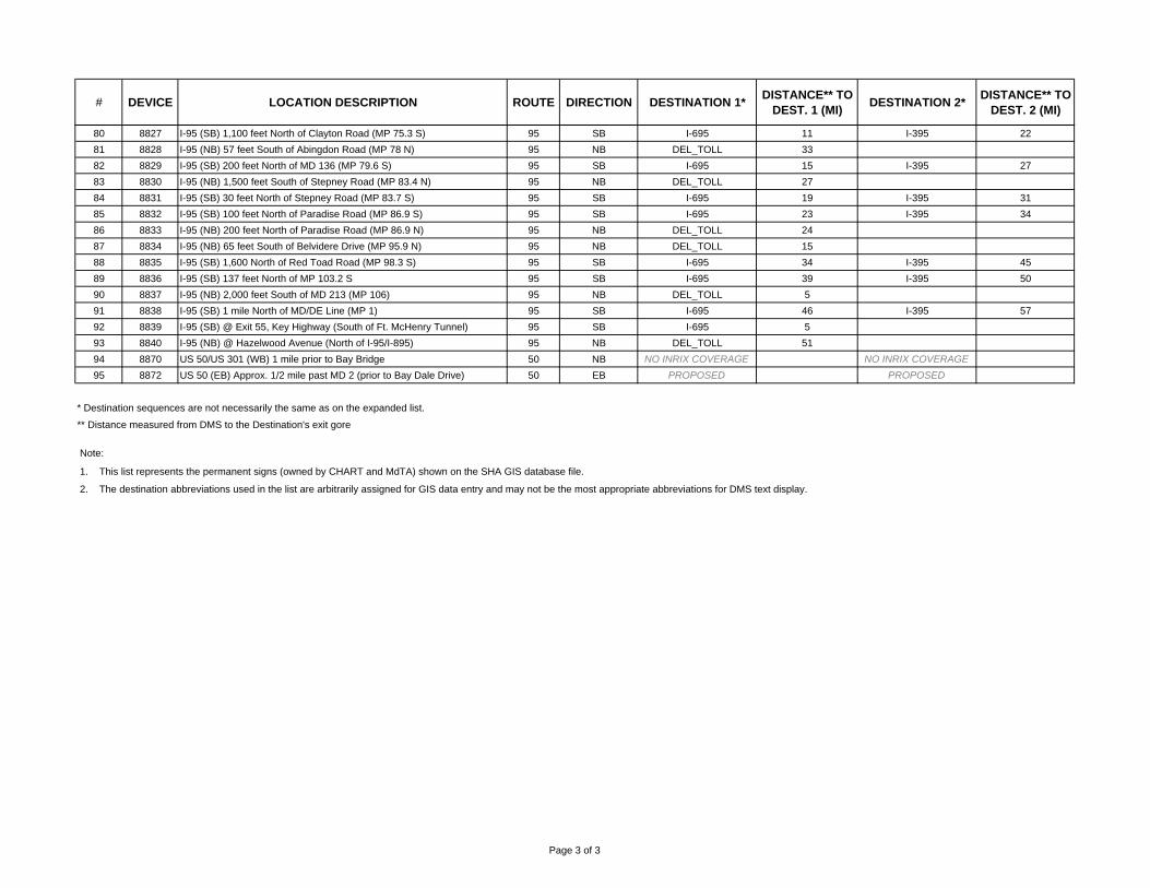
# DEVICE LOCATION DESCRIPTION ROUTE DIRECTION DESTINATION 1* DISTANCE** TO DEST. 1 (MI) DESTINATION 2* DISTANCE** TO
DEST. 2 (MI)
80 8827 I-95 (SB) 1,100 feet North of Clayton Road (MP 75.3 S) 95 SB I-695 11 I-395 2281 8828 I-95 (NB) 57 feet South of Abingdon Road (MP 78 N) 95 NB DEL_TOLL 3382 8829 I-95 (SB) 200 feet North of MD 136 (MP 79.6 S) 95 SB I-695 15 I-395 2783 8830 I-95 (NB) 1,500 feet South of Stepney Road (MP 83.4 N) 95 NB DEL_TOLL 2784 8831 I-95 (SB) 30 feet North of Stepney Road (MP 83.7 S) 95 SB I-695 19 I-395 3185 8832 I-95 (SB) 100 feet North of Paradise Road (MP 86.9 S) 95 SB I-695 23 I-395 3486 8833 I-95 (NB) 200 feet North of Paradise Road (MP 86.9 N) 95 NB DEL_TOLL 2487 8834 I-95 (NB) 65 feet South of Belvidere Drive (MP 95.9 N) 95 NB DEL_TOLL 1588 8835 I-95 (SB) 1,600 North of Red Toad Road (MP 98.3 S) 95 SB I-695 34 I-395 4589 8836 I-95 (SB) 137 feet North of MP 103.2 S 95 SB I-695 39 I-395 5090 8837 I-95 (NB) 2,000 feet South of MD 213 (MP 106) 95 NB DEL_TOLL 591 8838 I-95 (SB) 1 mile North of MD/DE Line (MP 1) 95 SB I-695 46 I-395 5792 8839 I-95 (SB) @ Exit 55, Key Highway (South of Ft. McHenry Tunnel) 95 SB I-695 593 8840 I-95 (NB) @ Hazelwood Avenue (North of I-95/I-895) 95 NB DEL_TOLL 5194 8870 US 50/US 301 (WB) 1 mile prior to Bay Bridge 50 NB NO INRIX COVERAGE NO INRIX COVERAGE95 8872 US 50 (EB) Approx. 1/2 mile past MD 2 (prior to Bay Dale Drive) 50 EB PROPOSED PROPOSED
* Destination sequences are not necessarily the same as on the expanded list.
** Distance measured from DMS to the Destination's exit gore
Note:
1. This list represents the permanent signs (owned by CHART and MdTA) shown on the SHA GIS database file.
2. The destination abbreviations used in the list are arbitrarily assigned for GIS data entry and may not be the most appropriate abbreviations for DMS text display.
Page 3 of 3

# DEVICE LOCATION DESCRIPTION ROUTE DIRECTION DESTINATION 1 DESTINATION 2 DESTINATION 3 DESTINATION 4 DESTINATION 4+ SPECIAL EVENT DEST.1 N/A Radioshop US 40 @ I-695 N/A N/A N/A N/A N/A N/A N/A N/A2 1102 Eastbound US 50 East of Hall Road 50 EB NO INRIX COVERAGE NO INRIX COVERAGE NO INRIX COVERAGE NO INRIX COVERAGE NO INRIX COVERAGE NO INRIX COVERAGE3 1103 Westbound US 50 West of Friendship Road 50 WB NO INRIX COVERAGE NO INRIX COVERAGE NO INRIX COVERAGE NO INRIX COVERAGE NO INRIX COVERAGE NO INRIX COVERAGE4 1105 Eastbound US 50 East of MD 347 50 EB NO INRIX COVERAGE NO INRIX COVERAGE NO INRIX COVERAGE NO INRIX COVERAGE NO INRIX COVERAGE NO INRIX COVERAGE5 2204 Westbound US 50 East of Skipton Creek 50 WB NO INRIX COVERAGE NO INRIX COVERAGE NO INRIX COVERAGE NO INRIX COVERAGE NO INRIX COVERAGE NO INRIX COVERAGE6 2205 Eastbound US 50 West of Scottown Lane 50 EB NO INRIX COVERAGE NO INRIX COVERAGE NO INRIX COVERAGE NO INRIX COVERAGE NO INRIX COVERAGE NO INRIX COVERAGE7 2206 Eastbound US 50 West of Exit 40B 50 EB NO INRIX COVERAGE NO INRIX COVERAGE NO INRIX COVERAGE NO INRIX COVERAGE NO INRIX COVERAGE NO INRIX COVERAGE8 3301 I-495 (I/L) North of Exit 39, MD 190 495 I/L I-270 I-95 US29 - - -9 3302 I-270 (SB) prior to I-495 Split 270 SB NO INRIX COVERAGE NO INRIX COVERAGE NO INRIX COVERAGE NO INRIX COVERAGE NO INRIX COVERAGE NO INRIX COVERAGE10 3303 I-270 (NB) prior to Exit 4, Montrose Road 270 NB NO INRIX COVERAGE NO INRIX COVERAGE NO INRIX COVERAGE NO INRIX COVERAGE NO INRIX COVERAGE NO INRIX COVERAGE11 3304 I-495 (O/L) West of Exit 33, MD 185 495 O/L I-270 LEG_BRG MD190 - - -12 3305 I-270 (SB) South of Exit 13, Middlebrook Road 270 SB NO INRIX COVERAGE NO INRIX COVERAGE NO INRIX COVERAGE NO INRIX COVERAGE NO INRIX COVERAGE NO INRIX COVERAGE13 3313 US 50 (EB) @ MD 950, Church Road 50 EB MD3 BAY_BRG* - - - -14 3314 US 50 (WB) prior to Exit 7, I-95/I-495 50 WB BW_PKWY WW_BRG - - - -15 3315 US 50 (EB) prior to Exit 5, MD 410 50 EB I-495** BAY_BRG* MD3 - - -16 3316 I-95/I-495 (O/L) @ Glenarden Parkway (prior to Exit 19, US 50) 95 O/L BW_PKWY I-95 - - - -17 3317 I-95/I-495 (I/L) @ Good Luck Road (prior to Exit 20, MD 450) 95 I/L MD4 BAY_BRG* WW_BRG - - FEDEX_FLD18 3318 I-95/I-495 (I/L) @ Old Auth Road (prior to Exit 7, MD 5) 95 I/L WW_BRG - - - - -19 3319 I-95 (SB) South of Exit 29, MD 212 95 SB I-270 WW_BRG LEG_BRG - - -20 3320 I-95 (SB) @ Brooklyn Bridge Road (prior to Exit 33, MD 198) 95 SB I-495 US50 I-270 - - -21 3321 I-95/I-495 (O/L) North of Exit 20, MD 450 95 O/L BW_PKWY I-95 I-270 - - -22 3322 I-495 (I/L) @ Northwest Branch Bridge (Prior to MD 650) 495 I/L I-695 US50 BW_PKWY - - -23 3323 I-95/I-495 (I/L) North of MD 202 95 I/L MD4 WW_BRG - - - -24 3325 I-95/I-495 (O/L) North of Exit 23, MD 201 95 O/L I-270 US29 - - -25 3326 I-95/I-495 (O/L) prior to Exit 15, MD 214 95 O/L US50 I-95 BW_PKWY - - FEDEX_FLD26 3327 I-95/I-495 (O/L) @ Temple Hill Road (North of Exit 4, MD 414) 95 O/L MD4 BW_PKWY US50 I-95 - FEDEX_FLD27 3328 I-95/I-495 (I/L) South of Exit 4, MD 414 95 I/L WW_BRG - - - - -28 3331 MD 210 (NB) 0.5 mile prior to I-95/I-495 210 NB NO INRIX COVERAGE NO INRIX COVERAGE NO INRIX COVERAGE NO INRIX COVERAGE NO INRIX COVERAGE NO INRIX COVERAGE29 3332 MD 210 South, 1/4 Mile Prior to I-95 210 SB NO INRIX COVERAGE NO INRIX COVERAGE NO INRIX COVERAGE NO INRIX COVERAGE NO INRIX COVERAGE NO INRIX COVERAGE30 4401 I-695 (O/L) prior to Exit 12B, MD 372 (Wilkens Avenue) 695 O/L I-495 BHT_TOLL MD295 - - -31 4403 I-695 (O/L) @ Exit 10, Alt.US 1 (Washington Blvd.) 695 O/L MD295** I-97 - - - -32 4404 I-95 (NB) North of Exit 47, I-195 95 NB I-695 I-395 FMT_TOLL US40 - ALT 1: HBR/M&T/CMDYDS33 4405 I-695 (I/L) North of Exit 17, Security Blvd. 695 I/L I-795 MD146 I-83 - - -34 4406 I-95 (SB) North of Exit 50, Caton Avenue 95 SB I-695 I-195 MD100 MD32 I-495 -35 4407 I-695 (O/L) @ Windsor Mill Road (prior to Exit 17, Security Blvd.) 695 O/L I-70 I-95 US40 - - -36 4408 I-695 (I/L) @ Stevenson Road (East of Exit 21, Park Heights Avenue) 695 I/L I-83 MD146 I-95 - - -37 4409 I-695 (O/L) prior to Exit 28, Providence Road 695 O/L I-83 I-70 I-795 I-695 - -38 4410 I-695 (I/L) North of Exit 12A, MD 372 (Wilkens Avenue) 695 I/L I-70 MD146 I-795 - - -39 4411 I-695 (I/L) East of Exit 32, US 1 (Belair Road) 695 I/L FSK_TOLL I-95** US40 - -40 4412 I-695 I/L (South) Prior to Exit 38, Eastern Blvd. 695 I/L FSK_TOLL I-97 MD295 I-95 - -41 4414 US 40 (WB) prior to MD 700 40 WB I-695 FSK_TOLL - - -42 4421 I-83 (SB) approaching Timonium Road 83 SB NO INRIX COVERAGE NO INRIX COVERAGE NO INRIX COVERAGE NO INRIX COVERAGE NO INRIX COVERAGE NO INRIX COVERAGE43 4422 I-795 (SB) @ Church Road (South of Exit 7, Franklin Blvd.) 795 SB NO INRIX COVERAGE NO INRIX COVERAGE NO INRIX COVERAGE NO INRIX COVERAGE NO INRIX COVERAGE NO INRIX COVERAGE44 4427 I-695 (O/L) prior to Exit 21, MD 129 (Park Heights Avenue) 695 O/L I-795 I-95 I-70 - - -45 4428 I-695 (O/L) 1 mile prior to MD 702 695 O/L US40 I-95 I-83 - - -46 5501 I-695 (I/L) West of Exit 8, Nursery Road 695 I/L I-95** I-70 I-795 I-83 - -47 5504 US 50/US 301 (WB) @ Sandy Point 50 WB NO INRIX COVERAGE NO INRIX COVERAGE NO INRIX COVERAGE NO INRIX COVERAGE NO INRIX COVERAGE NO INRIX COVERAGE48 5505 US 50/US 301 (WB) 1 mile East of Exit 21, I-97 50 WB NO INRIX COVERAGE NO INRIX COVERAGE NO INRIX COVERAGE NO INRIX COVERAGE NO INRIX COVERAGE NO INRIX COVERAGE49 5506 MD 295 (NB) prior to I-195 295 NB I-695 I-895 I-95 - - ALT 1: HBR/M&T/CMDYDS50 5507 MD 295 (NB) South of I-895 295 NB I-95 - - ALT 1: HBR/M&T/CMDYDS51 5508 I-97 (NB) @ Wellham Avenue (prior to I-695/I-895) 97 NB BHT_TOLL MD295 FSK_TOLL I-95 - ALT 1: HBR/M&T/CMDYDS52 5511 I-97 (NB) @ New Cut Road (North of Exit 12, Bus. MD 3) 97 NB I-695 FSK_TOLL BHT_TOLL - - -53 5512 I-97 (SB) prior to Exit 10, Benfield Road 97 SB MD32** US 50 - - - -54 5516 US 50/US 301 (WB) 1 mile East of Exit 13, MD 3 50 WB NO INRIX COVERAGE NO INRIX COVERAGE NO INRIX COVERAGE NO INRIX COVERAGE NO INRIX COVERAGE NO INRIX COVERAGE55 5517 US 50/US 301 (EB), 1 mile West of Exit 21, I-97 50 EB NO INRIX COVERAGE NO INRIX COVERAGE NO INRIX COVERAGE NO INRIX COVERAGE NO INRIX COVERAGE NO INRIX COVERAGE56 6601 I-68 (EB) @ Lavale 68 EB NO INRIX COVERAGE NO INRIX COVERAGE NO INRIX COVERAGE NO INRIX COVERAGE NO INRIX COVERAGE NO INRIX COVERAGE57 6602 I-68 (EB) prior to US 220 68 EB NO INRIX COVERAGE NO INRIX COVERAGE NO INRIX COVERAGE NO INRIX COVERAGE NO INRIX COVERAGE NO INRIX COVERAGE58 6603 I-68 (WB) @ Hillcrest 68 WB NO INRIX COVERAGE NO INRIX COVERAGE NO INRIX COVERAGE NO INRIX COVERAGE NO INRIX COVERAGE NO INRIX COVERAGE59 7701 I-95 (NB) @ Rest Area (prior to Exit 38, MD 32) 95 NB I-195 I-395 I-695 BHT_TOLL FMT_TOLL ALT 1: HBR/M&T/CMDYDS60 7702 I-95 (NB) Prior to MD 100 95 NB I-195 I-395 I-695 I-895 BHT_TOLL ALT 1: HBR/M&T/CMDYDS61 7703 I-95 (SB) South of Exit 41, MD 175 95 SB MD32 MD198 I-495 - - -62 7704 I-95 (SB) 1.5 miles prior to Exit 43, MD 100 95 SB MD100 I-270 MD29 I-495 I-295 VIA I-95 -63 7706 MD 32 (EB) @ Broken Land Pkwy (1 mile prior to I-95) 32 EB I-195 I-695 I-495 - - -64 7707 MD 32 (WB) approaching US 1 32 WB I-95 MD29 I-195 I-695 I-70 ALT 1: HBR/M&T/CMDYDS65 7719 I-70 (EB) @ Bethany Lane (2 miles prior to Exit 87, US 29) 70 EB NO INRIX COVERAGE NO INRIX COVERAGE NO INRIX COVERAGE NO INRIX COVERAGE NO INRIX COVERAGE NO INRIX COVERAGE66 7720 I-70 (EB) 1.5 miles prior to I-270 (West of MD 180) 70 EB NO INRIX COVERAGE NO INRIX COVERAGE NO INRIX COVERAGE NO INRIX COVERAGE NO INRIX COVERAGE NO INRIX COVERAGE67 7723 I-70 (WB), 2 miles East of Exit 56, MD 144 (Patrick Street) 70 WB NO INRIX COVERAGE NO INRIX COVERAGE NO INRIX COVERAGE NO INRIX COVERAGE NO INRIX COVERAGE NO INRIX COVERAGE68 7724 I-270 (NB) 1 mile South of Exit 31, MD 85 (Buckeystown Pike) 270 NB NO INRIX COVERAGE NO INRIX COVERAGE NO INRIX COVERAGE NO INRIX COVERAGE NO INRIX COVERAGE NO INRIX COVERAGE69 8802 I-95 (NB) South of Exit 50, Caton Avenue 95 NB FMT_TOLL US40 I-695 I-95 - ALT 1: HBR/M&T/CMDYDS70 8809 I-695 (O/L) Prior to Exit 3A, MD 2 695 O/L FSK_TOLL US40 I-95 - - -71 8815 I-695 (O/L) prior to Francis Scott Key Bridge 695 O/L FSK_TOLL I-95 - - - -72 8816 I-695 (I/L) West of Francis Scott Key Bridge 695 I/L I-97 MD295 I-95 - ALT 1: HBR/M&T/CMDYDS
EXPANDED LIST OF CANDIDATE DESTINATIONS FOR CHART AND MdTA DMS
Page 1 of 2

# DEVICE LOCATION DESCRIPTION ROUTE DIRECTION DESTINATION 1 DESTINATION 2 DESTINATION 3 DESTINATION 4 DESTINATION 4+ SPECIAL EVENT DEST.73 8817 I-695 (I/L) prior to Francis Scott Key Bridge 695 I/L I-97 MD295 I-95 - ALT 1: HBR/M&T/CMDYDS74 8818 I-95 South, 160' South of Chesaco Avenue 95 SB FMT_TOLL BHT_TOLL I-395 - - ALT 1: HBR/M&T/CMDYDS75 8819 I-95 (SB) @ Exit 57, O'Donnell Street 95 SB I-395 I-695 MD295 I-195 - ALT 1: HBR/M&T/CMDYDS76 8823 I-95 (NB) 150 feet South of King Avenue (MP 64.8 N) 95 NB MD43 MD24 JFK_TOLL MD279 DELL_TOLL -77 8824 I-95 (NB) 60 feet South of Clayton Road (MP 74.9 N) 95 NB MD24 JFK_TOLL MD213 MD279 DEL_TOLL -78 8825 I-95 (SB) 250 feet North of Old Joppa Road (MP 73.5 S) 95 SB MD43 I-695 I-895 FMT_TOLL BHT_TOLL, I-395 ALT 1: HBR/M&T/CMDYDS79 8826 I-95 (NB) 100 feet South of New Forge Road (MP 69.5) 95 NB MD24 JFK_TOLL MD213 MD279 DEL_TOLL -80 8827 I-95 (SB) 1,100 feet North of Clayton Road (MP 75.3 S) 95 SB MD43 I-695 I-895 FSK_TOLL BHT_TOLL, I-395 ALT 1: HBR/M&T/CMDYDS81 8828 I-95 (NB) 57 feet South of Abingdon Road (MP 78 N) 95 NB JFK_TOLL MD213 MD279 DEL_TOLL - -82 8829 I-95 (SB) 200 feet North of MD 136 (MP 79.6 S) 95 SB MD24 MD43 I-695 I-895 BHT_TOLL, I-395 ALT 1: HBR/M&T/CMDYDS83 8830 I-95 (NB) 1,500 feet South of Stepney Road (MP 83.4 N) 95 NB JFK_TOLL MD213 MD279 DEL_TOLL - -84 8831 I-95 (SB) 30 feet North of Stepney Road (MP 83.7 S) 95 SB MD24 MD152 MD43 I-695 I-895, I-395 ALT 1: HBR/M&T/CMDYDS85 8832 I-95 (SB) 100 feet North of Paradise Road (MP 86.9 S) 95 SB MD24 MD152 MD43 I-695 I-895, I-395 ALT 1: HBR/M&T/CMDYDS86 8833 I-95 (NB) 200 feet North of Paradise Road (MP 86.9 N) 95 NB JFK_TOLL MD213 MD279 DEL_TOLL - -87 8834 I-95 (NB) 65 feet South of Belvidere Drive (MP 95.9 N) 95 NB MD213 MD279 DEL_TOLL - - -88 8835 I-95 (SB) 1,600 North of Red Toad Road (MP 98.3 S) 95 SB MD279 MD213 JFK_TOLL MD24 MD43, I-695, I-395 ALT 1: HBR/M&T/CMDYDS89 8836 I-95 (SB) 137 feet North of MP 103.2 S 95 SB MD279 MD213 JFK_TOLL MD24 MD43, I-695, I-395 ALT 1: HBR/M&T/CMDYDS90 8837 I-95 (NB) 2,000 feet South of MD 213 (MP 106) 95 NB MD279 DEL_TOLL - - - -91 8838 I-95 (SB) 1 mile North of MD/DE Line (MP 1) 95 SB MD279 MD213 JFK_TOLL MD24 MD43, I-695, I-395 ALT 1: HBR/M&T/CMDYDS92 8839 I-95 (SB) @ Exit 55, Key Highway (South of Ft. McHenry Tunnel) 95 SB I-395** I-695 MD295 I-195 - -93 8840 I-95 (NB) @ Hazelwood Avenue (North of I-95/I-895) 95 NB MD43 DEL_TOLL - - - -94 8870 US 50/US 301 (WB) 1 mile prior to Bay Bridge 50 NB NO INRIX COVERAGE NO INRIX COVERAGE NO INRIX COVERAGE NO INRIX COVERAGE NO INRIX COVERAGE NO INRIX COVERAGE95 8872 US 50 (EB) Approx. 1/2 mile past MD 2 (prior to Bay Dale Drive) 50 EB PROPOSED PROPOSED PROPOSED PROPOSED PROPOSED PROPOSED
* Future destination - Currently not covered by INRIX** Possible destination, but too close
Note: 1. This list represents the permanent signs (owned by CHART and MdTA) shown on the SHA GIS database file. The destinations identified have been inserted as an attribute to the GIS, so that when the destinations are revised, SHA may modify the record on the GIS. 2. The destination abbreviations used in the list are arbitrarily assigned for GIS data entry and may not be the most appropriate abbreviations for DMS text display. 3. The destinations identified in the table represent apparently all viable locations for a specific DMS. Appropriate destinations should be selected as needed for travel time display.
Page 2 of 2


![SMART COLUMBUS CASE STUDY · FIGURE 7: Full geographic extent of the INRIX travel data set for Columbus in 2016 Source: NREL [1] Figures 7 and 8 show INRIX data. These GPS data compilations](https://img.pdfslide.us/doc/110x75/5ec706703272a62ad0587454/smart-columbus-case-study-figure-7-full-geographic-extent-of-the-inrix-travel-data.jpg)