Embed Size (px)
Citation preview

Appendix A Figures
1JMJMSCALE: : NTS’
PROJ NO
CLIENT
CHK BY
DR BY
DES BY
FILE
PROJ
REVISION NOFIGURE
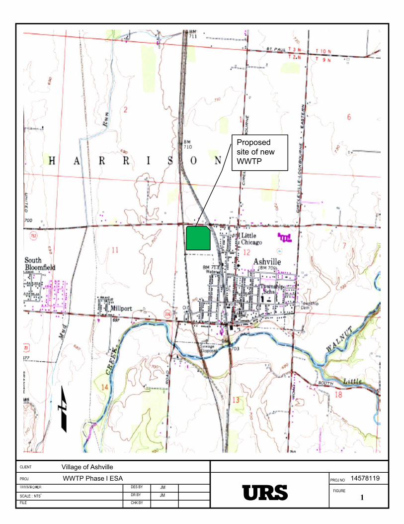
Proposedsite of new WWTP
Village of Ashville
WWTP Phase I ESA 14578119
2JMJMSCALE: : NTS’
PROJ NO
CLIENT
CHK BY
DR BY
DES BY
FILE
PROJ
REVISION NOFIGURE
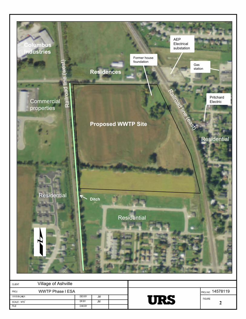
AEPElectricalsubstation
PritchardElectric
Former house foundation
Gas station
Proposed WWTP Site
ColumbusIndustries
Commercialproperties
Residential
Residential
Residential
Village of Ashville
WWTP Phase I ESA 14578119
Residences
Ditch
Asheville, Ohio
Sep 11, 2013
This map is for general reference only. The US Fish and Wildlife Service is notresponsible for the accuracy or currentness of the base data shown on this map. Allwetlands related data should be used in accordance with the layer metadata found onthe Wetlands Mapper web site.
User Remarks:

Appendix B Photographic Log
PHOTOGRAPHIC LOG
Client Name:
Village of Ashville, Ohio
Site Location:
New Waste Water Treatment Plant
Project No:
14578119
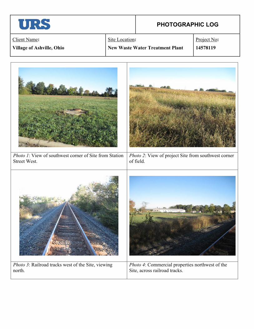
Photo 1: View of southwest corner of Site from Station Street West.
Photo 2: View of project Site from southwest corner of field.
Photo 3: Railroad tracks west of the Site, viewing north.
Photo 4: Commercial properties northwest of the Site, across railroad tracks.
PHOTOGRAPHIC LOG
Client Name:
Village of Ashville, Ohio
Site Location:
New Waste Water Treatment Plant
Project No:
14578119
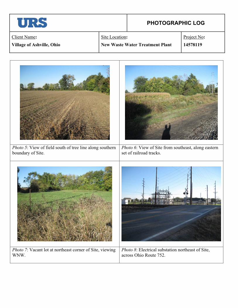
Photo 5: View of field south of tree line along southern boundary of Site.
Photo 6: View of Site from southeast, along eastern set of railroad tracks.
Photo 7: Vacant lot at northeast corner of Site, viewing WNW.
Photo 8: Electrical substation northeast of Site, across Ohio Route 752.
PHOTOGRAPHIC LOG
Client Name:
Village of Ashville, Ohio
Site Location:
New Waste Water Treatment Plant
Project No:
14578119
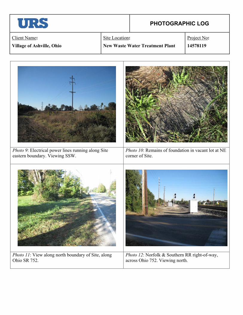
Photo 9: Electrical power lines running along Site eastern boundary. Viewing SSW.
Photo 10: Remains of foundation in vacant lot at NE corner of Site.
Photo 11: View along north boundary of Site, along Ohio SR 752.
Photo 12: Norfolk & Southern RR right-of-way, across Ohio 752. Viewing north.
PHOTOGRAPHIC LOG
Client Name:
Village of Ashville, Ohio
Site Location:
New Waste Water Treatment Plant
Project No:
14578119
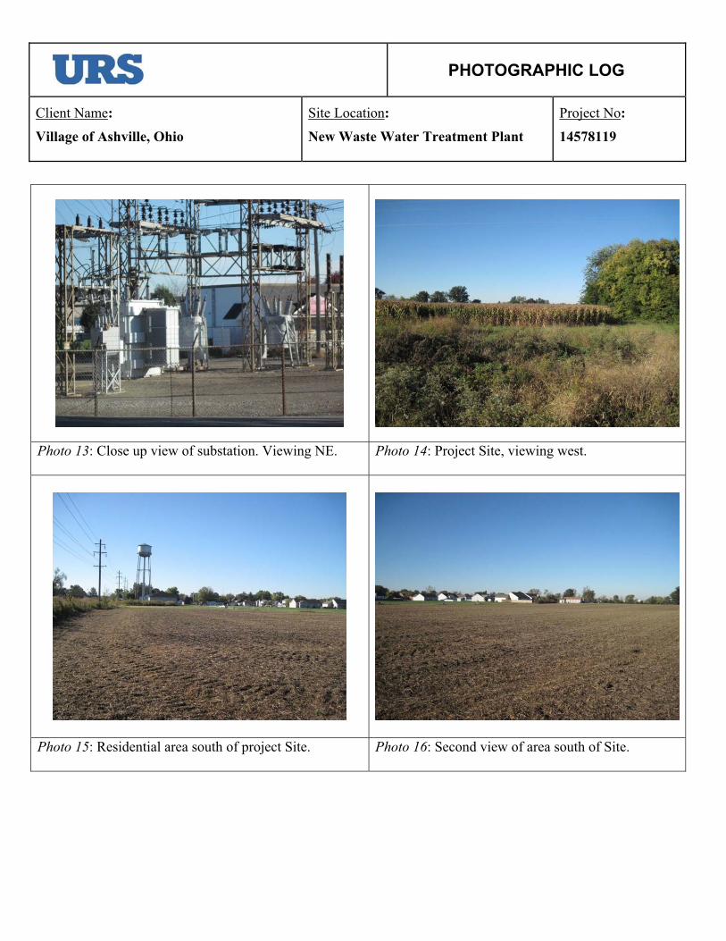
Photo 13: Close up view of substation. Viewing NE. Photo 14: Project Site, viewing west.
Photo 15: Residential area south of project Site. Photo 16: Second view of area south of Site.
PHOTOGRAPHIC LOG
Client Name:
Village of Ashville, Ohio
Site Location:
New Waste Water Treatment Plant
Project No:
14578119
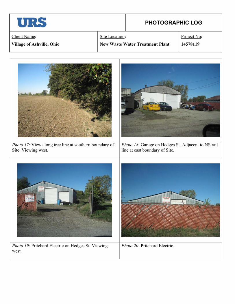
Photo 17: View along tree line at southern boundary of Site. Viewing west.
Photo 18: Garage on Hedges St. Adjacent to NS rail line at east boundary of Site.
Photo 19: Pritchard Electric on Hedges St. Viewing west.
Photo 20: Pritchard Electric.
Appendix C EDR Radius Map™ Report with GeoCheck®
FORM-NULL-PVC
tropeRpaMsuidaRyrammuSRDE
440 Wheelers Farms RoadMilford, CT 06461Toll Free: 800.352.0050www.edrnet.com
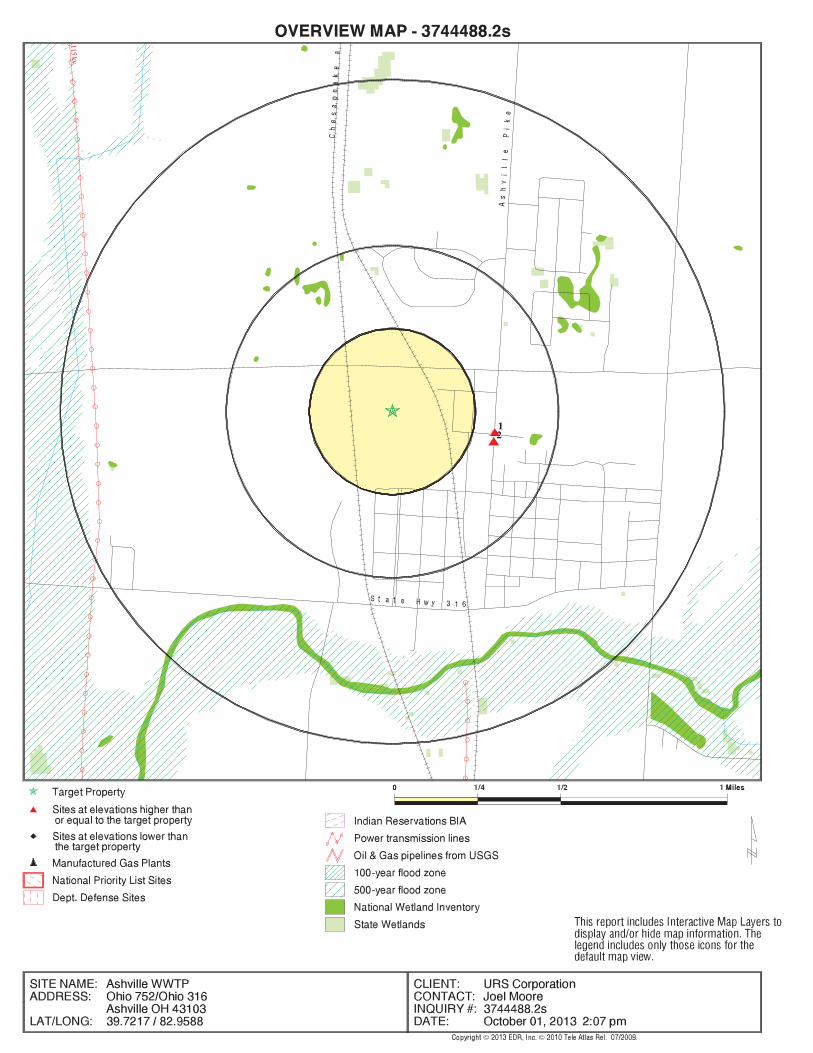
Ashville WWTPOhio 752/Ohio 316Ashville, OH 43103
Inquiry Number: 3744488.2sOctober 01, 2013
SECTION PAGE
Executive Summary ES1
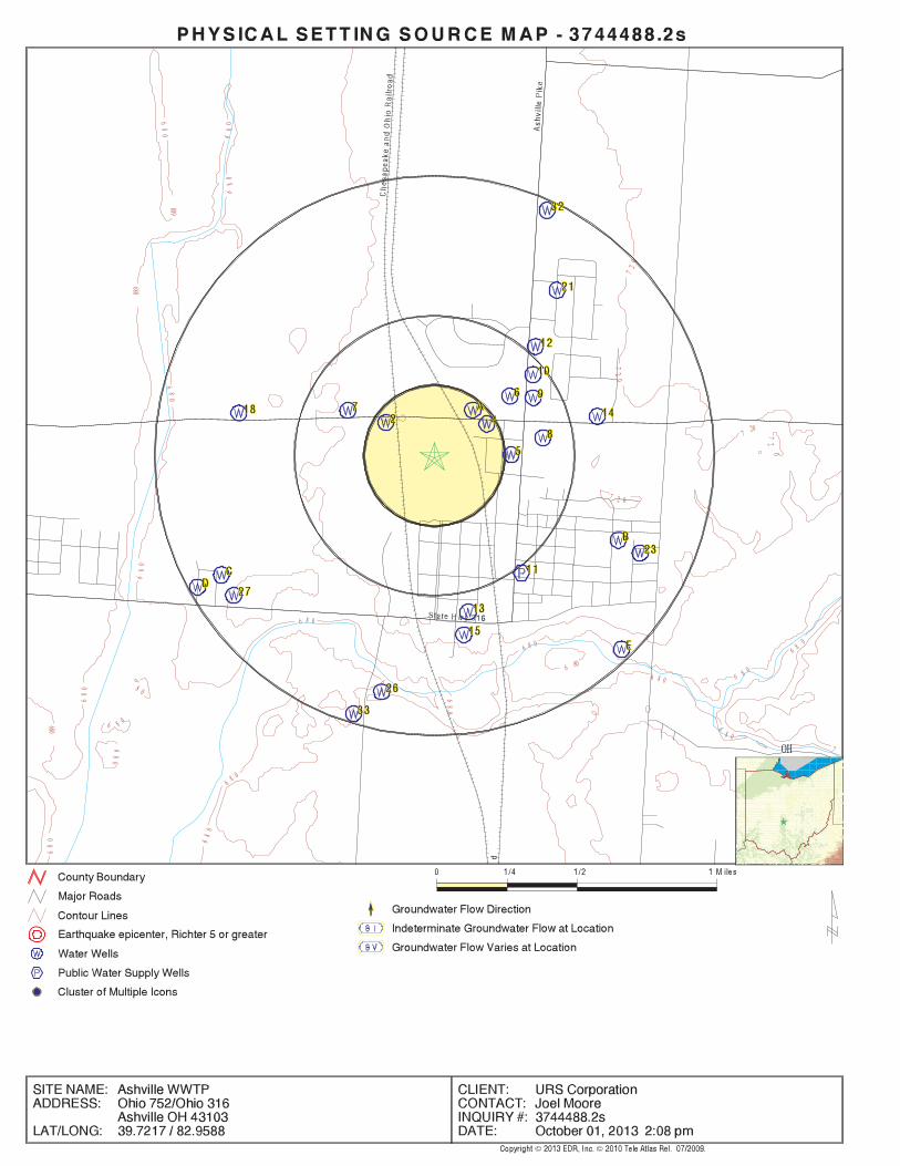
Overview Map 2
Detail Map 3
Map Findings Summary 4
Map Findings 8
Orphan Summary 17
Government Records Searched/Data Currency Tracking GR-1
GEOCHECK ADDENDUM
Physical Setting Source Addendum A-1
Physical Setting Source Summary A-2
Physical Setting SSURGO Soil Map A-5
Physical Setting Source Map A-10
Physical Setting Source Map Findings A-12
Physical Setting Source Records Searched A-55
TC3744488.2s Page 1
Thank you for your business.Please contact EDR at 1-800-352-0050
with any questions or comments.
Disclaimer - Copyright and Trademark NoticeThis Report contains certain information obtained from a variety of public and other sources reasonably available to Environmental DataResources, Inc. It cannot be concluded from this Report that coverage information for the target and surrounding properties does not exist fromother sources. NO WARRANTY EXPRESSED OR IMPLIED, IS MADE WHATSOEVER IN CONNECTION WITH THIS REPORT. ENVIRONMENTALDATA RESOURCES, INC. SPECIFICALLY DISCLAIMS THE MAKING OF ANY SUCH WARRANTIES, INCLUDING WITHOUT LIMITATION,MERCHANTABILITY OR FITNESS FOR A PARTICULAR USE OR PURPOSE. ALL RISK IS ASSUMED BY THE USER. IN NO EVENT SHALLENVIRONMENTAL DATA RESOURCES, INC. BE LIABLE TO ANYONE, WHETHER ARISING OUT OF ERRORS OR OMISSIONS, NEGLIGENCE,ACCIDENT OR ANY OTHER CAUSE, FOR ANY LOSS OF DAMAGE, INCLUDING, WITHOUT LIMITATION, SPECIAL, INCIDENTAL,CONSEQUENTIAL, OR EXEMPLARY DAMAGES. ANY LIABILITY ON THE PART OF ENVIRONMENTAL DATA RESOURCES, INC. IS STRICTLYLIMITED TO A REFUND OF THE AMOUNT PAID FOR THIS REPORT. Purchaser accepts this Report "AS IS". Any analyses, estimates, ratings,environmental risk levels or risk codes provided in this Report are provided for illustrative purposes only, and are not intended to provide, norshould they be interpreted as providing any facts regarding, or prediction or forecast of, any environmental risk for any property. Only a Phase IEnvironmental Site Assessment performed by an environmental professional can provide information regarding the environmental risk for anyproperty. Additionally, the information provided in this Report is not to be construed as legal advice.
Copyright 2013 by Environmental Data Resources, Inc. All rights reserved. Reproduction in any media or format, in wholeor in part, of any report or map of Environmental Data Resources, Inc., or its affiliates, is prohibited without prior written permission.EDR and its logos (including Sanborn and Sanborn Map) are trademarks of Environmental Data Resources, Inc. or its affiliates. All othertrademarks used herein are the property of their respective owners.
TABLE OF CONTENTS
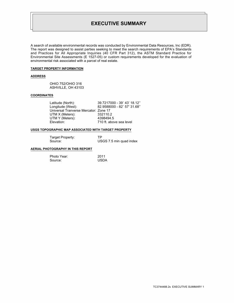
EXECUTIVE SUMMARY
TC3744488.2s EXECUTIVE SUMMARY 1
A search of available environmental records was conducted by Environmental Data Resources, Inc (EDR).The report was designed to assist parties seeking to meet the search requirements of EPA’s Standardsand Practices for All Appropriate Inquiries (40 CFR Part 312), the ASTM Standard Practice forEnvironmental Site Assessments (E 1527-05) or custom requirements developed for the evaluation ofenvironmental risk associated with a parcel of real estate.
TARGET PROPERTY INFORMATION
ADDRESS
OHIO 752/OHIO 316ASHVILLE, OH 43103
COORDINATES
39.7217000 - 39˚ 43’ 18.12’’Latitude (North): 82.9588000 - 82˚ 57’ 31.68’’Longitude (West): Zone 17Universal Tranverse Mercator: 332110.2UTM X (Meters): 4398494.5UTM Y (Meters): 710 ft. above sea levelElevation:
USGS TOPOGRAPHIC MAP ASSOCIATED WITH TARGET PROPERTY
TPTarget Property:USGS 7.5 min quad indexSource:
AERIAL PHOTOGRAPHY IN THIS REPORT
2011Photo Year:USDASource:
3744488.2s Page 2
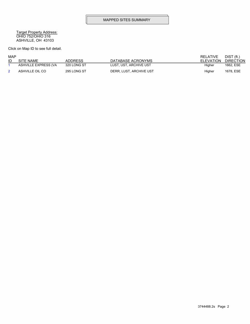
2 ASHVILLE OIL CO 295 LONG ST DERR, LUST, ARCHIVE UST Higher 1678, ESE
1 ASHVILLE EXPRESS (VA 320 LONG ST LUST, UST, ARCHIVE UST Higher 1662, ESE
MAPPED SITES SUMMARY
Target Property Address:OHIO 752/OHIO 316ASHVILLE, OH 43103
Click on Map ID to see full detail.
MAP RELATIVE DIST (ft.)ID DATABASE ACRONYMS ELEVATION DIRECTIONSITE NAME ADDRESS
EXECUTIVE SUMMARY
TC3744488.2s EXECUTIVE SUMMARY 3
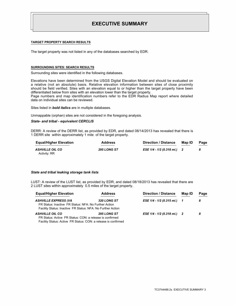
TARGET PROPERTY SEARCH RESULTS
The target property was not listed in any of the databases searched by EDR.
SURROUNDING SITES: SEARCH RESULTS
Surrounding sites were identified in the following databases.
Elevations have been determined from the USGS Digital Elevation Model and should be evaluated ona relative (not an absolute) basis. Relative elevation information between sites of close proximityshould be field verified. Sites with an elevation equal to or higher than the target property have beendifferentiated below from sites with an elevation lower than the target property.Page numbers and map identification numbers refer to the EDR Radius Map report where detaileddata on individual sites can be reviewed.
Sites listed in bold italics are in multiple databases.
Unmappable (orphan) sites are not considered in the foregoing analysis.
State- and tribal - equivalent CERCLIS
DERR: A review of the DERR list, as provided by EDR, and dated 08/14/2013 has revealed that there is1 DERR site within approximately 1 mile of the target property.
PageMap IDDirection / Distance Address Equal/Higher Elevation ____________________ ________ ___________________ _____ _____
ASHVILLE OIL CO 295 LONG ST ESE 1/4 - 1/2 (0.318 mi.) 2 8Activity: RR
State and tribal leaking storage tank lists
LUST: A review of the LUST list, as provided by EDR, and dated 08/18/2013 has revealed that there are2 LUST sites within approximately 0.5 miles of the target property.
PageMap IDDirection / Distance Address Equal/Higher Elevation ____________________ ________ ___________________ _____ _____
ASHVILLE EXPRESS (VA 320 LONG ST ESE 1/4 - 1/2 (0.315 mi.) 1 8FR Status: Inactive FR Status: NFA: No Further ActionFacility Status: Inactive FR Status: NFA: No Further Action
ASHVILLE OIL CO 295 LONG ST ESE 1/4 - 1/2 (0.318 mi.) 2 8FR Status: Active FR Status: CON: a release is confirmedFacility Status: Active FR Status: CON: a release is confirmed
EDR
Inc.ED
R Inc.
EDR
Inc.ED
R Inc.
EDR
Inc.ED
R Inc.
EDR
Inc.ED
R Inc.
EDR
Inc.ED
R Inc.
EDR
Inc.ED
R Inc.
EDR
Inc.ED
R Inc.
EDR
Inc.ED
R Inc.
EDR
Inc.ED
R Inc.
EDR
Inc.ED
R Inc.
EDR
Inc.ED
R Inc.
EDR
Inc.ED
R Inc.
EDR
Inc.ED
R Inc.
EDR
Inc.ED
R Inc.
EDR
Inc.ED
R Inc.
EDR
Inc.ED
R Inc.
EDR
Inc.ED
R Inc.
EDR
Inc.ED
R Inc.
EDR
Inc.ED
R Inc.
EDR
Inc.ED
R Inc.
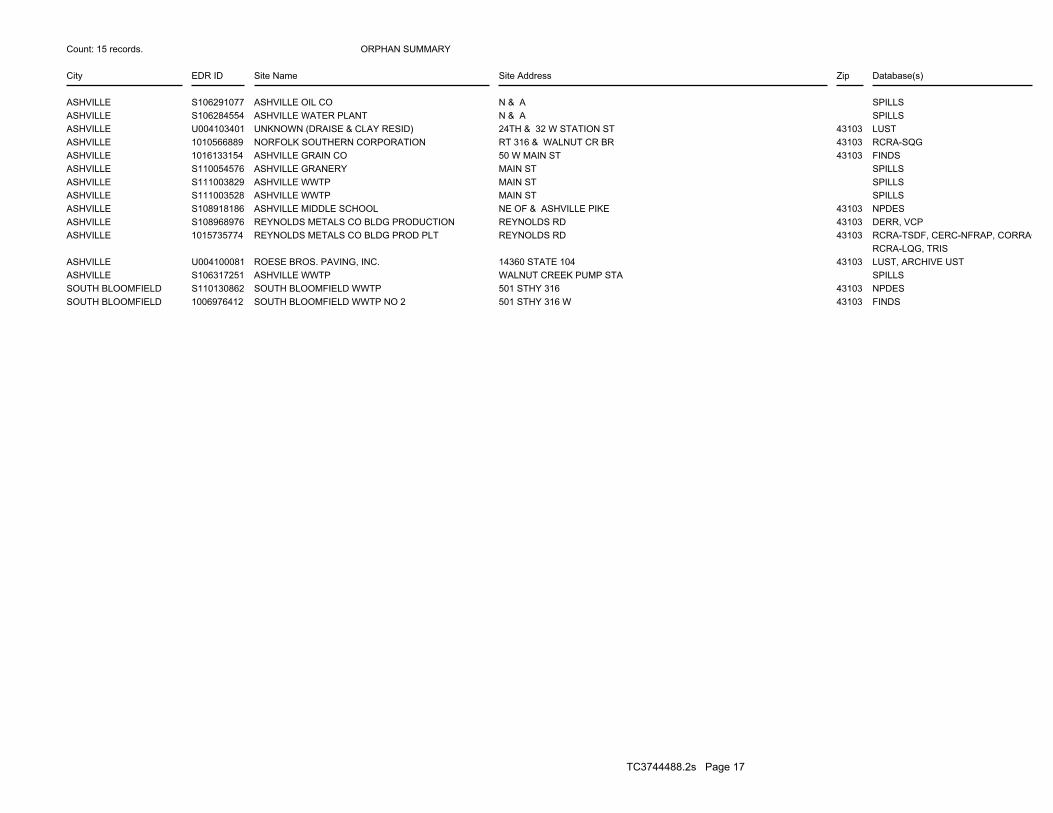
ORPHAN SUMMARY
City EDR ID Site Name Site Address Zip Database(s)
Count: 15 records.
ASHVILLE S106291077 ASHVILLE OIL CO N & A SPILLSASHVILLE S106284554 ASHVILLE WATER PLANT N & A SPILLSASHVILLE U004103401 UNKNOWN (DRAISE & CLAY RESID) 24TH & 32 W STATION ST 43103 LUSTASHVILLE 1010566889 NORFOLK SOUTHERN CORPORATION RT 316 & WALNUT CR BR 43103 RCRA-SQGASHVILLE 1016133154 ASHVILLE GRAIN CO 50 W MAIN ST 43103 FINDSASHVILLE S110054576 ASHVILLE GRANERY MAIN ST SPILLSASHVILLE S111003829 ASHVILLE WWTP MAIN ST SPILLSASHVILLE S111003528 ASHVILLE WWTP MAIN ST SPILLSASHVILLE S108918186 ASHVILLE MIDDLE SCHOOL NE OF & ASHVILLE PIKE 43103 NPDESASHVILLE S108968976 REYNOLDS METALS CO BLDG PRODUCTION REYNOLDS RD 43103 DERR, VCPASHVILLE 1015735774 REYNOLDS METALS CO BLDG PROD PLT REYNOLDS RD 43103 RCRA-TSDF, CERC-NFRAP, CORRAC
RCRA-LQG, TRISASHVILLE U004100081 ROESE BROS. PAVING, INC. 14360 STATE 104 43103 LUST, ARCHIVE USTASHVILLE S106317251 ASHVILLE WWTP WALNUT CREEK PUMP STA SPILLSSOUTH BLOOMFIELD S110130862 SOUTH BLOOMFIELD WWTP 501 STHY 316 43103 NPDESSOUTH BLOOMFIELD 1006976412 SOUTH BLOOMFIELD WWTP NO 2 501 STHY 316 W 43103 FINDS
TC3744488.2s Page 17
EDR Inc.EDR Inc.EDR Inc.EDR Inc.EDR Inc.EDR Inc.EDR Inc.EDR Inc.EDR Inc.EDR Inc.EDR Inc.EDR Inc.EDR Inc.EDR Inc.EDR Inc.EDR Inc.EDR Inc.EDR Inc.EDR Inc.EDR Inc.EDR Inc.EDR Inc.EDR Inc.EDR Inc.EDR Inc.EDR Inc.EDR Inc.EDR Inc.EDR Inc.EDR Inc.EDR Inc.EDR Inc.EDR Inc.EDR Inc.EDR Inc.EDR Inc.EDR Inc.EDR Inc.EDR Inc.EDR Inc.
115 kv
EDR Inc.EDR Inc.EDR Inc.EDR Inc.EDR Inc.EDR Inc.EDR Inc.EDR Inc.EDR Inc.EDR Inc.EDR Inc.EDR Inc.EDR Inc.EDR Inc.EDR Inc.EDR Inc.EDR Inc.EDR Inc.EDR Inc.EDR Inc.EDR Inc.EDR Inc.EDR Inc.EDR Inc.EDR Inc.EDR Inc.EDR Inc.EDR Inc.EDR Inc.EDR Inc.EDR Inc.EDR Inc.EDR Inc.EDR Inc.EDR Inc.EDR Inc.EDR Inc.EDR Inc.EDR Inc.EDR Inc.
EDR Inc.EDR Inc.EDR Inc.EDR Inc.EDR Inc.EDR Inc.EDR Inc.EDR Inc.EDR Inc.EDR Inc.EDR Inc.EDR Inc.EDR Inc.EDR Inc.EDR Inc.EDR Inc.EDR Inc.EDR Inc.EDR Inc.EDR Inc.EDR Inc.EDR Inc.EDR Inc.EDR Inc.EDR Inc.EDR Inc.EDR Inc.EDR Inc.EDR Inc.EDR Inc.EDR Inc.EDR Inc.EDR Inc.EDR Inc.EDR Inc.EDR Inc.EDR Inc.EDR Inc.EDR Inc.EDR Inc.
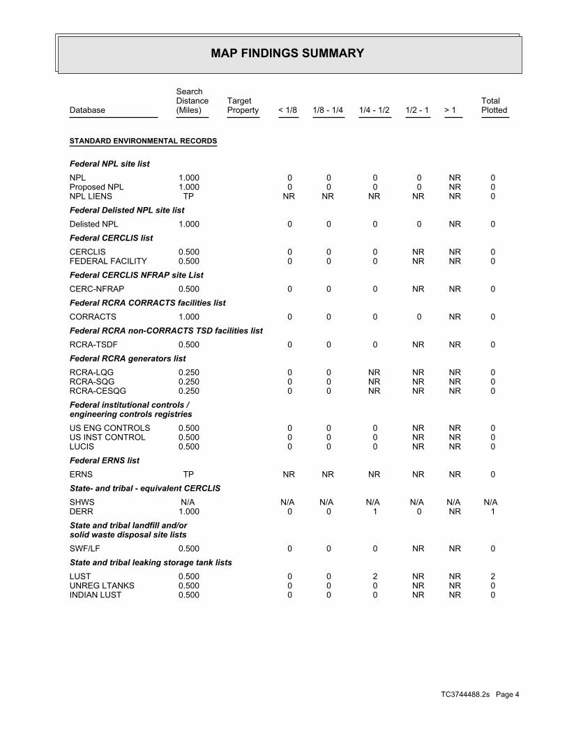
MAP FINDINGS SUMMARY
SearchTargetDistance Total
Database Property(Miles) < 1/8 1/8 - 1/4 1/4 - 1/2 1/2 - 1 > 1 Plotted
STANDARD ENVIRONMENTAL RECORDS
Federal NPL site list 0 NR 0 0 0 0 1.000NPL 0 NR 0 0 0 0 1.000Proposed NPL 0 NR NR NR NR NR TPNPL LIENS
Federal Delisted NPL site list 0 NR 0 0 0 0 1.000Delisted NPL
Federal CERCLIS list 0 NR NR 0 0 0 0.500CERCLIS 0 NR NR 0 0 0 0.500FEDERAL FACILITY
Federal CERCLIS NFRAP site List 0 NR NR 0 0 0 0.500CERC-NFRAP
Federal RCRA CORRACTS facilities list 0 NR 0 0 0 0 1.000CORRACTS
Federal RCRA non-CORRACTS TSD facilities list 0 NR NR 0 0 0 0.500RCRA-TSDF
Federal RCRA generators list 0 NR NR NR 0 0 0.250RCRA-LQG 0 NR NR NR 0 0 0.250RCRA-SQG 0 NR NR NR 0 0 0.250RCRA-CESQG
Federal institutional controls /engineering controls registries
0 NR NR 0 0 0 0.500US ENG CONTROLS 0 NR NR 0 0 0 0.500US INST CONTROL 0 NR NR 0 0 0 0.500LUCIS
Federal ERNS list 0 NR NR NR NR NR TPERNS
State- and tribal - equivalent CERCLIS N/A N/A N/A N/A N/A N/A N/ASHWS 1 NR 0 1 0 0 1.000DERR
State and tribal landfill and/orsolid waste disposal site lists
0 NR NR 0 0 0 0.500SWF/LF
State and tribal leaking storage tank lists 2 NR NR 2 0 0 0.500LUST 0 NR NR 0 0 0 0.500UNREG LTANKS 0 NR NR 0 0 0 0.500INDIAN LUST
TC3744488.2s Page 4
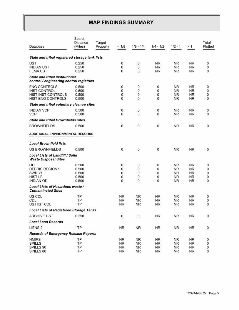
MAP FINDINGS SUMMARY
SearchTargetDistance Total
Database Property(Miles) < 1/8 1/8 - 1/4 1/4 - 1/2 1/2 - 1 > 1 Plotted
State and tribal registered storage tank lists 0 NR NR NR 0 0 0.250UST 0 NR NR NR 0 0 0.250INDIAN UST 0 NR NR NR 0 0 0.250FEMA UST
State and tribal institutionalcontrol / engineering control registries
0 NR NR 0 0 0 0.500ENG CONTROLS 0 NR NR 0 0 0 0.500INST CONTROL 0 NR NR 0 0 0 0.500HIST INST CONTROLS 0 NR NR 0 0 0 0.500HIST ENG CONTROLS
State and tribal voluntary cleanup sites 0 NR NR 0 0 0 0.500INDIAN VCP 0 NR NR 0 0 0 0.500VCP
State and tribal Brownfields sites 0 NR NR 0 0 0 0.500BROWNFIELDS
ADDITIONAL ENVIRONMENTAL RECORDS
Local Brownfield lists 0 NR NR 0 0 0 0.500US BROWNFIELDS
Local Lists of Landfill / SolidWaste Disposal Sites
0 NR NR 0 0 0 0.500ODI 0 NR NR 0 0 0 0.500DEBRIS REGION 9 0 NR NR 0 0 0 0.500SWRCY 0 NR NR 0 0 0 0.500HIST LF 0 NR NR 0 0 0 0.500INDIAN ODI
Local Lists of Hazardous waste /Contaminated Sites
0 NR NR NR NR NR TPUS CDL 0 NR NR NR NR NR TPCDL 0 NR NR NR NR NR TPUS HIST CDL
Local Lists of Registered Storage Tanks 0 NR NR NR 0 0 0.250ARCHIVE UST
Local Land Records 0 NR NR NR NR NR TPLIENS 2
Records of Emergency Release Reports 0 NR NR NR NR NR TPHMIRS 0 NR NR NR NR NR TPSPILLS 0 NR NR NR NR NR TPSPILLS 90 0 NR NR NR NR NR TPSPILLS 80
TC3744488.2s Page 5
MAP FINDINGS SUMMARY
SearchTargetDistance Total
Database Property(Miles) < 1/8 1/8 - 1/4 1/4 - 1/2 1/2 - 1 > 1 Plotted
Other Ascertainable Records 0 NR NR NR 0 0 0.250RCRA NonGen / NLR 0 NR NR NR NR NR TPDOT OPS 0 NR 0 0 0 0 1.000DOD 0 NR 0 0 0 0 1.000FUDS 0 NR 0 0 0 0 1.000CONSENT 0 NR 0 0 0 0 1.000ROD 0 NR NR 0 0 0 0.500UMTRA 0 NR NR NR 0 0 0.250US MINES 0 NR NR NR NR NR TPTRIS 0 NR NR NR NR NR TPTSCA 0 NR NR NR NR NR TPFTTS 0 NR NR NR NR NR TPHIST FTTS 0 NR NR NR NR NR TPSSTS 0 NR NR NR NR NR TPICIS 0 NR NR NR NR NR TPPADS 0 NR NR NR NR NR TPMLTS 0 NR NR NR NR NR TPRADINFO 0 NR NR NR NR NR TPFINDS 0 NR NR NR NR NR TPRAATS 0 NR NR NR NR NR TPRMP 0 NR 0 0 0 0 1.000TOWNGAS 0 NR NR NR NR NR TPUIC 0 NR NR NR 0 0 0.250DRYCLEANERS 0 NR NR NR NR NR TPNPDES 0 NR NR NR NR NR TPAIRS 0 NR NR 0 0 0 0.500USD 0 NR NR 0 0 0 0.500HIST USD 0 NR 0 0 0 0 1.000INDIAN RESERV 0 NR NR 0 0 0 0.500SCRD DRYCLEANERS 0 NR NR NR NR NR TPPRP 0 NR NR NR NR NR TPPCB TRANSFORMER 0 NR NR NR 0 0 0.2502020 COR ACTION 0 NR NR NR NR NR TPEPA WATCH LIST 0 NR NR NR NR NR TPUS FIN ASSUR 0 NR NR NR NR NR TPUS AIRS 0 NR NR 0 0 0 0.500COAL ASH 0 NR NR NR NR NR TPCRO 0 NR NR NR NR NR TPCOAL ASH DOE 0 NR NR 0 0 0 0.500COAL ASH EPA 0 NR NR NR NR NR TPFinancial Assurance 0 NR NR NR NR NR TPLEAD SMELTERS
EDR HIGH RISK HISTORICAL RECORDS
EDR Exclusive Records 0 NR 0 0 0 0 1.000EDR MGP 0 NR NR NR 0 0 0.250EDR US Hist Auto Stat 0 NR NR NR 0 0 0.250EDR US Hist Cleaners
TC3744488.2s Page 6
MAP FINDINGS SUMMARY
SearchTargetDistance Total
Database Property(Miles) < 1/8 1/8 - 1/4 1/4 - 1/2 1/2 - 1 > 1 Plotted
NOTES:
TP = Target Property
NR = Not Requested at this Search Distance
Sites may be listed in more than one database
N/A = This State does not maintain a SHWS list. See the Federal CERCLIS list.
TC3744488.2s Page 7
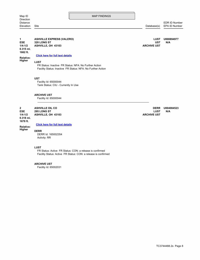
TC3744488.2s Page 8
2 DERRASHVILLE OIL CO U004084523ESE LUST295 LONG ST N/A1/4-1/2 ARCHIVE USTASHVILLE, OH 43103
Relative:Higher
Click here for full text details
0.318 mi.1678 ft.
DERR DERR Id: 165002354 Activity: RR
LUST FR Status: Active FR Status: CON: a release is confirmed Facility Status: Active FR Status: CON: a release is confirmed
ARCHIVE UST Facility Id: 65002031
1 LUSTASHVILLE EXPRESS (VALERO) U000894977ESE UST320 LONG ST N/A1/4-1/2 ARCHIVE USTASHVILLE, OH 43103
Relative:Higher
Click here for full text details
0.315 mi.1662 ft.
LUST FR Status: Inactive FR Status: NFA: No Further Action Facility Status: Inactive FR Status: NFA: No Further Action
UST Facility Id: 65000044 Tank Status: CIU - Currently In Use
ARCHIVE UST Facility Id: 65000044
MAP FINDINGSMap IDDirection
EDR ID NumberDistanceEPA ID NumberDatabase(s)SiteElevation
EDR
Inc.ED
R Inc.
EDR
Inc.ED
R Inc.
EDR
Inc.ED
R Inc.
EDR
Inc.ED
R Inc.
EDR
Inc.ED
R Inc.
EDR
Inc.ED
R Inc.
EDR
Inc.ED
R Inc.
EDR
Inc.ED
R Inc.
EDR
Inc.ED
R Inc.
EDR
Inc.ED
R Inc.
EDR
Inc.ED
R Inc.
EDR
Inc.ED
R Inc.
EDR
Inc.ED
R Inc.
EDR
Inc.ED
R Inc.
EDR
Inc.ED
R Inc.
EDR
Inc.ED
R Inc.
EDR
Inc.ED
R Inc.
EDR
Inc.ED
R Inc.
EDR
Inc.ED
R Inc.
EDR
Inc.ED
R Inc.
EDR
Inc.ED
R Inc.
EDR
Inc.ED
R Inc.
EDR
Inc.ED
R Inc.
EDR
Inc.ED
R Inc.
EDR
Inc.ED
R Inc.
EDR
Inc.ED
R Inc.
EDR
Inc.ED
R Inc.
EDR
Inc.ED
R Inc.
EDR
Inc.ED
R Inc.
EDR
Inc.ED
R Inc.
EDR
Inc.ED
R Inc.
EDR
Inc.ED
R Inc.
EDR
Inc.ED
R Inc.
EDR
Inc.ED
R Inc.
EDR
Inc.ED
R Inc.
EDR
Inc.ED
R Inc.
EDR
Inc.ED
R Inc.
EDR
Inc.ED
R Inc.
EDR
Inc.ED
R Inc.
EDR
Inc.ED
R Inc.
OH AIRS Title V Permits Listing Ohio EPA 06/28/2013 06/28/2013 08/15/2013OH ARCHIVE UST Archived Underground Storage Tank Sites Department of Commerce, Division of State Fir 08/18/2013 08/20/2013 09/23/2013OH BROWNFIELDS Ohio Brownfield Inventory Ohio EPA 06/17/2013 06/20/2013 08/14/2013OH CDL Clandestine Drug Lab Locations Ohio EPA 08/21/2013 08/23/2013 09/23/2013OH COAL ASH Coal Ash Disposal Site Listing Ohio EPA 02/07/2012 02/17/2012 03/28/2012OH CRO Cessation of Regulated Operations Facility Listing Ohio EPA 03/28/2013 05/17/2013 06/17/2013OH DERR Division of Emergency & Remedial Response’s Database Ohio EPA 08/14/2013 08/16/2013 09/23/2013OH DRYCLEANERS Drycleaner Facility Listing Ohio EPA 07/03/2013 07/05/2013 08/14/2013OH ENG CONTROLS Sites with Engineering Controls Ohio EPA 08/14/2013 08/16/2013 09/23/2013OH Financial Assurance Financial Assurance Information Listing Ohio EPA 07/15/2013 07/17/2013 08/14/2013OH HIST ENG CONTROLS Operation & Maintenance Agreements Database Ohio EPA 05/10/2005 04/04/2006 05/04/2006OH HIST INST CONTROLS Institutional Controls Database Ohio EPA 05/10/2005 04/06/2006 05/04/2006OH HIST LF Old Solid Waste Landfill Ohio EPA 01/01/1980 07/01/2003 07/17/2003OH HIST USD Urban Setting Designations Database Ohio EPA 05/10/2005 04/25/2006 05/11/2006OH INST CONTROL Sites with Institutional Engineering Controls Ohio Environmental Protection Agency 08/14/2013 08/16/2013 09/23/2013OH LUST Leaking Underground Storage Tank File Department of Commerce 08/18/2013 08/20/2013 09/23/2013OH NPDES NPDES General Permit List Ohio EPA 08/12/2013 08/15/2013 09/23/2013OH SHWS This state does not maintain a SHWS list. See the Federal CE Ohio EPAOH SPILLS Emergency Response Database Ohio EPA 08/21/2013 08/23/2013 09/23/2013OH SPILLS 80 SPILLS80 data from FirstSearch FirstSearch 04/24/2004 01/03/2013 03/01/2013OH SPILLS 90 SPILLS90 data from FirstSearch FirstSearch 09/13/2012 01/03/2013 02/27/2013OH SWF/LF Licensed Solid Waste Facilities Ohio Environmental Protection Agency 07/22/2013 07/24/2013 09/23/2013OH SWRCY Recycling Facility Listing Ohio EPA 01/14/2013 01/15/2013 03/19/2013OH TOWNGAS DERR Towngas Database Ohio EPA 07/28/1992 02/21/2003 03/05/2003OH UIC Underground Injection Wells Listing Ohio EPA 07/08/2013 08/15/2013 09/23/2013OH UNREG LTANKS Ohio Leaking UST File Department of Commerce 08/25/1999 08/19/2003 08/26/2003OH USD Urban Setting Designation Sites Ohio EPA 08/14/2013 08/16/2013 09/23/2013OH UST Underground Storage Tank Tank File Department of Commerce 08/18/2013 08/20/2013 09/20/2013OH VCP Voluntary Action Program Sites Ohio EPA, Voluntary Action Program 08/14/2013 08/16/2013 09/23/2013US 2020 COR ACTION 2020 Corrective Action Program List Environmental Protection Agency 11/11/2011 05/18/2012 05/25/2012US BRS Biennial Reporting System EPA/NTIS 12/31/2011 02/26/2013 04/19/2013US CERCLIS Comprehensive Environmental Response, Compensation, and Liab EPA 04/26/2013 05/29/2013 08/09/2013US CERCLIS-NFRAP CERCLIS No Further Remedial Action Planned EPA 04/26/2013 05/29/2013 08/09/2013US COAL ASH DOE Sleam-Electric Plan Operation Data Department of Energy 12/31/2005 08/07/2009 10/22/2009US COAL ASH EPA Coal Combustion Residues Surface Impoundments List Environmental Protection Agency 08/17/2010 01/03/2011 03/21/2011US CONSENT Superfund (CERCLA) Consent Decrees Department of Justice, Consent Decree Library 12/31/2011 01/15/2013 03/13/2013US CORRACTS Corrective Action Report EPA 07/11/2013 08/08/2013 09/13/2013US DEBRIS REGION 9 Torres Martinez Reservation Illegal Dump Site Locations EPA, Region 9 01/12/2009 05/07/2009 09/21/2009US DELISTED NPL National Priority List Deletions EPA 04/26/2013 05/09/2013 07/10/2013US DOD Department of Defense Sites USGS 12/31/2005 11/10/2006 01/11/2007US DOT OPS Incident and Accident Data Department of Transporation, Office of Pipeli 07/31/2012 08/07/2012 09/18/2012US EDR MGP EDR Proprietary Manufactured Gas Plants EDR, Inc.US EDR US Hist Auto Stat EDR Exclusive Historic Gas Stations EDR, Inc.US EDR US Hist Auto Stat EDR Proprietary Historic Gas Stations - ColeUS EDR US Hist Cleaners EDR Proprietary Historic Dry Cleaners - ColeUS EDR US Hist Cleaners EDR Exclusive Historic Dry Cleaners EDR, Inc.US EPA WATCH LIST EPA WATCH LIST Environmental Protection Agency 06/30/2013 08/13/2013 09/13/2013
TC3744488.2s Page GR-1
GOVERNMENT RECORDS SEARCHED / DATA CURRENCY TRACKING
St Acronym Full Name Government Agency Gov Date Arvl. Date Active Date
US ERNS Emergency Response Notification System National Response Center, United States Coast 12/31/2012 01/17/2013 02/15/2013US FEDERAL FACILITY Federal Facility Site Information listing Environmental Protection Agency 07/31/2012 10/09/2012 12/20/2012US FEDLAND Federal and Indian Lands U.S. Geological Survey 12/31/2005 02/06/2006 01/11/2007US FEMA UST Underground Storage Tank Listing FEMA 01/01/2010 02/16/2010 04/12/2010US FINDS Facility Index System/Facility Registry System EPA 03/08/2013 03/21/2013 07/10/2013US FTTS FIFRA/ TSCA Tracking System - FIFRA (Federal Insecticide, Fu EPA/Office of Prevention, Pesticides and Toxi 04/09/2009 04/16/2009 05/11/2009US FTTS INSP FIFRA/ TSCA Tracking System - FIFRA (Federal Insecticide, Fu EPA 04/09/2009 04/16/2009 05/11/2009US FUDS Formerly Used Defense Sites U.S. Army Corps of Engineers 12/31/2011 02/26/2013 03/13/2013US HIST FTTS FIFRA/TSCA Tracking System Administrative Case Listing Environmental Protection Agency 10/19/2006 03/01/2007 04/10/2007US HIST FTTS INSP FIFRA/TSCA Tracking System Inspection & Enforcement Case Lis Environmental Protection Agency 10/19/2006 03/01/2007 04/10/2007US HMIRS Hazardous Materials Information Reporting System U.S. Department of Transportation 12/31/2012 01/03/2013 02/27/2013US ICIS Integrated Compliance Information System Environmental Protection Agency 07/20/2011 11/10/2011 01/10/2012US INDIAN LUST R1 Leaking Underground Storage Tanks on Indian Land EPA Region 1 09/28/2012 11/01/2012 04/12/2013US INDIAN LUST R10 Leaking Underground Storage Tanks on Indian Land EPA Region 10 02/05/2013 02/06/2013 04/12/2013US INDIAN LUST R4 Leaking Underground Storage Tanks on Indian Land EPA Region 4 02/06/2013 02/08/2013 04/12/2013US INDIAN LUST R6 Leaking Underground Storage Tanks on Indian Land EPA Region 6 09/12/2011 09/13/2011 11/11/2011US INDIAN LUST R7 Leaking Underground Storage Tanks on Indian Land EPA Region 7 12/31/2012 02/28/2013 04/12/2013US INDIAN LUST R8 Leaking Underground Storage Tanks on Indian Land EPA Region 8 08/27/2012 08/28/2012 10/16/2012US INDIAN LUST R9 Leaking Underground Storage Tanks on Indian Land Environmental Protection Agency 03/01/2013 03/01/2013 04/12/2013US INDIAN ODI Report on the Status of Open Dumps on Indian Lands Environmental Protection Agency 12/31/1998 12/03/2007 01/24/2008US INDIAN RESERV Indian Reservations USGS 12/31/2005 12/08/2006 01/11/2007US INDIAN UST R1 Underground Storage Tanks on Indian Land EPA, Region 1 09/28/2012 11/07/2012 04/12/2013US INDIAN UST R10 Underground Storage Tanks on Indian Land EPA Region 10 02/05/2013 02/06/2013 04/12/2013US INDIAN UST R4 Underground Storage Tanks on Indian Land EPA Region 4 02/06/2013 02/08/2013 04/12/2013US INDIAN UST R5 Underground Storage Tanks on Indian Land EPA Region 5 08/02/2012 08/03/2012 11/05/2012US INDIAN UST R6 Underground Storage Tanks on Indian Land EPA Region 6 05/10/2011 05/11/2011 06/14/2011US INDIAN UST R7 Underground Storage Tanks on Indian Land EPA Region 7 12/31/2012 02/28/2013 04/12/2013US INDIAN UST R8 Underground Storage Tanks on Indian Land EPA Region 8 08/27/2012 08/28/2012 10/16/2012US INDIAN UST R9 Underground Storage Tanks on Indian Land EPA Region 9 02/21/2013 02/26/2013 04/12/2013US INDIAN VCP R1 Voluntary Cleanup Priority Listing EPA, Region 1 09/28/2012 10/02/2012 10/16/2012US INDIAN VCP R7 Voluntary Cleanup Priority Lisitng EPA, Region 7 03/20/2008 04/22/2008 05/19/2008US LEAD SMELTER 1 Lead Smelter Sites Environmental Protection Agency 01/29/2013 02/14/2013 02/27/2013US LEAD SMELTER 2 Lead Smelter Sites American Journal of Public Health 04/05/2001 10/27/2010 12/02/2010US LIENS 2 CERCLA Lien Information Environmental Protection Agency 02/06/2013 04/25/2013 05/10/2013US LUCIS Land Use Control Information System Department of the Navy 12/09/2005 12/11/2006 01/11/2007US MLTS Material Licensing Tracking System Nuclear Regulatory Commission 03/14/2013 03/20/2013 07/10/2013US NPL National Priority List EPA 04/26/2013 05/09/2013 07/10/2013US NPL LIENS Federal Superfund Liens EPA 10/15/1991 02/02/1994 03/30/1994US ODI Open Dump Inventory Environmental Protection Agency 06/30/1985 08/09/2004 09/17/2004US PADS PCB Activity Database System EPA 11/01/2012 01/16/2013 05/10/2013US PCB TRANSFORMER PCB Transformer Registration Database Environmental Protection Agency 02/01/2011 10/19/2011 01/10/2012US PRP Potentially Responsible Parties EPA 04/15/2013 07/03/2013 09/13/2013US Proposed NPL Proposed National Priority List Sites EPA 04/26/2013 05/09/2013 07/10/2013US RAATS RCRA Administrative Action Tracking System EPA 04/17/1995 07/03/1995 08/07/1995US RADINFO Radiation Information Database Environmental Protection Agency 04/09/2013 04/11/2013 05/10/2013US RCRA NonGen / NLR RCRA - Non Generators Environmental Protection Agency 07/11/2013 08/08/2013 09/13/2013US RCRA-CESQG RCRA - Conditionally Exempt Small Quantity Generators Environmental Protection Agency 07/11/2013 08/08/2013 09/13/2013
TC3744488.2s Page GR-2
GOVERNMENT RECORDS SEARCHED / DATA CURRENCY TRACKING
St Acronym Full Name Government Agency Gov Date Arvl. Date Active Date
US RCRA-LQG RCRA - Large Quantity Generators Environmental Protection Agency 07/11/2013 08/08/2013 09/13/2013US RCRA-SQG RCRA - Small Quantity Generators Environmental Protection Agency 07/11/2013 08/08/2013 09/13/2013US RCRA-TSDF RCRA - Treatment, Storage and Disposal Environmental Protection Agency 07/11/2013 08/08/2013 09/13/2013US RMP Risk Management Plans Environmental Protection Agency 05/08/2012 05/25/2012 07/10/2012US ROD Records Of Decision EPA 12/18/2012 03/13/2013 04/12/2013US SCRD DRYCLEANERS State Coalition for Remediation of Drycleaners Listing Environmental Protection Agency 03/07/2011 03/09/2011 05/02/2011US SSTS Section 7 Tracking Systems EPA 12/31/2009 12/10/2010 02/25/2011US TRIS Toxic Chemical Release Inventory System EPA 12/31/2011 07/31/2013 09/13/2013US TSCA Toxic Substances Control Act EPA 12/31/2006 09/29/2010 12/02/2010US UMTRA Uranium Mill Tailings Sites Department of Energy 09/14/2010 10/07/2011 03/01/2012US US AIRS (AFS) Aerometric Information Retrieval System Facility Subsystem ( EPA 01/23/2013 01/30/2013 05/10/2013US US AIRS MINOR Air Facility System Data EPA 01/23/2013 01/30/2013 05/10/2013US US BROWNFIELDS A Listing of Brownfields Sites Environmental Protection Agency 06/24/2013 06/25/2013 08/09/2013US US CDL Clandestine Drug Labs Drug Enforcement Administration 03/04/2013 03/12/2013 05/10/2013US US ENG CONTROLS Engineering Controls Sites List Environmental Protection Agency 03/14/2013 03/29/2013 05/10/2013US US FIN ASSUR Financial Assurance Information Environmental Protection Agency 03/04/2013 03/15/2013 05/10/2013US US HIST CDL National Clandestine Laboratory Register Drug Enforcement Administration 09/01/2007 11/19/2008 03/30/2009US US INST CONTROL Sites with Institutional Controls Environmental Protection Agency 03/14/2013 03/29/2013 05/10/2013US US MINES Mines Master Index File Department of Labor, Mine Safety and Health A 02/05/2013 04/18/2013 05/10/2013
CT CT MANIFEST Hazardous Waste Manifest Data Department of Energy & Environmental Protecti 05/20/2013 05/21/2013 06/27/2013NJ NJ MANIFEST Manifest Information Department of Environmental Protection 12/31/2011 07/19/2012 08/28/2012NY NY MANIFEST Facility and Manifest Data Department of Environmental Conservation 08/01/2013 08/07/2013 09/10/2013PA PA MANIFEST Manifest Information Department of Environmental Protection 12/31/2012 07/24/2013 08/19/2013RI RI MANIFEST Manifest information Department of Environmental Management 12/31/2012 06/21/2013 08/05/2013VT VT MANIFEST Hazardous Waste Manifest Data Department of Environmental Conservation 05/01/2013 08/14/2013 09/20/2013WI WI MANIFEST Manifest Information Department of Natural Resources 12/31/2012 08/09/2013 09/27/2013
US Oil/Gas Pipelines GeoData Digital Line Graphs from 1:100,000-Scale Maps USGSUS Electric Power Lines Electric Power Transmission Line Data Rextag Strategies Corp.
US AHA Hospitals Sensitive Receptor: AHA Hospitals American Hospital Association, Inc.US Medical Centers Sensitive Receptor: Medical Centers Centers for Medicare & Medicaid ServicesUS Nursing Homes Sensitive Receptor: Nursing Homes National Institutes of HealthUS Public Schools Sensitive Receptor: Public Schools National Center for Education StatisticsUS Private Schools Sensitive Receptor: Private Schools National Center for Education StatisticsOH Daycare Centers Sensitive Receptor: Licensed Child Day Care Facilities Department of Job & Family Services
US Flood Zones 100-year and 500-year flood zones Emergency Management Agency (FEMA)US NWI National Wetlands Inventory U.S. Fish and Wildlife ServiceOH State Wetlands Wetlands Inventory Department of Natural Resources
TC3744488.2s Page GR-3
GOVERNMENT RECORDS SEARCHED / DATA CURRENCY TRACKING
St Acronym Full Name Government Agency Gov Date Arvl. Date Active Date
US USGS 7.5’ Topographic Map Scanned Digital USGS 7.5’ Topographic Map (DRG) USGS
STREET AND ADDRESS INFORMATION
© 2010 Tele Atlas North America, Inc. All rights reserved. This material is proprietary and the subject of copyright protectionand other intellectual property rights owned by or licensed to Tele Atlas North America, Inc. The use of this material is subjectto the terms of a license agreement. You will be held liable for any unauthorized copying or disclosure of this material.
TC3744488.2s Page GR−4
GOVERNMENT RECORDS SEARCHED / DATA CURRENCY TRACKING
St Acronym Full Name Government Agency Gov Date Arvl. Date Active Date
TC3744488.2s Page A-1
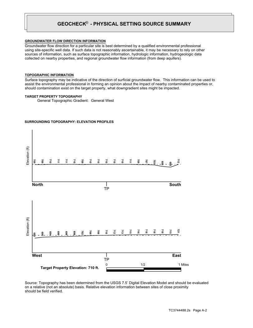
geologic strata.of the soil, and nearby wells. Groundwater flow velocity is generally impacted by the nature of theGroundwater flow direction may be impacted by surface topography, hydrology, hydrogeology, characteristics
2. Groundwater flow velocity. 1. Groundwater flow direction, and
Assessment of the impact of contaminant migration generally has two principal investigative components:
forming an opinion about the impact of potential contaminant migration.EDR’s GeoCheck Physical Setting Source Addendum is provided to assist the environmental professional in
1992Most Recent Revision:39082-F8 ASHVILLE, OHTarget Property Map:
USGS TOPOGRAPHIC MAP
710 ft. above sea levelElevation:4398494.5UTM Y (Meters): 332110.2UTM X (Meters): Zone 17Universal Tranverse Mercator: 82.9588 - 82˚ 57’ 31.68’’Longitude (West): 39.7217 - 39˚ 43’ 18.12’’Latitude (North):
TARGET PROPERTY COORDINATES
ASHVILLE, OH 43103OHIO 752/OHIO 316ASHVILLE WWTP
TARGET PROPERTY ADDRESS
®GEOCHECK - PHYSICAL SETTING SOURCE ADDENDUM®
TC3744488.2s Page A-2
should be field verified.on a relative (not an absolute) basis. Relative elevation information between sites of close proximitySource: Topography has been determined from the USGS 7.5’ Digital Elevation Model and should be evaluated
SURROUNDING TOPOGRAPHY: ELEVATION PROFILES
Ele
vatio
n (ft
)E
leva
tion
(ft)
TP
TP0 1/2 1 Miles✩Target Property Elevation: 710 ft.
North South
West East
712680
688
703
707
709
711
710
710
710
710
710
709
710
711
711
710
709
709680
690
694
696
696
698
702
706
709
710
712
713
715
716
718
718
719
715
721
General WestGeneral Topographic Gradient:TARGET PROPERTY TOPOGRAPHY
should contamination exist on the target property, what downgradient sites might be impacted.assist the environmental professional in forming an opinion about the impact of nearby contaminated properties or,Surface topography may be indicative of the direction of surficial groundwater flow. This information can be used toTOPOGRAPHIC INFORMATION
collected on nearby properties, and regional groundwater flow information (from deep aquifers).sources of information, such as surface topographic information, hydrologic information, hydrogeologic datausing site-specific well data. If such data is not reasonably ascertainable, it may be necessary to rely on otherGroundwater flow direction for a particular site is best determined by a qualified environmental professionalGROUNDWATER FLOW DIRECTION INFORMATION
®GEOCHECK - PHYSICAL SETTING SOURCE SUMMARY®
TC3744488.2s Page A-3
Not Reported
GENERAL DIRECTIONLOCATIONGROUNDWATER FLOWFROM TPMAP ID
hydrogeologically, and the depth to water table.authorities at select sites and has extracted the date of the report, groundwater flow direction as determinedflow at specific points. EDR has reviewed reports submitted by environmental professionals to regulatoryEDR has developed the AQUIFLOW Information System to provide data on the general direction of groundwater
AQUIFLOW®
Search Radius: 1.000 Mile.
contamination exist on the target property, what downgradient sites might be impacted.environmental professional in forming an opinion about the impact of nearby contaminated properties or, shouldof groundwater flow direction in the immediate area. Such hydrogeologic information can be used to assist theHydrogeologic information obtained by installation of wells on a specific site can often be an indicatorHYDROGEOLOGIC INFORMATION
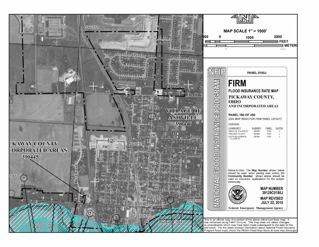
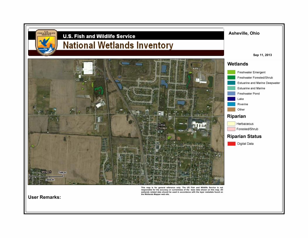
YES - refer to the Overview Map and Detail MapASHVILLE
NATIONAL WETLAND INVENTORYNWI ElectronicData CoverageNWI Quad at Target Property
Not ReportedAdditional Panels in search area:
39129C - FEMA DFIRM Flood dataFlood Plain Panel at Target Property:
YES - refer to the Overview Map and Detail MapPICKAWAY, OH
FEMA FLOOD ZONEFEMA FloodElectronic DataTarget Property County
and bodies of water).Refer to the Physical Setting Source Map following this summary for hydrologic information (major waterways
contamination exist on the target property, what downgradient sites might be impacted.the environmental professional in forming an opinion about the impact of nearby contaminated properties or, shouldSurface water can act as a hydrologic barrier to groundwater flow. Such hydrologic information can be used to assistHYDROLOGIC INFORMATION
®GEOCHECK - PHYSICAL SETTING SOURCE SUMMARY®
TC3744488.2s Page A-4
Map, USGS Digital Data Series DDS - 11 (1994).of the Conterminous U.S. at 1:2,500,000 Scale - a digital representation of the 1974 P.B. King and H.M. BeikmanGeologic Age and Rock Stratigraphic Unit Source: P.G. Schruben, R.E. Arndt and W.J. Bawiec, Geology
ROCK STRATIGRAPHIC UNIT GEOLOGIC AGE IDENTIFICATION
Stratified SequenceCategory:PaleozoicEra:DevonianSystem:Upper DevonianSeries:D3Code: (decoded above as Era, System & Series)
at which contaminant migration may be occurring.Geologic information can be used by the environmental professional in forming an opinion about the relative speedGEOLOGIC INFORMATION IN GENERAL AREA OF TARGET PROPERTY
move more quickly through sandy-gravelly types of soils than silty-clayey types of soils.characteristics data collected on nearby properties and regional soil information. In general, contaminant plumesto rely on other sources of information, including geologic age identification, rock stratigraphic unit and soilusing site specific geologic and soil strata data. If such data are not reasonably ascertainable, it may be necessaryGroundwater flow velocity information for a particular site is best determined by a qualified environmental professionalGROUNDWATER FLOW VELOCITY INFORMATION
®GEOCHECK - PHYSICAL SETTING SOURCE SUMMARY®
EDR Inc.EDR Inc.EDR Inc.EDR Inc.EDR Inc.EDR Inc.EDR Inc.EDR Inc.EDR Inc.EDR Inc.EDR Inc.EDR Inc.EDR Inc.EDR Inc.EDR Inc.EDR Inc.EDR Inc.EDR Inc.EDR Inc.EDR Inc.EDR Inc.EDR Inc.EDR Inc.EDR Inc.EDR Inc.EDR Inc.EDR Inc.EDR Inc.EDR Inc.EDR Inc.EDR Inc.EDR Inc.EDR Inc.EDR Inc.EDR Inc.EDR Inc.EDR Inc.EDR Inc.EDR Inc.EDR Inc.
1
3
2
3
32
3
2
2
4 2
2
0 1/16 1/8 1/4 Miles
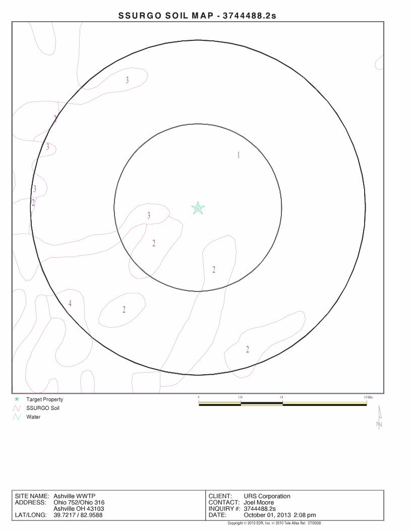
TC3744488.2s Page A-6
Min: 7.9Max: 8.4
Min: 0.42Max: 4.23
50%), Lean Claylimit less thanClays (liquidSOILS, Silts andFINE-GRAINED
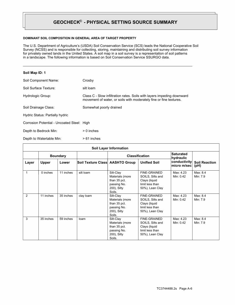
Soils.200), Siltypassing No.than 35 pct.Materials (moreSilt-Clayloam59 inches35 inches 3
Min: 7.9Max: 8.4
Min: 0.42Max: 4.23
50%), Lean Claylimit less thanClays (liquidSOILS, Silts andFINE-GRAINED
Soils.200), Siltypassing No.than 35 pct.Materials (moreSilt-Clayclay loam35 inches11 inches 2
Min: 7.9Max: 8.4
Min: 0.42Max: 4.23
50%), Lean Claylimit less thanClays (liquidSOILS, Silts andFINE-GRAINED
Soils.200), Siltypassing No.than 35 pct.Materials (moreSilt-Claysilt loam11 inches 0 inches 1
Soil Layer Information
Boundary Classification Saturatedhydraulicconductivitymicro m/sec
Layer Upper Lower Soil Texture Class AASHTO Group Unified Soil Soil Reaction(pH)
> 61 inchesDepth to Watertable Min:
> 0 inchesDepth to Bedrock Min:
HighCorrosion Potential - Uncoated Steel:
Hydric Status: Partially hydric
Somewhat poorly drainedSoil Drainage Class:
movement of water, or soils with moderately fine or fine textures.Class C - Slow infiltration rates. Soils with layers impeding downwardHydrologic Group:
silt loamSoil Surface Texture:
CrosbySoil Component Name:
Soil Map ID: 1
in a landscape. The following information is based on Soil Conservation Service SSURGO data.for privately owned lands in the United States. A soil map in a soil survey is a representation of soil patternsSurvey (NCSS) and is responsible for collecting, storing, maintaining and distributing soil survey informationThe U.S. Department of Agriculture’s (USDA) Soil Conservation Service (SCS) leads the National Cooperative Soil
DOMINANT SOIL COMPOSITION IN GENERAL AREA OF TARGET PROPERTY
®GEOCHECK - PHYSICAL SETTING SOURCE SUMMARY®
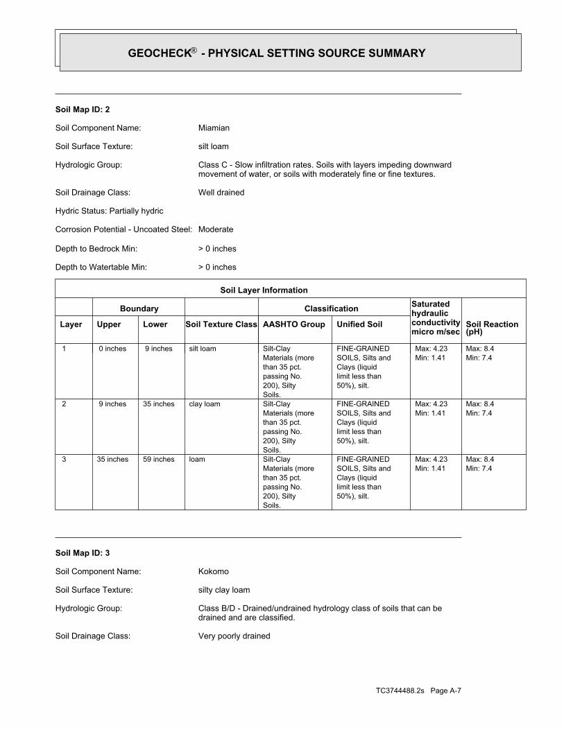
TC3744488.2s Page A-7
Very poorly drainedSoil Drainage Class:
drained and are classified.Class B/D - Drained/undrained hydrology class of soils that can beHydrologic Group:
silty clay loamSoil Surface Texture:
KokomoSoil Component Name:
Soil Map ID: 3
Min: 7.4Max: 8.4
Min: 1.41Max: 4.23
50%), silt.limit less thanClays (liquidSOILS, Silts andFINE-GRAINED
Soils.200), Siltypassing No.than 35 pct.Materials (moreSilt-Clayloam59 inches35 inches 3
Min: 7.4Max: 8.4
Min: 1.41Max: 4.23
50%), silt.limit less thanClays (liquidSOILS, Silts andFINE-GRAINED
Soils.200), Siltypassing No.than 35 pct.Materials (moreSilt-Clayclay loam35 inches 9 inches 2
Min: 7.4Max: 8.4
Min: 1.41Max: 4.23
50%), silt.limit less thanClays (liquidSOILS, Silts andFINE-GRAINED
Soils.200), Siltypassing No.than 35 pct.Materials (moreSilt-Claysilt loam 9 inches 0 inches 1
Soil Layer Information
Boundary Classification Saturatedhydraulicconductivitymicro m/sec
Layer Upper Lower Soil Texture Class AASHTO Group Unified Soil Soil Reaction(pH)
> 0 inchesDepth to Watertable Min:
> 0 inchesDepth to Bedrock Min:
ModerateCorrosion Potential - Uncoated Steel:
Hydric Status: Partially hydric
Well drainedSoil Drainage Class:
movement of water, or soils with moderately fine or fine textures.Class C - Slow infiltration rates. Soils with layers impeding downwardHydrologic Group:
silt loamSoil Surface Texture:
MiamianSoil Component Name:
Soil Map ID: 2
®GEOCHECK - PHYSICAL SETTING SOURCE SUMMARY®
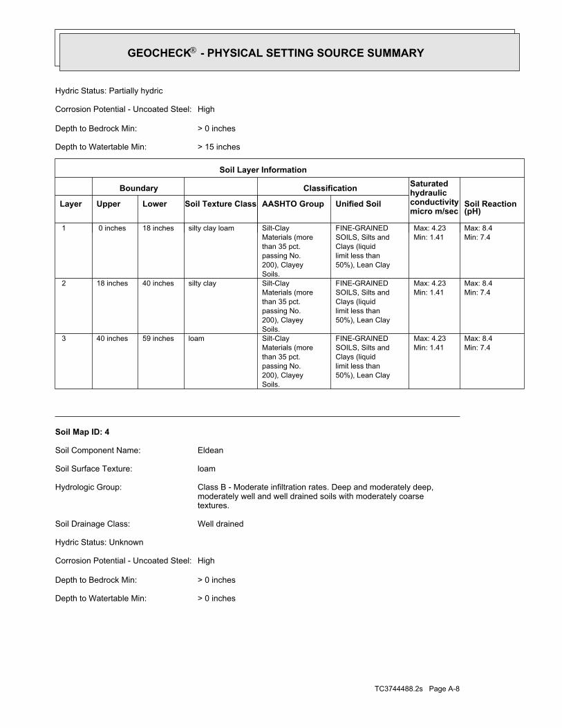
TC3744488.2s Page A-8
> 0 inchesDepth to Watertable Min:
> 0 inchesDepth to Bedrock Min:
HighCorrosion Potential - Uncoated Steel:
Hydric Status: Unknown
Well drainedSoil Drainage Class:
textures.moderately well and well drained soils with moderately coarseClass B - Moderate infiltration rates. Deep and moderately deep,Hydrologic Group:
loamSoil Surface Texture:
EldeanSoil Component Name:
Soil Map ID: 4
Min: 7.4Max: 8.4
Min: 1.41Max: 4.23
50%), Lean Claylimit less thanClays (liquidSOILS, Silts andFINE-GRAINED
Soils.200), Clayeypassing No.than 35 pct.Materials (moreSilt-Clayloam59 inches40 inches 3
Min: 7.4Max: 8.4
Min: 1.41Max: 4.23
50%), Lean Claylimit less thanClays (liquidSOILS, Silts andFINE-GRAINED
Soils.200), Clayeypassing No.than 35 pct.Materials (moreSilt-Claysilty clay40 inches18 inches 2
Min: 7.4Max: 8.4
Min: 1.41Max: 4.23
50%), Lean Claylimit less thanClays (liquidSOILS, Silts andFINE-GRAINED
Soils.200), Clayeypassing No.than 35 pct.Materials (moreSilt-Claysilty clay loam18 inches 0 inches 1
Soil Layer Information
Boundary Classification Saturatedhydraulicconductivitymicro m/sec
Layer Upper Lower Soil Texture Class AASHTO Group Unified Soil Soil Reaction(pH)
> 15 inchesDepth to Watertable Min:
> 0 inchesDepth to Bedrock Min:
HighCorrosion Potential - Uncoated Steel:
Hydric Status: Partially hydric
®GEOCHECK - PHYSICAL SETTING SOURCE SUMMARY®
TC3744488.2s Page A-9
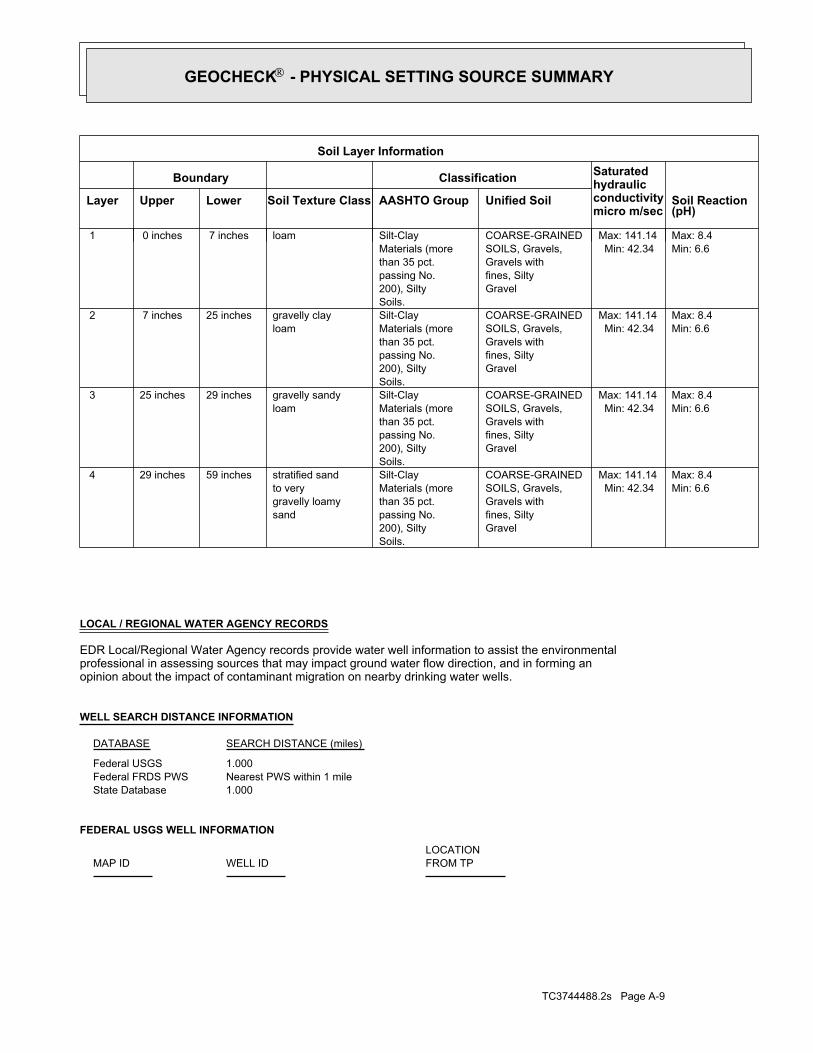
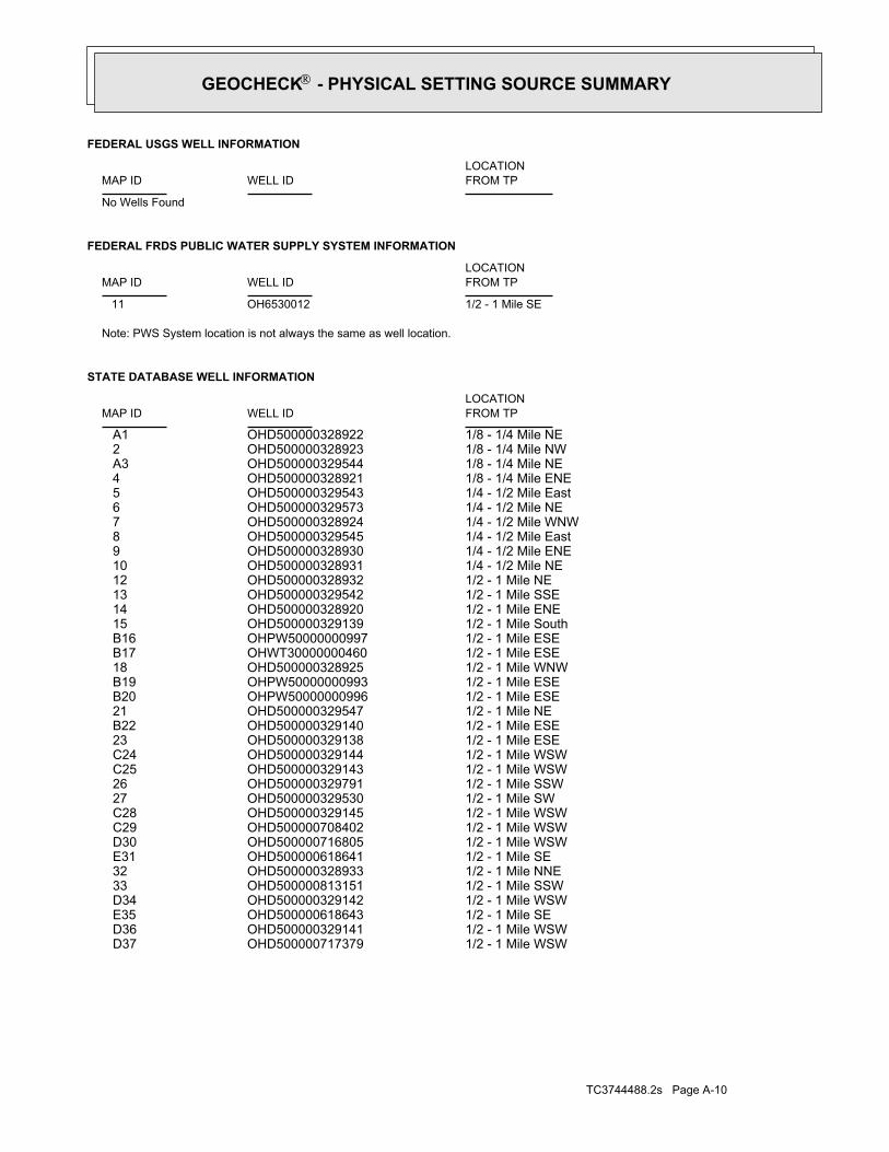
FEDERAL USGS WELL INFORMATION
LOCATIONFROM TPWELL IDMAP ID
1.000State DatabaseNearest PWS within 1 mileFederal FRDS PWS1.000Federal USGS
WELL SEARCH DISTANCE INFORMATION
SEARCH DISTANCE (miles)DATABASE
opinion about the impact of contaminant migration on nearby drinking water wells.professional in assessing sources that may impact ground water flow direction, and in forming anEDR Local/Regional Water Agency records provide water well information to assist the environmental
LOCAL / REGIONAL WATER AGENCY RECORDS
Min: 6.6Max: 8.4
Min: 42.34Max: 141.14
Gravelfines, SiltyGravels withSOILS, Gravels,COARSE-GRAINED
Soils.200), Siltypassing No.than 35 pct.Materials (moreSilt-Clay
sandgravelly loamyto verystratified sand59 inches29 inches 4
Min: 6.6Max: 8.4
Min: 42.34Max: 141.14
Gravelfines, SiltyGravels withSOILS, Gravels,COARSE-GRAINED
Soils.200), Siltypassing No.than 35 pct.Materials (moreSilt-Clay
loamgravelly sandy29 inches25 inches 3
Min: 6.6Max: 8.4
Min: 42.34Max: 141.14
Gravelfines, SiltyGravels withSOILS, Gravels,COARSE-GRAINED
Soils.200), Siltypassing No.than 35 pct.Materials (moreSilt-Clay
loamgravelly clay25 inches 7 inches 2
Min: 6.6Max: 8.4
Min: 42.34Max: 141.14
Gravelfines, SiltyGravels withSOILS, Gravels,COARSE-GRAINED
Soils.200), Siltypassing No.than 35 pct.Materials (moreSilt-Clayloam 7 inches 0 inches 1
Soil Layer Information
Boundary Classification Saturatedhydraulicconductivitymicro m/sec
Layer Upper Lower Soil Texture Class AASHTO Group Unified Soil Soil Reaction(pH)
®GEOCHECK - PHYSICAL SETTING SOURCE SUMMARY®
TC3744488.2s Page A-10
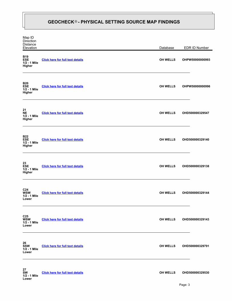
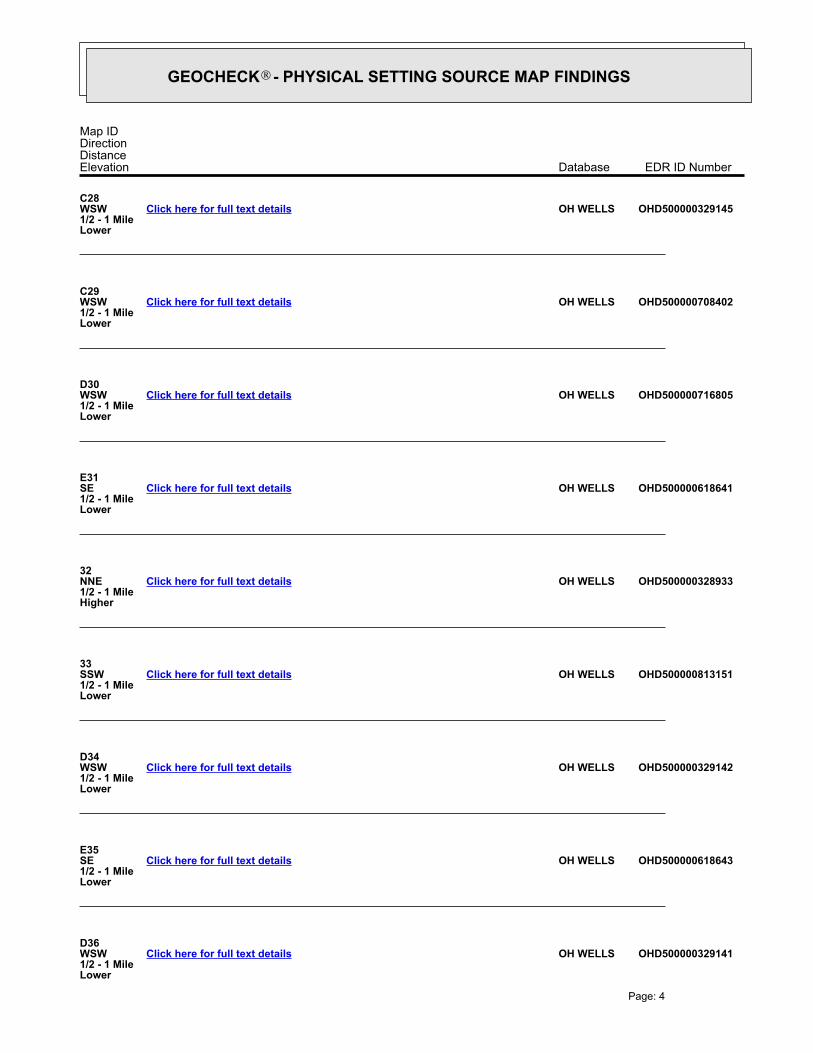
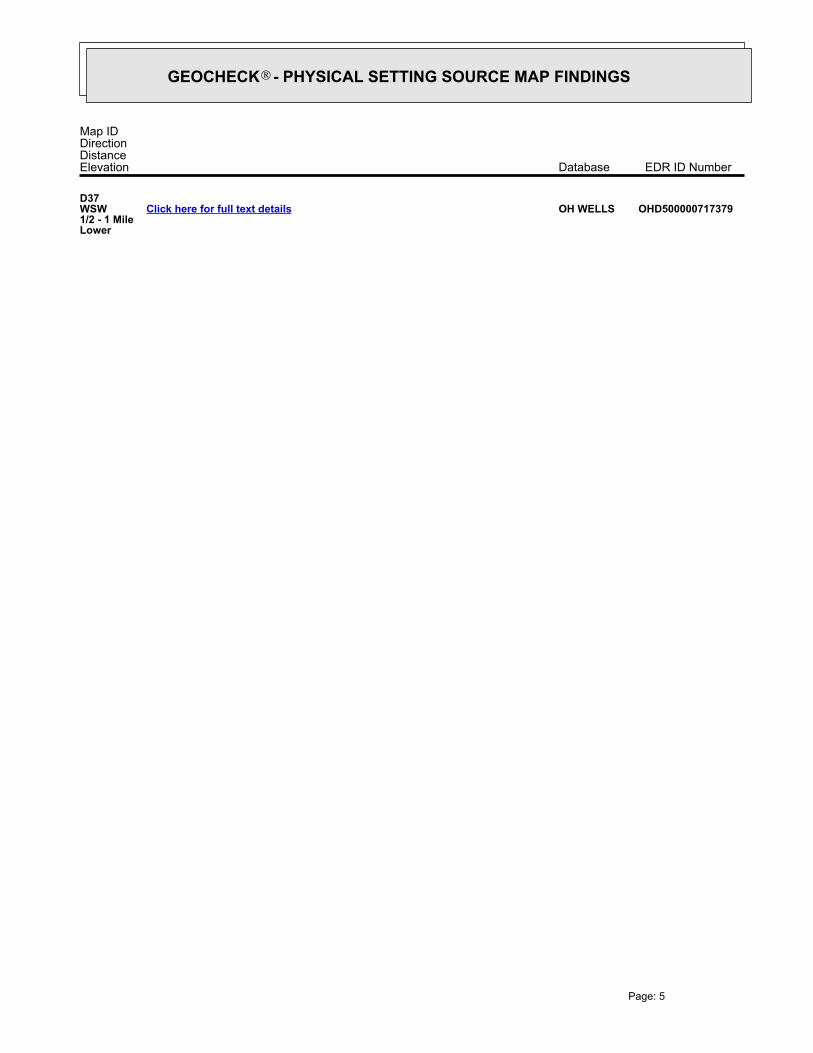
1/2 - 1 Mile WSWOHD500000717379 D371/2 - 1 Mile WSWOHD500000329141 D361/2 - 1 Mile SEOHD500000618643 E351/2 - 1 Mile WSWOHD500000329142 D341/2 - 1 Mile SSWOHD500000813151 331/2 - 1 Mile NNEOHD500000328933 321/2 - 1 Mile SEOHD500000618641 E311/2 - 1 Mile WSWOHD500000716805 D301/2 - 1 Mile WSWOHD500000708402 C291/2 - 1 Mile WSWOHD500000329145 C281/2 - 1 Mile SWOHD500000329530 271/2 - 1 Mile SSWOHD500000329791 261/2 - 1 Mile WSWOHD500000329143 C251/2 - 1 Mile WSWOHD500000329144 C241/2 - 1 Mile ESEOHD500000329138 231/2 - 1 Mile ESEOHD500000329140 B221/2 - 1 Mile NEOHD500000329547 211/2 - 1 Mile ESEOHPW50000000996 B201/2 - 1 Mile ESEOHPW50000000993 B191/2 - 1 Mile WNWOHD500000328925 181/2 - 1 Mile ESEOHWT30000000460 B171/2 - 1 Mile ESEOHPW50000000997 B161/2 - 1 Mile SouthOHD500000329139 151/2 - 1 Mile ENEOHD500000328920 141/2 - 1 Mile SSEOHD500000329542 131/2 - 1 Mile NEOHD500000328932 121/4 - 1/2 Mile NEOHD500000328931 101/4 - 1/2 Mile ENEOHD500000328930 91/4 - 1/2 Mile EastOHD500000329545 81/4 - 1/2 Mile WNWOHD500000328924 71/4 - 1/2 Mile NEOHD500000329573 61/4 - 1/2 Mile EastOHD500000329543 51/8 - 1/4 Mile ENEOHD500000328921 41/8 - 1/4 Mile NEOHD500000329544 A31/8 - 1/4 Mile NWOHD500000328923 21/8 - 1/4 Mile NEOHD500000328922 A1
STATE DATABASE WELL INFORMATION
LOCATIONFROM TPWELL IDMAP ID
Note: PWS System location is not always the same as well location.
1/2 - 1 Mile SEOH6530012 11
FEDERAL FRDS PUBLIC WATER SUPPLY SYSTEM INFORMATION
LOCATIONFROM TPWELL IDMAP ID
No Wells Found
FEDERAL USGS WELL INFORMATION
LOCATIONFROM TPWELL IDMAP ID
®GEOCHECK - PHYSICAL SETTING SOURCE SUMMARY®
EDR Inc.EDR Inc.EDR Inc.EDR Inc.EDR Inc.EDR Inc.EDR Inc.EDR Inc.EDR Inc.EDR Inc.EDR Inc.EDR Inc.EDR Inc.EDR Inc.EDR Inc.EDR Inc.EDR Inc.EDR Inc.EDR Inc.EDR Inc.EDR Inc.EDR Inc.EDR Inc.EDR Inc.EDR Inc.EDR Inc.EDR Inc.EDR Inc.EDR Inc.EDR Inc.EDR Inc.EDR Inc.EDR Inc.EDR Inc.EDR Inc.EDR Inc.EDR Inc.EDR Inc.EDR Inc.EDR Inc.
68
0
680
72
0
72
0
72
0
7 20
7 2 0
6 80
6
8 0
68
0
6 8 0
6 8 0
6 8 0
6 8 0
6 8 0
6
8 0
68
0
6 8 0
7
2 068
0
680
68
0
680
68
06
80
6 80
68
0
6 8 0
6 8 0
6 8 0
68
0
OH
EDR Inc.EDR Inc.EDR Inc.EDR Inc.EDR Inc.EDR Inc.EDR Inc.EDR Inc.EDR Inc.EDR Inc.EDR Inc.EDR Inc.EDR Inc.EDR Inc.EDR Inc.EDR Inc.EDR Inc.EDR Inc.EDR Inc.EDR Inc.EDR Inc.EDR Inc.EDR Inc.EDR Inc.EDR Inc.EDR Inc.EDR Inc.EDR Inc.EDR Inc.EDR Inc.EDR Inc.EDR Inc.EDR Inc.EDR Inc.EDR Inc.EDR Inc.EDR Inc.EDR Inc.EDR Inc.EDR Inc.
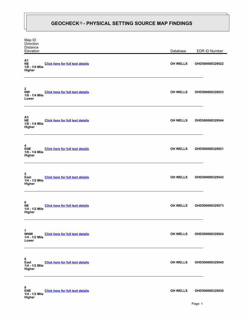
GEOCHECK - PHYSICAL SETTING SOURCE MAP FINDINGS®
Map IDDirectionDistanceElevation EDR ID NumberDatabase
A1NE1/8 - 1/4 MileHigher
OHD500000328922OH WELLSClick here for full text details
2NW1/8 - 1/4 MileLower
OHD500000328923OH WELLSClick here for full text details
A3NE1/8 - 1/4 MileHigher
OHD500000329544OH WELLSClick here for full text details
4ENE1/8 - 1/4 MileHigher
OHD500000328921OH WELLSClick here for full text details
5East1/4 - 1/2 MileHigher
OHD500000329543OH WELLSClick here for full text details
6NE1/4 - 1/2 MileHigher
OHD500000329573OH WELLSClick here for full text details
7WNW1/4 - 1/2 MileLower
OHD500000328924OH WELLSClick here for full text details
8East1/4 - 1/2 MileHigher
OHD500000329545OH WELLSClick here for full text details
9ENE1/4 - 1/2 MileHigher
OHD500000328930OH WELLSClick here for full text details
Page: 1
®GEOCHECK - PHYSICAL SETTING SOURCE MAP FINDINGS®
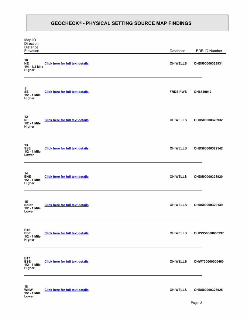
Map IDDirectionDistanceElevation EDR ID NumberDatabase
10NE1/4 - 1/2 MileHigher
OHD500000328931OH WELLSClick here for full text details
11SE1/2 - 1 MileHigher
OH6530012FRDS PWSClick here for full text details
12NE1/2 - 1 MileHigher
OHD500000328932OH WELLSClick here for full text details
13SSE1/2 - 1 MileLower
OHD500000329542OH WELLSClick here for full text details
14ENE1/2 - 1 MileHigher
OHD500000328920OH WELLSClick here for full text details
15South1/2 - 1 MileLower
OHD500000329139OH WELLSClick here for full text details
B16ESE1/2 - 1 MileHigher
OHPW50000000997OH WELLSClick here for full text details
B17ESE1/2 - 1 MileHigher
OHWT30000000460OH WELLSClick here for full text details
18WNW1/2 - 1 MileLower
OHD500000328925OH WELLSClick here for full text details
Page: 2
®GEOCHECK - PHYSICAL SETTING SOURCE MAP FINDINGS®
Map IDDirectionDistanceElevation EDR ID NumberDatabase
B19ESE1/2 - 1 MileHigher
OHPW50000000993OH WELLSClick here for full text details
B20ESE1/2 - 1 MileHigher
OHPW50000000996OH WELLSClick here for full text details
21NE1/2 - 1 MileHigher
OHD500000329547OH WELLSClick here for full text details
B22ESE1/2 - 1 MileHigher
OHD500000329140OH WELLSClick here for full text details
23ESE1/2 - 1 MileHigher
OHD500000329138OH WELLSClick here for full text details
C24WSW1/2 - 1 MileLower
OHD500000329144OH WELLSClick here for full text details
C25WSW1/2 - 1 MileLower
OHD500000329143OH WELLSClick here for full text details
26SSW1/2 - 1 MileLower
OHD500000329791OH WELLSClick here for full text details
27SW1/2 - 1 MileLower
OHD500000329530OH WELLSClick here for full text details
Page: 3
®GEOCHECK - PHYSICAL SETTING SOURCE MAP FINDINGS®
Map IDDirectionDistanceElevation EDR ID NumberDatabase
C28WSW1/2 - 1 MileLower
OHD500000329145OH WELLSClick here for full text details
C29WSW1/2 - 1 MileLower
OHD500000708402OH WELLSClick here for full text details
D30WSW1/2 - 1 MileLower
OHD500000716805OH WELLSClick here for full text details
E31SE1/2 - 1 MileLower
OHD500000618641OH WELLSClick here for full text details
32NNE1/2 - 1 MileHigher
OHD500000328933OH WELLSClick here for full text details
33SSW1/2 - 1 MileLower
OHD500000813151OH WELLSClick here for full text details
D34WSW1/2 - 1 MileLower
OHD500000329142OH WELLSClick here for full text details
E35SE1/2 - 1 MileLower
OHD500000618643OH WELLSClick here for full text details
D36WSW1/2 - 1 MileLower
OHD500000329141OH WELLSClick here for full text details
Page: 4
®GEOCHECK - PHYSICAL SETTING SOURCE MAP FINDINGS®
Map IDDirectionDistanceElevation EDR ID NumberDatabase
D37WSW1/2 - 1 MileLower
OHD500000717379OH WELLSClick here for full text details
Page: 5
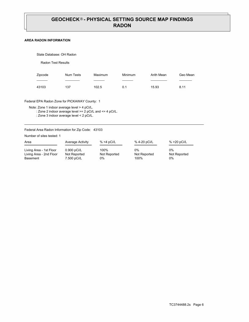
0%100%0%7.500 pCi/LBasementNot ReportedNot ReportedNot ReportedNot ReportedLiving Area - 2nd Floor0%0%100%0.900 pCi/LLiving Area - 1st Floor
% >20 pCi/L% 4-20 pCi/L% <4 pCi/LAverage ActivityArea
Number of sites tested: 1
Federal Area Radon Information for Zip Code: 43103
: Zone 3 indoor average level < 2 pCi/L. : Zone 2 indoor average level >= 2 pCi/L and <= 4 pCi/L. Note: Zone 1 indoor average level > 4 pCi/L.
Federal EPA Radon Zone for PICKAWAY County: 1
8.1115.930.1102.513743103
__________________________________________Geo MeanArith MeanMinimumMaximumNum TestsZipcode
Radon Test Results
State Database: OH Radon
AREA RADON INFORMATION
®GEOCHECK - PHYSICAL SETTING SOURCE MAP FINDINGSRADON
®
TC3744488.2s Page 6
EDR Inc.EDR Inc.EDR Inc.EDR Inc.EDR Inc.EDR Inc.EDR Inc.EDR Inc.EDR Inc.EDR Inc.EDR Inc.EDR Inc.EDR Inc.EDR Inc.EDR Inc.EDR Inc.EDR Inc.EDR Inc.EDR Inc.EDR Inc.EDR Inc.EDR Inc.EDR Inc.EDR Inc.EDR Inc.EDR Inc.EDR Inc.EDR Inc.EDR Inc.EDR Inc.EDR Inc.EDR Inc.EDR Inc.EDR Inc.EDR Inc.EDR Inc.EDR Inc.EDR Inc.EDR Inc.EDR Inc.
TOPOGRAPHIC INFORMATION
USGS 7.5’ Digital Elevation Model (DEM)Source: United States Geologic SurveyEDR acquired the USGS 7.5’ Digital Elevation Model in 2002 and updated it in 2006. The 7.5 minute DEM correspondsto the USGS 1:24,000- and 1:25,000-scale topographic quadrangle maps. The DEM provides elevation datawith consistent elevation units and projection.
Scanned Digital USGS 7.5’ Topographic Map (DRG)Source: United States Geologic SurveyA digital raster graphic (DRG) is a scanned image of a U.S. Geological Survey topographic map. The map imagesare made by scanning published paper maps on high-resolution scanners. The raster imageis georeferenced and fit to the Universal Transverse Mercator (UTM) projection.
HYDROLOGIC INFORMATION
Flood Zone Data: This data, available in select counties across the country, was obtained by EDR in 2003 & 2011 from the FederalEmergency Management Agency (FEMA). Data depicts 100-year and 500-year flood zones as defined by FEMA.
NWI: National Wetlands Inventory. This data, available in select counties across the country, was obtained by EDRin 2002 and 2005 from the U.S. Fish and Wildlife Service.
State Wetlands Data: Wetlands InventorySource: Department of Natural ResourcesTelephone: 614-265-1044
HYDROGEOLOGIC INFORMATION
AQUIFLOW Information SystemRSource: EDR proprietary database of groundwater flow informationEDR has developed the AQUIFLOW Information System (AIS) to provide data on the general direction of groundwater
flow at specific points. EDR has reviewed reports submitted to regulatory authorities at select sites and hasextracted the date of the report, hydrogeologically determined groundwater flow direction and depth to water tableinformation.
GEOLOGIC INFORMATION
Geologic Age and Rock Stratigraphic UnitSource: P.G. Schruben, R.E. Arndt and W.J. Bawiec, Geology of the Conterminous U.S. at 1:2,500,000 Scale - A digitalrepresentation of the 1974 P.B. King and H.M. Beikman Map, USGS Digital Data Series DDS - 11 (1994).
STATSGO: State Soil Geographic DatabaseSource: Department of Agriculture, Natural Resources Conservation ServicesThe U.S. Department of Agriculture’s (USDA) Natural Resources Conservation Service (NRCS) leads the nationalConservation Soil Survey (NCSS) and is responsible for collecting, storing, maintaining and distributing soilsurvey information for privately owned lands in the United States. A soil map in a soil survey is a representationof soil patterns in a landscape. Soil maps for STATSGO are compiled by generalizing more detailed (SSURGO)soil survey maps.
SSURGO: Soil Survey Geographic DatabaseSource: Department of Agriculture, Natural Resources Conservation Services (NRCS)Telephone: 800-672-5559SSURGO is the most detailed level of mapping done by the Natural Resources Conservation Services, mappingscales generally range from 1:12,000 to 1:63,360. Field mapping methods using national standards are used toconstruct the soil maps in the Soil Survey Geographic (SSURGO) database. SSURGO digitizing duplicates theoriginal soil survey maps. This level of mapping is designed for use by landowners, townships and countynatural resource planning and management.
TC3744488.2s Page A-55
PHYSICAL SETTING SOURCE RECORDS SEARCHED
LOCAL / REGIONAL WATER AGENCY RECORDS
FEDERAL WATER WELLS
PWS: Public Water SystemsSource: EPA/Office of Drinking WaterTelephone: 202-564-3750Public Water System data from the Federal Reporting Data System. A PWS is any water system which provides water to at
least 25 people for at least 60 days annually. PWSs provide water from wells, rivers and other sources.
PWS ENF: Public Water Systems Violation and Enforcement DataSource: EPA/Office of Drinking WaterTelephone: 202-564-3750Violation and Enforcement data for Public Water Systems from the Safe Drinking Water Information System (SDWIS) after
August 1995. Prior to August 1995, the data came from the Federal Reporting Data System (FRDS).
USGS Water Wells: USGS National Water Inventory System (NWIS)This database contains descriptive information on sites where the USGS collects or has collected data on surfacewater and/or groundwater. The groundwater data includes information on wells, springs, and other sources of groundwater.
STATE RECORDS
Public Water System DataSource: Ohio Environmental Protection AgencyTelephone: 614-644-2752The database includes community, transient noncommunity and nontransient noncommunity water wells; and source
treatment unit locations.
Water Well DatabaseSource: Department of Natural ResourcesTelephone: 614-265-6740
OTHER STATE DATABASE INFORMATION
RADON
State Database: OH RadonSource: Department of HealthTelephone: 614-644-2727Radon Statistics for Zip Code Areas
Area Radon InformationSource: USGSTelephone: 703-356-4020The National Radon Database has been developed by the U.S. Environmental Protection Agency(USEPA) and is a compilation of the EPA/State Residential Radon Survey and the National Residential Radon Survey.The study covers the years 1986 - 1992. Where necessary data has been supplemented by information collected atprivate sources such as universities and research institutions.
EPA Radon ZonesSource: EPATelephone: 703-356-4020Sections 307 & 309 of IRAA directed EPA to list and identify areas of U.S. with the potential for elevated indoorradon levels.
OTHER
Airport Landing Facilities: Private and public use landing facilitiesSource: Federal Aviation Administration, 800-457-6656
Epicenters: World earthquake epicenters, Richter 5 or greaterSource: Department of Commerce, National Oceanic and Atmospheric Administration
TC3744488.2s Page A-56
PHYSICAL SETTING SOURCE RECORDS SEARCHED

STREET AND ADDRESS INFORMATION
© 2010 Tele Atlas North America, Inc. All rights reserved. This material is proprietary and the subject of copyright protectionand other intellectual property rights owned by or licensed to Tele Atlas North America, Inc. The use of this material is subjectto the terms of a license agreement. You will be held liable for any unauthorized copying or disclosure of this material.
TC3744488.2s Page A-57
PHYSICAL SETTING SOURCE RECORDS SEARCHED