Embed Size (px)
Citation preview
Appendix A Existing Conditions Analysis
Parramore Comprehensive Neighborhood Plan – Appendix A Page 1
Parramore Comprehensive Neighborhood Plan Appendix A: Existing Conditions Analysis
1. Base Mapping
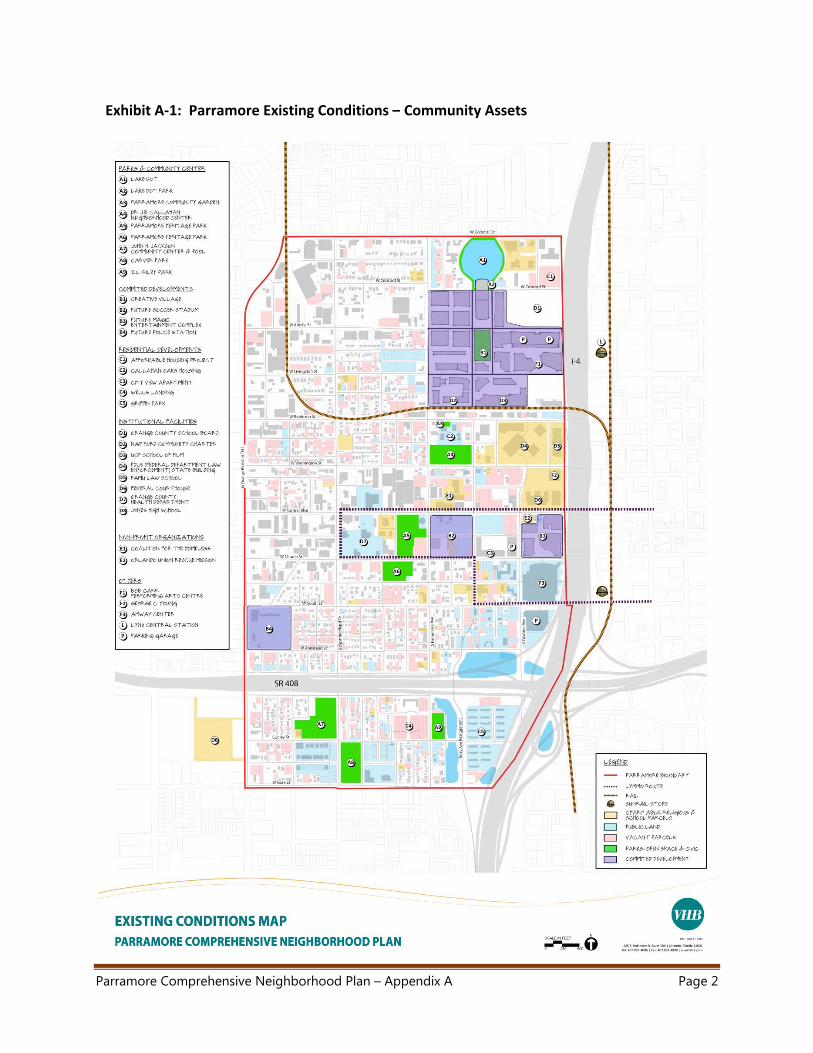
a. Community Assets Map (Community centers, parks, public lands, and vacant parcels)
There are many different existing community assets within the Parramore Community,
as shown on Exhibit A‐1.
Lake Dot (Arlington Heights) contains the former Amway Arena site, as well as portions
of the planned Creative Village project. It also contains the Orange County Vocational
Technical School and the Orlando Day Nursery day care and school, and the Salvation
Army headquarters complex which includes a large residential tower.
Callahan contains the J.B. Callahan Neighborhood Center, a portion of the planned
Creative Village project, the Nap Ford Charter School, Downtown Recreation Center,
Bob Carr Theater, and other educational and institutional assets, including the Florida
A&M University (FAMU) College of Law, George C. Young Federal Building and
Courthouse Building.
Holden/Parramore contains the historic Parramore Avenue Corridor, historic Wells’ Built
museum, the John H. Jackson Community Center, and the Z.L. Riley Park. The Church
Street corridor links together many of Orlando’s sports and entertainment venues,
including the Amway Center and planned Orlando Magic Sports Entertainment District,
planned Major League Soccer stadium for the Orlando City Lions, as well as the
Downtown Performing Arts Center to the east of Parramore, and the Florida Citrus Bowl
to the west. There is a substantial amount of public housing in this neighborhood,
including the Orlando Housing Authority (OHA) Carver Park HOPE VI project (64 one‐
bedroom age restricted rental units, and 56 other rental units) along W. Gore Street,
and the OHA Griffin Park community (198 rental units), located within the I‐4 and SR 408
interchange.
Parramore Comprehensive Neighborhood Plan – Appendix A Page 2
Exhibit A‐1: Parramore Existing Conditions – Community Assets
Parramore Comprehensive Neighborhood Plan – Appendix A Page 3
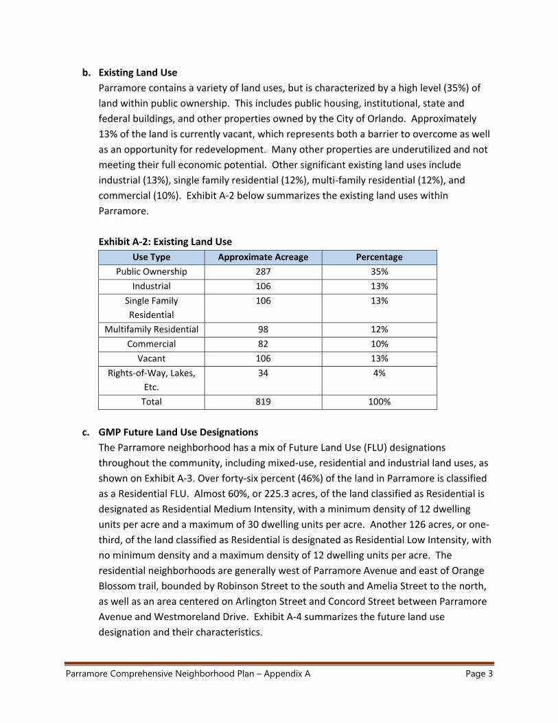
b. Existing Land Use
Parramore contains a variety of land uses, but is characterized by a high level (35%) of
land within public ownership. This includes public housing, institutional, state and
federal buildings, and other properties owned by the City of Orlando. Approximately
13% of the land is currently vacant, which represents both a barrier to overcome as well
as an opportunity for redevelopment. Many other properties are underutilized and not
meeting their full economic potential. Other significant existing land uses include
industrial (13%), single family residential (12%), multi‐family residential (12%), and
commercial (10%). Exhibit A‐2 below summarizes the existing land uses within
Parramore.
Exhibit A‐2: Existing Land Use
Use Type Approximate Acreage Percentage
Public Ownership 287 35%
Industrial 106 13%
Single Family
Residential
106 13%
Multifamily Residential 98 12%
Commercial 82 10%
Vacant 106 13%
Rights‐of‐Way, Lakes,
Etc.
34 4%
Total 819 100%
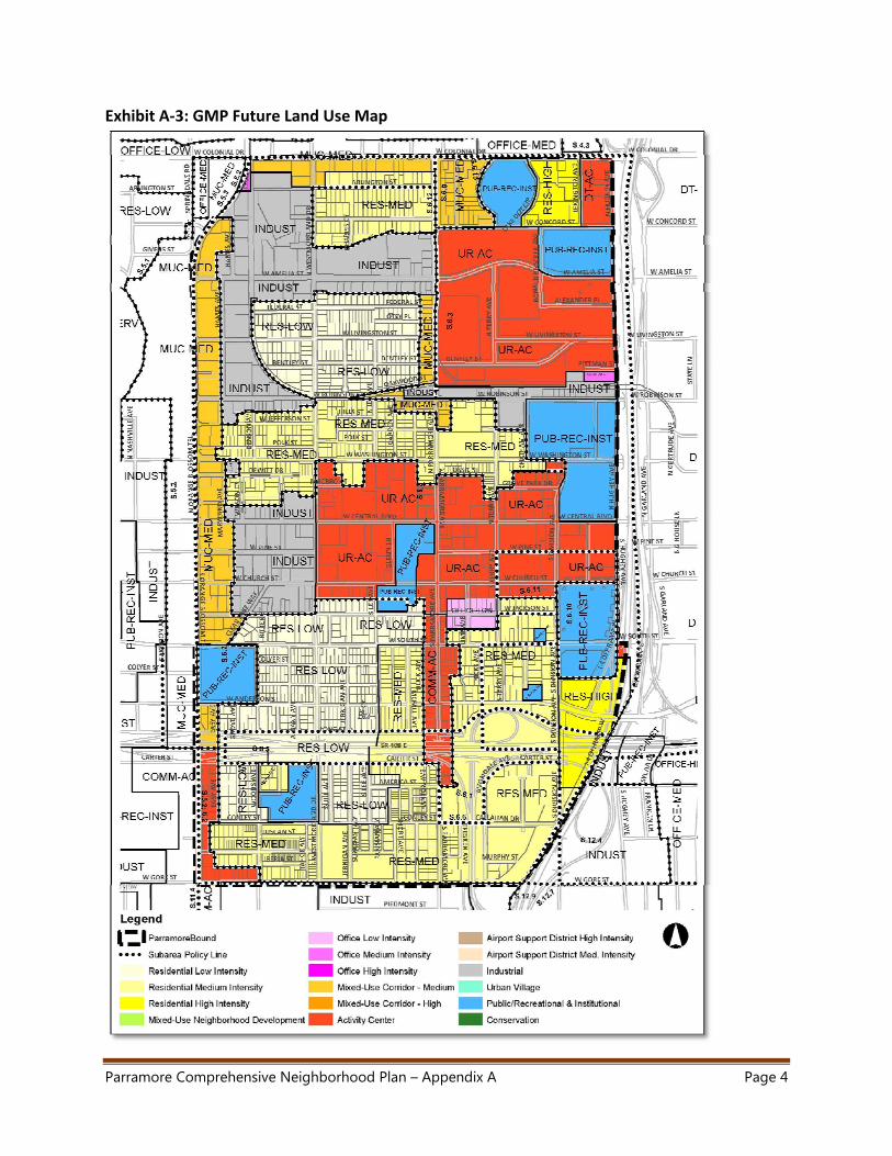
c. GMP Future Land Use Designations
The Parramore neighborhood has a mix of Future Land Use (FLU) designations
throughout the community, including mixed‐use, residential and industrial land uses, as
shown on Exhibit A‐3. Over forty‐six percent (46%) of the land in Parramore is classified
as a Residential FLU. Almost 60%, or 225.3 acres, of the land classified as Residential is
designated as Residential Medium Intensity, with a minimum density of 12 dwelling
units per acre and a maximum of 30 dwelling units per acre. Another 126 acres, or one‐
third, of the land classified as Residential is designated as Residential Low Intensity, with
no minimum density and a maximum density of 12 dwelling units per acre. The
residential neighborhoods are generally west of Parramore Avenue and east of Orange
Blossom trail, bounded by Robinson Street to the south and Amelia Street to the north,
as well as an area centered on Arlington Street and Concord Street between Parramore
Avenue and Westmoreland Drive. Exhibit A‐4 summarizes the future land use
designation and their characteristics.
Parramore Comprehensive Neighborhood Plan – Appendix A Page 4
Exhibit A‐3: GMP Future Land Use Map
Parramore Comprehensive Neighborhood Plan – Appendix A Page 5
Almost 20% of Parramore is designated as Urban Activity Center. An Urban Activity
Center is intended to offer a mix of uses, including residential, office, commercial,
public, recreational, institutional and industrial uses, in high densities to serve as a sub‐
region of the Orlando Urban Area. In Parramore, the Urban Activity Center areas are
generally located between Washington Street and Church Street, and extend from I‐4 to
Westmoreland Drive. Additionally, the Creative Village property in the northeast of
Parramore is also designated as an Urban Activity Center.
Exhibit A‐4: Future Land Use Designation Characteristics
FLU Designations Acreage Min. Density
(units/acre)
Max.
Density
(units/acre)
Min
FAR
Max
FAR
Residential Low Intensity RES‐LOW 126.0 12 0.30
Residential Medium Intensity RES‐MED 225.3 12 30 0.30
Residential High Intensity RES‐HIGH 25.8 30 200 0.35
Mixed Use Corridor ‐
Medium
MUC‐MED 64.2 15 30 0.50
Office Low Intensity OFFICE‐LOW 1.7 21 0.40
Office Medium Intensity OFFICE‐MED 4.3 12 40 0.30 0.70
Industrial INDUST 100.6 12 40 0.70
Public, Recreational,
Institutional
PUB‐REC‐
INST
85.0
Community Activity Center COMM‐AC 21.0 20 40 0.35 0.70
Urban Activity Center UR‐AC 155.6 30 100 0.50 1.00
Downtown Activity Center DT‐AC 6.2 75 200 0.75 4.00
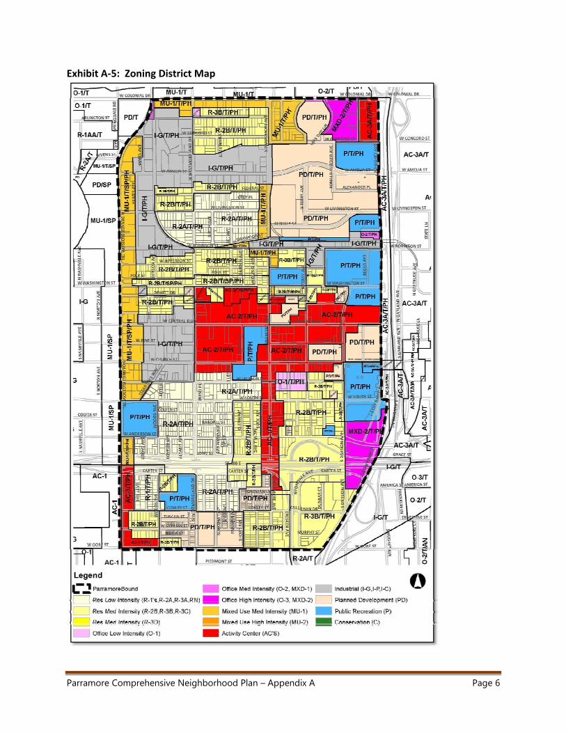
d. Zoning
There is a mix of zoning districts in the Parramore community, including residential,
activity centers, mixed‐use, and planned development districts, as shown on Exhibit A‐5.
Zoning districts corresponding to the Residential Medium Intensity future land use
designation, the R‐2B and R‐3B districts, together account for 21.5% of the land in
Parramore. The R‐2B districts are generally located along Arlington and Concord Streets
in the north of Parramore, between Robinson and Washington Streets in the center of
Parramore, and in the southeast section of Parramore, south of South Street. The
majority of the land zoned as R‐3B is located in the Griffin Park, a public housing
development, in the southeast corner of Parramore. Exhibit A‐6 summarizes the
characteristics of the various zoning districts in Parramore.
Parramore Comprehensive Neighborhood Plan – Appendix A Page 6
Exhibit A‐5: Zoning District Map
Parramore Comprehensive Neighborhood Plan – Appendix A Page 7
Land zoned as Public (P) accounts for approximately 17% of the land in Parramore. This
zoning district is for any lands owned by a public body generally located along the
eastern border of the Parramore community, between I‐4 and Division Street, and
includes government buildings, the Orange County School Board offices and the Amway
Center.
Additionally, there are two overlay districts that cover the entire Parramore community,
the Traditional City Overlay District (T) and the Parramore Heritage Overlay District (PH).
The T overlay district is intended to establish urban design standards for residential and
commercial development patterns found within the Traditional City. The PH district is
intended to “promote the stability and prosperity of the Parramore neighborhood by
reducing the over‐concentration of social service uses within the district.” The PH
district implements Future Land Use Subarea Policy S.6.9 which limits the establishment,
expansion, and relocation of social service uses.
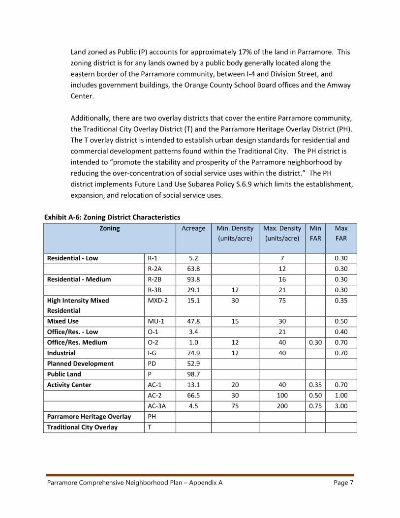
Exhibit A‐6: Zoning District Characteristics
Zoning Acreage Min. Density
(units/acre)
Max. Density
(units/acre)
Min
FAR
Max
FAR
Residential ‐ Low R‐1 5.2 7 0.30
R‐2A 63.8 12 0.30
Residential ‐ Medium R‐2B 93.8 16 0.30
R‐3B 29.1 12 21 0.30
High Intensity Mixed
Residential
MXD‐2 15.1 30 75 0.35
Mixed Use MU‐1 47.8 15 30 0.50
Office/Res. ‐ Low O‐1 3.4 21 0.40
Office/Res. Medium O‐2 1.0 12 40 0.30 0.70
Industrial I‐G 74.9 12 40 0.70
Planned Development PD 52.9
Public Land P 98.7
Activity Center AC‐1 13.1 20 40 0.35 0.70
AC‐2 66.5 30 100 0.50 1.00
AC‐3A 4.5 75 200 0.75 3.00
Parramore Heritage Overlay PH
Traditional City Overlay T
Parramore Comprehensive Neighborhood Plan – Appendix A Page 8
e. Base Transect Map
Prior to making recommendations for Parramore, it was important to identify the
existing context within the Parramore Study Area. The “transect” concept, derived from
the Smart Code, was utilized for this analysis. The Smart Code (an open source
document originally developed by the Duany Plater‐Zyberk and Company in 2003, and
maintained and updated by the Center for Applied Transect Studies) describes six basic
Transect Zones which provide the basis for neighborhood structure. The Transect Zones
vary by ratio and level of intensity of their natural, built, and social components, and can
be coordinated to various scales of planning from the region through the community
scale down to the individual lot and building. The Transect Zones can be modified to
address unique conditions found in specific neighborhoods.
The “Base Transect Map” (Exhibit A‐7) provides a snapshot of the existing conditions in
Parramore, by Transect, to help provide guidance on what exists today and identify,
through the Vision Plan, what Transect Zone’s should be considered that will meet the
community’s Vision for Parramore.
In order to reflect an accurate context for Parramore, minor modifications to the
Transect Zones were needed to better reflect the current conditions within Parramore.
The formal Transect predominately recognizes only mixed use zones while the current
context of Parramore is more reflective of a mix of uses and some areas that are more
single‐use focused. Parramore’s transects are described as follows:
Residential Neighborhood (T‐3) The Residential Neighborhood Zone consists primarily of single‐family residential
homes, duplexes, and some smaller apartment units. Setbacks vary from close to the
road to larger setbacks, depending on the neighborhood. Home occupation and
some small scale multi‐family exists. Typical building heights are 1‐2 stories.
Parramore Comprehensive Neighborhood Plan – Appendix A Page 9
Highway Commercial (T‐3.5)
The Highway Commercial zone is predominately a suburban style of development
with a mix of non‐residential uses that are directly adjacent to neighborhoods. The
uses are focused on vehicular accessibility. Setbacks are larger, with a predominance
of parking. Typical building heights are 1‐2 stories.
Mixed Use District (T‐4) The Mixed Use Zone consists of a mix of uses, primarily residential urban fabric. It
may have a wide range of building types: single family residential, duplexes, and
apartments with some small‐scale commercial/office uses. Setbacks and landscaping
are variable. Streets with curbs and sidewalks define medium‐sized blocks. Typical
building heights are 1‐3 stories.
Urban General (T‐5)
The Urban General Zone consists of higher density mixed use buildings that
accommodate retail, offices, and apartments. It has a tight network of streets, with
wide sidewalks, steady street tree planting and buildings set close to the sidewalks.
Typical building heights are 2‐5 stories.
Downtown Core (T‐6) The Downtown Core Zone consists of the highest density and height, with the
greatest variety of uses, and civic buildings of regional importance. It may have
larger blocks because of the regional buildings, I.e., Amway, Bob Carr, etc. Most of
the buildings are set close to wide sidewalks. This area in Parramore links directly to
the Center of Downtown. Typical building heights are 2‐6 stories.
Employment Center (SD) The Employment Center Zone is predominately industrial uses that are adjacent to
the residential areas, and mixed‐use areas of Parramore. The blocks are larger in
nature with larger setbacks. Most of these areas are not walkable nor integrate
harmoniously with the adjacent neighborhoods.
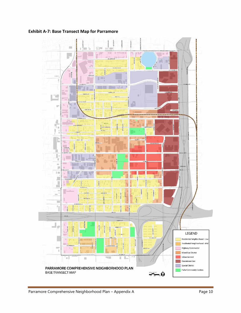
Parramore Comprehensive Neighborhood Plan – Appendix A Page 10
Exhibit A‐7: Base Transect Map for Parramore
Parramore Comprehensive Neighborhood Plan – Appendix A Page 11
2. Analysis of Existing Code and Regulations
Through the Growth Management Plan (GMP) and adopted Future Land Use Map, the
Parramore Community currently has sufficient land use rights to support the projected
growth through the year 2040. Therefore, these entitlements are not the limiting factor
that may act as a barrier to growth and revitalization of Parramore. Other factors, such as
market influences and competing uses, crime and perception of crime, concentration of
social services, deteriorated and outdated structures, and concentrated poverty, act as
barriers that may influence investment choices by residents or outside parties.
The Future Land Use Element of the GMP includes Subarea Policy S.6.9, which recognizes
that the “over‐concentration of social services uses in the Parramore Heritage Renovation
Area has had a negative impact on the area’s stability and prosperity.” Therefore, the policy
limits the establishment, expansion, and relocation of social service uses and prohibits adult
entertainment facilities. The policy is further implemented in the Land Development Code ‐
Parramore Heritage Overlay District (LDC Chapter 58, Sections 58.499.13 through
58.499.15). This policy does not however include a relocation strategy for existing social
services providers outside of the area, and it was determined through the public
engagement process that many Parramore residents would prefer that the homeless
population be dispersed throughout the City.
3. Existing Programs and Resources for Parramore Residents
In addition to social services that are primarily intended for the homeless population, there
are many existing programs and resources currently available for Parramore residents,
including recreational programs at the two community centers and participation with the
large faith community present in the community. Below are highlights of several existing
programs and organizations that are dedicated to improving Parramore and transforming it
into a healthy community.
Parramore Kidz Zone
Parramore Kidz Zone (PKZ) was launched in July 2006, after extensive community input via:
Mayor Buddy Dyers’ Education Action Council; Mayor’s Parramore Task Force; Mayor’s Blue
Ribbon Panel on Education; Mayor’s Safe Orlando Task Force; and, visits to New York City to
meet with leaders of Harlem Children’s Zone (HCZ) including HCZ’s founder, Geoffrey
Canada. Receipt of $500,000 in grant funding from the Robert Wood Johnson Foundation
and $500,000 in match funding from Orlando‐based charitable foundations allowed the
program to take root. PKZ is administered by staff from the City of Orlando’s Department of
Parramore Comprehensive Neighborhood Plan – Appendix A Page 12
Families Parks and Recreation and a charitable arm was created to support the effort – the
Orlando Community & Youth Trust, Inc.
The mission of PKZ is to level the playing field for Parramore’s children, equipping them to
become successful, healthy, well‐educated adults. PKZ aims to reduce juvenile crime, teen
pregnancy, and high school drop‐out rates in this high poverty, high crime neighborhood,
and ultimately replicate this model in other Orlando neighborhoods also struggling with
disproportionately high rates of juvenile crime, school failure and teen pregnancy. For
more information about PKZ, please visit their website:
http://www.cityoforlando.net/parramorekidzzone/
New Image Youth Center
New Image Youth Center, located at 212 S. Parramore Ave, is a 501c3 non‐profit
organization that organizes after‐school programs and summer camps for at‐risk youth in
Parramore. Founded by Shanta Barton Stubbs in June of 2004, New Image Youth Center has
become a safe haven for children who live in the Parramore community. Through tutoring,
educational activities, emotional support and counseling, New Image Youth Center has
made a difference in children’s lives in a community where they are not given much hope.
Students from surrounding universities and colleges have been an excellent source of
volunteerism. They have offered their mentoring services to help the children struggling
with homework. Guest speakers and staff promote a healthy and positive lifestyle for the
children, giving them the encouragement and tools for success. For more information
about New Image Youth Center, please visit their website:
http://www.newimageyouth.org/#!
ROCK (Reducing Obesity in Central Florida Kids)
ROCK is a regional consortium that is joining organizations with families and kids in an effort
to prevent, reduce and eliminate childhood obesity and promote healthy choices. The
movement was started in 2008 after a community health assessment identified childhood
obesity as a major concern in the Central Florida region: 30% of children here are
considered overweight/obese. The mission of ROCK is to ensure children living in Brevard,
Orange, Osceola and Seminole counties have healthy lifestyles that eliminate their risk for
childhood obesity through a collaborative community effort.
ROCK has worked with the Health Council of East Central Florida and the Florida Blue
Foundation to provide grant funding and to create an initiative to support various
strategies, activities and policies for building a healthy Parramore/Holden Heights
community. This effort resulted in the creation of an important document entitled
Parramore Comprehensive Neighborhood Plan – Appendix A Page 13
“Building a Healthy Parramore: A Call to Action to Reduce Childhood Obesity”. For more
information about ROCK, please visit this website: http://www.rockfl.org/index.html
Hebni Nutrition Consultants
Hebni Nutrition Consultants, Inc. (HNC) is a community based non‐profit organization
committed to improving health by providing comprehensive nutrition information. The
major goals of HNC are to foster dietary compliance for existing diseases and to facilitate
the prevention of nutrition related disease through appropriate nutrition intervention. HNC
targets culturally diverse populations who are at risk for obesity, heart disease, diabetes,
cancer, hypertension and other diet‐related diseases. The mission of HNC is to provide
nutrition education and strategies to prevent diet related diseases. HNC is committed to
improving consumers' health by providing comprehensive nutritional information to
culturally diverse populations through seminars and community education programs. HNC is
a community‐based not‐for‐profit (501c3) agency. Most recently, with support from
Orange County, the City of Orlando, and Lynx (regional transit provider), Hebni has
launched a mobile fresh produce bus that visits food desert areas throughout Central
Florida including Parramore. For more information about HNC, please visit their website:
http://soulfoodpyramid.org/
Florida Department of Health – Orange County
Located at 832 West Central Boulevard in the heart of Parramore, the Florida Department
of Health (Orange County’s Central Health Center) operates a number of programs including
personal health services, general health services, and environmental health services.
Personal health services include dental health, immunizations, school health, and the
Healthy Start program. Healthy Start provides maternal and child health services to
improve pregnancy outcomes and help children get a healthy start in live. Healthy Start
offers services for pregnant women, women between pregnancies, and for babies from
birth to age three. General health services include epidemiology, emergency operations,
and vital statistics. Finally, the Environmental Health Services focus on a wide array of
issues including drinking water, lead, food hygiene, group care, and indoor air. For more
information about Department of Health’s programs, please visit their website:
http://www.orchd.com/contact/centralHealth/index.asp
City Housing and Community Development Department Grants
The City of Orlando’s Housing and Community Development Department administers local,
state and federal funds designated for housing and community development. The
Department plans, develops and implements programs and activities that meet identified
needs in the community such as home ownership, rental and owner‐occupied housing
Parramore Comprehensive Neighborhood Plan – Appendix A Page 14
rehabilitation, public facilities and improvements and assistance to the homeless and
persons with HIV/AIDS. Programs managed by the Housing and Community Development
Department include:
Community Development
Home Buyer Assistance
Home Repair Assistance
Affordable Housing Assistance
For more information about financial assistance and grants available, please visit their
website: http://www.cityoforlando.net/housing/
City of Orlando Brownfield Program.
The City of Orlando administers a two part US EPA Brownfield Program that directly
addresses the Parramore community. The first part consists of a Brownfield Assessment
component which targets the entire neighborhood. The purpose of the assessment
activities is to analyze potential sites that have real or perceived contamination and which
can be used in the future for redevelopment. As part of this process, Phase I and Phase II
examinations are conducted. In compliance with US EPA grant terms, the City also
developed a public school asthma educational program which started in the fall of 2014.
The second component is a Brownfield Clean Up Program which specifically addresses the
clean‐up of a +/‐8.2 acre site at the southwest corner of Bentley Street and Parramore
Avenue.
Christian Service Center
The Christian Service Center is located at 808 W. Central Boulevard in the heart of
Parramore. The mission of the Christian Service Center is to mobilize the Central Florida
Community under one common mission to eradicate poverty through the provision of
services and resources that foster hope, well‐being and empowerment. There are currently
four inter‐dependent programs in place to best meet these needs including:
Family & Emergency Service – Compassion, which provides immediate emergency
assistance and relief to families and individuals faced with an unexpected financial
crisis, with the primary goal to help families maintain their residence and prevent
them from being forced into homelessness.
Daily Bread – Comfort, a program originally established in 1975 with the goal that no
person in Central Florida would struggle with hunger. Daily Bread has offered a free
nourishing noontime meal to anyone in the community who is hungry.
Fresh Start – Counsel, is a short‐term residential program designed for rebuilding
and restoration in the lives of men who are seeking a new beginning. The program
includes short‐term living accommodations such as a bedroom, living room, fully‐
Parramore Comprehensive Neighborhood Plan – Appendix A Page 15
equipped kitchen and laundry facilities. During the week, program participants are
required to work or pursue work during the day and partake in evening meals and
activities such as counseling, Bible study, anger management and life skills.
KidsFOCUS – Care, is a program which provides a safe and healthy learning
environment for children in economically challenged families who might not have an
after‐school alternative. KidsFOCUS provides after‐school care for children including
tutoring, academic monitoring and family assistance. KidsFOCUS incorporates the
entire family in its program curriculum to emphasize the importance of academic
attendance and achievement and to help foster a stable home environment for at‐
risk children.
For more information about the programs offered by the Christian Service Center, please
visit their website: http://christianservicecenter.org/
Health Care Center for the Homeless (HCCH)
The Health Care Center for the Homeless is located at 232 North Orange Blossom Trail,
whose mission is to provide for the health care needs of the homeless and uninsured
residents of the community in an atmosphere of dignity and respect. The HCCH addresses
multiple areas of health care with programs which include primary medical care, oral health
services, behavioral health and substance abuse counseling, an on‐site pharmacy, vision
services, a residential TB shelter, mobile health services and a street outreach program
known as the HOPE Team. For more information on HCCH’s programs please visit their
website: http://www.hcch.org/
Coalition for the Homeless of Central Florida
The Coalition for the Homeless, located at 639 W. Central Boulevard, provides programs for
families, women, and men. The Coalition is one of the few emergency shelters in the area
that accepts intact families. In addition to shelter and nutritious meals, homeless families,
women and men at the Coalition work with a case manager to build a budget and savings
account, and to develop a plan for self‐sufficiency. Programs include substance abuse
recovery, counseling, education and job skills training, and community housing. For more
information on the Coalition’s programs, please visit their website:
http://www.centralfloridahomeless.org/
Orlando Union Rescue Mission
The Orlando Union Rescue Mission, with facilities in Parramore at 410 W. Central Boulevard
and 1521 W. Washington Street (just to the west of Parramore), is one of Central Florida’s
oldest and largest homeless service providers (since 1948). The Mission provides for
immediate physical needs – including food, clothing, and shelter –along with programs to
Parramore Comprehensive Neighborhood Plan – Appendix A Page 16
lead the homeless to permanent independence. During the week of November 17, 2014, it
was announced that the property which currently contains the Mission’s Men’s Center at
410 W. Central Boulevard had been purchased by the Orlando Magic and that a new Men’s
Center facility will be constructed on property already owned by the Mission at 3250 Old
Winter Garden Road. For more information on the Orlando Union Rescue Mission’s
programs, please visit their website here: http://www.ourm.org/
Salvation Army
The Salvation Army’s Orlando headquarters are located at 416 W. Colonial Drive on the
northern border of Parramore. The Salvation Army operates a number of programs
including a men’s shelter – transitional housing facility, a women’s and children’s shelter,
housing for seniors, feeding programs, emergency assistance, an adult rehabilitation center
for substance abuse, and disaster services and assistance. For more information, please visit
the Salvation Army’s website here: http://salvationarmyorlando.org/
4. Assessment of Existing Infrastructure and Planned Improvements
a. Transportation
An extensive network of facilities for automobile, bus, bicycle, automobile, truck, and
walking modes are in place throughout the study area. Some of these facilities have
been in place for long periods of time and are in need of upgrades and maintenance, but
the overall transportation system serving the area is well established and generally
adequate to serve the basic multi‐modal transportation needs of the community.
There is a high amount of pedestrian, bicycle and transit use in Parramore. This
phenomenon was witnessed during physical assessments and walk audits of the
community, that in many areas, motorists defer to pedestrians and bicyclists. Many
residents use bicycles for transportation. Most of the internal Parramore neighborhood
streets are low volume and bicyclists share the roadway or sidewalk. Overall, the
Parramore neighborhood provides excellent opportunities for pedestrians, bicyclists and
transit users, but there are areas of the network that need to be expanded and
improved.
For more detailed information, please see Appendix C.
i. Roadway Network
The road network is bounded by Colonial Drive to the north, Hughey Avenue to the
east, Gore Street to the south, and Orange Blossom Trail to the west. This
Parramore Comprehensive Neighborhood Plan – Appendix A Page 17
rectangular area contains a nearly complete orthogonal grid system of roadways.
The primary grid is created by collector streets spaced roughly 1,300 feet apart in
the east‐west direction and 650 feet apart in the north‐south direction. South Street
and Anderson Street operate as a one‐way, east‐west couplet in the southern third
of the study area. All other collectors serving Parramore are operated as two‐way
streets. The roadways bounding the study area are classified as arterials and provide
good connections into and out of the neighborhood. The East/West Expressway (SR
408), a limited access toll road, bisects the neighborhood approximately ¼ mile from
its’ southern border. The study area connects to SR 408 at Orange Blossom Trail.
Local streets serve as a secondary grid within Parramore and have intersections
spaced every 600 feet in commercial areas and 200 to 300 ft in residential areas.
(Appendix C ‐ Exhibit U‐1) provides the capacity availability for the collector
roadways serving Parramore for 2013 based on peak hour projections.
Due to the proximity of Parramore to Orlando’s Downtown core area and event
centers such as the Amway Center, the collector grid within the area serves an
important role for accommodating commuter and special event traffic. Much of this
traffic that passes through the neighborhood is contained on the east‐west
collectors such as Washington Street, Central Boulevard, and the South
Street/Anderson Street couplet. Even with the high volume of traffic that moves
through the area at peak commuting hours and before and after special events,
roadway capacity is not a limiting factor to citizens’ mobility or to the movement of
freight to and from commercial properties.
Future Traffic Analysis
As part of the creation and testing of the character districts described in Chapter II –
Recommended Vision Plan, it was deemed necessary to compare the projected
build‐out of these districts to the Orlando Urban Area Transportation Study (OUATS)
travel demand forecasting model year 2040 results for the study area. The purpose
of that comparison was to determine if additional transportation facilities (such as
additional roadway lanes) would be required to accommodate the development
contemplated in the Plan.
At buildout, this Plan could increase residential uses by approximately 1,077 units,
but is well below the 2040 OUATS projections for non‐residential uses by
approximately 4,681,803 square feet. This increase in residential trips is more than
accounted for in the trip savings from the 4,681,803 square feet of non‐residential
uses identified in the OUATS model, thereby resulting in a reduction of
Parramore Comprehensive Neighborhood Plan – Appendix A Page 18
approximately half of the model trips. Therefore, no new capital projects are
necessary in order to accommodate future traffic volumes. For the full traffic
analysis, please see Appendix G.
ii. Transit
Central Florida Regional Transit Authority, known as LYNX, operates the traditional
bus system and two circulator routes through the Parramore study area. The LYNX
Central Station is located less than ¼ mile to the east of Parramore between Amelia
and Livingston Streets and is the terminus and transfer point for the majority of bus
routes operated by LYNX. Eleven local LYNX routes operate on the collector grid
through Parramore with typical headways of 30 minutes on weekdays and 60
minutes on weekends. Two additional local routes operate on the arterial roadways
that border Parramore. The neighborhood is also served by the recently opened
Grapefruit Line of LYNX’s downtown circulator system known as LYMMO. This
system is operated without fares and operates during the day with 15 minute
headways. A third LYMMO line is currently in the final stages of design and is
expected to begin operating in the northeastern portion of the neighborhood in
early 2016.
The eastern boundary of Parramore is also within ¼ mile of two SunRail commuter
rail stations located between Garland Avenue and Orange Avenue. This rail system
provides weekday service between south Orlando and Seminole and Volusia
Counties to the north. Both major area hospitals and many employment centers can
be easily reached from this 31 mile long rail corridor.
iii. Bicycle Facilities
Over 3 miles of bike lanes and a ½ mile of signed, on‐street bike routes currently
exist in the Parramore Neighborhood study area. There are no off‐street bike
facilities in the neighborhood at this time. Per City Code, all commercial and public
buildings within the area are required to provide bike parking racks when substantial
improvements or redevelopment occurs. Many buildings within the area have such
racks available.
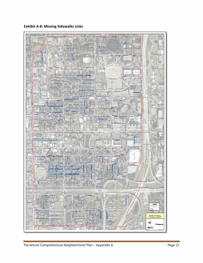
iv. Sidewalks
Sidewalks are the only existing pedestrian facilities within the Parramore
neighborhood. The majority of streets have sidewalks on both sides of the street. 46
blocks of varying lengths have sidewalk on only one side of the street.
Approximately 2 miles of local roadways do not have a sidewalk on either side of the
Parramore Comprehensive Neighborhood Plan – Appendix A Page 19
street. Exhibit A‐8 depicts the areas that are missing sidewalks. The condition of the
sidewalks and location of specific sites needing maintenance or replacement is
documented in Appendix C.
Walking Audits for all three neighborhoods were held February 8, 2014 to review
pedestrian and bicycle mobility and access to transit. Members of the project team,
as well as community members, spent several hours walking through the
neighborhoods and recording their observations. The results from the Walking
Audits can be found in Appendix D.
Overall, the Parramore community provides excellent opportunities for pedestrians,
bicyclists and transit users. Low volume traffic, shade trees and a well‐connected
transit system encourage walking, bicycling and transit use in most areas although
there is need for improvement. Existing, planned and future venues and attractions
create another layer of bicycle/pedestrian and transit needs that are separate from
resident needs.
The roads that border the Parramore community, especially SR 50 and Orange
Blossom Trail, are difficult to cross and create challenges for residents and visitors as
they walk, bike or access transit to areas external to the Parramore neighborhood.
The opening of SunRail, the expansion of LYMMO, the planned K‐8 Community
School, and the planned entertainment venues demand the need for ongoing
coordination and planning to ensure the Parramore area continues to provide
excellent walking, bicycle riding and transit conditions.
Expanding and improving the sidewalk network in Parramore will help to enhance
connectivity within Parramore as well as destinations outside the community. These
efforts will also address access problems for some users, especially those who
depend on wheelchairs, creating a safer, more comfortable, and more user‐friendly
system for all persons.
The City should develop a strategy to address the sidewalk deficiencies, starting in
locations where there are no sidewalks on either side of the street, or on roads
highlighted as Complete Streets on the Vision Plan (including Orange Blossom Trail,
Westmoreland Drive, West Central Street, and West Amelia Street).
Parramore Comprehensive Neighborhood Plan – Appendix A Page 20
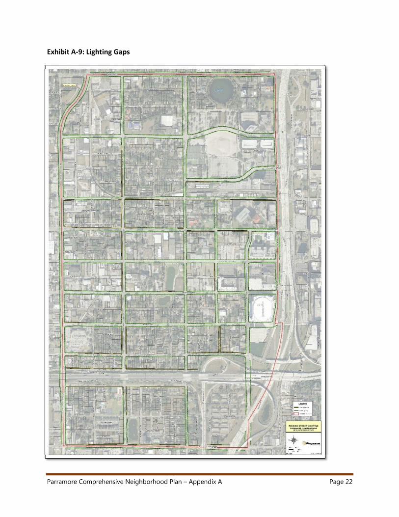
v. Lighting
The Parramore neighborhood and adjacent areas experience increases of pedestrian
activity during events at local venues. Many of these events occur at nighttime,
increasing the importance of lighting on the sidewalks. In general, the neighborhood
has sufficient lighting to provide visibility of sidewalks, but like the sidewalks, there
are areas of the community that need improved street lighting. Exhibit A‐9 shows
the missing sections of street lighting.
For a complete listing of locations, see Appendix C. By increasing consistency and
expectation of lighting in Parramore, people who use the sidewalk system will be
more visible to vehicles and other users, creating a safer pedestrian environment.
The City should develop a strategy to address the lighting deficiencies.
Parramore Comprehensive Neighborhood Plan – Appendix A Page 21
Exhibit A‐8: Missing Sidewalks Links
Parramore Comprehensive Neighborhood Plan – Appendix A Page 22
Exhibit A‐9: Lighting Gaps
Parramore Comprehensive Neighborhood Plan – Appendix A Page 23
b. Stormwater
Parramore contains seven (7) drainage sub‐basins. The Lake Lorna Doone, Lake
Beardall, and Clear Lake sub‐basins are located within the Shingle Creek Regional
Watershed; Lake Dot and Lake Concord are located within the Howell Branch Regional
Watershed; and Rock Lake and Lake Lucerne are land‐locked / closed basins.
With respect to existing problem areas, a coordination meeting was conducted with City
staff on January 10, 2014 to discuss the existing stormwater related data and known
deficiencies within the 819.5 acre study area. With the exception of repetitive flooding
issues in the Pine Street area (located east of Orange Blossom Trail) and the eastern
terminus of Long Street, there are no other known problem areas within the project
limits that exhibit stormwater deficiencies.
However, it is anticipated that future redevelopment projects may need to
accommodate stormwater management on‐site unless the City is able to provide
additional capacity in the master stormwater system. Current and projected
stormwater conditions in specific areas within Parramore, particularly those in close
proximity to the new MLS Soccer Stadium, are currently being evaluated by City staff.
Additional master stormwater system studies in other portion of the Parramore
community may be pursued in the future in order to expedite and encourage
redevelopment efforts. For more detailed information, please see Appendix C.
c. Water/Wastewater
Potable Water Distribution System: A detailed exhibit (Appendix C ‐ Exhibit U‐3) of the
Orlando Utilities Commission (OUC) existing potable water distribution system in the
study area has been prepared based on GIS data provided by OUC. Based on discussions
with OUC staff, they have verified that no deficiencies currently exist in their water
distribution system in the study area.
Sanitary Sewer System: A detailed exhibit (Appendix C ‐ Exhibit U‐4) of the City of
Orlando’s existing sanitary sewer system in the study area has been prepared based on
GIS data provided by the City’s Wastewater Division. Based on discussions with City of
Orlando Wastewater Division staff, no major deficiencies currently exist other than
routine scheduled replacement of certain older gravity sanitary sewers. However, the
City is currently studying wastewater improvements necessary to support the MLS
Soccer Stadium and surrounding redevelopment sites. For more detailed information,
please see Appendix C.
Parramore Comprehensive Neighborhood Plan – Appendix A Page 24
5. Housing
The United States Department of Housing and Urban Development Department (HUD) has
designated the City as an entitlement (or formula grant) community. As an entitlement
community, the city is eligible for federal funds to provide decent housing, create suitable
living environments and expand economic opportunities for principally low and moderate
income persons. The City has prepared a 2011‐2016 Consolidated Plan in order to apply for
HUD approval for this funding.
The City’s Consolidated Plan for Housing and Community Development directs staff to
ensure that grant funding (CDGB, HOME, ESG, and HOPWA) is available to address the
needs of very low‐, low‐, and moderate‐income residents. Although specific geographic
locations have not been identified or targeted, the three neighborhoods that comprise
Parramore meet the HUD criteria for low/moderate income and are therefore eligible for
grant funding assistance.
As of 2013, Parramore is home to 6,175 residents, distributed among 2,235 households and
2,762 housing units2. Approximately 30% of the housing units are single family homes
(mostly detached), while the remainder are in multi‐unit structures, ranging from duplexes
to buildings with 20 or more units.
More than half of the overall housing stock in the community was built over 50 years ago,
but stock age varies by neighborhood. In Holden/Parramore and Callahan, 36% and 40% of
the units are 75 years or older, respectively, whereas in Lake Dot nearly 72% of the units
were built between 35 and 54 years ago. In addition, many housing units qualify as being in
substandard condition and/or not meeting today’s construction or quality standards. Partly
as a result of these factors, the median value of homes in the Parramore community
($81,982 in 2013) is 29% lower than the median home value for the City of Orlando
($134,106).
The majority of Parramore residents (73%) rent rather than own their homes, making the
area having among one of the lowest homeownership rates in the City of Orlando.
However, while many people rent, it should be understood that many residents have rented
homes in the Parramore community for many years – in other words, it is not a transient
community. More than 43% of the households that rent a unit in Parramore are considered
cost‐burdened. Cost‐burdened households are those that pay more than thirty percent
2 Source: WTL +a Market Analysis/ESRI Business Analyst, March 2014
Parramore Comprehensive Neighborhood Plan – Appendix A Page 25
(30%) of income for rent or mortgage costs, according to the U.S. Department of Housing
and Development (HUD).
Socioeconomic conditions limit the ability of many households to easily qualify for financing
to purchase homes. However, homeownership and median home values fluctuate across
the neighborhoods in Parramore, suggesting that tailored strategies might be developed to
address tenure issues at the neighborhood level as well as at the community level:
Exhibit A‐10: Housing Statistics by Neighborhood
Neighborhood Percent Owner (Occupied
Units)
Median Home Value
(Owner Occupied Units)
Lake Dot 11.9% $155,400
Callahan 16.7% $146,948
Holden/Parramore 12.7% $70,014
Slightly more than 19% or 528 of the total housing units in the community are vacant. There
are neighborhood variations related to the status of these units:
Exhibit A‐11: Status of Vacant Units by Neighborhood
Neighborhood Status (Rent/Sale/Other*)
Lake Dot 0%/56%/44%
Callahan 0%/80%/20%
Holden/Parramore 45%/21%/34%
*(2010) Includes any units not on the market but not occupied and units that may
be abandoned, dilapidated and/or not livable
Whereas most of the existing housing units are over 50 years old, many householders in
Parramore did not move into their units until after 1990 (particularly renters). Older units
that are in poor condition offer potential for rehabilitation, renovation or redevelopment.
These older units can be remade into healthier homes through resolution of code
enforcement issues, promoting adequate pest and mold control, or household safety and
protection best practice upgrades. The HUD Healthy Homes Program provides additional
information on how to address household environmental hazards:
http://portal.hud.gov/hudportal/HUD?src=/program_offices/healthy_homes/hhi
In addition to the significant share of vacant residential units that represent potential
opportunities for strengthening the fabric of the existing neighborhoods, approximately
13% (106 acres) of the land in Parramore is currently vacant and offers opportunities for
revitalization. Many of the vacant parcels in the community are zoned Residential (mostly
Parramore Comprehensive Neighborhood Plan – Appendix A Page 26
Low and Medium Density), but they also may include land in other classifications that could
be redeveloped as housing.
More than 40% of the households in Parramore do not have access to an automobile,
indicating the need to carefully integrate the community’s land use, housing, and mobility
strategies.
Shimberg Center Affordable Housing Study
As part of the HUD Sustainable Communities Planning Grant, the Shimberg Center for
Housing Studies at the University of Florida (UF) conducted an evaluation of the 12 Phase‐1
SunRail stations and the reconfiguration of LYNX routes, to determine the affordable
housing and employment needs of each area. It is anticipated that the analysis will also help
formulate strategies to lessen cost burdens to households spending more than 45% of their
income on combined housing and transportation costs.
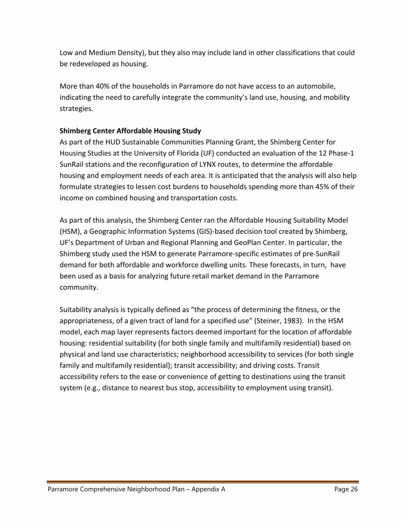
As part of this analysis, the Shimberg Center ran the Affordable Housing Suitability Model
(HSM), a Geographic Information Systems (GIS)‐based decision tool created by Shimberg,
UF’s Department of Urban and Regional Planning and GeoPlan Center. In particular, the
Shimberg study used the HSM to generate Parramore‐specific estimates of pre‐SunRail
demand for both affordable and workforce dwelling units. These forecasts, in turn, have
been used as a basis for analyzing future retail market demand in the Parramore
community.
Suitability analysis is typically defined as “the process of determining the fitness, or the
appropriateness, of a given tract of land for a specified use” (Steiner, 1983). In the HSM
model, each map layer represents factors deemed important for the location of affordable
housing: residential suitability (for both single family and multifamily residential) based on
physical and land use characteristics; neighborhood accessibility to services (for both single
family and multifamily residential); transit accessibility; and driving costs. Transit
accessibility refers to the ease or convenience of getting to destinations using the transit
system (e.g., distance to nearest bus stop, accessibility to employment using transit).
Parramore Comprehensive Neighborhood Plan – Appendix A Page 27
Exhibit A‐12: Affordable Housing Suitability Analysis Schematic
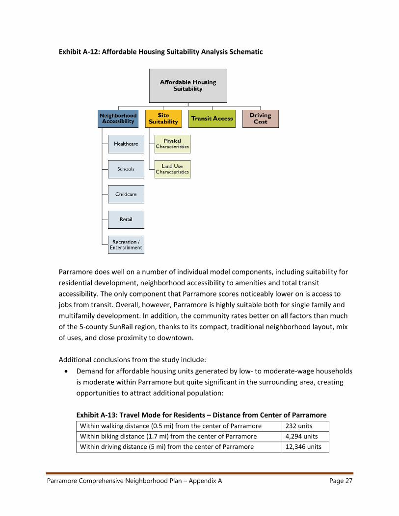
Parramore does well on a number of individual model components, including suitability for
residential development, neighborhood accessibility to amenities and total transit
accessibility. The only component that Parramore scores noticeably lower on is access to
jobs from transit. Overall, however, Parramore is highly suitable both for single family and
multifamily development. In addition, the community rates better on all factors than much
of the 5‐county SunRail region, thanks to its compact, traditional neighborhood layout, mix
of uses, and close proximity to downtown.
Additional conclusions from the study include:
Demand for affordable housing units generated by low‐ to moderate‐wage households
is moderate within Parramore but quite significant in the surrounding area, creating
opportunities to attract additional population:
Exhibit A‐13: Travel Mode for Residents – Distance from Center of Parramore
Within walking distance (0.5 mi) from the center of Parramore 232 units
Within biking distance (1.7 mi) from the center of Parramore 4,294 units
Within driving distance (5 mi) from the center of Parramore 12,346 units
Parramore Comprehensive Neighborhood Plan – Appendix A Page 28
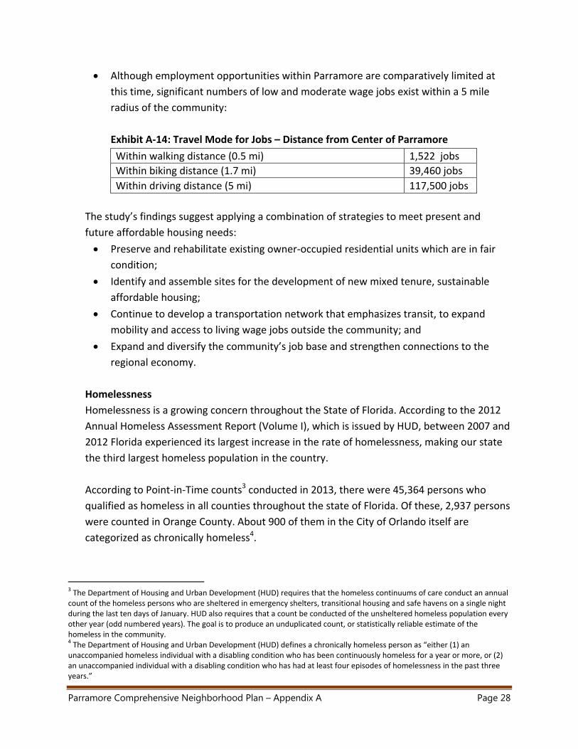
Although employment opportunities within Parramore are comparatively limited at
this time, significant numbers of low and moderate wage jobs exist within a 5 mile
radius of the community:
Exhibit A‐14: Travel Mode for Jobs – Distance from Center of Parramore
Within walking distance (0.5 mi) 1,522 jobs
Within biking distance (1.7 mi) 39,460 jobs
Within driving distance (5 mi) 117,500 jobs
The study’s findings suggest applying a combination of strategies to meet present and
future affordable housing needs:
Preserve and rehabilitate existing owner‐occupied residential units which are in fair
condition;
Identify and assemble sites for the development of new mixed tenure, sustainable
affordable housing;
Continue to develop a transportation network that emphasizes transit, to expand
mobility and access to living wage jobs outside the community; and
Expand and diversify the community’s job base and strengthen connections to the
regional economy.
Homelessness
Homelessness is a growing concern throughout the State of Florida. According to the 2012
Annual Homeless Assessment Report (Volume I), which is issued by HUD, between 2007 and
2012 Florida experienced its largest increase in the rate of homelessness, making our state
the third largest homeless population in the country.
According to Point‐in‐Time counts3 conducted in 2013, there were 45,364 persons who
qualified as homeless in all counties throughout the state of Florida. Of these, 2,937 persons
were counted in Orange County. About 900 of them in the City of Orlando itself are
categorized as chronically homeless4.
3 The Department of Housing and Urban Development (HUD) requires that the homeless continuums of care conduct an annual count of the homeless persons who are sheltered in emergency shelters, transitional housing and safe havens on a single night during the last ten days of January. HUD also requires that a count be conducted of the unsheltered homeless population every other year (odd numbered years). The goal is to produce an unduplicated count, or statistically reliable estimate of the homeless in the community. 4 The Department of Housing and Urban Development (HUD) defines a chronically homeless person as “either (1) an unaccompanied homeless individual with a disabling condition who has been continuously homeless for a year or more, or (2) an unaccompanied individual with a disabling condition who has had at least four episodes of homelessness in the past three years.”
Parramore Comprehensive Neighborhood Plan – Appendix A Page 29
While neighborhood‐level data is not available, it is clear that the incidence of
homelessness in Parramore is one of the most pervasive challenges that the community has
to deal with. Homeless people tend to converge into and around Parramore to some extent
because of the depressed socioeconomic conditions prevalent in the area today, but
primarily as a result of the large concentration of supportive social services available there.
Not only has the over‐concentration of social services had an adverse impact on the
function and image of the community (a fact acknowledged in the City’s Comprehensive
Plan policies that pertain to Parramore), but the needs of the homeless population can
strain already scarce resources in an area facing multiple urgent demands. This is because
the City and Orange County spend millions of dollars each year providing services for the
chronically homeless, including but not limited to EMS/fire and police response, community
health and mental health services, jail bookings, public park cleanup and municipal court
expenses.
In addition to being the right thing to do, addressing the homeless issue in Parramore
makes economic sense –and will be a requirement for the success of this Plan. Various
research studies show that developing solutions to the problem is far more cost effective
than continuing to allow the problem to exist. One recent example, a study conducted for
the Central Florida Commission on Homelessness5, indicates that the average annual cost
per person to provide a continuum of care to chronically homeless individuals in the tri‐
county region including Osceola, Seminole and Orange is in the $30,000 range, whereas
providing permanent supportive housing to those individuals could cost an average of
around $10,000 per person per year.
Recommendations for addressing the homelessness issue in Parramore, Orlando and the
Central Florida region are included in the Plan document – Executive Summary and Chapter
II.
5 Creative Housing Solutions for the Central Florida Commission on Homelessness, 2014, The Cost of Long‐Term Homelessness in Central Florida: The Current Crisis and Economic Impact of Providing Sustainable Housing Solutions. http://www.impacthomelessness.org/resources/docs/eis/Eco‐Impact‐Report‐LOW‐RES.pdf. The study used a cohort of 107 chronic homeless individuals across the tri‐county area.