Embed Size (px)
Citation preview
Volume 1-7 Central Florida Statewide Regional Evacuation Study Program
Appendix IVA – DeSoto County Page IVA-1
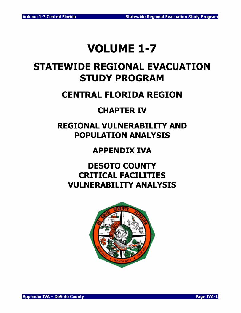
VOLUME 1-7
STATEWIDE REGIONAL EVACUATION STUDY PROGRAM
CENTRAL FLORIDA REGION
CHAPTER IV
REGIONAL VULNERABILITY AND POPULATION ANALYSIS
APPENDIX IVA
DESOTO COUNTY CRITICAL FACILITIES
VULNERABILITY ANALYSIS

Statewide Regional Evacuation Study Program Volume 1-7 Central Florida
Page IVA-2 Appendix IVA – DeSoto County
THIS PAGE INTENTIONALLY LEFT BLANK
Volume 1-7 Central Florida Statewide Regional Evacuation Study Program
Appendix IVA – DeSoto County Page IVA-3
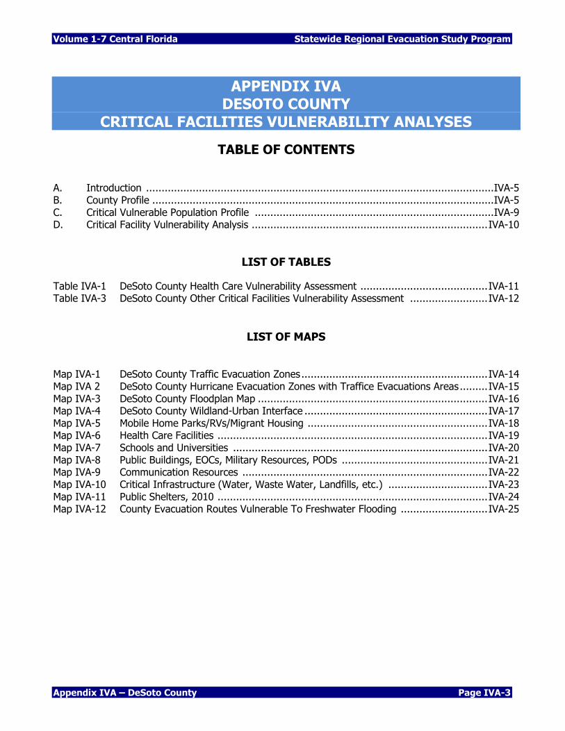
APPENDIX IVA DESOTO COUNTY
CRITICAL FACILITIES VULNERABILITY ANALYSES
TABLE OF CONTENTS
A. Introduction ................................................................................................................ IVA-5 B. County Profile .............................................................................................................. IVA-5 C. Critical Vulnerable Population Profile ............................................................................. IVA-9 D. Critical Facility Vulnerability Analysis ............................................................................ IVA-10
LIST OF TABLES
Table IVA-1 DeSoto County Health Care Vulnerability Assessment ......................................... IVA-11
Table IVA-3 DeSoto County Other Critical Facilities Vulnerability Assessment ......................... IVA-12
LIST OF MAPS
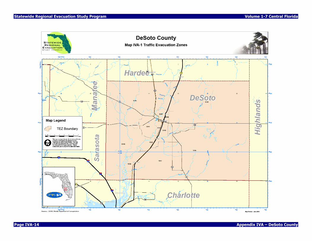
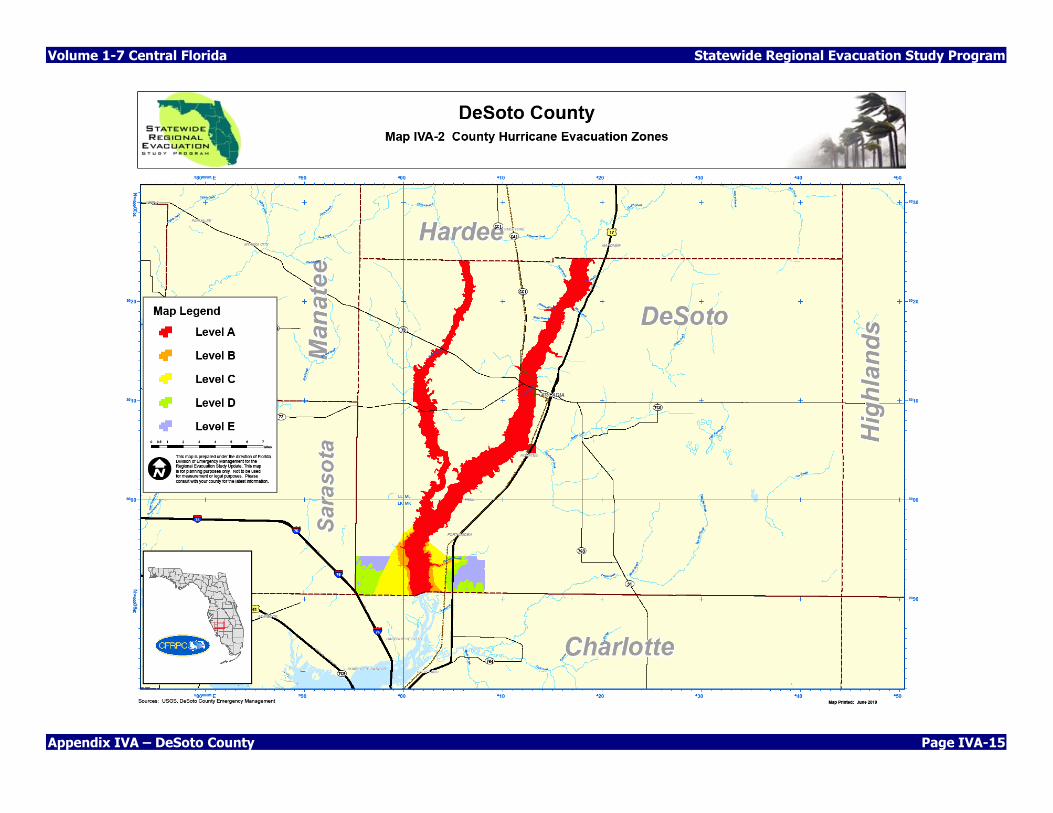
Map IVA-1 DeSoto County Traffic Evacuation Zones ............................................................ IVA-14 Map IVA 2 DeSoto County Hurricane Evacuation Zones with Traffice Evacuations Areas ......... IVA-15
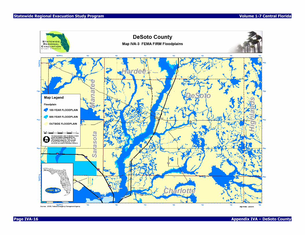
Map IVA-3 DeSoto County Floodplan Map .......................................................................... IVA-16
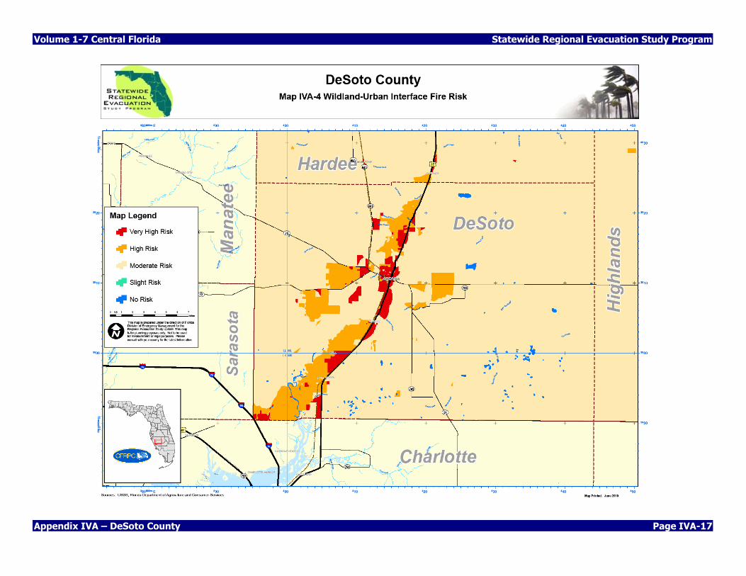
Map IVA-4 DeSoto County Wildland-Urban Interface ........................................................... IVA-17
Map IVA-5 Mobile Home Parks/RVs/Migrant Housing .......................................................... IVA-18
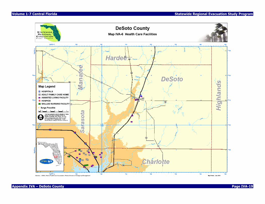
Map IVA-6 Health Care Facilities ....................................................................................... IVA-19
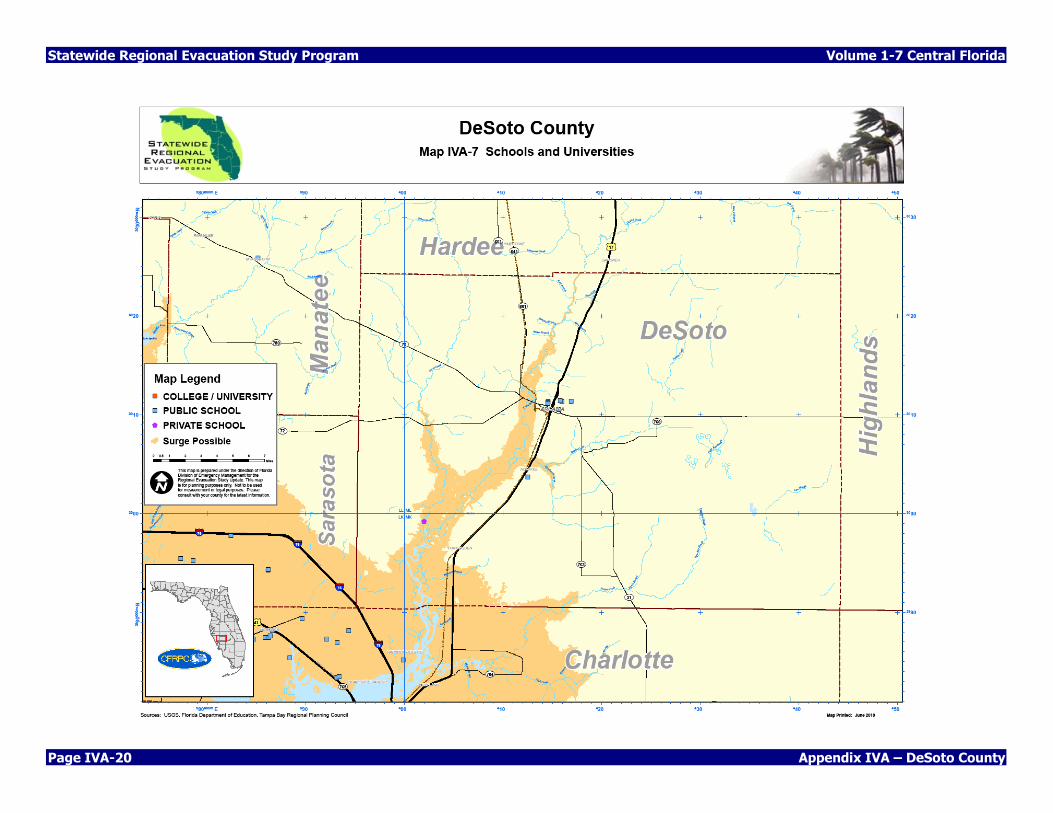
Map IVA-7 Schools and Universities .................................................................................. IVA-20
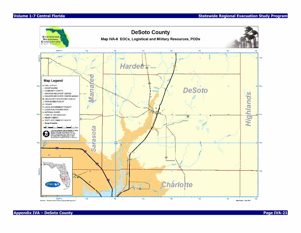
Map IVA-8 Public Buildings, EOCs, Military Resources, PODs ............................................... IVA-21
Map IVA-9 Communication Resources ............................................................................... IVA-22
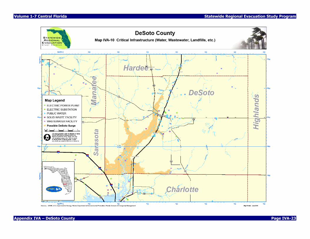
Map IVA-10 Critical Infrastructure (Water, Waste Water, Landfills, etc.) ................................ IVA-23
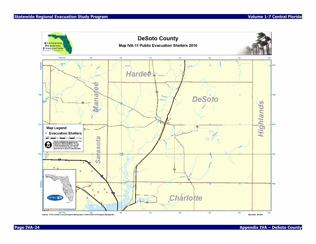
Map IVA-11 Public Shelters, 2010 ....................................................................................... IVA-24
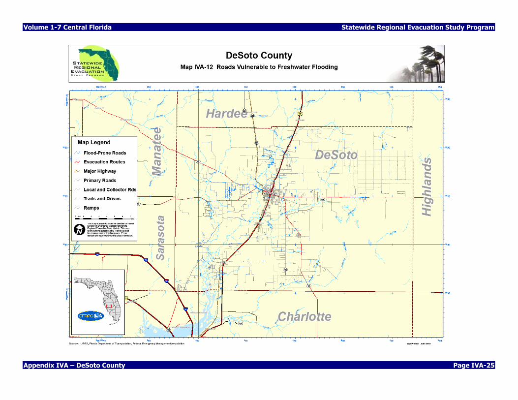
Map IVA-12 County Evacuation Routes Vulnerable To Freshwater Flooding ............................ IVA-25

Statewide Regional Evacuation Study Program Volume 1-7 Central Florida
Page IVA-4 Appendix IVA – DeSoto County
THIS PAGE INTENTIONALLY LEFT BLANK
Volume 1-7 Central Florida Statewide Regional Evacuation Study Program
Appendix IVA – DeSoto County Page IVA-5
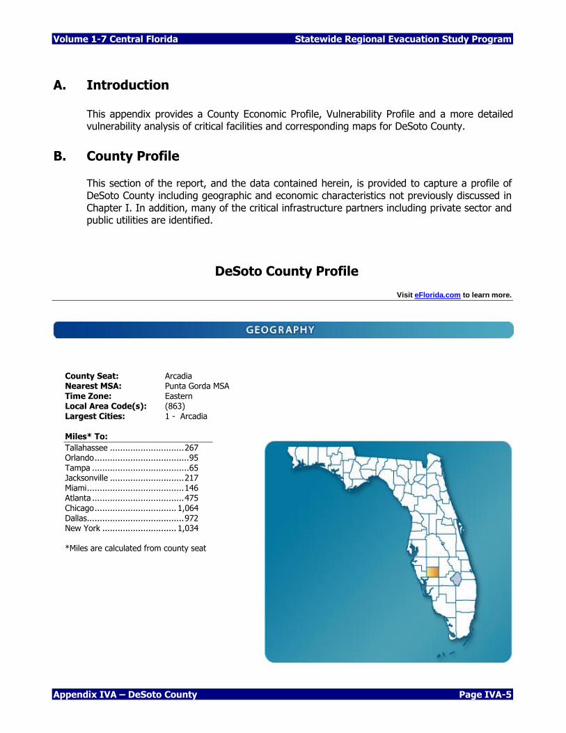
A. Introduction
This appendix provides a County Economic Profile, Vulnerability Profile and a more detailed vulnerability analysis of critical facilities and corresponding maps for DeSoto County.
B. County Profile
This section of the report, and the data contained herein, is provided to capture a profile of DeSoto County including geographic and economic characteristics not previously discussed in Chapter I. In addition, many of the critical infrastructure partners including private sector and public utilities are identified.
DeSoto County Profile Visit eFlorida.com to learn more.
County Seat: Arcadia Nearest MSA: Punta Gorda MSA Time Zone: Eastern Local Area Code(s): (863) Largest Cities: 1 - Arcadia
Miles* To:
Tallahassee ............................. 267 Orlando ..................................... 95 Tampa ...................................... 65 Jacksonville ............................. 217 Miami ...................................... 146 Atlanta .................................... 475 Chicago ................................ 1,064 Dallas...................................... 972 New York ............................. 1,034 *Miles are calculated from county seat
Statewide Regional Evacuation Study Program Volume 1-7 Central Florida
Page IVA-6 Appendix IVA – DeSoto County
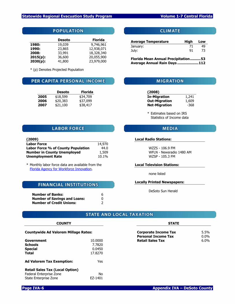
Desoto Florida 1980: 19,039 9,746,961 1990: 23,865 12,938,071 2008: 33,991 18,328,340 2015(p): 36,600 20,055,900 2030(p): 41,800 23,979,000 * (p) Denotes Projected Population
Average Temperature High Low
January: 71 49 July: 91 73 Florida Mean Annual Precipitation .......... 53 Average Annual Rain Days .................... 112
Desoto Florida 2005 $18,599 $34,709 2006 $20,383 $37,099 2007 $21,100 $38,417
(2008)
In-Migration 1,241 Out-Migration 1,609 Net-Migration -368 * Estimates based on IRS
Statistics of Income data
(2009)
Labor Force 14,970 Labor Force % of County Population 44.0 Number in County Unemployed 1,509 Unemployment Rate 10.1% * Monthly labor force data are available from the
Florida Agency for Workforce Innovation.
COUNTY
Countywide Ad Valorem Millage Rates: Government 10.0000 Schools 7.7820 Special 0.0450 Total 17.8270 Ad Valorem Tax Exemption: Yes Retail Sales Tax (Local Option) Federal Enterprise Zone No State Enterprise Zone EZ-1401
STATE
Corporate Income Tax 5.5% Personal Income Tax 0.0% Retail Sales Tax 6.0%
Local Radio Stations:
WZZS - 106.9 FM WFLN - Newsradio 1480 AM WZSP - 105.3 FM Local Television Stations:
none listed
Locally Printed Newspapers:
DeSoto Sun Herald Number of Banks: 6
Number of Savings and Loans: 0 Number of Credit Unions: 2
Volume 1-7 Central Florida Statewide Regional Evacuation Study Program
Appendix IVA – DeSoto County Page IVA-7
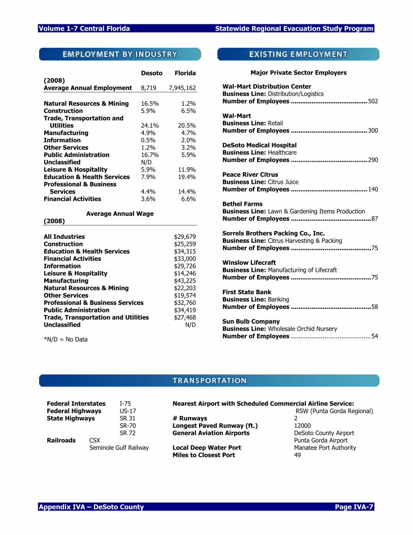
Desoto Florida (2008) Average Annual Employment 8,719 7,945,162
Natural Resources & Mining 16.5% 1.2% Construction 5.9% 6.5% Trade, Transportation and Utilities 24.1% 20.5% Manufacturing 4.9% 4.7% Information 0.5% 2.0% Other Services 1.2% 3.2% Public Administration 16.7% 5.9% Unclassified N/D Leisure & Hospitality 5.9% 11.9%
Education & Health Services 7.9% 19.4% Professional & Business Services 4.4% 14.4% Financial Activities 3.6% 6.6%
Average Annual Wage (2008)
All Industries $29,679 Construction $25,259 Education & Health Services $34,315 Financial Activities $33,000 Information $29,726 Leisure & Hospitality $14,246 Manufacturing $43,225 Natural Resources & Mining $22,203
Other Services $19,574 Professional & Business Services $32,760 Public Administration $34,419 Trade, Transportation and Utilities $27,468 Unclassified N/D *N/D = No Data
Major Private Sector Employers
Wal-Mart Distribution Center Business Line: Distribution/Logistics Number of Employees ......................................... 502 Wal-Mart Business Line: Retail Number of Employees ......................................... 300 DeSoto Medical Hospital Business Line: Healthcare Number of Employees ......................................... 290 Peace River Citrus Business Line: Citrus Juice Number of Employees ......................................... 140 Bethel Farms Business Line: Lawn & Gardening Items Production Number of Employees ........................................... 87 Sorrels Brothers Packing Co., Inc. Business Line: Citrus Harvesting & Packing Number of Employees ........................................... 75 Winslow Lifecraft Business Line: Manufacturing of Lifecraft Number of Employees ........................................... 75
First State Bank Business Line: Banking Number of Employees ........................................... 58 Sun Bulb Company Business Line: Wholesale Orchid Nursery Number of Employees ........................................... 54
Federal Interstates I-75
Federal Highways US-17 State Highways SR 31 SR-70 SR 72 Railroads CSX Seminole Gulf Railway
Nearest Airport with Scheduled Commercial Airline Service:
RSW (Punta Gorda Regional) # Runways 2 Longest Paved Runway (ft.) 12000 General Aviation Airports DeSoto County Airport Punta Gorda Airport Local Deep Water Port Manatee Port Authority Miles to Closest Port 49
Statewide Regional Evacuation Study Program Volume 1-7 Central Florida
Page IVA-8 Appendix IVA – DeSoto County
Source: Enterprise Florida, Inc. 800 North Magnolia Avenue, Suite 1100 Orlando, Florida 32803 Phone: (407) 956-5600 Fax: (407) 956-5599 Visit us on the World Wide Web: http://www.eflorida.com
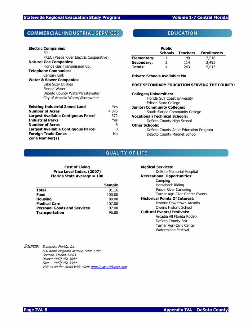
Electric Companies: FPL PREC (Peace River Electric Cooperative) Natural Gas Companies: Florida Gas Transmission Co. Telephone Companies: Century Link Water & Sewer Companies: Lake Suzy Utilities Florida Water DeSoto County Water/Wastewater City of Arcadia Water/Wastewater
Existing Industrial Zoned Land Yes Number of Acres 4,876 Largest Available Contiguous Parcel 672 Industrial Parks Yes Number of Acres 8 Largest Available Contiguous Parcel 8 Foreign Trade Zones No Zone Number(s)
Public
Schools Teachers Enrollments
Elementary: 1 149 2,518 Secondary: 3 114 2,495 Totals: 4 263 5,013 Private Schools Available: No POST SECONDARY EDUCATION SERVING THE COUNTY: Colleges/Universities: Florida Gulf Coast University Edison State College Junior/Community Colleges: South Florida Community College Vocational/Technical Schools: DeSoto County High School Other Schools: DeSoto County Adult Education Program DeSoto County Magnet School
Cost of Living Price Level Index, (2007)
Florida State Average = 100
Sample
Total 91.16 Food 100.00 Housing 80.00 Medical Care 107.00 Personal Goods and Services 97.00 Transportation 96.00
Medical Services: DeSoto Memorial Hospital Recreational Opportunities:
Camping Horseback Riding Peace River Canoeing Turner Agri-Civic Center Events Historical Points Of Interest: Historic Downtown Arcadia Owens Historic School Cultural Events/Festivals: Arcadia All Florida Rodeo DeSoto County Fair Turner Agri-Civic Center Watermelon Festival
Volume 1-7 Central Florida Statewide Regional Evacuation Study Program
Appendix IVA – DeSoto County Page IVA-9
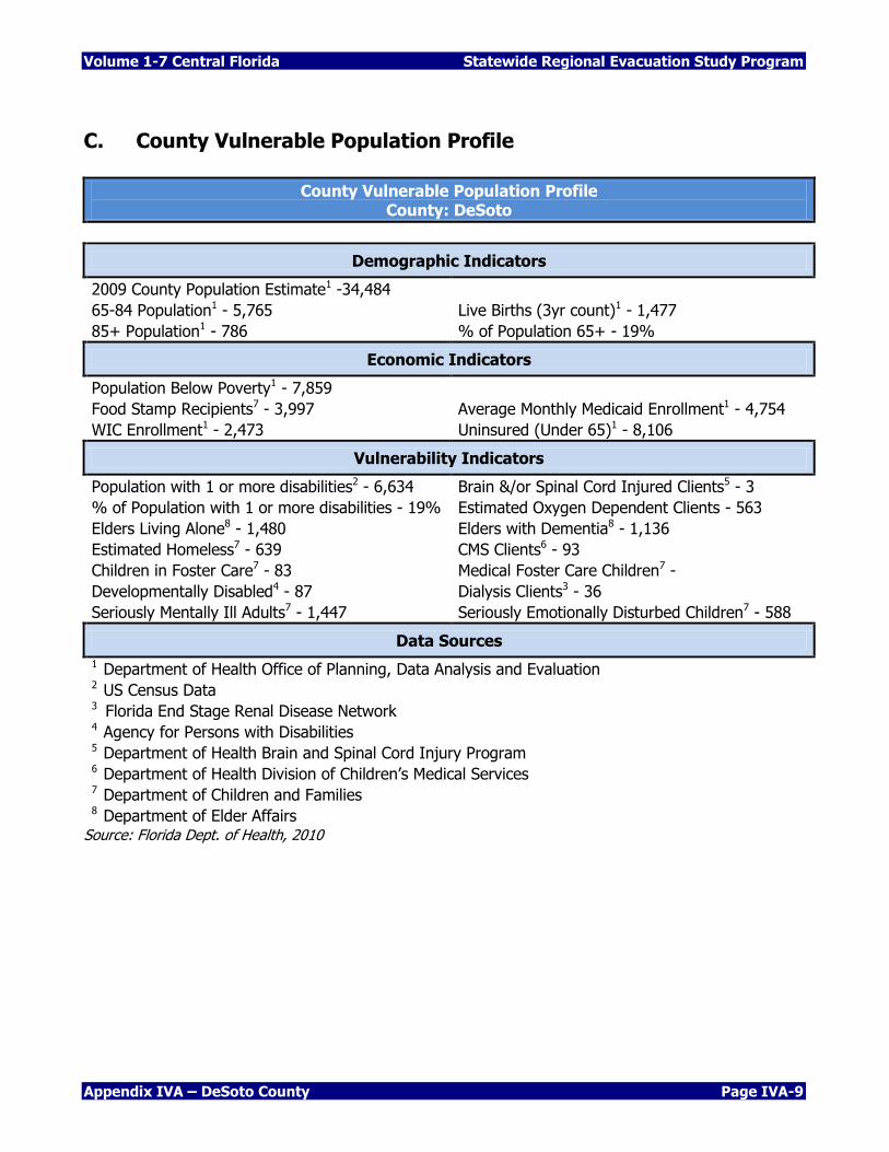
C. County Vulnerable Population Profile
County Vulnerable Population Profile County: DeSoto
Demographic Indicators
2009 County Population Estimate1 -34,484
65-84 Population1 - 5,765 Live Births (3yr count)1 - 1,477
85+ Population1 - 786 % of Population 65+ - 19%
Economic Indicators
Population Below Poverty1 - 7,859
Food Stamp Recipients7 - 3,997 Average Monthly Medicaid Enrollment1 - 4,754
WIC Enrollment1 - 2,473 Uninsured (Under 65)1 - 8,106
Vulnerability Indicators
Population with 1 or more disabilities2 - 6,634 Brain &/or Spinal Cord Injured Clients5 - 3
% of Population with 1 or more disabilities - 19% Estimated Oxygen Dependent Clients - 563
Elders Living Alone8 - 1,480 Elders with Dementia8 - 1,136
Estimated Homeless7 - 639 CMS Clients6 - 93
Children in Foster Care7 - 83 Medical Foster Care Children7 -
Developmentally Disabled4 - 87 Dialysis Clients3 - 36
Seriously Mentally Ill Adults7 - 1,447 Seriously Emotionally Disturbed Children7 - 588
Data Sources
1 Department of Health Office of Planning, Data Analysis and Evaluation 2 US Census Data 3 Florida End Stage Renal Disease Network 4 Agency for Persons with Disabilities 5 Department of Health Brain and Spinal Cord Injury Program 6 Department of Health Division of Children’s Medical Services 7 Department of Children and Families 8 Department of Elder Affairs
Source: Florida Dept. of Health, 2010
Statewide Regional Evacuation Study Program Volume 1-7 Central Florida
Page IVA-10 Appendix IVA – DeSoto County
D. Critical Facility Vulnerability Analysis
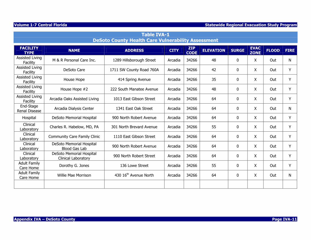
Considerable staff resources were expended to update the critical facilities inventory. Specific attention was paid to health care facilities such as hospitals and nursing homes; emergency response agencies, hazardous materials, mobile home parks, schools and colleges and community centers. Where possible, communications resources and community infrastructure utilities such as water and waste-water facilities were located by latitude and longitude and overlaid on the storm tide limits map. Each facility has the name, location, lat/long coordinates, description, critical code and results of the 2010 surge analysis based on the most accurate topographic data and the SLOSH model. The Critical Facility Inventory (Data base) includes a comprehensive list of critical facilities identified by the State and County Emergency Management Agencies. This inventory is not published as part of the report. However, selected facilities which may require evacuation or mitigation are identified in the tables and maps which follow. The tables indicate vulnerability from storm surge (based on the SLOSH model), freshwater flooding (based on the FEMA Flood Maps) and wildfire (Wildfire Interface/Levels of Concern). The two illustrations below identify the potential storm surge heights on county landmarks. These illustrations are provided for public information purposes only.
Volume 1-7 Central Florida Statewide Regional Evacuation Study Program
Appendix IVA – DeSoto County Page IVA-11
Table IVA-1 DeSoto County Health Care Vulnerability Assessment
FACILITY
TYPE NAME ADDRESS CITY
ZIP
CODE ELEVATION SURGE
EVAC
ZONE FLOOD FIRE
Assisted Living
Facility M & R Personal Care Inc. 1289 Hillsborough Street Arcadia 34266 48 0 X Out N
Assisted Living Facility
DeSoto Care 1711 SW County Road 760A Arcadia 34266 42 0 X Out Y
Assisted Living
Facility House Hope 414 Spring Avenue Arcadia 34266 35 0 X Out Y
Assisted Living
Facility House Hope #2 222 South Manatee Avenue Arcadia 34266 48 0 X Out Y
Assisted Living Facility
Arcadia Oaks Assisted Living 1013 East Gibson Street Arcadia 34266 64 0 X Out Y
End-Stage
Renal Disease Arcadia Dialysis Center 1341 East Oak Street Arcadia 34266 64 0 X Out N
Hospital DeSoto Memorial Hospital 900 North Robert Avenue Arcadia 34266 64 0 X Out Y
Clinical Laboratory
Charles R. Habelow, MD, PA 301 North Brevard Avenue Arcadia 34266 55 0 X Out Y
Clinical Laboratory
Community Care Family Clinic 1110 East Gibson Street Arcadia 34266 64 0 X Out Y
Clinical
Laboratory
DeSoto Memorial Hospital
Blood Gas Lab 900 North Robert Avenue Arcadia 34266 64 0 X Out Y
Clinical Laboratory
DeSoto Memorial Hospital Clinical Laboratory
900 North Robert Street Arcadia 34266 64 0 X Out Y
Adult Family Care Home
Dorothy G. Jones 136 Lowe Street Arcadia 34266 55 0 X Out Y
Adult Family
Care Home Willie Mae Morrison 430 16th Avenue North Arcadia 34266 64 0 X Out N
Statewide Regional Evacuation Study Program Volume 1-7 Central Florida
Page IVA-12 Appendix IVA – DeSoto County
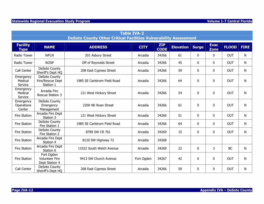
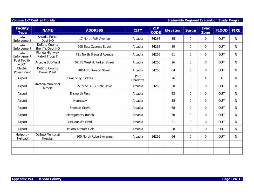
Table IVA-2 DeSoto County Other Critical Facilities Vulnerability Assessment
Facility Type
NAME ADDRESS CITY ZIP
CODE Elevation Surge
Evac Zone
FLOOD FIRE
Radio Tower WFLN 201 Asbury Street Arcadia 34266 61 0 0 OUT N
Radio Tower WZSP Off of Reynolds Street Arcadia 34266 45 0 0 OUT N
Call Center DeSoto County
Sheriff’s Dept HQ 208 East Cypress Street Arcadia 34266 59 0 0 OUT N
Emergency
Medical Service
DeSoto County
Fire/Rescue Dept Station 1
1985 SE Carlstrom Field Road Arcadia 34266 64 0 0 OUT N
Emergency Medical
Service
Arcadia Fire
Rescue Station 3 121 West Hickory Street Arcadia 34266 54 0 0 OUT N
Emergency Operations
Center
DeSoto County Emergency
Management
2200 NE Roan Street Arcadia 34266 61 0 0 OUT N
Fire Station Arcadia Fire Dept
Station 3 121 West Hickory Street Arcadia 34266 51 0 0 OUT N
Fire Station DeSoto County
Fire Station 1 1985 SE Carlstrom Field Road Arcadia 34266 64 0 0 OUT N
Fire Station DeSoto County
Fire Station 2 8789 SW CR 761 Arcadia 34269 15 0 0 OUT N
Fire Station Arcadia Fire Dept
Station 4 8120 SW Highway 72 Arcadia 34268
Fire Station Arcadia Fire Dept
Station 6 11022 South Welch Avenue Arcadia 34269 22 0 3 BC N
Fire Station
Fort Ogden
Volunteer Fire
Dept Station 4
9413 SW Church Avenue Fort Ogden 34267 42 0 0 OUT N
Call Center DeSoto County
Sheriff’s Dept HQ 208 East Cypress Street Arcadia 34266 59 0 0 OUT N
Volume 1-7 Central Florida Statewide Regional Evacuation Study Program
Appendix IVA – DeSoto County Page IVA-13
Facility Type
NAME ADDRESS CITY ZIP
CODE Elevation Surge
Evac Zone
FLOOD FIRE
Law
Enforcement
Arcadia Police
Dept HQ 17 North Polk Avenue Arcadia 34266 55 0 0 OUT N
Law
Enforcement
DeSoto County
Sheriff’s Dept HQ 208 East Cypress Street Arcadia 34266 59 0 0 OUT N
Law Enforcement
Florida Highway Patrol Troop F
721 North Brevard Avenue Arcadia 34266 61 0 0 OUT N
Fuel Facility
– DOT Arcadia Sub-Yard SR 70 West & Parker Street Arcadia 34266 26 0 0 OUT N
Electric
Power Plant
DeSoto County
Power Plant 4051 NE Karson Street Arcadia 34266 64 0 0 OUT N
Airport Lake Suzy Estates Port
Charlotte 26 0 4 DE N
Airport Arcadia Municipal
Airport 2269 SE A. G. Polk Drive Arcadia 34266 58 0 0 OUT N
Airport Ellsworth Field Arcadia 63 0 0 OUT N
Airport Hennessy Arcadia 38 0 0 OUT N
Airport Frierson Grove Arcadia 68 0 0 OUT N
Airport Montgomery Ranch Arcadia 70 0 0 OUT N
Airport McDonald’s Field Arcadia 51 0 0 OUT N
Airport DeSoto Aircraft Field Arcadia 50 0 0 OUT N
Heliport -
Helipad
DeSoto Memorial
Hospital 900 North Robert Avenue Arcadia 34266 64 0 0 OUT N
Statewide Regional Evacuation Study Program Volume 1-7 Central Florida
Page IVA-14 Appendix IVA – DeSoto County
Volume 1-7 Central Florida Statewide Regional Evacuation Study Program
Appendix IVA – DeSoto County Page IVA-15
Statewide Regional Evacuation Study Program Volume 1-7 Central Florida
Page IVA-16 Appendix IVA – DeSoto County
Volume 1-7 Central Florida Statewide Regional Evacuation Study Program
Appendix IVA – DeSoto County Page IVA-17

Statewide Regional Evacuation Study Program Volume 1-7 Central Florida
Page IVA-18 Appendix IVA – DeSoto County
Volume 1-7 Central Florida Statewide Regional Evacuation Study Program
Appendix IVA – DeSoto County Page IVA-19
Statewide Regional Evacuation Study Program Volume 1-7 Central Florida
Page IVA-20 Appendix IVA – DeSoto County
Volume 1-7 Central Florida Statewide Regional Evacuation Study Program
Appendix IVA – DeSoto County Page IVA-21

Statewide Regional Evacuation Study Program Volume 1-7 Central Florida
Page IVA-22 Appendix IVA – DeSoto County
Volume 1-7 Central Florida Statewide Regional Evacuation Study Program
Appendix IVA – DeSoto County Page IVA-23
Statewide Regional Evacuation Study Program Volume 1-7 Central Florida
Page IVA-24 Appendix IVA – DeSoto County
Volume 1-7 Central Florida Statewide Regional Evacuation Study Program
Appendix IVA – DeSoto County Page IVA-25

Statewide Regional Evacuation Study Program Volume 1-7 Central Florida
Page IVA-26 Appendix IVA – DeSoto County
THIS PAGE INTENTIONALLY LEFT BLANK