Embed Size (px)
Citation preview

Ap
pend
ix A – B
iodiversity O
ffset Strategy
Appendix ABiodiversity Offset Strategy


Moorebank Intermodal Company
Biodiversity Offset Areas
Biodiversity Assessment Report16 June 2015

Document information
Client: Moorebank Intermodal CompanyTitle: Biodiversity Offset AreasSubtitle: Biodiversity Assessment ReportDocument No: 2189293E-ECO-REP-001 RevADate: 16 June 2015
Rev Date Details
A 16/06/2015 Draft
Author, Reviewer and Approver details
Prepared by: Tanya Bangel Date: 16/06/2015 Signature
Reviewed by: Paul Rossington Date: 16/06/2015 Signature:
Approved by: Alex Cockerill Date: 16/06/2015 Signature
Distribution
Moorebank Intermodal Company, Parsons Brinckerhoff file
©Parsons Brinckerhoff Australia Pty Limited 2015
Copyright in the drawings, information and data recorded in this document (the information) is the property of ParsonsBrinckerhoff. This document and the information are solely for the use of the authorised recipient and this documentmay not be used, copied or reproduced in whole or part for any purpose other than that for which it was supplied byParsons Brinckerhoff. Parsons Brinckerhoff makes no representation, undertakes no duty and accepts noresponsibility to any third party who may use or rely upon this document or the information.
Document owner
Parsons Brinckerhoff Australia Pty LimitedABN 80 078 004 798Level 3 51-55 Bolton StreetNewcastle NSW 2300PO Box 1162Newcastle NSW 2300AustraliaTel: +61 2 4929 8300Fax: +61 2 4929 8382www.pbworld.comCertified to ISO 9001, ISO 14001, OHSAS 18001

DRAFT
Parsons Brinckerhoff | 2189293E-ECO-REP-001 RevA i
Moorebank Intermodal Company Biodiversity Offset Areas - Biodiversity Assessment Report
ContentsPage number
Glossary iv
1. Introduction 1
1.1 Study area 1
1.2 Study aims 2
2. Methodology 4
2.1 Personnel 4
2.2 Database searches 4
2.3 Field survey 5
2.4 Flora 6
2.5 Fauna habitat assessment 11
2.6 Likelihood-of-occurrence assessment 12
2.7 BioBanking assessment 13
2.8 Limitations 13
3. Existing environment 14
3.1 Landscape assessment 14
3.2 Vegetation types and zones 18
3.3 Fauna habitat 49
3.4 Habitat and geographic features 50
3.5 Threatened communities, populations and species 51
4. Management actions and management plans 58
4.1 Standard management actions 58
4.2 Additional management actions 58
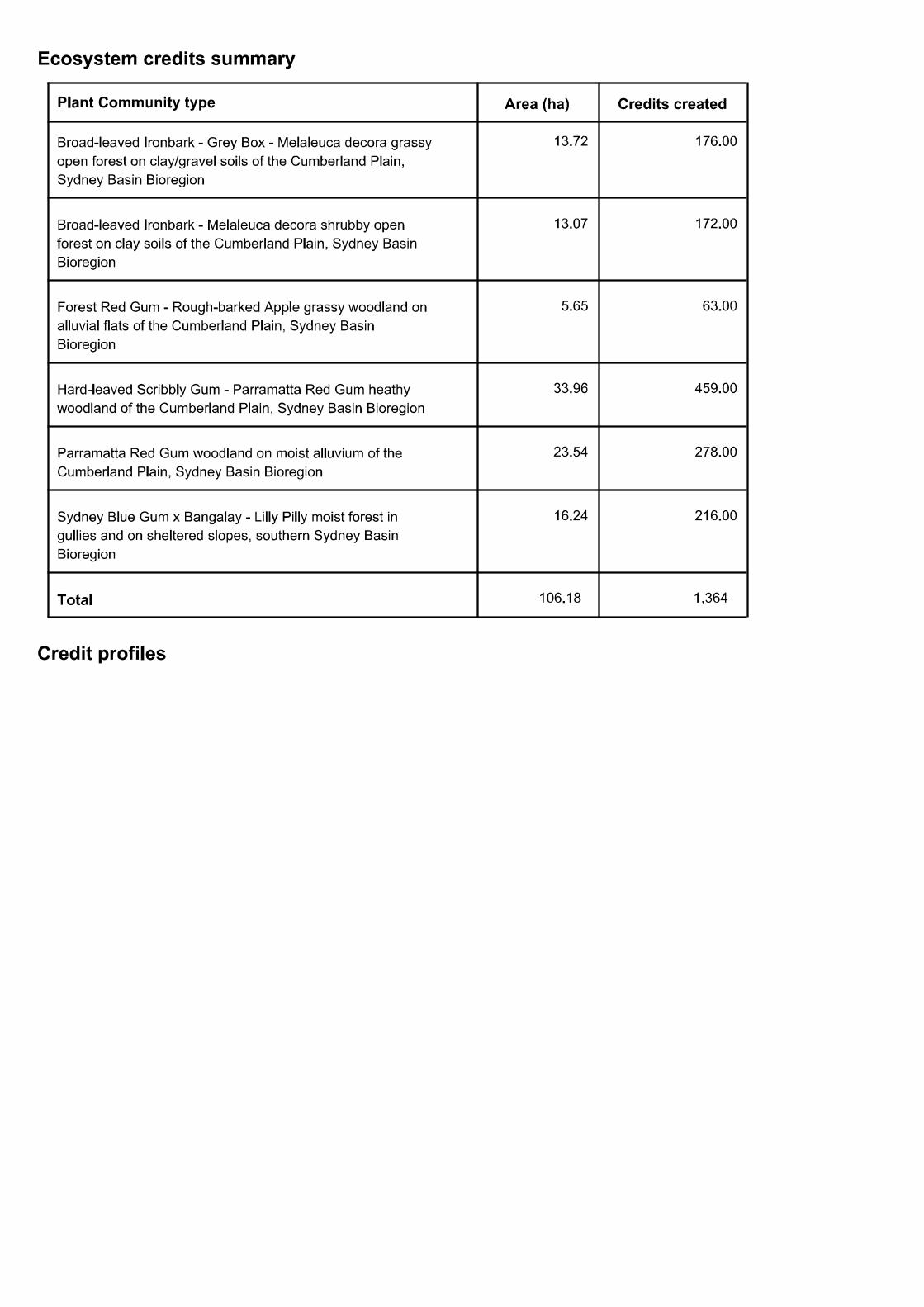
5. BioBanking credit report 60
5.1 Ecosystem credits 60
5.2 Species credits 61
6. References 64

DRAFT
ii 2189293E-ECO-REP-001 RevA | Parsons Brinckerhoff
Moorebank Intermodal Company Biodiversity Offset Areas - Biodiversity Assessment Report
List of tablesPage number
Table 1.1 Study area location 2Table 2.1 Study team 4Table 2.2 Database searches 5Table 2.3 Weather conditions during the site inspection 6Table 2.4 Location of flora quadrats 7Table 2.5 Likelihood of occurrence assessment 12Table 3.1 Study area location 14Table 3.2 Strategic location of the BioBank site 14Table 3.3 Vegetation cover assessment 15Table 3.4 Summary of vegetation type ME004 Broad-leaved Ironbark – Grey Box –
Melaleuca decora grassy open forest on clay/gravel soils of the Cumberland Plain,Sydney Basin 21
Table 3.5 Summary of vegetation type ME002 Broad-leaved Ironbark – Melaleuca decorashrubby open forest on clay soils of the Cumberland Plain, Sydney Basin Bioregion 21
Table 3.6 Summary of vegetation type ME003 Hard-leaved Scribbly Gum – Parramatta RedGum heathy woodland of the Cumberland Plain, Sydney Basin Bioregion 22
Table 3.7 Summary of vegetation type ME005 Parramatta Red Gum woodland on moistalluvium of the Cumberland Plain, Sydney Basin Bioregion 22
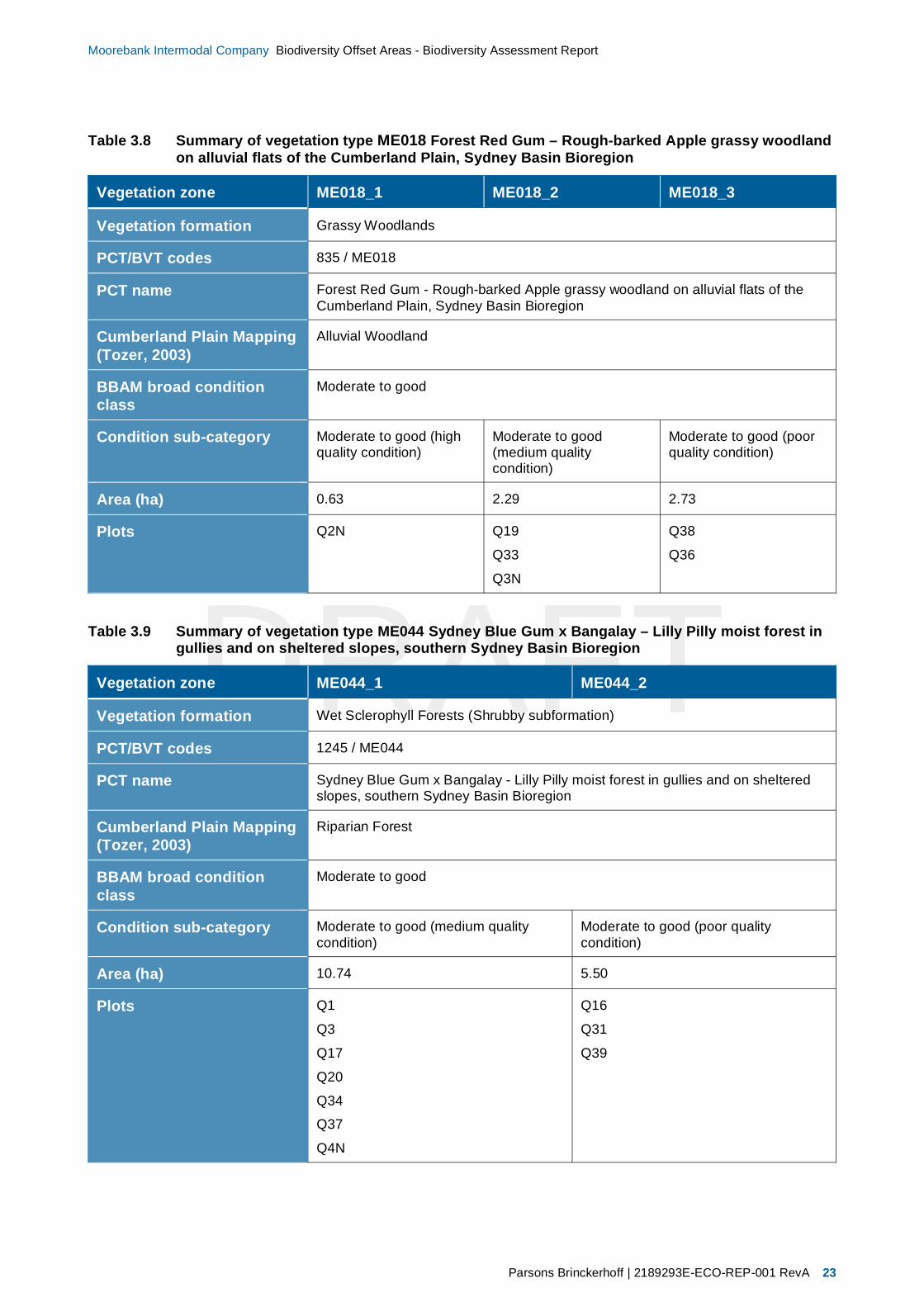
Table 3.8 Summary of vegetation type ME018 Forest Red Gum – Rough-barked Applegrassy woodland on alluvial flats of the Cumberland Plain, Sydney Basin Bioregion 23
Table 3.9 Summary of vegetation type ME044 Sydney Blue Gum x Bangalay – Lilly Pillymoist forest in gullies and on sheltered slopes, southern Sydney Basin Bioregion 23
Table 3.10 Characteristics of ME004 Broad-leaved Ironbark – Grey Box – Melaleuca decoragrassy open forest on clay/gravel soils of the Cumberland Plain, Sydney BasinBioregion 24
Table 3.11 Comparison ME004 Broad-leaved Ironbark – Grey Box – Melaleuca decora grassyopen forest on clay/gravel soils of the Cumberland Plain, Sydney Basin Bioregionquadrat data against vegetation benchmark data 26
Table 3.12 Characteristics of ME002 Broad-leaved Ironbark – Melaleuca decora shrubby openforest on clay soils of the Cumberland Plain, Sydney Basin 27
Table 3.13 Comparison ME002 Broad-leaved Ironbark - Melaleuca decora shrubby openforest on clay soils of the Cumberland Plain, Sydney Basin quadrat data againstvegetation benchmark data 29
Table 3.14 Characteristics of ME003 Hard-leaved Scribbly Gum – Parramatta Red Gumheathy woodland of the Cumberland Plain, Sydney Basin 30
Table 3.15 Comparison ME003 Hard-leaved Scribbly Gum – Parramatta Red Gum heathywoodland of the Cumberland Plain, Sydney Basin quadrat data against vegetationbenchmark data 32
Table 3.16 Characteristics of ME005 Parramatta Red Gum woodland on moist alluvium of theCumberland Plain, Sydney Basin Bioregion 33
Table 3.17 Comparison ME005 Parramatta Red Gum woodland on moist alluvium of theCumberland Plain, Sydney Basin Bioregion quadrat data against vegetationbenchmark data 35
Table 3.18 Characteristics of ME018 Forest Red Gum – Rough-barked Apple grassywoodland on alluvial flats of the Cumberland Plain, Sydney Basin 36
Table 3.19 Comparison ME018 Forest Red Gum – Rough-barked Apple grassy woodland onalluvial flats of the Cumberland Plain, Sydney Basin quadrat data againstvegetation benchmark data 38
Table 3.20 Characteristics of ME044 Sydney Blue Gum X Bangalay – Lilly Pilly moist forest ingullies and on sheltered slopes, southern Sydney Basin 39

DRAFT
Parsons Brinckerhoff | 2189293E-ECO-REP-001 RevA iii
Moorebank Intermodal Company Biodiversity Offset Areas - Biodiversity Assessment Report
List of tables (Continued)
Page number
Table 3.21 Comparison ME044 Sydney Blue Gum X Bangalay – Lilly Pilly moist forest ingullies and on sheltered slopes, southern Sydney Basin quadrat data againstvegetation benchmark data 41
Table 3.22 Characteristics of the exotic vegetation within the study area 42Table 3.23 Noxious weeds identified on the site 44Table 3.24 BioBanking Plot data 45Table 3.25 Threatened species of plant with potential to occur in habitat of the study area 52Table 3.26 Threatened species of animal with potential to occur in habitat within the study
area 53Table 3.27 Threatened species predicted to occur by the BioBanking calculator within the
Wattle Grove Offset Area 54Table 3.28 Threatened species predicted to occur by the biobanking calculator within the
Moorebank Conservation Area and Casula Offset Area 55Table 5.1 Summary of ecosystem credits 60Table 5.2 Summary of species credits 63
List of figuresPage number
Figure 1.1 Locality plan 3Figure 2.1 Survey effort 9Figure 2.2 Schematic diagram illustrating the layout of the nested 20 x 50 m and 20 x 20 m
quadrats used for the assessment of condition attributes at each site 10Figure 3.1 Mitchell landscape 16Figure 3.2 Landscape ssessment – Moorebank Conservation Area and Casula Offset Area 17Figure 3.3 Vegetation zones 20Figure 3.4 Threatened biodiversity 57Figure 4.1 Management zones 59
List of appendicesAppendix A Species of plant recordedAppendix B Threatened species of plantAppendix C Threatened species of animalAppendix D BioBanking credit report
DRAFT
iv 2189293E-ECO-REP-001 RevA | Parsons Brinckerhoff
Moorebank Intermodal Company Biodiversity Offset Areas - Biodiversity Assessment Report
GlossaryBBAM The NSW BioBanking Assessment Methodology 2014.
Biodiversity The biological diversity of life is commonly regarded as being made up of thefollowing three components:
genetic diversity – the variety of genes (or units of heredity) in any populationspecies diversity – the variety of speciesecosystem diversity – the variety of communities or ecosystems.
Critical Habitat The whole or any part or parts of an area or areas of land comprising the habitat ofan endangered species, an endangered population or an endangered ecologicalcommunity that is critical to the survival of the species, population or ecologicalcommunity (Department of Environment and Conservation 2004). Critical habitat islisted under both the Threatened Species Conservation Act 1995 and theEnvironment Protection and Biodiversity Conservation Act 1999 and both the State(OEH) and Federal (DoE) environment agencies maintain a register of this habitat.Capitalisation of the term ‘Critical Habitat’ in this report refers to the habitat listedspecifically under the relevant State and Commonwealth legislation.
Department of theEnvironment (DoE)
The Department of the Environment changed name in 2013 from the Department ofSustainability, Environment, Water, Population and Communities (SEWPAC) to thecurrent name.
Department ofEnvironment, ClimateChange and Water(DECCW)
The most recent former name for the NSW Office of Environment and Heritage(OEH).
Department ofSustainability,Environment, Water,Population andCommunities (SEWPAC)
The Commonwealth Department of Sustainability, Environment, Water, Populationand Communities changed name in 2010 from the Department of Department ofthe Environment, Water, Heritage and the Arts (DEWHA) to the current name.
The department develops and implements national policy, programs and legislationto protect and conserve Australia's natural environment and cultural heritage andadministers the Environment Protection and Biodiversity Conservation Act 1999.
Department of theEnvironment, Water,Heritage and the Arts(DEWHA)
The most recent former name of the Commonwealth Department of Sustainability,Environment, Water, Population and Communities (SEWPAC).
Ecological community An assemblage of species occupying a particular area.
Environmental weed Any plant that is not native to a local area that has invaded native vegetation.
Habitat An area or areas occupied, or periodically or occasionally occupied by a species,population or ecological community, including any biotic or abiotic components.

DRAFT
Parsons Brinckerhoff | 2189293E-ECO-REP-001 RevA v
Moorebank Intermodal Company Biodiversity Offset Areas - Biodiversity Assessment Report
Key ThreateningProcesses
A process that threatens, or could threaten, the survival, abundance or evolutionarydevelopment of native species, populations or ecological communities (Departmentof Environment and Conservation 2004). Key Threatening Processes are listedunder the Threatened Species Conservation Act 1995, the Fisheries ManagementAct 1994 and the Environment Protection and Biodiversity Conservation Act 1999.Capitalisation of the term ‘Key Threatening Processes’ in this report refers to thoseprocesses listed specifically under the relevant state and Commonwealthlegislation.
Likely Taken to be a real chance or possibility (Department of Environment andConservation 2004).
Locality The area within 10 km of the study area.
Local population The population that occurs within the study area, unless the existence ofcontiguous or proximal occupied habitat and the movement of individuals orexchange of genetic material across the boundary can be demonstrated(Department of Environment and Climate Change 2007).
MIC The Moorebank Intermodal Company (MIC).
Management zone (MZ) A defined vegetation zone that is subject to specific management actions within abiobank site.
Migratory species Species protected as Migratory under the Environment Protection and BiodiversityConservation Act 1999. Listed migratory species are those listed in the Conventionon the Conservation of Migratory Species of Wild Animals (Bonn Convention),China-Australia Migratory Bird Agreement (CAMBA), Japan-Australia MigratoryBird Agreement (JAMBA) and Republic of Korea – Australia Migratory BirdAgreement (RoKAMBA). Listed migratory species also include any native speciesidentified in an international agreement approved by the Minister (Matthei 1995).Capitalisation of the term ‘Migratory’ in this report refers to those species listed asMigratory under the Environment Protection and Biodiversity Conservation Act1999.
Moorebank IntermodalTerminal (IMT)
The Moorebank Intermodal Terminal (IMT) is a project proposed by the MoorebankIntermodal Company that involves the construction and operation of an IMT andassociated infrastructure, facilities and warehousing at Moorebank in NSW. TheProject also includes a rail link connecting the IMT site to the Southern SydneyFreight Line (SSFL) and a road entry and exit points from Moorebank Avenue atMoorebank in NSW.
Office of Environment andHeritage (OEH)
Following the 2010 NSW elections the NSW Department of Environment ClimateChange and Water (DECCW) was abolished, is now known as the Office ofEnvironment and Heritage, and has been incorporated into the Department ofPremier and Cabinet.
Broadly, the Office of Environment and Heritage works towards a healthyenvironment cared for and enjoyed by the whole NSW community: manages thestate’s natural resources, including biodiversity, soils and natural vegetation:manages natural and cultural heritage across the state’s land and waters: acts tominimise the impacts of climate change: promotes sustainable consumption,resource use and waste management: regulates activities to protect theenvironment: and conducts biodiversity, plant, environmental and cultural heritageresearch to improve decision making.

DRAFT
vi 2189293E-ECO-REP-001 RevA | Parsons Brinckerhoff
Moorebank Intermodal Company Biodiversity Offset Areas - Biodiversity Assessment Report
Protected species Those species defined as protected under the National Parks and Wildlife Act1974. Includes all native animals, and all native plants listed on Schedule 13 of theNational Parks and Wildlife Act 1974.
Region A bioregion defined in a national system of bioregionalisation. For this study, this isthe Sydney Basin Bioregion as defined in the Interim BiogeographicRegionalisation for Australia (Thackway & Cresswell 1995).
Significant Important, weighty, or more than ordinary (as defined by the Department ofEnvironment and Climate Change 2007).
SSFL South Sydney Freight Line.
Study area The specific area that has been assessed for flora and fauna present.
Subject site The extent of direct impacts from the proposal. This includes the footprint of theproposal, associated with the proposed infrastructure and potential constructionwork sites.
Threatened biodiversity Threatened species, populations or ecological communities, or their habitats aslisted under the Threatened Species Conservation Act 1995 Fisheries ManagementAct 1994 or the Environment Protection and Biodiversity Conservation Act 1999.
Capitalisation of the terms ‘Threatened’ in this report refers to listing under therelevant State and/or Commonwealth legislation.
Threatened species,populations and ecologicalcommunities
Species, populations and ecological communities listed as Vulnerable, endangeredor critically endangered (collectively referred to as Threatened) under theThreatened Species Conservation Act 1995, Fisheries Management Act 1994 orthe Environment Protection and Biodiversity Conservation Act 1999.
Capitalisation of the terms ‘threatened’, ‘vulnerable’, ‘endangered’ or ‘criticallyendangered’ in this report refers to listing under the relevant state and/orCommonwealth legislation.
Vegetation zone (VZ) A defined area of vegetation that is identified as homogeneous based onvegetation type and condition.
Viable local population A population that has the capacity to live, develop, and reproduce under normalconditions, unless the contrary can be conclusively demonstrated through analysisof records and references ( Department of Environment and Climate Change2007).
Weeds of NationalSignificance
In 1998, Australian governments endorsed a framework to identify which weedspecies could be considered (WONS) within an agricultural, forestry andenvironmental context. Thirty one WONS were identified through this process(Biosis Research 2003).

DRAFT
Parsons Brinckerhoff | 2189293E-ECO-REP-001 RevA 1
Moorebank Intermodal Company Biodiversity Offset Areas - Biodiversity Assessment Report
1. IntroductionThis report provides a Biodiversity Assessment of biodiversity conservation values within three biodiversityoffset sites located in the Liverpool City Council (LCC). The biodiversity offset sites are to be utilised as partof a biodiversity offset package for impacts on biodiversity associated with the proposed construction of theMoorebank IMT Project (henceforth, referred to as the Project). The proposed Project includes theconstruction and operation of the IMT and associated infrastructure, facilities and warehousing. The Projectalso includes a rail link connecting the IMT site to the Southern Sydney Freight Line (SSFL) and a road entryand exit points from Moorebank Avenue at Moorebank in NSW.
Moorebank Intermodal Company (henceforth, referred to as MIC) are investigating whether proposedbiodiversity offset sites located within the LCC can be utilised as River-flat Eucalypt Forest (i.e. RiparianForest and Alluvial Woodland), Castlereagh Swamp Woodland, Cooks River/Castlereagh Ironbark Forestand Castlereagh Scribbly Gum Woodland offsets for the Project. This Biodiversity Assessment Report hasbeen prepared to support the establishment of a BioBanking agreement on this land.
1.1 Study areaThe biodiversity offset sites are located on land in the Sydney suburb of Moorebank, NSW (refer Figure 1.1).The three biodiversity offset sites include:
Wattle Grove Offset Area – management to maintain or improve the condition of vegetation and habitatof native vegetation (approximately 73.81 ha) within part of the eastern portion of Lot 3001 DP 1125930(east of Moorebank Avenue) which adjoins the East Hills Railway Line to the south, land owned by theSIMTA consortium to the northwest, and the residential area of the Wattle Grove to the east(Figure 1.1).
Moorebank Conservational Area – Georges River riparian zone: restoration and management of theGeorges River riparian zone (approximately 32.3–38.6 ha) including the eastern side of the rivercorridor from approximately 300 m south of the M5 Motorway for a length of approximately 2.5 km southto the East Hills Railway Line (Figure 1.1).
Casual Offset Area (also referred to as the ‘hourglass land): restoration and management of vegetationwithin Lot 4 DP 1130937 which is an irregular shaped allotment (approximately 3.2 ha) on the westernside of the Georges River opposite the Project site (Figure 1.1).
The sites are large and botanically diverse, containing six vegetation communities, including five endangeredecological communities (including Shale Gravel Transition Forest, Cooks River/Castlereagh Ironbark Forest,Castlereagh Scribbly Gum Woodland, Castlereagh Swamp Woodland and River-flat Eucalypt Forest) andknown habitat for at least three threatened plant species: the vulnerable Grevillea parviflora subsp. parvifloraAcacia pubescens, and the endangered Persoonia nutans. The site also provides habitat for threatenedfauna including the Little Lorikeet, Grey-headed Flying Fox, Powerful Owl, Swift Parrot and the EasternBentwing-bat which are all dependent on the forest ecosystem.
In order to determine the proposed biobank site, the potential biobank footprint was subject to detailed fieldassessment in accordance with BioBanking Assessment Methodology 2014 (BBAM) (Seidel & Briggs 2008).The proposed biobank footprint was then stratified into vegetation and management zones. The finalproposed biobank site was determined based on management costing that could be adequately funded bythe Project.
Location information for the study area is outlined in Table 1.1.
DRAFT
2 2189293E-ECO-REP-001 RevA | Parsons Brinckerhoff
Moorebank Intermodal Company Biodiversity Offset Areas - Biodiversity Assessment Report
Table 1.1 Study area location
Location information Study area
Bioregion Sydney Basin bioregion
Botanical subregion Central Coast
Local government area Liverpool
Catchment Management Authority, subregion Sydney Metropolitan CMA – Georges River sub-region
1.2 Study aimsThe overall objective of this study was to provide supporting information required to establish a proposedBioBanking site. Specifically, this assessment aimed to:
Complete a Biodiversity Assessment Report describing the biological characteristics of the proposedbiobank site.
Determine and describe the characteristics and condition of the vegetation communities and flora andfauna habitats.
Determine the occurrence, or likelihood of occurrence within the study area, of threatened species,populations and communities (biodiversity) listed under the NSW Threatened Species Conservation Act1995, Fisheries Management Act 1994 and Commonwealth Environmental Protection and BiodiversityConservation Act 1999.
Complete a Biodiversity Credit Report using the BioBanking credit calculator to set out the number andtype of biodiversity credits that will be created from the proposed BioBanking site.

STOV
BARDIA
M7
ENU
6238000624000062420006244000

DRAFT
4 2189293E-ECO-REP-001 RevA | Parsons Brinckerhoff
Moorebank Intermodal Company Biodiversity Offset Areas - Biodiversity Assessment Report
2. MethodologyThe biodiversity assessment for the proposed biobank site included desk-based searches of relevantdatabases and historical records, as well as field inspections of the study area. This section outlines thespecific methods used to survey and assess biodiversity within and surrounding the study area.
2.1 PersonnelThe contributors to the preparation of this paper, their qualifications and roles are listed in Table 2.1.
Table 2.1 Study team
Name Qualifications Position and role
Paul Rossington BSc, Dip WldMgt Senior Ecologist – field surveys
Tanya Bangel BSc (Hons) Senior Ecologist – field surveys, report preparation
Debbie Landenberger BSc (Hons) Ecologist – field surveys
Kim Lentz BSc Ecologist – field surveys
Troy Jennings BSc Graduate Ecologist – field surveys
Alex Cockerill BSc (Hons), AccreditedBioBanking assessor
BioBanking assessment, calculations and reporting
All work was carried out under the appropriate licences, including scientific licences as required underClause 22 of the National Parks and Wildlife Regulations 2002, Section 132C of the NPW Act (LicenseNumber: SL100630) as well as an animal research authority issued by the Department of Trade andInvestment, Regional Infrastructure and Services (Primary Industries).
2.2 Database searchesThe aim of this background research was to identify threatened flora and fauna species, populations andecological communities; Commonwealth listed Migratory species or critical habitat recorded previously orpredicted to occur in the vicinity of the study area.
This allowed the known habitat characteristics to be compared with those of the study area to determinatethe likelihood of occurrence of each species or population. This assessment included a review of:
Research papers, books and other published data.Aerial photographs.The Native Vegetation of the Cumberland Plain, Wester Sydney and recent update (Tozer 2003; Tozeret al. 2006)Moorebank Intermodal Freight Terminal – Ecological Impact Assessment (ENSR Australia 2008)Moorebank Intermodal Terminal – Biodiversity Offset Strategy (Parsons Brinckerhoff 2014)Database searches (refer Table 2.2 and Appendix A and B).

DRAFT
Parsons Brinckerhoff | 2189293E-ECO-REP-001 RevA 5
Moorebank Intermodal Company Biodiversity Offset Areas - Biodiversity Assessment Report
Table 2.2 Database searches
Database Date of search Search area Reference
Bionet Atlas of NSWWildlife
29 April 2014 10 km x 10 km locality search Office of Environment andHeritage (2015a)
PlantNet Database 29 April 2014 10 km x 10 km locality search Royal Botanic Gardens (2015)
EPBC Protected MattersSearch Tool
29 April 2014 10 km x 10 km locality search Department of the Environment(2015b)
NSW Threatened AquaticFauna Database
29 April 2014 Hawkesbury Nepean CMA Department of Trade andInvestment Regional Infrastructureand Services (2015b)
2.2.1 Nomenclature
Names of vegetation communities used in this report are based on the Plant Community Type (PCT) used inthe NSW Vegetation Information System (VIS) Classification 2.1 Database (Office of Environment & Heritage2014d).
These names are cross-referenced with those used for threatened ecological communities listed under theThreatened Species Conservation Act 1995 and/or the Environment Protection and BiodiversityConservation Act 1999 Act. They are also cross-referenced with (Tozer 2003; Tozer et al. 2006) previousvegetation mapping by in ‘The Native Vegetation of the Cumberland Plain, Wester Sydney’ and recentupdate using dominant species and structure of the community.
Names of plants used in this document follow Harden (Harden 1992, 1993, 2000, 2002) with reference toPlantNet (Royal Botanic Gardens 2015) for recent taxonomic changes. Scientific names are used in thisreport for species of plant. Scientific and common names (where available) are provided in plant lists inAppendices A and C. The names of introduced species are denoted with an asterisk (*).
For threatened species of plants, the names used in the OEH Threatened Species Website (Office ofEnvironment and Heritage 2015b) are also provided in the tabulated data in Appendices A and B wherethese differ from the names used by Harden or the PlantNet database.
Names of vertebrate fauna follow the Australian Faunal Directory maintained by the Department of theEnvironment (Department of the Environment 2015a). Common names are used in the report for species ofanimal. Scientific names are included in species lists found in Appendices B and D.
For threatened species of animals, the names used in the OEH Threatened Species Website and NSWDepartment of Trade and Investment Regional Investment Regional Infrastructure and Services Threatenedand Protected species website (Department of Trade and Investment Regional Infrastructure and Services2015b; Office of Environment and Heritage 2015b) are also provided in the tabulated data in Appendices Cwhere these differ from the names used by the Australian Faunal Database.
2.3 Field surveyThe study area was inspected during daylight hours by a team of two ecologists on 5, 20, 21, 22, 23, 26 and27 May 2014 and by two ecologists on 30 April 2015 and 1 May 2015.
Field surveys were conducted in accordance with BBAM (Seidel & Briggs 2008) as described in Section 2.4and 2.5 of this report.

DRAFT
6 2189293E-ECO-REP-001 RevA | Parsons Brinckerhoff
Moorebank Intermodal Company Biodiversity Offset Areas - Biodiversity Assessment Report
2.3.1 Weather conditions
Weather conditions were generally warm with some light winds (Table 2.3). No rainfall was recorded duringthe 2014 survey however light rainfall was recorded (~7.2 mm) during the April and May 2015 survey period.
Table 2.3 Weather conditions during the site inspection
Date Qualifications Rain (mm) Wind speed (km/h) /Direction
Min (°C) Max (°C)
5 May 2014 5.1 19.5 0 31/WSW
20 May 2014 8.9 24.3 0 20/NNW
21 May 2014 10.6 23.1 0 24/NNE
22 May 2014 8.6 25.2 0 20/NW
23 May 2014 7.9 25.2 0 20/NW
26 May 2014 9.9 25.4 0 26/N
27 May 2014 11.5 23.8 0 50/N
30 April 2015 13.1 19 2.8 35/WSW
1 May 2015 12.8 20.5 3.4 28/S
(1) Data from Bureau of Meteorology (Bureau of Meteorology 2015) – Holsworthy Aerodrome (station 0666161)
2.4 FloraThe floristic diversity and possible presence of threat-listed species was assessed using a combination ofrandom meander and plot-based (quadrat/transect) surveys in accordance with BBAM (Seidel & Briggs2008).
Random meander surveys are a variation of the transect type survey and were completed in accordance withthe technique described by Cropper (1993), whereby the recorder walks in a random manner throughout theStudy Area recording species observed, boundaries between various vegetation communities and conditionof vegetation. The time spent in each vegetation patch was generally proportional to the size of the patchand its species richness.
2.4.1 Field verification of existing vegetation mapping
Vegetation within the study area and locality had already been mapped at the regional scale in the NativeVegetation of the Cumberland Plain, Wester Sydney and update (Tozer 2003; Tozer et al. 2006). Data ongeology, dominant canopy species, native diversity, vegetation structure and condition was collected acrossthe study area to validate and refine this existing vegetation classification to determine their classification asPlant Community Types (PCTs) required to be used by BBAM in the BioBanking assessment and thedelineation of vegetation type boundaries.
2.4.2 Quadrat and transect surveys
35 quantitative (quadrat/transect) site surveys (Table 2.4 and Figure 2.1) were undertaken as outlined in themethodology contained within the BBAM (Seidel & Briggs 2008) as described below. Figure 2.2 illustratesthe plot layout that was used at each BioBanking site.

DRAFT
Parsons Brinckerhoff | 2189293E-ECO-REP-001 RevA 7
Moorebank Intermodal Company Biodiversity Offset Areas - Biodiversity Assessment Report
Table 2.4 Location of flora quadrats
Plot Easting Northing Orientation (magneticdegrees from North)
Wattle Grove Offset Area
BB1 309165 6241019 270
BB2 309248 6240883 30
BB3 309209 6240882 15
BB4 308759 6240894 0
BB5 308668 6240908 80
BB6 309049 6240719 230
BB7 308756 6240675 50
BB8 308660 6240536 50
BB9 308866 6240798 270
BB10 308635 6240487 100
BB11 308655 6240245 60
BB12 308826 6239938 330
BB13 308837 6240092 160
BB14 308916 6240340 230
BB15 308573 6240149 75
BB16 308569 6240050 85
BB17 309074 6241131 270
Q1N 309154 6241152 98
Moorebank Conservation Area and Casula Offset Area
Q1 307012 6241153 5
Q3 307142 6241045 20
Q16 307042 6240933 5
Q17 307288 6239922 195
Q19 307294 6241051 105
Q20 307186 6240476 345
Q31 307466 6241638 195
Q333 307995 6241307 10
Q34 309154 6241152 138
Q35 309154 6241152 130
Q36 309154 6241152 168
Q37 309154 6241152 153
Q38 309154 6241152 336

DRAFT
8 2189293E-ECO-REP-001 RevA | Parsons Brinckerhoff
Moorebank Intermodal Company Biodiversity Offset Areas - Biodiversity Assessment Report
Plot Easting Northing Orientation (magneticdegrees from North)
Q39 309154 6241152 238
Q2N 309154 6241152 10
Q3N 309154 6241152 27
Q4N 309154 6241152 189
(1) Co-ordinate System = GDA 94 Zone 56(2) Plot sampled within potential biobank footprint although located outside the final proposed biobank site(3) Quadrats from the Moorebank development site that are representative of the ME018 (Forest Red Gum – Rough-barked Apple
grassy woodland on alluvial flats of the Cumberland Plain, Sydney Basin) vegetation community.

624000062410006242000

DRAFT
10 2189293E-ECO-REP-001 RevA | Parsons Brinckerhoff
Moorebank Intermodal Company Biodiversity Offset Areas - Biodiversity Assessment Report
Figure 2.2 Schematic diagram illustrating the layout of the nested 20 x 50 m and 20 x 20 m quadratsused for the assessment of condition attributes at each site
The following site attributes were recorded at each site:
Location (easting – northing grid type MGA 94, Zone 56).
Vegetation structure and dominant species and vegetation condition. Vegetation structure wasrecorded through estimates of percentage foliage cover, average height and height range for eachvegetation layer. Vegetation condition was described in terms of the categories described insection 2.1.4.
Native and exotic species richness (within a 400 m2 quadrat): This consisted of recording all speciesby systematically walking through each 20 x 20 m quadrat. The cover abundance (percentage of area ofquadrat covered) of each species was estimated.
Number of trees with hollows (1,000 m2 quadrat): This was the frequency of hollows within living anddead trees within each 50 x 20 m quadrat. A hollow was only recorded if (a) the entrance could be seen:(b) the estimated entrance width was at least 5 cm across: (c) the hollow appeared to have depth:(d) the hollow was at least 1 m above the ground and the (e) the centre of the tree was located withinthe sampled quadrat.
Total length of fallen logs (1,000 m2 quadrat): This was the cumulative total of logs within each 50 x20 m quadrat with a diameter of at least 10 cm and a length of at least 0.5 m.
Native overstorey cover: This consisted of estimating the percentage foliage projective cover of thetallest woody stratum present (>1 m and including emergents). The woody stratum included species thatwere native to New South Wales including both indigenous and non-indigenous native species.
Native mid-storey cover: This involved estimating the foliage projective cover of vegetation betweenthe overstorey stratum and a height of 1 m (i.e. tall shrubs, under-storey trees and tree regeneration).
Ground cover: This comprised estimating the foliage projective cover of plants below 1 m in height.The following categories of plants were recorded:
Native ground cover (grasses): native grasses (Poaceae family native to NSW).Native ground cover (shrubs): all woody vegetation below 1 m in height and native to New SouthWales.Native ground cover (other): non-woody vegetation (i.e. vascular plants – ferns and herbs) below1 m in height and native to New South Wales.Exotic plant cover: vascular plants not native to Australia.
Evaluation of regeneration: This was estimated as the proportion of overstorey species present at thesite that was regenerating (i.e. saplings with a diameter at breast height 5 cm). The maximum value forthis measure was 1.
10 m
50m line transect
20 m
10 m

DRAFT
Parsons Brinckerhoff | 2189293E-ECO-REP-001 RevA 11
Moorebank Intermodal Company Biodiversity Offset Areas - Biodiversity Assessment Report
2.4.3 Condition of vegetation communities
The condition of vegetation was assessed firstly against the BBAM definitions of ‘low’ and ‘moderate to good’broad conditions and secondly against the BioBanking condition benchmark data for the relevant vegetationtype and other parameters such as intactness, diversity, history of disturbance, weed invasion and health.
Under BBAM, vegetation in ‘low’ broad condition is:
a) woody native vegetation with native over-storey percent foliage cover less than 25% of the lowervalue of the over-storey percent foliage cover benchmark for that vegetation type, and where either: –less than 50% of ground cover vegetation is indigenous species, or greater than 90% of ground covervegetation is cleared
OR
b) native grassland, wetland or herbfield where either: – less than 50% of ground cover vegetation isindigenous species, or more than 90% of ground cover vegetation is cleared.
‘Moderate to good’ broad condition is native vegetation that is not in ‘low’ broad condition.
All vegetation sampled within the proposed biobank site was identified to fall within the ‘moderate to good’broad condition class as defined under the BBAM (Office of Environment & Heritage 2014c).
Three condition sub-categories within the ‘moderate to good’ broad BBAM condition class were used tofurther define the condition of the vegetation using factors such as levels of disturbance, weed invasion,resilience and comparison with BioBanking benchmark data:
Condition sub-category ‘High quality condition’: Vegetation still retains the species complement andstructural characteristics of the pre-European equivalent. The vegetation displays resilience to weedinvasion due to intact groundcover, shrub and canopy layers. Native species diversity is relatively high.Weeds may exist in this vegetation type but exhibit <5% foliage cover.
Condition sub-category ‘Medium quality condition’: Vegetation has retained a native canopy(greater than or equal to 25% of the lower benchmark value) but the understorey and groundcoverlayers are generally co-dominated by exotic species that exhibit between 5–40% foliage cover.
Condition sub-category ‘Poor quality condition’: Vegetation has retained a native canopy (greaterthan or equal to 25% of the lower benchmark value) but the understorey and groundcover layers aregenerally dominated or co-dominated by exotic species that exhibit between 41–70% foliage cover.Native species diversity is generally relatively low and the mid and low stratums have been structurallymodified due to weed incursions.
These sub-categories are based on a modified version of the Weed Invasion Mapping method developed bythe Hawkesbury-Nepean Catchment Management Trust (2000).
2.5 Fauna habitat assessmentThe fauna habitat assessment was derived from BBAM (Office of Environment & Heritage 2014c) datacollected during the plot and transect surveys. Fauna habitat assessments data was used not only forbiobank credit calculations but also to assess the likelihood of threatened species of animal (those speciesknown or predicted to occur within the locality from the literature and database review) occurring within thestudy area. Fauna habitat characteristics assessed included:
Structure and floristic diversity of the canopy, understorey and ground vegetation.Presence of hollow-bearing trees providing roosting and breeding habitat for arboreal mammals, birdsand reptiles.
DRAFT
12 2189293E-ECO-REP-001 RevA | Parsons Brinckerhoff
Moorebank Intermodal Company Biodiversity Offset Areas - Biodiversity Assessment Report
Presence of fallen timber and potential to provide protection for ground-dwelling mammals, reptiles andamphibians.Presence of waterways (ephemeral or permanent) and water bodies.
The following criteria were used to evaluate the condition of habitat values:
Good: A full range of fauna habitat components are usually present (for example, old-growth trees,fallen timber, feeding and roosting resources) and habitat linkages to other remnant ecosystems in thelandscape are intact.
Moderate: Some fauna habitat components are missing or greatly reduced (for example, old-growthtrees and fallen timber), although linkages with other remnant habitats in the landscape are usuallyintact, but sometimes degraded.
Poor: Many fauna habitat elements in low quality remnants have been lost, including old growth trees(for example, due to past timber harvesting or land clearing) and fallen timber, and tree canopies areoften highly fragmented. Habitat linkages with other remnant ecosystems in the landscape have usuallybeen severely compromised by extensive clearing in the past.
2.6 Likelihood-of-occurrence assessmentThe likelihood of threatened and migratory and threatened species populations occurring within the studyarea was assessed against the criteria outlined in Table 2.5.
Species subject to likelihood-of-occurrence assessments were those identified during the desktop and field-based investigations and any additional species considered having the potential to occur in the professionalopinion of contributors to this assessment.
Table 2.5 Likelihood of occurrence assessment
Likelihood-of-occurrence
Criteria
Low Have not been recorded previously in the study area and surrounds which are beyond thecurrent known geographic range.Are dependent on specific habitat types or resources that are not present in the study area.Are considered extinct in the locality.
Moderate Have been recorded previously infrequently in the study area and surrounds (i.e. vagrantindividuals).Use habitat types or resources that are present in the study area, although resources aregenerally in a poor or modified condition.Are unlikely to maintain sedentary populations, however may utilise resources within the studyarea opportunistically when resources seasonally available or during migration.
High Have been previously recorded in the study area.Are dependent on habitat types or resources that are present in the study area that areabundant and/or in good condition within the study area.Are known or likely to maintain resident populations surrounding the study area.Are known or likely to visit the study area or surrounds during regular seasonal movements ormigration.
Recorded Recorded in the study area during current field study.
DRAFT
Parsons Brinckerhoff | 2189293E-ECO-REP-001 RevA 13
Moorebank Intermodal Company Biodiversity Offset Areas - Biodiversity Assessment Report
2.7 BioBanking assessmentThe BioBanking credit calculator was used to provide a calculation of the number and class of biodiversitycredits required to ensure maintenance or improvement in biodiversity. Quantitative (quadrat & transect) sitesurveys were undertaken following the methodology contained the BBAM (Seidel & Briggs 2008) and asoutlined in Section 3.1.
2.8 LimitationsNo sampling technique can totally eliminate the possibility that a species is present on a site. For example,some species of plant may be present in the soil seed bank and some fauna species use habitats on asporadic or seasonal basis and may not be present on site during surveys. The conclusions in this report arebased upon data acquired for the site and the environmental field surveys and are, therefore, merelyindicative of the environmental condition of the site at the time of preparing the report, including the presenceor otherwise of species. Also, it should be recognised that site conditions, including the presence ofthreatened species, can change with time.
Where surveys were conducted outside the optimal time for detecting a particular species, or field surveyswere of limited scope, a precautionary approach was taken and it was assumed that the species was presentif suitable habitat was observed.
The data used in the assessment is based on results of the field surveys and are, therefore, merely indicativeof the environmental condition of the site at the time of survey, including the presence or otherwise ofspecies. For species where the timing of surveys was not appropriate for detection, a precautionaryapproach was taken and surveys focussed on detection of areas of potential habitat for these species.

DRAFT
14 2189293E-ECO-REP-001 RevA | Parsons Brinckerhoff
Moorebank Intermodal Company Biodiversity Offset Areas - Biodiversity Assessment Report
3. Existing environment3.1 Landscape assessmentAn assessment of the landscape value of the potential BioBanking site was undertaken in accordance withAppendix 6 of the BBAM (Office of Environment & Heritage 2014c). A summary of the landscape feature isprovided in Table 3.1.
Table 3.1 Study area location
Location information Study area
Council Liverpool
Catchment Management Authority Sydney Metro CMA, Cumberland sub-region1
IBRA sub-region Cumberland
Mitchell Landscape Georges River Alluvial Plain(1)
(1) While the Moorebank Site is located within the Georges River Alluvial Plain Mitchel Landscape there is a fault in the Framework forBiodiversity Credit Calculator Version 1.03 that prevents the Georges River Alluvial Plain to be entered therefore the CumberlandMitchell Landscape has been used as a default (John Seidel 2014).
3.1.1 Strategic location
The site is located within an urban setting fringed by residential and urban development and roads. The siteis connected to a series of bushland reserves and parks that follow Georges River and the adjoin bushlandremnants associated with the Defence lands to the south.
An assessment of the site against the criteria defining a ‘Strategic Location’ was undertaken. While theGeorges River and bushland reserves within the Defence lands are considered to be important localcorridors they have not been formally identified as regional conservation links approved by the director andas such are not considered to meet the regional corridor criteria.
The site does incorporate both sides of the riparian buffer to the fifth order George River and as such meetsthe stream order ‘Strategic location’ criteria as defined within Table 25 of Appendix 6 of the BBAM (Office ofEnvironment & Heritage 2014c).
Given the site is identified within a strategic location assessment of connectivity value is not required and thescore for connectivity value is included in the category of the strategic location.
A summary of the strategic location landscape assessment is summarised in Table 3.2.
Table 3.2 Strategic location of the BioBank site
Site Strategic location Connectivity description Score
Georges RiverBioBank site
Riparian buffer area onboth sides of a 5th orderstream
The site does incorporates both side of theriparian buffer to the fifth order GeorgesRiver and is within a patch size >1000 ha
15

DRAFT
Parsons Brinckerhoff | 2189293E-ECO-REP-001 RevA 15
Moorebank Intermodal Company Biodiversity Offset Areas - Biodiversity Assessment Report
3.1.2 Native vegetation cover
To assess percent current extent of native vegetation cover a 100 ha circle and a 1000 ha circle were placedcentred on the site (refer Figure 3.2). The native vegetation cover within these circles was calculated inaccordance with Appendix 6 of the BBAM (Office of Environment & Heritage 2014c) and is summarised inTable 3.3. The Wattle Grove Offset Area is almost completely vegetated; revegetation and rehabilitation willnot result in a change in the vegetation cover class. Alternatively, the Moorebank Conservation Area andCasula Offset Area will involve substantial revegetation and restoration of the Georges River riparian corridorto significantly improving the existing vegetation condition and width.
Table 3.3 Vegetation cover assessment
Assessmentcircle
Area Native vegetation cover (%) Comments / assumptions
Current extent Future extent
1 1,000 ha 26-30 26-30 The offset will involve the substantialrevegetation and restoration of theGeorges River riparian corridorsignificantly improving the existingvegetation condition and width.
100 ha 21-25 31-35
3.1.3 Patch size
Patch size is defined under the BBAM (Office of Environment & Heritage 2014c) as an area of nativevegetation that:
a) occurs on the development site or biobank site, andb) is in moderate to good condition, andc) includes native vegetation that has a gap of less than 100 m from the next area of moderate to good
native vegetation (or 30 m for non woody ecosystems).Patch size may extend onto adjoining land that is not part of the development site or biobank site.
Patch size for the potential biobank site has been determined in accordance with Table 31 of Appendix 6 ofthe BBAM (Office of Environment & Heritage 2014c) where the percent of native vegetation cleared in theMitchell landscape – Cumberland Plain is <30% and the patch size class is estimated as extra-large> 1000 ha giving a total patch size score of 12.

624000062410006242000

624000062410006242000

DRAFT
18 2189293E-ECO-REP-001 RevA | Parsons Brinckerhoff
Moorebank Intermodal Company Biodiversity Offset Areas - Biodiversity Assessment Report
3.2 Vegetation types and zones3.2.1 Vegetation types
3.2.1.1 Wattle Grove Offset Area
The vegetation within the Wattle Grove Offset Area consisted predominantly on remnant and regrowthvegetation that has been subjected to minor weed invasion in small areas. Areas of more intense weedinvasion, where introduced species are dominant in the ground layer, are limited to the periphery of the siteand along the existing rail way track that intersects the lower portion of the site. There is also a linear patchof regrowth vegetation that occurs to the north-east of the site which has been subjected to vegetationmaintenance as a bush fire break and access track (Figure 3.3).
The majority of the vegetation within the proposed biobank site consists of remnant forest vegetation that hasbeen recorded to be of good to moderate condition which are representative of the following four vegetationtypes within the Sydney Metro CMA, Cumberland IBRA subregion:
ME004: Broad-leaved Ironbark – Grey Box – Melaleuca decora grassy open forest on clay/gravel soilsof the Cumberland Plain, Sydney Basin.
ME002: Broad-leaved Ironbark – Melaleuca decora shrubby open forest on clay soils of the CumberlandPlain, Sydney Basin.
ME003: Hard-leaved Scribbly Gum – Parramatta Red Gum heathy woodland of the Cumberland Plain,Sydney Basin.
ME005: Parramatta Red Gum woodland on moist alluvium of the Cumberland Plain, Sydney Basin.
3.2.1.2 Moorebank Conservation Area and Casula Offset Area
The vegetation within the Morrebank Conservation and Casula Offset Areas varied from patches with nativespecies dominant in all vegetation layers to patches with the understorey and ground layer dominated byintroduced vines and shrubs (e.g. *Lantana camara, *Privet spp. and * Cardiospermum grandiflorum). Thesites also included areas with dirt/gravel vehicle paths, small patches of bare ground with minimal vegetationand concrete pads (Figure 3.3).
The majority of the vegetation within the proposed Moorebank Conservation Area and Casula Offset Areaconsisted of remnant vegetation that has been recorded in good to moderate condition and representative ofthe following vegetation types within the Sydney Metro CMA, Cumberland IBRA subregion:
ME018: Forest Red Gum – Rough-barked Apple grassy woodland on alluvial flats of the CumberlandPlain, Sydney Basin
ME044: Sydney Blue Gum X Bangalay – Lilly Pilly moist forest in gullies and on sheltered slopes,southern Sydney Basin.
In additional to the native vegetation communities outlined above each of the offset sites contained areasconsisting predominantly of introduced species. This exotic vegetation has been split into two vegetationtypes; exotic woody vegetation and exotic grassland.
The offset sites contain in total six native vegetation communities and two exotic vegetation communitieswhich are illustrated in Figure 3.3 and described in Tables 3.4 to 3.21.
DRAFT
Parsons Brinckerhoff | 2189293E-ECO-REP-001 RevA 19
Moorebank Intermodal Company Biodiversity Offset Areas - Biodiversity Assessment Report
3.2.2 Vegetation zones
Modification to these vegetation types has occurred as the result of:
edge effects from adjoining urban development such as:
road infrastructure; e.g. Moorebank Avenue and internal road network within the Defence land Defence infrastructure; e.g. internal road network, training grounds and buildings
foot paths and fire trails within the vegetation remnantssewerage and stormwater infrastructure leading to weed infestations around point source outlets andsewer pipe leaksrubbish dumpinginvasion by exotic species of plant such as Lantana (Lanatana camara*), Wandering Jew (Tradescantiaalbiflora*) and privets (Ligustrum spp.*).
These modifications have resulted in six native vegetation types, two exotic vegetation types, four conditioncategories and thirteen vegetation zones which are presented in Tables 3.4 to 3.21.

624000062410006242000

DRAFT
Parsons Brinckerhoff | 2189293E-ECO-REP-001 RevA 21
Moorebank Intermodal Company Biodiversity Offset Areas - Biodiversity Assessment Report
Table 3.4 Summary of vegetation type ME004 Broad-leaved Ironbark – Grey Box – Melaleuca decoragrassy open forest on clay/gravel soils of the Cumberland Plain, Sydney Basin
Vegetation zone ME004_1 ME004_2
Vegetation formation Sydney Sand Flats Dry Sclerophyll Forests
PCT/BVT codes 724 / ME004
PCT name Broad-leaved Ironbark – Grey Box – Melaleuca decora grassy open forest onclay/gravel soils of the Cumberland Plain, Sydney Basin Bioregion
Cumberland Plain Mapping(Tozer, 2003)
Shale/Gravel Transition Forest
BBAM broad conditionclass
Moderate to good
Condition sub-category Moderate to good (high qualitycondition)
Moderate to good (medium qualitycondition)
Area (ha) 13.67 0.05
Plots Q4
Q5
Q7
Q8
Q1N
Table 3.5 Summary of vegetation type ME002 Broad-leaved Ironbark – Melaleuca decora shrubby openforest on clay soils of the Cumberland Plain, Sydney Basin Bioregion
Vegetation zone ME002_1
Vegetation formation Dry Sclerophyll forests (Shrub/grass)
PCT/BVT codes 725 / ME002
PCT name Broad-leaved Ironbark – Melaleuca decora shrubby open forest on clay soils of theCumberland Plain, Sydney Basin Bioregion
Cumberland Plain Mapping(Tozer, 2003)
Cooks River Castlereagh Ironbark Forest
BBAM broad conditionclass
Moderate to good
Condition sub-category Moderate to good (high quality condition)
Area (ha) 13.07
Plots Q10
Q13
Q16
Q17

DRAFT
22 2189293E-ECO-REP-001 RevA | Parsons Brinckerhoff
Moorebank Intermodal Company Biodiversity Offset Areas - Biodiversity Assessment Report
Table 3.6 Summary of vegetation type ME003 Hard-leaved Scribbly Gum – Parramatta Red Gum heathywoodland of the Cumberland Plain, Sydney Basin Bioregion
Vegetation zone ME003_1 ME003_2
Vegetation formation Dry Sclerophyll forests (Shrubby)
PCT/BVT codes 883 / ME003
PCT name Hard-leaved Scribbly Gum - Parramatta Red Gum heathy woodland of theCumberland Plain, Sydney Basin Bioregion
Cumberland Plain Mapping(Tozer, 2003)
Castlereagh Scribbly Gum Woodland
BBAM broad conditionclass
Moderate to good
Condition sub-category Moderate to good (high qualitycondition)
Moderate to good (medium qualitycondition)
Area (ha) 31.55 2.41
Plots Q1
Q9
Q11
Q15
Q2
100
Table 3.7 Summary of vegetation type ME005 Parramatta Red Gum woodland on moist alluvium of theCumberland Plain, Sydney Basin Bioregion
Vegetation zone ME005_1
Vegetation formation Dry Sclerophyll forests (Shrub/grass)
PCT/BVT codes 1067 / ME005
PCT name Parramatta Red Gum woodland on moist alluvium of the Cumberland Plain,Sydney Basin Bioregion
Cumberland Plain Mapping(Tozer, 2003)
Castlereagh Swamp Woodland
BBAM broad conditionclass
Moderate to good
Condition sub-category Moderate to good (high quality condition)
Area (ha) 23.54
Plots Q3
Q6
Q12
Q14
DRAFT
Parsons Brinckerhoff | 2189293E-ECO-REP-001 RevA 23
Moorebank Intermodal Company Biodiversity Offset Areas - Biodiversity Assessment Report
Table 3.8 Summary of vegetation type ME018 Forest Red Gum – Rough-barked Apple grassy woodlandon alluvial flats of the Cumberland Plain, Sydney Basin Bioregion
Vegetation zone ME018_1 ME018_2 ME018_3
Vegetation formation Grassy Woodlands
PCT/BVT codes 835 / ME018
PCT name Forest Red Gum - Rough-barked Apple grassy woodland on alluvial flats of theCumberland Plain, Sydney Basin Bioregion
Cumberland Plain Mapping(Tozer, 2003)
Alluvial Woodland
BBAM broad conditionclass
Moderate to good
Condition sub-category Moderate to good (highquality condition)
Moderate to good(medium qualitycondition)
Moderate to good (poorquality condition)
Area (ha) 0.63 2.29 2.73
Plots Q2N Q19
Q33
Q3N
Q38
Q36
Table 3.9 Summary of vegetation type ME044 Sydney Blue Gum x Bangalay – Lilly Pilly moist forest ingullies and on sheltered slopes, southern Sydney Basin Bioregion
Vegetation zone ME044_1 ME044_2
Vegetation formation Wet Sclerophyll Forests (Shrubby subformation)
PCT/BVT codes 1245 / ME044
PCT name Sydney Blue Gum x Bangalay - Lilly Pilly moist forest in gullies and on shelteredslopes, southern Sydney Basin Bioregion
Cumberland Plain Mapping(Tozer, 2003)
Riparian Forest
BBAM broad conditionclass
Moderate to good
Condition sub-category Moderate to good (medium qualitycondition)
Moderate to good (poor qualitycondition)
Area (ha) 10.74 5.50
Plots Q1
Q3
Q17
Q20
Q34
Q37
Q4N
Q16
Q31
Q39

DRAFT
24 2189293E-ECO-REP-001 RevA | Parsons Brinckerhoff
Moorebank Intermodal Company Biodiversity Offset Areas - Biodiversity Assessment Report
3.2.3 ME004 Broad-leaved Ironbark – Grey Box – Melaleuca decoragrassy open forest on clay/gravel soils of the Cumberland Plain,Sydney Basin
Vegetation mapping of the study area identified the presence of Broad-leaved Ironbark – Grey Box –Melaleuca decora grassy open forest on clay/gravel soils of the Cumberland Plain, Sydney Basincorresponding to the Shale Gravel Transition Forest community described in ‘Native Vegetation of theCumberland Plain, Wester Sydney’ (Tozer 2003). The occurrence of this community was confirmed duringsite surveys. The community occurred within the north-west corner of the Wattle Grove Offset Area and wasnot recorded within the Moorebank Conservation Area or Casula Offset Area. The vegetation typecorresponds to the PCT described as ME004 Broad-leaved Ironbark - Grey Box - Melaleuca decora grassyopen forest on clay/gravel soils of the Cumberland Plain, Sydney Basin Bioregion. This was confirmed duringthe site surveys. It covers approximately 13.09 ha equivalent to 15% of the Wattle Grove Offset Area or 11%of the combined offset areas. The vegetation characteristics of this community and its sub-category types aresummarised in Table 3.10. A comparison of this vegetation type against vegetation benchmark data ispresented in Table 3.11.
Table 3.10 Characteristics of ME004 Broad-leaved Ironbark – Grey Box – Melaleuca decora grassy openforest on clay/gravel soils of the Cumberland Plain, Sydney Basin Bioregion
ME004 Broad-leaved Ironbark – Grey Box – Melaleuca decora grassy open forest on clay/gravelsoils of the Cumberland Plain, Sydney Basin Bioregion
Conservationsignificance
This community corresponds to the endangered ecological community of Shale Gravel TransitionForest in the Sydney Basin Bioregion under the TSC Act and as a critically endangeredecological community Cumberland Plain Shale Woodlands and Shale-Gravel Transition Forestunder the EPBC Act
Condition This community met the good to moderate BBAM condition class and has been further split intothe two sub-categories which are described below:
ME004_1 (high quality condition): all vegetation layers within this sub-category retained nativespecies which complements the structural characteristics of the pre-European equivalent. Thevegetation displayed moderate to high native species diversity with minimal weed speciespresent.
ME004_2 (moderate quality condition): the vegetation had retained a native canopy covercanopy that predominately included Eucalyptus fibrosa and Eucalyptus tereticornis. Although thecanopy cover was native the understorey and groundcover layers were co-dominated by bothnative and exotic species such as Eragrostis curvula* and Pennisetum clandestinum*.
This vegetation community occurred only within the Wattle Grove Offset Area as a solid patch tothe north-west of the site.
Strata Heightrange (m)
Foliagecover (%)
Dominant species
Canopy 10-20 0-40 Eucalyptus fibrosa and Eucalyptus tereticornis.
Sub-canopy 4-8 0-40 Melaleuca decora and Acacia decurrens.
Shrub stratum 0.4-3 0-60 Bursaria spinosa, Allocasuarina sp., Pultenaea villosa, Acaciafalcata, Ozothamnus diosmifolius, Exocarpos cupressiformis,Bossiaea heterophylla, Persoonia linearis, Monotoca scoparia,Daviesia ulicifolia, Melaleuca nodosa and Notelaea longifolia.
Ground cover 0.1-1 0-60 Lomandra multiflora, Lepidosperma laterale, Microlaena stipoides,Panicum simile, Dichondra repens, Entolasia stricta, Desmodiumvarians, Cheilanthes sieberi, Digitaria parviflora, Lomandra filiformis,Glycine clandestina, Sporobolus creber, Einadia nutans, Eragrostisspp., Aristda vagans, Glycine tabacina, Opercularia spp., Pomaxumbellata, Cymbopogon refractus, Echinopogon caespitosus, Poaspp. and Hardenbergia violacea.

DRAFT
Parsons Brinckerhoff | 2189293E-ECO-REP-001 RevA 25
Moorebank Intermodal Company Biodiversity Offset Areas - Biodiversity Assessment Report
ME004 Broad-leaved Ironbark – Grey Box – Melaleuca decora grassy open forest on clay/gravelsoils of the Cumberland Plain, Sydney Basin Bioregion

DRAFT
Parsons Brinckerhoff | 2189293E-ECO-REP-001 RevA 27
Moorebank Intermodal Company Biodiversity Offset Areas - Biodiversity Assessment Report
3.2.4 ME002 Broad-leaved Ironbark – Melaleuca decora shrubby openforest on clay soils of the Cumberland Plain, Sydney Basin
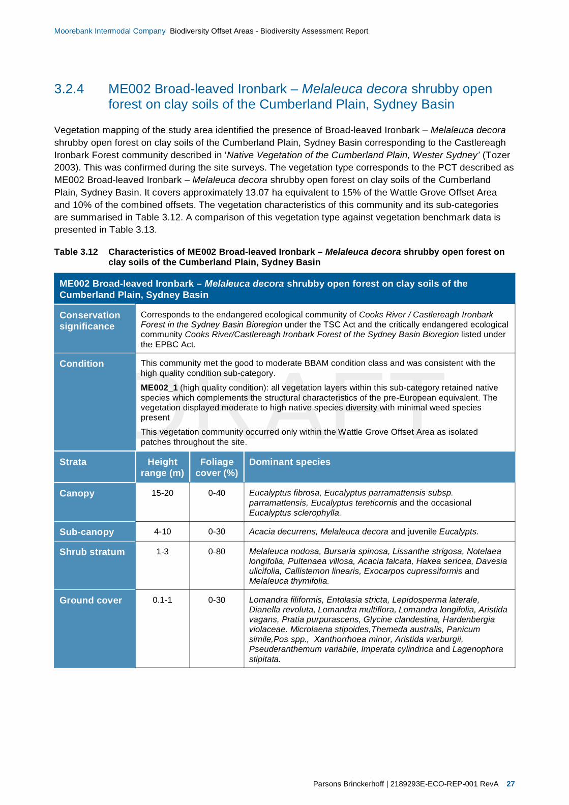
Vegetation mapping of the study area identified the presence of Broad-leaved Ironbark – Melaleuca decorashrubby open forest on clay soils of the Cumberland Plain, Sydney Basin corresponding to the CastlereaghIronbark Forest community described in ‘Native Vegetation of the Cumberland Plain, Wester Sydney’ (Tozer2003). This was confirmed during the site surveys. The vegetation type corresponds to the PCT described asME002 Broad-leaved Ironbark – Melaleuca decora shrubby open forest on clay soils of the CumberlandPlain, Sydney Basin. It covers approximately 13.07 ha equivalent to 15% of the Wattle Grove Offset Areaand 10% of the combined offsets. The vegetation characteristics of this community and its sub-categoriesare summarised in Table 3.12. A comparison of this vegetation type against vegetation benchmark data ispresented in Table 3.13.
Table 3.12 Characteristics of ME002 Broad-leaved Ironbark – Melaleuca decora shrubby open forest onclay soils of the Cumberland Plain, Sydney Basin
ME002 Broad-leaved Ironbark – Melaleuca decora shrubby open forest on clay soils of theCumberland Plain, Sydney Basin
Conservationsignificance
Corresponds to the endangered ecological community of Cooks River / Castlereagh IronbarkForest in the Sydney Basin Bioregion under the TSC Act and the critically endangered ecologicalcommunity Cooks River/Castlereagh Ironbark Forest of the Sydney Basin Bioregion listed underthe EPBC Act.
Condition This community met the good to moderate BBAM condition class and was consistent with thehigh quality condition sub-category.
ME002_1 (high quality condition): all vegetation layers within this sub-category retained nativespecies which complements the structural characteristics of the pre-European equivalent. Thevegetation displayed moderate to high native species diversity with minimal weed speciespresent
This vegetation community occurred only within the Wattle Grove Offset Area as isolatedpatches throughout the site.
Strata Heightrange (m)
Foliagecover (%)
Dominant species
Canopy 15-20 0-40 Eucalyptus fibrosa, Eucalyptus parramattensis subsp.parramattensis, Eucalyptus tereticornis and the occasionalEucalyptus sclerophylla.
Sub-canopy 4-10 0-30 Acacia decurrens, Melaleuca decora and juvenile Eucalypts.
Shrub stratum 1-3 0-80 Melaleuca nodosa, Bursaria spinosa, Lissanthe strigosa, Notelaealongifolia, Pultenaea villosa, Acacia falcata, Hakea sericea, Davesiaulicifolia, Callistemon linearis, Exocarpos cupressiformis andMelaleuca thymifolia.
Ground cover 0.1-1 0-30 Lomandra filiformis, Entolasia stricta, Lepidosperma laterale,Dianella revoluta, Lomandra multiflora, Lomandra longifolia, Aristidavagans, Pratia purpurascens, Glycine clandestina, Hardenbergiaviolaceae. Microlaena stipoides,Themeda australis, Panicumsimile,Pos spp., Xanthorrhoea minor, Aristida warburgii,Pseuderanthemum variabile, Imperata cylindrica and Lagenophorastipitata.

DRAFT
28 2189293E-ECO-REP-001 RevA | Parsons Brinckerhoff
Moorebank Intermodal Company Biodiversity Offset Areas - Biodiversity Assessment Report
ME002 Broad-leaved Ironbark – Melaleuca decora shrubby open forest on clay soils of theCumberland Plain, Sydney Basin


DRAFT
30 2189293E-ECO-REP-001 RevA | Parsons Brinckerhoff
Moorebank Intermodal Company Biodiversity Offset Areas - Biodiversity Assessment Report
3.2.5 ME003 Hard-leaved Scribbly Gum – Parramatta Red Gum heathywoodland of the Cumberland Plain, Sydney Basin
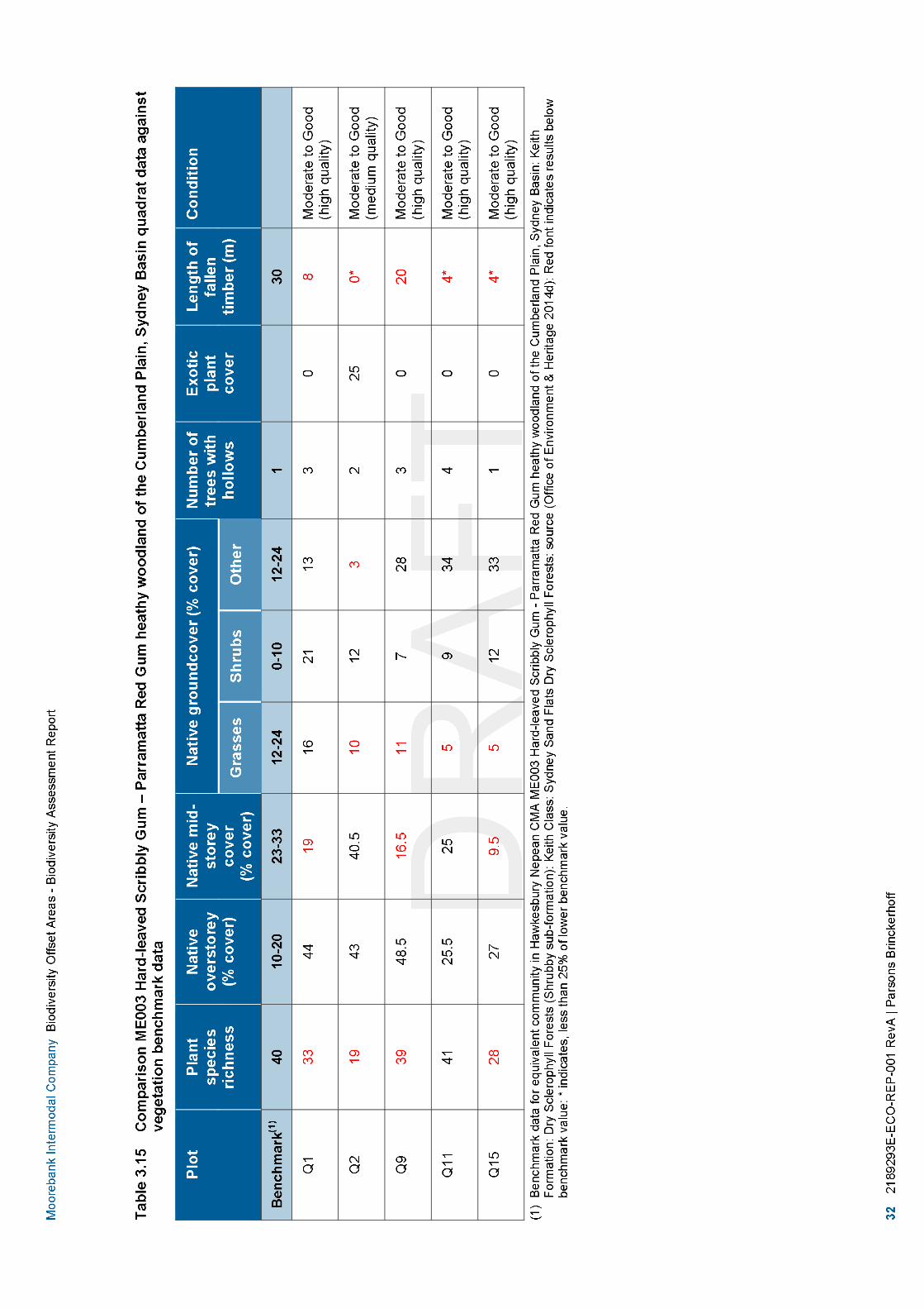
Vegetation mapping of the study area identified the presence of Parramatta Red Gum Woodland on moistalluvium of the Cumberland Plain, Sydney Basin corresponding to the Castlereagh Scribbly Gum Woodlandcommunity described in ‘Native Vegetation of the Cumberland Plain, Wester Sydney’ (Tozer 2003). This wasconfirmed during the site surveys. This vegetation community corresponds to the PCT listed as ME003 Hard-leaved Scribbly Gum – Parramatta Red Gum heathy woodland of the Cumberland Plain, Sydney Basin. Itcovers approximately 33.97 ha equivalent to 38% of the Wattle Grove Offset Area or 27% of the combinedoffsets. The vegetation community’s characteristics and its sub-category types are summarised inTable 3.14. A comparison of this vegetation type against vegetation benchmark data is presented inTable 3.15.
Table 3.14 Characteristics of ME003 Hard-leaved Scribbly Gum – Parramatta Red Gum heathy woodlandof the Cumberland Plain, Sydney Basin
ME003 Hard-leaved Scribbly Gum – Parramatta Red Gum heathy woodland of the CumberlandPlain, Sydney Basin
Conservationsignificance
Corresponds to the vulnerable ecological community of Castlereagh Scribbly Gum Woodland inthe Sydney Basin Bioregion under the TSC Act and the endangered ecological communityCastlereagh Scribbly Gum and Agnes Banks Woodlands of the Sydney Basin Bioregion listedunder the EPBC Act.
Condition This community met the good to moderate BBAM condition class and has been further split intothe two sub-categories which are described below:
ME003_1 (high quality condition): all vegetation layers within this sub-category retained nativespecies which complements the structural characteristics of the pre-European equivalent. Thevegetation displayed moderate to high native species diversity with minimal weed speciespresent.
ME003_2 (moderate quality condition): the vegetation had retained a native canopy covercanopy that predominately included Eucalyptus sclerophylla, Angophora bakeri and Eucalyptusparramattensis subsp. parramattensis. Although the canopy cover was native the understoreyand groundcover layers were co-dominated by both native and exotic species such as Eragrostiscurvula* and Pennisetum clandestinum*.
This vegetation community occupied as the majority of the Wattle Grove Offset Area. Themajority of theis vegetation community existed in the high quality condition sub-category. Themoderate quality condition sub-category patches of this community occurred predominatly on theperiphery of the site or in areas adjacent to access tracks and old railway line.
Strata Heightrange (m)
Foliagecover (%)
Dominant species
Canopy 8-18 0-30 Eucalyptus sclerophylla, Angophora bakeri and Eucalyptusparramattensis subsp. parramattensis.
Sub-canopy 1.5-8 0-40 Angophora bakeri, Melaleuca decora and Leptospermumparvifolium.
Shrub stratum 1-2.5 10-80 Persoonia linearis, Melaleuca nodosa, Hakea sericea, Callistemonlinearis, Persoonia nutans, Banksia spinulosa, Leptospermumtrinervium, Banksia oblongifolia, Persoonia lanceolata, Daviesiaulicifolia, Acacia falcata, Isopogon anemonifolius, Leptospermumcontinentale, Lissanthe strigosa, Melaleuca thymifolia, Daviesiaulicifolia, Bossiaea heterophylla, Banksia spinulosa, Pultenaeavillosa, Acacia decurrens, Leptospermum polygalifolium, Acaciabrownii, Pimelea linifolia and Persoonia levis.

DRAFT
Parsons Brinckerhoff | 2189293E-ECO-REP-001 RevA 31
Moorebank Intermodal Company Biodiversity Offset Areas - Biodiversity Assessment Report
ME003 Hard-leaved Scribbly Gum – Parramatta Red Gum heathy woodland of the CumberlandPlain, Sydney Basin
Ground cover 0.1-1 0-80 Entolasia stricta, Austrostipa verticillata, Xanthorrhoea minor,Pomax umbellata, Themeda australis, Cassytha glabella, Lomandrafiliformis, Lomandra longifolia, Gonocarpus tetragynus, Eragrostisbrownii, Microlaena stipoides, Cynodon dactylon, Dianella sp.,Aristida spp., Glycine clandestina, Lepidosperma laterale,Echinopogon caespitosus, Pratia purpurascens, Lomandramultiflora, Panicum simile, Patersonia sericea, Trachymene incisa,Hardenbergia violaceae and Poa sp.

DRAFT
Parsons Brinckerhoff | 2189293E-ECO-REP-001 RevA 33
Moorebank Intermodal Company Biodiversity Offset Areas - Biodiversity Assessment Report
3.2.6 ME005 Parramatta Red Gum woodland on moist alluvium of theCumberland Plain, Sydney Basin Bioregion
Vegetation mapping of the study area identified the presence of Hard-leaved Scribbly Gum – ParramattaRed Gum heathy Woodland of the Cumberland Plain, Sydney Basin corresponding to the CastlereaghSwamp Woodland community described in ‘Native Vegetation of the Cumberland Plain, Wester Sydney’(Tozer 2003). This was confirmed during the site surveys. This vegetation community corresponds to thePCT listed as ME005 Parramatta Red Gum woodland on moist alluvium of the Cumberland Plain, SydneyBasin Bioregion. It covers approximately 23.54 ha equivalent to 27% of the Wattle Grove Offset Area or 19%of the combined offsets. The vegetation community’s characteristics and its sub-category types aresummarised in Table 3.16. A comparison of this vegetation type against vegetation benchmark data ispresented in Table 3.17.
Table 3.16 Characteristics of ME005 Parramatta Red Gum woodland on moist alluvium of theCumberland Plain, Sydney Basin Bioregion
ME005 Parramatta Red Gum woodland on moist alluvium of the Cumberland Plain, Sydney BasinBioregion
Conservationsignificance
Corresponds to the endangered ecological community of Castlereagh Swamp WoodlandCommunity under the TSC Act.
Condition This community met the good to moderate BBAM condition class and was consistent with thehigh quality condition sub-category.
ME005_1 (high quality condition): all vegetation layers within this sub-category retained nativespecies which complements the structural characteristics of the pre-European equivalent. Thevegetation displayed moderate to high native species diversity with minimal weed speciespresent.
This vegetation community occurred with the Wattle Grove Offset area only within lineardepressions that occur throughout the site.
Strata Heightrange (m)
Foliagecover (%)
Dominant species
Canopy 6-20 0-40 Eucalyptus parramattensis subsp. parramattensis, Eucalyptussclerophylla, Angophora bakeri, Angophora floribunda andMelalueca decora.
Sub-canopy 3-6 0-30 Melaleuca nodosa, Banksia oblongifolia, Bossiaea heterophylla,Bossiaea obcordata, Isopogon anemonifolius, Acacia ulicifolia,Banksia spinulosa, Pimelea linifolia, Persoonia levis, Leptospermumtrinervium, Leptospermum polygalifolium, Melaleuca linariifolia,Melaleuca armillaris, Callistemon linearis, Pultenaea villosa,Leptospermum continentale, Acacia falcata and Bursaria spinosa.
Shrub stratum 0.9-3 0-60 Persoonia linearis, Angophora bakeri and Hakea sericea.
Ground cover 0.1-1 20-90 Pteridium esculentum, Cassytha glabella, Themeda australis,Entolasia stricta, Xanthorrhoea minor, Billardiera scandens,Lomandra longifolia, Lomandra filiformis, Lomandra multiflora,Pomax umbellata, Lomatia silaifolia, Monotoca scoparia,Trachymene incisa, Centella asiatica, Carex appressa, Baumearubiginosa, Juncus usitaris, Imperata cylindrica, Hibbertia sp.,Hydrocotyle peduncularis, Gonocarpus tetragynus, Goodeniapaniculata, Lepidosperma laterale, Panicum simile, Pratiapurperescens and Lagenophora stipitata.

DRAFT
34 2189293E-ECO-REP-001 RevA | Parsons Brinckerhoff
Moorebank Intermodal Company Biodiversity Offset Areas - Biodiversity Assessment Report
ME005 Parramatta Red Gum woodland on moist alluvium of the Cumberland Plain, Sydney BasinBioregion


DRAFT
36 2189293E-ECO-REP-001 RevA | Parsons Brinckerhoff
Moorebank Intermodal Company Biodiversity Offset Areas - Biodiversity Assessment Report
3.2.7 ME018 Forest Red Gum - Rough-barked Apple grassy woodland onalluvial flats of the Cumberland Plain, Sydney Basin
Vegetation mapping of the study area identified the presence of Forest Red Gum - Rough-barked Applegrassy woodland on alluvial flats of the Cumberland Plain, Sydney Basin corresponding to the AlluvialWoodland community described in ‘Native Vegetation of the Cumberland Plain, Wester Sydney’ (Tozer2003). This was confirmed during the site surveys. This vegetation community corresponds to the PCT listedas ME018 Forest Red Gum - Rough-barked Apple grassy woodland on alluvial flats of the Cumberland Plain,Sydney Basin. It covers approximately 5.65 ha equivalent to 17% of the Moorebank Conservation Area or5% of the combined offsets. The vegetation community’s characteristics and its sub-category types aresummarised in Table 3.18. A comparison of this vegetation type against vegetation benchmark data ispresented in Table 3.19.
Table 3.18 Characteristics of ME018 Forest Red Gum – Rough-barked Apple grassy woodland on alluvialflats of the Cumberland Plain, Sydney Basin
ME018 Forest Red Gum – Rough-barked Apple grassy woodland on alluvial flats of theCumberland Plain, Sydney Basin
Conservationsignificance
Corresponds to the endangered ecological community of River-Flat Eucalypt Forest on CoastalFloodplains of the New South Wales North Coast, Sydney Basin and South East CornerBioregions listed under the TSC Act.
Condition This community met the good to moderate BBAM condition class and has been further split intothe two sub-categories which are described below:
ME018_2 (moderate quality condition): the vegetation had retained a native canopy covercanopy that predominately included Eucalyptus tereticornis, Eucalyptus amplifolia, Angophorasubvelutina and/or Angophora floribunda. Although the canopy cover was native the understoreyand groundcover layers were co-dominated by both native and exotic species.
ME018_1 (poor quality condition): the vegetation had retained a native canopy thatpredominately included Eucalyptus tereticornis, Eucalyptus amplifolia, Angophora subvelutinaand/or Angophora floribunda. Although the canopy was native the understorey and groundlayerswere generally dominated by exotic species such as Ehrharta erecta*, Ligustrum spp.*, Oleaeuropaea subsp. cuspidata* and Lantana camara*. Native species diversity within these areaswas relatively low and the vegetation was structurally modified as a result of edge effects,access tracks, DOD activities and weed invasion.
This vegetation community occurred only within the Moorebank Conservation Area and CasulaOffset Area running immediately adjacent along the Georges River which forms a ripariancorridor to the north and south of the study area.
Strata Heightrange (m)
Foliagecover (%)
Dominant species
Canopy 16-24 20–40 Eucalyptus tereticornis, Eucalyptus amplifolia, Angophorasubvelutina, Angophora floribunda and Eucalyptus baueriana.
Sub-canopy 3-8 5-20 Acacia decurrens, Acacia binervia, Pittosporum undulatum, Acaciaparramattensis and Melaleuca decora.
Shrub stratum 0.5-3 5-80 Breynia oblongifolia, Bursaria spinosa, Kunzea ambigua,Ozothamnus diosmifolius, Leucopogon juniperinus and Jacksoniascoparia.
Ground cover 0–1 80-100 Microlaena stipoides, Commelina cyanea, Oplismenus imbecillis,Cassytha pubescens, Juncus usitatus, Cynodon dactylon, Entolasiastricta, Opercularia aspera, Sigesbeckia orientalis, Carex appressa,Trachymene incisa, Aristida ramosa, Pratia purpurascens, Einadiahastata, Dichondra repens, Centella asiatica, Glycine tabacina,Rumex brownii, Pteridium esculentum, Lomandra longifolia,Entolasia marginata, Dianella revoluta, Themeda australis andHardenbergia violaceae.

DRAFT
Parsons Brinckerhoff | 2189293E-ECO-REP-001 RevA 37
Moorebank Intermodal Company Biodiversity Offset Areas - Biodiversity Assessment Report
ME018 Forest Red Gum – Rough-barked Apple grassy woodland on alluvial flats of theCumberland Plain, Sydney Basin


DRAFT
Parsons Brinckerhoff | 2189293E-ECO-REP-001 RevA 39
Moorebank Intermodal Company Biodiversity Offset Areas - Biodiversity Assessment Report
3.2.8 ME044 Sydney Blue Gum X Bangalay – Lilly Pilly moist forest ingullies and on sheltered slopes, southern Sydney Basin
Vegetation mapping of the study area identified the presence of Sydney Blue Gum X Bangalay – Lilly Pillymoist forest in gullies and on sheltered slopes, southern Sydney Basin corresponding to the Riparian Forestcommunity described in ‘Native Vegetation of the Cumberland Plain, Wester Sydney’ (Tozer 2003). This wasconfirmed during the site surveys. This vegetation community corresponds to the PCT listed as ME044Sydney Blue Gum X Bangalay - Lilly Pilly moist forest in gullies and on sheltered slopes, southern SydneyBasin. It covers approximately 16.24 ha equivalent to 43% of the Moorebank Conservation Area or 70% ofthe Casula Offset Area or 13% of the combined offsets. The vegetation community’s characteristics and itssub-category types are summarised in Table 3.20. A comparison of this vegetation type against vegetationbenchmark data is presented in Table 3.21.
Table 3.20 Characteristics of ME044 Sydney Blue Gum X Bangalay – Lilly Pilly moist forest in gullies andon sheltered slopes, southern Sydney Basin
ME044 Sydney Blue Gum X Bangalay – Lilly Pilly moist forest in gullies and on sheltered slopes,southern Sydney Basin
Conservationsignificance
Corresponds to the endangered ecological community of River-Flat Eucalypt Forest on CoastalFloodplains of the New South Wales North Coast, Sydney Basin and South East CornerBioregions listed under the TSC Act.
Condition This community met the good to moderate BBAM condition class and has been further split intothe thee sub-categories which are described below:ME018_1 (high quality condition): all vegetation layers within this sub-category retained nativespecies which complements the structural characteristics of the pre-European equivalent. Thevegetation displayed moderate to high native species diversity with minimal weed speciespresent.ME018_2 (moderate quality condition): the vegetation had retained a native canopy covercanopy that dominantly by Eucalyptus saligna X botryoides. Although the canopy cover wasnative the understorey and groundcover layers were co-dominated by both native and exoticspecies.ME018_1 (poor quality condition): the vegetation had retained a native canopy that wasdominated by Eucalyptus saligna X botryoides. Although the canopy was native the understoreyand groundlayers were generally dominated by exotic species such as Ehrharta erecta*,Cardiospermum grandiflorum*, Senna pendula*, Ligustrum spp.*, Olea europaea subsp.cuspidata* and Lantana camara*. Native species diversity within these areas was relatively lowand the vegetation was structurally modified as a result of edge effects, access tracks, DODactivities and weed invasion.This vegetation community occurred only within the Moorebank Conservation Area runningimmediately adjacent along the Georges River which forms a riparian corridor to the north andsouth of the study area.
Strata Heightrange (m)
Foliagecover (%)
Dominant species
Canopy 20-28 20–40 Eucalyptus saligna X botryoides with the occasional Angophorasubvelutina, Angophora floribunda and Eucalyptus tereticornis
Sub-canopy 2–8 10–30 Acacia binervia, Acacia decurrens and the occasional Grevillearobusta.
Shrub stratum 0.5-4 5-20 Breynia oblongifolia, Bursaria spinosa, Banksia integrifolia,Backhousia myrtifolia and the occasional Leucopogon juniperinus.
Ground cover 0–1.5 80-100 Lomandra longifolia, Dianella revoluta, Cheilanthes sieberi,Billardiera scandens, Pratia purpurascens, Microlaena stipoides,Pteridium esculentum, Cassytha glabella, Glycine tabacina,Cheilanthes sieberi, Austrostipa ramosissima, Entolasia marginata,Einadia hastata, Centella asiatica, Eustrephus latifolius, Cayratiaclematidea, Senecio hispidus, Plectranthus parviflorus andOplismenus aemulus.

DRAFT
40 2189293E-ECO-REP-001 RevA | Parsons Brinckerhoff
Moorebank Intermodal Company Biodiversity Offset Areas - Biodiversity Assessment Report
ME044 Sydney Blue Gum X Bangalay – Lilly Pilly moist forest in gullies and on sheltered slopes,southern Sydney Basin


DRAFT
42 2189293E-ECO-REP-001 RevA | Parsons Brinckerhoff
Moorebank Intermodal Company Biodiversity Offset Areas - Biodiversity Assessment Report
3.2.9 Exotic vegetation
The exotic vegetation was a highly disturbed vegetation community that occurred predominantly to the northof the Casula Offset Area, centre of the Moorebank Conservation Area and scattered throughout the WattleGrove Offset Area. The community covered 19.09 ha equivalent to 15.32% of the combined offset area. Thecommunity was generally associated with areas that have been subjected to land clearance and weedinvasion as a result of development and infrastructure (such as walk ways, railway lines and roads). Due tothe previous and current land uses this community no longer resembles any local native remnant vegetationcommunity. The vegetation community’s characteristics are summarised in Table 3.22.
Table 3.22 Characteristics of the exotic vegetation within the study area
Exotic vegetation
Conservationsignificance
Low. The exotic vegetation communities recorded within the study area are not consistent withany native vegetation communities.
Condition This community met the low BBAM condition class and has been further split into the two sub-categories which are described below:
Exotic woody vegetation: occupies 0.97 ha within the Casula Offset Area. This vegetation wasdominated by exotic woody plant species that formed dense sub-canopies and shrub coverwhich predominantly excluded the growth of groundcover species.
Exotic grassland: occupied approximately 12.99 ha of the Moorebank Conservation Area and5.13 ha of the Wattle Grove Offset Area. This vegetation generally had a void canopy and shrubcover and occurred as grassland dominated by exotic species.
This vegetation community occurred predominately within in the Moorebank Conservation Areaand as small to medium patches throughout the Wattle Grove and Casula Offset areas.
Strata Heightrange (m)
Foliagecover (%)
Dominant species
Canopy 12-18 0-10 Occasional isolated Eucalyptus sp.
Sub-canopy 3–8 0–30 Ligustrum lucidum* and Ligustrum sinense*
Shrub stratum 0.5-4 0-100 Lantana camara*, Acacia longifolia and Acacia decurrens
Ground cover 0–1.5 0-80 Eragrostis curvula*, Conyza sp.*, Chloris virgata*, Sida rhombifolia*,Senecio madagascariensis*, Hypochaeris radicata* and Cirsiumvulgare*.
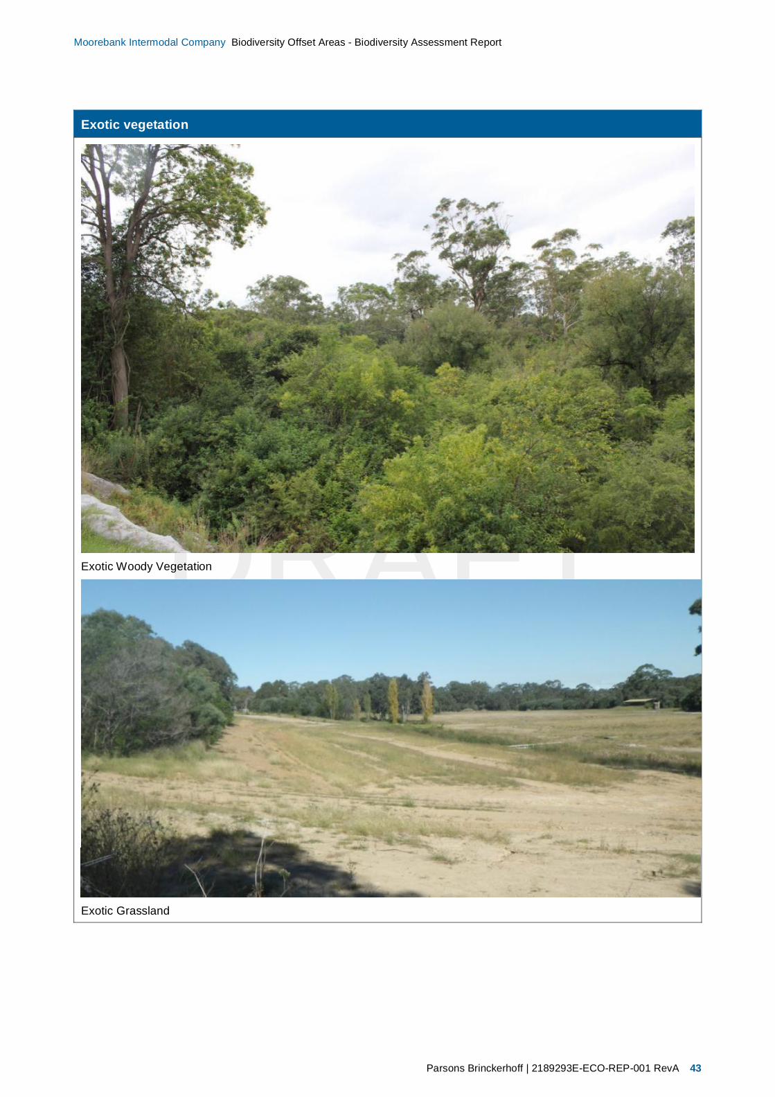
DRAFT
Parsons Brinckerhoff | 2189293E-ECO-REP-001 RevA 43
Moorebank Intermodal Company Biodiversity Offset Areas - Biodiversity Assessment Report
Exotic vegetation
Exotic Woody Vegetation
Exotic Grassland

DRAFT
44 2189293E-ECO-REP-001 RevA | Parsons Brinckerhoff
Moorebank Intermodal Company Biodiversity Offset Areas - Biodiversity Assessment Report
3.2.10 Species of plant recorded
Two hundred and fifty six plant species were recorded within the study area. Of these, 196 were native and62 were introduced species (refer Appendix A).
Of these 62 exotic species that were recorded in the study area, 16 species of plant are listed under theNoxious Weeds Act 1993 for the Liverpool Council noxious weed control area (refer Table 3.23). Of thesespecies eight are listed as a Weeds of National Significance (Australian Weeds Committee 2015).
Table 3.23 Noxious weeds identified on the site
Scientific Name Common Name Noxious Weeds Act1993 control class(1)
Weed of NationalSignificance
Alternanthera philoxeroides* Alligator Weed 3 Yes
Sagittaria platyphylla* Sagittaria 4 Yes
Arundo donax* Giant Reed 4
Asparagus aethiopicus* Ground Asparagus 4 Yes
Asparagus asparagoides* Bridal Creeper 4 Yes
Asparagus officinalis* Asparagus 4 Yes
Cestrum parqui Green Cestrum 3
Lantana camara* Lantana 4 Yes
Ligustrum sinense* Small-leaved Privet 4
Ligustrum lucidum* Large-leaved Privet 4
Ludwigia peruviana* Ludwigia 3
Olea europaea subsp.cuspidata*
African olive 4
Ricinus communis* Castor Oil Plant 4
Rubus fruticosus* Blackberry 4 Yes
Senecio madagascariensis* Fireweed 4 Yes
Eichhornia crassipes* Water hyacinth 2
(1) Control Categories under the Noxious Weeds Act 1993: Class 4: The growth and spread of the plant must be controlled accordingto the measures specified in a management plan published by the local control authority, Class 3: The plant must be fully andcontinuously suppressed and destroyed Class 2 The plant must be eradicated from the land and that land must be kept free of theplant (Department of Trade and Investment Regional Infrastructure and Services 2015a).
3.2.11 Plot data
The plot data is provided in Table 3.24. A list of flora species found in each quadrat is provided inAppendix A.

Nativeplantspecies
Nativeover-storeycover
Nativemid-storeycover
Nativegroundcover(grasses)
Nativegroundcover(shrubs)
Nativegroundcover(other)
Exoticplantcover
Numberoftreeswithhollows
Overstoreyregeneration
Totallengthoffallenlongs
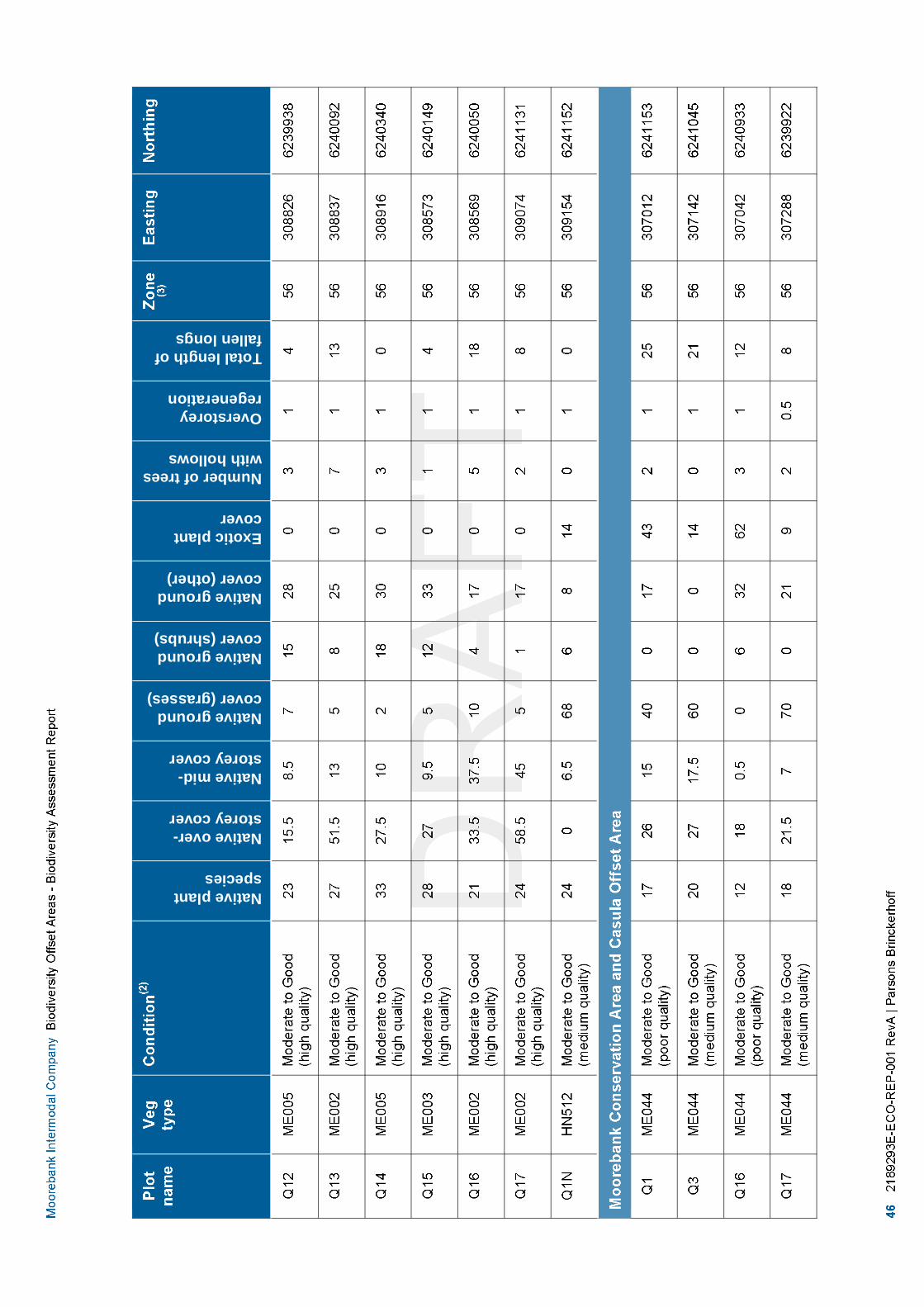
Nativeplantspecies
Nativeover-storeycover
Nativemid-storeycover
Nativegroundcover(grasses)
Nativegroundcover(shrubs)
Nativegroundcover(other)
Exoticplantcover
Numberoftreeswithhollows
Overstoreyregeneration
Totallengthoffallenlongs

Nativeplantspecies
Nativeover-storeycover
Nativemid-storeycover
Nativegroundcover(grasses)
Nativegroundcover(shrubs)
Nativegroundcover(other)
Exoticplantcover
Numberoftreeswithhollows
Overstoreyregeneration
Totallengthoffallenlongs

Nativeplantspecies
Nativeover-storeycover
Nativemid-storeycover
Nativegroundcover(grasses)
Nativegroundcover(shrubs)
Nativegroundcover(other)
Exoticplantcover
Numberoftreeswithhollows
Overstoreyregeneration
Totallengthoffallenlongs

DRAFT
Parsons Brinckerhoff | 2189293E-ECO-REP-001 RevA 49
Moorebank Intermodal Company Biodiversity Offset Areas - Biodiversity Assessment Report
3.3 Fauna habitatThe quality of vertebrate fauna habitats is typically correlated with the patch size, configuration, structure,species composition and connectivity of the vegetation communities present at a given site and the presenceof non-biological features such as rock outcrops and water bodies. Therefore, the fauna habitats present inthe study area vary from moderate in highly modified weedy areas through too high in less disturbed intactvegetation.
3.3.1.1 Terrestrial fauna habitats
Four broad types of terrestrial fauna habitat were found within the study area referred to here as:
Riparian vegetation along George’s River.Structurally intact woodland.Highly disturbed areas with scattered trees.Aquatic habitats.
These habitats are described below.
3.3.1.2 Riparian vegetation along the George’s River
This habitat type includes all moderate to good condition Riparian Forest and Alluvial Woodland that runsadjacently along the George’s River within the Moorebank development site.
These areas contain relatively intact native understorey and/or groundcover vegetation (some areas containa high diversity of exotic shrub and groundcover species such as Lantana camara* thickets andCardiospermum grandiflorum*). They contain a complete vegetation structure, fallen timber, and dense leaflitter layers that are essential to the life cycles of many fauna. Patches of dense understorey and diversegroundcover in this habitat type provide potential foraging and nesting habitat for a variety of terrestrial birds,reptiles and mammals.
The canopy of this habitat type consists of a moderate to dense cover of immature, semi-mature and maturetrees. The canopy provides foraging habitat for nectar-feeding and seed-eating animals and is likely tocontain hollows suitable for birds such as small to large parrots, owls, tree roosting microchiropteran bat andsmall to large arboreal mammals. Foraging opportunities exist in the canopy for predatory species includingPowerful Owl and Spotted-tailed Quoll.
Overall, this fauna habitat type is in moderate to good condition providing potential habitat for species ofanimal that require diverse native understorey vegetation, canopy connectivity to other habitat in the localityand tree hollows.
3.3.1.3 Structurally intact woodland
This habitat type includes all low to good condition native woodland vegetation and occurs throughout themajority of the Wattle Grove Offset Area.
These areas contain relatively intact native understorey and/or groundcover vegetation. They contain acomplete vegetation structure, fallen timber, and dense leaf litter layers that are essential to the life cycles ofmany fauna. Patches of dense understorey and diverse groundcover in this habitat type provide potentialforaging and nesting habitat for a variety of terrestrial reptiles, bird and mammals.
The canopy of this habitat type consists of a moderate to dense cover of immature, semi-mature and maturetrees. The canopy provides foraging habitat for nectar-feeding and seed-eating animals and is likely tocontain hollows suitable for birds such as small to large parrots, owls, tree roosting microchiropteran bat and

DRAFT
50 2189293E-ECO-REP-001 RevA | Parsons Brinckerhoff
Moorebank Intermodal Company Biodiversity Offset Areas - Biodiversity Assessment Report
small to large arboreal mammals. Foraging opportunities exist in the canopy for predatory species includingPowerful Owl and Spotted-tailed Quoll.
Overall, this fauna habitat type is in moderate to good condition providing potential habitat for species ofanimal that require diverse native understorey vegetation, canopy connectivity and tree hollows.
3.3.1.4 Highly disturbed areas with scattered trees
This habitat type occurs in areas that have been subject to substantial human disturbance such as clearingfor urban development and transport and power infrastructure. This habitat type does not correspond to anynative vegetation community.
Native vegetation in this habitat type is restricted to occasional trees, shrubs and groundcover plants withinotherwise exotic vegetation.
This habitat is only likely to provide habitat for native and introduced fauna species that are adapted to openenvironments and tolerant of human disturbance. Many such native species (e.g. Willie Wagtail and NoisyMiners) have increased in abundance in response to human disturbance.
This habitat type is in poor condition and generally of very limited value to threatened fauna species.
3.3.1.5 Aquatic habitats
Field observations identified an ephemeral water body within the native Castlereagh Swamp Woodlandcommunity recorded within the Wattle Grove Offset Area. The water body ranged from approximately 0.1-0.3m in depth. The ephemeral swamp is subjected to changes in water depth and turbulence dependent uponrainfall patterns. The substrate consisted of clay soils.
Field observation of the water body revealed that it was in moderate to good ecological condition. Moderatecondition aquatic fauna habitat occurs where some habitat components are missing or have been reduced,but linkages with other remnant habitats in the landscape are generally intact, but sometimes degraded.The aquatic habitat within the study area has been subjected to low levels of weed invasion and vegetationfragmentation as a result of weed invasion and urban developments (such as the access paths). Although,the habitat has been slightly degraded, it still retains most aquatic fauna habitat features such as rocks,organic detritus, aquatic vegetation and occasional snags. These habitat features provide potential habitatfor a number of aquatic and terrestrial species of fish, reptiles, birds invertebrates and amphibians.
The aquatic habitat was unlikely to provide habitat for any threatened species listed under the FisheriesManagement Act 1994 due to the condition of habitat and as no records have been identified in theHawkesbury/Nepean Catchment Management Authority (Department of Trade & Investment RegionInfrastructure and Services 2014).
3.4 Habitat and geographic featuresThe sites were surveyed in May 2014 and in April and May of 2015. Targeted surveys for Persooonia nutansand Grevillea parviflora were undertaken. The surveys did not include any targeted surveys for threatenedfauna species, although opportunistic observations of Scarlet Robin (Petroica boodang) and Little Lorikeet(Glossopsitta pusilla) were made.
The following geographic habitat features were identified within the site:
land situated in damp, disturbed sites (Wahlenbergia multicaulis (Tadgells Bluebell) population, Auburn,Bankstown, Baulkham Hills, Canterbury, Hornsby, Parramatta and Strathfield local government areas)land containing bark or leaf litter accumulation (Cumberland Plain Land Snail)

DRAFT
Parsons Brinckerhoff | 2189293E-ECO-REP-001 RevA 51
Moorebank Intermodal Company Biodiversity Offset Areas - Biodiversity Assessment Report
land within 40 m of fresh/brackish/saline waters of larger rivers or creeks; estuaries, coastal lagoons,lakes and/or inshore marine waters (Eastern Osprey)land within 100 m of emergent aquatic or riparian vegetation (Green and Golden Bell Frog)Wet and damp areas only.( Hypsela sessiliflora)land within 40 m of heath, woodland or forest – providing potential habitat for Giant Burrowing Frog(Heleioporus australiacus).alluvial soils for Camden White Gum.land within 250 m of termite mounds or rock outcrops for Rosenberg's Goanna.
3.5 Threatened communities, populations and speciesThis section details the threatened biodiversity and other species of conservation concern recorded or likelyto occur in the study area, based on those found within the locality and the nature of the habitats observedwithin the existing environment.
The sites were surveyed in May 2014 and in April and May of 2015. Targeted surveys for Persooonia nutansand Grevillea parviflora were undertaken. The surveys did not include any targeted surveys for threatenedfauna species, although opportunistic observations of Scarlet Robin (Petroica boodang) and Little Lorikeet(Glossopsitta pusilla) were made.
3.5.1 Threatened ecological communities (critically endangered,endangered and vulnerable) are listed under the ThreatenedSpecies Conservation Act 1995, Fisheries Management Plan Act1994 and Environmental Protection and Biodiversity ConservationAct 1999
Two Commonwealth listed threatened ecological community was recorded as present during the field survey:
Castlereagh Scribbly Gum and Agnes Banks Woodlands of the Sydney Basin Bioregion listed asendangered under the Environmental Protection and Biodiversity Conservation Act 1999.
Cumberland Plain Shale Woodlands and Shale-Gravel Transition Forest listed as critically endangeredunder the Environmental Protection and Biodiversity Conservation Act 1999.
Four State listed Threatened ecological communities were recorded as present during the recent fieldsurvey:
Castlereagh Scribbly Gum Woodland in the Sydney Basin Bioregion listed as vulnerable under theThreatened Species Conservation Act 1995.
Castlereagh Swamp Woodland Community listed as endangered under the Threatened SpeciesConservation Act 1995.
River-flat Eucalypt Forest on coastal floodplains of the NSW North Coast, Sydney Basin and South EastCorner bioregions listed as endangered under the Threatened Species Conservation Act 1995.
Shale Gravel Transition Forest in the Sydney Basin Bioregion listed as endangered under theThreatened Species Conservation Act 1995.
The occurrence of these communities in the study area is descripted in section 3.2 of this report.

DRAFT
52 2189293E-ECO-REP-001 RevA | Parsons Brinckerhoff
Moorebank Intermodal Company Biodiversity Offset Areas - Biodiversity Assessment Report
3.5.2 Endangered populations
Endangered populations are listed under Schedule 1, Part 2 of the Threatened Species Conservation Act1995. Results of the desk-top assessment indicate that one endangered population has the potential tooccur in the study locality.
Marsdenia viridiflora subsp. viridiflora in the Bankstown, Blacktown, Camden, Campbelltown, Fairfield,Holroyd, Liverpool and Penrith LGAs. This species was not recorded within the study area and nosuitable however potential habitat was recorded. This species is considered to have moderately likely tooccur within the study area.
3.5.3 Threatened species of plant
Fifty seven species of threatened plant listed under the Threatened Species Conservation Act 1995 and/orthe Environmental Protection and Biodiversity Conservation Act 1999 Act are known to occur or predicted tooccur within and surrounding the study area. Details of these species and their habitat requirements areprovided in Appendix B.
Three threatened flora species, Persoonia nutans, Acacia pubescens and Grevillea parviflora subsp.parviflora, were recorded from the site during the current survey. In addition, based on the presence ofsuitable habitat, a further five species are considered to have a moderate or greater likelihood of occurrence(Table 3.25). The remaining species are considered to have a low likelihood of occurrence based on theavailability of habitat. Full details of species requirements are provided in Appendix B.
Table 3.25 Threatened species of plant with potential to occur in habitat of the study area
Species Common name TSCAct(1)
EPBCAct(2)
Likelihood ofoccurrence
Grevillea parviflora subsp. parviflora Small-flower Grevillea V V Recorded
Persoonia nutans Nodding Geebung E1 E Recorded
Acacia pubescens Downy Wattle V V Recorded
Acacia bynoeana Bynoe's Wattle E1 V Moderate
Dillwynia tenuifolia V V Moderate
Leucopogon exolasius Woronora Beard-heath V V Moderate
Persoonia hirsuta Hairy Geebung E1 E Moderate
Pultenaea parviflora Sydney Bush-pea E1 V Moderate
(1) TSC Act = Threatened Species Conservation Act 1995, V = Vulnerable, E1 = Endangered, E2 = Endangered population in theLiverpool LGA.
(2) EPBC Act = Environment Protection and Biodiversity Conservation Act 1999, E = Endangered.
3.5.4 Threatened species of animal
Fifty seven species of threatened animal listed under the Threatened Species Conservation Act 1995 and/orthe Environmental Protection and Biodiversity Conservation Act 1999 Act are known to occur or predicted tooccur within and surrounding the study area. Details of these species and their habitat requirements areprovided in Appendix C.
Two threatened species were recorded, Little Eagle and Scarlet Robin, within the Study Area (. Based on thepresence of suitable habitat, an additional 23 species are considered to have a moderate or greaterlikelihood of occurrence (Table 3.26). The remaining species are considered to have a low likelihood of

DRAFT
Parsons Brinckerhoff | 2189293E-ECO-REP-001 RevA 53
Moorebank Intermodal Company Biodiversity Offset Areas - Biodiversity Assessment Report
occurrence based on the availability of habitat. Full details of species requirements are provided inAppendix C.
Table 3.26 Threatened species of animal with potential to occur in habitat within the study area
Scientific name Common name TSCAct(1)
EPBCAct(2)
Likelihood ofoccurrence
Birds
Glossopsitta pusilla Little Lorikeet V High
Ninox connivens Barking Owl V Moderate
Melithreptus gularis gularis Black-chinned Honeyeater V Moderate
Petroica phoenicea Flame Robin V Moderate
Callocephalon fimbriatum Gang-gang Cockatoo V Moderate
Hieraaetus morphnoides Little Eagle V Recorded
Anthochaera phrygia Regent Honeyeater CE EM Moderate
Ninox strenua Powerful Owl V Moderate
Petroica boodang Scarlet Robin V Recorded
Circus assimilis Spotted Harrier V Moderate
Lophoictinia isura Square-tailed Kite V Moderate
Lathamus discolor Swift Parrot E1 E Moderate
Calyptorhynchus lathami Varied Sittella V Moderate
Invertebrates
Meridolum corneovirens Cumberland Land Snail E1 Moderate
Bats
Miniopterus schreibersiioceanensis
Eastern Bent-wing Bat V High
Mormopterus norfolkensis Eastern Free-tail Bat V High
Falsistrellus tasmaniensis Eastern Flase Pipistrelle V Moderate
Myotis adversus Large-footed Myotis V High
Scoteanax rueppellii Greater Broad-nosed Bat V Moderate
Saccolaimus flaviventris Yellow-bellied Sheathtail Bat V Moderate
Mammals
Pteropus poliocephalus Grey-headed Flying-fox V V Recorded
Dasyurus maculatus maculatus Spotted-Tailed Quoll(Southern Subspecies)
V E Moderate
Cercartetus nanus Eastern Pygmy-possum V Moderate
Petaurus norfolcensis Squirrel Glider V Moderate
Phascolarctos cinereus Koala V V Moderate
(1) TSC Act = Threatened Species Conservation Act 1995, V = Vulnerable, E1 = Endangered, E2 = Endangered population in theLiverpool LGA.
(2) EPBC Act = Environment Protection and Biodiversity Conservation Act 1999, E = Endangered.

DRAFT
54 2189293E-ECO-REP-001 RevA | Parsons Brinckerhoff
Moorebank Intermodal Company Biodiversity Offset Areas - Biodiversity Assessment Report
Eighteen threatened species were predicted to occur in the sites by the BioBanking calculator based on thedata entered (Table 3.27 and Table 3.28). Although there was no targeted surveys undertaken two of thesespecies (Scarlet Robin and Little Eagle) were incidentally observed during the field surveys. If targetedsurveys recorded these species additional credits would be obtained.
Table 3.27 Threatened species predicted to occur by the BioBanking calculator within the Wattle GroveOffset Area
Scientific name Common name TSCAct(1)
EPBCAct(2)
Likelihood ofoccurrence
Birds
Ninox connivens Barking Owl V Moderate likelihood
Melithreptus gularis gularis Black-chinned Honeyeater V Moderate likelihood
Climacteris picumnus victoriae Brown Treecreeper (easternsubspecies)
V Unlikely
Stagonopleura guttata Diamond Firetail V Unlikely
Tyto novaehollandiae Masked Owl V Unlikely
Ninox strenua Powerful Owl V Moderate likelihood
Petroica boodang Scarlet Robin V Recorded
Lathamus discolor Swift Parrot E1 E Moderate likelihood
Invertebrates
Meridolum corneovirens Cumberland Plain Land Snail E1 Moderate likelihood
Mammals
Dasyurus maculatus Spotted-tailed Quoll V E Moderate likelihood
Phascolarctos cinereus Koala V V Moderate likelihood
Myotis macropus (formally Myotisadversus)
Large-footed Myotis V High likelihood
Pteropus poliocephalus Grey-headed Flying-fox V V High likelihood
Miniopterus schreibersiioceanensis
Eastern Bentwing-bat V High likelihood
Falsistrellus tasmaniensis Eastern False Pipistrelle V Moderate likelihood
Mormopterus norfolkensis Eastern Freetail-bat V High likelihood
Scoteanax rueppellii Greater Broad-nosed Bat V High likelihood
(1) TSC Act = Threatened Species Conservation Act 1995, V = Vulnerable, E1 = Endangered, E2 = Endangered population in theLiverpool LGA.
(2) EPBC Act = Environment Protection and Biodiversity Conservation Act 1999, E = Endangered.
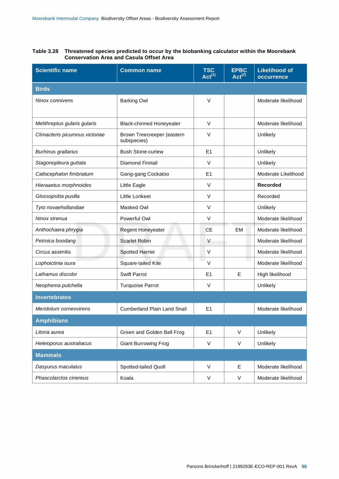
DRAFT
Parsons Brinckerhoff | 2189293E-ECO-REP-001 RevA 55
Moorebank Intermodal Company Biodiversity Offset Areas - Biodiversity Assessment Report
Table 3.28 Threatened species predicted to occur by the biobanking calculator within the MoorebankConservation Area and Casula Offset Area
Scientific name Common name TSCAct(1)
EPBCAct(2)
Likelihood ofoccurrence
Birds
Ninox connivens Barking Owl V Moderate likelihood
Melithreptus gularis gularis Black-chinned Honeyeater V Moderate likelihood
Climacteris picumnus victoriae Brown Treecreeper (easternsubspecies)
V Unlikely
Burhinus grallarius Bush Stone-curlew E1 Unlikely
Stagonopleura guttata Diamond Firetail V Unlikely
Callocephalon fimbriatum Gang-gang Cockatoo E1 Moderate Likelihood
Hieraaetus morphnoides Little Eagle V Recorded
Glossopsitta pusilla Little Lorikeet V Recorded
Tyto novaehollandiae Masked Owl V Unlikely
Ninox strenua Powerful Owl V Moderate likelihood
Anthochaera phrygia Regent Honeyeater CE EM Moderate likelihood
Petroica boodang Scarlet Robin V Moderate likelihood
Circus assimilis Spotted Harrier V Moderate likelihood
Lophoictinia isura Square-tailed Kite V Moderate likelihood
Lathamus discolor Swift Parrot E1 E High likelihood
Neophema pulchella Turquoise Parrot V Unlikely
Invertebrates
Meridolum corneovirens Cumberland Plain Land Snail E1 Moderate likelihood
Amphibians
Litoria aurea Green and Golden Bell Frog E1 V Unlikely
Heleioporus australiacus Giant Burrowing Frog V V Unlikely
Mammals
Dasyurus maculatus Spotted-tailed Quoll V E Moderate likelihood
Phascolarctos cinereus Koala V V Moderate likelihood

DRAFT
56 2189293E-ECO-REP-001 RevA | Parsons Brinckerhoff
Moorebank Intermodal Company Biodiversity Offset Areas - Biodiversity Assessment Report
3.5.5 Migratory species
Migratory species are protected under international agreements to which Australia are a signatory, includingthe Japan Australia Migratory Bird Agreement (JAMBA), the China Australia Migratory Bird Agreement(CAMBA), the Republic of Korea Australia Migratory Bird Agreement (RoKAMBA) and the Bonn Conventionon the Conservation of Migratory Species of Wild Animals. Migratory species are considered to comprise‘Matters of National Environmental Significance’ and are protected under the Environment Protection andBiodiversity Conservation Act 1999.
Based on the findings of the desk-top assessment, a total of 13 Migratory species have been recorded orhave the potential to occur in the study area locality (Appendix B). No Migratory species were recordedduring field surveys the site does contain potential habitat however for the Regent Honeyeater, Fork-tailedSwift, Cattle Egret, Eastern Great Egret, Latham’s Snipe, White-bellied Sea-Eagle, White-throatedNeedletail, Black-faced Monarch, Satin Flycatcher and Rufous Fantail.

624000062410006242000

DRAFT
58 2189293E-ECO-REP-001 RevA | Parsons Brinckerhoff
Moorebank Intermodal Company Biodiversity Offset Areas - Biodiversity Assessment Report
4. Management actions andmanagement plans
4.1 Standard management actionsStandard management actions are required on all BioBank sites to improve vegetation condition whenentering into a BioBanking agreement (refer to Figure 4.1). These management actions would be describedin detail in the Bush Regeneration Strategy developed for the site.
The standard management actions for all BioBank sites are:
management of grazing for conservationweed controlmanagement of fire for conservationmanagement of human disturbance (e.g. Illegal mountain bike trails management)retention of regrowth and remnant native vegetationreplanting or supplementary planting where natural regeneration will not be sufficientretention of dead timbererosion controlretention of rocks.
4.2 Additional management actionsNo specific management actions are currently proposed.

624000062410006242000
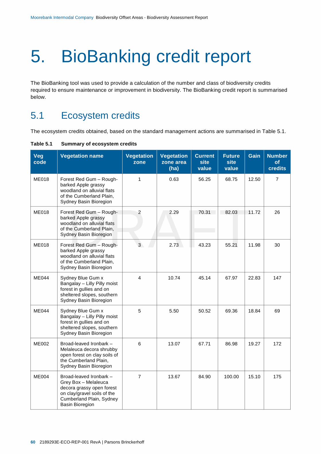
DRAFT
60 2189293E-ECO-REP-001 RevA | Parsons Brinckerhoff
Moorebank Intermodal Company Biodiversity Offset Areas - Biodiversity Assessment Report
5. BioBanking credit reportThe BioBanking tool was used to provide a calculation of the number and class of biodiversity creditsrequired to ensure maintenance or improvement in biodiversity. The BioBanking credit report is summarisedbelow.
5.1 Ecosystem creditsThe ecosystem credits obtained, based on the standard management actions are summarised in Table 5.1.
Table 5.1 Summary of ecosystem credits
Vegcode
Vegetation name Vegetationzone
Vegetationzone area
(ha)
Currentsite
value
Futuresite
value
Gain Numberof
credits
ME018 Forest Red Gum – Rough-barked Apple grassywoodland on alluvial flatsof the Cumberland Plain,Sydney Basin Bioregion
1 0.63 56.25 68.75 12.50 7
ME018 Forest Red Gum – Rough-barked Apple grassywoodland on alluvial flatsof the Cumberland Plain,Sydney Basin Bioregion
2 2.29 70.31 82.03 11.72 26
ME018 Forest Red Gum – Rough-barked Apple grassywoodland on alluvial flatsof the Cumberland Plain,Sydney Basin Bioregion
3 2.73 43.23 55.21 11.98 30
ME044 Sydney Blue Gum xBangalay – Lilly Pilly moistforest in gullies and onsheltered slopes, southernSydney Basin Bioregion
4 10.74 45.14 67.97 22.83 147
ME044 Sydney Blue Gum xBangalay – Lilly Pilly moistforest in gullies and onsheltered slopes, southernSydney Basin Bioregion
5 5.50 50.52 69.36 18.84 69
ME002 Broad-leaved Ironbark –Melaleuca decora shrubbyopen forest on clay soils ofthe Cumberland Plain,Sydney Basin Bioregion
6 13.07 67.71 86.98 19.27 172
ME004 Broad-leaved Ironbark –Grey Box – Melaleucadecora grassy open foreston clay/gravel soils of theCumberland Plain, SydneyBasin Bioregion
7 13.67 84.90 100.00 15.10 175

DRAFT
Parsons Brinckerhoff | 2189293E-ECO-REP-001 RevA 61
Moorebank Intermodal Company Biodiversity Offset Areas - Biodiversity Assessment Report
Vegcode
Vegetation name Vegetationzone
Vegetationzone area
(ha)
Currentsite
value
Futuresite
value
Gain Numberof
credits
ME003 Hard-leaved Scribbly Gum– Parramatta Red Gumheathy woodland of theCumberland Plain, SydneyBasin Bioregion
9 31.55 71.35 92.19 20.84 428
ME004 Broad-leaved Ironbark –Grey Box – Melaleucadecora grassy open foreston clay/gravel soils of theCumberland Plain, SydneyBasin Bioregion
8 0.05 41.67 61.46 19.79 1
ME003 Hard-leaved Scribbly Gum– Parramatta Red Gumheathy woodland of theCumberland Plain, SydneyBasin Bioregion
10 2.41 74.48 92.19 17.71 31
ME005 Parramatta Red Gumwoodland on moistalluvium of theCumberland Plain, SydneyBasin Bioregion
11 23.54 79.69 92.19 12.50 278
N/A Exotic woody vegetation(poor quality condition)
MZ12
N/A Exotic grassland and bareareas (poor qualitycondition)
MZ13
5.2 Species creditsThree threatened species of were recorded during the sites surveys by Parsons Brinckerhoff for thepreparation of this report and by Hyder Consulting during preparation of the Biodiversity Assessment Reportfor the proposed SIMTA Intermodal Terminal Facility (Hyder Consulting 2015):
Grevillea parviflora subsp. parvifloraPersoonia nutansAcacia pubescens.
5.2.1 Persoonia nutans
In surveys conducted for the proposed SIMTA Intermodal Terminal Facility, Hyder Consulting recorded 115Persoonia nutans individuals within the western portion of the Wattle Grove offset biobank site (HyderConsulting 2015). Surveys conducted by Parsons Brinckerhoff in the eastern portion of the Wattle Groveoffset biobank site recorded an additional 60 individuals.
A total of 175 Persoonia nutans individuals was recorded and this is considered to be the minimumpopulation size for the Wattle Grove offset biobank site.

DRAFT
62 2189293E-ECO-REP-001 RevA | Parsons Brinckerhoff
Moorebank Intermodal Company Biodiversity Offset Areas - Biodiversity Assessment Report
5.2.2 Grevillea parviflora subsp. parviflora
Hyder Consulting conducted the following intensive transect surveys in the western portion of the WattleGrove offset biobank site:
2011-2012 surveys; 4 metre wide transects spaced 10 metres apart on both sides of the existing railspur producing a count of1644 stems and a population estimate of 4110 stems based on 40 per centof the survey area sampled
2014 surveys; to the west of the existing rail spur producing a total count of 2825 stems and apopulation estimate of approximately 7063 stems
Intensive surveys in July 2012; focused on the subset of the population in the vicinity of the proposedRail link; these surveys involved counting all stems within approximately 25 metres either side of thecentre line of the proposed Rail link, and were undertaken over an area of approximately 0.37 hectares.A total of 842 stems were recorded in this area; this equates to 2275 stems per hectare (HyderConsulting 2015).
This detailed density information has been used, in conjunction with habitat inspection and mapping toproduce a stem count estimate across the entire Wattle Grove offset biobank site.
The estimate is based on the following:
In their intensive count stems over a 0.37ha area of a dense patch of the species in the west of the site,Hyder Consulting recorded a density of 2275 stems per hectare; extrapolation of this density across thelarge dense patches recorded alone produces a figure in excess of 11,600 stems.
Smaller dense patches and individuals were observed throughout Castlereagh Scribbly Gum Woodlandand Cooks River Castlereagh Ironbark Forest (totalling 40 ha) at an estimated overall density of at least50 stems per hectare equating to an additional 2000 stems.
Occasional small patches and individuals were observed in Shale/Gravel Transition Forest andCastlereagh Swamp Woodland near the boundary of these communities and adjacent areas ofCastlereagh Scribbly Gum Woodland Cooks River Castlereagh Ironbark Forest.
A total stem count of 13,600 is therefore considered a reasonable and conservative estimate of the totalpopulation within the Wattle Grove offset biobank site for the purposes of the calculation of species creditsfor Grevillea parviflora subsp. parviflora.
5.2.3 Acacia pubescens
Acacia pubescens was recorded in three distinct patches. One patch contained three stems within a fewmetres of one another. Each of the other two patches contained a large number of stems. Due to itssuckering habit resulting in clonal reproduction, it is difficult to determine how many genetic individuals arerepresented. The total number of stems over the three patches was estimated at 80-100 stems.
5.2.4 Species credits
Three species were recorded incidentally during the sites surveys within the Biobank site. There is potentialhabitat within the sites for a number of additional threatened species and if recorded during targeted surveysspecies credits could also be calculated and obtained.
The species credits obtained, based on the standard management actions are summarised in Table 5.2.

DRAFT
Parsons Brinckerhoff | 2189293E-ECO-REP-001 RevA 63
Moorebank Intermodal Company Biodiversity Offset Areas - Biodiversity Assessment Report
Table 5.2 Summary of species credits
Scientific name Common name Number of speciescredits created
Acacia pubescens Downy Wattle 710
Persoonia nutans Nodding Geebung 1,242
Grevillea parviflora subsp. parviflora Small-flower Grevillea 96,560
Total 98,512
DRAFT
64 2189293E-ECO-REP-001 RevA | Parsons Brinckerhoff
Moorebank Intermodal Company Biodiversity Offset Areas - Biodiversity Assessment Report
6. ReferencesAustralian Weeds Committee 2015, Weeds of National Significance, 2015,<http://www.weeds.org.au/WoNS/>.
Biosis Research 2003, National Highway Link F3 to Branxton - Updated Additional Flora and FaunaAssessment, Report prepared for Roads and Traffic Authority.
Bureau of Meteorology 2015, 'Climate Data Online'.
Cropper, SC 1993, Management of Endangered Plants, CSIRO Australia, Melbourne.
Department of Environment and Climate Change 2007, Threatened species assessment guidelines. Theassessment of significance, Department of Environment and Climate Change, Hurstville.
Department of Environment and Conservation 2004, Threatened Biodiversity Survey and Assessment:Guidelines for Developments and Activities (Working Draft), Department of Environment and Conservation,Hurstville.
Department of the Environment 2015a, Australian Faunal Directory, viewed 9 February 2015<http://www.environment.gov.au/biodiversity/abrs/online-resources/fauna/afd/home>.
Department of the Environment 2015b, EPBC Protected Matters Search Tool, viewed 1 March 2015,<http://www.environment.gov.au/epbc/pmst/>.
Department of Trade & Investment Region Infrastructure and Services 2014, Threatened & protectedspecies - records viewer, <http://www.dpi.nsw.gov.au/fisheries/species-protection/records/viewer>.
Department of Trade and Investment Regional Infrastructure and Services 2015a, Noxious WeedsDeclaration Page, viewed 8 May 2015, <http://www.dpi.nsw.gov.au/agriculture/pests-weeds/weeds/noxweed/noxious-app-application>.
Department of Trade and Investment Regional Infrastructure and Services 2015b, 'NSW Threatened AquaticFauna Database'.
ENSR Australia 2008, 'Integra Coal Operations Pty Ltd, Weed Management Plan'.
Harden, G 1992, Flora of New South Wales Volume 3, University of New South Wales Press Ltd.,Kensington.
Harden, G 1993, Flora of New South Wales Volume 4, University of New South Wales Press Ltd.,Kensington.
Harden, G 2000, Flora of New South Wales Volume 1 (Revised Edition), University of New South WalesPress Ltd., Kensington.
Harden, G 2002, Flora of New South Wales Volume 2 (Revised Edition), 2nd edn, vol. 2, University of NewSouth Wales Press Ltd., Kensington.
Hawkesbury Nepean Catchment Management Trust 2000, Guidelines for Bushland Weed Mapping. AComponent of the Trusts Manual "Aspects of Catchment Health". Hawkesbury-Nepean CatchmentManagement Trust, Windsor.
DRAFT
Parsons Brinckerhoff | 2189293E-ECO-REP-001 RevA 65
Moorebank Intermodal Company Biodiversity Offset Areas - Biodiversity Assessment Report
Hyder Consulting 2015, Sydney Intermodal Terminal Alliance (SIMTA) Intermodal Terminal Facility Stage 1 -Biodiversity Assessment Report.
John Seidel 2014, Principal Project Officer - Ecosystems & Threatened Species - Regional Operations 2014,
Matthei, LE 1995, Soil Landscapes of the Newcastle 1:100,000 sheet, Department of Land and WaterConservation, Sydney.
Office of Environment and Heritage 2015a, NSW Bionet Atlas of NSW Wildlife,<http://www.bionet.nsw.gov.au/>.
Office of Environment and Heritage 2015b, 'Threatened species, populations and ecological communities ofNSW online database'.
Parsons Brinckerhoff 2014, Moorebank Intermodal Terminal- Biodiversity Offset Strategy Sydney.
Royal Botanic Gardens 2015, 'PlantNet - The Plant Information Network System of Botanic Gardens Trust(version 2.0)'.
Seidel, J & Briggs, S 2008, Biobanking Operation Manual NSW Department of Environment and ClimateChange, Sydney.
Thackway, R & Cresswell, ID 1995, An Interim Biogeographic Regionalisation of Australia, Australian NatureConservation Agency, Canberra.
Tozer, M 2003, 'The native vegetation of the Cumberland Plain, western Sydney: systematic classificationand field identification of communities', Cunninghamia, vol. 8, no. 1, pp. 1-75.
Tozer, M, Turner, K, Simpson, C, Keith, D, Beukers, P, MacKenzie, B, Tindall, D & Pennay, C 2006, NativeVegetation of Southeast NSW: A Revised Classification and Map for the Coast and Eastern Tablelands.Version 1.0, Department of Environment and Climate Change, Hurstville.


Appendix ASpecies of plant recorded


BioBanking Biodiversity ReportMoorebank Intermodal Terminal
Biodiversity Offset Areas
2106567A-ECO-REP-:BT/BT: 1/8
Appendix A – Plant species recorded
Family Name Scientific Name Common Name EPBCAct(1)
TSCAct(2)
Native
Acanthaceae Pseuderanthemumvariabile
Pastel Flower True
Adiantaceae Cheilanthesaustrotenuifolia
Rock Fern True
Adiantaceae Cheilanthes sieberi Mulga Fern True
Alismataceae Sagittaria platyphylla Sagittaria False
Amaranthaceae Alternanthera denticulata Lesser Joyweed True
Amaranthaceae Alternantheraphiloxeroides
Alligator Weed False
Apiaceae Centella asiatica Pennywort True
Apiaceae Hydrocotyle peduncularis True
Apiaceae Platysace ericoides True
Apiaceae Trachymene incisa True
Asclepiadaceae Araujia sericifera Moth Vine False
Asclepiadaceae Asclepias curassavica Blood Flower False
Asparagaceae Asparagus aethiopicus Asparagus Fern False
Asparagaceae Asparagus asparagoides Bridal Creeper False
Asparagaceae Asparagus officinalis Asparagus False
Asteraceae Ageratina adenophora Crofton Weed False
Asteraceae Aster subulatus Wild Aster False
Asteraceae Bidens bipinnata Bipinnate Beggars Ticks False
Asteraceae Bidens pilosa Cobblers Pegs False
Asteraceae Cirsium vulgare Spear Thistle False
Asteraceae Conyza albida Tall Fleabane False
Asteraceae Conyza bonariensis Flaxleaf Fleabane False
Asteraceae Conyza sp. False
Asteraceae Hypochaeris radicata Catsear False
Asteraceae Lagenifera stipitata Blue Bottle-daisy True
Asteraceae Ozothamnus diosmifolius White Dogwood True
Asteraceae Senecio hispidulus Hill Fireweed True
Asteraceae Seneciomadagascariensis
Fireweed False
Asteraceae Vittadinia cuneata Fuzzweed True
Caprifoliaceae Lonicera japonica Japanese Honeysuckle False
Casuarinaceae Allocasuarina littoralis Black Sheoak True
Casuarinaceae Allocasuarina sp. True
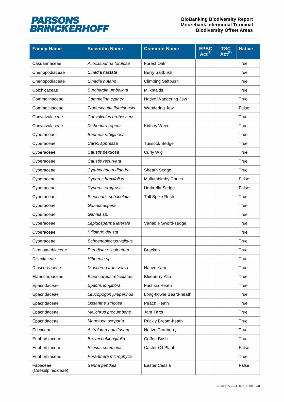
BioBanking Biodiversity ReportMoorebank Intermodal Terminal
Biodiversity Offset Areas
2106567A-ECO-REP-:BT/BT: 2/8
Family Name Scientific Name Common Name EPBCAct(1)
TSCAct(2)
Native
Casuarinaceae Allocasuarina torulosa Forest Oak True
Chenopodiaceae Einadia hastata Berry Saltbush True
Chenopodiaceae Einadia nutans Climbing Saltbush True
Colchicaceae Burchardia umbellata Milkmaids True
Commelinaceae Commelina cyanea Native Wandering Jew True
Commelinaceae Tradescantia fluminensis Wandering Jew False
Convolvulaceae Convolvulus erubescens True
Convolvulaceae Dichondra repens Kidney Weed True
Cyperaceae Baumea rubiginosa True
Cyperaceae Carex appressa Tussock Sedge True
Cyperaceae Caustis flexuosa Curly Wig True
Cyperaceae Caustis recurvata True
Cyperaceae Cyathochaeta diandra Sheath Sedge True
Cyperaceae Cyperus brevifolius Mullumbimby Couch False
Cyperaceae Cyperus eragrostis Umbrella Sedge False
Cyperaceae Eleocharis sphacelata Tall Spike Rush True
Cyperaceae Gahnia aspera True
Cyperaceae Gahnia sp. True
Cyperaceae Lepidosperma laterale Variable Sword-sedge True
Cyperaceae Ptilothrix deusta True
Cyperaceae Schoenoplectus validus True
Dennstaedtiaceae Pteridium esculentum Bracken True
Dilleniaceae Hibbertia sp. True
Dioscoreaceae Dioscorea transversa Native Yam True
Elaeocarpaceae Elaeocarpus reticulatus Blueberry Ash True
Epacridaceae Epacris longiflora Fuchsia Heath True
Epacridaceae Leucopogon juniperinus Long-flower Beard-heath True
Epacridaceae Lissanthe strigosa Peach Heath True
Epacridaceae Melichrus procumbens Jam Tarts True
Epacridaceae Monotoca scoparia Prickly Broom-heath True
Ericaceae Astroloma humifusum Native Cranberry True
Euphorbiaceae Breynia oblongifolia Coffee Bush True
Euphorbiaceae Ricinus communis Castor Oil Plant False
Euphorbiaceae Poranthera microphylla True
Fabaceae(Caesalpinioideae)
Senna pendula Easter Cassia False

BioBanking Biodiversity ReportMoorebank Intermodal Terminal
Biodiversity Offset Areas
2106567A-ECO-REP-:BT/BT: 3/8
Family Name Scientific Name Common Name EPBCAct(1)
TSCAct(2)
Native
Fabaceae (Faboideae) Bossiaea heterophylla Variable Bossiaea True
Fabaceae (Faboideae) Bossiaea obcordata Spiny Bossiaea True
Fabaceae (Faboideae) Daviesia ulicifolia Gorse Bitter Pea True
Fabaceae (Faboideae) Desmodium varians Slender Tick-trefoil True
Fabaceae (Faboideae) Dillwynia retorta True
Fabaceae (Faboideae) Glycine clandestina Twining Glycine True
Fabaceae (Faboideae) Glycine microphylla Small-leaf Glycine True
Fabaceae (Faboideae) Glycine tabacina True
Fabaceae (Faboideae) Gompholobiumgrandiflorum
Large Wedge Pea True
Fabaceae (Faboideae) Gompholobium pinnatum Pinnate Wedge Pea True
Fabaceae (Faboideae) Hardenbergia violacea False Sarsaparilla True
Fabaceae (Faboideae) Lotus uliginosus Birds-foot Trefoil False
Fabaceae (Faboideae) Pultenaea retusa Blunt Bush-pea True
Fabaceae (Faboideae) Pultenaea sp. True
Fabaceae (Faboideae) Pultenaea sp. A True
Fabaceae (Faboideae) Pultenaea villosa True
Fabaceae (Faboideae) Trifolium repens White Clover False
Fabaceae (Faboideae) Vicia sativa Common Vetch False
Fabaceae (Mimosoideae) Acacia baileyana Cootamundra Wattle True
Fabaceae (Mimosoideae) Acacia binervia Coast Myall True
Fabaceae (Mimosoideae) Acacia brownii Heath Wattle True
Fabaceae (Mimosoideae) Acacia decurrens Black Wattle True
Fabaceae (Mimosoideae) Acacia falcata True
Fabaceae (Mimosoideae) Acacia floribunda White Sally True
Fabaceae (Mimosoideae) Acacia longifolia Sydney Golden Wattle True
Fabaceae (Mimosoideae) Acacia parramattensis Parramatta Wattle True
Fabaceae (Mimosoideae) Acacia pubescens Downy Wattle True
Fabaceae (Mimosoideae) Acacia ulicifolia Prickly Moses True
Geraniaceae Geranium homeanum Rainforest Cranes-bill True
Goodeniaceae Goodenia hederacea True
Goodeniaceae Goodenia paniculata Branched Goodenia True
Goodeniaceae Goodenia sp. True
Haloragaceae Gonocarpus tetragynus Common Raspwort True
Haloragaceae Gonocarpus teucrioides True
Iridaceae Patersonia sericea Silky Purple-flag True

BioBanking Biodiversity ReportMoorebank Intermodal Terminal
Biodiversity Offset Areas
2106567A-ECO-REP-:BT/BT: 4/8
Family Name Scientific Name Common Name EPBCAct(1)
TSCAct(2)
Native
Juncaceae Juncus australis Austral Rush True
Juncaceae Juncus cognatus False
Juncaceae Juncus usitatus Billabong Rush True
Lamiaceae Plectranthus parviflorus Cockspur Flower True
Lauraceae Cassytha glabella Slender Dodder-laurel True
Lauraceae Cassytha pubescens True
Lauraceae Cinnamomum camphora Camphor Laurel False
Lobeliaceae Pratia purpurascens Whiteroot True
Loganiaceae Mitrasacme polymorpha Varied Mitrewort True
Lomandraceae Lomandra filiformis Wattle Matt-rush True
Lomandraceae Lomandra longifolia Spiny-headed Mat-rush True
Lomandraceae Lomandra multiflora True
Lomandraceae Lomandra sp. True
Loranthaceae Amyema gaudichaudii True
Luzuriagaceae Eustrephus latifolius Wombat Berry True
Malvaceae Modiola caroliniana Red-flowered Mallow False
Malvaceae Pavonia hastata False
Malvaceae Sida rhombifolia Paddys Lucerne False
Myrtaceae Angophora bakeri Narrow-leaved Apple True
Myrtaceae Angophora floribunda Rough-barked Apple True
Myrtaceae Angophora subvelutina Broad-leaved Apple True
Myrtaceae Backhousia myrtifolia Grey Myrtle True
Myrtaceae Callistemon linearis Narrow-leavedBottlebrush
True
Myrtaceae Callistemon salignus Willow Bottlebrush True
Myrtaceae Eucalyptus amplifolia Cabbage Gum True
Myrtaceae Eucalyptus baueriana Blue Box True
Myrtaceae Eucalyptus crebra Narrow-leaved Ironbark True
Myrtaceae Eucalyptus eugenioides Thin-leaved Stringybark True
Myrtaceae Eucalyptus fibrosa Red Ironbark True
Myrtaceae Eucalyptus parramattensissubsp. parramattensis
Parramatta Red Gum True
Myrtaceae Eucalyptus resinifera Red Mahogany True
Myrtaceae Eucalyptus saligna xbotryoides
True
Myrtaceae Eucalyptus sclerophylla Hard-leaved ScribblyGum
True

BioBanking Biodiversity ReportMoorebank Intermodal Terminal
Biodiversity Offset Areas
2106567A-ECO-REP-:BT/BT: 5/8
Family Name Scientific Name Common Name EPBCAct(1)
TSCAct(2)
Native
Myrtaceae Eucalyptus sp. True
Myrtaceae Eucalyptus tereticornis Forest Red Gum True
Myrtaceae Kunzea ambigua Tick Bush True
Myrtaceae Leptospermumcontinentale
Prickly Teatree True
Myrtaceae Leptospermum parvifolium True
Myrtaceae Leptospermumpolygalifolium
True
Myrtaceae Leptospermum trinervium Paperbark Tea-tree True
Myrtaceae Melaleuca armillaris True
Myrtaceae Melaleuca decora White FeatherHoneymyrtle
True
Myrtaceae Melaleuca ericifolia True
Myrtaceae Melaleuca linariifolia True
Myrtaceae Melaleuca nodosa Pricklyleaf Paperbark True
Myrtaceae Melaleuca thymifolia True
Oleaceae Ligustrum lucidum Large-leaved Privet False
Oleaceae Ligustrum sinense Small-leaved Privet False
Oleaceae Notelaea longifolia Large Mock-olive True
Oleaceae Olea europaea subsp.cuspidata
False
Onagraceae Ludwigia peruviana False
Orchidaceae Pterostylis sp. True
Oxalidaceae Oxalis perennans Grassland Wood-sorrel True
Oxalidaceae Oxalis sp. True
Philydraceae Philydrum lanuginosum Frogsmouth True
Phormiaceae Dianella revoluta True
Phormiaceae Dianella sp. True
Phytolaccaceae Phytolacca octandra Inkweed False
Pittosporaceae Billardiera scandens Appleberry True
Pittosporaceae Bursaria spinosa Native Blackthorn True
Pittosporaceae Pittosporum undulatum Sweet Pittosporum True
Plantaginaceae Plantago lanceolata Lambs Tongues False
Poaceae Andropogon virginicus Whisky Grass False
Poaceae Aristida ramosa Cane Wire-grass True
Poaceae Aristida sp. True
Poaceae Aristida vagans Threeawn Speargrass True

BioBanking Biodiversity ReportMoorebank Intermodal Terminal
Biodiversity Offset Areas
2106567A-ECO-REP-:BT/BT: 6/8
Family Name Scientific Name Common Name EPBCAct(1)
TSCAct(2)
Native
Poaceae Aristida warburgii True
Poaceae Arundo donax Giant Reed False
Poaceae Austrostipa pubescens True
Poaceae Austrostipa ramosissima Stout Bamboo Grass True
Poaceae Austrostipa sp. True
Poaceae Axonopus fissifolius Narrow-leafed CarpetGrass
False
Poaceae Bothriochloa macra Red Grass True
Poaceae Briza subaristata False
Poaceae Chloris gayana Rhodes Grass False
Poaceae Chloris virgata Feathertop RhodesGrass
False
Poaceae Cymbopogon refractus Barbed Wire Grass True
Poaceae Cynodon dactylon Common Couch True
Poaceae Dactyloctenium radulans Button Grass True
Poaceae Dichelachne sp. True
Poaceae Digitaria didactyla Queensland Blue Couch True
Poaceae Digitaria parviflora Small-flowered FingerGrass
True
Poaceae Echinopogon caespitosus True
Poaceae Echinopogon ovatus Forest Hedgehog Grass True
Poaceae Ehrharta erecta Panic Veldtgrass False
Poaceae Entolasia marginata Bordered Panic True
Poaceae Entolasia stricta Wiry Panic True
Poaceae Eragrostis brownii Browns Lovegrass True
Poaceae Eragrostis curvula African Lovegrass False
Poaceae Eragrostis sp. True
Poaceae Hemarthria uncinata Matgrass True
Poaceae Imperata cylindrica Bladey Grass True
Poaceae Lachnagrostis filiformis Common Blown-grass True
Poaceae Microlaena stipoides True
Poaceae Oplismenus aemulus True
Poaceae Oplismenus imbecillis Creeping Beard Grass True
Poaceae Panicum simile Two-colour Panic True
Poaceae Paspalidium distans Spreading Panic-grass True
Poaceae Paspalum dilatatum Paspalum False
Poaceae Paspalum urvillei Vasey Grass False

BioBanking Biodiversity ReportMoorebank Intermodal Terminal
Biodiversity Offset Areas
2106567A-ECO-REP-:BT/BT: 7/8
Family Name Scientific Name Common Name EPBCAct(1)
TSCAct(2)
Native
Poaceae Pennisetum clandestinum Kikuyu Grass False
Poaceae Poa labillardierei var.labillardierei
Tussock True
Poaceae Rytidosperma sp. True
Poaceae Setaria gracilis Slender Pigeon Grass False
Poaceae Sporobolus africanus Parramatta Grass False
Poaceae Sporobolus creber Slender Rats Tail Grass True
Poaceae Sporobolus elongatus Slender Rats Tail Grass True
Poaceae Sporobolus sp. True
Poaceae Themeda australis Kangaroo Grass True
Polygonaceae Acetosa sagittata Rambling Dock False
Polygonaceae Persicaria decipiens Slender Knotweed True
Polygonaceae Persicaria sp. True
Pontederiaceae Eichhornia crassipes Water Hyacinth False
Proteaceae Banksia integrifolia True
Proteaceae Banksia oblongifolia True
Proteaceae Banksia spinulosa True
Proteaceae Grevillea parviflora subsp.parviflora
Small-flower Grevillea V V (NSW )
True
Proteaceae Grevillea robusta Silky Oak True
Proteaceae Hakea dactyloides Broad-leaved Hakea True
Proteaceae Hakea sericea True
Proteaceae Isopogon anemonifolius True
Proteaceae Lomatia silaifolia Crinkle Bush True
Proteaceae Persoonia lanceolata True
Proteaceae Persoonia levis Broad-leaved Geebung True
Proteaceae Persoonia linearis Narrow-leaved Geebung True
Proteaceae Persoonia nutans Nodding Geebung E E1 (NSW )
True
Proteaceae Petrophile sessilis True
Ranunculaceae Clematis aristata Mountain Clematis True
Restionaceae Empodisma minus Spreading Rope-rush True
Restionaceae Lepyrodia scariosa True
Rosaceae Rubus fruiticosus Blackberry complex False
Rosaceae Rubus parvifolius Native Raspberry True
Rosaceae Rubus ulmifolius Blackberry False
Rubiaceae Opercularia aspera Coarse Stinkweed True

BioBanking Biodiversity ReportMoorebank Intermodal Terminal
Biodiversity Offset Areas
2106567A-ECO-REP-:BT/BT: 8/8
Family Name Scientific Name Common Name EPBCAct(1)
TSCAct(2)
Native
Rubiaceae Opercularia diphylla True
Rubiaceae Opercularia sp. True
Rubiaceae Pomax umbellata Pomax True
Rubiaceae Richardia stellaris False
Rutaceae Phebalium dentatum Toothed Phebalium True
Santalaceae Exocarpos cupressiformis Native Cherry True
Sapindaceae Cardiospermumgrandiflorum
Balloon Vine False
Scrophulariaceae Veronica plebeia Trailing Speedwell True
Solanaceae Cestrum parqui Green Cestrum False
Solanaceae Solanum americanum Glossy Nightshade True
Solanaceae Solanum chenopodioides Whitetip Nightshade False
Solanaceae Solanum mauritianum Wild Tobacco Bush False
Thymelaeaceae Pimelea linifolia Slender Rice-flower True
Typhaceae Typha orientalis Broad-leaved Cumbungi True
Verbenaceae Lantana camara Lantana False
Verbenaceae Verbena bonariensis Purpletop False
Verbenaceae Verbena rigida Veined Verbena False
Vitaceae Cayratia clematidea Slender Grape True
Xanthorrhoeaceae Xanthorrhoea minor True
Xanthorrhoeaceae Xanthorrhoea spp. True
(1) EPBC Act – Environment Protection and Biodiversity Conservation Act 1999. X = Extinct, CE = Critically Endangered, E =Endangered V = Vulnerable
(2) TSC Act – Threatened Species and Conservation Act 1995. E4A = Extinct, CE = Critically Endangered, E1 = Endangered V =Vulnerable E2= Endangered Population,

Appendix BThreatened species of plant


BioBanking Biodiversity ReportMoorebank Intermodal Terminal
Biodiversity Offset Areas
2106567A-ECO-REP-:BT/BT: 7/9
Appendix B ReferencesBishop, T 2000, Field guide to the orchids of New South Wales and Victoria, Second edn, University of NewSouth Wales Press Pty. Ltd., Sydney.
Brooker, MIH & Kleinig, DA 1999, Field guide to Eucalypts, Volume 1: South-eastern Australia, BloomingBooks, Hawthorn, Australia.
Department of the Environment Water Heritage and the Arts 2009, Thelymitra sp. Kangaloon (D.L.Jones18108) in Species Profile and Threats Database, Department of the Environment Water Heritage and theArts, viewed 21 August 2009 2009, <http://www.environment.gov.au/cgi-bin/sprat/public/publicspecies.pl?taxon_id=81971>.
Fairley, A 2004, Seldom Seen: Rare Plants of Greater Sydney., 1st edn, Reed New Holland, Sydney.
Fairley, A & Moore, P 2002, Native plants of the Sydney district. An identification guide, Revised Edition edn,Kangaroo Press, Sydney.
Harden, G 1992, Flora of New South Wales Volume 3, University of New South Wales Press Ltd.,Kensington.
Harden, G 1993, Flora of New South Wales Volume 4, University of New South Wales Press Ltd.,Kensington.
Harden, G 2000, Flora of New South Wales Volume 1 (Revised Edition), University of New South WalesPress Ltd., Kensington.
Harden, G 2002, Flora of New South Wales Volume 2 (Revised Edition), 2nd edn, vol. 2, University of NewSouth Wales Press Ltd., Kensington.
James, T 1997a, Urban bushland biodiversity survey. Flora appendices. , NSW National Parks and WildlifeService, Hurstville,
James, T 1997b, Urban bushland biodiversity survey. Native flora in western Sydney. , NSW National Parksand Wildlife Service, Hurstville,
James, T, McDougall, L & Benson, D 1999, Rare bushland plants of western Sydney, Royal BotanicGardens, Sydney.
Lunt, ID 1997, 'Germinable soil seed banks of anthropogenic native grasslands and grassy forest remnantsin temperate south-eastern Australia', Plant Ecology, vol. 130, no. 1, pp. 21-34.
NSW National Parks and Wildlife Service 1999a, Acacia bynoeana threatened species information, NSWNational Parks and Wildlife Service, Hurstville.
NSW National Parks and Wildlife Service 1999b, Terms of licence under the Threatened SpeciesConservation Act 1995. Appendix B of the Integrated Forestry Operations Approval for the Upper North EastRegion.,
NSW National Parks and Wildlife Service 2000, Pimelea spicata threatened species information, NSWNational Parks and Wildlife Service, Hurstville.
NSW National Parks and Wildlife Service 2001, Persoonia nutans threatened species information, NSWNational Parks and Wildlife Service, Hurstville.
NSW National Parks and Wildlife Service 2002a, Camarophyllopsis kearneyi (an agaric fungus) -endangered species listing, NSW National Parks and Wildlife Service, Hurstville.

BioBanking Biodiversity ReportMoorebank Intermodal Terminal
Biodiversity Offset Areas
2106567A-ECO-REP-:BT/BT: 8/9
NSW National Parks and Wildlife Service 2002b, Cynanchum elegans threatened species information, NSWNational Parks and Wildlife Service, Hurstville.
NSW National Parks and Wildlife Service 2002c, Epacris purpurascens var. purpurascens threatenedspecies information, NSW National Parks and Wildlife Service, Hurstville.
NSW National Parks and Wildlife Service 2002d, Hygrocybe anomala var. ianthinomarginata (an agaricfungus) - vulnerable species listing, NSW National Parks and Wildlife Service, Hurstville.
NSW National Parks and Wildlife Service 2002e, Hygrocybe aurantipes (an agaric fungus) - vulnerablespecies listing, NSW National Parks and Wildlife Service, Hurstville.
NSW National Parks and Wildlife Service 2002f, Hygrocybe austropratensis (an agaric fungus) - endangeredspecies listing, NSW National Parks and Wildlife Service, Hurstville.
NSW National Parks and Wildlife Service 2002g, Hygrocybe collucera (an agaric fungus) - endangeredspecies listing, NSW National Parks and Wildlife Service, Hurstville.
NSW National Parks and Wildlife Service 2002h, Hygrocybe griseoramosa (an agaric fungus) - endangeredspecies listing, NSW National Parks and Wildlife Service, Hurstville.
NSW National Parks and Wildlife Service 2002i, Hygrocybe lanecovensis (an agaric fungus) - endangeredspecies listing, NSW National Parks and Wildlife Service, Hurstville.
NSW National Parks and Wildlife Service 2002j, Hygrocybe reesiae (an agaric fungus) - vulnerable specieslisting, NSW National Parks and Wildlife Service, Hurstville.
NSW National Parks and Wildlife Service 2002k, Hygrocybe rubronivea (an agaric fungus) - vulnerablespecies listing, NSW National Parks and Wildlife Service, Hurstville.
NSW National Parks and Wildlife Service 2002l, Pultenaea parviflora threatened species information, NSWNational Parks and Wildlife Service, Hurstville.
NSW National Parks and Wildlife Service 2002m, Pultenaea pedunculata threatened species information,NSW National Parks and Wildlife Service, Hurstville.
NSW National Parks and Wildlife Service 2003, Acacia pubescens threatened species information, NSWNational Parks and Wildlife Service, Hurstville.
NSW Scientific Committee 1998a, Final determination to list Grevillea parvilfora ssp. parviflora as avulnerable species, NSW National Parks and Wildlife Service, Hurstville.
NSW Scientific Committee 1998b, Final determination to list Gyrostemon thesioides as an endangeredspecies, NSW National Parks and Wildlife Service, Hurstville.
NSW Scientific Committee 1998c, Final determination to list Melaleuca biconvexa as a vulnerable species,NSW National Parks and Wildlife Service, Hurstville.
NSW Scientific Committee 1998d, Final determination to list Persoonia hirsuta as an endangered species,NSW National Parks and Wildlife Service, Hurstville.
NSW Scientific Committee 1998e, Final determination to list Pimelea curviflora var curviflora as a vulnerablespecies, NSW National Parks and Wildlife Service, Hurstville.
NSW Scientific Committee 1999a, Final determination to list Callistemon linearifolius as a vulnerablespecies, NSW National Parks and Wildlife Service, Hurstville.

BioBanking Biodiversity ReportMoorebank Intermodal Terminal
Biodiversity Offset Areas
2106567A-ECO-REP-:BT/BT: 9/9
NSW Scientific Committee 1999b, Final determination to list Pomaderris prunifolia as an endangeredpopulation in the Parramatta, Auburn, Strathfield and Bankstown Local Government Areas., NSW NationalParks and Wildlife Service, Hurstville.
NSW Scientific Committee 1999c, Final determination to list Pultenaea pedunculata as an endangeredspecies, NSW National Parks and Wildlife Service, Hurstville.
NSW Scientific Committee 2000a, Final determination to list Marsdenia viridiflora ssp. viridiflora as anendangered population in the Bankstown, Blacktown, Camden, Campbelltown, Fairfield, Holroyd, Liverpooland Penrith local government areas, NSW National Parks and Wildlife Service, Hurstville.
NSW Scientific Committee 2000b, Final determination to list Wilsonia backhousei as a vulnerable species,NSW National Parks and Wildlife Service, Hurstville.
NSW Scientific Committee 2001, Final Determination to list Hibbertia superans (a low spreading shrub) as anEndangered species, Department of Environment and Conservation,<http://www.environment.nsw.gov.au/determinations/HibbertiaSuperansALowSpreadingShrubEndSpListing.htm>.
NSW Scientific Committee 2002a, Final determination to list Caladenia tessellata as an endangered species,NSW National Parks and Wildlife Service, Hurstville.
NSW Scientific Committee 2002b, Final determination to list the Diuris aequalis as an endangered species,NSW National Parks and Wildlife Service, Hurstville.
NSW Scientific Committee 2003a, Final determination to list Hypsela sessiliflora as an endangered species,NSW National Parks and Wildlife Service, Hurstville.
NSW Scientific Committee 2003b, Final determination to list Wahlenbergia multicaulis as an endangeredpopulation in the local government areas of Auburn, Bankstown, Baulkham Hills, Canterbury, Hornsby,Parramatta and Strathfield., NSW National Parks and Wildlife Service, Hurstville.
Office of Environment and Heritage 2011a, Narrow-leaved Black Peppermint - profile, Office of Environmentand Heritage, 2011,<http://www.threatenedspecies.environment.nsw.gov.au/tsprofile/profile.aspx?id=10302>.
Office of Environment and Heritage 2011b, Threatened Species Profile: Eucalyptus camfieldii Office ofEnvironment and Heritage, viewed April 2011<http://www.threatenedspecies.environment.nsw.gov.au/tsprofile/profile.aspx?id=10287>.
Office of Environment and Heritage 2011c, Threatened species, populations and ecological communities ofNSW online database, NSW Government,<http://www.threatenedspecies.environment.nsw.gov.au/tsprofile/index.aspx>.
Robinson, L 1994, Field guide to the native plants of Sydney, Kangaroo Press, Sydney.
Royal Botanic Gardens 2011, PlantNet - The Plant Information Network System of Botanic Gardens Trust(version 2.0), <http://plantnet.rbgsyd.nsw.gov.au/>.
Sharp, D & Simon, BK 2002, AusGrass: Grasses of Australia, CD-ROM, Version 1.0, Australian BiologicalResources Study, Canberra, and Environmental Protection Agency, Queensland.,
Upper Parramatta River Catchment Trust 1999, Green corridors management strategy, Upper ParramattaRiver Catchment Trust, <http://www.uprct.nsw.gov.au/vegetation/publications/greencorridors/GreenCorr/>.


Appendix CThreatened species of animal


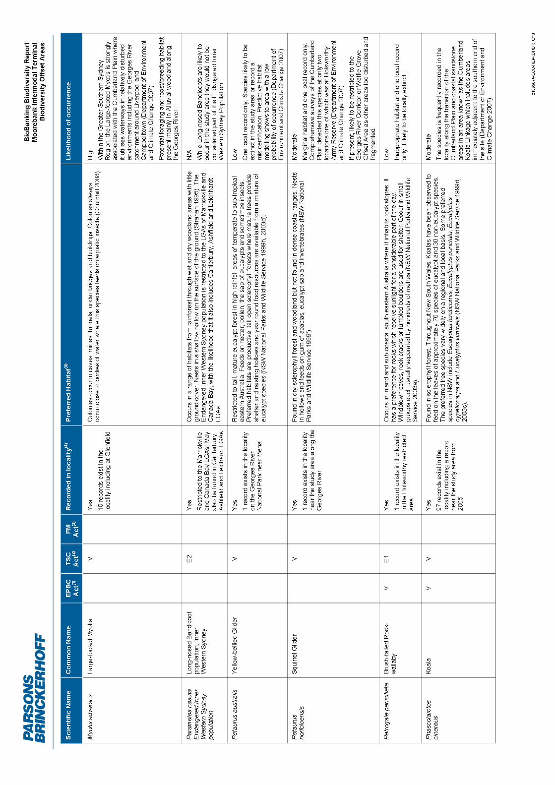


BioBanking Biodiversity ReportMoorebank Intermodal Terminal
Biodiversity Offset Areas
2106567A-ECO-REP-:BT/BT: 11/13
Attachment C ReferencesAustralian Museum 2003, Great Egret factsheet, Australian Museum,
Churchill, S 2008, Australian Bats, 2nd edn, Allen & Unwin, Sydney.
Cogger, HG 2000, Reptiles and Amphibians of Australia, Reed Books, Sydney.
Department of Environment and Climate Change 2007, Terrestrial Vertebrate Fauna of the Greater SouthernSydney Region: Volume 2 Fauna of Conservation Concern and Priority Pest Species, Sydney CatchmentAuthority and the Department of Environment and Climate Change (NSW), Hurstville.
Department of Environment and Conservation 2004, Green and Golden Bell Frog environmental impactassessment guidelines Department of Environment and Conservation (NSW), Hurstville.
Department of Environment and Conservation 2005, Draft Recovery Plan for the Green and Golden BellFrog (Litoria aurea), Department of Environment and Conservation (NSW), Hurstville, NSW,
Department of Environment Climate Change and Water 2009, White-fronted Chat Population in the SydneyMetropolitan Catchment Management Authority Area - profile, Department of Environment Climate Changeand Water, viewed 27 August 2010 2010,<http://www.threatenedspecies.environment.nsw.gov.au/tsprofile/profile.aspx?id=20144>.
Department of Environment Climate Change and Water 2010a, Flame Robin Petroica phoenicea (Gould1837) - vulnerable species listing, Department of Environment Climate Change and Water, viewed 20 April2010, <http://www.environment.nsw.gov.au/determinations/flamerobinFD.htm>.
Department of Environment Climate Change and Water 2010b, Scarlet Robin Petroica boodang - proposedvulnerable species listing, Department of Environment Climate Change and Water, viewed 20 April 2010,<http://www.environment.nsw.gov.au/determinations/scarletrobinpd.htm>.
Department of Environment Climate Change and Water 2010c, Spotted Harrier Circus assimilis - proposedvulnerable species listing, Department of Environment Climate Change and Water, viewed 20 April 2010,<http://npws.nsw.gov.au/determinations/spottedharrierpd.htm>.
Department of Environment Climate Change and Water 2010d, Varied Sittella Daphoenositta chrysoptera(Latham 1802) - vulnerable species listing, Department of Environment Climate Change and Water, viewed20 April 2010, <http://www.environment.nsw.gov.au/determinations/variedsittellaFD.htm>.
Department of Primary industries 2014, Endangered species - Adams Emerald Dragonfly, viewed 8 July2014, <http://www.dpi.nsw.gov.au/fisheries/species-protection/conservation/what-current/endangered-species/adams-emerald-dragonfly>.
Department of the Environment and Heritage 2004, Macquarie Perch- Species profiles and threats database,Department of the Environment and Heritage. Http://www.deh.gov.au/cgi-bin/sprat/public/publicspecies.pl?taxon_id=66632, Canberra
Department of Trade and Investment Regional Infrastructure and Services 2011, Threatened SpeciesPriorities Action Statement - Profiles for species, populations and ecological communities, Department ofTrade and Investment Regional Infrastructure and Services,<http://pas.dpi.nsw.gov.au/Species/Species_Home.aspx>.
Garnett, ST & Crowley, GM 2000a, The Action Plan for Australian Birds, Environment Australia, Canberra.
Garnett, ST & Crowley, GM (eds) 2000b, The Action Plan for Australian Birds, Canberra.

BioBanking Biodiversity ReportMoorebank Intermodal Terminal
Biodiversity Offset Areas
2106567A-ECO-REP-:BT/BT: 12/13
Higgins, PJ (ed.) 1999, Handbook of Australian, New Zealand and Antarctic Birds Volume 4: Parrots toDollarbirds, Volume 4: Parrots to Dollarbird, Oxford University Press, Melbourne.
Higgins, PJ & Peter, JM (eds) 2002, Handbook of Australian, New Zealand and Antarctic Birds, Volume 6:Pardalotes to Shrike-thrushes, Oxford University Press, Melbourne.
Higgins, PJ, Peter, JM & Steele, WK (eds) 2001, Handbook of Australian, New Zealand and Antarctic BirdsVolume 5: Tyrant-flycatchers to Chats, Oxford University Press, Melbourne.
Johnston, PG 1995, 'Long-nosed Potoroo', in R Strahan (ed.), The Mammals of Australia, Reed NewHolland, Sydney, pp. 301-2.
Marchant, S & Higgins, PJ (eds) 1993, Handbook of Australian, New Zealand and Antarctic Birds Volume 2:Raptors to Lapwings, vol. 2, Volume 2: Raptors to Lapwings, Oxford University Press, Melbourne.
McKilligan, N 2005, Herons, egrets and bitterns: their biology and conservation in Australia, CSIROPublishing, Collingwood, Victoria.
NSW Fisheries 2004, Status and monitoring of the Australian Grayling in NSW, NSW Fisheries.
NSW National Parks and Wildlife Service 1999a, Bush Stone-curlew threatened species information, NSWNational Parks and Wildlife Service, Hurstville.
NSW National Parks and Wildlife Service 1999b, Cumberland Plain Large Land Snail threatened speciesinformation, NSW National Parks and Wildlife Service, Hurstville.
NSW National Parks and Wildlife Service 1999c, Glossy Black-cockatoo threatened species information,NSW National Parks and Wildlife Service, Hurstville.
NSW National Parks and Wildlife Service 1999d, Koala threatened species information, NSW National Parksand Wildlife Service, Hurstville.
NSW National Parks and Wildlife Service 1999e, Spotted-tailed Quoll threatened species information, NSWNational Parks and Wildlife Service, Hurstville.
NSW National Parks and Wildlife Service 1999f, Squirrel Glider threatened species information, NSWNational Parks and Wildlife Service, Hurstville.
NSW National Parks and Wildlife Service 1999g, Terms of licence under the Threatened SpeciesConservation Act 1995. Appendix B of the Integrated Forestry Operations Approval for the Upper North EastRegion.,
NSW National Parks and Wildlife Service 1999h, Yellow-bellied Glider threatened species information, NSWNational Parks and Wildlife Service, Hurstville.
NSW National Parks and Wildlife Service 2001a, Giant Burrowing Frog threatened species information, NSWNational Parks and Wildlife Service, Hurstville.
NSW National Parks and Wildlife Service 2001b, Grey-headed Flying Fox threatened species information,NSW National Parks and Wildlife Service, Hurstville.
NSW National Parks and Wildlife Service 2003a, Brush-tailed Rock Wallaby Warrumbungles endangeredpopulation threatened species information, NSW National Parks and Wildlife Service, Hurstville.
NSW National Parks and Wildlife Service 2003b, Draft Recovery Plan for the Bush Stone-curlew Burhinusgrallarius, National Parks and Wildlife Service, Hurstville.

BioBanking Biodiversity ReportMoorebank Intermodal Terminal
Biodiversity Offset Areas
2106567A-ECO-REP-:BT/BT: 13/13
NSW National Parks and Wildlife Service 2003c, Draft Recovery Plan for the Koala, NSW National Parksand Wildlife Service, Hurstville.
NSW National Parks and Wildlife Service 2003d, Recovery Plan for the Yellow-bellied Glider (Petaurusaustralis), NSW National Parks and Wildlife Service, Hurstville.
NSW Scientific Committee 2000, Final determination to list Littlejohn's tree Frog as a vulnerable species,NSW National Parks and Wildlife Service, Hurstville.
NSW Scientific Committee 2003, Final determination to list the Stuttering Frog as an endangered species,NSW National Parks and Wildlife Service, Hurstville.
Office of Environment and Heritage 2011a, Atlas of NSW Wildlife,<http://wildlifeatlas.nationalparks.nsw.gov.au/wildlifeatlas/watlas.jsp>.
Office of Environment and Heritage 2011b, Brown Treecreeper (eastern subspecies) - Profile, Office ofEnvironment and Heritage, 2011,<http://www.threatenedspecies.environment.nsw.gov.au/tsprofile/profile.aspx?id=10171>.
Office of Environment and Heritage 2011c, Threatened species, populations and ecological communities ofNSW online database, NSW Government,<http://www.threatenedspecies.environment.nsw.gov.au/tsprofile/index.aspx>.
Office of Environment and Heritage 2012a, Bionet Atlas of NSW Wildlife website,<http://www.bionet.nsw.gov.au/>.
Office of Environment and Heritage 2012b, Threatened species, populations and ecological communities ofNSW online database, NSW Government,<http://www.threatenedspecies.environment.nsw.gov.au/tsprofile/index.aspx>.
Pizzey, G & Knight, F 1997, Field Guide to the Birds of Australia, Harper and Collins, Sydney.
Pizzey, G & Knight, F 2007, Field Guide to the Birds of Australia, Harper and Collins, Sydney.
Strahan, R 1995, The Mammals of Australia, Reed New Holland, Sydney.
Swift Parrot Recovery Team 2001, Swift Parrot Recovery Plan, Department of Primary Industries, Water andEnvironment, Hobart.
Threatened Species Scientific Committee 2010, Advice to the Minister for the Environment, Heritage and theArts from the Threatened Species Scientific Committee (the Committee) on Amendment to the list ofThreatened Species under the Environment Protection and Biodiversity Conservation Act 1999 (EPBC Act) -Pseudomys novaehollandiae, Threatened Species Scientific Committee, Canberra.
Turner, V & Ward, SJ 1995, 'Eastern Pygmy-possum', in R Strahan (ed.), The Mammals of Australia, ReedNew Holland, Sydney, pp. 217-8.
Webb, JK & Shine, R 1998, 'Ecological characteristic of an endangered snake species Hoplocephalusbungaroides (Serpentes: Elapidae)', Animal Conservation, vol. 1, pp. 185-93.
White, A & Pyke, G 2010, 'Green and Golden Bell Frogs in New South Wales: Current status and futureprospects', Australian Zoologist, vol. 34, no. 3, pp. 319-33.


Appendix DBioBanking credit report