Embed Size (px)
Citation preview

(1) Minor changes to the red line boundary
What is being consulted upon?The Council is carrying out further localised consultation on amendments to the‘red line boundary’ (see explanation below) that was presented at the originalStage 3 consultations.The changes and the reasons for them are explained on the following drawings.
What is the red line boundary? When the Council applies for a Development Consent Order, it will seek authorisation for the scheme to be carried out within an area of land shown by a red line on the plans accompanying the application. This is the “red line boundary”, and it will include all the land the Council seeks to acquire permanently for the scheme, as well as land over which the Council seeks to acquire rights and land over which the Council seeks temporary possession.
How to respond to the consultation Any response to this consultation should be made by:
• Emailing: [email protected]• Writing to: Freepost Plus RTCL-XSTT-JZSK, Norfolk County Council,
GY3RC, Ground floor - south wing, County Hall, Martineau Lane, NorwichNR1 2DH
The deadline for receipt of responses to this consultation is 23:59hrs on 17 March 2019.
APPENDIX A

Suffolk Road
Roundabout
Boundary Road
Proposed extension to the redline boundary on Suffolk Roadnorthwards so that it includesthe Suffolk Road/Boundary Road junction.
This plan shows the schemeproposal and red line boundarypresented at consultation in Summer2018. The further proposed changesto the red line boundary which we arecurrently consulting upon are also shown.
KeyRed Line Boundary consulted upon inSummer 2018Proposed extension of Red Line BoundaryArea of Red Line Boundary extension
Description of ChangeProposed extension to the red line boundary onSuffolk Road northwards so that it includes theSuffolk Road/Boundary Road junction.
Reason for ChangeTo allow for any potential temporary changes tothe junction that may be required duringconstruction of the Scheme in order to maintainaccess to Suffolk Road.
ORIGINAL SIZE: A3
REV.
DRAWN BYDESIGNED BY
CHECKED BY
SURVEYED BY
DRAWING TITLE
CHECKEDDESCRIPTION DATE
IG 12/10/16
PROJECT TITLE
DRAWING No.INITIAL
SCALE
DATE
FILE No.
Tom McCabeExecutive Director ofCommunity and Environmental ServicesNorfolk County CouncilCounty HallMartineau LaneNorwich NR1 2SG
DRAWNPKA018-MP-098
Great Yarmouth Third River Crossing
NTS PKA018
KP 02/19KP 02/19GB 02/19
Great Yarmouth Third River CrossingFurther Consultation Design Changes
Area 1: Suffolk Road Red Line Boundary Changes
© Crown copyrightand database rights2017. OrdnanceSurvey 0100031673

KeyRed Line Boundary consulted upon inSummer 2018Proposed extension of Red Line BoundaryArea of Red Line Boundary extension
Description of ChangeProposed extension to the red line boundary onBollard Quay northwards to its northernboundary and southwards to its southernboundary.
Reason for ChangeTo allow construction vehicles to use the existingaccess ramps to and from Bollard Quay duringconstruction therefore removing the need toconstruct a separate temporary access.
Cromwell Road
River Yare
Suffolk Road
Fish W
harf
Boundary Road
This plan shows the schemeproposal and red line boundarypresented at consultation in Summer2018. The further proposed changesto the red line boundary which we arecurrently consulting upon are also shown.
Proposed extension to the red lineboundary on Bollard Quay northwardsto its northern boundary.
Proposed extension to the red lineboundary on Bollard Quay southwardsto its southern boundary.
ORIGINAL SIZE: A3
REV.
DRAWN BYDESIGNED BY
CHECKED BY
SURVEYED BY
DRAWING TITLE
CHECKEDDESCRIPTION DATE
IG 12/10/16
PROJECT TITLE
DRAWING No.INITIAL
SCALE
DATE
FILE No.
Tom McCabeExecutive Director ofCommunity and Environmental ServicesNorfolk County CouncilCounty HallMartineau LaneNorwich NR1 2SG
DRAWNPKA018-MP-099
Great Yarmouth Third River Crossing
NTS PKA018
KP 02/19KP 02/19GB 02/19
Great Yarmouth Third River CrossingFurther Consultation Design Changes
Area 2: Bollard Quay Red Line Boundary Changes
© Crown copyrightand database rights2017. OrdnanceSurvey 0100031673

Cromwell Road
Suffolk Road
Harfrey'sRoundabout
Queen Anne's RoadKey
Red Line Boundary consulted upon inSummer 2018Proposed reduction of Red Line BoundaryArea of Red Line Boundary reduction
Description of ChangeProposed revisions to the red line boundary in thearea of the King Centre, which results in areas ofland no longer being within the Scheme boundary.
Reason for ChangeAs the Scheme has been developed these areas ofland have been identified as being no longerrequired for the permanent scheme or requiredtemporarily during construction.
ORIGINAL SIZE: A3
REV.
DRAWN BYDESIGNED BY
CHECKED BY
SURVEYED BY
DRAWING TITLE
CHECKEDDESCRIPTION DATE
IG 12/10/16
PROJECT TITLE
DRAWING No.INITIAL
SCALE
DATE
FILE No.
Tom McCabeExecutive Director ofCommunity and Environmental ServicesNorfolk County CouncilCounty HallMartineau LaneNorwich NR1 2SG
DRAWNPKA018-MP-100
Great Yarmouth Third River Crossing
NTS PKA018
KP 02/19KP 02/19GB 02/19
Great Yarmouth Third River CrossingFurther Consultation Design Changes
Area 3: Kings Centre Red Line Boundary Changes
Proposed revisions to thered line boundary in thearea of the King Centre,which results in areas ofland no longer being withinthe boundary.
© Crown copyrightand database rights2017. OrdnanceSurvey 0100031673
This plan shows the schemeproposal and red line boundarypresented at consultation in Summer2018. The further proposed changesto the red line boundary which we arecurrently consulting upon are also shown.

Sutton Road
River Yare
Swanstons Road
Fish W
harfThis plan shows the scheme
proposal and red line boundarypresented at consultation in Summer2018. The further proposed changesto the red line boundary which we arecurrently consulting upon are also shown.
Proposed revisions to thered line boundary in thearea of the ASCO, Perenco andEastern Power Networks sites,which results in areas ofland no longer being withinthe boundary.
KeyRed Line Boundary consulted upon inSummer 2018Proposed reduction of Red Line BoundaryArea of Red Line Boundary reduction
Description of ChangeProposed revisions to the red line boundary in the area of theASCO, Perenco and Eastern Power Networks sites, whichresults in areas of land no longer being within the boundary.
Reason for ChangeAs the Scheme has been developed these areas of land havebeen identified as being no longer required for the permanentscheme or required temporarily during construction.
ORIGINAL SIZE: A3
REV.
DRAWN BYDESIGNED BY
CHECKED BY
SURVEYED BY
DRAWING TITLE
CHECKEDDESCRIPTION DATE
IG 12/10/16
PROJECT TITLE
DRAWING No.INITIAL
SCALE
DATE
FILE No.
Tom McCabeExecutive Director ofCommunity and Environmental ServicesNorfolk County CouncilCounty HallMartineau LaneNorwich NR1 2SG
DRAWNPKA018-MP-101
Great Yarmouth Third River Crossing
NTS PKA018
KP 02/19KP 02/19GB 02/19
Great Yarmouth Third River CrossingFurther Consultation Design Changes
Area 4: ASCO/Perenco/Eastern Power Networks Red Line Boundary Changes
© Crown copyrightand database rights2017. OrdnanceSurvey 0100031673

Cromwell Road
Southtown R
oad
Queen Anne's Road
Proposed reduction to the redline boundary, which resultsin areas of land no longerbeing within the boundary.
This plan shows thescheme proposal and redline boundary presented atconsultation in Summer2018. The further proposedchanges to the red lineboundary which we arecurrently consulting uponare also shown.
KeyRed Line Boundary consulted upon inSummer 2018Proposed reduction of Red LineBoundaryArea of Red Line Boundary reduction
Description of ChangeProposed revisions to the red line boundary inthe area between, 156 and 175 SouthtownRoad which results in areas of land no longerbeing within the boundary.
Reason for ChangeAs the Scheme has been developed theseareas of land have been identified as being nolonger required for the permanent scheme orrequired temporarily during construction.
ORIGINAL SIZE: A3
REV.
DRAWN BYDESIGNED BY
CHECKED BY
SURVEYED BY
DRAWING TITLE
CHECKEDDESCRIPTION DATE
IG 12/10/16
PROJECT TITLE
DRAWING No.INITIAL
SCALE
DATE
FILE No.
Tom McCabeExecutive Director ofCommunity and Environmental ServicesNorfolk County CouncilCounty HallMartineau LaneNorwich NR1 2SG
DRAWNPKA018-MP-102
Great Yarmouth Third River Crossing
NTS PKA018
KP 02/19KP 02/19GB 02/19
Great Yarmouth Third River CrossingFurther Consultation Design Changes
Area 5: 173 Southtown Road Red Line Boundary Changes
© Crown copyrightand database rights2017. OrdnanceSurvey 0100031673

FISH W
HAR
F
B olla
rd Q
u ay
Atlas Wharf
YARMOUTH
39 40
GREAT
Bol la
rd B
igh t
dstone Court33 to 3 6
SOU
THTO
WN
RO
AD 70b
Dolphin
1.5m
1.5m
1.5m
1.5m
Landing Stage
70a
1 52
14514 8
136
Mooring Posts
SOU
TH D
ENES
RO
AD
Cromwell Road
River Yare
South Denes R
oad
Southtown R
oad
Fish W
harf
Proposed reduction to the redline boundary, which resultsin areas of land no longerbeing within the boundary.
This plan shows the schemeproposal and red lineboundary presented atconsultation in Summer2018. The further proposedchanges to the red lineboundary which we arecurrently consulting uponare also shown.
KeyRed Line Boundary consulted upon inSummer 2018Proposed reduction of Red LineBoundaryArea of Red Line Boundary reduction
Description of ChangeProposed revisions to the red line boundary in thearea of the Atlas Terminal site, which results inareas of land no longer being within the boundary.
Reason for ChangeAs the Scheme has been developed these areas ofland have been identified as being no longerrequired for the permanent scheme or requiredtemporarily during construction.
ORIGINAL SIZE: A3
REV.
DRAWN BYDESIGNED BY
CHECKED BY
SURVEYED BY
DRAWING TITLE
CHECKEDDESCRIPTION DATE
IG 12/10/16
PROJECT TITLE
DRAWING No.INITIAL
SCALE
DATE
FILE No.
Tom McCabeExecutive Director ofCommunity and Environmental ServicesNorfolk County CouncilCounty HallMartineau LaneNorwich NR1 2SG
DRAWNPKA018-MP-104
Great Yarmouth Third River Crossing
NTS PKA018
KP 2/19KP 2/19GB 9/19
Great Yarmouth Third River CrossingFurther Consultation Design Change
Area 7: Atlas Terminal Red Line Boundary Changes
© Crown copyrightand database rights2017. OrdnanceSurvey 0100031673

Lighting
CROMWELL ROAD
BOUNDARY ROAD
Old
MID
DLE
RO
AD
WE
ST
Fish Curing
Fish Wharf
Marine Building
Cana
FI SH W
HAR
F
WAVENEY ROAD
Ol ley C
ott ages
o 79
Bolla
rd Q
uay
The St eeps
Gas Holde
16 to 18
YMCA
14 610 to 12
SUTTON ROAD
a len
tine
Customs
Gashouse Q
uay
Atlas Wharf
WELL COURT
YARMOUTH
39 40
GREAT
B ollard B ig ht
Bol
lar d
Big
h t
Gladstone Court
Tower
SOU
THTO
WN
RO
AD
SOU
THTO
WN
RO
AD
BARRACK ROAD
Har ry M
i ller Cour t
7 0b
1 t o 3
Dolphin
1.5m1.5m
1.5m
1.5m
1.5m
1.5m
1.5m
1.2m
Landing Stage
Factory
70a
1 52
144
1 45
145
120
148
13 6
136
Mooring Posts
Mooring Posts
Depots
SOU
TH D
ENES
RO
AD
SOU
TH D
ENES
RO
AD
Cromwell Road
Sutton Road
River Yare
South Denes R
oad
Swanstons Road
Southtown R
oad
Barrack Road
Queen Anne's Road
Fish W
harf
Boundary Road
Proposed reduction to the redline boundary, which resultsin areas of land no longerbeing within the boundary.
This plan shows theschemeproposal and red lineboundary presented atconsultation in Summer2018. The further proposedchanges to the red lineboundary which we arecurrently consulting uponare also shown.
KeyRed Line Boundary consulted upon inSummer 2018Proposed reduction of Red LineBoundaryArea of Red Line Boundary reduction
Description of ChangeProposed revisions to the red line boundary in thearea of the Dolphin Public House site, which resultsin areas of land no longer being within the boundary.
Reason for ChangeAs the Scheme has been developed these areas ofland have been identified as being no longerrequired for the permanent scheme or requiredtemporarily during construction.
ORIGINAL SIZE: A3
REV.
DRAWN BYDESIGNED BY
CHECKED BY
SURVEYED BY
DRAWING TITLE
CHECKEDDESCRIPTION DATE
IG 12/10/16
PROJECT TITLE
DRAWING No.INITIAL
SCALE
DATE
FILE No.
Tom McCabeExecutive Director ofCommunity and Environmental ServicesNorfolk County CouncilCounty HallMartineau LaneNorwich NR1 2SG
DRAWNPKA018-MP-105
Great Yarmouth Third River Crossing
NTS PKA018
KP 02/19KP 02/19GB 02/19
Great Yarmouth Third River CrossingFurther Consultation Design Change
Area 8: Dolphin Public House Red Line Boundary Changes
© Crown copyrightand database rights2017. OrdnanceSurvey 0100031673

(2) Removal of the large commercial vessel waiting facility to the south of theproposed crossing
What is being consulted upon?The original Stage 3 consultation documents explained that consideration isbeing given to a potential large commercial vessel waiting facility, for use in theevent that the proposed bridge fails to operate. The documents also explainedthat the need for this facility would be confirmed in the application for theDevelopment Consent Order (DCO).It is now proposed that this waiting facility will not be included in the schemethat will form the application for a DCO. The reason for this proposal isexplained on the following drawing.
How to respond to the consultation Any response to this consultation should be made by:
• Emailing: [email protected]• Writing to: Freepost Plus RTCL-XSTT-JZSK, Norfolk County Council,
GY3RC, Ground floor - south wing, County Hall, Martineau Lane, NorwichNR1 2DH
The deadline for receipt of responses to this consultation is 23:59hrs on 17 March 2019.

Rescue
Nav
igat
i on
Ligh
t
Shingle
Sea
Grenfell
RIV
ERSI
DE
Tide Gauge
LIMMER ROAD
2 to 3
River
King W
illiam IV
Teasdel's Buildings
43 44
Gospel H
all
62 6 3
PIER WALK
FISKE'S OPENING
Tradewinds
Inshore
74b
6b
Boat House
FS
Ocean Room
Pier Hotel
Port Control
Spur Breakwater
W
South Pier
Line of Posts
Line of Posts
L ine
of P
ost s
DRUDGE R
OAD
Marine Terrace
SOUTH
The Point
MoPs
MoPs
Builders Yard
Landing Stage
Quays
Slipway
Slipway
74a
142
Boat Station
BELL'SM
AR
SHR
OAD
Factory
Riverside
28 a
ED
and Wa rd B
dy
144
145
159
42a
MoP
MoP
Dinghy Park
Brush Quay
Brush Quay
and Mean Low Water
Mean High
(fixed red)
148
BEACH RO
AD
PA VILION
RO
AD
80
QU
AY R
OAD
b
Fun Park
135
Mooring Posts
Depots
Groyne
Removal of the LargeVessel Waiting facilityto the south of theScheme.
KeyRed Line Boundary consulted upon inSummer 2018Proposed reduction of Red LineBoundaryArea of Red Line Boundary reduction
Description of ChangeRemoval of the Large Vessel Waiting facilityto the south of the Scheme.
Reason for ChangeA robust assessment of the risk levels of abridge failure during a large vessel movementhas been undertaken. This shows that therisk rating for these larger vessels will be lowand would be considered acceptable underthe processes laid out in the Port MarineSafety Code and the Port Operator's MarineSafety Management Systems. It is thereforeconcluded that the risks to large commercialvessels associated with a bridge failure do notwarrant the provision of this large vesselwaiting facility.
ORIGINAL SIZE: A3
REV.
DRAWN BYDESIGNED BY
CHECKED BY
SURVEYED BY
DRAWING TITLE
CHECKEDDESCRIPTION DATE
IG 12/10/16
PROJECT TITLE
DRAWING No.INITIAL
SCALE
DATE
FILE No.
Tom McCabeExecutive Director ofCommunity and Environmental ServicesNorfolk County CouncilCounty HallMartineau LaneNorwich NR1 2SG
DRAWNPKA018-MP-103
Great Yarmouth Third River Crossing
NTS PKA018
OS 02/19KP 02/19KP 02/19GB 02/19
Great Yarmouth Third River CrossingFurther Consultation Design Changes
Area 6: Removal of Large Vessel Waiting Facility

Great Yarmouth Third River Crossing Further Consultation on Scheme Proposals at the Community Roots at Mind Site
Briefing Note to Accompany Drawing No’s PKA018-MP-106 and PKA018-MP-107
Page 1
Great Yarmouth Third River Crossing Further Consultation on Scheme Proposals at the Community Roots at Mind Site Briefing Note to Accompany Drawing No’s PKA018-MP-106 and PKA018-MP-107
1.0 What are the proposed changes?
This note provides an explanation of the proposed changes to the Community Roots at Mind site in order to reduce the impact of the Third River Crossing project (the Scheme) proposals previously presented by the consultation carried out between August and December 2018. This note should be read in conjunction with the attached Drawing No’s PKA018-MP-106 and PKA018-MP-107.
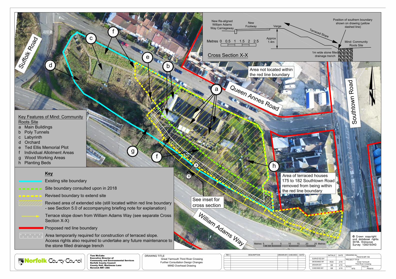
2.0 Drawing No PKA018-MP-106
This drawing shows an aerial photograph of the Community Roots at Mind site. Key features within the site are shown, together with the current existing site boundary and the boundary resulting from the Scheme as previously presented by the 2018 consultation.
The hatched area shows an updated Scheme boundary that the Council is now consulting upon. This reduces the impact of the Scheme proposals on the Community Roots at Mind site and provides for a greater area for the main site to be retained compared to that previously proposed. The increased site area would be achieved by:
• Removing the originally proposed drainage ditch on the south side of the site, together with changing the terraced embankment slope between William Adams Way and the Community Roots at Mind site. A typical cross section showing this terrace slope is provided on the drawing (see Cross Section X-X). The slope could be planted as part of the Scheme proposals and, subject to agreement, could be maintained by Community Roots.
• Changing the position of the vehicle turning head at the end of Queen Anne’s Road (see Drawing No PKA018-MP-107), which enables the extension of the main Community Roots at Mind site further to the west.
3.0 Drawing No PKA018-MP-107
This drawing shows changes to the public realm and other proposals, which would provide additional areas to accommodate some of the features that are currently on the Community Roots at Mind site. This drawing also shows the same revised main site boundary that is shown in more detail on Drawing No PKA018-MP-106. The proposed changes are as follows (the location of each numbered proposal is shown by a corresponding number on the drawing):
(1) To change the location of the vehicle turning head at the end of Queen Anne’s Road, to provide a greater area for the main Community Roots at Mind site. However, this proposal does reduce the area provided for the relocated allotment site currently located on the north side of Queen Anne’s Road.
(2) To mitigate the reduction in size of the relocated allotment site (noted in (1) above), an extra area of land is proposed to be provided.

Great Yarmouth Third River Crossing Further Consultation on Scheme Proposals at the Community Roots at Mind Site
Briefing Note to Accompany Drawing No’s PKA018-MP-106 and PKA018-MP-107
Page 2
(3) To use an area of public open space for the relocation of the labyrinth that currentlyoccupies an area of the Community Roots at Mind site. If the labyrinth cannot besafely relocated then an option could be to recommission the original artist torecreate the labyrinth at this new location. In order to provide the labyrinth on alevel surface a retaining feature will be needed on the southern side of this area(see Cross Section Z-Z on the drawing).
(4) To relocate the proposed footway closer to the roundabout to provide a separatearea for the orchard and individual planting areas that are currently on theCommunity Roots at Mind site.
(5) To provide a retaining feature on the western side of the roundabout. This isbecause the separate area for the orchard and individual planting areas will be atthe same level as the main Community Roots at Mind site, but the roundabout isapproximately 2m higher. A typical cross section through this area is provided (seeCross Section Y-Y on the drawing).
4.0 Effects of the changes The table below provides an estimate of the effects of the proposed changes:
Community Roots at Mind Site Approximate Area
Current area of site (Light blue line on Drawing No PKA018-MP-106)
4450m2
Remaining area of site following construction of the Scheme, as consulted upon in 2018 (Green dashed line on Drawing No PKA018-MP-106)
1800m2
Area of public space used to accommodate the relocated labyrinth 250m2 Revised area of site following construction of the Scheme, now being consulted upon:
Revised main site operational area (3200m2) (Yellow hatched areas on Drawing No PKA018-MP-106 and 107
Additional orchard/planting area east of new roundabout (450m2) (Yellow hatched area on Drawing No PKA018-MP-107)
Additional area of terraced slope (300m2) (Area indicated by yellow arrows on Drawing No PKA018-MP-106)
Total 3950m2
5.0 Revised red line boundary
When the Council applies for a Development Consent Order for the Scheme it will seek authorisation for it to be constructed within an area of land shown by a red line on the plans accompanying the application. This is the “red line boundary” (also known as "Order limits"), and it will include:

Great Yarmouth Third River Crossing Further Consultation on Scheme Proposals at the Community Roots at Mind Site
Briefing Note to Accompany Drawing No’s PKA018-MP-106 and PKA018-MP-107
Page 3
• All the land the Council seeks to acquire permanently for the Scheme;• Land over which the Council seeks to create and acquire new rights;• Land over which the Council seeks powers of temporary possession.
Drawing Nos. PKA018-MP-106 and 107 detail the proposed revised red line boundary. Please note that whilst the drawings show some areas being removed from the red line boundary proposed by the 2018 consultation, the Community Roots at Mind site is not shown as being removed and is shown as still being located within red line boundary. This is because:
• The Council will need to take temporary possession of a 3m strip of land adjacent tothe foot of the terraced slope (proposed on the south side of the site) in order toconstruct this terraced slope. It will also need to create and acquire new rights toenable future access to this area in order to undertake any inspection andmaintenance works that may be required in respect of the proposed stone-filleddrainage trench;
• During construction of the Scheme the Council may need to temporarily takepossession of parts of the site to undertake work to relocate, protect or replaceindividual features. At this time the detail of the work which may be required hasnot been determined and would need to be discussed with the current tenants.
6.0 How to respond to this further consultation
The Council welcomes your views on the proposed changes detailed in this letter and any other matters you may wish to raise. Responses to this consultation should be made by: • Emailing: [email protected]• Writing to: Freepost Plus RTCL-XSTT-JZSK, Norfolk County Council, GY3RC,
Ground floor - south wing, County Hall, Martineau Lane, Norwich NR1 2DH
The deadline for responses to this consultation is 23:59hrs on Sunday 24 March 2019
d
cf
Sout
htow
n R
oad
William Adams Way
Suffo
lk Ro
ad
See inset forcross section
Queen Annes Road
g
Area of terraced houses175 to 182 Southtown Roadremoved from being withinthe red line boundary
Area not located withinthe red line boundary
0 5 10 15 20 255Metres Metres
X
fX h
eb
a
New Re-alignedWilliam Adams
Way Carriageway
NewFootway Verge
Terraced Slope
Mind: CommunityRoots Site
Approx1.4m
Position of southern boundaryshown on drawing (yellow
dashed line)
Cross Section X-X1m wide stone filled
drainage trench
0 2.5Metres 0.5 1 1.5 2
Key Features of Mind: CommunityRoots Sitea Main Buildingsb Poly Tunnelsc Labyrinthd Orcharde Ted Ellis Memorial Plot f Individual Allotment Areasg Wood Working Areash Planting Beds
KeyExisting site boundary
Site boundary consulted upon in 2018
Revised boundary to extend site
Revised area of extended site (still located within red line boundary- see Section 5.0 of accompanying briefing note for explanation)
Terrace slope down from William Adams Way (see separate CrossSection X-X)
Proposed red line boundary
Area temporarily required for construction of terraced slope.Access rights also required to undertake any future maintenance tothe stone filled drainage trench
PKA018-MP-106
Great YarmouthThird River Crossing
NTS PKA018
ROD 2/19
GB 2/19
GB 2/19
Great Yarmouth Third River CrossingFurther Consultation Design Changes
MIND Overhead Drawing
DRAWING TITLESURVEYED BY
DRAWN BY
CHECKED BY
DESIGNED BY
REV. DESCRIPTION DATECHECKED DRAWING No.INITIALS DATE
FILE No.
PROJECT TITLE
Tom McCabeExecutive Director ofCommunity and Environmental ServicesNorfolk County CouncilCounty Hall, Martineau LaneNorwich NR1 2SG SCALE
DRAWN BY

3
Z
Z
William Adams Way
Sout
htow
n R
oad
4
See inset forcross section Y-Y
5 Queen Annes Road
Suffo
lk R
oad
Area not located withinthe red line boundary
2
1
See inset forcross section Z-Z
Area of terrace houses 175to 182 Southtown Roadremoved from being withinthe red line boundary
Y Y
NewFootway
Approx2.5m
Public spaceallocated for
relocated labyrinth
Cross Section Z-Z
1m wide stone filleddrainage trench
Vehiclerestraintparapet
0Metres 0.5 1 1.5 2
Retaining feature toaccommodate level
difference
NewRoundaboutCarriageway
NewFootway
Approx2.2m
AdditionalMind: Community
Roots Site
Vehiclerestraintparapet
Cross Section Y-Y
1m wide stone filleddrainage trench
0 2.5Metres 0.5 1 1.5 2
Retaining feature toaccommodate level
difference
KeyRevised area of extended Mind: Community Rootssite (see Drawing No PKA018-MP-106)Additional area for Mind: Community Roots siteRevised area for relocated allotments currentlylocated on the north side of Queen Annes RoadRetaining feature to accommodate difference in levelsProposed red line boundary
Area temporarily required for construction of terracedslope. Access rights also required to undertake anyfuture maintenance to the stone filled drainage trench
PKA018-MP-107
Great YarmouthThird River Crossing
NTS PKA018
ROD 2/19
GB 2/19
GB 2/19
Great Yarmouth Third River CrossingFurther Consultation Design Changes
MIND Public Realm Drawing
DRAWING TITLESURVEYED BY
DRAWN BY
CHECKED BY
DESIGNED BY
REV. DESCRIPTION DATECHECKED DRAWING No.INITIALS DATE
FILE No.
PROJECT TITLE
Tom McCabeExecutive Director ofCommunity and Environmental ServicesNorfolk County CouncilCounty Hall, Martineau LaneNorwich NR1 2SG SCALE
DRAWN BY
IG 12/10/16
This plan shows the scheme proposalpresented at consultation in Summer 2018. Thefurther proposed changes to mitigate the impacton the Mind: Community Roots site which weare currently consulting upon are also shown.
Refer to the separate briefing noteaccompanying this plan for a description of thenumbered annotations shown.