Embed Size (px)
Citation preview

Appendix 5.2C Desert Tortoise Survey Report

Mercy Vaughn • (928) 380-5507 [email protected] Stephen Boland • (928) 380-8850 [email protected]
Presence/Absence Survey for the Desert Tortoise (Gopherus agassizii) on the proposed Rice Solar Energy Project, Riverside County, California
July 1, 2009
Prepared for:
CH2M HILL, Inc. 2485 Natomas Park Drive, Suite 600,
Sacramento, California 95833
Prepared by:
Sundance Biology, Inc.
179 Niblick Road, PMB 272
Paso Robles, California 93446

SSUUNNDDAANNCCEE BBIIOOLLOOGGYY,, IINNCC.. PPaaggee iiii
EXECUTIVE SUMMARY As recommended in the US Fish and Wildlife Service (USFWS) Survey Protocol for any Non-Federal Action that may Occur within the Range of the Desert Tortoise, January 1992, a desert tortoise (Gopherus agassizii) presence or absence survey was conducted on the proposed 2,560 acre Rice Solar Energy Project site, 17 miles west of Vidal Junction in Riverside County, California.
Two thousand, five hundred and sixty acres were surveyed for desert tortoises and tortoise sign on the main project site as well as 9.2 linear miles on the proposed transmission line. Zone of influence (ZOI) transects were conducted adjacent to the two project sites where suitable habitat occurred in order to establish the possible effect the project may have on nearby tortoise populations. A total of 7 tortoises, 91 shell-skeletal remains, 66 burrows, 3 egg shell fragment locations, and 56 scat events were detected on the main project site, on the transmission line and while conducting ZOI transects. A habitat quality assessment was conducted on an alternative forty-five mile transmission line. The results of this assessment are documented in Addendum 1.
Observations were recorded for Burrowing owl (Athene cunicularia) and its sign, Loggerhead shrike (Lanius ludovicianus), Mojave fringe-toed lizard, (Uma scoparia) and other sensitive plants and wildlife that might occur in the area.
SSUUNNDDAANNCCEE BBIIOOLLOOGGYY,, IINNCC.. PPaaggee iiiiii
TABLE OF CONTENTS
EXECUTIVE SUMMARY .........................................................................................................ii
INTRODUCTION ................................................................................................................... 1
METHODOLOGY .................................................................................................................. 1
Habitat Delineation ......................................................................................................... 1 Survey Methodology ....................................................................................................... 1 ZOI Transects ................................................................................................................... 2 Data Recorded ................................................................................................................ 2 Biological Field Team ...................................................................................................... 2
RESULTS............................................................................................................................... 3
Survey Area ..................................................................................................................... 3 Desert Tortoise-Survey Area ........................................................................................... 3 Desert Tortoise-Zone of Influence .................................................................................. 3 Other Sensitive Species ................................................................................................... 3
Burrowing Owl ............................................................................................................ 4
Loggerhead Shrike....................................................................................................... 4
Mojave Fringe-toed Lizard .......................................................................................... 4
Plants ........................................................................................................................... 5
DISCUSSION ......................................................................................................................... 5
Desert Tortoise ............................................................................................................... 5 Burrowing Owl ................................................................................................................ 6 Loggerhead Shrike........................................................................................................... 6 Mojave fringe-toed lizard ............................................................................................... 6
MITIGATION RECOMMENDATIONS .................................................................................... 6
Desert Tortoise ............................................................................................................... 6 Burrowing Owl ................................................................................................................ 7 Loggerhead Shrike........................................................................................................... 8 Mojave Fringe-toed Lizard .............................................................................................. 8
LITERATURE CITED .............................................................................................................. 8
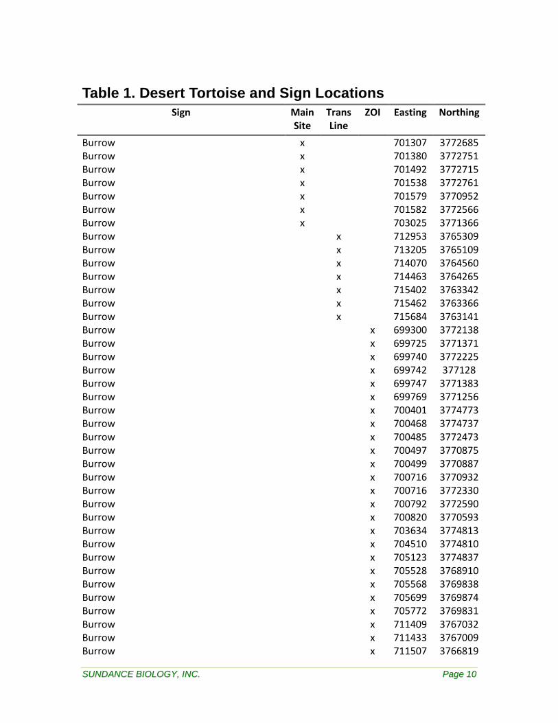
Table 1. Desert Tortoise and Sign Locations ..................................................................... 10
Table 2. Plant Species List ................................................................................................ 15
Table 3. Mammal Species List ........................................................................................... 17
SSUUNNDDAANNCCEE BBIIOOLLOOGGYY,, IINNCC.. PPaaggee iivv
Table 4. Reptile Species List .............................................................................................. 18
Table 5. Bird Species List ................................................................................................... 18
Figure 1. Rice Solar Energy Project proposed site location, Riverside County, California 19
Figure 2. Rice Solar Energy Project Live Tortoise Sign, Riverside County, California ....... 20
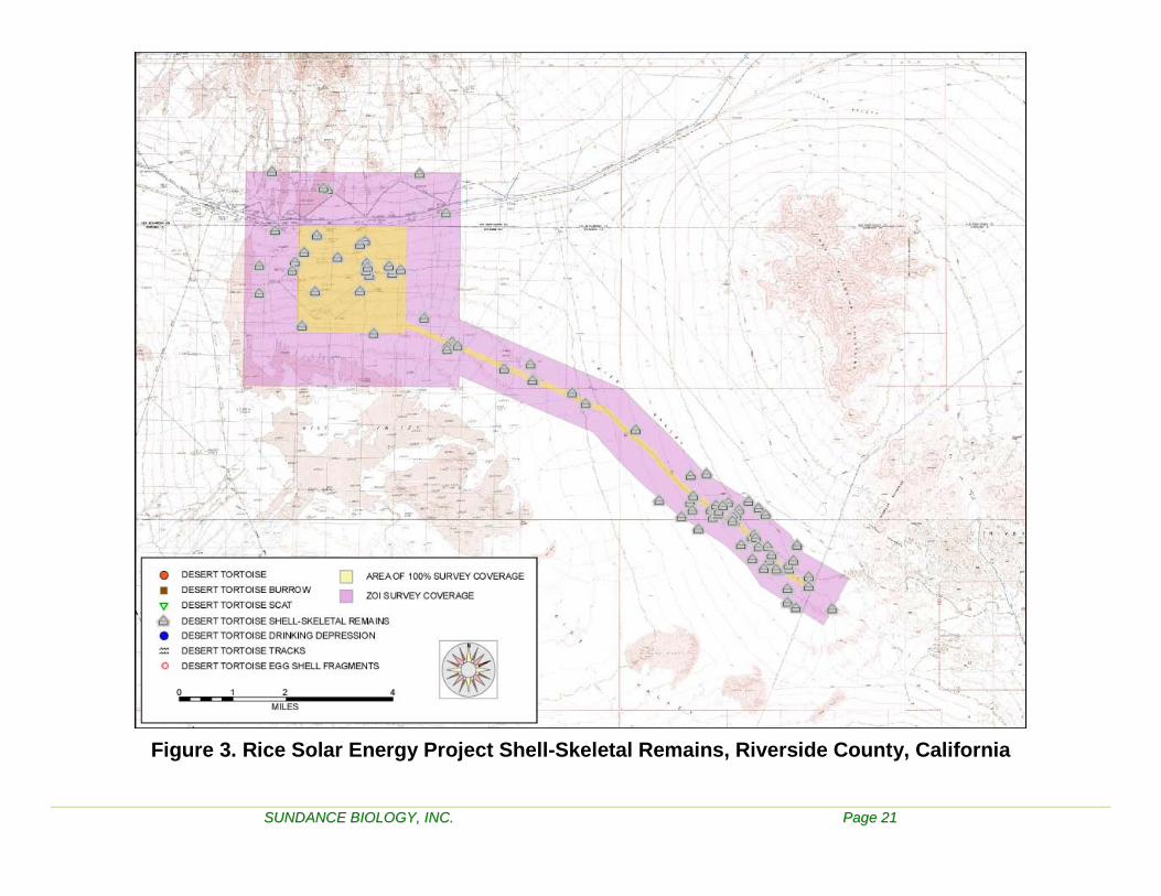
Figure 3. Rice Solar Energy Project Shell-Skeletal Remains, Riverside County, California 21
Figure 4. Habitat photos, Rice Solar Energy Project proposed site, Riverside County, California. (Datum NAD 83 CONUS) .................................................................................. 22
Figure 5. Desert tortoise sign photos, Rice Solar Energy Project proposed site, Riverside County, California. (Datum NAD 83 CONUS) .................................................................... 24
Figure 6. Desert tortoise and other sensitive species photos, Rice Solar Energy Project proposed site, Riverside County, California. ..................................................................... 25
ADDENDUM 1 ................................................................................................................... 27

SSUUNNDDAANNCCEE BBIIOOLLOOGGYY,, IINNCC.. PPaaggee 11
INTRODUCTION This report addresses the results of a presence/absence survey for the desert tortoise on the proposed Rice Solar Energy Project site, Riverside County, California as well as other sensitive species. Potential desert tortoise habitat was delineated considering vegetation, elevation, and topography.
The proposed project is located approximately 17 miles west of Vidal Junction, CA and approximately 70 miles east of the city of Twentynine Palms, San Bernardino County (Figure 1). The main site comprises four square miles and the proposed transmission line covers 9.2 linear miles. The site is located in the Mojave Desert south of Highway 62 on an old, abandoned airfield and the surrounding area. The main project site is located in Sections 19, 20, 29, and 30 of Township 1S, Range 21E (Figure 2). The proposed transmission line runs through portions of Sections 28, 33, 34, and 35 of Township 1S, Range 21E and portions of Township 2S, Range 22E and Township 2S, Range 23E. The elevation of the main project site ranges between 730 and 930 feet above mean sea level. The proposed transmission line ranges from 735 to 990 feet above mean sea level (Figure 2). Both the main site and the transmission line lie within the Eastern Colorado Recovery Unit which is managed under the guidelines set out in the Northern and Eastern Colorado Desert Coordinated Management Plan/Federal Environmental Impact Statement (NECO, CMP/FEIS). However, neither lies within a Desert Tortoise Critical Habitat area nor a Desert Wildlife Management Area (DWMA).
The proposed site was surveyed for desert tortoises and tortoise sign as well as other sensitive species between 18 April 2009 and 18 May 2009. ZOI transects were conducted in suitable adjacent habitat at 100’, 300’, 600’, 1,200’, 2,400’, ¾ mile and 1 mile from the outside edge of the 2,560 acre main survey area. ZOI transects were conducted along the 11 mile transmission line in suitable adjacent habitat at 100, 300, 600, 1200 and 2400 feet from the outside edge 200’ wide transmission line corridor.
METHODOLOGY
Habitat Delineation Delineation of the potential desert tortoise habitat was done prior to commencing the survey during a ground reconnaissance in April 2009. All typical vegetation communities used by desert tortoises throughout their geographic range were included in the survey area.
Survey Methodology The following methodology was used to increase efficiency in determining presence or absence of desert tortoises through systematic search and location of tortoises, their burrows and other sign. This methodology has proven accurate on other large-scale presence/absence surveys.

SSUUNNDDAANNCCEE BBIIOOLLOOGGYY,, IINNCC.. PPaaggee 22
A team consisting of fourteen experienced desert tortoise biologists conducted the survey by walking a set of transects that covered the 2,560 acre main survey area, and the 9.2 mile transmission line. Transect spacing was at 30 feet between transect centerlines, the standard width for desert tortoise presence/absence surveys. No more than five biologists surveyed together in a team, as larger team sizes decrease efficiency and accuracy.
A set of UTM coordinates for transect endpoints for virtual north-south transects were calculated for the main site. This resulted in 357 transects each approximately 2 miles in length. For navigation of transects Lowrance iFinder handheld global positioning system (GPS) units were used.
Seven parallel routes spaced 30 feet apart were programmed into the Lowrance GPS units to navigate the 9.2 mile long, 200 foot wide transmission line corridor.
Each team was equipped with an iFinder GPS. One member of each team was responsible to navigate the selected transect. When the end of a transect was reached, the team shifted five transects (for a five person team) and the navigator programmed the beginning and ending point of the team center transect for the next trip.
Team members focused on a search area that included 15 feet on either side of them. The members of each team remained close to one another without leading or lagging in order to increase the precision of searching. When one member of the team stopped to investigate an observation, all members of the team stopped. Team members were instructed to search beneath every shrub.
ZOI Transects ZOI transects were conducted in suitable tortoise habitat along all sides of both the main project site and along the transmission line project boundary at 100, 300, 600, 1,200, and 2,400 feet from the survey area perimeter. The main project site also had additional ZOI’s conducted at ¾ mile and 1 mile.
Data Recorded Any tortoise or large mammal burrows encountered that could potentially be used by tortoises were visually checked. When the end was not visible burrow entrances were gated with small sticks placed vertically in the soil at the entrance and checked periodically during the survey for tortoise activity. Very small burrows that could be potentially utilized by juvenile tortoises but are much more often rodent burrows were also visually checked when encountered. Only definitive tortoise sign was recorded.
Biological Field Team The survey was managed by Stephen Boland and Mercy Vaughn. The biological team for the survey was as follows:
Art Schaub Bret Blosser Jenny Weidensee Jake Mohlmann Bill Hasskamp Leslie Backus

SSUUNNDDAANNCCEE BBIIOOLLOOGGYY,, IINNCC.. PPaaggee 33
Michael Omana M.A. Hasskamp Sean Lindey Brooks Hart Rachel Woodard T.G. Jackson Stephen Boland Dave Focardi
RESULTS
Survey Area The survey area ranges in elevation from 730 to 990 ft and is characterized by a creosote-bursage desert bush scrub vegetation community (Figure 4). The old asphalt/oil and gravel airstrip is barely recognizable as Larrea tridentata (Creosote) and Ambrosia dumosa (Burrobush) have recolonized the area. The geomorphology of the survey area is lower bajada with predominantly sandy loam soils. Most common human impacts within the survey area were dirt roads and the abandoned air field. There was minimal litter or OHV activity in the area. The overall habitat condition is fair. The entire main site as well as the transmission line is suitable desert tortoise habitat.
Desert Tortoise-Survey Area Desert tortoise is listed as a threatened species by both State and federal governments (California Department of Fish and Game 2006b). On the main project site, 1 tortoise was detected as well as 16 shell-skeletal remains, 7 burrows, 13 scat events, and 2 locations with egg shell fragments (Table 1). All but one scat event occurred this year. Thirteen of the shell-skeletal remains were over four years since time of death. Two were between two and four years since time of death and one died within the last year.
The survey of the proposed transmission line detected 1 tortoise, 9 shell-skeletal remains, 7 burrows, and 8 scat events (Table 1). All but two scat events occurred this year. Six of the shell-skeletal remains were over four years since time of death. Three were between two and four years since time of death.
Desert Tortoise-Zone of Influence Surveys of the ZOI transects for both the main site and the transmission line produced a considerable amount of tortoise sign (Table 1). Five tortoises were located, as well as 66 shell-skeletal remains, 52 burrows, 35 scat events, and 1 location with egg shell fragments. All but eleven scat events occurred this year. Forty-six of the shell-skeletal remains were over four years since time of death. Fifteen were between two and four years since time of death. One was between one and two years since time of death, and one died within the last year.
Other Sensitive Species Several species of wildlife were identified on the project site listed as either a Species of Special Concern (SSC), Bird of Conservation Concern (BCC), or both (California Department of Fish and Game 2006a, USFWS 2002). These include the Burrowing owl, Loggerhead shrike, and the Mojave fringe-toed lizard. These findings are discussed below. No sensitive plants were identified on the project site

SSUUNNDDAANNCCEE BBIIOOLLOOGGYY,, IINNCC.. PPaaggee 44
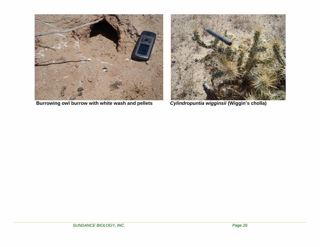
Burrowing Owl The Burrowing owl is designated as a Bird of Conservation Concern by the USFWS (2002) and a Bird Species of Special Concern by the CDFG (2006a). Burrowing owls rely on existing burrows of other animals, which they modify for their own use. The presence of coyotes and kit fox on the site provide suitable burrows for burrowing owls. This survey was not a focused survey for western burrowing owl, but all sign observed was recorded which included birds, burrows with and without whitewash (i.e., droppings, feathers, and diagnostic pellets). The proposed project may have direct impacts on the burrowing owl population on the site as burrowing owl sign was detected (See below).
Date Observation Easting Northing Comments
NAD 83, ZONE 11
13-May burrow 707161 3769005 On transmission line 100’ ZOI
14-May burrow 702875 3771926 white wash, pellets. Main site
14-May burrow 702854 3771805 white wash, pellets. Main site
14-May burrows 703036 3771885 white wash, pellets. Main site
15-May burrow 702711 3772178 white wash. Main site
15-May burrow 702644 3771112 3 holes, white wash, pellets. Main site
16-May burrow 705284 3770626 White wash and pellets, recent use
Loggerhead Shrike Loggerhead shrike is designated as a Bird of Conservation Concern by the USFWS (2002) and a Bird Species of Special Concern by the CDFG (2006a). Evidence of Loggerhead shrike found during the current survey is shown below. The proposed project may have direct impacts on the Loggerhead shrike population on the site. Loggerhead shrikes were observed on the main site and may have been nesting.
Date Observation Easting Northing Comments
NAD 83, ZONE 11
11-May adult 702338 3771059
13-May adult Individual on site but too far to determine UTM’s.
14-May adult 702932 3771806
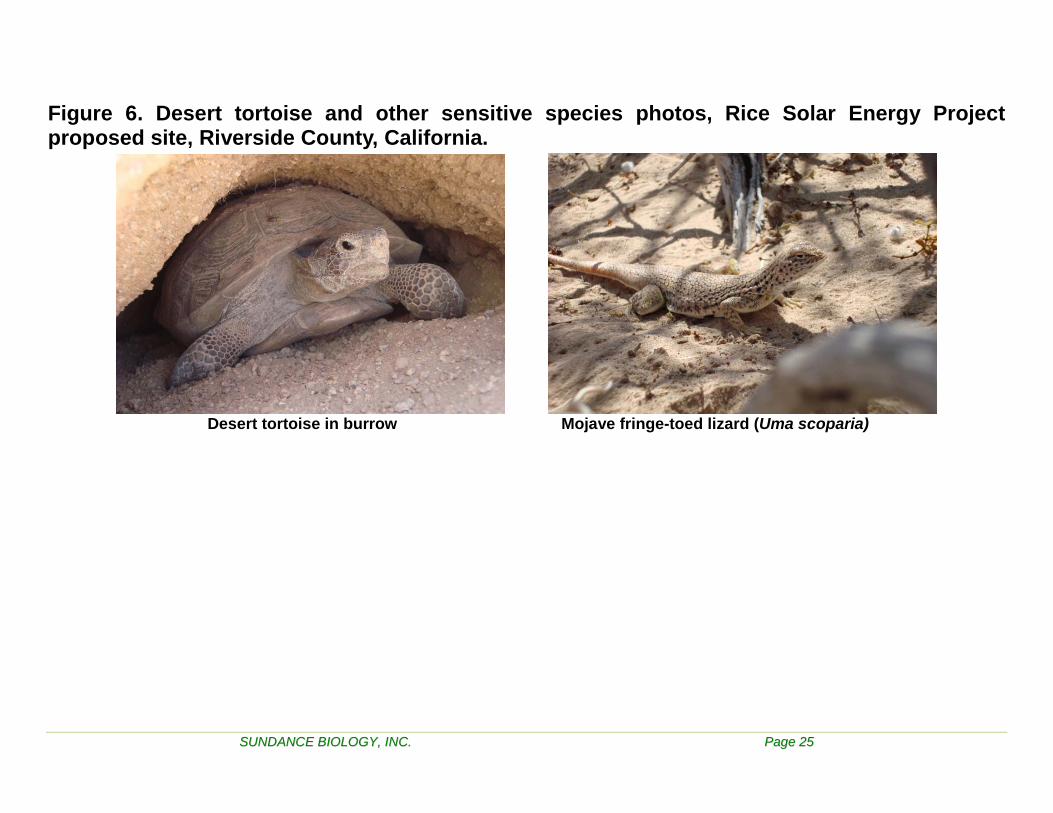
Mojave Fringe-toed Lizard The Mojave fringe-toed lizard (MFTL) (Uma scoparia) is considered a Reptile Species of Special Concern by CDFG (2006a) was observed on one occasion. The individual was observed in a sand dune community on the ¾ mile ZOI line (See Figure 6).
SSUUNNDDAANNCCEE BBIIOOLLOOGGYY,, IINNCC.. PPaaggee 55
Date Observation Easting Northing Comments NAD 83, ZONE 11
May 17 adult 699788 3768907 ¾ mile ZOI in sand dunes
Plants No special status plants were identified during this survey. It should be noted that Wiggin’s cholla (Cylindropuntia wigginsii) was found onsite. This plant is rarely found in California. This succulent may be a sporadic hybrid between Opuntia ramosissima and Opuntia echinocarpa. This taxon is only mentioned in The Jepson Manual (Hickman 1993) under O. ramosissima as "possibly O. ramosissima X O. echinocarpa". Pinkava (2004) says this is just a dwarf form of C. echinocarpa. Even so, the California Native Plant Society (CNPS) has identified this as a List 3 plant (to be reviewed).
All plant, mammal, reptile and bird species observed during the survey were also recorded (Tables 2-5).
DISCUSSION
Desert Tortoise The proposed Rice Solar Energy Project site lies within the geographic range of the desert tortoise. The habitat within the survey area as well as adjacent habitat is typical and suitable for desert tortoises. Juvenile through adult size classes were represented in the recent tortoise sign found in the survey area and in the ZOI. Additionally, egg shell fragments were found at three locations, two on the main site and one in the ZOI. Seventy-one percent of the shell skeletal remains were greater than four years since time of death. Of the remaining 29% only 3% died within the last year.
Within the survey area recent sign was concentrated in the northwest portion of the main site and along the southern half of the transmission line route. Shell-skeletal remains were found throughout the survey area. Sign was scattered similarly in the ZOI with recent sign found mostly to the north and west of the main site and along the southern half of the transmission line route. Shell-skeletal remains were found throughout the ZOI except south of the main site.
The high number of shell-skeletal remains indicates that a significantly higher density tortoise population was here within the last 10 years. Approximately 1/3 of these animals died within the last four years. It is not known why this die-off occurred without further investigation; however, likely causes are drought and/or disease. There is currently a low density population of tortoises utilizing the project site. Evidence of reproduction, i.e. egg shell fragments on site, suggests there is still a potentially viable population within the project area.
The proposed Rice Field Solar Project will have direct and/or indirect impacts on desert tortoises in the area. Since tortoises use the site, indirect impacts will occur through loss of habitat. Direct impacts could occur during construction of the solar site if a tortoise wanders onto the site.

SSUUNNDDAANNCCEE BBIIOOLLOOGGYY,, IINNCC.. PPaaggee 66
In addition to loss of habitat, the tortoises located on site would have to be translocated to an appropriate area off site. The effectiveness of translocation of tortoises is still being researched. Both the translocated tortoises as well as the tortoises located on the recipient site could be affected. This effect could be minimized by translocation within the current home range of tortoises cleared from the site. The long-term use of the site may pose a risk to any tortoises wandering into the area if permanent tortoise proof fencing is not installed and maintained.
Burrowing Owl The proposed project may have direct impacts on the burrowing owl population on the site. Burrowing owl sign was observed on site, and owls may have been nesting. They seem to be attracted to disturbed areas and are often found in fallow agricultural fields as well as native desert scrub. Burrowing owls rely on existing burrows of other animals, which they modify for their own use.
Loggerhead Shrike The proposed project may have direct impacts on the Loggerhead shrike population on the site. Loggerhead shrikes were observed on site and may have been nesting.
Mojave fringe-toed lizard Mojave fringe-toed lizards occur in the Lower Sonoran life zones of the Mojave Desert and the northwestern reaches of the Sonoran desert (Hollingsworth et al. 1999). They are restricted to areas with fine, aeolian sand including both large and small dunes, margins of dry lakebeds and washes, and isolated pockets against hillsides. Although the proposed project site does not have sand dunes there is occupied habitat within ½ mile of the southern boundary of the project site. Potential indirect disturbances may occur with the disruption of the dune ecosystem source sand, wind transport, and sand transport corridors. Additionally, some animals may travel up washes to the project site. Individuals not trapped and relocated on site would be destroyed during construction.
MITIGATION RECOMMENDATIONS
Desert Tortoise Under the compensation guidelines set out in the NECO CMP/FEIS (July, 2002), Appendix D - Desert tortoise Mitigation Measures, a mitigation fee based on the amount of acreage disturbed shall be required of proponents of new development. Outside DWMAs (Category III), the lands delivered or equivalent fee shall be an amount that achieves a ratio of one acre of compensation land for every one acre disturbed.
In order to mitigate potential direct impacts, the following recommendations will help minimize the potential for “take” of tortoises during and after construction.
1). Develop a translocation plan for the desert tortoises onsite.

SSUUNNDDAANNCCEE BBIIOOLLOOGGYY,, IINNCC.. PPaaggee 77
2). Develop a biological monitoring plan in consultation with the CEC, USFWS and the CDFG. This plan would delineate all measures to be implemented prior to, during and post-construction, which would include but are not limited to the following measures:
a). All land surveying personnel prior to construction should be accompanied by an authorized desert tortoise biologist.
b). Permanent and or temporary tortoise-proof fencing (1”x 2” mesh hardware cloth) may need to be erected and maintained between the interface of the project area and any remaining desert tortoise habitat prior to initiating construction and clearance surveys for desert tortoises on site. The fence will prevent tortoises from wandering onto the site both during construction as well as during use of the facility. Ongoing maintenance of the fencing would be recommended with oversight by an authorized biologist. Fence installation should be monitored by a qualified tortoise biologist.
c). If tortoises are to be cleared from the site, it is recommended tortoise clearance surveys be conducted at 15-foot intervals. It is recommended that two coverages without finding any tortoises or new tortoise sign be conducted prior to declaring the site clear of tortoises. All burrows that could provide shelter for a desert tortoise should be excavated during the first clearance survey.
d). All construction and operations personnel should undergo desert tortoise awareness training.
e). After the tortoise-proof fence is erected, a qualified biologist(s) should remain onsite until all vegetation is cleared and, at a minimum, conduct site and fence inspections on a bi-weekly basis throughout construction in order to maintain compliance with mitigation measures.
f). A qualified biologist(s) should be on site to survey for tortoises immediately in front of vegetation clearance activities in the event a tortoise was inadvertently missed during clearance surveys.
g). A biologist should remain on-call throughout construction in the event a tortoise wanders onto the site.
h). A raven management plan should be developed for the project site.
i). Post-construction reporting should be provided to all agencies within 90 days of completion of construction.
Burrowing Owl In order to mitigate direct impacts to burrowing owls it is recommended that construction activities not occur during the breeding season if any nests are in the area. Otherwise, nests should be avoided and construction activities approach no closer than 300 feet.

SSUUNNDDAANNCCEE BBIIOOLLOOGGYY,, IINNCC.. PPaaggee 88
Loggerhead Shrike In order to mitigate direct impacts to Loggerhead shrikes it is recommended that construction activities (particularly clearance of vegetation) not occur during the breeding season.
Mojave Fringe-toed Lizard In order to mitigate direct impacts to the MFTL it is recommended that if individuals are seen on site during desert tortoise clearance surveys that an attempt be made to capture individuals and relocate them to nearby suitable habitat off-site using pit fall traps and/or noosing.
LITERATURE CITED California Department of Fish and Game. 2006a. California's plants and animals: Animal Species of Special Concern. Species lists published and updated by California Department of Fish and Game, Habitat Conservation Planning Branch. Dated 1 February 2006. Sacramento, CA.
California Department of Fish and Game. 2006b. State and federally listed endangered and threatened animals of California. Species lists published and updated by The Resources Agency, Department of Fish and Game, Habitat Conservation Division, Wildlife and Habitat Data Analysis Branch, California Natural Diversity Data Base. Dated January 2006. Sacramento, CA.
California Natural Diversity Database, Biogeographic Data Branch, Department of Fish and Game, September 01, 2007
De Groot, S. 2007. The “Nose” of California: an important part of the state’s plant diversity. Pp. 3-6 in Fremontia Vol. 35:1, Winter 2007.
Hickman, J. Editor. 1993. The Jepson Manual: Higher Plants of California. University of California Press. Berkeley, CA.
Holland, R. 1986. Preliminary descriptions of the terrestrial natural communities of California. California Department of Fish and Game. Sacramento, CA.
Hollingsworth, Bradford D. and Kent R. Beaman. 1999. Mojave Fringe-toed Lizard. Downloaded from BLM PDF file http://www.ca.blm.gov/pdfs/cdd_pdfs/fringe1PDF
Ingles, L. 1965. Mammals of the Pacific States: California, Oregon, Washington. Stanford University Press. Stanford, CA.
Jaeger, E. 1969. Desert Wild Flowers. Stanford University Press. Stanford, CA.
Munz, P. 1974. A Flora of Southern California. University of California Press. Berkeley, CA.
SSUUNNDDAANNCCEE BBIIOOLLOOGGYY,, IINNCC.. PPaaggee 99
Pinkava, D. J. 2004. Cylindropuntia, pp. 103-118 in FNA Editorial Committee (eds.), Flora of North America North of New Mexico, Vol. 4. Oxford University Press, New York.
Tibor, D.P., ed. 2001. Inventory of Rare and Endangered Plants of California, 6th ed. California Native Plant Society, Sacramento, CA.
U.S. Fish and Wildlife Service. 2002. Birds of Conservation Concern. Division of Migratory Bird Management. Arlington, VA.
SSUUNNDDAANNCCEE BBIIOOLLOOGGYY,, IINNCC.. PPaaggee 1100
Table 1. Desert Tortoise and Sign Locations Sign Main
Site Trans Line
ZOI Easting Northing
Burrow x 701307 3772685 Burrow x 701380 3772751 Burrow x 701492 3772715 Burrow x 701538 3772761 Burrow x 701579 3770952 Burrow x 701582 3772566 Burrow x 703025 3771366 Burrow x 712953 3765309 Burrow x 713205 3765109 Burrow x 714070 3764560 Burrow x 714463 3764265 Burrow x 715402 3763342 Burrow x 715462 3763366 Burrow x 715684 3763141 Burrow x 699300 3772138 Burrow x 699725 3771371 Burrow x 699740 3772225 Burrow x 699742 377128 Burrow x 699747 3771383 Burrow x 699769 3771256 Burrow x 700401 3774773 Burrow x 700468 3774737 Burrow x 700485 3772473 Burrow x 700497 3770875 Burrow x 700499 3770887 Burrow x 700716 3770932 Burrow x 700716 3772330 Burrow x 700792 3772590 Burrow x 700820 3770593 Burrow x 703634 3774813 Burrow x 704510 3774810 Burrow x 705123 3774837 Burrow x 705528 3768910 Burrow x 705568 3769838 Burrow x 705699 3769874 Burrow x 705772 3769831 Burrow x 711409 3767032 Burrow x 711433 3767009 Burrow x 711507 3766819
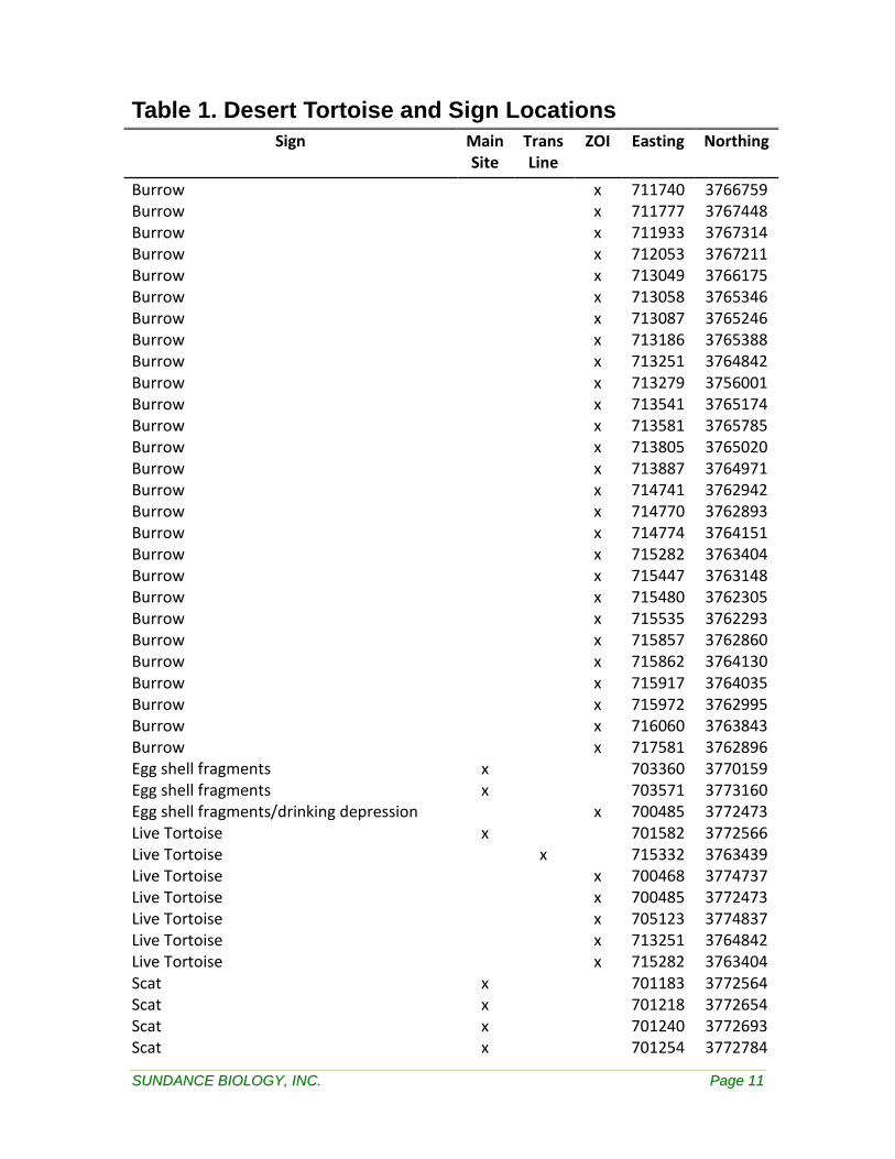
SSUUNNDDAANNCCEE BBIIOOLLOOGGYY,, IINNCC.. PPaaggee 1111
Table 1. Desert Tortoise and Sign Locations Sign Main
Site Trans Line
ZOI Easting Northing
Burrow x 711740 3766759 Burrow x 711777 3767448 Burrow x 711933 3767314 Burrow x 712053 3767211 Burrow x 713049 3766175 Burrow x 713058 3765346 Burrow x 713087 3765246 Burrow x 713186 3765388 Burrow x 713251 3764842 Burrow x 713279 3756001 Burrow x 713541 3765174 Burrow x 713581 3765785 Burrow x 713805 3765020 Burrow x 713887 3764971 Burrow x 714741 3762942 Burrow x 714770 3762893 Burrow x 714774 3764151 Burrow x 715282 3763404 Burrow x 715447 3763148 Burrow x 715480 3762305 Burrow x 715535 3762293 Burrow x 715857 3762860 Burrow x 715862 3764130 Burrow x 715917 3764035 Burrow x 715972 3762995 Burrow x 716060 3763843 Burrow x 717581 3762896 Egg shell fragments x 703360 3770159 Egg shell fragments x 703571 3773160 Egg shell fragments/drinking depression x 700485 3772473 Live Tortoise x 701582 3772566 Live Tortoise x 715332 3763439 Live Tortoise x 700468 3774737 Live Tortoise x 700485 3772473 Live Tortoise x 705123 3774837 Live Tortoise x 713251 3764842 Live Tortoise x 715282 3763404 Scat x 701183 3772564 Scat x 701218 3772654 Scat x 701240 3772693 Scat x 701254 3772784

SSUUNNDDAANNCCEE BBIIOOLLOOGGYY,, IINNCC.. PPaaggee 1122
Table 1. Desert Tortoise and Sign Locations Sign Main
Site Trans Line
ZOI Easting Northing
Scat x 701327 3772799 Scat x 701359 3772655 Scat x 701388 3772605 Scat x 701403 3772928 Scat x 701482 3772410 Scat x 701491 3772560 Scat x 701492 3772498 Scat x 701551 3772707 Scat x 701586 3772512 Scat x 705684 3769641 Scat x 705740 3769666 Scat x 712859 3765356 Scat x 713058 3765228 Scat x 715358 3763342 Scat x 715425 3763412 Scat x 716067 3762902 Scat x 716133 3762858 Scat x 700472 3774758 Scat x 700485 3772473 Scat x 705123 3774837 Scat x 705325 3773804 Scat x 705997 3769119 Scat x 707818 3768890 Scat x 713086 3765239 Scat x 713148 3765191 Scat x 713251 3764842 Scat x 713254 3764632 Scat x 713343 3765170 Scat x 713935 3764524 Scat x 714031 3764758 Scat x 714223 3764614 Scat x 714727 3762981 Scat x 714864 3764965 Scat x 715102 3764039 Scat x 715242 3763404 Scat x 715313 3762853 Scat x 715386 3762797 Scat x 715537 3762699 Scat x 715923 3763109 Scat x 716125 3763085 Scat x 717152 3761944
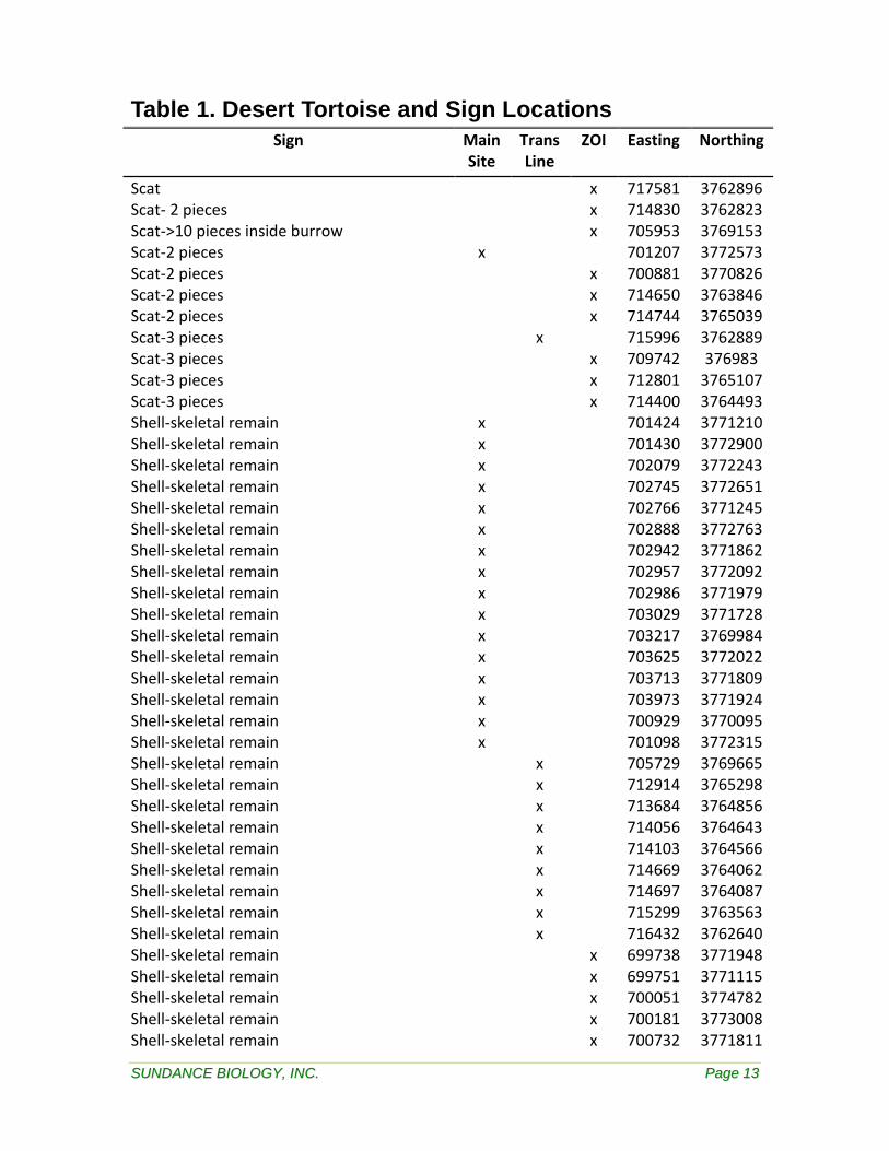
SSUUNNDDAANNCCEE BBIIOOLLOOGGYY,, IINNCC.. PPaaggee 1133
Table 1. Desert Tortoise and Sign Locations Sign Main
Site Trans Line
ZOI Easting Northing
Scat x 717581 3762896 Scat- 2 pieces x 714830 3762823 Scat->10 pieces inside burrow x 705953 3769153 Scat-2 pieces x 701207 3772573 Scat-2 pieces x 700881 3770826 Scat-2 pieces x 714650 3763846 Scat-2 pieces x 714744 3765039 Scat-3 pieces x 715996 3762889 Scat-3 pieces x 709742 376983 Scat-3 pieces x 712801 3765107 Scat-3 pieces x 714400 3764493 Shell-skeletal remain x 701424 3771210 Shell-skeletal remain x 701430 3772900 Shell-skeletal remain x 702079 3772243 Shell-skeletal remain x 702745 3772651 Shell-skeletal remain x 702766 3771245 Shell-skeletal remain x 702888 3772763 Shell-skeletal remain x 702942 3771862 Shell-skeletal remain x 702957 3772092 Shell-skeletal remain x 702986 3771979 Shell-skeletal remain x 703029 3771728 Shell-skeletal remain x 703217 3769984 Shell-skeletal remain x 703625 3772022 Shell-skeletal remain x 703713 3771809 Shell-skeletal remain x 703973 3771924 Shell-skeletal remain x 700929 3770095 Shell-skeletal remain x 701098 3772315 Shell-skeletal remain x 705729 3769665 Shell-skeletal remain x 712914 3765298 Shell-skeletal remain x 713684 3764856 Shell-skeletal remain x 714056 3764643 Shell-skeletal remain x 714103 3764566 Shell-skeletal remain x 714669 3764062 Shell-skeletal remain x 714697 3764087 Shell-skeletal remain x 715299 3763563 Shell-skeletal remain x 716432 3762640 Shell-skeletal remain x 699738 3771948 Shell-skeletal remain x 699751 3771115 Shell-skeletal remain x 700051 3774782 Shell-skeletal remain x 700181 3773008 Shell-skeletal remain x 700732 3771811

SSUUNNDDAANNCCEE BBIIOOLLOOGGYY,, IINNCC.. PPaaggee 1144
Table 1. Desert Tortoise and Sign Locations Sign Main
Site Trans Line
ZOI Easting Northing
Shell-skeletal remain x 700791 3772073 Shell-skeletal remain x 701606 3774331 Shell-skeletal remain x 701682 3774321 Shell-skeletal remain x 704478 3774827 Shell-skeletal remain x 704708 3770478 Shell-skeletal remain x 705302 3773669 Shell-skeletal remain x 705412 3769546 Shell-skeletal remain x 705423 3769657 Shell-skeletal remain x 705557 3769783 Shell-skeletal remain x 707131 3769010 Shell-skeletal remain x 707921 3769158 Shell-skeletal remain x 708003 3768667 Shell-skeletal remain x 708032 3768705 Shell-skeletal remain x 709198 3768322 Shell-skeletal remain x 709617 3768004 Shell-skeletal remain x 711138 3767239 Shell-skeletal remain x 711891 3765132 Shell-skeletal remain x 712577 3764658 Shell-skeletal remain x 712817 3765903 Shell-skeletal remain x 712824 3765096 Shell-skeletal remain x 712897 3764860 Shell-skeletal remain x 713084 3764304 Shell-skeletal remain x 713296 3765961 Shell-skeletal remain x 713448 3764887 Shell-skeletal remain x 713502 3764669 Shell-skeletal remain x 713604 3765034 Shell-skeletal remain x 713666 3764758 Shell-skeletal remain x 713811 3765015 Shell-skeletal remain x 713966 3765120 Shell-skeletal remain x 714135 3764670 Shell-skeletal remain x 714167 3764541 Shell-skeletal remain x 714218 3764727 Shell-skeletal remain x 714295 3764917 Shell-skeletal remain x 714384 3763860 Shell-skeletal remain x 714578 3765158 Shell-skeletal remain x 714730 3763438 Shell-skeletal remain x 714767 3764174 Shell-skeletal remain x 714868 3764964 Shell-skeletal remain x 714906 3763807 Shell-skeletal remain x 715075 3763150 Shell-skeletal remain x 715097 3764773

SSUUNNDDAANNCCEE BBIIOOLLOOGGYY,, IINNCC.. PPaaggee 1155
Table 1. Desert Tortoise and Sign Locations Sign Main
Site Trans Line
ZOI Easting Northing
Shell-skeletal remain x 715173 3763823 Shell-skeletal remain x 715242 3763404 Shell-skeletal remain x 715442 3763150 Shell-skeletal remain x 715491 3763105 Shell-skeletal remain x 715807 3763273 Shell-skeletal remain x 715814 3762563 Shell-skeletal remain x 715814 3762563 Shell-skeletal remain x 715835 3762148 Shell-skeletal remain x 715835 3762149 Shell-skeletal remain x 715849 3763153 Shell-skeletal remain x 715964 3763421 Shell-skeletal remain x 716051 3763872 Shell-skeletal remain x 716062 3761990 Shell-skeletal remain x 716424 3762944 Shell-skeletal remain x 717146 3761984 Shell-skeletal remain (3 individuals) x 715826 3762563 Shell-skeletal remains (2 individuals) x 714812 3764086 Tracks x 701632 3772765 Tracks x 701605 3772507 Tracks x 702113 3772492 (Datum NAD 83 CONUS)
Table 2. Plant Species List Scientific Name Common Name Notes
ASCLEPIADACEAE Milkweed Family Asclepias subulata Rush milkweed Herbaceous perennial Cynanchum utahense Utah cynanchum Perennial shrub Sarcostemma cynanchoides var hartweggii
Climbing milkweed Herbaceous perennial
ASTERACEAE Composite Family Ambrosia salsola Cheesebush Shrub; common Ambrosia dumosa Burrobush Shrub; common Bebbia juncea var. aspera Sweetbush Shrub Calycoseris wrightii White Tack-Stem Annual Chaenactis carphoclinia Pebble pincushion Annual Encelia farinosa Brittlebush Shrub Geraea canascens Desert sunflower annual

SSUUNNDDAANNCCEE BBIIOOLLOOGGYY,, IINNCC.. PPaaggee 1166
Table 2. Plant Species List Scientific Name Common Name Notes
Malacothrix glabrata Desert dandelion Annual Monoptilon belloides Desert star Annual Porophyllum gracile Odora Subshrub Rafinesquia neomexicana Desert chicory Annual
Stephanomeria parryi Parry rock pink Small shrub-herbaceous perennial; common on roadsides and dry, open areas
BORAGINACEAE Borage Family Amsinckia menziesii Rancher’s Fireweed Annual Cryptantha sp. Forget-me-not Annual BRASSICACEAE Mustard Family Brassica tournefortii Asian mustard Annual Lepidium fremontii Desert alyssum Shrub; occasional Lepidium lasiocarpum var. lasiocarpum
Peppergrass Annual
CACTACEAE Cactus Family Cylindropuntia bigelovii Teddy-bear cholla One individual Cylindropuntia echinocarpa Silver cholla Occasional throughout area Cylindropuntia ramosissima Pencil cholla Occasional throughout area
Cylindropuntia wiginsii Wiggin’s cholla* One individual. CNPS 3. See below
Opuntia basilaris Beavertail cactus Occasional/common throughout area
CUCURBITACEAE Gourd Family Brandegea bigelovii Desert star vine Perennial CUSCUTACEAE Dodder Family Cuscuta sp. Dodder Annual EUPHORBIACEAE Spurge Family Chamaecyse albomarginata White-margin sandmat Annual FABACEAE Legume Family Acacia gregii Catclaw Tree Cercidium floridum ssp. floridum
Palo verde Tree
Lotus strigosus Stiff-haired lotus Annual Lupinus arizonicus Arizona lupine Annual Olneya tesota Ironwood Tree. Found on transmission
line HYDROPHYLLACEAE Waterleaf Family Phacelia crenulata Notch-leaved phacelia Annual KRAMERIACEAE Rhatany Family
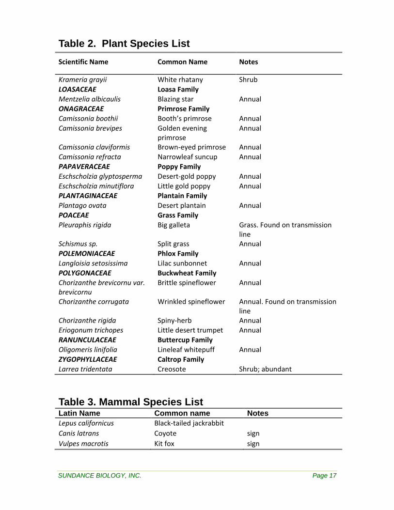
SSUUNNDDAANNCCEE BBIIOOLLOOGGYY,, IINNCC.. PPaaggee 1177
Table 2. Plant Species List Scientific Name Common Name Notes
Krameria grayii White rhatany Shrub LOASACEAE Loasa Family Mentzelia albicaulis Blazing star Annual ONAGRACEAE Primrose Family Camissonia boothii Booth’s primrose Annual Camissonia brevipes Golden evening
primrose Annual
Camissonia claviformis Brown-eyed primrose Annual Camissonia refracta Narrowleaf suncup Annual PAPAVERACEAE Poppy Family Eschscholzia glyptosperma Desert-gold poppy Annual Eschscholzia minutiflora Little gold poppy Annual PLANTAGINACEAE Plantain Family Plantago ovata Desert plantain Annual POACEAE Grass Family Pleuraphis rigida Big galleta Grass. Found on transmission
line Schismus sp. Split grass Annual POLEMONIACEAE Phlox Family Langloisia setosissima Lilac sunbonnet Annual POLYGONACEAE Buckwheat Family Chorizanthe brevicornu var. brevicornu
Brittle spineflower Annual
Chorizanthe corrugata Wrinkled spineflower Annual. Found on transmission line
Chorizanthe rigida Spiny-herb Annual Eriogonum trichopes Little desert trumpet Annual RANUNCULACEAE Buttercup Family Oligomeris linifolia Lineleaf whitepuff Annual ZYGOPHYLLACEAE Caltrop Family Larrea tridentata Creosote Shrub; abundant
Table 3. Mammal Species List Latin Name Common name Notes Lepus californicus Black-tailed jackrabbit Canis latrans Coyote sign Vulpes macrotis Kit fox sign

SSUUNNDDAANNCCEE BBIIOOLLOOGGYY,, IINNCC.. PPaaggee 1188
Table 4. Reptile Species List Scientific Name Common Name Notes Gopherus agassizii Desert tortoise USFWS/CDFG threatened Uma scoparia Mojave Fringe-toed lizard CDFG;RSSC Phrynosoma platyrhinos Desert horned lizard Dipsosaurus dorsalis Desert iguana Gambelia wislizenii Long-nosed leopard lizard Uta stansburiana Side-blotched lizard
Callisaurus draconoides Zebra-tail lizard Aspidoscelis tigris Western whiptail Masticophis flagellum Coachwhip Pituophis catenifer Gopher snake Salvadora hexalepis Western patch-nosed snake Crotalus cerastes Sidewinder
Table 5. Bird Species List
Scientific Name Common Name Notes Cathartes aura Turkey vulture Buteo jamaicensis Red-tailed hawk Falco mexicanus Prairie falcon Zenaida asiatica White-winged dove Athene cunicularia Burrowing owl CDFG-SSC,USFWS-BCC Chordeiles acutipennis Lesser nighthawk Phalaenoptilus nuttallii Common poorwill Lanius ludovicianus Loggerhead shrike CDFG-SSC,USFWS-BCC Corvus corax Common raven Eremophila alpestris Horned lark Hirundo rustica Barn Swallow Mimus polyglottos Northern Mockingbird Wilsonia pusilla Wilson’s Warbler Dendroica townsendi Townsend’s Warbler Piranga ludoviciana Western Tanager Amphispiza bilineata Black-throated Sparrow Xanthocephalus xanthocephalus
Yellow-Headed blackbird
Quiscalus mexicanus Great-Tailed Grackle Molothrus ater Brown-headed Cowbird

SSUUNNDDAANNCCEE BBIIOOLLOOGGYY,, IINNCC.. PPaaggee 1199
Figure 1. Rice Solar Energy Project proposed site location, Riverside County, California

SSUUNNDDAANNCCEE BBIIOOLLOOGGYY,, IINNCC.. PPaaggee 2200
Figure 2. Rice Solar Energy Project Live Tortoise Sign, Riverside County, California
SSUUNNDDAANNCCEE BBIIOOLLOOGGYY,, IINNCC.. PPaaggee 2211
Figure 3. Rice Solar Energy Project Shell-Skeletal Remains, Riverside County, California

SSUUNNDDAANNCCEE BBIIOOLLOOGGYY,, IINNCC.. PPaaggee 2222
Figure 4. Habitat photos, Rice Solar Energy Project proposed site, Riverside County, California. (Datum NAD 83 CONUS)
Main site-view SW from NE corner Main site-view S from center
UTM 704136 E, 3773193 N UTM 702534 E, 3771548 N
Main site-view N from center of Section 30 Main site-view N from SE corner
UTM 701751 E, 3770610 N UTM 704028 E, 3769957 N

SSUUNNDDAANNCCEE BBIIOOLLOOGGYY,, IINNCC.. PPaaggee 2233
Transmission line-view NW in N portion Transmission line-view SE in S portion
UTM 709523 E, 3768026 N UTM 704028 E, 3769957 N

SSUUNNDDAANNCCEE BBIIOOLLOOGGYY,, IINNCC.. PPaaggee 2244
Figure 5. Desert tortoise sign photos, Rice Solar Energy Project proposed site, Riverside County, California. (Datum NAD 83 CONUS)
Adult desert tortoise Shell-skeletal remain Juvenile desert tortoise Shell-skeletal remain
Desert tortoise scat Desert tortoise burrow
SSUUNNDDAANNCCEE BBIIOOLLOOGGYY,, IINNCC.. PPaaggee 2255
Figure 6. Desert tortoise and other sensitive species photos, Rice Solar Energy Project proposed site, Riverside County, California.
Desert tortoise in burrow Mojave fringe-toed lizard (Uma scoparia)
SSUUNNDDAANNCCEE BBIIOOLLOOGGYY,, IINNCC.. PPaaggee 2266
Burrowing owl burrow with white wash and pellets Cylindropuntia wigginsii (Wiggin’s cholla)

SSUUNNDDAANNCCEE BBIIOOLLOOGGYY,, IINNCC.. PPaaggee 2277
ADDENDUM 1
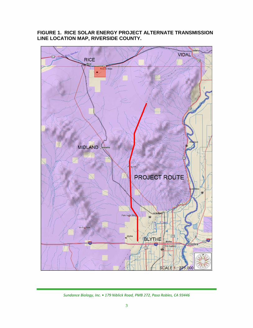
Habitat assessment along the Rice Solar Energy Project alternate transmission line route following the Parker-Blythe 230kV WAPA Line corridor.

Mercy Vaughn • (928) 380-5507 •: [email protected] Stephen Boland • (928) 380-8850 •: [email protected]
Date: July 1, 2009
Regarding: Habitat assessment along the Rice Solar Energy Project alternate transmission line route following the Parker-Blythe 230kV WAPA Line corridor.
Prepared for:
CH2M HILL, Inc.
2485 Natomas Park Drive, Suite 600,
Sacramento, California 95833
Prepared by:
Sundance Biology, Inc.
179 Niblick Rd. PMB 272
Paso Robles, CA 93446
Introduction: Following is a description of the habitat assessment and findings along the Rice Solar Energy Project alternate transmission line route following the Parker-Blythe 230kV WAPA Line corridor. The survey was conducted May 13-16. The field biologist conducting the assessment was Stephen Boland.
Assessment Location: The proposed transmission line route runs 26.2 miles along the Parker-Blythe 230kV WAPA Line corridor starting 12.5 miles southwest of its intersection with Highway 95 (UTMs: 716522 E, 3776383 N, NAD 83 CONUS) and ending in Blythe, CA (UTMs: 714819 E, 3722122 N, NAD 83 CONUS) (Figure 1).
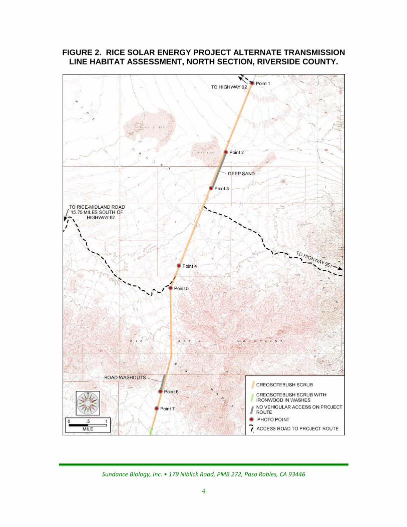
Survey Methodology: On 13-16 May, 2009 Stephen Boland drove the proposed route along the existing corridor road, beginning at the north end and working south. Not all areas of the route were accessible by vehicle due to sand dune encroachment over the corridor road, washouts through canyon ravines, and the conversion of road to deep sandy washes where railroad levies channeled runoff along the roads. These areas of deep sand and washouts are identified in Figures 2-4.
Summary of Findings: Desert tortoise habitat occurs along the entire length of the project route. Portions of the route include habitat for the Mojave Fringe-toed lizard (Uma scoparia). Desert trees utilized by nesting birds and raptors were common in the southern half of the project route. Photo points, access routes and habitat are identified in Figures 2-4. Photos corresponding to the points on Figures 2-4 are shown in Figure 5.
Predominantly sandy soils occur between photo points 1 and 4. Dominant perennials include creosote bush (Larrea tridentata), burrobush (Ambrosia dumosa), and
Sundance Biology, Inc. • 179 Niblick Road, PMB 272, Paso Robles, CA 93446
2
Cheesebush (Ambrosia salsola). Plant species diversity and shrub density are generally high. A Mojave Fringe-toed lizard was seen at photo point 2. Habitat for this species occurs all along this stretch of the proposed route. The corridor road between points 2 and 3 is impassable due to encroaching sand dunes over the road.
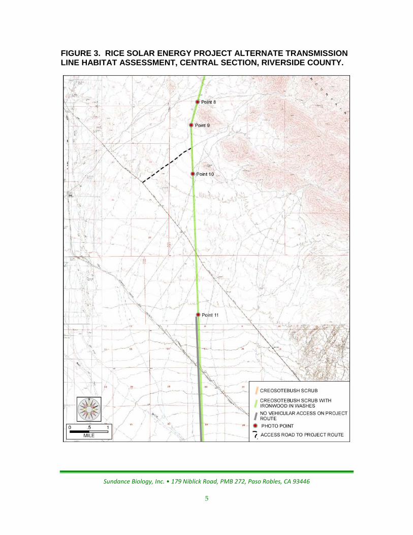
South of point 4 the substrate becomes rocky as the route moves into the canyon through the Big Maria Mountains. Dominant perennials are creosote bush, burrobush and brittle bush (Encelia farinosa). Plant species diversity is low and shrub density is sparse. Access into this canyon was very difficult due to extremely rough road conditions. Passage all the way through was not possible due to washouts through the incised canyon ravines.
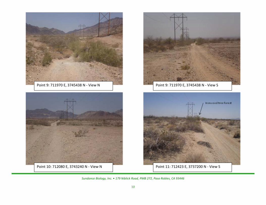
South of the Big Maria Mountains, from point 7 on, the dominant perennials include creosote bush, burrobush and ironwood tree (Olneya tessellata). Species diversity is moderate to low. Ironwood trees with some mesquite trees (Prosopis sp.) and palo verde trees (Cercidium sp.) occur as well. Trees generally occurred in the washes. From point 11 south the tree density increased as the soils went from rocky near point 7 to mostly sandy south of Midland Road. This region south of Midland Road is comprised of numerous washes beginning to converge as they flow into the large McCoy Wash. From point 11 south for approximately 6 miles the corridor road was a wash channel and impassable due to deep sand.
South of McCoy Wash the trees become less common. Palo Verde Mesa appears to have been farmed in the past. Several sections of land were fallow agriculture fields that have been sparsely reclaimed by desert shrubs. These areas could still be used by desert tortoises. Dominant perennials include creosote bush and burrobush. Access is good from the south end of the project route north to McCoy Wash. Between McCoy Wash and Midland Road access is difficult to impassable.
Sundance Biology, Inc. • 179 Niblick Road, PMB 272, Paso Robles, CA 93446
3
FIGURE 1. RICE SOLAR ENERGY PROJECT ALTERNATE TRANSMISSION LINE LOCATION MAP, RIVERSIDE COUNTY.
Sundance Biology, Inc. • 179 Niblick Road, PMB 272, Paso Robles, CA 93446
4
FIGURE 2. RICE SOLAR ENERGY PROJECT ALTERNATE TRANSMISSION LINE HABITAT ASSESSMENT, NORTH SECTION, RIVERSIDE COUNTY.
Sundance Biology, Inc. • 179 Niblick Road, PMB 272, Paso Robles, CA 93446
5
FIGURE 3. RICE SOLAR ENERGY PROJECT ALTERNATE TRANSMISSION LINE HABITAT ASSESSMENT, CENTRAL SECTION, RIVERSIDE COUNTY.

Sundance Biology, Inc. • 179 Niblick Road, PMB 272, Paso Robles, CA 93446
6
FIGURE 4. RICE SOLAR ENERGY PROJECT ALTERNATE TRANSMISSION LINE HABITAT ASSESSMENT, SOUTH SECTION, RIVERSIDE COUNTY.
Sundance Biology, Inc. • 179 Niblick Road, PMB 272, Paso Robles, CA 93446
7
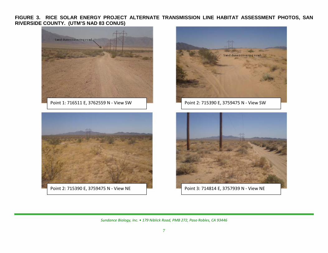
FIGURE 3. RICE SOLAR ENERGY PROJECT ALTERNATE TRANSMISSION LINE HABITAT ASSESSMENT PHOTOS, SAN RIVERSIDE COUNTY. (UTM’S NAD 83 CONUS)
Point 3: 714814 E, 3757939 N - View NE
Point 2: 715390 E, 3759475 N - View SW
Point 2: 715390 E, 3759475 N - View NE
Point 1: 716511 E, 3762559 N - View SW

Sundance Biology, Inc. • 179 Niblick Road, PMB 272, Paso Robles, CA 93446
8
Point 5: 713173 E, 3753506 N - View NE Point 5: 713173 E, 3753506 N - View S
Point 4: 713524 E, 3754448 N - View NE Point 3: 714814 E, 3757939 N - View S

Sundance Biology, Inc. • 179 Niblick Road, PMB 272, Paso Robles, CA 93446
9
Point 8: 712240 E, 3746400 N - View S Point 7: 712695 E, 3748228 N - View N
Point 7: 712695 E, 3748228 N - View S Point 6: 712749 E, 3749010 N - View N
Sundance Biology, Inc. • 179 Niblick Road, PMB 272, Paso Robles, CA 93446
10
Point 11: 712423 E, 3737200 N - View S Point 10: 712080 E, 3743240 N - View N
Point 9: 711970 E, 3745438 N - View S Point 9: 711970 E, 3745438 N - View N

Sundance Biology, Inc. • 179 Niblick Road, PMB 272, Paso Robles, CA 93446
11
Fallow agriculture field
Point 12: 714759 E, 3725367 N - View N Point 12: 714759 E, 3725367 N – View S