Embed Size (px)
Citation preview
APPENDIX 5
ARCHAEOLOGY
Specialist
Mr Jonathan KaplanAgency for Cultural Resource Management
Peer Review
Prof Hilary DeaconResearch Fellow, University of Stellenbosch
PHASE 1 ARCHAEOLOGICAL IMPACT ASSESSMENT AND HERITAGE REVIEWTHE PROPOSED N1 N2 WINELANDS TOLL HIGHWAY PROJECT
Prepared by
The Agency for Cultural Resource ManagementPO Box 159
Riebeek West7306
Ph/Fax: 022 461 2755Mobile: 082 321 0172
E-mail: [email protected]
Submitted to
CROWTHER CAMPBELL & ASSOCIATES
On behalf of
THE NATIONAL ROADS AGENCY
JULY2002
1
Executive summary
Heritage remains were located during a Phase 1 Archaeological Impact Assessment(AIA) and Heritage Review of the proposed N1 N2 Winelands Toll Highway Project.
The proposed project envisages a toll road on sections of the N1 and N2 NationalRoutes in the Western Cape.
With regard to the N1 Route, stone artefacts were located at the proposed R101 RampToll Plaza, the proposed Florence Interchange, the proposed Worcester CasinoInterchange, the proposed Glen Heatlie (North) Toll Plaza and the proposed SandhillsToll Plaza. Stone tools were also found in the service road between the railway line andthe N1 in the Hex River Poort. A few stone tools were also found in a shallow overhangsouth of the N1 in the Hex River Poort.
With regard to the N2 Route, stone artefacts were located at the proposed Bot RiverMainline Toll Plaza, the proposed Houwhoek Interchange, the proposed Firlands WestToll Plaza, the proposed Onverwacht Interchange and south-east of Strand HaltIndustrial area in the proposed Helderzicht By-pass.
The tools were found in mostly severely disturbed, highly altered and developed andpartially disturbed environments and have been given low significance ratings.
In addition to the archaeological finds, nine graves were located in a thick grove ofPoplar trees alongside the N1, about 1.3 kms from the proposed Glen Heatlie Toll Plaza.
All the graves are younger than 60 years and therefore do not fall under the protection ofthe South African Heritage Resources Act (No. 25 of 1999).
The graves will, however, be severely negatively impacted by the proposed constructionof Alternative Road 2 and have been assigned high significance ratings.
A small cemetery comprising about 20 graves was also located near the Kanetvleiturnoff on the N1 in the Hex River Poort Northern Section. Some of the graves are olderthan 60 years and therefore qualify for protection under the National Heritage ResourcesAct (No. 25 of 1999).
The site will most likely be negatively impacted by construction of the Alternative RoadX, either directly, or as a result of secondary impacts. The site has been assigned a highsignificance rating.
2
The overall impact of the proposed N1 N2 Winelands Toll Highway Project onarchaeological and heritage sites is, however, likely to be low.
The probability of locating significant archaeological remains during implementation(construction and operation) of the proposed project is also likely to be low.
However, the potential impact on graves/burial sites in the Central and NorthernSections of the N1 Hex River Poort will be of high significance.
In general, the receiving environment is not considered to be archaeologically orhistorically sensitive, vulnerable or threatened.
3
With regard to the proposed N1 N2 Winelands Toll Highway Project, the followingrecommendations are made.
1. No immediate archaeological mitigation is required.
2. The Kanetvlei cemetery in the Hex River Poort should be cleaned up, fenced off andprotected, prior to construction work commencing.
3. Landowners and farm labourers living in Kanetvlei must be consulted with regard tothe status, ownership and age of the graves/burial sites.
4. Care should be taken not to locate construction camps, plant equipment, or anyfacilities related to construction work close to the cemetery at Kanetvlei.
5. The South African Heritage Resources Agency (SAHRA) must be consulted withregard to any proposed measures to destroy, damage, alter, exhume, or remove theKanetvlei graves.
Permits to destroy, damage, alter, exhume or remove the graves from its originalposition, or disturb any grave or burial ground older than 60 years, must be appliedfor by the NRA.
Permit applications must be made on the official form Application for permit: BurialGrounds and Graves, available from SAHRA or any provincial heritage resourcesauthority.
The Proponent (NRA) must submit permit applications, to SAHRA or the relevantprovincial heritage resources authority.
6. Should any human remains be disturbed, exposed or uncovered during earthworksfor the proposed Khayelitsha Toll Plaza, these should immediately be reported to aprofessional archaeologist, or SAHRA.
Burial remains should be treated sensitively at all times. Human remains should notbe removed until inspected by a professional archaeologist.
7. Care should be taken not to locate construction camps, plant equipment, or anyfacilities related to construction work close to the N2 Houwhoek railway pass.
8. Future proposed borrow pits and quarry sites, from the Huguenot Toll Plaza (east) toSandhills (N1) and from Sir Lowry’s Pass to Bot River (N2), should be inspected forarchaeological sites/remains.
9. The construction EMP should detail reporting procedures to manage the discovery ofany heritage artefacts during construction. This would include the recovery orexposure of human burials during construction activities, for example.
The recommendations are subject to the approval of SAHRA.
4
TABLE OF CONTENTSExecutive summary 1
1. INTRODUCTION 5
1.1 Background and brief 5
2. LOCATION AND STUDY AREA 5
2.1 N1 Road Corridor 52.2 N2 Road Corridor 6
3. STUDY APPROACH 6
3.1 Overview of archaeological information in the study area 63.1.1 The N1 63.1.2 The N2 6
4. LEGISLATIVE REQUIREMENTS 7
4.1 The National Heritage Resources Act (No. 25 of 1999) 74.1.1 Archaeology (Section 35 (4)) 74.1.2 Burial grounds and graves (Section 36(3)) 7
5. IDENTIFICATION OF RISK SOURCES
5.1 The N1 75.2 The N2 7
6. IMPACT DESCRIPTION AND ASSESSMENT 8
6.1 The N1 86.1.1 Section 1: Old Oak Interchange to Huguenot Tunnel Toll Plaza 86.1.2 Section 2: Huguenot Tunnel Toll Plaza to Rawsonville 86.1.3 Section 3: Rawsonville to Sandhills 96.1.4 Section 3: Hex River Poort - Southern Section Alternatives
A and B 106.1.5 Section 3: Hex River Poort - Central Section Alternative
Alignment 2 116.1.6 Section 3: Hex River Poort - Northern Section Alternative
Alignments X and O 136.2 The N2 156.2.1 Section 1: R300 to De Beers Interchange 156.2.2 Section 2: De Beers Interchange to foot of Sir Lowry's Pass 166.2.3 Section 3: Foot of Sir Lowry's Pass to Bot River 16
7. CONCLUSION 18
8. RECOMMENDATIONS 18
9. REFERENCES 20
5
1. INTRODUCTION
1.1 Background and brief
Crowther Campbell & Associates has requested that the Agency for Cultural ResourceManagement undertake a Phase 1 Archaeological Impact Assessment (AIA) andHeritage Review of the proposed N1 N2 Winelands Toll Highway Project.
The proposed project envisages a toll road on sections of the N1 and N2 NationalRoutes in the Western Cape.
The bulk of the project will involve construction work on the existing alignments of the N1and the N2, and includes road widening and the construction of interchanges and tollplazas.
In two instances, however, alternative alignments are proposed. These include thesection through the Hex River Poort (along the N1) and the proposed new alignment ofthe N2 through Helderberg.
The aim of the study is to locate, identify and map heritage remains that may benegatively impacted by the proposed project, to assess the significance of likely impactsand to propose measures to mitigate against the impacts.
The terms of reference for the study are:
1. to inspect the proposed toll plaza locations, the Helderberg By-pass route, theupgrade options for the Hex River Poort and those areas identified for road wideningfor any heritage resources, and assess the significance of the likely impacts of theconstruction on heritage resources;
2. to identify practicable mitigation measures to reduce negative impacts on thearchaeological resources and indicate how these can be incorporated in theconstruction and management of the toll road; and
3. to provide guidance for the requirement of any permits from the South AfricanHeritage Resources Agency (SAHRA) that might become necessary.
2. LOCATION AND STUDY AREA
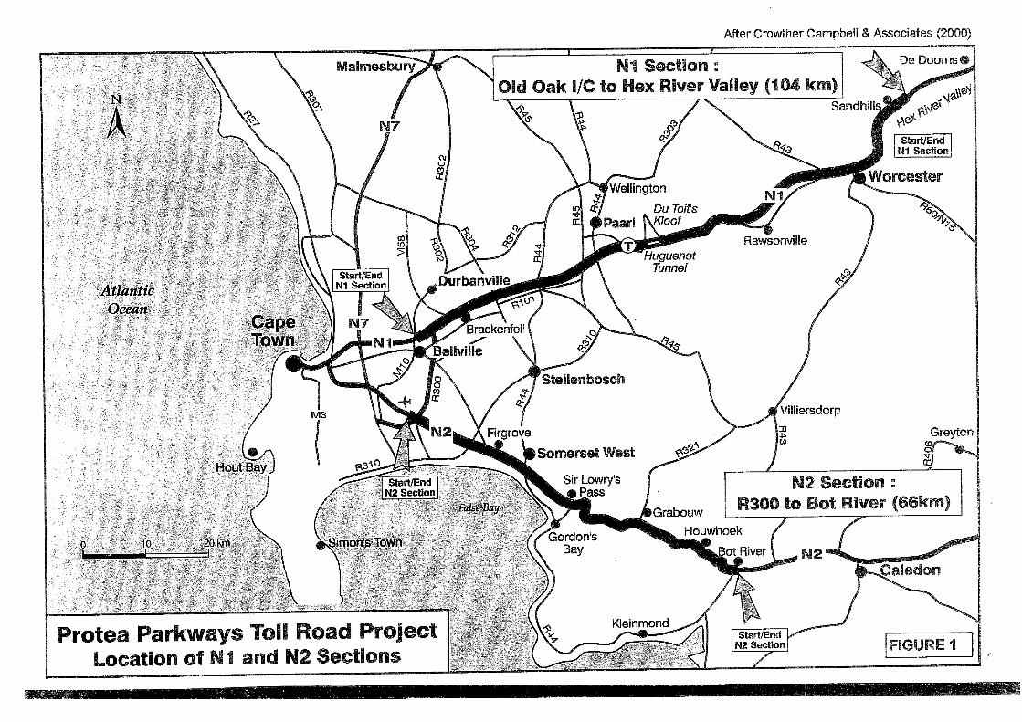
The location and study area for the proposed project is illustrated in Figure 1.
2.1 N1 Road Corridor
The proposed concession route follows the existing N1 route and covers the area fromthe Old Oak Interchange through to Sandhills at the start of the Hex River Valley. Thetotal route length is 105.8 km.
6
2.2 N2 Road Corridor
The proposed concession route follows the existing N2 route and starts on the westernside of the R300, passes through the Helderberg and ends just east of the HermanusInterchange at Bot River. The total route length is 70.3 km.
3. STUDY APPROACH
The approach used in the study entailed a foot survey of the proposed interchange andtoll plaza sites and areas identified for road widening.
The proposed alternative alignments through the Hex River Poort (N1) and the N2 atSomerset West (the Heldeberg By-pass), were also searched for heritage remains.
Aerial photographs were studied in order to ascertain the historical and current landuseof the proposed construction sites.
A desktop study was also undertaken.
3.1 Overview of archaeological information in the study area
According to the records of the Archaeological Data Recording Centre at the SouthAfrican Museum (Cape Town) no archaeological sites or remains have been recorded inthe immediate study area.
3.1.1 The N1
Middle Stone Age1 (MSA) and Early Stone Age2 (ESA) tools have been found in theElandspad close to the Huguenot Tunnel (East), and in the Molenaars River Valley(Halkett & Hart 1994; Parkington & Poggenpoel 1988). Later Stone Age3 (LSA) rockpaintings have been recorded in the Molenaars River Valley (Halkett & Hart 1994), whilerock paintings have also been recorded at Tolkloof in the Hex River Poort (HilaryDeacon, pers. comm.).
3.1.2 The N2
MSA tools have been located at a site alongside Sir Lowry’s Pass (Kaplan 1995). LSAand MSA tools were also located during a study of the upper catchment of the PalmietRiver (Kaplan 1990), while MSA tools were located at the proposed Ikapa Quarry nearGrabouw (Kaplan 1998). Rock paintings have also been located near the SteenbrasRiver Dam (Royden Yates, South African Museum, pers. comm.) and alongside the BotRiver near the old Houwhoek railway road (Burman 1963).
1 A term referring to the period between 200 000 and 20 000 years ago.2 A term referring to the period between 2 million and 200 00 years ago.3 A term referring to the last 20 000 years of precolonial history in southern Africa.
7
4. LEGISLATIVE REQUIREMENTS
4.1 The National Heritage Resources Act (Act No. 25 of 1999)
4.1.1 Archaeology (Section 35 (4))
No person may, without a permit issued by the responsible heritage resources authority,destroy, damage, excavate, alter or remove from its original position, or collect, anyarchaeological material or object.
4.1.2 Burial grounds and graves (Section 36 (3))
No person may, without a permit issued by SAHRA or a provincial heritage authority,destroy, damage, alter, exhume or remove from its original position or otherwise disturbany grave or burial ground older than 60 years, which is situated outside a formalcemetery administered by a local authority.
5. IDENTIFICATION OF RISK SOURCES
The following project actions may impact negatively on archaeological sites and othersites of cultural importance. The actions are most likely to occur during the constructionphase of the proposed project.
5.1 The N1
• Road widening and the construction of interchanges and toll plazas may expose anduncover ESA and MSA tools.
5.2 The N2
• Road widening and the construction of interchanges and toll plazas may expose anduncover ESA and MSA tools.
• Excavations and earthworks may expose human burial remains during constructionfor the proposed Khayelitsha Toll Plaza.
8
6. IMPACT DESCRIPTION AND ASSESSMENT
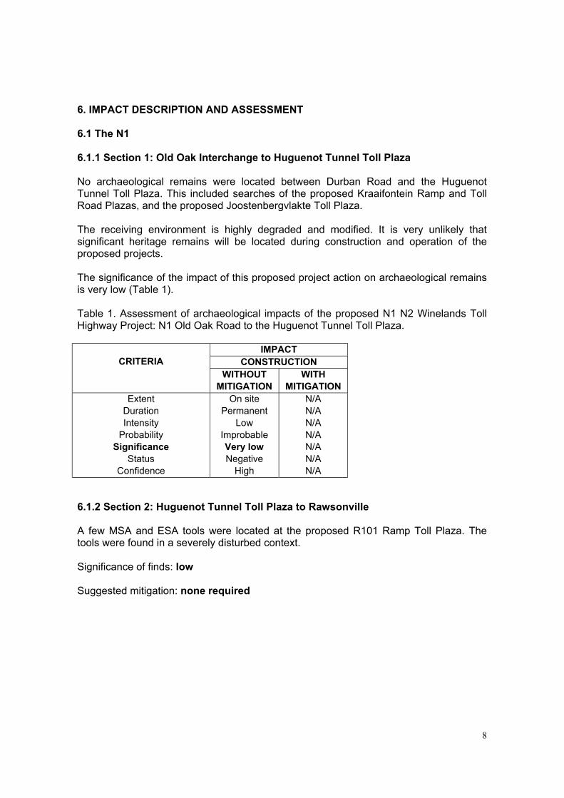
6.1 The N1
6.1.1 Section 1: Old Oak Interchange to Huguenot Tunnel Toll Plaza
No archaeological remains were located between Durban Road and the HuguenotTunnel Toll Plaza. This included searches of the proposed Kraaifontein Ramp and TollRoad Plazas, and the proposed Joostenbergvlakte Toll Plaza.
The receiving environment is highly degraded and modified. It is very unlikely thatsignificant heritage remains will be located during construction and operation of theproposed projects.
The significance of the impact of this proposed project action on archaeological remainsis very low (Table 1).
Table 1. Assessment of archaeological impacts of the proposed N1 N2 Winelands TollHighway Project: N1 Old Oak Road to the Huguenot Tunnel Toll Plaza.
IMPACTCONSTRUCTIONCRITERIA
WITHOUTMITIGATION
WITHMITIGATION
ExtentDurationIntensity
ProbabilitySignificance
StatusConfidence
On sitePermanent
LowImprobableVery lowNegative
High
N/AN/AN/AN/AN/AN/AN/A
6.1.2 Section 2: Huguenot Tunnel Toll Plaza to Rawsonville
A few MSA and ESA tools were located at the proposed R101 Ramp Toll Plaza. Thetools were found in a severely disturbed context.
Significance of finds: low
Suggested mitigation: none required
9
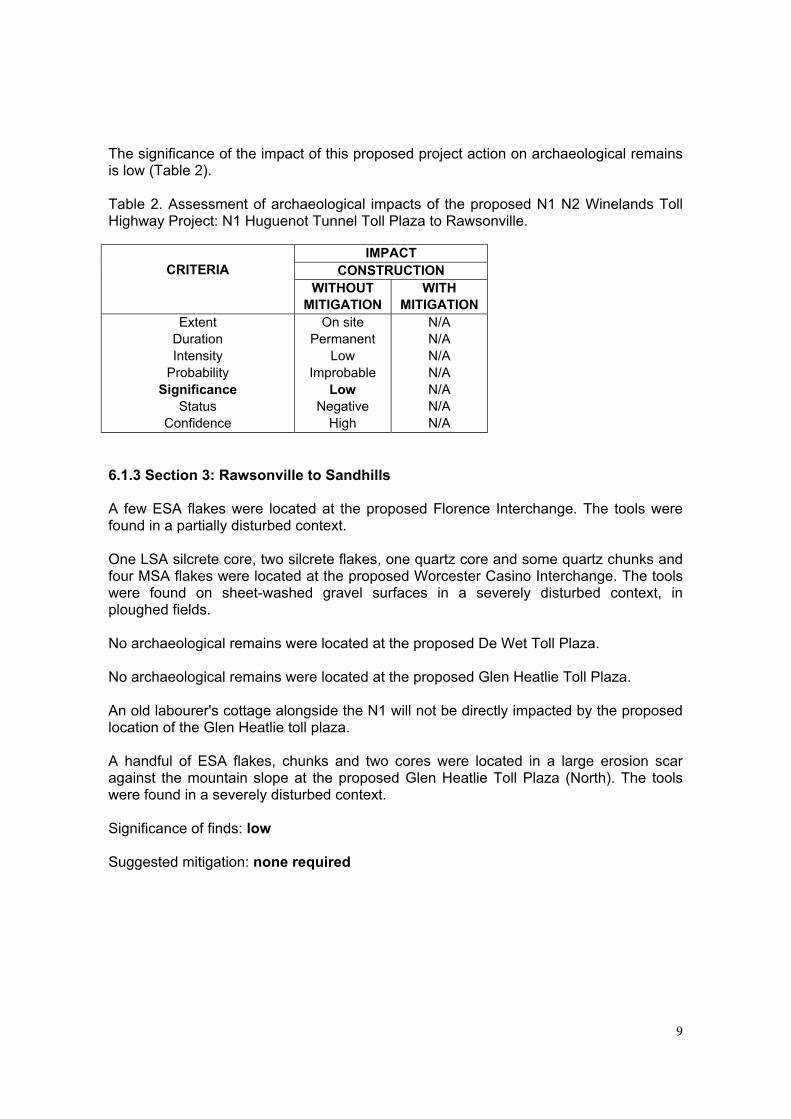
The significance of the impact of this proposed project action on archaeological remainsis low (Table 2).
Table 2. Assessment of archaeological impacts of the proposed N1 N2 Winelands TollHighway Project: N1 Huguenot Tunnel Toll Plaza to Rawsonville.
IMPACTCONSTRUCTIONCRITERIA
WITHOUTMITIGATION
WITHMITIGATION
ExtentDurationIntensity
ProbabilitySignificance
StatusConfidence
On sitePermanent
LowImprobable
LowNegative
High
N/AN/AN/AN/AN/AN/AN/A
6.1.3 Section 3: Rawsonville to Sandhills
A few ESA flakes were located at the proposed Florence Interchange. The tools werefound in a partially disturbed context.
One LSA silcrete core, two silcrete flakes, one quartz core and some quartz chunks andfour MSA flakes were located at the proposed Worcester Casino Interchange. The toolswere found on sheet-washed gravel surfaces in a severely disturbed context, inploughed fields.
No archaeological remains were located at the proposed De Wet Toll Plaza.
No archaeological remains were located at the proposed Glen Heatlie Toll Plaza.
An old labourer's cottage alongside the N1 will not be directly impacted by the proposedlocation of the Glen Heatlie toll plaza.
A handful of ESA flakes, chunks and two cores were located in a large erosion scaragainst the mountain slope at the proposed Glen Heatlie Toll Plaza (North). The toolswere found in a severely disturbed context.
Significance of finds: low
Suggested mitigation: none required
10
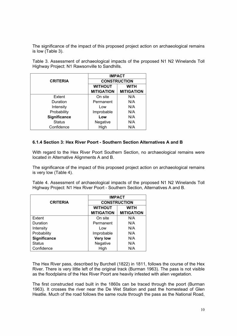
The significance of the impact of this proposed project action on archaeological remainsis low (Table 3).
Table 3. Assessment of archaeological impacts of the proposed N1 N2 Winelands TollHighway Project: N1 Rawsonville to Sandhills.
IMPACTCONSTRUCTIONCRITERIA
WITHOUTMITIGATION
WITHMITIGATION
ExtentDurationIntensity
ProbabilitySignificance
StatusConfidence
On sitePermanent
LowImprobable
LowNegative
High
N/AN/AN/AN/AN/AN/AN/A
6.1.4 Section 3: Hex River Poort - Southern Section Alternatives A and B
With regard to the Hex River Poort Southern Section, no archaeological remains werelocated in Alternative Alignments A and B.
The significance of the impact of this proposed project action on archaeological remainsis very low (Table 4).
Table 4. Assessment of archaeological impacts of the proposed N1 N2 Winelands TollHighway Project: N1 Hex River Poort - Southern Section, Alternatives A and B.
IMPACTCONSTRUCTIONCRITERIA
WITHOUTMITIGATION
WITHMITIGATION
ExtentDurationIntensityProbabilitySignificanceStatusConfidence
On sitePermanent
LowImprobableVery lowNegative
High
N/AN/AN/AN/AN/AN/AN/A
The Hex River pass, described by Burchell (1822) in 1811, follows the course of the HexRiver. There is very little left of the original track (Burman 1963). The pass is not visibleas the floodplains of the Hex River Poort are heavily infested with alien vegetation.
The first constructed road built in the 1860s can be traced through the poort (Burman1963). It crosses the river near the De Wet Station and past the homestead of GlenHeatlie. Much of the road follows the same route through the pass as the National Road,
11
which was constructed in 1939, and can be seen in places next to it, and above therailway line.
The Hex River Pass railway line was surveyed and built in 1876 (Baas 1998). The linewas the first major extension of a South African railway line into the interior, and is theoldest railway pass in South Africa. The line played a central role in the 19th and 20th
century history of South Africa. While Cape Town was the capital of the Colony, theWestern railway system provided a strategic link to the interior. The line is associatedwith the Kimberley diamond boom (1867) and the South African Anglo Boer War (1899-1904).
The current Hex River railway line was laid in the 1930s, and only a small portion of theoriginal (1876) line still exists north of De Doorns (Baas 1998). The 1930s section of theline does not rate highly in terms of regional or national historical significance, andplayed no pioneering role in the development of railway infrastructure in the country(Baas 1998:28).
6.1.5 Section 3: Hex River Poort - Central Section Alternative Alignment 2
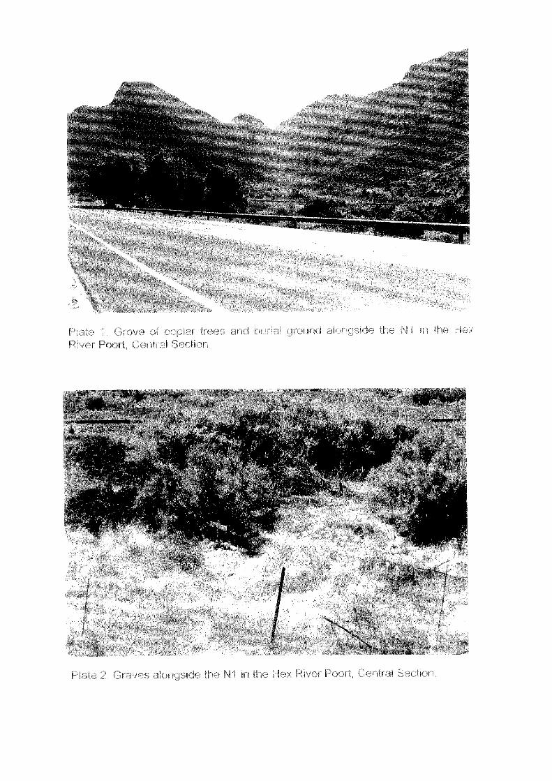
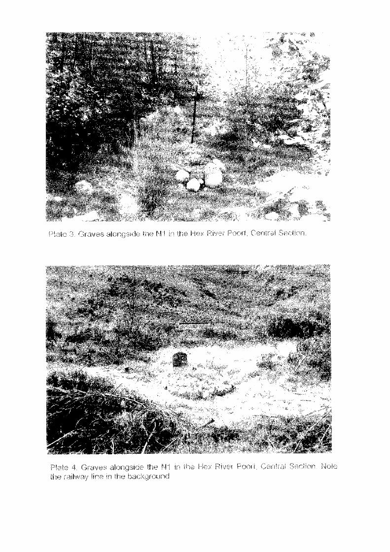
With regard to the Hex River Poort Central Section, nine graves were located in a thickgrove of Poplar trees alongside the N1 in Alternative Alignment 2, about 1.3 km from theproposed Glen Heatlie Toll Plaza (Plates 1-4).
The grave mounds are overgrown and hidden in thick vegetation, but some are visibleand well maintained and cared for, suggesting regular visits by family/relatives andfriends of the deceased. At least five of the graves have headstones. Date at death onone headstone reads 1966. All the other headstones are unmarked. More graves mayoccur in the thickly wooded site.
The graves will be severely negatively impacted by construction of Alternative Road 2.
The Glen Heatlie graves were previously identified by Ninhan Shand ConsultingEngineers in a Scoping Report completed by Johnson and Luger (2001). The report wasundertaken as part of a separate contract undertaken by Ninhan Shand on behalf of theNRA.
According to Ms Milicient Solomons (pers. comm.) of Ninham Shand ConsultingEngineers, the so-called Glen Heatlie cemetery originated sometime in the mid 1940's.Therefore the graves do not fall under the protection of the South African HeritageResources Act (No 25 of 1999). The graves will be exhumed and reburied in a formalcemetery in Worcester, as part of a process being carried out by Ninhan ShandConsulting Engineers (Milicient Solomons, pers. comm.).
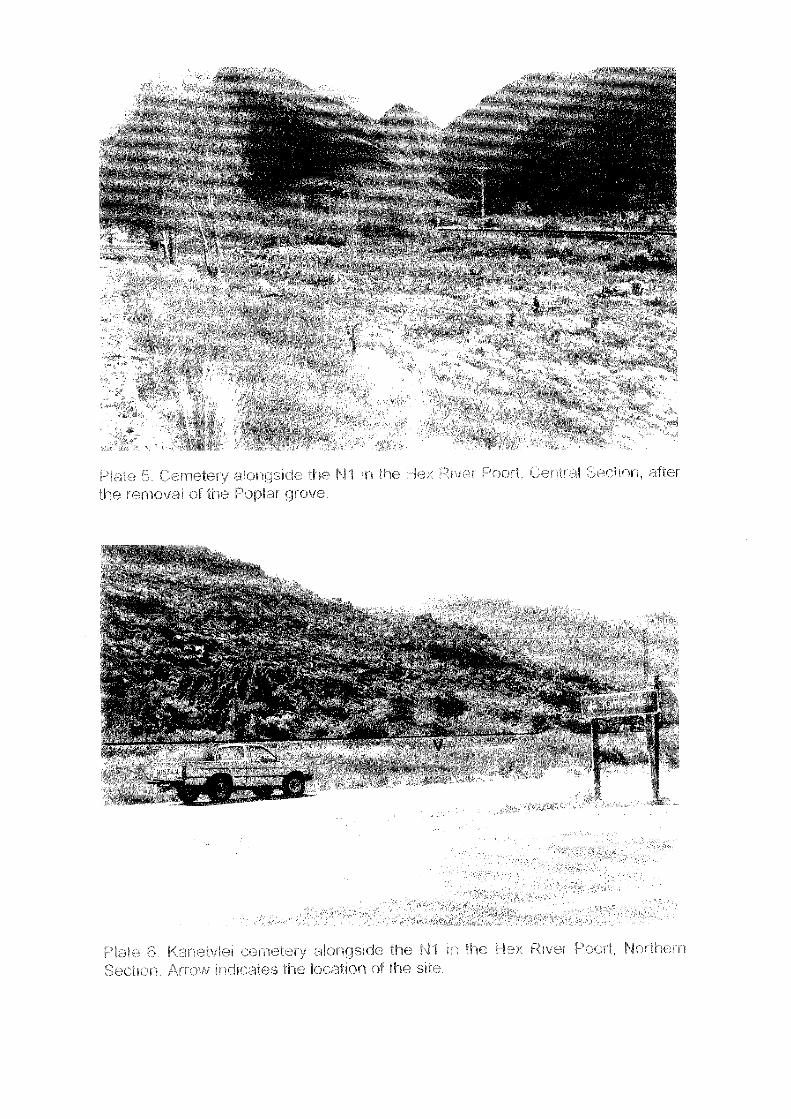
The heritage specialist revisited the site on Friday 24 May 2002. The grove of Poplartrees has been cleared from the site (Plate 5). Between 30 and 40 additional graveswere identified.
Significance of finds: high
12
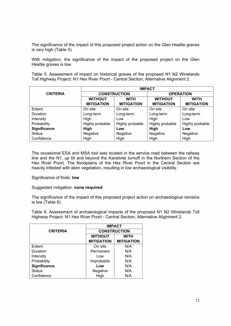
The significance of the impact of this proposed project action on the Glen Heatlie gravesis very high (Table 5).
With mitigation, the significance of the impact of the proposed project on the GlenHeatlie graves is low.
Table 5. Assessment of impact on historical graves of the proposed N1 N2 WinelandsToll Highway Project: N1 Hex River Poort - Central Section, Alternative Alignment 2.
IMPACTCONSTRUCTION OPERATIONCRITERIA
WITHOUTMITIGATION
WITHMITIGATION
WITHOUTMITIGATION
WITHMITIGATION
ExtentDurationIntensityProbabilitySignificanceStatusConfidence
On siteLong-termHighHighly probableHighNegativeHigh
On siteLong-termLowHighly probableLowNegativeHigh
On siteLong-termHighHighly probableHighNegativeHigh
On siteLong-termLowHighly probableLowNegativeHigh
The occasional ESA and MSA tool was located in the service road between the railwayline and the N1, up till and beyond the Kanetvlei turnoff in the Northern Section of theHex River Poort. The floodplains of the Hex River Poort in the Central Section areheavily infested with alien vegetation, resulting in low archaeological visibility.
Significance of finds: low
Suggested mitigation: none required
The significance of the impact of this proposed project action on archaeological remainsis low (Table 6).
Table 6. Assessment of archaeological impacts of the proposed N1 N2 Winelands TollHighway Project: N1 Hex River Poort - Central Section, Alternative Alignment 2.
IMPACTCONSTRUCTIONCRITERIA
WITHOUTMITIGATION
WITHMITIGATION
ExtentDurationIntensityProbabilitySignificanceStatusConfidence
On sitePermanent
LowImprobable
LowNegative
High
N/AN/AN/AN/AN/AN/AN/A
13
6.1.6 Section 3: Hex River Poort - Northern Section Alternative Alignment X, Y & O
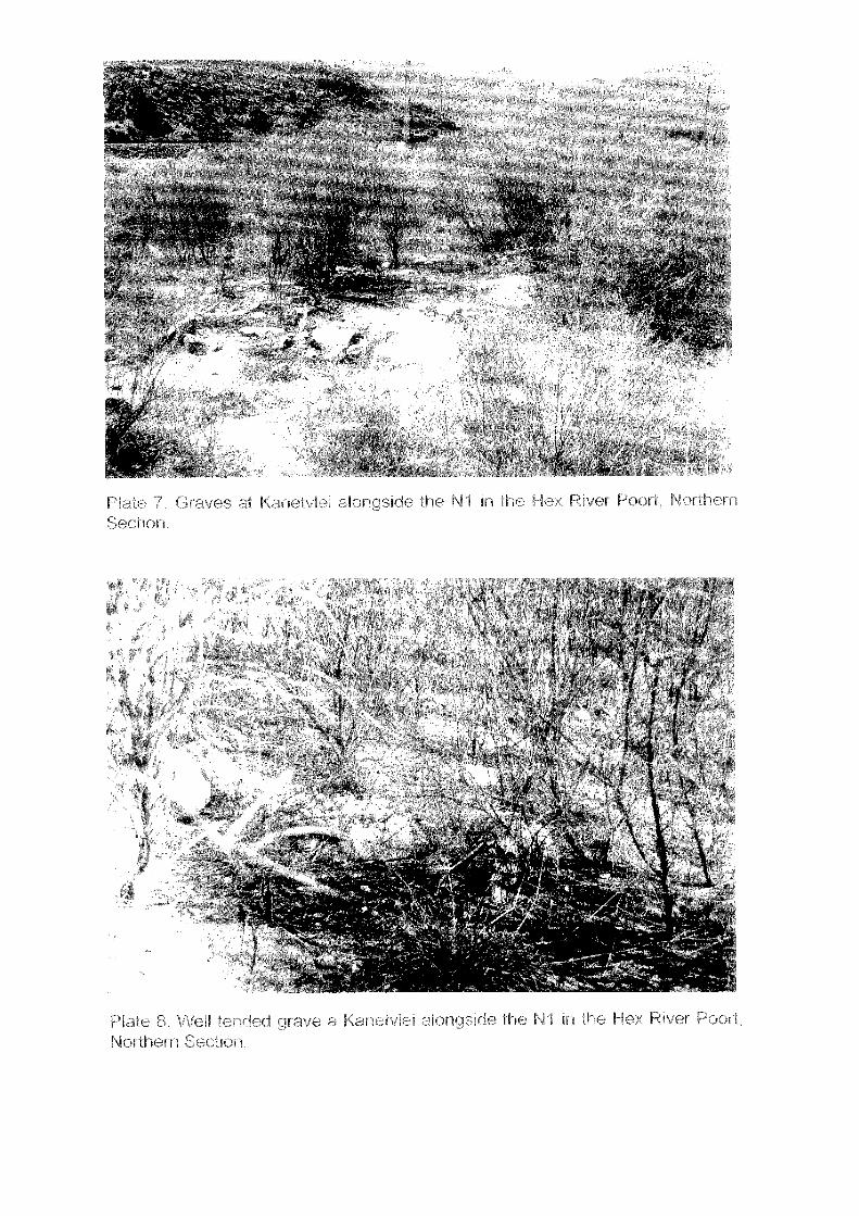
With regard to the Hex River Poort Northern Section, a small cemetery comprising about20 graves was located in thick vegetation near the Kanetvlei turnoff in AlternativeAlignment X (Plate 6).
Most of the graves, belonging to previous generations of farm workers, have fallen into asevere state of neglect (Plate 7), but some are reasonably well maintained and cared for(Plate 8).
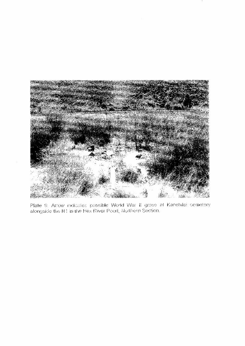
A single grave (Plate 9), with remnants of a black granite headstone, apparently belongsto a World War II veteran that lived in the area (Johnson & Luger 2001).
According to Mr Dave Haskins (pers. comm.) of Melis Du Plessis ConsultingGeotechnical Engineers, the majority of the Kanetvlei graves are older than 60 yearsand are therefore protected under the National Heritage Resources Act (No. 25 of 1999).
The cemetery will likely be negatively impacted by construction of the AlternativeAlignment X, either directly, or as a result of secondary (construction) impacts.
If construction of Alternative Alignment X directly results in the destruction of theKanetvlei graves, the NRA must comply with legislative requirements regarding theexhumation of burials.
Secondary impacts in the construction phase (for example damage cause by plantequipment) may also damage or destroy some of the graves. These must be avoided atall costs.
Significance of finds: high
Suggested mitigation: the cemetery should be cleaned up, fenced off and protected,prior to construction work commencing
14
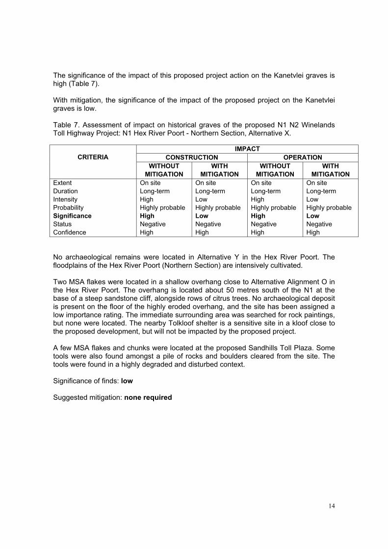
The significance of the impact of this proposed project action on the Kanetvlei graves ishigh (Table 7).
With mitigation, the significance of the impact of the proposed project on the Kanetvleigraves is low.
Table 7. Assessment of impact on historical graves of the proposed N1 N2 WinelandsToll Highway Project: N1 Hex River Poort - Northern Section, Alternative X.
IMPACTCONSTRUCTION OPERATIONCRITERIA
WITHOUTMITIGATION
WITHMITIGATION
WITHOUTMITIGATION
WITHMITIGATION
ExtentDurationIntensityProbabilitySignificanceStatusConfidence
On siteLong-termHighHighly probableHighNegativeHigh
On siteLong-termLowHighly probableLowNegativeHigh
On siteLong-termHighHighly probableHighNegativeHigh
On siteLong-termLowHighly probableLowNegativeHigh
No archaeological remains were located in Alternative Y in the Hex River Poort. Thefloodplains of the Hex River Poort (Northern Section) are intensively cultivated.
Two MSA flakes were located in a shallow overhang close to Alternative Alignment O inthe Hex River Poort. The overhang is located about 50 metres south of the N1 at thebase of a steep sandstone cliff, alongside rows of citrus trees. No archaeological depositis present on the floor of the highly eroded overhang, and the site has been assigned alow importance rating. The immediate surrounding area was searched for rock paintings,but none were located. The nearby Tolkloof shelter is a sensitive site in a kloof close tothe proposed development, but will not be impacted by the proposed project.
A few MSA flakes and chunks were located at the proposed Sandhills Toll Plaza. Sometools were also found amongst a pile of rocks and boulders cleared from the site. Thetools were found in a highly degraded and disturbed context.
Significance of finds: low
Suggested mitigation: none required
15
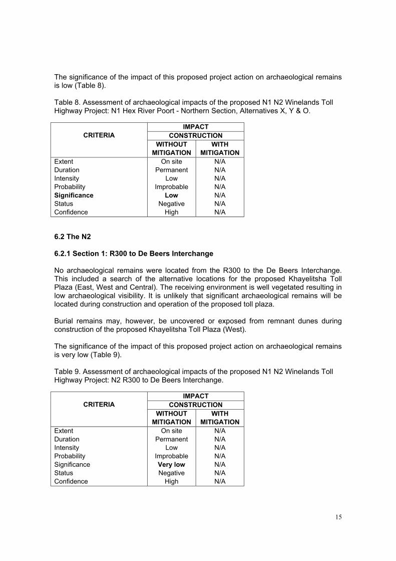
The significance of the impact of this proposed project action on archaeological remainsis low (Table 8).
Table 8. Assessment of archaeological impacts of the proposed N1 N2 Winelands TollHighway Project: N1 Hex River Poort - Northern Section, Alternatives X, Y & O.
IMPACTCONSTRUCTIONCRITERIA
WITHOUTMITIGATION
WITHMITIGATION
ExtentDurationIntensityProbabilitySignificanceStatusConfidence
On sitePermanent
LowImprobable
LowNegative
High
N/AN/AN/AN/AN/AN/AN/A
6.2 The N2
6.2.1 Section 1: R300 to De Beers Interchange
No archaeological remains were located from the R300 to the De Beers Interchange.This included a search of the alternative locations for the proposed Khayelitsha TollPlaza (East, West and Central). The receiving environment is well vegetated resulting inlow archaeological visibility. It is unlikely that significant archaeological remains will belocated during construction and operation of the proposed toll plaza.
Burial remains may, however, be uncovered or exposed from remnant dunes duringconstruction of the proposed Khayelitsha Toll Plaza (West).
The significance of the impact of this proposed project action on archaeological remainsis very low (Table 9).
Table 9. Assessment of archaeological impacts of the proposed N1 N2 Winelands TollHighway Project: N2 R300 to De Beers Interchange.
IMPACTCONSTRUCTIONCRITERIA
WITHOUTMITIGATION
WITHMITIGATION
ExtentDurationIntensityProbabilitySignificanceStatusConfidence
On sitePermanent
LowImprobableVery lowNegative
High
N/AN/AN/AN/AN/AN/AN/A
16
6.2.2 Section 2: De Beers Interchange to the foot of Sir Lowry’s Pass
No archaeological or heritage remains were located in the alternative alignments for theproposed N2 Helderzicht By-pass near Somerset West.
MSA and LSA tools were, however, located south-east of the Strand Halt Industrial area.The receiving environment is highly altered and disturbed and also infested with alienvegetation.
The modern industrial buildings in Broadlands Road are not considered to be historicallyimportant (Crowther Campbell & Associates 2000; Kaplan 2000).
A handful of MSA tools were located at the proposed Onverwacht Interchange and onsheet-washed gravel slopes at the proposed Firlands West Toll Plaza. The receivingenvironment is highly degraded and disturbed.
Significance of finds: low
Suggested mitigation: none required
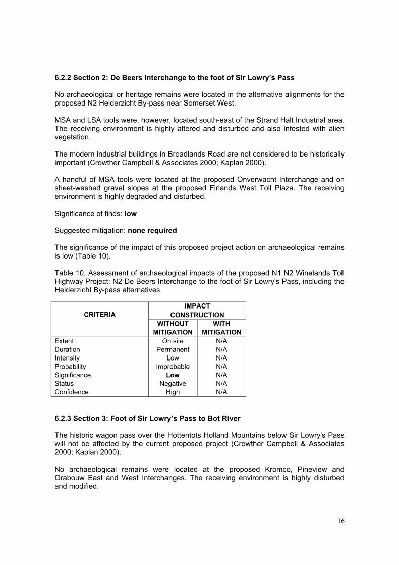
The significance of the impact of this proposed project action on archaeological remainsis low (Table 10).
Table 10. Assessment of archaeological impacts of the proposed N1 N2 Winelands TollHighway Project: N2 De Beers Interchange to the foot of Sir Lowry's Pass, including theHelderzicht By-pass alternatives.
IMPACTCONSTRUCTIONCRITERIA
WITHOUTMITIGATION
WITHMITIGATION
ExtentDurationIntensityProbabilitySignificanceStatusConfidence
On sitePermanent
LowImprobable
LowNegative
High
N/AN/AN/AN/AN/AN/AN/A
6.2.3 Section 3: Foot of Sir Lowry’s Pass to Bot River
The historic wagon pass over the Hottentots Holland Mountains below Sir Lowry's Passwill not be affected by the current proposed project (Crowther Campbell & Associates2000; Kaplan 2000).
No archaeological remains were located at the proposed Kromco, Pineview andGrabouw East and West Interchanges. The receiving environment is highly disturbedand modified.
17
ESA flakes, chunks and cores were located on the north facing vegetated slopes aboveand below the N2, at the proposed Houwhoek Interchange. The receiving environment ispartially disturbed and altered by previous roadworks.
Significance of finds: low
Suggested mitigation: none required
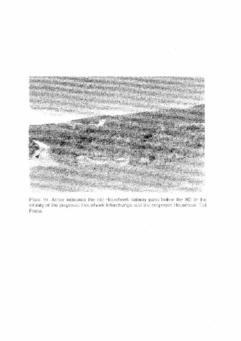
The remains of the old railway road, built immediately after the South African Anglo BoerWar (1899-1904) is visible below the N2 and follows the course of the Bot River (Plate10). The original wagon pass, constructed sometime in the 1680s (Burman 1963),passes above the N2, east of the proposed Houwhoek Toll Plaza. This pass wassubsequently improved in the 1830s and then again in the late 1840s by renowned roadbuilder Andrew Geddes Bain (Burman 1963).
No archaeological remains were located at the proposed Houwhoek Toll Plaza. Rockpaintings, however, do occur near the old railway road, below the N2 (Burman 1963).However, it is unlikely that the paintings will be impacted by the construction of theproposed toll plaza.
MSA flakes, chunks and split chunks/cobbles were located at the proposed Bot RiverMainline Toll Plaza. The receiving environment is partially disturbed.
Significance of finds: low
Suggested mitigation: none required
No archaeological remains were located at the proposed Bot River Ramp Toll Plaza.The receiving environment is well vegetated.
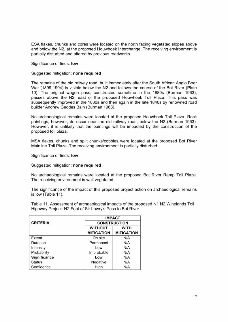
The significance of the impact of this proposed project action on archaeological remainsis low (Table 11).
Table 11. Assessment of archaeological impacts of the proposed N1 N2 Winelands TollHighway Project: N2 Foot of Sir Lowry's Pass to Bot River.
IMPACTCONSTRUCTIONCRITERIA
WITHOUTMITIGATION
WITHMITIGATION
ExtentDurationIntensityProbabilitySignificanceStatusConfidence
On sitePermanent
LowImprobable
LowNegative
High
N/AN/AN/AN/AN/AN/AN/A
18
7. CONCLUSION
The Archeological Impact Assessment and Heritage Review has shown that theproposed N1 N2 Winelands Toll Highway Project will have no significantly high negativeimpacts on archaeological and historical sites.
The probability of locating significant archaeological and historical sites/remains duringimplementation (construction and operation) of the proposed project is likely to be low.
In general, the receiving environment is not considered to be archaeologically orhistorically sensitive, vulnerable or threatened.
However, the potential impact on graves/burial sites in the Central and NorthernSections of the N1 Hex River Poort will be of high significance.
Burial remains may also possibly be uncovered or exposed during construction of theproposed N2 Khayelitsha Toll Plaza (West ).
8. RECOMMENDATIONS
With regard to the proposed N1 N2 Winelands Toll Highway Project, the followingrecommendations are made.
1. No immediate archaeological mitigation is required.
2. The Kanetvlei cemetery in the Hex River Poort, should be cleaned up, fenced off andprotected, prior to construction work commencing.
3. Landowners and farm labourers living in Kanetvlei must be consulted with regard tothe status, ownership and age of the graves/burial sites.
4. Care should be taken not to locate construction camps, plant equipment, or anyfacilities related to construction work close to the cemetery at Kanetvlei.
5. The South African Heritage Resources Agency (SAHRA) must be consulted withregard to any proposed measures to destroy, damage, alter, exhume, or remove theKanetvlei graves.
Permits to destroy, damage, alter, exhume or remove the graves from its originalposition, or disturb any grave or burial ground older than 60 years, must be appliedfor by the NRA.
Permit applications must be made on the official form Application for permit: BurialGrounds and Graves, available from SAHRA or any provincial heritage resourcesauthority.
The Proponent (NRA) must submit permit applications, to SAHRA or the relevantprovincial heritage resources authority.
19
6. Should any human remains be disturbed, exposed or uncovered during earthworksfor the proposed Khayelitsha Toll Plaza, these should immediately be reported to aprofessional archaeologist, or SAHRA.
Burial remains should be treated sensitively at all times. Human remains should notbe removed until inspected by a professional archaeologist.
7. Care should be taken not to locate construction camps, plant equipment, or anyfacilities related to construction work close to the N2 Houwhoek railway pass.
8. Future proposed borrow pits and quarry sites, from the Huguenot Toll Plaza (east) toSandhills (N1) and from Sir Lowry’s Pass to Bot River (N2), should be inspected forarchaeological sites/remains.
9. The construction EMP should detail reporting procedures to manage the discovery ofany heritage artefacts during construction. This would include the recovery orexposure of human burials during construction activities, for example.
The recommendations are subject to the approval of the SAHRA.
20
9. RERERENCES
Baas, A. 1998. Cultural and historical assessment of the Hex River Pass Railway Line.Final report. Report prepared for Transnet. Ninham Shand Environmental & EngineeringConsultants.
Burchell, W.J. 1822. Towards the interior of southern Africa. London: Longman, Hurst,Rees.
Burman, J. 1963. So high the road. Mountain passes of the Western Cape. Human &Rousseau. Cape Town · Pretoria.
Crowther Campbell & Associates, 2000. Final Scoping Report, the proposed N1 N2Protea Parkways Toll Road Project. Report prepared for Protea Parkways Consortium.
Halkett, D. & Hart, T. 1994. Archaeological survey of four dam sites in thePaarl/Wellington area. Report prepared for Ninham Shand Consulting Engineers.Archaeology Contracts Office, Department of Archaeology, University of Cape Town.
Johnson, B. & Luger, M. 2001. Environmental Scoping Report. Proposed N 1 (GlenHeatlie to Hex River Poort) Upgrade and Rehabilitation. Final Scoping Report. Reportprepared for South African National Roads Agency. Ninham Shand ConsultingEngineers, Environmental Section. Report No. 3120/9308
Kaplan, J. 1990. Archaeological study: Kogelberg Nature Reserve. Report prepared forthe Department of Water Affairs and Forestry. Agency for Cultural ResourceManagement.
Kaplan, J. 1995. Archaeological study, Bonnita Spring Water Bottling Plant. Reportprepared for Dennis Moss Partnership. Agency for Cultural Resource Management.
Kaplan, J. 1998. Archaeological study, Ikapa Quarry, Grabauw. Report prepared forEcosense. Agency for Cultural Resource Management.
Kaplan, J. 2000. Archaeological scoping, proposed N1 N2 Protea Parkways Toll RoadProject. Report prepared for Crowther Campbell & Associates. Agency for CulturalResource Management
Parkington, J.E. & Poggenpoel, C. 1988. Archaeological survey of the Molenaar's RiverValley, Du Toitskloof In: Du Toitskloof: Environmental Impact Assessment. NationalRoad Route 1 - sections 1 & 2 (Huguenot Tunnel to Gevonden). Report prepared for theNational Transport Commission. Chief Directorate: National Road by Hill Kaplan ScottInc. Volumes 1 & 2.
PROPOSED N1 N2 PROTEA PARKWAYS TOLL ROAD PROJECT
REVIEW OF DRAFT ARCHAEOLOGICAL AND HERITAGE IMPACTREPORT
The draft archaeological and heritage report was prepared by The Agency for Cultural
Resource Management, Riebeek West and is dated June 2002.
This review is compiled in accordance with the terms of reference provided by Crowther
Campbell Associates in their letter of 10 June 2002. These terms are given as headings
below.
Assess whether the study has complied with its Terms of Reference
The terms of reference for the study were as follows:
1. to inspect the proposed toll plaza locations, the Helderberg By-pass route, the upgradeoptions for the Hex River Poort and those areas identified for road widening for anyarchaeological remains, and assess the significance of the likely impacts of theconstruction activities from an archaeological perspective;
2. to identify practicable mitigation measures to reduce negative impacts onarchaeological resources and indicate how these can be incorporated in theconstruction and management of the toll road; and
3. to provide guidance for the requirement of any permits from the South AfricanHeritage Resources Agency that might become necessary.
The study has involved a foot survey inspection of the proposed interchange and toll
plaza sites and areas identified for road widening and provides assessment of the likely
impacts. It identifies mitigation measures to be taken particularly in respect of graves.
Guidance is given on the necessary South African Heritage Resources Agency permit
requirements, again notably in respect of human remains. The study has complied with
the terms of reference.
Assess whether adequate consideration is given, where appropriate, to the legal,policy and/or planning context of direct relevance to the specialist study
The main legal considerations relevant to the archaeological and heritage impacts have to
do with the blanket protection given to heritage materials older than 60 years under the
National Heritage Resources Act (Act No. 25 of 1999). The report indicates that adequate
consideration is given to this legal constraint.
2
Assess the technical content and the assessment methodology of the specialist studyto determine whether it is credible
The study has shown the presence of stone artefacts at a number of localities but mainly
in low concentrations and in disturbed contexts. These artefacts have been referred to the
major temporal stage divisions, Earlier, Middle and Later Stone Ages, as is usual
practice. The low concentration and lack of context is the reason for low assessment of
significance given to these occurrences. However, the report does mention two Middle
Stone Age flakes located in a shallow overhang in the Alternative Alignment O in the
Hex River Poort. This mention requires further explanation of why the significance of
this occurrence should be rated as low. As an overhang may include deposits, an
assessment of the extent and possible depth of any deposits is required. In the Hex River
Poort opposite the Kanetvlei turnoff to the south of the existing road, is the property
known as Tolkloof, presumably the site of an historic toll. On this property which is
noted for its rock art, close to the entrance of the kloof, is a small rock shelter with ashy
possibly Later Stone Age deposits exposed in the floor. There are Middle Stone Age
artefacts on the talus slope of the rock shelter that would have eroded out of the lower
deposits in the shelter. This is an indication that there was notable Middle Stone Age
presence in the Hex River Poort area. It is a reason for requiring an expanded comment
on the shallow overhang. The report should identify the rock shelter in Tolkloof and flag
it as a sensitive site close to proposed developments.
Other than the occurrence of stone artefacts, the heritage remains noted are graves in the
Hex River Poort. All are relatively recent and they occur in two informal cemeteries.
Those in the Glen Heatlie cemetery, probably 40 or more individuals, are considered
younger than 60 years and therefore may not fall under the provisions of the National
Heritage Resources Act (Act No. 25 of 1999). This means the remains may be removed
for reburial without formal permission of the South African Heritage Resources Agency.
The graves in the Kanetvlei cemetery, numbering some 20, are considered older and
would be protected by the provisions of the Act and removal for reburial would require
permission. All the graves are assessed as being of very high significance. Some graves
in both cemeteries are maintained and cared for and this underscores the need for full
consultation with the local community before mitigating action is taken.
3
Assess the adequacy of information used, and identify whether there are anyobvious information gaps, omissions or inaccuracies that need to be addressed
The information at the Archaeological Data Recording Centre of the Iziko Museums of
Cape Town was consulted and various reports on nearby areas are cited. These give an
adequate idea of the cultural remains that are likely to be encountered. The lack of
specific information along the routes has meant that reliance has had to be placed on
direct observations.
Assess whether the significance ratings given to potential impacts are reasonableand reliable
The assessment of the stone artefact occurrences as coming from disturbed contexts
justifies their assessment as being very low in significance. More justification for the low
assessment of significance of the Middle Stone Age flakes in the low overhang, noted
above, is needed. All graves are assessed as of very high significance. This is appropriate
because the local community cares for them.
Assess whether the recommendations of the study with regard to the mostappropriate alternatives are sound and defensible
The main recommendations contained in the report have to do with the removal or
protection of the graves. The recommendation to remove and rebury the remains from the
recent Glen Heatlie cemetery in the formal cemetery in Worcester would be an
appropriate action but needs agreement of the local community as to where the remains
are to be reburied. Mitigation by avoidance is the basis for the recommendation for the
fencing off and protection of the Kanetvlei cemetery. The report does state that this
should be done prior to construction and this must be a priority for action.
State any alternative viewpoints concerning the issues presented in the report, ifany, giving explicit reasons for your particular stance
There are none
4
State whether you believe that any key uncertainties or risks, and/or assumptionsunderpinning the assessment have been sufficiently highlighted in the study
It is uncertain whether more informal burials will be located during construction in the
Hex River Poort but this has been adequately stressed in the report. The Kanetvlei turnoff
area on both sides of the existing road is sensitive to the impact of construction activities.
The report mentions the Kanetvlei cemetery side but not the Tolkloof side. This needs to
be noted. The Houwhoek railway pass is stressed as sensitive. There is a chance that in
the construction activities especially in the excavation of borrow pits and quarries more
heritage artefacts will be uncovered but this risk can be managed though inspection and
reporting procedures to be detailed in the EMP.
Conclusion
This is a report that adequately addresses the heritage impact assessment of the toll road
routes.
Professor H J Deacon PhD
Consulting ArchaeologistResearch Fellow, University of Stellenbosch
49 van Riebeeck StreetStellenbosch 7600
Tel/Fax 021 887 1540Email [email protected]
18 June 2002