Embed Size (px)
Citation preview
Appendix 3.19-A
California High-Speed Rail Authority September 2018
Merced to Fresno Section: Central Valley Wye Draft Supplemental EIR/EIS Page | A-1
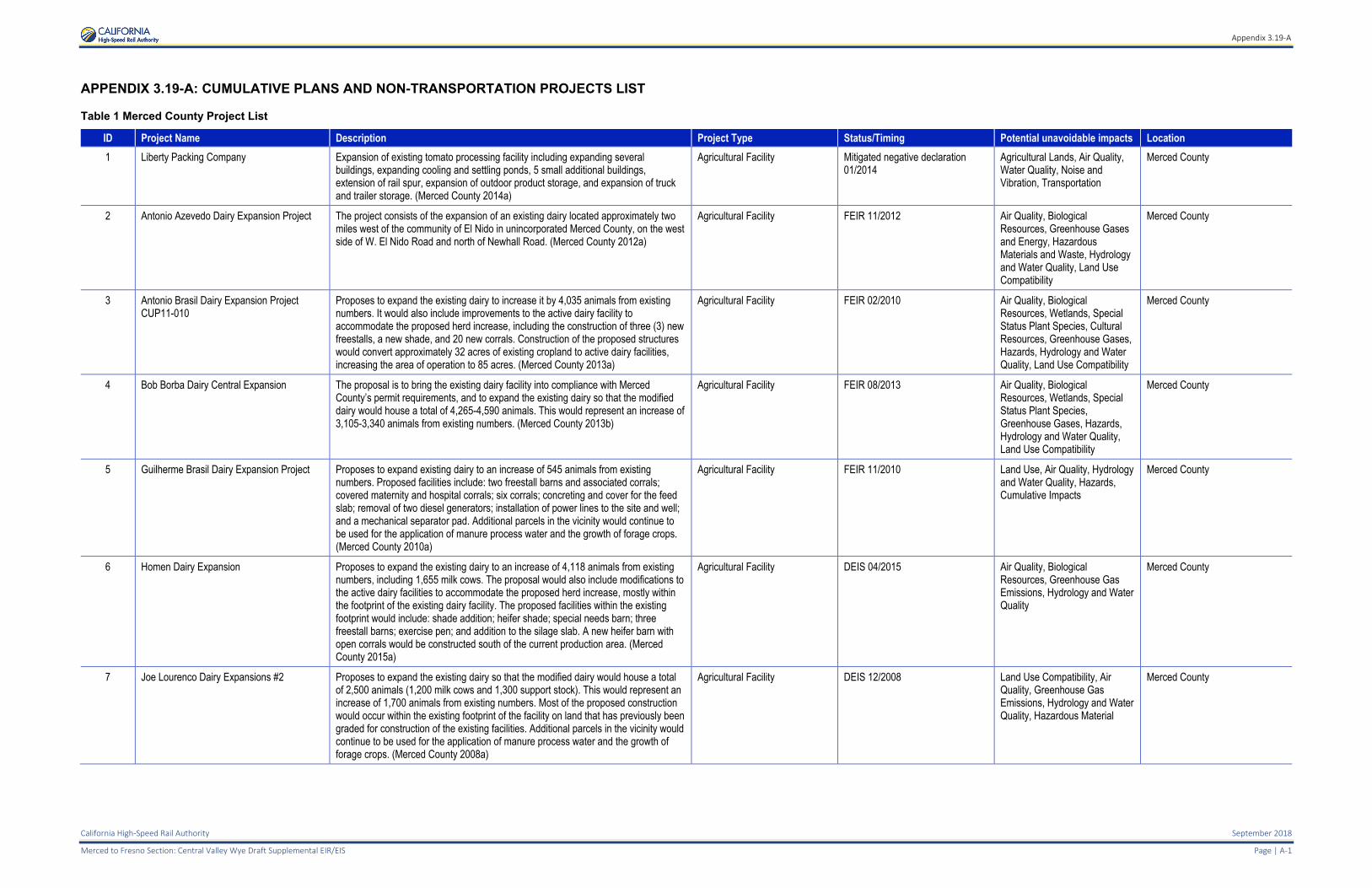
APPENDIX 3.19-A: CUMULATIVE PLANS AND NON-TRANSPORTATION PROJECTS LIST
Table 1 Merced County Project List
ID Project Name Description Project Type Status/Timing Potential unavoidable impacts Location
1 Liberty Packing Company Expansion of existing tomato processing facility including expanding several buildings, expanding cooling and settling ponds, 5 small additional buildings, extension of rail spur, expansion of outdoor product storage, and expansion of truck and trailer storage. (Merced County 2014a)
Agricultural Facility Mitigated negative declaration 01/2014
Agricultural Lands, Air Quality, Water Quality, Noise and Vibration, Transportation
Merced County
2 Antonio Azevedo Dairy Expansion Project The project consists of the expansion of an existing dairy located approximately two miles west of the community of El Nido in unincorporated Merced County, on the west side of W. El Nido Road and north of Newhall Road. (Merced County 2012a)
Agricultural Facility FEIR 11/2012 Air Quality, Biological Resources, Greenhouse Gases and Energy, Hazardous Materials and Waste, Hydrology and Water Quality, Land Use Compatibility
Merced County
3 Antonio Brasil Dairy Expansion Project CUP11-010
Proposes to expand the existing dairy to increase it by 4,035 animals from existing numbers. It would also include improvements to the active dairy facility to accommodate the proposed herd increase, including the construction of three (3) new freestalls, a new shade, and 20 new corrals. Construction of the proposed structures would convert approximately 32 acres of existing cropland to active dairy facilities, increasing the area of operation to 85 acres. (Merced County 2013a)
Agricultural Facility FEIR 02/2010 Air Quality, Biological Resources, Wetlands, Special Status Plant Species, Cultural Resources, Greenhouse Gases, Hazards, Hydrology and Water Quality, Land Use Compatibility
Merced County
4 Bob Borba Dairy Central Expansion The proposal is to bring the existing dairy facility into compliance with Merced County’s permit requirements, and to expand the existing dairy so that the modified dairy would house a total of 4,265-4,590 animals. This would represent an increase of 3,105-3,340 animals from existing numbers. (Merced County 2013b)
Agricultural Facility FEIR 08/2013 Air Quality, Biological Resources, Wetlands, Special Status Plant Species, Greenhouse Gases, Hazards, Hydrology and Water Quality, Land Use Compatibility
Merced County
5 Guilherme Brasil Dairy Expansion Project Proposes to expand existing dairy to an increase of 545 animals from existing numbers. Proposed facilities include: two freestall barns and associated corrals; covered maternity and hospital corrals; six corrals; concreting and cover for the feed slab; removal of two diesel generators; installation of power lines to the site and well; and a mechanical separator pad. Additional parcels in the vicinity would continue to be used for the application of manure process water and the growth of forage crops. (Merced County 2010a)
Agricultural Facility FEIR 11/2010 Land Use, Air Quality, Hydrology and Water Quality, Hazards, Cumulative Impacts
Merced County
6 Homen Dairy Expansion Proposes to expand the existing dairy to an increase of 4,118 animals from existing numbers, including 1,655 milk cows. The proposal would also include modifications to the active dairy facilities to accommodate the proposed herd increase, mostly within the footprint of the existing dairy facility. The proposed facilities within the existing footprint would include: shade addition; heifer shade; special needs barn; three freestall barns; exercise pen; and addition to the silage slab. A new heifer barn with open corrals would be constructed south of the current production area. (Merced County 2015a)
Agricultural Facility DEIS 04/2015 Air Quality, Biological Resources, Greenhouse Gas Emissions, Hydrology and Water Quality
Merced County
7 Joe Lourenco Dairy Expansions #2 Proposes to expand the existing dairy so that the modified dairy would house a total of 2,500 animals (1,200 milk cows and 1,300 support stock). This would represent an increase of 1,700 animals from existing numbers. Most of the proposed construction would occur within the existing footprint of the facility on land that has previously been graded for construction of the existing facilities. Additional parcels in the vicinity would continue to be used for the application of manure process water and the growth of forage crops. (Merced County 2008a)
Agricultural Facility DEIS 12/2008 Land Use Compatibility, Air Quality, Greenhouse Gas Emissions, Hydrology and Water Quality, Hazardous Material
Merced County
Appendix 3.19-A
September 2018 California High-Speed Rail Authority
Page |A-2 Merced to Fresno Section: Central Valley Wye Draft Supplemental EIR/EIS
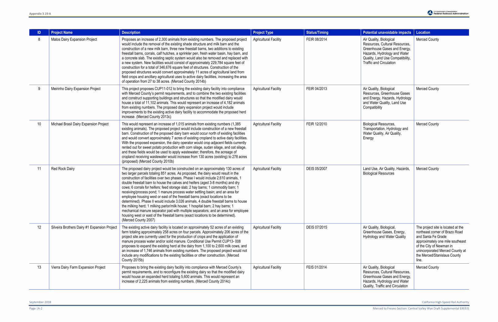
ID Project Name Description Project Type Status/Timing Potential unavoidable impacts Location
8 Matos Dairy Expansion Project Proposes an increase of 2,300 animals from existing numbers. The proposed project would include the removal of the existing shade structure and milk barn and the construction of a new milk barn, three new freestall barns, two additions to existing freestall barns, corrals, calf hutches, a sprinkler pen, fresh water basin, hay barn, and a concrete slab. The existing septic system would also be removed and replaced with a new system. New facilities would consist of approximately 229,784 square feet of construction for a total of 346,676 square feet of structures. Construction of the proposed structures would convert approximately 11 acres of agricultural land from field crops and ancillary agricultural uses to active dairy facilities, increasing the area of operation from 27 to 38 acres. (Merced County 2014b)
Agricultural Facility FEIR 08/2014 Air Quality, Biological Resources, Cultural Resources, Greenhouse Gases and Energy, Hazards, Hydrology and Water Quality, Land Use Compatibility, Traffic and Circulation
Merced County
9 Meirinho Dairy Expansion Project This project proposes CUP11-012 to bring the existing dairy facility into compliance with Merced County’s permit requirements, and to combine the two existing facilities and construct supporting buildings and structures so that the modified dairy would house a total of 11,102 animals. This would represent an increase of 4,182 animals from existing numbers. The proposed dairy expansion project would include improvements to the existing active dairy facility to accommodate the proposed herd increase. (Merced County 2013c)
Agricultural Facility FEIR 04/2013 Air Quality, Biological Resources, Greenhouse Gases and Energy, Hazards, Hydrology and Water Quality, Land Use Compatibility
Merced County
10 Michael Brasil Dairy Expansion Project This would represent an increase of 1,015 animals from existing numbers (1,385 existing animals). The proposed project would include construction of a new freestall barn. Construction of the proposed dairy barn would occur north of existing facilities and would convert approximately 7 acres of existing cropland to active dairy facilities. With the proposed expansion, the dairy operator would crop adjacent fields currently rented out for sweet potato production with corn silage, sudan silage, and oat silage, and these fields would be used to apply wastewater; therefore, the acreage of cropland receiving wastewater would increase from 130 acres (existing) to 278 acres (proposed) (Merced County 2010b)
Agricultural Facility FEIR 12/2010 Biological Resources, Transportation, Hydrology and Water Quality, Air Quality, Energy
Merced County
11 Red Rock Dairy The proposed dairy project would be constructed on an approximately 130 acres of two larger parcels totaling 851 acres. As proposed, the dairy would result in the construction of facilities over two phases. Phase I would include 2,610 animals, 1 double freestall barn to house the calves and heifers (aged 3-8 months) and dry cows; 6 corrals for heifers; feed storage slab; 2 hay barns; 1 commodity barn; 1 receiving/process pond; 1 manure process water settling basin; and an area for employee housing west or east of the freestall barns (exact locations to be determined). Phase II would include 3,026 animals, 4 double freestall barns to house the milking herd; 1 milking parlor/milk house; 1 hospital barn; 2 hay barns; 1 mechanical manure separator pad with multiple separators; and an area for employee housing west or east of the freestall barns (exact locations to be determined). (Merced County 2007)
Agricultural Facility DEIS 05/2007 Land Use, Air Quality, Hazards, Biological Resources
Merced County
12 Silveira Brothers Dairy #1 Expansion Project The existing active dairy facility is located on approximately 52 acres of an existing farm totaling approximately 258 acres on four parcels. Approximately 206 acres of the project site are currently used for the production of crops and the application of manure process water and/or solid manure. Conditional Use Permit CUP13- 008 proposes to expand the existing herd at the dairy from 1,100 to 2,600 milk cows, and an increase of 1,746 animals from existing numbers. The proposed project would not include any modifications to the existing facilities or other construction. (Merced County 2015b)
Agricultural Facility DEIS 07/2015 Air Quality, Biological, Greenhouse Gases, Energy, Hydrology and Water Quality
The project site is located at the northeast corner of Brazo Road and Santa Fe Grade approximately one mile southeast of the City of Newman in unincorporated Merced County at the Merced/Stanislaus County line.
13 Vierra Dairy Farm Expansion Project Proposes to bring the existing dairy facility into compliance with Merced County’s permit requirements, and to reconfigure the existing dairy so that the modified dairy would house an expanded herd totaling 5,600 animals. This would represent an increase of 2,225 animals from existing numbers. (Merced County 2014c)
Agricultural Facility FEIS 01/2014 Air Quality, Biological Resources, Cultural Resources, Greenhouse Gases and Energy, Hazards, Hydrology and Water Quality, Traffic and Circulation
Merced County
Appendix 3.19-A
California High-Speed Rail Authority September 2018
Merced to Fresno Section: Central Valley Wye Draft Supplemental EIR/EIS Page | A-3
ID Project Name Description Project Type Status/Timing Potential unavoidable impacts Location
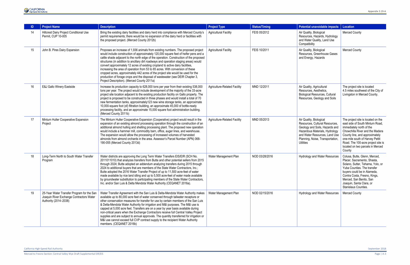
14 Hillcrest Dairy Project Conditional Use Permit, CUP 10-005
Bring the existing dairy facilities and dairy herd into compliance with Merced County’s permit requirements; there would be no expansion of the dairy herd or facilities with the proposed project. (Merced County 2012b)
Agricultural Facility FEIS 05/2012 Air Quality, Biological Resources, Hazards, Hydrology and Water Quality, Land Use Compatibility
Merced County
15 John B. Pires Dairy Expansion Proposes an increase of 1,936 animals from existing numbers. The proposed project would include construction of approximately 120,000 square feet of heifer pens and a cattle shade adjacent to the north edge of the operation. Construction of the proposed structures (in addition to ancillary dirt roadways and operation staging areas) would convert approximately 12 acres of existing cropland to active dairy facilities, increasing the area of operation from 53 to 65 acres. With conversion of these cropped acres, approximately 442 acres of the project site would be used for the production of forage crops and the disposal of wastewater (see DEIR Chapter 3, Project Description). (Merced County 2011a)
Agricultural Facility FEIS 10/2011 Air Quality, Biological Resources, Greenhouse Gases and Energy, Hazards
Merced County
16 E&J Gallo Winery Eastside Increase its production capacity to 628,000 tons per year from their existing 538,000 tons per year. The project would include development of the majority of the 33-acre project site location adjacent to the existing production facility on Gallo property. The project is proposed to be constructed in three phases and would install a total of 70 new fermentation tanks, approximately123 new wine storage tanks, an approximate 10,000-square foot (sf) filtration building, an approximate 45,000 sf bottle-ready processing facility, and an approximate 15,000 square foot administration building. (Merced County 2011b)
Agriculture-Related Facility MND 12/2011 Air Quality, Agricultural Resources, Aesthetics, Biological Resources, Cultural Resources, Geology and Soils
The project site is located 4.5 miles southwest of the City of Livingston in Merced County.
17 Minturn Huller Cooperative Expansion Project
The Minturn Huller Cooperative Expansion (Cooperative) project would result in the expansion of an existing almond processing operation through the construction of an additional almond hulling and shelling processing plant. The proposed new operation would include a hammer mill, commodity barn, office, auger lines, and warehouse. The expansion would allow the processing of increased volumes of harvested almonds from almond orchards in the area. Assessor’s Parcel Number (APN) 068-190-055 (Merced County 2013d)
Agriculture-Related Facility MND 05/2013 Air Quality, Biological Resources, Cultural Resources, Geology and Soils, Hazards and Hazardous Materials, Hydrology and Water Resources, Land Use Planning, Noise, Transportation, Utilities
The project site is located on the east side of South Minturn Road, immediately north of the Chowchilla River and the Madera County line, and approximately one-mile south of Harvey Pettit Road. The 100-acre project site is located on two parcels in Merced County
18 Long-Term North to South Water Transfer Program
Water districts are approving the Long Term Water Transfers EIS/EIR (SCH No. 2011011010) that analyzes transfers from Butte and other potential sellers from 2015 through 2024; Butte adopted an addendum analyzing transfers during 2015 through 2024 to additional buyers that are members of the State Water Contractors, Inc.; Butte adopted the 2016 Water Transfer Project of up to 11,500 acre-feet of water made available by rice land idling and up to 5,500 acre-feet of water made available by groundwater substitution to participating members of the State Water Contractors, Inc. and/or San Luis & Delta Mendota Water Authority (CEQANET 2016a).
Water Management Plan NOD 03/28/2016 Hydrology and Water Resources Colusa, Butte, Glenn, Merced, Placer, Sacramento, Shasta, Solano, Sutter, Tehama, Yolo, or Yuba Counties. The transfer buyers could be in Alameda, Contra Costa, Fresno, Kings, Merced, San Benito, San Joaquin, Santa Clara, or Stanislaus Counties.
19 25-Year Water Transfer Program for the San Joaquin River Exchange Contractors Water Authority (2014–2038)
Water Transfer Agreement with the San Luis & Delta-Mendota Water Authority makes available up to 80,000 acre feet of water conserved through tailwater recapture or other conservation measures for transfer for use by certain members of the San Luis & Delta-Mendota Water Authority for irrigation and M&I purposes. The M&I use is capped at 5,000 acre feet. Transfers are on a year by year basis available during non-critical years when the Exchange Contractors receive full Central Valley Project supplies and are subject to annual approvals. The quantity transferred for irrigation or M&I use cannot exceed full CVP contract supply to the recipient Water Authority members. (CEQANET 2016b)
Water Management Plan NOD 02/15/2016 Hydrology and Water Resources Merced County
Appendix 3.19-A
September 2018 California High-Speed Rail Authority
Page |A-4 Merced to Fresno Section: Central Valley Wye Draft Supplemental EIR/EIS
ID Project Name Description Project Type Status/Timing Potential unavoidable impacts Location
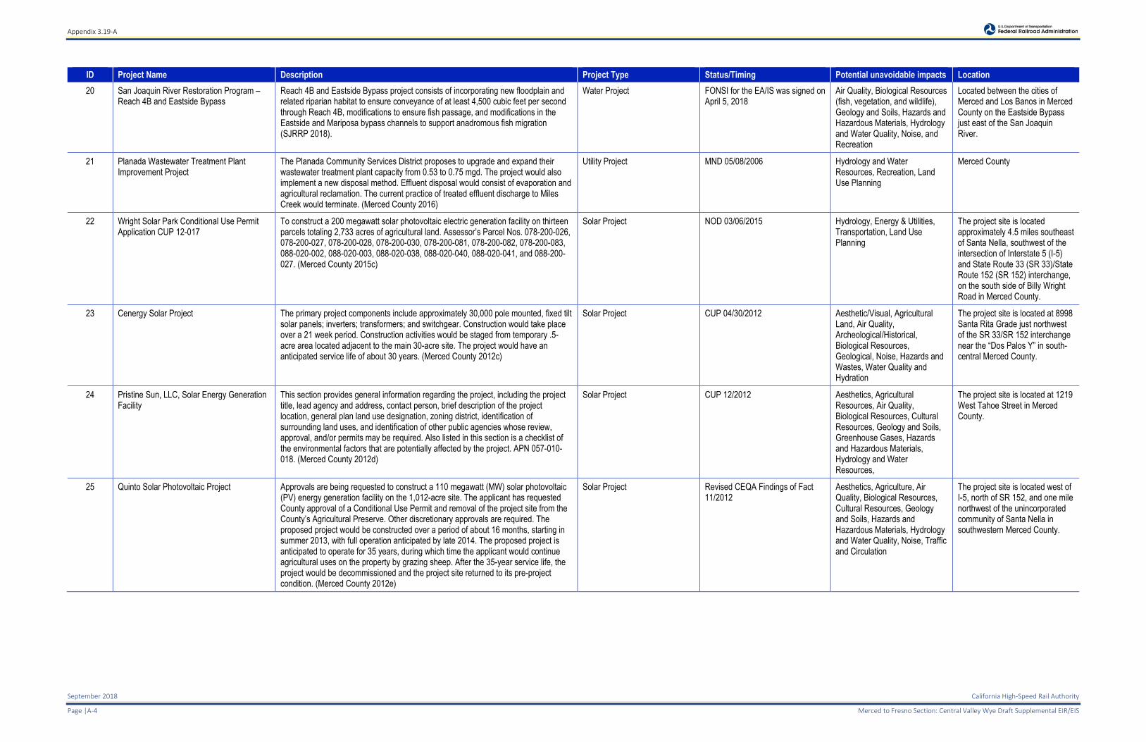
20 San Joaquin River Restoration Program – Reach 4B and Eastside Bypass
Reach 4B and Eastside Bypass project consists of incorporating new floodplain and related riparian habitat to ensure conveyance of at least 4,500 cubic feet per second through Reach 4B, modifications to ensure fish passage, and modifications in the Eastside and Mariposa bypass channels to support anadromous fish migration (SJRRP 2018).
Water Project FONSI for the EA/IS was signed on April 5, 2018
Air Quality, Biological Resources (fish, vegetation, and wildlife), Geology and Soils, Hazards and Hazardous Materials, Hydrology and Water Quality, Noise, and Recreation
Located between the cities of Merced and Los Banos in Merced County on the Eastside Bypass just east of the San Joaquin River.
21 Planada Wastewater Treatment Plant Improvement Project
The Planada Community Services District proposes to upgrade and expand their wastewater treatment plant capacity from 0.53 to 0.75 mgd. The project would also implement a new disposal method. Effluent disposal would consist of evaporation and agricultural reclamation. The current practice of treated effluent discharge to Miles Creek would terminate. (Merced County 2016)
Utility Project MND 05/08/2006 Hydrology and Water Resources, Recreation, Land Use Planning
Merced County
22 Wright Solar Park Conditional Use Permit Application CUP 12-017
To construct a 200 megawatt solar photovoltaic electric generation facility on thirteen parcels totaling 2,733 acres of agricultural land. Assessor’s Parcel Nos. 078-200-026, 078-200-027, 078-200-028, 078-200-030, 078-200-081, 078-200-082, 078-200-083, 088-020-002, 088-020-003, 088-020-038, 088-020-040, 088-020-041, and 088-200-027. (Merced County 2015c)
Solar Project NOD 03/06/2015 Hydrology, Energy & Utilities, Transportation, Land Use Planning
The project site is located approximately 4.5 miles southeast of Santa Nella, southwest of the intersection of Interstate 5 (I-5) and State Route 33 (SR 33)/State Route 152 (SR 152) interchange, on the south side of Billy Wright Road in Merced County.
23 Cenergy Solar Project The primary project components include approximately 30,000 pole mounted, fixed tilt solar panels; inverters; transformers; and switchgear. Construction would take place over a 21 week period. Construction activities would be staged from temporary .5-acre area located adjacent to the main 30-acre site. The project would have an anticipated service life of about 30 years. (Merced County 2012c)
Solar Project CUP 04/30/2012 Aesthetic/Visual, Agricultural Land, Air Quality, Archeological/Historical, Biological Resources, Geological, Noise, Hazards and Wastes, Water Quality and Hydration
The project site is located at 8998 Santa Rita Grade just northwest of the SR 33/SR 152 interchange near the “Dos Palos Y” in south-central Merced County.
24 Pristine Sun, LLC, Solar Energy Generation Facility
This section provides general information regarding the project, including the project title, lead agency and address, contact person, brief description of the project location, general plan land use designation, zoning district, identification of surrounding land uses, and identification of other public agencies whose review, approval, and/or permits may be required. Also listed in this section is a checklist of the environmental factors that are potentially affected by the project. APN 057-010-018. (Merced County 2012d)
Solar Project CUP 12/2012 Aesthetics, Agricultural Resources, Air Quality, Biological Resources, Cultural Resources, Geology and Soils, Greenhouse Gases, Hazards and Hazardous Materials, Hydrology and Water Resources,
The project site is located at 1219 West Tahoe Street in Merced County.
25 Quinto Solar Photovoltaic Project Approvals are being requested to construct a 110 megawatt (MW) solar photovoltaic (PV) energy generation facility on the 1,012-acre site. The applicant has requested County approval of a Conditional Use Permit and removal of the project site from the County’s Agricultural Preserve. Other discretionary approvals are required. The proposed project would be constructed over a period of about 16 months, starting in summer 2013, with full operation anticipated by late 2014. The proposed project is anticipated to operate for 35 years, during which time the applicant would continue agricultural uses on the property by grazing sheep. After the 35-year service life, the project would be decommissioned and the project site returned to its pre-project condition. (Merced County 2012e)
Solar Project Revised CEQA Findings of Fact 11/2012
Aesthetics, Agriculture, Air Quality, Biological Resources, Cultural Resources, Geology and Soils, Hazards and Hazardous Materials, Hydrology and Water Quality, Noise, Traffic and Circulation
The project site is located west of I-5, north of SR 152, and one mile northwest of the unincorporated community of Santa Nella in southwestern Merced County.
Appendix 3.19-A
California High-Speed Rail Authority September 2018
Merced to Fresno Section: Central Valley Wye Draft Supplemental EIR/EIS Page | A-5
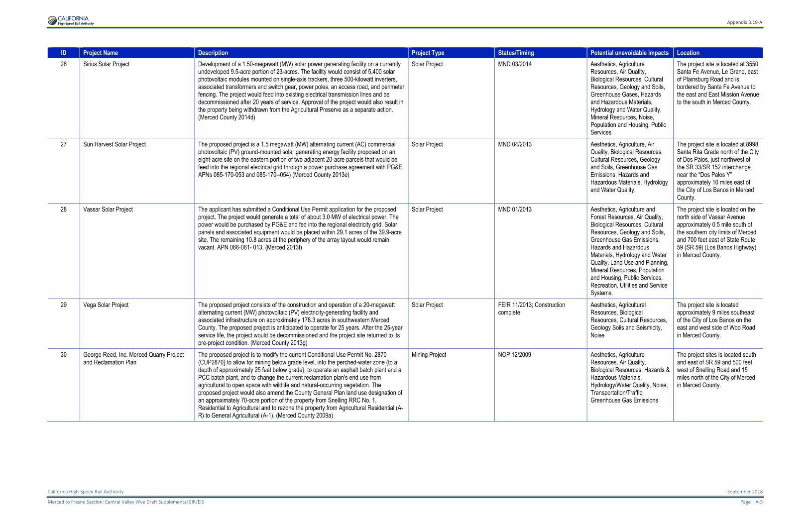
ID Project Name Description Project Type Status/Timing Potential unavoidable impacts Location
26 Sirius Solar Project Development of a 1.50-megawatt (MW) solar power generating facility on a currently undeveloped 9.5-acre portion of 23-acres. The facility would consist of 5,400 solar photovoltaic modules mounted on single-axis trackers, three 500-kilowatt inverters, associated transformers and switch gear, power poles, an access road, and perimeter fencing. The project would feed into existing electrical transmission lines and be decommissioned after 20 years of service. Approval of the project would also result in the property being withdrawn from the Agricultural Preserve as a separate action. (Merced County 2014d)
Solar Project MND 03/2014 Aesthetics, Agriculture Resources, Air Quality, Biological Resources, Cultural Resources, Geology and Soils, Greenhouse Gases, Hazards and Hazardous Materials, Hydrology and Water Quality, Mineral Resources, Noise, Population and Housing, Public Services
The project site is located at 3550 Santa Fe Avenue, Le Grand, east of Plainsburg Road and is bordered by Santa Fe Avenue to the east and East Mission Avenue to the south in Merced County.
27 Sun Harvest Solar Project The proposed project is a 1.5 megawatt (MW) alternating current (AC) commercial photovoltaic (PV) ground-mounted solar generating energy facility proposed on an eight-acre site on the eastern portion of two adjacent 20-acre parcels that would be feed into the regional electrical grid through a power purchase agreement with PG&E. APNs 085-170-053 and 085-170--054) (Merced County 2013e)
Solar Project MND 04/2013 Aesthetics, Agriculture, Air Quality, Biological Resources, Cultural Resources, Geology and Soils, Greenhouse Gas Emissions, Hazards and Hazardous Materials, Hydrology and Water Quality,
The project site is located at 8998 Santa Rita Grade north of the City of Dos Palos, just northwest of the SR 33/SR 152 interchange near the “Dos Palos Y” approximately 10 miles east of the City of Los Banos in Merced County.
28 Vassar Solar Project The applicant has submitted a Conditional Use Permit application for the proposed project. The project would generate a total of about 3.0 MW of electrical power. The power would be purchased by PG&E and fed into the regional electricity grid. Solar panels and associated equipment would be placed within 29.1 acres of the 39.9-acre site. The remaining 10.8 acres at the periphery of the array layout would remain vacant. APN 066-061- 013. (Merced 2013f)
Solar Project MND 01/2013 Aesthetics, Agriculture and Forest Resources, Air Quality, Biological Resources, Cultural Resources, Geology and Soils, Greenhouse Gas Emissions, Hazards and Hazardous Materials, Hydrology and Water Quality, Land Use and Planning, Mineral Resources, Population and Housing, Public Services, Recreation, Utilities and Service Systems,
The project site is located on the north side of Vassar Avenue approximately 0.5 mile south of the southern city limits of Merced and 700 feet east of State Route 59 (SR 59) (Los Banos Highway) in Merced County.
29 Vega Solar Project The proposed project consists of the construction and operation of a 20-megawatt alternating current (MW) photovoltaic (PV) electricity-generating facility and associated infrastructure on approximately 178.3 acres in southwestern Merced County. The proposed project is anticipated to operate for 25 years. After the 25-year service life, the project would be decommissioned and the project site returned to its pre-project condition. (Merced County 2013g)
Solar Project FEIR 11/2013; Construction complete
Aesthetics, Agricultural Resources, Biological Resources, Cultural Resources, Geology Soils and Seismicity, Noise
The project site is located approximately 9 miles southeast of the City of Los Banos on the east and west side of Woo Road in Merced County.
30 George Reed, Inc. Merced Quarry Project and Reclamation Plan
The proposed project is to modify the current Conditional Use Permit No. 2870 (CUP2870} to allow for mining below grade level, into the perched-water zone (to a depth of approximately 25 feet below grade}, to operate an asphalt batch plant and a PCC batch plant, and to change the current reclamation plan's end use from agricultural to open space with wildlife and natural-occurring vegetation. The proposed project would also amend the County General Plan land use designation of an approximately 70-acre portion of the property from Snelling RRC No. 1, Residential to Agricultural and to rezone the property from Agricultural Residential (A-R) to General Agricultural (A-1). (Merced County 2009a)
Mining Project NOP 12/2009 Aesthetics, Agriculture Resources, Air Quality, Biological Resources, Hazards & Hazardous Materials, Hydrology/Water Quality, Noise, Transportation/Traffic, Greenhouse Gas Emissions
The project sites is located south and east of SR 59 and 500 feet west of Snelling Road and 15 miles north of the City of Merced in Merced County.
Appendix 3.19-A
September 2018 California High-Speed Rail Authority
Page |A-6 Merced to Fresno Section: Central Valley Wye Draft Supplemental EIR/EIS
ID Project Name Description Project Type Status/Timing Potential unavoidable impacts Location
31 Jaxon Enterprises To excavate and process 6 million tons of aggregate by.
The Project, as proposed, would include about 267 acres of currently unpermitted area. The total area to be disturbed would be about 357 acres within the 471‐acre site, APN 068‐020‐022, owned by the Applicant. (Merced County 2008b)
Mining Project FEIR 05/2008 Noise, Transportation The project site is located at 3000 White Rock Road, Le Grand about 0.25 mile north of Le Grand Road and about four miles northeast of the unincorporated community of Le Grand within portions of Sections 2 and 11, Township 8 South, Range 16 East (USGS Owens Reservoir and Le Grand California 7.5 minute topographic maps) in southeast Merced County.
32 Santa Fe Aggregates Snelling Tailings Project
The Project would remove above grade dredge tailings from an approximate 624‐acre Project site, composed of 8 parcels (7 in their entirety, and a portion of an eighth). The properties are under long‐term lease by the Applicant from two separate
landowners. Of the 624‐acre mining area, due to proposed setbacks only about 409 acres would actually be mined. The remaining area would be excluded from mining to accommodate setbacks proposed by the Applicant to minimize potential impacts (e.g., riparian habitat, wetlands). This site would complement the Applicant’s other aggregate operations in the region, and would provide a long‐term aggregate base rock supply following closure of its adjacent Doolittle site (estimated to close within two to four years) (see Figure 2.0‐3, Existing Conditions Aerial Photograph). The
proposed post‐mining land use for the Project site would be open space. APNs 043‐040‐024, 043‐050‐041, 043‐050‐046, 043‐050‐007, 043‐050‐048, 043‐050‐011, 043‐050‐008, and (portion of) 043‐070‐033. (Merced County 2009b)
Mining Project FEIR 10/2009 Air Quality, Land Use and Planning, Noise and Vibration
The project site is located immediately south and west of the Community of Snelling at the southeast corner of SR 59 and Snelling Road at Township 5 South, Range 14 East, Sections 3, 8, 9, 10, and 16, Mount Diablo Base and Meridian in southeast Merced County.
33 Highway 99 Truck Stop Project at Harvey Pettit Road
The proposed General Plan Amendment No. GPA11-001 would amend the General Plan to establish a Highway Interchange Center (HIC) at the project site by changing the land use designation from Agricultural to Highway Interchange Center Commercial. Zone Change No. ZC11-001 would change the zoning from A-1 (General Agricultural) to H-I-C (Highway Interchange Center). Conditional Use Permit No. CUP11-011 would bring the existing uses on site into conformance with the Zoning Code, and permit the construction of a one-story tire repair shop and the re-opening of the existing restaurant. With the establishment of the HIC General Plan land use designation and acquisition of proper zoning and permits, the existing truck stop facilities would be in conformance with Merced County zoning and land use requirements. The H-I-C boundary would match the boundary of the existing truck stop and would not include any productive agricultural land. (Merced County 2012f)
Commercial Development Project
IS 12/2012 None The project site is located approximately four miles northwest of the City of Chowchilla and five miles southwest of the community of Le Grand in Merced County.
34 Templo La Hermosa Project The project applicant has applied for Conditional Use Permit CUP11-005 from Merced County to construct a one-story, 10,620-square-foot church facility. The proposed church facility would be located on a new parcel that would consist of 5.25 acres. The new parcel would result from the combination of portions of two existing parcels (APNs 061-330-029 and 061-330-030). The project applicant currently owns APN 061-330-029 (±4.78 acres). (Merced County 2012g)
New Church Development Project
IS/MND 12/2012 None The project site is approximately 3.5 miles east of the City of Merced and approximately 5.5 miles west of the community of Planada in Merced County,
35 Buena Vista I Subdivision The proposed project is a rezone and Major Subdivision Application for, and the development of, a 45.7-acre residential subdivision consisting of 211 single-family residential lots ranging from 5,000 to 6,000 square feet in size, a 2.21-acre park, and a 14.3-acre business park. (Merced County 2015d)
Residential Development Project FEIR 01/2015 Aesthetics; Agricultural Resources; Global Climate Change; Hydrology and Water Quality; Noise; Population and Housing; Public Services, Utilities, and Recreation
The proposed project is located to the east of the City of Merced in southeastern Merced County. The proposed project site is bounded by Plainsburg Road, Childs Avenue, the Burlington Northern Santa Fe (Railroad line to the north, and agricultural lands on the west.
Appendix 3.19-A
California High-Speed Rail Authority September 2018
Merced to Fresno Section: Central Valley Wye Draft Supplemental EIR/EIS Page | A-7
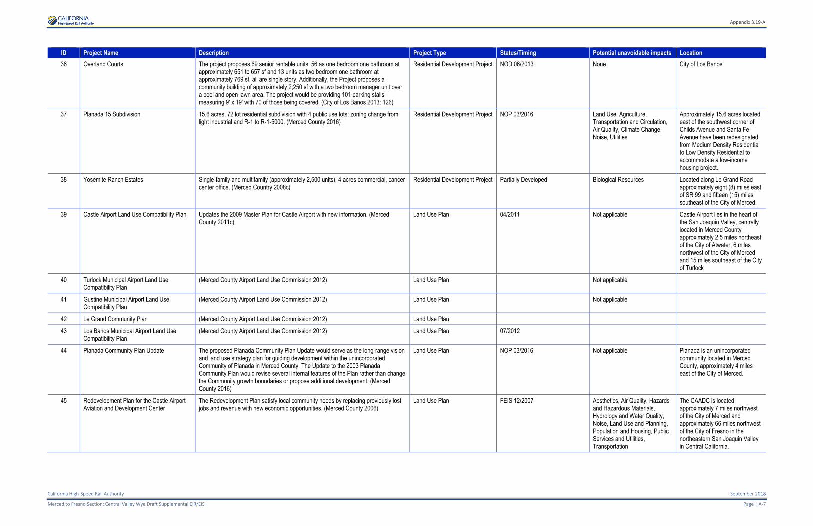
ID Project Name Description Project Type Status/Timing Potential unavoidable impacts Location
36 Overland Courts The project proposes 69 senior rentable units, 56 as one bedroom one bathroom at approximately 651 to 657 sf and 13 units as two bedroom one bathroom at approximately 769 sf, all are single story. Additionally, the Project proposes a community building of approximately 2,250 sf with a two bedroom manager unit over, a pool and open lawn area. The project would be providing 101 parking stalls measuring 9' x 19' with 70 of those being covered. (City of Los Banos 2013: 126)
Residential Development Project NOD 06/2013 None City of Los Banos
37 Planada 15 Subdivision 15.6 acres, 72 lot residential subdivision with 4 public use lots; zoning change from light industrial and R-1 to R-1-5000. (Merced County 2016)
Residential Development Project NOP 03/2016 Land Use, Agriculture, Transportation and Circulation, Air Quality, Climate Change, Noise, Utilities
Approximately 15.6 acres located east of the southwest corner of Childs Avenue and Santa Fe Avenue have been redesignated from Medium Density Residential to Low Density Residential to accommodate a low-income housing project.
38 Yosemite Ranch Estates Single-family and multifamily (approximately 2,500 units), 4 acres commercial, cancer center office. (Merced Country 2008c)
Residential Development Project Partially Developed Biological Resources Located along Le Grand Road approximately eight (8) miles east of SR 99 and fifteen (15) miles southeast of the City of Merced.
39 Castle Airport Land Use Compatibility Plan Updates the 2009 Master Plan for Castle Airport with new information. (Merced County 2011c)
Land Use Plan 04/2011 Not applicable Castle Airport lies in the heart of the San Joaquin Valley, centrally located in Merced County approximately 2.5 miles northeast of the City of Atwater, 6 miles northwest of the City of Merced and 15 miles southeast of the City of Turlock
40 Turlock Municipal Airport Land Use Compatibility Plan
(Merced County Airport Land Use Commission 2012) Land Use Plan Not applicable
41 Gustine Municipal Airport Land Use Compatibility Plan
(Merced County Airport Land Use Commission 2012) Land Use Plan Not applicable
42 Le Grand Community Plan (Merced County Airport Land Use Commission 2012) Land Use Plan
43 Los Banos Municipal Airport Land Use Compatibility Plan
(Merced County Airport Land Use Commission 2012) Land Use Plan 07/2012
44 Planada Community Plan Update The proposed Planada Community Plan Update would serve as the long-range vision and land use strategy plan for guiding development within the unincorporated Community of Planada in Merced County. The Update to the 2003 Planada Community Plan would revise several internal features of the Plan rather than change the Community growth boundaries or propose additional development. (Merced County 2016)
Land Use Plan NOP 03/2016 Not applicable Planada is an unincorporated community located in Merced County, approximately 4 miles east of the City of Merced.
45 Redevelopment Plan for the Castle Airport Aviation and Development Center
The Redevelopment Plan satisfy local community needs by replacing previously lost jobs and revenue with new economic opportunities. (Merced County 2006)
Land Use Plan FEIS 12/2007 Aesthetics, Air Quality, Hazards and Hazardous Materials, Hydrology and Water Quality, Noise, Land Use and Planning, Population and Housing, Public Services and Utilities, Transportation
The CAADC is located approximately 7 miles northwest of the City of Merced and approximately 66 miles northwest of the City of Fresno in the northeastern San Joaquin Valley in Central California.
Appendix 3.19-A
September 2018 California High-Speed Rail Authority
Page |A-8 Merced to Fresno Section: Central Valley Wye Draft Supplemental EIR/EIS
ID Project Name Description Project Type Status/Timing Potential unavoidable impacts Location
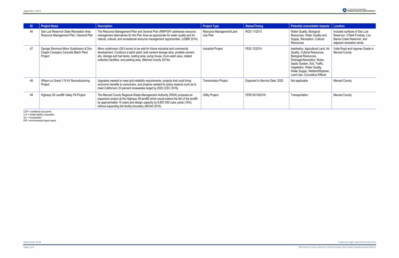
46 San Luis Reservoir State Recreation Area Resource Management Plan / General Plan
The Resource Management Plan and General Plan (RMP/GP) addresses resource management alternatives for the Plan Area as appropriate for water quality and for natural, cultural, and recreational resource management opportunities. (USBR 2014)
Resource Management/Land Use Plan
ROD 11/2013 Water Quality, Biological Resources, Water Quality and Supply, Recreation, Cultural Resources
Includes surfaces of San Luis Reservoir, O’Neill Forebay, Los Banos Creek Reservoir, and adjacent recreation lands.
47 George Simmons Minor Subdivision & Don Chapin Company Concrete Batch Plant Project
Minor subdivision (26.9 acres) to be sold for future industrial and commercial development. Construct a batch plant, bulk cement storage silos, portable cement silo, storage and fuel tanks, casting area, pump house, truck wash area, related collection facilities, and parking area. (Merced County 2014e)
Industrial Project FEIS 12/2014 Aesthetics, Agricultural Land, Air Quality, Cultural Resources, Biological Resources, Drainage/Absorption, Noise, Septic System, Soil, Traffic, Vegetation, Water Quality, Water Supply, Wetland/Riparian, Land Use, Cumulative Effects
Volta Road and Ingomar Grade in Merced County
48 Wilson-Le Grand 115 kV Reconductoring Project
Upgrades needed to meet grid reliability requirements, projects that could bring economic benefits to consumers, and projects needed for policy reasons such as to meet California’s 33 percent renewables target by 2020 (CEC 2016).
Transmission Project Expected In-Service Date: 2020 Not applicable Merced County
49 Highway 59 Landfill Valley Fill Project The Merced County Regional Waste Management Authority (RWA) proposes an expansion project at the Highway 59 landfill which would extend the life of the landfill by approximately 15 years and design capacity by 6,857,000 cubic yards (19%) without expanding the facility boundary (MCAG 2016).
Utility Project FEIR 05/19/2016 Transportation Merced County
CUP = conditional use permit LLC = limited liability corporation Inc. = incorporated EIR = environmental impact report
Appendix 3.19-A
California High-Speed Rail Authority September 2018
Merced to Fresno Section: Central Valley Wye Draft Supplemental EIR/EIS Page | A-9
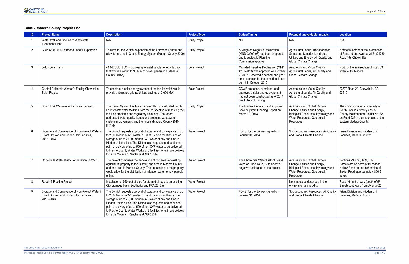
Table 2 Madera County Project List
ID Project Name Description Project Type Status/Timing Potential unavoidable impacts Location
1 Water Well and Pipeline to Wastewater Treatment Plant
N/A Utility Project N/A N/A N/A
2 CUP #2009-004 Fairmead Landfill Expansion To allow for the vertical expansion of the Fairmead Landfill and allow for a Landfill Gas to Energy System (Madera County 2009)
Utility Project A Mitigated Negative Declaration (MND #2009-06) has been prepared and is subject to Planning Commission approval
Agricultural Lands, Transportation, Safety and Security, Land Use, Utilities and Energy, Air Quality and Global Climate Change.
Northeast corner of the intersection of Road 19 and Avenue 21 ½ (21739 Road 19), Chowchilla
3 Lotus Solar Farm 41 MB 8ME, LLC is proposing to install a solar energy facility that would allow up to 90 MW of power generation (Madera County 2015a).
Solar Project Mitigated Negative Declaration (MND #2012-013) was approved on October 2, 2012. Received a second one-year time extension for the conditional use permit in October, 2015
Aesthetics and Visual Quality, Agricultural Lands, Air Quality and Global Climate Change
North of the intersection of Road 33, Avenue 13, Madera
4 Central California Women’s Facility Chowchilla Solar Project
To construct a solar energy system at the facility which would provide anticipated grid peak load savings of 3,000 MW.
Solar Project CCWF proposed, submitted, and approved a solar energy system. It had not been constructed as of 2011 due to lack of funding
Aesthetics and Visual Quality, Agricultural Lands, Air Quality and Global Climate Change
23370 Road 22, Chowchilla, CA 93610
5 South Fork Wastewater Facilities Planning The Sewer System Facilities Planning Report evaluated South Fork’s wastewater facilities from the perspective of resolving the facilities problems and regulatory violations. The report addressed water quality issues and proposed wastewater system improvements and their costs (Madera County 2010 [2012])
Utility Project The Madera County Board approved Sewer System Planning Report on March 12, 2013
Air Quality and Global Climate Change, Utilities and Energy, Biological Resources, Hydrology and Water Resources, Geological Resources
The unincorporated community of South Fork lies directly east of County Maintenance District No. 8A on Road 225 in the mountains of the eastern Madera County.
6 Storage and Conveyance of Non-Project Water in Friant Division and Hidden Unit Facilities, 2013–2043
The District requests approval of storage and conveyance of up to 25,000 of non-CVP water in Friant Division facilities, and/or storage of up to 26,000 of non-CVP water at any one time in Hidden Unit facilities. The District also requests and additional point of delivery of up to 500 of non-CVP water to be delivered to Fresno County Water Works #18 facilities for ultimate delivery to Table Mountain Rancheria (USBR 2014)
Water Project FONSI for the EA was signed on January 31, 2014
Socioeconomic Resources, Air Quality and Global Climate Change.
Friant Division and Hidden Unit Facilities, Madera County.
7 Chowchilla Water District Annexation 2012-01 The project comprises the annexation of two areas of existing agricultural property to the District, one area in Madera County and one area in Merced County. The annexation of the property would allow for the distribution of irrigation water to new parcels of land.
Water Project The Chowchilla Water District Board voted on June 13, 2012 to adopt a negative declaration of the project
Air Quality and Global Climate Change, Utilities and Energy, Biological Resources, Hydrology and Water Resources, Geological Resources
Sections 29 & 30, T8S, R17E. Parcels are on north of Buchanan Hollow Road and on either side of Baxter Road, approximately 806.9 acres.
8 Road 16 Pipeline Project Installation of 920 feet of pipe for storm drainage to an existing City drainage basin. (Authority and FRA 2012a)
Water Project No impacts as described in the environmental checklist.
Road 16 right-of-way (south of 5th Street) southward from Avenue 25.
9 Storage and Conveyance of Non-Project Water in Friant Division and Hidden Unit Facilities, 2013–2043
The District requests approval of storage and conveyance of up to 25,000 of non-CVP water in Friant Division facilities, and/or storage of up to 26,000 of non-CVP water at any one time in Hidden Unit facilities. The District also requests and additional point of delivery of up to 500 of non-CVP water to be delivered to Fresno County Water Works #18 facilities for ultimate delivery to Table Mountain Rancheria (USBR 2014)
Water Project FONSI for the EA was signed on January 31, 2014
Socioeconomic Resources, Air Quality and Global Climate Change.
Friant Division and Hidden Unit Facilities, Madera County.
Appendix 3.19-A
September 2018 California High-Speed Rail Authority
Page |A-10 Merced to Fresno Section: Central Valley Wye Draft Supplemental EIR/EIS
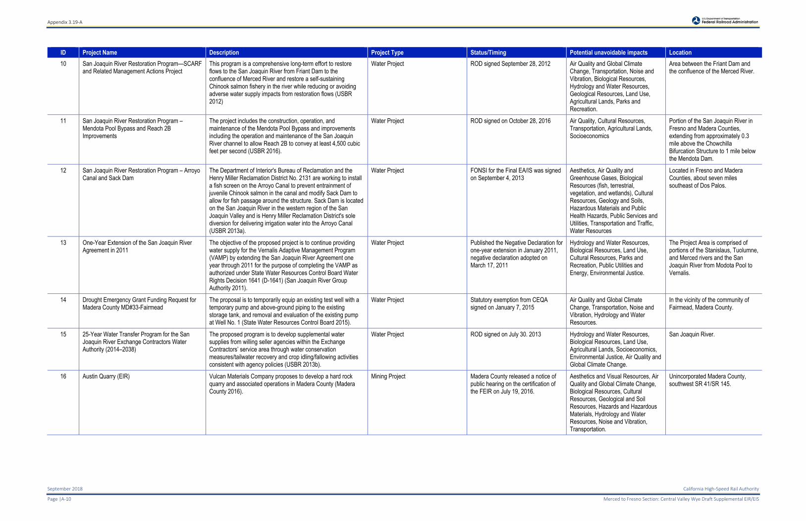
ID Project Name Description Project Type Status/Timing Potential unavoidable impacts Location
10 San Joaquin River Restoration Program—SCARF and Related Management Actions Project
This program is a comprehensive long-term effort to restore flows to the San Joaquin River from Friant Dam to the confluence of Merced River and restore a self-sustaining Chinook salmon fishery in the river while reducing or avoiding adverse water supply impacts from restoration flows (USBR 2012)
Water Project ROD signed September 28, 2012 Air Quality and Global Climate Change, Transportation, Noise and Vibration, Biological Resources, Hydrology and Water Resources, Geological Resources, Land Use, Agricultural Lands, Parks and Recreation.
Area between the Friant Dam and the confluence of the Merced River.
11 San Joaquin River Restoration Program –Mendota Pool Bypass and Reach 2B Improvements
The project includes the construction, operation, and maintenance of the Mendota Pool Bypass and improvements including the operation and maintenance of the San Joaquin River channel to allow Reach 2B to convey at least 4,500 cubic feet per second (USBR 2016).
Water Project ROD signed on October 28, 2016 Air Quality, Cultural Resources, Transportation, Agricultural Lands, Socioeconomics
Portion of the San Joaquin River in Fresno and Madera Counties, extending from approximately 0.3 mile above the Chowchilla Bifurcation Structure to 1 mile below the Mendota Dam.
12 San Joaquin River Restoration Program – Arroyo Canal and Sack Dam
The Department of Interior's Bureau of Reclamation and the Henry Miller Reclamation District No. 2131 are working to install a fish screen on the Arroyo Canal to prevent entrainment of juvenile Chinook salmon in the canal and modify Sack Dam to allow for fish passage around the structure. Sack Dam is located on the San Joaquin River in the western region of the San Joaquin Valley and is Henry Miller Reclamation District's sole diversion for delivering irrigation water into the Arroyo Canal (USBR 2013a).
Water Project FONSI for the Final EA/IS was signed on September 4, 2013
Aesthetics, Air Quality and Greenhouse Gases, Biological Resources (fish, terrestrial, vegetation, and wetlands), Cultural Resources, Geology and Soils, Hazardous Materials and Public Health Hazards, Public Services and Utilities, Transportation and Traffic, Water Resources
Located in Fresno and Madera Counties, about seven miles southeast of Dos Palos.
13 One-Year Extension of the San Joaquin River Agreement in 2011
The objective of the proposed project is to continue providing water supply for the Vernalis Adaptive Management Program (VAMP) by extending the San Joaquin River Agreement one year through 2011 for the purpose of completing the VAMP as authorized under State Water Resources Control Board Water Rights Decision 1641 (D-1641) (San Joaquin River Group Authority 2011).
Water Project Published the Negative Declaration for one-year extension in January 2011, negative declaration adopted on March 17, 2011
Hydrology and Water Resources, Biological Resources, Land Use, Cultural Resources, Parks and Recreation, Public Utilities and Energy, Environmental Justice.
The Project Area is comprised of portions of the Stanislaus, Tuolumne, and Merced rivers and the San Joaquin River from Modota Pool to Vernalis.
14 Drought Emergency Grant Funding Request for Madera County MD#33-Fairmead
The proposal is to temporarily equip an existing test well with a temporary pump and above-ground piping to the existing storage tank, and removal and evaluation of the existing pump at Well No. 1 (State Water Resources Control Board 2015).
Water Project Statutory exemption from CEQA signed on January 7, 2015
Air Quality and Global Climate Change, Transportation, Noise and Vibration, Hydrology and Water Resources.
In the vicinity of the community of Fairmead, Madera County.
15 25-Year Water Transfer Program for the San Joaquin River Exchange Contractors Water Authority (2014–2038)
The proposed program is to develop supplemental water supplies from willing seller agencies within the Exchange Contractors’ service area through water conservation measures/tailwater recovery and crop idling/fallowing activities consistent with agency policies (USBR 2013b).
Water Project ROD signed on July 30. 2013 Hydrology and Water Resources, Biological Resources, Land Use, Agricultural Lands, Socioeconomics, Environmental Justice, Air Quality and Global Climate Change.
San Joaquin River.
16 Austin Quarry (EIR) Vulcan Materials Company proposes to develop a hard rock quarry and associated operations in Madera County (Madera County 2016).
Mining Project Madera County released a notice of public hearing on the certification of the FEIR on July 19, 2016.
Aesthetics and Visual Resources, Air Quality and Global Climate Change, Biological Resources, Cultural Resources, Geological and Soil Resources, Hazards and Hazardous Materials, Hydrology and Water Resources, Noise and Vibration, Transportation.
Unincorporated Madera County, southwest SR 41/SR 145.

Appendix 3.19-A
California High-Speed Rail Authority September 2018
Merced to Fresno Section: Central Valley Wye Draft Supplemental EIR/EIS Page | A-11
ID Project Name Description Project Type Status/Timing Potential unavoidable impacts Location
17 Madera Ranch Quarry The project includes development of a new 78-acre hard rock quarry that would mine 900,000 tons of aggregate annually for 40 years. The project will also include the alignment and widening of Road 209 and improvements to the Road 209/State Highway 41 intersection, as well as the permanent preservation and management of Habitat Management lands to offset the Project Related impacts.
Mining Project Notice of Determination published on June 17, 2013
Aesthetics and Visual Resources, Air Quality and Global Climate Change, Biological Resources, Cultural Resources, Geological and Soil Resources, Hazards and Hazardous Materials, Hydrology and Water Resources, Noise and Vibration, Transportation.
County Road 209 and Road 406 in Madera County
18 North Fork Mill Site Subdivision The North Fork Community Development Council is requesting two tentative subdivision maps, a general plan amendment, and rezoning from heavy industrial to a Planned Development District for 113 acres on North Fork’s old mill site (Wilkinson 2015).
Development Project The North Fork CDC issued an RFP on February 26, 2015
Aesthetics and Visual Resources, Air Quality and Global Climate Change, Geological and Soil Resources, Hazards and Hazardous Materials, Noise and Vibration, Transportation.
30 miles south of Yosemite National Park and 50 miles north of Fresno.
19 North Fork Rancheria of Mono Indians Fee-to-Trust Casino/ Hotel Project
The proposed action includes the trust acquisition for gaming purposes and the approval by the National Indian Gaming Commission of a gaming management contract between SC Madera Management LLC and the Tribe. Includes taking 7 parcels totaling 305 acres into Federal trust and to develop a casino and hotel resort, parking structure, and associated facilities (BIA 2012).
Development Project Record of Decision signed in November 2012
Land Use, Hydrology and Water Resources, Air Quality and Global Climate Change, Biological Resources, Cultural Resources, Geological and Paleontological Resources, Socioeconomics.
Southwest Madera County, just north of the City of Madera and adjacent to SR 99.
20 Foxglove Shopping Center Project A request for approval of a site plan review and various conditional use permits in support of the proposed development of a retail shopping center (City of Madera 2013).
Development Project Final EIR published on February 1, 2013
Socioeconomics Southeast corner of Schnoor Avenue and Foxglove Way.
21 Southeast Madera Development Project The property would be developed as a 289 acre Master Planned Community that would include residential, commercial and open space uses developed around an existing elementary school (CEQAnet 2016c).
Development Project Notice of Determinations on October 10, 2010
Agricultural Lands, Air Quality and Global Climate Change, Noise and Vibration, Transportation.
Freeway 99 at Pecan Avenue in the City of Madera.
22 Northshore at Millerton Lake (North Fork Village) The plan proposes a development of a comprehensive planned conversion of 2,238 acres site to urban uses. The planned community as proposed would consist of 1,437 acres of rural to high density residential units, 172 acres of commercial and mixed use and 629 acres of major open space (CEQAnet 2016d)
Development Project Final EIR published on 7/15/2008, Notice of Determination issued on 10/9/2014 from the CA Department of Fish and Wildlife to execute a Lake and Streambed Alteration Agreement
Aesthetic and Visual Resources, Agricultural Lands, Air Quality and Climate Change, Minerals, Noise and Vibration, Parks and Recreation, Transportation, Hydrology and Water Resources, Land Use.
Friant Road 206/Road 145
23 Tra Vigne Subdivision A proposal to include a 432-lot residential subdivision, outlots with locations for a community shopping center and a community center, open space areas, and a community park with a stormwater retention basin (County of Madera 2015b).
Development Project Partially Recirculated Draft EIR published July 15, 2015
Air Quality and Global Climate Change, Biological Resources, Hydrology and Water Resources, Transportation, Public Utilities and Energy.
Southeastern Madera County, approximately 16 miles east of downtown Madera and 14 miles north of downtown Fresno.
24 Sierra Meadows Subdivision The proposed Sierra Meadows Estates Planned Residential Development Project involves buildout of 315 single-family residential lots and necessary infrastructure to support the development (Madera County 2007)
Development Project Final EIR published December 2007 Land Use, Aesthetics and Visual Resources, Transportation, Safety/Security, Air Quality and Global Climate Change, Noise and Vibration, Biological Resources, Cultural Resources, Geological and Paleontological Resources, Hydrology and Water Resources, Public Services and Utilities,
Unincorporated area of eastern Madera County near the southeast border of Mariposa County, along Opah Drive, approximately 0.75 mile north of its intersection with Harmony Lane.
Appendix 3.19-A
September 2018 California High-Speed Rail Authority
Page |A-12 Merced to Fresno Section: Central Valley Wye Draft Supplemental EIR/EIS
ID Project Name Description Project Type Status/Timing Potential unavoidable impacts Location
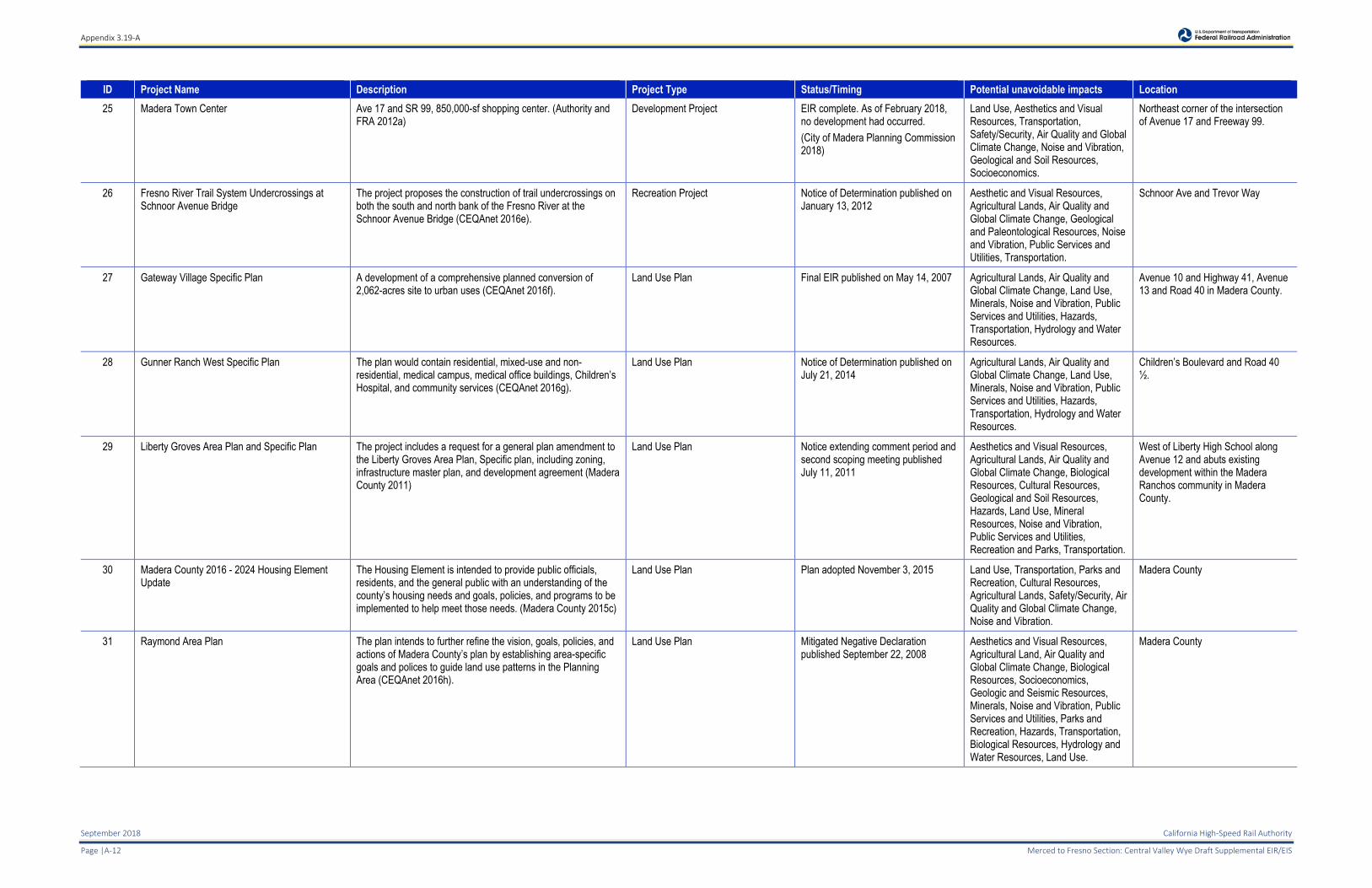
25 Madera Town Center Ave 17 and SR 99, 850,000-sf shopping center. (Authority and FRA 2012a)
Development Project EIR complete. As of February 2018, no development had occurred.
(City of Madera Planning Commission 2018)
Land Use, Aesthetics and Visual Resources, Transportation, Safety/Security, Air Quality and Global Climate Change, Noise and Vibration, Geological and Soil Resources, Socioeconomics.
Northeast corner of the intersection of Avenue 17 and Freeway 99.
26 Fresno River Trail System Undercrossings at Schnoor Avenue Bridge
The project proposes the construction of trail undercrossings on both the south and north bank of the Fresno River at the Schnoor Avenue Bridge (CEQAnet 2016e).
Recreation Project Notice of Determination published on January 13, 2012
Aesthetic and Visual Resources, Agricultural Lands, Air Quality and Global Climate Change, Geological and Paleontological Resources, Noise and Vibration, Public Services and Utilities, Transportation.
Schnoor Ave and Trevor Way
27 Gateway Village Specific Plan A development of a comprehensive planned conversion of 2,062-acres site to urban uses (CEQAnet 2016f).
Land Use Plan Final EIR published on May 14, 2007 Agricultural Lands, Air Quality and Global Climate Change, Land Use, Minerals, Noise and Vibration, Public Services and Utilities, Hazards, Transportation, Hydrology and Water Resources.
Avenue 10 and Highway 41, Avenue 13 and Road 40 in Madera County.
28 Gunner Ranch West Specific Plan The plan would contain residential, mixed-use and non-residential, medical campus, medical office buildings, Children’s Hospital, and community services (CEQAnet 2016g).
Land Use Plan Notice of Determination published on July 21, 2014
Agricultural Lands, Air Quality and Global Climate Change, Land Use, Minerals, Noise and Vibration, Public Services and Utilities, Hazards, Transportation, Hydrology and Water Resources.
Children’s Boulevard and Road 40 ½.
29 Liberty Groves Area Plan and Specific Plan The project includes a request for a general plan amendment to the Liberty Groves Area Plan, Specific plan, including zoning, infrastructure master plan, and development agreement (Madera County 2011)
Land Use Plan Notice extending comment period and second scoping meeting published July 11, 2011
Aesthetics and Visual Resources, Agricultural Lands, Air Quality and Global Climate Change, Biological Resources, Cultural Resources, Geological and Soil Resources, Hazards, Land Use, Mineral Resources, Noise and Vibration, Public Services and Utilities, Recreation and Parks, Transportation.
West of Liberty High School along Avenue 12 and abuts existing development within the Madera Ranchos community in Madera County.
30 Madera County 2016 - 2024 Housing Element Update
The Housing Element is intended to provide public officials, residents, and the general public with an understanding of the county’s housing needs and goals, policies, and programs to be implemented to help meet those needs. (Madera County 2015c)
Land Use Plan Plan adopted November 3, 2015 Land Use, Transportation, Parks and Recreation, Cultural Resources, Agricultural Lands, Safety/Security, Air Quality and Global Climate Change, Noise and Vibration.
Madera County
31 Raymond Area Plan The plan intends to further refine the vision, goals, policies, and actions of Madera County’s plan by establishing area-specific goals and polices to guide land use patterns in the Planning Area (CEQAnet 2016h).
Land Use Plan Mitigated Negative Declaration published September 22, 2008
Aesthetics and Visual Resources, Agricultural Land, Air Quality and Global Climate Change, Biological Resources, Socioeconomics, Geologic and Seismic Resources, Minerals, Noise and Vibration, Public Services and Utilities, Parks and Recreation, Hazards, Transportation, Biological Resources, Hydrology and Water Resources, Land Use.
Madera County
Appendix 3.19-A
California High-Speed Rail Authority September 2018
Merced to Fresno Section: Central Valley Wye Draft Supplemental EIR/EIS Page | A-13
ID Project Name Description Project Type Status/Timing Potential unavoidable impacts Location
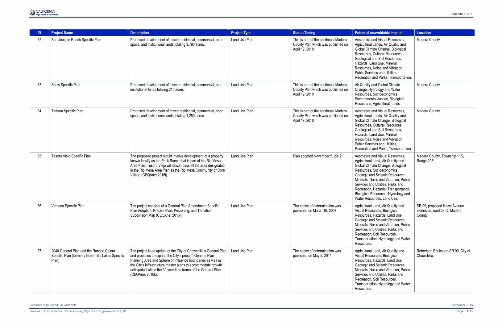
32 San Joaquin Ranch Specific Plan Proposed development of mixed residential, commercial, open space, and institutional lands totaling 3,795 acres.
Land Use Plan This is part of the southeast Madera County Plan which was published on April 19, 2010
Aesthetics and Visual Resources, Agricultural Lands, Air Quality and Global Climate Change, Biological Resources, Cultural Resources, Geological and Soil Resources, Hazards, Land Use, Mineral Resources, Noise and Vibration, Public Services and Utilities, Recreation and Parks, Transportation.
Madera County
33 Shaw Specific Plan Proposed development of mixed residential, commercial, and institutional lands totaling 215 acres.
Land Use Plan This is part of the southeast Madera County Plan which was published on April 19, 2010
Air Quality and Global Climate Change, Hydrology and Water Resources, Socioeconomics, Environmental Justice, Biological Resources, Agricultural Lands.
Madera County
34 Tatham Specific Plan Proposed development of mixed residential, commercial, open space, and institutional lands totaling 1,250 acres.
Land Use Plan This is part of the southeast Madera County Plan which was published on April 19, 2010
Aesthetics and Visual Resources, Agricultural Lands, Air Quality and Global Climate Change, Biological Resources, Cultural Resources, Geological and Soil Resources, Hazards, Land Use, Mineral Resources, Noise and Vibration, Public Services and Utilities, Recreation and Parks, Transportation.
Madera County
35 Tesoro Viejo Specific Plan The proposed project would involve development of a property known locally as the Peck Ranch that is part of the Rio Mesa Area Plan. Tesoro Viejo will encompass all the area designated in the Rio Mesa Area Plan as the Rio Mesa Community or Core Village (CEQAnet 2016i).
Land Use Plan Plan adopted November 5, 2012 Aesthetics and Visual Resources, Agricultural Land, Air Quality and Global Climate Change, Biological Resources, Socioeconomics, Geologic and Seismic Resources, Minerals, Noise and Vibration, Public Services and Utilities, Parks and Recreation, Hazards, Transportation, Biological Resources, Hydrology and Water Resources, Land Use.
Madera County, Township 11S, Range 20E
36 Ventana Specific Plan The project consists of a General Plan Amendment Specific Plan Adoption, Precise Plan, Prezoning, and Tentative Subdivision Map (CEQAnet 2016j).
Land Use Plan The notice of determination was published on March 16, 2007
Agricultural Land, Air Quality and Visual Resources, Biological Resources, Hazards, Land Use, Geologic and Seismic Resources, Minerals, Noise and Vibration, Public Services and Utilities, Parks and Recreation, Soil Resources, Transportation, Hydrology and Water Resources.
SR 99, proposed Hazel Avenue extension, road 28 ¼, Madera County.
37 2040 General Plan and the Rancho Calera Specific Plan (formerly Greenhills Lakes Specific Plan)
The project is an update of the City of Chowchilla’s General Plan and proposes to expand the City’s present General Plan Planning Area and Sphere of Influence boundaries as well as the City’s infrastructure master plans to accommodate growth anticipated within the 30 year time frame of the General Plan (CEQAnet 2016k).
Land Use Plan The notice of determination was published on May 5, 2011
Agricultural Land, Air Quality and Visual Resources, Biological Resources, Hazards, Land Use, Geologic and Seismic Resources, Minerals, Noise and Vibration, Public Services and Utilities, Parks and Recreation, Soil Resources, Transportation, Hydrology and Water Resources.
Robertson Boulevard/SR 99, City of Chowchilla.
Appendix 3.19-A
September 2018 California High-Speed Rail Authority
Page |A-14 Merced to Fresno Section: Central Valley Wye Draft Supplemental EIR/EIS
ID Project Name Description Project Type Status/Timing Potential unavoidable impacts Location
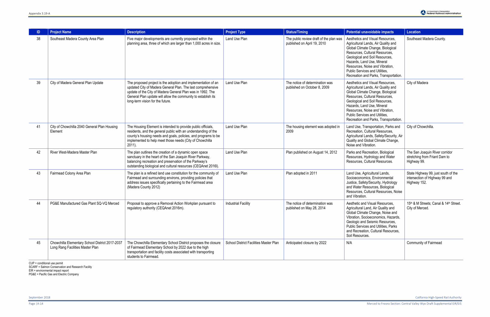
38 Southeast Madera County Area Plan Five major developments are currently proposed within the planning area, three of which are larger than 1,000 acres in size.
Land Use Plan The public review draft of the plan was published on April 19, 2010
Aesthetics and Visual Resources, Agricultural Lands, Air Quality and Global Climate Change, Biological Resources, Cultural Resources, Geological and Soil Resources, Hazards, Land Use, Mineral Resources, Noise and Vibration, Public Services and Utilities, Recreation and Parks, Transportation.
Southeast Madera County.
39 City of Madera General Plan Update The proposed project is the adoption and implementation of an updated City of Madera General Plan. The last comprehensive update of the City of Madera General Plan was in 1992. The General Plan update will allow the community to establish its long-term vision for the future.
Land Use Plan The notice of determination was published on October 8, 2009
Aesthetics and Visual Resources, Agricultural Lands, Air Quality and Global Climate Change, Biological Resources, Cultural Resources, Geological and Soil Resources, Hazards, Land Use, Mineral Resources, Noise and Vibration, Public Services and Utilities, Recreation and Parks, Transportation.
City of Madera
41 City of Chowchilla 2040 General Plan Housing Element
The Housing Element is intended to provide public officials, residents, and the general public with an understanding of the county’s housing needs and goals, policies, and programs to be implemented to help meet those needs (City of Chowchilla 2011).
Land Use Plan The housing element was adopted in 2009
Land Use, Transportation, Parks and Recreation, Cultural Resources, Agricultural Lands, Safety/Security, Air Quality and Global Climate Change, Noise and Vibration.
City of Chowchilla.
42 River West-Madera Master Plan The plan outlines the creation of a dynamic open space sanctuary in the heart of the San Joaquin River Parkway, balancing recreation and preservation of the Parkway’s outstanding biological and cultural resources (CEQAnet 2016l).
Land Use Plan Plan published on August 14, 2012 Parks and Recreation, Biological Resources, Hydrology and Water Resources, Cultural Resources.
The San Joaquin River corridor stretching from Friant Dam to Highway 99.
43 Fairmead Colony Area Plan The plan is a refined land use constitution for the community of Fairmead and surrounding environs, providing policies that address issues specifically pertaining to the Fairmead area (Madera County 2012)
Land Use Plan Plan adopted in 2011 Land Use, Agricultural Lands, Socioeconomics, Environmental Justice, Safety/Security, Hydrology and Water Resources, Biological Resources, Cultural Resources, Noise and Vibration.
State Highway 99, just south of the intersection of Highway 99 and Highway 152.
44 PG&E Manufactured Gas Plant SQ-VQ Merced Proposal to approve a Removal Action Workplan pursuant to regulatory authority (CEQAnet 2016m).
Industrial Facility The notice of determination was published on May 28, 2014
Aesthetic and Visual Resources, Agricultural Land, Air Quality and Global Climate Change, Noise and Vibration, Socioeconomics, Hazards, Geologic and Seismic Resources, Public Services and Utilities, Parks and Recreation, Cultural Resources, Soil Resources.
15th & M Streets; Canal & 14th Street. City of Merced.
45 Chowchilla Elementary School District 2017-2037 Long Rang Facilities Master Plan
The Chowchilla Elementary School District proposes the closure of Fairmead Elementary School by 2022 due to the high transportation and facility costs associated with transporting students to Fairmead.
School District Facilities Master Plan Anticipated closure by 2022 N/A Community of Fairmead
CUP = conditional use permit SCARF = Salmon Conservation and Research Facility EIR = environmental impact report PG&E = Pacific Gas and Electric Company
Appendix 3.19-A
California High-Speed Rail Authority September 2018
Merced to Fresno Section: Central Valley Wye Draft Supplemental EIR/EIS Page | A-15
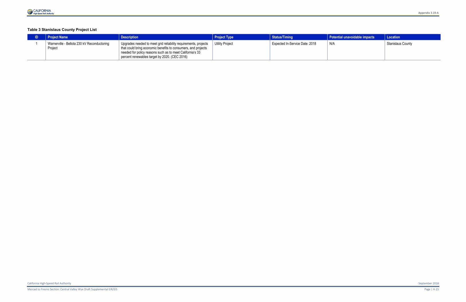
Table 3 Stanislaus County Project List
ID Project Name Description Project Type Status/Timing Potential unavoidable impacts Location
1 Warnerville - Bellota 230 kV Reconductoring Project
Upgrades needed to meet grid reliability requirements, projects that could bring economic benefits to consumers, and projects needed for policy reasons such as to meet California’s 33 percent renewables target by 2020. (CEC 2016)
Utility Project Expected In-Service Date: 2018 N/A Stanislaus County

Appendix 3.19-B
California High-Speed Rail Authority September 2018
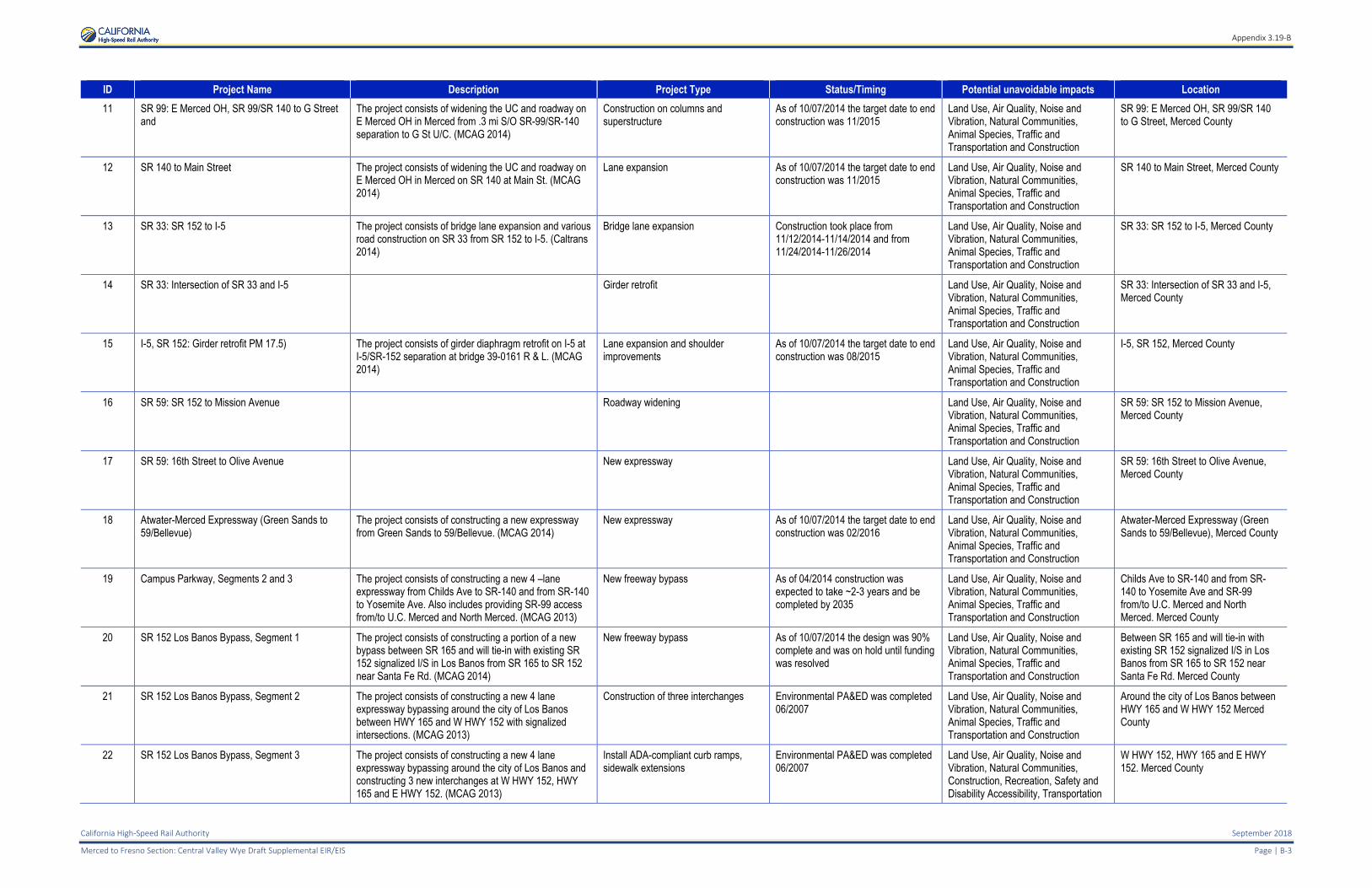
Merced to Fresno Section: Central Valley Wye Draft Supplemental EIR/EIS Page | B-1
APPENDIX 3.19-B: CUMULATIVE TRANSPORTATION PROJECTS LIST
Table 1 California High-Speed Rail Projects List
ID Project Name Description Project Type Status/Timing Potential unavoidable impacts Location
1 California High-Speed Rail Project, Merced to Fresno Section
Construction of high-speed rail alignment connecting Merced Station to Fresno Station.
New transportation facility (high-speed rail)
Under construction Agricultural Lands, Noise and Vibration, Parks, Recreation and Open Space, Aesthetics and Visual Resources, Cultural and Paleontological Resources, Cumulative
Merced County, Madera County, City of Chowchilla, City of Madera Acres, City of Fresno
2 California High-Speed Rail Project, San Jose to Merced Section
Construction of high-speed rail alignment connecting San Jose Station, Gilroy Station, and Fresno Station.
New transportation facility (high-speed rail)
Environmental compliance documentation in progress (2018).
Agricultural Lands, Noise and Vibration, Parks, Recreation and Open Space, Aesthetics and Visual Resources, Cultural and Paleontological Resources, Cumulative
Santa Clara County, San Benito County, Merced County, Madera County, City of San Jose, City of Morgan Hill, City of Gilroy, City of Los Banos
Appendix 3.19-B
September 2018 California High-Speed Rail Authority
B-2 | Page Merced to Fresno Section: Central Valley Draft Supplemental EIR/EIS
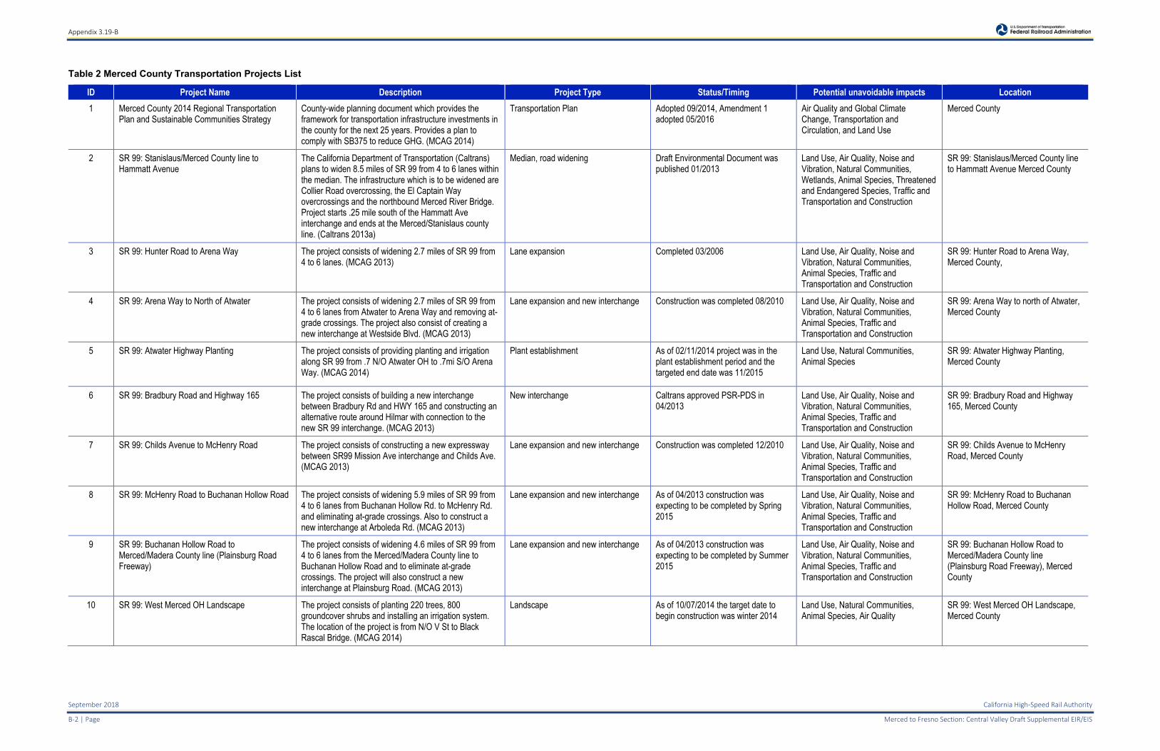
Table 2 Merced County Transportation Projects List
ID Project Name Description Project Type Status/Timing Potential unavoidable impacts Location
1 Merced County 2014 Regional Transportation Plan and Sustainable Communities Strategy
County-wide planning document which provides the framework for transportation infrastructure investments in the county for the next 25 years. Provides a plan to comply with SB375 to reduce GHG. (MCAG 2014)
Transportation Plan Adopted 09/2014, Amendment 1 adopted 05/2016
Air Quality and Global Climate Change, Transportation and Circulation, and Land Use
Merced County
2 SR 99: Stanislaus/Merced County line to Hammatt Avenue
The California Department of Transportation (Caltrans) plans to widen 8.5 miles of SR 99 from 4 to 6 lanes within the median. The infrastructure which is to be widened are Collier Road overcrossing, the El Captain Way overcrossings and the northbound Merced River Bridge. Project starts .25 mile south of the Hammatt Ave interchange and ends at the Merced/Stanislaus county line. (Caltrans 2013a)
Median, road widening Draft Environmental Document was published 01/2013
Land Use, Air Quality, Noise and Vibration, Natural Communities, Wetlands, Animal Species, Threatened and Endangered Species, Traffic and Transportation and Construction
SR 99: Stanislaus/Merced County line to Hammatt Avenue Merced County
3 SR 99: Hunter Road to Arena Way The project consists of widening 2.7 miles of SR 99 from 4 to 6 lanes. (MCAG 2013)
Lane expansion Completed 03/2006 Land Use, Air Quality, Noise and Vibration, Natural Communities, Animal Species, Traffic and Transportation and Construction
SR 99: Hunter Road to Arena Way, Merced County,
4 SR 99: Arena Way to North of Atwater The project consists of widening 2.7 miles of SR 99 from 4 to 6 lanes from Atwater to Arena Way and removing at-grade crossings. The project also consist of creating a new interchange at Westside Blvd. (MCAG 2013)
Lane expansion and new interchange Construction was completed 08/2010 Land Use, Air Quality, Noise and Vibration, Natural Communities, Animal Species, Traffic and Transportation and Construction
SR 99: Arena Way to north of Atwater, Merced County
5 SR 99: Atwater Highway Planting The project consists of providing planting and irrigation along SR 99 from .7 N/O Atwater OH to .7mi S/O Arena Way. (MCAG 2014)
Plant establishment As of 02/11/2014 project was in the plant establishment period and the targeted end date was 11/2015
Land Use, Natural Communities, Animal Species
SR 99: Atwater Highway Planting, Merced County
6 SR 99: Bradbury Road and Highway 165 The project consists of building a new interchange between Bradbury Rd and HWY 165 and constructing an alternative route around Hilmar with connection to the new SR 99 interchange. (MCAG 2013)
New interchange Caltrans approved PSR-PDS in 04/2013
Land Use, Air Quality, Noise and Vibration, Natural Communities, Animal Species, Traffic and Transportation and Construction
SR 99: Bradbury Road and Highway 165, Merced County
7 SR 99: Childs Avenue to McHenry Road The project consists of constructing a new expressway between SR99 Mission Ave interchange and Childs Ave. (MCAG 2013)
Lane expansion and new interchange Construction was completed 12/2010 Land Use, Air Quality, Noise and Vibration, Natural Communities, Animal Species, Traffic and Transportation and Construction
SR 99: Childs Avenue to McHenry Road, Merced County
8 SR 99: McHenry Road to Buchanan Hollow Road The project consists of widening 5.9 miles of SR 99 from 4 to 6 lanes from Buchanan Hollow Rd. to McHenry Rd. and eliminating at-grade crossings. Also to construct a new interchange at Arboleda Rd. (MCAG 2013)
Lane expansion and new interchange As of 04/2013 construction was expecting to be completed by Spring 2015
Land Use, Air Quality, Noise and Vibration, Natural Communities, Animal Species, Traffic and Transportation and Construction
SR 99: McHenry Road to Buchanan Hollow Road, Merced County
9 SR 99: Buchanan Hollow Road to Merced/Madera County line (Plainsburg Road Freeway)
The project consists of widening 4.6 miles of SR 99 from 4 to 6 lanes from the Merced/Madera County line to Buchanan Hollow Road and to eliminate at-grade crossings. The project will also construct a new interchange at Plainsburg Road. (MCAG 2013)
Lane expansion and new interchange As of 04/2013 construction was expecting to be completed by Summer 2015
Land Use, Air Quality, Noise and Vibration, Natural Communities, Animal Species, Traffic and Transportation and Construction
SR 99: Buchanan Hollow Road to Merced/Madera County line (Plainsburg Road Freeway), Merced County
10 SR 99: West Merced OH Landscape The project consists of planting 220 trees, 800 groundcover shrubs and installing an irrigation system. The location of the project is from N/O V St to Black Rascal Bridge. (MCAG 2014)
Landscape As of 10/07/2014 the target date to begin construction was winter 2014
Land Use, Natural Communities, Animal Species, Air Quality
SR 99: West Merced OH Landscape, Merced County
Appendix 3.19-B
California High-Speed Rail Authority September 2018
Merced to Fresno Section: Central Valley Wye Draft Supplemental EIR/EIS Page | B-3
ID Project Name Description Project Type Status/Timing Potential unavoidable impacts Location
11 SR 99: E Merced OH, SR 99/SR 140 to G Street and
The project consists of widening the UC and roadway on E Merced OH in Merced from .3 mi S/O SR-99/SR-140 separation to G St U/C. (MCAG 2014)
Construction on columns and superstructure
As of 10/07/2014 the target date to end construction was 11/2015
Land Use, Air Quality, Noise and Vibration, Natural Communities, Animal Species, Traffic and Transportation and Construction
SR 99: E Merced OH, SR 99/SR 140 to G Street, Merced County
12 SR 140 to Main Street The project consists of widening the UC and roadway on E Merced OH in Merced on SR 140 at Main St. (MCAG 2014)
Lane expansion As of 10/07/2014 the target date to end construction was 11/2015
Land Use, Air Quality, Noise and Vibration, Natural Communities, Animal Species, Traffic and Transportation and Construction
SR 140 to Main Street, Merced County
13 SR 33: SR 152 to I-5 The project consists of bridge lane expansion and various road construction on SR 33 from SR 152 to I-5. (Caltrans 2014)
Bridge lane expansion Construction took place from 11/12/2014-11/14/2014 and from 11/24/2014-11/26/2014
Land Use, Air Quality, Noise and Vibration, Natural Communities, Animal Species, Traffic and Transportation and Construction
SR 33: SR 152 to I-5, Merced County
14 SR 33: Intersection of SR 33 and I-5 Girder retrofit Land Use, Air Quality, Noise and Vibration, Natural Communities, Animal Species, Traffic and Transportation and Construction
SR 33: Intersection of SR 33 and I-5, Merced County
15 I-5, SR 152: Girder retrofit PM 17.5) The project consists of girder diaphragm retrofit on I-5 at I-5/SR-152 separation at bridge 39-0161 R & L. (MCAG 2014)
Lane expansion and shoulder improvements
As of 10/07/2014 the target date to end construction was 08/2015
Land Use, Air Quality, Noise and Vibration, Natural Communities, Animal Species, Traffic and Transportation and Construction
I-5, SR 152, Merced County
16 SR 59: SR 152 to Mission Avenue Roadway widening Land Use, Air Quality, Noise and Vibration, Natural Communities, Animal Species, Traffic and Transportation and Construction
SR 59: SR 152 to Mission Avenue, Merced County
17 SR 59: 16th Street to Olive Avenue New expressway Land Use, Air Quality, Noise and Vibration, Natural Communities, Animal Species, Traffic and Transportation and Construction
SR 59: 16th Street to Olive Avenue, Merced County
18 Atwater-Merced Expressway (Green Sands to 59/Bellevue)
The project consists of constructing a new expressway from Green Sands to 59/Bellevue. (MCAG 2014)
New expressway As of 10/07/2014 the target date to end construction was 02/2016
Land Use, Air Quality, Noise and Vibration, Natural Communities, Animal Species, Traffic and Transportation and Construction
Atwater-Merced Expressway (Green Sands to 59/Bellevue), Merced County
19 Campus Parkway, Segments 2 and 3 The project consists of constructing a new 4 –lane expressway from Childs Ave to SR-140 and from SR-140 to Yosemite Ave. Also includes providing SR-99 access from/to U.C. Merced and North Merced. (MCAG 2013)
New freeway bypass As of 04/2014 construction was expected to take ~2-3 years and be completed by 2035
Land Use, Air Quality, Noise and Vibration, Natural Communities, Animal Species, Traffic and Transportation and Construction
Childs Ave to SR-140 and from SR-140 to Yosemite Ave and SR-99 from/to U.C. Merced and North Merced. Merced County
20 SR 152 Los Banos Bypass, Segment 1 The project consists of constructing a portion of a new bypass between SR 165 and will tie-in with existing SR 152 signalized I/S in Los Banos from SR 165 to SR 152 near Santa Fe Rd. (MCAG 2014)
New freeway bypass As of 10/07/2014 the design was 90% complete and was on hold until funding was resolved
Land Use, Air Quality, Noise and Vibration, Natural Communities, Animal Species, Traffic and Transportation and Construction
Between SR 165 and will tie-in with existing SR 152 signalized I/S in Los Banos from SR 165 to SR 152 near Santa Fe Rd. Merced County
21 SR 152 Los Banos Bypass, Segment 2 The project consists of constructing a new 4 lane expressway bypassing around the city of Los Banos between HWY 165 and W HWY 152 with signalized intersections. (MCAG 2013)
Construction of three interchanges Environmental PA&ED was completed 06/2007
Land Use, Air Quality, Noise and Vibration, Natural Communities, Animal Species, Traffic and Transportation and Construction
Around the city of Los Banos between HWY 165 and W HWY 152 Merced County
22 SR 152 Los Banos Bypass, Segment 3 The project consists of constructing a new 4 lane expressway bypassing around the city of Los Banos and constructing 3 new interchanges at W HWY 152, HWY 165 and E HWY 152. (MCAG 2013)
Install ADA-compliant curb ramps, sidewalk extensions
Environmental PA&ED was completed 06/2007
Land Use, Air Quality, Noise and Vibration, Natural Communities, Construction, Recreation, Safety and Disability Accessibility, Transportation
W HWY 152, HWY 165 and E HWY 152. Merced County
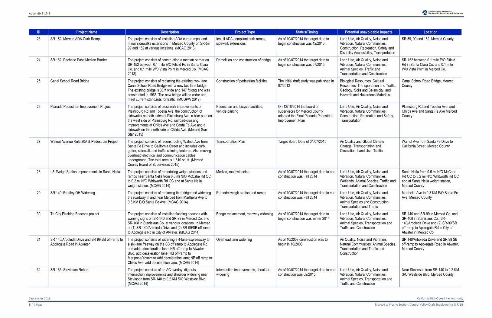
Appendix 3.19-B
September 2018 California High-Speed Rail Authority
B-4 | Page Merced to Fresno Section: Central Valley Draft Supplemental EIR/EIS
ID Project Name Description Project Type Status/Timing Potential unavoidable impacts Location
23 SR 152: Merced ADA Curb Ramps The project consists of installing ADA curb ramps, and minor sidewalks extensions in Merced County on SR-59, 99 and 152 at various locations. (MCAG 2013)
Install ADA-compliant curb ramps, sidewalk extensions
As of 10/07/2014 the target date to begin construction was 12/2015
Land Use, Air Quality, Noise and Vibration, Natural Communities, Construction, Recreation, Safety and Disability Accessibility, Transportation
SR 59, 99 and 152, Merced County
24 SR 152: Pacheco Pass Median Barrier The project consists of constructing a median barrier on SR-152 between 0.1 mile E/O Fifield Rd in Santa Clara Co. and 0.1 mile W/0 Vista Point in Merced Co. (MCAG 2013)
Demolition and construction of bridge As of 10/07/2014 the target date to begin construction was 07/2015
Land Use, Air Quality, Noise and Vibration, Natural Communities, Animal Species, Traffic and Transportation and Construction
SR-152 between 0.1 mile E/O Fifield Rd in Santa Clara Co. and 0.1 mile W/0 Vista Point in Merced Co.
25 Canal School Road Bridge The project consists of replacing the existing two- lane Canal School Road Bridge with a new two lane bridge. The existing bridge is 30 ft wide and 147 ft long and was constructed in 1968. The new bridge will be wider and meet current standards for traffic. (MCDPW 2012)
Construction of pedestrian facilities The initial draft study was published in 07/2012
Biological Resources, Cultural Resources, Transportation and Traffic, Geology, Soils and Seismicity, and Hazards and Hazardous Materials
Canal School Road Bridge, Merced County
26 Planada Pedestrian Improvement Project The project consists of crosswalk improvements on Plainsburg Rd and Topeka Ave, the construction of sidewalks on both sides of Plainsburg Ave, a bike path on the west side of Plainsburg Rd, railroad-crossing improvements at Childs Ave and Santa Fe Ave and a sidewalk on the north side of Childs Ave. (Merced Sun-Star 2015)
Pedestrian and bicycle facilities, vehicle parking
On 12/16/2014 the board of supervisors for Merced County adopted the Final Planada Pedestrian Improvement Plan
Land Use, Air Quality, Noise and Vibration, Natural Communities, Construction, Recreation and Safety, Transportation
Plainsburg Rd and Topeka Ave, and Childs Ave and Santa Fe Ave Merced County
27 Walnut Avenue Rule 20A & Pedestrian Project The project consists of reconstructing Walnut Ave from Santa Fe Drive to California Street and includes curb, gutter, sidewalk and traffic calming features. Also moving overhead electrical and communication cables underground. The total area is 1,610 sq. ft. (Merced County Board of Supervisors 2015)
Transportation Plan Target Board Date of 04/07/2015 Air Quality and Global Climate Change, Transportation and Circulation, Land Use, Traffic
Walnut Ave from Santa Fe Drive to California Street, Merced County
28 I-5: Weigh Station Improvements in Santa Nella The project consists of remodeling weight stations and ramps near Santa Nella from 0.5 mi N/O McCabe Rd OC to 0.2 mi N/O Whitworth Rd OC and at Santa Nella weight station. (MCAG 2014)
Median, road widening As of 10/07/2014 the target date to end construction was Fall 2014
Land Use, Air Quality, Noise and Vibration, Natural Communities, Wetlands, Animal Species, Traffic and Transportation and Construction
Santa Nella from 0.5 mi N/O McCabe Rd OC to 0.2 mi N/O Whitworth Rd OC and at Santa Nella weight station, Merced County
29 SR 140: Bradley OH Widening The project consists of replacing the bridge and widening the roadway in and near Merced from Marthella Ave to 0.3 KM E/O Santa Fe Ave. (MCAG 2014)
Remodel weigh station and ramps As of 10/07/2014 the target date to end construction was Fall 2014
Land Use, Air Quality, Noise and Vibration, Natural Communities, Animal Species and Construction, Transportation and Traffic
Marthella Ave to 0.3 KM E/O Santa Fe Ave, Merced County
30 Tri-City Flashing Beacons project The project consists of installing flashing beacons with warning signs on SR-140 and SR-99 in Merced Co. and SR-108 in Stanislaus Co. at various locations. In Merced at (1) SR-140/Arboleda Drive and (2) SR-99/SB off-ramp to Applegate Rd in City of Atwater. (MCAG 2014)
Bridge replacement, roadway widening As of 10/07/2014 the target date to begin construction was winter 2014
Land Use, Air Quality, Noise and Vibration, Natural Communities, Animal Species, Transportation and Traffic and Construction
SR-140 and SR-99 in Merced Co. and SR-108 in Stanislaus Co.; SR-140/Arboleda Drive and (2) SR-99/SB off-ramp to Applegate Rd in City of Atwater in Merced Co.
31 SR 140/Arboleda Drive and SR 99 SB off-ramp to Applegate Road in Atwater
The project consists of widening a 4-lane expressway to a six-lane freeway on the SB off ramp to Applegate Rd. and add a deceleration lane; NB off-ramp to Atwater Blvd. add deceleration lane; NB off-ramp to Mariposa/Yosemite Add deceleration lane; NB off ramp to Childs Ave. add deceleration lane. (MCAG 2014)
Overhead lane widening As of 10/2008 construction was to begin in 10/2008
Air Quality, Noise and Vibration, Natural Communities, Animal Species, Transportation and Traffic and Construction
SR 140/Arboleda Drive and SR 99 SB off-ramp to Applegate Road in Atwater, Merced County
32 SR 165: Stevinson Rehab The project consists of an AC overlay, dig outs, intersection improvements and shoulder widening near Stevinson from SR-140 to 0.2 KM S/O Westside Blvd. (MCAG 2014)
Intersection improvements, shoulder widening
As of 10/07/2014 the target date to end construction was 02/2015
Land Use, Air Quality, Noise and Vibration, Natural Communities, Animal Species, Transportation and Traffic and Construction
Near Stevinson from SR-140 to 0.2 KM S/O Westside Blvd, Merced County
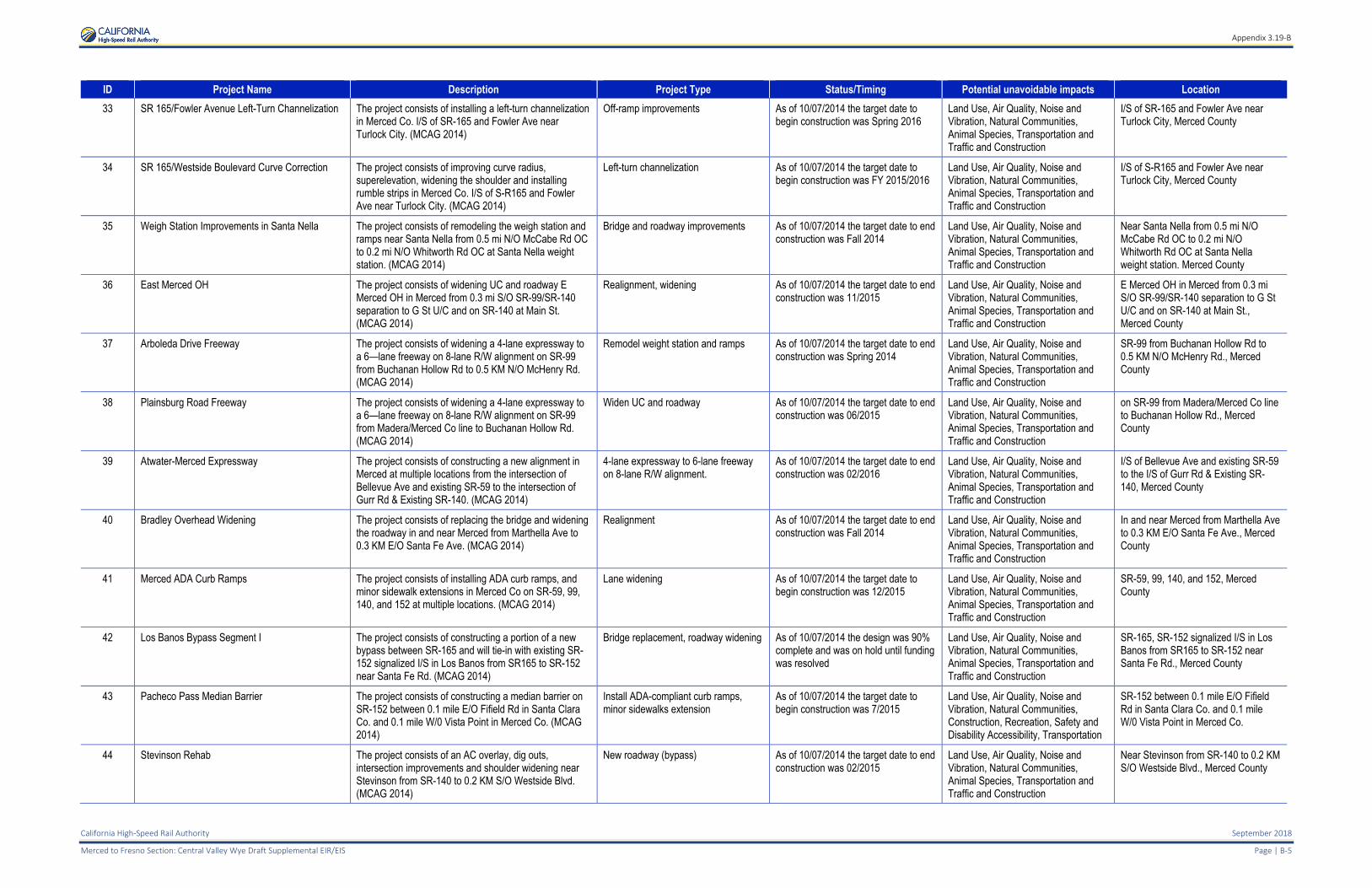
Appendix 3.19-B
California High-Speed Rail Authority September 2018
Merced to Fresno Section: Central Valley Wye Draft Supplemental EIR/EIS Page | B-5
ID Project Name Description Project Type Status/Timing Potential unavoidable impacts Location
33 SR 165/Fowler Avenue Left-Turn Channelization The project consists of installing a left-turn channelization in Merced Co. I/S of SR-165 and Fowler Ave near Turlock City. (MCAG 2014)
Off-ramp improvements As of 10/07/2014 the target date to begin construction was Spring 2016
Land Use, Air Quality, Noise and Vibration, Natural Communities, Animal Species, Transportation and Traffic and Construction
I/S of SR-165 and Fowler Ave near Turlock City, Merced County
34 SR 165/Westside Boulevard Curve Correction The project consists of improving curve radius, superelevation, widening the shoulder and installing rumble strips in Merced Co. I/S of S-R165 and Fowler Ave near Turlock City. (MCAG 2014)
Left-turn channelization As of 10/07/2014 the target date to begin construction was FY 2015/2016
Land Use, Air Quality, Noise and Vibration, Natural Communities, Animal Species, Transportation and Traffic and Construction
I/S of S-R165 and Fowler Ave near Turlock City, Merced County
35 Weigh Station Improvements in Santa Nella The project consists of remodeling the weigh station and ramps near Santa Nella from 0.5 mi N/O McCabe Rd OC to 0.2 mi N/O Whitworth Rd OC at Santa Nella weight station. (MCAG 2014)
Bridge and roadway improvements As of 10/07/2014 the target date to end construction was Fall 2014
Land Use, Air Quality, Noise and Vibration, Natural Communities, Animal Species, Transportation and Traffic and Construction
Near Santa Nella from 0.5 mi N/O McCabe Rd OC to 0.2 mi N/O Whitworth Rd OC at Santa Nella weight station. Merced County
36 East Merced OH The project consists of widening UC and roadway E Merced OH in Merced from 0.3 mi S/O SR-99/SR-140 separation to G St U/C and on SR-140 at Main St. (MCAG 2014)
Realignment, widening As of 10/07/2014 the target date to end construction was 11/2015
Land Use, Air Quality, Noise and Vibration, Natural Communities, Animal Species, Transportation and Traffic and Construction
E Merced OH in Merced from 0.3 mi S/O SR-99/SR-140 separation to G St U/C and on SR-140 at Main St., Merced County
37 Arboleda Drive Freeway The project consists of widening a 4-lane expressway to a 6—lane freeway on 8-lane R/W alignment on SR-99 from Buchanan Hollow Rd to 0.5 KM N/O McHenry Rd. (MCAG 2014)
Remodel weight station and ramps As of 10/07/2014 the target date to end construction was Spring 2014
Land Use, Air Quality, Noise and Vibration, Natural Communities, Animal Species, Transportation and Traffic and Construction
SR-99 from Buchanan Hollow Rd to 0.5 KM N/O McHenry Rd., Merced County
38 Plainsburg Road Freeway The project consists of widening a 4-lane expressway to a 6—lane freeway on 8-lane R/W alignment on SR-99 from Madera/Merced Co line to Buchanan Hollow Rd. (MCAG 2014)
Widen UC and roadway As of 10/07/2014 the target date to end construction was 06/2015
Land Use, Air Quality, Noise and Vibration, Natural Communities, Animal Species, Transportation and Traffic and Construction
on SR-99 from Madera/Merced Co line to Buchanan Hollow Rd., Merced County
39 Atwater-Merced Expressway The project consists of constructing a new alignment in Merced at multiple locations from the intersection of Bellevue Ave and existing SR-59 to the intersection of Gurr Rd & Existing SR-140. (MCAG 2014)
4-lane expressway to 6-lane freeway on 8-lane R/W alignment.
As of 10/07/2014 the target date to end construction was 02/2016
Land Use, Air Quality, Noise and Vibration, Natural Communities, Animal Species, Transportation and Traffic and Construction
I/S of Bellevue Ave and existing SR-59 to the I/S of Gurr Rd & Existing SR-140, Merced County
40 Bradley Overhead Widening The project consists of replacing the bridge and widening the roadway in and near Merced from Marthella Ave to 0.3 KM E/O Santa Fe Ave. (MCAG 2014)
Realignment As of 10/07/2014 the target date to end construction was Fall 2014
Land Use, Air Quality, Noise and Vibration, Natural Communities, Animal Species, Transportation and Traffic and Construction
In and near Merced from Marthella Ave to 0.3 KM E/O Santa Fe Ave., Merced County
41 Merced ADA Curb Ramps The project consists of installing ADA curb ramps, and minor sidewalk extensions in Merced Co on SR-59, 99, 140, and 152 at multiple locations. (MCAG 2014)
Lane widening As of 10/07/2014 the target date to begin construction was 12/2015
Land Use, Air Quality, Noise and Vibration, Natural Communities, Animal Species, Transportation and Traffic and Construction
SR-59, 99, 140, and 152, Merced County
42 Los Banos Bypass Segment I The project consists of constructing a portion of a new bypass between SR-165 and will tie-in with existing SR-152 signalized I/S in Los Banos from SR165 to SR-152 near Santa Fe Rd. (MCAG 2014)
Bridge replacement, roadway widening As of 10/07/2014 the design was 90% complete and was on hold until funding was resolved
Land Use, Air Quality, Noise and Vibration, Natural Communities, Animal Species, Transportation and Traffic and Construction
SR-165, SR-152 signalized I/S in Los Banos from SR165 to SR-152 near Santa Fe Rd., Merced County
43 Pacheco Pass Median Barrier The project consists of constructing a median barrier on SR-152 between 0.1 mile E/O Fifield Rd in Santa Clara Co. and 0.1 mile W/0 Vista Point in Merced Co. (MCAG 2014)
Install ADA-compliant curb ramps, minor sidewalks extension
As of 10/07/2014 the target date to begin construction was 7/2015
Land Use, Air Quality, Noise and Vibration, Natural Communities, Construction, Recreation, Safety and Disability Accessibility, Transportation
SR-152 between 0.1 mile E/O Fifield Rd in Santa Clara Co. and 0.1 mile W/0 Vista Point in Merced Co.
44 Stevinson Rehab The project consists of an AC overlay, dig outs, intersection improvements and shoulder widening near Stevinson from SR-140 to 0.2 KM S/O Westside Blvd. (MCAG 2014)
New roadway (bypass) As of 10/07/2014 the target date to end construction was 02/2015
Land Use, Air Quality, Noise and Vibration, Natural Communities, Animal Species, Transportation and Traffic and Construction
Near Stevinson from SR-140 to 0.2 KM S/O Westside Blvd., Merced County
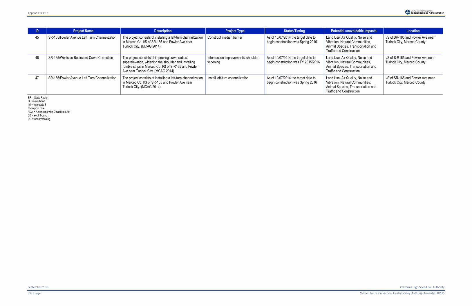
Appendix 3.19-B
September 2018 California High-Speed Rail Authority
B-6 | Page Merced to Fresno Section: Central Valley Draft Supplemental EIR/EIS
ID Project Name Description Project Type Status/Timing Potential unavoidable impacts Location
45 SR-165/Fowler Avenue Left Turn Channelization The project consists of installing a left-turn channelization in Merced Co. I/S of SR-165 and Fowler Ave near Turlock City. (MCAG 2014)
Construct median barrier As of 10/07/2014 the target date to begin construction was Spring 2016
Land Use, Air Quality, Noise and Vibration, Natural Communities, Animal Species, Transportation and Traffic and Construction
I/S of SR-165 and Fowler Ave near Turlock City, Merced County
46 SR-165/Westside Boulevard Curve Correction The project consists of improving curve radius, superelevation, widening the shoulder and installing rumble strips in Merced Co. I/S of S-R165 and Fowler Ave near Turlock City. (MCAG 2014)
Intersection improvements, shoulder widening
As of 10/07/2014 the target date to begin construction was FY 2015/2016
Land Use, Air Quality, Noise and Vibration, Natural Communities, Animal Species, Transportation and Traffic and Construction
I/S of S-R165 and Fowler Ave near Turlock City, Merced County
47 SR-165/Fowler Avenue Left Turn Channelization The project consists of installing a left-turn channelization in Merced Co. I/S of SR-165 and Fowler Ave near Turlock City. (MCAG 2014)
Install left-turn channelization As of 10/07/2014 the target date to begin construction was Spring 2016
Land Use, Air Quality, Noise and Vibration, Natural Communities, Animal Species, Transportation and Traffic and Construction
I/S of SR-165 and Fowler Ave near Turlock City, Merced County
SR = State Route OH = overhead I-5 = Interstate 5 PM = post mile ADA = Americans with Disabilities Act SB = southbound UC = undercrossing
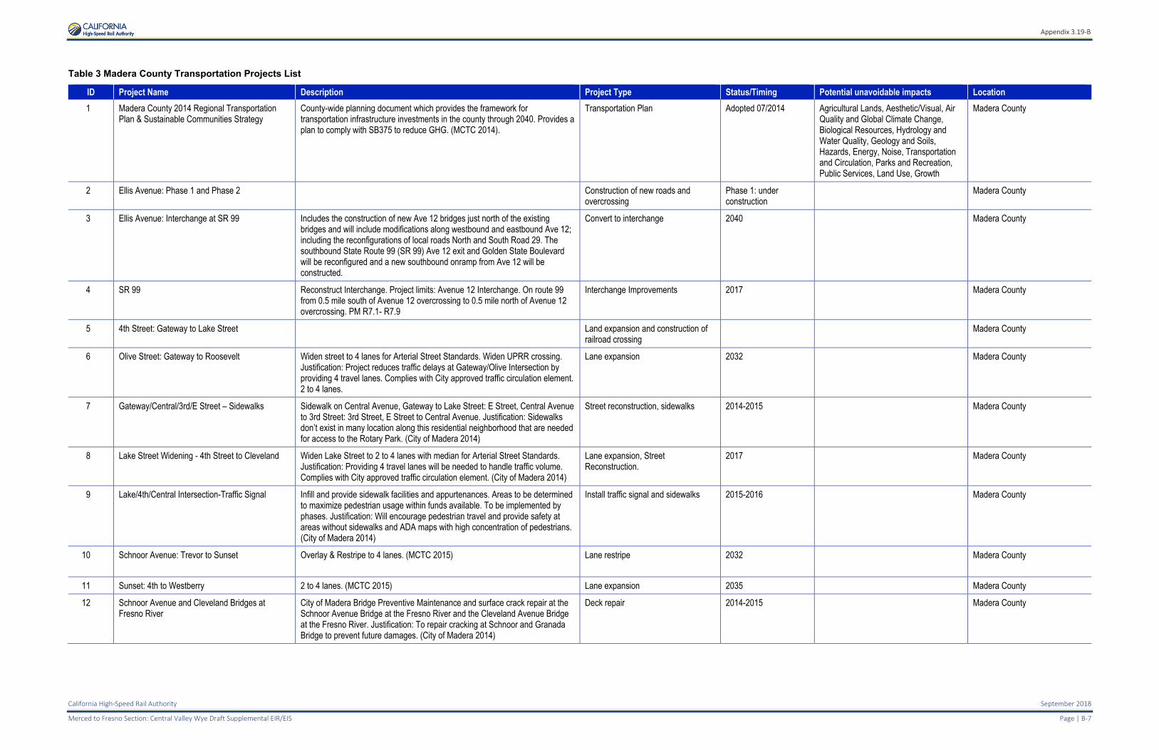
Appendix 3.19-B
California High-Speed Rail Authority September 2018
Merced to Fresno Section: Central Valley Wye Draft Supplemental EIR/EIS Page | B-7
Table 3 Madera County Transportation Projects List
ID Project Name Description Project Type Status/Timing Potential unavoidable impacts Location
1 Madera County 2014 Regional Transportation Plan & Sustainable Communities Strategy
County-wide planning document which provides the framework for transportation infrastructure investments in the county through 2040. Provides a plan to comply with SB375 to reduce GHG. (MCTC 2014).
Transportation Plan Adopted 07/2014 Agricultural Lands, Aesthetic/Visual, Air Quality and Global Climate Change, Biological Resources, Hydrology and Water Quality, Geology and Soils, Hazards, Energy, Noise, Transportation and Circulation, Parks and Recreation, Public Services, Land Use, Growth
Madera County
2 Ellis Avenue: Phase 1 and Phase 2 Construction of new roads and overcrossing
Phase 1: under construction
Madera County
3 Ellis Avenue: Interchange at SR 99 Includes the construction of new Ave 12 bridges just north of the existing bridges and will include modifications along westbound and eastbound Ave 12; including the reconfigurations of local roads North and South Road 29. The southbound State Route 99 (SR 99) Ave 12 exit and Golden State Boulevard will be reconfigured and a new southbound onramp from Ave 12 will be constructed.
Convert to interchange 2040 Madera County
4 SR 99 Reconstruct Interchange. Project limits: Avenue 12 Interchange. On route 99 from 0.5 mile south of Avenue 12 overcrossing to 0.5 mile north of Avenue 12 overcrossing. PM R7.1- R7.9
Interchange Improvements 2017 Madera County
5 4th Street: Gateway to Lake Street Land expansion and construction of railroad crossing
Madera County
6 Olive Street: Gateway to Roosevelt Widen street to 4 lanes for Arterial Street Standards. Widen UPRR crossing. Justification: Project reduces traffic delays at Gateway/Olive Intersection by providing 4 travel lanes. Complies with City approved traffic circulation element. 2 to 4 lanes.
Lane expansion 2032 Madera County
7 Gateway/Central/3rd/E Street – Sidewalks Sidewalk on Central Avenue, Gateway to Lake Street: E Street, Central Avenue to 3rd Street: 3rd Street, E Street to Central Avenue. Justification: Sidewalks don’t exist in many location along this residential neighborhood that are needed for access to the Rotary Park. (City of Madera 2014)
Street reconstruction, sidewalks 2014-2015 Madera County
8 Lake Street Widening - 4th Street to Cleveland Widen Lake Street to 2 to 4 lanes with median for Arterial Street Standards. Justification: Providing 4 travel lanes will be needed to handle traffic volume. Complies with City approved traffic circulation element. (City of Madera 2014)
Lane expansion, Street Reconstruction.
2017 Madera County
9 Lake/4th/Central Intersection-Traffic Signal Infill and provide sidewalk facilities and appurtenances. Areas to be determined to maximize pedestrian usage within funds available. To be implemented by phases. Justification: Will encourage pedestrian travel and provide safety at areas without sidewalks and ADA maps with high concentration of pedestrians. (City of Madera 2014)
Install traffic signal and sidewalks 2015-2016 Madera County
10 Schnoor Avenue: Trevor to Sunset Overlay & Restripe to 4 lanes. (MCTC 2015)
Lane restripe 2032 Madera County
11 Sunset: 4th to Westberry 2 to 4 lanes. (MCTC 2015) Lane expansion 2035 Madera County
12 Schnoor Avenue and Cleveland Bridges at Fresno River
City of Madera Bridge Preventive Maintenance and surface crack repair at the Schnoor Avenue Bridge at the Fresno River and the Cleveland Avenue Bridge at the Fresno River. Justification: To repair cracking at Schnoor and Granada Bridge to prevent future damages. (City of Madera 2014)
Deck repair 2014-2015 Madera County
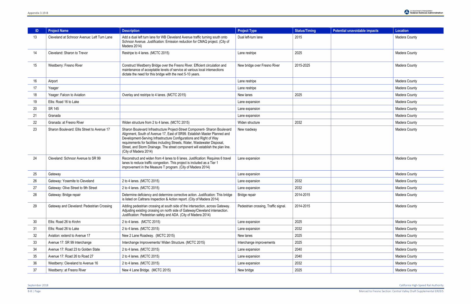
Appendix 3.19-B
September 2018 California High-Speed Rail Authority
B-8 | Page Merced to Fresno Section: Central Valley Draft Supplemental EIR/EIS
ID Project Name Description Project Type Status/Timing Potential unavoidable impacts Location
13 Cleveland at Schnoor Avenue: Left Turn Lane Add a dual left turn lane for WB Cleveland Avenue traffic turning south onto Schnoor Avenue. Justification: Emission reduction for CMAQ project. (City of Madera 2014)
Dual left-turn lane 2015 Madera County
14 Cleveland: Sharon to Trevor Restripe to 4 lanes. (MCTC 2015)
Lane restripe 2025 Madera County
15 Westberry: Fresno River Construct Westberry Bridge over the Fresno River. Efficient circulation and maintenance of acceptable levels of service at various local intersections dictate the need for this bridge with the next 5-10 years.
New bridge over Fresno River 2015-2025 Madera County
16 Airport Lane restripe Madera County
17 Yeager Lane restripe Madera County
18 Yeager: Falcon to Aviation Overlay and restripe to 4 lanes. (MCTC 2015) New lanes 2025 Madera County
19 Ellis: Road 16 to Lake Lane expansion Madera County
20 SR 145 Lane expansion Madera County
21 Granada Lane expansion Madera County
22 Granada: at Fresno River Widen structure from 2 to 4 lanes. (MCTC 2015) Widen structure 2032 Madera County
23 Sharon Boulevard: Ellis Street to Avenue 17 Sharon Boulevard Infrastructure Project-Street Component- Sharon Boulevard Alignment, South of Avenue 17, East of SR99. Establish Master Planned and Development-Serving Infrastructure Configurations and Right of Way requirements for facilities including Streets, Water, Wastewater Disposal, Street, and Storm Drainage. The street component will establish the plan line. (City of Madera 2014)
New roadway Madera County
24 Cleveland: Schnoor Avenue to SR 99 Reconstruct and widen from 4 lanes to 6 lanes. Justification: Requires 6 travel lanes to reduce traffic congestion. This project is included as a Tier 1 improvement in the Measure T program. (City of Madera 2014)
Lane expansion Madera County
25 Gateway Lane expansion Madera County
26 Gateway: Yosemite to Cleveland 2 to 4 lanes. (MCTC 2015) Lane expansion 2032 Madera County
27 Gateway: Olive Street to 9th Street 2 to 4 lanes. (MCTC 2015) Lane expansion 2032 Madera County
28 Gateway: Bridge repair Determine deficiency and determine corrective action. Justification: This bridge is listed on Caltrans Inspection & Action report. (City of Madera 2014)
Bridge repair 2014-2015 Madera County
29 Gateway and Cleveland: Pedestrian Crossing Adding pedestrian crossing at south side of the intersection, across Gateway. Adjusting existing crossing on north side of Gateway/Cleveland intersection. Justification: Pedestrian safety and ADA. (City of Madera 2014)
Pedestrian crossing, Traffic signal. 2014-2015 Madera County
30 Ellis: Road 26 to Krohn 2 to 4 lanes. (MCTC 2015) Lane expansion 2025 Madera County
31 Ellis: Road 26 to Lake 2 to 4 lanes. (MCTC 2015) Lane expansion 2032 Madera County
32 Aviation: extend to Avenue 17 New 2 Lane Roadway. (MCTC 2015) New lanes 2025 Madera County
33 Avenue 17: SR 99 Interchange Interchange Improvements/ Widen Structure. (MCTC 2015) Interchange improvements 2025 Madera County
34 Avenue 17: Road 23 to Golden State 2 to 4 lanes. (MCTC 2015) Lane expansion 2040 Madera County
35 Avenue 17: Road 26 to Road 27 2 to 4 lanes. (MCTC 2015) Lane expansion 2040 Madera County
36 Westberry: Cleveland to Avenue 16 2 to 4 lanes. (MCTC 2015) Lane expansion 2032 Madera County
37 Westberry: at Fresno River New 4 Lane Bridge. (MCTC 2015) New bridge 2025 Madera County
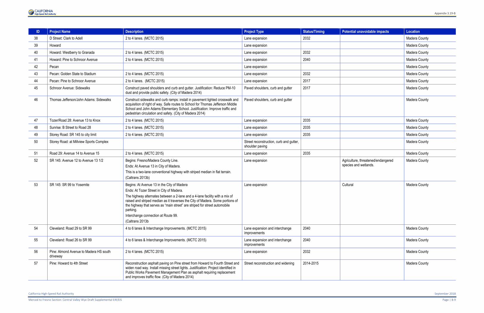
Appendix 3.19-B
California High-Speed Rail Authority September 2018
Merced to Fresno Section: Central Valley Wye Draft Supplemental EIR/EIS Page | B-9
ID Project Name Description Project Type Status/Timing Potential unavoidable impacts Location
38 D Street: Clark to Adell 2 to 4 lanes. (MCTC 2015) Lane expansion 2032 Madera County
39 Howard Lane expansion Madera County
40 Howard: Westberry to Granada 2 to 4 lanes. (MCTC 2015) Lane expansion 2032 Madera County
41 Howard: Pine to Schnoor Avenue 2 to 4 lanes. (MCTC 2015) Lane expansion 2040 Madera County
42 Pecan Lane expansion Madera County
43 Pecan: Golden State to Stadium 2 to 4 lanes. (MCTC 2015) Lane expansion 2032 Madera County
44 Pecan: Pine to Schnoor Avenue 2 to 4 lanes. (MCTC 2015) Lane expansion 2017 Madera County
45 Schnoor Avenue: Sidewalks Construct paved shoulders and curb and gutter. Justification: Reduce PM-10 dust and provide public safety. (City of Madera 2014)
Paved shoulders, curb and gutter 2017 Madera County
46 Thomas Jefferson/John Adams: Sidewalks Construct sidewalks and curb ramps: install in pavement lighted crosswalk and acquisition of right of way. Safe routes to School for Thomas Jefferson Middle School and John Adams Elementary School. Justification: Improve traffic and pedestrian circulation and safety. (City of Madera 2014)
Paved shoulders, curb and gutter Madera County
47 Tozer/Road 28: Avenue 13 to Knox 2 to 4 lanes. (MCTC 2015) Lane expansion 2035 Madera County
48 Sunrise: B Street to Road 28 2 to 4 lanes. (MCTC 2015) Lane expansion 2035 Madera County
49 Storey Road: SR 145 to city limit 2 to 4 lanes. (MCTC 2015) Lane expansion 2035 Madera County
50 Storey Road: at Millview Sports Complex Street reconstruction, curb and gutter, shoulder paving
Madera County
51 Road 29: Avenue 14 to Avenue 15 2 to 4 lanes. (MCTC 2015) Lane expansion 2035 Madera County
52 SR 145: Avenue 12 to Avenue 13 1/2 Begins: Fresno/Madera County Line.
Ends: At Avenue 13 in City of Madera.
This is a two-lane conventional highway with striped median in flat terrain.
(Caltrans 2013b)
Lane expansion Agriculture, threatened/endangered species and wetlands.
Madera County
53 SR 145: SR 99 to Yosemite Begins: At Avenue 13 in the City of Madera
Ends: At Tozer Street in City of Madera.
The highway alternates between a 2-lane and a 4-lane facility with a mix of raised and striped median as it traverses the City of Madera. Some portions of the highway that serves as “main street” are striped for street automobile parking.
Interchange connection at Route 99.
(Caltrans 2013b
Lane expansion Cultural Madera County
54 Cleveland: Road 29 to SR 99 4 to 6 lanes & Interchange Improvements. (MCTC 2015) Lane expansion and interchange improvements
2040 Madera County
55 Cleveland: Road 26 to SR 99 4 to 6 lanes & Interchange Improvements. (MCTC 2015) Lane expansion and interchange improvements
2040 Madera County
56 Pine: Almond Avenue to Madera HS south driveway
2 to 4 lanes. (MCTC 2015) Lane expansion 2032 Madera County
57 Pine: Howard to 4th Street Reconstruction asphalt paving on Pine street from Howard to Fourth Street and widen road way. Install missing street lights. Justification: Project identified in Public Works Pavement Management Plan as asphalt requiring replacement and improves traffic flow. (City of Madera 2014)
Street reconstruction and widening 2014-2015 Madera County
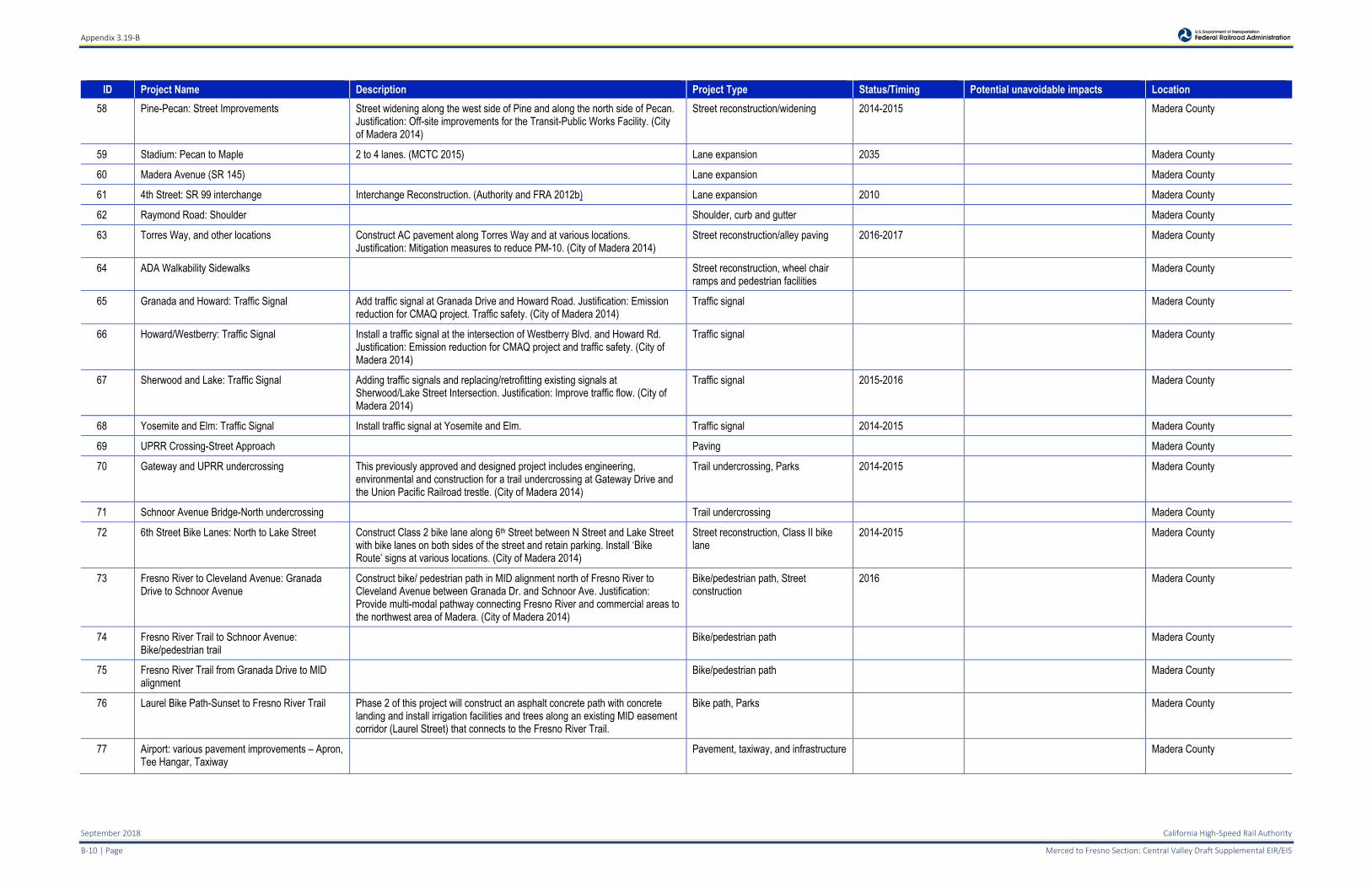
Appendix 3.19-B
September 2018 California High-Speed Rail Authority
B-10 | Page Merced to Fresno Section: Central Valley Draft Supplemental EIR/EIS
ID Project Name Description Project Type Status/Timing Potential unavoidable impacts Location
58 Pine-Pecan: Street Improvements Street widening along the west side of Pine and along the north side of Pecan. Justification: Off-site improvements for the Transit-Public Works Facility. (City of Madera 2014)
Street reconstruction/widening 2014-2015 Madera County
59 Stadium: Pecan to Maple 2 to 4 lanes. (MCTC 2015) Lane expansion 2035 Madera County
60 Madera Avenue (SR 145) Lane expansion Madera County
61 4th Street: SR 99 interchange Interchange Reconstruction. (Authority and FRA 2012b) Lane expansion 2010 Madera County
62 Raymond Road: Shoulder Shoulder, curb and gutter Madera County
63 Torres Way, and other locations Construct AC pavement along Torres Way and at various locations. Justification: Mitigation measures to reduce PM-10. (City of Madera 2014)
Street reconstruction/alley paving 2016-2017 Madera County
64 ADA Walkability Sidewalks Street reconstruction, wheel chair ramps and pedestrian facilities
Madera County
65 Granada and Howard: Traffic Signal Add traffic signal at Granada Drive and Howard Road. Justification: Emission reduction for CMAQ project. Traffic safety. (City of Madera 2014)
Traffic signal Madera County
66 Howard/Westberry: Traffic Signal Install a traffic signal at the intersection of Westberry Blvd. and Howard Rd. Justification: Emission reduction for CMAQ project and traffic safety. (City of Madera 2014)
Traffic signal Madera County
67 Sherwood and Lake: Traffic Signal Adding traffic signals and replacing/retrofitting existing signals at Sherwood/Lake Street Intersection. Justification: Improve traffic flow. (City of Madera 2014)
Traffic signal 2015-2016 Madera County
68 Yosemite and Elm: Traffic Signal Install traffic signal at Yosemite and Elm. Traffic signal 2014-2015 Madera County
69 UPRR Crossing-Street Approach Paving Madera County
70 Gateway and UPRR undercrossing This previously approved and designed project includes engineering, environmental and construction for a trail undercrossing at Gateway Drive and the Union Pacific Railroad trestle. (City of Madera 2014)
Trail undercrossing, Parks 2014-2015 Madera County
71 Schnoor Avenue Bridge-North undercrossing Trail undercrossing Madera County
72 6th Street Bike Lanes: North to Lake Street Construct Class 2 bike lane along 6th Street between N Street and Lake Street with bike lanes on both sides of the street and retain parking. Install ‘Bike Route’ signs at various locations. (City of Madera 2014)
Street reconstruction, Class II bike lane
2014-2015 Madera County
73 Fresno River to Cleveland Avenue: Granada Drive to Schnoor Avenue
Construct bike/ pedestrian path in MID alignment north of Fresno River to Cleveland Avenue between Granada Dr. and Schnoor Ave. Justification: Provide multi-modal pathway connecting Fresno River and commercial areas to the northwest area of Madera. (City of Madera 2014)
Bike/pedestrian path, Street construction
2016 Madera County
74 Fresno River Trail to Schnoor Avenue: Bike/pedestrian trail
Bike/pedestrian path Madera County
75 Fresno River Trail from Granada Drive to MID alignment
Bike/pedestrian path Madera County
76 Laurel Bike Path-Sunset to Fresno River Trail Phase 2 of this project will construct an asphalt concrete path with concrete landing and install irrigation facilities and trees along an existing MID easement corridor (Laurel Street) that connects to the Fresno River Trail.
Bike path, Parks Madera County
77 Airport: various pavement improvements – Apron, Tee Hangar, Taxiway
Pavement, taxiway, and infrastructure Madera County
Appendix 3.19-B
California High-Speed Rail Authority September 2018
Merced to Fresno Section: Central Valley Wye Draft Supplemental EIR/EIS Page | B-11
ID Project Name Description Project Type Status/Timing Potential unavoidable impacts Location
78 Fairmead Median Barriers Median barrier construction Community of Fairmead
79 Fresno, Kings, Madera Bridges Seismic Restoration
In Fresno, Kings and Madera Counties at structure #’s 42-0134, 42-0215F, 45-0007, 45-0064, and 41—59E; Bridge Seismic restoration.
Seismic restoration Milestones that are tracked by HQ in the Delivery Plan for the current 2016
Agriculture & Biological Resources Central Region District 06
Madera County
SR = State Route OC = overcrossing ADA = Americans with Disabilities Act UPRR = Union Pacific Railroad MID = Modesto Irrigation District
Appendix 3.19-B
September 2018 California High-Speed Rail Authority
B-12 | Page Merced to Fresno Section: Central Valley Draft Supplemental EIR/EIS
Table 4 Stanislaus County Transportation Projects List
ID Project Name Description Project Type Status/Timing Potential unavoidable impacts* Location
1 Stanislaus County 2014 Regional Transportation Plan & Sustainable Communities Strategy
County-wide planning document which provides the framework for transportation infrastructure investments in the county through 2040. Provides a plan to comply with SB375 to reduce GHG. (MCTC 2014). Projects identified in the 2031 to 2033 timeframe include:
Install Ramp Metering Improvements including Intelligent Transportation Systems (ITS) on SR 99 from Mitchell Road to the Merced County Line
Complete Street Improvements associated with Roselle Avenue/Patterson Road to Claribel Road, Riverbank CA
Various other unidentified projects
Transportation Plan Adopted 07/2014 Air Quality, Biological Resources, Energy, GHG (Short-term emissions), and Hydrology and Water Quality (water demand)
Stanislaus County
* Only disclosed unavoidable effects for which construction activities in the 2031 to 2033 timeframe associated with the Site 7 – Le Grand Junction/Sandy Mush Road, Warnerville – Wilson 230 kV Transmission Line could contribute. 1. StanCOG 2014
Appendix 3.19-B
California High-Speed Rail Authority September 2018
Merced to Fresno Section: Central Valley Wye Draft Supplemental EIR/EIS Page | B-13
Table 5 Fresno County Transportation Projects List
ID Project Name Description Project Type Status/Timing Potential unavoidable impacts* Location
1 Fresno County 2014 Regional Transportation Plan & Sustainable Communities Strategy
County-wide planning document which provides the framework for transportation infrastructure investments in the county through 2040. Provides a plan to comply with SB375 to reduce GHG. (MCTC 2014). Projects identified on Figure 2-8, Capacity Increasing Projects (2026 – 2040) include:
Unnamed projects generally located within urban areas along the SR 99 corridor and within the cities of Fresno, Clovis and Reedley.
Transportation Plan Adopted 07/2014 Air Quality, Energy, Hydrology and Water Quality (groundwater depletion)
Fresno County
* Only disclosed unavoidable effects for which construction activities in the 2031 to 2033 timeframe associated with a portion of the Site 6 – El Nido, Los - Banos – Oro Loma – Canal 70 kV Power Line and the entirety of the Site 6 – El Nido, Oro Loma – Panoche Junction 115 kV Power Line could contribute. 1. Fresno Council of Governments 2014
Appendix 3.19-B
September 2018 California High-Speed Rail Authority
B-14 | Page Merced to Fresno Section: Central Valley Draft Supplemental EIR/EIS
Table 6 City of Chowchilla Transportation Projects List
ID Project Name Description Project Type Status/Timing Potential unavoidable impacts Location
1 SR 233: Robertson Restripe 2 to 4 lanes. (Authority and FRA 2012b) Lane restripe 2013 City of Chowchilla
2 SR 99 – SR 233 Interchange Interchange reconstruction project. Reconstruct interchange City of Chowchilla
3 Road 16 1/2 Improvement Fund Road improvement project. Road Improvement City of Chowchilla
4 SR 99: Road 17 Interchange Interchange reconstruction project. Reconstruct Interchange City of Chowchilla
5 Fig Tree: SR 99 OC 2 Lane Overcrossing to Chowchilla Blvd. (Authority and FRA 2012b) Overcrossing construction 2013 City of Chowchilla
6 SR 99: Avenue 26 Interchange Reconstruct interchange City of Chowchilla
7 Avenue 26: SR 99 to Coronado Widen to 4 lanes. (Authority and FRA 2012b) Lane expansion 2030 City of Chowchilla
8 Washington Road and Robertson Boulevard Intersection Project
Road realignment and expansion project. Road realignment and expansion City of Chowchilla
SR = State Route OC = overcrossing
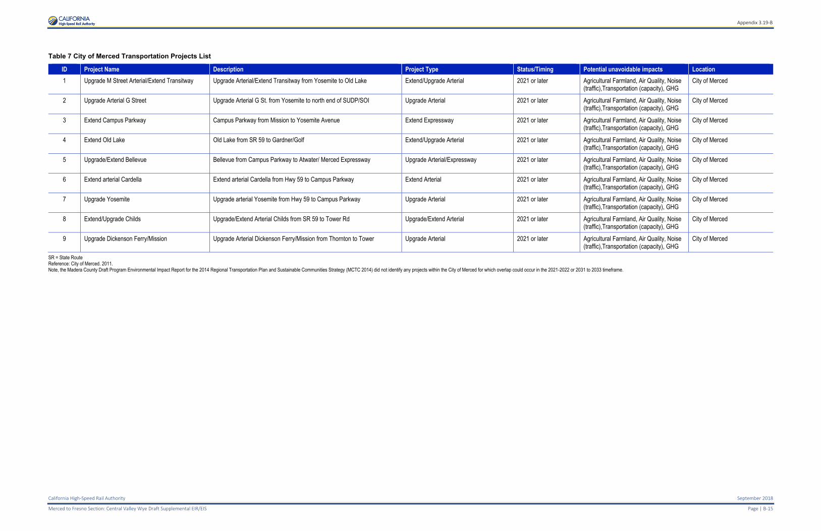
Appendix 3.19-B
California High-Speed Rail Authority September 2018
Merced to Fresno Section: Central Valley Wye Draft Supplemental EIR/EIS Page | B-15
Table 7 City of Merced Transportation Projects List
ID Project Name Description Project Type Status/Timing Potential unavoidable impacts Location
1 Upgrade M Street Arterial/Extend Transitway Upgrade Arterial/Extend Transitway from Yosemite to Old Lake Extend/Upgrade Arterial 2021 or later Agricultural Farmland, Air Quality, Noise (traffic),Transportation (capacity), GHG
City of Merced
2 Upgrade Arterial G Street Upgrade Arterial G St. from Yosemite to north end of SUDP/SOI Upgrade Arterial 2021 or later Agricultural Farmland, Air Quality, Noise (traffic),Transportation (capacity), GHG
City of Merced
3 Extend Campus Parkway Campus Parkway from Mission to Yosemite Avenue Extend Expressway 2021 or later Agricultural Farmland, Air Quality, Noise (traffic),Transportation (capacity), GHG
City of Merced
4 Extend Old Lake Old Lake from SR 59 to Gardner/Golf Extend/Upgrade Arterial 2021 or later Agricultural Farmland, Air Quality, Noise (traffic),Transportation (capacity), GHG
City of Merced
5 Upgrade/Extend Bellevue Bellevue from Campus Parkway to Atwater/ Merced Expressway Upgrade Arterial/Expressway 2021 or later Agricultural Farmland, Air Quality, Noise (traffic),Transportation (capacity), GHG
City of Merced
6 Extend arterial Cardella Extend arterial Cardella from Hwy 59 to Campus Parkway Extend Arterial 2021 or later Agricultural Farmland, Air Quality, Noise (traffic),Transportation (capacity), GHG
City of Merced
7 Upgrade Yosemite Upgrade arterial Yosemite from Hwy 59 to Campus Parkway Upgrade Arterial 2021 or later Agricultural Farmland, Air Quality, Noise (traffic),Transportation (capacity), GHG
City of Merced
8 Extend/Upgrade Childs Upgrade/Extend Arterial Childs from SR 59 to Tower Rd Upgrade/Extend Arterial 2021 or later Agricultural Farmland, Air Quality, Noise (traffic),Transportation (capacity), GHG
City of Merced
9 Upgrade Dickenson Ferry/Mission Upgrade Arterial Dickenson Ferry/Mission from Thornton to Tower Upgrade Arterial 2021 or later Agricultural Farmland, Air Quality, Noise (traffic),Transportation (capacity), GHG
City of Merced
SR = State Route Reference: City of Merced. 2011. Note, the Madera County Draft Program Environmental Impact Report for the 2014 Regional Transportation Plan and Sustainable Communities Strategy (MCTC 2014) did not identify any projects within the City of Merced for which overlap could occur in the 2021-2022 or 2031 to 2033 timeframe.

Appendix 3.19-B
California High-Speed Rail Authority September 2018
Merced to Fresno Section: Central Valley Wye Draft Supplemental EIR/EIS Page | B-17
REFERENCES
California Department of Transportation (Caltrans), 2008. State Route 99 Corridor System Management Plan Merced County and Portions of Madera & Stanislaus Counties for the Arboleda and Plainsburg Freeway Projects. http://www.dot.ca.gov/dist10/divisions/Planning/advancedplanning/docs/FinalSR-99MercedWEB11708.pdf
California Department of Transportation (Caltrans). 2013a. Draft Environmental Document for the State Route 99/Livingston Median Widening Project in Merced County. http://www.dot.ca.gov/dist10/environmental/projects/LivingstonWidening/docs/LivingstonWideningDraftED.pdf
California Department of Transportation. 2013b. Transportation Concept Report. State Route 145, District 06. October. http://www.dot.ca.gov/d6/planning/tcrs/sr145tcr/sr145final_v2.pdf
California Department of Transportation (Caltrans). 2014. News Release. Full Highway Closure. Interstate 5 from State Route 152 to State Route 33 in Merced County. November 10. http://www.dot.ca.gov/dist10/pages/pressreleases/2014/Nov/14-11-23MER5FullHighwayClosureBridgeWork.pdf
California Energy Commission (CEC). 2016. Tracking Progress. Transmission Expansion Projects for Renewables. Available: http://www.energy.ca.gov/renewables/tracking_progress/documents/transmission_expansion_projects.pdf. Accessed: January 5, 2017.
California High-Speed Rail Authority and Federal Railroad Administration (Authority and FRA). 2012a. California High-Speed Train Project EIR/EIS, Merced to Fresno Section Appendix 3.19-A, Planned and Potential Transportation Projects. Available: http://www.hsr.ca.gov/docs/programs/merced-fresno-eir/drft_EIR_MerFres_Vol2_3_19a.pdf
California High-Speed Rail Authority and Federal Railroad Administration (Authority and FRA). 2012b. California High-Speed Train Project EIR/EIS, Merced to Fresno Section Appendix 3.19-B, Planned and Potential Transportation Projects. Available: www.hsr.ca.gov/docs/programs/merced-fresno-eir/drft_EIR_MerFres_Vol2_3_19b.pdf. Accessed: June 25, 2018.
CEQANET 2016a. Long-Term North to South Water Transfer Program. Project Description. SCH# 2011011010. http://www.ceqanet.ca.gov/DocDescription.asp?DocPK=648698
CEQANET 2016b. 25-Year Water Transfer Program for the San Joaquin River Exchange Contractors Water Authority (2014–2038). Notice of Preparation. SCH# 2011061057. http://www.ceqanet.ca.gov/DocDescription.asp?DocPK=652020
CEQAnet. 2016c. Southeast Madera Development Project. Notice of Determination. http://www.ceqanet.ca.gov/ProjDocList.asp?ProjectPK=579657
CEQAnet. 2016d. North Fork Village Specific Plan. http://www.ceqanet.ca.gov/ProjDocList.asp?ProjectPK=569310
CEQAnet. 2016e. Fresno River Trail System Undercrossings at Schnoor Avenue Bridge. Notice of Determination. January 13. http://www.ceqanet.ca.gov/ProjDocList.asp?ProjectPK=609586
CEQAnet. 2016f. Gateway Village Area Plan. Final Environmental Impact Report. SCH# 2005091071. http://www.ceqanet.ca.gov/DocDescription.asp?DocPK=608108
CEQAnet. 2016g. Gunner Ranch West Specific Plan. Notice of Determination. SCH# 2008051084. http://www.ceqanet.ca.gov/NODdescription.asp?DocPK=683201
CEQAnet. 2016h. Raymond Area Plan. Mitigated Negative Declaration. September 22. http://www.ceqanet.ca.gov/ProjDocList.asp?ProjectPK=593073
Appendix 3.19-B
September 2018 California High-Speed Rail Authority
B-18 | Page Merced to Fresno Section: Central Valley Draft Supplemental EIR/EIS
CEQAnet. 2016i. Tesoro Viejo Specific Plan (and Development Pursuant Thereto). Notice of Determination. July 27, 2016. http://www.ceqanet.ca.gov/ProjDocList.asp?ProjectPK=577422
CEQAnet. 2016j. Ventana Specific Plan. Notice of Determination. SCH# 2005091149. http://www.ceqanet.ca.gov/NODdescription.asp?DocPK=606763
CEQAnet. 2016k. 2040 General plan and the Rancho Calera Specific Plan (formerly Greenhills Lakes Specific Plan). Notice of Determination. May 5, 2011. SCH# 2009022007. http://www.ceqanet.ca.gov/NODdescription.asp?DocPK=651575.
CEQAnet. 2016l. River West-Madera Master Plan. http://www.ceqanet.ca.gov/ProjDocList.asp?ProjectPK=617319
CEQAnet. 2016m. PG&E Manufactured Gas Plant SQ-VO Merced. http://www.ceqanet.ca.gov/ProjDocList.asp?ProjectPK=630153
City of Chowchilla. 2011. 2040 City of Chowchilla General Plan Housing Element 2009–2014. http://www.ci.chowchilla.ca.us/154/Chowchilla-2040-General-Plan
City of Los Banos 2013. Agenda Staff Report Overland Courts Senior Living Apartment Community. June 5. http://www.losbanos.org/wp-content/uploads/2013/06/ccpck20130605.pdf
City of Madera. 2013. Foxglove Shopping Center Project. Notice of Determination. http://www.ceqanet.ca.gov/NODdescription.asp?DocPK=669039
City of Madera. 2014. Draft Capital Improvement Plan (CIP) Fiscal Year 2014-15 to 2018-19. https://web.archive.org/web/20160515023727/http://www.cityofmadera.org/c/document_library/get_file?uuid=312021af-f9fc-4233-a48b-60309a034975&groupId=10128&
City of Madera Planning Commission. 2018. Staff Report: Madera Town Center Development Agreement Annual Review and Environmental Determination. February 13, 2018. https://www.cityofmadera.ca.gov/wp-content/uploads/2018/02/02-13-18-PC-Agenda-w-Reports.pdf.
City of Merced. 2011. Merced Vision 2030 General Plan Final EIR. Adopted July 20, 2011. Prepared by Quad Knopf, Inc. https://www.cityofmerced.org/civicax/filebank/blobdload.aspx?BlobID=10348
Fresno County Council of Governments. 2014. Regional Transportation Plan and Sustainable Communities Strategy, Draft Program Environmental Impact Report. March 21, 2014. www.fresnocog.org/sites/default/files/publications/RTP/Final_RTP/Fresno_COG_2014_RTP_Draft_PEIR.pdf (accessed December 20, 2016).
Madera County 2012. Fairmead Colony Area Plan. Madera County Planning Department.
Madera County Transportation Commission (MCTC). 2014. Madera County Draft Program Environmental Impact Report for the 2014 Regional Transportation Plan and Sustainable Communities Strategy. May 1. Prepared by VRPA Technologies, Inc. SCH# 2012111025.
Madera County Transportation Commission (MCTC). 2015. Meeting Notice, January 21, 2015. Agenda. www.maderactc.org/wp-content/uploads/2014/10/January-2015-MCTC-Board-Agenda.pdf
Madera County. 2007. Sierra Meadows Estates Subdivision (S2001-03) Environmental Impact Report. Prepared by RBF Consulting. Final. December. https://www.maderacounty.com/Home/ShowDocument?id=2766
Madera County. 2009 CUP #2009-004 Fairmead Landfill Expansion. http://www.ceqanet.ca.gov/ProjDocList.asp?ProjectPK=603443
Madera County. 2010 [2012]. South Fork Sewer System Facilities Plan. June 16, 2010. Revised November 27, 2012. Prepared by Blair, Church & Flynn. Clovis, California. http://wdl.water.ca.gov/irwm/grants/docs/Archives/Prop84/Submitted_Applications/P84_Round2_Implementation/Provost%20&%20Pritchard%20Consulting%20Group%20(201312340016)/Attachment%203.%20(cont)%20-%20Att3_IG2_WorkPlan_2of2.pdf

Appendix 3.19-B
California High-Speed Rail Authority September 2018
Merced to Fresno Section: Central Valley Wye Draft Supplemental EIR/EIS Page | B-19
Madera County. 2011. Notice Extending Comment Period and Second Scoping Meeting for the Liberty Groves Project Program Environmental Impact Report (EIR) Notice of Preparation (NOP). July 11. Madera County Planning Department. https://www.maderacounty.com/Home/ShowDocument?id=2804
Madera County. 2015a. CUP #2012-010 A one-year time extension for a Conditional Use Permit for a 90 megawatt solar facility. CEQA #2012-013 Mitigated Negative Declaration. https://www.maderacounty.com/Home/ShowDocument?id=3326
Madera County. 2015b. Partially Recirculated Draft Environmental Impact Report. Tra Vigne Subdivision. County of Madera, California. Prepared by First Carbon Solutions. Fresno, California. SCH# 2008081130. https://www.maderacounty.com/Home/ShowDocument?id=2840
Madera County. 2015c. Madera County 2016–2024 Housing Element Update. Adopted November 3, 2015. http://www.hcd.ca.gov/community-development/housing-element/docs/madera_county_5th_adopted111015.pdf
Madera County. 2016. Notice of Public Hearing. Tuesday, July 19, 2016. Public Hearing. Calmat Co., DBA Vulcan Materials Company – Certification of a Final Environmental Impact Report (FEIR SCH#20100710360) – Conditional Use Permits (CUP #2009-017, CUP 2009-020), Variance (VA #2016-003) for the Austin Quarry Project. https://www.maderacounty.com/Home/ShowDocument?id=2492
Merced County. 2006. Redevelopment Plan for the Castle Airport Aviation and Development Center Redevelopment Project. http://web2.co.merced.ca.us/pdfs/env_docs/castle/RDA%20Plan%20Mar%2030-%202006.PDF
Merced County. 2007. Draft Environmental Impact Report for the Red Rock Dairy. Administrative Permit No. CUP05-136. SCH# 2006071033. May. https://www.co.merced.ca.us/DocumentView.asp?DID=1226
Merced County. 2008a. Draft Environmental Impact Report for the Joe Lourenco Dairy #2 Expansion Project. Conditional Use Permit No. CUP07-029. SCH# 2008081045. December. https://www.co.merced.ca.us/DocumentView.asp?DID=1224
Merced County. 2008b. Jaxon Enterprises, Inc. Mine Expansion and Reclamation Plan, Merced County, California Conditional Use Application No. CUA-99-009 Final Environmental Impact Report. SCH# 2003021087. https://www.co.merced.ca.us/DocumentCenter/View/1223/jaxon_ent_final_eir?bidId=
Merced County. 2008c. Draft Environmental Impact Report. Yosemite Ranch Estates. SCH#2006052021. July. Prepared by Quad Knopf. Roseville, California. https://www.co.merced.ca.us/DocumentCenter/View/1220/DEIR---Yosemite-Ranch-Estates?bidId=
Merced County. 2009a. Notice of Preparation of an Environmental Impact Report for the George Reed, Inc. Merced Quarry Project and Reclamation Plan. http://web2.co.merced.ca.us/pdfs/env_docs/eir/Reed_NOP.pdf
Merced County. 2009b. Snelling Tailings Project Use Permit and Reclamation Plan, Merced County, California Conditional Use Application No. CUP06-011 Final Environmental Impact Report. SCH# 2007111108. October. Prepared by Resource Design Technology, Inc. El Dorado Hills, California. https://www.co.merced.ca.us/DocumentCenter/View/2327/Complete-FEIR-with-Appendices-smallerfile?bidId=
Merced County. 2010a. Final Environmental Impact Report for the Guilherme Brasil Dairy Expansion Project. Conditional Use Permit No. CUP07-014. SCH# 2008031079. November. http://web2.co.merced.ca.us/pdfs/env_docs/eir/final_environmental_impact_report_for_the_guilherme_brasil_dairy_expansion_project.pdf
Appendix 3.19-B
September 2018 California High-Speed Rail Authority
B-20 | Page Merced to Fresno Section: Central Valley Draft Supplemental EIR/EIS
Merced County. 2010b. Final Environmental Impact Report for the Michael Brasil Dairy Expansion Project. Conditional Use Permit No. CUP07-004. SCH# 2003051002. November. http://web2.co.merced.ca.us/pdfs/env_docs/eir/feir_m_brasil_112910.pdf
Merced County. 2011a. Final Environmental Impact Report for the John B. Pires Dairy Expansion Project. Conditional Use Permit No. CUP10-007. SCH# 2011041059. October. http://web2.co.merced.ca.us/pdfs/env_docs/eir/pires_complete_feir_101011.pdf
Merced County. 2011b. Initial Study/Mitigated Negative Declaration. E. & J. Gallo Livingston Winery Eastside Expansion. Prepared by ICF International. San Francisco, California. November. http://web2.co.merced.ca.us/pdfs/env_docs/initial_studies/gallo_is_mnd_nov2011_webready.pdf
Merced County. 2011c. Castle Airport Master Plan. Adopted December 6, 2011. Prepared for County of Merced Department of Commerce, Aviation and Economic Development. Prepared by Mead & Hunt. Santa Rosa, California. https://www.co.merced.ca.us/pdfs/env_docs/castle/CAED/Castle_AMP_full.pdf
Merced County. 2012a. Revised Final Environmental Impact Report for the Antonio Azevedo Dairy Expansion Project. Conditional Use Permit No. CUP09-11. SCH# 2010111045. November. Available: http://web2.co.merced.ca.us/pdfs/env_docs/eir/rfeir_azevedo_complete_111912f.pdf
Merced County. 2012b. Final Environmental Impact Report for the Hillcrest Dairy Project. Conditional Use Permit No. CUP10-005. SCH# 2011031020. http://web2.co.merced.ca.us/pdfs/env_docs/eir/hillcrest_feir_complete_020612f.pdf
Merced County. 2012c. Notice of Preparation of an Environmental Impact Report for the Cenergy Solar Project. April. http://web2.co.merced.ca.us/pdfs/env_docs/eir/cenergy_solar_energy_project_combined_nop_submittals.pdf
Merced County. 2012d. Pristine Sun Solar Energy Project Conditional Use Permit No. CUP12-013, West Tahoe Street, Merced, CA, “2097 Helton” Initial Study. Prepared by PMC. Rancho Cordova, California. December. http://web2.co.merced.ca.us/pdfs/env_docs/initial_studies/Pristine-Sun-Initial-Study_FINAL.pdf
Merced County. 2012e. Revised Final EIR Quinto Solar PV Project. SCH# 2010121039. Prepared by EMC Planning Group Inc. Monterey, California. http://web2.co.merced.ca.us/pdfs/env_docs/quintosolarpvproject/October_18_2012_Revised_Final_EIR.pdf
Merced County. 2012f. Initial Study for the “Highway 99 Truck Stop Project at Harvey Pettit Road”. General Plan Amendment No. GPA11-01, Zone Change No. ZC11-001, and Conditional Use Permit No. CUP11-001. December. http://web2.co.merced.ca.us/pdfs/env_docs/initial_studies/Harvey_Pettit_IS-MND_121112F.pdf
Merced County. 2012g. Revised Initial Study/Mitigated Negative Declaration for the Templo La Hermosa Project. Conditional Use Permit No. CUP11-005. December. http://web2.co.merced.ca.us/pdfs/env_docs/initial_studies/templo_lh_is_121212f.pdf
Merced County. 2013a. Staff Report. Conditional Use Permit No. CUP-11-010. April. Available: http://web2.co.merced.ca.us/pdfs/commissionarchive/2013/04-24/Item_B_CUP11-010_Antonio_Brasil.pdf.
Merced County. 2013b. Final Environmental Impact Report for the Bob Borba Daily Central Expansion Project. Conditional Use Permit No. CUP12-002. SCH# 2012101071. August. http://web2.co.merced.ca.us/pdfs/env_docs/eir/bborba_feir_083013.pdf
Merced County. 2013c. Final Environmental Impact Report for the Meirinho Daily Expasnsion Project. Conditional Use Permit No. CUP11-012. SCH# 2012071006. April. http://web2.co.merced.ca.us/pdfs/env_docs/eir/meirinho_dairy_expansion_feir_april_2013.pdf
Appendix 3.19-B
California High-Speed Rail Authority September 2018
Merced to Fresno Section: Central Valley Wye Draft Supplemental EIR/EIS Page | B-21
Merced County. 2013d. Initial Study for the Minturn Huller Cooperative Expansion Project. Major Modification No. MM12-010 to Conditional Use Permit No. CUP3678. May. http://web2.co.merced.ca.us/pdfs/env_docs/initial_studies/MinturnHuller/m_huller_is_052313f.pdf
Merced County. 2013e.Initial Study/Mitigated Negative Declaration Sun Harvest Solar Project Conditional Use Permit No. 13-009. Prepared by EMC Planning Group Inc. Monterey, California. December. http://web2.co.merced.ca.us/pdfs/env_docs/initial_studies/sun_harvest_is_pr.pdf
Merced County. 2013f. Proposed Mitigated Negative Declaration Vassar Solar Project Conditional Use Permit 13-001. Prepared by EMC Planning Group Inc. Monterey, California. August. http://web2.co.merced.ca.us/pdfs/env_docs/initial_studies/vassar_ecos_initial_study.pdf
Merced County. 2013g. Final Environmental Impact Report Vega Solar Project, County of Merced, California. SCH# 2013021011. Prepared by Michael Brandman Associates. Sacramento, California. November. http://web2.co.merced.ca.us/pdfs/env_docs/eir/Vega_Solar_Final_EIR.pdf
Merced County. 2014a. Initial Study/Mitigated Negative Declaration Liberty Packing Company. Draft. January. S Prepared for Merced County Planning and Economic Development Department, Merced, CA. Prepared by ICF International, Sacramento, CA. Available: http://web2.co.merced.ca.us/pdfs/env_docs/initial_studies/morningstar_publicdraft_is_mnd_web.pdf
Merced County. 2014b. Final Environmental Impact Report for the Matos Dairy Expansion Project. Conditional Use Permit No. CUP12-014. SCH# 2013011023. August. http://web2.co.merced.ca.us/pdfs/env_docs/eir/MatosDairyExpansion_feir.pdf
Merced County. 2014c. Final Environmental Impact Report for the Vierra Dairy Expansion Project. Conditional Use Permit No. CUP12-005. SCH# 2012111086. January. http://web2.co.merced.ca.us/pdfs/env_docs/eir/vierra_afeir_complete_010814fs.pdf
Merced County. 2014d. Sirius Solar Project Initial Study/Mitigated Negative Declaration. Prepared by PMC. March. http://web2.co.merced.ca.us/pdfs/env_docs/initial_studies/Merced_is_mnd_final.PDF
Merced County. 2014e. Final Environmental Impact Report for Minor Subdivision No. MS07-027 & Administrative Permit No. AA08-033, George Simmons Minor Subdivision & Don Chapin Company Concrete Batch Plant Project Volta, County of Merced, California. SCH# 2010041046. Prepared by Michael Brandman Associates. Sacramento, California. https://www.co.merced.ca.us/pdfs/env_docs/eir/16040051_chapin_concrete_feir.pdf
Merced County. 2015a. Final Environmental Impact Report for the Homen Dairy Expansion Project. Conditional Use Permit No. CUP12-004. SCH# 2014071078. June. http://web2.co.merced.ca.us/pdfs/env_docs/eir/feir_complete_homen_061515.pdf
Merced County. 2015b. Draft Environmental Impact Report for the Silveira Brothers Dairy #1 Herd Expansion Project. Conditional Use Permit No. CUP13-008. SCH# 2014061052. http://web2.co.merced.ca.us/pdfs/env_docs/eir/silveira_dairy_deir_complete.pdf
Merced County. 2015c. Final Environmental Impact Report for the Wright Solar Park Conditional Use Permit Application CUP12-017. December. SCH# 2013101071. Prepared by ICF International. Sacramento, California. http://web2.co.merced.ca.us/pdfs/env_docs/eir/wright_solar_feir_12_24_14.pdf
Merced County. 2015d. Final Environmental Impact Report Buena Vista I Subdivision. ZC 03-019, MAS 03-018. SCH# 2006091120. January. Prepared by Quad Knopf, Fresno, California. http://web2.co.merced.ca.us/pdfs/env_docs/eir/feir_buena_visat_i_subdivision.pdf
Merced County. 2016. Notice of Preparation: Draft Environmental Impact Report for the Planada Community Plan Update. March. http://web2.co.merced.ca.us/pdfs/env_docs/eir/planada_nop_final_mar_2016.pdf
Appendix 3.19-B
September 2018 California High-Speed Rail Authority
B-22 | Page Merced to Fresno Section: Central Valley Draft Supplemental EIR/EIS
Merced County Airport Land Use Commission (Merced County ALUC). 2012. Merced County Airport Land Use Compatibility Plan. Containing individual compatibility plans for Castle Airport, Gustine Municipal Airport, Los Banos Municipal Airport, Merced Regional Airport, and Turlock Municipal Airport. Adopted June 21, 2012. http://www.co.merced.ca.us/pdfs/planning/aluc/alucp_july2012/2012_mer_alucp_entire_document.pdf
Merced County Association of Governments (MCAG). 2013. Regional Road Projects. Funding Needs for Project Implementation. April.
Merced County Association of Governments (MCAG). 2014. 2014 Regional Transportation Plan (Draft EIR) http://www.mcagov.org/DocumentCenter/View/284
Merced County Association of Governments (MCAG). 2014. Status of Projects in Merced County Planned and Active http://www.mcagov.org/DocumentCenter/View/316
Merced County Association of Governments (MCAG). 2016. Final Environmental Impact Report for the Highway 59 Landfill Valley Fill Project. Prepared for Merced County Regional Waste Management Authority. Prepared by Ascent Environmental, Inc. Sacramento, California. May. http://www.mcagov.org/DocumentCenter/View/776
Merced County Board of Supervisors. 2014. Adoption of the Final Safe Routes To School and Pedestrian Improvement Plans Prepared For The Communities of Franklin-Beachwood and Planada. http://www.co.merced.ca.us/BoardAgenda/2014/20141216Board/AS198103/AS198108/AI198216/DO198045/all_pages.pdf
Merced County Board of Supervisors. 2015. Property Acquisition for Walnut Ave Rule 20A & Pedestrian Project. http://www.co.merced.ca.us/BoardAgenda/2015/20150407Board/AS200112/AS200113/AI200172/DO199982/all_pages.pdf
Merced County Department of Public Works, (MCDPW). 2012. Canal School Road Bridge Replacement Project: http://www.co.merced.ca.us/BoardAgenda/2012/MG178781/AS178814/AS178817/AI178858/DO178648/all_pages.pdf
Merced Sun-Star, 2015. Road improvement plans for Planada and Franklin-Beachwood areas move forward. http://www.mercedsunstar.com/news/local/community/article5588988.html#!
San Joaquin River Group Authority. 2011. Notice of Intent to Adopt a Negative Declaration for One-Year Extension of the San Joaquin River Agreement in 2011. http://www.sjrg.org/notices/.
San Joaquin River Restoration Program (SJRRP). 2018. Finding of No Significant Impact. San Joaquin River Restoration Program Eastside Bypass Improvements Project Merced National Wildlife Refuge Well Replacement. U.S. Department of Interior, Bureau of Reclamation Mid-Pacific Region. Sacramento, California. http://www.restoresjr.net/?wpfb_dl=2149
Stanislaus Council of Governments (StanCOG). 2014. 2014 Regional Transportation Plan/Sustainable Communities Strategy, Draft Programmatic Environmental Impact Report. March 2014. Prepared by Rincon Consultants, Inc. www.stancog.org/pdf/rtp/draft-2014-rtpscs-peir.pdf (accessed December 20, 2016).
State Water Resources Control Board. 2015. Drought Emergency Grant Funding Request for Madera County MD#33-Fairmead. Notice of Exemption (Statutory).
United States Bureau of Indian Affairs (BIA). 2012. Record of Decision. Trust Acquisition of the 305.49-acre Site in Madera County, California, for the North Fork Rancheria of Mono Indians. November.
United States Bureau of Reclamation. 2014. Record of Decision. San Luis Reservoir State Recreation Area Resource Management Plan/General Plan. ROD 11-048. Approved April 4, 2014. https://www.usbr.gov/mp/nepa/nepa_project_details.php?Project_ID=548
Appendix 3.19-B
California High-Speed Rail Authority September 2018
Merced to Fresno Section: Central Valley Wye Draft Supplemental EIR/EIS Page | B-23
United States Bureau of Reclamation (USBR). 2012. Record of Decision. San Joaquin River Restoration Program. September 28. https://www.usbr.gov/mp/nepa/includes/documentShow.php?Doc_ID=11170
United States Bureau of Reclamation (USBR). 2013a. Arroyo Canal Fish Screen and Sack Dam Fish Passage Project, Finding of No Significant Impact. Available: https://www.usbr.gov/mp/nepa/includes/documentShow.php?Doc_ID=14864. Accessed June 6, 2018.
United States Bureau of Reclamation (USBR). 2013b. Record of Decision. 25-Year Water Transfer Program for the San Joaquin River Exchange Contractors Water Authority (2014–2038). Mid-Pacific Region. Sacramento, California. https://www.usbr.gov/mp/nepa/nepa_project_details.php?Project_ID=9086
United States Bureau of Reclamation (USBR). 2014. Finding of No Significant Impact. Madera Irrigation District Storage and Conveyance of Non-Project Water in Friant Division and Hidden Unit Facilities, 2013–2043. https://www.usbr.gov/mp/nepa/nepa_project_details.php?Project_ID=15641
United States Bureau of Reclamation (USBR). 2016. Mendota Pool Bypass and Reach 2B Improvements Project, Record of Decision. Available: https://www.usbr.gov/mp/nepa/includes/documentShow.php?Doc_ID=27046. Accessed June 6, 2018.
Wilkinson, Brian. 2015. North Fork Development Moves Forward. Sierra Star. October 7. https://www.sierrastar.com/news/article87812132.html