Embed Size (px)
Citation preview

APPENDIX 3-A
Descriptions of Projects and
Activities Contributing to Existing Conditions
and Expected Conditions

PORT METRO VANCOUVER | Roberts Bank Terminal 2
This page is intentionally left blank

PORT METRO VANCOUVER | Roberts Bank Terminal 2
Page | i
TABLE OF CONTENTS
3-A 1 Projects Contributing to Existing Conditions .................................................. 1
3-A 1.1 B.C. Ferries Tsawwassen Terminal .............................................. 1
3-A 1.2 Westshore Terminals ................................................................ 2
3-A 1.3 Deltaport Terminal and Deltaport Third Berth Project .................... 3
3-A 1.4 Deltaport Terminal Road and Rail Improvement Project ................. 5
3-A 1.5 Roberts Bank Rail Corridor Program ............................................ 6
3-A 1.6 Highway 17 ............................................................................. 7
3-A 1.7 BP Cherry Point Refinery, Washington State, U.S.A. ...................... 8
3-A 2 Activities Contributing to Existing Conditions ................................................. 8
3-A 2.1 Aboriginal Fishing and Shellfish Harvest ...................................... 9
3-A 2.2 Aboriginal Hunting ................................................................... 9
3-A 2.3 Aboriginal Plant Gathering ......................................................... 9
3-A 2.4 Aboriginal Cultural Use ............................................................. 9
3-A 2.5 Agriculture .............................................................................. 9
3-A 2.6 Boundary Bay Airport ............................................................... 9
3-A 2.7 Commercial Fishing ................................................................ 10
3-A 2.8 Land-Based Transportation ...................................................... 10
3-A 2.9 Marine Vessel Traffic .............................................................. 10
3-A 2.10 Outdoor Recreation and Tourism .............................................. 11
3-A 3 Projects Contributing to Expected Conditions ............................................... 11
3-A 3.1 Westshore Terminals - Terminal Infrastructure Reinvestment Project
........................................................................................... 12
3-A 3.2 Deltaport Terminal Road and Rail Improvement Project ............... 12
3-A 3.3 Roberts Bank Rail Corridor Program .......................................... 13
3-A 3.4 Tsawwassen Mills and Power Centre Project and Tsawwassen
Commons Project ................................................................... 13

PORT METRO VANCOUVER | Roberts Bank Terminal 2
Page | ii
3-A 3.5 Tsawwassen Gateway Logistics Centre Project and Container
Examination Facility ............................................................... 14
3-A 3.6 Tsawwassen First Nation Sewage Treatment Plant Project ............ 14
3-A 3.7 Tsawwassen Springs Development ........................................... 15
3-A 3.8 Tsawwassen Shores Phases 1 and 2.......................................... 15
3-A 3.9 Neptune Terminals Coal Handling Capacity Expansion ................. 16
3-A 3.10 Pacific Coast Terminals Expansion and Improvement Project ........ 16
3-A 3.11 Richardson International Grain Storage Capacity Project .............. 16
3-A 4 REFERENCES .......................................................................................... 17
List of Figures
Figure 3-A1 Westshore Terminals, View East, Delta, B.C. (2010) .................................. 3
Figure 3-A2 Deltaport Terminal (including the Deltaport Third Berth) View Southwest,
Delta, B.C. (2010) ................................................................................ 4

PORT METRO VANCOUVER | Roberts Bank Terminal 2
Page | 1
Appendix 3-A describes the projects and activities contributing to existing conditions, as
well as the projects contributing to expected conditions, which have been considered in the
environmental effects assessment for RBT2.
3-A 1 PROJECTS CONTRIBUTING TO EXISTING CONDITIONS
Projects that have been or were being carried out as of April 2014 and have contributed to
existing conditions in the RBT2 assessment area include the following:
B.C. Ferries Tsawwassen Terminal (Section 3-A 1.1);
Westshore Terminals (Section 3-A 1.2);
Deltaport Terminal and Deltaport Third Berth (DP3) Project (Section 3-A 1.3);
Deltaport Terminal, Road and Rail Improvement Project (DTRRIP) (Section 3-A 1.4);
Roberts Bank Rail Corridor Program (RBRC) (Section 3-A 1.5);
Highway 17 (South Fraser Perimeter Road) (Section 3-A 1.6); and
BP Cherry Point Refinery (Section 3-A 1.7).
An overview description of each of these projects is presented below. Refer to Figure 3-9
Projects Contributing to Existing Conditions for project locations.
3-A 1.1 B.C. Ferries Tsawwassen Terminal
The B.C. Ferries Tsawwassen Terminal in Delta, B.C. is located on approximately 22.3 ha of
land on Roberts Bank and is accessed via a 3-km-long man-made causeway. Ferry service
to and from Tsawwassen and Swartz Bay on Vancouver Island, and to the Southern Gulf
Islands is part of the provincial highway system and represents an important link for the
movement of goods and people in southwestern B.C.
Ferry terminal construction, which involved placement of fill to create an offshore island,
followed by causeway development, began in 1958 and was completed in 1960. Terminal
development occurred within the same timeframe as the extension of an 11-km-long
highway, now referred to as Highway 17A and Highway 17, between the south end of the
George Massey Tunnel near Ladner and the new ferry terminal. The ferry terminal was
expanded in 1976 and 1991. The latter work involved a terminal renovation and expansion,
including the development of 8 ha of land on the facility’s north side to enlarge parking and
loading lane areas.

PORT METRO VANCOUVER | Roberts Bank Terminal 2
Page | 2
The B.C. Ferries Terminal presently consists of five berths for roll-on, roll-off vehicle ferries,
as well as a large expanse of paved vehicle parking and vehicle loading lanes, several
overhead walkways and vehicle on- and off-ramps, a commercial retail building and
passenger amenities, a control tower, and landscaped outdoor areas. Ferry service for
vehicles and passengers varies depending on the season.
3-A 1.2 Westshore Terminals
The Roberts Bank coal port facility, known as Westshore Terminals, is operated by
Westshore Terminals Ltd. pursuant to a lease with PMV. Road and rail access to and from
Westshore Terminals is via Highway 17 and Deltaport Way, and the Roberts Bank Rail
Corridor (RBRC), respectively Figure 3-A1). The Roberts Bank causeway is located 2.5 km
west of and parallel to the B.C. Ferries Terminal causeway.
Westshore Terminals opened in June 1970 following several years of construction, which
included placement of fill to create a 20-ha island and a 5-km-long, 30-m-wide causeway
across Roberts Bank, connecting the terminal to the mainland. A single rotary coal car
dumper, two mobile reclaimers, and one deep-sea dock provided for an annual capacity of
8.5 million tonnes (Mt).
Between 1981 and 1984, the land area at the Roberts Bank facility was expanded to 80 ha.
Upon completion of this $130 million expansion, the Westshore Terminals land area had
more than doubled in size to 54 ha, a second deep-sea berth had been added, and a third
stacker-reclaimer with a twin-car rotary coal dumper had been installed (SNC-Lavalin
2013). A single rotary dumper was added in 1991 and the original dumper was removed.
Equipment replacements and terminal improvements have continued, including, from 2007
to 2009, a $49 million, three-phase equipment upgrade that increased the terminal’s
throughput capacity. In 2013, Westshore Terminals shipped 30 Mt of coal (Westshore
Terminals Ltd. 2014).
Current facilities at the Westshore Terminals (Figure 3-A1) include two rail loops,
two twin rotary dumpers, four stacker reclaimers, two deep-sea loading berths, and 7 km of
high-speed conveyor systems. A new dust suppression system involving 94 ground-level
rain guns, twelve 40-m-high water towers, and related equipment to control dust was
installed in 2013. A series of ditches and reservoirs collect rainwater, surface run-off, and
other water used on site. Further improvements are planned, as described below
(Section 3-A 3.1) with reference to the Westshore Terminals Reinvestment Project.

PORT METRO VANCOUVER | Roberts Bank Terminal 2
Page | 3
Figure 3-A1 Westshore Terminals, View East, Delta, B.C. (2010)
3-A 1.3 Deltaport Terminal and Deltaport Third Berth Project
In 1990, PMV began construction of the Deltaport Container Terminal on the 80 ha of
additional land area created during the 1981 to 1984 expansion of Westshore Terminals
(described above). Container handling at Deltaport Terminal began in 1997 with a two-berth
operation.
The DP3 Project, completed in 2010, increased the Deltaport Terminal land area to 85 ha
and the annual terminal capacity from 1.2 million to 1.8 million TEUs. In addition, DP3
included the following:
Development of a tug basin, ship access channel and turning basin, and terminal
services and infrastructure;
Rail track and road improvements along the Roberts Bank causeway; and
Creation of new fish and wildlife habitat along the east causeway portion of Deltaport
Way.
PORT METRO VANCOUVER | Roberts Bank Terminal 2
Page | 4
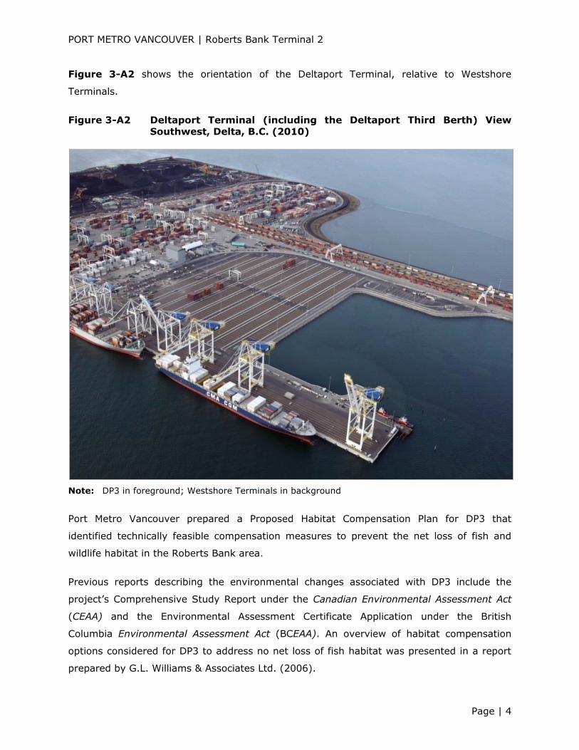
Figure 3-A2 shows the orientation of the Deltaport Terminal, relative to Westshore
Terminals.
Figure 3-A2 Deltaport Terminal (including the Deltaport Third Berth) View Southwest, Delta, B.C. (2010)
Note: DP3 in foreground; Westshore Terminals in background
Port Metro Vancouver prepared a Proposed Habitat Compensation Plan for DP3 that
identified technically feasible compensation measures to prevent the net loss of fish and
wildlife habitat in the Roberts Bank area.
Previous reports describing the environmental changes associated with DP3 include the
project’s Comprehensive Study Report under the Canadian Environmental Assessment Act
(CEAA) and the Environmental Assessment Certificate Application under the British
Columbia Environmental Assessment Act (BCEAA). An overview of habitat compensation
options considered for DP3 to address no net loss of fish habitat was presented in a report
prepared by G.L. Williams & Associates Ltd. (2006).

PORT METRO VANCOUVER | Roberts Bank Terminal 2
Page | 5
The DP3 Adaptive Management Strategy provided for an annual monitoring program
to facilitate the identification, management, prevention, and mitigation of effects to the
inter-causeway ecosystem due, directly or indirectly, to DP3 construction. The Adaptive
Management Strategy was developed in conjunction with and approved by Fisheries and
Oceans Canada (DFO) and Environment Canada. A final report was prepared by Hemmera in
2012, which describes the results of studies undertaken following DP3 construction,
documenting environmental conditions on Roberts Bank with respect to coastal
geomorphology, surface water quality, sediment quality, eelgrass, benthic invertebrates,
and coastal seabirds.
Deltaport Terminal, operated by Global Container Terminals (GCT), pursuant to a lease with
PMV, currently provides 10 high-speed Super Post-Panamax dock gantry cranes, a modern
fleet of container-handling equipment, and an 8-track, on-dock rail intermodal yard
(TSI Terminal Systems Inc. 2014).
3-A 1.4 Deltaport Terminal Road and Rail Improvement Project
As a part of its Container Capacity Improvement Program, PMV is working with the Province
of B.C., including BCR Properties, Ltd., a subsidiary of the British Columbia Railway
Company, a Crown Corporation, and Global Container Terminals, to implement DTRRIP. This
project will increase the terminal’s container capacity through improvements to existing port
infrastructure. Project components include:
DTRRIP Overpass - an overpass on the existing Roberts Bank causeway to separate
road and rail traffic. Under construction since March 2013, the overpass opened in
fall 2014 and consists of elevated roadways connecting Deltaport Way to Roberts
Bank Way (North and South) east of the Deltaport intermodal yard, and entirely
within the footprint of the existing Roberts Bank causeway;
Terminal Improvements - reconfiguration of rail tracks, additional container-handling
equipment, and modernisation of equipment at the Deltaport container terminal.
Improvements include the addition and realignment of rail tracks to increase the
capacity of the intermodal yard within the existing footprint;
Railway Improvements – Placement of additional rail track within the existing railway
corridor and immediately adjacent lands; and
Road Improvements on and adjacent to Deltaport Way – road works to improve the
movement of container trucks at Deltaport include weigh-in motion scales, and a
vehicle access control system gate.

PORT METRO VANCOUVER | Roberts Bank Terminal 2
Page | 6
A screening-level environmental assessment pursuant to CEAA was initiated for DTRRIP in
October 2011. In July 2012, when the Canadian Environmental Assessment Act, 2012
(CEAA 2012) came into force, CEAA was repealed. Since the DTRRIP scope did not include
any activities described within the regulations associated with CEAA 2012 (i.e., Regulation
Designating Physical Activities) it was no longer subject to review under CEAA 2012. Port
Metro Vancouver continued the environmental assessment review and public participation
process in order to meet the requirements of CEAA 2012 and PMV’s own Environment
Policy. In November 2012, DTRRIP was authorised to proceed.
Construction of the DTRRIP overpass has been underway for more than a year and has
therefore contributed to existing conditions in the Project assessment area up to April 2014.
As it is anticipated that construction of the overpass and other DTRRIP components will be
completed by 2016, this construction and the project’s operations will contribute to
expected conditions prior to the anticipated commencement of RBT2 in 2018.
3-A 1.5 Roberts Bank Rail Corridor Program
Trains bound for the Roberts Bank terminals travel through the Tsawwassen First Nation
(TFN) community and the municipalities of Delta, Surrey, White Rock, City of Langley, and
Township of Langley along the RBRC (RBRC n.d.). The corridor, which connects the Roberts
Bank terminals with the international rail network, consists primarily of a single rail track
and approximately 66 road-rail crossings (i.e., 12 overpasses, 38 public street-level
crossings, and 16 private street-level crossings) (TransLink 2014). By 2021, increases are
anticipated in the number and length of trains, and the volume of daily vehicle crossings
along the 70-km-long RBRC due to overall growth in marine terminal throughput and
increasing population (TransLink 2014).
The RBRC Program, which involves 9 projects to improve rail operation and road network
efficiency, is sponsored by 12 funding partners representing local, regional, provincial, and
federal governments, as well as private industry. The projects include eight overpasses and
one new railway siding. In addition, a Railway Crossing Information System is planned to
complement these projects by providing up to nine signs located at decision points on major
roads in the cities of Langley and Surrey and in the Township of Langley to help drivers
make informed choices when planning their route around railway crossings. The signs will
provide information regarding the status of at-grade crossings, allowing drivers to minimise
travel delays by rerouting to one of the new overpass crossings.

PORT METRO VANCOUVER | Roberts Bank Terminal 2
Page | 7
Three of the RBRC’s program components were completed as of April 2014, as follows
(TransLink 2014):
41B Street Rail Overpass at Deltaport Way – Completed in December 2011 to
minimise traffic delays and train whistling in the area and facilitate any potential
future expansion of the Gulf Rail Yard for staging and building of trains bound for
Deltaport Terminal;
80th Street Rail Overpass - Completed in June 2012 to minimise traffic delays while
providing direct access to Boundary Bay Airport and the surrounding industrial lands.
The project included repaving of 72nd Street and 80th Street and installation of a new
signalised intersection at Ladner Trunk Road and 72nd Street and an advanced
warning system on Ladner Trunk Road; and
232nd Street Overpass - Completed in March 2014 to connect communities north of
Highway 1, including the eastern section of Walnut Grove and Fort Langley, with
other parts of Langley. A street-level crossing of the Canadian Pacific Railway
(CP Rail) tracks was replaced by a two-lane overpass, allowing for the potential
westward extension of Canadian National Railway Company’s Rawlison rail siding into
CP Rail’s Page Subdivision. The overpass eliminates the requirement for train
whistling between Glover Road and River Road, increases public safety, and reduces
traffic delays.
The remaining RBRC program components, under construction during EIS preparation and
scheduled for completion in late 2014, are described below with respect to projects
contributing to expected conditions.
3-A 1.6 Highway 17
Led by the B.C. Ministry of Transportation and Infrastructure and completed in December
2013, Highway 17 (formerly known as South Fraser Perimeter Project) is a 40-km, four-lane
highway that extends from the BC Ferries Terminal in southwest Delta to 176th Street
(Highway 15) in Surrey, with connections to Highways 1, 15, 17A, 91, and 99. The new
highway facilitates the separation of local and regional traffic and reduces regional traffic on
the local and municipal road network.
The South Fraser Perimeter Road Project was subject to a harmonised provincial and federal
environmental review. The Application for an Environmental Assessment Certificate under
BCEAA and Screening-level Environmental Assessment Report under CEAA recommended
mitigation to address species-specific and site-specific effects to wildlife values, including
wildlife values on agricultural land, connectivity between upland, forest, and river, wetland
PORT METRO VANCOUVER | Roberts Bank Terminal 2
Page | 8
areas, Burns Bog, provincially Red- and Blue-listed plant communities1, and sensitive
species (i.e., barn owl, sandhill crane). Residual effects were anticipated with respect to air
quality, wildlife, vegetation, fisheries, and noise.
3-A 1.7 BP Cherry Point Refinery, Washington State, U.S.A.
Operating since 1971 and situated approximately 11 km south of the Canada-U.S.A. border,
BP's Cherry Point Refinery in Blaine, Washington processes more than 34 million litres of
crude oil per day, primarily to produce transportation fuels. Crude oil is delivered to the site
by tanker, as well as by pipeline. Finished products are transported offsite by pipeline,
marine barge, or tanker and truck. The facility’s contribution to existing conditions in the
RBT2 assessment area was considered with respect to air quality (see Section 9.2 Air
Quality).
3-A 2 ACTIVITIES CONTRIBUTING TO EXISTING CONDITIONS
Activities that have been or were being carried out as of April 2014 and have contributed to
existing conditions in the RBT2 assessment area include the following:
Aboriginal fishing and shellfish harvest (Section 3-A 2.1);
Aboriginal hunting (Section 3-A 2.2);
Aboriginal plant gathering (Section 3-A 2.3);
Aboriginal cultural use (Section 3-A 2.4);
Agriculture (Section 3-A 2.5);
Boundary Bay Airport (Section 3-A 2.6);
Commercial fishing (Section 3-A 2.7);
Land-based transportation (Section 3-A 2.8);
Marine vessel traffic (Section 3-A 2.9); and
Outdoor recreation and tourism (Section 3-A 2.10).
An overview description of each of these activities is presented below:
1 Refer to Section 10.0 Biophysical Setting for provincially listed species definitions.

PORT METRO VANCOUVER | Roberts Bank Terminal 2
Page | 9
3-A 2.1 Aboriginal Fishing and Shellfish Harvest
Aboriginal fishing and marine harvest activities for food, social and ceremonial purposes are
long-standing activities in the Roberts Bank area (see Section 16.0 Ongoing Productivity
of Commercial, Recreational, and Aboriginal Fisheries and Section 32.2.4 Potential
or Established Aboriginal and Treaty Rights and Related Interests, Current Use of
Lands and Resources for Traditional Purposes Assessment, Existing Conditions).
3-A 2.2 Aboriginal Hunting
A description of Aboriginal hunting activities in the Roberts Bank area is provided in
Section 32.2.4.
3-A 2.3 Aboriginal Plant Gathering
A description of Aboriginal plant-gathering activities in the Roberts Bank area is provided in
Section 32.2.4.
3-A 2.4 Aboriginal Cultural Use
A description of Aboriginal cultural use activities in the Roberts Bank area is provided in
Section 32.2.4.
3-A 2.5 Agriculture
Lands in B.C. with agricultural potential are protected in the Agricultural Land Reserve, a
provincial zone in which agriculture is recognised as the priority use. As of 2010, more than
half of the lands within the municipal boundaries of the Corporation of Delta were contained
in the Agricultural Land Reserve.
3-A 2.6 Boundary Bay Airport
Owned by the Corporation of Delta and operated under lease by Alpha Aviation Inc., the
Boundary Bay Airport consists of two runways, an air-traffic control tower and a terminal
complex that operate seven days per week, year-round. The airport is located on Boundary
Bay, approximately 12.5 km northeast of the Roberts Bank terminals. Air traffic involves
more than 200,000 takeoffs and landings per year (Boundary Bay Airport 2014). General
aviation operations include flight training schools and flying clubs that provide flying lessons
and aircraft rentals. The Boundary Bay Airport’s contribution to existing conditions in the
RBT2 assessment area was considered with respect to air quality (Section 9.2 Air Quality)
and coastal birds (Section 15.0 Coastal Birds).

PORT METRO VANCOUVER | Roberts Bank Terminal 2
Page | 10
3-A 2.7 Commercial Fishing
Commercial fishing activities in the Roberts Bank area include salmon and crab harvesting.
The commercial salmon fishery targets sockeye salmon primarily and pink salmon
occasionally. Fisheries and Oceans Canada’s licensing areas vary by gear type for
commercial salmon fishing; the Roberts Bank area lies within the boundaries of Salmon
Gillnet Area E and Salmon Seine Area B.
Waters in the vicinity of Roberts Bank lie within the southernmost part of DFO’s Area I crab
management area, which extends northwards to the English Bay, Howe Sound, and
Sunshine Coast areas. There are 32 crab licences in Area I, 29 of which are commercial
licences (limited entry and vessel-based) and three of which are communal commercial
licences (Aboriginal groups). Dungeness crab is the main target species.
3-A 2.8 Land-Based Transportation
Land-based transportation infrastructure and use has contributed to existing conditions in
the Project’s assessment area. The use of and vehicle volumes associated with this
infrastructure is provided in Appendix 4-D Roberts Bank Traffic Data Matrix.
3-A 2.9 Marine Vessel Traffic
Commercial vessel traffic transiting waters within PMV jurisdiction, including Roberts Bank,
includes the following vessel types:
Container ships;
General cargo ships;
Crude oil and product tankers;
Chemical, gas, and bulk carriers;
Tank and cargo barges;
Ferries;
Fishing vessels;
Tugs; and
Cruise ships.
Annual ship traffic at Roberts Bank in 2012 comprised 15,626 vessel movements (one-way
movements), including 540 movements for Westshore Terminals, 538 movements for
Deltaport Terminal, and 14,548 B.C. Ferries movements (see Section 4.0 Project

PORT METRO VANCOUVER | Roberts Bank Terminal 2
Page | 11
Description, Figure 4-27 Ship Traffic – Annual Ship Movements for 2012 and
2030). Detailed information regarding marine vessel traffic near Roberts Bank, including
route descriptions and approach characteristics, is provided in Appendix 30-A Marine
Vessel Incidence Prediction Inputs to the Quantitative Risk Assessment.
3-A 2.10 Outdoor Recreation and Tourism
Existing marine-based recreational and tourism activities in the Roberts Bank area include
sailing, kayaking, windsurfing, kiteboarding, motor boating, crab harvesting, salmon fishing,
ecotours, and whale watching. The latter activities are focused on southern resident killer
whales, as well as transient killer whales and humpback whales.
Existing land-based recreational activities in the Roberts Bank area include walking, cycling,
bird watching, nature study, photography, use of recreational areas such as parks, and
hunting of migratory birds. The latter activity also occurs from boats.
3-A 3 PROJECTS CONTRIBUTING TO EXPECTED CONDITIONS
Projects that will have been carried out prior to RBT2 commencement in 2018 and will
contribute to expected conditions in the RBT2 assessment area include the following:
Westshore Terminals – Terminal Infrastructure Reinvestment Project (Section 3-A
3.1);
DTRRIP (Section 3-A 3.2);
RBRC Program (Section 3-A 3.3);
Tsawwassen Mills and Power Centre Project and Tsawwassen Commons Project
(Section 3-A 3.4);
Tsawwassen Gateway Logistics Centre Project and Container Examination Facility
(Section 3-A 3.5);
TFN Sewage Treatment Plant Project (Section 3-A 3.6);
Tsawwassen Springs Development (Section 3-A 3.7);
Tsawwassen Shores Development Phases 1 and 2 (Section 3-A 3.8);
Neptune Coal Handling Capacity Expansion Project (Section 3-A 3.9);
Pacific Coast Terminals Expansion and Improvement Project (Section 3-A 3.10);
and
Richardson International Grain Storage Capacity Project (Section 3-A 3.11).
PORT METRO VANCOUVER | Roberts Bank Terminal 2
Page | 12
An overview description of each of these projects is presented below. Refer to Figure 3-10
Projects Contributing to Expected Conditions for project locations.
Since the nature and level of existing activities is not anticipated to change prior to 2018,
only projects (not activities) were considered to have contributed to the expected
conditions case.
3-A 3.1 Westshore Terminals - Terminal Infrastructure Reinvestment Project
In spring 2014, Westshore Terminals Ltd. initiated its Terminal Infrastructure Reinvestment
Project to be carried out at the existing Westshore Terminals. The Environmental Impact
Assessment for the Terminal Infrastructure Reinvestment Project (SNC-Lavalin 2013)
provides detailed information on the existing facility, the project components to be replaced
or installed, potential environmental effects, and the mitigation measures to be used to
avoid or reduce these effects. Key project components include the following:
Relocation and construction of a new consolidated office and shop building;
Removal of the existing office, shops, and warehouse complex, and expansion of the
coal stockpile in the vacated footprint;
Replacement of the shiploader at berth one;
Replacement of three stacker-reclaimers;
Conveyor upgrades; and
Replacement and upgrade of other equipment to improve operational efficiencies,
atmospheric emissions, and dust control.
These activities will allow the terminal’s annual throughput capacity to increase by 3 Mt,
bringing the terminal’s maximum annual capacity to 36 Mt. Project completion is scheduled
for 2018.
3-A 3.2 Deltaport Terminal Road and Rail Improvement Project
The DTRRIP project construction will continue through 2016, and therefore will contribute to
expected conditions prior to Project commencement in 2018.
PORT METRO VANCOUVER | Roberts Bank Terminal 2
Page | 13
3-A 3.3 Roberts Bank Rail Corridor Program
The RBRC program and the three program components completed prior to April 2014 are
described above with respect to projects contributing to existing conditions. Remaining
program components, under construction during EIS preparation and to be completed prior
to RBT2 commencement, include the following (TransLink 2014):
Combo Project (196th Street Overpass, 192nd Street Overpass, and 54th Avenue East-
West Connector Projects) – Located in the City of Surrey and the City of Langley,
construction of these projects began in early 2012. Each project involves the
development of a new overpass that will reduce traffic delays associated with train
transits along the RBRC, resulting in reduced vehicle idling and associated emissions.
Panorama Ridge Whistle Cessation Project – In combination with other initiatives,
including the gating of the 148th Street crossing and upgraded protection at a series
of rail crossings, this project will contribute to the elimination of train whistling. The
project involves the closure of an at-grade rail crossing at 131A Street and a private
crossing near 138th Street, access road upgrades, and at-grade crossing
improvements, as well as development of an uninterrupted railway siding to extend
from Mud Bay eastward to 144th Street.
152nd Street Rail Overpass Project – Due to population growth, traffic along
152nd Street between South Surrey and White Rock is expected to double to nearly
40,000 vehicles per day by 2021. This project will contribute to the elimination of
train whistling along the RBRC corridor through Surrey.
Mufford and 64th Avenue at Highway 10 – Construction of an overpass across the CP
Rail tracks will eliminate an at-grade rail crossing. Coupled with other improvements
to the 64th Avenue corridor, road network connectivity, reliability, and access to
Glover Road and Highway 10 will be improved, reducing traffic delays and congestion
and improving response times for emergency vehicles.
3-A 3.4 Tsawwassen Mills and Power Centre Project and Tsawwassen Commons
Project
The Tsawwassen First Nation Economic Development Corporation, in partnership with
Ivanhoe Cambridge, is developing a new shopping centre (48 ha), referred to as the
Tsawwassen Mills and Power Centre, on the north side of Highway 17 and 52nd Street in
Delta, B.C., northeast of the B.C. Ferries Terminal causeway. The development will include
approximately 167,225 m2 for retail, office, entertainment, and other uses. The enclosed
mall area will be approximately 108,000 m2 with the remaining land area to be used for
parking (Tsawwassen First Nation Economic Development Corporation 2011).
PORT METRO VANCOUVER | Roberts Bank Terminal 2
Page | 14
The Tsawwassen First Nation Economic Development Corporation is also involved in the
development of the Tsawwassen Commons, an outdoor retail complex (23 ha) located
immediately adjacent to the Tsawwassen Mills and Power Centre. This development, which
is being undertaken in partnership with the Property Development Group, will include retail
outlets, restaurants, and financial service providers. The total building area in the
Tsawwassen Commons will be approximately 53,000 m2. A collector road will be built as an
access road between the Tsawwassen Mills and Power Centre and Tsawwassen Commons
developments.
Environmental and socio-community changes associated with the construction of these
developments, which will be carried out between January 2014 and spring 2016, will
contribute to expected conditions in the RBT2 assessment area. These changes include but
are not limited to loss of agricultural land, and increased atmospheric emissions and noise
levels. By 2018, the two shopping centres will have been in operation for approximately two
years. It is therefore assumed that changes associated with their operation (e.g., increased
atmospheric emissions, noise and light levels, and traffic) will also contribute to the
expected conditions temporal case.
3-A 3.5 Tsawwassen Gateway Logistics Centre Project and Container
Examination Facility
The Tsawwassen First Nation Economic Development Corporation, in partnership with the
Government of Canada and a private partner, is developing a logistics centre on a 135-ha
site south of Deltaport Way in Delta, B.C. Under the TFN Zoning Regulation, the project
lands are zoned for a wide range of industrial land uses (Tsawwassen First Nation Economic
Development Corporation 2011).
Work on the Tsawwassen Gateway Logistics Centre, which will include a container storage
yard, container examination facility, rail-served warehouse, truck plaza, office space, and
utility services, began in June 2010 and is ongoing. The container examination facility, to be
operated by the Canadian Border Services Agency, will provide for customs inspection of
imported containers arriving at Roberts Bank.
3-A 3.6 Tsawwassen First Nation Sewage Treatment Plant Project
To be completed in 2015, the TFN Sewage Treatment Plant will be situated on 1.6 ha in the
TFN Industrial Park, north of 27b Avenue, in Delta, B.C. As of March 2014, construction was
underway and preloading site preparation activities had been completed (TFN 2014). Key
PORT METRO VANCOUVER | Roberts Bank Terminal 2
Page | 15
components of the new treatment plant include administration, process and workshop
buildings, plus pump stations and associated infrastructure. The project’s contribution to
expected conditions relates to air quality during construction (see Section 9.2 Air Quality)
and water quality (see Section 9.7 Marine Water Quality). The plant, with a design
capacity of approximately 8,000 m³ per day and tertiary treatment capability, will
accommodate anticipated growth associated with the commercial, industrial, and residential
developments underway and planned for the TFN Lands. It will replace a smaller treatment
plant that currently services the Tsawwassen First Nation community.
3-A 3.7 Tsawwassen Springs Development
Under construction since 2012, this 55.4-ha residential development will include
296 condominiums and 194 detached houses on privately owned land located southeast of
Highway 17 and west of 52nd Street in Delta, B.C. (Tsawwassen Springs 2014). The
development is to include amenities for seniors, a clubhouse, a new golf course, and
upgrades to an existing golf course. Buildings will be Leadership in Energy and
Environmental Design-certified, and the golf course will be certified under the Audubon
Cooperative Sanctuary Society, which requires the provision of wildlife habitats,
conservation and protection of water quality, reduced chemical use, protection of
environmental quality, and conservation of natural resources. The project is being
developed by Shato Holdings and Talisman Homes, and is scheduled for completion in 2016
(Shato Holdings Ltd. 2014).
3-A 3.8 Tsawwassen Shores Phases 1 and 2
This project is a master-planned community (190 ha) on TFN Lands that is being developed
by Aquilini Development and Construction Inc. (Aquilini), in partnership with TFN. The
new community will consist of 2,200 homes with an estimated population of 5,200
(Aquilini 2014). The master plan provides for a village centre with commercial facilities, a
library and community market, administration and community support services, green
space, and an elementary school for 400 students. The development is to be constructed on
land designated for residential use and commercial enterprise and residential use under the
TFN Land Use Plan (AECOM 2009). Construction is scheduled for completion in fall and
winter 2015 (Aquilini 2014).
PORT METRO VANCOUVER | Roberts Bank Terminal 2
Page | 16
3-A 3.9 Neptune Terminals Coal Handling Capacity Expansion
In January 2013, Neptune Terminals received a PMV project permit to increase its capacity
to handle metallurgical coal at its existing terminal on the north side of Burrard Inlet in the
City of North Vancouver. All work, including the installation of a second railcar dumper, new
conveyors to unload coal from trains and additional rail track, replacement of an existing
shiploader, and reinforcement of the berth one foundation, is being conducted within the
existing facility footprint. The project will increase the terminal’s export capacity from 12 Mt
to 18 Mt annually (PMV 2014). Upon project completion in spring 2015, approximately one
additional ship per week will call on the terminal.
3-A 3.10 Pacific Coast Terminals Expansion and Improvement Project
In April 2014, Pacific Coast Terminals Co. Ltd. signed a long-term contract with K+S Potash
Canada General Partnership to provide handling, storage, and ship loading of potash
products to be transported by rail from the company’s Legacy mine site in Saskatchewan.
Modifications and upgrades are underway at the Pacific Coast Terminal on Port Moody Arm,
Burrard Inlet, Port Moody, B.C. to provide terminal facilities and capacity.
Project completion is scheduled for fall 2016. The project is expected to result in an increase
of approximately two ship calls per week.
3-A 3.11 Richardson International Grain Storage Capacity Project
In May 2013, PMV issued a project permit to Richardson International Limited for the
addition of a concrete Grain Storage Annex (capacity for 80,000 t) at the company’s Burrard
Inlet terminal in the City of North Vancouver to increase grain storage capacity. The
terminal currently handles approximately 3 Mt of grain and oilseeds per year and is a major
exporter of canola and cereal grains (Richardson International Limited 2013a, b). The
increased storage capacity will increase the terminal’s handling capacity to more than 5 Mt
per year. Richardson International expects to complete project construction by November
2015. The terminal is capable of loading Panamax-sized vessels (65,000 to 70,000 t).
No increases to vessel traffic are expected due to this project.
PORT METRO VANCOUVER | Roberts Bank Terminal 2
Page | 17
3-A 4 REFERENCES
AECOM. 2009. Tsawwassen First Nation Land Use Plan. Prepared for Tsawwassen First Nation.
Available at http://www.tsawwassenfirstnation.com/pdfs/TFN-About/Information-
Centre/Strategic-Planning/TFN_Land_Use_Plan.pdf. Accessed July 2014.
Aquilini Development and Construction Inc. (Aquilini). 2014. Tsawwassen Shores - In the
News. Available at http://www.tsawwassenshores.com/news/. Accessed July 2014.
Boundary Bay Airport. 2014. Boundary Bay Air Services. Boundary Bay Airport CZBB.
Available at http://www.czbb.com/. Accessed July 2014.
G.L. Williams & Associates Ltd. 2006. Vancouver Port Authority Deltaport Third Berth
Proposed Habitat Compensation. Prepared for Vancouver Port Authority, Container
Development Group, Vancouver, B.C. Available at
http://www.ceaa.gc.ca/050/documents/16097/16097E.pdf. Accessed July 2014.
Hemmera. 2012. Final Report: Adaptive Management Strategy 2012 Annual Report
Deltaport Third Berth, Delta, BC. Prepared for Vancouver Port Authority. Available at
http://www.portmetrovancouver.com/docs/default-source/projects-deltaport-third-
berth-project/ams-2012-annual-report.pdf?sfvrsn=0. Accessed May 2014.
Port Metro Vancouver (PMV). 2014. Neptune Terminal Upgrades. Available at
http://www.portmetrovancouver.com/en/projects/ongoingprojects/Tenant-Led-
Projects/NeptuneTerminals.aspx. Accessed July 2014.
Richardson International Limited. 2013a. Richardson International Proposed Grain Storage
Project Alternatives Report. Available at
http://www.richardson.ca/uploads/ck/files/Alternatives%20Report%20FINAL.pdf.
Accessed July 2014.
Richardson International Limited. 2013b. Vancouver Terminal Grain Storage Project. Available
at http://www.richardson.ca/news/vancouver-grain-terminal. Accessed July 2014.
Roberts Bank Rail Corridor (RBRC). n.d. The Roberts Bank Rail Corridor. Available at
http://www.robertsbankrailcorridor.ca/application/www.robertsbankrailcorridor.ca/as
set/upload/tiny_mce/page/link/152-Boards.pdf. Accessed July 2014.
Shato Holdings Ltd. 2014. Tsawwassen Springs - A Whole New Kind of Community. Available at
http://residential.tsawwassensprings.ca/tsawwassen/. Accessed July 2014.
PORT METRO VANCOUVER | Roberts Bank Terminal 2
Page | 18
SNC-Lavalin. 2013. Environmental Impact Assessment for the Terminal Infrastructure
Reinvestment Project. Port Metro Vancouver, Vancouver, B.C. Available at
http://www.westshore.com/pdf/misc/eia-12052013-report.pdf. Accessed July 2014.
TransLink. 2014. Roberts Bank Rail Corridor Program. Available at
http://www.robertsbankrailcorridor.ca/home. Accessed July 2014.
Tsawwassen First Nation Economic Development Corporation. 2011. Proposed Mixed Use
Development for Tsawwassen First Nation Lands. Available at
http://www.newswire.ca/en/story/768273/proposed-mixed-use-development-for-
tsawwassen-first-nation-lands. Accessed July 2014.
Tsawwassen First Nation. 2014. Tsawwassen First Nation Sewage Treatment Plant. Community
Notice. Weekly Issue - Thursday, March 16, 2014. Available at
http://www.tsawwassenfirstnation.com/pdfs/TFN-About/Information-
Centre/Newsletters/Community-Notice/03.06.14_tfncommnotice.pdf. Accessed July
2014.
Tsawwassen Springs. 2014. Tsawwassen Springs Resort Community: The Masterplan. Available
at http://residential.tsawwassensprings.ca/masterplan/. Accessed July 2014.
TSI Terminal Systems Inc. 2014. Deltaport. Available at
http://www.tsi.bc.ca/content/deltaport>. Accessed July 2014.
Westshore Terminals Ltd. 2014. The Terminal. Available at http://www.westshore.com/.
Accessed July 2014.