Embed Size (px)
Citation preview


Consolidated Comments on SPL-2008-00816-MB Page 2
Table of Contents Application comments Regarding Jurisdictional Waters of the US (WOUS) Regarding Floodplain management On Hydrology, Sediment, and Engineering Design On Effect on Wetlands Regarding impacts on species Regarding impacts to Historic, Cultural, Scenic and Recreational Values and Associated Impacts Comments regarding Section 404(b)(1) Alternative Analysis Comments on Monitoring Plan Comment on Habitat Mitigation Plan (HMP) Comments on Permit Conditions, Groundwater Monitoring, Cleanup Responsibilities, Closure and Post-Closure, and Funding Appendices A. Concerns about Stormwater and Hydrology Methods B. Comparison of Stream Lengths C. 10-year Floodplain Modeling D. Specific Concerns about Rosemont’s Hydrologic Inputs E. Concerns about the Use of the PSIAC Method for Alternatives Analysis of Soil Erosion Impacts F. Complete testimony of Dr. Tom Myers on behalf of Save the Scenic Santa Ritas G. Davidson Canyon Hydrologic, Hydraulic, and Geomorphic Scope of Work H. Principles and Recommendations for Selection of Compensatory Mitigation Lands

Consolidated Comments on SPL-2008-00816-MB Page 3
Pima County and Pima County Regional Flood Control District have provided herein consolidated comments to the U. S. Army Corps (Corps) of Engineers regarding the Rosemont Copper Mine (SPL-2008-00816-MB) In preparing these comments, staff reviewed the following documents:
Draft Environmental Impact Statement for the Rosemont Copper Project (hereafter referred to as Forest Service DEIS)
US Army Corps Application for Permit (hereafter referred to as
Application)
CWA Section 404(b)(1) Alternatives Analysis (SPL-2008-00816-MB) Westland Resources, September 2011 (Appendix B of the Forest Service DEIS, hereafter referred to as 404(b)(1) Analysis) DEIS Monitoring Plan (Appendix B, Forest Service DEIS) Habitat Monitoring Plan (HMP) Westland Resources, September 2011 (Appendix E of the Forest Service DEIS, hereafter referred to as HMP)
First, we present comments on the validity of the analysis provided in the 404 Application in evaluating the areas described in 33 CFR 320.4. These include comments on the determination of Waters of the United States (WOUS), and specific technical comments on the 404 application and related documents. Then we review the 404(b)(1) Analysis, and mitigation and monitoring plans (Appendices B and E of the DEIS) . Application comments regarding Jurisdictional WOUS 1. The methods used to determine the area of impacts to the Waters of the US (WOUS) are not specifically stated, and should not be assumed to be accurate. The values in Table 2 are integral for determining impacts, however the actual methods used to estimate the WOUS are not provided. While the reader may assume that these values are the areas between the Ordinary High Water Mark (OHWM), the methods used to identify the OHWM are not stated. 2. The jurisdictional limits on headwater streams are probably greatly underestimated in the application. Many first- and second-order streams are visible in an independently mapped stream delineation presented below and in Appendix C.

Consolidated Comments on SPL-2008-00816-MB Page 4
Figure 1. MPO in orange at left, Preferred (Barrel) Alternative in pink at right. Mine access road is shown as part of the footprint for both. Figure provided by Pima County IT. Delineation of stream centerlines based on stero-photographs suggests that many headwaters streams were not analyzed in the Application, nor delineated by Westlands in their preliminary jurisdictional determinations (JD). Over 100 miles of streams would be directly affected by the Mine Plan of Operations, (Figure 1; shown at left). An equal number of stream-miles would be affected by the Forest’s Preferred Alternative (Barrel), shown at right. By contrast, Westland’s preliminary JD would predict only 36 miles of impact from the MPO and 34 miles of impact from the Barrel alternative. See Appendix C for methods used in this analysis by Dr. Robert Casavant, Arizona State Parks, with assistance from Pima County. 3. The permit application appears to greatly underestimate the widths of WOUS. An estimate of the area of WOUS based on the limits of the 10-yr floodplains yields 116 acres which is approximately three times larger than the 38.6 acre estimate provided in the permit application. In Pima County, the limits of the 10-yr floodplain are often used as an approximation for the limits of the ordinary high water mark. The analysis described in this document in Appendix D shows that this criterion results in much higher acreage than those in the permit application and DEIS. Furthermore, the analysis in Appendix D did not estimate 10-yr floodplain areas for the tributary watersheds mentioned above, so the area of the 10-yr floodplains is actually greater than the 116 acres calculated. In addition to the lack of documentation on the establishment of jurisdictional limits to determine impacts to WOUS, these are preliminary JDs. As such, for the purposes of computation of impacts, compensatory mitigation requirements, and other resource protection measures, a permit decision made on the basis of a preliminary JD will treat all waters and wetlands that would be affected in any

Consolidated Comments on SPL-2008-00816-MB Page 5
way by the permitted activity on the site as if they are jurisdictional waters of the U.S.1 In general, Regulatory Guidance Letter 08-02, states that an approved JDs should be used to support individual permit application. Request: Develop and use approved JDs. This is warranted because of the scope
of the proposed mining operation and environmental impacts and the likelihood that the Application grossly underestimates potential impacts to WOUS.
Comments regarding 33 CFR 320.4 (l) Floodplain management
1. The 404 application is for an alternative that does not minimize impact of the proposed activity, therefore the application should not be considered.
According to 33 CFR 320.4 (l) 3
‘….the district engineer should avoid authorizing floodplain developments whenever practicable alternatives exist outside the floodplain. If there are no such practicable alternatives, the district engineer shall consider, as a means of mitigation, alternatives within the floodplain which will lessen any significant adverse impact to the floodplain.’
Given the significant errors and impacts we identified above with regard to jurisdictional delineations, we believe the alternative proposed in the Application does not meet the criteria for lessening significant adverse impact to the floodplain and should not be considered for this permit. We see no substantive difference between the Preferred Alternative and the Mine Plan of Operation in terms of minimizing impacts of the proposed activity. In addition, Table 87 presented in the DEIS indicates that impacts to the WOUS are greater for the application (Preferred Alternative) than for the Scholefield-McCleary Alternative. 2. If the application is considered in its present state, it should be denied because the Barrel Alternative is incompletely characterized, and therefore cannot be evaluated. On page 3 of the Corps Application, it is noted “The applicant has submitted a Section 404 permit application for the Preferred Alternative (Alternative 4 under the Draft EIS), which has been identified as the preferred alternative in the Draft EIS.” 1 U.S. Army Corps of Engineers, Regulatory Guidance Letter 08-02, Jurisdictional Determinations, 2008.

Consolidated Comments on SPL-2008-00816-MB Page 6
However, there was insufficient definition of the Preferred Alternative to allow a meaningful review of environmental impacts resulting from implementation of this preferred alternative. Figure 3 of the Application, and Figure 14 of the Forest Service DEIS (Chapter 2, page 58), simply show layout views of this alternative, void of any contouring or stormwater management system information for the massive tailing and waste rock disposal mounds. Turning back to the figure which overlays the Preferred alternative on the stereo-interpreted streams, it can be seen that there are additional streams outside the footprint that would be impounded by the Barrel landform. Effects on these streams would increase the 100 miles of effects that we identified, even without further information on stormwater management for the Preferred alternative. For an enormous industrial complex which is proposed to permanently impact thousands of acres of Forest Service land, the lack of design plans to adequately review this alternative from development, closure, post-closure, mitigation, and cumulative impacts perspectives is unacceptable. Requests: Provide a GRADING AND DRAINAGE PLAN for the Preferred Alternative,
with appropriate sections and details for development of the tailings and waste rock disposal mounds
Provide a STORMWATER MANAGEMENT PLAN for the Preferred
Alternative, which clearly shows perimeter drainage channels, surface water flow direction, planned retention / detention basins and pools on the final cover system and disposal mound side slopes, and all planned Perimeter Containment Areas where surface water will be trapped against the base slope of the tailings and waste rock disposal mounds.
Provide PHASING PLANS which show the development sequencing of
the mine for the Preferred Alternative, to include at a minimum clear development and reclamation activities for the following periods of mining: 1yr, 2yr, 5yr, 10yr, 15 yr, 20yr, and 25 yr
Require a new individual 404 application be submitted to extend mining
beyond the proposed 20 year term, and mining reclamation beyond the 25-year term.
3. The methodology used to evaluate stormwater impacts within the DEIS is not compatible with the methods recognized by the Pima County Regional Flood Control District (District) which is the regulatory agency for floodplains on private lands in Pima County, so the results cannot be accurately used to evaluate the effect of the proposed alternative on floodplains.

Consolidated Comments on SPL-2008-00816-MB Page 7
Concerns about the methodology as they relate to the values used in the 404 application are described in Appendix A of this document. The actual justification for much of the methodology used is provided in technical memos written by Tetra Tech, Rosemont’s hydrology consultant. Appendix A summarizes the District’s concerns about hydrologic methods and addresses some of the responses to the concerns raised by Tetra Tech. Appendix B summarizes the District’s concerns about the specific values used as inputs to the hydrologic models. 4. Identify floodplain impacts associated with improvements needed to Highway 83 from Interstate Highway 10 to the mine turnoff. The application does not fully account for dredge and fill that will be needed to correct deficient vertical and horizontal sight-lines on Highway 83 for safe travel. Corrections will require an as-yet unquantified discharge of fill into WOUS, including Davidson Canyon and its tributaries. Application Comments on Hydrology, Sediment, and Engineering Design 1. The Pit Diversion Channel, Permanent Diversion Channel, and Plant Site Stormwater Features may be undersized because they were not designed using appropriately conservative hydrology assumptions. The pit and stormwater features were designed by using a 100-yr 24-hr storm event (Tetra Tech, 2010, Site Water Management Update for the Rosemont Copper Project). The 404 application cited that “In general, project water management facilities are intended to have sufficient capacity to handle runoff generated from 100-year, 24-hour storm events”. This indicates that they used 100-yr, 24-hr storm as Probable Maximum Precipitation (PMP). The application is flawed for two reasons. First, the hydrologic analysis is not based on the methods recommended by Pima County (See Appendix A) . Secondly, 100-yr, 24-hr storms are not appropriate for the maximum volume calculation. This is because multi-day volumes can substantially exceed single-day return-period rainfall values. Because of the higher elevation and orographic effect in the project site, multiple day storms are common in mountain areas of southern Arizona. For example, a rainfall depth with a recurrence interval of about five years caused the floods on July 31, 2006 that exceeded the 100-year estimates, largely as a result of saturated soil conditions created by five days of rainfall prior to July 31 (Griffiths et al., 2009; Magirl, et al., 2007). Similarly, a major flooding occurred on the largest river in southern Arizona, the Santa Cruz River, on Oct 1, 1983, after several days of rainfall. Additionally, the PMP selection is inconsistent with Technical Memorandum “Rosemont Hydrology Method Justification” (Tetra Tech, 2010). In the Memorandum, Tetra Tech selected 72-hr storm for General PMP and 6-hour storm for local PMP. Runoff volume produced by the 72-hr or 6-hr PMP is larger

Consolidated Comments on SPL-2008-00816-MB Page 8
than the 100-yr, 24-hr storm runoff volume. Tetra Tech should explain why the PMPs (larger runoff volume) were not used to size the stormwater management features. Pit diversion channel, permanent diversion channel and ponds should be sized to handle volumes generated by multi-day storms, and estimated by using appropriate parameters. The mine is critical because after the mine closes, many of the drainage features will remain, and we need to be assured that they will be stable in perpetuity. Request: Use the 72-hour storm event as the PMP for design of the above-
mentioned features. 2. The location and operation of Compliance Point Dam is inadequate The following definition is provided on page 7 of the Application: “The Compliance Point Dam is a six-ft high, porous, rock-fill structure where additional sediment controls will be applied as necessary to manage stormwater quality and where stormwater samples will be taken.” Within the Forest Service DEIS (p 340), it is noted the compliance point dam forms a “final sediment pond located at the outlet of Barrel Canyon” For all alternatives, the rock-fill structure would be constructed of large inert waste rock. The capacity of the compliance point dam is only two acre feet, suggesting it may be overtopped frequently. Based upon Figure 3 of the CORPS Application, it appears that all of the flow-through and finger drain system would discharge toward this pond. In addition, a significant area of the tailings and waste rock disposal mound also must drain to the compliance point dam, but there is not sufficient enough information presented to evaluate this amount (see Comment 2 above). The location of the Compliance Point Dam as shown on Figure 3 is unacceptable, because it does not provide for the systematic assessment, monitoring, and sediment control of surface waters within Trail Canyon which emanate from the proposed Waste Rock Disposal Mound covering the head of Trail Canyon. Requests: Relocate the Compliance Point Dam shown on Figure 3 to account for
stormwater leaving the proposed Waste Rock Disposal Mound covering the head of Trail Canyon.
Alternately, design a second Compliance Point Dam (#2) to be dedicated
to Trail Canyon, which provides for the necessary management of stormwater quality and where stormwater samples can be taken.
For both the shown Compliance Point Dam, and a probable Compliance

Consolidated Comments on SPL-2008-00816-MB Page 9
Point Dam #2, provide the following: delineation of watershed areas, and hydrologic calculations which demonstrate under what size stormwater flow event would the dam(s) be expected to overtop.
3. The sediment control facilities were designed using a method inappropriate for estimating sediment production from mining sites. The PSIAC method (Pacific Inter Agency Committee - PSIAC, 1968) used for this analysis (p.6) is inappropriate because it is a scoring method that does not explicitly recognize site conditions and changes in site conditions resulting from disturbance (like mining) in the analysis. Because it does not recognize the effect of site disturbance, it cannot be used to evaluate alternatives that specifically involve evaluating the impact of site disturbance. Additionally, the impacts of the projects on sediment yield were estimated simply based on changes in the contributing watershed areas. It is highly unlikely that sediment yield would decrease proportionally to a decrease in the contributing watershed area. Instead, it is expected that loss of vegetation cover, dredging or filling resulting from the proposed mining activities will increase erosion rate or sediment yield from the project site. Additional specific concerns about the PSIAC method and the need to use a method like the Revised Universal Soil Loss Equation (RUSLE) for mining (Toy and Foster, 1998) are summarized in Appendix E. 4. The flow-through drains are inappropriate for this use are not adequately sized and cannot remain in perpetuity without maintenance. Flow-through drains will be used to transport stormwater across the site (p.7). The drains were designed by using hydrologic methods (Rosemont Flow-Through Drain Sedimentation Analysis, Tetra Tech, 2010) that the District has determined to be inappropriate as described in Appendices A and B. As cited in the Tetra Tech Memo, the drain systems are supposed to be designed to convey the local and general PMP events. The PMPs used to size the flow-through drain are inconsistent with the results of Technical Memorandum “Rosemont Hydrology Method Justification” (Tetra Tech, 2010). In the “Rosemont Hydrology Method Justification”, Tetra Tech selected 72-hr storm event for General PMP and 6-hour storm event for local PMP. Runoff volume produced by the 72-hr or 6-hr PMP is larger than the 100-yr, 24-hr storm runoff volume. However, the flow-through drains were designed by using a 100-yr 24-hr storm event, as explained in the 404 application, which indicates that they are under-sized. Furthermore, there is a question about maintenance of the drains. Neither the 404 application nor the Rosemont Flow-Through Drain Sedimentation Analysis, discussed the necessity of maintenance over time. While they would have a sedimentation pond sized for the 10-yr event, sediment moved by larger events would be substantially greater than the 10-yr event, which suggests that these basins would be under-sized even for normal operation of a mine that is

Consolidated Comments on SPL-2008-00816-MB Page 10
expected to operate for 20 years. Because there are no plans described for maintenance of the sedimentation ponds, they can expect to fill and cease to function, at which time, the drains would receive the upstream sediment. Over time they are likely to be clogged by sediment from upstream, and the drains would lose a function to convey storm flow and sediment. This situation is reasonably expected at the entrance to all the flow-through drains, particularly in association with adjacent stormwater basins. The use of a geotextile filter fabric at the drain inlet ponding areas / rock drain interface is not sufficient to allow for long-term operation of the flow-through system, and will not stop blockage at the entrance due to sediment buildup. Similarly, the use of a graded rock filter may assist in passing water into the drain entrance, but will not stop the eventual clogging of the entrance due to fine sediment buildup. This can only be accomplished by mechanical removal of accumulated sediment which will block the entrances to the flow-through drains. In addition, water storage in the ponds are predicted to last up to one month in duration following significant storm events, with water surface elevations rising to heights which significantly cover the entrances to the flow-through drain features (Reclamation and Closure Plan – Fig. 16) and cause direct seepage into the stacked tailings materials. Simply put, implementation of the proposed Flow-Through Drain System at the proposed Rosemont Copper Mine is ultimately a fatal flaw. The design function of this earthen-material system will cease in the future – it is only a question of when, not if. Failure of these engineered systems will adversely impact WOUS and the ecosystem downstream of the mine site, in Barrel Canyon, Davidson Canyon and likely Cienega Creek. Requests: Discuss what occurs if the flow exceeds the capacity of these three flow-
through drains, or if the volume detained at their respective entrances exceeds the available storage capacity.
Provide for public comment a Monitoring, Maintenance, and Contingency
Plan for the Flow-Through Drain System so that both Augusta Resources, the Forest Service, and the public are fully aware of the measures to be taken regarding the operation of this sub-drain system below massive, permanent Tailings and Waste Rock Disposal Mounds. Include a long-term monitoring and maintenance plan to ensure the proper function of the flow-through drains in perpetuity.
The above Plan must identify who will be responsible for the monitoring,

Consolidated Comments on SPL-2008-00816-MB Page 11
maintenance, and repair of the flow-through drain system when Rosemont Copper completes their post-mining reclamation work and leaves the project site. The Plan must identify and evaluate the likely effectiveness of any proposed responses.
When the flow-through drains fail to function and pass water, as they will
at some time in the future, identify a contingency action to be taken as part of the above plan to provide for the proper operation of the flow-through drain system.
Provide for remedial actions to be taken if drains fail and proper operation
cannot be addressed through contingency actions. Provide specific examples where flow-through drain systems, in the size
and tributary configuration the proposed system beneath the Tailings and Waste Rock Disposal Mound, have been successfully implemented at mining sites for periods of 10-20 years, 20-40 years, and 40+ years.
On Figure 9 of the Application, label the South Main and South 1 flow-
through drains, and identify/label the flow-through drain located between the South Main and South 1 drains (South 2?).
On Figure 9 of the Application, properly label the North Finger Drain,
which is now labeled the South Finger Drain. On Figure 10 of the Application, show tailings material completely
covering all flow-through drain sections. The notes provided are unclear, in part due to a lack of a longitudinal section(s) showing construction sequencing. Provide longitudinal sections to better exhibit the nature and construction of the flow-through drains.
Provide plans and sections showing the entrance design and setting for
the three primary flow-through drain systems (South 1, South 2? and the PWTS flow-through drains) which are proposed to transfer surface water completely through the Tailings Disposal Mound.
Provide a map showing mining post-closure watersheds for the three
primary flow-through drains (South 1, South 2?, and the PWTS flow-through drains). Provide watershed calculations for these three drains, and show wet area due to the 100-yr storm event. Provide calculations showing storage and drainage times for these three drains, including the cumulative effects of a 100-yr storm event followed by a 25-yr storm event.
Consolidated Comments on SPL-2008-00816-MB Page 12
5. Supporting information about the design of rock chutes does not support the design, which indicates the chutes may not be stable. The analysis for the “Waste Rock Storage Area and Dry Stack Tailings Facility” (p.7) was done by Tetra Tech (Rosemont Flow-Through Drain Sedimentation Analysis, 2010). Tetra Tech used Agricultural Research Station (ARS) methods (Robinson et al., 1998) to design the rock chutes. The ARS study was based on the flume experiment using rocks with median sizes (D50) from 15 to 278 mm (0.6 to 11 inches). According to the Tetra Tech’s Technical Memo, it appears that the D50 used for the analysis is 16.2 inches. This is outside the range of the rock size used for the ARS experiment. The ARS paper clearly noted that “caution should be exercised if equation 1 or 2 is applied outside the data base from which they were developed”. Request: Tetra Tech should provide qualitative analysis to show the proposed riprap
protection will not fail. 6. The statement that channel realignment will not affect downstream flows is unsupported. The 404 application cited that the channel realignment will not result in the modification of downstream flows and no technical support was provided (p.8). It is uncertain how it is assessed. Without quantitative analyses, the conclusion of “no effects to downstream” is not reliable. Hydrology / Engineering References Stewart, DS and Canfield HE. 2009. Curve Number Determination. Internal Memo to File
10/02/2009, Pima County Regional Flood Control District Griffiths, P. G., Magirl, C. S., Webb, R. H., and Pytlak, E., 2009. Spatial distribution and
frequency of precipitation during an extreme event: July 2006 mesoscale convective complexes and floods in southeastern Arizona. Water Resour. Res., 45, W07419.
Magirl, C. S., et al. 2007. Impacts of recent Arizona storms. EOS Trans. AGU, 88(17), 191–193. Pacific Southwest Interagency Committee (PSIAC). 1968. Report of the Management Committee,
Factors Affecting Sediment Yield and Measures for Reduction of Erosion and Sediment Yield.
Rasely, RC. 1991. Proposed Revision of the Sediment Yield Procedure Pacific Southwest
Interagency Committee Report of the Water Management Subcommittee, 1968. Upper Colorado River Basin Rangeland Salinity Control Project, Salt Lake City, UT. U.S. Department of Agriculture, Natural Resources Conservation Service, 17 p.
Renard KG and Stone JJ. 1981. Estimating Erosion and Sediment Yield from Rangeland.
Proceedings of the Symposium on Watershed Management, ASCE, Boise, Idaho, July 21-23, 1980
Robinson, K. M., Rice, C. E., Kadavy, K. C., 1998. Design of Rock Chutes. American Society of
Agricultural Engineers, Vol 41, 3, 621-626.

Consolidated Comments on SPL-2008-00816-MB Page 13
Tetra Tech, 2010. Site Water Management Update for the Rosemont Copper Project. Technical Memorandum
Tetra Tech, 2010. Rosemont Hydrology Method Justification. Technical Memorandum Tetra Tech, 2009. Rosemont Copper Project Design Storm and Precipitation Data/Design
Criteria. Technical Memorandum Tetra Tech, 2010. Rosemont Flow-Through Drain Sedimentation Analysis. Technical
Memorandum Tetra tech, 2011. Response to PCRFCD Comments Regarding Hydrology. Technical
Memorandum Thomas, B.E., H.W. Hjalmarson, and S.D. Waltemeyer. 1997. Methods for Estimating Magnitude
and Frequency of Floods in the Southwestern United States. USGS Water Supply Paper 2433. 195 p.
Toy T. and Foster, G. 1998. Guidelines for the Use of the Revised Universal Soil Loss Equation
(RUSLE) Version 1.06 on Mined Lands, Construction Sites and Reclamation Lands: J.R. Galetovic (Technical Coordinator), the Office of Technology Transfer, Western Regional Coordinating Center, Office of Surface Mining.
Application Comments regarding 33 CFR 320.4 (b) Effect on wetlands.
1. The proposed mining operation will significantly impact springs and spring-related wetlands, but the applicant fails to disclose the full extent of those impacts. Wetlands associated with springs are one of the most important natural features in desert environments. This is certainly true on and near-to the site of the proposed Rosemont Mine. According to SWCA (2011), the original springs assessment done by Westland Resources Inc (2007) was insufficient and therefore warranted the collection of more data. The 2011 report by SWCA did advance an important new framework for understand potential impacts of the proposed mine on a larger set of springs and seeps (as compared to the WestLand effort), but did not provide additional field data; instead they relied on a host of data sources with known problems of accuracy. Requests: In light of the guidance established by the U.S. Corps of Engineers after
the Rapanos decision, impacts to springs must be part of the significant nexus analysis to assess flow characteristics and functions if activities will affect the chemical, physical and biological integrity of downstream waters. Significant nexus includes hydrologic and ecologic factors including groundwater where such waters feed surface flows.2
2 U.S. Army Corps of Engineers, Clean Water Act Jurisdiction Following the U.S. Supreme Court’s decision in Rapanos b. United States & Carabell v. United States, December 2, 2008.

Consolidated Comments on SPL-2008-00816-MB Page 14
The validity of the results reported in the 2011 SWCA report must be
verified with additional field data, especially investigation of the geological setting of each spring and at least a point-in-time inventory of spring flow and key water-quality parameters. Only then can such data be used with confidence.
The 404 Application should specifically consider the impacts to Scholefield
Spring and Rosemont Spring. These sites are specifically recognized, but no attempt is made to quantify impacts on these sites (or the 10 additional springs identified in table 61 of the DEIS) at all.
Other impacts to springs need to be also considered. Desert mountain
springs habitats are home to unique species and provide a relatively stable source of water for desert fauna including large mammals. Groundwater modeling has identified significant impacts will occur due to mining operations and groundwater pumping that will reduce or eliminate flows at these springs. These mining activities will impact the native fracture limestone rock and associated groundwater flow will thus directly and indirectly impact to downstream surface flows including springs.
2. Specifically consider the impacts on other waters and wetlands located downstream or downgradient from the site.
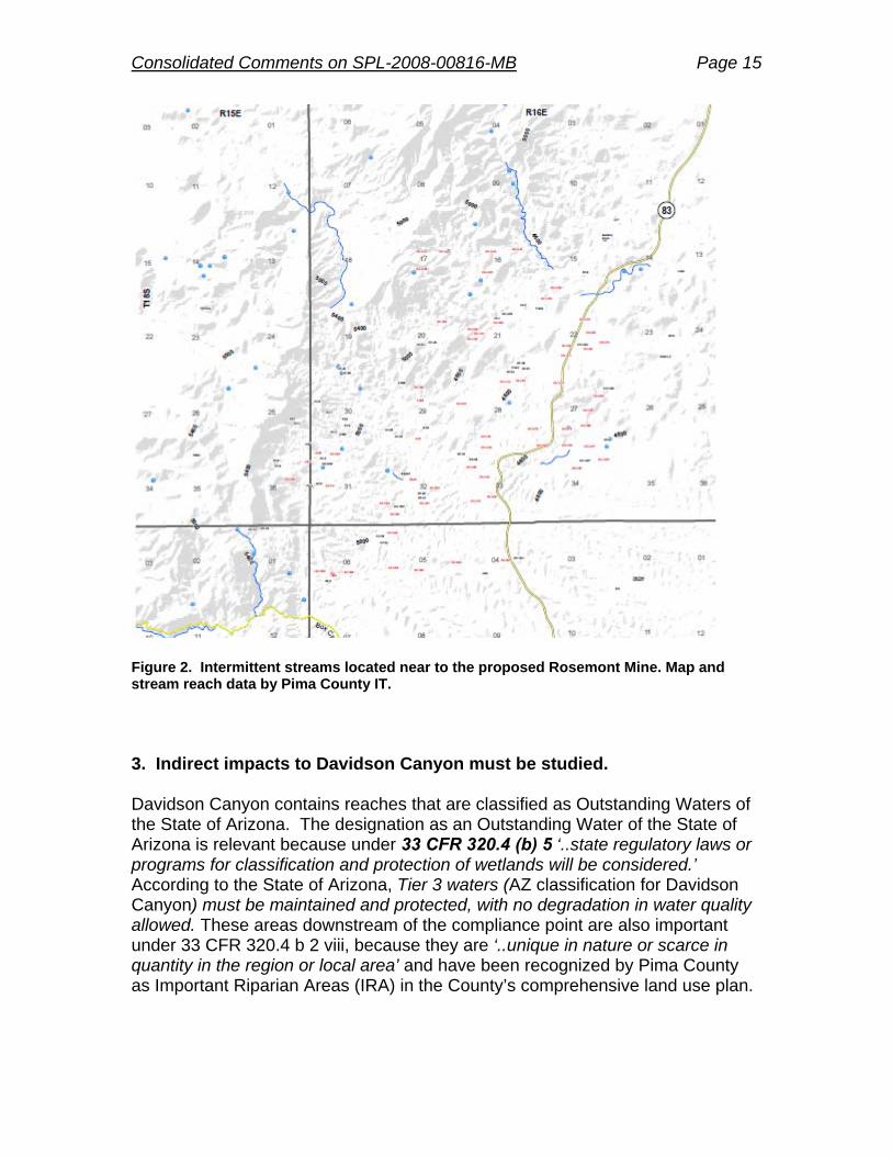
The discussion provided by Rosemont Copper considered only impacts within the proposed footprint of the mine and associated activities, and not on waters and wetlands downgradient from the open pit. As part of the Sonoran Desert Conservation Plan, intermittent and perennial streams were inventoried in Pima County by Pima Association of Governments and subsequently by Pima County. Pima County has identified that there are intermittent streams in the area that could be affected indirectly by the project, including Box Canyon, Sycamore Canyon, Mulberry, and Barrel Wash and certain other tributaries (see Figure 2 for the locations of intermittent stream reaches).
Consolidated Comments on SPL-2008-00816-MB Page 15
Figure 2. Intermittent streams located near to the proposed Rosemont Mine. Map and stream reach data by Pima County IT.
3. Indirect impacts to Davidson Canyon must be studied.
Davidson Canyon contains reaches that are classified as Outstanding Waters of the State of Arizona. The designation as an Outstanding Water of the State of Arizona is relevant because under 33 CFR 320.4 (b) 5 ‘..state regulatory laws or programs for classification and protection of wetlands will be considered.’ According to the State of Arizona, Tier 3 waters (AZ classification for Davidson Canyon) must be maintained and protected, with no degradation in water quality allowed. These areas downstream of the compliance point are also important under 33 CFR 320.4 b 2 viii, because they are ‘..unique in nature or scarce in quantity in the region or local area’ and have been recognized by Pima County as Important Riparian Areas (IRA) in the County’s comprehensive land use plan.
Consolidated Comments on SPL-2008-00816-MB Page 16
Over the period of the mine’s development, the 8.2 square mile watershed upstream of the compliance point, in the headwaters of Davidson Canyon, will be modified to retain most of the runoff. Since the entire Davidson Canyon Watershed is only 50.5 square miles, the modifications in the upper portions of the watershed are likely to have significant impact on the Outstanding Waters, especially the frequency of runoff (most likely small storms will be retained and not discharged to downstream).
Furthermore, the 404 application used the PSIAC method (Pacific Inter Agency Committee - PSIAC, 1968) to assess sediment delivery. First, this method is not appropriate. The issues are summarized below. Please see Appendix E of this document for details. The PSIAC method is not capable of analyzing sediment transport. Proposed and alternative plans will change the stream sediment delivery system. Most likely aggradation (deposition) and degradation (scour) patterns in streams will be changed. Sediment transport analysis is necessary to assess the impact of the proposed mining activities on sediment transport. As cited in the DEIS, changes in sediment delivery to portions of Barrel and Davidson canyons downstream of the US Geological Survey gaging station have the potential to cause aggradation or scour, thereby affecting riparian areas in the reaches designated as Outstanding Arizona Waters. The potential impacts to Outstanding Waters are clearly cited in the Draft Environmental Statement (DEIS), Page 338, Line 1-3. As mentioned above, Davidson Canyon contains reaches that are classified as Outstanding Waters of the State of Arizona. Therefore, the analysis of sediment transportation for Davidson Canyon is required, throughout the Outstanding Waters reaches.
Request: Evaluate potential impacts on “Outstanding Waters” using the attached
scope of work (Appendix G) to qualitatively and quantitatively analyze the impacts of proposed mining activities on volume, frequency, and magnitude of runoff to Davidson Canyon. Pima County requests the applicant to complete the analysis before the application is resubmitted.
Evaluate the potential effects of sulfate emanating from the tailings to
affect wetlands, including the potential to increase tamarisk abundance in affected areas. Complete the analysis before the application is re-submitted.
Application Comments with regard to impacts on species (Clean Water Act 33 CFR 320.4 (c), Endangered Species Act, and Fish and Wildlife Coordination Act) The proposed activities will have effects—both direct and indirect—on plants and animals that are directly connected to (or rely on) WOUS for their survival,

Consolidated Comments on SPL-2008-00816-MB Page 17
reproduction, and habitat. In general, the application fails to adequately disclose the full extent of the proposed activities’ effects. By way of the following analysis, there is clearly sufficient information available to enable a more thorough examination and quantification of impacts, which should be completed before any regulatory determination is made. This analysis focuses on direct mortality, habitat loss and degradation, and disturbance and displacement of individuals representing species that rely on the Waters of the United States. In addition to impacts during the life of the mine (estimated to be 20 years), the long-term impacts of climate change are also discussed because they will magnify the mine’s impact on species and their habitats over longer time periods. Below is a brief introduction to the range of anticipated impacts on species, in general, followed by an in-depth, species-specific analysis for riparian and aquatic species including how they are likely to be impacted by the proposed mining operation. Before presenting a species-specific analysis, it is important to provide a context for evaluating the link between a resource that is important to a species and the proposed mining operation. In the broadest sense, habitat is a species-specific term that represents the sum of the resources and conditions in an area that promote occupancy by a given species (Hall et. al. 1997). Therefore, habitat includes characteristics of water (e.g., volume, oxygen concentration), vegetation (e.g., cover, species, heterogeneity), elevation, prey, soils, tolerance to noise and disturbance, and even human-made features. 1.1 Direct Mortality Direct mortality will impact species that can not escape the mechanisms of active landform change including blasting, land clearing, and access to and from the proposed activities. The proposed mining operation will likely result in the direct mortality of individuals representing aquatic species of concern, most importantly the Chiricahua leopard frog, Arizona giant sedge and other species that live in around the springs and stock ponds that will be impacted by the proposed activity. 1.2 Ground Disturbance and Habitat Loss Assuming that total backfill of the mine pit will not be undertaken, the proposed activities (exclusive of the water and transmission lines) will result in the permanent loss of approximately 3,786 acres—or 5.9 square miles—of natural landscape and associated habitat elements for species, including 511 acres of Important Riparian Areas, as defined by the County’s Conservation Land System (Pima County 2000) and replace it with an artificial landscape that has little or no appreciable habitat value for native species. The inclusion of the transmission lines (with a 500-foot buffer) will add an additional 787 acres of impacts, bringing the total loss to 4,573 acres, which is equal to 7.1 square miles.

Consolidated Comments on SPL-2008-00816-MB Page 18
To quantify direct, on-site destruction of habitat, Pima County ran a geographical information system analysis of the preferred alternatives for the mine and transmission lines and then quantified habitat loss for aquatic and riparian species based on the number of acres of modeled habitat from the County’s Sonoran Desert Conservation Plan process (RECON Environmental Inc. 2000). The results of this analysis are in Table 1 below. Table 1. Number of acres of modeled habitat for riparian and aquatic species that are projected to be lost as a result of the proposed mine and power line operations. For this analysis we combined low, medium, and high potential habitat (RECON Environmental Inc. 2000).
Species Acres of Habitat
Impacted
Abert's towhee 600.1 Bell's vireo 600.1 Chiricahua leopard frog 4,208.4 Gila chub 0.2 Gila topminnow 0.2 Huachuca water umbel 1.01 Longfin dace 0.2 Lowland leopard frog 932.1 Southwestern willow flycatcher 36.7 Western red bat 4,506.4 Western yellow-billed cuckoo 176.6
1.3 Indirect Impacts to Habitat In most cases, determining a link between changes in a species of interest and a habitat element is both well understood and definable, such as the predictable impact to birds when vegetation characteristics change (e.g., Carothers et. al. 1974, Mills et. al. 1991, Destefano and Mccloskey 1997, Holmes and Sherry 2001), or when aquatic species come in contact with compromised water-quality characteristics (e.g., Dixit et. al. 1999, Rouse et. al. 1999, Barber et. al. 2006). Other times, changes in a non-habitat feature of the environment can have cascading impacts to habitat, then to species. An excellent example—and one that is applicable to the Rosemont situation—is the impact that reduced subsurface water flows will have on species. Specifically, the impact of short-term loss of water into the headwaters of Davidson Canyon (due to diversion and use in the mining operation) and after-mining drawdown of the regional aquifer (to form the pit lake) will impact a host of riparian species in Davidson Canyon and Cienega Creek. These impacts will occur because of the well-understood connection between the depth of the shallow aquifer and aquifer-dependant plants in desert systems; plants that will die or become stressed if the aquifer level drops below a threshold. This well-documented threshold for the dominant species such as cottonwood and willow (Salix spp.) is about 3m to water (Lite and Stromberg 2005). Depths to a shallow aquifer that exceed 3m will, in turn,

Consolidated Comments on SPL-2008-00816-MB Page 19
have a predictable and negative impact on riparian and aquatic bird species (Brand et. al. 2010) such as those that are found in Cienega Creek (e.g., yellow-billed cuckoo, summer tanager, southwestern willow flycatcher). For this reason, the analysis in Table 1 underestimates the number of acres of habitat that will be impacted by the mining operations, because for many of the aquatic and riparian species of interest to the County, the off-site impacts to habitat are likely to exceed the impacts at the mine site. 1.4 Behavioral Disturbance to Individuals Impacts to species are not always related to direct mortality to individuals or disturbance of habitat. The proposed mining activities will disturb the behavior of individuals, from relatively minor and short-term changes in behavior (e.g., increased heart rate) to more serious and persistent long-term disturbances that can affect reproductive success, survival, and habitat occupancy, which in turn can reduce population viability, especially for rare, threatened, or endangered species (e.g., Riffell et. al. 1996, Steidl and Anthony 1996, Miller et. al. 1998). 1.5. Impacts of Climate Change on Species and their Habitat At least a 5.4°F increase in global temperatures is expected in the next 100 years (Meehl et. al. 2007). Most models predict a 10-20% reduction in precipitation in the Southwest region in the next 75 years (Christensen et. al. 2007), with most reductions in precipitation during the winter months. This will leave southern Arizona more arid, particularly during years when La Niña patterns predominate (Seager et. al. 2007). Recent work by The Nature Conservancy indicates that moisture stress (annual evaporation minus precipitation) from 1970-2006 led to an effective decrease in precipitation of approximately 0.4 inches over much of Pima County (Rob Marshall, unpublished data). Moisture stress will increase in the coming decades. This increase in temperature and lower precipitation will lead to a further reduction in habitat, particularly for species that rely on ephemeral and perennial creeks, springs, and seeps (Fonseca and Connolly 2002) because of reduced runoff and recharge (Powell 2010). These resources are especially critical for aquatic invertebrates as well as fish, amphibians (e.g., lowland and Chiricahua leopard frogs), bats, and other wildlife that requires water sources and thermal cover for their life-history functions (Pounds et. al. 1999, Kirkpatrick et. al. 2007). The proposed Rosemont Mine presents two challenges to species with regards to climate change. First, the mine will produce an enormous quantity of climate-changing fossil fuels during all stages of its development and operation. Second, any analysis of the effect of the Rosemont operation on aquatic and riparian species must take into consideration that climate change will intensify the impacts of the proposed mining operation on water resources. For example, the dewatering of the regional aquifer as a result of the pit lake will be

Consolidated Comments on SPL-2008-00816-MB Page 20
more extensive because evaporation rates from the lake will increase as temperatures increase. Transpiration requirements for the maintenance of riparian plants will also increase. These indirect effects of climate change were not given sufficient attention in the mine’s impact on water resources and the species that rely on these valuable water resources. We have attempted to qualify the impacts of climate change on the species of interest to Pima County in Table 2. Table 2. Potential impacts of climate change on a select group of riparian and/or aquatic species which are anticipated to be impacted by the proposed Rosemont mining operation. The impacts below are in addition to—and not inclusive of— short-term and long-term impacts resulting from the Rosemont mine. More general impacts may include increased incidence of pests, diseases (e.g., West Nile virus), pathogens, and heat/moisture stress. Species Potential Direct and Indirect Impacts from climate change Huachuca water umbel (Lilaeopsis schaffneriana var. recurva)
Habitat altered or lost by drought and scouring floods
Arizona giant sedge (Carex ultra)
Loss or degradation of springs and seeps.
Coleman’s coral root (Hexalectrs colemanii)
Loss of oaks (due to a retreat of oaks upslope) which are important to create cool, moist microclimate for this species, will lead to shift in the elevation range of this species. It is not clear if habitat is available for this species in the upper reaches of the watersheds that will not be directly impacted by mining
Western red bat (Lasourus blossevillii)
Loss or degradation of mesic riparian vegetation along Cienega Creek from drought; possible change in phenology of insect prey
Western yellow-billed cuckoo (Coccyzus americanus)
Mesic riparian habitat along Cienega Creek may be lost due to flooding (i.e., scour) and prolonged drought; lack of synchrony with critical food sources during chick rearing
Southwestern willow flycatcher (Empidonax traillii extimus)
Mesic riparian habitat along Cienega Creek may be lost due to flooding (i.e., scour) and prolonged drought; increased heat stress; lack of synchrony with food sources during chick rearing
Abert’s towhee (Pipilo aberti) Riparian habitat along Davidson and Cienega Creek may be lost due to prolonged drought; lack of synchrony with food sources during chick rearing
Bell’s vireo (Vireo bellii) Riparian habitat may be lost in some areas due to prolonged drought and flooding, but increased in some areas due to increased in shrub density; lack of synchrony with food sources during chick rearing; effects on non-breeding habitat unknown
Longfin dace (Agosia chrysogaster)
Drought conditions will affect water availability and aquatic habitat features; higher temperatures will lead to stress and lower oxygen availability; prey base may change. Positive result of higher temperatures may mean fewer freezing events, thereby reducing mortality.
Gila chub (Gila intermedia) See longfin dace Gila topminnow (Poeciliopsis occidentalis occidentalis)
See longfin dace
Chiricahua leopard frog (Lithobates chiricahensis)
Drought conditions lead to loss of open-water habitat; intense fires in uplands leads to loss of habitat from silt and debris buildup; increased water temperatures. Potential positive effects may be a decrease in chytrid fungus because that disease prefers colder water
Lowland leopard frog (Lithobates yavapaiensis)
See Chiricahua leopard frog
Mexican garter snake (Thamnophis eques megalops)
Drought conditions will affect this species through loss of aquatic habitat and effects on prey species

Consolidated Comments on SPL-2008-00816-MB Page 21
1.6 Species Assessments Using data from the proposed mining operation and the anticipated impacts to range of disturbances highlighted above, Pima County has prepared a set of narratives of the proposed impacts on a suite of species that are of particular importance to Pima County. The County’s interest stems from our pursuit of a Section 10(a)(1)(B) permit from the U.S. Fish and Wildlife Service (Pima County 2010). This permit requires that the County clearly articulate the anticipated impacts and offsetting avoidance, minimization, and mitigation measures associated with the activities associated with the permit (primarily ground-disturbance activities). Many of the County’s mitigation activities for impacts to aquatic and riparian resources are focused on the Cienega Creek Preserve and Bar V Ranch. Because the proposed mine is upstream of both the Preserve and Bar V Ranch, the mine will negatively impact the County’s mitigation efforts for the species covered in the Section 10(a)(1)(B) permit, as well as other plants and animals. The following sections highlight the lack of impact assessment and mitigation consideration that Augusta Resources has provided in the Draft Environmental Impact Statement (DEIS; U.S. Forest Service 2011). 1.6.1. Huachuca Water Umbel. This species is listed as endangered under the Endangered Species Act. It is an aquatic plant that requires permanent water along Cienega Creek and other perennial streams of southeastern Arizona. It will be impacted by the Rosemont Mine because of the diversion of water from Davidson Canyon during mining operations and subsequent dewatering of the regional aquifer to form the pit lake. These actions and consequences will impact habitat for this species. The DEIS states that impacts along Cienega Creek are not expected to occur until about 50 years after project closure but this is an insufficient time horizon for analysis period given that the groundwater impacts of this operation will last for thousands of years (Myers 2010). Rosemont did not conduct surveys for this species (and therefore relies on old location data for the species) nor has a mitigation plan been proposed to offset long-term impacts along Cienega Creek. Because this is a very spatially restricted species, specific and measurable mitigation methods must be established, along with periodic surveys to establish efficacy of those efforts. 1.6.2. Arizona Giant Sedge. This species is found in wet springs and streams and will be impacted by the proposed activities through direct mortality and long-term dewatering of the aquifer at spring and riparian sites. Spring sites where it may be present include: McCleary, MC-1, MC-2, Fig Tree, Sycamore, Helvetia, Peligro Adit, Ruelas, SW, Locust, Deering, Papago, Mulberry, Crucero, Lower Mulberry, Scholefield, SC-2, Barrel, Questa, Davidson, Reach 2, and Escondido. It is unclear from the DEIS where surveys for this species occurred, but it appears likely that only a subset of sites were visited. Impacts to this species were not explored in the DEIS. Rosemont has not conducted sufficient surveys for this species nor have they developed any mitigation strategy this wetland

Consolidated Comments on SPL-2008-00816-MB Page 22
species. These must take place to more fully understand the impacts that the mine will have on this species. 1.6.3. Coleman’s coral root. This xeroriparian species is found under the canopies of oak trees along washes and is associated with a fungus. According to surveys for this species, many individuals were found in McCleary Canyon and a few individual were found in Wasp Canyon (WestLand Resources Inc 2010). This species is being petitioned for listing under the Endangered Species Act. Surveys for this species were sufficient to document presence, but the population adjacent to the proposed mine represent the largest population of the species and is likely to be impacted by the proposed mining activity, activities that are mentioned will likely result in a downward trend in the species. Augusta Resources has not suggested any mitigation for this species, which will get serious consideration for listing under the ESA. 1.6.4. Western red bat. This species is primarily associated with broadleaf riparian deciduous forests and woodlands. A population likely occurs along Cienega Creek and Davidson Canyon, though complete regional surveys are lacking for this species. Reducing surface flows into Davidson Canyon and reducing groundwater levels will likely impact the species’ roosting habitat (tall mesoriparian trees) and food supplies (insects), but the species is not given serious consideration in the DEIS. No mitigation plan has been put forth by Rosemont. 1.6.5. Western yellow-billed cuckoo. This meso-riparian obligate species requires large cottonwood and willow trees for nesting and feeding. It has been found nesting at Cienega Creek (Empire Ranch, Davidson Canyon confluence, and Upper Cienega Creek) and has been found on the project site. Impacts to water quantity (and potentially quality) will likely impact this species by way of impacts to the large riparian trees that it needs for nesting as well as its prey base. Insufficient surveys have been conducted on and in the vicinity of proposed mine to determine the status of the population. No mitigation plan has been put forward by Augusta Resources; this must be done, especially considering that this species is a likely candidate for protection under the ESA. 1.6.6. Southwestern willow flycatcher. This meso-riparian species is listed as endangered under the Endangered Species Act. It is known to nest along Cienega Creek and will be impacted by the proposed project as a result of reduced flows in Davidson Canyon and groundwater drawdown. Impacts to water quantity (and potentially quality) will likely effect this species because of impacts to the dense understory and midstory, which it needs for nesting and its prey base. The DEIS states that impacts along Cienega Creek are not expected to occur until about 50 years after project closure but this is an insufficient time horizon for analysis period given that the groundwater impacts of this operation will be indefinite. No mitigation measures have proposed by Augusta Resources for this species.

Consolidated Comments on SPL-2008-00816-MB Page 23
1.6.7. Abert’s towhee. This year-round resident is found along many of the major washes and rivers of eastern Pima County including along Davidson Canyon and Cienega Creek. Habitat features that are important for this species are primarily mesic-riparian and xeric-riparian small trees and shrubs and the vegetation structure in the understory and midstory, which will be impacted by the Rosemont mine due to a loss of water into Davidson Canyon and a reduction of aquifer levels from the pit lake. This species was not analyzed in the DEIS and no mitigation for loss of habitat has been proposed by Augusta Resources. 1.6.8. Bell’s vireo. This migratory bird is found along many of the major washes and rivers of eastern Pima County including along Davidson Canyon and Cienega Creek where its habitat is dense stands of xero-riparian and meso-riparian vegetation, particularly in the understory and midstory. Vegetation species of importance include hackberry, mesquite, and Baccharis. The vireo will be impacted by the Rosemont mine due to a loss of water into Davidson Canyon and a reduction of aquifer levels from the pit lake and subsequent loss of riparian vegetation. This species was not analyzed in the DEIS and no mitigation for loss of habitat has been proposed by Augusta Resources. 1.6.8. Other migratory birds. The DEIS gives scant attention to other riparian and aquatic, migratory bird species that will be impacted by the proposed mining operation. Species include the summer tanager, hepatic tanager, blue grosbeak, and mallard. Additional analysis should be conducted for these species and there should be proposed mitigation measures to conform with the Migratory Bird Treaty Act. 1.6.9. Long-fined dace. This is one of three species of fish that occur in Cienega Creek and which will be impacted by the proposed activities. It is the only one of the three fish species that has been documented in Davidson Canyon (Ehert 2007). This species uses a variety of open-water conditions in creeks, including runs, riffles and pools. Potential impacts for this species are reduced water quality and quantity. Water quality impacts could come from the mine itself through discharge of toxic materials and sediment as well as impacts to parameters such as dissolved oxygen and water temperature, which are regulated, in part, by hydro-riparian emergent vegetation and trees. Habitat impact to these trees (through reduction in groundwater) was not noted in the DEIS. In general, when impacts are noted in the DEIS they are minimized by suggesting that impacts along Cienega Creek are not expected to occur until about 50 years after project closure. This is an insufficient time horizon for analysis period given that groundwater impacts of this operation will be indefinite. Augusta Resources has proposed no mitigation for this species. 1.6.10. Gila topminnow. This is one of three species of fish that occur in Cienega Creek and which will be impacted by the proposed activity. It is listed as Endangered under the Endangered Species Act. This species tolerates a

Consolidated Comments on SPL-2008-00816-MB Page 24
narrower range of conditions than the long-fined dace and uses runs and riffles to a lesser extent. Potential impacts for this species as a result of the proposed activities are primarily reduced water quality and quantity. Water quality impacts could come from the mine itself through discharge of toxic materials and sediment as well as impacts to parameters such as dissolved oxygen and water temperature, which are regulated, in part, by hydro-riparian emergent vegetation and trees. Habitat impact to these trees (through reduction in groundwater) was not noted in the DEIS. In general, when impacts are noted in the DEIS they are minimized by suggesting that impacts along Cienega Creek are not expected to occur until about 50 years after project closure. This is an insufficient time horizon for analysis period given that groundwater impacts of this operation will be indefinite. Augusta Resources has proposed no mitigation for this endangered species. 1.6.11. Gila chub. This is one of three species of fish that occur in Cienega Creek and which will be impacted by the proposed activity. It is listed as Endangered under the Endangered Species Act. This species is primarily found in the deepest pools along Cienega Creek. Potential impacts for this species as a result of the proposed activities are primarily reduced water quality and quantity. Water quality impacts could come from the mine itself through discharge of toxic materials and sediment as well as impacts to parameters such as dissolved oxygen and water temperature, which are regulated, in part, by hydro-riparian emergent vegetation and trees. Habitat impact to these trees (through reduction in groundwater) was not noted in the DEIS. In the DEIS there is first a suggestion that no impacts will occur, then (later) a suggestion that some impact might occur as a result of groundwater drawdown. This fact is minimized by suggesting that impacts along Cienega Creek are not expected to occur until about 50 years after project closure. This is an insufficient time horizon for analysis period given that groundwater impacts of this operation will be indefinite. Augusta Resources has proposed no mitigation for this endangered species. 1.6.12 Chiricahua leopard frog. The Chiricahua leopard frog is listed as Threatened under the Endangered Species Act and has been found at a number of sites on and around the proposed mining site in 2008 and 2009 (WestLand Resources Inc 2008, 2009), including Box Canyon, South Sycamore Canyon, the Lower Stock tank, as well as three areas just east of the proposed mine: East Dam, “Oak Tree Canyon” tank, and Highway Tank. (Surveys were also conducted in 2011, but no data have been reported from that effort.). Earlier surveys—conducted in 1975-76— by Lowe and Johnson (1980), also found what was most likely the Chiricahua leopard frog. The presence of Chiricahua leopard frog in the entire mountain complex suggests that that area of the Santa Rita Mountains is an important metapopulations and currently the U.S. Fish and Wildlife Service is reviewing comments on the species’ proposed critical habitat designation. Based on the

Consolidated Comments on SPL-2008-00816-MB Page 25
historical data from the area and from recent surveys by Augusta’s consultants, Pima County and others have requested that the Rosemont area be considered as critical habitat. Whether or not this request is considered, it still remains that the death of individuals or (more importantly) the loss and degradation of habitat from the proposed mining operations will likely compromise the long-term viability of this species in this part of southern Arizona. Loss of habitat will occur as a result of on-site disturbance of habitat (most of the areas that were mentioned earlier) as well as long-term dewatering of the aquifer to create the pit lake. Individuals dispersing from nearby source populations will die or be displaced if they enter the project site during active operations and over the subsequent thousands of years the pit lake may become a long-term “sink” for the population as individuals dispersing to the lake either die from the toxicity or are trapped in the lake. Rosemont has conducted surveys for this species in and around the proposed mine site, but no mitigation plan has been proposed. This must be completed and because of the site-specific nature of the species (i.e., restricted to small, isolated wetlands), any broader mitigation plan for the project must include specific, measureable objectives for mitigation for this species. 1.6.13 Lowland leopard frog. In general, the lowland leopard frog occurs at lower elevations than its congener, the Chiricahua leopard frog. A population of interest for this analysis occurs along Cienega Creek and occasionally in Davidson Canyon, though complete regional surveys are lacking for this species. Potential impacts for this species as a result of the proposed activities are primarily reduced water quality and quantity. Water quality impacts could come from the mine itself through discharge of toxic materials (or accidental spills) as well as impacts to parameters such as dissolved oxygen and water temperature, which are regulated, in part, by hydro-riparian emergent vegetation and trees. Habitat impact to these trees (through reduction in groundwater) was not noted in the DEIS. Impacts to this species are not directly addressed in the DEIS and no mitigation is proposed. 1.6.14 Northern Mexican garter snake. This species was once common along perennial streams but is now very rare along Cienega Creek, though habitat features important for the species (close proximity to standing water, emergent vegetation, hydro-riparian streamside vegetation, and course woody debris) as well as a robust prey base appear to be present there. There is a high likelihood that this species will be listed under the Endangered Species Act in the coming years. The species will be impacted by the proposed mine through death of individuals, loss and/or pollution of water coming into Cienega Creek and subsequent impacts to habitat features and prey base. Augusta Resources conducted no surveys for this species within the project area or analysis area and has not developed a mitigation plan.

Consolidated Comments on SPL-2008-00816-MB Page 26
Request: This review has highlighted that the proposed mine and its associated
activities, actions, and infrastructure will have a large and permanent impact on species that rely on the WOUS for their survival and reproduction. These impacts are neither fully accounted for in the DEIS or the Application, nor is there any proposed mitigation. These deficiencies must be more fully addressed in a supplemental DEIS to support the issuance of a 404 permit. It may be appropriate for the Corps to consider issuing its own DEIS given the failure of this DEIS to identify, evaluate, avoid, minimize or mitigate these impacts.
Wildlife and Recreation References Barber, L. B., S. H. Keefe, R. C. Antweiler, H. E. Taylor, and R. D. Wass. 2006. Accumulation of
contaminants in fish from wastewater treatment wetlands. Environmental Science & Technology 40:603-611.
Brand, L. A., J. C. Stromberg, D. C. Goodrich, M. D. Dixon, K. Lansey, D. Kang, D. S. Brookshire, and D. J. Cerasale. 2010. Projecting avian response to linked changes in groundwater and riparian floodplain vegetation along a dryland river: a scenario analysis. Ecohydrology 4:130-142.
Carothers, S. W., R. R. Johnson, and S. W. Aitchison. 1974. Population structure and social-organization of southwestern riparian birds. American Zoologist 14:97-108.
Christensen, J. H., B. Hewitson, A. Busuioc, A. Chen, X. Gao, I. Held, R. Jones, R. K. Kolli, W.-T. Kwon, R. Laprise, V. M. Rueda, L. Mearns, C. G. Menéndez, J. Räisänen, A. Rinke, A. Sarr, and P. Whetton.S. Solomon, D. Qin, M. Manning, Z. Chen, M. Marquis, K. B. Averyt, M. Tignor, and H. L. Miller, Eds. 2007. Regional climate projections. In: Climate Change 2007: The Physical Science Basis. Contribution of Working Group I to the Fourth Assessment Report of the Intergovernmental Panel on Climate Change. Cambridge University Press, Cambridge, United Kingdom and New York, NY, USA.
Destefano, S., and J. Mccloskey. 1997. Does vegetation structure limit the distribution of Northern Goshawks in the Oregon Coast ranges? Journal of Raptor Research 31:34-39.
Dixit, S. S., J. P. Smol, D. F. Charles, R. M. Hughes, S. G. Paulsen, and G. B. Collins. 1999. Assessing water quality changes in the lakes of the Northeastern United States using sediment diatoms. Canadian Journal of Fisheries and Aquatic Sciences 56:131-152.
Ehert, S. 2007. Arizona Game and Fish Department trip report: Davidson Canyon. Region 5 Fisheries Program, Arizona Game and Fish Department, Tucson, AZ.
Fonseca, J., and N. Connolly. 2002. Representation of vegetation communities and Special Elements in reserve design. Report to the Pima County Board of Supervisors for the Sonoran Desert Conservation Plan, Tucson, AZ.
Hall, L. S., P. R. Krausman, and M. L. Morrison. 1997. The habitat concept and a plea for standard terminology. Wildlife Society Bulletin 25:173-182.
Holmes, R. T., and T. W. Sherry. 2001. Thirty-year bird population trends in an unfragmented temperate deciduous forest: Importance of habitat change. Auk 118:589-609.
Kirkpatrick, C., C. J. Conway, and D. LaRoche. 2007. Quantifying impacts of groundwater withdrawal on avian communities in desert riparian woodlands of the southwestern U.S. Unpublished report to the Department of Defense, Legacy Resource Management Program, Arlington, VA.
Lite, S. J., and J. C. Stromberg. 2005. Surface water and ground-water thresholds for maintaining Populus-Salix forests, San Pedro River, Arizona. Biological Conservation 125:153-167.
Lowe, C. H., and T. B. Johnson. 1980. Fishes, amphibians, and reptiles of the Rosemont Site. Pages 116-166. In R. Davis and R. R. Callahan, editors. An environmental inventory of the
Consolidated Comments on SPL-2008-00816-MB Page 27
Rosemont area in southern Arizona. Volume I: The present environment. The University of Arizona, Tucson, AZ.
Meehl, G. A., T. F. Stocker, W. D. Collins, P. Friedlingstein, A. T. Gaye, J. M. Gregory, A. Kitoh, R. Knutti, J. M. Murphy, A. Noda, S.C.B. Raper, I. G. Watterson, A. J. Weaver, and Z. C. Zhao.S. Solomon, D. Qin, M. Manning, Z. Chen, M. Marquis, K. B. Averyt, M. Tignor, and H. L. Miller, Eds. 2007. Global Climate Projections. In: Climate Change 2007: The Physical science basis. Contribution of Working Group I to the Fourth Assessment Report of the Intergovernmental Panel on Climate Change. Cambridge University Press, Cambridge, United Kingdom and New York, NY, USA.
Miller, S. G., R. L. Knight, and C. K. Miller. 1998. Influence of recreational trails on breeding bird communities. Ecological Applications 8:162-169.
Mills, G. S., J. B. Dunning, and J. M. Bates. 1991. The relationship between breeding bird density and vegetation volume. Wilson Bulletin 103:468-479.
Myers, T. 2010. Updated groundwater modeling report: Proposed Rosemont Open Pit Mining Project. Technical Memorandum to Pima County and the Pima County Regional Flood Control District.
Pima County. 2000. Draft preliminary Sonoran Desert Conservation Plan. Report to the Pima County Board of Supervisors for the Sonoran Desert Conservation Plan. Tucson, AZ.
Pima County. 2010. Pima County Multiple Species Conservation Plan. Administrative draft report to the U.S. Fish and Wildlife Service and the Pima County Board of Supervisors, Tucson, AZ. Accessed from http://www.pima.gov/cmo/sdcp/MSCP/PDF/12.10/MSCP_AdminDraft_Low_REs.pdf on January 2, 2012.
Pounds, J. A., M. P. L. Fogden, and J. H. Campbell. 1999. Biological response to climate change on a tropical mountain. Nature 398:611-615.
Powell, B. F. 2010. Climate change and natural resources in Pima County: Anticipated impacts and management challenges. Unpublished report of the Pima County Office of Sustainability and Conservation, Tucson, AZ. Accessed on June 10, 2010 at: http://www.pima.gov/cmo/sdcp/reports/d52/Ecological_Impacts.pdf.
RECON Environmental Inc. 2000. Priority vulnerable species: Habitat data analysis. Report to the Pima County Board of Supervisors for the Sonoran Desert Conservation Plan, Tucson, AZ.
Riffell, S. K., K. J. Gutzwiller, and S. H. Anderson. 1996. Does repeated human intrusion cause cumulative declines in avian richness and abundance? Ecological Applications 6:492-505.
Rouse, J. D., C. A. Bishop, and J. Struger. 1999. Nitrogen pollution: An assessment of its threat to amphibian survival. Environmental Health Perspectives 107:799-803.
Seager, R., M. F. Ting, I. Held, Y. Kushnir, J. Lu, G. Vecchi, H. P. Huang, N. Harnik, A. Leetmaa, N. C. Lau, C. H. Li, J. Velez, and N. Naik. 2007. Model projections of an imminent transition to a more arid climate in southwestern North America. Science 316:1181-1184.
Steidl, R. J., and R. G. Anthony. 1996. Responses of bald eagles to human activity during the summer in interior Alaska. Ecological Applications 6:482-491.
SWCA Inc. 2011. Revised springs inventory for Rosemont project area – for Cooperating Agency Draft of DEIS. Memorandum from Chris Garrett, May 31, 2011.
U.S. Forest Service. 2011. Draft Environmental Impact Statement for the Rosemont Copper project: A proposed mining operation, Coronado National Forest, Pima County, Arizona. U.S. Department of Agriculture, Forest Service, Southwestern Region. Document number MB-R3-05-3.
WestLand Resources Inc. 2007. Rosemont project preliminary springs assessment (Issue No. SW-2, Item No.12). Memorandum to the U.S. Forest Service, Coronado National Forest. December 3, 2007.
WestLand Resources Inc. 2008. 2008 Ranid frog survey of the Rosemont holdings and vicinity. Report to Rosemont Copper Company, Tucson, AZ.
WestLand Resources Inc. 2009. 2009 Ranid frog survey of the Rosemont holdings and vicinity. Report to Rosemont Copper Company, Tucson, AZ.
WestLand Resources Inc. 2010. Field surveys for Hexalectris colemanii in southeastern Arizona. Report for the Rosemont Copper Company, Tucson, AZ.

Consolidated Comments on SPL-2008-00816-MB Page 28
Application comments in relation to 33 CFR 320.4 (e) Impacts to Historic, Cultural, Scenic and Recreational Values and Associated Impacts
Historic and Cultural Values Pima County Office of Sustainability and Conservation, Cultural Resources & Historic Preservation Division, has worked extensively with the legal protections for cultural resources that include archaeological sites, historic sites and buildings, and traditional cultural places. We work with the State Historic Preservation Office (SHPO) and the Arizona State Museum (ASM) on an ongoing basis, and we have worked cooperatively with various state and federal land management agencies affected by the Rosemont Mine undertaking. These include the US Forest Service, the Bureau of Land Management (BLM), the Arizona State Land Department (ASLD), and various American Indian Tribes that may have an interest in the project area. We have an interest in cooperating with the Coronado National Forest (CNF) to ensure protections for cultural resources are fully considered in the Environmental Impact Statement as required by the National Environmental Policy Act (NEPA). The Corps is evaluating the potential discharge fill material into Barrel Canyon and associated tributaries including Wasp Canyon, McCleary Canyon, Trail Canyon, and other unnamed ephemeral washes for construction of the proposed Rosemont Copper Project open pit copper mine. The 404 permit application relies heavily upon the Forest’ DEIS for its impact assessment and disclosure of impacts, and defers to actions and decisions that the US Forest Service will make regarding treatment of heritage and cultural resources. The following comments address Rosemont’s proposed open-pit mine in the northern Santa Rita Mountains, Pima County, Arizona as it relates to the mine’s 404 permit application to the Corps. The comments below provide background and comments regarding impacts that will result once the mine is permitted to: (1) cultural resources including archaeological and historic properties; (2) traditional cultural properties, especially Ce:wi Duag to the Tohono O’odham Nation; and (3) sacred sites that include springs and streams and associated resources. Because the Area of Potential effect is not yet defined, the totality of the proposed mine direct, indirect and cumulative impacts on heritage cultural resources is addressed. Background: The issuance of the permit for the Rosemont Mine by the Corps under Section 404 of the Clean Water Act (33 U.S.C. 1344) is a federal action subject to the

Consolidated Comments on SPL-2008-00816-MB Page 29
requirements of the Clean Water Act, and concerning cultural resources, Section 106 of the National Historic Preservation Act, as amended, and its implementing regulations, 36 CFR 800 Part 60. The Rosemont application to the USFS for permitting the mine actions is also subject to NEPA, as implemented by the Council on Environmental Quality regulations, 40 CFR 1500. NEPA recognizes the importance of cultural and historic preservation in its policy statement under Title I. Section 101(b) of the Act states it is:
“...the continuing responsibility of the Federal Government to use all practical means, consistent with other essential considerations of national policy, to improve and coordinate Federal plans, functions, programs, and resources to the end that the Nation may ... preserve important historic, cultural, and natural aspects of our national heritage...”
The permit to develop and operate the Rosemont Mine is a “major federal action significantly affecting the quality of the human environment” (40 CFR 1502.3). The term “Significantly,” as used in NEPA, requires consideration of both context and intensity (40 CFR 1500.27). Context relates to the multiple contexts in which both short and long term effects must be analyzed (society as a whole, the region, affected interests, and the locality). Intensity refers to the severity of the impacts on the quality of the human environment. The regulations establish a number of subjects that should be considered in evaluating intensity including:
“(3) Unique characteristics of the geographic area such as the proximity to historic or cultural resources, park lands, prime farmlands, wetlands, wild and scenic rivers, or ecologically critical area.”
“(8) The degree to which the action may adversely affect districts, sites, highways, structures, or objects listed in or eligible for listing in the National Register of Historic Places or may cause loss or destruction of significant scientific, cultural, or historical resources”(1508.27) The term “effects” includes “ecological, aesthetic, historic, cultural, economic, social or health, whether direct, indirect or cumulative” (40 CFR 1500.8).
The term “human environment” is broadly interpreted to include
“...the natural and physical environment and the relationship of people with that environment.... When an environmental impact statement is prepared and economic or social and natural or physical environmental effects are interrelated, then the environmental impact statement will discuss all of these effects on the human environment.” (40 CFR 1508.14)

Consolidated Comments on SPL-2008-00816-MB Page 30
Thus, in considering the impacts of the proposed permit for the Rosemont Mine on the human environment, the Forest is directed to assess the physical effects to cultural and historical resources and those places that are listed in or eligible for listing in the National Register of Historic Places in accordance with the National Historic Preservation Act (NHPA). The agency, however, must also consider the social effects of its actions on cultural and historical resources as a part of the relationship between people and their environment. This is particularly important in situations where federal actions may affect the relationships between Indian tribes and their cultural landscapes, the consideration of which is consistent with the requirements of Executive Order 12898 on Environmental Justice, Executive Order 13007 on American Indian Sites, and the American Indian Religious Freedom Act.
As proposed, Rosemont Mine would have both physical and social consequences to cultural and historic resources. Because the Tohono O’odham, Hopi, Apache, Pascua Yaqui and other tribes have interests in the area and claims to the region as their ancestral lands, the Rosemont Mine has the potential to affect the tribes’ access to, and traditional use of, the land as well.
Pima County has an interest in cooperating with the USFS to ensure the full extent of impacts to cultural resources and the human environment from the Rosemont Mine is understood. These impacts, whether immediate or future, direct, indirect, on-site, off-site, and cumulative, must be identified, assessed, and made known to the public and all interested parties, and appropriately and comprehensively considered under NEPA.
The assessment of alternatives, including the no-action alternative, must be considered as well as appropriate mitigation measures in the event the project should proceed. The opinions and comments of all citizens, including affected tribes and other traditional communities, must be heard and included in the decision-making process. Social and environmental justice must be considered in the NEPA process to ensure that individuals and groups receive fair treatment and to ensure that Rosemont Mine does not impact certain segments of the Pima County community disproportionately.
Comments: 1. Project Purpose and Need The stated purpose and need for the undertaking published in the Federal Register by the Forest is “to grant permission to the Company to use National Forest land for certain activities relating to the operation of the Rosemont Mine.”

Consolidated Comments on SPL-2008-00816-MB Page 31
This is a clear statement that the Forest has already made the decision to issue the permit. This statement essentially precludes any real consideration of alternatives or the no-action alternative. Consequently, there is also no consideration of the positive effects of the no-action alternative that includes preservation of non-renewable cultural resources, traditional cultural properties, and sacred sites that include the functioning of natural springs. If indeed the decision to grant a permit is already made, it is also clear that public comment will not be considered in a meaningful way, nor will any impact assessment lead to any modifications or meaningful efforts to minimize these impacts to the human and physical environment. 2. Preferred Alternative (Alternative 4 of the DEIS) The Rosemont Mine DEIS and its Appendix B Corps of Engineers’ Section 404(b)(1) Alternatives Analysis describe the Preferred Alternative as affecting the Barrel-only Alternative (Alternative 4 of the DEIS.) This is the Applicant’s preferred alternative, and it is unclear whether this alternative is preferred by the Corps or whether the Corps and determined this to be the “Least Environmentally Damaging Practicable Alternative” (LEDPRA). Furthermore, the DEIS does not disclose the full range of impacts resulting from this alternative. The Preferred Alternative is described as affecting less than 4,000 acres of Forest Service land. This is too restrictive. Instead, the entirety of the mine impacts, currently planned and future, including all the mine features and ancillary facilities, roads, pipelines, utilities, smelter, railroad line, well fields, etc. that would not exist but for the mine operation must be considered. These must be included as part of the project description in order to assess the direct, indirect and cumulative impacts of the issuance of the permit to operate the mine. Request: Preparation of a separate EIS to address the Corps’ federal undertaking of
the issuance of a 404 permit and development of alternatives including the “no action” alternative.
3. Impacts of the Rosemont Mine Project to Cultural Resources Although cultural resources inventories have been completed for the several alternatives in the DEIS, impacts of the project have not been fully defined. The Corps will define the Area of Potential Effect (APE) for the physical environment based, in part, of the Determination of Jurisdictional Waters of the United States affected by the proposed undertaking, but also should include all the off-site facilities and related construction, not just the Federal land, including connected actions, such as the electric power and water lines proposed to service the mine. The APE for the impacts to the human environment may be different and can only be defined after in-depth consultation with interested parties, direct

Consolidated Comments on SPL-2008-00816-MB Page 32
evaluation of traditional cultural places and sacred sites by tribal groups, and other studies are completed. Existing cultural resources documents prepared for the Rosemont Mine provide information about the distribution, nature, and potential significance of the known archaeological and historic sites within the mining project area and its ancillary facilities, including the No Action Alternative, the Preferred Alternative, and all proposed Action Alternatives, as listed in the DEIS currently under public review. The cultural resources documentation provided in the DEIS provides adequate documentation of known, recorded archaeological and historic resources to allow assessment of impact from proposed actions. These will be summarized in the following comments. In addition, an important issue will be addressed regarding the importance of the Santa Rita Mountains to the Tohono O’odham Nation, Hopi, Apache, Pascua Yaqui and other concerned Indian Tribes. Direct, Indirect, and Cumulative Impacts to Cultural Resources Direct, indirect, and cumulative impacts to cultural resources and the physical and human environment will be both intense and far-reaching. In order to assess all the impacts from planned and future mine operations, and adequately inform the public and interested and affected parties, the full extent of mine facilities must be identified and the Area of Potential Effect (APE) must be defined in support of the Section 404 permitting process. Although preliminary mapping of the Jurisdictional Determination (JD) of Waters of the United States within the Rosemont Mine has been done, the JD has not been finalized and the Corps has not determined the project APE. Therefore, the following comments are intended to address more general issues and concerns, with direct application to questions about specific impacts impact on specific resources once the COE has determined the APE. The results of archaeological surveys conducted for the Rosemont Mine reveal that regardless of which Alternative is selected, the consequences for affected historic properties will be dramatically and consistently severe, with only small differences in the numbers and types of cultural resources damaged or destroyed by the different Alternatives. Nearly all the threatened resources have been evaluated as archaeologically or historically significant and eligible for listing in the National Register of Historic Places. The Proposed Action will adversely affect, damage or destroy at least 90 historic properties representing many centuries of human occupation and land use in the Santa Rita Mountains. The threatened resources range from prehistoric villages, including an important Hohokam village with a ballcourt and many Native American sites with human burial remains, to historic ranches, town sites, and mines. Impacts from the Alternatives will have similar results, damaging or destroying as many as 100 historic properties, or more. These important, but
Consolidated Comments on SPL-2008-00816-MB Page 33
fragile and non-renewable cultural and historic resources represent our shared heritage of prehistoric and historic events, cultural traditions, and religious beliefs. It is important to holistically consider the effects of the Proposed Action and Alternatives within the larger context of the culturally significant landscape of the Santa Rita Mountains. Another important issue concerns the irretrievable and irreversible loss of Cultural and Historic resources and scientific information. The Section 404 Analysis does not address specific cultural or historic resources issues, but relies on discussions in the DEIS, which describe the scope and scale of impacts from the Action Alternatives and Connected Actions (utility corridors) and the mitigation measures proposed by Rosemont Copper as well as the Forest’s intention to enter into a MOA with Arizona SHPO to formulate and implement mitigation strategies. Pima County is concerned that the huge scale of irretrievable loss of cultural and natural resources that will result from implementation of any Action Alternative remains inadequately justified, in spite of any proposed mitigation measures. Pima County supports and shares the concerns expressed by consulted Tribal representatives; the value of the proposed mine to the people of Pima County is limited, but the short- and long-term costs and permanent losses are immense and simply cannot be justified. In spite of mitigation strategies designed to recover these categories of remains, there is great potential for irretrievable loss of human burial remains. The potential for loss of human burial remains and associated burial objects should be discussed in more detail in the DEIS. Tabular summaries of known sites with human remains, based on previous investigations, are presented with estimates of as yet unexcavated sites with potential for human burial remains. Greater emphasis is needed in addressing this potential and incorporating appropriate strategies for recovery into any mitigation treatment plan. Monitoring should be an important component of any mitigation plan because of the high potential for human remains in the area. The discussion in the DEIS of identified prehistoric cultural resources emphasizes numbers of sites, and the Hohokam ballcourt site and other villages, but does not synthesize the combined results of survey data to reflect new knowledge of regional settlement history and patterns of settlement distribution revealed in the Santa Rita Mountains. This approach would reveal new perspectives on the identified Hohokam upland complex and allow for more detailed inter-regional comparisons with other contemporaneous settlement groups in geographically or physiographically constrained settings. Valuable synthetic interpretive analyses, with significant potential to contribute to new scientific knowledge, can never be made if any Action Alternatives are implemented. These comments apply equally to consideration of Historic cultural resources lost to the Rosemont Mine. The discussion of historic resources is mixed in with

Consolidated Comments on SPL-2008-00816-MB Page 34
prehistoric and protohistoric resources and shares the same deficiencies, lacking synthetic discussions of the complex of historic sites in the Santa Rita Mountains, considered within a regional context, and with a similar potential for significant loss of scientific knowledge. These are serious scientific losses that should be considered. There is mention of perimeter fencing around the implemented Action Alternative in a few places in the DEIS, including 404(b)(1) Alternatives, but there is no mention of cultural or Heritage Resources. This deficiency should be addressed with discussion recognizing the potential for impacts to cultural resources from perimeter fencing to be installed around the mine. Mitigation measures to address impacts from the fencing also need to be discussed. The analysis areas for indirect effects are determined by reference to the location of the perimeter fence for each alternative. This is inadequate to evaluate indirect effects, including vibration and audible impacts. The analysis areas should be expanded, with appropriate justifications provided. Impacts to Sonoran Desert Conservation Plan Priority Cultural Resources Pima County is especially concerned about adverse effects on “Priority Cultural Resources” identified in the Sonoran Desert Conservation Plan and the Comprehensive Land Use Plan. For example, the historic Helvetia Townsite, which is recorded as site AZ EE:1:80(ASM), is included in the western portion of the mining project area (Township 18 South, Range 15 East, Section 23; parcel #s. 305-58-0200 & 305-58-0210). This is an important historic mining townsite and a Priority Cultural Resource (as determined in the Sonoran Desert Conservation Plan and Pima County Comprehensive Land Use Plan). This preservation project was a 2004 bond project, CIP No. HP-04-405; Bond No. CR4.05, but the County was unsuccessful in acquiring the property before it was acquired by the Augusta Resource Corporation as part of the acquisition of lands for the mining project. Saving and preserving the Helvetia Townsite is an important historic preservation goal. Helvetia Townsite from our Priority Cultural Resources Database:
Helvetia Townsite Site No. Az EE:1:80(ASM): This was a mining community, and like so many in the region, suffered the ups and downs of the marker for copper ore. Mines were probably in use after the civil war but it wasn’t until the early 1880s that several large mining claims were developed including the Old Dick, Heavyweight, and Tallyhoo mines. In the 1890s the Helvetia Copper Company formed and it was in response to the mining under this company that the community of Helvetia developed. Copper mining

Consolidated Comments on SPL-2008-00816-MB Page 35
continued until 1911 when low copper prices lead to a shut down, although sporadic mining continued through the years of the First World War. The post office opened in 1899 and was closed by 1921.
The historic Helvetia Cemetery is within the preferred alignment for the connected action to provide electric power to the mine, but the cultural resources survey conducted for the alignment did not record or mention the historic Helvetia Cemetery, situated on the north side of the Santa Rita Road in state land. As mentioned, Santa Rita Road is a County right of way, subject to County permitting, but a permit to use or enter Pima County lands or right of way for mine utilities or other purposes was not cited in the DEIS. Cultural resources inventory, evaluation, and treatment/ mitigation are required for right of way use permit to be issued. All cultural resources survey, evaluation and treatment including mitigation or data recovery on County land or right-of-way must be done according to a plan approved by the County and State and will require issuance of an Arizona Antiquities Permit from the Arizona State Museum per State statute. Depending on how a site boundary would be drawn, the Helvetia Cemetery is partially or entirely within the preferred utility corridor. The cultural resources survey report includes a brief discussion of the historic Helvetia Townsite, AZ EE:1:80(ASM) as part of the “Survey Expectations” section of the report (page 12), but does not mention the cemetery, which is directly related to the town site and located a short distance to the west of Helvetia. The cemetery is not identified or recorded as a historic site. The utility corridor Area of Potential Effects (APE) diverges from its parallel route along Santa Rita Road to the west of the Helvetia Townsite, but it does encompass the cemetery, which leaves the historic resources and human burials there extremely vulnerable to construction impacts. The cemetery receives infrequent visitation, from family and friends of some individuals buried there, but the cemetery is not actively used; does not have recent graves and does not receive new internments of recently deceased individuals. It has not been documented as an historic property and its significance under the National Register of Historic Places criteria has not been determined. Therefore, it is impossible to assess the potential of adverse effect from construction, under Section 106 of the National Historic Preservation Act. In spite of claims to avoid the cemetery during construction – a voluntary act – the cemetery remains unprotected by law, with the exception of Arizona State Burial protections (ARS 41-844), which account for discovery situations. This deficiency in the assessment of effect from the proposed electric alignment should be addressed before the action proceeds. The Upper Davidson Canyon Archaeological District listed in the National Register of Historic Places is adjacent to the project area and may be both directly and indirectly impacted by the Rosemont Mine operations. This district is also County Priority Cultural Resource Complex and described as:
Consolidated Comments on SPL-2008-00816-MB Page 36
Davidson Canyon Complex This complex includes sites that were recorded as part of the survey of the Cienega Creek area by Michelle Stevens in the mid 1990s, as well as during the Anamax land exchange on US Forest Service lands in the 1970s and 1980s. The complex contains multiple archaeological sites representing human use of the upland areas of the eastern Santa Rita Mountains from the Archaic Period through the historic era. Sites within the area include those listed on the National Register of Historic Places as part of the Upper Davidson Canyon Archaeological District created listed on the National Register of Historic Places in 1991. The District encompasses 1300 acres within which 29 sites are recorded dating to both the Archaic and later Ceramic Periods with the most intensive occupation associated with Hohokam land use between A.D. 700-1200. A single historic ranch house dating between 1870 and 1920 is also known with in the District. In all, this complex represents a complementary set of archaeological sites to those recorded along the Cienega Creek and which represent the upland component of human existence in the Cienega Valley.
The Santa Rita Experimental Range (SRER) is an identified Scientific Research Area under the Sonoran Desert Conservation Plan. Under the County’s comprehensive land use plan, SRAs should continue to be managed for the purpose of scientific research on the environment and natural resources. The SRER as a scientific research area is entirely dependent on the future decisions of the State Legislature and ASLD; University of Arizona is only a lessee. The construction of a power line capable of serving a huge excess capacity for future growth is proposed in this DEIS. No evaluation of the impacts on the long-term viability of the SRER as a Scientific Research Area has been provided.. Pima County urges the Corps to consider the entire 53,000 acre SRER as an historic district deserving of analysis and protection as a unit. Swartz (2002:17) notes that “given markers and other remains from studies [conducted] in the first half of the twentieith century may meet eligibility requirements for inclusion in the National Register of Historic Places.” Madsen (2003:69) states “by virtue of being an experimental station with 100 years of continuous operation and contributing significantly to range research, SRER today may warrant national recognition as an historic landmark”. Request: Supplemental analyses that fully and comprehensively disclose direct,
indirect, and cumulative impacts to cultural resources resulting from all aspects of permitting the Rosemont mine to operate.
Consolidated Comments on SPL-2008-00816-MB Page 37
4. Impacts to Ce:wi Duag Traditional Cultural Property and the Tohono O’odham Nation The Tohono O’odham Nation issued a Tribal Resolution to consider the Santa Rita Mountains as a Traditional Cultural Place/Property. The Forest conducted an evaluation of the eligibility of the proposed TCP, under NRHP criteria of significance, and has submitted a request to SHPO for an official Determination of Eligibility. The discussion in the DEIS does not say whether SHPO consultation will occur in a meaningful time frame relevant to the DEIS review period nor does it list what possible actions might result from a SHPO determination of eligibility (says only that the evaluation has been sent to SHPO for review and comment). The discussion is too brief and needs to be significantly expanded to address the issues discussed below. Pima County fully supports the Tohono O’odham position, as voiced by the Chairman, Tribal Council, and Tribal Historic Preservation Officer, regarding the view of the Santa Rita Mountains as a as a traditional cultural landscape. The Tohono O’odham consider the area to be a Traditional Cultural Property (TCP), under the criteria of significance of the National Register of Historic Places, and believe the effects of the proposed Rosemont Mine on its cultural and heritage resources should be evaluated holistically. The Santa Rita Mountains are important for the plants, animals, springs, ancestral homes, ancestral burials, and ancestral religious places that are embedded within this natural landscape, all of which have tremendous present day cultural and religious importance to them. The proposed Rosemont Mine is at such an enormous vertical and horizontal scale that it will eviscerate Ce:iw Duag effectively destroying this unique traditional cultural place. The San Carlos Apaches, Mescalero Apaches, Chiricahua Apaches, Western Apaches, who know the Santa Rita Mountains as Dził enzho (‘Beautiful Mountain’), and the Hopis all have similar concerns with respect to their traditional cultural landscapes and important ancestral places within the Santa Rita Mountains. There simply is no adequate measure that can mitigate the destructive and permanent impact of the proposed Rosemont Mine to this important and unique traditional cultural landscape. In 2009, the Tohono O’odham Nation formally requested that the CNF begin the process to assess and nominate the Santa Rita Mountains as the Ce:wi duag TCP for its archaeological and cultural significance and critical importance to the living traditions of the Tohono O’odham, Western Apache, and other concerned Indian Tribes; however, the CNF response did not come until 2011. The CNF responded with an evaluation and recommendation that the proposed TCP is significant and eligible for listing on the National Register of Historic Places, under Criteria A and D. The CNF submitted a formal request to SHPO for a determination of eligibility of the Ce:wi Duag TCP, with supporting documentation described as meeting standards for registering properties in the National Register of Historic Places and meeting the procedural and professional

Consolidated Comments on SPL-2008-00816-MB Page 38
requirements set forth in 36 CFR Part 60. SHPO has responded with initial comments favoring the eligibility of Ce:wi Duag, but has not yet issued a formal Determination of Eligibility. Pima County is concerned that the timing of the Forest request, overlapping with the release and review period of the Rosemont Mine DEIS, will allow insufficient time for SHPO to properly evaluate the request for Determination of Eligibility and respond with its determination before the review period expires. This timing represents a deficiency in the DEIS because a SHPO Determination of Eligibility for the TCP significantly alters the way in which effects are evaluated, under 36 CFR Part 60, and is critical to the fair and comprehensive assessment of the effects of the proposed mine actions on the natural and cultural resources. Pima County is also concerned that the Forest submittal should present a better rationale for the proposed boundary of the TCP and stronger arguments for the natural and cultural significance of the TCP to the Tohono O’odham. Insufficient research was done, and too few informant interviews with tribal elders were conducted to provide supporting traditional knowledge about the significance of the landscape and resources of Ce:wi Duag to the Tohono O’odham. The lack of stronger supporting documentation is a deficiency that could be corrected if additional time were allowed for revision of the submittal. In fact, SHPO identified the same deficiencies and responded with similar comments regarding the CNF submittal and with requests for additional information to strengthen the supporting documentation for a Determination of Eligibility. The effects of the Rosemont Mine on Ce:wi Duag can only be properly evaluated within the context of its status as a TCP. Furthermore, a SHPO Determination of Eligibility will lead to the next logical step to protect and preserve Ce:wi Duag, that of preparing and submitting a nomination to the Keeper of the National Register for listing on the National Register of Historic Places as a Traditional Cultural Place. If listed, the TCP will receive the comprehensive protections it deserves under Section 106 of the NHPA, as amended, and supporting regulations, 36 CFR 800 Part 60. Although the importance of the Santa Rita Mountains as a traditional cultural property to the Tohono O’odham Nation has been known for many years, consideration of the Ce:wi Duag in the preparation of the Rosemont DEIS has been largely disregarded until very recently, and it has not involved Tohono O’odham Nation directly in organizing traditional knowledge of the area and in directly assessing how the mine will impact its cultural values.
The present documentation of Ce:wi Duag is simply not adequate. Until the Tohono O’odham Nation has been provided the opportunity, time, and resources to conduct and complete their own study of Ce:wi Duag as a traditional cultural place per National Park service Bulletin 38, the DEIS can only be considered woefully deficient on this aspect of cultural resources compliance requirements.

Consolidated Comments on SPL-2008-00816-MB Page 39
Request: Permitting decisions should be postponed until the National Register
status of Ce:wi Duag Traditional Cultural Place is determined and effects of the proposed undertaking can be assessed under the appropriate standard relative to the National Register eligibility status of the resource.
Provide the Tohono O’odham Nation the opportunity, time, and resources to conduct its own studies with regard to the Ce:wi Duag documentation, evaluation of significance, and assessment of effect.
5. Impacts to Seeps, Springs and Streams considered Sacred Sites by the Tohono O’odham and others The ethnohistorical research report (SWCA 2011) prepared for the Rosemont Mine notes that “O’odham, Apache, and Puebloan people holds specific types of natural topography to be sacred: mountain heights, caves, and springs,” as well as cultural landscapes, peaks, shrines, cached sacred objects and burials.” The report further notes that in the arid Southwest, water sources and springs, are especially important “…because of their special relationship with the land from which they come, the special plants and minerals that surround them, and their draw for all animals.” The DEIS reveals says that 132 springs are identified in the Rosemont project area, and of these, that 63 springs will either be destroyed or so severely impacted by reduced flow from water drawdown in the aquifer from the mine that they will lose their function as a resource. Needless to say, the destruction of these springs and seeps will greatly impact plants and animals that use them, but are also important for the religious freedom of the Tohono O’odham and other Native American peoples that not only have ancestral ties to the area, but also use these natural springs in traditional ways. Unfortunately, if the mine is permitted and constructed, there is no way to mitigate the destruction of these waters and therefore no way to avoid the loss of religious freedom. While the DEIS mentions that the Tohono O’odham Nation has petitioned that the entire Santa Rita Mountains be listed as a TCP under the NHPA, the DEIS does not address or disclose the cultural impacts to religious freedom and traditional practice from the loss of these springs, seeps and streams to Native peoples. Request:
Permitting decisions should be postponed until adequate the cultural importance of each affected stream, seep, and spring can be identified and assessed in the context of religious and traditional use by the Tohono O’odham and other affected Native peoples..

Consolidated Comments on SPL-2008-00816-MB Page 40
Provide the Tohono O’odham Nation the opportunity, time, and resources to conduct its own studies with regard to how all these springs, seeps, and streams contribute to the cultural significance of Ce:wi Duag so that complete documentation, evaluation of significance, and assessment of effect may be considered.
5. Mitigation Measures If permitted, mine construction, operations, and closure would bury, remove, or damage historic properties, including traditional cultural properties, sacred sites and springs, archaeological sites (many considered ancestral sites to the Tohono O’odham and others), historical structures, districts, and landscapes including numerous National Register of Historical Places eligible historic properties, consisting of 62 prehistoric sites (many known or likely to have human remains), 32 historic sites, and 2 multi-component prehistoric/historic sites. To even address mitigation measures assumes that we have precluded from further consideration the no-action alternative. Through the no- action alternative, in place preservation may be achieved. Avoidance is always a preferred mitigation strategy because it preserves individual resources, and more importantly, contributes to the preservation of the integrity of the cultural landscape formed by the resources, rather than losing the resources through mitigation of impacts by data recovery or other mitigation treatment, such as documentation. Should the mine permit be approved, Augusta Resource Corporation should be required to purchase lands of at least equivalent acreage and natural and cultural value as mitigation land for preservation purposes and retire any mineral rights and other potential for disturbance. Precedence for this kind of mitigation is acquisition of lands for preservation purposes by the Bureau of Land Management as mitigation for the Central Arizona Project Canal and related projects. However, it is recommended that the Forest and Corps initiate consultation with the SHPO and tribal entities to develop appropriate mitigation measures to address the potential adverse effects of this undertaking in the event that permits for the mine is issued. Consultation defines the requirements for inventory, evaluation of significance, eligibility to the National Register, determination of effect, and resolution of adverse effects that are compliance requirements under Section 106 of the NHPA General Comments on DEIS Cultural Resource Inventory, Assessment, and Treatment:
1. The DEIS descriptions of means to avoid or reduce impacts on cultural resources is extremely limited and needs to be expanded. Similarly, the
Consolidated Comments on SPL-2008-00816-MB Page 41
Section 404 permitting process should provide more detailed information about how and by what criteria the project APE would be defined, as is pertinent to the officially determined JD and the implemented Action Alternative.
2. It is unclear in the DEIS whether cultural resources were considered in determining that the preferred alternative for the Corps is the “Least Environmentally Damaging Practicable Alternative” (LEDPRA).
3. Impact avoidance measures are not adequately detailed should be detailed according to strategies employed relevant to specific categories of impacts on different prehistoric and historic site types and/or Heritage Resource categories.
4. The cultural resource inventory surveys need to be described in more detail, including defining the review process and reviewers, and the standards to which they were executed (cite SHPO standards for survey and appropriate federal and/or ASM site recording standards). The distinction should be made between surveys that have already been done (cf. surveys conducted by SWCA for the MPO and its proposed APE and the later supplemental survey for the Alternatives and the ethnohistoric study; as well as the surveys for the TEP utility corridor alternatives). If this is so, the discussion should provide detailed descriptions of the work, survey results, and documentation. If the discussion refers to proposed surveys to be conducted after the Action Alternative is selected, then detailed descriptions should be provided of the proposed inventory survey research designs, what historic contexts would be cited, what relevant research questions would be addressed by the anticipated data collected, and the necessary data requirements to address the research questions. Describe the survey method, including variations in systematic or reconnaissance-level surveys that would be required by the variations in environments and physiographic differences in the defined APE. Also provide detailed discussions of recording and documentation methods, mapping and artifact collection policies employed. Survey documentation needs to be addressed, including project record keeping, site records, and the project reports to be generated. Include the proposed dissemination of project reports, to public agencies, responsible private sector entities, etc., and for what purposes.
5. Include provision for production and circulation of redacted versions of project documentation for public release. Discuss any phasing of implementation of proposed mitigation, including Phase I testing and Phase II data recovery sequencing for the project and/or individual sites, site types, or Heritage resource categories.
6. Provide justification and discussion of mitigation phasing that is tied to phases of mine construction, operation, decommissioning, and reclamation, including direct and indirect impacts from the implemented Action Alternative and connected actions, such as access roads and utility corridors.

Consolidated Comments on SPL-2008-00816-MB Page 42
7. Mitigation strategies should be detailed that maximize potential recovery of human burial remains and associated grave goods and ceremonial objects. It should be emphasized that in spite of the proposed mitigation, there is great potential for irretrievable loss of burial remains.
8. Discussions in the DEIS regarding development of a Historic Properties Treatment Plan to address the requirements of Section 106, NHPA, are too brief and do not provide details about the scope and scale of mitigation (even in general terms relative to the anticipated scale of impacts from the Action Alternatives). The discussions should provide a detailed synopsis of how this process would work and a timeline for development and implementation. The synopsis should review the full consultation process, development of an MOA (including requirements, standards, and guiding mitigation strategies it would contain), and the implementation of mitigation (phased? If so, how and in what sequence and time frame).
9. How tribes and other traditional communities will be consulted going forward is not specified
10. The direct, indirect and cumulative impacts of the entirety of the Rosemont Mine to the human environment are not adequately addressed nor are the impacts fully disclosed.
Recreation Rosemont has repeatedly touted the number of jobs that will be created as a reason for approval of the mine, but the company consistently ignores the long-term consequences that the mine will have on the recreation and tourism-related jobs and revenue. Should this mine be approved, recreational and tourism opportunities, which are cornerstones of the local economy and quality of life, will be affected by the direct loss of almost 8,000 acres of vegetation and wildlife habitat, adverse impacts to dark sky conditions, impacts to viewsheds and other factors that draw recreation and tourism to the area. Key to understanding the short-term and isolated argument for approximately 450 new jobs at the Rosemont Mine is highlighted when one looks at the relative contributions of employment from mining with that of tourism. Pima County has a robust, diverse economy, but the mining industry accounted for only 0.4% of employment in the county in 2006. By contrast, tourism in Pima County in 2006 accounted for more than 5% of total county employment in that year; more than 10 times the employment impact of mining. With an estimated $2.26 billion in revenue and over 25,870 jobs in Pima County in 2006, the long term maintenance of tourism should be given far more priority. Recreation opportunities in the northern Santa Rita will be severely impacted as a result of the mine. Hunting and fishing are big revenue generators and in 2001, direct spending generated by hunting and fishing along activities totaling $84.5 million with state tax revenues from spending on equipment totaling more that $5 million in Pima County. Revenues from activities associated with wildlife viewing in scenic places like the Santa Rita Mountains was even greater. In 2001 these
Consolidated Comments on SPL-2008-00816-MB Page 43
revenues amounted to $173.5 million and generated almost $10 million in state tax revenue in Pima County. A 1977 EIS for mining in the Rosemont area identified that recreation impacts could be as much as $4.3 Million Net Present Value using 8% discount rate. ($1.3 Million in 1977 dollars). This estimate did not factor in loss of value down stream due to dewatering or pollution of riparian areas. Requests: Given the overwhelming importance of tourism and recreation in Pima
County—as compared to the contribution of the proposed mine—the arguments put forth by the proponents for more jobs is a false argument and must be rejected.
More specific to this application, there is a close correspondence between
the WOUS locations and the use areas for public recreation. Many people use the designated Forest Roads to gain access to the area; these roads are in many places located in the sandy beds of the streams. The oaks and other large trees above the sandy beds of the streams offer attractive camping spots. The DEIS should specifically identify impacts to recreation that depends on WOUS, and attempt to quantify economic impacts to recreation.
Cultural and Recreation References Madsen, J. H. 2003. Cultural Resources of the Santa Rita Experimental Range. USDA Forest Service Proceedings RRS-P-30. Swartz, D. L., 2002. A cultural resources survey of six parcels on the Santa Rita Experimental Range, Pima County, Arizona. Project Report 02-159. Desert Archeology. Inc (DAI Project No. 02-139) Tucson Az. University of Arizona, 1977. Rosemont Mine Impact Summary- based on An Environmental
Inventory of the Rosemont Area in Southern Arizona, Volume II: Impact Analysis.
Consolidated Comments on SPL-2008-00816-MB Page 44
Comments regarding Section 404(b)(1) Alternative Analysis SPL-2008-00816-MB Draft Deliberative Work Product, Rosemont Copper Project (Appendix B of the DEIS) The 404(b)(1) alternatives are inadequate because of several major flaws in consideration of protection of the waters of the United States (US). Viable alternatives have NOT been considered that provide “…practicable alternatives to the proposed discharge, that is, not discharging into the waters of the U.S…” in accordance with 40 CFR 230(5) (c). Other more viable alternatives need consideration and evaluation prior to any decisions by the US Army Corp of Engineers. The following discussion outlines the flaws with the existing 404(b)(1) Alternatives Analysis and proposes three alternative strategies that could be combined to allow substantially better protection of the Waters of the United States. 1. Consider and Evaluate Pit Backfilling Alternatives On page 1 of the Application, the permit Activity is defined as follows:
To discharge fill material into Barrel Canyon and associated tributaries including Wasp Canyon, McCleary Canyon, Trail Canyon, and unnamed ephemeral washes for construction of the proposed Rosemont Copper Project open pit copper mine.
On page 2 of the Application, the following is stated under Evaluation Factors:
The decision to issue a permit will be based on an evaluation of the probable impact, including cumulative impacts of the proposed activity on the public interest. That decision will reflect the national concern for both protection and utilization of important resources. The benefit, which reasonably may be expected to accrue from the proposal, must be balanced against its reasonably foreseeable detriments….
On page 27 of the 404(b)(1) Analysis under Section 2.3.1.1, Onsite Alternatives Considered but Dismissed, there is absolutely no mention of a Open Mine Pit Backfill Alternative. As discussed in detail below, the complete backfill alternative would absolutely provide for the least long-term impact to Waters of the United States and the least amount of cumulative impacts to the industrial project site and connected downstream and downgradient areas. Partial backfill alternatives also could reduce direct and indirect impacts to WOUS.

Consolidated Comments on SPL-2008-00816-MB Page 45
This discussion includes the findings of Dr. Tom Myers, a professional consultant who has assisted Pima County with the evaluation of the proposed Rosemont mine for the past four years (Section A), and the findings of key County professional staff with technical experience in the design, permitting, construction, closure, mitigation, and remediation of large industrial complexes, including metal mining projects. A. Key Findings of Dr. Tom Myers Dr. Myers is a professional consultant with expertise in groundwater systems and water resource issues associated with open pit mines in the Western United States. Dr. Myers’ has specifically evaluated--through an independent modeling effort--the proposed Rosemont Copper Mine during the last three years, and has provided Pima County the following key documents:
Review of Proposed Rosemont Ranch Mine Draft Environmental Impact Statement – Water Resources Related Sections, January 2012
Technical Memorandum, Updated Groundwater Modeling Report,
Proposed Rosemont Open Pit Mining Project, April 21, 2010;
Technical Memorandum, Review of the Proposed Rosemont Ranch Mine Hydrogeologic Analysis and Groundwater Model, February 1, 2010 (review of October 2009 groundwater flow model prepared by Rosemont Copper consultant E.M. Montgomery and Associates, entitled Groundwater Flow Modeling Conducted for Simulation of Proposed Rosemont Pit Dewatering and Post-Closure).
Hydrogeology of the Santa Rita Rosemont Project Site: Numerical
Groundwater Modeling of the Conceptual Flow Model and Effects of the Construction of the Proposed Open Pit, April 2008
Hydrogeology of the Santa Rita Rosemont Site: Conceptual Flow Model
and Water Balance. 2007.
In addition to providing this analysis for Pima County, Dr. Myers has also prepared expert witness testimony that was recently docketed with the Arizona Corporation Commission on the impacts of the pit on water resources and water quality. Because his testimony so clearly states the issues associated with the open pit in non-technical language, we include his testimony here as Appendix F. Below are key findings that should be considered by the corps when evaluating the 404(b)(1) Alternatives Analysis. Dewatering of two watersheds – Dr. Myers work has shown that the Rosemont project will result in dewatering of at least two different watersheds: the upper

Consolidated Comments on SPL-2008-00816-MB Page 46
Cienega watershed in the Las Cienegas National Conservation Area and the Davidson Canyon watershed north and east of the proposed facilities. Figure 3 (below) shows the location relative to these two different areas.
Figure 3. Location of the proposed mining operations in relationship to Davdison Canyon and upper Cienga Creek watersheds. Both the upper Cienega and Davidson watersheds are tributary to the Tucson Active Management Area. Dewatering over the 20-year mining period will exceed 10,000 acre-feet. Based upon Myers (2008) estimates of 650 af/yr of recharge, evaporative loss of water by the open pit in a pit-lake configuration puts groundwater use beyond safe yield and seriously out of balance with natural recharge rates. Currently, recharged stormwater replenishes the aquifer and provides sustenance for down-gradient shallow groundwater riparian areas and meso- and hydro-riparian areas. Persistent overdrafting of the aquifer because of the open pit’s evaporative loss will significantly disturb this balance. Groundwater Drawdown of the Davidson Canyon and Upper Cienega Watersheds - At a time period of 100-years after the end of mining, groundwater drawdowns of 10 feet to one foot will cover much of the Davidson Canyon Watershed, designated as a Unique Water of Arizona. In addition, drawdowns will eventually extend into the Upper Cienega Watershed and the Las Cienegas National Conservation Area, where the perennial Cienega Creek presently sustains thousands of acres of meso- and hydro-riparian habitat, home to special status species and large game animals. The area of drawdown will affect Box Canyon (National Forest) and Empire Gulch (Las Cienegas NCA) as well. Pit Lake vs. Pit Backfill with Waste Rock/Tailings - The open pit would lower the regional aquifer by about 2000 feet within the pit. The maximum groundwater

Consolidated Comments on SPL-2008-00816-MB Page 47
drawdown at the pit occurs at the end of mining, when a pit lake begins to form. After closure, the mining company would stop dewatering and the pit would begin to fill with water (see Figure 4, below). Continued evaporation from the pit-lake surface removes water directly from the aquifer. The effect on the surrounding groundwater is the same as having a large diameter well.
Figure 4. Aquifer levels in relationship with the proposed mine pit. Figure provided by the U. S. Forest Service. Unless filled with rock or other geologic materials, the pit will become the center of a permanent drawdown cone with the lake forming in the unbackfilled pit. Evaporation would prevent the pit lake from filling up to the original water table, therefore groundwater would flow forever into the pit lake from all directions. In addition, the water quality of the pit lake will likely exceed water quality standards (DEIS, Chapter 3, Table 68 at 293). Alternately, complete or partial backfilling the pit with waste rock/tailings materials would eliminate the long-term loss of water to evaporation and eliminate the threats posed to water quality and wildlife by the pit lake. The Corps needs to understand that The Forest Service used mistaken assumptions to dismiss the backfilling alternatives. The DEIS treats partial or complete backfilling of the pit as an alternative considered but eliminated from future study (DEIS, p 84-85). The Forest eliminated backfilling from consideration because they indicate that “maintaining a hydrologic sink” would capture any contaminants, which is “an acceptable and desirable condition … should pit water become contaminated” (DEIS, p 85). The FS argues that backfill would eliminate the hydraulic sink and increase “the risk of detrimental impacts to groundwater chemistry from potential contaminants in pit lake water” (Id.). However, Myers (2010) found that the cone of depression created by the open pit could be maintained for a prolonged period of time, even when the pit is backfilled so that a pit-lake does not form. As demonstrated on Figure A-4

Consolidated Comments on SPL-2008-00816-MB Page 48
(Myers, April 2010), the 50-foot and 10-foot groundwater drawdown contours within the uppermost groundwater model layer – which contrast conditions simulating both pit lake creation and open pit backfilling - are remarkably similar in location relative to the mining pit even 1,000 years after the end of mining. On that same diagram, the 1-foot drawdown contours suggest that the effects of drawdown do not persist as far laterally away from the mine when a backfill alternative is used in comparison to the pit-lake configuration. Therefore, regardless of whether a permanent lake is established in the open pit or the open pit is backfilled completely with mine waste materials, a hydraulic condition that would confine contamination would be maintained for at least 700 years. The benefits of backfilling could be realized while maintaining containment in the aquifer below the mine complex. The Forest’s dismissal of backfilling is even more egregious in light of the fact that neither the APP application submitted by Rosemont or the Draft Permit written by ADEQ relies upon a hydrologic sink as passive containment (A.R.S. §49-243.G.) in the design of the mine. Therefore, a pit-lake configuration and resultant cone of depression is not a necessary component for the facility. Backfilling the pit would itself be a water quality protection measure, reducing the long-term contamination that would come from oxidation and seepage along the face of the pit walls (see Appendix F). The DEIS indicates that seepage through the waste rock would be relatively clean. With pit backfilling, the relatively small amount of potentially acid generating (PAG) rock could be segregated and placed above the water level; alternatively, PAG rock could be placed very deeply in a submerged condition, so oxidation, if it occurs, ends quickly. If seepage through the backfilled waste rock could be a problem, then it can also be a problem dumped on the ground surface. B. Additional Pima County Comments Regarding Assessment of Open Pit
Backfill Alternatives The DEIS fails to analyze the advantages of backfilling the pit. The adverse impacts are clearly understood – dewatering of the Rosemont Watershed, permanent regional groundwater drawdown extending to the Davidson-Cienega watershed system, creation of a large permanent pit lake, increased oxidation and mobility of metal and sulfate contaminants along the pit walls, restriction of surface water downgradient movement, and the creation of massive, permanent waste rock and tailings disposal mounds which will cover thousands of acres of Forest Service land. The size of the resultant pit lake itself will exceed 150 surface acres and a volume of over 90,000 acre-feet of water. Other disadvantages a visual blight on the land.

Consolidated Comments on SPL-2008-00816-MB Page 49
Request:
The Corps should analyze and disclose the advantages of pit backfill. The Corps should consider the ecosystem impacts of the water lost to
the pit lake. To protect wildlife, the Corps should disclose the steps that the mining
company would be required to take if the pit lake did become contaminated.
Area, Volume, and Impact to WOUS Considerations for the Open Pit Backfill Alternative Pima County personnel evaluated general spatial and volume considerations for a new alternative we call the Open Pit Backfill Alternative. Below we compare the landform presented in the Mine Plan of Operations (MPO) and a landform that could result from the Open Pit Backfill Alternative. The proposed Mine Plan of Operations (MPO) landform is some 2,640 acres in size, as shown in the Figure 5 below.
Figure 5
Figure 5. Size of the tailings pile for the Mine Plan of Operations (left) or much reduced size with the pit backfill (right). For evaluation of the Open Pit Backfill Alternative, the County simulated the backfilling of the pit with waste rock and tailings materials with a final upper surface sloping about 8.5% across the pit from west to east (elevations 5600 ft

Consolidated Comments on SPL-2008-00816-MB Page 50
amsl to 5100 ft amsl (Figure 5, above). This is not the only landform that could be created—we simply ran out of time to look for best fit locations. Under this geometry, the volume of waste mining materials which can be backfilled into the pit is about 830,000,000 cubic yards. As a result, the remaining ~215,000,000 cubic yards of waste rock and tailings materials not backfilled into the mining pit could be stacked about 200 feet high in a 400-acre landform which includes the proposed Heap Leach Phase 1 and Phase 2 areas. The footprint for this much smaller landform is similar to the South Stack footprint presented in the Scholefield-McCleary Alternative. The environmental consequences of backfilling the pit greatly reduced impacts:
The MPO waste rock and tailings disposal mounds footprint is reduced from 2,640 acres to 400 acres, an 85% reduction;
The MPO surface disposal volumes for the waste rock and tailings disposal mounds is reduced from ~ 830M to ~ 215M cubic yards, a 74% reduction
Equally dramatic is the reduction of long-term or irretrievable impacts to jurisdictional waters: As a result of backfilling of the mining pit, irretrievable impacts to Waters of the U.S. are reduced from ~ 36 acres to ~ 6 acres, an 83% reduction (Figure 6, below).
Figure 6. Reduced impacts to the Waters of the U.S. as a result of the backfill option (right) as compared to the Mine Plan of Operations. Figure provided by Pima County IT.
Consolidated Comments on SPL-2008-00816-MB Page 51
Implementation of an Open Pit Backfill Alternative will significantly minimize indirect impacts to waters of the United States, and provide greater long-term preservation of resource values in springs and adjacent canyons, including recreation, riparian areas, floodplains, wildlife species habitat and movement corridors, visual resources, and (potentially) buried cultural sites. Benefits of Backfilling the Open Pit Backfilling of the mine pit creates a significantly different closure configuration and therefore it should be analyzed as a separate, stand-alone Open Pit Backfill Alternative. This alternative is deserving of a thorough professional evaluation because this configuration for mining operation results in a design that may contrast greatly with many of the adverse impacts associated with keeping the mine pit permanently open. Highlights of this alternative include:
There would be far smaller waste rock and tailings disposal mounds permanently impacting waters of the United States and covering thousands of acres of Forest Service land. Even partial backfilling would allow greater flexibility for landforming concepts to be advanced for waste remaining on the present land surface.
Reduction of potential hazard to animals and humans with steep sided pit
slopes. Reduction of long-term catastrophic failures associated with the drainage
systems of the mine landform. The ultimate reclamation topographic surface would more closely
resemble the present surface condition, resulting in a more successful revegetation program on thousands of acres of land.
The 900-acre pit could be reclaimed to provide a mix of terrestrial and
possibly aquatic habitat to serve as another water quality buffer. Potential use of the pit floor for other post-closure uses. Minimize indirect impacts to groundwater-dependent wetlands located on
Empire Gulch, upper Cienega Creek, lower Cienega Creek, Davidson Canyon, Box Canyon, Gardner Canyon, Mulberry Canyon, and other locations over the next hundreds to thousands of years.
Reduced production of oxidized metallic contaminants that would
otherwise occur due to exposure of mineral-bearing bedrock on the pit wall.

Consolidated Comments on SPL-2008-00816-MB Page 52
Less potential for evapo-concentrated water leading to water quality
degradation. Unconstrained surface water could move freely down slope into the
Davidson and upper Cienega watershed systems. Greatly reduced losses to the aquifer, conserving large quantities of water
in the aquifer, which would benefit the Tucson Active Management Area.
After a long period of time, a groundwater system with similarities to the current system would become re-established to allow replenishment of the regional groundwater system feeding Davidson Canyon and Cienega Creek.
Greater consistency with state surface water quality regulation found in
A.A.C. R18-108(D) stating, “Surface water shall not contain solid waste such as refuse, rubbish, demolition or construction debris, trash, garbage, motor vehicles, appliances, or tires.” The restrictions on discharge expressed in 40 CFR 230(10)(b)(1) would seem to discourage alternatives that may violate state water quality standards.
Additional benefits seen at other sites (highlighted below) where pit backfill is used include reduced waste haulage, transport and storage costs and the elimination of on-going monitoring and management of the lake and pit. Furthermore, achievement of clean closure under ADEQ’s APP regulations is more likely. When these findings are considered in conjunction with the groundwater modeling findings presented above, the mine development alternative of backfilling the open pit would likely become the LEDPA. Comments Regarding Practicability of the Open Pit Backfill Alternative Open-pit mining is commonly used in the copper industry to exploit low-grade ore deposits. Such methods create very large excavations and in the process the volume of the material recovered from the pit increases by 25 to 35%. Less than 1% of the volume generated by the Rosemont project would be marketable metallic substances. Thus, the open pit proposed will generate large volumes of waste. In all alternatives listed by the Forest Service in the DEIS, the open pit itself is not to be reclaimed, but is proposed to be left as a hole over 2000 feet deep. Over thirty years ago, Congress required surface coal mines be backfilled as an element of reclamation. Backfilling is also used, voluntarily, in some underground

Consolidated Comments on SPL-2008-00816-MB Page 53
mines. In 2003, California’s state Mining and Geology Board evaluated reclamation of open pits from metallic mines. They found that none of the open pits that had been created since 1976 had been reclaimed, despite having a reclamation standard to return land to usable condition and protect public health and safety The Board found that many of the pit lakes, where present, were found to have elevated levels of metals of concern to human and other life. Because open pits were not being reclaimed, the State of California adopted a new requirement to backfill new metallic mines to a level “not less than the original surface elevation” unless there remains insufficient volume of materials (Public Resource Code Section 3704.1 Performance Standards). Financial assurances are collected to assure backfilling and grading required. This standard remains in effect today. In the state of Nevada regulations require the following with respect to pit lakes:
3. Bodies of water which are a result of mine pits penetrating the water table must not create an impoundment which: (a) Has the potential to degrade the groundwaters of the State; or (b) Has the potential to affect adversely the health of human, terrestrial or avian life. (NAC 445A.429)
If these criteria cannot be met, mine closure must incorporate an alternative approach, such as partial or complete backfill of the pit. Pit backfill was been completed in Ladysmith, Wisconsin following open-pit copper-gold mining. The mine’s open pit was backfilled and the site returned to its original contours. Notice of closure was filed with Wisconsin DNR in 2001. As a result of backfilling, over 10 acres of wetlands were created and clusters of trees and prairie grasses were planted to provide habitat for wildlife. At the request of local governments, 32 acres of the site were set aside for industrial use and leased for subsequent industrial development purposes. In Arizona, backfilling of open pit mines is practiced voluntarily, and has been previously evaluated in NEPA deliberations. For instance, partial backfilling was considered as an alternative in EISs for both the Carlota and Dos Pobres mines. In the case of the Carlota mine, Tonto National Forest, partial backfilling was advantageous enough to the company that it was incorporated into the preferred alternative voluntarily. Partial backfilling is used in certain areas of the mine at Morenci. At Pinto Valley there is precedent for the open pit being backfilled with re-processed tailings. Based on representations made by Rosemont Copper, it is anticipated that several billions of dollars of profit might result from operation of the proposed mine. If so, partial or complete backfilling would likely be financially and

Consolidated Comments on SPL-2008-00816-MB Page 54
technically feasible, particularly in consideration of the waste rock and non-acid generating material characterizations provided by Rosemont. An argument that some future technology might make the processed Rosemont tailings material economically viable would be a very weak argument, at best. Energy costs for processing increase dramatically as concentration declines. Even should new technology dramatically decrease energy costs, the metal content of waste rock and tailings materials from the proposed Rosemont project would still be substantially less than the nearby Peach-Elgin, Broadtop Butte and Copper World mineral deposits owned by Rosemont. Request for Professional Evaluation of Backfilling The US Army Corps of Engineers is hereby requested, as a formal part of Rosemont Copper’s Application for Permit under Section 404 of the Clean Water Act, to analyze the physical, environmental, social and economic impacts associated with complete and partial backfilling of the proposed open mine pit with mining byproducts, including waste rock and tailings materials. At the same time, a companion analysis of the physical, environmental, social and economic impacts associated with the creation of a permanent pit lake and permanent waste rock/tailings disposal mounds should be performed. Per discussion comments above, the analysis should factually account for
expected conditions for a 100-year period beginning with the start of mining, and estimated conditions for the period from 100 to 1000 years after the start of mining.
Rosemont Copper must provide a rigorous accounting of their expected
capital, operating, and closure costs relative to this analysis, including their anticipated revenues and profit for each option. Their financial summary should be carefully and independently reviewed and incorporated into the economic impacts portion of the analysis for the Open Pit Backfilling Alternatives.
2. Complete a more comprehensive and unbiased evaluation of an Modified Pit Alternative Alternative 6 of the Section 404(b)(1) alternatives is the modified pit alternative. The applicant dismissed this alternative in part for stormwater-related stability issues. A new Modified pit alternative must address stability using either engineering solutions or dewatering. Other pit designs, or a combination of open-pit and underground mining should be developed by a qualified consultant that is not paid by Rosemont Copper or Augusta Resources.
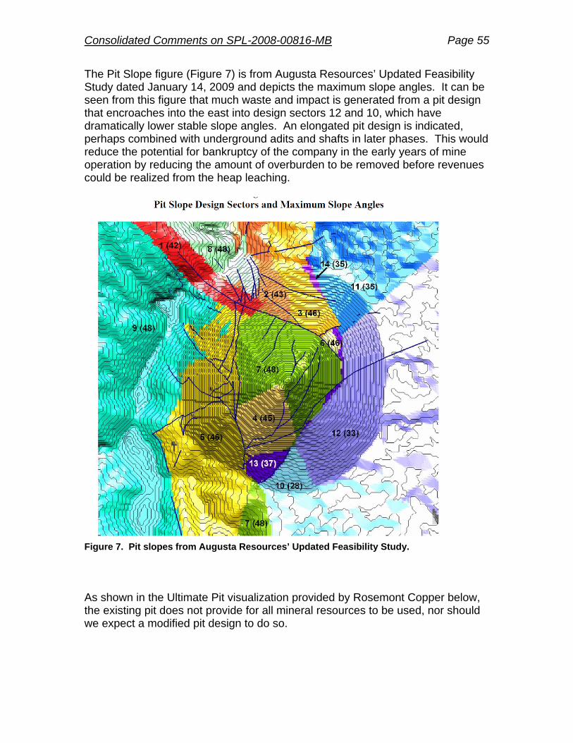
Consolidated Comments on SPL-2008-00816-MB Page 55
The Pit Slope figure (Figure 7) is from Augusta Resources’ Updated Feasibility Study dated January 14, 2009 and depicts the maximum slope angles. It can be seen from this figure that much waste and impact is generated from a pit design that encroaches into the east into design sectors 12 and 10, which have dramatically lower stable slope angles. An elongated pit design is indicated, perhaps combined with underground adits and shafts in later phases. This would reduce the potential for bankruptcy of the company in the early years of mine operation by reducing the amount of overburden to be removed before revenues could be realized from the heap leaching.
Figure 7. Pit slopes from Augusta Resources’ Updated Feasibility Study. As shown in the Ultimate Pit visualization provided by Rosemont Copper below, the existing pit does not provide for all mineral resources to be used, nor should we expect a modified pit design to do so.
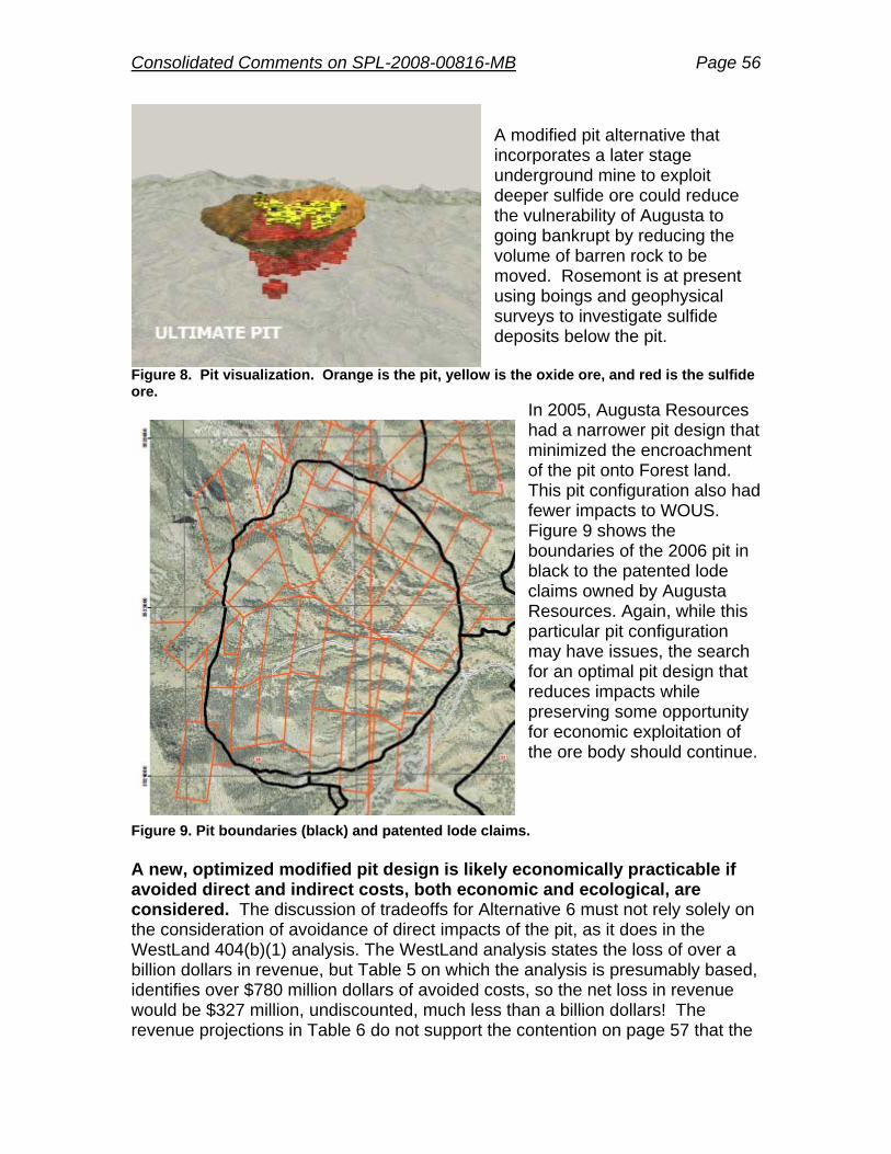
Consolidated Comments on SPL-2008-00816-MB Page 56
A modified pit alternative that incorporates a later stage underground mine to exploit deeper sulfide ore could reduce the vulnerability of Augusta to going bankrupt by reducing the volume of barren rock to be moved. Rosemont is at present using boings and geophysical surveys to investigate sulfide deposits below the pit.
Figure 8. Pit visualization. Orange is the pit, yellow is the oxide ore, and red is the sulfide ore.
In 2005, Augusta Resources had a narrower pit design that minimized the encroachment of the pit onto Forest land. This pit configuration also had fewer impacts to WOUS. Figure 9 shows the boundaries of the 2006 pit in black to the patented lode claims owned by Augusta Resources. Again, while this particular pit configuration may have issues, the search for an optimal pit design that reduces impacts while preserving some opportunity for economic exploitation of the ore body should continue.
Figure 9. Pit boundaries (black) and patented lode claims. A new, optimized modified pit design is likely economically practicable if avoided direct and indirect costs, both economic and ecological, are considered. The discussion of tradeoffs for Alternative 6 must not rely solely on the consideration of avoidance of direct impacts of the pit, as it does in the WestLand 404(b)(1) analysis. The WestLand analysis states the loss of over a billion dollars in revenue, but Table 5 on which the analysis is presumably based, identifies over $780 million dollars of avoided costs, so the net loss in revenue would be $327 million, undiscounted, much less than a billion dollars! The revenue projections in Table 6 do not support the contention on page 57 that the

Consolidated Comments on SPL-2008-00816-MB Page 57
losses are “unreasonable”. When considering the discount rate, a total of $29 million dollars in lost revenue was identified in Table 5. WestLand’s analysis is biased. The information presented for Alternative 6 supports the notion that a modified pit configuration would likely be economically practicable. Reduced operating costs should also be weighed against the reduced income from the altered pit configuration, and the timing of those avoided costs. The Corps should require an unbiased party to quantify the avoided or minimized impacts that would be generated from the reduced volume of waste and tailings. The study should also consider and quantify where possible reduced indirect and cumulative impacts on WOUS resulting from the modified pit, for instance, the benefits of less dewatering, reduced drawdown associated with a smaller and likely shallower pit, and reduced pit lake size. The benefits of a reduced pit lake size include less long-term water loss to pit evaporation and less water irretrievably lost to an unusable pit lake. 3. The underdrains common to all alternatives are a fatal design flaw. Listed as common to all the alternatives is a surface water management plan with underdrains to be “located along the major drainages underlying the facilities” (bolded our emphasis). In other words, the majority of drainages will be covered in perpetuity. The entrances to flow-through or “underdrains” will be shrouded by 3.5:1 (H:V) tailings closure slopes 400 ft high covered with one foot of soil capping material. A steady progression of finer materials will be eroded from these 1400-foot long run slopes. In addition, watershed surface flows will bring sediment-laden stormwater to the entrance of the underdrains, to be constructed with 12-inch minus rock sizes. At these locations, Rosemont Copper envisions the development of a storm-water attenuation pond, which is estimated to hold up to 400+ ac-ft resulting from a 100-yr precipitation event. Water storage in the pond is predicted to last up to one month in duration following significant storm events, with water surface elevations rising to heights which significantly cover the South Flow-Through Drain feature. Upgradient sediment collected during storm events will settle in the attenuation pond and over time retard the transmission of water into the sub-drain. The accumulated sediments will likely clog the entrance to the drain during the post-mining period and render the flow-through drain non-operational. This situation might be reasonably expected at the entrance to all the flow-through drains, particularly in association with adjacent stormwater basins. Specific examples where sizable sub-drain systems, such as those proposed beneath the Tailings and Waste Rock Disposal Mound, that have been successfully implemented at mining sites for periods of 10-20 years, 20-40 years,
Consolidated Comments on SPL-2008-00816-MB Page 58
and 40+ years have not been provided to us as requested; and we suspect they are not available from Rosemont. In addition, after Rosemont leaves who will monitor the storm underdrains? Will the public be left with the job of dealing with a clogged system where stormwater will pond above the drains and eventually move around the tailing/waste rock system creating enormous erosion problems? In consideration of long-term and permanent surface water availability for the downstream Davidson Canyon, a re-appraisal regarding the effects of damming the watershed by Rosemont Copper in order to create the Tailings and Waste Rock Disposal Mound is needed. The DEIS has stated (Table 69, p.300). That this proposed system will reduce downgradient flow by as much as 23% (Scolefield-McCleary) to 35% (Barrel) to 53% (Proposed action). Why is the primary drainage from Wasp and McCleary Canyons, and probably much of the surface and western side of the proposed disposal mounds, restricted and not open for permanent surface water passage downstream to Davidson Canyon, a Water of the US and Arizona Outstanding Water? An alternative arrangement to the underdrains is needed to address the design deficiencies. The alternative should not require perpetual maintenance and monitoring. Request: Develop a better alternative: open drains through existing canyons.
We had suggested the following alternative in 2009 to the USFS and Rosemont, and it was largely ignored and not even dismissed as an alternative in this 404 Alternatives Analysis. This alternative would reduce impairment to the Waters of the US and supplant a fatally flawed design fraught with all kinds of future drainage and potential pollution problems.
Due to the direct connection between the project watershed and flow into
Davidson Canyon, Rosemont Copper must diligently monitor for, and perform timely remediation of, incidents of surface and subsurface contamination during the active operational period for mining operations. On-site basins would be required to capture sediment before final surface water release to the proposed Compliance Dam and downstream. Downgradient reductions in flow will be mitigated.
The Tailings and Waste Rock Disposal Mound could be separated into two distinct mounds, allowing permanent surface water flow through an open constructed canyon (along the general alignment of the existing Wasp – Barrel Canyon drainage or the Scolefield Drainage (depending upon alternative), from the vicinity of the proposed Mine Plant site area on the west to the proposed Compliance Dam on the east). Except for surface water lost to the mine pit

Consolidated Comments on SPL-2008-00816-MB Page 59
footprint and associated limited watershed, the majority of the remainder of the existing site watershed stormwater could then be collected via positive drainage off existing and constructed topographic surfaces. The considerable excess material volume from the creation of a constructed canyon can be utilized in the creation of natural-looking ridge and hilly terrain on the upper surfaces of the two tailings/waste rock disposal mounds. 4. Analyze the related mining exploration and development activities of Augusta and its subsidiaries in relation to a revised purpose and need. Augusta is in the business of gathering investors to develop prospective mines. Augusta Resources has choices in where it invests. Since 2005, Augusta Resources has acquired additional land for mining in southern Arizona. Therefore, analysis of offsite choices should be updated and should examine other mining districts in the Coronado National Forest. In particular, Augusta principals have been reportedly exploring the Wildcat Silver deposit in the Patagonia Mountains. The dismissal of mining the alternative prospects owned by Augusta Resources and its subsidiary Rosemont Copper is clearly unreasonable. Using their logic, there is no other prospect that could ever be chosen by any company, anywhere, unless an equal amount of investigation had occurred. A company has choices in where it invests, and will always have choices, but these choices should not be used as excuses for avoiding a hard look at the alternatives. As investors, Augusta necessarily analyzes alternative prospects based on a lesser degree of information. That’s what companies do when they choose among prospects. The information presented here for the size of the Peach-Elgin, Broadtop Butte, and Copper World prospects supports the notion that the individual impacts of development might well be less than the impacts of the Rosemont prospect. It is possible to analyze the potential impacts of the tailings and waste generated by these other prospects, similar to what Anamax (197Os) and ASARCO (1990s) did for previous NEPA efforts when a lesser level of information was available for the Rosemont prospect. The economic practicability of development is also subject to analysis, especially given that the infrastructure would be similarly situated. 5. Identify and analyze the Least Environmentally Damaging Practicable Alternative Paragraph 3 of the Summary and Conclusions section concludes with this sentence: “Table 6 provides a quick ranking summary of the practicability criteria and environmental effects of each of the onsite alternatives.” In consideration of a proposed mining project which may permanently impact thousands of acres of Forest Service Land, surface water, groundwater quantity and quality, and the natural environment, it is inappropriate for the ultimate conclusion of the 404 Alternatives Analysis to result in a quick ranking summary.
Consolidated Comments on SPL-2008-00816-MB Page 60
Request:
Provide a formal and thorough analysis regarding the determination of the
least environmentally damaging practicable alternative for the proposed mine project, and specifically identify the LEDPA as the result of the analysis.
6. Consider a Separate EIS process for the Corps’ decision. Within the CORPS Application under Overview (p3), the first sentence states “The applicant has submitted a Section 404 permit application for the Barrel-only Alternative (Alternative 4 under the Draft EIS), which has been identified as the preferred alternative in the Draft EIS.” However, the draft 404(b)(1) Analysis does not support identifying Barrel as the LEDPA, and as previously mentioned herein, the DEIS contains data that show that Barrel cannot be the LEDPA selected for this process. In consideration of the discrepancy between what the Forest has now chosen as their preferred alternative, and the Corps’ duties for 404(b)(1) analysis, the Corps may be better served by completing their own EIS process separately from the Forest. Another factor that the Corps may want to consider is whether the Forest Services’ overall conduct of the NEPA process compromises the ability of the Corps to make a timely decision, or will impose significant burden on the Corps in the event that the Forest’s FEIS is challenged. Comments on the Monitoring Plan A Corps-compliant monitoring plan is missing and unavailable for review. Although packaged as a Corps Habitat Monitoring Plan, Appendix E of the Forest DEIS is about mitigation; monitoring is completely lacking. Therefore, in this section we review Appendix C of the DEIS, which is entitled Monitoring Plan. The comments below are intended to apply to the Corps’, Fish and Wildlife Service’s, and the Forest’s monitoring obligations. 1) Appendix C, page 125, Introduction: Process for developing final monitoring plan. Pima County recognizes that a more in-depth monitoring plan will be developed as part of any Corps action and that the Draft Monitoring Plan in the DEIS is simply preliminary. The majority of the comments in the next section are directed at specific ways that a final monitoring plan for the Rosemont mine can be improved. From a process perspective, however, it must be noted that developing a monitoring plan should take place with a wide range of stakeholders and experts to ensure the best outcome. Pima County’s proposed monitoring program, known as the Pima County Ecological Monitoring Program, has undergone an extensive review process at two stages of early planning before

Consolidated Comments on SPL-2008-00816-MB Page 61
any data were collected. In fact, every major ecological monitoring effort that we are aware of undergoes an extensive input and review process prior to data collection. We are concerned that a monitoring plan will developed without sufficient input and review, thereby leading to a weaker plan than would be brought forward with the assistance of a review process. 2) Appendix C, page 125, Introduction: Recommended Key Elements of the Final Monitoring Plan. The following are elements of a monitoring plan that should be included (or expanded upon) for the Rosemont monitoring plan to have relevance and a chance for success. a) Start with Clear Goals and Objectives. Goals are what we are trying to achieve and objectives are how we are going to achieve those goals. Goals can be broad, but objectives must be realistic, specific, and measureable (Elzinga et. al. 2001). It of great concern that the DEIS monitoring plan mistakes objectives for goals, but even more importantly, there are no specific or measureable outcomes identified. For example, in the Groundwater section, the stated objective (really a goal) is to “minimize impacts to groundwater resources.” This goal should be followed by objectives such as: Monitoring XX well within each of 3 strata (strata based on distance from or geological setting in relation to the proposed mine) to detect a 1% annual change in groundwater resources (in each strata) with a Type I error rate of 10%. In the DEIS Appendix C there is are method sections, but without clear objectives, we have no way to evaluate if the type of sampling, location, or number of samples is sufficient to actually observe a change that will be meaningful and that will be able to be acted on by managers. Therefore, we recommend that all objectives be articulated with sufficient detail for an analysis of the monitoring necessary to meet that detail (more on this below). b) Choosing what to monitor. Assuming that the goal of the Rosemont monitoring program is to determine changes in abundance, distribution, condition, or other attributes of natural resources through time, one decision that has a powerful influence on program design—and on the ultimate effectiveness of the program—is the choice of which resource attributes or “parameters” should be measured from among the wide range of possibilities (National Research Council 2000). This decision will influence all aspects of the program, from design through implementation, and ultimately affect the likelihood that the program will successfully detect meaningful changes. Choosing from among the hundreds of potential monitoring parameters is difficult, and the basis for these choices is rarely well-justified (Noon 2003). Any entity that is developing a monitoring plan should clearly understand the importance of choosing the right parameter and be able to justify why one parameters was chosen over another. For example, there is considerable discussion about the use of occupancy versus abundance in monitoring wildlife. The choice of which of these two parameters to monitor is neither trivial nor clear cut and will depend on the program goals, objectives, the species and population of interest, and so on. Our recommendation is that the final monitoring plan should include a clear and cogent argument for why a particular parameter was chosen over another.

Consolidated Comments on SPL-2008-00816-MB Page 62
C). Being Able to Detect Change: Understanding variation and sampling timeframes. Once a parameter is chosen, there is often an assumption that change will be detected, but often monitoring efforts fail to detect change because sampling designs and effort are insufficient (Legg and Nagy 2006, Field et. al. 2007). In particular, understanding the natural variation in parameters over space and time (daily, seasonal, annual, etc.) is fundamental to design of any sampling effort because these patterns drive decisions as to where and when to sample; in general, the more a parameter varies naturally in time and space, the more sampling effort that is required to obtain precise estimates of that parameter (Urquhart et. al. 1993, Urquhart et. al. 1998). For this reason, any discussion of what to monitor for the Rosemont project must include realistic and achievable sampling designs that take into account issues of variability. Further, the time scale of monitoring must be such that the program will be able to detect anticipated and significant results. For example, monitoring groundwater resources for the life of the mining operation will be insufficient to detect the anticipated impact of the mine on this key resource and therefore monitoring must continue beyond the life of the mine. D) Sampling Design. Sampling is employed when it is not possible or prudent to survey all resources of interest due to financial or logistical limitations. The method of selecting where and how often to sample is referred to as sampling design; these choices ultimately determine the power and precision, spatial and temporal inference, and overall cost of a monitoring program (Thompson and Seber 1996, Lohr 1999, Morrison et. al. 2001, Thompson 2002). For the Rosemont project, we suggest that the sampling design must be clearly articulated, with particular emphasis on consideration of probability-based sampling (where sampling is drawn from a larger population of interest and each unit must have a known likelihood of being included in the sample) versus non-probability based (i.e., subjective) approaches that are often used in ecological monitoring (Olsen et. al. 1999). Regardless of the method used, clear justification for design is needed and this should be developed in consultation with a scientific advisory panel (more on this below). E) Cost, Funding, and Timeframe. Monitoring can be very expensive and the amount of funding needed will be directly tied to what to monitor, the spatial extent of monitoring, the precision of estimates, and so forth. The monitoring plan must clearly articulate cost estimates and contingency plans for what to do if meeting the program objectives cost more money than was budgeted. To address these and other contingencies, the final monitoring plan must include details about an assured funding mechanism (ideally in the form of a bond or endowment) for the monitoring program. Also, the time frame of the monitoring plan is insufficient for almost all parameters that have been proposed. Specifically, the final monitoring plan activities should be commensurate with the time scale of impacts, particularly for those parameters that will not experience the greatest impacts until after the mine closes. Parameters related to water, wildlife, and plants will be expected to be impacted years beyond the mine’s closure. Finally, it is important for Rosemont to pay for monitoring for key resources (especially water) for years beyond the mine's

Consolidated Comments on SPL-2008-00816-MB Page 63
closure, because this monitoring will have to be done. If Rosemont does not pay for the monitoring, then the long-term costs will shift to the taxpayers. F) Monitoring independence and expert review. The current monitoring plan calls for Rosemont to fund and carry out monitoring activities. We recommend that monitoring be carried out by an outside entity to add credibility to the results. If this can not be achieved, then independent observers should be allowed to verify the company’s monitoring results by way of access to sites and data from the project. In addition, a scientific advisory panel should be gathered to review the monitoring plan, interpret results, and make recommendations for management actions. This advisory panel should not be influenced in any way by Rosemont. G) Integrating monitoring results with management actions. The type of monitoring being proposed for the Rosemont project provides little or no opportunity to change existing management actions or implement new management actions based on results from the monitoring program. Using monitoring data to inform management is called adaptive management and we recommend that the final monitoring plan build in opportunities for adaptive management. A key aspect of adaptive management is the establishment of thresholds—or resource conditions—that will prompt management actions to reverse or mitigate for unexpected impacts. Thresholds must be established during the development of the monitoring program (and certainly not later) and should be directly tied to objectives. For example, if groundwater levels decline by a set amount (i.e., threshold), then one (or multiple) management prescription would be developed to mitigate for declines that were beyond the threshold. In some cases, thresholds may be set based on the range of values expressed in the DEIS and other times based on ecological thresholds. For example, cottonwood and willow trees have a threshold for depth to water; if the water table drops below approximately 3m, the trees become stressed and could die. Therefore, 3m is a critical threshold. It is important that any resulting mitigation and monitoring actions must be paid for by Rosemont and therefore contingency funding should be established to take this into account. Finally, it is very important for agencies to impose explicit guidelines for changes requiring mitigation or corrective action, even if uncertainties exist about the exact cause(s) of observed change. This is critical because too often entities will hide behind a mantle uncertainty and suggest more study is needed to determine what caused the observed changes. No matter the level of destruction of the natural environment by the Rosemont mine, one will have a difficult time establishing that observed changes were—without a doubt—caused by the Rosemont Mine, because establishing cause and effect requires rigorous adherence to the experimental method. Therefore, we urge the adoption of a correlative assessment approach that would acknowledge that uncertainty exists, but nevertheless requiring action (assuming that the weight of the evidence favored such a determination). Having a robust sampling design for each parameter would go a long way towards reducing uncertainty. In addition, having an unbiased scientific advisory board could provide expertise needed to make key determinations.

Consolidated Comments on SPL-2008-00816-MB Page 64
3) Comments specific to Section H: Biological Resources. In this section we make comments specific to five of the six objectives for this section. In general, we find the monitoring requirements related to biological resources to be insufficient given the long time frame of the mine's impacts and the number of species that will be impacted. A more appropriate monitoring strategy would be to develop a comprehensive program that considered a host of biological elements that were chosen using a process that is explicit and objective-driven. Specifically, we urge a monitoring approach that is much more broad than that proposed and therefore looks at monitoring a mix of parameters related to species, their habitats, and mine-related threats to both. There are a number of models for how to achieve this, but fundamentally such a planning exercise would start with a list of planning species (beyond the Section 7 list) and follows with indentifying features of the environment that are important to those planning species. Finally, linking those features to monitoring objectives and methods would provide a solid foundation for a habitat monitoring program. Pima County underwent a similar planning process for its Section 10(a)(1)(B) monitoring program (Powell 2011). For the Rosemont monitoring program, we recommend coupling habitat monitoring with target species monitoring for a host of key species and the plan would likely have a greater likelihood of observing biologically meaningful changes and would help inform larger, regional monitoring efforts, such as the Pima County effort. 3a: Objective 1: Ensure the requirements of Section 7 of the Endangered Species Act are met. The document indicates only three species will be evaluated for Section 7. The Sonoran population of desert tortoise and the jaguar should be part of any Section 7 discussion. Monitoring for all species identified through this process should contribute to larger (i.e., more spatially extensive) monitoring efforts of the region, such as the County's forthcoming Ecological Monitoring Program. In addition, the mine would be wise to develop a Section 10(a)(1)(B) permit, because there are many species within the area of the mine's direct and indirect impact that will receive consideration for listing under the Endangered Species Act during the life of the mine. Listing of these species during the mine's operation could considerably impact the mine's ability to operate, particularly if there is a jeopardy decision. Developing a Section 10(a)(1)(B) permit will provide more flexibility and options for the operators. 3b: Objective 2: Ensure that viability of species occurring in the project area are not impacted beyond projections disclosed in the FEIS, ROD, and Biological Opinion. This objective requires the most work to ensure the results are meaningful. First, a key question to be answered is: what is meant by the term "viability?" The DEIS glossary gives the definition as "a population that has the estimated numbers and distribution of reproductive individuals to ensure the continued existence of the species throughout its existing range (or range required to meet recovery for listed species) within the planning area." Given this definition, how will viability be assessed? Typically, viability is determined by way of population viability analysis (PVA). However, many authors have noted

Consolidated Comments on SPL-2008-00816-MB Page 65
that PVAs that are conducted with little or no information about the species are largely meaningless (Coulson et al. 2001). This has important implications because, according to the definition of viability in the DEIS, we believe that no species that will be impacted by the Rosemont Mine has sufficient information on the "numbers and distribution of reproductive individuals" for a PVA to be performed. This dearth of data has been noted in previous sections of these comments. Therefore, more information on the intent of viability analysis (and the data to be used) must be provided in the final EIS. We would especially like to know what "species" viability will be evaluated for. Appendix C of the DEIS seems to suggest that viability will be evaluated just for the three species under Section 7 consultation, but this is just inferred from the text. We would like to see that additional species, such as many of those that are called out in the DEIS (and additional species that we have noted) be given consideration. Related to the lack of data for PVAs is the stated intention that species will not be "impacted beyond projections disclosed in the FEIS, ROD, and Biological Opinion." Given that the projected impacts to species are 1) stated in very broad and qualitative terms, and 2) minimized (as has been pointed out in other County comments), much more information is needed on the process of determining if impacts have exceeded this threshold. (Note a threshold has been implied by stating "beyond projections"). A threshold must be stated in terms of a quantitative objective. Numbers of individuals or acres of habitat might be sufficient, but this must be determined in a rigorous and explicit way. We would like to see sampling objectives and levels of certainty (expressed in statistical terms) clearly spelled out for evaluation. Objective 3: Ensure success of revegetation efforts. Success needs to be better defined. A benchmark for success should be directly related to the vegetation species and spatial structure of the existing vegetation community. Also, contingencies should be articulated if "success" is not achieved within a reasonable time frame. Objective 4: Ensure success of efforts to reduce or eliminate invasive and noxious species in disturbed areas. Again, success needs to be defined and a list of invasive species of concern should be drawn up for review. In general, invasive species are difficult to control once established, therefore particular attention should be paid to early detection and treatment. Because of the scale of ground disturbance and the time frame of impacts, an invasive species management plan should be developed for a time period far beyond the mine's closure. Otherwise, this area will likely become a seedbed for invasive species that will wash down into sensitive areas of Davidson Canyon and Cienega Creek. Objective 6: Protect high value riparian habitat from livestock grazing. The monitoring plan must identify what areas need to be protected from grazing and why.

Consolidated Comments on SPL-2008-00816-MB Page 66
References Cited Coulson, T., G. M. Mace, E. Hudson, and H. Possingham. 2001. The use and misuse of
population viability analysis. Trends in Ecology and Evolution. 16:219-221. Elzinga, C. L., D. W. Salzar, J. W. Willoughby, and J. P. Gibbs. 2001. Monitoring plant and
animal populations. Blackwell Publishing, Malden, MA. Field, S. A., P. J. O'Connor, A. J. Tyre, and H. P. Possingham. 2007. Making monitoring
meaningful. Austral Ecology 32:485-491. Legg, C. J., and L. Nagy. 2006. Why most conservation monitoring is, but need not be, a waste
of time. Journal of Environmental Management 78:194-199. Lohr, S. 1999. Sampling: Design and analysis. Duxbury Press, Pacific Grove, CA. Morrison, M. L., W. M. Block, M. D. Strickland, and W. L. Kendall. 2001. Wildlife study design.
Springer Press, New York, NY. National Research Council. 2000. Ecological indicators for the nation. National Academy Press,
Washington, DC. Olsen, A. R., J. Sedransk, D. Edwards, C. A. Gotway, W. Liggett, S. Rathbun, K. H. Reckhow,
and L. J. Young. 1999. Statistical issues for monitoring ecological and natural resources in the United States. Environmental Monitoring and Assessment 54:1-45.
Powell, B. F. 2010. Pima County Ecological Monitoring Program: Phase II Summary. Unpublished report accessed on January 15, 2012 from : http://www.pima.gov/cmo/sdcp/monitoring/index.html.
Thompson, S. K. 2002. Sampling. Second edition. John Wiley and Sons, New York, NY. Thompson, S. K., and G. A. F. Seber. 1996. Adaptive sampling. John Wiley and Sons, New
York, NY. Urquhart, N. S., W. S. Overton, and D. S. Birkes. 1993. Comparing sampling designs for
monitoring ecological status and trends: Impact of temporal patterns. Pages 71-85. In V. Barnett and K. F. Turkman, editors. Statistics for the environment. John Wiley and Sons, London.
Urquhart, N. S., S. G. Paulsen, and D. P. Larsen. 1998. Monitoring for policy-relevant regional trends over time. Ecological Applications 8:246-257.
Yoccoz, N. G., J. D. Nichols, and T. Boulinier. 2001. Monitoring of biological diversity in space and time. Trends in Ecology & Evolution 16:446-453.
Comment on Habitat Monitoring Plan (HMP) and Mitigation (Appendix E) Mitigation is totally inadequate to address effects. Although packaged as a Corps of Engineers Habitat Monitoring Plan (HMP) in Appendix E of the FS DEIS, the title of the six-page document is Proposed Mitigation Concept. This document provides little tangible information pertaining to mitigation for the proposed massive industrial complex. What can be gleaned is that Augusta is apparently looking at offsite parcels for compensatory mitigation for impacts to waters of the U.S. Requests: Deed restrictions should be to prohibit valley fills elsewhere in the
watersheds owned by either the Forest Service or Augusta Resources to reduce cumulative and indirect impacts.

Consolidated Comments on SPL-2008-00816-MB Page 67
Add sufficient information to assess the mitigation criteria to be used by
the Corps to evaluate compensatory mitigation for impacts to WOUS. Include information regarding options for Corps mitigation other than
preservation of offsite land parcels Use approved JDs for basis for mitigation.
Include mitigation for direct, indirect and cumulative impacts on springs
and streams, not just direct impacts. Use Pima County’s Conservation Lands System Guidelines from the Pima
County Comprehensive Plan as a basis for calculating compensatory mitigation areas.
Use Pima County’s principles and recommendations for selection of
compensatory mitigation lands (Appendix H).
Comments on Permit Conditions, Groundwater Monitoring, Cleanup Responsibilities, Closure and Post-Closure, and Funding Per the requirements of an ADEQ Aquifer Protection Permit, Rosemont Copper is responsible for compliance with aquifer water quality standards at the downgradient edge of the mine’s pollutant management area. Per permit conditions, this must be demonstrated by systematic groundwater sampling from the mine compliance monitoring well system. Should it be found that Rosemont Copper is contaminating the bedrock or alluvial groundwater systems, they would be responsible for remediation or mitigation of the groundwater through corrective action. At first glance, from a project permitting perspective, it appears there will be abundant time for the systematic collection and analysis of groundwater monitor well data in order to determine if ground-water contamination has occurred and to respond with appropriate mitigation strategies. However, because of low hydraulic conductivity in the bedrock aquifer and fracture-flow conditions, it is entirely possible that any groundwater contamination in bedrock might not be observed for many tens or even hundreds of years, long after releases of assurances have been made or monitoring has ceased.. Rosemont Copper would be completely out of the picture, as their APP groundwater monitoring program in bedrock would be terminated by ADEQ based upon a number of successive sampling results indicating no groundwater contamination.

Consolidated Comments on SPL-2008-00816-MB Page 68
If and when bedrock groundwater contamination became apparent either within site monitoring wells or in regional public or private wells, the responsibility for cleanup would lie squarely with the landowners, the federal government and US taxpayers. Request: The Corps should include within Rosemont Copper’s bonding
requirements a separate $15,000,000 - $25,000,000 environmental protection fund, to be used solely for the purpose of mitigating unforeseen environmental impacts from the mine site after mine reclamation and closure and release of other assurances. Should surface water contamination be detected within WOUS either within the Rosemont Copper mining project area or within the area of potential effect identified in the FEIS, the fund would be utilized to implement environmental remediation technologies and resources towards remediation of the affected environment and communities.
The Corps permit should be valid only for the first phase through end of
heap leaching. The impacts associated with the next phase, sulfide operation should be contingent on the Applicant maintaining compliance with all local, state and federal rules.
The Corps should have an opportunity to require modifications of the
permit if the impacts exceed those identified in the record of decision.
Miscellaneous editorial comments 1. The 404 application is inconsistent in terms of the link between the figures and the text. In some cases important items on the figures are not labeled (Process Water – Temporary Storage Pond in Figure 8; Flow Through Drains in figure 9). 2. Although the Application mentions the 404(b)(1) Alternatives Analysis in a couple of places, it never states where the Analysis may be found and reviewed by the public. Revise the Application to specifically mention the location of the Analysis - Appendix B of the Forest Service DEIS.
Consolidated Comments on SPL-2008-00816-MB Page 69
Appendices A. Concerns about Stormwater and Hydrology Methods B. Comparison of Stream Lengths C. WOUS and 10-year Floodplains D. Specific Concerns about Rosemont’s Hydrologic Inputs E. Concerns about the Use of the PSIAC Method for Alternatives Analysis of Soil Erosion Impacts F. Complete testimony of Dr. Tom Myers on behalf of Save the Scenic Santa Ritas G. Davidson Canyon Hydrologic, Hydraulic, and Geomorphic Scope of Work H. Principles and Recommendations for Selection of Compensatory Mitigation Lands

Consolidated Comments on SPL-2008-00816-MB Page 70
Appendix A - Concerns about Stormwater and Hydrology Methods Comments: Storm water analysis was done by using methods not acceptable to Pima County. Analysis related to “Surface Water Management” was mostly done by Tetra Tech. Tetra Tech should use the methods described in the Technical Policies 010, 015 and 018. Tetra Tech cited that they use the Corps of Engineering HEC-HMS model to characterize peak discharges (Tetra Tech, 2011). Tetra Tech stated that their discharge calculation by comparison with the Regional Regression Equation 13 (Thomas et al, 1997), and performed a return-period analysis using the period of record on Barrel Canyon (Tetra Tech, 2011). However, peak record on Barrel Canyon is 1,900 cfs and the 100-yr prediction will be 5000 cfs or greater. It is questionable if using such limited observed data (especially observed discharge is much smaller than estimated 100-yr discharge). In addition, Tetra Tech used an outdated regional skew coefficient (-0.2 vs current recommendation of 0.0). Furthermore, RFCD internal study indicated that peak discharge is substantially higher than the peak discharge estimated by Tetra Tech. The studies the 404 application used to evaluate the impact of the proposed mining plans were done by Tetra Tech in 2010. Storm water analysis was done by using methods not acceptable to Pima County. Analysis related to “Surface Water Management” was mostly done by Tetra Tech. Tetra Tech should use the methods described in the Technical Policies 010, 015 and 018. Tetra Tech (Tetra Tech, 2011) cited that they use the Corps of Engineers HEC-HMS model to characterize peak discharges. However, in comparing a HEC-HMS model at the compliance point with the methods used by Tetra-Tech and those recommended by RFCD models yield dramatically different values at the compliance point, especially for the peak discharge rate:
Watershed
Area (sq mi) Critical Storm
Precipitation (in)
Volume (ac-ft)
Peak Discharge
(cfs) RFCD 7.92 3-hr 3.52 960 13,865Tetra-Tech 8.2 24-hr 4.75 1003 5,359
RFCD follows the FEMA guidance to use the ‘critical storm’ that results in the highest discharge at a point of interest. Since 3-hr storms are typically more intense than 24-hr storms, they tend to be more intense with a shorter duration and result in a higher peak. This comparison suggests that Tetra Tech’s discharges used for the 404 application are most likely underestimated. Tetra Tech should revise their discharge and runoff calculations. Specific issues of parameterizations for storm water analysis are summarized below.
Precipitation Tetra Tech uses the point rainfall at 31.862N 110.692W, an elevation of 4429 feet. However, Tetra Tech documents that the mean elevations in the watersheds are between 5000 feet (Lower Barrel Canyon) and 5470 feet (Wasp
Consolidated Comments on SPL-2008-00816-MB Page 71
Canyon). In addition, the 404 application (p.12, L13) said that the lower end of the proposed mining site is 4,500 feet. The location Tetra Tech selected for the analysis appears downstream of the downstream end of the project site. Therefore, the rainfall at the selected point is not representative for the entire project site. The elevation is too low, and as a result, rainfall is too low. It is known that rainfall is generally higher at higher elevation (orographic effect). Since there is a considerable orographic effect in the NOAA 14 Atlas, this will make a significant impact on discharge rates. When the higher rainfall is used, estimates of runoff volume should be greater than those used to assess the impacts of the proposed and alternative mining activities in the 404 application. Additionally, Pima County has chosen to use NOAA 14 Upper 90% rainfall (Tech Policy 10). Tetra-Tech has simply discounted the use of this value. In addition, the selected Area reduction Factor (0.9) is too low. Because the watershed area is only ~1.93 square feet, the ARF should be around 0.95 per Hydro-40. Tetra Tech should closely look at the Hydro-40, Figure 14. Since there is a considerable orographic effect in the NOAA 14 Atlas, this will make a significant impact on discharge rates.
Rainfall Distribution The rainfall distribution used by Tetra Tech has the greatest intensity in the first hour (31.9 %), which has the net effect of reducing runoff peak by using the highest intensity portion of the rainfall to satisfy the initial rainfall losses. Arizona State Standard Guidelines on Hydrologic Modeling [ADWR SS 10-07, section 3.3.4] recommends a symmetrical distribution. Pima County requires the use of a USDA-SCS Type I (24-hr) or USDA-SCS Type II (3-hr) storm. Both of these have peak intensity, at or near the middle of the hyetograph, and do not have peak rainfall at the front of the hyetograph as Tetra Tech has used.
Runoff Curve Number: Our assessment (PC-Hydro and HEC-HMS parameterized by Tech 018) and others have noted that runoff estimates are most sensitive to the CN value. The USDA SSURGO soils map indicates that the fee land on the site is hydrologic soils group D. Pima County has used available data to calculate CN values in support of CN tables (Stewart and Canfield, 2009). This analysis showed that values used in PC-Hydro were found to be more accurate in Pima County than those listed in TR-55. Tetra Tech should use the PC-Hydro CN tables and vegetation map with the SSURGO soils map to estimate CN values. The PC Hydro vegetation map indicates cover of Mountain Brush, Desert Brush and Herbaceous. Assuming 40% cover (which is fairly high), the CN for existing conditions is between 86 and 89. Tetra Tech used a CN of 85. Therefore, the CN of 85 is too low for existing conditions.
Time of Concentration/Lag Time: Tetra Tech did not use the method recommended by Pima County (Tech 018) to estimate Time of Concentration/Lag Time. Tetra Tech also uses methods that are not in the current parameterization of the ‘NRCS Method’ as practiced by

Consolidated Comments on SPL-2008-00816-MB Page 72
NRCS (USDA-NRCS; 1986). The methods Tetra Tech is using to develop the Time of Concentration are un-documented or have been superseded. Since we do not know the origin of some of the equations, we cannot evaluate its appropriateness. Tetra Tech would be best-served by practicing the ‘NRCS Method’ as it is currently recommended by NRCS (NRCS, 1986) unless they provide documentation that another method is appropriate.
Rainfall Losses: The CN of 85 is too low for existing conditions. Please see the comment for “Runoff Curve Number”.
Rainfall Run-off Volume: The CN of 85 is too low for existing conditions, and therefore the estimated Cw is too low. Please see the comment for “Runoff Curve Number”. It is unclear how the duration and rainfall depth of the General PMP and Local PMP were determined. Please explain. Tetra Tech used the thunderstorm distribution with the peak in the middle, while the Local PMP has the peak within 30 min of the distribution. It is not clear why the highest intensity of the 6-hour Local PMP occurs within the firs 30 min.
Peak Flows, Runoff Volume: Results of peak discharge and volume should be recalculated by using the method recommended by Pima County (Tech 018) and appropriate methods to determine parameters (see all comments above). Tetra Tech (Baseline Regulatory (100-Yr) Hydrology and Average-Annual Runoff, Rosemont Copper Proejct, Tetra Tech, 2010; Mine Plan of Operations Stormwater Assessment, Tetra Tech, 2010) developed a regression equation to estimate average annual runoff using watershed area, average precipitation and mean watershed elevation. According to those the first Technical Memo, estimated annual runoff volume is 1407 ac-ft. It appears that Tetra Tech used elevation of ~4625 ft to estimate this volume for a “Baseline” condition. This elevation is too low, because the downstream end of the watershed (USGS Gauge Station # 09484580) is 4367 ft. The other issue is that it appears that Tetra Tech used the elevation of ~5000 ft for “MPO Post Mining” (Mine Plan of Operations Stormwater Assessment, Tetra Tech, 2010). There are two issues about the analysis.
1. The elevation for the “Post Mining” should be lower. 2. Elevation for both the “Post Mining” and “Baseline” conditions should be
higher than the selected values because the downstream end of the watershed (USGS Gauge Station # 09484580) is 4367 ft.
In addition to the elevation issue, there is an issue about the selection of rainfall depth. Tetra Tech used 4.82 inches of precipitation to estimate peak discharge. It appears that this value is a mean, 24-hr precipitation at the elevation of 4429 ft

Consolidated Comments on SPL-2008-00816-MB Page 73
(NOAA Altas 14). The elevation is too low since the watershed outlet elevation is 4364 ft. Because of those issues, the annual average runoff estimates used for this 404 application are not reliable.
Post-Mining Hydrology Since Tetra Tech did not use parameterization methods approved by Pima County, the estimated pre-mining peak discharge and assessment are not reliable. The volume of the stormwater control basin should be determined using multi-day storms. Storms with the highest peak discharge do not necessary produce the largest volume. This is because multi-day volumes can substantially exceed single-day return-period rainfall values. Because of the higher elevation and orographic effect in the project site, multiple day storms are common in mountain areas of southern Arizona. It appears that Tetra Tech used the elevation of ~5000 ft for “MPO Post Mining”. First, the elevation for “Post Mining” should be higher than the elevation for a “Baseline” condition. Secondly, the elevation for both the “Post Mining” and “Baseline” condition should be higher because the downstream end of the watershed (USGS Gauge Station # 09484580) is 4367 ft. Additionally, Tetra Tech used 4.82 inches of precipitation to estimate peak discharge for a “Post Mining” condition. It appears that Tetra Tech used the mean, 24-hr precipitation at the elevation of 4429 ft (NOAA Altas 14). The elevation is too low since the watershed outlet elevation is 4364 ft. Tetra Tech should provide the information of the location and elevation of the point and explain why this low elevation point was selected. Because of those issues, the annual average runoff and peak discharge estimates in this Memo are not reliable. Summary: Tetra Tech should reassess hydrology for pre-mining, post-mining, proposed plan and alternative plans using the methods recommended by Pima County Regional Flood Control with appropriate parameters.
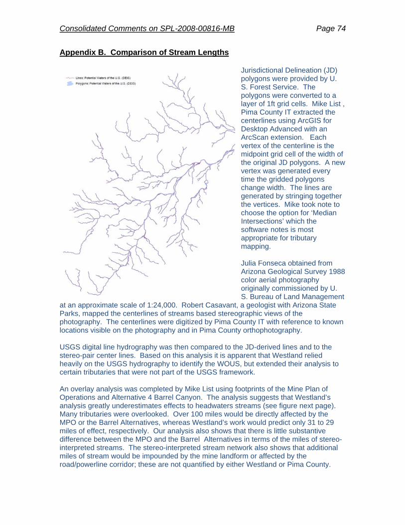
Consolidated Comments on SPL-2008-00816-MB Page 74
Appendix B. Comparison of Stream Lengths
Jurisdictional Delineation (JD) polygons were provided by U. S. Forest Service. The polygons were converted to a layer of 1ft grid cells. Mike List , Pima County IT extracted the centerlines using ArcGIS for Desktop Advanced with an ArcScan extension. Each vertex of the centerline is the midpoint grid cell of the width of the original JD polygons. A new vertex was generated every time the gridded polygons change width. The lines are generated by stringing together the vertices. Mike took note to choose the option for ‘Median Intersections’ which the software notes is most appropriate for tributary mapping. Julia Fonseca obtained from Arizona Geological Survey 1988 color aerial photography originally commissioned by U. S. Bureau of Land Management
at an approximate scale of 1:24,000. Robert Casavant, a geologist with Arizona State Parks, mapped the centerlines of streams based stereographic views of the photography. The centerlines were digitized by Pima County IT with reference to known locations visible on the photography and in Pima County orthophotography. USGS digital line hydrography was then compared to the JD-derived lines and to the stereo-pair center lines. Based on this analysis it is apparent that Westland relied heavily on the USGS hydrography to identify the WOUS, but extended their analysis to certain tributaries that were not part of the USGS framework. An overlay analysis was completed by Mike List using footprints of the Mine Plan of Operations and Alternative 4 Barrel Canyon. The analysis suggests that Westland’s analysis greatly underestimates effects to headwaters streams (see figure next page). Many tributaries were overlooked. Over 100 miles would be directly affected by the MPO or the Barrel Alternatives, whereas Westland’s work would predict only 31 to 29 miles of effect, respectively. Our analysis also shows that there is little substantive difference between the MPO and the Barrel Alternatives in terms of the miles of stereo-interpreted streams. The stereo-interpreted stream network also shows that additional miles of stream would be impounded by the mine landform or affected by the road/powerline corridor; these are not quantified by either Westland or Pima County.

Consolidated Comments on SPL-2008-00816-MB Page 75

Appendix C. DATE: December 27, 2011
TO: Chris Cawein FROM: Dave Stewart SUBJECT: 10-yr Floodplain Modeling for Proposed Mining Area ______________________________________________________________________________
BACKGROUND: Ten-year floodplains were required for the proposed Rosemont mining area. A polygon of the jurisdictional waters within the area was submitted in a 404 permit application, and a comparison of the jurisdictional waterways with the 10-yr floodplains is required. METHODS: Watersheds were delineated for the project area from Pima Association of Government (PAG) 2008 Light Detection and Ranging (LiDAR) data (Figure 1). The 10-year peak discharges were modeled using the U.S. Army Corps of Engineers Computer Hydrologic Modeling System, (HEC-HMS, Version 3.5) for drainage areas greater than 1 square mile, and PC-Hydro was used at two locations where the drainage area was less than 1 square mile. The Upper 90% Confidence Interval 10-year NOAA14 rainfall depths were used with aerial reduction for watersheds larger than one square mile as specified in Tech 018 (Appendix C.1). For each discharge point of interest, an independent model was run that used an aerial reduction factor based on the upstream drainage area applied to the rainfall depth. A 3-hr SCS Type II storm distribution was found to produce higher peak discharges than a 24-hr SCS Type I and therefore the 3-hr SCS Type II was used for the hydrologic modeling. The SCS Curve Number (CN) values were found using the soil and vegetation maps with the CN values in the PC-Hydro User Guide for each watershed. The SCS Unit hydrograph was used as the transform method and the lag time for each watershed was found using the time of concentration calculation based on the TR-55 method as described in Tech 018. Modified-Puls was used for hydrologic routing. The hydraulic model was created using HEC-GeoRAS Version 10.0 by digitizing channels and cross sections in ArcGIS. The Manning’s n-values and ineffective flow
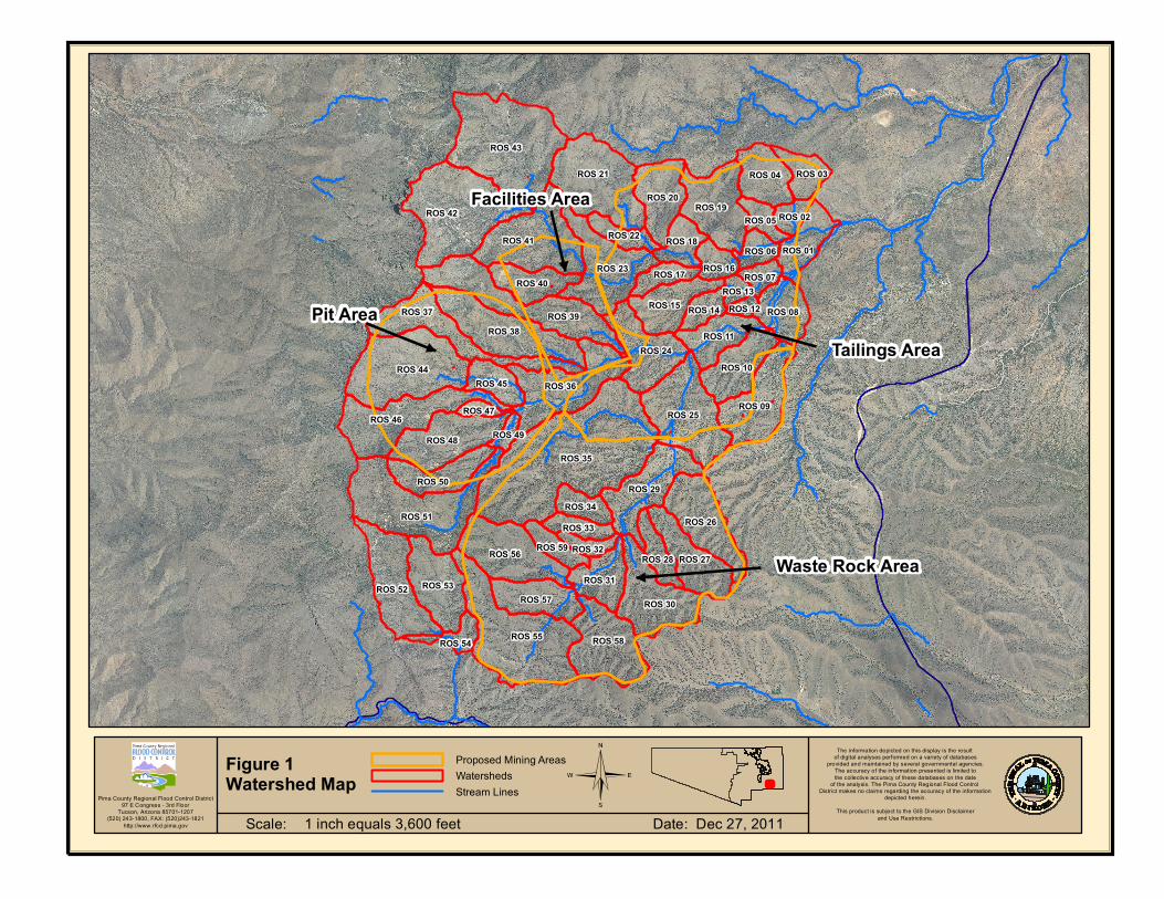
The information depicted on this display is the result of digital analyses performed on a variety of databases
provided and maintained by several governmental agencies.The accuracy of the information presented is limited tothe collective accuracy of these databases on the date
of the analysis. The Pima County Regional Flood Control District makes no claims regarding the accuracy of the information
depicted herein.This product is subject to the GIS Division Disclaimer
and Use Restrictions.
Pima County Regional Flood Control District97 E Congress - 3rd Floor
Tucson, Arizona 85701-1207(520) 243-1800, FAX: (520)243-1821
http://www.rfcd.pima.gov
©
Waste Rock Area
Tailings Area
Facilities Area
Pit Area
ROS 35
ROS 43
ROS 55
ROS 42
ROS 51
ROS 44
ROS 21
ROS 39
ROS 41
ROS 25
ROS 38
ROS 36
ROS 46
ROS 23
ROS 52
ROS 56
ROS 58
ROS 30
ROS 37
ROS 19
ROS 48
ROS 09
ROS 29
ROS 26
ROS 53
ROS 24
ROS 20
ROS 10
ROS 15
ROS 57
ROS 04
ROS 50
ROS 08
ROS 11
ROS 31
ROS 01
ROS 40
ROS 45
ROS 34
ROS 17 ROS 16
ROS 27
ROS 18
ROS 03
ROS 28
ROS 22
ROS 59ROS 33
ROS 14
ROS 06
ROS 05
ROS 54
ROS 07
ROS 02
ROS 32
ROS 13
ROS 49
ROS 47
ROS 12
Proposed Mining AreasWatershedsStream Lines
Scale: Date: Dec 27, 20111 inch equals 3,600 feet
Figure 1Watershed Map

areas were manually entered into HEC-RAS. The hydraulic data obtained from HEC-RAS were exported to ArcGIS to delineate the 10-yr floodplain in the study area. The floodplain analysis was performed for the major channels in the study area, or generally the areas with a drainage area greater than 1 square mile. RESULTS: The 10-yr peak discharges for the points of interest are shown in Table 1. A summary of the watershed attributes and the storage-discharge curves for hydrologic routing are included in Appendix C.2. Table 1. 10-year Peak Discharges calculated for the project area.
Junction Area (mi2) 3-hr P(in) 10-yr Qp (cfs) V (ac-ft) Q/A (cfs/ac) J01 7.92 2.30 6443 512.7 1.27
J01_A 5.56 2.36 4520 344.4 1.27 J01_B 2.26 2.59 3577 210.1 2.47
J06 2.00 2.61 3416 188.3 2.66 J08 5.31 2.37 4477 326.3 1.32 J11 4.91 2.39 4366 300.5 1.39 J16 1.79 2.63 3234 169.3 2.83 J18 1.68 2.64 3169 154.1 2.94 J23 1.19 2.68 2471 116.3 3.23 J24 2.15 2.60 3209 186.1 2.34 J25 2.67 2.56 2056 145.9 1.20 J29 1.67 2.64 1351 85.0 1.26 J31* 0.98 NA 828 NA 1.33
J36_1 1.40 2.66 1885 119.6 2.11 J36_2 1.76 2.63 2795 152.3 2.49 J55* 0.44 NA 539 NA 1.90
*Calculated in PC-Hydro The 10-yr floodplains within the floodplain analysis area are shown in Figure 2 with the August 2011 proposed jurisdictional waterways polygon. The area of the modeled 10-yr floodplain within the analysis area and within the proposed mining area is 115.7 ac. The area of the proposed jurisdictional waterways polygon within the floodplain analysis area and within the proposed mining area is 23.0 ac. The total area of the jurisdictional waterways polygon within the proposed mining area was calculated in ArcGIS as 40.9 acres.

The information depicted on this display is the result of digital analyses performed on a variety of databases
provided and maintained by several governmental agencies.The accuracy of the information presented is limited tothe collective accuracy of these databases on the date
of the analysis. The Pima County Regional Flood Control District makes no claims regarding the accuracy of the information
depicted herein.This product is subject to the GIS Division Disclaimer
and Use Restrictions.
Pima County Regional Flood Control District97 E Congress - 3rd Floor
Tucson, Arizona 85701-1207(520) 243-1800, FAX: (520)243-1821
http://www.rfcd.pima.gov
©
539 cfs
828 cfs
1351 cfs
3209 cfs2056 cfs
4366 cfs
4477 cfs4520 cfs
3577 cfs6443 cfs
3416 cfs3234 cfs
3169 cfs
10-yr Peak DischargesRFCD Major 10-yr FloodplainsStudy Limit for Floodplain AnalysisRosemont Jurisdictional Waterways August 2011Proposed Mining Areas
Scale: R:\templates Date: Dec 22, 20111 inch equals 2,600 feet
Figure 2Modeled10-yr Floodplains

PIMA COUNTY REGIONAL FLOOD CONTROL DISTRICT TECHNICAL POLICY
POLICY NAME: Acceptable Model Parameterization for Determining Peak
Discharges POLICY NUMBER: Technical Policy, TECH-018 EFFECTIVE DATE: April 1, 2011 PURPOSE The purpose of this technical policy is to standardize the parameterization of hydrologic models. BACKGROUND When determining peak discharges, a computer-based hydrologic model or previously-accepted discharge value may be used. Technical Policy TECH-015, Hydrologic Model Selection for Peak Discharge Determination, describes which models are acceptable for determining peak discharges. Pima County Hydrology Procedures shall be used for riverine watersheds with an area less than 1 square mile, and it may be used for watersheds up to 10 square miles. HEC-HMS may be applied to riverine watersheds with an area larger than 1 square mile, and is particularly useful for evaluating watersheds that have detention basins or where channel routing or storage is important. This policy describes which parameterization shall be used for submittals to the Pima County Regional Flood Control District (District). POLICY
A. Watershed Delineation: The accuracy of watershed delineation and flow path identification is critical in hydrologic modeling. The District requires the use of 2-foot contour interval (or finer where available) maps, such as the Pima Association of Governments (PAG) contour maps for delineation of basin boundaries and flow paths in all areas other than steep terrain. In areas of steep terrain, or where 2-foot or finer contour interval maps are not available, U.S. Geologic Survey (USGS) contour maps (7.5 minute series) may be accepted. At the discretion of the District, it may be a requirement that topographic data be sealed by an Arizona registered civil engineer (PE), or land surveyor (RLS). In regulatory sheetflood areas, both 2-foot or finer contour interval maps and aerial photos shall be used with a resolution sufficient to determine flow paths and watershed boundaries. If Geo-HMS (COE, 2003) is used, Digital Elevation Models (DEMs) or Digital Terrain Models (DTMs) or DEMs derived from Lidar data from PAG or other reputable vendors, may be used. With the approval of the District, alternative topographic data, such as stereo photography, may be used.

B. Pima County Hydrology Procedures: Peak-discharge calculations performed using the Pima County Hydrology Procedures shall follow the guidance for parameterization provided in the PC- Hydro User Guide (Arroyo Engineering, 2007).
C. HEC-1 and HEC-HMS: Peak discharges calculated using HEC-HMS (COE, 2006) or
HEC-1 (COE, 1998) shall employ the following parameterization:
a. Rainfall Loss Method: Models shall employ the U.S Soil Conservation Service (SCS) Curve Number method using the Curve Number tables, Vegetation map and Hydrologic Soils Group map associated with the PC Hydro User Guide (Arroyo Engineering, 2007), shall be used. The default vegetation cover percent provided in the PC- Hydro User Guide (Arroyo Engineering, 2007) shall be used unless additional justification is provided. The Curve Number shall not be adjusted for rainfall intensity or antecedent moisture conditions.
b. Time of Concentration Calculation: The modified U.S. Natural Resources
Conservation Service (NRCS) segmented Time of Concentration (Tc) calculation shall be employed (USDA-NRCS, 1986). The Tc shall be calculated by summing the travel time for sheet flow, shallow concentrated flow and channel flow, along the primary flow path.
i. For sheet flow segment:
1. Manning’s roughness coefficient for sheet flow shall be obtained using Table 3-1 in Technical Release 55, Urban Hydrology for Small Watersheds (USDA-NRCS, 1986).
2. Maximum slope length for sheet flow shall be 100 feet unless additional justification is provided.
3. The Kinematic wave method shall be used to estimate the travel time for sheet flow.
ii. For shallow concentrated flow segment:
1. The travel time for shallow concentrated flow shall be obtained using the velocity determined from Figure 3-1 of Technical Release 55, Urban Hydrology for Small Watersheds (USDA-NRCS, 1986).
iii. For channel flow
1. Manning’s roughness coefficient for channel flow shall be determined using the method described in the District’s Technical Policy TECH-019, Standards for Floodplain Hydraulic Modeling.
2. HEC-RAS velocity or the Manning’s equation may be used to estimate the travel time for channel flow.
3. The discharge for upstream sub-basins shall be 2/3 times the 100-yr discharge value calculated with Regional Regression Equation 13 (Thomas et al., 1997). Sub-basins with channel flow from an

upstream basin shall use the 100-yr discharge value calculated with Regional Regression Equation 13.
c. Transform: The SCS Unit Hydrograph method shall be used.
d. Channel Routing:
1.) Routing in Natural Channels: Runoff shall be routed using the Modified-
Puls method for natural channels with the slope less than 1.5%. It may also be used for steeper channels. A storage discharge table is required if HEC-HMS is used. Such a table can be developed using cross-sections and slopes derived from a Manning normal depth analysis or HEC-RAS (COE, 2001). The number of sub-reaches shall be calculated using the methods described in the HEC-HMS User’s Manual. Initial discharge to estimate HEC-RAS velocity for channel flow should be determined using discharge calculated with USGS Regression Equation 13 (Thomas et al., 1997).
2.) Routing in Constructed Channels and Steep Channel: The Kinematic Wave
Method may be used for constructed channels and natural channels with slopes greater than 1%. Reach length, slope, bottom width and side slope may be obtained using the data utilized for watershed delineation (e.g. 2-foot contour interval contour maps, Digital Elevation Models (DEMs) or Digital Terrain Models (DTMs), or DEMs). Selection of Manning’s n values shall conform to the guidance in Technical Policy TECH-019, Standards for Floodplain Hydraulic Modeling.. The number of sub-reaches shall be calculated using the methods described in the HEC-HMS User’s Manuals.
e. Rainfall: The NOAA 14 Upper 90% rainfall shall be used as described in the
District’s Technical Policy TECH-010, Rainfall Input for Hydrologic Modeling. Point rainfall depth shall be evaluated for a watershed, based on the latitude and longitude of the centroid of the watershed. If appreciable elevation change occurs on a watershed, users should use different values for higher and lower elevations.
f. Rainfall Aereal Reduction: Aereal reduction shall be applied to watersheds
larger than 1 square mile. Aereal reduction shall be estimated using Hydro-40 (National Weather Service, 1984) for the watershed and event of interest (i.e. same tables as contained in Arizona State Standard [SS10-07]).
g. Rainfall Distribution: The following rainfall distributions shall be used, with the
highest peak discharge selected in order to determine the critical storm (i.e. the storm that produces the highest discharge) :
1. SCS Type II 3-hr Storm: The 3-hr distribution shall be used as the
local storm. In general, this includes watersheds with a time of concentration (Tc) equal to or less than three hours (Haan et al 1994).

3. SCS Type I (24 hr): The SCS Type I rainfall (NRCS, 1986) may apply for general storms on watersheds with times of concentration (Tc) greater than three hours.
D. Comparison of peak discharge: Peak discharges shall be compared with the peak discharges obtained from USGS Regression Equation 13 (Thomas et al., 1997) and/or the equations (both urban and rural) developed by Eychaner (1984) (See Appendix), and existing regulatory discharge estimates. Appropriate Basin Development Factors (BDFs) shall be used for urban areas. The discharge may also be compared with graphs prepared by Arizona Department of Transportation (ADOT, 1993). REFERENCES
Aldridge, B. and J. Garrett. 1973. Roughness Coefficients for Stream Channels in Arizona. US Department of the Interior Geological Survey. Tucson, AZ. Arizona Department of Transportation (ADOT). 1993. Highway Drainage Design Manual Hydrology Prepared by: NBS/Lowry Engineers Inc. and Planners and George V. Sabol Consulting Engineers, Inc. Arroyo Engineering. 2007. PC-Hydro User Guide. Pima County Regional Flood Control District City of Tucson (COT), Department of Transportation, 1989. Standards Manual for Drainage Design and Floodplain Management in Tucson, Arizona. Revised in 1998. Eychaner, J.H., 1984. Estimation of magnitude and frequency of floods in Pima County, Arizona, with comparisons of alternative methods: U.S. Geological Survey Water-Resources Investigations Report 84-4142, 69 p. Haan, C.T., Barfield, B.J., Hayes, J.C. 1994. Design Hydrology and Sedimentology for Small Catchments, Academic Press. National Weather Service. 1984. Depth-Area Ratios in the Semi-Arid Southwest United States, NOAA Technical Memorandum NWS Hydro-40 Phillips, J., and S. Tadayon. 2006. Selection of Manning’s roughness coefficient for natural and constructed vegetated and non-vegetated channels, and vegetation maintenance plan guidelines for vegetated channels in central Arizona: U.S. Geological Survey Scientific Investigations Report 2006–5108, 41 p. Phillips, J., and T. Ingersoll. 1998. Verification of Roughness Coefficients for Selected Natural and Constructed Stream Channels in Arizona. U.S. Geological Survey Professional Paper 1584.

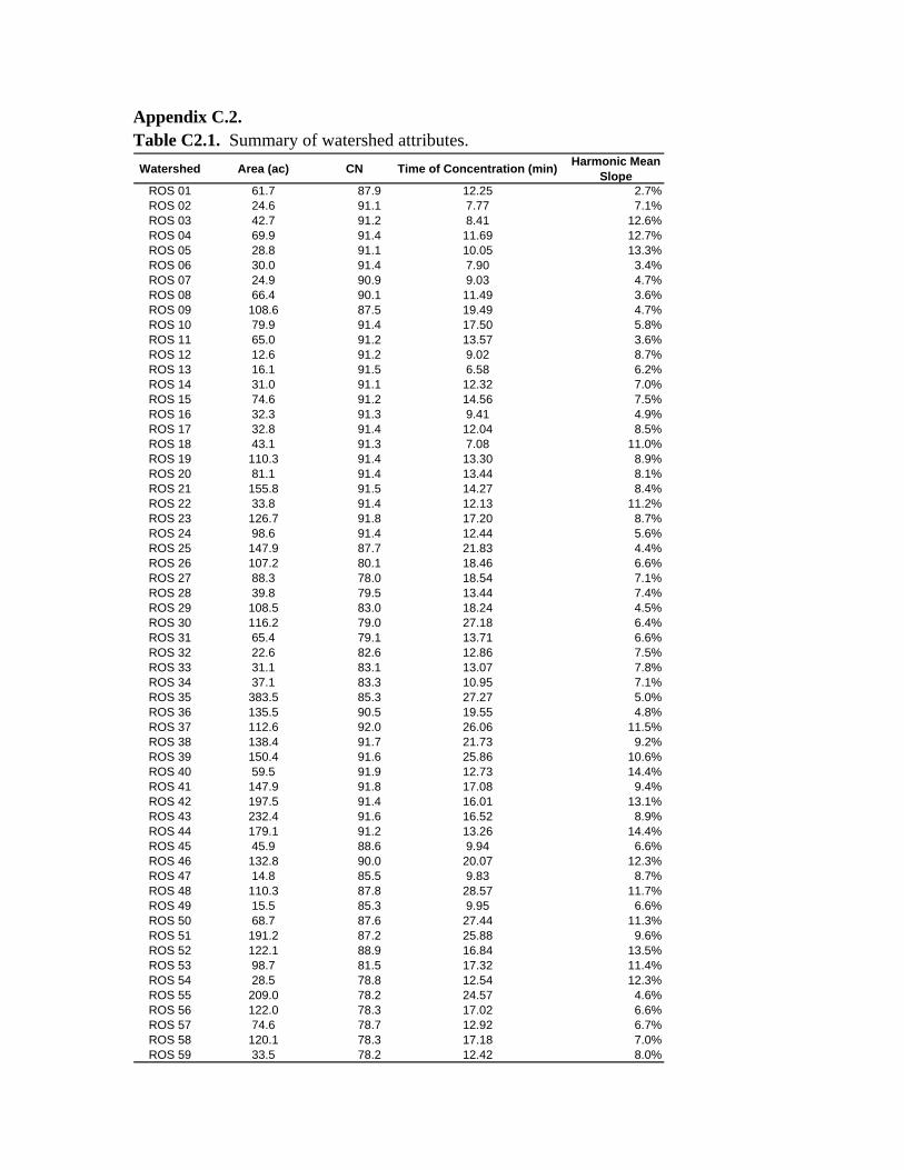
Appendix C.2. Table C2.1. Summary of watershed attributes.
Watershed Area (ac) CN Time of Concentration (min)Harmonic Mean
SlopeROS 01 61.7 87.9 12.25 2.7%ROS 02 24.6 91.1 7.77 7.1%ROS 03 42.7 91.2 8.41 12.6%ROS 04 69.9 91.4 11.69 12.7%ROS 05 28.8 91.1 10.05 13.3%ROS 06 30.0 91.4 7.90 3.4%ROS 07 24.9 90.9 9.03 4.7%ROS 08 66.4 90.1 11.49 3.6%ROS 09 108.6 87.5 19.49 4.7%ROS 10 79.9 91.4 17.50 5.8%ROS 11 65.0 91.2 13.57 3.6%ROS 12 12.6 91.2 9.02 8.7%ROS 13 16.1 91.5 6.58 6.2%ROS 14 31.0 91.1 12.32 7.0%ROS 15 74.6 91.2 14.56 7.5%ROS 16 32.3 91.3 9.41 4.9%ROS 17 32.8 91.4 12.04 8.5%ROS 18 43.1 91.3 7.08 11.0%ROS 19 110.3 91.4 13.30 8.9%ROS 20 81.1 91.4 13.44 8.1%ROS 21 155.8 91.5 14.27 8.4%ROS 22 33.8 91.4 12.13 11.2%ROS 23 126.7 91.8 17.20 8.7%ROS 24 98.6 91.4 12.44 5.6%ROS 25 147.9 87.7 21.83 4.4%ROS 26 107.2 80.1 18.46 6.6%ROS 27 88.3 78.0 18.54 7.1%ROS 28 39.8 79.5 13.44 7.4%ROS 29 108.5 83.0 18.24 4.5%ROS 30 116.2 79.0 27.18 6.4%ROS 31 65.4 79.1 13.71 6.6%ROS 32 22.6 82.6 12.86 7.5%ROS 33 31.1 83.1 13.07 7.8%ROS 34 37.1 83.3 10.95 7.1%ROS 35 383.5 85.3 27.27 5.0%ROS 36 135.5 90.5 19.55 4.8%ROS 37 112.6 92.0 26.06 11.5%ROS 38 138.4 91.7 21.73 9.2%ROS 39 150.4 91.6 25.86 10.6%ROS 40 59.5 91.9 12.73 14.4%ROS 41 147.9 91.8 17.08 9.4%ROS 42 197.5 91.4 16.01 13.1%ROS 43 232.4 91.6 16.52 8.9%ROS 44 179.1 91.2 13.26 14.4%ROS 45 45.9 88.6 9.94 6.6%ROS 46 132.8 90.0 20.07 12.3%ROS 47 14.8 85.5 9.83 8.7%ROS 48 110.3 87.8 28.57 11.7%ROS 49 15.5 85.3 9.95 6.6%ROS 50 68.7 87.6 27.44 11.3%ROS 51 191.2 87.2 25.88 9.6%ROS 52 122.1 88.9 16.84 13.5%ROS 53 98.7 81.5 17.32 11.4%ROS 54 28.5 78.8 12.54 12.3%ROS 55 209.0 78.2 24.57 4.6%ROS 56 122.0 78.3 17.02 6.6%ROS 57 74.6 78.7 12.92 6.7%ROS 58 120.1 78.3 17.18 7.0%ROS 59 33.5 78.2 12.42 8.0%
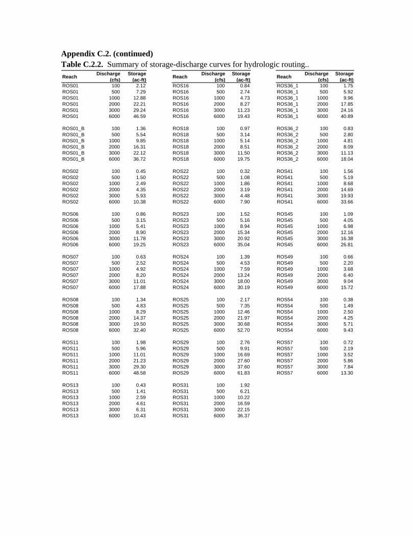
Appendix C.2. (continued) Table C.2.2. Summary of storage-discharge curves for hydrologic routing..
ReachDischarge
(cfs)Storage
(ac-ft)Reach
Discharge (cfs)
Storage (ac-ft)
ReachDischarge
(cfs)Storage
(ac-ft)ROS01 100 2.12 ROS16 100 0.84 ROS36_1 100 1.75ROS01 500 7.29 ROS16 500 2.74 ROS36_1 500 5.92ROS01 1000 12.88 ROS16 1000 4.73 ROS36_1 1000 9.96ROS01 2000 22.21 ROS16 2000 8.27 ROS36_1 2000 17.85ROS01 3000 29.24 ROS16 3000 11.23 ROS36_1 3000 24.16ROS01 6000 46.59 ROS16 6000 19.43 ROS36_1 6000 40.89
ROS01_B 100 1.36 ROS18 100 0.97 ROS36_2 100 0.83ROS01_B 500 5.54 ROS18 500 3.14 ROS36_2 500 2.80ROS01_B 1000 9.85 ROS18 1000 5.14 ROS36_2 1000 4.81ROS01_B 2000 16.31 ROS18 2000 8.51 ROS36_2 2000 8.09ROS01_B 3000 22.12 ROS18 3000 11.50 ROS36_2 3000 11.13ROS01_B 6000 36.72 ROS18 6000 19.75 ROS36_2 6000 18.04
ROS02 100 0.45 ROS22 100 0.32 ROS41 100 1.56ROS02 500 1.50 ROS22 500 1.08 ROS41 500 5.19ROS02 1000 2.49 ROS22 1000 1.86 ROS41 1000 8.68ROS02 2000 4.35 ROS22 2000 3.19 ROS41 2000 14.69ROS02 3000 5.93 ROS22 3000 4.48 ROS41 3000 19.93ROS02 6000 10.38 ROS22 6000 7.90 ROS41 6000 33.66
ROS06 100 0.86 ROS23 100 1.52 ROS45 100 1.09ROS06 500 3.15 ROS23 500 5.16 ROS45 500 4.05ROS06 1000 5.41 ROS23 1000 8.94 ROS45 1000 6.98ROS06 2000 8.90 ROS23 2000 15.34 ROS45 2000 12.16ROS06 3000 11.78 ROS23 3000 20.92 ROS45 3000 16.38ROS06 6000 19.25 ROS23 6000 35.04 ROS45 6000 26.81
ROS07 100 0.63 ROS24 100 1.39 ROS49 100 0.66ROS07 500 2.52 ROS24 500 4.53 ROS49 500 2.20ROS07 1000 4.92 ROS24 1000 7.59 ROS49 1000 3.68ROS07 2000 8.20 ROS24 2000 13.24 ROS49 2000 6.40ROS07 3000 11.01 ROS24 3000 18.00 ROS49 3000 9.04ROS07 6000 17.88 ROS24 6000 30.19 ROS49 6000 15.72
ROS08 100 1.34 ROS25 100 2.17 ROS54 100 0.38ROS08 500 4.83 ROS25 500 7.35 ROS54 500 1.49ROS08 1000 8.29 ROS25 1000 12.46 ROS54 1000 2.50ROS08 2000 14.37 ROS25 2000 21.97 ROS54 2000 4.25ROS08 3000 19.50 ROS25 3000 30.68 ROS54 3000 5.71ROS08 6000 32.40 ROS25 6000 52.70 ROS54 6000 9.43
ROS11 100 1.98 ROS29 100 2.76 ROS57 100 0.72ROS11 500 5.96 ROS29 500 9.91 ROS57 500 2.19ROS11 1000 11.01 ROS29 1000 16.69 ROS57 1000 3.52ROS11 2000 21.23 ROS29 2000 27.60 ROS57 2000 5.86ROS11 3000 29.30 ROS29 3000 37.60 ROS57 3000 7.84ROS11 6000 48.58 ROS29 6000 61.83 ROS57 6000 13.30
ROS13 100 0.43 ROS31 100 1.92ROS13 500 1.41 ROS31 500 6.21ROS13 1000 2.59 ROS31 1000 10.22ROS13 2000 4.61 ROS31 2000 16.59ROS13 3000 6.31 ROS31 3000 22.15ROS13 6000 10.43 ROS31 6000 36.37

Consolidated Comments on SPL-2008-00816-MB Page 77
Appendix D--Specific Concerns about Rosemont’s Hydrologic Inputs In addition to the inconsistency about the PMP storms, it should be noted that the method used in the Technical Memorandum is problematic (see more comments for “Surface Water Management”). Tetra Tech selected the NRCS method to determine runoff volumes to size storm management features. One of the problems is that Tetra Tech used 18 inches of average annual rainfall, while the NRCS reported that the average annual rainfall is 24 inches and the rain gage data from the nearby Santa Rita experiment station has mean annual rainfall of 23.41 inches. Because the mine is higher than the Santa Rita gage, and annual rainfall increases with elevation, annual rainfall at Rosemont Mine is expected to be at least greater than 23.41 inches. Tetra Tech justified using the lower rainfall depth (18 inches instead of the NRCS 24 inches) for runoff calculation with the following reasons;
1. Rainfall measurement at the proposed mine site from 2006 to 2008 (Tetra Tech 2009) showed that an annual rainfall depth is 17.12 inches. This closely matched the average annual rainfall recorded at the Nogales 6 N station.
2. NRCS 24 inches of rainfall will produce unrealistically higher runoff. 3. Estimated rainfall at the Rosemont site by Sellers for the period of 1931 to
1970 was approximately 16 inches. 4. Average annual precipitation for Helvetia (nearby the Rosemont site) from
1916 to 1950 was 19.72 inches. Pima County Regional Flood Control’s (RFCD) comments for those justifications are
1. Rainfall record is less than 2 years from early-2006 to mid-2008 (Tetra Tech, 2009), which is too short to determine “representative rainfall”. Additionally, RFCD looked into the rainfall record for the Santa Rita Experimental Range during the same period. Rainfall at the Santa Rita Experimental Range from 2006 to 2008 (Gage #6, elevation 3986 ft) showed that both the average monthly and annual total precipitations at the Santa Rita were lower than the long-term average from 1970 to 2000 (~23 inches). This suggests that the Rosemont site received less rainfall than a long-term average during the two years from 2006 to 2008. In other word, the period the rainfall was observed at the Rosemont site was “drought”. Therefore, the 2-yr record of rainfall at the Rosemont site should not be used as representative rainfall.
Average Rainfall at the Santa Rita Experimental Range from 2006-2008

Consolidated Comments on SPL-2008-00816-MB Page 78
Jan 0.47Feb 0.39Mar 0.47Apr 0.33May 0.33Jun 1.96Jul 4.70Aug 2.91Sep 1.15Oct 0.11Nov 0.75Dec 0.80
Annual Total 14.33 2. There was no explanation about “unrealistically higher runoff” other than
the simple Tetra Tech’s statement. It is unclear how Tetra Tech can conclude that the estimated runoff is “unrealistic”. It is unclear if Tetra Tech has reasonable measured data to support their assessment. Tetra Tech should clearly show the reason why the 24 inches of rainfall leads to “unrealistically” higher runoff.
3. 1931-1970 rainfall data is too old to justify that 18 inches of rainfall is reasonable. It is known that precipitation pattern and trend change over time.
4. Same as above, 3. In addition to the above, Tetra Tech cited that the use of 18 inches of rainfall can be justified because the same rainfall depth was used in a Technical Memorandum titled “Baseline Regulatory (100-Yr) Hydrology and Average-Annual Runoff, Rosemont Copper Project” (Tetra Tech, 2010). This indicates that most of the Tetra Tech’s Technical Memos were based on inappropriate calculations. Tetra Tech also compared their runoff calculation with average runoff for the Tucson Active Management Area (AMA) to justify their runoff estimations. However, Tetra Tech ignores an orographic effect. The Rosemont site is located at higher elevation than the average elevation of the Tucson AMA. It is expected that average annual runoff at the Rosemont site is larger than average runoff in the Tucson AMA. However, the Tetra Tech’s calculated annual average runoff at the Rosemont site is close to the average runoff in the Tucson AMA This also indicates that the Tetra Tech’s calculation is not reasonable.

Consolidated Comments on SPL-2008-00816-MB Page 79
Appendix E – Concerns about the Use of the PSIAC Method for Alternatives Analysis of Soil Erosion Impacts The District has previously noted that the PSIAC method (Pacific Inter Agency Committee - PSIAC, 1968) used for this analysis is inappropriate because it is a scoring method that does not explicitly recognize site conditions and changes in site condition resulting from disturbance (like mining) in the analysis. Because it does not recognize the effect of site disturbance, it cannot be used to evaluate alternatives that specifically involve evaluating the impact of site disturbance. While Rosemont’s consultant, Tetra Tech, has reiterated their justification for this method (August 18, 2011, comment 2 - below), their justification is flawed. While the District concedes that the PSIAC method has been proposed for use on watersheds smaller than the 10 sq. miles, the two studies cited by Tetra Tech (Rasely, 1991; Renard and Stone 1982 [Tetra-Tech neglected to mention the co-author Stone]), clearly state that the PSIAC method is inappropriate for site level assessment:
‘The method developed by the Water Management Committee of PSIAC (1968) was intended for broad planning rather than specific project formulation where more intensive investigations are required.’
p. 130 in Renard KG and Stone JJ. 1981 “Estimating Erosion and Sediment Yield from Rangeland.” Proceeedings of the Symposium on Watershed Management, ASCE, Boise, Idaho, July 21-23, 1980
‘It should be emphasized that the PSIAC sediment yield procedure is quite different from the Universal Soil Loss Equation, USLE, (Wischmeier and Smith, 1978) because the USLE evaluates on-site soil disturbance in relationship to agricultural cropland, which is the gross soil erosion in an individual soil and farm field setting, while the PSIAC sediment yield procedure rates sediment delivery from rangeland and mountainland which is net soil loss in a watershed hydrologic unit setting.’
p. 6 in Rasely, RC. 1991. “Proposed Revision of the Sediment Yield Procedure Pacific Southwest Interagency Committee Report of the Water Management Subcommittee, 1968.” Upper Colorado River Basin Rangeland Salinity Control Project, Salt Lake City, UT. U.S. Department of Agriculture, Natural Resources Conservation Service, 17 p
This quote from Rasely, 1991 clearly indicates that PSIAC is meant to be used on undisturbed rangelands and mountainlands, while other methods, such as USLE, are appropriate for assessing the impacts of disturbance. Furthermore, the District contacted Ken Renard (co-author of Renard and Stone, 1981), who re-iterated that the PSIAC method is inappropriate for estimating erosion from mine sites. Therefore, the two sources identified by Tetra Tech as justification for

Consolidated Comments on SPL-2008-00816-MB Page 80
the use of PSIAC method for evaluating the impact of the Rosemont mine actually state that PSIAC is an inappropriate method for evaluating impacts of mining on erosion and soil loss. As such, there can be no-doubt that the PSIAC method is inappropriate for evaluating the impacts of the different mine alternatives. Therefore, the soil loss, sedimentation and sediment yield evaluations need to be re-done using a method that is appropriate for mine sites. The Revised Universal Soil Loss Equation (RUSLE) should have been used to evaluation the erosion impacts of the alternatives. Tetra Tech itself has cited the Revised Universal Soil Loss Equation (RUSLE) as an appropriate tool for evaluating the post-closure soil loss (Tetra Tech, March 10, 2010), noting that specific guidance has been developed for its use on mine reclamation (Toy and Foster, 1998). However, these calculations and the RUSLE model results were not cited in the DEIS, and must not have been used in the alternatives analysis. RUSLE is a defensible model for evaluating the impacts of mining on erosion and should be used instead of the PSIAC model, which is inappropriate for mine sites. Tetra Tech. 2010. Soil Erosion Estimates – Technical Memorandum from Mike Thornbrue (Tetra
Tec) to Kathy Arnold (Rosemont Copper Company), March 11, 2010 Toy T. and Foster, G. 1998. Guidelines for the Use of the Revised Universal Soil Loss Equation
(RUSLE) Version 1.06 on Mined Lands, Construction Sites and Reclamation Lands: J.R. Galetovic (Technical Coordinator), the Office of Technology Transfer, Western Regional Coordinating Center, Office of Surface Mining. August. 1998
Comment from: Tetra Tech. 2011. Response to PCRFCD Comments Regarding Hydrology -Technical Memorandum from Mike Zeller (Tetra Tech) to Kathy Arnold, (Rosemont Copper Company), August 18, 2011 PCRFCD Comment No.2 Tetra tech (Zeller 2010b) used PSIAC to estimate sediment yield from the study site. PSIAC is developed for planning purposes by the Pacific Inter Agency Committee for for watershed basins larger than 10 square miles (PSIAC, 1968). The watershed is 8.2 sq. mile for Baseline condition is 1.9 sq. mile for post-mining condition. It is not appropriate to use the PSIAC method, especially for the post-mining condition. Additionally, it is not clear how the sediment concentration was calculated (i.e. flow volume). Tetra Tech Response to PCRFCD Comment No. 2

Consolidated Comments on SPL-2008-00816-MB Page 81
The RFCD statement regarding the use of PSIAC is incorrect. While it is true that the original developers of the PSIAC method recommended that the procedure be used for the watershed delineations of 10 square miles or greater, subsequent studies in the intervening 43 years have shown that the method can be used to reasonably characterize sediment yield from areas as small as 100 acres (see, for example, Rasely, RC. 1991, “Proposed Revision of the Sediment Yield Procedure Pacific Southwest Interagency Committee Report of the Water Management Subcommittee, 1968.” Upper Colorado River Basin Rangeland Salinity Control Project, Salt Lake City, UT. U.S. Department of Agriculture, Natural Resources Conservation Service, 17 p.; and Renard, KG, “Estimating Erosion and Sediment Yield from Rangeland.” Proceeedings of the Symposium on Watershed Management, ASCE, Boise, Idaho, July 21-23, 1980, 12 p). Over the past 30 years, Tetra Tech has used PSIAC to estimate sediment yield emanating from many small watersheds throughout southern Arizona, with highly satisfactory results. The sediment concentration was calculated by dividing the weight of the average annual sediment yield by the combined water-sediment mixture of the average-annual sediment yield and the average-annual stormwater runoff volume. This ratio was then converted to parts per million, by weight.

Consolidated Comments on SPL-2008-00816-MB Page 82
Appendix F. Complete testimony of Dr. Tom Myers on behalf of Save the Scenic Santa Ritas. For brevity the legal formatting of this document was omitted and the first page has been removed. INTRODUCTION AND PURPOSE OF TESTIMONY.

Consolidated Comments on SPL-2008-00816-MB Page 83
Q1. Please state your name and business address.
A1. My name is Tom Myers, PhD and my business address is 6320 Walnut Creek Road, Reno, NV 89523.
Q2. By whom are you employed and in what capacity?
A2. I am self employed as a Consultant, Hydrology and Water Resources.
Q3. On whose behalf are you testifying in this proceeding?
A3. I am testifying on behalf of Intervenors Save the Scenic Santa Ritas Association, Sky Island Alliance, the Center for Biological Diversity and the Tucson Audubon Society.
Q4. What is the purpose of your testimony?
A4. The purpose of my testimony is to discuss the environmental impact of natural water resources associated from the construction, operation, reclamation and closure of the Rosemont Copper mine (“Mine”) to be developed by the Augusta Resource Corporation, the parent company of Rosemont Copper Company (Rosemont Copper). My testimony will include a discussion as to the impact that constructing and operating the proposed Rosemont Mine will have on the hydrology related environmental resources of the area near the mine.
Q5. Have you done any previous analysis of the environmental impacts of the Mine? And if so, please explain.
A5. Yes. I have completed an independent review of the minesite hydrogeology including the development of a conceptual flow model, the coding and calibration of a numerical groundwater model to simulate mine dewatering, the development of a drawdown cone, and the development of a pit lake, and reviewed various reports completed on behalf of the Rosemont Mine. These reports include two different groundwater models, the pit lake model, and seepage studies for flow through the waste rock and tailings impoundments. I have also reviewed an administrative draft environmental impact statement and am currently reviewing the draft environmental impact statement.
Q6. On whose behalf was such analysis performed?
A6. My analysis of the minesite hydrology was performed on behalf of Pima County, Arizona.
Q7. Has any other governmental entity looked at the environmental impacts associated with the construction, operation, reclamation and closure of the Mine?
A7. Yes. The Coronado National Forest, part of the Forest Service within the United States Department of Agriculture, prepared a Draft Environmental

Consolidated Comments on SPL-2008-00816-MB Page 84
Impact Study (“DEIS”)3 in response to a preliminary mine plan of operations (MPO) submitted by Rosemont Copper for development of the Rosemont ore deposit. An administrative draft of the DEIS was provided to Cooperators including the BLM, Pima County and Arizona Game and Fish in June 2011. These comments on the administrative draft are included in my assessment of the adequacy of the DEIS.
Q8. Have you reviewed the DEIS prepared by the USDA Forest Service (Octoberr 2011) (“DEIS”)?
A8. Yes, I am reviewing it currently.
Q9. Where is the proposed mine located?
A9. The proposed Mine site is located on the east side of the Santa Rita Mountains of the Nogales Ranger District, Coronado National Forest, southeast of Tucson, Arizona.
Q10. Please describe the characteristics of the Mine that are pertinent to your testimony.
A10. The proposed mine would be an open pit mine and the open pit would cover about 700 acres. The pit would be over 2,500 feet deep and extend almost 2,000 feet below the groundwater table. The mine would also have heap leach pads, tailings impoundments, and waste rock dumps. The mine will conduct dewatering operations to maintain dry working conditions. Operation of the mine is proposed to occur over a 20-year period, after which the pit will partially fill with water creating a pit lake, which at its fullest extent will contain over 90,000 acre-feet of water.
Q11. What is the significance of the construction of an open pit mine in relation to its effect on ground water and surface water?
A11. Large open pits can affect groundwater because they require dewatering to maintain dry working conditions. After mining is completed, they will partially fill with water if groundwater inflow and precipitation exceeds evaporation. Even if the groundwater inflows are not substantial enough to require a large system of dewatering wells, the proposed pit will lower the water table and cause inflows similar to pumping a large diameter well. They affect surface water by diverting and capturing runoff.
Q12. Please explain how open pits can affect groundwater in the surrounding area?
A12. If a large open pit extends below the groundwater table, it must be dewatered to maintain dry working conditions. The water is lowered to below the bottom of the pit as it is excavated. The proposed open pit at Rosemont would lower the regional aquifer water table by up to 2,000 feet within the pit area. It would cause a drawdown cone that would expand
3 A copy of the DEIS was attached to Tucson Electric Power Company’s Certificate of Environmental Compatibility (“CEC”) Application as Exhibit B-3.
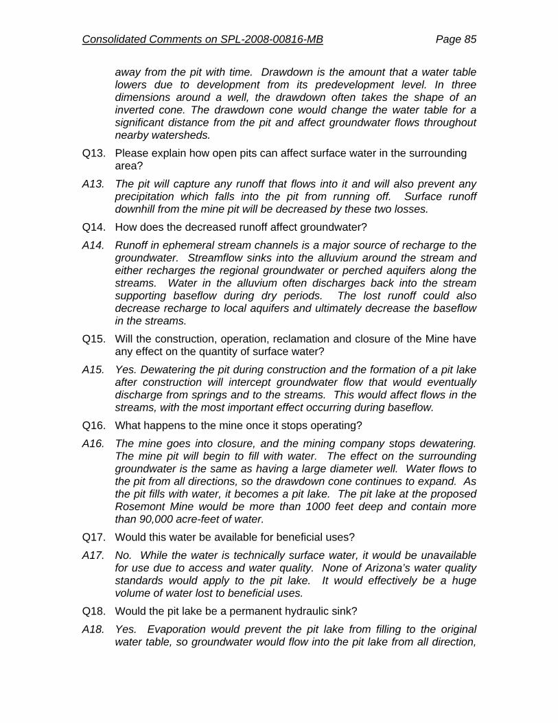
Consolidated Comments on SPL-2008-00816-MB Page 85
away from the pit with time. Drawdown is the amount that a water table lowers due to development from its predevelopment level. In three dimensions around a well, the drawdown often takes the shape of an inverted cone. The drawdown cone would change the water table for a significant distance from the pit and affect groundwater flows throughout nearby watersheds.
Q13. Please explain how open pits can affect surface water in the surrounding area?
A13. The pit will capture any runoff that flows into it and will also prevent any precipitation which falls into the pit from running off. Surface runoff downhill from the mine pit will be decreased by these two losses.
Q14. How does the decreased runoff affect groundwater?
A14. Runoff in ephemeral stream channels is a major source of recharge to the groundwater. Streamflow sinks into the alluvium around the stream and either recharges the regional groundwater or perched aquifers along the streams. Water in the alluvium often discharges back into the stream supporting baseflow during dry periods. The lost runoff could also decrease recharge to local aquifers and ultimately decrease the baseflow in the streams.
Q15. Will the construction, operation, reclamation and closure of the Mine have any effect on the quantity of surface water?
A15. Yes. Dewatering the pit during construction and the formation of a pit lake after construction will intercept groundwater flow that would eventually discharge from springs and to the streams. This would affect flows in the streams, with the most important effect occurring during baseflow.
Q16. What happens to the mine once it stops operating?
A16. The mine goes into closure, and the mining company stops dewatering. The mine pit will begin to fill with water. The effect on the surrounding groundwater is the same as having a large diameter well. Water flows to the pit from all directions, so the drawdown cone continues to expand. As the pit fills with water, it becomes a pit lake. The pit lake at the proposed Rosemont Mine would be more than 1000 feet deep and contain more than 90,000 acre-feet of water.
Q17. Would this water be available for beneficial uses?
A17. No. While the water is technically surface water, it would be unavailable for use due to access and water quality. None of Arizona’s water quality standards would apply to the pit lake. It would effectively be a huge volume of water lost to beneficial uses.
Q18. Would the pit lake be a permanent hydraulic sink?
A18. Yes. Evaporation would prevent the pit lake from filling to the original water table, so groundwater would flow into the pit lake from all direction,
Consolidated Comments on SPL-2008-00816-MB Page 86
making it a terminal sink into which water does not leave except by evaporation.
Q19. Does the pit lake being a permanent hydraulic sink cause you concern?
A19. Yes. The pit will be the center of a permanent drawdown cone with a lake forming in the unbackfilled pit. The pit will capture water forever that would otherwise discharge to springs or to streams downgradient from the pit.
Q20. Are there additional ramifications to the drawdown of groundwater resulting from the Mine operation?
A20. Yes. According to the DEIS, based on median flow values, a reduction in average annual flow from 1 to 3 percent would occur along Cienega Creek from drawdown in the regional aquifer, resulting in 0.16 mile of lost perennial stream length. During periods of low flow (typically May and June), impacts could be much greater. A reduction in flow of 10 percent would occur along Davidson Canyon from reduction in ephemeral flows stored in the shallow alluvial aquifer; the impact on perennial stream length in Davidson Canyon is not known. In addition, Mountain front recharge to the Davidson Canyon/Cienega Basin would be reduced by approximately 1 percent, and the water lost in perpetuity to evaporation from the mine pit lake would represent up to 5.3 percent of the basin water balance. Groundwater outflow from Davidson Canyon would potentially be reduced by up to 6.4 percent. (See DEIS, Executive Summary at xxiii-xxiv, see also, Chapter 3 at 338).
Q21. How would the proposed Rosemont Mine affect groundwater quality?
A21. The mine can affect groundwater quality either by seepage through the waste rock dumps, tailing impoundments, or leach pads and by the creation of a pit lake. Water that seeps through waste rock or tailings can leach contaminants from the rock or processed ore. The pit lake water quality will vary according to the sources of water seeping to the pit lake.
Q22. What is your biggest concern regarding water quality?
A22. I am most concerned about the pit lake. It will eventually contain tens of thousands of acre-feet of water with poor quality as I describe below.
Q23. What would the water quality of the pit lake be like?
A23. The DEIS reports that the pit lake will exceed standards for a variety of contaminants, including silver, cadmium, copper, lead, mercury, selenium, and zinc. (See DEIS, Chapter 3, Table 68 at 293). There are indications that the pit lake model may have substantially underestimated the concentration of some of the constituents, as well.
Q24. Why do you suggest that the concentrations may be underestimated?
A24. I reviewed the pit lake model for Pima County and found that many inflows to the pit lake had been ignored (See Technical Memorandum, Review of
Consolidated Comments on SPL-2008-00816-MB Page 87
the Proposed Rosemont Ranch Mine, Geochemical Pit Lake Predictive Model, Myers 2010 attached as Exhibit 1). The modelers ignored the precipitation that infiltrates the pit walls only to discharge into the pit lake; because the pit walls can be highly fractured, the contaminant load from seepage is usually much higher than from the background groundwater. In fact, the modelers also ignored the additional contaminants that groundwater inflow may leach from the pit wall as the groundwater flows through it. The pit wall yields more contaminants to seepage because it has been subject to oxidation. The model also ignores the first flush of contaminants from the pit wall. The model uses an average inflow for groundwater chemistry without accounting for relative proportion of groundwater that discharges from certain formations or from various directions. The model assumes no stratification, without justification. All of these points could cause the model to underpredict constituent concentrations.
Q25. According to the DEIS, 5,400 acre-feet per year of groundwater would be pumped from the Upper Santa Cruz Subbasin of the Tucson Active Management Area and piped to the mine site in the Davidson Canyon/Cienega Basin. This would represent a 6 to 7 percent increase in groundwater pumping from the Upper Santa Cruz Subbasin and a 2 percent increase in groundwater pumping from the entire Tucson Active Management Area. (See DEIS, Executive Summary at xxiii, see also Chapter 3, Table 47 at 225-226). Please describe how this usage could impact the quantity of the water supply in the surrounding areas?
A25. The local basin is already experiencing an overdraft situation. Current pumping exceeds 80,000 acre-feet per year while the recharge from all sources, natural and artificial is only about 60,000 acre-feet per year. Because the pumping exceeds the recharge, drawdown will continue to expand throughout the area. The Rosemont Mine pumping will add to the overdraft.
Q26. According to the DEIS, groundwater levels would decrease up to an additional 70 feet from the pumping, declining at a rate of up to 3.5 feet per year above and beyond existing groundwater declines. (See DEIS, Executive Summary at xxiii, see also, Chapter 3, Table 47 at 225-226). What would be the effect of removing this quantity of groundwater on the existing aquifer?
A26. Continuing to remove water at this rate will add to the existing deficit in the aquifer. This will increase the pumping lift and dry springs, if any still flow from the existing overdraft.
Q27. According to the DEIS, the geographic extent of the drawdown would be 3 to 4 miles from the Rosemont production wells during the first 20 years of pumping; the geographic extent of impacts would continue to expand an additional 1 to 2 miles for up to 140 years after completion of pumping. (See DEIS, Executive Summary at xxiii, see also, Chapter 3, Table 47 at

Consolidated Comments on SPL-2008-00816-MB Page 88
225-226). What lasting impact would this have on the existing and future water supply?
A27. A deficit can only be made up if a natural discharge is decreased due to pumping or if additional recharge is added to the system. In lieu of that, pumping for Rosemont will create a deficit that will not replenish for a very long time. It will only be redistributed around the area, as evidenced by the continuing expansion of the drawdown cone.
Q28. According to the DEIS, there are an estimated 400 to 450 registered wells located within this area of drawdown; specific impacts to these wells are not known. (See DEIS, Executive Summary at xxiii, see also, Chapter 3, Table 47 at 225-226). Does this cause you concern?
A28. Yes. The aquifer in this area is stratified, which means that drawdown at some wells may affect the yield more than the drawdown as a proportion of the well depth would one to expect. In some wells, most of the yield comes from a thin lithologic section. If the drawdown takes the water table below that productive section, the well yield may be substantially reduced.
Q29. According to the DEIS, existing groundwater withdrawals contribute to land subsidence in the Santa Cruz Valley; an incremental additional risk of subsidence would result from mine water supply pumping. (See DEIS, Executive Summary at xxiv, see also, Chapter 3 at 253). Does this cause you concern? Does this raise any additional concerns?
A29. Yes. Subsidence causes the pore spaces and the ability of the aquifer to hold water to decrease. Additional subsidence would decrease the overall groundwater storage capacity of the aquifer, to the detriment of all users.
Q30. Does the DEIS identify any additional concerns resulting from the drawdown of groundwater by the Mine operation?
A30. Yes. A total of 63 springs would potentially be lost either directly to surface disturbance or to impacts from declining aquifer water levels. (See DEIS, Executive Summary at xxiv, see also, Chapter 3 at 274).
Q31. To what effect will Rosemont mitigate the potential effects of mine pumping by funding the U.S. Geological Survey to operate and maintain the existing surface waterflow measurement gage at Barrel Canyon?
A31. Rosemont proposes to maintain the existing gage for five years beyond the end of operations. Because the effects of drawdown would continue to expand for many years beyond the end of mining and beyond the end of this mitigation, this time period may not be sufficiently long. Impacts are not projected to commence for 50 years after mining (See DEIS, Chapter 3 at 265). Rosemont would have to fund the gage in perpetuity. Additionally, maintaining a gage is not mitigating the problem of decreased flow, it is merely documenting the degradation. There does not appear to be a viable plan to replace stream flows.

Consolidated Comments on SPL-2008-00816-MB Page 89
Q32. Do you agree that Rosemont will have effective mitigation plan in place to replace lost water sources?
A32. The problem with most any mitigation for impacts from this mine is that the worst effects occur long after mining operations have been completed because the forming pit lake causes the drawdown to expand so that more water resources are impacted. The additional problem is that mitigating a problem requires bringing water to the area. If the water is obtained locally, doing so may just be moving the problem around the local area. There is only so much water to around, and once the pit lake begins to form, there will not be much water to mitigate its impacts.
Q1. Does that conclude your testimony?
A1. Yes.

Consolidated Comments on SPL-2008-00816-MB Page 90
Appendix G. Davidson Canyon Hydrologic, Hydraulic, and Geomorphic Scope of Work
Study Purpose The purpose of the Davidson Hydrologic, Hydraulic, and Geomorphic Study (Study) is to provide a comprehensive analysis of the hydrology, surface water hydraulics, sediment transport and channel stability found within the Davidson Canyon watershed. The study will provide a solid understanding of existing conditions and probable changes to the watershed if the Rosemont mining operations occurred as planned. Mining has been known to significantly disrupt surface and groundwater movement and the habitat dependent on the stability of those systems. Analyzing the existing conditions will establish the baseline for comparison of probable changes to the watershed, over time, with the mine’s proposed land use alterations. This study is necessary to ensure continued public safety and habitat protection and provide information for the Environmental Impact Statement. The analysis can also help to identify appropriate mitigation measures needed to protect the natural resources and public and private infrastructure downstream should the proposed mining operations occur. Study Description This scope of work is for professional engineering services necessary for the identification of existing hydrologic, hydraulic and geomorphic conditions in the area; identification and quantification of changes to the hydrology, hydraulics and geomorphology within the watershed as a result of the mining operations; identification and quantification of changes to the hydrology, hydraulics and geomorphology within the watershed as a result of proposed action undertaken for mine closure; and identification and quantification of changes to the hydrology, hydraulics and geomorphology within the watershed which would be anticipated several decades after the mine is closed and maintenance ceases on the remaining infrastructure.
Location
The Study area should, at a minimum, include all of the Davidson Canyon Watershed (including tributaries) to its confluence with Cienega Creek. If however, any of the computer models used in the analysis reflect continued change between existing and proposed conditions at this confluence, then the analysis should extend further downstream to a logical conclusion. Study Categories and Tasks

Consolidated Comments on SPL-2008-00816-MB Page 91
The Study has a number of tasks to be performed in several categories, including: I Hydrology
I a. Existing Conditions Hydrologic Analysis This task is to identify the various discharge values expected at strategic concentration points within the study area given current vegetation, soils, topographic relief, and adjusted for various spatial and temporal rainfall events. At a minimum, guidelines for establishment of concentration points should be where two washes converge and the smaller of the drainage areas equals or exceeds 20 acres. Utilization of the US Army Corps of Engineers (USACE), HEC-HMS computer model with precipitation sources from the National Oceanic and Atmospheric Administration XIV upper 90% confidence interval to establish rainfall distribution patterns would be encouraged. Hydrologic modeling from seasonal rainfall events, to establish existing soil moisture conditions in the local vadose zone, through to the Probable Maximum Flood (PMF) to analyze catastrophic flood and erosion hazards would be expected. This would include, at a minimum, assessment of the four individual seasonal rains as well as the 1-year 1-hour storm, 2-year 1-hour storm, 5-year 1- and 3-hour storms, 10-year 1- and 3-hour storms, 25-year 1-, 6-, and 24 hour storms, 50-year 1-, 6-, and 24 hour storms, 100-year 1-, 6-, and 24 hour storms, 500-year 1-, 6-, 24-, and 72-hour storms, and the PMF. Durations of six hours or less are to assume an SCS Type II distribution, while durations greater than six hours should assume an SCS Type 1 distribution storm. Methods shall otherwise follow Pima County Regional Flood Control District Draft Technical Policy 018. I b. 20-years With Project Hydrology, Hydrologic Change Attributable to Mining Utilizing the hydrologic computer model developed in Task Ia (presumably HEC-HMS), the consultant will simulate the hydrologic changes in the watershed that would be expected if the mine is in full operation, 20 years after opening. Model runs will include the return periods cited above and will require the same deliverables. Compare the results from this run to the base line model established in Task Ia and document the changes. Potential hydrologic changes that will be documented include but are not limited to changes in watershed area, changes in soil conditions, changes in vegetative cover, increased amount of impervious surfaces, flow path changes, changes to attenuation of flow resulting from retention and detention within the mine project site, and changes in flow duration and magnitude of perennial and intermittent watercourse reaches in the study area due to alteration of subsurface flows. I c. 10-years post project Hydrology Utilizing the same hydrologic computer model (presumably HEC-HMS) with all of the flow events referenced in Task Ia, simulate the hydrologic changes that would be expected once the

Consolidated Comments on SPL-2008-00816-MB Page 92
proposed mine is closed but is still maintained; ten years after closing. Document all changes. I d. 100-years post project Hydrology Utilizing the same hydrologic computer model (presumably HEC-HMS) with all of the flow events referenced in Task Ia, simulate the hydrologic changes that would be expected once the proposed mine is closed and there is no maintenance occurring; 100 years after closing. Document all changes.
II Soil Moisture II a. Existing Conditions Continuous Simulation of Soil Moisture and Evapotranspiration (ET) Continuous simulation modeling of the changes in soil moisture and ET should be undertaken using the HEC-HMS computer model to the existing conditions soil moisture and variability. Use daily soil moisture accounting using the 105 years of daily rainfall at University of Arizona to determine impact to soil moisture in riparian areas across the range of observed rainfall. Because the mine will be at a higher elevation than the University of Arizona, daily rainfall should be increased to account for the orographic effects noted in NOAA 14. The simulation should document all changes in soil moisture using the 105 years of observed rainfall data to identify periods where soil moisture drops below the Permanent Wilting Point of riparian vegetation indicating the risk of loss of riparian vegetation and habitat. II b. 20-years With Project Soil Moisture and Evapotranspiration Utilizing the same model (HEC-HMS) developed above, simulate the soil moisture conditions that would be expected if the mine is in full operations 20 years after opening. Potential hydrologic changes that will be documented include but are not limited to changes in watershed area, changes in soil conditions, changes in vegetative cover, increased amount of impervious surfaces, flow path changes, retention and detention within the mine, and changes in baseflows of perennial and semi perennial watercourses due to alterations of subsurface flows. The analysis should compare results with the existing conditions simulation (Task IIa) to determine if periods of soil moisture below the Permanent Wilting Point become more frequent or extended, which will indicate an increased risk of loss of riparian vegetation and habitat. II c. 10-years Post Project Soil Moisture and Evapotranspiration Utilizing the same model (HEC-HMS) developed above, simulate the soil moisture conditions that would be expected once the proposed mine is closed but is still maintained. Document all changes and potential impacts to riparian vegetation and habitat. II d. 100-years Post Project Soil Moisture and Evapotranspiration Utilizing the same model (HEC-HMS) developed above, simulate the soil moisture conditions that would be expected once the proposed mine is closed and

Consolidated Comments on SPL-2008-00816-MB Page 93
there is no maintenance occurring; say 100 years after closing. Document all changes and potential impacts to riparian vegetation and habitat.
III Hydraulics III a. Existing Conditions Hydraulic Analysis This task will identify the flow depths, velocities and floodplain delineations for various flow regimes expected along the downstream watercourse reaches. The various flow regimes discharges would be established from existing conditions hydrology as discussed in Task Ia. Utilization of the USACE HEC-RAS computer model with locally acceptable parameters on model variables such as roughness and expansion contraction for all of the rainfall events from seasonal to the PMF would be encouraged. The hydraulic analysis shall determine the footprint of the inundated area for each of the rainfall events described in Task Ia. Methods shall otherwise follow RFCD Draft Tech Policy 019. III b. 20-years With Project Hydraulics Utilizing the same hydraulic computer model (presumably HEC-RAS) for all of the flow events referenced in Task IIIa simulate the hydraulic changes that would be expected if the mine is in full operations, 20 years after opening. Compare the results from this run to the base line model established in Task IIIa and document the changes. Of particular importance is documenting the change in the frequency of overbank flows and velocity of channel flows. III c. 10-years Post Project Hydraulics Utilizing the same hydraulic computer model (presumably HEC-RAS) for all of the flow events referenced in Task IIIa simulate the hydraulic changes that would be expected once the proposed mine is closed but is still maintained; ten years after closing. Document all changes. Of particular importance is documenting the change in the frequency of overbank flows and velocity of channel flows. III d. 100-years Post Project Hydraulics Utilizing the same hydraulic computer model (presumably HEC-RAS) for all of the flow events referenced in Task IIIa simulate the hydraulic changes that would be expected once the proposed mine is closed and there is no maintenance occurring; say 100 years after closing. Document all changes. Of particular importance is documenting the change in the frequency of overbank flows and velocity of channel flows. III e. Catastrophic Event Under a “Worst Condition Scenario” (tailing dams at there tallest height, watershed under saturated condition and all reservoirs full) simulate dam breaks utilizing the USACE Dam Break (or compatible) computer model. Document the impacts.
IV Geomorphology: Degradation/Aggradation
IV a. Existing Conditions Geomorphic Analysis Existing Conditions Geomorphic Analysis is to establish a base line that simulates long term

Consolidated Comments on SPL-2008-00816-MB Page 94
channel bed elevation changes (degradation/ aggradation) and lateral channel bank stability along Davidson Canyon Wash and appropriate tributaries under a without mine scenario. The existing conditions shall determine the channel-maintaining sediment flux of bed-load and suspended load. The assessment should be based on existing soils and surficial geologic mapping, interpretation of recent and historical aerial photographs and field investigations and modeled utilizing the USACE HEC-6 (or compatible) computer program. IV b. 20-years With Project Geomorphology Utilizing the same geomorphic computer model (presumably HEC-6) developed in Task Three, simulate the geomorphic changes that would be expected if the mine is in full operations, 20 years after opening. Compare the results from this run to the base line model established in Task IVa and document the changes. Changes in degradation/aggradation and changes in timing and nature of the sediment fluxes of bed load and suspended shall be specifically addressed. IV c. 10-years Post Project Geomorphology utilizing the same geomorphic computer model (presumably HEC-6) developed in Task Three, simulate the geomorphic changes that would be expected once the proposed mine is closed but is still maintained; ten years after closing. Document all changes. Changes in degradation/aggradation and changes in timing and nature of the sediment fluxes of bed load and suspended shall be specifically addressed. IVd. 100-years Post Project Geomorphology Utilizing the same geomorphic computer model (presumably HEC-6) developed in Task IVa, simulate the geomorphic changes that would be expected once the proposed mine is closed and there is no maintenance occurring; say 100 years after closing. Document all changes. Changes in degradation/aggradation and changes in timing and nature of the sediment fluxes of bed load and suspended shall be specifically addressed.
Results and Deliverables Based upon the above hydrologic, hydraulic, geomorphologic, and soil moisture analysis, access all adverse impacts anticipated as a result of the proposed mining operation and recommend measure to mitigate these impacts. Note the with-project effects to on-site, adjacent, and downstream features or improvements including roads, culverts, habitat conditions, wildlife corridors, and/or any other public or private noteworthy features. Document procedures, justify parameters, explain any discrepancies, and summarize results.

Consolidated Comments on SPL-2008-00816-MB Page 95
Electronic Data specifications should meet the Forest Service standards and needs for data use and possible follow-up modeling. Recommendations could include:
Final deliverables of the hydrologic data shall include digital line point and polygon features in ArcView shape file format.
Line files shall be for the stream length segments. Attributes are to include stream length identification number from the HEC model, length, elevation change, slope, routing method used (if applicable) and comment field (if applicable).
Point files shall be for the discharge concentration points. Attributes are to include 100-year and 500-year discharge values, time to peak, location description and comment field if necessary.
Polygon files are to be for the watershed and sub-basin boundaries. Attributes are to include drainage area, hydrologic basin factors and comment field if necessary.

Consolidated Comments on SPL-2008-00816-MB Page 96
Appendix H. Principles and Recommendations for Selection of Compensatory Mitigation Lands Lands protected as compensatory mitigation should be:
1) in the area of direct effect or as close as possible to the area of direct effect; and 2) adjacent to other protected lands; and 3) protected in perpetuity with legal instruments that secure minerals and water, and
other land interests; and 4) managed for protection of land and water; and 5) monitored to assure the mitigation intent is being met; and 6) accessible to the public (at least by means of foot); and 7) located within the Maeveen Marie Behan Conservation Lands System (CLS); and 8) a total acreage that is consistent with the CLS guidelines for mitigation (~8800
acres) Based on these principles, the ideal compensatory mitigation lands would include (in no particular order):
1) portions of the Santa Rita Experimental Range adjacent to the Coronado National Forest;
2) private lands located inside or adjacent to the Santa Rita units of the National Forest, especially in Pima County close to the mine
3) Rosemont’s fee-owned lands in or adjacent to the Santa Rita unit of the Coronado National Forest;
4) private and state trust lands along Barrel and Davidson Canyons, including lands owned by Rosemont, and state trust lands which are part of Pima County’s Bar V Ranch.
Principles for waters for compensatory mitigation:
1) springs and perennial streams (if their existence is not threatened by the mine itself; and
2) inside other protected land areas; and 3) protected in perpetuity with legal instruments that secure minerals and water; and 4) provide habitat for listed or candidate species; and 5) managed for protection of land and water; 6) monitored to assure the mitigation intent is being met; 7) Mitigation for water impacts to the Cienega Basin can include the purchase of the
one-acre Vail diversion dam and associated water rights along Cienega Creek.
If insufficient compensatory mitigation land is available from the ideal lands, then County preferences in order of priority are:
1. State and private lands in the Santa Rita unit at similar elevation, including the private lands at the mouth of Madera Canyon;
2. State and private lands adjacent to BLM and County land in the Empire Mountains. The Empire Mountains are an important recharge area in the

Consolidated Comments on SPL-2008-00816-MB Page 97
Cienega Basin. Possesses extensive outcrops of limestone, includes mine claims. Land is situated close to the mine and at a similar elevation. Includes lands in the area of visual effect. Several land owners in the area have approached Pima County with interest in selling.
3. State and private lands adjacent to BLM and County land in the piedmont of the Whetstone Mountains. Land is situated close to the mine and at a similar elevation. Includes lands in the area of visual effect.
4. Private lands along Agua Verde Creek south of the Rincon Mountains. Land includes riparian areas similar to those which would be affected along Davidson and Barrel Canyons. Is close to or adjacent to protected lands.
---end---