Embed Size (px)
Citation preview

appendiCHaracareas

ix:ter

P
RIVERS CROSSING 1
RIVERS CROSSING 1
Royal Docks KCAP London UK Parc de la Villette B. Tschumi Paris FR
120 KCAP/MCGNIE/JMP/BG
Area brief Rivers CrossingThe coincidence of the Robinhood River, the new linear open space, the Naas Road and its public transport corridor locates the central focus of the Naas Road area. A mix of uses is proposed that would sustain a real neighbourhood condition with an emphasis on higher value commercial useavailing of the high profileto the Naas Road. A range of mixes is anticipated with the deliberate intervention of the liner park giving definition and orientation. Development on plots situated directly at the park and or Naas road are key to successful transformation into an urban mixed use neighbourhood. Building typology at the Naas Road should tend towards closed city-blocks that follow plotline with an average height of four floors. On limited plots with particular positions and/or good visibility higher building heights may be appropriate.

Cam
mock
Rive r
Cam
mock
Rive r
Cam
mock
Rive r
Cam
mock
Rive r
Cam
mock
Rive r
Cam
mock
Rive r
Naas Road Rivers Crossing
121Naas Road Development Framework
Connectivity Open space
Uses and activity Density
R 40% C 60%I 0%
R 40% C 60%I 0%
R 40% C 60%I 0% R 40%
C 60%I 0% 2.0
2.0
2.02.0
2.0
1.01.0
1.5
1.5
1.5
R 50% C 25%I 25%
R 50% C 25%I 25%
R 40% C 60%I 0%R 40%
C 60%I 0%R 40%
C 60%I 0%
R 40% C 60%I 0%
Existing built Potential transformation built

RED COW EAST 2
RED COW EAST 2
OHK housing and offices KCAP Amsterdam NL Sihlcity Theo Hotz Zurich CH
122 KCAP/MCGNIE/JMP/BG
Area brief red cow eastRed Cow East is predominantly non-residential availing of the adjacencies to the M50 and the higher commercial profilethis affords. Plot ratios are higher - reflecting the market potential of location. Uses can be a mix of existing industrial and higher quality commercial development profiting from the greater visibility afforded from the Red Cow crossing. The new junction on the Naas Road allows a radically improved environment eastwards and results in greatly improved accessibility of lands towards Oak Road and Ballymount Road.

Sports GroundSports Ground
Sports GroundSports Ground
Sports Ground Sports Ground
Hardbrücke Zurich West CH Arena Boulevard Amsterdam NL Kennedy business center KCAP Eindhoven NL
123Naas Road Development Framework
2.0 2.0
2.0
2.01.5
1.5
1.5
1.5 1.50.7
R 35% C 50%I 15%
R 35% C 50%I 15%
R 35% C 50%I 15%
R 35% C 50%I 15%
R 35% C 50%I 15%
R 40% C 60%I 0%
R 40% C 60%I 0%
R 60% C 40%I 0%
Connectivity Open space
Uses and activity
Existing built
Density
Potential transformation built

P+R
RED COW WEST 3
RED COW WEST 3
Pre Wonen office KCAP Velserbroek NL De Brug JHK Architects Rotterdam NL
124 KCAP/MCGNIE/JMP/BG
Area brief red cow westDevelopment around the Red Cow has the commercial advantage of high profile and can make legible this significant gateway location. Quantum is capped by infrastructural capacities and critically by the preference to encourage development east of the M50. Its interface with the Newlands Green Space is now clearly defined and spatially coherent. Densities can be higher adjacent to the Red Cow and diminish towards Newlands Green Space and along the N7, where the attractive potential of being at the edge of an important green lung should be exploited.

Photonics Sauerbruch Hutton Berlin DE The Red Apple KCAP Rotterdam NL Optus office park Rice Daubney Sydney AU
125Naas Road Development Framework
2.0
1.0
0.7
1.3
0.7
0.7
0.5
R 40% C 60%I 0%
R 40% C 60%I 0%
R 40% C 60%I 0%
R 40% C 60%I 0%
R 60% C 40%I 0%
Connectivity Open space
Uses and activity Density
Existing built Potential transformation built

GREENHILLS 4
GREENHILLS 4
Housing EM2N Zurich CH Neighbourhood square Lyon FR
126 KCAP/MCGNIE/JMP/BG
Area brief greenhillsThe finger-like extension of Greenhills Park in the direction of Walkinstown serves as buffer between the industrial activities in Ballymount and Robinhood. It offers recreational space on a local level, thereby accommodating the coexistence of different activities. Residential developments with a sufficient mix of supporting functions and of a density no higher than the existing residential use are proposed for this relatively well connected area.

Collective housing Meta BelgiumBreevaarthoek KCAP Gouda NL Maaskwadrant KCAP Hoogvliet NL
127Naas Road Development Framework
0.5
0.50.5
0.7
1.0
0.5
0.5 0.5
R 100% C 0%I 0%R 0%
C 0%I 100%
R 100% C 0%I 0%
R 100% C 0%I 0%
R 100% C 0%I 0%
R 34% C 33%I 33%
R 34% C 33%I 33%
Connectivity Open space
Uses and activity Density
Existing built Potential transformation built

CANAL SITE 5
CANAL SITE 5
Breevaarthoek KCAP Gouda NL Eilandenrijk UN Studio Almere NL
128 KCAP/MCGNIE/JMP/BG
Area brief canal siteThe Grand Canal is a crucial and underused phenomenon - critical in terms of its incredible amenity value and as a structuring device in an area bereft of orientation or character. That this potential would continue to be reserved for exclusively non-residential purposes would be disappointing and short sighted. Hence the proposal to develop a residential quarter along the south side of the Canal. The existing relative isolation of the area is now offset by the increased emphasis on the Canal as a route and by the repair to the fractured movement pattern of the urban structure to the south. Locations at water are now universally understood to be a preferred and characterising places to live. Key issues will be to ensure the residential development is of sufficient quantum to establish its own character capable of competing with the existing condition. Allied to this is the timing of the network improvements necessary to integrate the area with the wider context.
FB
LOCKSEVENTH
GRAND CANAL
6th Lock
FB
LOCKSEVENTH
GRAND CANAL
6th Lock
FB
LOCKSEVENTH
GRAND CANAL
6th Lock
LOCKSEVENTH
GRAND CANAL
6th Lock
FB
LOCKSEVENTH
GRAND CANAL
6th Lock
FB
LOCKSEVENTH
GRAND CANAL
6th Lock
GWL terrein KCAP Amsterdam NLBorneo Sporenburg various Amsterdam NL Hollainhof Neutelings Riedijk Gent BE
129Naas Road Development Framework
0.7
0.7
0.7
0.7
1.01.0
0.7
R 100% C 0%I 0%
R 100% C 0%I 0%
R 34% C 33%I 33%
R 50% C 25%I 25%
R 34% C 33%I 33%
R 50% C 25%I 25%
Connectivity Open space
Uses and activity Density
Existing built Potential transformation built

ROBINHOOD 6
ROBINHOOD 6
Police office Sauerbruch Hutton Berlin DEBlok 1.3 KCAP Leidsche Rijn NL
130 KCAP/MCGNIE/JMP/BG
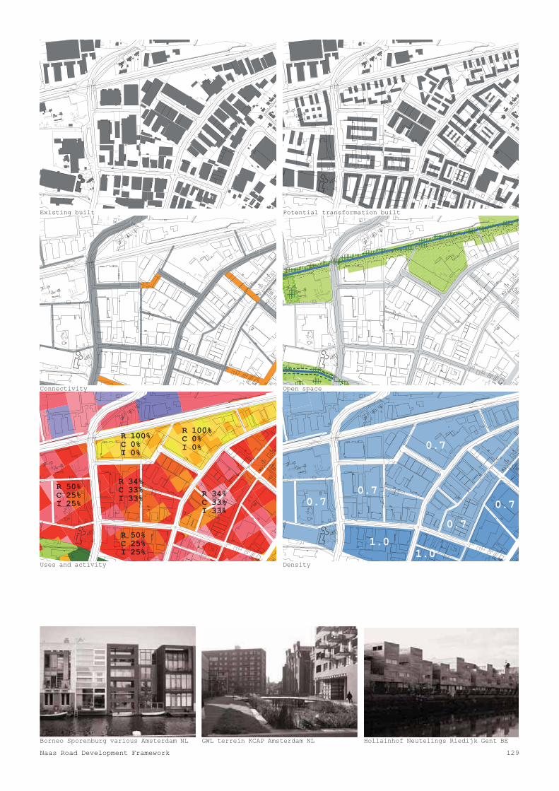
Area brief robinhoodOnce the preferred location for logistics in the region, a level of existing industrial uses are maintained. The presence of the linear park crossing through the area allows for an increased variety of functions. Where compatible, residential development can arise, using the location at the green strip and improved accessibility.This moderate mix can assure that Robinhood acts as a connection between Walkinstown and the areas around the Naas Road. Densities remain low reflecting the use pattern.
The Red Apple KCAP Rotterdam NL Research Building UN Studio Groningen NLVondelpark Amsterdam NL
131Naas Road Development Framework
0.7
0.7
0.7
1.0
1.51.0
0.70.7
0.70.7
1.5
1.5
R 34% C 33%I 33%
R 34% C 33%I 33%
R 34% C 33%I 33%
R 60% C 40%I 0% R 34%
C 33%I 33%
R 34% C 33%I 33%
R 34% C 33%I 33%R 34%
C 33%I 33%
R 0% C 0%I 100%
R 34% C 33%I 33%
R 34% C 33%I 33%
R 60% C 40%I 0%
Connectivity Open space
Uses and activity Density
Existing built Potential transformation built

BALLYMOUNT 7
BALLYMOUNT 7
Office development unknown Utrecht NL Init Groosman Partners Amsterdam NL
132 KCAP/MCGNIE/JMP/BG
Area brief ballymountFashion City has developed here as the preferred location for the wholesale fashion industry for the country. Market driven developments are to be encouraged and supported. Here location, plot size and profile have combined to answer a market need. The mix balance reflects this. Visibility and direct accessibility from the M50 are an obvious advantage for industrial and commercial development.

Schaulager Herzog & de Meuron Basel CH Flight Forum MVRDV Maastricht NL De Veranda Parking Paul De Ruiter NL
133Naas Road Development Framework
1.30.7
0.7
0.5
0.5
1.3
R 15% C 35%I 50%
R 15% C 35%I 50%
R 0% C 0%I 100%R 0%
C 0%I 100%
R 0% C 0%I 100%
R 0% C 0%I 100%
Connectivity Open space
Uses and activity Density
Existing built Potential transformation built

OAK ROAD 8
OAK ROAD 8
Ricola Herzog & de Meuron Mullhouse FROffice building Claus en Kaan NL
134 KCAP/MCGNIE/JMP/BG
Area brief oak roadThis area has a relatively recent building stock and some significant (high capital value) processes are accommodated in the area. Radical change is not proposed and the new junction on the Naas Road will improve vehicular access improving efficiencies and perception. General network improvement will establish connections to the adjoining areas and the improvement to the Camac will help orientation and legibility.

FB
FBCammock River
Cammock River
Cammock River
FB
FBCammock River
Cammock River
Cammock River
FB
FBCammock River
Cammock River
Cammock River
FB
FBCammock River
Cammock River
Cammock River
FB
FBCammock River
Cammock River
Cammock River
FB
FBCammock River
Cammock River
Cammock River
Pharma Lab Sauerbruch Hutton Biberach DEZona Franca Logistics R.Bofill Barcelona Park lane
135Naas Road Development Framework
0.7
0.7
0.7
0.7
0.5 0.7
0.7
0.50.5
0.5 0.7R 50% C 25%I 25%
R 0% C 0%I 100%
R 0% C 0%I 100%
R 0% C 0%I 100%
R 0% C 0%I 100%
R 0% C 0%I 100%
R 0% C 0%I 100%
R 0% C 0%I 100%
R 0% C 0%I 100%
R 15% C 35%I 50%
R 15% C 35%I 50%
Connectivity Open space
Uses and activity Density
Existing built Potential transformation built

NEWLANDS 9
NEWLANDS 9
Theepaviljoen Architectengroep Rheden NLTh ilj A hit t Rh d NL Swimming pond in park
136 KCAP/MCGNIE/JMP/BG
Area brief NewlandsReconfigured, the existing Green Belt zoning is consolidated in shape with a greater range of recreational uses - active and passive. A large lake is proposed as part of the area wide surface water attenuation proposals and to provide a unique amenity in South Dublin. Proximity to Metro and Luas support this as a significantdestination in the south west Dublin area. Towards the N7 some very limited development is proposed - pavilion structures with compatible uses. On its eastern edge, the Robinhood River is used as the soft link back to lands east of the M50 - providing pedestrian and cycle connections into this relatively inaccessible area.

Flooding landscapeWimby Onix Hoogvliet NLCemetery Park Oslo NO
137Naas Road Development Framework
0.5
0.05
R 40%R 40% C 60%C 60%I 0%I 0%
Connectivity Open space
Uses and activity Density
Existing built Potential transformation built

appendiseveso
138 KCAP/MCGNIE/JMP/BG

ix:sites
139Naas Road Development Framework

140 KCAP/MCGNIE/JMP/BG
There are three Seveso sites located within the Naas Road area: BOC Gases Ireland, Bluebell Industrial Estate, Irish Distillers Ltd, Robinhood Road and Tibbett and Britten Group Ireland, Robinhood Road.
The Seveso regulations apply to the storage of dangerous substances in quantities equal to or above specifi ed thresholds. Sites are identified and subject to development advice by the Health and Safety Authority (H.S.A.), in accordance with Directive 1996/82/EC and Irish Regulation S.I. No. 476 of 2000 and SI 74/2006 European Communities (Control of Major Accident Hazards Involving Dangerous Substances) Regulations 2006.
The designation as a Seveso site means that some restrictions apply to proposed land uses in the surrounding area, as identified by the HSA. While each site will incur differing restrictions, generally, the closer a proposed development is located to a Seveso site, the more land use occupation and density restrictions will apply. New development proposals will be referred to the HSA within the following referral distances from a Seveso site:
• BOC Gases Ireland. Bluebell Industrial Estate, D12. (Consultation Distance 700 m)• Irish Distillers Ltd, Robinhood Road, D22. (Consultation Distance 300 m)• Tibbett and Britten Group Ireland. Robinhood Road, D22. (Consultation Distance 300 m)
The HAS has determined a graduated constraints zone (zones 1-3) within the wider referral zone. The referral distances and graduated constraint zones associated with each site should be read in conjunction with the Policy & Approach of the Health & Safety Authority to COMAH Risk-based Land-use Planning,
published by the HSA September 2009.
Taking workplaces as an example, a development providing workplaces for less than 100 occupants in a building less than 3 storeys could be acceptable in Zone 1 (inner, red zone). More intensive employment uses are considered appropriate in Zone 2 and beyond. Very limited infill residential development of one or two units may be acceptable in Zone 1. Small developments up to 40 units per hectare may be appropriate in Zone 2 and larger developments greater than 30 dwelling units and more than 40 units per hectare are only acceptable in Zone 3 and beyond.
For some types of development, particularly those involving large numbers of people, it is likely that the deciding factor from the point of view of land use planning is the societal risk, i.e. the risk of large numbers of people being affected in a single accident. Therefore for large scale developments, including those outside Zone 3 but within the consultation distance set out in the Planning and Development Regulations 2001-2006 and notified to the planning authority by the HSA at the time of notification of the establishment, estimations of societal risk will be undertaken.
In general, the strategy will be to encourage the relocation of these facilities to suitable alternative sites. The Zoning and Density Objectives proposed in the Development Framework assumes the relocation of these Seveso sites in the short to medium term. In the meantime, these sites represent a significant constraint on the full development potential of the Naas Road Area.
seveso sites

141Naas Road Development Framework

142 KCAP/MCGNIE/JMP/BG
IrishDistiller
Tibbet &Britten
Naas Road Development FrameworkCurrent Seveso ZonesApril 2010

143Naas Road Development Framework
Legend
County Boundary
Seveso Zones
Zone 1
Zone 2
Zone 3
300m Referral Zone
700m Referral Zone
$
0 250 500 750 1,000125Meters
BOC
rs

144
Produced by
South Dublin County CouncilPlanning DepartmentCounty Hall TallaghtDublin 24Ireland
T +353 (1) 414 9000
176 Ivy ExchangeGranby PlaceParnell SquareDublin 1Ireland
T +353 (1) 888 0840F +353 (1) 872 7813
Wasserwerkstrasse 1298037 ZürichSchweiz
T +41 (0) 44 350 1651F +41 (0) 44 350 1652
Audrey House,16-20 Ely Place,London EC1N 6SNUnited Kingdom
Tel: +44 (0)20 7405 2800Fax: +44 (0)20 7430 9049
1 Albemarle WayLondon EC1V 4JBUnited Kingdom
t +44 (0)20 7549 2184f +44 (0)20 7549 2182
Dublin May 2010

145Naas Road Development Framework

W
JOGGING
SWIMMMMING
HORSEBACK RIDINGI
RIVERSIDE WALK
ARTAR
BELV
UR
GREEN BOULEVARDGRE VARD
LAKEBIG
CANAL
ENTERING
HUUBB
EWAYTEWATEGAT
ESSIBLECECCAC
CIT
CONNNNN
EXHIBITIONVIBRANNN
LIVIINEIGHBOURHORHOODOODD
LIVI
BLBBBBBBLOOOURBABANBAANAN
SESNEBUSIN
VISIBILITYLITYTYTY
EATINGPEDESTRIAN ZONE
PUBLIBLICB IC
VIBRANTVI
BUZZZBUZZINZZINGINI
FESTIVALSESTIVALSSTIVAL
DDB
CAFES
MEDIA CENMEDIA ENCECEN
RECREATION TEMPORAPORA
CLUBBI
P+R
RED COW EAST 2
RED COW WEST 3
NEWLANDS 9 BAL
11PARK WEST
OAK ROAD 8
CLONDALKIN 10
asroad