Embed Size (px)
Citation preview

Appendix H
Blythe Solar Power Project August 2009
APPENDIX H
Paleontological Resources Technical Report

Paleontological Resources Assessment for the Blythe Solar Power Project, Riverside County, California
Prepared for
AECOM Environment
On behalf of:
Solar Millennium, LLC and
Chevron Energy Solutions
Prepared by
SWCA Environmental Consultants Pasadena Office August 2009

PALEONTOLOGICAL RESOURCES ASSESSMENT BLYTHE SOLAR POWER PROJECT- AECOM ENVIRONMENT
PALEONTOLOGICAL RESOURCES ASSESSMENT FOR THE BLYTHE SOLAR POWER PROJECT RIVERSIDE COUNTY, CALIFORNIA SWCA PROJECT NUMBER 15415 SUBMITTED TO: AECOM Environment 1220 Avenida Acaso Camarillo, California 93012 SUBMITTED BY: SWCA Environmental Consultants 625 Fair Oaks Avenue, Suite 190 South Pasadena, California 91030
Jessica L. DeBusk, SWCA Project Manager – Paleontology
Cara Corsetti, Qualified Paleontologist and SWCA Program Director – Paleontology

PALEONTOLOGICAL RESOURCES ASSESSMENT BLYTHE SOLAR POWER PROJECT- AECOM ENVIRONMENT
SWCA Env i ronmenta l Consu l tan ts iii
PROJECT SUMMARY
PURPOSE AND SCOPE SWCA Environmental Consultants was retained by AECOM Environment to conduct paleontological resources management services for the Blythe Solar Power Project (BSPP or Project) located north of I-10 approximately 8 miles west of Blythe in Riverside County, California. Solar Millennium, LLC and Chevron Energy Solutions (Applicants) propose to develop a nominal 500 megawatt (MW) solar thermal electric generating facility on public lands managed by the Bureau of Land Management (BLM). The BSPP comes under the jurisdiction of both the California Energy Commission (CEC) and BLM and the two agencies are conducting a joint review of the Project. The paleontological studies documented in this report are intended to support CEC compliance with the requirements of the California Environmental Quality Act (CEQA) and BLM’s compliance with the National Environmental Policy Act (NEPA); a combined CEQA/NEPA document will be prepared jointly by the two agencies.
The Project will require a 500 kV transmission line to interconnect its electrical output with the regional transmission system, but the route of this transmission line has not yet been finalized. For that reason no paleontological investigation of a transmission route for the BSPP has been performed yet. When the route is finalized, the necessary paleontological investigation and impact assessment will be performed and the results reported to the regulatory agencies and other stakeholders.
The paleontological resources scope of services included (1) a comprehensive museum records search and literature review, (2) a paleontological field survey, and (3) preparation of this technical report of findings that includes recommended mitigation measures.
DATES OF INVESTIGATION The museum records searches were performed between May 7 and June 17, 2009. The paleontological reconnaissance survey of the proposed project site was performed June 2 through June 20, 2009. This technical report was completed in August 2009.
RESULTS OF THE INVESTIGATION According to geologic mapping by Jennings (1967) and Stone (2006), the BSPP project site is mostly underlain by Quaternary to Tertiary age alluvial and fluvial deposits ranging from Pliocene (greater than 10,000 years before present [BP]), Pleistocene (1.8 million years old [Ma] to 10,000 years before present [BP]) and Holocene (10,000 years BP to Recent) in age (Figure 2). In addition, a small outcropping of the McCoy Mountains Formation, Cretaceous in age, occurs in the far southwestern portion of the project site. Museum collections records maintained by the Natural History Museum of Los Angeles County (LACM), the San Bernardino County Museum (SBCM), and the Colorado Desert District Stout Research Center (CDDSRC) indicate that no previously recorded fossil localities exist within the plant site boundaries nor have any fossil localities been previously recorded within one mile of these boundaries. However, numerous vertebrate fossil localities have been recorded throughout the region within the same or similar sedimentary deposits that occur within the Project boundaries.
No significant fossils were discovered during the field survey; however, a total of thirty-seven non-significant fossil occurrences and sixty-four non-significant fossil points yielding non-diagnostic fossils materials were recorded. The non-significant fossil occurrences consisted of petrified wood mostly likely

PALEONTOLOGICAL RESOURCES ASSESSMENT BLYTHE SOLAR POWER PROJECT- AECOM ENVIRONMENT
SWCA Env i ronmenta l Consu l tan ts iv
transported in as lag deposits from nearby Jurassic and Cretaceous age units (McCoy Mountains Formation or equivalent). None of these specimens were collected. Of the thirty-seven non-significant fossil points discovered, the vast majority yielded turtle shell fragments that could not be placed in a taxonomic class any higher than the order Testudines (turtles). Approximately eight vertebrate specimens consisted of unidentifiable fragmented bone classified as Mammalian. Two invertebrate specimens, consisting of a crinoid and bivalve, were also documented and collected. All specimens were discovered ex-situ (removed from their original place of fossilization) as lag deposits occurring on top of alluvial sediments.
The combined results of the museum records searches, literature review, and field survey indicate that geologic units underlying the Project area have a paleontological sensitivity ranging from low to high. Therefore, construction of the BSPP may potentially result in an adverse impact to non-renewable fossil resources and will require implementation of paleontological resources mitigation measures to reduce such impacts to a less than significant level.
RECOMMENDATIONS SWCA recommends that a qualified paleontologist be retained to design and implement a paleontological resources monitoring and mitigation plan (PRMMP) for regulatory agency approval and subsequent implementation during any ground disturbances related to the proposed Project. All significant fossils recovered during construction monitoring should be prepared, stabilized, identified, and permanently curated in an approved repository or museum such as the SBCM. As was the case for the investigation reported in this document, all future paleontological field work for the BSPP would require a Paleontological Resources Use Permit issued by the Bureau of Land Management (BLM) and Field Authorization issued by the local BLM Field Office.
DISPOSITION OF DATA This report will be filed with AECOM Environment, the Applicants, the California Energy Commission, the BLM California State Office, and the SBCM. All vertebrate fossil specimens discovered during the course of the field survey will be transferred to the SBCM for permanent curation. A copy of the report will be retained at SWCA Environmental Consultants, along with maps, field notes, photographs, and all other records relating to the Project.

PALEONTOLOGICAL RESOURCES ASSESSMENT BLYTHE SOLAR POWER PROJECT- AECOM ENVIRONMENT
SWCA Env i ronmenta l Consu l tan ts v
TABLE OF CONTENTS PROJECT SUMMARY............................................................................................................................. iii
Purpose and Scope................................................................................................................................. iii Dates of Investigation............................................................................................................................ iii Results of the Investigation ................................................................................................................... iii Recommendations ................................................................................................................................. iv Disposition of Data................................................................................................................................ iv
INTRODUCTION....................................................................................................................................... 1 Definition and Significance of Paleontological Resources .................................................................... 1
LAWS, ORDINANCES, REGULATIONS, AND STANDARDS .......................................................... 2 Federal .................................................................................................................................................... 2
National Environmental Policy Act ................................................................................................. 2 Paleontological Resources Preservation Act.................................................................................... 2 Federal Land Management and Policy Act...................................................................................... 3 American Antiquities Act of 1906 1 (6 USC 431 433).................................................................... 3 National Historic Preservation Act of 1966..................................................................................... 3 Code of Federal Regulations Title 43 .............................................................................................. 3 Department of the Interior Report- Fossils on Federal and Indian Lands........................................ 3
State ........................................................................................................................................................ 4 Local....................................................................................................................................................... 4 Professional Standards ........................................................................................................................... 5 Bureau of Land Management ................................................................................................................. 6
RESOURCE ASSESSMENT GUIDELINES........................................................................................... 7 Paleontological Sensitivity............................................................................................................... 7
PROJECT LOCATION AND DESCRIPTION....................................................................................... 8 PROJECT PERSONNEL ........................................................................................................................ 10 METHODS ................................................................................................................................................ 10
Museum Records Search ...................................................................................................................... 10 Field Methods....................................................................................................................................... 13
GEOLOGY AND PALEONTOLOGY ................................................................................................... 13 Geologic Setting ................................................................................................................................... 13 Site Specific Geology and Paleontology .............................................................................................. 13
McCoy Mountains Formation (Kmf)............................................................................................. 13 Alluvial deposits of the McCoy Wash area (QTmw) .................................................................... 14 Alluvial deposits of Palo Verde Mesa (Qpv) ................................................................................. 14 Alluvial fan and alluvial valley deposits (Qa6, Qa3, QTa2) ............................................................ 14 Quaternary alluvium of modern washes (Qw)............................................................................... 15
ANALYSIS AND RESULTS ................................................................................................................... 16 Museum Records Search ...................................................................................................................... 16 Field Survey ......................................................................................................................................... 16 Non-Significant Fossil Occurrences..................................................................................................... 20
Petrified Wood............................................................................................................................... 20 Invertebrates................................................................................................................................... 21
Fossil Occurrence Points ...................................................................................................................... 22 Vertebrates ..................................................................................................................................... 23
CONCLUSIONS ....................................................................................................................................... 23 RECOMMENDED MITIGATION MEASURES.................................................................................. 24
Pre-construction Phase ......................................................................................................................... 24

PALEONTOLOGICAL RESOURCES ASSESSMENT BLYTHE SOLAR POWER PROJECT- AECOM ENVIRONMENT
SWCA Env i ronmenta l Consu l tan ts vi
Construction Phase ............................................................................................................................... 25 Post-construction Phase........................................................................................................................ 26
REFERENCES.......................................................................................................................................... 27
LIST OF FIGURES Figure 1. Project Location Map ..................................................................................................................... 9 Figure 2. Geologic Map .............................................................................................................................. 11 Figure 3. Paleontological Sensitivity Map.................................................................................................. 12
LIST OF TABLES Table 1. Summary of Paleontological LORS Applicable to the Project....................................................... 5 Table 2. Geologic Units Within the Blythe Solar Power Plant Project Area.............................................. 15 Table 3. Previously Recorded Fossil Localities in the Vicinity of the Project. .......................................... 16 Table 4. Newly Recorded Fossil Occurrences Within the BSPP Boundaries............................................. 18
LIST OF PHOTOGRAPHS Photograph 1. View of typical ground visibility within the BSPP site. ...................................................... 17 Photograph 2. View of an alluvial deposit along a drainage within the BSPP site..................................... 18 Photograph 3. Petrified wood, F3-090617-14............................................................................................. 21 Photograph 4. Fossil bivalve, F3-090618-09 .............................................................................................. 22 Photograph 5. Fossil crinoid, F3-090618-18 .............................................................................................. 22
CONFIDENTIAL ATTACHMENTS Confidential Attachment A: Non-Significant Fossil Occurrences.............................................................. 28 Confidential Attachment B: Fossil Occurrence Points ............................................................................... 30 Confidential Attachment C: Paleontological Locality Forms..................................................................... 31

PALEONTOLOGICAL RESOURCES ASSESSMENT BLYTHE SOLAR POWER PROJECT- AECOM ENVIRONMENT
SWCA Env i ronmenta l Consu l tan ts 1
INTRODUCTION This report presents the findings of a comprehensive literature review, museum records search, and pedestrian field survey conducted for the Blythe Solar Power Project (BSPP) located north of I-10 approximately 8 miles northwest of the City of Blythe, Riverside County, California. Solar Millennium, LLC and Chevron Energy Solutions (the Applicants) propose to develop a nominal 500 megawatt (MW) solar thermal electric generating facility on public lands managed by the BLM. The PSPP comes under the jurisdiction of both the CEC and BLM and the two agencies are conducting a joint review of the Project. This paleontological studies documented in this report are intended to support CEC compliance with the requirements of the CEQA and BLM’s compliance with the NEPA; a combined CEQA/NEPA document will be prepared jointly by the two agencies.
The Project will require a 500 kV transmission line to interconnect its output with the regional transmission system, but the route of this transmission has not yet been finalized. For that reason no paleontological investigation of a transmission route for the PSPP has been performed to date. When the route is finalized, the necessary paleontological investigation and impact assessment will be performed and the results reported to the regulatory agencies and other stakeholders.
This study was performed to evaluate the paleontological sensitivity of the Project area and vicinity, assess potential Project-related impacts on paleontological resources, and provide recommendations for the management of paleontological resources. This study was conducted in accordance with the professional guidelines established by the Society of Vertebrate Paleontology (SVP) (1995) and paleontological guidelines set for by the BLM (2008). This study also satisfies the requirements set forth by the CEC (2000, 2007).
DEFINITION AND SIGNIFICANCE OF PALEONTOLOGICAL RESOURCES Paleontology is a multidisciplinary science that combines elements of geology, biology, chemistry, and physics in an effort to understand the history of life on earth. Paleontological resources, or fossils, are the remains, imprints, or traces of once-living organisms preserved in rocks and sediments. These include mineralized, partially mineralized, or unmineralized bones and teeth, soft tissues, shells, wood, leaf impressions, footprints, burrows, and microscopic remains. The fossil record is the only evidence that life on earth has existed for more than 3.6 billion years. Fossils are considered nonrenewable resources because the organisms they represent no longer exist (Murphey and Daitch, 2007). Thus, once destroyed, a fossil can never be replaced. Fossils are an important scientific and educational resource because they are used to:
• Study the phylogenetic relationships between extinct organisms, as well as their relationships to modern groups.
• Elucidate the taphonomic, behavioral, temporal, and diagenetic pathways responsible for fossil preservation, including biases in the fossil record.
• Reconstruct ancient environments, climate change, and paleoecological relationships. • Provide a measure of relative geologic dating, which forms the basis for biochronology and
biostratigraphy, and which is an independent and supporting line of evidence for isotopic dating. • Study the geographic distribution of organisms and tectonic movements of land masses and ocean
basins through time. • Study patterns and processes of evolution, extinction, and speciation. • Identify past and potential future human-caused effects to global environments and climates
(Murphey and Daitch, 2007).

PALEONTOLOGICAL RESOURCES ASSESSMENT BLYTHE SOLAR POWER PROJECT- AECOM ENVIRONMENT
SWCA Env i ronmenta l Consu l tan ts 2
LAWS, ORDINANCES, REGULATIONS, AND STANDARDS Fossils are classified as nonrenewable scientific resources and are protected by various laws, ordinances, regulations, and standards (LORS) across the country. The SVP (1995) has established professional standards for the assessment and mitigation of adverse impacts to paleontological resources. This paleontological assessment was conducted in accordance with the LORS that are applicable to paleontological resources within the Project area. These LORS are summarized in Table 1 and the following sections.
FEDERAL Fossils are classified as non-renewable scientific resources and are protected by various laws, ordinances, regulations, and standards (LORS) across the country. Professional standards for the assessment and mitigation of adverse impacts on paleontological resources have been established by the Society of Vertebrate Paleontology (SVP) (1995, 1996). Federal protections for scientifically significant paleontological resources apply to projects if any construction or other related project impacts occur on federally owned or managed lands, involve the crossing of state lines, or are federally funded. Since the BSPP site is located entirely within federally managed land, then federal protections would apply to paleontological resources within the Project boundaries. Pertinent federal LORS are summarized below.
National Environmental Policy Act The National Environmental Policy Act of 1969, as amended (Pub. L. 91-190, 42 USC 4321-4347, January 1, 1970, as amended by Pub. L. 94-52, July 3, 1975, Pub. L. 94-83, August 9, 1975, and Pub. L. 97-258 § 4(b), Sept. 13, 1982). NEPA recognizes the continuing responsibility of the Federal Government to “preserve important historic, cultural, and natural aspects of our national heritage...” (Sec. 101 [42 USC § 4321]) (#382).
The goal of the NEPA process is to make informed, publicly supported decisions regarding environmental issues. Under NEPA, the Federal Government requires that:
a) all federal agencies consider the environmental impacts of proposed actions;
b) the public be informed of the potential environmental impacts of proposed actions; and
c) that the public be involved in planning and analysis relevant to actions that impact the environment.
Paleontological Resources Preservation Act In March 2009, the Paleontological Resources Preservation Act (PRPA) was enacted as a result of the passage of the Omnibus Public Lands Management Act (OPLA) of 2009, Public Law 111-011. P.L. 111-011, Title VI, Subtitle D. Paleontological Resources Preservation. The PRPA sets forth regulations and provisions pertaining to paleontological resources on all federally administered lands. The PRPA affirms the authority of BLM policies already in place and is consistent with paleontological guidelines outlined in the Paleontology Resources Management Manual and Handbook H-8270-1 (BLM, revised 2008). As a result of the recent enactment of the PRPA, Federal agencies will begin developing appropriate plans for the management of paleontological resources and the implementation of the PRPA.

PALEONTOLOGICAL RESOURCES ASSESSMENT BLYTHE SOLAR POWER PROJECT- AECOM ENVIRONMENT
SWCA Env i ronmenta l Consu l tan ts 3
Federal Land Management and Policy Act Federal Land Management and Policy Act of 1976 (43 USC 1712[c], 1732[b]); sec. 2, Federal Land Management and Policy Act of 1962 [30 USC 611]; Subpart 3631.0 et seq.), Federal Register Vol. 47, No. 159, 1982. The FLMPA does not refer specifically to fossils. However, “significant fossils” are understood and recognized in policy as scientific resources. Permits which authorize the collection of significant fossils for scientific purposes are issued under the authority of FLMPA.
Under FLMPA, federal agencies are charged to:
a) manage public lands in a manner that protects the quality of scientific, scenic, historical, ecological, environmental, air and atmospheric, archaeological, and water resources, and, where appropriate, preserve and protect certain public lands in their natural condition (Section 102[a][8] [11]);
b) periodically inventory public lands so that the data can be used to make informed land-use decisions (Section 102[a][2]); and
c) regulate the use and development of public lands and resources through easements, licenses, and permits (Section 302[b]).
American Antiquities Act of 1906 1 (6 USC 431 433) Establishes a penalty for disturbing or excavating any historic or prehistoric ruin or monument or object of antiquity on federal lands as a maximum fine of $500 or 90 days in jail.
National Historic Preservation Act of 1966 Provides for the survey, recovery, and preservation of significant paleontological data when such data may be destroyed or lost due to a federal, federally licensed, or federally funded project. (Pub. L. 89 665; 80 Stat. 915, 16 U.S.C. 470 et seq.)
Code of Federal Regulations Title 43 Under the Code of Federal Regulations (CFR) Title 43, Section 8365.1-5, the collection of scientific resources, including vertebrate fossils, is prohibited without a permit. Except where prohibited, individuals are also authorized to collect some fossils for their personal use. The use of fossils found on federal lands for commercial purposes is also prohibited.
Department of the Interior Report- Fossils on Federal and Indian Lands In 2000, the Secretary of the Interior submitted a report to Congress entitled “Assessment of Fossil Management on Federal and Indian Lands.” This report was prepared with the assistance of eight federal agencies including the Bureau of Indian Affairs, the BLM, the Bureau of Reclamation, the United States Fish and Wildlife Service, the United States Forest Service (USFS), the National Park Service, the U.S. Geological Survey (USGS), and the Smithsonian Institution. The consulting agencies concluded that administrative and Congressional actions with respect to fossils should be governed by these seven basic principles:
a) Fossils on federal land are a part of America's heritage.
b) Most vertebrate fossils are rare.

PALEONTOLOGICAL RESOURCES ASSESSMENT BLYTHE SOLAR POWER PROJECT- AECOM ENVIRONMENT
SWCA Env i ronmenta l Consu l tan ts 4
c) Some invertebrate and plant fossils are rare.
d) Penalties for fossil theft should be strengthened.
e) Effective stewardship requires accurate information.
f) Federal fossil collections should be preserved and available for research and public education.
g) Federal fossil management should emphasize opportunities for public involvement.
STATE With regard to paleontological resources, the CEC environmental review process under the Warren-Alquist Act is considered functionally equivalent to that of the California Environmental Quality Act (CEQA, Public Resources Code Sections 15000 et seq.). Guidelines for the Implementation of CEQA, as amended March 29, 1999 (Title 14, Chapter 3, California Code of Regulations: 15000 et seq.) define procedures, types of activities, persons, and public agencies required to comply with CEQA, and include as one of the questions to be answered in the Environmental Checklist (Section 15023, Appendix G, Section XIV, Part a) the following: “Will the proposed project directly or indirectly destroy a unique paleontological resource or site or unique geologic feature?”
Other state requirements for paleontological resources management are included in the Public Resources Code (Chapter 1.7), Section 5097.5 and 30244. These statutes prohibit the removal of any paleontological site or feature on public lands without permission of the jurisdictional agency, define the removal of paleontological sites or features as a misdemeanor, and require reasonable mitigation of adverse impacts to paleontological resources from developments on public (state) lands. These protections would apply to the proposed project only if the state or a state agency were to obtain ownership of project lands during the term of the project license.
LOCAL Paleontological resources are addressed in the Multipurpose Open Space Element of the County of Riverside General Plan (adoption October 7, 2003). The following policies provide direction for paleontological resources:
OS 19.8 “Whenever existing information indicated that a site proposed for development may contain biological, paleontological, or other scientific resources, a report shall be filed stating the extent and potential significance of the resources that may exist within the proposed development and appropriate measures through which the impacts of development may be mitigated.”
OS 19.9 “This policy requires that when existing information indicates that a site proposed for development may contain paleontological resources, a paleontologist shall monitor grading activities, with the authority to halt grading to collect uncovered paleontological resources, curate any resources collected with an appropriate repository, and file a report with the Planning Department documenting any paleontological resources that are found during the course of site grading.”

PALEONTOLOGICAL RESOURCES ASSESSMENT BLYTHE SOLAR POWER PROJECT- AECOM ENVIRONMENT
SWCA Env i ronmenta l Consu l tan ts 5
OS 19.10 “Transmit significant development applications subject to CEQA to the San Bernardino County Museum for review, comment, and/or preparation of recommended conditions of approval with regard to paleontological resources.”
Table 1. Summary of Paleontological LORS Applicable to the Project
Jurisdiction Pertinent Paleontological LORS
NEPA PRPA FLMPA American Antiquities Act of 1906 National Historic Preservation Act of 1966 Code of Federal Regulations Title 43
Federal
Department of Interior-Fossils on Federal and Indian Lands
State CEQA County Riverside County General Plan
PROFESSIONAL STANDARDS The SVP has established standard guidelines (SVP, 1995) that outline professional protocols and practices for the conducting of paleontological resource assessments and surveys, monitoring and mitigation, data and fossil recovery, sampling procedures, and specimen preparation, identification, analysis, and curation. Most practicing professional vertebrate paleontologists adhere closely to the SVP’s assessment, mitigation, and monitoring requirements as specifically provided in its standard guidelines. Typically, state regulatory agencies with paleontological LORS accept and utilize the professional standards set forth by the SVP.
As defined by the SVP (1995:26), significant nonrenewable paleontological resources are defined as:
…Fossils and fossiliferous deposits here restricted to vertebrate fossils and their taphonomic and associated environmental indicators. This definition excludes invertebrate or paleobotanical fossils except when present within a given vertebrate assemblage. Certain invertebrate and plant fossils may be defined as significant by a project paleontologist, local paleontologist, specialists, or special interest groups, or by lead agencies or local governments.
As defined by the SVP (1995:26), significant fossiliferous deposits are defined as:
A rock unit or formation which contains significant nonrenewable paleontologic resources, here defined as comprising one or more identifiable vertebrate fossils, large or small, and any associated invertebrate and plant fossils, traces and other data that provide taphonomic, taxonomic, phylogenetic, ecologic, and stratigraphic information (ichnites and trace fossils generated by vertebrate animals, e.g., trackways, or nests and middens which provide datable material and climatic information). Paleontologic resources are considered to be older than recorded history and/or older than 5,000 years, BP [before present].
Based on the significance definitions of the SVP (1995), all identifiable vertebrate fossils are considered to have significant scientific value. This position is adhered to because vertebrate fossils are relatively
PALEONTOLOGICAL RESOURCES ASSESSMENT BLYTHE SOLAR POWER PROJECT- AECOM ENVIRONMENT
SWCA Env i ronmenta l Consu l tan ts 6
uncommon, and only rarely will a fossil locality yield a statistically significant number of specimens of the same genus. Therefore, every vertebrate fossil found has the potential to provide significant new information on the taxon it represents, its paleoenvironment, and/or its distribution. Furthermore, all geologic units in which vertebrate fossils have previously been found are considered to have high sensitivity. Identifiable plant and invertebrate fossils are considered significant if found in association with vertebrate fossils or if defined as significant by project paleontologists, specialists, or local government agencies.
A geologic unit known to contain significant fossils is considered to be “sensitive” to adverse impacts if there is a high probability that earth-moving or ground-disturbing activities in that rock unit will either disturb or destroy fossil remains directly or indirectly. This definition of sensitivity differs fundamentally from that for archaeological resources as follows:
It is extremely important to distinguish between archaeological and paleontological (fossil) resource sites when defining the sensitivity of rock units. The boundaries of archaeological sites define the areal extent of the resource. Paleontologic sites, however, indicate that the containing sedimentary rock unit or formation is fossiliferous. The limits of the entire rock formation, both areal and stratigraphic, therefore define the scope of the paleontologic potential in each case. [SVP, 1995]
Many archaeological sites contain features that are visually detectable on the surface. In contrast, fossils are contained within surficial sediments or bedrock and are therefore not observable or detectable unless exposed by erosion or human activity. Monitoring by experienced paleontologists greatly increases the probability that fossils will be discovered during ground-disturbing activities and that, if these remains are significant, successful mitigation and salvage efforts may be undertaken in order to prevent adverse impacts to these resources.
BUREAU OF LAND MANAGEMENT The BLM manages fossils for their scientific, educational, and (where appropriate) recreational values. Scientifically significant fossils, such as vertebrates and noteworthy occurrences of invertebrates and plants, may be collected by qualified individuals who have obtained Paleontological Resources Use permits from the BLM. All fossils collected under these permits must be stored and preserved in approved repositories where they can be studied or displayed. Potential adverse impacts on significant fossils are assessed and mitigated to prevent damage or lessen negative effects on the resources. The BLM inventories and monitors paleontological resources on a case-by-case basis under the guidance of Handbook H-8270-1 (2008). When notice of a proposed land use is received, the pertinent Field Office determines whether significant resources may be impacted and whether a field survey and subsequent work are necessary.
Four objectives have been identified by the BLM for the management of paleontological resources on the lands it administers. These include (1) locating, evaluating, managing, and protecting paleontological resources; (2) facilitating appropriate scientific, educational, and recreational uses of paleontological resources; (3) ensuring that proposed land uses do not inadvertently damage or destroy important paleontological resources; and (4) fostering public awareness of the Nation’s rich paleontological heritage. The BLM considers vertebrate fossils to be scientifically significant, while invertebrate and plant fossils may be deemed scientifically significant on a case-by-case basis. Fossilized wood is considered a mineral resource, and may be collected or purchased under the Material Sales Act of 1947 (as amended), but cannot be obtained under the General Mining Law of 1872.

PALEONTOLOGICAL RESOURCES ASSESSMENT BLYTHE SOLAR POWER PROJECT- AECOM ENVIRONMENT
SWCA Env i ronmenta l Consu l tan ts 7
RESOURCE ASSESSMENT GUIDELINES Paleontological resources are limited, nonrenewable resources of scientific, cultural, and educational value and are afforded protection under federal (National Environmental Policy Act, or NEPA), state (California Environmental Quality Act, or CEQA), and local (County of Riverside) laws and regulations. This study satisfies project requirements in accordance with CEQA (13 PRC, 2100 et seq.) and Public Resources Code Section 5097.5 (Stats 1965, c 1136, p. 2792). This analysis also complies with guidelines and significance criteria specified by the SVP (1995) and requirements set forth by the California Energy Commission (CEC) in Appendix B, Information Requirements for an Application of the CEC’s Power Plant Site Certification Regulations (CEC, 2000).
Paleontological Sensitivity Paleontological sensitivity is defined as the potential for a geologic unit to produce scientifically significant fossils. This is determined by rock type, past history of the geologic unit in producing significant fossils, and fossil localities recorded from that unit. Paleontological sensitivity is derived from the known fossil data collected from the entire geologic unit, not just from a specific survey. In its “Standard Guidelines for the Assessment and Mitigation of Adverse Impacts to Nonrenewable Paleontologic Resources,” the SVP (1995:23) defines three categories of paleontological sensitivity (potential) for sedimentary rock units: high, low, and undetermined:
• High Potential. Rock units from which vertebrate or significant invertebrate fossils or suites of plant fossils have been recovered and are considered to have a high potential for containing significant nonrenewable fossiliferous resources. These units include, but are not limited to, sedimentary formations and some volcanic formations that contain significant nonrenewable paleontologic resources anywhere within their geographical extent and sedimentary rock units temporally or lithologically suitable for the preservation of fossils. Sensitivity comprises both (a) the potential for yielding abundant or significant vertebrate fossils or for yielding a few significant fossils, large or small, vertebrate, invertebrate, or botanical, and (b) the importance of recovered evidence for new and significant taxonomic, phylogenetic, ecologic, or stratigraphic data. Areas that contain potentially datable organic remains older than Recent, including deposits associated with nests or middens, and areas that may contain new vertebrate deposits, traces, or trackways are also classified as significant.
• Low Potential. Reports in the paleontological literature or field surveys by a qualified vertebrate paleontologist may allow determination that some areas or units have low potentials for yielding significant fossils. Such units will be poorly represented by specimens in institutional collections.
• Undetermined Potential. Specific areas underlain by sedimentary rock units for which little information is available are considered to have undetermined fossiliferous potentials.
Note that highly metamorphosed rocks and granitic rock units generally do not yield fossils and therefore have low potential to yield significant nonrenewable fossiliferous resources.
In general terms, for geologic units with high potential, full-time monitoring typically is recommended during any project-related ground disturbance. For geologic units with low potential, protection or salvage efforts typically are not required. For geologic units with undetermined potential, field surveys by a qualified paleontologist are usually recommended to specifically determine the paleontologic potential of the rock units present within the study area.
PALEONTOLOGICAL RESOURCES ASSESSMENT BLYTHE SOLAR POWER PROJECT- AECOM ENVIRONMENT
SWCA Env i ronmenta l Consu l tan ts 8
PROJECT LOCATION AND DESCRIPTION The BSPP project is located about 8 miles west of Blythe, north of I-10 in unincorporated Riverside County, California, entirely within public land (BLM right-of-way [ROW] No. CACA 48811). The project is mapped within sections 31-32 of Township 5 South, Range 22 East; sections 4-8 of Township 6 South, Range 22 East; and sections 1-5, and 8-15 of Township 6 South, Range 21 East on the McCoy Wash and McCoy Peak, CA 7.5-minute U.S. Geological Survey quadrangles.
Solar Millennium, LLC and Chevron Energy Solutions (the Applicants) are proposing to construct a commercial solar thermal electric power generating project, referred to as the BSPP. The Applicant seeks to lease 9,400 acres of Federal land administered by the Bureau of Land Management (BLM), within which the area disturbed by Project construction and operation would be about 5,950 acres. The Project will utilize solar parabolic trough technology to generate electricity. With this technology, arrays of parabolic mirrors collect heat energy from the sun and refocus the radiation on a receiver tube located at the focal point of the parabola. A heat transfer fluid (HTF) is heated to high temperature (750 °F) as it circulates through the receiver tubes. The heated HTF is then piped through a series of heat exchangers where it releases its stored heat to generate high pressure steam. The steam is then fed to a traditional steam turbine generator where electricity is produced.
The Project will have a nominal output of 1000 MW, produced by four adjacent, identical and independent 250 MW units. The four power generating facilities will share a main office building, a main warehouse/maintenance building, a parking lot, onsite access roads, two bioremediation areas for HTF-contaminated soil, and a central internal switchyard. Each unit will have its own solar field, comprised of piping loops arranged in parallel groups, and its own power block, centrally located within the solar field. Each power block will have its own HTF pumping and freeze protection system, solar steam generator; steam turbine generator; an air-cooled condenser for cooling, transmission lines and related electrical system; and auxiliary equipment, e.g., emergency generators. Two water treatment systems will be provided for the four power units, each system dedicated to two of the four power units. From the onsite switchyard, a common new 500 kV transmission line will interconnect with Southern California Edison’s (SCE) Devers-Palos Verde line at SCE’s Colorado River Substation south of U.S. Interstate I-10 and approximately 5 miles southwest of the BSPP site.
The Project will use a gas-fired boiler for quick startup (but not for power generation), and a gas-fired heater for HTF freeze protection. Natural gas will be supplied via a new gas pipeline constructed by the Southern California Gas Company that is expected to extend south approximately two miles south of the Project’s southern boundary to tie in with an existing gas line about 1,800 feet south of I-10.
All thermal power plants require cooling, which historically has involved large quantities of cooling water. The BSPP will utilize an air cooled condenser (ACC) commonly referred to as “dry cooling”, thereby dramatically reducing the amount of water needed by the facility. Water will be used principally for solar mirror washing, ancillary equipment heat rejection, feedwater makeup, dust suppression, firewater supply, and onsite domestic use. Total consumption for the four units is estimated at approximately 600 acre-feet annually, supplied by onsite wells.
Project construction is scheduled to begin in late 2010 on the first unit. The construction phase to complete all four units will have an expected duration of 68 months. Commercial operation of the first unit is expected to begin in early 2013 with the fourth unit being available for commercial operation in 2016.

PALEONTOLOGICAL RESOURCES ASSESSMENT BLYTHE SOLAR POWER PROJECT- AECOM ENVIRONMENT
SWCA Env i ronmenta l Consu l tan ts 9
Figure 1. Project Location Map

PALEONTOLOGICAL RESOURCES ASSESSMENT BLYTHE SOLAR POWER PROJECT- AECOM ENVIRONMENT
SWCA Env i ronmenta l Consu l tan ts 10
PROJECT PERSONNEL SWCA paleontologists Jessica DeBusk, B.S., Justin Strauss, M.S., Stephanie Lukowski, M.S., Peter Kloess, B.S., and Benjamin Borkan, B.S. (in progress) conducted fieldwork. Ms. DeBusk requested the museum records searches, managed field staff, and authored this technical report. Justin Strauss directed the field staff and contributed to the Analysis and Results section of this report. Paleontologists David Daitch, Ph.D. and Georgia Knauss, M.S. examined the fossil specimens for identification. GIS Specialists Chad Flynn and John Covert produced graphics. Technical Editor Michelle Trevino edited and formatted this report. Cara Corsetti, Qualified Paleontologist and SWCA Paleontology Program Director, served as Principal Investigator overseeing all paleontological work.
METHODS Due to the nature of the fossil record, paleontologists cannot know either the quality or the quantity of fossils present in a given geologic unit prior to natural erosion or human-caused exposure. Therefore, in the absence of surface fossils, it is necessary to assess the sensitivity of rock units based on their known potential to produce scientifically significant fossils elsewhere within the same geologic unit (both within and outside of the study area) or a unit representative of the same depositional environment.
MUSEUM RECORDS SEARCH For this project, museum records searches were performed by the Vertebrate Paleontology Section of the Natural History Museum of Los Angeles County (LACM), the Department of Earth Sciences at the San Bernardino County Museum (SBCM), and the Colorado Desert District Stout Research Center (CDDSRC). Museum collections records were searched for the purposes of determining whether there are any known fossil localities in or near the project site, identifying the geologic units present in the project area, and determining the paleontological sensitivity ratings of those geologic units in order to assess potential impacts to nonrenewable paleontological resources. Published and unpublished literature and geologic maps were reviewed, and mitigation measures specific to this project were developed in accordance with the SVP’s professional standards and guidelines (1995).
Geologic units were assigned a paleontological sensitivity rating based on the museum records search, literature review, and field survey. For the area underlying the Project area, geologic maps (Figure 2) and paleontological sensitivity maps (Figure 3) were created.

PALEONTOLOGICAL RESOURCES ASSESSMENT BLYTHE SOLAR POWER PROJECT- AECOM ENVIRONMENT
SWCA Env i ronmenta l Consu l tan ts 11
Figure 2. Geologic Map

PALEONTOLOGICAL RESOURCES ASSESSMENT BLYTHE SOLAR POWER PROJECT- AECOM ENVIRONMENT
SWCA Env i ronmenta l Consu l tan ts 12
Figure 3. Paleontological Sensitivity Map

PALEONTOLOGICAL RESOURCES ASSESSMENT BLYTHE SOLAR POWER PROJECT- AECOM ENVIRONMENT
SWCA Env i ronmenta l Consu l tan ts 13
FIELD METHODS A pedestrian reconnaissance survey of the Project area was performed between June 2 and June 20, 2009. The purpose of the fieldwork was to inspect the study area for surface fossils and exposures of potentially fossil-bearing geologic units and to determine areas in which fossil-bearing geologic units could be exposed during Project-related ground disturbances. For the purposes of this analysis, only the areas of disturbance, including a 200-foot buffer, were surveyed for paleontological resources (See Figure 1).
GEOLOGY AND PALEONTOLOGY
GEOLOGIC SETTING California is naturally divided into the following twelve geomorphic provinces, each distinguished from one another by having unique topographic features and geologic formations: (1) the Sierra Nevada, (2) the Klamath Mountains, (3) the Cascade Range, (4) the Modoc Plateau, (5) the Basin and Range, (6) the Mojave Desert, (7) the Colorado Desert, (8) the Peninsular Ranges, (9) the Transverse Ranges, (10) the Coast Ranges, (11) the Great Valley, and (12) the Offshore area. The BSPP project site is located in the northeast corner of the Colorado Desert geomorphic province. The Colorado Desert is bounded to the east by the Colorado River, to the south by the international border, and to the west by the Peninsular Ranges. Norris and Webb (1976) define the northern border as the southern edge of the eastern Transverse Ranges and the San-Bernardino- Riverside county line.
The BSPP project site is located within the McCoy Wash area of the western Colorado River flood plain and in part on the Palo Verde Mesa. The McCoy Wash area is situated in a valley southwest of the Big Maria Mountains, southeast of the Little Maria Mountains, and northeast of the McCoy Mountains. (Stone, 2006; Jennings, 1967). The surrounding mountains reach as much as 3,000 feet or more above the valley floor, and about 3,350 feet above mean sea level (amsl) (Metzger, et al., 1973). The valley floor is dominated by Quaternary age alluvial and fluvial sediments derived form the surrounding mountain ranges or transported in by the nearby Colorado River.
SITE SPECIFIC GEOLOGY AND PALEONTOLOGY The geology in the vicinity of the BSPP project site has been mapped by Jennings (1967) at a scale of 1:250,000 and Stone (2006) at a scale of 1:100,000. No larger scale maps (1:24,000) were available for this analysis. A review of these published maps indicate that the BSPP project site is mostly underlain by Quaternary to Tertiary age alluvial and fluvial deposits ranging from Pliocene (greater than 10,000 years before present [BP]), Pleistocene (1.8 million years old [Ma] to 10,000 years before present [BP]) and Holocene (10,000 years BP to Recent) in age (Figure 2 and Table 2). In addition, a small outcropping of the McCoy Mountains Formation, Cretaceous in age, occurs in the far southwestern portion of the project site. These geologic units, and their paleontological resource potential, are depicted in Figures 2 and 3 and discussed in more detail in the following sections.
McCoy Mountains Formation (Kmf) The McCoy Mountains Formation mostly occurs to the southwest of the project site, and is outside of the proposed area of ground disturbance. This formation, Cretaceous and possibly Jurassic in age, is subdivided into Members A through L. A very small outcrop of Member F of this formation is present within the project boundaries and is mapped as “Kmf.” Member F, Cretaceous in age, is composed of light to medium-

PALEONTOLOGICAL RESOURCES ASSESSMENT BLYTHE SOLAR POWER PROJECT- AECOM ENVIRONMENT
SWCA Env i ronmenta l Consu l tan ts 14
gray, fine to coarse grained arkosic sandstone and conglomerate interbedded with some light gray phyllitic shale. The total thickness of this member is 2,600 meters (Stone, 2006).
Stone (2006) reports that equivalent strata west of the BSPP area and in the vicinity of the Palen Mountains has yielded fragments of fossil wood of late Early Cretaceous age. No statement on the sensitivity of the unit was made in any of the record searches performed for this project and no previously recorded significant fossil specimens have been reported from this unit. However, the LACM did note that the older and younger Quaternary alluvial deposits within the area are likely derived from this formation. Under SVP (1995) criteria, this unit is considered to have a low paleontological sensitivity
Alluvial deposits of the McCoy Wash area (QTmw) Alluvial deposits of the McCoy Wash area, mapped as “QTmw,” outcrop in both the eastern and the southern portion of the BSPP project area. This unit, Pleistocene and/or Pliocene in age, is composed of hill forming deposits of rounded river gravel and locally derived gravel. These broad hills reach 15 to 25 meters above Palo Verde Mesa in the vicinity of McCoy Wash and southeast of the McCoy Mountains. The surface gravels are underlain by brown, well-consolidated calcareous or gypsiferous sandstone (Stone, 2006).
Although no in-situ fossil resources were discovered from this geologic unit within the project area, it is considered highly likely to contain significant paleontological resources because of its age, subsurface lithologic composition, and proximity to the ancient Colorado River floodplain. Additionally, this unit is known to be equivalent in age to the nearby Arroyo Diablo Formation, which has a proven paleontological resource potential (Jefferson, 2009). Therefore, under SVP (1995) criteria, this geologic unit is considered to have a high paleontological sensitivity.
Alluvial deposits of Palo Verde Mesa (Qpv) The Palo Verde Mesa is located immediately southeast of the BSPP area and alluvial deposits composing the mesa are present in the northeast portion of the Project site. Mapped as “Qpv” and dated as Pleistocene in age (1.2 million years ago [Ma] to 10,000 years BP) this unit consists of terrace forming unconsolidated to weakly consolidated sand, pebbly sand, silt and clay (Stone, 2006).
Although no in-situ fossil resources were discovered from this geologic unit within the Project area, numerous vertebrate localities have been reported from the same or similar units elsewhere in the eastern Mojave Desert, in Arizona, and in Sonora Mexico yielding scientifically significant remains of Mammuthus sp. (extinct mammoth) and several thousand other vertebrate fossils (Scott, 2009). Therefore, under SVP (1995) criteria this geologic unit is considered to have a high paleontological sensitivity.
Alluvial fan and alluvial valley deposits (Qa6, Qa3, QTa2) Various alluvial fan and alluvial valley deposits underlie the majority of the project area and consist of unconsolidated to weakly consolidated angular to subangular gravel and sand derived from the surrounding mountains. Older deposits are locally well consolidated. Stone (2006) divides these alluvial deposits into six units based on surficial and geomorphic characteristics. The center and eastern portions of the BSPP site is mostly underlain by the Holocene age Unit 6, mapped as “Qa6,” consisting of mostly sand, pebbly sand, and sandy pebble-gravel locally overlain by eolian sand (Stone, 2006). Stone (2006) assigns this unit an age of 100 to 2,000 years BP. The Holocene and Pleistocene age Unit 3, mapped as “Qa3”, is variously mapped in the center and western portion of the Project area. This unit consists of alluvial fan deposits composed of gravel and sand forming relatively dissected surfaces referred to as desert pavement. Stone (2006) assigns

PALEONTOLOGICAL RESOURCES ASSESSMENT BLYTHE SOLAR POWER PROJECT- AECOM ENVIRONMENT
SWCA Env i ronmenta l Consu l tan ts 15
Qa3 an age ranging between 730,000 to 8,000 years BP. Finally, the oldest alluvial fan deposit within the project area, mapped as “QTa2”, occurs in the westernmost portion of the BSPP site. This unit, dated as at least 12,000 years BP or possibly as old as Miocene in age, consists of fine to coarse, poorly sorted gravel and sand that typically form high, narrow ridges extending away from local mountain fronts (Stone, 2006).
Although no in-situ fossil resources were discovered from this geologic unit within the Project area, several previously recorded vertebrate localities have been recorded from the same or similar deposits southwest and northwest of the Project area (McLeod, 2009). Whereas Qa6 is too young to contain fossilized material and is considered to have a low sensitivity at least at the surface, the older units Qa3 and QTa2 are considered as having high potential for containing significant fossil resources (McLeod, 2009; Scott, 2009) and under SVP (1995) criteria are considered to have a high paleontological sensitivity.
Quaternary alluvium of modern washes (Qw) Quaternary alluvium of modern washes, mapped as “Qw,” occurs in the northeast portion of the Project area within the McCoy Wash and in the west and southwest portion of the Project area in areas mapped as a “dry wash.” Modern wash sediments, dated as Recent in age, consist of unconsolidated, angular to subangular gravelly sand derived from the surrounding higher elevations. These sediments are coarser grained toward the flanks of the surrounding mountains and become more fine grained grading toward younger alluvial sand and gravel (Stone, 2006).
Holocene-aged sediments often contain the remains of modern organisms, however they are too young to contain significant paleontological resources. In addition, coarser grained alluvial deposits are not likely to contain significant vertebrate fossils due to their nature of deposition; therefore, these sediments are determined to have a low paleontological sensitivity. However, paleontologically sensitive Pleistocene age alluvial and fluvial deposits may be encountered at depth, Thus, areas within the Project area mapped as “Qw” are considered to have a paleontological sensitivity ranging from low to high increasing with depth (i.e. age).
Table 2. Geologic Units Within the Blythe Solar Power Plant Project Area
Age Geologic Unit Map Abbreviation*
Typical Fossil Types Paleontological Resource Potential (Sensitivity)
Holocene Quaternary alluvium of modern washes
Qw1, Qal2 None Low
Holocene and Pleistocene
Alluvial-fan and alluvial-valley deposits
Qa61, Qa3
1 Terrestrial Vertebrates Low to High (increasing with depth)
Pleistocene Alluvial deposits of Palo Verde Mesa
Qpv1, Qal2 Terrestrial Vertebrates High
Pleistocene and/or Pliocene
Alluvial deposits of the McCoy Wash area
QTmw1, QP2 Terrestrial Vertebrates High
Pleistocene to Miocene
Alluvial-fan and alluvial-valley deposits
QTa21, Qc2 Terrestrial Vertebrates High
Jurassic McCoy Mountains Formation, Member F
Kmf1, ms2 Fossil wood Low

PALEONTOLOGICAL RESOURCES ASSESSMENT BLYTHE SOLAR POWER PROJECT- AECOM ENVIRONMENT
SWCA Env i ronmenta l Consu l tan ts 16
Table 2. Geologic Units Within the Blythe Solar Power Plant Project Area
Age Geologic Unit Map Abbreviation*
Typical Fossil Types Paleontological Resource Potential (Sensitivity)
*Sources: • 1Stone, P. 2006. Geologic Map of the West Half of the Blythe 30’ by 60’ Quadrangle, Riverside County, California and
La Paz County, Arizona. • 2Jennings, C.W. 1967. Geologic Map of California, Salton Sea Sheet. Scale 1:250,000. California Division of Mines
and Geology. ANALYSIS AND RESULTS
MUSEUM RECORDS SEARCH A review of museum collections records at the LACM, SBCM, and CDDSRC confirmed that no fossil localities have been previously recorded within the BSPP disturbance area boundaries or within a one- mile radius. However, at least three vertebrate fossil localities have been previously recorded southwest of the Project area within the same or similar sediments (McLeod, 2009). LACM 5977, located just south of due west of the BSPP site north of I-10 and on the southwest side of Ford Dry Lake, yielded fossilized remains of Perognathus (pocket mouse). LACM (CIT) 208 and LACM 3414, located west-northwest of the proposed BSPP site between Eagle and Coxcomb Mountains, yielded fossilized remains of Gopherus (tortoise), Equus (horse), Camelops (camel) and Tanupolama stevensi (llama). The depth at which these localities were discovered was not reported by the LACM; however, the SBCM indicates that significant vertebrate fossil remains have often been discovered in this region from similar Pleistocene deposits at a depth of approximately five feet or more below the ground surface (Scott, 2009).
Table 3. Previously Recorded Fossil Localities in the Vicinity of the Project.
Geological Formation
*Museum Locality Number and Approximate Location
Taxon Common Name
Quaternary Alluvium
LACM 5977; just south of due west of the southernmost portion of the project area north of I-10 and on the southwest side of Ford Dry Lake
Perognathus Pocket mouse
Gopherus Tortoise Equus Horse Camelops Camel
Quaternary Alluvium (Pinto Formation)
LACM (CIT) 208 and LACM 3414; west-northwest of the project area between the Eagle Mountains and the Coxcomb Mountains Tanupolama stevensi Camel
*LACM = Natural History Museum of Los Angeles County SBCM= San Bernardino County Museum
FIELD SURVEY A comprehensive field survey of the project area was performed between June 2 and June 20, 2009. The entire project area was relatively flat and scarcely to moderately vegetated (Photograph 1). A transect survey of the entire study area was conducted using 25- to 50-meter intervals, with close examination of exposed cross-sections and drainages (Photograph 2). The interval width used in any given area was determined based on the expected abundance of fossil materials in each area, based upon the

PALEONTOLOGICAL RESOURCES ASSESSMENT BLYTHE SOLAR POWER PROJECT- AECOM ENVIRONMENT
SWCA Env i ronmenta l Consu l tan ts 17
recommendations of the museum records searches performed prior to the field survey, inspection of geologic and aerial maps, and visual observations of ground surface visibility. Both a handheld Garmin Global Positioning System (GPS) unit and a Trimble GeoXT GPS unit were used to ensure complete coverage of the project area. Upon discovery of any fossil materials, the exact location of each fossil was recorded on the Trimble unit and pertinent information was recorded for each specimen, including notes on the material on which it was found and a brief description of the specimen. A set of photographs were also taken and if warranted, the fossil was then collected.
Photograph 1. View of typical ground visibility within the BSPP site.

PALEONTOLOGICAL RESOURCES ASSESSMENT BLYTHE SOLAR POWER PROJECT- AECOM ENVIRONMENT
SWCA Env i ronmenta l Consu l tan ts 18
Photograph 2. View of an alluvial deposit along a drainage within the BSPP site.
During the course of the paleontological survey within the BSPP site, a total of thirty-seven non-significant fossil occurrences yielding petrified wood and sixty-four non-significant fossil points yielding non-diagnostic vertebrate material were recorded. All specimens were discovered ex situ (removed from their original place of fossilization) as lag deposits transported and unknown distance and re-deposited on top of alluvial sediments. The petrified wood was mostly likely transported in as reworked deposits from nearby Jurassic and Cretaceous age units (McCoy Mountains Formation or equivalent). For the purposes of surface clearance, the vertebrate fossils were collected and examined by vertebrate paleontologists and subsequently determined to be unidentifiable beyond the classifications of Testudines (turtles) and Mammalian (mammals). No petrified wood was collected throughout the course of the survey.
All specimens were discovered ex situ as lag deposits transported an unknown distance and re-deposited on top of alluvial sediments. For this reason, and due to the lack of diagnostic characteristics, none of the paleontological resources discovered within Project site are considered scientifically significant. However, the presence of fossilized bone indicates that scientifically significant specimens could be discovered in situ at the subsurface.
Table 4. Newly Recorded Fossil Occurrences Within the BSPP Boundaries
Geologic Formation* SWCA Field Number Taxa and Description Significance
090606-JJS-01 Testudines- 2 shell fragments Non-significant 090608-JJS-01 Testudines- 2 shell fragments Non-significant 090609-BPN-01 Testudines- 1 shell fragment Non-significant 090609-BPB-02 Testudines- 1 shell fragment Non-significant 090609-SML-01 Testudines- 1 shell fragment Non-significant 090609-SML-02 Testudines- 1 shell fragment Non-significant
Alluvial fan and alluvial valley deposits (Qa3 and Qa6)
090610-BPB-01 Testudines- 1 shell fragment Non-significant

PALEONTOLOGICAL RESOURCES ASSESSMENT BLYTHE SOLAR POWER PROJECT- AECOM ENVIRONMENT
SWCA Env i ronmenta l Consu l tan ts 19
Table 4. Newly Recorded Fossil Occurrences Within the BSPP Boundaries
Geologic Formation* SWCA Field Number Taxa and Description Significance
090610-BPB-02 Mammalian- bone fragment, possible rib Non-significant
090610-BPB-03 Mammalian- bone fragment Testudines- 1 shell fragment Non-significant
090610-BPB-04 Testudines- 1 shell fragment Non-significant
090610-SML-01 Testudines - possible cervical vertebra Non-significant
090610-SML-02 Testudines- 2 shell fragments Non-significant 090610-SML-03 Testudines- 2 shell fragments Non-significant 090612-BPB-01 Testudines- 1 shell fragment Non-significant 090612-SML-01 Testudines- 1 shell fragment Non-significant 090616-BPB-01 Mammalian- bone fragment Non-significant 090616-BPB-02 Testudines- 1 shell fragment Non-significant 090616-BPB-03 Testudines- 1 shell fragment Non-significant 090616-BPB-04 Testudines- 1 shell fragment Non-significant 090616-BPB-05 Testudines- 1 shell fragment Non-significant 090616-JJS-01 Testudines- 1 shell fragment Non-significant 090616-SML-01 Testudines- 2 shell fragments Non-significant 090616-SML-02 Testudines- 1 shell fragment Non-significant 090616-SML-03 Testudines- 2 shell fragments Non-significant 090616-SML-04 Testudines- 2 shell fragments Non-significant 090616-SML-05 Testudines- 1 shell fragment Non-significant 090616-SML-06 Testudines- 1 shell fragment Non-significant 090616-SML-07 Testudines- 1 shell fragment Non-significant 090617-BPB-01 Testudines- 1 shell fragment Non-significant 090617-BPB-02 Testudines- 1 shell fragment Non-significant 090617-BPB-03 Testudines- 1 shell fragment Non-significant 090617-SML-01 Testudines- 1 shell fragment Non-significant 090617-SML-02 Testudines- 1 shell fragment Non-significant 090617-SML-03 Testudines- 1 shell fragment Non-significant 090618-BPB-01 Testudines- 1 shell fragment Non-significant
090618-BPB-02 Mammalia- limb bone fragment? Non-significant
090618-BPB-03 Testudines- 1 shell fragment Non-significant 090618-BPB-04 Testudines- 1 shell fragment Non-significant 090618-JJS-01 Testudines- 1 shell fragment Non-significant
090618-JJS-02 Mammalia- limb bone fragment? Non-significant
090618-JJS-03 Testudines- 1 shell fragment Non-significant 090618-JLD-01 Testudines- 1 shell fragment Non-significant 090618-SML-01 Testudines- 1 shell fragment Non-significant 090618-SML-02 Testudines- 1 shell fragment Non-significant 090618-SML-03 Testudines- 1 shell fragment Non-significant
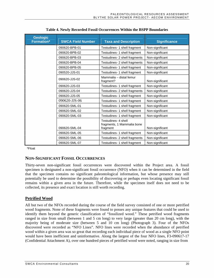
PALEONTOLOGICAL RESOURCES ASSESSMENT BLYTHE SOLAR POWER PROJECT- AECOM ENVIRONMENT
SWCA Env i ronmenta l Consu l tan ts 20
Table 4. Newly Recorded Fossil Occurrences Within the BSPP Boundaries
Geologic Formation* SWCA Field Number Taxa and Description Significance
090620-BPB-01 Testudines- 1 shell fragment Non-significant 090620-BPB-02 Testudines- 1 shell fragment Non-significant 090620-BPB-03 Testudines- 2 shell fragments Non-significant 090620-BPB-04 Testudines- 2 shell fragments Non-significant 090620-BPB-05 Testudines- 1 shell fragment Non-significant 090520-JJS-01 Testudines- 1 shell fragment Non-significant
090620-JJS-02 Mammalia – distal femur fragment? Non-significant
090620-JJS-03 Testudines- 1 shell fragment Non-significant 090620-JJS-04 Testudines- 2 shell fragments Non-significant 090620-JJS-05 Testudines- 1 shell fragment Non-significant 090620-JJS-06 Testudines- 1 shell fragment Non-significant 090620-SML-01 Testudines- 1 shell fragment Non-significant 090620-SML-02 Testudines- 1 shell fragment Non-significant 090620-SML-03 Testudines- 1 shell fragment Non-significant
090620-SML-04
Testudines- 4 shell fragments, 1 Mammalia bone fragment Non-significant
090620-SML-05 Testudines- 1 shell fragment Non-significant 090620-SML-06 Testudines- 2 shell fragments Non-significant 090620-SML-07 Testudines- 1 shell fragment Non-significant
*Float
NON-SIGNIFICANT FOSSIL OCCURRENCES Thirty-seven non-significant fossil occurrences were discovered within the Project area. A fossil specimen is designated a non-significant fossil occurrence (NFO) when it can be determined in the field that the specimen contains no significant paleontological information, but whose presence may still potentially be used to determine the possibility of discovering or perhaps even locating significant fossil remains within a given area in the future. Therefore, while the specimen itself does not need to be collected, its presence and exact location is still worth recording.
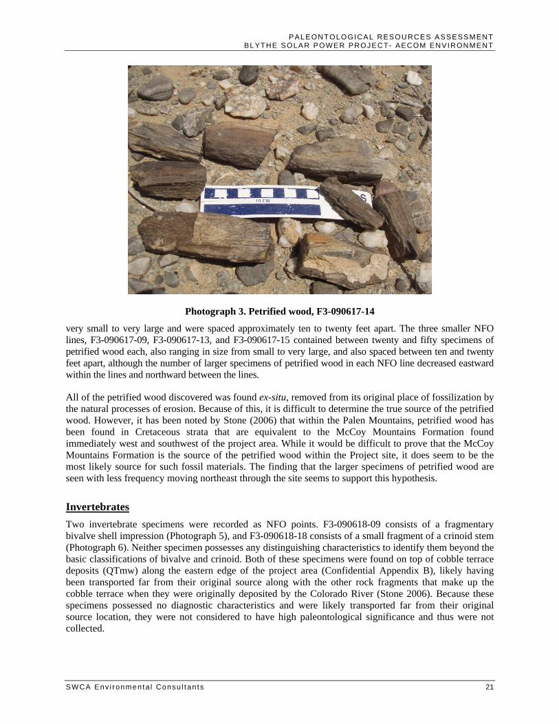
Petrified Wood All but two of the NFOs recorded during the course of the field survey consisted of one or more petrified wood fragments. None of these fragments were found to posses any unique features that could be used to identify them beyond the generic classification of “fossilized wood.” These petrified wood fragments ranged in size from small (between 1 and 5 cm long) to very large (greater than 20 cm long), with the majority being of moderate size (between 5 and 10 cm long) (Photograph 3). Four of the NFOs discovered were recorded as “NFO Lines”. NFO lines were recorded when the abundance of petrified wood within a given area was so great that recording each individual piece of wood as a single NFO point would have been inefficient and uninformative. Along the largest of the four NFO lines, F3-090617-17 (Confidential Attachment A), over one hundred pieces of petrified wood were noted, ranging in size from
PALEONTOLOGICAL RESOURCES ASSESSMENT BLYTHE SOLAR POWER PROJECT- AECOM ENVIRONMENT
SWCA Env i ronmenta l Consu l tan ts 21
Photograph 3. Petrified wood, F3-090617-14
very small to very large and were spaced approximately ten to twenty feet apart. The three smaller NFO lines, F3-090617-09, F3-090617-13, and F3-090617-15 contained between twenty and fifty specimens of petrified wood each, also ranging in size from small to very large, and also spaced between ten and twenty feet apart, although the number of larger specimens of petrified wood in each NFO line decreased eastward within the lines and northward between the lines.
All of the petrified wood discovered was found ex-situ, removed from its original place of fossilization by the natural processes of erosion. Because of this, it is difficult to determine the true source of the petrified wood. However, it has been noted by Stone (2006) that within the Palen Mountains, petrified wood has been found in Cretaceous strata that are equivalent to the McCoy Mountains Formation found immediately west and southwest of the project area. While it would be difficult to prove that the McCoy Mountains Formation is the source of the petrified wood within the Project site, it does seem to be the most likely source for such fossil materials. The finding that the larger specimens of petrified wood are seen with less frequency moving northeast through the site seems to support this hypothesis.
Invertebrates Two invertebrate specimens were recorded as NFO points. F3-090618-09 consists of a fragmentary bivalve shell impression (Photograph 5), and F3-090618-18 consists of a small fragment of a crinoid stem (Photograph 6). Neither specimen possesses any distinguishing characteristics to identify them beyond the basic classifications of bivalve and crinoid. Both of these specimens were found on top of cobble terrace deposits (QTmw) along the eastern edge of the project area (Confidential Appendix B), likely having been transported far from their original source along with the other rock fragments that make up the cobble terrace when they were originally deposited by the Colorado River (Stone 2006). Because these specimens possessed no diagnostic characteristics and were likely transported far from their original source location, they were not considered to have high paleontological significance and thus were not collected.

PALEONTOLOGICAL RESOURCES ASSESSMENT BLYTHE SOLAR POWER PROJECT- AECOM ENVIRONMENT
SWCA Env i ronmenta l Consu l tan ts 22
Photograph 4. Fossil bivalve, F3-090618-09
Photograph 5. Fossil crinoid, F3-090618-18
FOSSIL OCCURRENCE POINTS A total of sixty-four fossil occurrence points (i.e. localities) were recorded within the project area. The discovery of a fossil specimen is recorded as a fossil “point or “locality” when the significance of the specimen can not be determined in the field, and further evaluation is warranted. Because no vertebrate remains had been previously noted within the project area or within the immediate surroundings of the
PALEONTOLOGICAL RESOURCES ASSESSMENT BLYTHE SOLAR POWER PROJECT- AECOM ENVIRONMENT
SWCA Env i ronmenta l Consu l tan ts 23
Project area, it was determined at the start of the project that any vertebrate remains discovered should be considered as potentially significant.
Vertebrates As previously discussed, vertebrate remains have been previously discovered within the immediate vicinity of the )Project area, but not within the Project area itself. Because all vertebrate remains are considered by the BLM to be of potential significance and because none have been previously recorded within the Project site or within a one-mile radius, all vertebrate remains discovered during the field survey were collected. Of the 62 vertebrate fossil specimens discovered, 55 were determined to belong to the order Testudines, more commonly referred to as turtles. It is likely that all of these specimens belong to the family of Testudinidae, the land tortoises; however, it is difficult to be certain with most of the specimens as they lack any diagnostic characteristics required to make this distinction. These specimens typically consisted of shell and plastron fragments, usually between 2 and 3 square cm in size, although several shell fragments were much larger than this. A single cervical (neck) vertebra was discovered (090610-SML-01), the only non-shell turtle materials recovered during the field survey. The remaining eight vertebrate fossils discovered have been identified as mammalian and include a rib fragment, an ungula (terminal toe bone), a distal femur fragment, and several limb bone fragments. Unfortunately, none of the mammal bone fragments discovered possess any features that can be used to identify the specimens beyond the classification of Mammalian.
All of the vertebrate fossil remains discovered were found ex-situ, removed from their original place of fossilization, and resting on top of alluvial deposits. Additionally, nearly all of the specimens were found on Holocene-aged, young alluvial-fan and alluvial valley deposits (Qa6). While it is difficult to determine the exact origin of these fossil remains, it is suspected that they are originated from the surrounding and/or underlying Plio-Pleistocene and Pleistocene sediments, such as the alluvial deposits of the McCoy Wash area (QTmw) (see Figure 2), sediments that have been recognized by the LACM, SBCM and CDDSRC as potentially highly fossiliferous.
CONCLUSIONS All specimens were discovered ex-situ as lag deposits transported an unknown distance and re-deposited on top of alluvial sediments. For this reason, and due to the lack of diagnostic characteristics, none of the paleontological resources discovered within Project site are considered scientifically significant. However, the presence of fossilized bone indicates that scientifically significant specimens could be discovered in situ at the subsurface. The destruction of fossils as a result of human-caused ground disturbance has a significant cumulative impact, as it makes biological records of ancient life permanently unavailable for study by scientists. Implementation of proper mitigation measures can, however, reduce the impacts to the paleontological resources to below the level of significance. Construction of the project has the potential to result in the destruction of sub-surface paleontological resources via breakage and crushing related to ground-disturbing activities during grading for the proposed solar field, power block, drainage channels, and access road. Ground disturbance and terrain modification, expected to disturb 8,300,000 cubic yards of sediments, has the potential to adversely affect an unknown quantity of fossils that may occur on or underneath the surface in areas containing paleontologically sensitive geologic units. Although no significant paleontological resources were identified within the Project area during the course of the field survey, the entire Project area is underlain by geologic sediments determined to have a high paleontological sensitivity either at the surface or at a potentially shallow depth (5 feet or less below ground surface) (Figure 3).
PALEONTOLOGICAL RESOURCES ASSESSMENT BLYTHE SOLAR POWER PROJECT- AECOM ENVIRONMENT
SWCA Env i ronmenta l Consu l tan ts 24
All ground-disturbing activities in areas determined to have a high sensitivity (see Figure 3) shall be monitored on a full-time basis because of their high paleontological sensitivity. All ground disturbances in areas determined to have a “low to high” sensitivity (see Figure 3) at depths of 5 feet or greater shall also be monitored on a full-time basis. All ground disturbing activities less than 5 feet in depth shall be “spot-checked” by paleontological monitors.
Shallow excavations related to the development of the proposed plant site in areas immediately underlain by Holocene age alluvium are unlikely to result in adverse impacts to significant paleontological resources as these sediments are determined to have a “low” sensitivity at the surface. However, deeper excavations (5 feet or greater) within this unit may have an adverse impact to paleontological resources unless proper mitigation measures are implemented. Any excavations within Pleistocene and/or Pliocene age units throughout the project area may result in adverse impacts to paleontological resources unless proper mitigation measures are implemented.
Using information from published geologic maps and the results of the paleontology study of the PSP project site, the locations of the paleontologically sensitive geologic units underlying the proposed project area were identified and are depicted in Figure 3.
RECOMMENDED MITIGATION MEASURES Ground-disturbing activities in the BSPP project area may result in adverse impacts to significant paleontological resources unless proper mitigation measures are implemented. Implementation of proper mitigation measures can, however, reduce the impacts to the paleontological resources to below the level of significance.
The following mitigation measures have been developed to reduce the potential adverse impacts on paleontological resources to a less than significant level. The measures are based on the SVP standard guidelines (1995) and meet the requirements of CEQA. These mitigation measures have been used throughout California and have been demonstrated to be successful in protecting paleontological resources while allowing timely completion of construction projects in paleontologically sensitive areas.
PRE-CONSTRUCTION PHASE A. Prior to the start of any project related construction (defined as construction related vegetation clearing, ground disturbance and preparation, and site excavation activities), the project owner shall ensure that the designed paleontological resource specialist approved by the CPM is available for field activities and prepared to implement the conditions of certification. The designated paleontological resource specialist shall be responsible for implementing all the paleontological conditions of certification and for using qualified personnel to assist in this work.
B. Prior to the start of construction, a Paleontological Resource Monitoring and Mitigation Plan drafted by the designated paleontological resource specialist shall be submitted to the CPM for approval. The plan shall identify general and specific measures to minimize potential impacts to sensitive paleontological resources. The project paleontological resource specialist shall implement the Paleontological Resource Monitoring and Mitigation Plan as needed.
The Paleontological Resource Monitoring and Mitigation plan shall include, but not be limited to, the following elements and measures.

PALEONTOLOGICAL RESOURCES ASSESSMENT BLYTHE SOLAR POWER PROJECT- AECOM ENVIRONMENT
SWCA Env i ronmenta l Consu l tan ts 25
• A discussion of the sequence of project-related tasks, such as any preconstruction surveys, fieldwork, flagging or staking; construction monitoring; mapping and data recovery; fossil preparation and recovery; identification and inventory; preparation of final reports; and transmittal of materials for curation;
• Identification of the person(s) expected to assist with each of the tasks identified within this condition, and a discussion of the mitigation team leadership and organizational structure, and the interrelationship of tasks and responsibilities;
• Where monitoring of project construction activities is deemed necessary, the extent of the areas where monitoring is to occur and a schedule for the monitoring.
• An explanation that the designated Paleontological Resource Specialist shall have the authority to halt or redirect construction in the immediate vicinity of a vertebrate fossil find until the significance of the find can be determined;
• A discussion of the equipment and supplies necessary for the recovery of fossil materials and any specialized equipment needed to prepare, remove, load, transport, and analyze large-sized fossils or extensive fossil deposits;
• Inventory, preparation and delivery for curation info a retrievable storage collection in a public repository or museum, which meets the Society of Vertebrate Paleontology standards and requirements for the curation of paleontological resources; and
• Identification of the intuition that has agreed to receive any data and fossil materials recovered during project-related monitoring and mitigation work, discussion of any requirements of specifications for materials delivered for curation and how they will be met, and the name and phone number of the contact person at the institution.
C. Prior to the start of construction, the Paleontological Resource Specialist shall prepare a staff training program for review and approval by the CPM. Prior to and throughout the project and as needed, the paleontological resource specialist shall conduct training for the project owner, project managers, construction supervisors, equipment operators and all new employees in accordance with the CPM approved training plan. Contractor briefings will also be videotaped and used for education for new employees.
The paleontological training program shall address the potential to encounter paleontological resources in the field, the sensitivity and importance of these resources, and the legal obligations to preserve and protect such resources. The training program shall also include the set of reporting procedures that workers are to follow if paleontological resources are encountered during project activities. The training program shall be presented by the designated Paleontological Resource Specialist and may be combined with other training programs prepared for cultural and biological resources, hazardous materials or any other areas of interests or concerns.
CONSTRUCTION PHASE D. The designated paleontological resource specialist or paleontological monitor shall be present at all times he or she deems appropriate to monitor construction-related grading, excavation, trenching, and/or augering in areas with a significant potential for fossil-bearing sediments to occur. All ground-disturbing activities in areas determined to have a high sensitivity (See Figure 3) shall be monitored on a full-time

PALEONTOLOGICAL RESOURCES ASSESSMENT BLYTHE SOLAR POWER PROJECT- AECOM ENVIRONMENT
SWCA Env i ronmenta l Consu l tan ts 26
basis because of their high paleontological sensitivity. All ground disturbances in areas determined to have a “low to high” sensitivity (see Figure 3) at depths of 5 feet or greater shall also be monitored on a full-time basis. All ground disturbing activities less than 5 feet in depth shall be “spot-checked” by paleontological monitors. The frequency of the spot checks shall be determined by the Paleontological Specialist and will be based on factors such as the extent of ground disturbance and the location of those disturbances in relation to paleontologically sensitive sediments. Paleontological monitoring will include inspection of exposed rock units and collection of matrix to be testing for the presence of microscopic fossils. Paleontological monitors will have authority to temporarily divert excavations or drilling away from exposed fossils in order to efficiently and professionally recover the fossil specimens and collect associated data.
POST-CONSTRUCTION PHASE E. The project owner, through the designated paleontological resource specialist, shall ensure recovery, preparation for analysis, analysis, identification and inventory, the preparation for curation, and the delivery for curation of all significant paleontological resource materials encountered and collected during the monitoring, data recovery, mapping, and mitigation activities related to the project.
F. The project owner shall ensure preparation of a Paleontological Resources Report by the designated paleontological resource specialist. The Paleontological Resources Report shall be completed following the analysis of the recovered fossil materials and related information. The project owner shall submit the paleontological report to the CPM for approval. The report shall include, but not be limited to, a description and inventory list of recovered fossil materials; a map showing the location of paleontological resources found in the field; determinations of sensitivity and significance; and a statement by the paleontological resource specialist that project impacts to paleontological resources have been mitigated.

PALEONTOLOGICAL RESOURCES ASSESSMENT BLYTHE SOLAR POWER PROJECT- AECOM ENVIRONMENT
SWCA Env i ronmenta l Consu l tan ts 27
REFERENCES Bureau of Land Management, 2008 (revised). Paleontology Resources Management Manual and
Handbook H-8270-1, 38p.
California Energy Commission, 2000, Energy Facility Licensing Process: Developers Guide of Practices and Procedures. Staff Report, 67 p.
California Energy Commission (CEC), 2007, Complete Text of the California Energy Commission’s Proposed Amendments to the Power Plant Siting Regulations. Commission Report, 49 p.
County of Riverside. 2003. County of Riverside General Plan. Adopted October 7, 2003.
Jennings, C.W., 1967, Geologic map of California: Salton Sea Sheet. Scale: 1:250,000. California Division of Mines and Geology.
McLeod, S.A., 2009, Unpublished paleontological specimen and locality data. Natural History Museum of Los Angeles County, Los Angeles, California, 2 p.
Metzger, D.G., Loeltz, O.J., and B. Irelna. 1973. Geohydrology of the Parker-Blythe-Cibola Area, Arizona and California: Water Resources of Lower Colorado River-Salton Sea Area. U.S. Geological Survey Professional Paper 486-G.
Murphey, P.C., and Daitch, D., 2007, Paleontological overview of oil shale and tar sands areas in Colorado, Utah and Wyoming: U.S. Department of Energy, Argonne National Laboratory Report Prepared for the U.S. Department of Interior Bureau of Land Management, 468 p. and 6 maps (scale 1:500,000).
Norris, R.M. and R.W. Webb, 1976, Geology of California, second edition. John Wiley & Sons, New York, p. 277–300.
Scott, E., 2009, Unpublished paleontological specimen and locality data. San Bernardino County Museum, Redlands, California, 2p.
Society of Vertebrate Paleontology (SVP), 1995, Assessment and Mitigation of Adverse Impacts to Nonrenewable Paleontologic Resources: Standard Guidelines. Society of Vertebrate Paleontology News Bulletin. v. 163, p. 22–27.
Stone, P. 2006. Geologic Map of the West Half of the Blythe 30’ by 60’ Quadrangle, Riverside County, California and La Paz County, Arizona. U.S. Geological Survey Scientific Investigations Map 2922. Scale: 1:100,000.

PALEONTOLOGICAL RESOURCES ASSESSMENT BLYTHE SOLAR POWER PROJECT- AECOM ENVIRONMENT
SWCA Env i ronmenta l Consu l tan ts
Confidential Attachment A: Non-Significant Fossil Occurrences
Confidential Attachment B:
Fossil Occurrence Points
Confidential Attachment C: Paleontological Locality Forms
Confidential Documents will be submitted under separate cover