Embed Size (px)
Citation preview

AONB DPD Submission Version (February 2018)

AONB DPD Submission Version (February 2018)
Foreword
This Development Plan Document (DPD) for the Arnside & Silverdale Area of Outstanding
Natural Beauty (AONB) has been produced by Lancaster and South Lakeland District
Councils, with assistance from the Arnside & Silverdale AONB Unit. A joint working approach
makes sense because these bodies have a shared responsibility for this important protected
landscape.
The AONB DPD is the first Development Plan Document for an AONB in the country.
The AONB DPD complements the Management Plan for the AONB, for which the underlying
principle is to work collaboratively to help conserve and enhance the landscape of the area.
The AONB DPD places the landscape at the heart of shaping development over the next 15
years. It is a clear statement of the positive benefits of joint working between Lancaster and
South Lakeland, and the two Councils are committed to applying the policies consistently.
Signed:
Cllr. Jonathan Brook, Housing & Innovation Portfolio Holder, South Lakeland District Council
Cllr. Janice Hanson, Economic Regeneration & Planning Portfolio Holder, Lancaster City
Council

AONB DPD Submission Version (February 2018)
1
Contents
1 Introduction .................................................................................................................... 3 1.1 Introduction ............................................................................................................. 3 1.2 Why do we need a Development Plan Document for the AONB? ........................... 3 1.3 Other documents that guide development in the AONB .......................................... 7 1.4 Evidence and Infrastructure .................................................................................. 10 1.5 Sustainability Appraisal and Habitats Regulations Assessment ............................ 11 1.6 Structure of Document .......................................................................................... 11
2 Vision and Objectives .................................................................................................. 13 2.1 Vision .................................................................................................................... 13 2.2 Objectives ............................................................................................................. 14
3 Overall Strategy ............................................................................................................ 15 3.1 The Landscape and Development Strategy .......................................................... 15
AS01 – Development Strategy .............................................................................................. 15 AS02 – Landscape ................................................................................................................ 20
4 Policy Issues ................................................................................................................. 23 4.1 Housing Provision ................................................................................................. 23
AS03 – Housing Provision ..................................................................................................... 23 4.2 Natural Environment ............................................................................................. 25
AS04 – Natural Environment ................................................................................................. 25 4.3 Open Space and Recreation ................................................................................. 31
AS05 – Public Open Space and Recreation.......................................................................... 31 AS06 – Key Settlement Landscapes ..................................................................................... 31
4.4 Historic Environment ............................................................................................. 34 AS07 – Historic Environment ................................................................................................. 34
4.5 Design .................................................................................................................. 36 AS08 – Design ....................................................................................................................... 36
4.6 Economic Development and Community Facilities ................................................ 42 AS09 - Economic Development and Community Facilities ................................................... 42
4.7 Supporting Infrastructure for New Development .................................................... 44 AS10 – Infrastructure for New Development ......................................................................... 44
4.8 Camping, Caravan and Visitor Accommodation .................................................... 46 AS11 - Camping, Caravan and Visitor Accommodation ........................................................ 46
4.9 Water quality, sewerage and sustainable drainage ............................................... 49 AS12 – Water quality, sewerage and sustainable drainage .................................................. 49
4.10 Energy and Communications ................................................................................ 51 AS13 – Energy and Communications .................................................................................... 51
4.11 Advertising and Signage ....................................................................................... 54 AS14 – Advertising and Signage ........................................................................................... 54
5 Proposed Development Allocations ............................................................................ 55 5.1 Site assessment and selection .............................................................................. 55 5.2 Sites Proposed for Allocation for Development ..................................................... 55
AS15 – Housing Allocations .................................................................................................. 55 AS16 – Mixed-Use Allocations .............................................................................................. 56
5.3 Site Mini-Briefs ...................................................................................................... 57 AS17 (A6) – Land off Queen’s Drive, Arnside ....................................................................... 58 AS18 (part of A9) – Land on Hollins Lane, Arnside ............................................................... 60 AS19 (A11) – Land on Briery Bank, Arnside ......................................................................... 62 AS20 (B108) – Land on Church Street, Beetham ................................................................. 64 AS21 (W88) – Land North West of Sand Lane, Warton ........................................................ 66 AS22 (part of W130) – Land North of 17 Main Street, Warton .............................................. 68
AONB DPD Submission Version (February 2018)
2
AS23 (A26/A27) - Station Yard, Arnside ............................................................................... 70 AS24 (S70) – Railway Goods Yard, Silverdale ..................................................................... 72 AS25 (B35 / B38 / B81 / B125) – Land on Sandside Road and Quarry Lane, Sandside ...... 74
6 Policy Areas Not Covered in this Document .............................................................. 77
7 Monitoring and Implementation Framework ............................................................... 78
8 Appendices ................................................................................................................... 80 Appendix 1: Policies Map (see separate document) ....................................................... 80 Appendix 2: List of Public Open Spaces ......................................................................... 80 Appendix 3: List of Key Settlement Landscapes ............................................................. 81 Appendix 4: Glossary ..................................................................................................... 82

AONB DPD Submission Version (February 2018)
3
1 Introduction
1.1 Introduction
Lancaster City Council and South Lakeland District Council are Local Planning Authorities,
responsible for preparing Local Plans and determining planning applications in their areas1. A
Local Plan sets out what development is needed in an area and contains policies to ensure
that those needs are met in a sustainable way. Local Plans are used to determine planning
applications and also to influence infrastructure provision and environmental management. A
Development Plan Document (DPD) is part of the statutory Local Plan.
Together, we have prepared this DPD for the Arnside & Silverdale area. The area is
designated as an Area of Outstanding Natural Beauty (AONB) (see map on page 6) with the
statutory purpose of conserving and enhancing the natural beauty of the area. This means
that the area’s landscape has been identified by the Government as being of national
importance. Designation as an AONB and the resulting legal powers and statutory obligations
arise out of the National Parks and Access to the Countryside Act 1949 and the Countryside
and Rights of Way Act 2000.
1.2 Why do we need a Development Plan Document for the
AONB?
The Arnside & Silverdale AONB is a special place. It is characterised by an intimate mosaic of
low limestone hills, woodland, wetland, pastures, limestone pavements, intertidal flats, coastal
scenery and distinctive settlements. Reflecting these, the AONB’s Special Qualities are:
Outstanding landscape and spectacular views;
Unique limestone geology;
Morecambe Bay – a stunning seascape;
Rare and precious habitats;
Internationally and nationally important species;
Rich sense of history;
Distinctive settlement character;
Strong community and culture;
Opportunities to enjoy the countryside;
A sense of tranquillity, space and place; and
A highly designated area.
The Special Qualities are described in more detail in the AONB Special Qualities Report.
The AONB straddles the boundary between two counties (Lancashire and Cumbria) and two
Districts (Lancaster and South Lakeland). The two District Councils (along with other public
bodies) have a statutory duty under Section 85 of the Countryside and Rights of Way
(CRoW) Act 2000 to have regard to the statutory purpose of AONBs in carrying out their
1 Lancashire and Cumbria County Councils are the minerals and waste planning authorities for the AONB. Both Councils have adopted Minerals and Waste Local Plans and these must be read in conjunction with this DPD, especially where development is proposed within Minerals Safeguarding Areas.

AONB DPD Submission Version (February 2018)
4
functions. Within the AONB, Government policy requires that councils give great weight to
conserving landscape and natural beauty.
Management of the AONB is co-ordinated by the Arnside & Silverdale AONB Partnership,
which is made up of the County and District Councils, Parish Councils, government agencies
and community and business representatives. The Partnership adopted an updated Statutory
Management Plan2 in 2014, which sets out the overall strategy for managing, conserving and
enhancing the AONB. The Management Plan also sets out some key principles for the DPD.
These include that it should:
(I) reflect the national importance of the AONB;
(II) contain policies to conserve and enhance landscape quality and character,
tranquillity, dark skies, local distinctiveness, settlement character, pattern and local
vernacular architecture, habitats and species, geodiversity and the historic
environment;
(III) identify appropriate sites for the delivery of housing to meet local community
needs demonstrated by a housing needs survey, prioritising affordable housing and
use of brownfield sites;
(IV) identify appropriate sites to support the delivery of local employment and
business opportunities, prioritising use of brownfield sites;
(V) support the development and retention of local services and facilities and
advocate the need for local services to support community life and the local tourism
industry;
(VI) define and conserve areas of important open green space within settlements;
(VII) protect the setting of, and views out from and in to the AONB;
(VIII) support small-scale renewable energy developments appropriate to the local
landscape character;
(IX) manage tourism related development such as camping, lodge and caravan
development and car parking;
(X) promote appropriate diversification and sensitive re-use of rural buildings and
consider the spatial relationship with surrounding areas, in particular Milnthorpe and
Carnforth.
Therefore, the reasons for preparing the AONB DPD are:
(I) While the AONB is an area of national landscape importance, it is relatively
small and lies on the edge of both Districts. This means that District-wide
Local Plans for Lancaster and South Lakeland would not have the AONB as
2 Adopted by Lancaster City Council and South Lakeland District Council in 2014

AONB DPD Submission Version (February 2018)
5
their main focus. An AONB DPD can focus on the AONB and have its
conservation and enhancement at its heart.
(II) The AONB DPD is an important means of implementing the AONB
Management Plan and will give statutory development plan policy force to
some of the principles of the management plan when planning applications
are considered.
(III) The special character of the AONB requires a different approach to local
planning to that outside nationally important landscapes, an issue that was
raised by the Inspector considering South Lakeland’s Local Plan Land
Allocations document.
(IV) Councils and other public bodies now have a duty to co-operate, which
means that, in areas where planning issues cross boundaries, they must work
together.
(V) Policies and decisions need to be consistent across the whole of the
AONB in respect of the conservation significances and the response to
development pressures.
(VI) The communities within the AONB have a strong desire to be involved
in shaping its future. The AONB Partnership provides a strong and well
established forum to bring the communities together.
(VII) The compact size of the AONB and its complex self-contained inter-
relationships and related settlement characters give it a strong sense of
unity and cohesiveness.
This is the first AONB DPD in England. It is a pioneering and innovative approach and has
been followed closely by other AONB Partnerships up and down the country as an example of
how an AONB Partnership, councils and communities can work together to produce the best
outcomes for an AONB.
The AONB covers 75 km2 and has a population of around 7,800. The main settlements are
Arnside (population 2,334), Warton (1,805), Silverdale (1,326) and Storth/Sandside (978).
Around 2,800 people work within the AONB. The largest single employer is the Billerud
Paper Mill in Beetham. Other important sectors are land management, education, health,
accommodation, food and drink, tourism and construction. Arnside and Silverdale are the
main service centres within the AONB. The area has close links to Carnforth, Lancaster,
Kendal and Milnthorpe for employment and for services such as supermarkets and secondary
education. Many people living in the AONB work and use services further afield.

AONB DPD Submission Version (February 2018)
6

AONB DPD Submission Version (February 2018)
7
1.3 Other documents that guide development in the AONB
The AONB DPD is only one of a number of plans and strategies affecting the AONB. It will
complement existing plans and strategies including the AONB Management Plan and other
local plan documents. The most important of these at the time that the Arnside & Silverdale
AONB DPD was submitted are described below. The status of these documents should
always be checked and verified as being up to date when reading the DPD.
The AONB DPD must be read alongside these other documents in order to understand the
full range of requirements that will apply to new development in the AONB. When assessing
development proposals within the AONB or its setting, the policies set out in this DPD must be
followed in conjunction with national and District-wide policies. Where this DPD sets specific,
different and/or additional requirements that are not set out in the District-wide policies, this
DPD takes precedence.
Policies within the AONB DPD must be read alongside one another and each is subject to
compliance with the requirements set out in all others. The accompanying Policy Links
document sets out which policy topics are covered in the AONB DPD and which are covered
in other Local Plan documents in each of the two Districts as well as identifying which AONB
Management Plan objectives and which elements of national policy and which evidence
documents are relevant to each policy.
National Planning Policies
Local Plans must be in general conformity with national planning policies set out in National
Policy; currently the National Planning Policy Framework (NPPF) (2012). The central theme
of the NPPF is a ‘presumption in favour of sustainable development’. Paragraph 14 sets out
that:
At the heart of the National Planning Policy Framework is a presumption in favour of
sustainable development, which should be seen as a golden thread running through both
plan-making and decision-taking. For plan-making this means that:
Local Planning Authorities should positively seek opportunities to meet the
development needs of their area;
Local Plans should meet objectively assessed needs, with sufficient flexibility to
adapt to rapid change, unless:
- any adverse impacts of doing so would significantly and demonstratively outweigh
the benefits, when assessed against the policies in this Framework taken as a
whole; or
- specific policies in this Framework indicate development should be restricted.
Footnote 9 in the NPPF, which relates to the ‘specific policies’ referenced in the above
paragraph, states: “For example, those policies relating to sites protected under the Birds and
Habitats Directives (see paragraph 119) and/or designated as Sites of Special Scientific
Interest; land designated as Green Belt, Local Green Space, an Area of Outstanding Natural
Beauty, Heritage Coast or within a National Park (or the Broads Authority); designated
heritage assets; and locations at risk of flooding or coastal erosion”.

AONB DPD Submission Version (February 2018)
8
This means that within AONBs, development should be restricted and Objectively Assessed
Needs need not be met. It also means that the presumption in favour of sustainable
development needs to be taken in the context of the AONB’s status as a nationally protected
landscape and in the context of the purpose of AONB designation.
Paragraph 115 of the NPPF states:
Great weight should be given to conserving landscape and scenic beauty in National Parks,
the Broads and Areas of Outstanding Natural Beauty, which have the highest status of
protection in relation to landscape and natural beauty. The conservation of wildlife and cultural
heritage are important considerations in all these areas, and should be given great weight in
National Parks and the Broads.
The NPPF also confirms that Local Planning Authorities should set out the strategic priorities
for their areas within Local Plans and deliver the conservation and enhancement of the
natural environment, including landscape (NPPF paragraph 156). It also states that:
Planning should contribute to conserving and enhancing the natural environment
(paragraph 17, bullet 7, first part), and Local Plans should identify land where
development would be inappropriate because of its environmental or historical
significance (paragraph 157);
Allocations of land for development should prefer land of lesser environmental value
(counting AONBs as the highest value: paragraph 17 bullet 7, second part);
Local Planning Authorities should set evidence and criteria based planning policies
against which proposals for any development on or affecting landscape will be judged
(paragraph 113).
Paragraph 116 of the NPPF states:
Planning permission should be refused for major developments3 in these designated areas
except in exceptional circumstances and where it can be demonstrated that they are in the
public interest. Consideration of such applications should include an assessment of:
The need for the development, including in terms of any national considerations, and the
impact of permitting it, or refusing it, upon the local economy;
The cost of, and scope for, developing elsewhere outside the designated area, or
meeting the need for it in some other way; and
Any detrimental effect on the environment, the landscape and recreational opportunities,
and the extent to which that could be moderated.
The National Planning Policy Guidance (NPPG), which accompanies the NPPF, re-iterates
Local Authorities’ statutory duties in relation to AONBs, setting out that Local Planning
3 Major development in the Arnside & Silverdale AONB is defined as development that has the potential to have a serious adverse impact on the landscape, wildlife, cultural heritage or other characteristics of the AONB because of its scale, form, character or nature.

AONB DPD Submission Version (February 2018)
9
Authorities should have regard to AONB management plans, including their contribution to
setting the strategic context for development by providing evidence and principles.
The Lancaster District Local Plan
The relevant parts of the Lancaster Local Plan are:
(I) The Lancaster District Core Strategy (2008), which sets out the overall
development strategy and vision for the District. It identifies the AONB as a key
element of the District’s environmental capital, identifies the need for a spatial
strategy for the AONB and identifies Silverdale as a focus to meet local
development needs in the area.
(II) The Lancaster District Development Management DPD (2014), which sets out
policies used to help determine planning applications in Lancaster District. It
identifies Warton and Silverdale as sustainable settlements. The DPD is written in
anticipation that certain policy areas may be subject to further consideration in the
preparation of the Arnside & Silverdale AONB DPD.
(III) Saved policies of the Lancaster District Local Plan (2004).
Lancaster City Council is currently preparing a Local Plan for the District. This comprises a
Land Allocations DPD and a review of the 2014 Development Management DPD. Policies
within the Development Management DPD will apply to development within the AONB, with
the policies in the AONB DPD forming an additional layer that will also apply. When adopted,
the Land Allocations DPD will replace all other allocations in the District for the area outside
the AONB.
The South Lakeland Local Plan
The relevant parts of the South Lakeland Local Plan are:
(I) The South Lakeland Local Plan - Core Strategy (2010), which sets out the
overall development strategy and vision for the District, recognises and
safeguards the special characteristics of the AONB and identifies Arnside and
Storth/Sandside as Local Service Centres.
(II) The South Lakeland Local Plan – Land Allocations (2013), which identifies the
AONB as an area for which a specific DPD will be prepared and sets out some
issues that the plan is intended to address including a review of settlement
boundaries and policies on landscape, building design and new visitor facilities.
The Local Plan - Land Allocations does not allocate sites in the AONB.
(III) Saved policies of the South Lakeland Local Plan (1997, updated 2006)
including Development Management policies, the identification of important open
spaces in the AONB and an unimplemented allocation for local employment use at
Quarry Lane, Storth4.
4 The AONB DPD, once adopted, will supersede the extant allocation at Quarry Lane, Sandside

AONB DPD Submission Version (February 2018)
10
South Lakeland is currently preparing a Development Management Policies document. Saved
policies set out in the 2006 Local Plan will be superseded by the new Development
Management Policies document. The new policies will complement the existing Core Strategy
policies. Policies within the document will apply to development in the AONB, with the policies
in the AONB DPD forming an additional layer that will also apply.
The Arnside & Silverdale AONB Management Plan
The statutory AONB Management Plan is a critical document. It is not part of the Local Plan
for the area, but it is a material consideration in making planning decisions. The Management
Plan is prepared by the statutory AONB Partnership, which includes Local Authorities, Parish
Councils, Government agencies, local businesses, landowners and community and user
groups. It defines the Special Qualities of the AONB, sets out the shared vision and
objectives for the AONB and establishes a joint partnership approach to the management of
the area. The aims of the Management Plan reflect the primary purpose of the AONB and are
to:
(I) conserve and enhance the natural beauty and Special Qualities of the AONB;
(II) promote and support sustainable agriculture, forestry and other rural industries;
(III) promote the social and economic wellbeing of people living within the AONB;
(IV) increase public understanding and enjoyment of the AONB; and
(V) meet the recreational needs of local residents and visitors alike – where these are
compatible with the primary purpose of AONB designation.
The AONB DPD is one of the key mechanisms by which the Management Plan will be
delivered as it will implement a development planning approach that delivers services,
infrastructure and affordable housing to contribute to meeting the local needs of the AONB
whilst conserving and enhancing the landscape character, natural beauty and Special
Qualities of the AONB.
1.4 Evidence and Infrastructure
To ensure that any infrastructure requirements to support the delivery of the plan have been
properly considered we have worked closely with infrastructure providers throughout the
preparation of the DPD. Alongside wider consultation, this has helped us to identify key
AONB-wide and site-specific infrastructure issues (including those that might prevent or
hinder site delivery), as well as likely requirements in the AONB and delivery mechanisms.
Lancaster City and South Lakeland District Councils have developed evidence bases to
inform their existing Local Plan documents, and the AONB Partnership has done the same to
inform the AONB Management Plan. Much of this evidence is relevant to and has helped to
inform the AONB DPD. This includes for example Employment Land Studies, the AONB
Landscape and Seascape Character Assessment and a wealth of information provided by
mapping local, national and internationally protected biodiversity sites and other designations
such as sites of heritage importance. However, there are some topic areas in which new
information was required, the most important of which was the AONB-wide Housing Needs

AONB DPD Submission Version (February 2018)
11
Survey undertaken in 2014. New evidence has also been prepared for the historic
environment, including the Historic Designed Landscapes Study and Local Lists - lists of
locally important heritage assets and management approaches for them, and also for caravan
sites (recording the number and location of caravan pitches). Evidence and guidance
documents relevant to the application of each policy are set out in the accompanying Policy
Links document.
1.5 Sustainability Appraisal and Habitats Regulations
Assessment
All new Local Plan documents are assessed using a Sustainability Appraisal (SA) to ensure
that they are contributing to sustainable development. This is required by the Strategic
Environmental Assessment (SEA) Directive5. The SA has informed plan making throughout
the process.
The SA report sits alongside the DPD. It sets out the approach to SA, the methodology used
and the results, as well as how the SA informed the preparation of the AONB DPD. The SA
concluded that there are no significant matters that need to be addressed, but it made a
number of recommendations that have been taken into account to improve the overall
contribution of the DPD to sustainability.
The DPD is also accompanied and has been informed by assessment under the Habitats
Regulations6. This assessment concluded that the Plan would not be likely to have a
significant effect on any site designated for its biodiversity value at a European level, either
alone or in combination with any other plans or projects.
1.6 Structure of Document
The document is split into 7 sections:
Part 1 is this Introduction. It tells you what the DPD is for, the context of the DPD and the
stages of preparation of the DPD. It explains how the two Councils have worked together. It
also explains the structure of the document.
Part 2 sets out the Vision and Objectives for the AONB DPD.
Part 3 sets out policies dealing with the overall strategy for development in the AONB.
Part 4 sets out development management policies for the AONB, which will be applied in
addition to other local and national policies as part of the Development Plan for the area.
Part 5 sets out allocations for residential and mixed-use development.
Part 6 explains how the AONB DPD sits alongside other documents, and where topics not
covered in the AONB DPD are covered.
Part 7 considers the monitoring and implementation of the plan.
Part 8 contains the Appendices.
5 Directive 2001/42/EC of the European Parliament and of the Council of 27 June 2001 on the assessment of the effects of certain plans and programmes on the environment 6 Directive 92/43/EEC of 21 May 1992 on the conservation of natural habitats and of wild fauna and flora. The Habitats Directive is primarily transposed in England under the Conservation of Habitats and Species Regulations 2010 (the Habitats Regulations) and in the offshore marine area by the Offshore Marine Conservation (Natural Habitats, &c) Regulations 2007.

AONB DPD Submission Version (February 2018)
12
In parts 2-5, each topic area is presented in the same way. First, the policy is set out in a box.
This is then accompanied by supporting, explanatory and background text to the content of
the policy. The Consultation Statement sets out all the responses made to consultations on
the DPD, our response to these and how they have informed the final DPD.

AONB DPD Submission Version (February 2018)
13
2 Vision and Objectives
2.1 Vision
The Vision for the AONB set out in the adopted Management Plan is:
Arnside & Silverdale Area of Outstanding Natural Beauty is a landscape of
international importance, whose distinctive character is conserved and enhanced
for future generations.
It is a place that is much loved and highly valued for its strong sense of place,
unique geology, rich wildlife and cultural heritage and the benefits it provides to
society.
Its distinctive landscape character - an intimate mosaic of low limestone hills,
woodland, wetland, pastures, limestone pavements, intertidal flats, coastal scenery
and distinctive settlements - is enjoyed, cherished and conserved by those who live
in, work in and visit the area.
The high quality landscape supports and is supported by the area’s thriving rural
economy and vibrant diverse local communities.
There are many and varied opportunities for people to access, enjoy and
understand the area’s Special Qualities, and participate in their conservation,
creating a strong connection with nature and the landscape.
Challenges and pressures are effectively and sensitively managed in an integrated
way through a partnership approach. The area’s natural and cultural assets are
managed and used wisely for future generations.
2.1.2 The Vision for the AONB DPD needs to reflect and supplement the adopted Management
Plan Vision, the two relevant Local Plans, national policy, the evidence gathered and wider
context. The following Vision for the AONB DPD sets out how development and planning
considerations will support the Management Plan Vision and delivery. It relates specifically
to those areas that can be managed and delivered through the planning system.
Within the Arnside & Silverdale AONB, housing, employment, services, infrastructure
and other development is managed to contribute towards meeting the needs of those
who live in, work in and visit the area in a way that:
(I) conserves and enhances the landscape, the natural beauty, and the Special
Qualities of the AONB; and
(II) creates vibrant, diverse and sustainable communities with a strong sense of
place; and
(III) maintains a thriving local economy.

AONB DPD Submission Version (February 2018)
14
2.2 Objectives
The Objectives for the AONB DPD should reflect the objectives set out in the AONB
Management Plan, the two relevant Local Plans, national policy, the evidence gathered and
wider context.
(I) To conserve and enhance the landscape, and the natural beauty of the AONB,
including landscape character and visual amenity, wildlife, geology, heritage and
settlement character;
(II) To ensure that all development is appropriate and sustainable in its location and
design and is of high quality;
(III) To ensure that planning policy is shaped by effective community engagement;
(IV) To provide sufficient supply and mix of high quality housing to contribute to meeting
the needs of the AONB’s communities, with an emphasis on affordable housing and
without adverse impact on the landscape character of the AONB;
(V) To support rural employment and livelihoods, and sustainable tourism;
(VI) To provide the necessary services and infrastructure to support both existing and new
development;
(VII) To support the development of a safe and sustainable transport network, including
paths and cycleways, to improve connectivity, reduce the need to travel and
encourage sustainable forms of transport.
The proposed Objectives for the DPD state what needs to be achieved in order to make the
Vision a reality. They provide a link between the Vision and the proposals for development in
the AONB.

AONB DPD Submission Version (February 2018)
15
3 Overall Strategy
3.1 The Landscape and Development Strategy
This DPD places development more clearly in the context of the primary purpose of the AONB
– to conserve and enhance the natural beauty of the area - and to put this at the heart of
planning for the AONB. The two policies that follow in this section are designed to ensure that
the primary purpose is at the heart of the overall approach to development in the AONB and
to better ensure that new development supports the AONB’s primary purpose and Special
Qualities. Given the coastal location of the AONB, landscape and seascape are closely
related. References in this DPD to “landscape” should be read to include “seascape”. This is
especially relevant in reading and interpreting policy wording where both landscape and
seascape characteristics are important considerations.
AS01 – Development Strategy
A landscape capacity-led approach to development will be taken in the AONB. Great
weight will be given to the principle of conserving landscape and natural beauty, wildlife
and cultural heritage in the AONB.
All Development
All development in the Arnside & Silverdale AONB should be sustainable, consistent with
the primary purpose of AONB designation7, and support the Special Qualities of the AONB
as set out in the AONB Management Plan.
Development within Local Service Centres
To promote vibrant local communities and support services, small scale growth and
investment will be supported in the identified Local Service Centres where it closely reflects
identified local needs within the AONB and conserves and enhances the local landscape
and settlement character. The following villages are defined as AONB Local Service
Centres: Arnside, Silverdale, Sandside/Storth and Warton.
Development in Small Villages
In the Small Villages of Yealand Redmayne, Yealand Conyers, Hale, Carr Bank, Slackhead
and Beetham, development will typically be limited to conversion of buildings, re-use of
brownfield land or regeneration opportunities. In Beetham, other proposals will be
considered for their suitability in relation to the level of services and facilities available in
the village.
contd.
7 As set out in the National Parks and Access to the Countryside Act 1949; confirmed by Section 82 of the Countryside and Rights of Way Act 2000:
The primary purpose of the designation is to conserve and enhance natural beauty.
In pursuing the primary purpose of the designation, account should be taken of the needs of agriculture, forestry and other rural industries and of the economic and social needs of local communities. Particular regard should be paid to promoting sustainable forms of social and economic development that in themselves conserve and enhance the environment.
Recreation is not an objective of the designation, but the demand for recreation should be met insofar as this is consistent with the conservation of natural beauty and the needs of agriculture, forestry and other uses.

AONB DPD Submission Version (February 2018)
16
AS01 – Development Strategy contd.
Development proposals within the Small Villages will be permitted only where they:
(I) conserve and enhance the area’s distinctive landscape and settlement character;
and
(II) closely reflect demonstrable local needs within the AONB; and
(III) demonstrate an efficient use of previously developed land or buildings or help sustain
an existing business.
Development on the edge of and outside settlements
Development proposals on the edge of and outside settlements, including in hamlets and
the open countryside, will be treated as exceptions and will be permitted only where they
demonstrate that:
(IV) there would be no adverse impact on settlement or landscape character; and that
(V) there is an essential need for a rural location; or
(VI) it will help to sustain an existing business, including farm diversification schemes; or
(VII) it contributes to the meeting of a proven and essential housing need in that location;
or
(VIII) it represents a sensitive and appropriate reuse, redevelopment or extension of an
existing building.
Major Development
Proposals for major development will not be permitted in the AONB, unless the proposal
can be demonstrated to be in the public interest and exceptional circumstances exist.
Whether a proposed development constitutes major development will be a matter for the
relevant decision taker, taking into account the individual characteristics and circumstances
of the proposal and the local context. In determining whether a proposed development
constitutes major development the Councils will consider whether by reason of its scale,
form, character or nature, the proposal has the potential to have a significant adverse
impact on the natural beauty of the AONB.
In determining whether exceptional circumstances exist the Councils will consider:
(IX) the need for the development, including any national considerations, and the impact
of permitting or refusing it upon the local economy; and
(X) the cost of, and scope for, developing outside the designated area, or meeting the
need for it in some other way; and
(XI) any detrimental effect on the environment, the landscape and recreational
opportunities, and the extent to which that could be moderated.
The intimate nature of the AONB landscape means that even some smaller-scale
proposals may be considered to be major development depending on the local context.
Brownfield Land
The categorisation of a site as brownfield does not negate or outweigh the need for the full
and careful consideration of the impacts of a development on the AONB against the full
range of policy requirements.
AONB DPD Submission Version (February 2018)
17
The primary purpose of the AONB designation is to conserve and enhance the landscape and
natural beauty of the area. It is therefore entirely appropriate that the Development Strategy
identifies a landscape-capacity led and criteria-based approach to development, consistent
with this primary purpose and the AONB’s Special Qualities. A strategy that did not put the
conservation and enhancement of the landscape central to the approach to development
would compromise the primary purpose and undermine the national designation and the value
of the AONB in the national interest. Where a development proposal would create conflict
between the primary purpose of the AONB and other uses of the AONB, greater weight will be
attached to the purpose of conserving and enhancing the landscape and natural beauty of the
AONB.
Objectively Assessed Needs
An important part of District-wide plan preparation is the identification of objectively assessed
housing needs (OAN). This includes needs for affordable housing, but also any needs for
other housing types, including open market housing. The identified levels of need for South
Lakeland and Lancaster represent the position across the whole of each District. It is difficult
to apportion a figure specific to the AONB as a whole or in line with the two local authority
parts, and no precedent exists for such an approach. OAN calculations are district-wide
assessments and there are difficulties in calculating an OAN for a smaller area such as the
AONB.
Given the difficulties in apportioning the OAN, and the emphasis on the capacity of the
landscape to accommodate development within the AONB, the Councils have concluded,
taking advice from relevant Counsel and organisations such as Planning Advisory Service,
that it is not necessary to identify a specific housing requirement for the AONB. In the AONB,
the priority should be to meet identified affordable and other local housing needs within the
capacity of the landscape.
The Housing Needs Survey for the AONB identified a need for 72 affordable houses between
September 2014 and September 2019 (5 years) for people living in the AONB. The Councils
are aware that:
the AONB DPD plan period is 15 years, and it will be necessary to roll forward and
review the Housing Needs Survey information to cover the whole plan period; and
affordable housing may need to be cross-subsidised by open market housing.
Some housing needs may be met outside the AONB if suitable sites are not available within.
This includes where development could not take place without harm to the statutory purpose
of the AONB. There are also a number of existing planning permissions that, if developed, will
contribute to meeting housing needs.
In line with the landscape-capacity led approach, the Councils have not sought to set targets
for amounts of development to be achieved. This would require a particular quantum of
development to be delivered regardless of its impacts upon the protected landscape. Instead,
the Development Strategy ensures that only development that can be accommodated without
harm to the AONB’s primary purpose will be permitted, whilst maintaining a positive approach,
recognising that appropriately located and designed development can contribute to

AONB DPD Submission Version (February 2018)
18
conserving and enhancing the landscape and settlement character, including where
opportunities for regeneration and redevelopment can be delivered.
Locational Strategy
The policy provides a locational strategy to ensure that development is focused in those
settlements with the most services and facilities, in line with national policy. It does not identify
development boundaries, instead, new development proposals will be expected to concord
with the criteria in this and all other relevant policies in this DPD and other current
development plan documents. This will ensure that the most appropriate development takes
place in the most appropriate locations, rather than assuming that certain locations are
suitable for any development in principle. This will minimise impacts on the AONB, including
on the sensitive settlement edges.
Major Development
National planning policy does not allow major new development in Areas of Outstanding
Natural Beauty except in exceptional circumstances because of the likely harm it would cause
to the nation’s long term interest of conserving these places. Proposals are subject to the
most rigorous examination and have to demonstrate that they are genuinely in the nation’s
interest if they are to proceed.
Whether a proposed development constitutes major development will be a matter for the
relevant decision taker. Major development in the Arnside & Silverdale AONB is defined as
development that has the potential to have a serious adverse impact on the landscape,
wildlife, cultural heritage or other characteristics of the AONB because of its scale, form,
character or nature. Examples may include quarrying, medium and large scale housing
development, commercial development that is out of keeping with the landscape, caravan
sites, golf courses, new roads, tall vertical structures and high voltage overhead power lines.
The intimate nature of the AONB landscape means that even smaller-scale proposals may be
considered to be ‘major’ development depending on the context. Development may have the
potential to have a significant impact on the Special Qualities of an AONB whether it is
located inside or outside of its boundary.
The majority of development proposals in the AONB are modest in scale. However, it is
important that where proposals for larger developments are put forward, they are properly and
fully considered in line with national policy and in the context of the AONB designation. The
policy sets out the approach to be taken to major development within the AONB. It sets clear
criteria that reflect national policy to enable judgements to be made as to what constitutes
major development on a case-by-case basis, taking into account a range of factors. This
approach is in line with previous judgements on the assessment of major development within
AONBs.
Brownfield Land
The policy sets out the approach to be taken to the re-development of brownfield land within
the AONB. The Development Strategy does not set a brownfield target on the basis that
brownfield opportunities are currently limited within the AONB and that brownfield sites are
not automatically suitable for development and if developed may harm the AONB’s Special
Qualities.

AONB DPD Submission Version (February 2018)
19
The redevelopment of a brownfield site may offer opportunities to enhance the AONB, and
that development of brownfield land may often be preferable in other ways to the development
of greenfield sites. However, brownfield status is one factor to be taken into account amongst
many, including in the context of making judgements about whether a proposal constitutes
major development, and does not provide justification to ignore or reduce the weight given to
policy requirements or factors such as the landscape impacts of the specific proposals or the
biodiversity value of the brownfield site.
Density
The policy does not set density requirements. Densities of individual allocations and other
development proposals will be guided by the policy requirements in this DPD and the other
documents in the Districts’ Development Plans, again to ensure that the most appropriate
approach is taken in each case, based on the type of development and its context.

AONB DPD Submission Version (February 2018)
20
AS02 – Landscape
Within the Arnside & Silverdale AONB, development proposals will be required to
demonstrate how they conserve and enhance the landscape and natural beauty of the area.
Proposals will not be permitted where they would have an adverse effect upon the
landscape character or visual amenity of the AONB or its setting.
Development proposals will be supported where they:
(I) take into account the AONB Landscape and Seascape Character Assessment, and
other relevant evidence; and
(II) reflect the rural nature, historic character and local distinctiveness of the area including
settlement character and separation, local vernacular traditions and building materials
and native vegetation/planting; and
(III) respect the coastline, taking into account the particular sensitivities and character of
the coastal landscape and seascape, including the protection of open views; and
(IV) respect visual amenity, views (including into and out from the AONB), tranquillity,
dark skies, and the sense of space and place, avoiding the introduction of intrusive
elements, or compromise to the skyline or settlement separation; and
(V) take full account of the cumulative and incremental impacts of development having
regard to the effects of existing developments (including unintended impacts and
impacts of development that has taken place as a result of Permitted Development
Rights, licensing or certification) and the likely further impacts of the proposal in hand;
and
(VI) include a landscape assessment; the level of detail of which should be proportionate
to the scale of the proposal and the level of impact of the proposed development on
the landscape. For larger or otherwise more sensitive sites or schemes, this will
require a Landscape and Visual Impact Assessment (LVIA) undertaken by a qualified
professional to Landscape Institute standards, showing how impacts may be
minimised or mitigated.
The AONB benefits from the highest status of protection in relation to landscape and natural
beauty and great weight will be given to conserving and enhancing natural beauty when
considering development proposals.
‘Natural Beauty’ is not just an aesthetic concept, and ‘landscape’ means more than just
scenery. The natural beauty of the AONB is strongly linked with its distinctive landscape
character, including the open, undeveloped coastline and seascape, which is one of Arnside
& Silverdale AONB’s most valued assets. The landscape of the AONB is largely due to
natural features and processes such as geological diversity, landforms, climate, soil, water
features, sea and coast, biodiversity, habitats, but is in part the product of many centuries of
human modification and management, including communities, settlements, heritage assets,
people and perceptions. Many of these elements are recognised as being of national or
international importance, and are protected by law. The Special Qualities of Arnside &
Silverdale AONB, as set out in the Management Plan, define and describe the elements that
give the area its natural beauty as well as those human elements that also contribute its
unique landscape character.

AONB DPD Submission Version (February 2018)
21
It is the unique combination of elements and features (characteristics) in this area that makes
the landscape and seascape so distinctive, and which creates the highly valued natural
beauty of the area, resulting in a strong sense of place. The AONB is part of the cultural and
natural heritage of the nation and if these characteristics are damaged, for example by
insensitive development, then that will compromise the primary purpose of the AONB and the
enjoyment of the area by the public.
The Arnside & Silverdale Landscape and Seascape Character Assessment (2016) describes
the landscape character of the area in detail, identifying valued attributes and key
characteristics for each landscape/seascape character type. There is also information about
the sensitivity and capacity for development and guidelines that development proposals
should take account of. Further relevant information and guidelines are available in the
Cumbria Landscape Character Assessment and Toolkit and the Lancashire Landscape
Strategy. Planning decisions will be informed by the information and guidelines in all these
documents.
The main landscape character types within the AONB are defined as:
Intertidal flats
Saltmarshes and lagoons
Lowland Moss
Coastal limestone pasture
Inland pasture and parkland
Wooded limestone hills and pavements
The assessment identified a very high level of sensitivity of the AONB landscape to
development and its very limited capacity for change.
Three landscape character types forming part of the setting of the AONB are also defined:
Drumlin farmland
Low coastal drumlins
Lowland Valley and Coastal Margins
All development within the AONB should conserve and enhance the natural beauty of the
area and must reflect the capacity of the landscape to accommodate it without harm to key
features and characteristics and without compromise to the statutory purpose.
This includes taking into full account all elements and individual features that contribute to the
natural beauty, landscape and settlement character of the AONB, guided by the AONB
Management Plan.
In order to best serve the primary purpose of AONB designation, new development must
relate to the established character of the area in which it is to be located, as described in the
Landscape and Seascape Character Assessment. It must integrate with its setting and be in
keeping with neighbouring buildings and the landscape by appropriate siting, nature, scale,
proportion, massing, design, materials and landscaping.
New development can make a positive contribution to the landscape but can also harm it in a
number of ways. For example, new features that are uncharacteristic of the landscape may be

AONB DPD Submission Version (February 2018)
22
introduced that detract from the local vernacular building style, intrude into skylines or obstruct
or erode important views. Important landscape features such as hedges, drystone walls and
mature trees may be damaged or removed. Over time, development can lead to the gradual
erosion of local distinctiveness and in a protected landscape of such unique character, this
sort of cumulative, incremental loss and harm must be avoided in order to best serve the
primary purpose of AONB designation.
Spectacular views, into, out of and across the AONB, are one of the characteristics of the
area. Development has the potential to introduce intrusive and jarring elements into the
landscape resulting in adverse impacts on views and visual amenity. How a site, feature,
building or view is seen, fitting in with its surroundings, and enjoyed in that context is very
important within the AONB. This is a highly valued aspect of the AONB and is the reason why
many visitors come to the area.
The AONB is set within a wider landscape that is highly visible from within the AONB; it is this
surrounding landscape that provides the impressive ‘setting’ to the AONB. The landscape
setting is an important aspect of the AONB as the surroundings contribute to how the AONB
is experienced, understood and appreciated. Development within the setting of the AONB has
the potential to adversely affect the landscape and natural beauty of the AONB and will be
considered very carefully by the Councils against the policies in this DPD.
Development proposals within the AONB or affecting its setting will have to demonstrate
clearly that they are appropriate to the landscape character type and designation, taking into
account the wealth of landscape character evidence and guidance available. The Councils
may require the submission of a Landscape and Visual Impact Assessment (LVIA)
undertaken to recognised Landscape Institute standards, and will also expect proposals to
have regard to the content of the AONB Management Plan.
A sense of tranquillity is a special quality of the AONB but is gradually being eroded by
increases in noise, activity, traffic and disturbance. The scale and type of new development
and level of activity along with journeys to and from a site will affect tranquillity and will be a
factor in determining whether or not a proposed development can proceed.
All light pollution, however small, contributes to the general erosion of darkness in the AONB.
The spilling of light beyond a site boundary and into the surrounding countryside can be
disturbing to wildlife and have an intrusive visual impact. Light pollution contributes generally
to the urbanisation of the rural landscape and the loss of darkness in the night sky and should
be minimised in any new development.
There are many opportunities to conserve and enhance the special and distinctive character
of the AONB landscapes by managing development and supporting the conservation of
distinctive landscape features such as in-field trees, hedgerows, drystone walls, ponds and
limekilns. Proposals will be supported where they remove elements that adversely affect the
landscape, such as overhead cables.

AONB DPD Submission Version (February 2018)
23
4 Policy Issues
4.1 Housing Provision
As the AONB is a protected landscape, sites that are suitable for housing should be
developed specifically to help meet local affordable or other locally identified housing needs.
To do otherwise would fail to address these needs, which could then only be met by releasing
more sensitive sites, causing harm and compromising the primary purpose of the AONB
designation. This policy seeks to ensure that the approach to housing delivery in the AONB
reflects the local needs within the AONB and better ensures that new development supports
the AONB’s primary purpose and Special Qualities.
AS03 – Housing Provision
Within the Arnside & Silverdale AONB, the number, size, types and tenures of all homes
provided should closely reflect identified local needs in accordance with current AONB
housing needs evidence at the time of the application. Proposals for new housing
development will be supported where they deliver no less than 50% affordable housing.
Only where this is demonstrably unachievable will a lower percentage be acceptable.
Priority will be given to the delivery of affordable housing and maximising the potential for
meeting identified local needs and local affordable needs from appropriate individual
development opportunities. Proposals will be expected to demonstrate that densities make
best and efficient use of land and reflect local settlement character.
Affordable housing needs are forecast to apply over a period of time and not all the identified
need is required straight away. The delivery of affordable housing should be phased in line
with demand to ensure that the market is not over-supplied at any time. This can be done
by close working with and between housing developers, landowners and appropriate
Registered Providers of affordable housing.
4.1.2 Rather than identify specific types to meet particular needs, which can change over time, the
policy requires that proposals show how they reflect local needs as identified in the most recent
and up-to-date AONB-specific housing needs evidence.
4.1.3 A requirement for 50% of new homes to be affordable is justified because the AONB is a
sensitive landscape protected at a national level. It is inappropriate to use those sites that are
suitable for development in the AONB to deliver development that does not help to meet local
affordable or other local needs. Doing so would mean that those needs would remain unmet
and more sensitive sites would have to be developed in order to meet the needs, causing harm
and compromising the primary purpose of the AONB designation.
4.1.4 Existing policies and legal conditions mean that all affordable housing is already restricted to
those with a local connection in perpetuity. Although additional occupancy restrictions have
been applied elsewhere, this has been in areas where the evidence has shown significantly

AONB DPD Submission Version (February 2018)
24
higher proportions of second homes and holiday lets than are present in the AONB. This
document does not set out any proposal to restrict the occupancy of new properties other than
the existing restrictions placed on affordable housing. However, development proposals will be
encouraged that:
(I) convert or sub-divide existing buildings or redevelop previously developed land;
or
(II) provide for specific societal groups (such as older people or those with
disabilities).

AONB DPD Submission Version (February 2018)
25
4.2 Natural Environment
Biodiversity and geodiversity are key environmental significances in the AONB. The area is
home to rare species, including some found only here. Many sites are subject to the highest
level of protection in national or international law and there are sixty four locally protected
sites and priority habitats. Both Councils have comprehensive policies on biodiversity and
geodiversity with clear implications for their protection and enhancement within the AONB.
This policy clarifies and expands on these to better ensure that new development supports
the AONB’s natural environment, primary purpose and Special Qualities.
AS04 – Natural Environment
The high quality of the natural environment is a key feature of the AONB. New development
will conserve and enhance the AONB’s biodiversity and geodiversity, avoid the
fragmentation and isolation of or disturbance to wildlife, habitats and species. It will also
help to create and reinforce green corridors and ecological networks, and deliver ecosystem
services8 as a means of maximising wider public benefits and in reinforcing the local area’s
identity and sense of place.
To protect and enhance the robustness, function and value of the natural environment,
development proposals must protect and contribute to the appropriate enhancement of the
extent, value and/or integrity of:
(I) any site or habitat protected for its biodiversity or geodiversity value, including
limestone features, at an international, national or local level;
(II) any priority habitat or species;
(III) ecosystem services;
(IV) ecological networks and their connectivity, including ‘stepping stones’, buffer zones,
functionally linked land, corridors and other linkages, including those that connect
across the AONB boundary;
(V) the mosaic pattern of habitats and species and the mosaic approach to their
management and protection9;
(VI) any other natural features or assets of significance and value in the AONB or
characteristic of the AONB, including those that do not enjoy formal protected status.
Exceptions will only be made where:
(VII) there is an overriding public need for the development; and
(VIII) the development cannot be located elsewhere; and
(IX) mitigation is provided, or, where mitigation is not possible, compensatory measures
are provided before the development’s completion that result in enhancement (net
gain) of the habitat’s extent and value.
contd.
8 Ecosystem services are the benefits provided to us by the natural environment when it is allowed to function healthily, including clean air and water, climate and disease regulation, crop pollination and cultural, health and recreational benefits – also see Glossary. 9 The Mosaic Approach integrates the requirements of species into habitat management, ensuring that plants and wildlife have the places they need to live and reproduce.

AONB DPD Submission Version (February 2018)
26
AS04 – Natural Environment contd.
Before works to traditional buildings or features take place, appropriate species surveys
should be undertaken and an appropriate plan for their protection, mitigation and
enhancement put in place.
New buildings and conversions will be required to incorporate measures to support
biodiversity as part of their fabric as is appropriate based on site specific and other local
biodiversity evidence. These should include measures such as swift bricks, hedgehog
highways, bat boxes, access tiles, living roofs or walls, and special consideration for species
that are dependent on the built environment.
Development should restore and enhance water bodies, prevent deterioration, promote
recovery, reduce flood risk and conserve habitats and species that depend directly on water.
Where relevant, this should involve the opening up of culverts. Proposals that enable or
facilitate specifically tailored or targeted action to restore or enhance rare or priority species
or habitats will be particularly supported.
Trees10 and woodland
New development should protect and enhance existing trees unless there are clear and
demonstrable reasons why their removal would aid delivery of a better development overall
and positively incorporate new trees.
Proposals that would result in the loss or deterioration of trees that are subject to Tree
Preservation Orders, are Ancient, Veteran or located within Conservation Areas, or that are
otherwise significant, will not be permitted unless:
(X) an overriding need for the development and its benefits in that location clearly outweigh the loss or harm; and
(XI) compensatory planting is provided.
New or replacement planting in proposals for development should:
be at appropriate ratio and of appropriate species to conserve and enhance the
special character of the area and to reflect the purpose of the planting; and
promote a wider diversity of species, including diversity of height; and
reinforce adjacent habitats and reflect historic planting patterns in the locality; and
preserve, enhance or restore any existing or relic orchards on the site; and
be supported by an appropriate management regime; and
support the need to manage mature or over-mature trees.
Landscaping in new development should remove invasive species. Proposals for the
restoration of or planting of new orchards and fruit trees will be supported. Account should
be taken of the needs of particular species dependent on the retention of dead wood and
mature trees within woodland.
Development proposals will be accompanied by a proportionate ecological survey including
an assessment of the role the site plays in the local ecological network, taking into account
connectivity and activity at different times of year. There should be clear links between the
survey outcomes and any protection, mitigation and enhancement measures proposed.
10 In this policy, ‘trees’ should be read to include single trees, tree groups, woodlands and hedgerows.
AONB DPD Submission Version (February 2018)
27
The need to protect the natural environment and develop robust ecological networks is now
well established. At the time of publication, the National Planning Policy Framework
(paragraphs 109 and 113) requires Local Planning Authorities to set criteria-based policies
against which proposals for any development on or affecting protected wildlife or geodiversity
sites will be judged.
Effective conservation and enhancement of biodiversity means taking action at a landscape-
scale across local authority boundaries to develop robust ecological networks. Policies
should protect and enhance the hierarchy of international, national and locally designated
sites of importance for biodiversity and also wildlife habitat corridors and stepping stones that
buffer and connect them.
Single trees, tree groups, woodland and hedgerows are all features of the natural
environment of the AONB; in-field and boundary trees, fruit trees, mature and notable trees
are particularly characteristic of the area. Ancient trees and woodland and veteran trees are
an irreplaceable resource.
Habitats and species are sensitive to and can be harmed by new development, for example
through degradation or absolute loss or through impacts caused by development, such as
increased activity and light spillage. However, if approached imaginatively in a way that is
appropriate to the context, there is scope for new development to enhance biodiversity.
Arnside & Silverdale AONB supports an exceptionally diverse range of priority habitats and
species, many of which are designated at an international, national or local level, but some of
which are not formally designated. It is therefore important that policies promote the
conservation, restoration and recreation of priority habitats and protection and recovery of
priority species and the wider ecological networks that support them.
New development in the AONB should not have an adverse impact on designated sites. The
AONB contains outstanding and significant habitat and wildlife networks. A measure of how
important the area is for its biological and geological interest is provided by the number and
extent of locally, nationally and internationally designated sites that lie within the AONB:
49% of the total AONB area is designated under European Directive for its habitat,
species or bird interest;
54% of the AONB is covered by national Site of Special Scientific Interest (SSSI)
designation;
A further 12% of the AONB has been identified as Local Wildlife Sites by Lancashire
and Cumbria County Councils;
Over 15% of the AONB is covered by Limestone Pavement Orders;
7 sites covering nearly 6% of the area of the AONB are designated as Local Geological
Sites;
The whole of the AONB is contained within the Morecambe Bay Limestones and
Wetlands Nature Improvement Area, designated in order to promote the restoration,
enhancement and connectivity of habitats.
All planning applications will need to be accompanied by ecological surveys that are
proportionate to the nature and scale of the development and the level of protection afforded
to the habitats and species likely to be impacted. The survey should incorporate a biodiversity

AONB DPD Submission Version (February 2018)
28
impact assessment and describe the biodiversity interest of the site, and the nature and
extent of any impact of the proposed development, including on ecological networks and
connectivity. Applicants should seek to improve habitats and outline any mitigation measures
and the steps to be taken to retain, incorporate, protect, enhance and where appropriate,
manage the biodiversity interest, as part of the proposals. Proposals near to or otherwise
likely to affect an internationally designated site also require a Habitats Regulations
Assessment.
Section 41 of the Natural Environment and Rural Communities (NERC) Act 2006 requires the
Government to publish a list of habitats and species that are of principal importance (termed
priority habitats and species) for the conservation of biodiversity in England. The S41 list is
used to guide decision-makers such as public bodies, including Local Authorities, in
implementing their duty under section 40 of the NERC Act to have regard to the conservation
of biodiversity in England, when carrying out their normal functions. However, it is
also important to note that 'biodiversity' means all biodiversity and not purely the habitats and
species of principal importance.
Internationally designated sites
The AONB contains three types of internationally designated sites: Ramsar sites; Special
Protection Areas (SPAs); and, Special Areas of Conservation (SACs).
These sites are protected by The Conservation (Natural Habitats, &c.) Regulations 1994, as
subsequently amended. The level of protection is extremely high. Protection is required from
damage to the integrity of a site (defined as the coherence of its ecological structure and
function across its whole area that enables it to sustain the habitat, complex of habitats and/or
the levels of populations of species for which it was classified).
In assessing development likely to affect the integrity of internationally protected sites, the
Councils will follow the procedure set out in the Habitats Regulations. Essentially, this
involves assessing likely impacts and considering the alternative solutions. The applicant will
be expected to provide this information before the proposal can be considered. The applicant
must demonstrate that a proposal would not have adverse effects. If this cannot be proven,
planning permission will only be given in exceptional circumstances of overriding public
interest. Natural England will advise the Councils in these circumstances.
Nationally designated sites and national priority habitats
Sites of Special Scientific Interest (SSSIs) and areas subject to Limestone Pavement Orders
are of national importance for their habitats, species or geodiversity. Their importance means
that special scrutiny and thorough evaluation is required for development that would have an
adverse impact on them. An application for such development on or adjacent a SSSI will need
to be supported by sufficient information for the Councils to make a competent evaluation of it.
National policy only permits development that will have an adverse effect on a SSSI where
the benefits will clearly outweigh the impact on the qualities of the site or the wider ecological
network. This will be an issue for the Councils to consider with advice from Natural England.
Where development is permitted, the Councils will use conditions or planning obligations to
minimise its impact. Where appropriate, planning obligations will be used to secure long-term

AONB DPD Submission Version (February 2018)
29
management, to provide funds for management, or to provide nature conservation features to
compensate for any loss when development takes place.
The S41 priority habitats that occur in the Arnside & Silverdale AONB include deciduous
woodland, traditional orchards, lowland calcareous grassland, coastal and floodplain grazing
marsh, hedgerows, reed-beds, intertidal mudflats, maritime cliffs and slopes and limestone
pavement (a full list appears in the AONB Management Plan).
Local Protection and areas or species without specific protection
Local Wildlife Sites are judged to have importance for wildlife at the local level. There are also
habitats, sites and species that have no special protection but nevertheless have a key role to
play in overall ecosystem health. For example, areas that lie between designated sites,
providing connectivity between habitats and allowing species to move through the landscape
to different feeding, breeding, nesting and resting sites are crucial for species survival.
Similarly, areas that lie adjacent protected sites can act as a buffer between them and
sources of disturbance, such as settlements or transport infrastructure.
Protected species
Many species are protected by designation of their habitat. However, a number of species,
have specific legal protection under the Habitats Regulations and other statutes. The level of
protection afforded to individual species varies. Where there would be an adverse effect on a
European protected species, and that impact cannot be mitigated, development is only
permitted if there is an essential need for it, there are no alternative solutions, there are
overriding reasons relating to human health or public safety or there are beneficial
consequences of primary importance to the environment.
With certain species, the law protects their habitat or places of shelter from damage or
disturbance. Traditional buildings, for example, can provide habitat for endangered species
such as bats. Where the presence of a European protected species in a building is
established, the design and implementation of any approved alterations or change of use
must take account of the need to safeguard the habitat. Before a planning application that
would affect a European protected species can be determined, the applicant is required to
undertake a thorough evaluation to a relevant specification, and include proportionate
mitigation measures.
Nationally important species are treated slightly differently. Whilst it is not necessary to prove
an essential need for development that would affect a nationally important species, it is
necessary for a developer to incorporate sufficient measures that will mitigate the impact. As
biodiversity is an inherent part of the Special Qualities and character of the AONB, it is
important to protect rather than mitigate unless exceptional circumstances apply.
Over 100 priority species included on the S41 list are known to occur regularly within the
AONB. Some examples include Curlew, Dark-red Helleborine, Slow Worm, Brown Hare, High
Brown Fritillary butterfly and Otter.
Certain protected and non-protected species rely on the built environment so are particularly
vulnerable to insensitive renovations and development. In the AONB, the unique nature of
AONB DPD Submission Version (February 2018)
30
the area‘s traditional buildings means that they provide habitat for and support such species.
However, the specific characteristics that enable this can be lost through demolition or
alteration. All development should contribute to the enhancement of biodiversity and include
proactive measures to encourage and support wildlife that relies on the built environment
such as swifts, swallows and bats wherever possible.
Geology and geomorphology
The geology and geomorphology of the AONB is responsible for its distinctive limestone
scenery, its assembly of habitats and species, its past industrial activities and the materials
used to construct its settlements, buildings and dry stone walls. The most important geological
and geomorphological sites are protected through SSSI designation, Limestone Pavement
Orders` or are identified as regionally important geological sites (Local Geological Sites -
LGSs). LGSs are a non-statutory designation of sites that are considered worthy of protection
for their educational, scientific, and historic or landscape significance. These sites, and other
non-designated geological features such as low limestone cliffs and fossil assemblages are
valuable to the special landscape qualities of the AONB as well as creating specific habitats.
They should be conserved and protected from avoidable harm.
Ecosystem Services
Ecosystem services are defined as services provided by the natural environment that benefit
people. These include clean water and air, pollination and food sources, energy and climate
regulation, as well as a range of wider health and wellbeing benefits. The ecosystem services
relevant to the AONB are listed in the AONB Management Plan. In addition to the intrinsic
value of species and habitats, these wider benefits provide a strong case for protecting and
enhancing the natural environment, to ensure its continued and optimum health. The
collective value of the natural environment is recognised in the ecosystems approach
advocated by DEFRA.

AONB DPD Submission Version (February 2018)
31
4.3 Open Space and Recreation
Public Open Spaces shown on the Policies Map (Appendix 1) and listed at Appendix 2 are
publicly accessible areas of land that provide sporting, recreational or play opportunities for
the communities of and visitors to the AONB. Such spaces can also play an important role in
the character of the AONB’s settlements. This policy protects these spaces along with other
recreational networks.
AS05 – Public Open Space and Recreation
Public open space is a valuable resource within the AONB. The areas identified on the
policies map as Public Open Spaces are designated for protection from development for
public benefit. Proposals for development on land designated as Public Open Space will not
be permitted where they result in the loss of, or harm to, the integrity of the open space or
its qualities or functions. Exceptions may be made if it can be demonstrated that the space
is no longer needed, or a suitably located replacement of at least equivalent standard is
secured.
Development proposals will be supported where they connect with and bring about
improvements to the recreational route network and/or promote opportunities to enjoy the
countryside. Proposals that restrict or prevent access to the coast, or that reduce or
compromise other recreational networks will not be permitted.
Proposals will be supported for the provision of new publicly accessible open space. Where
new development is proposed, developers will be required to provide new or enhanced
public open space in line with policy requirements in the relevant District’s Local Plan. New
or enhanced open space must reflect the primary purpose and Special Qualities of the
AONB.
Key Settlement Landscapes are private (not publicly accessible) areas of open space that
make a particular and important contribution to the character of settlements in the AONB by
bringing the countryside into the settlements and reinforcing their rural character as well as by
providing key views and offering variety in settlement form, fabric and feel. This policy
protects the areas identified as Key Settlement Landscapes on the Policies Map (Appendix 1)
and listed at Appendix 3 from development to ensure that they can continue to perform this
role in perpetuity.
AS06 – Key Settlement Landscapes
Key Settlement Landscapes make an important contribution to the character of the AONB and its settlements. The areas identified on the Policies Map as Key Settlement Landscapes are designated for protection from development.
Development proposals will not be permitted within Key Settlement Landscapes; or where
they would compromise the integrity, setting, open nature or rural characteristics of these
areas. Exceptions will only be considered where the proposal is for development that is
well-related to existing buildings and that does not compromise the integrity, open nature
or rural characteristics of the Key Settlement Landscape.
AONB DPD Submission Version (February 2018)
32
Both Public Open Space and Key Settlement Landscape designations are based on research
and evidence, including a review of previous open space designations and new suggestions,
as well as assessment against robust criteria.
Public Open Space
All the Public Open Spaces identified for protection are listed in Appendix 2. Public Open
Space is designated in and around the main settlements of the AONB in the following
categories:
Active recreation
Amenity spaces
Allotments
Active recreation applies to those spaces providing opportunity for recreation and sports
activities and includes facilities for children and young people. Examples include sports
pitches, tennis courts, bowling greens, golf courses, skate-parks, playgrounds and playing
fields (including school playing fields).
Amenity spaces offer wider benefits and include areas identified as parks and gardens,
informal recreation spaces, village greens, areas of natural and semi-natural greenspace,
which include publicly accessible woodlands, grassland, cemeteries and churchyards. Some
spaces have a dual role providing an active and an amenity resource.
Policy AS05 incorporates flexibility to accommodate some development where it is sufficiently
minor so as not to detract significantly from the overall integrity, qualities and functions of the
open space. So, for example, a space designated for its recreational value may well be
capable of accommodating play equipment or other development that is complementary to or
enhances its enjoyment. The policy will support public realm improvements where these
conserve and enhance the qualities of these spaces. However, the Councils will guard against
incremental changes to open spaces that result in cumulative harm.
The purpose of the designation may extend beyond the planning remit. For example where
enhancements to important spaces are proposed, inclusion within the Plan may help lend
weight to funding bids. With this in mind, some spaces that seem very unlikely to be subject to
development pressures, but are nonetheless locally important, have been included (for
example churchyards).
Where a space has public access and/or a sport and recreation function, its value is rooted in
community and the test for loss or harm is directly linked to this. To be consistent with national
guidance, the proposed policy requires that for any development proposed that will result in
the loss of or harm to such a space, a robust case must be made that the space is no longer
needed for this function or that suitable alternative provision can be made.
Key Settlement Landscapes
All the Key Settlement Landscapes identified for protection are listed in Appendix 3. Key
Settlement Landscapes are designated within the four AONB Local Service Centres. All the
spaces identified as Key Settlement Landscapes form an important part of the distinctive
characters of the settlements within which they lie. Some are part of significant tracts of land

AONB DPD Submission Version (February 2018)
33
within settlements. All Key Settlement Landscapes contribute to the settlements’ rural nature
and settlement form and give the sense of the countryside and landscape of the AONB being
an integral part of the settlements as well as being the setting for them.
The protection of Key Settlement Landscapes is important for their visual and amenity value
but also for the wider role that these areas perform, contributing to the distinctive characters
of the AONB’s settlements, to the wider AONB landscape and to the Special Qualities of the
AONB. The proposed policy is designed to protect the areas identified as Key Settlement
Landscapes from development, including development that may be proposed outside of the
areas but that would harm their integrity as Key Settlement Landscapes.

AONB DPD Submission Version (February 2018)
34
4.4 Historic Environment
4.4.1 The AONB contains a wide range of significant historic landscapes, features and distinctive
settlement characters. Both Councils have District-wide policies on the historic environment.
This policy sets out additional measures to better ensure that new development supports the
AONB’s heritage assets and special historic character and reflects the AONB’s primary
purpose and Special Qualities.
AS07 – Historic Environment
All development proposals in the AONB must take into account the unique heritage assets
and historic character of the area, including built, natural, historic and cultural heritage
features, and protect, conserve and enhance the significance of heritage assets (including
any contribution made by their setting) historic landscape character and the distinctiveness
of settlements.
Before works to historic assets take place, surveys should be undertaken proportionate to
the asset’s importance, to record its historical interest and to understand the nature and
scale of impact on its significance.
Development proposals affecting designated heritage assets or affecting non-designated
heritage assets that are identified on the relevant Council’s Local List or in the Historic
Environment Record, or discovered during the application process, will be supported
provided that they:
(I) conserve and enhance the significance of the asset, including its contribution to the
wider historic character and landscape of the AONB. This may include schemes that
specifically aim to (or include measures to) protect, restore, enhance, reveal, interpret,
sensitively and imaginatively incorporate or record historic assets or features;
(II) reflect local vernacular and the distinctive historic and settlement character through
the design, style, scale, massing and materials used;
(III) conserve and enhance the character and setting of the asset; and
(IV) promote enjoyment, understanding and interpretation of the asset(s), as a means of
maximising wider public benefits and reinforcing the AONB’s identity and sense of
place.
Development proposals will not be permitted where they are unjustified or where public
benefits do not offset any harm that would occur to the significance of heritage assets
including the area’s historic landscape character, including cumulative impacts.
Proposals affecting ancient/historic field patterns should reinforce and reflect the pattern.
4.4.2 The proposed policy, alongside existing policies and legislation, provides a comprehensive,
AONB-specific approach that seeks to recognise and protect heritage assets and the wider
historic environment and historic character of the AONB in a way that reflects the AONB
Management Plan and the AONB’s Special Qualities.

AONB DPD Submission Version (February 2018)
35
4.4.3 Conservation Areas have been declared in Warton, Yealand and Beetham and there are
many other heritage assets and historic features across the AONB that contribute to its
character. Evidence such as Conservation Area Appraisals, the Arnside & Silverdale AONB
Historic Designed Landscape Report, both Counties’ Historic Landscape Character
Assessments, the Traditional Orchards Survey, the Rapid Coastal Zone Survey, Heritage at
Risk Register, Register of Parks and Gardens, Historic Environment Record, National
Heritage List for England and National Archaeological Identification Survey should be used to
inform planning applications and decisions. In addition to the policy requirements above,
further measures relating to archaeology are set out in District-wide Local Plan policies.
4.4.4 The full range of heritage assets, designated and non-designated, should be recognised and
taken into account when planning new development, including, but not exclusively:
Conservation Areas; hidden features and archaeology; field patterns; ancient enclosures;
historic routes (such as the Coffin Route); lime kilns; milk churn stands; bee boles; mile-
markers; traditional road signs; marker posts and directional signage; traditional stone walls
and buildings; parkland; historic designed landscapes; ponds; wells and springs; hedgerows;
orchards and veteran trees. Features should not be considered in isolation but in their context
as part of a historic environment at the landscape scale. A fuller description of the richness of
the historic environment within the AONB, including a synopsis of the numbers and types of
designated assets, can be found in the AONB Management Plan and in the AONB Special
Qualities Report.
4.4.5 The designation of new Conservation Areas and the preparation of an AONB design guide will
be explored.

AONB DPD Submission Version (February 2018)
36
4.5 Design
The quality of design and the character of the AONB’s settlements is strongly linked to the
surrounding landscape. Settlement character is not only shaped by the landscape, through
use of local materials and topography, but also contributes to the landscape through
influences of style, construction methods, form, scale, layout and pattern. This policy ensures
that new development throughout the AONB continues and reinforces this mutual relationship,
ensuring that the design of new development contributes fully to conserving and enhancing
the landscape and settlement character and better supports the AONB’s primary purpose and
Special Qualities.
AS08 – Design
For development proposals within the AONB the highest standards of design and
construction will be required to conserve and enhance the landscape, built environment,
distinctive settlement character and historic, cultural and architectural features.
In addition to the design requirements set out in the relevant District policies, the design of
development proposals should:
(I) respond to the character of the landscape and local built environment including
buildings, boundary treatments, open spaces, trees, roofscapes, historic village
layouts and have particular regard to local vernacular traditions, building to plot/green
space ratios and to the quality, integrity, character and settings of natural, built and
historic features; and
(II) reinforce what is special and locally distinctive about design in the AONB through
careful consideration of visual amenity, layout, views, scale, height, solid form,
massing, proportions, alignment, design detailing, lighting, materials, colours, finishes
and the nature of the development; and
(III) provide well designed landscape schemes that retain distinctive trees and include
new structural planting that contributes to the character and amenity value of the area;
and
(IV) ensure that boundary treatments, screening and entranceways reflect local
character and context including through retention (or appropriate replacement where
necessary) of existing features of value such as hedgerows, trees, verges and
traditional stone walls and through the careful consideration of materials and heights
for gates, gateposts and fencing and of appropriate species for planting; and
(V) avoid using existing development that is harmful to landscape and settlement
character to inform the design of new development or proximity to it as justification for
further poor quality or harmful development.
The distinctive settlement character of the villages within the AONB makes an important
contribution to its overall character. Their overall ambience is greatly dependent on the quality
and distinctiveness of the built environment. The design, construction, materials and detailing
of individual buildings, the form, layout and pattern of villages and hamlets and the settings of
many of the buildings are key elements of settlement character. Limestone underpins the
natural beauty of the AONB and unifies its character. The use of local limestone in buildings
and settlements across the AONB makes a major contribution to its special character.

AONB DPD Submission Version (February 2018)
37
Certain aspects of settlement character derive from their history, such as village layouts and
the shapes of individual plots. The dispersed nature of Silverdale village, the linear pattern of
the Yealands, the historic core of Beetham and the medieval layout of the centre of Warton,
following old burgage plots, are examples. The density of housing, spacing of buildings and
visual permeability are also important elements of settlement character. New development
should respect and be in keeping with historic settlement character.
Open green spaces within settlements are an important aspect of settlement character. They
can contribute to the setting and appreciation of important buildings and have historical
significance in themselves, either as part of historic settlement pattern and form or as an
archaeological resource. They can also allow public views in to or out from the settlement and
can provide a recreational resource for the local community. Open spaces add distinctiveness
to the character and interest of settlements and the quality of life of their inhabitants and are a
key part of the rural character of the AONB’s villages and the wider landscape.
Local distinctiveness and visual harmony (between buildings and also with the local limestone
geology) is important within the AONB. This is very important in the visual appeal of the
landscape and built environment and is valued by the public – both residents and visitors to
the AONB.
Gradual erosion of local distinctiveness, character and visual harmony has occurred within
parts of AONB settlements and each of the settlements has seen the addition of some
modern development, often with little respect for the historic settlement pattern, character or
materials. Harmful modern development should not be taken to set the character or provide a
reference point for new development. Similarly, being in close proximity to existing
development that is harmful to the landscape or settlement character of the AONB should not
be used to justify further poor quality or harmful development.
The control of design, materials and cumulative impacts is crucial. Use of local and
appropriate materials is essential to ensure that new development is in keeping with the local
surroundings and avoids the gradual, incremental erosion of character. There are strong
vernacular traditions in the area including the design, materials, construction and detailing of
individual buildings and these should be retained and reflected in new development. The risk
of contribution to a gradual erosion of settlement character needs to be carefully considered in
any assessment of development proposals.
The grouping of buildings, use of local building materials, road and footway surfaces, signs
and lighting apparatus, all affect settlement character and the quality of the street scene.
To sustain character and quality, development should reflect traditional materials, styles and
proportions. For proposals affecting the street scene and local landscape and settlement
character, the following factors are important:
(I) retaining traditional surfaces and layouts, or reintroducing them;
(II) ensuring that the scale, texture, colour, finish and patterns of new materials are
sympathetic to the area’s character and appearance;
(III) avoiding the creation of dominant or incongruous extensions and alterations to existing
buildings;

AONB DPD Submission Version (February 2018)
38
(IV) retaining or reinstating street furniture of historical or architectural interest or of local
distinctiveness;
(V) ensuring that road layouts, construction materials, signs, lighting and markings are of
appropriate scale, appearance and quality, with no unnecessary duplication. Signs
should be fixed, where possible and appropriate, to buildings or existing street
furniture. Every effort should be made to avoid or minimise clutter;
(VI) minimising the use of lighting equipment as much as possible, confining it to built up
areas and locations where it is essential for safety. Lighting should be low intensity
and appropriate in colour and design to minimise light spillage and disturbance to
wildlife and to conserve landscape tranquillity and dark skies.
In order to ensure that settlement character is conserved and enhanced, it is important to first
understand the specific character of each the AONB’s settlements. The following text provides
an overview of the general characteristics of the settlements in the AONB and is not intended
to constitute a definitive statement of each settlement’s character.
Arnside
Arnside is a stone-built village situated along the Kent Estuary with a rising topography
towards Arnside Knott. The area rapidly evolved as a seaside settlement in the mid-to-late
19th century. Buildings are concentrated in a sinuous route along the promenade,
predominantly facing out towards the sublime views of Milnthorpe Sands and Arnside Viaduct.
Further inland, there are significant areas of more modern development, including mid to late
20th century estate developments and buildings become more detached and interspersed.
Due to the steep topography leading up to Arnside Knott, the village has a distinctively
staggered appearance of roofs and chimney stacks, which punctuate the skyline. Small
pastures backing onto woodland have survived along the southern edge of Arnside and in the
vicinity of Black Dyke and Redhills. These provide an attractive transition between the built
development and the open countryside.
Throughout the village there is a sense of unity in the built form with a similar height, design
and materials: buildings are two or three storeys, utilise Victorian revival detailing and are
primarily constructed in limestone, some with sandstone dressing, and a blue-grey slate roof.
Along the promenade, there is a mixture of residential and commercial buildings. To the north
of the promenade, buildings have traditional timber shopfronts, some with glazed canopies
that face immediately onto the main street. To the southern end of the promenade, residential
buildings are three-storey terraces with pitched gabled projections, some half timbering,
revival detailing and enclosed by a stone boundary wall.
Whilst buildings are relatively clustered together throughout Arnside, the detached nature of
some buildings on steeper topography emphasises the surrounding views of the estuary and
Meathop Fell.
Beetham
Beetham village has medieval origins but the majority of buildings date from the late 18th to
late 19th-century. Beetham is a nucleated settlement, with a historic core and buildings

AONB DPD Submission Version (February 2018)
39
arranged in a very linear form along Church Street and Stanley Street. Some larger manor
houses and industrial buildings, such as Beetham Hall and Heron Corn Mill, are situated in
more isolated locations to the north and south. The majority of the village (excluding the more
modern buildings of the Billerud-Korsnäs factory) and a significant part of its surrounds,
including parts of Slackhead, is covered by a Conservation Area.
Within the core of the village there are a variety of building types, heights and architectural
styles, however the overriding impression of Beetham is a compact limestone built village.
There is a mixture of cottages and barns of vernacular construction that face immediately onto
a cobbled forecourt amongst the polite architecture of grander houses and St Michael’s
church, which are set back from the street and enclosed by a stone boundary wall.
Along the two main streets, buildings are predominantly two-storey with the exception of the
three-storey Jacobethan revival Wheatsheaf Inn, a distinctive focal point at the juncture of two
roads. Along Stanley Street there is a break in the development offering views of limestone
outcrops.
Two linear groups of post-war former Council housing mirror each other at either end of the
village, and there is a very limited amount of more modern development on individual
redeveloped plots and in the form of conversions.
Silverdale
Silverdale is a dispersed rural settlement in coastal limestone pasture with views of
Morecambe Bay. Historically, the Silverdale area was characterised by dispersed and isolated
farmsteads but, as a result of the mid-19th century railway development, houses and cottages
developed in a more concentrated area along Cove Road, Emesgate Lane and Stankelt
Road.
Buildings are varied in design and there is a mixture of farmhouses, barns, small cottages,
public buildings and larger manor houses. Many of the Victorian and Edwardian buildings are
designed in architectural revival styles, such as the Arts and Crafts and Art Nouveau
traditions. These buildings are relatively secluded and enclosed by boundary walls with large
gardens. In comparison, older and vernacular buildings have a greater presence by facing
onto or sitting otherwise adjacent main highways.
Within the village, there is a juxtaposition of small two-storey cottages against the grander
scale of larger houses and public buildings. Although there is a variety of building types and
styles, these are harmoniously linked to the surrounding natural landscape through their
traditional construction techniques, whether vernacular or revival, and materials.
Much of the village is fringed by small to medium sized pastures, which are enclosed by a
characteristic pattern of limestone walls. Pockets of development are interspersed with
woodlands and pastureland that form attractive open spaces and pastures follow a pattern of
ancient enclosures in some areas. Some of these open areas form a very important part of
Silverdale’s character.
There are some mid to late 20th century estate developments and post-war former Council
housing including Cove Drive, St. John’s Avenue and Lindeth Close.

AONB DPD Submission Version (February 2018)
40
Storth and Sandside
Storth and Sandside are two settlements that converge along the south side of River Kent
estuary. The two areas have relatively scattered plan form, but generally follow the main
artery – Storth Road – running north to south. Perpendicular to this road is the dismantled
railway line, which dramatically cuts through the limestone.
Storth, has a clustered, more finely-grained core of late-18th to late-19th century buildings
situated around a small village green and war memorial. These buildings have a vernacular
character, constructed in limestone, some rendered, with pitched slate roofs. Many of the
buildings are terraced and face immediately onto the main road.
Following Storth Road south of this, and particularly to the south east of Storth Road, the built
form is predominantly mid to late 20th century estate housing, mainly bungalows and on
individual, relatively large plots, with some late 19th century buildings running adjacent the
main road. Some late 18th and 19th century two-storey cottages are dotted amongst the more
modern houses.
Sandside is similar in the sense that there are older properties mixed within areas of 20th
century housing, although differs in that there are significant areas of the settlement that are
in business use including car sales, offices, storage and a quarry.
Warton
The village of Warton lies under the limestone outcrop of Warton Crag, which creates a
dramatic backdrop to the area. The historic settlement of the village is focused primarily along
one street that curves downhill, with some development north and south of this street. This
most historic part of Warton is covered by a Conservation Area.
Warton has a distinctively fine grain due to the retention of its medieval burgage plot
formation; compacted buildings face onto the highway with a narrow plot running from the
main street, some with integral passageways to allow access to the rear. The area’s historic
importance is further evident in the remains of a late 13th century rectory east of St Oswald’s
church.
Many houses and cottages date from the post-medieval period, constructed in a vernacular
style of slate pitched roofs and rubble limestone or rendered walls. The village is also
populated with some vernacular barns and public houses. More sophisticated architectural
detailing is used in some mid to late 19th century buildings, such as dressed limestone, bay
windows and cornicing.
The main street has a deliberate village form and constricted layout. However the houses and
cottages are relatively low rise at two-storey and the surrounding rural landscape can still be
appreciated as part of its context. To the northern end of the village, and to a lesser extent, to
the south of Borwick Lane and in a linear arrangement on Sand Lane, there are significant
areas of mid to late 20th century housing.
The Yealands

AONB DPD Submission Version (February 2018)
41
Yealand Conyers and Yealand Redmayne are two stone-built villages that run along the east
side of a limestone ridge. Yealand Conyers is located to the south on a steep incline that dips
down to Yealand Redmayne and the hamlet of Yealand Storrs further north. Both settlements
are characteristically nucleated and linear, but the relative openness along Flat Lane creates
a distinction between the settlement boundaries. Within the Yealands, there is a mixture of
building uses including houses, workers’ cottages, churches, a Quaker meeting house, public
house and school. These are either sited to face immediately onto the main road or set back,
often behind a low stone wall. Traditional elongated barn buildings are also characteristic in
the Yealands. These tend to run perpendicular to the highway.
The overriding impression of the buildings of Yealands is of their traditional and vernacular
construction – of two storeys, a mix of limestone rubble and rendered walls with pitched slate
roofs.
Yealand Conyers has a much more dispersed arrangement of buildings; plots are
intermittently small clusters of buildings, open spaces and fields. Scenic views of the
surrounding landscape and distant fells are accentuated in Yealand Conyers due to this
irregular formation and steep topography. The grain of Yealand Redmayne is comparatively
finer, but due to the openness of fields immediately behind the village it still retains a rural
‘sense of place’.
There is limited building of recent construction and the majority of the most recently created
dwellings are conversions of older buildings, however, there is an area of post-war former
Council housing in Yealand Redmayne.

AONB DPD Submission Version (February 2018)
42
4.6 Economic Development and Community Facilities
A rural economy operates in the AONB, contributing employment, welcoming visitors and
providing investment in the area. The Councils recognise the relationship between the AONB
designation and the economy and the AONB Management Plan is specifically focused on
supporting rural enterprise where there is a positive relationship between businesses and the
landscape. This policy seeks to ensure that new development reflects and benefits the
AONB’s local communities and local economy whilst supporting the AONB’s primary purpose
and Special Qualities.
AS09 - Economic Development and Community
Facilities
Development proposals of an appropriate scale and nature will be supported where they
bring economic and community benefits to the AONB, including economic diversification,
for the following purposes:
(I) essential operations for agriculture, horticulture, allocated mineral extraction11 or
waste management and essential infrastructure where there is a proven and justified
need;
(II) appropriate small scale new or expanded outdoor sport and leisure facilities;
(III) the conservation or enhancement of sites of heritage, biodiversity or geodiversity
value;
(IV) house extensions or extensions to outbuildings that are ancillary to the existing
dwelling and are sympathetic to the character of the original building and its setting;
(V) sensitive conversions and alternative uses for farm buildings that can be shown to be
no longer required for agriculture but that enable farm diversification where they:
- sustain, complement and are ancillary to the core farm business;
- do not compromise the working of the farm, or create additional requirements for
new agricultural buildings;
- provide satisfactory access, servicing and parking arrangements;
(VI) micro-growth points for business development, including live/work units;
(VII) shared (co-location) and flexible service and facility uses of buildings in Local Service
Centres and Small Villages where this will help to ensure the continued operation of
key services or community assets.
The retention of existing community facilities will be prioritised in line with District-wide
policies.
This policy aims to create the conditions for economic growth within the exceptionally high
quality environment of the AONB and helps to create connections between business,
communities and nature. Economic development will not be permitted where it is
inappropriate when considered against the other policies of this DPD, including where aspects
such as the scale or proposed use conflicts with the primary purpose of the AONB.
11There are currently no allocations for minerals or waste operations in the AONB
AONB DPD Submission Version (February 2018)
43
The impact on the tranquillity of the AONB of new economic development, through increased
traffic, lighting, activity and disturbance, is an important aspect to be considered.
A range of purposes that may be supported by the Councils are set out in criteria (I) to (VII) in
Policy AS09; this is not an exhaustive list. It will be for applicants to show that proposals are
compatible with the designation of the AONB as a protected landscape and would conserve
or enhance its Special Qualities.

AONB DPD Submission Version (February 2018)
44
4.7 Supporting Infrastructure for New Development
Infrastructure planning helps to ensure that the two Councils, local communities, service
providers and developers understand what infrastructure is needed to deliver the DPD, and
helps to ensure that it is properly planned for, funded and delivered. This policy seeks to
ensure that new development is supported by infrastructure that is appropriate to both the
character and needs of the AONB and that in turn supports the AONB’s primary purpose and
Special Qualities.
AS10 – Infrastructure for New Development
In the AONB, new development will contribute towards new infrastructure or improve the
capacity of existing infrastructure in a way that reflects the primary purpose of AONB
designation and conserves and enhances its landscape character and visual amenity.
High priority should be given to supporting active travel and enhancing sustainable travel
networks, including infrastructure investment to benefit walking, cycling and public transport.
Reference should be made to the Councils’ Infrastructure Delivery Plans and the AONB
Management Plan when considering the priorities for new infrastructure provision in the
AONB.
Critical service and utility infrastructure will be provided on-site by the developer and
utility providers to ensure development is properly serviced. In addition, a suitable package
of supporting infrastructure will be negotiated by and secured through legal agreements to
ensure the development is both acceptable in planning terms and self-supporting and that
its impacts are properly mitigated.
On-site infrastructure will be secured (if necessary, through legal agreements) based on
the needs of each proposal and delivered directly by the developer or through financial
contributions and/or land. Infrastructure delivery will be integrated with development
phasing to ensure timely provision and commuted payments will secure necessary future
maintenance.
Off-site infrastructure will be secured through development contributions (including CIL).
Section 278 agreements will be secured, where appropriate, to ensure safe and suitable
access and highway improvements.
A strong community requires services and facilities that contribute to its quality of life, vibrancy
and vitality. Both Councils have adopted policies to ensure that there are opportunities to
develop and maintain features including recreation facilities, health services, allotments,
shops, places of worship, pubs and village halls. There are also locally specific needs such as
for new provision for car parking or for new pedestrian or cycle routes. In some cases, it will
be possible for new development to contribute towards the provision or maintenance of these
facilities, through the use of planning obligations, which may be sought where they are
necessary to make the development acceptable in planning terms. Obligations are funded
through the Community Infrastructure Levy (CIL), or legal agreements. CIL is operational in
South Lakeland and under investigation in Lancaster District.
AONB DPD Submission Version (February 2018)
45
The Councils’ Infrastructure Delivery Plans (IDP) currently identify the following specific
infrastructure needs for the AONB, along with some other general/potential needs (see IDP
documents for further details):
Improved car parking for Arnside and Silverdale;
Station improvements at Arnside and Silverdale (including parking and improved
accessibility for disabled rail users or those with pushchairs etc.);
Potential improvements to the Furness line;
Pedestrian and cycle link across the Arnside viaduct. A Network Rail report has
determined that the project is technically viable;
Footpath and bridleway improvements across AONB including provisions for improved
coastal access, including to support the delivery of the England Coast Path;
Primary school places required as a result of new development;
Additional burial space at Arnside cemetery;
Creation of priority habitat and green infrastructure and new public open space.
New development places a burden on existing infrastructure such as utility provision, highway
capacity and school places. Planning obligations are designed to help mitigate the impact of
development in a way that benefits local communities and supports the provision of local
infrastructure. In addition to providing the minimum services and utilities necessary to support
development proposals, the Councils will negotiate a suitable package of supporting
infrastructure to ensure proposals are self-supporting and do not harm the Special Qualities of
the AONB.
Critical service and utility infrastructure can include access, clean water provision, wastewater
and sewerage, power supplies and telecommunications connectivity.

AONB DPD Submission Version (February 2018)
46
4.8 Camping, Caravan and Visitor Accommodation
The AONB is a popular tourist and visitor destination, with a well-developed range of
camping, caravan and visitor accommodation. The character and quality of the AONB’s
environment is fundamental to its attractiveness to visitors. This brings many economic
benefits to the area, which must be carefully balanced against the landscape character and
natural beauty of the AONB. This policy takes account of existing provision and takes a
restrictive approach to new development to better ensure that new development supports the
AONB’s primary purpose and Special Qualities, giving attention to opportunities for new ways
in which the camping and caravanning offer could diversify.
AS11 - Camping, Caravan and Visitor Accommodation
Camping and Caravans
Within the Arnside & Silverdale AONB, development proposals:
(I) will not be permitted for new caravan, chalet, cabin or lodge style development, in
order to conserve the landscape character or natural beauty of the AONB.
(II) may be supported within existing caravan or camping sites for small-scale tented
camping and other low impact visitor accommodation. Proposals should be within
the developed, screened footprint of an existing site, able to diversify the local offer
and enhance the landscape character and natural beauty of the AONB. Proposals will
be required to show no adverse impact on the capacity of road, sewerage or other
infrastructure.
(III) will not be permitted for the replacement of tent or touring caravan pitches or
other low impact accommodation with static caravans, chalets, cabins or lodges.
Exceptions and permissions for incremental changes or additions to or intensification of
camping and caravan sites will not be allowed on the basis of any incidental or unapproved
previous uses of the site including for camping or storage, including the storage of caravans.
Visitor Accommodation
New building development intended to provide self-catering visitor accommodation and
holiday lets will not be permitted within the Arnside & Silverdale AONB. Conversion of
existing buildings, or redevelopment within the footprint of existing buildings for these uses
may be acceptable where the conversion of the building to a permanent dwelling would be
inappropriate (e.g. due to its location).
The AONB provides approximately 1,684 caravan site pitches (1,388 static, 292 touring and 4
residential) for visitors on 14 registered sites (split between touring and static). This
represents a significant part of the visitor economy in the AONB, but also can increase the
resident population by over 50% at peak times, putting pressure on local infrastructure
including parts of the road network and arrangements for safe waste water treatment.
The recent trend has been for sites to change from touring to static caravan use, and some
touring sites are occupied year-round by caravans, with the pitches sometimes used as open
storage in the winter months. This increases the impacts on the AONB, including visual and

AONB DPD Submission Version (February 2018)
47
infrastructure impacts. The number and type of caravans in the AONB have an adverse
impact on the landscape, especially on those sites where there is limited screening of the
development.
While new tourist accommodation and leisure development can improve the tourism offer, it is
essential that they do not detract from the qualities that make the area attractive to visitors
and residents. Tourism development can have an ‘urbanising’ effect on the rural landscape
and the tranquillity of the countryside may be affected by noisy activities, increased traffic
levels and lighting, as well as by increased visitor numbers.
At the time of publication, Lancaster District has adopted a policy (DM14) that does not permit
proposals for new caravan sites, or the expansion of existing sites that have an adverse
impact on the landscape or natural beauty of the AONB. South Lakeland’s ‘saved’ Local Plan
policy T5 prohibits new caravan development in the AONB unless specific exceptions apply
whilst T7 permits extensions to caravan parks’ open season only where there will be no
adverse impacts on the AONB.
The Councils define low impact visitor accommodation as fixed but reversible short term
structures of sympathetic design. The definition excludes static caravans, chalets, cabins and
lodges, which are a more permanent form of development and a more intensive use of the
land. The market for low impact visitor accommodation includes tented camping sites,
“shepherds’ huts”, yurts and other types of off-grid/eco accommodation.
The policy may permit some additional low impact units to be located within the developed
footprint of an existing site as long the new units are well screened or will facilitate a
remodelling scheme that will improve the overall visual impact of the existing site. Planning
approval for new low impact visitor accommodation will define the type of units permitted in
order to maintain future control over replacement units. The Councils will also expect new
units to incorporate designs and technologies that will conserve energy, recycle waste,
generate renewable power and heat, utilise natural resources sustainably, and enhance
biodiversity. Proposals will be subject to relevant Environmental Health Licence approvals.
The policy is more restrictive towards the use of land for static caravans because of their
unsuitable appearance within a protected landscape. The policy restricts static caravan
development or intensification, but opens up opportunities for existing operators to diversify
into new markets. This may include, for example, a scheme that has a high proportion of
yurts, shepherds huts or other units manufactured from low impact materials, designed in
organic shapes and with colours that are sympathetic to the locality. The design, number and
appearance of units will be key to their satisfactory accommodation into the landscape.
Static caravan sites range from individual units in fields, to exclusive luxury chalets and ‘park
home’ sites that contain residential dwellings. The wide scope afforded to the legal definition
of ‘caravan’ means that they can be replaced by new units of up to twice the original footprint
without the need for planning permission. Over time this can lead to an increased density of
development and a significant reduction in the amount of green space within a site, reducing
its amenity.

AONB DPD Submission Version (February 2018)
48
Given the high proportion of owner-occupied static units, and reduced choice for visitors, the
Councils will resist the further loss of any touring pitches where there is evidence that it would
have a significant negative impact on the supply or choice available locally.
The policy continues the current restrictive approach to caravan development, along with
some additional criteria and clarifications, providing a bespoke AONB approach.

AONB DPD Submission Version (February 2018)
49
4.9 Water quality, sewerage and sustainable drainage
Safe and secure water, sewerage and drainage infrastructure are essential public health
requirements. Some parts of the AONB have inadequate sewerage and drainage provision,
with discharges from septic tanks likely to pollute groundwater. This can have adverse
impacts on communities themselves but also on the sensitive and fragile habitats and
ecosystems of the AONB. This policy seeks to ensure that water quality, sewerage and
sustainable drainage are planned and managed in ways that avoid adverse impacts on water
bodies, ensuring that existing problems are not made worse by new development proposals
and that where possible, improvements are made.
AS12 – Water quality, sewerage and sustainable
drainage
The Councils will protect water bodies in the AONB and will not permit the physical
modification of any water body unless the change is required to protect public health or
reduce flood risk. The Councils will support initiatives that rationalise or improve the
provision of waste water treatment in areas not connected to mains drainage, including
installing new treatment infrastructure.
In areas not connected to mains drainage, development proposals that will increase flows
will only be approved if the condition and capacity of the existing infrastructure can be
demonstrated to be adequate to receive the increased flows or, if new infrastructure is
required to achieve this, it will not have an adverse impact on the environment or landscape.
For development proposals that require new waste water treatment infrastructure or the
replacement or upgrade of a septic tank, consideration must be given to the proximity of
existing systems and the need to avoid adverse impacts on their operation. In such cases,
applicants will need to show how foul water will be treated so that it is appropriate to
discharge.
Natural drainage flow paths and SuDS, including opportunities for permeable surfacing and
the incorporation of natural water management features, should inform site layouts of
development proposals at the earliest opportunity. Options for surface water discharge
should be considered in accordance with the surface water hierarchy.
Problems related to the lack of mains sewerage systems and the use of septic tank
infrastructure are relevant across the AONB but are particularly prominent in Silverdale where
no properties are connected to mains sewers or surface water drainage. Applicants are
advised to engage a specialist consultant to inform the precise design (subject to the above
minimum standards) of the sewage treatment system. The consultant should be made aware
of the location and problems with the existing septic tanks/soakaways adjacent any proposed
development site.
Development such as increases in caravan numbers and farm diversifications, including any
change in use patterns e.g. from holiday or other uses to residential use can lead to
overloading of septic tank infrastructure unless this is upgraded as part of the development
and requires careful monitoring and control.

AONB DPD Submission Version (February 2018)
50
Planning proposals that will increase drainage discharges should be supported by full details
of the proposed sewage, soakaway and surface water drainage design. Enhanced treatment
may be required in areas not connected to mains drainage.
National Policy requires Councils to ensure that development is directed away from areas at
highest risk from flooding. Lancaster District’s Development Management DPD contains a
policy (DM39) that deals with the new requirements for surface water and sustainable
drainage following the enactment of The Floods and Water Management Act 2010. An
equivalent policy is being developed by South Lakeland in their forthcoming Development
Management Policies DPD to complement existing policy in their Core Strategy (CS8.8). In
the AONB there are risks from coastal flooding as well as areas that can be susceptible to
fluvial flood risk and surface water run-off, which can also lead to flooding. Through their roles
as Lead Local Flood Authorities (LLFA), Cumbria and Lancashire County Councils now lead
on flooding and drainage issues. As such, these issues are likely to be covered at County
and District levels.
Whilst other aspects of drainage and flooding are adequately covered by existing local and
national policies and guidance, the policy set out above will help to ensure that development
does not worsen the situation and seeks to improve it where possible.

AONB DPD Submission Version (February 2018)
51
4.10 Energy and Communications
Renewable energy is a more sustainable use of natural capital than burning fossil fuels.
National planning guidance challenges all communities to respond to the need for sustainable
energy generation, including through the use of renewable and low carbon technologies.
Technological developments also heighten demand for telecommunications infrastructure. In
practice this includes the delivery of faster broadband connections and scope for small-scale
renewable and low-carbon energy schemes to be introduced in the AONB. This policy seeks
to ensure that the communities of the AONB can make a contribution to and benefit from
renewable and low carbon energy and up-to-date communications infrastructure in a way that
supports the AONB’s primary purpose and Special Qualities.
AS13 – Energy and Communications
Commercial or otherwise medium to large scale energy or communications infrastructure,
including single stand-alone, pairs or groups12 of wind turbines, are likely to be major
development contrary to national policy and will not be permitted in the AONB13.
Small-scale14 low carbon energy, renewable energy or communications infrastructure
schemes in the AONB will be encouraged providing that:
(I) the siting, scale, design and appearance will not have an adverse impact upon
landscape, seascape or settlement character or views into, out of and across the
AONB, including from Public Rights of Way;
(II) they do not compromise heritage assets and their settings, historic character,
biodiversity or geodiversity assets;
(III) noise, disturbance, vibration, stroboscopic effect, glint, glare or electromagnetic
interference will not have an adverse impact on adjoining uses, visual and residential
amenity, tranquillity or the quiet enjoyment of the AONB;
(IV) existing public access is not impeded; and
(V) they give careful consideration to cumulative impacts, the technology used, site
location and decommissioning.
Development proposals that promote the AONB as a low carbon landscape will be
particularly encouraged. This includes provision of low carbon, energy efficiency and
renewable energy systems within new developments and through the retrofitting of existing
buildings.
contd.
12 A group is a linear or cluster arrangement of 3 or more turbines 13 Unless the major development exceptions set out in AS01 are met 14 Small scale renewable energy and communication infrastructure is of domestic scale or similar, usually serving only a single dwelling, business or community building.
AONB DPD Submission Version (February 2018)
52
AS13 – Energy and Communications contd. The installation of new overhead cables for energy or communications will be permitted
only where undergrounding is demonstrably inappropriate or where overhead cables are
essential for reasons of overriding public need and safety and cannot be located elsewhere.
Development proposals that enable or facilitate the removal of overhead cables or other
elements of energy or communications infrastructure that adversely affect the landscape
will be supported.
New development will include superfast broadband infrastructure15. Opportunities to share
communications infrastructure in order to enhance services whilst avoiding or minimising
landscape impacts should be fully explored and the results evidenced before additional
infrastructure is considered. Sensitive developments that enhance mobile ‘phone coverage
will be supported.
Up-to-date evidence relating to low carbon energy, renewable energy and vertical
infrastructure and its impacts should be used to inform planning applications and decisions.
The character of the AONB landscape is particularly vulnerable to the impacts of energy and
telecommunications development. Turbines, masts and power lines can detract from
important open skylines that are otherwise free of vertical structures and can intrude into key
views. Overhead cables and service poles can add visual clutter to the rural landscape. Also,
turbines, buildings and other structures related to energy projects along with masts and other
communications infrastructure can have an ‘industrial’ character, which would be out of
keeping with the rural landscape of the AONB. Such development can also detract from the
character or setting of Listed Buildings, scheduled monuments or conservation areas.
The Councils support renewable or low-carbon energy schemes in the AONB where the
nature, type, scale, design and location of the installation does not adversely affect the
Special Qualities. Whereas, for much of the country, permitted development rights apply to
solar PV and solar thermal technologies, these do not apply in designated landscapes
including AONBs. There are also more specific restrictions that apply to the installation of
renewable technologies in Listed Buildings or conservation areas. Potential applicants should
seek guidance from the Councils on the nature of these restrictions and the best way of
accommodating renewable or low-carbon energy schemes, making use of relevant pre-
application advice.
In the AONB, renewable energy potential is diverse and appropriate schemes could include:
(I) wood fuel or wood chip boilers; (II) domestic scale solar energy; (III) anaerobic digestion plants that are fuelled by agricultural feed stocks;
15 High speed or ‘superfast’ broadband is currently (at the time of this document’s submission) defined under EU
requirements as 30Mbps. The definition of superfast is likely to evolve over the time period of this DPD, and consideration of the up to date definition of ‘superfast’ must be made at the time of a planning application based on Government/Industry guidance.

AONB DPD Submission Version (February 2018)
53
(IV) ground, air and water source heat pumps; (V) small-scale hydro-electric power; (VI) other microgeneration schemes.
Policy AS13 draws on the approach to energy and communications infrastructure set out in
the AONB Management Plan as well as on the consultation feedback. The policy aims to
ensure that new energy and communications infrastructure that supports the AONB objectives
and Special Qualities is encouraged whilst protecting the AONB from the types, sizes and
scales of this infrastructure that would be inappropriate and harmful to the AONB.
It is important to remember that this policy sits alongside other policies in this document,
national policy and other locally applicable policies set out in the Local Plans for South
Lakeland and Lancaster. This includes protecting the setting of the AONB.
The policy does not set out special requirements relating to fracking as current policy in the
UK is that fracking can take place beneath protected areas but that their wells must start
outside the protected area. Policies in the AONB DPD could not override this or alter this
national approach.
AONB DPD Submission Version (February 2018)
54
4.11 Advertising and Signage
Inappropriate advertising and signage can compromise the AONB’s Special Qualities.
Advertising and Signage is subject to specific regulations and controls in the AONB. This
policy seeks to ensure that the design and management of adverts and signs improves and
enhances the visual amenity of the area and supports the AONB’s primary purpose and
Special Qualities.
AS14 – Advertising and Signage
Part of Warton and the whole of the area of the AONB that falls within South Lakeland are
Areas of Special Control of Advertisements. The special requirements for these areas set
out in the relevant District’s Local Plan should be adhered to.
Proposals for adverts and signs in the AONB will be permitted only where:
(I) they conserve and enhance the landscape character and visual amenity of the
AONB and its setting;
(II) they avoid the use of projecting box signs and instead reflect, re-interpret or
complement traditional hanging sign styles;
(III) they seek opportunities where relevant to rationalise signage and avoid the
proliferation of individual signs and clutter;
(IV) they are of high quality design and of appropriate scale and colour to be in keeping
with the surroundings;
(V) they avoid any over-formalising and urbanising effect, including at junctions and
entranceways to visitor destinations and accommodation sites.
Illuminated signage and advertisements and advertisements or signage on hoardings,
telephone kiosks or balloons will not be permitted in the AONB.
Traditional signage, including that relating to the highway, should be retained and restored
wherever possible. Removal or rationalisation of existing signage where conducive to safety
will be supported. Proposals for necessary new or replacement road signage, including
road markings should be carefully considered to prevent an urbanised feel and should seek
to reflect the characteristics of the AONB through the use of design and materials.
As there are specific regulations relating to this type of development in AONBs and because
there are some differences in the approach of the relevant policies in the Districts’ Local
Plans, it is appropriate to set out a clear policy position for advertisements and signs in the
AONB DPD.
Policy AS14 brings together appropriate local and national requirements to set out the overall
requirements for proposals for adverts and signs within the AONB, including drawing on the
enhanced requirements in other policies where relevant to ensure that the AONB has the
most appropriate protection.
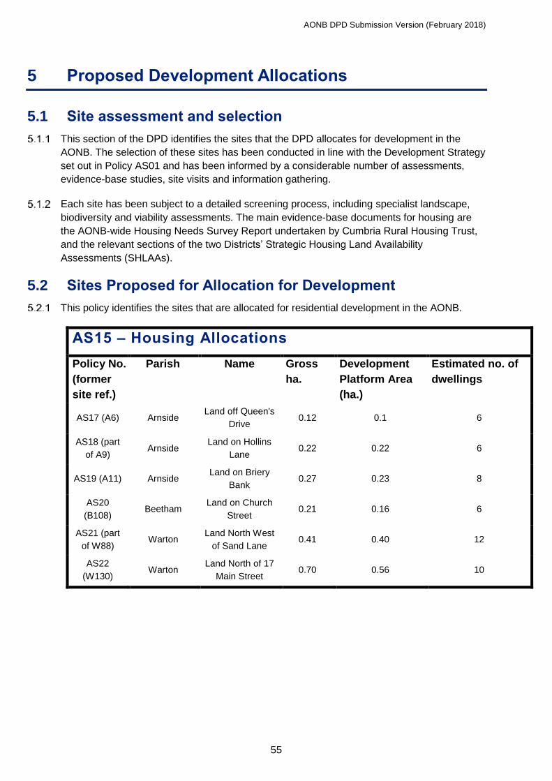
AONB DPD Submission Version (February 2018)
55
5 Proposed Development Allocations
5.1 Site assessment and selection
This section of the DPD identifies the sites that the DPD allocates for development in the
AONB. The selection of these sites has been conducted in line with the Development Strategy
set out in Policy AS01 and has been informed by a considerable number of assessments,
evidence-base studies, site visits and information gathering.
Each site has been subject to a detailed screening process, including specialist landscape,
biodiversity and viability assessments. The main evidence-base documents for housing are
the AONB-wide Housing Needs Survey Report undertaken by Cumbria Rural Housing Trust,
and the relevant sections of the two Districts’ Strategic Housing Land Availability
Assessments (SHLAAs).
5.2 Sites Proposed for Allocation for Development
This policy identifies the sites that are allocated for residential development in the AONB.
AS15 – Housing Allocations
Policy No.
(former
site ref.)
Parish Name Gross
ha.
Development
Platform Area
(ha.)
Estimated no. of
dwellings
AS17 (A6) Arnside Land off Queen's
Drive 0.12 0.1 6
AS18 (part
of A9) Arnside
Land on Hollins
Lane 0.22 0.22 6
AS19 (A11) Arnside Land on Briery
Bank 0.27 0.23 8
AS20
(B108) Beetham
Land on Church
Street 0.21 0.16 6
AS21 (part
of W88) Warton
Land North West
of Sand Lane 0.41 0.40 12
AS22
(W130) Warton
Land North of 17
Main Street 0.70 0.56 10

AONB DPD Submission Version (February 2018)
56
This policy identifies the sites that are allocated for mixed-use development in the AONB.
AS16 – Mixed-Use Allocations
Policy No.
(former
site ref.)
Parish Name Gross
ha.
Development
Platform
Area (ha.)
Proposal
AS23
(A26/A27) Arnside Station Yard 1.03 0.65
Car parking, employment,
community/visitor facilities
and rail access. Possible
residential or live-work.
AS24 (S70) Silverdale Railway Goods
Yard 0.36 0.26
Employment and car
parking
AS25 (B35 /
B38 / B81 /
B125 (part)
Beetham
Land on Sandside
Road and Quarry
Lane
3.10 3.10
Employment, Residential,
community facilities and
access
All sites suggested at the initial Call for Sites stage or through the Issues and Options
Consultation were visited by SLDC and LCC Officers and the AONB Manager. Alongside the
initial call for sites, a set of site assessment criteria was developed in consultation with key
stakeholders, including Parish Councils. These were used to create a Site Assessment Form
against which each of the site suggestions were assessed.
Amongst other criteria, the Site Assessment included a set of Exclusion Criteria. Any sites to
which these applied were ruled out of further consideration. Any sites that were not ruled out
by Exclusion Criteria were subject to further tests and assessment. Habitats Regulations
Assessments (HRA) were undertaken on all sites to which Exclusion Criteria did not apply.
Details can be found in the accompanying HRA Report.
All other sites were then subject to independent landscape assessment and sites found to
have a significant, non-mitigatable landscape impact were subject to no further assessment.
Remaining sites were subject to an independent biodiversity assessment. All sites excluded
by that point were considered not to represent ‘reasonable alternatives’ for the purposes of
Sustainability Appraisal (SA) and as such, only those sites remaining after these assessments
were subject to SA. Details can be found in the accompanying Draft SA Report.
Some sites were ruled out later in the process when new information became available, for
example, some owners who had previously submitted their sites for consideration changed
their minds. Altogether, the assessment left a small number of sites suitable for allocation for
development. These sites were all subject to assessment to establish whether or not they
constitute major development and where relevant, a Sequential Test was carried out to
ensure that sites with a degree of flood risk were not allocated where other more suitable sites
were available.
All sites allocated for development are shown on the Policies Map (Appendix 1).

AONB DPD Submission Version (February 2018)
57
5.3 Site Mini-Briefs
This section sets out policies detailing key expectations for the development of each of the
allocated sites. In most cases these will inform pre-application discussions between
developers and the relevant Council. The mini-briefs are accompanied by indicative plans for
each site. The mini-briefs and indicative plans are intended to guide development;
development is expected to closely reflect these but it is accepted that alternative proposals
may be equally acceptable where they meet policy requirements. The Councils do not
propose working up the mini-briefs in more detail, but welcome any proposals by developers
to engage in public consultation or master-planning prior to submitting a planning application.
Interested parties for all sites should contact United Utilities’ Developer Services at their
earliest convenience.

AONB DPD Submission Version (February 2018)
58
Housing Sites
AS17 (A6) - Land off Queen’s Drive, Arnside
Key considerations for this site are the presence of water mains and the need for easements,
relocation of the garages and the rock face adjacent the site.
AS17 (A6) – Land off Queen’s Drive, Arnside
Amount of development: Approximately 6 dwellings
Site Area: 0.12 hectares (0.1 developable area)
Site description: The site is located within Arnside village and currently houses a
garage block. It is in South Lakes Housing’s ownership.
Policy Guidance: Land off Queen’s Drive, Arnside, as shown on the Policies Map, is
allocated for development for approximately 6 dwellings. Detailed proposals that meet the
following site-specific development requirements will be permitted:
I. Development proposals and must be accompanied by drainage, surface water and
sewerage plans and reports, demonstrating to the satisfaction of the relevant
authorities that they provide resilience against flood, surface water and
wastewater/sewerage issues and will not create or worsen flood, surface water or
sewerage risks to existing properties. There is an existing risk of surface water
flooding and the applicant must place land uses most sensitive to flood damage in
areas within the site that are at least risk of flooding, and ensure that the
development and any measures to protect the site from flooding will not cause any
increase in flood risk off-site and elsewhere (e.g. provide compensatory surface
water storage).
II. Biodiversity mitigation measures will be required, guided by existing evidence and
an appropriate ecological survey of the site.
III. Appropriate access arrangements from Queen’s Drive and parking arrangements
are to be agreed to the satisfaction of the highway authority. This would include
alteration of the existing access width, justification with a Road Safety Audit (or a
combination of the two).
IV. Landscaping and scheme design will result in a net gain in visual amenity value in
line with the local landscape character and the AONB’s primary purpose and Special
Qualities.
V. Development will require provision of parking/garaging on-site or elsewhere for
those residents whose garages have been removed and who still require a garage.
VI. Suitable measures are required to protect people and property from hazards
associated with the cliff-face on the south western side of the site.
VII. The route and potential re-opening of the footpath to the Knott should be taken into
account in the layout and redevelopment of the site.
VIII. Existing trees should be retained and additional planting should be included in the
scheme to complement and support adjacent habitats and visual amenity.
IX. The presence of water mains and the need for easements will need to be taken
into account in the design of the scheme.

AONB DPD Submission Version (February 2018)
59
AS17 (A6) - Land off Queen’s Drive, Arnside

AONB DPD Submission Version (February 2018)
60
AS18 (part of A9) - Land on Hollins Lane, Arnside
This site is within the settlement and relatively visually contained. The landscape assessment
showed that partial development could be accommodated without compromise to the
landscape character of the area. Access, retaining the remainder of the site as Key
Settlement Landscape and opening up long views are key issues.
AS18 (part of A9) – Land on Hollins Lane, Arnside
Amount of development: Approximately 6 dwellings
Site Area: 0.22 hectares (0.22 developable area)
Site description: The site is located within Arnside village and is currently part of a small
field used for sheep grazing.
Policy Guidance: Land on Hollins Lane, Arnside, as shown on the Policies Map, is
allocated for development for approximately 6 dwellings. Detailed proposals that meet the
following site-specific development requirements will be permitted:
I. A Landscape and Visual Impact Assessment (LVIA) is required to inform the design
and layout of the site proposals with particular attention to the need to protect and
enhance public views across, through and out of the site, particularly towards the
north east.
II. Development proposals must be accompanied by drainage, surface water and
sewerage plans and reports, demonstrating to the satisfaction of the relevant
authorities that they provide resilience against flood, surface water and
wastewater/sewerage issues and will not create or worsen flood, surface water or
sewerage risks to existing properties.
III. Biodiversity mitigation measures will be required, guided by existing evidence and
an appropriate ecological survey of the site.
IV. Appropriate parking and access arrangements from Hollins Lane are to be agreed
to the satisfaction of the highway authority.
V. Landscaping and scheme design will result in a net gain in visual amenity value in
line with the local landscape character and the AONB’s primary purpose and Special
Qualities.
VI. Development will retain as much as is possible of the mature hedge on the south
eastern boundary of the site in order to achieve safe access.
VII. A new hedgerow and trees of appropriate species and species mix will be planted
to form new, robust and defensible boundary to the north of this small site, whilst
retaining and complementing the key view across the site.
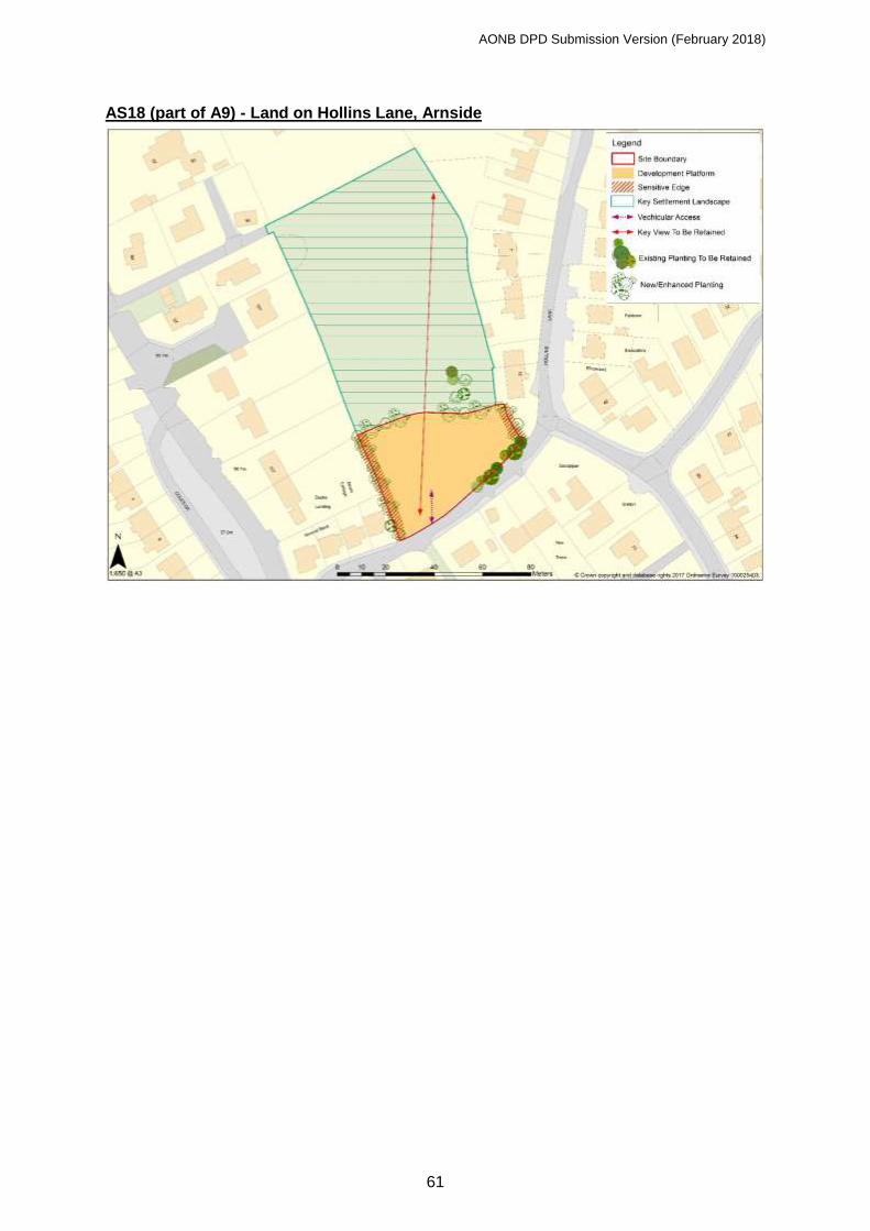
AONB DPD Submission Version (February 2018)
61
AS18 (part of A9) - Land on Hollins Lane, Arnside
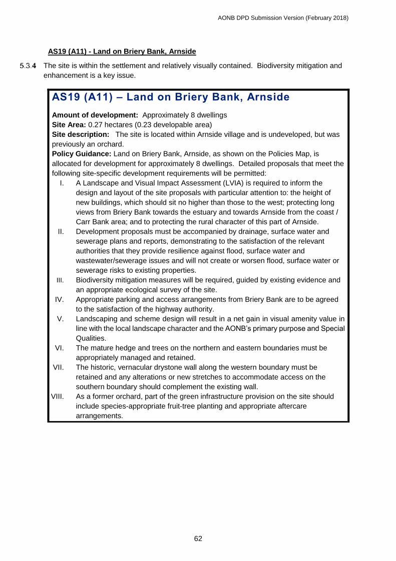
AONB DPD Submission Version (February 2018)
62
AS19 (A11) - Land on Briery Bank, Arnside
The site is within the settlement and relatively visually contained. Biodiversity mitigation and
enhancement is a key issue.
AS19 (A11) – Land on Briery Bank, Arnside
Amount of development: Approximately 8 dwellings
Site Area: 0.27 hectares (0.23 developable area)
Site description: The site is located within Arnside village and is undeveloped, but was
previously an orchard.
Policy Guidance: Land on Briery Bank, Arnside, as shown on the Policies Map, is
allocated for development for approximately 8 dwellings. Detailed proposals that meet the
following site-specific development requirements will be permitted:
I. A Landscape and Visual Impact Assessment (LVIA) is required to inform the
design and layout of the site proposals with particular attention to: the height of
new buildings, which should sit no higher than those to the west; protecting long
views from Briery Bank towards the estuary and towards Arnside from the coast /
Carr Bank area; and to protecting the rural character of this part of Arnside.
II. Development proposals must be accompanied by drainage, surface water and
sewerage plans and reports, demonstrating to the satisfaction of the relevant
authorities that they provide resilience against flood, surface water and
wastewater/sewerage issues and will not create or worsen flood, surface water or
sewerage risks to existing properties.
III. Biodiversity mitigation measures will be required, guided by existing evidence and
an appropriate ecological survey of the site.
IV. Appropriate parking and access arrangements from Briery Bank are to be agreed
to the satisfaction of the highway authority.
V. Landscaping and scheme design will result in a net gain in visual amenity value in
line with the local landscape character and the AONB’s primary purpose and Special
Qualities.
VI. The mature hedge and trees on the northern and eastern boundaries must be
appropriately managed and retained.
VII. The historic, vernacular drystone wall along the western boundary must be
retained and any alterations or new stretches to accommodate access on the
southern boundary should complement the existing wall.
VIII. As a former orchard, part of the green infrastructure provision on the site should
include species-appropriate fruit-tree planting and appropriate aftercare
arrangements.

AONB DPD Submission Version (February 2018)
63
AS19 (A11) - Land on Briery Bank, Arnside

AONB DPD Submission Version (February 2018)
64
AS20 (B108) - Land on Church Street, Beetham
Development of the site would reflect the historic village form. Sensitivity to Beetham
Conservation Area and retention of the footpath to Fairy Steps are key issues.
AS20 (B108) – Land on Church Street, Beetham
Amount of development: Approximately 6 dwellings
Site Area: 0.21 hectares (0.16 developable area)
Site description: The site is located adjoining Beetham village and is currently in
agricultural use.
Policy Guidance: Land on Church Street, Beetham, as shown on the Policies Map, is
allocated for development for approximately 6 dwellings. Detailed proposals that meet the
following site-specific development requirements will be permitted:
I. A Landscape and Visual Impact Assessment (LVIA) is required to inform the
design and layout of the site proposals with particular attention to views towards
the site and Beetham as a whole from the public footpath to the Fairy Steps and
when approaching from the west.
II. Development proposals must be accompanied by drainage, surface water and
sewerage plans and reports, demonstrating to the satisfaction of the relevant
authorities that they provide resilience against flood, surface water and
wastewater/sewerage issues and will not create or worsen flood, surface water or
sewerage risks to existing properties.
III. Biodiversity mitigation measures will be required, guided by existing evidence and
an appropriate ecological survey of the site.
IV. Appropriate parking and access arrangements from Church Street are to be
agreed to the satisfaction of the highway authority.
V. Landscaping and scheme design will result in a net gain in visual amenity value in
line with the local landscape character and the AONB’s primary purpose and Special
Qualities.
VI. The site’s location adjacent the boundary of the Beetham Conservation Area,
opposite the graveyard associated with St Michael’s and All Angels’ church and in
one of the latent mediaeval tofts associated with the village’s forming in the middle
mediaeval period must be fully reflected in the design and layout of the scheme.
VII. An archaeological investigation of the site will be needed and any finds recorded.
VIII. Existing boundary hedgerows should be retained and a new hedgerow and trees
of appropriate species and species mix planted to form new, robust and defensible
boundaries to the south west and north west of this small site.
IX. The existing public footpath route leading through the site to the Fairy Steps must
be protected and enhanced, including the retention of the existing limestone stile.

AONB DPD Submission Version (February 2018)
65
AS20 (B108) - Land on Church Street, Beetham
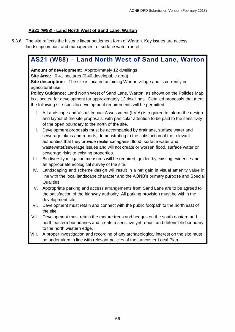
AONB DPD Submission Version (February 2018)
66
AS21 (W88) - Land North West of Sand Lane, Warton
The site reflects the historic linear settlement form of Warton. Key issues are access,
landscape impact and management of surface water run-off.
AS21 (W88) – Land North West of Sand Lane, Warton
Amount of development: Approximately 12 dwellings
Site Area: 0.41 hectares (0.40 developable area)
Site description: The site is located adjoining Warton village and is currently in
agricultural use.
Policy Guidance: Land North West of Sand Lane, Warton, as shown on the Policies Map,
is allocated for development for approximately 12 dwellings. Detailed proposals that meet
the following site-specific development requirements will be permitted:
I. A Landscape and Visual Impact Assessment (LVIA) is required to inform the design
and layout of the site proposals, with particular attention to be paid to the sensitivity
of the open boundary to the north of the site.
II. Development proposals must be accompanied by drainage, surface water and
sewerage plans and reports, demonstrating to the satisfaction of the relevant
authorities that they provide resilience against flood, surface water and
wastewater/sewerage issues and will not create or worsen flood, surface water or
sewerage risks to existing properties.
III. Biodiversity mitigation measures will be required, guided by existing evidence and
an appropriate ecological survey of the site.
IV. Landscaping and scheme design will result in a net gain in visual amenity value in
line with the local landscape character and the AONB’s primary purpose and Special
Qualities.
V. Appropriate parking and access arrangements from Sand Lane are to be agreed to
the satisfaction of the highway authority. All parking provision must be within the
development site.
VI. Development must retain and connect with the public footpath to the north east of
the site.
VII. Development must retain the mature trees and hedges on the south eastern and
north eastern boundaries and create a sensitive yet robust and defensible boundary
to the north western edge.
VIII. A proper investigation and recording of any archaeological interest on the site must
be undertaken in line with relevant policies of the Lancaster Local Plan.

AONB DPD Submission Version (February 2018)
67
AS21 (W88) - Land North West of Sand Lane, Warton

AONB DPD Submission Version (February 2018)
68
AS22 (part of W130) - Land North of 17 Main Street, Warton
The site reflects the historic linear settlement form of Warton. Key issues are access,
landscape impact and management of surface water run-off.
AS22 (part of W130) – Land North of 17 Main Street,
Warton
Amount of development: Approximately 10 dwellings
Site Area: 0.70 hectares (0.56 developable area)
Site description: The site is located within Warton village and is currently in agricultural
use.
Policy Guidance: Land north of 17 Main Street, Warton, as shown on the Policies Map, is
allocated for development for approximately 10 dwellings. Detailed proposals that meet
the following site-specific development requirements will be permitted:
I. A Landscape and Visual Impact Assessment (LVIA) is required to inform the design
and layout of the site proposals. Particular attention must be paid to the potential
impacts of developing close to a house of local historical importance, and to the
open boundary to the north of the site.
II. Development proposals must be accompanied by drainage, surface water and
sewerage plans and reports, demonstrating to the satisfaction of the relevant
authorities that they provide resilience against flood, surface water and
wastewater/sewerage issues and will not create or worsen flood, surface water or
sewerage risks to existing properties.
III. Biodiversity mitigation measures will be required, guided by existing evidence and
an appropriate ecological survey of the site.
IV. Landscaping and scheme design will result in a net gain in visual amenity value in
line with the local landscape character and the AONB’s primary purpose and Special
Qualities.
V. Appropriate parking and access arrangements from Main Street are to be agreed to
the satisfaction of the highway authority. All parking provision must be within the
development site.
VI. Hedges and boundary features should be retained as far as possible and integrated
into the layout of any development scheme. Development must create a sensitive
yet robust and defensible boundary to the northern edge of the site.

AONB DPD Submission Version (February 2018)
69
AS22 (part of W130) - Land North of 17 Main Street, Warton

AONB DPD Submission Version (February 2018)
70
Mixed Use Sites
AS23 (A26/A27) - Station Yard, Arnside
Key issues for this site are flood risk and the proximity to Morecambe Bay as an
internationally protected site for biodiversity.
AS23 (A26/A27) - Station Yard, Arnside
Type of development: Mixed uses including business, tourism and car parking and
potentially residential or live-work units subject to satisfactorily addressing constraints.
Employment development will be limited to use classes B1a, b and c.
Site Area: 1.03 hectares (0.65 developable area)
Site description: The site is located within Arnside and currently contains a small office,
storage, informal car parking and access to the railway.
Policy Guidance: Station Yard, Arnside, as shown on the Policies Map, is allocated for
mixed-use development. Detailed proposals that meet the following site-specific
development requirements will be permitted:
I. The site is previously developed land. It offers scope to make more efficient and
beneficial use of the land, especially for business, tourism and car parking uses.
There is particular scope for development to relate to the site’s location adjacent
Arnside railway station, including the formation of a visitor/recreational hub.
II. A Landscape and Visual Impact Assessment (LVIA) is required to inform the design
and layout of the site proposals, with a focus on enhancing the visual amenity of the
site and reflecting the local landscape character type.
III. Development proposals will require an Environmental Permit and relevant discharge
consents and must be accompanied by drainage, surface water and sewerage plans
and reports, demonstrating to the satisfaction of the relevant authorities that they
provide resilience against flood, surface water and wastewater/sewerage issues and
will not create or worsen flood, surface water or sewerage risks to existing
properties.
IV. Residential development must avoid Flood Risk Zone 3 areas. A site-specific flood
risk assessment and drainage strategy will be required.
V. The site adjoins a site designated as SSSI, SAC, SPA and under the Ramsar
Convention. Biodiversity mitigation measures will be required, guided by existing
evidence and an appropriate ecological survey. This should include a project-level
Habitats Regulations Assessment Standard best practice approaches such as
pollution prevention measures must be implemented.
VI. Appropriate parking and access arrangements from Sandside Road are to be
agreed to the satisfaction of the highway authority.
VII. Existing buildings must be retained and incorporated into new development.
VIII. The site contains some woodland and a watercourse, both of which should be
protected and sensitively incorporated into any scheme to the benefit of both the
proposals and their own intrinsic value.
IX. Landscaping and scheme design will result in a net gain in visual amenity in line with
the local landscape character and the AONB’s primary purpose and Special Qualities.
X. Development must retain access through the site for Network Rail and enhance
access to the rail platforms, including for wheelchair users.

AONB DPD Submission Version (February 2018)
71
XI. The site will benefit from master-planning to ensure best and most appropriate
redevelopment of the site.
AS23 (A26/A27) - Station Yard, Arnside
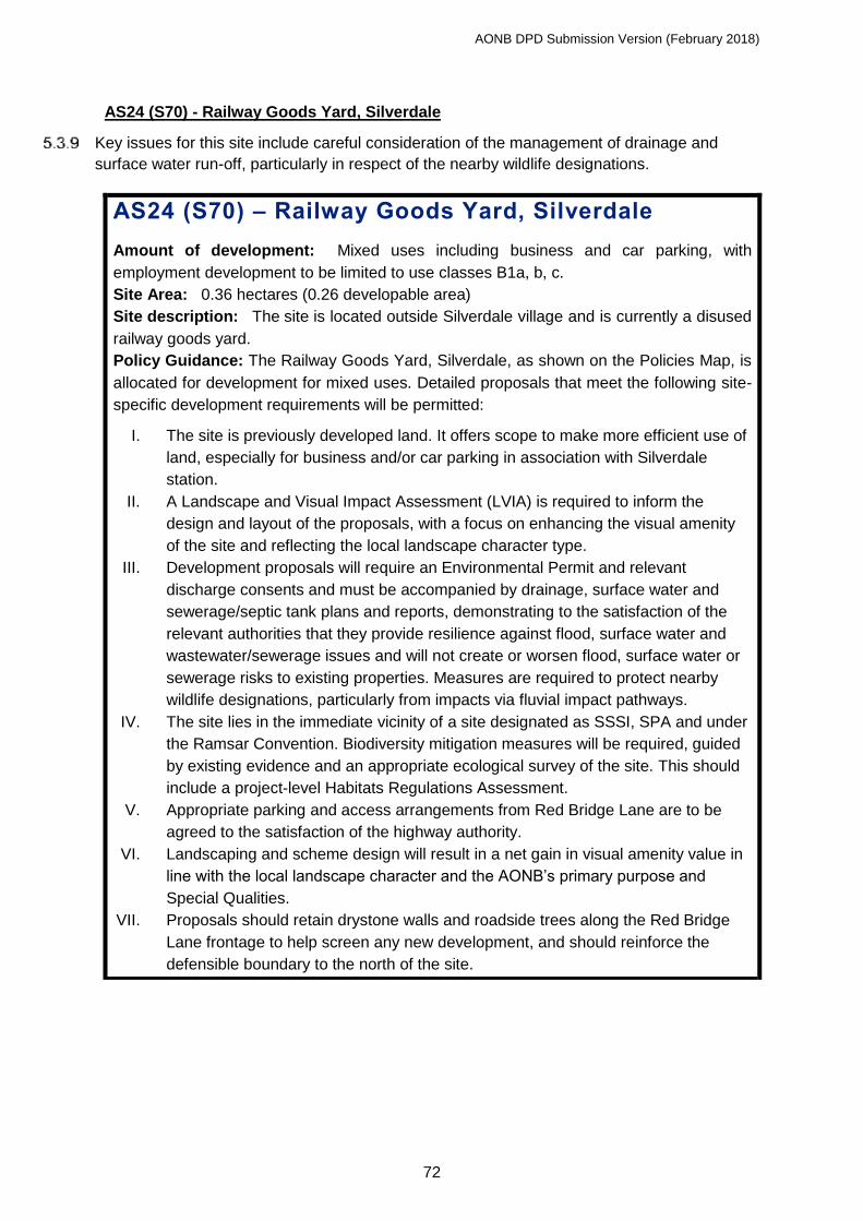
AONB DPD Submission Version (February 2018)
72
AS24 (S70) - Railway Goods Yard, Silverdale
Key issues for this site include careful consideration of the management of drainage and
surface water run-off, particularly in respect of the nearby wildlife designations.
AS24 (S70) – Railway Goods Yard, Silverdale
Amount of development: Mixed uses including business and car parking, with
employment development to be limited to use classes B1a, b, c.
Site Area: 0.36 hectares (0.26 developable area)
Site description: The site is located outside Silverdale village and is currently a disused
railway goods yard.
Policy Guidance: The Railway Goods Yard, Silverdale, as shown on the Policies Map, is
allocated for development for mixed uses. Detailed proposals that meet the following site-
specific development requirements will be permitted:
I. The site is previously developed land. It offers scope to make more efficient use of
land, especially for business and/or car parking in association with Silverdale
station.
II. A Landscape and Visual Impact Assessment (LVIA) is required to inform the
design and layout of the proposals, with a focus on enhancing the visual amenity
of the site and reflecting the local landscape character type.
III. Development proposals will require an Environmental Permit and relevant
discharge consents and must be accompanied by drainage, surface water and
sewerage/septic tank plans and reports, demonstrating to the satisfaction of the
relevant authorities that they provide resilience against flood, surface water and
wastewater/sewerage issues and will not create or worsen flood, surface water or
sewerage risks to existing properties. Measures are required to protect nearby
wildlife designations, particularly from impacts via fluvial impact pathways.
IV. The site lies in the immediate vicinity of a site designated as SSSI, SPA and under
the Ramsar Convention. Biodiversity mitigation measures will be required, guided
by existing evidence and an appropriate ecological survey of the site. This should
include a project-level Habitats Regulations Assessment.
V. Appropriate parking and access arrangements from Red Bridge Lane are to be
agreed to the satisfaction of the highway authority.
VI. Landscaping and scheme design will result in a net gain in visual amenity value in
line with the local landscape character and the AONB’s primary purpose and
Special Qualities.
VII. Proposals should retain drystone walls and roadside trees along the Red Bridge
Lane frontage to help screen any new development, and should reinforce the
defensible boundary to the north of the site.

AONB DPD Submission Version (February 2018)
73
AS24 (S70) - Railway Goods Yard, Silverdale

AONB DPD Submission Version (February 2018)
74
AS25 (B35 / B38 / B81 / B125) - Land on Sandside Road and Quarry Lane, Sandside
Key issues for this site are taking a comprehensive approach to redevelopment, careful
management of flood risk and impacts on Morecambe Bay and consideration of the trunk
main, pumping station and sewers on/adjacent the site, as well as the retention of The Ship
Inn as a community facility.
AS25 (B35 / B38 / B81 / B125) – Land on Sandside
Road and Quarry Lane, Sandside
Redevelopment of this site should be undertaken comprehensively. Development
proposals will benefit from master-planning and collaboration between landowners.
Type of development: Mixed uses including business, tourism and residential.
Employment development will be limited to use classes B1a, b and c and B8.
Site Area: 3.10 hectares (3.10 developable area)
Site description: There are currently a range of uses on the site including businesses,
car parking, grazing and vacant land.
Policy Guidance: Land on Sandside Road and Quarry Lane Storth, as shown on the
Policies Map, is allocated for mixed-use development. Detailed proposals that meet the
following site-specific development requirements will be permitted:
I. The site is predominantly previously developed land. It offers scope to make more
efficient use of the land for mixed-uses including business or tourism uses and
residential, subject to flood risk constraints.
II. A Landscape and Visual Impact Assessment (LVIA) is required to inform the design
and layout of the proposals, with a focus on enhancing the visual amenity of the site
and reflecting the local landscape character type.
III. Development proposals will require an Environmental Permit and relevant discharge
consents and must be accompanied by drainage, surface water and sewerage plans
and reports, demonstrating to the satisfaction of the relevant authorities that they
provide resilience against flood, surface water and wastewater/sewerage issues and
will not create or worsen flood, surface water or sewerage risks to existing
properties. The drainage system must accommodate off site water as well as run-off
generated within the site.
IV. Residential development must avoid Flood Risk Zone 3 areas. A site-specific flood
risk assessment and drainage strategy will be required.
V. The site adjoins a site designated as SSSI, SAC, SPA and under the Ramsar
Convention. Biodiversity mitigation measures will be required, guided by existing
evidence and an appropriate ecological survey. This should include a project-level
Habitats Regulations Assessment. Standard best practice approaches such as
pollution prevention measures must be implemented.
VI. Appropriate parking and access arrangements from Park Road, supported by a
Transport Assessment or Road Safety Audit, are to be agreed to the satisfaction of
the highway authority.
VII. Connectivity, permeability and access, including for active travel, is important.
VIII. Development must incorporate a pedestrian access route alongside Park Road to
connect with existing footways and protect the existing footpath along the route of

AONB DPD Submission Version (February 2018)
75
the former railway. Improvements should be made to Quarry Lane as a foot/cycle
connection with the village centre and new footpath connections should be
incorporated within the site.
IX. Development will incorporate areas to perform open space and green infrastructure
functions, informed by drainage, biodiversity and accessibility needs and landscape
evidence.
X. Landscaping and scheme design will result in a net gain in visual amenity value in
line with the local landscape character and the AONB’s primary purpose and
Special Qualities.
XI. Development should reinforce and enhance the defensible boundaries with the open
countryside, especially to the eastern edges of the site.
XII. Development will protect existing green infrastructure and include new or
replacement species-rich hedgerow and other planting and landscaping appropriate
to this part of the AONB. This will reflect the local landscape character typology.
XIII. Development will retain and complement and respect the materials, scale and
character of the recently refurbished historic building and lime kilns on the site,
including protecting and enhancing views of them.
XIV. Development will retain and complement The Ship Inn and will retain appropriate
levels of car parking to serve the public house.
XV. The site will benefit from master-planning to ensure best and most appropriate
redevelopment of the site. The presence of trunk and distribution mains and the
need for maintenance strips, as well as the pumping station and sewers on and
adjacent the site will need to be taken into account in the design of the scheme.
XVI. Proposals that extend beyond the brownfield area allocated must comply with points
I-XV above and will be acceptable only where they also:
comprehensively demonstrate that they reflect landscape character and visual
amenity evidence and;
are accompanied by viability evidence that clearly demonstrates that
development of the allocated site is not possible without development of
additional land and;
demonstrate that any incursion beyond the site boundary is of the minimum
scale necessary to achieve an acceptable viable scheme and;
meet the exceptions tests for major development as set out in national policy.

AONB DPD Submission Version (February 2018)
76
AS25 (B35 / B38 / B81 / B125) - Land on Sandside Road and Quarry Lane, Sandside

AONB DPD Submission Version (February 2018)
77
6 Policy Areas Not Covered in this Document
Where a policy topic is not included in the AONB DPD, it is covered adequately elsewhere in
the Development Plan for each District and/or through National Policies. Only policy topics for
which a special approach is required in the AONB are covered in the AONB DPD.
Many policy topics and issues that apply to the AONB are covered adequately by National
Policy or International or National Legislation or are covered by policies in other Local Plan
documents prepared by the District Councils. These policies and requirements all still apply to
the AONB. The AONB DPD is an extra layer of policy for the AONB rather than a replacement
for these, and all the relevant documents must be read in conjunction in order to provide the
full picture of planning policy covering the AONB.
The accompanying Policy Links document sets out which policy topics are covered in which of
the other Local Plan documents in each of the two Districts.

AONB DPD Submission Version (February 2018)
78
7 Monitoring and Implementation Framework
Monitoring and review are important parts of any plan, and helps to address questions such
as:
Are policies achieving their objectives and in particular are they delivering
sustainable development?
Have policies had unintended consequences that were not originally anticipated?
Are the assumptions and objectives underpinning the policies still relevant and
applicable?
Are the targets being achieved?
The policies contained in the AONB DPD will be monitored in the Councils’ annual monitoring
reports (AMRs). The monitoring frameworks in the AMRs set out a series of key indicators
that can be used to measure the DPD’s performance. The indicators have related targets in
order to assess whether current policies are working effectively or whether they need to be
reviewed or replaced. New indicators may be introduced over time, and others removed to
ensure appropriate monitoring of new policies and to avoid monitoring indicators that are no
longer useful. Where it becomes evident that policies are not performing as intended, any
subsequent monitoring analysis will suggest the actions that need to be taken to address the
issues.
Effective implementation of the policies in the AONB DPD depends on the actions of the
Councils and a number of other organisations. The overall aim of the Councils is to ensure the
delivery of the sustainable development appropriate for the AONB. Development should be
co-ordinated with infrastructure. Where development creates the need for investment in
infrastructure, the costs for that infrastructure should be offset.
Contributions to infrastructure will be secured through planning obligations and the
Community Infrastructure Levy (CIL, which applies in South Lakeland but not in Lancaster
District). CIL will be the preferred method of collecting and pooling financial contributions
(except for affordable housing) in South Lakeland. CIL liabilities are not negotiable. Section
106 planning obligations must be collected on a site by site basis in compliance with the three
tests in Regulation 122(2) of the CIL Regulations 2010 (as amended):
necessary to make the development acceptable in planning terms;
directly related to the development; and
fairly and reasonably related in scale and kind to the development.
The costs of development (including the contribution it must make to infrastructure) may affect
the viability of a scheme and prevent it coming forward. While the Councils normally expect
development to meet sustainable design standards, affordable housing requirements, the CIL
charge and any site specific obligations, there are occasions where some adjustment may be
justified in order to reduce costs and enable a scheme to go forward. In such cases the
Council must be satisfied that the assessment of viability is accurate. The Councils will weigh

AONB DPD Submission Version (February 2018)
79
up what the effect of any cost savings would be and then decide whether that is reasonable in
the particular circumstances of that case.
The plan will be reviewed if there is a change in circumstances (e.g. the introduction of new
planning legislation or guidance), and in any event within five years of the DPD being
adopted.
Policy AS03 Housing Provision requires current demand and likely take-up at the time to be
taken into account when delivering affordable housing in order to avoid a situation whereby
affordable housing delivered cannot be taken up by local families as it fails to match need in
terms of type and/or timing.
Any phasing would be a guide to when allocated sites were expected to come forward based
on factors such as availability and infrastructure requirements rather than indicating a required
timescale and subject to meeting other policy requirements. Planning permission could not be
refused for a site on the grounds of being outside of the identified phasing.
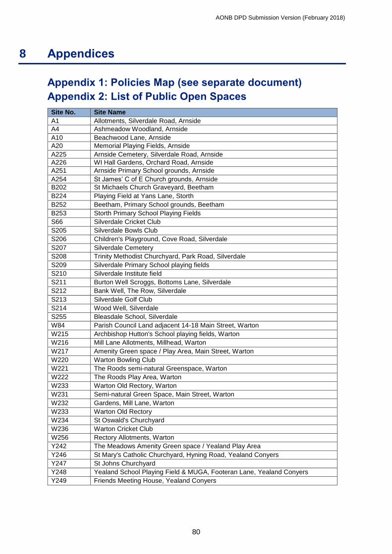
AONB DPD Submission Version (February 2018)
80
8 Appendices
Appendix 1: Policies Map (see separate document)
Appendix 2: List of Public Open Spaces
Site No. Site Name
A1 Allotments, Silverdale Road, Arnside
A4 Ashmeadow Woodland, Arnside
A10 Beachwood Lane, Arnside
A20 Memorial Playing Fields, Arnside
A225 Arnside Cemetery, Silverdale Road, Arnside
A226 WI Hall Gardens, Orchard Road, Arnside
A251 Arnside Primary School grounds, Arnside
A254 St James’ C of E Church grounds, Arnside
B202 St Michaels Church Graveyard, Beetham
B224 Playing Field at Yans Lane, Storth
B252 Beetham, Primary School grounds, Beetham
B253 Storth Primary School Playing Fields
S66 Silverdale Cricket Club
S205 Silverdale Bowls Club
S206 Children's Playground, Cove Road, Silverdale
S207 Silverdale Cemetery
S208 Trinity Methodist Churchyard, Park Road, Silverdale
S209 Silverdale Primary School playing fields
S210 Silverdale Institute field
S211 Burton Well Scroggs, Bottoms Lane, Silverdale
S212 Bank Well, The Row, Silverdale
S213 Silverdale Golf Club
S214 Wood Well, Silverdale
S255 Bleasdale School, Silverdale
W84 Parish Council Land adjacent 14-18 Main Street, Warton
W215 Archbishop Hutton's School playing fields, Warton
W216 Mill Lane Allotments, Millhead, Warton
W217 Amenity Green space / Play Area, Main Street, Warton
W220 Warton Bowling Club
W221 The Roods semi-natural Greenspace, Warton
W222 The Roods Play Area, Warton
W233 Warton Old Rectory, Warton
W231 Semi-natural Green Space, Main Street, Warton
W232 Gardens, Mill Lane, Warton
W233 Warton Old Rectory
W234 St Oswald's Churchyard
W236 Warton Cricket Club
W256 Rectory Allotments, Warton
Y242 The Meadows Amenity Green space / Yealand Play Area
Y246 St Mary's Catholic Churchyard, Hyning Road, Yealand Conyers
Y247 St Johns Churchyard
Y248 Yealand School Playing Field & MUGA, Footeran Lane, Yealand Conyers
Y249 Friends Meeting House, Yealand Conyers

AONB DPD Submission Version (February 2018)
81
Appendix 3: List of Key Settlement Landscapes
Site No. Site Name
A3 Ashmeadow Gardens, Arnside
A9 Hollins Lane, Arnside
A12 Briery Bank 2, Arnside
A14 NW of Briery Bank 1, Arnside
A15/16 The Common, Arnside
A18/19 Saltcotes Hall 1&2, Arnside
A22-24 Station Fields, Arnside
A106 E of Black Dyke Road, Arnside
A107 NW of Briery Bank 2, Arnside
A200 Heathcliffe Court, Arnside
A201 Hollins Plantation, Arnside
A259 Saltcotes Hall, Arnside
B32 Mill Lane, Beetham
B79 N of Yans Lane, Storth
B116 E of Quarry Lane, Storth
B223 West of Storth Road, Storth
B204 Beetham Sports Field
S43 Elmslack Field, Silverdale
S54 S of Cove Drive, Silverdale
S67 Townsfield, Silverdale
S258 W of Hawthorn Bank, Cove Road, Silverdale
S260 Bank House Farm, Silverdale
S261 S of Hawthorn Bank, Cove Road, Silverdale
W84A Main Street, Warton (part of site)
W219 Ash Drive Amenity Open Space, Warton
W257 Boon Town Farm, Warton

AONB DPD Submission Version (February 2018)
82
Appendix 4: Glossary
Active Travel – Travel that requires physical activity of the human being to generate the
movement, such as cycling and walking.
Adoption - The final confirmation of a Development Plan (Local Plan) Document coming
into force as part of the statutory development plan by a Local Planning Authority (LPA).
Affordable Housing - Housing, whether for rent, shared ownership or outright purchase,
provided at a lower cost in relation to incomes that are average or below average, or in relation
to the price of general market housing.
Aged or veteran tree – A tree that, because of its great age, size or condition, is of exceptional
value for wildlife, in the landscape, or culturally.
Agriculture - Defined by Section 336(1) of the Town and Country Planning Act 1990 as
including: horticulture, fruit growing, seed growing, dairy farming, the breeding and keeping of
livestock (including any creature kept for the production of food, wool, skins or furs, or the
purpose of its use in the farming of land), the use of land as grazing land, meadow land,
osier land, market gardens and nursery grounds, and the use of land for woodlands where that
use is ancillary to the farming of land for other agricultural purposes.
Allocated site - Land identified in a development plan as appropriate for a specific land use.
Amenity – This refers to positive element(s) that contribute to the overall character or
enjoyment of an area. For example, open land, trees, historic buildings and the inter-
relationships between them, or less tangible factors such as tranquillity can all be considered
as an amenity asset.
Appropriate - Within the AONB Management Plan and the AONB DPD, the word
“appropriate” is generally used to mean “appropriate to the AONB statutory purpose and
designation and the AONB’s special qualities” unless it is being quoted from another source,
document or policy statement etc.
Biodiversity – The whole variety of life on earth. It includes all species of plants and animals
and the ecosystems and habitats they are part of.
Brownfield Land (previously-developed land) - Land that is or was occupied by a permanent
structure (excluding agricultural or forestry buildings), and associated fixed surface
infrastructure. The definition covers the curtilage of the developed land. Previously-
developed land may occur in both built-up and rural settings. The definition includes
defence buildings and land used for mineral extraction and waste disposal where provision
for restoration has not been made through planning condition or legal agreement. Domestic
gardens are not classified as previously developed land.
Buffer Zone - Areas between core protected areas and the surrounding landscape or
seascape that protect the network from potentially damaging external influences and which
are essentially transitional areas.
Caravan Development – The creation, extension or adaptation of land that is used for the
purposes of accommodating both static and/or touring caravans. The legislative definition can
also include chalets that are used for temporary periods for leisure uses. This can also include
development that is ancillary to the purpose of using caravans, including toilet blocks, laundry
and shower blocks and other associated infrastructure.
Conservation Area - Conservation Areas are places of special architectural or historic interest
where it is desirable to preserve and enhance the character and appearance of such areas.

AONB DPD Submission Version (February 2018)
83
Core Strategy - A key Local Plan document setting out the spatial vision, strategic
objectives and the planning framework for an area, having regard to the Community Strategy.
Development - Development is defined under the 1990 Town and Country Planning Act as
"the carrying out of building, engineering, mining or other operation in, on, over or under
land, or the making of any material change in the use of any building or other land". Most
forms of development require planning permission (see also "permitted development").
Ecosystem Services - The benefits people obtain from ecosystems and their components:
water, soil, nutrients and organisms. These include provisioning services such as food and
water; regulating services such as flood and disease control; cultural services such as
spiritual, recreational, and cultural benefits; and supporting services such as nutrient cycling
that maintain the conditions for life on Earth.
Extra Care Housing - Extra Care Housing is housing designed with the needs of frailer older
people in mind and with varying levels of care and support available on site.
Flood Risk Assessment - An assessment of the likelihood of flooding in a particular area so
that development needs and mitigation measures can be carefully considered.
Geodiversity - The diversity of minerals, rocks (whether “solid” or “drift”), fossils, landforms,
sediments and soils, together with the natural processes that constitute the Earth’s
topography, landscape and the underlying structure.
Greenfield Land/Site - Land (or a defined site), usually farmland, that has not previously
been developed. This does not include domestic gardens.
Green infrastructure – A network of multi-functional green space, urban and rural that is
capable of delivering a wide range of environmental and quality of life benefits for local
communities.
Habitats Regulations Assessment (HRA) – Assesses the impacts of plans or projects on
Natura 2000 sites (these are Special Areas of Conservation (SAC) and Special Protection
Areas (SPA)). National guidance recommends that Ramsar sites and candidate SPAs and
SACs are also afforded the same protection through the Habitats Regulation Assessment
process.
Heritage asset – A building, monument, site, feature, place, area or landscape identified as
having a degree of significance meriting consideration in planning decisions, in respect of its
contribution to a nation’s society, knowledge and/or culture.
Historic Environment – All aspects of the environment resulting from the interaction between
people and places through time, including all surviving physical remains of past human activity,
whether visible, buried or submerged, and landscaped and planted or managed flora.
Infill development/infilling - Building taking place on a vacant plot in an otherwise built-up
street frontage.
Infrastructure – In planning terms the physical structures that are required for a community
to operate and be sustainable in the long term. Infrastructure typically refers to matters such
as roads, water supply, sewers, electricity and other social elements such as education and
health.
Landscape and Visual Impact Assessment (LVIA) - is the process of evaluating the effect
of a proposal upon the landscape. There is an important distinction between visual effects (the
human view or perception) and the landscape effects (which occur whether or not anyone can
see them).

AONB DPD Submission Version (February 2018)
84
Landscape Character Assessment (LCA) – is an assessment to identify different landscape
areas that have a distinct character based on a recognisable pattern of elements, including
combinations of geology, landform, soils, vegetation, land-use and human settlement.
Limestone Pavement - Continuous areas of exposed limestone consisting of rock blocks
(clints) interspersed with cracks/clefts (grikes).
Limestone Pavement Orders – Order protecting the above. The removal of rock from areas
protected by LPO is a criminal offence under the Wildlife & Countryside Act 1981.
Local Geological Sites - Locally designated sites of local, national and regional importance
for geodiversity (geology and geomorphology)
Local Plan - A document setting out the Local Planning Authority's policies and proposals for
the development and use of land and buildings in the authority's area prepared under the
Planning & Compulsory Purchase Act 2004. Local Plan documents include the Core Strategy,
Land Allocations and, where needed, other documents such as Development Management
Policies or documents covering specific topics or areas such as Gypsies and Travellers and
Kendal Canal Head. There will also be an adopted Policies Map that illustrates the spatial
extent of policies. The Policies Map must be prepared and maintained to accompany all
Local Plans. All Local Plan documents must be subject to rigorous procedures of community
involvement, consultation and independent examination, and adopted after receipt of the
Inspector's report. Once adopted, Development Management decisions must be made in
accordance with them unless material considerations indicate otherwise.
Local Planning Authority (LPA) - The local authority or Council that is empowered by law to
exercise planning functions, usually the local borough or District Council. National parks and
the Broads authority are also considered to be Local Planning Authorities. County Councils
are the authority for waste and minerals matters.
Local Wildlife Site - Commonly known as County Biological Heritage Sites in Lancashire and
as County Wildlife Sites in Cumbria, these sites are of local or regional importance for
biodiversity. These sites do not enjoy direct statutory protection but are the subject of specific
Local Plan policies aimed at ensuring their wellbeing.
Material Consideration - A matter that should be taken into account in deciding a planning
application or an appeal against a planning decision.
Mitigation - Measures to avoid reduce or offset significant adverse effects.
Mosaic Approach - The Mosaic Approach integrates the requirements of species into habitat
management, ensuring that plants and wildlife have the places they need to live and
reproduce.
National Planning Policy Framework (NPPF) – A document that has been prepared by the
Government, which has replaced all previous National Planning Policy contained within
Planning Policy Statements (PPSs) and Planning Policy Guidance (PPGs).
National Planning Practice Guidance (NPPG) – Revised and continuously updated planning
practice guidance produced by the government.
Nature Improvement Area - Nature Improvement Areas were introduced by the
Government’s Natural Environment White Paper, 2011 to ‘enhance and reconnect nature on
a significant scale’ in England.
Objective - A statement of what is intended, specifying the desired direction of change in
trends.
Permitted Development - Permitted development rights allow owners of a building to make
certain building changes and changes of use without having to make a planning application.

AONB DPD Submission Version (February 2018)
85
Previously Developed Land - See Brownfield Land.
Priority Habitats and Species - Section 41 of the Natural Environment and Rural
Communities Act (2006) requires the Secretary of State to publish a list of habitats and species
that are of principal importance for the conservation and biodiversity in England.
Registered Social Landlord (RSL) or Registered Provider (RP) - Technical names for a
body registered with the Housing Corporation. Most Housing Associations are RSL/RPs.
They own or manage some 1.4 million affordable homes, both social rented and intermediate.
Renewable Energy - Renewable energy is energy sourced from flows that occur naturally
and repeatedly in the environment, for example from the wind, water flow, tides or the sun.
Rural Exception Site – Small sites used for affordable housing in perpetuity where sites
would not normally be used for housing. Rural exception sites seek to address the needs of
the local community by accommodating households who are either current residents or have
an existing family or employment connection. Small numbers of market houses may be
allowed e.g. where essential to enable the delivery of affordable dwellings without grant
funding.
Saved Local Plan Policies - Policies in Local Plans that remain in operation pending
production of replacement Local Development Documents.
Self-build Housing - Housing built or commissioned by an individual, group of individuals or
community, either directly on a DIY and subcontracting basis or through the involvement of
self-build package companies, builders or contractors.
Setting - The landscape of the Arnside & Silverdale Area of Outstanding Natural Beauty does
not exist in isolation; it is nested within a larger landscape that can be visible from within the
AONB and when looking towards it. It is this surrounding landscape that provides the ‘setting’
to the AONB. The landscape setting is an important aspect of the AONB as the surroundings
contribute to how the AONB is experienced, understood and appreciated.
Settlement Character - The distinctive and historic pattern of development in a settlement,
and the way in which it associates with the natural environment and the countryside. It may
include building styles, materials or vernacular traditions.
Site of Special Scientific Interest (SSSI) - A site identified under the Wildlife and Countryside
Act 1981 (as amended by the Countryside and Rights of Way Act 2000) as an area of special
interest by reason of any of its flora, fauna, geological or physiographical features (basically,
plants, animals, and natural features relating to the Earth's structure).
Special Area of Conservation (SAC) - Areas designated under the European Union Habitat
Directive. They provide increased protection for a variety of wild animals, plants and habitats
and are a vital part of the global effort to conserve world biodiversity.
Special Protection Area (SPA) - An area containing an assemblage of breeding populations
of rare birds at a level of European significance, designated under EC Directive 79/409.
Special Qualities - An assessment or understanding of what makes an area particularly
special and distinctive from the surrounding countryside. For the Arnside & Silverdale AONB,
The Special Qualities are summarised in paragraph 1.2.1 of this DPD, and in more detail in
the AONB Management Plan.
Specific Consultation Bodies / Statutory Bodies - These are bodies that must be consulted
on Local Plans and planning applications.
Stakeholders - Those individuals or organisations that are vital to the success or failure of an
organisation or project. Primary stakeholders are those needed for permission, approval,
implementation and financial support and also those who are directly affected by the activities

AONB DPD Submission Version (February 2018)
86
of the organisation or project. Secondary stakeholders are those who are indirectly involved
or affected.
Static Caravans – Caravan units that are sited on land either permanently or semi-
permanently. Whilst such units are moveable and have fixed axles, static caravans are of
sufficient size to ensure that transportation from place to place cannot be undertaken with a
private car.
Strategic Environmental Assessment (SEA) - Formal process to anticipate the likely
significant environmental effects (including cumulative environmental effects) of implementing a
plan and its reasonable alternatives with a view to avoiding, reducing or offsetting any negative
impacts. See Sustainability Appraisal.
Strategic Flood Risk Assessment (SFRA) - The assessment of flood risk on a catchment-
wide basis.
Supplementary Planning Document (SPD) - A document that may cover a range of issues,
thematic or site-specific, and provide further detail about policies and proposals in a 'parent'
Local Plan.
Surface Water Hierarchy – Nationally recommended means of managing surface water by
prioritising discharge of water into the ground, followed by discharge into a surface water body,
followed by discharge to a surface water sewer, highway drain or other drain and finally,
discharge to a combined sewer.
Sustainability Appraisal (SA) - Formal, systematic and comprehensive process of
evaluating the environmental, social and economic impacts of a plan, policy or programme
or its alternatives. The SA process incorporates the SEA process.
Sustainable Development - A widely accepted definition is: ‘development that meets the
needs of the present without compromising the ability of future generations to meet their own
needs’.
Sustainable Drainage System (SuDS) - Current "best practice" for new development
that seeks to minimise the impact on drainage systems e.g. through the use of pervious areas
within a development to reduce the quantity of runoff from the site.
Touring Caravans – A touring caravan unit can be towed behind a vehicle and is capable of
being unhitched prior to its use as holiday accommodation.
Windfall Development - The term 'windfall sites' is used to refer to those sites that become
available for development unexpectedly and are therefore not included as allocated land in a
Planning Authority's Development Plan.

AONB DPD Submission Version (February 2018)
87