Embed Size (px)
Citation preview

European Global Navigation System Services Programme
“All you need to know to do business with GNSS”
N. Dumesnil , September 2007

WHO MIGHT FIND THIS BOOKLET USEFUL?
Do terms like GNSS, satellite navigation, and geo-positioning sound familiar to you? Have you ever thought of doing business based on satellite navigation services? If so, at first you should have a look at the booklet. The following pages might bring you a clearer overview of the overall landscape of GNSS. This booklet is a guide composed of modules in order to cover each aspect of GNSS, helping you to understand and position yourself in this new challenging environment. Note that the GNSS marketplace is considerably and rapidly evolving, market data can quickly become obsolete. This document will tell what technologies exist, for which applications, in which environment and how to set up successful business in this domain. We wish you a good reading!
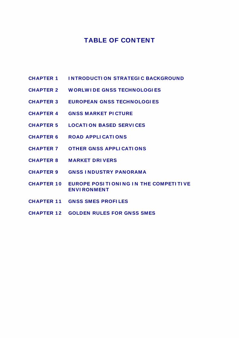
TABLE OF CONTENT
CHAPTER 1 INTRODUCTION STRATEGIC BACKGROUND CHAPTER 2 WORLWIDE GNSS TECHNOLOGIES CHAPTER 3 EUROPEAN GNSS TECHNOLOGIES CHAPTER 4 GNSS MARKET PICTURE CHAPTER 5 LOCATION BASED SERVICES CHAPTER 6 ROAD APPLICATIONS CHAPTER 7 OTHER GNSS APPLICATIONS CHAPTER 8 MARKET DRIVERS CHAPTER 9 GNSS INDUSTRY PANORAMA CHAPTER 10 EUROPE POSITIONING IN THE COMPETITIVE
ENVIRONMENT CHAPTER 11 GNSS SMES PROFILES CHAPTER 12 GOLDEN RULES FOR GNSS SMES

All you need to know to do business with GNSS Capital High Tech Page 4 Noémie Dumesnil
CHAPTER 1
INTRODUCTION STRATEGIC BACKGROUND
In this introduction chapter, we will introduce you the strategic interest of global navigation satellite systems (GNSS) and a first insight on Europe motivation for having its own GNSS.
I. The importance of GNSS applications in our day to day life The benefits of global navigation satellite system have already been demonstrated with the availability of the American (USA) Global Positioning System (GPS). Applications are continuously being developed, covering all lifestyle and sectors of the world economy. Satellite navigation is becoming more and more part of the daily life, not only in their cars and portable telephones but also in energy distribution networks or banking systems. Receivers are now found in all kinds of electronic devices for everyday use such as mobile phones, personal digital assistants, cameras, portable PCs or wristwatches. Mobile telephony is a promising market with over 2 billion mobile phone subscribers. Half a billion units are sold every year, with a prospect of 1 billion a year by 2020, allowing for fast market penetration of satellite positioning-based services. Vehicles should increasingly be fitted with navigation equipment. All sectors of modern economies are affected by the development of satellite navigation technologies. Applications span a large range of sectors, not only in transport and communication but also in other markets such as land survey, agriculture, scientific research, tourism and others. Global satellites navigation systems services are penetrating all segments of society and are becoming a common tool in the citizen’s daily life. In combination with even more cheaper and powerful handheld terminals and the demand for ubiquitous services, the role played by satellite global positioning systems is set to grow considerably, and is expected to reveal new sources of business in the years ahead.
II. A political challenge Having control of the satellite constellation technology that is central to the system means having control of the many industrial applications made possible thanks to satellite positioning. The European Union cannot afford not to become involved in what, it is already clear, will be one of the main sectors of industry in the twenty-first century. That would mean becoming dependent on systems and technologies developed outside Europe for applications vital to the running of the society of tomorrow. 1
1 http://ec.europa.eu/dgs/energy_transport/GALILEO/intro/challenge_en.htm
All you need to know to do business with GNSS Capital High Tech Page 5 Noémie Dumesnil
The European Councils at Cologne, Feira, Nice, Stockholm, Laeken and Barcelona all emphasised the strategic importance of Satellite Navigation programme. As a result, the European Union is now building the European global navigation satellite system (GNSS), comprising GALILEO and EGNOS, which will provide a set of positioning, navigation and timing services. GALILEO is a flagship of the European Space Policy. Its objectives are, amongst others, to respond to citizen's needs, to serve other EU policies, to concentrate on space applications and to improve European competitiveness. GALILEO has also to be seen in the wider context for fostering innovation and in the Lisbon strategy to make Europe the most competitive and dynamic knowledge-based economy in the world, capable of sustainable economic growth with more, better jobs, and greater social inclusion.2
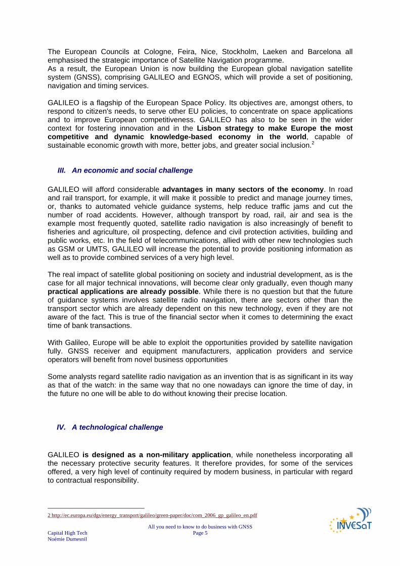
III. An economic and social challenge GALILEO will afford considerable advantages in many sectors of the economy. In road and rail transport, for example, it will make it possible to predict and manage journey times, or, thanks to automated vehicle guidance systems, help reduce traffic jams and cut the number of road accidents. However, although transport by road, rail, air and sea is the example most frequently quoted, satellite radio navigation is also increasingly of benefit to fisheries and agriculture, oil prospecting, defence and civil protection activities, building and public works, etc. In the field of telecommunications, allied with other new technologies such as GSM or UMTS, GALILEO will increase the potential to provide positioning information as well as to provide combined services of a very high level. The real impact of satellite global positioning on society and industrial development, as is the case for all major technical innovations, will become clear only gradually, even though many practical applications are already possible. While there is no question but that the future of guidance systems involves satellite radio navigation, there are sectors other than the transport sector which are already dependent on this new technology, even if they are not aware of the fact. This is true of the financial sector when it comes to determining the exact time of bank transactions. With Galileo, Europe will be able to exploit the opportunities provided by satellite navigation fully. GNSS receiver and equipment manufacturers, application providers and service operators will benefit from novel business opportunities Some analysts regard satellite radio navigation as an invention that is as significant in its way as that of the watch: in the same way that no one nowadays can ignore the time of day, in the future no one will be able to do without knowing their precise location.
IV. A technological challenge GALILEO is designed as a non-military application, while nonetheless incorporating all the necessary protective security features. It therefore provides, for some of the services offered, a very high level of continuity required by modern business, in particular with regard to contractual responsibility.
2 http://ec.europa.eu/dgs/energy_transport/galileo/green-paper/doc/com_2006_gp_galileo_en.pdf
All you need to know to do business with GNSS Capital High Tech Page 6 Noémie Dumesnil
It is based on the same technology as GPS and provides a similar - possibly higher - degree of precision, thanks to the structure of the constellation of satellites and the ground-based control and management systems planned. GALILEO is more reliable as it includes a signal "integrity message" informing the user immediately of any errors. In addition, by placing satellites in orbits at a greater inclination to the equatorial plane than GPS, Galileo will achieve better coverage at high latitudes. This will make it particularly suitable for operation over northern Europe, an area not well covered by GPS. It will be possible to receive GALILEO in towns and in regions located in extreme latitudes. It represents a real public service and, as such, guarantees continuity of service provision for specific applications.
GALILEO multiple challenges (source EC)3
GALILEO and the Global Navigation Satellite Systems more generally, offer key functionalities likely to revolutionise society in the same way that the mobile phone has done in recent years while also heralding the development of a new generation of universal services.
3 Presentations from EURISY CONFERENCE GALILEO Services: Chances for Business.24/25 April 2006 - PRAGUE, Czech Republic - Overview of the GALILEO Services, approach & business strategy: Ignacio González, European Navigation Concessionnaire
All you need to know to do business with GNSS Capital High Tech Page 7 Noémie Dumesnil
CHAPTER 2
GNSS TECHNOLGIES
The 20th century was marked by the definitive takeoff of geopositioning or the advent of radio navigation followed by satellite navigation. We will discuss in this chapter the existing or future technologies, their performances and differences. A full chapter is dedicated to European GNSS (GALILEO & EGNOS): their performances and complementarities/differences with other systems.
I. Introduction Developed in the first half of the 20th century, radio navigation uses radioelectric signals to determine a position. The points obtained do not depend on visibility conditions. In 1957, Sputnik I, the world’s first artificial satellite was launched by Russia. It remained three months in orbit and emitted signals for 21 days. It marked the beginning of research in satellite location. In 1968, the first Global Positioning System (GPS) satellite was launched by the United States. In 1973, the Pentagon designed and financed a GPS system composed of several satellites in orbit around the Earth, which gave the position in real time of any point on the planet. This system was originally designed for military purposes. In 1990, the American government announced that GPS satellites were also open to the civil domain and in 1995; the system was operational with accuracy from 7 to 10 meters. For its part, Europe is working on the EGNOS project, a system designed to inform users about the integrity of positioning signals of the GPS (American) and GLONASS (Russian) systems, as well as correcting errors and improving availability. EGNOS is the first step towards GALILEO, European satellite navigation and positioning system, which will be operational by 2010. GALILEO is a civil system that will provide better accuracy than the current GPS system.4
4 http://www.navigation-satellites-toulouse.com/rubrique.php3?id_rubrique=74

All you need to know to do business with GNSS Capital High Tech Page 8 Noémie Dumesnil
II. Principle of satellite radio navigation
1) Satellite radio navigation, geopositioning & navigation Satellite radio navigation has been developed over the last 30 years or so, essentially for military purposes originally, enables anyone with a receiver capable of picking up signals emitted by a constellation of satellites to instantly determine his position in time and space very accurately. Geopositioning is used to locate the exact position of a mobile element or object on the Earth. Today, it is based on satellite geopositioning systems composed of satellite constellations in orbit around the Earth and receivers. The latter can be on the ground or on board a vehicle or a plane, receives information from satellites, which allows it to calculate its position relative to the Earth. While navigation refers to the science and techniques, which make possible to: Determine the position (coordinates) of a mobile object relative to a reference system or a
determined, fixed point. Calculate or measure the route to be taken to get to another point of known coordinates Calculate any other information relative to the movement of this mobile object (distances
and durations, speed, estimated time of arrival, etc.) All navigation systems are frequently called "GPS", although GPS specifically describes the American system. The systems built so far work according to the same principle. 5
2) Operating principle of GNSS The operating principle is simple: The satellites in the constellation are fitted with an atomic clock measuring time very accurately. The satellites emit personalised signals indicating the precise time the signal leaves the satellite. The ground receiver, incorporated for example into a mobile phone, has in its memory the precise details of the orbits of all the satellites in the constellation. By reading the incoming signal, it can thus recognise the particular satellite, determine the time taken by the signal to arrive and calculate the distance from the satellite. Once the ground receiver receives the signals from at least four satellites simultaneously, it can calculate the exact position. 6
5 http://en.wikipedia.org/wiki/User:Dual_Freq/GNSS 6 http://ec.europa.eu/dgs/energy_transport/GALILEO/index_en.htm

All you need to know to do business with GNSS Capital High Tech Page 9 Noémie Dumesnil
GNSS infrastructure (source EC)
A GNSS is composed of three segments: Space segment is the satellite constellation Ground segment includes control segment for operation, orbit and time determination,
and the system for integrity monitoring User segment is composed of receivers translating the signals provided by the
satellites into real services for the user
3) To go further into principles: pseudorandom noise codes
Pseudo distance concept7
7 AEROSPACE VALLEY/DAS NPT - Journée PME/TPE – 03/05/2007- Introduction à la Navigation par Satellite : Luis RUIZ - CNES Toulouse
Satellite emission time
Propagation time × Speed of light⇒ Distance covered d
Signal reception timeby user terminal
Satellite emission time
Propagation time × Speed of light⇒ Distance covered d
Signal reception timeby user terminal

All you need to know to do business with GNSS Capital High Tech Page 10 Noémie Dumesnil
Each satellite transmits a pseudorandom noise synchronised on GPS time reference. The code consists of a long series of bits (0's and 1's). A sequence of digital 1's and 0's that appear to be randomly distributed like noise but that can be reproduced exactly. Their most important property is a low autocorrelation value for all delays or lags except when they coincide exactly. The codes-patterns used for GPS repeat themselves after the 1023rd bit. These codes can be easily made with very few digital elements. For the 1023-bit pattern, 10 shifting registers and some digital adders are needed.
Source TU Delft
In general, with n shifting registers a series of 2n -1 bits can be generated. For n = 10 this will become 1024 (= 210) - 1 = 1023 bits. The codes are generated with a speed of 1.023 MHz (or 1023000 bits per second). An example with 4 shifting elements is given in below. 8
Source TU Delft
8 http://www.eurofix.tudelft.nl/prncode.htm
All you need to know to do business with GNSS Capital High Tech Page 11 Noémie Dumesnil
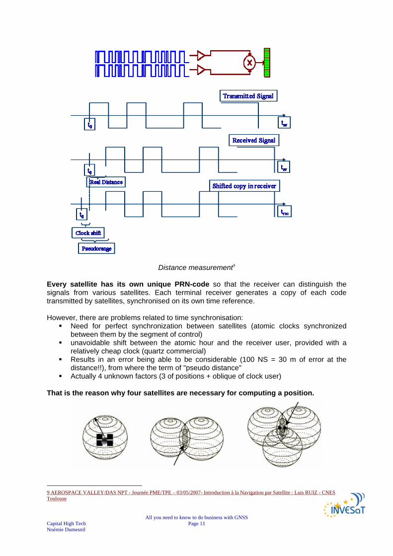
Distance measurement9 Every satellite has its own unique PRN-code so that the receiver can distinguish the signals from various satellites. Each terminal receiver generates a copy of each code transmitted by satellites, synchronised on its own time reference. However, there are problems related to time synchronisation:
Need for perfect synchronization between satellites (atomic clocks synchronized between them by the segment of control)
unavoidable shift between the atomic hour and the receiver user, provided with a relatively cheap clock (quartz commercial)
Results in an error being able to be considerable (100 NS = 30 m of error at the distance!!), from where the term of "pseudo distance"
Actually 4 unknown factors (3 of positions + oblique of clock user) That is the reason why four satellites are necessary for computing a position.
9 AEROSPACE VALLEY/DAS NPT - Journée PME/TPE – 03/05/2007- Introduction à la Navigation par Satellite : Luis RUIZ - CNES Toulouse

All you need to know to do business with GNSS Capital High Tech Page 12 Noémie Dumesnil
Based on one satellite, one can define a sphere; with two satellites, one can define a circle. Thanks to a third satellite, one can find the position of a receiver (excluding absurd solution).
III. The navigation satellite systems classification Global Navigation Satellite System (GNSS) is the standard generic term for satellite navigation systems that provide autonomous geo-spatial positioning with global coverage. GNSS that provide enhanced accuracy and integrity monitoring usable for civil navigation are classified as follows:
GNSS-1 is the first generation system and is the combination of existing satellite navigation systems (GPS and GLONASS), with Satellite Based Augmentation Systems (SBAS) or Ground Based Augmentation Systems (GBAS).
GNSS-2 is the second generation of systems that independently provides a full
civilian satellite navigation system, exemplified by the European GALILEO positioning system. These systems will provide the accuracy and integrity monitoring necessary for civil navigation. This system consists of L1 and L2 frequencies for civil use and L5 for system integrity. Development is also in progress to provide GPS with civil use L2 and L5 frequencies, making it a GNSS-2 system.
GNSS steps10
10 PROGENY – GALILEO JOINT UNDERTAKING Document repository WP5000/WP5100- EGNOS and GALILEO Programmes - Overview and Status

All you need to know to do business with GNSS Capital High Tech Page 13 Noémie Dumesnil
GNSS may have several layers of infrastructure:
Global Satellite navigation systems: currently GPS (US), GLONASS (Russia), and future GALILEO (Europe) and Beidou 2 (China).
Regional Satellite Navigation Systems: IRNSS (India), and Beidou 1 (China). Regional Satellite Based Augmentation Systems (SBAS): WAAS (US), EGNOS
(EU), MSAS (Japan) and GAGAN (India). Ground Based Augmentation Systems (GBAS) for example Differential GPS
(DGPS) , Local Area Augmentation System (LAAS), local GBAS typified by a single GPS reference station operating Real Time Kinematic (RTK) corrections
GNSS layers by regions

All you need to know to do business with GNSS Capital High Tech Page 14 Noémie Dumesnil
IV. The Global Satellite Navigation Systems
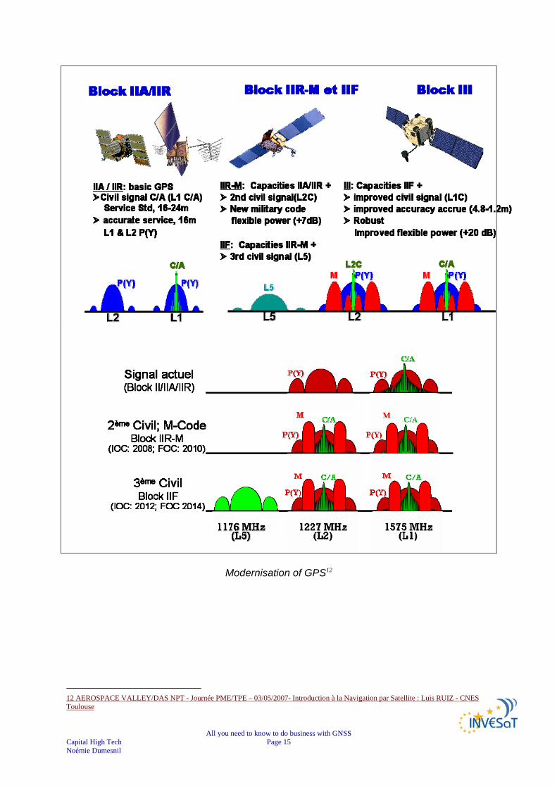
1) GPS
As mentioned previously although the acronym GPS is commonly used for designating GNSS, it only refers to the American GNSS system. The Global Positioning System (GPS) is currently the only fully functional Global Navigation Satellite System (GNSS). Developed by the United States Department of Defence, it is officially named NAVSTAR GPS (NAVigation Satellite Timing And Ranging Global Positioning System). The NAVSTAR GPS Joint Program Office manages the NAVSTAR Global Positioning System.
The Global Positioning System (GPS) satellite network is operated by the U.S. Air Force to provide highly accurate navigation information to military forces around the world. A growing number of commercial products are also using the network. GPS transmits precise radio signals; the system enables a GPS receiver to determine its location, speed and direction. The idea for a global positioning system was first proposed in 1940. There are 4 generations of the GPS satellite: the Block I, Block II/IIA, Block IIR and Block IIF.
Block I satellites were used to test the principles of the system, and lessons learned from those 11 satellites were incorporated into later blocks.
Block II and IIA satellites make up the current constellation. The third generation Block IIR satellites are currently being deployed as the Block
II/IIA satellites reach their end-of-life and are retired. Block IIF satellites will be the fourth generation of satellites and will be used for
operations and maintenance (O&M) replenishment.11
11 http://www.spaceandtech.com/spacedata/constellations/navstar-gps_consum.shtml
All you need to know to do business with GNSS Capital High Tech Page 15 Noémie Dumesnil
Modernisation of GPS12
12 AEROSPACE VALLEY/DAS NPT - Journée PME/TPE – 03/05/2007- Introduction à la Navigation par Satellite : Luis RUIZ - CNES Toulouse

All you need to know to do business with GNSS Capital High Tech Page 16 Noémie Dumesnil
GPS positioning performance13
The GPS space segment consists of into 6 orbital planes, requiring a minimum of 4 satellites in each, to operate. GPS is based on a constellation of:
24 medium Earth orbit satellites (at least 24 Active and 4 spare) 6 orbital planes Orbital inclination: 55° Altitude: 20200 km
The GPS control segment consists of
5 monitoring stations (Hawaii, Kwajalein, Ascension Island, Diego Garcia, Colorado Springs),
3 ground antennas, (Ascension Island, Diego Garcia, Kwajalein), 1 Master Control station located at Schriever AFB in Colorado.
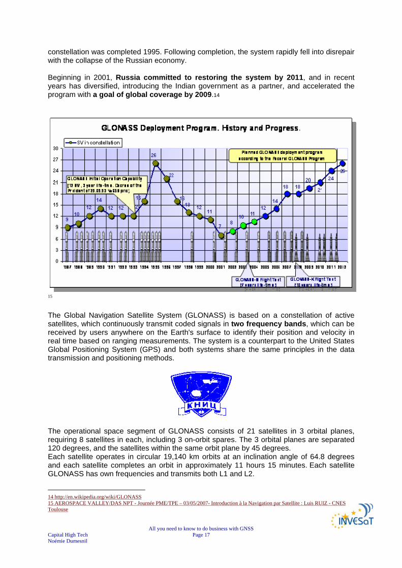
2) GLONASS GLONASS is a radio-based satellite navigation system, developed by the former Soviet Union and now operated for the Russian Federation Government by the Russian Space Forces, and the system is operated by the Coordination Scientific Information Centre (KNITs) of the Ministry of Defence of the Russian Federation. Development on the GLONASS began in 1976, with a goal of global coverage by 1991. Beginning in 1982, numerous satellite launches progressed the system forward until the
13 AEROSPACE VALLEY/DAS NPT - Journée PME/TPE – 03/05/2007- Introduction à la Navigation par Satellite : Luis RUIZ - CNES Toulouse
All you need to know to do business with GNSS Capital High Tech Page 17 Noémie Dumesnil
constellation was completed 1995. Following completion, the system rapidly fell into disrepair with the collapse of the Russian economy. Beginning in 2001, Russia committed to restoring the system by 2011, and in recent years has diversified, introducing the Indian government as a partner, and accelerated the program with a goal of global coverage by 2009.14
15 The Global Navigation Satellite System (GLONASS) is based on a constellation of active satellites, which continuously transmit coded signals in two frequency bands, which can be received by users anywhere on the Earth's surface to identify their position and velocity in real time based on ranging measurements. The system is a counterpart to the United States Global Positioning System (GPS) and both systems share the same principles in the data transmission and positioning methods.
The operational space segment of GLONASS consists of 21 satellites in 3 orbital planes, requiring 8 satellites in each, including 3 on-orbit spares. The 3 orbital planes are separated 120 degrees, and the satellites within the same orbit plane by 45 degrees. Each satellite operates in circular 19,140 km orbits at an inclination angle of 64.8 degrees and each satellite completes an orbit in approximately 11 hours 15 minutes. Each satellite GLONASS has own frequencies and transmits both L1 and L2.
14 http://en.wikipedia.org/wiki/GLONASS 15 AEROSPACE VALLEY/DAS NPT - Journée PME/TPE – 03/05/2007- Introduction à la Navigation par Satellite : Luis RUIZ - CNES Toulouse

All you need to know to do business with GNSS Capital High Tech Page 18 Noémie Dumesnil
GLONASS is based on a constellation of:
24 medium Earth orbit satellites (including 3 on orbit spares) Rotation on 3 orbital planes Orbital of inclination plans 64.8° Altitude is 19.140 Km
The ground control segment of GLONASS is entirely located within former Soviet Union territory.
Ground Control Centre and Time Standards is located in Moscow 4 telemetry and tracking stations are in St. Petersburg, Ternopol, Eniseisk,
Komsomolsk-na-Amure.
Work is underway to modernise the system. The new GLONASS-M satellite will have better signal characteristics as well as a longer design life (7-8 years instead of the current 3 years). In the future, plans are being developed to transition to a low mass third generation GLONASS-K satellites with a guaranteed lifespan of 10 years.
3) GALILEO
The GALILEO positioning system, referred to simply as GALILEO, is the European GNSS programme. It is named after the Italian astronomer GALILEO Galilei. The GALILEO positioning system is referred to as "GALILEO" instead of as the abbreviation "GPS" to distinguish it from the existing United States system. GALILEO is designed to provide a higher precision to all users than is currently available through GPS or GLONASS, to improve availability of positioning services at higher latitudes, and to provide an independent positioning system upon which European nations can rely even in times of war or political disagreement. The GALILEO constellation should become operational by 2012.
GALILEO constellation (source ESA)
FOR MORE INFORMATION SEE CHAPTER “FOCUS ON EUROPEAN GNSS”

All you need to know to do business with GNSS Capital High Tech Page 19 Noémie Dumesnil
4) COMPASS Navigation Satellite System (CNSS)/BeiDou 2
China is planning to build a navigation satellite constellation known as Compass Navigation Satellite System (CNSS), or “BeiDou 2” in its Chinese name. The BeiDou 2 system will be based on its current Compass Satellite Navigation Experimental System (BeiDou-1). BeiDou-1 will be able to provide navigation and positioning services to users in China and its neighbouring countries by 2008. The BeiDou 1 system will gradually be expanded into BeiDou 2 global navigation satellite constellation comprising 5 Geostationary Earth Orbit (GEO) satellites and 30 medium Earth orbit satellites. The BeiDou 2 system is intended to provide navigation and positioning services to global users. The CNSS will provide two types of services:
a free service for civilian users will have positioning accuracy within 10 metres, velocity accuracy within 0.2 metre per second and timing accuracy within 50 nanoseconds;
a licensed service with higher accuracy for authorised and military users only. The system will initially cover China and its neighbouring countries only but will eventually extend into a global navigation satellite network.
The new generation BeiDou 2 will allow ground receiver to calculate its position by measuring the distance between itself and three or more satellites, similar to the method of operation of the GPS and GLONASS systems. An independent satellite navigation network would allow Chinese forces to maintain its satellite navigation capability in time of crisis without relying on foreign satellites. China successfully launched a first medium Earth orbit BeiDou 2 navigation satellite codenamed Compass-M1 on 14 April 2007. The satellite will operate at an altitude of 21,500km orbit. 16
16 http://www.sinodefence.com/strategic/spacecraft/beidou2.asp
All you need to know to do business with GNSS Capital High Tech Page 20 Noémie Dumesnil
V. Regional Satellite Navigation Systems
1) BEIDOU 1
The Compass Navigation Satellite Experimental System, or BeiDou-1 in its Chinese name, is the 3 satellites constellation developed by China Academy of Space Technology (CAST). It is China’s first space-based regional navigation and positioning network. The system provides all weather, two-dimensional positioning data for both military and civilian users. The satellites are capable of communication and horizontal positioning for China’s military within their region. The network covers most areas of East Asia region and has both navigation and communication functions. The system will be able to provide navigation and positioning services to users in China and its neighbouring countries by 2008. The satellite network comprises three BeiDou-1 satellites (2 operational and 1 backup). The first two satellites of the BeiDou-1 navigation experimental system, the BeiDou-1A and BeiDou-1B, were launched on 31 October 2000 and 21 December 2000 respectively. The system began to provide navigation and positioning services in late 2001. The third satellite (backup) BeiDou-1C was launched on 25 May 2003, bringing the system fully operational. The navigation and positioning services became available to civilian users in April 2004. This has made China the third country in world to have deployed an operational space-based navigation and positioning network. Following the three successful launches of the BeiDou-1 satellites, a fourth GEO satellite was launched on 2 February 2007. The satellite suffered from a control system malfunction, which resulted in the solar power panel unable to expand. After some adjustment work from the ground control station, the satellite was said to be fully restored. The satellite was placed into the GEO, presumably to complement the three existing regional Beidou-1 geostationary satellites. At current time, we are not able to say if the satellite is being used. The ground systems include:
central control station, 3 ground tracking stations for orbit determination (at Jamushi, Kashi and
Zhanjiang), ground correction stations, user terminals (receivers/transmitters).
The system provides positioning data of 100m accuracy. By using ground- and/or space-based (the 3rd and 4th satellites) differential methods, the accuracy can be increased to under 20m. The system capacity is 540,000 users per hour, and serve up to 150 users simultaneously. The method of operation is specific: Beidou 1 Satellite Navigation Experimental System requires dual-way transmissions between the user and the central control station via the satellite. Firstly, the central control station sends inquiry signals to the users via two satellites. When the user terminal received the signal from one satellite, it sends responding signal back to both satellites. The central station receives the responding signals sent by the user from two satellites, and calculates the user’s 2D position based on the time difference between the two signals. This position is then compared with the digital territorial map stored
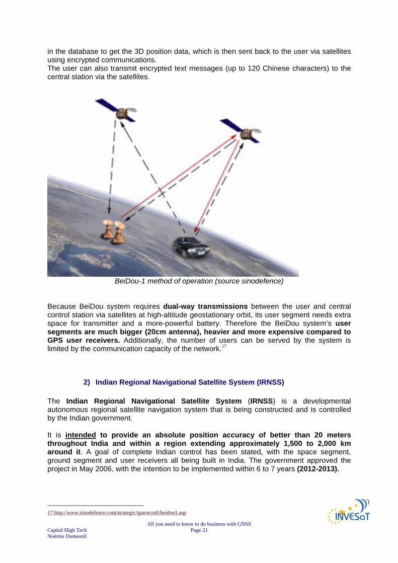
All you need to know to do business with GNSS Capital High Tech Page 21 Noémie Dumesnil
in the database to get the 3D position data, which is then sent back to the user via satellites using encrypted communications. The user can also transmit encrypted text messages (up to 120 Chinese characters) to the central station via the satellites.
BeiDou-1 method of operation (source sinodefence)
Because BeiDou system requires dual-way transmissions between the user and central control station via satellites at high-altitude geostationary orbit, its user segment needs extra space for transmitter and a more-powerful battery. Therefore the BeiDou system’s user segments are much bigger (20cm antenna), heavier and more expensive compared to GPS user receivers. Additionally, the number of users can be served by the system is limited by the communication capacity of the network.17
2) Indian Regional Navigational Satellite System (IRNSS) The Indian Regional Navigational Satellite System (IRNSS) is a developmental autonomous regional satellite navigation system that is being constructed and is controlled by the Indian government. It is intended to provide an absolute position accuracy of better than 20 meters throughout India and within a region extending approximately 1,500 to 2,000 km around it. A goal of complete Indian control has been stated, with the space segment, ground segment and user receivers all being built in India. The government approved the project in May 2006, with the intention to be implemented within 6 to 7 years (2012-2013).
17 http://www.sinodefence.com/strategic/spacecraft/beidou1.asp
All you need to know to do business with GNSS Capital High Tech Page 22 Noémie Dumesnil
It is unclear if recent dealings with the Russian government to restore their GLONASS system will supersede the IRNSS project or feed additional technical support to enable its completion. The proposed system would consist of a constellation of 7 satellites and a support ground segment.
3 of the satellites in the constellation will be placed in geostationary orbit 4 in geosynchronous inclined orbit of 29° relative to the equatorial plane.
Such an arrangement would mean all 7 satellites would have continuous radio visibility with Indian control stations. The satellite payloads would consist of atomic clocks and electronic equipment to generate the navigation signals. The navigation signals themselves would be transmitted in the S-band frequency (2-4 GHz), and broadcast through a phased array antenna to maintain required coverage and signal strength. The satellites would weigh approximately 1,330 kg and their solar panels generate 1,400 watts of energy. The ground segment of IRNSS constellation would consist of:
a Master Control Centre (MCC), ground stations to track and estimate the satellites' orbits and ensure the integrity of
the network (IRIM), additional ground stations to monitor the health of the satellites with the capability of
issuing radio commands to the satellites (TT&C stations). The MCC would estimate and predict the position of all IRNSS satellites, calculate integrity, makes necessary ionospheric and clock corrections and run the navigation software. In pursuit of a highly independent system, an Indian standard time infrastructure would also be established.18
18 http://fr.wikipedia.org/wiki/Indian_Regional_Navigational_Satellite_System

All you need to know to do business with GNSS Capital High Tech Page 23 Noémie Dumesnil
VI. Augmentation systems Augmentation of a Global Navigation Satellite System is a method of improving the navigation system's attributes, such as accuracy, reliability, and availability, through the integration of external information into the calculation process. There are many such systems in place and they are generally named or described based on how the GNSS sensor receives the external information.
some systems transmit additional information about sources of error (such as clock drift, ephemeris, or ionospheric delay),
others provide direct measurements of how much the signal was off in the past, while a third group provide additional vehicle information to be integrated in the
calculation process.19
VII. The satellite based augmentation systems A Satellite Based Augmentation System (SBAS) is a system that supports wide-area or regional augmentation using additional satellite-broadcast messages.
SBAS worldwide20
Such systems are commonly composed of multiple ground stations, located at accurately surveyed points. The ground stations take measurements of one or more of the GNSS satellites, the satellite signals, or other environmental factors, which may affect the signal received by the users. Using these measurements, information messages are created, and sent to one or more satellites for broadcast to the end users.21 Various SBAS are implemented worldwide. 19 http://en.wikipedia.org/wiki/GNSS_Augmentation 20 PROGENY – GALILEO JOINT UNDERTAKING Document repository WP5000/WP5100- EGNOS and GALILEO Programmes - Overview and Status 21 http://en.wikipedia.org/wiki/GBAS#Satellite_Based_Augmentation_Systems
All you need to know to do business with GNSS Capital High Tech Page 24 Noémie Dumesnil
1) Wide Area Augmentation System (WAAS) The Federal Aviation Administration (FAA) and the Department of Transportation (DOT) are developing the WAAS program for use in precision flight approaches. Currently, GPS alone does not meet the FAA's navigation requirements for accuracy, integrity, and availability. WAAS corrects for GPS signal errors caused by ionospheric disturbances, timing, and satellite orbit errors, and it provides vital integrity information regarding the health of each GPS satellite. WAAS consists of approximately 25 ground reference stations positioned across the United States that monitor GPS satellite data. The 2 master stations, located on either coast, collect data from the reference stations and create a GPS correction message. This correction accounts for GPS satellite orbit and clock drift plus signal delays caused by the atmosphere and ionosphere. The corrected differential message is then broadcast through one of 2 geostationary satellites, or satellites with a fixed position over the equator. The information is compatible with the basic GPS signal structure, which means any WAAS-enabled GPS receiver can read the signal. Currently, WAAS satellite coverage is only available in North America. There are no ground reference stations in South America, so even if GPS users can receive WAAS, the signal has not been corrected and thus would not improve the accuracy of their unit. For some users in the U.S., the position of the satellites over the equator makes it difficult to receive the signals when trees or mountains obstruct the view of the horizon.
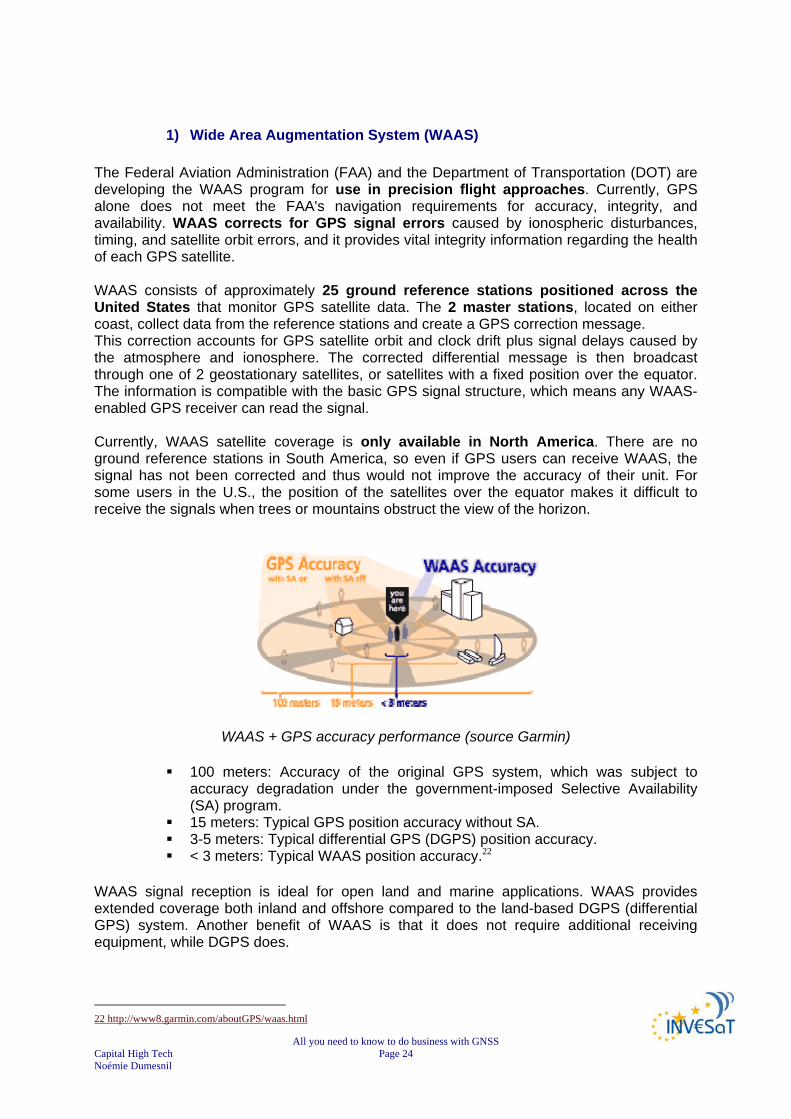
WAAS + GPS accuracy performance (source Garmin)
100 meters: Accuracy of the original GPS system, which was subject to accuracy degradation under the government-imposed Selective Availability (SA) program.
15 meters: Typical GPS position accuracy without SA. 3-5 meters: Typical differential GPS (DGPS) position accuracy. < 3 meters: Typical WAAS position accuracy.22
WAAS signal reception is ideal for open land and marine applications. WAAS provides extended coverage both inland and offshore compared to the land-based DGPS (differential GPS) system. Another benefit of WAAS is that it does not require additional receiving equipment, while DGPS does.
22 http://www8.garmin.com/aboutGPS/waas.html

All you need to know to do business with GNSS Capital High Tech Page 25 Noémie Dumesnil
2) GPS Aided Geo Augmented Navigation GAGAN Indian Space Research Organization (ISRO), along with Airport Authority of India (AAI) has worked out a joint program to implement the Satellite Based Augmentation System (SBAS) for the Indian region to fill the gap between EGNOS and MSAS. The project called GAGAN (GPS Aided Geo Augmented Navigation) has been taken up with an objective to demonstrate the SBAS technology over the Indian region. There is a plan to have an operational system to provide a seamless navigation facility in the region, which is interoperable with other SBAS. The Airports Authority of India (AAI) plans to use Gagan to meet the civil aviation industry's growing needs in communications, navigation and surveillance and air traffic management. It will result in greater efficiency and safety in over 100 airports in India. Although primarily meant for civil aviation, it is also beneficial for other users. The GAGAN system will have a full complement of the SBAS inclusive of ground and onboard segment. The ground segment consists of
8 reference stations distributed across the country, 1 mission control centre in Bangalore 1 up linking station also in Bangalore.
The onboard segment consists of a navigation payload onboard Indian geostationary satellite GSAT-4. The indigenously designed and developed navigational transponder has the latest features inclusive of L1 and L5 operation, higher EIRP of up to 33 dBw and higher bandwidth of 20 Mhz. The preliminary system acceptance test in 2006 for the Technology Demonstration System (TDS) of the GPS-aided Geo Augmented Navigation (GAGAN), being developed by the Indian Space Research Organisation (ISRO) to improve Air Traffic Control, was successful. The GAGAN -TDS network monitors Global Positioning Satellite (GPS) signals for errors and then generates correction messages to improve accuracy for users. During the test period, average accuracy of GAGAN-TDS was better than 1-metre horizontally and only slightly more than one metre vertically, thus surpassing the 7.6-metre requirement by a significant margin.2324
3) European Geostationary Navigation Overlay Service (EGNOS)
The European Geostationary Navigation Overlay Service (EGNOS) is Europe’s first venture into satellite navigation. It will augment the 2 military satellite navigation systems now operating, the US GPS and Russian GLONASS systems, and make them suitable for safety critical applications such as flying aircraft or navigating ships through narrow channels.
Consisting of 3 geostationary satellites and a network of ground stations, EGNOS will achieve its aim by transmitting a signal containing information on the reliability and accuracy of the positioning signals sent out by the Global Positioning System (GPS) and the Global Orbiting Navigation Satellite System (GLONASS). It will allow users in Europe and beyond to determine their position within 5 m, compared with about 20 m at present.
23 http://www.india-defence.com/reports/2239 24 http://www.aiaa.org/indiaus2004/Sat-navigation.pdf
All you need to know to do business with GNSS Capital High Tech Page 26 Noémie Dumesnil
EGNOS is a joint project of the European Space Agency (ESA), the European Commission (EC) and Eurocontrol, the European Organisation for the Safety of Air Navigation. It is Europe’s contribution to the first stage of the global navigation satellite system (GNSS) and is a precursor to GALILEO, the full global satellite navigation system under development in Europe.
FOR MORE INFORMATION SEE CHAPTER “FOCUS ON EUROPEAN GNSS”
4) Multi-functional Satellite Augmentation System (MSAS)
Throughout Asia, Multi-functional Satellite Augmentation System (MSAS) provides satellite navigation correction and validation, making SBAS-enabled receivers at least 3 times more accurate than standard devices. MSAS relay stations have been set at known positions throughout Asia.
SBAS-enabled receivers do not require any additional equipment to use MSAS correction signals and, as with satellite navigation signals, there are no setup or subscription fees. MSAS is scheduled for full operation in 2005 providing accuracy to within 5 meters or less, and will expand safety and air-traffic capacity in the Asia pacific regions.25
25 http://corp.magellangps.com/en/products/aboutgps/augmentation.asp
All you need to know to do business with GNSS Capital High Tech Page 27 Noémie Dumesnil
VIII. Ground Based Augmentation System (GBAS )
The Ground Based Augmentation System (GBAS) is an augmentation to GNSS that focuses its service on the airport area (approximately a 30 km radius). It broadcasts its correction message via a very high frequency (VHF) radio data link from a ground-based transmitter. GBAS will initially provide support for (Category I) Precision Approach operation and ultimately fulfil the extremely high requirements for accuracy, availability, and integrity necessary (for Category I, II, and III) precision approaches. In addition, it will provide the ability for more flexible, curved approach paths, terminal area and regional augmentation in regions, which desire such implementation. The current Instrument Landing System (ILS) suffers from a number of technical limitations such as, VHF interference, multi path effects (for example due to new building works at and around airports), as well as ILS channel limitations. The operational benefits of GBAS include:
One GBAS Ground Station will be able to support multiple runway ends; Flight Inspection and maintenance requirements should be reduced compared to ILS; More stable signal, and less interference with preceding aircraft.
Current GBAS demonstrated accuracy is less than 1 meter in both the horizontal and vertical axis. The Ground-Based Augmentation System (GBAS) supports all phases of approach, landing, departure, and surface operations within its area of coverage. 26
1) The United States' Local Area Augmentation System (LAAS) LAAS, or the Local Area Augmentation System, is the FAA version of the Ground Based Augmentation System, or GBAS, that has been defined by the International Civil Aviation Organization (ICAO). LAAS is based on a single GPS reference station facility located on the property of the airport being serviced. This facility has 3 or more (redundant) reference receivers that independently measure GPS satellite pseudo range and carrier phase (GPS measurements based on the L1 or L2 carrier signal) and generate differential carrier-smoothed-code corrections that are eventually broadcast to user via a 31.5-kbps VHF data broadcast (in the 108 - 118 MHz band) that also includes safety and approach-geometry information. This information allows users within 45 km of the LAAS ground station to perform GPS-based position fixes with 0.5-meter (95%) accuracy and to perform all civil flight operations up to non-precision approach. Aircraft landing at a LAAS-equipped airport will be able to perform precision approach operations up to at least Category I weather minima. The pseudolites shown in the diagram below are optional means of improving user ranging geometries with ground-based GPS-like transmitters but are not likely to be needed in the foreseeable future. 27 26 http://www.ecacnav.com/content.asp?CatID=64 27 http://waas.stanford.edu/research/laas.htm
All you need to know to do business with GNSS Capital High Tech Page 28 Noémie Dumesnil
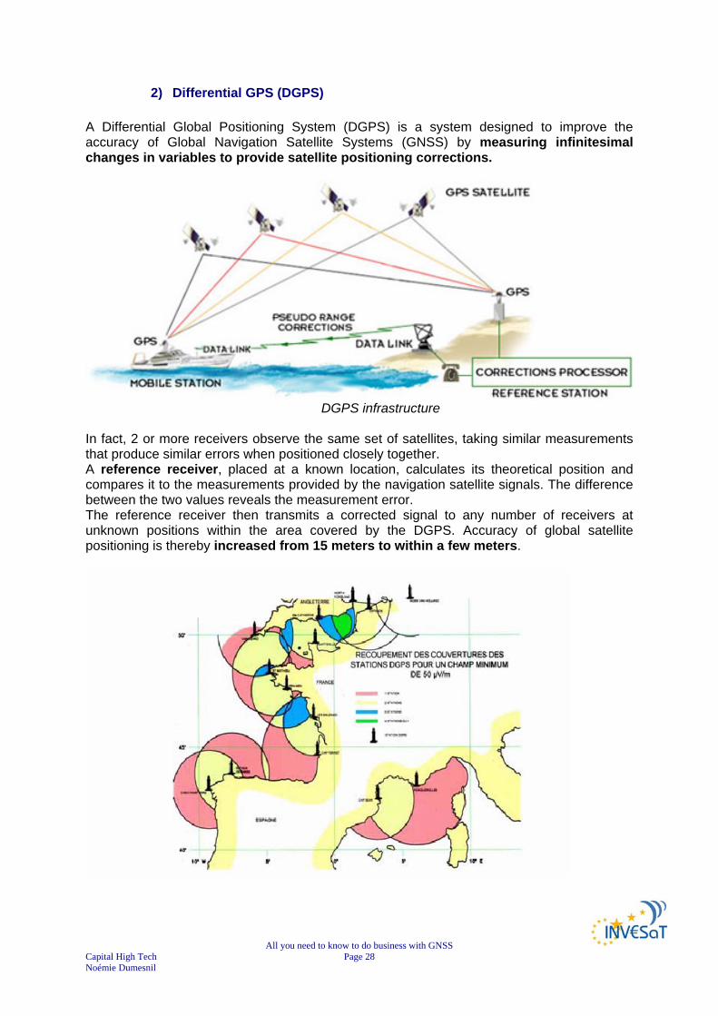
2) Differential GPS (DGPS) A Differential Global Positioning System (DGPS) is a system designed to improve the accuracy of Global Navigation Satellite Systems (GNSS) by measuring infinitesimal changes in variables to provide satellite positioning corrections.
DGPS infrastructure
In fact, 2 or more receivers observe the same set of satellites, taking similar measurements that produce similar errors when positioned closely together. A reference receiver, placed at a known location, calculates its theoretical position and compares it to the measurements provided by the navigation satellite signals. The difference between the two values reveals the measurement error. The reference receiver then transmits a corrected signal to any number of receivers at unknown positions within the area covered by the DGPS. Accuracy of global satellite positioning is thereby increased from 15 meters to within a few meters.

All you need to know to do business with GNSS Capital High Tech Page 29 Noémie Dumesnil
French DGPS network28 This technique compensates for errors in the satellite navigation system itself but may not always correct errors caused by the local environment when satellite navigation signals are reflected off of tall buildings or nearby mountains, creating multi-path signals. The accuracy of DGPS decreases with asynchronous measurement caused by spatial and temporal error decorrelation when the system receivers are set at greater distances apart.
DGPS stations performances29
More sophisticated DGPS techniques can increase positioning accuracy to within a few millimetres. Raw measurements recorded by the reference receiver and one or more roving receivers can be processed using specially designed software that calculates the errors. The corrections may then be transmitted in real time or after the fact (post-processing). By applying the corrections and recalculating the position, accuracy from within several meters to within a few millimetres is achieved, depending on the specific methodology used and the quality of the real-time data link. Satellite navigation receivers calculate position by measuring pseudo distances from the positioning satellites.
Code phase measurement method: most common method, used by all receivers, is to calculate the difference between the time a signal is transmitted from a satellite and the time it is recorded by the receiver, using the code embedded in the satellite's signal. This measurement is called code phase, and produces non-ambiguous meter-level results.
28 AEROSPACE VALLEY/DAS NPT - Journée PME/TPE – 03/05/2007- Introduction à la Navigation par Satellite : Luis RUIZ - CNES Toulouse 29 AEROSPACE VALLEY/DAS NPT - Journée PME/TPE – 03/05/2007- Introduction à la Navigation par Satellite : Luis RUIZ - CNES Toulouse

All you need to know to do business with GNSS Capital High Tech Page 30 Noémie Dumesnil
There are three types of DGPS using code phase measurement methods: o DGPS and LADGPS (Local Area DGPS) typically cover an area up to several
tens of kilometres. o WADGPS greatly increases the coverage area up to several thousand
kilometers by a more sophisticated method known as WADGPS (Wide Area DGPS). WADGPS classifies errors into position-dependent and position-independent components creating a secondary set of measurements that are transmitted to the rover receivers. The rover receivers are then able to reconstruct the pseudo range correction most applicable to their actual position and compute an accurate differential position.
Carrier phase serves to compliment code phase measurement by measuring the
satellite carrier wave. This method provides millimetres-level resolution with measurements that are ambiguous to about 19 centimeters. DGPS using the carrier phase achieves maximum accuracy only when measurement ambiguities are resolved in some way. The static method of ambiguity resolution is related to stationary receivers, with rover receiver point occupation from 30 minutes to several hours or even several days. The rapid static method reduces occupation periods to several minutes, while the kinematic method allows rover receivers to move without constraint.
Measurement Type
Real-time or Post-processing
System Type Accuracy Coverage Area
Code phase Post-processing
Post-processed DGPS, post-processed LADGPS or post-processed WADGPS
from < 1 m to ~10 m
From several x 10 km to several x 1000 km
Code phase Real time DGPS, LADGPS or WADGPS
from < 1 m to ~10 m
From several x 10 km to several x 1000 km
Carrier phase Post-processing
Kinematic, rapid static or static
from < 1 cm to several cm
From several km to several x 1000 km
Carrier phase Real time Real-time kinematic from < 1 cm to several cm
From several km to several x 10 km
3) Real Time Kinematic (RTK) Real Time Kinematic (RTK) satellite navigation is a technique used in land survey based on the use of carrier phase measurements of the GPS, GLONASS and/or GALILEO signals where a single reference station provides the real-time corrections of even to a centimetre level of accuracy. When referring to GPS in particular, the system is also commonly referred to as Carrier-Phase Enhancement, CPGPS. RTK is a process where GPS signal corrections are transmitted in real time from a reference receiver at a known location to one or more remote rover receivers.

All you need to know to do business with GNSS Capital High Tech Page 31 Noémie Dumesnil
The use of an RTK capable GPS system can compensate for atmospheric delay, orbital errors and other variables in GPS geometry, increasing positioning accuracy up to within a centimetre. Used by engineers, topographers, surveyors and other professionals, RTK is a technique employed in applications where precision is paramount. RTK is used, not only as a precision positioning instrument, but also as a core for navigation systems or automatic machine guidance, in applications such as civil engineering and dredging. It provides advantages over other traditional positioning and tracking methods, increasing productivity and accuracy. Using the code phase of GPS signals, as well as the carrier phase, which delivers the most accurate GPS information, RTK provides differential corrections to produce the most precise GPS positioning. The RTK process begins with a preliminary ambiguity resolution. This is a crucial aspect of any kinematic system, particularly in real-time where the velocity of a rover receiver should not degrade either the achievable performance or the system's overall reliability.30
Local augmentation: RTK31
30 http://pro.magellangps.com/en/products/aboutgps/rtk.asp 31 AEROSPACE VALLEY/DAS NPT - Journée PME/TPE – 03/05/2007- Introduction à la Navigation par Satellite : Luis RUIZ - CNES Toulouse

All you need to know to do business with GNSS Capital High Tech Page 32 Noémie Dumesnil
CHAPTER 3
EUROPEAN GNSS TECHNOLOGIES
This chapter is dedicated to European GNSS, known as GALILEO & EGNOS their performances and complementarities/differences with other systems.
I. European GNSS32 Recognising the strategic importance of satellite navigation and its potential applications, Europe decided to develop its own GNSS capability in following a two-step approach: Step 1: EGNOS to provide civil complement to military GPS and GLONASS initial
services in early 2006. EGNOS is an initiative of the European Commission, Eurocontrol and ESA. EGNOS is a precursor to Galileo
Step 2: GALILEO to achieve European sovereignty through system under civil control. GALILEO is an initiative of the European Commission and ESA.
The European GNSS infrastructure is made of EGNOS and Galileo.
II. EGNOS: the European Geostationary Navigation Overlay Service The European Geostationary Navigation Overlay Service (EGNOS) is:
Europe first development of a satellite navigation ground segment Europe’s first venture into satellite navigation Europe’s contribution to the first stage of the GNSS
EGNOS is being developed under a tripartite agreement between:
the European Commission (EC), the European Organisation for the Safety of Air Navigation (Eurocontrol) the European Space Agency (ESA).
Several air traffic service providers are supporting the development programme with their own investments. EGNOS development phase started in 2000 and initial operations were in 2005. The European Space Agency is currently finalising the qualification of the operator and the deployed infrastructure. The funding of the technical activities is ensured until the Operational Qualification Review in 2008, at which ESA is committed to bring EGNOS to a qualified pre-operational state with a system compliant with the specifications. 32 http://ec.europa.eu/dgs/energy_transport/GALILEO/intro/index_en.htm

All you need to know to do business with GNSS Capital High Tech Page 33 Noémie Dumesnil
In 2007, the Galileo Supervisory Authority and ESA will negotiate and conclude on the EGNOS assets transfer of ownership taking into account the investors. In the same year, the GSA will launch a call for tender for an EGNOS Economic Operator (EEO). The EGNOS Economic Operator will be responsible to obtain certification in the shortest time possible in order to allow service provision to, in particular, the aviation community. The EGNOS Economic Operator will also develop services provision to other user communities. 33
1) EGNOS principles EGNOS will complement the GPS and GLONASS systems over large European area to improve accuracy, and make them suitable for safety critical applications such as flying aircraft or navigating ships through narrow channels.
Consisting of three geostationary satellites and a network of ground stations, EGNOS will send out a ranging signal similar to those transmitted by the GPS and GLONASS satellites. However, the signals will be more than another opportunity for users to fix a position. They will also provide information about the accuracy of position measurements delivered by GPS and GLONASS so that a train driver, for example, will be able to assess whether the position is accurate enough to rely on. EGNOS will disseminate, on the GPS L1 frequency carry out the task of transmitting a signal containing information on the reliability and accuracy of the positioning signals sent out by the GNSS.
This information, or integrity data, will be modulated onto the ranging signal. It will include accurate information on the position of each GPS and GLONASS satellite, the accuracy of the atomic clocks on board the satellites and information on disturbances within the ionosphere that might affect the accuracy of positioning measurements. The EGNOS receiver, which is more sophisticated than a standard satellite navigation receiver, will de-code the signal to give a more accurate position than is possible with GPS or GLONASS alone and an accurate estimate of errors.
33 http://ec.europa.eu/dgs/energy_transport/galileo/doc/staff_doc_galileo_en_final_16052007.pdf

All you need to know to do business with GNSS Capital High Tech Page 34 Noémie Dumesnil
Egnos description34
Consequently, EGNOS will improve the accuracy of positions from about 20 m to 5m, inform users on the health of the constellation, of the errors in position measurements and warn of disruption to a satellite signal within six seconds. EGNOS will have the responsibility to guarantee the integrity of the service, meaning to provide timely warnings to users when the system should not be used for navigation because of errors or failures in the system.
2) EGNOS system components
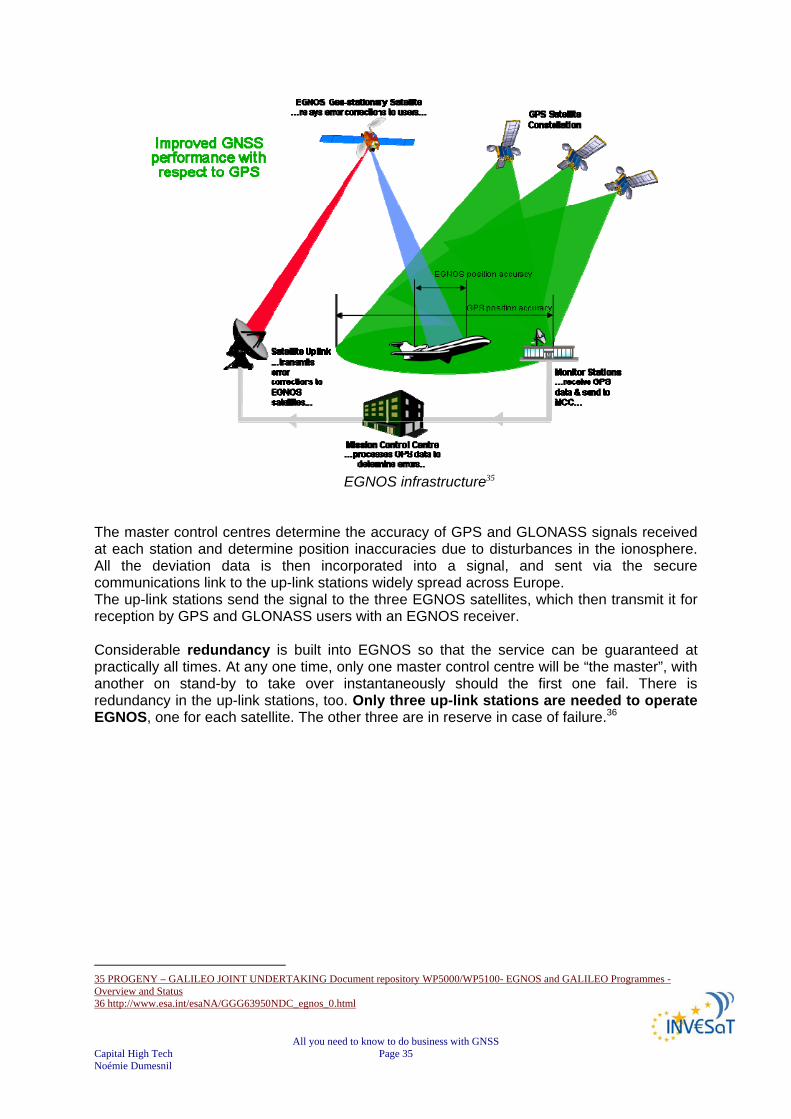
Two Inmarsat-3 satellites, one over the eastern part of the Atlantic, the other over the Indian Ocean, and the ESA Artemis satellite will broadcast the EGNOS signal, which is in Geostationary Earth orbit above Africa. Unlike the GPS and GLONASS satellites, these three will not have signal generators on board. A transponder will transmit signals up-linked to the satellites from the ground, where all the signal processing will take place. The sophisticated ground segment will consist of:
about 30 ranging and integrity monitoring stations (RIMS) 4 master control centres 6 up-link stations
The RIMS measure the positions of each EGNOS satellite and compare accurate measurements of the positions of each GPS and GLONASS satellite with measurements obtained from the satellites’ signals. The RIMS then send this data to the master control centres, via a purpose built communications network.
34 PROGENY – GALILEO JOINT UNDERTAKING Document repository WP5000/WP5100- EGNOS and GALILEO Programmes - Overview and Status
All you need to know to do business with GNSS Capital High Tech Page 35 Noémie Dumesnil
EGNOS infrastructure35
The master control centres determine the accuracy of GPS and GLONASS signals received at each station and determine position inaccuracies due to disturbances in the ionosphere. All the deviation data is then incorporated into a signal, and sent via the secure communications link to the up-link stations widely spread across Europe. The up-link stations send the signal to the three EGNOS satellites, which then transmit it for reception by GPS and GLONASS users with an EGNOS receiver. Considerable redundancy is built into EGNOS so that the service can be guaranteed at practically all times. At any one time, only one master control centre will be “the master”, with another on stand-by to take over instantaneously should the first one fail. There is redundancy in the up-link stations, too. Only three up-link stations are needed to operate EGNOS, one for each satellite. The other three are in reserve in case of failure.36
35 PROGENY – GALILEO JOINT UNDERTAKING Document repository WP5000/WP5100- EGNOS and GALILEO Programmes - Overview and Status 36 http://www.esa.int/esaNA/GGG63950NDC_egnos_0.html

All you need to know to do business with GNSS Capital High Tech Page 36 Noémie Dumesnil
EGNOS ground segment37
3) EGNOS coverage
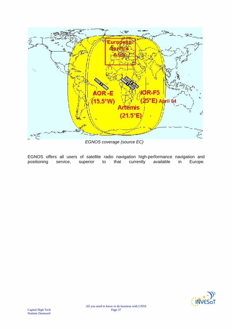
The EGNOS coverage area includes all European states, and could be extended to include other regions, such as South America, Africa, and parts of Asia and Australia, within the coverage of three geostationary satellites being used.
37 PROGENY – GALILEO JOINT UNDERTAKING Document repository WP5000/WP5100- EGNOS and GALILEO Programmes - Overview and Status
All you need to know to do business with GNSS Capital High Tech Page 37 Noémie Dumesnil
EGNOS coverage (source EC)
EGNOS offers all users of satellite radio navigation high-performance navigation and positioning service, superior to that currently available in Europe.

All you need to know to do business with GNSS Capital High Tech Page 38 Noémie Dumesnil
4) EGNOS performances
Figure 1: Mean horizontal positioning accuracy (95%) achieved through the GPS
constellation alone (in m) (1)
Figure 2: Mean horizontal positioning accuracy (95%) achieved through the GPS
constellation augmented by EGNOS (in m) (1)
Comparison between GPS constellation alone and GPS Constellation augmented by EGNOS (source EC)

All you need to know to do business with GNSS Capital High Tech Page 39 Noémie Dumesnil
Example of a GPS integrity event38
On 25 December 2005, GPS satellite PRN25 started to malfunction at 21H06. It took ~30 minutes for the GPS operators to take the satellite out of service. During this period, EGNOS managed to correct the satellite error.39
Example of a GPS integrity event40
38 PROGENY – GALILEO JOINT UNDERTAKING Document repository WP5000/WP5100- EGNOS and GALILEO Programmes - Overview and Status 39 PROGENY – GALILEO JOINT UNDERTAKING Document repository WP5000/WP5100 - EGNOS_Galileo_overview_270606 40 PROGENY – GALILEO JOINT UNDERTAKING Document repository WP5000/WP5100- EGNOS and GALILEO Programmes - Overview and Status

All you need to know to do business with GNSS Capital High Tech Page 40 Noémie Dumesnil
III. GALILEO41 GALILEO is Europe’s initiative for a state-of-the-art global navigation satellite system, providing a highly accurate, guaranteed global positioning service under civilian control. The GALILEO positioning system is referred to as "GALILEO" instead of as the abbreviation "GPS" to distinguish it from the existing United States system.
1) GALILEO background GALILEO is designed to provide a higher precision to all users than is currently available through GPS or GLONASS, to improve availability of positioning services at higher latitudes, and to provide an independent positioning system upon which European nations can rely even in times of war or political disagreement. Galileo will be Europe’s own global navigation satellite system, providing a highly accurate, guaranteed global positioning service under civilian control. It will be inter-operable with GPS and GLONASS. By offering dual frequencies as standard, however, Galileo will deliver real-time positioning accuracy down to the metre range, which is unprecedented for a publicly available system. It will guarantee availability of the service under all but the most extreme circumstances and will inform users within seconds of a failure of any satellite. This will make it suitable for applications where safety is crucial, such as running trains, guiding cars and landing aircraft. GALILEO is to achieve European sovereignty and service guarantees through a dedicated satellite navigation system operated under civil control. Indeed, today, satellite navigation users in Europe have no other alternative than to derive their positions from US GPS or Russian GLONASS satellites. Therefore, not all the operators who make a strong use of navigation data can be guaranteed of an uninterrupted service. This is therefore the major reason why the GALILEO programme was launched: to guarantee European independence. However, other subsidiary reasons also include:
Implementation of European Transport Policy Certifiable for Safety of Life Applications Innovation through new Applications Market share for European Industry Creation of 150,000 new jobs in Europe and much more on a global scale Research & development for present & future generations Contribution to the Lisbon Strategy
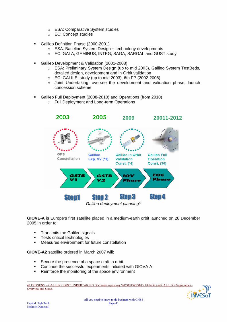
2) GALILEO Planning Originally, the GALILEO programme phase was planned as follows:
Preliminary Studies: (1998-1999)
41 http://www.esa.int/esaNA/GGG28850NDC_galileo_0.html
All you need to know to do business with GNSS Capital High Tech Page 41 Noémie Dumesnil
o ESA: Comparative System studies o EC: Concept studies
Galileo Definition Phase (2000-2001) o ESA: Baseline System Design + technology developments o EC: GALA, GEMINUS, INTEG, SAGA, SARGAL and GUST study
Galileo Development & Validation (2001-2008) o ESA: Preliminary System Design (up to mid 2003), Galileo System TestBeds,
detailed design, development and in-Orbit validation o EC: GALILEI study (up to mid 2003), 6th FP (2002-2006) o Joint Undertaking: oversee the development and validation phase, launch
concession scheme
Galileo Full Deployment (2008-2010) and Operations (from 2010) o Full Deployment and Long-term Operations
Galileo deployment planning42
GIOVE-A is Europe’s first satellite placed in a medium-earth orbit launched on 28 December 2005 in order to:
Transmits the Galileo signals Tests critical technologies Measures environment for future constellation
GIOVE-A2 satellite ordered in March 2007 will:
Secure the presence of a space craft in orbit Continue the successful experiments initiated with GIOVA A Reinforce the monitoring of the space environment
42 PROGENY – GALILEO JOINT UNDERTAKING Document repository WP5000/WP5100- EGNOS and GALILEO Programmes - Overview and Status
2009 20011-2012
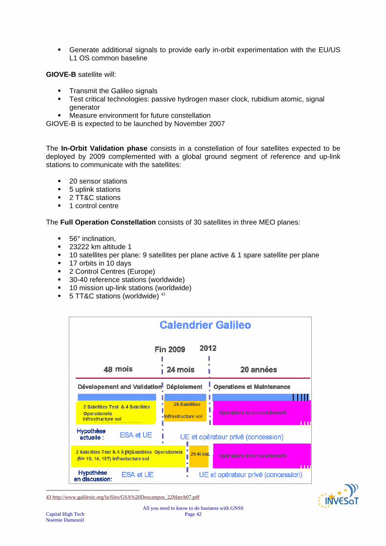
All you need to know to do business with GNSS Capital High Tech Page 42 Noémie Dumesnil
Generate additional signals to provide early in-orbit experimentation with the EU/US L1 OS common baseline
GIOVE-B satellite will:
Transmit the Galileo signals Test critical technologies: passive hydrogen maser clock, rubidium atomic, signal
generator Measure environment for future constellation
GIOVE-B is expected to be launched by November 2007 The In-Orbit Validation phase consists in a constellation of four satellites expected to be deployed by 2009 complemented with a global ground segment of reference and up-link stations to communicate with the satellites:
20 sensor stations 5 uplink stations 2 TT&C stations 1 control centre
The Full Operation Constellation consists of 30 satellites in three MEO planes:
56° inclination, 23222 km altitude 1 10 satellites per plane: 9 satellites per plane active & 1 spare satellite per plane 17 orbits in 10 days 2 Control Centres (Europe) 30-40 reference stations (worldwide) 10 mission up-link stations (worldwide) 5 TT&C stations (worldwide) 43
43 http://www.galileoic.org/la/files/GSA%20Doscampos_22March07.pdf

All you need to know to do business with GNSS Capital High Tech Page 43 Noémie Dumesnil
GALILEO Calendar (source EC)44
3) GALILEO system description The fully deployed Galileo system consists of 30 satellites (27 operational + 3 active spares), positioned in three circular Medium Earth Orbit (MEO) planes at 23 222 km altitude above the Earth, and at an inclination of the orbital planes of 56 degrees with reference to the equatorial plane. GALILEO constellation is based on:
30 spacecrafts orbital altitude: 23 222 km (MEO) 3 orbital planes, 56° inclination (9 operational satellites and one active spare per orbital plane)
17 orbits in 10 days 2 Control Centres (Europe) 30-40 reference stations (worldwide) 10 mission up-link stations (worldwide) 5 TT&C stations (worldwide)
satellite lifetime: >12 years satellite mass: 675 kg satellite body dimensions: 2.7 m x 1.2 m x 1.1 m
span of solar arrays: 18.7 m power of solar arrays: 1500 W (end of life)
Once this is achieved, the Galileo navigation signals will provide good coverage even at latitudes up to 75 degrees north, which corresponds to the North Cape, and beyond. The large number of satellites together with the optimisation of the constellation, and the availability of the 3 active spare satellites, will ensure that the loss of one satellite has no discernible effect on the user. The two Galileo Control Centres (GCC) will be implemented on European ground to provide for the control of the satellites and to perform the navigation mission management. The data provided by a global network of 20 Galileo Sensor Stations (GSS) will be sent to the Galileo Control Centres through a redundant communications network. The GCC’s will use the data of the Sensor Stations to compute the integrity information and to synchronize the time signal of all satellites and of the ground station clocks. The exchange of the data between the Control Centres and the satellites will be performed through so-called up-link stations. For this purpose, five S-band up-link stations and ten C-band up-link stations will be installed around the globe.
44 AEROSPACE VALLEY/DAS NPT - Journée PME/TPE – 03/05/2007 - Introduction à la Navigation par Satellite : Luis RUIZ - CNES Toulouse

All you need to know to do business with GNSS Capital High Tech Page 44 Noémie Dumesnil
Galileo constellation45
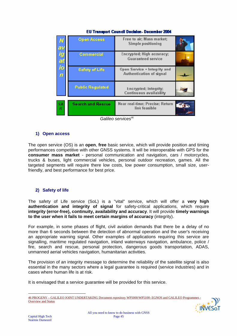
IV. GALILEO services Studies have already been carried out in order to identify future GALILEO users needs and then to define the characteristics of the services. Four navigation services and one service to support Search and Rescue operations have been identified to cover the widest range of users needs, including professional users, scientists, mass-market users, safety of life and public regulated domains.
The range of GALILEO services is designed to meet practical objectives and expectations, from improving the coverage of open-access services in urban environments (to cover 95% of urban districts compared with the 50% currently covered by GPS alone). All services are directly accessible worldwide. However, local bodies may have to make some adaptations to specific environments or user communities (tunnels, airports, ports, etc.). In addition, the satellite infrastructure can be complemented by regional components, particularly for producing the integrity message. It is worth emphasising that the services offered by GALILEO will cover the whole planet, particularly areas at a geographical disadvantage and the outermost regions of the European Union.
45 PROGENY – GALILEO JOINT UNDERTAKING Document repository WP5000/WP5100- EGNOS and GALILEO Programmes - Overview and Status
All you need to know to do business with GNSS Capital High Tech Page 45 Noémie Dumesnil
Galileo services46
1) Open access The open service (OS) is an open, free basic service, which will provide position and timing performances competitive with other GNSS systems. It will be interoperable with GPS for the consumer mass market - personal communication and navigation, cars / motorcycles, trucks & buses, light commercial vehicles, personal outdoor recreation, games. All the targeted segments will require there low costs, low power consumption, small size, user-friendly, and best performance for best price.
2) Safety of life The safety of Life service (SoL) is a "vital" service, which will offer a very high authentication and integrity of signal for safety-critical applications, which require integrity (error-free), continuity, availability and accuracy. It will provide timely warnings to the user when it fails to meet certain margins of accuracy (integrity). For example, in some phases of flight, civil aviation demands that there be a delay of no more than 6 seconds between the detection of abnormal operation and the user's receiving an appropriate warning signal. Other examples of applications requiring this service are signalling, maritime regulated navigation, inland waterways navigation, ambulance, police / fire, search and rescue, personal protection, dangerous goods transportation, ADAS, unmanned aerial vehicles navigation, humanitarian activities. The provision of an integrity message to determine the reliability of the satellite signal is also essential in the many sectors where a legal guarantee is required (service industries) and in cases where human life is at risk. It is envisaged that a service guarantee will be provided for this service. 46 PROGENY – GALILEO JOINT UNDERTAKING Document repository WP5000/WP5100- EGNOS and GALILEO Programmes - Overview and Status

All you need to know to do business with GNSS Capital High Tech Page 46 Noémie Dumesnil
3) Commercial service
The Commercial Service (CS) provides access to two additional signals, to allow for a higher data rate throughput and to enable users to benefit from improved accuracy. This service will provide also a limited broadcasting capacity for messages from service centres to users (in the order of 500 bits per second). This commercial service will facilitate the development of professional applications since it will offer enhanced performance compared with the basic service. It is envisaged that a service guarantee will also be provided. This service will offer value added navigation services for users with mission critical positioning requirements, in addition to guarantees regarding the specific basic parameters of the services provided (precision, availability, etc.). All professional and road market applications which require high precision, high accuracy, and high reliability will be able to benefit from this professional service : from the insurance sector (tracking stolen vehicles, premiums adjusted to the actual movements of the vehicles, monitoring movements of goods, etc.), to high-tech sectors such as oil prospecting, precision crop management, freight management, etc. Other examples of applications are oil and gas, mining, timing, environment, fleet management, asset management, geodesy, meteorological forecasting, land survey / GIS, precision survey, precision agriculture, fisheries, vehicle control and robotics, construction and civil engineering.
4) Public regulated services The Public Regulated Service (PRS) will provide position and timing capabilities to specific users requiring a high continuity of service with controlled access. Moreover, the public regulated service will be encrypted and resistant to jamming and interference. Two PRS navigation signals with encrypted ranging codes and data will be available. The PRS is aimed at government applications requiring robust navigation services for defence and public safety. In other words, it will be reserved principally for the public authorities responsible for civil protection, national security and law enforcement. It will enable secured applications to be developed in the European Union, and could prove in particular to be an important tool in improving the instruments used by the European Union to combat illegal exports and illegal immigration.
5) Search and rescue As a further feature, Galileo will provide a global Search and Rescue (SAR) function, based on the operational Cospas-Sarsat system.

All you need to know to do business with GNSS Capital High Tech Page 47 Noémie Dumesnil
Cospas-Sarsat is a satellite system designed to provide distress alert and location data to assist search and rescue (SAR) operations, using spacecraft and ground facilities to detect and locate the signals of distress beacons operating on 406 Megahertz (MHz) or 121.5 MHz. The position of the distress and other related information is forwarded to the appropriate Search and Rescue Point of Contact (SPOC) through the Cospas-Sarsat Mission Control Center (MCC) network. The Search and Rescue Service (SAR) will broadcast globally the alert messages received from distress emitting beacons. This service will offer alert and acknowledgement communications for search and rescue activities. It will greatly improve existing relief and rescue services contribute to enhance the performances of the international COSPAS-SARSAT Search and Rescue system.
SAR service infrastructure (source EC) To do so, each satellite will be equipped with a transponder, which is able to transfer the distress signals from the user transmitters to the Rescue Co-ordination Centre, which will then initiate the rescue operation. At the same time, the system will provide a signal to the user, informing him that his situation has been detected and that help is under way. This latter feature is new and is considered a major upgrade compared to the existing system, which does not provide a feedback to the user. The SAR system will support all organizations in the world with responsibility for SAR operations, whether at sea, in the air or on land. SAR benefits:
Reduction of false alarms Better time of detection Better precision of localisation Acknowledgment/receipt of distress message of (ACK) towards the user in
distress
All you need to know to do business with GNSS Capital High Tech Page 48 Noémie Dumesnil
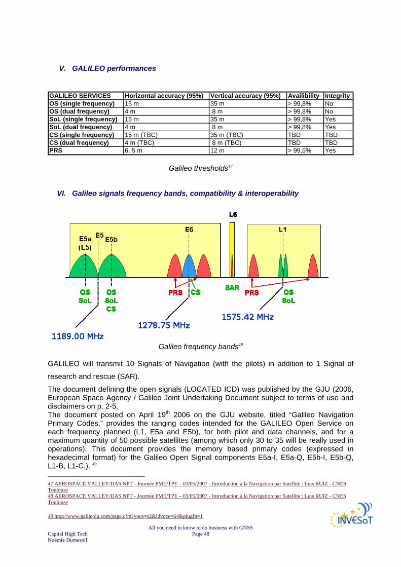
V. GALILEO performances GALILEO SERVICES Horizontal accuracy (95%) Vertical accuracy (95%) Availibility IntegrityOS (single frequency) 15 m 35 m > 99,8% NoOS (dual frequency) 4 m 8 m > 99,8% NoSoL (single frequency) 15 m 35 m > 99,8% YesSoL (dual frequency) 4 m 8 m > 99,8% YesCS (single frequency) 15 m (TBC) 35 m (TBC) TBD TBDCS (dual frequency) 4 m (TBC) 8 m (TBC) TBD TBDPRS 6, 5 m 12 m > 99,5% Yes
Galileo thresholds47
VI. Galileo signals frequency bands, compatibility & interoperability
Galileo frequency bands48
GALILEO will transmit 10 Signals of Navigation (with the pilots) in addition to 1 Signal of
research and rescue (SAR).
The document defining the open signals (LOCATED ICD) was published by the GJU (2006, European Space Agency / Galileo Joint Undertaking Document subject to terms of use and disclaimers on p. 2-5. The document posted on April 19th 2006 on the GJU website, titled “Galileo Navigation Primary Codes,” provides the ranging codes intended for the GALILEO Open Service on each frequency planned (L1, E5a and E5b), for both pilot and data channels, and for a maximum quantity of 50 possible satellites (among which only 30 to 35 will be really used in operations). This document provides the memory based primary codes (expressed in hexadecimal format) for the Galileo Open Signal components E5a-I, E5a-Q, E5b-I, E5b-Q, L1-B, L1-C.). 49 47 AEROSPACE VALLEY/DAS NPT - Journée PME/TPE – 03/05/2007 - Introduction à la Navigation par Satellite : Luis RUIZ - CNES Toulouse 48 AEROSPACE VALLEY/DAS NPT - Journée PME/TPE – 03/05/2007 - Introduction à la Navigation par Satellite : Luis RUIZ - CNES Toulouse 49 http://www.galileoju.com/page.cfm?voce=s2&idvoce=64&plugIn=1
All you need to know to do business with GNSS Capital High Tech Page 49 Noémie Dumesnil
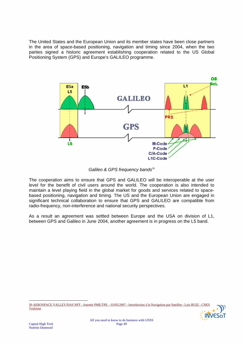
The United States and the European Union and its member states have been close partners in the area of space-based positioning, navigation and timing since 2004, when the two parties signed a historic agreement establishing cooperation related to the US Global Positioning System (GPS) and Europe's GALILEO programme.
Galileo & GPS frequency bands50 The cooperation aims to ensure that GPS and GALILEO will be interoperable at the user level for the benefit of civil users around the world. The cooperation is also intended to maintain a level playing field in the global market for goods and services related to space-based positioning, navigation and timing. The US and the European Union are engaged in significant technical collaboration to ensure that GPS and GALILEO are compatible from radio-frequency, non-interference and national security perspectives. As a result an agreement was settled between Europe and the USA on division of L1, between GPS and Galileo in June 2004, another agreement is in progress on the L5 band.
50 AEROSPACE VALLEY/DAS NPT - Journée PME/TPE – 03/05/2007 - Introduction à la Navigation par Satellite : Luis RUIZ - CNES Toulouse
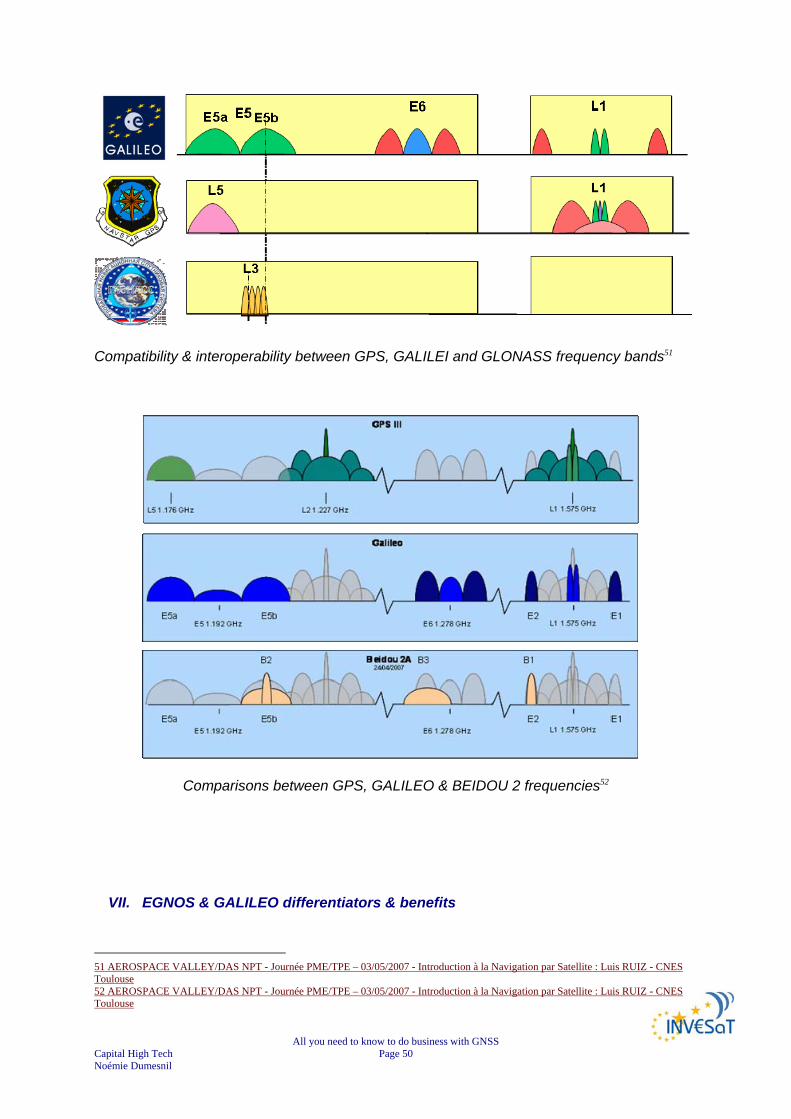
All you need to know to do business with GNSS Capital High Tech Page 50 Noémie Dumesnil
Compatibility & interoperability between GPS, GALILEI and GLONASS frequency bands51
Comparisons between GPS, GALILEO & BEIDOU 2 frequencies52
VII. EGNOS & GALILEO differentiators & benefits
51 AEROSPACE VALLEY/DAS NPT - Journée PME/TPE – 03/05/2007 - Introduction à la Navigation par Satellite : Luis RUIZ - CNES Toulouse 52 AEROSPACE VALLEY/DAS NPT - Journée PME/TPE – 03/05/2007 - Introduction à la Navigation par Satellite : Luis RUIZ - CNES Toulouse
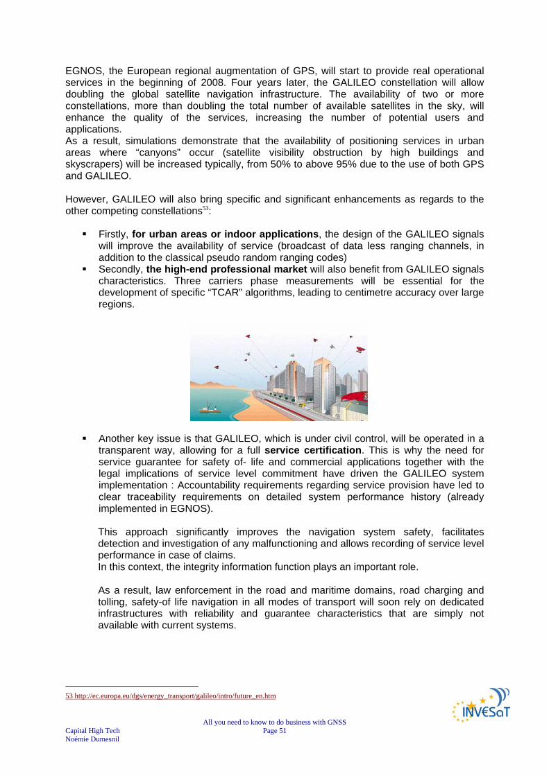
All you need to know to do business with GNSS Capital High Tech Page 51 Noémie Dumesnil
EGNOS, the European regional augmentation of GPS, will start to provide real operational services in the beginning of 2008. Four years later, the GALILEO constellation will allow doubling the global satellite navigation infrastructure. The availability of two or more constellations, more than doubling the total number of available satellites in the sky, will enhance the quality of the services, increasing the number of potential users and applications. As a result, simulations demonstrate that the availability of positioning services in urban areas where “canyons” occur (satellite visibility obstruction by high buildings and skyscrapers) will be increased typically, from 50% to above 95% due to the use of both GPS and GALILEO. However, GALILEO will also bring specific and significant enhancements as regards to the other competing constellations53:
Firstly, for urban areas or indoor applications, the design of the GALILEO signals will improve the availability of service (broadcast of data less ranging channels, in addition to the classical pseudo random ranging codes)
Secondly, the high-end professional market will also benefit from GALILEO signals characteristics. Three carriers phase measurements will be essential for the development of specific “TCAR” algorithms, leading to centimetre accuracy over large regions.
Another key issue is that GALILEO, which is under civil control, will be operated in a transparent way, allowing for a full service certification. This is why the need for service guarantee for safety of- life and commercial applications together with the legal implications of service level commitment have driven the GALILEO system implementation : Accountability requirements regarding service provision have led to clear traceability requirements on detailed system performance history (already implemented in EGNOS). This approach significantly improves the navigation system safety, facilitates detection and investigation of any malfunctioning and allows recording of service level performance in case of claims. In this context, the integrity information function plays an important role. As a result, law enforcement in the road and maritime domains, road charging and tolling, safety-of life navigation in all modes of transport will soon rely on dedicated infrastructures with reliability and guarantee characteristics that are simply not available with current systems.
53 http://ec.europa.eu/dgs/energy_transport/galileo/intro/future_en.htm

All you need to know to do business with GNSS Capital High Tech Page 52 Noémie Dumesnil
VIII. GALILEO possible pricing methodologies It is expected that each GALILEO application will yield a revenue stream, which will contribute in some way towards the full European GNSS cost recovery. The specific cost recovery principle to be applied will to some extent be determined by what the users are willing to pay for the application and the associated offering. It is important therefore to identify the potential user communities and revenue stream for each application, e.g. by using demand estimation techniques or using previous studies done on the market. The number of users in each community establishes once this for each application this could be multiplied. This will provide some insights into how many specific users communities are willing to pay for the service offering emanating from an application and indirectly indicate the users who are willing to pay higher amounts. This analysis will then reveal exactly what types of cost recovery mechanisms to apply (full or partial). Factors that will also influence the economic methods and that should be considered as potential parameters or variables in any formulae (which may also be extremely complicated to quantify) are related to the international aspects of a global service. In other words what should one charge a national airline, whose own country has its own GNSS system (and whose aircraft has flown from Europe) for landing or flying over its own country? Issues such as these needs to be considered and any formulae need to allow for some ‘quantification’ if and where appropriate. It is proposed that a separate list of these types of issues and risks be maintained so that they can be considered and applied as deemed appropriate.54
54PROGENY – GALILEO JOINT UNDERTAKING Document repository WP 3000 D-3000-1-Methodology-Study-Report-v1[1].00
All you need to know to do business with GNSS Capital High Tech Page 53 Noémie Dumesnil
CHAPTER 4
GNSS GLOBAL MARKET PICTURE In the following chapter, we are focusing on the user segment: products & services (cf. value chain). Satellite construction, space and ground segment are not discussed. Markets of applications will be discussed in a dedicated chapter. Note: the GNSS market being a fast evolving market, many studies and information are available. We will try to provide you with a global picture of the market using different sources.
I. The perimeter of the Satellite Navigation market The user segment is the part of the whole GNSS that includes the receivers, allowing the translation of the satellite signals into services for end-users, thanks to the integration of technologies (components, antennas, receivers, systems, platforms) in a product, combined with services (information content, communications providers and services providers to end-users). The overall market can be defined as the set of suppliers and demanders of satellite-based positioning, navigation and time applications.
II. Global market revenues According to the PRODDAGE Study/GJU 6thFP 2006, the overall GNSS turnover (products & services) is around € 58 billion in 2005 and is forecasted to reach € 450 billion in 202555.
1) Breakdown products and services According to the PRODDAGE Study/GJU 6thFP 2006, revenues are expected by both products and services.
55 Presentations EURISY CONFERENCE GALILEO Services: Chances for Business. 24/25 April 2006 - PRAGUE, Czech Republic Nina Costa, ESYS, UK The GNSS market from the financial perspective
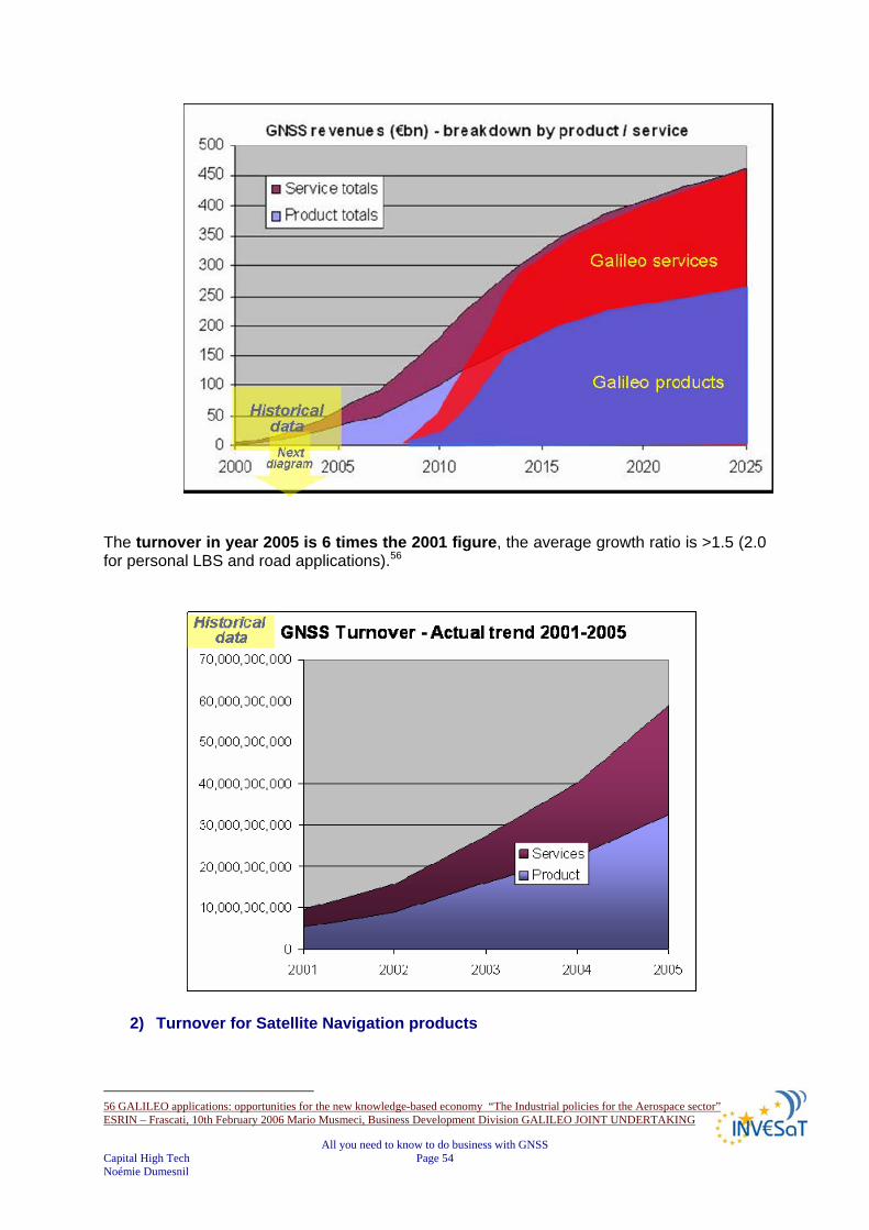
All you need to know to do business with GNSS Capital High Tech Page 54 Noémie Dumesnil
The turnover in year 2005 is 6 times the 2001 figure, the average growth ratio is >1.5 (2.0 for personal LBS and road applications).56
2) Turnover for Satellite Navigation products
56 GALILEO applications: opportunities for the new knowledge-based economy “The Industrial policies for the Aerospace sector” ESRIN – Frascati, 10th February 2006 Mario Musmeci, Business Development Division GALILEO JOINT UNDERTAKING
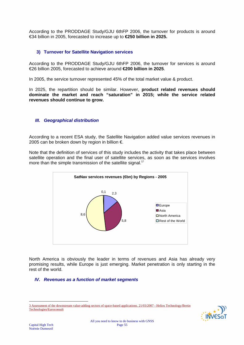
All you need to know to do business with GNSS Capital High Tech Page 55 Noémie Dumesnil
According to the PRODDAGE Study/GJU 6thFP 2006, the turnover for products is around €34 billion in 2005, forecasted to increase up to €250 billion in 2025.
3) Turnover for Satellite Navigation services According to the PRODDAGE Study/GJU 6thFP 2006, the turnover for services is around €26 billion 2005, forecasted to achieve around €200 billion in 2025. In 2005, the service turnover represented 45% of the total market value & product. In 2025, the repartition should be similar. However, product related revenues should dominate the market and reach “saturation” in 2015; while the service related revenues should continue to grow.
III. Geographical distribution
According to a recent ESA study, the Satellite Navigation added value services revenues in 2005 can be broken down by region in billion €. Note that the definition of services of this study includes the activity that takes place between satellite operation and the final user of satellite services, as soon as the services involves more than the simple transmission of the satellite signal.57
SatNav services revenues (€bn) by Regions - 2005
2,3
5,8
8,6
0,1
EuropeAsiaNorth AmericaRest of the World
North America is obviously the leader in terms of revenues and Asia has already very promising results, while Europe is just emerging. Market penetration is only starting in the rest of the world.
IV. Revenues as a function of market segments
3 Assessment of the downstream value-adding sectors of space-based applications. 21/03/2007 - Helios Technology/Bertin Technologies/Euroconsult

All you need to know to do business with GNSS Capital High Tech Page 56 Noémie Dumesnil
The market of Satellite Navigation can be assessed as a function of the main market segments, and their related applications.
In the following figures, we will highlight the relative weight of each market segment in terms of revenues: As mentioned before by 2025, the GNSS product and service revenues will amount 450 billion Euros.
Personal mobility/LBS will take over the market with revenue of €30 bn in 2005, equal to 50% of the market, and growing up to €200 bn – 45% of the total market - in 2025. However, after 2015, revenues will start to stagnate, while other applications will keep increasing.
Mass market vehicles is the second most profitable segment with a total
revenues of €20 bn in 2005 – around 35% of the total market – increasing up to €190bn in 2025.
As a result, in 2025, 98% of GNSS receivers will be in road
vehicles and mobile phones.
Commercial vehicles and Emergency services are respectively in the third and fourth position dominating the €60 bn market uncovered by LBS and mass-market vehicles.
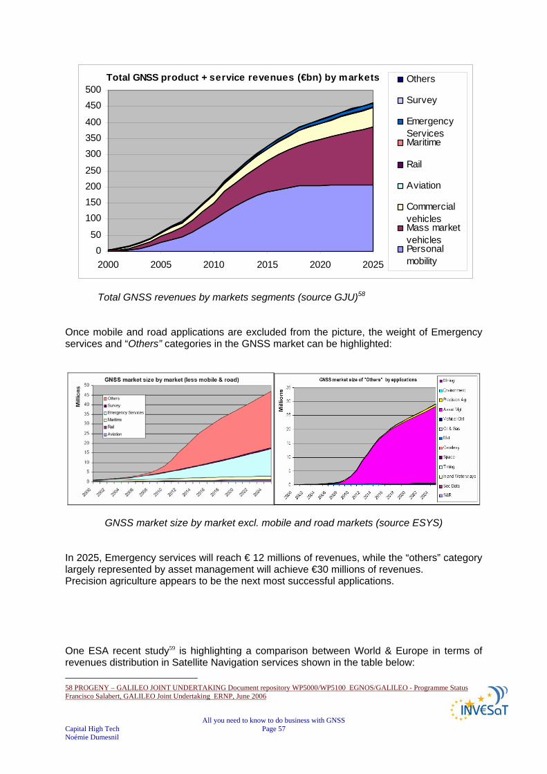
All you need to know to do business with GNSS Capital High Tech Page 57 Noémie Dumesnil
Total GNSS revenues by markets segments (source GJU)58
Once mobile and road applications are excluded from the picture, the weight of Emergency services and “Others” categories in the GNSS market can be highlighted:
GNSS market size by market excl. mobile and road markets (source ESYS) In 2025, Emergency services will reach € 12 millions of revenues, while the “others” category largely represented by asset management will achieve €30 millions of revenues. Precision agriculture appears to be the next most successful applications. One ESA recent study59 is highlighting a comparison between World & Europe in terms of revenues distribution in Satellite Navigation services shown in the table below: 58 PROGENY – GALILEO JOINT UNDERTAKING Document repository WP5000/WP5100 EGNOS/GALILEO - Programme Status Francisco Salabert, GALILEO Joint Undertaking ERNP, June 2006
Total GNSS product + service revenues (€bn) by markets
050
100150200250
300350400
450500
2000 2005 2010 2015 2020 2025
Others
Survey
EmergencyServicesMaritime
Rail
Aviation
CommercialvehiclesMass marketvehiclesPersonalmobility
All you need to know to do business with GNSS Capital High Tech Page 58 Noémie Dumesnil
WORLD EUROPE
€ 17.3bn revenues, including €8bn in road sector
€2.3bn revenues, including €1.3 in the road sector
It appears that services revenues are spread across several major segments on a worldwide scale, but Europe has a narrower focus.
V. Number of Users Market forecast indicates 2.5 billion GALILEO Users by 2020 and 3.1 billion in 2025, i.e. an increase of +24% in 5 years. Mass-market use will dominate GALILEO user community: for the 2020, about 90% of the users will be related to mobile phone integrated with GNSS receiver and Vehicle Telematics.60 A joint GALILEO / GPS receiver will become the default by 2012 for mass-market use61. The ESA recent study62 has compared the users’ type in Europe and worldwide:
WORLD EUROPE Satellite Navigation primarily delivers to private customers: often more sensitive to price (not always) and often demand operational benefits
B-to-C: worldwide B-C account for 55% of revenue, but in Europe it is only 35%
“national interest” segments have a greater presence of public customers
Consumer service market based outside Europe
Mature B-B segments are now less significant as B-C has grown to €36bn
At segment level, Europe is comparable to the world for B-B and B-C sales.
B-to-C customers’ type is larger worldwide than in Europe, where B-to-B is dominating. Meanwhile Europe is meeting a continued growth with the emergence of mass-market B-C segments.
VI. Conclusion
59 Assessment of the downstream value-adding sectors of space-based applications. 21/03/2007 - Helios Technology/Bertin Technologies/Euroconsult 60 PROGENY – GALILEO JOINT UNDERTAKING Document repository WP5000/WP5100GALILEO applications: opportunities for the new knowledge-based economy “The Industrial policies for the Aerospace sector” ESRIN – Frascati, 10th February 2006 Mario Musmeci, Business Development Division GALILEO JOINT UNDERTAKING 61 PROGENY – GALILEO JOINT UNDERTAKING Document repository WP5000/WP5100GALILEO applications: opportunities for the new knowledge-based economy “The Industrial policies for the Aerospace sector” ESRIN – Frascati, 10th February 2006 Mario Musmeci, Business Development Division GALILEO JOINT UNDERTAKING 62 Assessment of the downstream value-adding sectors of space-based applications. 21/03/2007 - Helios Technology/Bertin Technologies/Euroconsult
All you need to know to do business with GNSS Capital High Tech Page 59 Noémie Dumesnil
The annual global market growth rate for satellite navigation products and services has been quite substantial over the 1999 - 2003, with an average annual increase of 25%. In the difficult economic situation of the recent years, very few other markets have shown such a positive trend. The turnover in year 2005 is 6 times the 2001 figure, the average growth ratio is >1.5 (2.0 for personal LBS and road applications)63, while the forecasted revenues in 2025 is almost 8 times the 2005 figure. Market growth should accelerate by 2007: regulation & technology maturity will allow massive penetration of LBS. Yet, it is important to note that the service part of the turnover will be higher than the ‘product’ counterpart, which will reach saturation around 2015. As the number of users increases in mass-market car and hand-held segments, competition and economies of scale for suppliers will instigate lower selling prices while maturing service offerings and network effects; the combination of all these factors will increase the relative value of the service market. The GNSS market should then become a market of services. The largest markets in terms of numbers of receivers and revenues by 2025 will be those of mobile phones and road transport. Commercial and regulatory factors are driving the mobile phone market, while the road transport market will be driven by telematics product evolution. These markets will then be followed by the surge of emergency services, maritime market, asset management and precision agriculture. The uptake of GNSS services in safety critical applications in major transport sectors will be slower, aviation leading the way. KEY FINDINGS
GNSS turnover (products & services) : € 58 billion in 2005 & € 450 billion in 2025 Turnover for products: €34 billion in 2005 & €250 billion in 2025 Turnover for services: €26 billion 2005 & €200 billion in 2025. Product revenues dominate until 2015 & reach “saturation” while service revenues grow Joint GALILEO / GPS receiver: for mass-market use by 2012.
North America leader in terms of revenues, Asia very promising results Personal mobility/LBS take over the market: €200 bn in 2025 Mass market vehicles is second most profitable segment: €190bn in 2025 European services revenues focus on some segments 2.5 billion GALILEO Users by 2020 dominated by mass market: 90% of the users related to mobile phone integrated with GNSS receiver and Vehicle Telematics.
B-to-B customers’ type dominates in Europe, but emergence of mass-market B-C segments. GNSS market should become a market of services
VII. Remarks
63 PROGENY – GALILEO JOINT UNDERTAKING Document repository WP5000/WP5100GALILEO applications: opportunities for the new knowledge-based economy “The Industrial policies for the Aerospace sector” ESRIN – Frascati, 10th February 2006 Mario Musmeci, Business Development Division GALILEO JOINT UNDERTAKING

All you need to know to do business with GNSS Capital High Tech Page 60 Noémie Dumesnil
According to the studies64 performed by FUGRO NV, the market studies used to substantiate the commercial case in support of GALILEO are flawed for some or all of the following reasons:
Revenue estimates assume that GPS will not evolve. Estimates overlook the fact that in about 5 years from now, the stand-alone accuracy
achievable with commercial GNSS receivers, (which combine GPS, Glonass and GALILEO Open Access), will be better than 1m level (95%) and meet most mass-market needs.
Civil aviation has made it clear that they should not be expected to pay for a “Safety of Life” service
Estimates of potential service revenues conveniently overlook the activities of commercial GNSS augmentation companies.
While a royalty fee on GALILEO chip-sets may be feasible, it would totally undermine efforts to catch-up with GPS in terms of market position and customer acceptance
64 GNSS Services: Separating the Business Opportunities from the hype. Owen GoodmanFugro N.V.Eurisy ConferencePragueApril 2006

All you need to know to do business with GNSS Capital High Tech Page 61 Noémie Dumesnil
CHAPTER 5
GNSS APPLICATIONS ZOOM ON LOCATION BASED SERVICES
In this section, The Location Based Services (LBS) are presented with an insight into the present markets, the possibilities for development and, the new markets opened by GALILEO.
I. Perimeter of LBS market NOTE: The LBS market is covering a wide spectrum of applications, which are currently segmented into four categories:
Information and navigation services: provide data directly to end- users, in particular destination location and criteria for journey optimisation.
Emergency assistance services: provide the location of mobile users in case of distress and need for assistance.
Tracking services: provide location data. Network related services: knowledge of user position improves
communication services. This chapter deals with the LBS market for mobile phone users. Similar LBS services provided for car and truck drivers are covered by the telematics market in the road applications chapter.
II. Background of LBS: Location of mobile telephones
Knowing your position can be sometimes useless if it cannot be communicated. Telecommunication is indispensable for most of satellite-navigation applications. Reciprocally, satellite navigation techniques will become indispensable for the telecommunication community, to increase the level of communications and the efficiency of their networks. The integration of GALILEO receivers with mobile phones will generate a multitude of combined uses in positioning, direction finding, real-time traffic information and many others. The need to locate callers has two main drivers:
emergency calls (E-112 in Europe, E-911 in US); new services based on the location.
The first arises through new legislation in several countries aiming to offer efficient emergency services to their citizens by precise and fast response to distress calls. In Europe alone, there are about 180 million distress calls every year, 6 million are not adequately responded because of missing or incomplete information about the caller’s location. The second is more commercial and points to increasing traffic in the coming years.
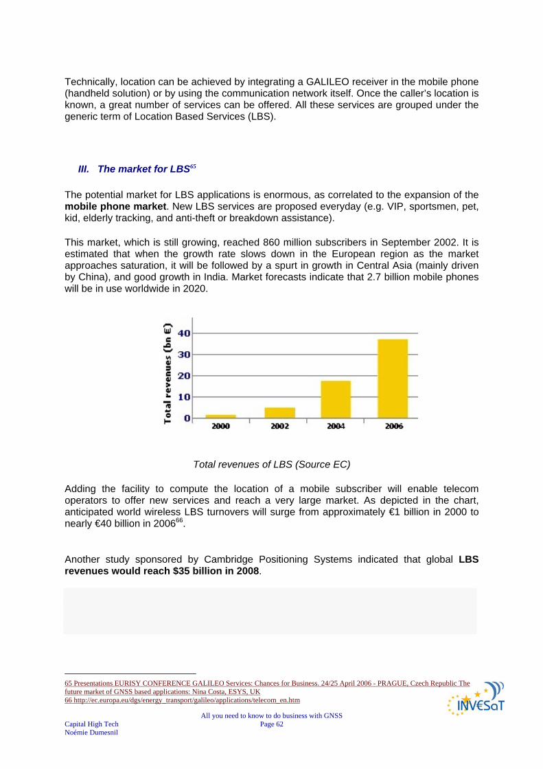
All you need to know to do business with GNSS Capital High Tech Page 62 Noémie Dumesnil
Technically, location can be achieved by integrating a GALILEO receiver in the mobile phone (handheld solution) or by using the communication network itself. Once the caller’s location is known, a great number of services can be offered. All these services are grouped under the generic term of Location Based Services (LBS).
III. The market for LBS65
The potential market for LBS applications is enormous, as correlated to the expansion of the mobile phone market. New LBS services are proposed everyday (e.g. VIP, sportsmen, pet, kid, elderly tracking, and anti-theft or breakdown assistance).
This market, which is still growing, reached 860 million subscribers in September 2002. It is estimated that when the growth rate slows down in the European region as the market approaches saturation, it will be followed by a spurt in growth in Central Asia (mainly driven by China), and good growth in India. Market forecasts indicate that 2.7 billion mobile phones will be in use worldwide in 2020.
Total revenues of LBS (Source EC)
Adding the facility to compute the location of a mobile subscriber will enable telecom operators to offer new services and reach a very large market. As depicted in the chart, anticipated world wireless LBS turnovers will surge from approximately €1 billion in 2000 to nearly €40 billion in 200666.
Another study sponsored by Cambridge Positioning Systems indicated that global LBS revenues would reach $35 billion in 2008.
65 Presentations EURISY CONFERENCE GALILEO Services: Chances for Business. 24/25 April 2006 - PRAGUE, Czech Republic The future market of GNSS based applications: Nina Costa, ESYS, UK 66 http://ec.europa.eu/dgs/energy_transport/galileo/applications/telecom_en.htm

All you need to know to do business with GNSS Capital High Tech Page 63 Noémie Dumesnil
GNSS Enabled mobile phones forecasts per region (source ESYS)
The LBS market forecast is approaching 1,800 million GNSS-enabled phones by 2025. Europe should reach more than 200 millions of GNSS enabled phones by 2025.
1) Worldwide
The service market is valued at around €3.8bn in 2005 based in US and Asia and forecasted to grow in service revenues to over €13bn by 2015 worldwide. In the US and Japan, after a slow start, the market will be fostered and driven by personal safety E911 legislation. Location-based services are booming in the U.S., largely thanks to the FCC's E-911 legislation, that required location information to be included in emergency calls made from mobile phones. By deploying high-accuracy location technologies, the mobile industry in the U.S. has developed an LBS market that is expected to reach revenues of more than $2.1 billion in 2007, according to ABI Research. North America has seen strong business use for several years, and should see significant consumer uptake in 2007 and beyond. In 2011, the total population of GPS-enabled location-based services (LBS) subscribers will reach 315 million, up from 12 million in 2006, according to a new study from ABI Research. Regions of greatest growth will be North America and Western Europe. The Asia-Pacific region will have strong growth as well, but it will vary by market. Leaders South Korea and Japan will continue to be engines of LBS growth. In the future, LBS solutions are likely to converge with telematics, public safety and consumer sector applications, but today mobile network operators still dominate the supply chain and applications in use.
All you need to know to do business with GNSS Capital High Tech Page 64 Noémie Dumesnil
2) In Europe In Europe, first LBS appeared at the end of the 90s, but the market is still not mature. Operators are looking to other services to boost average revenue per user. In fact, the relationship with mobile network operators and emergence of application providers is critical and there is a limited take-up in 3G markets so far. Market growth in Western Europe has been limited by the fact that very few handsets have GPS, but ABI Research expects that beginning in 2007 and increasing in 2008, many more 3G phones will contain GPS chipsets, allowing operators to offer LBS. GPS services will drive the adoption of UMTS 3G handsets, 3G growth has been limited by customers’ low uptake of many 3G services, making it uneconomical for operators to subsidise these handsets heavily. GPS-enabled LBS is expected to lead subscribers to use more 3G data services, and thereby to drive overall 3G handset sales.67 The European market lags behind the U.S. on LBS because it lacks a guaranteed customer base, but does not lack the demand. Without government mandates in Europe, operators and LBS providers need to create the link between demand and delivery. The LBS market forecast in Western Europe is nearly $330 million in 2007 and barely scratched the surface of its potential. ABI Research predicts growth of almost 500% (CAGR) in western European GPS-enabled LBS application revenue from 2007 to 2011, and forecasts that by 2011 there will be over 300 million GPS-enabled LBS subscribers; in 2005 there were just 4.3 million. Location is a logical extension to existing mobile services, and can drive the uptake of new services to deliver enhanced value to subscribers.68
KEY FINDINGS
Huge potential market for LBS applications correlated to the expansion of the mobile phone (3G) market
Western European LBS market emerging: services revenues forecast to €330 million in 2007
China leader country for subscribers followed by the USA; US and Japan market driven by personal safety E911 legislation.
Mobile network operators dominate the supply chain and applications in use
CHAPTER 6
GNSS APPLICATIONS ZOOM ON ROAD APPLICATIONS
67 http://www.3g.co.uk/PR/Sept2006/3701.htm 68 http://www.totaltele.com/View.aspx?ID=91162&t=4

All you need to know to do business with GNSS Capital High Tech Page 65 Noémie Dumesnil
In this section, road applications that have shown very promising developments are presented with an insight into the current markets, the possibilities for development and, the new markets opened by GALILEO.
I. Perimeter of road market segment The road sector is a major potential market for GNSS applications. Satellite navigation receivers are now commonly installed in cars as a key tool for providing new services to people on the move such as:
route guidance, advanced driving assistance systems. real time traffic information, road user charging, emergency calls, fleet management
LBS provided for car and truck drivers are covered by the telematics market in this chapter. The LBS market for mobile phone users is discussed in the LBS chapter.
II. Market segment forecasts69 By 2010, there will be more than 660 million cars, 29 million buses, trucks, and 214 million light commercial vehicles worldwide. However only half of this market potential will be exploited 10 years later. The market is far from being saturated. In 2020, there will be over 330 million cars with GNSS-based navigation systems onboard and 400 million in 2025. Up to now, speed of innovation in consumer product has led to faster market growth than was anticipated. One reason for this is that improvements in digital maps have increased usability. The market should keep growing, triggered by possibility multiple regulations from 2010 onwards. It is expected that in-car navigation systems will be “dual mode”, i.e. based on GALILEO and GPS.
69 Presentations from EURISY CONFERENCE GALILEO Services : Chances for Business. 24/25 April 2006 - PRAGUE, Czech Republic The current drivers, market and players of GNSS based applications : Pascal Campagne, France Développement Conseil (FDC)

All you need to know to do business with GNSS Capital High Tech Page 66 Noémie Dumesnil
Number of GNSS equipped cars by regions (source ESYS) The three biggest markets are North America, the Pacific Rim and Europe. The average price will tend to stabilise around a minimum value as in the computer industry, in this case around € 500 (with a constant increase in the functionality and improvements in man-machine interfaces, etc.) With these assumptions, the total annual gross turnover of the road applications market will reach 25 billion Euros in 2016. Today the standalone GPS solution is certainly getting the preference of users, for instance, automobiles consumers are expressing a preference for standalones over integrated units, because of a great price difference between the two technologies and the feature set offered in standalone devices is actually superior to that of many built-in solutions. The gap between the two technologies should close in the future (5 years time), but actual take-up rate, 90% of new cars today are still coming out without navigation. At the same time, the PND business is actually exploding and has a tremendously bright future in front of it.70 In this respect, the integration of the value chain is increasing in Europe and worldwide to offer the best products and services. For example, MapShare is a technology that TomTom is introducing in collaboration with Tele Atlas that allows users to dynamically change map attributes directly on their device. All stakeholders are looking for the best alliances to optimise their offer. From an industrial point of view, Japan currently leads the road applications industry, even though European has strong capabilities in this segment, but few are international players (TeleAtlas,TomTom). Nevertheless, there are new add-on services suppliers emerging in Europe (traffic master). Auto manufacturers looking for market revenues continue to push branded services (Security in the US, Navigation in the Far East, and Congestion in Europe).
70 The Engadget Interview: Jocelyn Vigreux, President of TomTom USA Posted Jul 2nd 2007 12:57PM by Peter Rojas Filed under: Features, GPS, Interviews : http://www.engadget.com/2007/07/02/the-engadget-interview-jocelyn-vigreux-president-of-tomtom-usa/
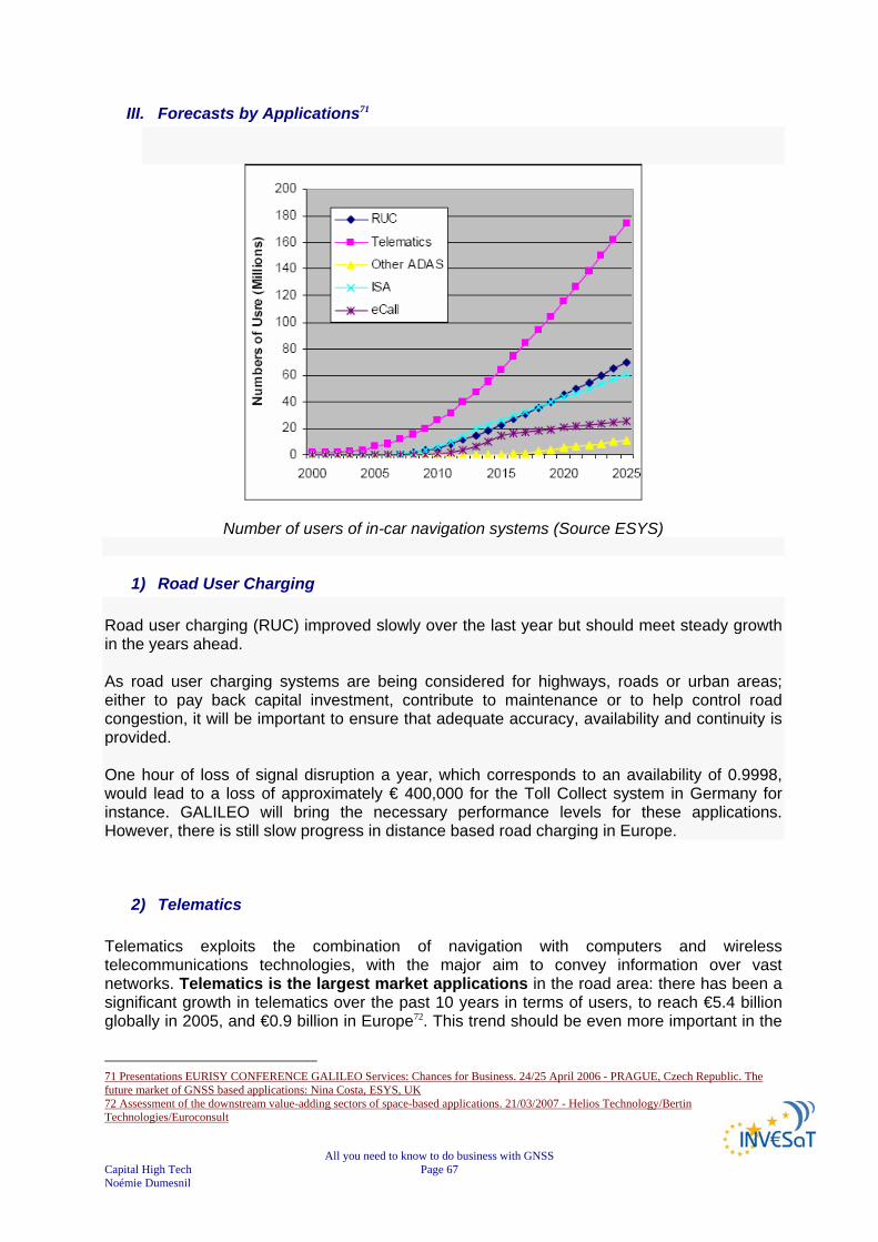
All you need to know to do business with GNSS Capital High Tech Page 67 Noémie Dumesnil
III. Forecasts by Applications71
Number of users of in-car navigation systems (Source ESYS)
1) Road User Charging Road user charging (RUC) improved slowly over the last year but should meet steady growth in the years ahead. As road user charging systems are being considered for highways, roads or urban areas; either to pay back capital investment, contribute to maintenance or to help control road congestion, it will be important to ensure that adequate accuracy, availability and continuity is provided. One hour of loss of signal disruption a year, which corresponds to an availability of 0.9998, would lead to a loss of approximately € 400,000 for the Toll Collect system in Germany for instance. GALILEO will bring the necessary performance levels for these applications. However, there is still slow progress in distance based road charging in Europe.
2) Telematics Telematics exploits the combination of navigation with computers and wireless telecommunications technologies, with the major aim to convey information over vast networks. Telematics is the largest market applications in the road area: there has been a significant growth in telematics over the past 10 years in terms of users, to reach €5.4 billion globally in 2005, and €0.9 billion in Europe72. This trend should be even more important in the
71 Presentations EURISY CONFERENCE GALILEO Services: Chances for Business. 24/25 April 2006 - PRAGUE, Czech Republic. The future market of GNSS based applications: Nina Costa, ESYS, UK 72 Assessment of the downstream value-adding sectors of space-based applications. 21/03/2007 - Helios Technology/Bertin Technologies/Euroconsult

All you need to know to do business with GNSS Capital High Tech Page 68 Noémie Dumesnil
coming years, reaching 180 millions users by 2025. Telematics is now considered as a mass market.
3) eCall In the USA, by combining satellite navigation tracking and wireless communications, the new telematics systems will offer automatic post-collision notification integrated into the current E-911 emergency networks. In the event of collision, onboard systems will immediately transmit alerts along with details such as location, magnitude and number of passengers involved to emergency response centres operated by Cross Country Automotive Services. eCall is promoted by industry & government group as “Automotive E-911” and contributing to the application development. Without the “big bang” regulation, the market driven applications will dominate. eCall application is strongly depending on regulatory decisions and will take off in between 2010 – 2015 and gradually increased up to 25 millions users by 2025.
4) Advanced Driver Assistance Systems & Intelligent Speed Assistant From 2015, it is likely that GALILEO signals aided by a network of continuous monitoring stations will provide vehicle accuracies of well under 1 meter. It could be used in combination with other sensors in Advanced Driver Assistance Systems (ADAS), for example, to help vehicles navigate along the highway lanes automatically. ADAS remains in the technology phase and will slowly progress starting from 2015; while Intelligent Speed Assistant (ISA included in ADAS) should meet a faster growth than other ADAS in the years ahead. Intelligent Speed Assistant is the first “ADAS” application for GNSS and is currently in trials in several countries. KEY FINDINGS
Major potential market In 2020: 330 million cars with navigation systems onboard and 400 million in 2025 Total annual turnover: 25 billion Euros in 2016 Biggest markets: North America, the Pacific Rim and Europe Consumer preferences for PDA and stand alone products Japan leader of the industry European capabilities, but few international players (Tele Atlas, TomTom) Integration of the supply chain increasing in Europe and worldwide Telematics is now mass market: 180 millions users by 2025 ADAS in technology phase eCall application depending on regulatory decisions: 25 millions users by 2025

All you need to know to do business with GNSS Capital High Tech Page 69 Noémie Dumesnil
CHAPTER 7
OTHER GNSS APPLICATIONS In this section, applications that have shown very promising developments are presented with an insight into the current markets, the possibilities for development and, the new markets opened by GALILEO. The Location Based Services (LBS) market and road applications, with their enormous potential, are further detailed in other dedicated chapters. Four important transport domains (road, aviation, maritime and rail) are presented in this chapter.73&74 Thanks to the improvements in exploitation techniques made achievable by satellite navigation technologies, other specific applications such as oil and gas, electricity networks and precision farming are addressed as well. Finally, a new category of applications is emerging in the professional market thanks to GALILEO differentiators, called Liability Critical applications75. These applications require regulations, authentication, service guarantee, type approval, transparency, audit ability:
Road tolling and charging (city access) Insurance “pay per use” Vehicles rentals Car sharing Surveys for public interest (cadastre, agriculture parcels, energy distribution
networks, environment protection) Time-stamping for e-commerce transactions Dangerous goods and high valuable goods transportation Support to Customs Traceability and quality of food (Protected Geographical Indication, cold chain) Tracking and tracing for regulated activities Others
I. Transport
73 INVESAT WIKIPEDIA TOOL http://www.dappolonia-research.com/invesatwiki/index.php/Main_Page 74 Presentations from EURISY CONFERENCE GALILEO Services: Chances for Business. 24/25 April 2006 - PRAGUE, Czech Republic The future market of GNSS based applications: Nina Costa, ESYS, UK 3Telespazio France vision on Galileo applications June 2007 - N. Vincent Director Navigation – Telespazio France http://www.telematicsupdate.com/naveurope2007/presentations/NicolasVincent_Telespazio.pdf

All you need to know to do business with GNSS Capital High Tech Page 70 Noémie Dumesnil
1) Aviation Air traffic controllers need position, heading, speed and time information for the continuous management of all aircraft. Some areas of the world lack the appropriate ground infrastructure, including secondary radar and communication links. Standardised transmission of GALILEO navigation data will lead to advanced systems and techniques for safer air traffic monitoring. EGNOS and GALILEO will assist pilots in all flight phases, from movement on the ground to take-off, en-route flying and landing in all weather conditions, reaching the level of safety that will be required to cope with the continuous increase in the number of flights. GALILEO, with the aid of ground-based local elements, will satisfy the needs for precision approach as defined in the aeronautical standards. Moreover, higher navigation accuracy and service integrity are required to allow for aircraft separation reduction, and thus for the increase in traffic capacity. Generally speaking, GALILEO will improve all operations safety. Indeed, all aviation-related operations, such as airport surface movement and guidance control, also require precise assistance from air traffic controllers. Airports may have surface radar, but sometimes pilots report taxi movements manually and aircraft are managed using visual aids only. This has lead to severe accidents. For the time being, satellite positioning and timing services are mainly used to provide supplementary information in many flight phases: this is particularly the case for the general and commercial aviation, which cannot make use of the sophisticated avionics of larger planes. In the European Union, nearly 15,000 civil aircraft (commercial aviation and general aviation) are currently registered with an additional 30,000 small private planes in use. In recent years, scheduled traffic has increased by about 4% per year worldwide, doubling the number of flights within 20 years.
GPS systems in commercial aviation by regions (source FDC)
The GPS systems market in commercial aviation slightly decreased in 2003 compared to 2002, from €10M to €8M, but improved again in 2004 up to €9M. Every region, also in North America, which is largely dominating the market, met this trend.

All you need to know to do business with GNSS Capital High Tech Page 71 Noémie Dumesnil
GPS systems in general aviation by regions (source FDC)
In parallel, the GPS equipments markets in general aviation in 2002-2004 constantly increased to reach up to €170M in 2004. The market is unquestionably led by North America, the other regions having started to progress only in 2004, with Europe achieving €20M, and Asia being last with €5M in 2004.
2) Maritime
Open sea and inland waterways are the most widely used mode for transporting goods worldwide. A wide variety of vessels moves around the world each day. The efficiency, safety and optimisation of marine transportation are key issues. Satellite navigation is becoming a fundamental tool for bringing innovation and progress to this sector and to many other marine activities such as fishing, oceanography and oil and gas exploitation, which will also benefit from the availability of GALILEO services. The increased accuracy and integrity, certified services and high signal availability brought by GALILEO will be used by leisure boats, commercial vessels and all ships falling under the Safety of Life At Sea (SOLAS) convention (safety of merchants ships) in every phase of marine navigation, i.e. ocean, coastal, port approach and harbour manoeuvres, and under all weather conditions. For marine navigation, regulated by the International Maritime Organisation, GALILEO will be an additional means of implementing the regulations on Automatic Identification Systems (AIS) and vessel traffic management systems to increase navigation safety and collision prevention. Many maritime commercial activities are starting to use satellite navigation:
In fishing, it helps locate traps and nets,

All you need to know to do business with GNSS Capital High Tech Page 72 Noémie Dumesnil
Within ports, a system for information services tailored to each ship’s location is being considered,
For inland waterways, accuracy and integrity of navigation data are essential to automate precise manoeuvres in narrow rivers and canals; Better navigation can be a major aid to increasing capacity in inland waterway networks, which in turn contributes to the modal shift targets EC transport policy. From Limerick to Kiev, Europe has nearly 100,000 km of navigable waterways.
Satellite navigation could be used for the automatic piloting of barges,
Satellite navigation has revolutionised hydrographical surveying. Most marine engineering activities benefit from satellite navigation, such as the dredging and maintenance of ports and waterways, mapping underwater obstacles during hydrographical surveys, pipe and cable laying, and mineral and aggregate extraction.
Ice-breaking ships in the Arctic have started to use satellite navigation to adjust their paths in the shipping lanes according to ice thickness.
Regulatory pressures for dangerous goods (potential) and eCall (when technically feasible, network operators must put emergency caller location information at the disposal of the Emergency services) are promoting the adoption of GALILEO.
Last, but not least, the use of GPS for marine fleet management corresponds to a mature segment in Europe and has demonstrated already strong operational benefits : Cargo monitoring, delivery and loading schedules optimised; Even the location of shipping containers can be facilitated.
GPS equipments market in commercial marine by regions (source FDC) The growth of the GPS commercial maritime markets was constant from 2002 to 2004, reaching up to €2.2M in 2004; Europe sales amounted for € 0.6M.
3) Rail With a network of 150,000 kilometres of lines, the general trend in the European railway is the standardisation process of the main subsystems involved in railway operations, in order to reach efficient interoperability. In particular, the European Rail Traffic Management System (ERTMS) is becoming the European standard for train control, signalling and traffic
All you need to know to do business with GNSS Capital High Tech Page 73 Noémie Dumesnil
management. Two layers of ERTMS can rely on satellite navigation: the European Train Control System (ETCS), which deals with train control and protection and the European Traffic Management Layer (ETML) dealing with non-safety of life related aspects such as traffic management and regulation. Current technologies used for the location of rail vehicles and trains in Europe are ground based solutions, with high equipment and maintenance costs. The use of satellite navigation would reduce costs, allowing cheaper train signalling and traffic management systems, whilst simultaneously increasing line capacity and efficiency. In the rail sector, other applications are also designed for proximity alarms, triggering reports when two trains on the same track are too close and velocity limit alarms to report that a train is exceeding the allowed speed for that section of the track. For track survey purposes, satellite navigation services are not only used for construction work where very precise differential techniques are used but also for video recorded track survey techniques, as done, for instance, in the UK. Applications that are more sophisticated are being designed. It is known that train tilting in curves improves passenger comfort. Up to now, the detection of curves is performed through a combination of accelerometers and other sensors. The use of satellite navigation services, along with track information (curve radius, location, etc.) is being studied and tested to improve performance of such systems.
II. Timing services & professional applications The timing service is synchronised with UTC when used with receivers in fixed locations. This timing service can be used for applications such as network synchronisation or scientific applications. Living in the information society implies the transmission of sensitive data daily, making security, data integrity, authenticity and confidentiality a major stake in the electronic exchange of documents. The protection of such information is mandatory; as a result, encryption and authentication techniques are constantly evolving. The latest technologies for electronic encryption rely on highly precise time references – at performance levels obtainable only from atomic clocks – so they are not affordable to mass-market users. The spread of the Galileo timing service, in addition to its certification and guarantee, will enable secure transmission via inexpensive terminals, thus bringing data security within the reach of us all. In this context, Galileo will play a key role and offer considerable benefits:
a common, validated time reference at low cost availability of advanced and simple security modules for low-cost encryption ease & secure transactions with easily authenticated electronic documents and data a secure tool for e-commerce applications satisfy demands from insurance companies and users reduce the risks in highly sensitive operations

All you need to know to do business with GNSS Capital High Tech Page 74 Noémie Dumesnil
1) Banking Galileo technology for encryption, electronic signature and time stamping will enable many applications for example in the financial sector. Indeed, one of the greatest concerns in e-commerce is the security of information provided by the customer in the purchasing process. In the same way, e-banking suffers from risks such as unauthorised access to documents, accounts and credit cards, and falsified transactions.76
2) Electricity networks Galileo timing services also have valuable applications in the energy sector. The very precise timing obtainable via Galileo will help to optimise the transfer of electricity along power lines. Galileo could also help in the maintenance of the electricity distribution infrastructure. A range of instruments spread around the system continuously monitors power grids. Information from these instruments is used to repair the system when a power line breaks or weaknesses appear in the grid. For their synchronisation, power distribution networks might use the very accurate timing functions of satellite navigation. Electronic mapping systems are also used to reduce power outage time by 20%. Galileo will improve the instruments’ time synchronisation to provide a speedier return to full service. The ‘trust ability’ and ‘traceability’ of the Galileo time stamp will facilitate the contractual and commercial agreements for the power distribution contract between public and private contractors. 77
III. Professional applications
1) Precision farming In agriculture, we can find a number of applications for GNSS systems among which, the applications related to precise farming and parcel measurement. Precision agriculture applications include:
the measurement of crop yield during harvesting, management of soil sampling and weeds, variable rate fertiliser spreading, auditing of fertilisers, insecticides and herbicides, autonomous farm machinery and, tracking of animal movements through the addition of short range tagging
technology.
76 http://ec.europa.eu/dgs/energy_transport/galileo/doc/galileo_app05.pdf 77 http://esamultimedia.esa.int/docs/galileo/GalileoE3web_copy.pdf
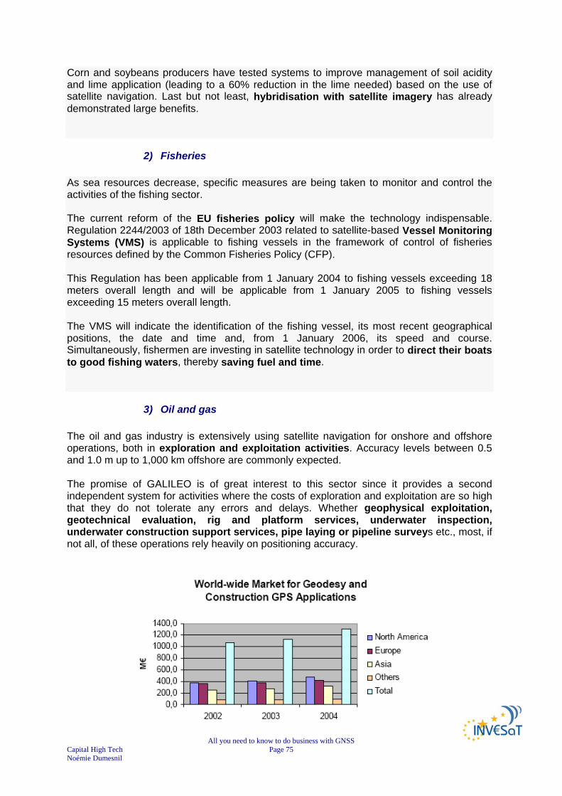
All you need to know to do business with GNSS Capital High Tech Page 75 Noémie Dumesnil
Corn and soybeans producers have tested systems to improve management of soil acidity and lime application (leading to a 60% reduction in the lime needed) based on the use of satellite navigation. Last but not least, hybridisation with satellite imagery has already demonstrated large benefits.
2) Fisheries As sea resources decrease, specific measures are being taken to monitor and control the activities of the fishing sector. The current reform of the EU fisheries policy will make the technology indispensable. Regulation 2244/2003 of 18th December 2003 related to satellite-based Vessel Monitoring Systems (VMS) is applicable to fishing vessels in the framework of control of fisheries resources defined by the Common Fisheries Policy (CFP). This Regulation has been applicable from 1 January 2004 to fishing vessels exceeding 18 meters overall length and will be applicable from 1 January 2005 to fishing vessels exceeding 15 meters overall length. The VMS will indicate the identification of the fishing vessel, its most recent geographical positions, the date and time and, from 1 January 2006, its speed and course. Simultaneously, fishermen are investing in satellite technology in order to direct their boats to good fishing waters, thereby saving fuel and time.
3) Oil and gas The oil and gas industry is extensively using satellite navigation for onshore and offshore operations, both in exploration and exploitation activities. Accuracy levels between 0.5 and 1.0 m up to 1,000 km offshore are commonly expected. The promise of GALILEO is of great interest to this sector since it provides a second independent system for activities where the costs of exploration and exploitation are so high that they do not tolerate any errors and delays. Whether geophysical exploitation, geotechnical evaluation, rig and platform services, underwater inspection, underwater construction support services, pipe laying or pipeline surveys etc., most, if not all, of these operations rely heavily on positioning accuracy.

All you need to know to do business with GNSS Capital High Tech Page 76 Noémie Dumesnil
Worldwide market for Geodesy and construction GPS applications by regions (Source FDC)
The worldwide market for geodesy and construction GPS applications steadily evolved from 2002 to 2004, reaching €1.3 bn in 2004; North America is leading the game (€ 500M) closely followed by Europe (€ 400M).
4) Science Satellite navigation technologies are providing tools for science and environmental studies such as the observation of tides and currents. The deployment of moving buoys which report their position, help scientists to generate information to merge with data from different sources (e.g. earth observation and remote sensing) in a comprehensive and integrated study of the oceans and seas. Animal movements are studied in many research centres; e.g. grizzly bear movements, habitat and migration paths of sharks, and movements of birds around the world. These all help us to understand mobility patterns of wildlife, hence mastering essential data for the preservation of our ecosystem. Earthquake warning systems based on satellite navigation are being developed primarily in seismic areas and close to volcanoes.
IV. Security
1) Disabled people & Insurance People with disabilities will soon benefit from the latest satellite navigation technology. Various research institutes have invested in wearable computer systems to create navigational aids for blind people. Keeping track of people can be of great value. Lightweight devices are already available on the market. While privacy concerns have been raised, it is expected that some well-defined applications will emerge rapidly. The insurance industry has shown real interest into the possibilities offered by the advent of mature satellite navigation technologies. Using such techniques can improve safety and allow the retrieval of lost goods in a faster way.
2) Customs
In the field of justice, customs, police, etc. various applications are already being implemented. Vehicle theft represents an annual cost of some $8 billion in the U.S.
All you need to know to do business with GNSS Capital High Tech Page 77 Noémie Dumesnil
Specific policies to combat vehicle crime are being proposed in the EU, in terms of tracking and tracing systems for vehicles and the development of after-alarm procedures for private security branches and the police. Satellite navigation tagging gives governments cheap alternatives to incarceration and allows offenders an opportunity to continue working and living at home. Coastguards also make use of satellite navigation to help maritime border control activities, whether for surveillance of smugglers or other illegal activities. Customs administrations are investigating the possibility of deploying systems that allow the interrogation of trucks transporting various goods to check whether they are still on the most direct route to their final destination. When unexpected movements or operations occur, (e.g. the backdoor of a truck is opened before it has reached its final destination) alarms are sent to the closest customs office with the position and identification of the truck.
V. Consumer applications The leisure sector is the one where the most unexpected and sometimes the most innovative applications are developing. A huge market could be found in the fitting of satellite navigation receivers onto cameras and video cameras to record the place where photos or video sequences were taken, or for “intelligent suitcases” that can be recovered in case of theft. However, many other applications still need to be invented for golf, skiing or treasure races.

All you need to know to do business with GNSS Capital High Tech Page 78 Noémie Dumesnil
KEY FINDINGS78
Aviation: provision of supplementary service for many flight phases, in leisure flying & commercial air transport. Increase in traffic capacity, precision approach with the aid of ground-based local elements, advanced systems and techniques for safer air traffic monitoring, improvement of operations safety. Aviation market dominated by North America
Maritime: provision of supplementary service in every phase of marine navigation: ocean, coastal, port approach and harbour manoeuvres, under all weather conditions. Vessel traffic management systems (mature segment in Europe), increase in navigation safety and collision prevention, increase in capacity in inland waterway networks. Regulatory pressures promote the adoption of GALILEO
Rail: reduction in costs, cheaper train signalling and traffic management systems, increase in line capacity and efficiency, proximity alarms, velocity limit alarms, video recorded track survey techniques, improvement of passenger comfort
Oil and gas: onshore and offshore operations, both in exploration and exploitation activities rely heavily on positioning accuracy. The worldwide market for geodesy and construction GPS applications led by North America (€ 500M) and closely followed by Europe (€ 400M)
Electricity networks: power distribution networks synchronisation Precision farming: precise farming and parcel measurement, management of soil acidity
and lime application, hybridisation with satellite imagery demonstrated large benefits. Fisheries : identification of the fishing vessel, its most recent geographical positions, the
date and time and, its speed and course, direction of boats to good fishing waters, savings in fuel and time
Survey and maritime engineering: dredging and maintenance of ports and waterways, mapping underwater obstacles during hydrographical surveys, pipe and cable laying, and mineral and aggregate extraction, adjustment of paths in shipping lanes
Disabled people & Insurance: wearable computer systems to create navigational aids for blind people, track keeping of people, improvement of safety and retrieval of lost goods
Leisure: cameras and video cameras to record the place, “intelligent suitcases” in case of theft
Customs: tracking and tracing systems for vehicles, satellite navigation tagging alternatives to incarceration, maritime border control activities, warning of unexpected movements or operations from transporters
Science: comprehensive and integrated study of the oceans and seas, understanding in mobility patterns of wildlife, earthquake warning systems
78 INVESAT WIKIPEDIA TOOL http://www.dappolonia-research.com/invesatwiki/index.php/Main_applications_in_the_field_of_GMES%2C_GNSS_and_Telecommunications#MAIN_APPLICATIONS_IN_THE_FIELD_OF_GNSS

All you need to know to do business with GNSS Capital High Tech Page 79 Noémie Dumesnil
CHAPTER 8
GNSS MARKET DRIVERS Satellite navigation services are undergoing fast change under the pressure of the media, entertainment, telecommunications, energy, transportation and competing terrestrial technologies in Europe and worldwide. In this chapter, we will discuss the key drivers of the Galileo market.
I. GALILEO deployment & organisation The first driver of the GALILEO market development will be related to the GALILEO constellation deployment and associated commercial organisation. Indeed, players potentially interested in GALILEO need to see clear and unambiguous signals that GALILEO will become operational at a certain point in time. Today, there are still several question marks around the programme, which could prevent most companies from going forward. The following questions must be answered in a credible way:
Date of completion: The year 2008 appears unrealistic, considering the fact that not even the signal and frequency structure is finalised yet:
When will GALILEO be operational? Costs of using the GALILEO signals: Without knowing the costs, no business
plan in the “user segment” can be put together What needs to be paid & to whom? Regulations which encourage – or even force - the use of GALILEO: in the
absence of clearly visible user benefits one needs to know to what extent GALILEO will be mandatory to be used for certain applications, otherwise GPS alone might be sufficient enough.
What regulations will be linked to GALILEO? Uncertainties regarding the future technical, legal, organisational and economical features of GALILEO will have strong consequences. No one will further invest into the development of GALILEO services, before the EC or the GALILEO proponents send out clear and positive signals associated to a viable strategy.

All you need to know to do business with GNSS Capital High Tech Page 80 Noémie Dumesnil
II. Social & economics factors79 The market growth for satellite navigation is more than likely to continue in the future, as economic activity drives demand for commercially-oriented services in all the transport modes, together with professional surveying, timing and scientific applications. As already stated, in the very near future new developments will overlay on this existing trend as mass consumer markets become established for both hand-held and in-vehicle devices. This results in a step change in the market for navigation products, with an acceleration of the market growth in the next 2-3 years. A number of important drivers cause this evolution, though it will happen differently all over the world:
Increased demand for consumer electronics Pressures within consumer electronics industry require maintaining high product
replacement rates Changing work patterns and increased mobility heighten demand for efficient travel
in both personal and public modes Concerns about transport and personal safety drive better safety performance and
monitoring needs Overall economic activity and production patterns drive demand for corporate
transport European Satellite Navigation face intense competition and exciting opportunities
related to the fast development of the economies of Asia, the Americas and the enlargement of the EU
European navigation initiatives will further contribute to the rapid evolution of the market, as they will significantly improve performances, initially with EGNOS and then with GALILEO. Particular characteristics of the latter, such as global integrity signals and service guarantees, will strengthen user and service providers’ confidence, hence favouring the further development of safety-critical and mass-market commercial applications.
III. Political and regulatory environment80 Regulation at a number of levels, international, EU-wide and national, will indirectly steer the use of satellite navigation systems, hence also of GALILEO. Regulation either mandates performance or technology, or authorises certain technology.
1) Mandate of performance Such regulations require provision of service with a set of performance criteria, and are technologically neutral.
79 Business in Satellite Navigation – an overview of market development and emerging applications GALILEO Joint Undertaking 80 Business in Satellite Navigation – an overview of market development and emerging applications GALILEO Joint Undertaking
All you need to know to do business with GNSS Capital High Tech Page 81 Noémie Dumesnil
A typical example is the U.S. regulation mandating localisation of calls to emergency services from mobile phones, known as “911 numbering”. To comply with FCC regulations mandating the localisation of calls to emergency services, several US carriers have adopted GNSS-based solutions. Whereas AT&T and Cingular Wireless chose network-based solutions, Cingular, Nextel, Sprint PCS, and Verizon Wireless opted for Assisted-GPS solutions. The latter companies are to provide 95% of all subscriber handsets in service nationwide with an A-GPS-capability by 31 December 2005. Given that Nextel, Sprint PCS, and Verizon Wireless have more than 50 Million wireless users together. An “E-911 regulation” type at European level would considerably improve the European market uptake of satellite navigation.
2) Mandate of technologies In this case, regulations require a particular technology to be used for provision of services. This obviously boosts the mandated technologies. The existence of such regulations give GNSS (and therefore GALILEO) a certain and well-defined market boost over other technologies. An example of this is the British government policy to equip all ambulances with satellite navigation units for resource management. Another example is the German toll system for truck journeys on motorways, collected through satellite navigation-based systems. It is estimated that 1.2 to 1.4 million trucks will be subject to this toll, and hence they will all be fitted with satellite navigation receivers.
3) Technology authorisation There are cases where the use of satellite navigation is not obligatory but recommended as a standard navigational aid. This is the case of the Standard And Recommended Practices (SARPs) in Annex 10 of the aviation Chicago Convention. Many countries (in particular in South America and Africa) normally transpose these SARPs into national legislation without major modifications, leading to direct positive impact on receiver sales. International bodies like ICAO (International Civil Aviation Organisation) and IMO (International Maritime Organisation) are elaborating future policies based on the use of satellite navigation. In Europe, regulation is either being implement or under discussion in various domains, whether for road tolls, agriculture, fisheries, road (eSafety), customs, justice and home affairs, environment, telecommunication (E112), etc. These new policies and standards will drive the demand for accurate and reliable navigation systems. Satellite navigation infrastructures, boosted by the advent of GALILEO, will offer readily available solution:
Development and specification of new, more efficient and safer transport networks (road, rail, maritime, aviation).
New directives in fishery policies, in environment monitoring, in agriculture, etc. New measures to enhancing public and consumer protection (customs, justice and
home affairs, external relations, etc.).
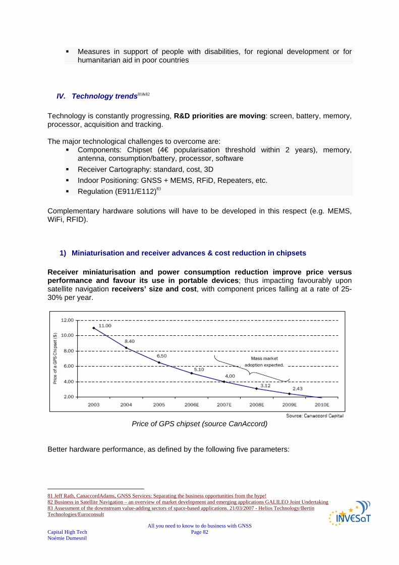
All you need to know to do business with GNSS Capital High Tech Page 82 Noémie Dumesnil
Measures in support of people with disabilities, for regional development or for humanitarian aid in poor countries
IV. Technology trends81&82 Technology is constantly progressing, R&D priorities are moving: screen, battery, memory, processor, acquisition and tracking. The major technological challenges to overcome are:
Components: Chipset (4€ popularisation threshold within 2 years), memory, antenna, consumption/battery, processor, software
Receiver Cartography: standard, cost, 3D Indoor Positioning: GNSS + MEMS, RFiD, Repeaters, etc. Regulation (E911/E112)83
Complementary hardware solutions will have to be developed in this respect (e.g. MEMS, WiFi, RFID).
1) Miniaturisation and receiver advances & cost reduction in chipsets Receiver miniaturisation and power consumption reduction improve price versus performance and favour its use in portable devices; thus impacting favourably upon satellite navigation receivers’ size and cost, with component prices falling at a rate of 25-30% per year.
Price of GPS chipset (source CanAccord)
Better hardware performance, as defined by the following five parameters:
81 Jeff Rath, CanaccordAdams, GNSS Services: Separating the business opportunities from the hype! 82 Business in Satellite Navigation – an overview of market development and emerging applications GALILEO Joint Undertaking 83 Assessment of the downstream value-adding sectors of space-based applications. 21/03/2007 - Helios Technology/Bertin Technologies/Euroconsult

All you need to know to do business with GNSS Capital High Tech Page 83 Noémie Dumesnil
Hardware performance parameters (source CanAccord) Certainly annual price declines in the 25-30% in key components and integrated devices are expected to continue while performance of hardware keeps improving (discrete components and device level performance). “Software receivers” should appear within 2 years and will meet the requirements of the mobile telecommunications:
low consumption small size lower equipment cost.
Software receivers will have the key advantages of allowing the implementation of evolutions (e.g. a GPS handset could be upgraded into a GPS/GALILEO handset by downloading a new software version).
2) Advances in geographical information systems and digital mapping84 Advances in geographical information systems and digital mapping provide the necessary data to support new Location Based Services: declining costs and expanding area coverage of GIS datasets and interoperability of GIS software toolkits drives the market. As GIS companies successfully license their datasets over larger markets, unit level ASPs (ASP delivers application functionality and associated services across a network to multiple customers using a rental pricing model) continue to decrease modestly (5-10% decrease annually over the last few years), which in turn expand the number of addressable markets (license model). Improving Inter-operability-GIS programs are moving towards industry-wide open standards, as the Internet has become a popular medium to access and distribute GIS data (several governmental organisations have been supporting this initiative…). More than 65 million people, or 38 % of the total internet audience, used Map sites in March 2006 i.e. Google Earth, Yahoo Maps, MSN Maps and Mapquest.
3) Mobile communication technologies
84 Presentations from EURISY CONFERENCE GALILEO Services: Chances for Business. 24/25 April 2006 - PRAGUE, Czech Republic. Source CanAccordAdams : Jeff Rath - The GNSS market from the financial perspective
All you need to know to do business with GNSS Capital High Tech Page 84 Noémie Dumesnil
Mobile communication technologies push the markets for positioning and timing services. The potential market for LBS applications is enormous and correlated to the expansion of the mobile phone market. EGNOS in a first stage and GALILEO in a second stage will provide for quantum leaps in satellite navigation performances, hence stimulating demand and supply industries. Industry driven open standards (supported by public) adoption drives towards interoperable applications and devices. The presence of global markets pursued at system level by public/military funding, smoothes technology readiness differences and interoperability. Handheld receivers are already being offered at less than €50. These trends linked with the constant improvement of other technologies such as Geographical Information Systems or mobile communications networks provide the necessary base to support the use of satellite navigation technology for high volume consumer applications. 85
V. Major Market Trends The Navigation market has become a mass market since 2005 thanks to the exponential growth of PNDs sales. The market growth should still accelerate after 2007 due to new regulations and the massive growth of Location Based Services. Yet, the GNSS market should become a market of services. There is a big market potential for road navigation in Europe, USA and even Japan. Market penetration for GNSS applications is only starting in the rest of the world compared to Europe, USA and Asia, which is already a very promising market.
VI. Risks High risks are limited to a few segments and are primarily technology and market based. An obvious technological risk is present in emerging segments or those requiring new applications by definition, and risks found in established and matured markets are lower. However, there are some comparable risks levels as segments migrate to global markets. The largest risks are found in safety critical and highly regulated markets. Some specific additional European market and policy risks exist in smaller markets and some policies may push other solutions.
85 http://ec.europa.eu/dgs/energy_transport/galileo/doc/business_in_satnav.pdf
All you need to know to do business with GNSS Capital High Tech Page 85 Noémie Dumesnil
KEY FINDINGS
Need for information on GALILEO deployment & organisation: date of completion, costs of using the GALILEO signals, regulations linked to GALILEO
Need for information on regulations to know future drivers in terms of performance & technology
Economic activity drives demand for commercially-oriented services in all the transport modes, together with professional surveying, timing and scientific applications: acceleration of the market growth in the next 2-3 years due to a number of drivers
Receivers’ miniaturisation and power consumption reduction improve price versus performance and favour its use in portable devices
Declining costs and expanding area coverage of GIS datasets and interoperability of GIS software toolkits drives the market.
Mobile communication technologies push the markets for positioning and timing services: towards interoperable applications and devices.
High risks are primarily technology based in emerging segments or those requiring new applications by definition, and market based in safety critical and highly regulated markets

All you need to know to do business with GNSS Capital High Tech Page 86 Noémie Dumesnil
CHAPTER 9
GNSS INDUSTRY PANORAMA In this chapter, we will put forward the user segment value chain developed by the GALILEO Joint Undertaking. We will base our study on its main building blocks: chips, navigation systems (including receivers), and information content providers. We will give you insight into the current situation industries and market for the main building blocks, the possibilities for development and the new markets opened by GALILEO. Finally, we will give an overall industry panorama. Note that the market is evolving rapidly, mergers and acquisitions are regularly taking place; as a result, the information prided below should carefully be considered.
I. Galileo user segment Three segments composed the European GNSS program:
1) The space segment 2) The ground segment 3) The user segment
In the following chapter, we are focusing only on the User Segment. (The space and ground segments are not discussed). The user segment is driven by the need to translate the signals provided by the Satellites into real services for the citizens, resulting in the so-called “Users’ Applications”.
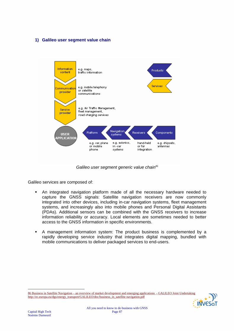
All you need to know to do business with GNSS Capital High Tech Page 87 Noémie Dumesnil
1) Galileo user segment value chain
Galileo user segment generic value chain86
Galileo services are composed of:
An integrated navigation platform made of all the necessary hardware needed to capture the GNSS signals: Satellite navigation receivers are now commonly integrated into other devices, including in-car navigation systems, fleet management systems, and increasingly also into mobile phones and Personal Digital Assistants (PDAs). Additional sensors can be combined with the GNSS receivers to increase information reliability or accuracy. Local elements are sometimes needed to better access to the GNSS information in specific environments.
A management information system: The product business is complemented by a
rapidly developing service industry that integrates digital mapping, bundled with mobile communications to deliver packaged services to end-users.
86 Business in Satellite Navigation – an overview of market development and emerging applications - GALILEO Joint Undertaking http://ec.europa.eu/dgs/energy_transport/GALILEO/doc/business_in_satellite navigation.pdf

All you need to know to do business with GNSS Capital High Tech Page 88 Noémie Dumesnil
2) Remarks Depending on the final application targeted, the order and integration of value chain building blocks might differ subsequently. However, most market segments are moving towards more integration and consolidation. The value adding chain for the provision of navigation services is rapidly moving from stand-alone navigation products to services provision based on a combination of navigation and communication/information technologies. As a result, the industry panorama is likely to change considerably in the next years ahead: All stakeholders are looking for more value chain integration and best alliances to optimise their offer.
II. Chip industry
1) GNSS chip market Chip is an essential element of users’ GNSS receivers. Due to the success of Personal Navigation Devices, the market has met a significant growth over the last years (~ + 45% / year) to reach a turnover of €200M in 2005.
2) Chip manufacturers87
The chip market is highly competitive and dominated by SiRF:
SiRF achieved a turnover of €100M in 2004 - owns 40 to 50% of the market thanks to its best seller is “SiRF star III Powered”.
JRC is second on the market but far behind SiRF and owns ~1/3 of the automotive market.
ST Microelectronics is in third position. NEMERIX behind ST Microelectronics is to become a major player thanks to its
achievements in terms of low size & consumption, as well as Global Locate, whose chip should replace SiRF in TomTom One receiver (best seller).
87 The current drivers, market and players of GNSS based applications: Pascal Campagne, France Développement Conseil (FDC)
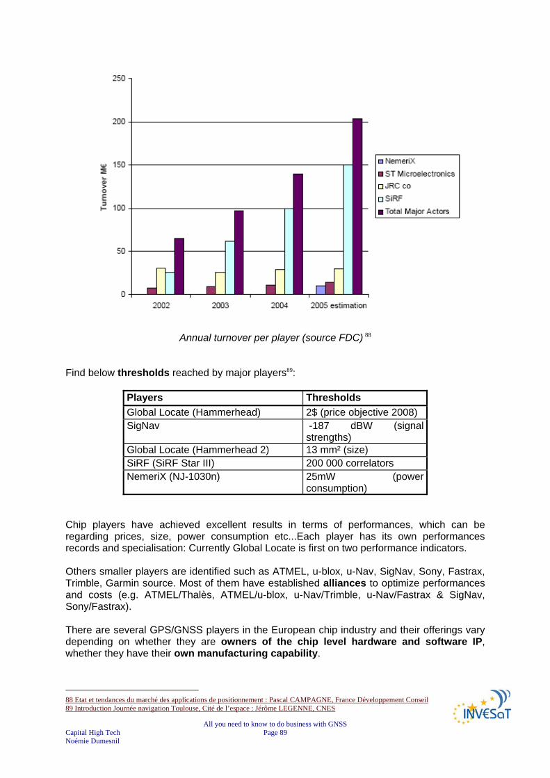
All you need to know to do business with GNSS Capital High Tech Page 89 Noémie Dumesnil
Annual turnover per player (source FDC) 88 Find below thresholds reached by major players89:
Players Thresholds Global Locate (Hammerhead) 2$ (price objective 2008) SigNav -187 dBW (signal
strengths) Global Locate (Hammerhead 2) 13 mm² (size) SiRF (SiRF Star III) 200 000 correlators NemeriX (NJ-1030n) 25mW (power
consumption) Chip players have achieved excellent results in terms of performances, which can be regarding prices, size, power consumption etc...Each player has its own performances records and specialisation: Currently Global Locate is first on two performance indicators. Others smaller players are identified such as ATMEL, u-blox, u-Nav, SigNav, Sony, Fastrax, Trimble, Garmin source. Most of them have established alliances to optimize performances and costs (e.g. ATMEL/Thalès, ATMEL/u-blox, u-Nav/Trimble, u-Nav/Fastrax & SigNav, Sony/Fastrax). There are several GPS/GNSS players in the European chip industry and their offerings vary depending on whether they are owners of the chip level hardware and software IP, whether they have their own manufacturing capability.
88 Etat et tendances du marché des applications de positionnement : Pascal CAMPAGNE, France Développement Conseil 89 Introduction Journée navigation Toulouse, Cité de l’espace : Jérôme LEGENNE, CNES

All you need to know to do business with GNSS Capital High Tech Page 90 Noémie Dumesnil
For instance ST Microelectronics (France/Italy) have their own proprietary GPS hardware and software IP which they sell on the open market, but they also offer design and foundry services to fab-less chip companies and key original equipment manufacturer (OEM)’s to build custom GPS chips sometimes using third party GPS technology. Whereas Parthus (Ireland) are a fab-less chip company, they offer silicon design services and license their proprietary GPS Hardware and Software IP to other chipmakers. Infineon (Germany) have a co-operation with Trimble (U.S.A), where Infineon build and market a GPS chip set based on Trimble GPS IP. Philips Semiconductor (Netherlands) was in a similar situation, they had a GPS chip but had a co-operation with Ashtec (U.S.A.) to provide GPS software support. It is therefore sometimes necessary to wonder when a European chipmaker is not a European chipmaker90.
3) Chip technology trends
Chipmakers invest a huge amount of money in fabs and it is imperative that these fabs are kept running at optimum capacity/efficiency. Mainstream chipmakers therefore target high volume products/applications to keep fabs full and to achieve good economies of scale. Lower volume, high added value products/applications such as military, aviation and surveying, are generally serviced by specialist companies with expertise in high accuracy techniques, military or CAA/FAA qualification/certification procedures etc. As applications converge and mainstream chipmakers adopt System on Chip (SOC) technologies, it is becoming increasingly important for the chipmaker to be able to offer a complete product/IP portfolio capable of supporting a broader application area. Therefore, to be successful in the market, a chip vendor cannot just sell the chips, he must also have the application software, development tools and application know-how (reference design etc.) to support the chip. This is particularly important for GPS/GNSS chip sets that are highly programmable products, expert knowledge is required to write the software and to design/layout the RF section. Industrial cooperations are sometimes sought to bring all the various elements together to make the complete GPS/GNSS product offering. On a wider level, chipmakers often forge strategic alliances with key customers to combine silicon know-how with system know-how to produce innovative, market driven products with better performance and lower cost. For example for Personal Navigation the GPS/GNSS functionality may be integrated alongside PDA technology, GSM technology, etc., the GPS/GNSS function will be increasingly seen as an IP building block. Today, the preparation of the Mobile phone/GNSS market is considerably modifying the environment (Emergency call regulations). Since R&D priorities have turned to consumption, size, cost, Time To First Fix (actual time required by a GPS receiver to achieve a position solution). “Software” receivers should be launched within 2 years to meet requirements of mobile telephony (e.g. consumption, size and lower equipment cost) and enable new developments
90 INVESAT WIKIPEDIA TOOL http://www.dappolonia-research.com/invesatwiki/index.php/Main_Page
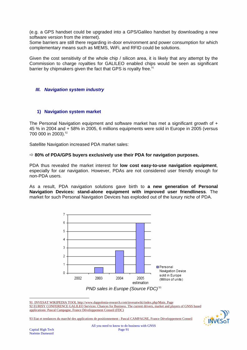
All you need to know to do business with GNSS Capital High Tech Page 91 Noémie Dumesnil
(e.g. a GPS handset could be upgraded into a GPS/Galileo handset by downloading a new software version from the internet). Some barriers are still there regarding in-door environment and power consumption for which complementary means such as MEMS, WiFi, and RFID could be solutions. Given the cost sensitivity of the whole chip / silicon area, it is likely that any attempt by the Commission to charge royalties for GALILEO enabled chips would be seen as significant barrier by chipmakers given the fact that GPS is royalty free.91
III. Navigation system industry
1) Navigation system market The Personal Navigation equipment and software market has met a significant growth of + 45 % in 2004 and + 58% in 2005, 6 millions equipments were sold in Europe in 2005 (versus 700 000 in 2003).92 Satellite Navigation increased PDA market sales:
80% of PDA/GPS buyers exclusively use their PDA for navigation purposes. PDA thus revealed the market interest for low cost easy-to-use navigation equipment, especially for car navigation. However, PDAs are not considered user friendly enough for non-PDA users. As a result, PDA navigation solutions gave birth to a new generation of Personal Navigation Devices: stand-alone equipment with improved user friendliness. The market for such Personal Navigation Devices has exploded out of the luxury niche of PDA.
PND sales in Europe (Source FDC) 93
91 INVESAT WIKIPEDIA TOOL http://www.dappolonia-research.com/invesatwiki/index.php/Main_Page 92 EURISY CONFERENCE GALILEO Services: Chances for Business. The current drivers, market and players of GNSS based applications: Pascal Campagne, France Développement Conseil (FDC) 93 Etat et tendances du marché des applications de positionnement : Pascal CAMPAGNE, France Développement Conseil

All you need to know to do business with GNSS Capital High Tech Page 92 Noémie Dumesnil
Market is essentially European and North American, and there is still a huge market potential:
94% European cars and 98% US cars are not equipped yet with navigation systems
Total number of cars in Europe and US: 418 millions Today 90% new cars sold in Europe and US do not embark built-in navigation system:94
Price are still prohibitive (1 500 -2 000 €) Competition of PND (300 -700 €)
In 2007, the PND market continues to develop strongly, mainly because of the fact that regular consumers' awareness of car navigation is increasing
2) Navigation system industry trends
The integration of satellite navigation modules within mobile communication handsets is, no doubt, one of the biggest evolutions over the next decade for the mass-market user. This will allow the development of smaller terminals, which will support Location Based Services, gathering position and commercial information. It is worth noting that emergent techniques like “software” radio (i.e. using appropriate software on to the same hardware components for both navigation and communication functions), might also promote dual use of the terminal. The main trend in receivers is the miniaturisation of the satellite navigation hardware. The progress made in silicon technology allows for size reduction, power consumption reduction, and integration of additional functionalities, encompassing communication and computation; at the same time the software content is steadily increasing. The decrease in power consumption and size of electronics hardware is a major condition for receivers to be used in conjunction with mobile handset. In particular, the reduction of power consumption in electronic devices determines user autonomy. The decrease in receivers’ internal voltage needs demonstrate the very significant decrease in power needs, which in turns translate to much longer receiver autonomy (i.e. leading to much smaller battery size and an increased number of hours without the need for re-charging). These factors influence most applications, where no connection to fixed power supplies is available.
94 Journée navigation Toulouse, Cité de l’espace - 7/12/2006. Introduction Journée navigation Toulouse, Cité de l’espace : Jérôme LEGENNE, CNES
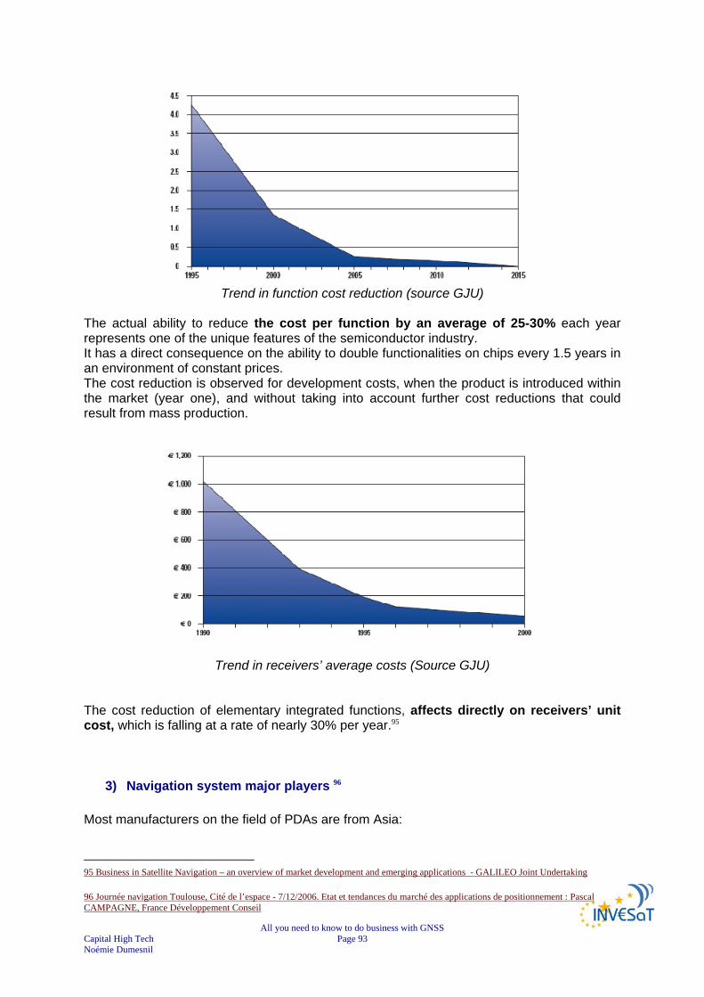
All you need to know to do business with GNSS Capital High Tech Page 93 Noémie Dumesnil
Trend in function cost reduction (source GJU)
The actual ability to reduce the cost per function by an average of 25-30% each year represents one of the unique features of the semiconductor industry. It has a direct consequence on the ability to double functionalities on chips every 1.5 years in an environment of constant prices. The cost reduction is observed for development costs, when the product is introduced within the market (year one), and without taking into account further cost reductions that could result from mass production.
Trend in receivers’ average costs (Source GJU) The cost reduction of elementary integrated functions, affects directly on receivers’ unit cost, which is falling at a rate of nearly 30% per year.95
3) Navigation system major players 96 Most manufacturers on the field of PDAs are from Asia:
95 Business in Satellite Navigation – an overview of market development and emerging applications - GALILEO Joint Undertaking 96 Journée navigation Toulouse, Cité de l’espace - 7/12/2006. Etat et tendances du marché des applications de positionnement : Pascal CAMPAGNE, France Développement Conseil

All you need to know to do business with GNSS Capital High Tech Page 94 Noémie Dumesnil
Taiwanese: Haicom, Holux, Rikaline, GlobalSat, EMTAC, Fortuna, TFAC, RoyalTekLtd, San Jose Navigation, LeadtekResearch Inc., AcoreTech, ETEK Navigation Inc, Polstar;
Japanese e.g. Itochuor Korean e.g. SysOnChip.
Taiwanese makers control a majority of production orders from brand-name PND vendors such as TomTom, Magellan, Medion, Mio, and Navman. Taiwanese production accounts for over 70% of worldwide production. In the first half of 2007, Taiwanese PND shipment volume reached approximately 7.28 million units.97 The turnover of these companies turnover is about 5 to 10 millions €. PNDs major players are Garmin (US), TomTom (the Netherlands), Navigon (Germany), Navman (NZ) which was recently bought by MiTAC (Taiwan), in addition to Thalès Navigation, d-Media, via Michelin. Electronics giants such as SONY, Acre, LG and Microsoft started to assault the market in 2005.
Annual turnover per player (source FDC)
97 http://www.emsnow.com/npps/story.cfm?pg=story&id=28240

All you need to know to do business with GNSS Capital High Tech Page 95 Noémie Dumesnil
Comparison of sales distribution between market leaders in 2005 Q3 (source FDC)
In 2005, the leader of the market is Garmin, closely followed by TomTom and Navman (now MiTAC) and Navigon. TomTom has met a fast growth since 2003, catching up with big players. Few years later, it is still valid. In 2007, TomTom, with its market share of 37%, becomes the world’s largest PND manufacturer, followed at a distance by Garmin, which holds market share of 25%. The number three is MiTAC with a share of 20% of all the PND sales in the world. The trio’s position seems to strengthen continuously. Despite big competition in the market, only three brands that really matter according to iSuppli marketing research bureau report. These three parties accounts for around 82% of the total Personal Navigation Device sales. With no exception, the ‘Big Three’ all do very well on their home market. Garmin is market leader in North America, while MiTAC is doing well in Asia. TomTom is the largest in Europe, and in Australia. The three big players rule the market. It will be very tough for newcomers to take part to competition. That is why last year Philips decided ultimately not to launch their announced product, and not to enter the PND market at all. Similarly, Sony and JVC have downsized their PND market sales expectation. 98 When considering the position of Europe on the worldwide market, it differs from one targeted application to another99:
In the automotive segment, for example, namely car navigation systems and road tolling, Europe has a leading role in the world market: Siemens VDO, Grundig, Fela, Magneti Marelli, Bosch-Blaupunkt, and Becker.
The same applies to the high end surveying market, where Leica and Thalès play a
major role.
US companies mostly dominate the aviation market, although Thalès is a major player.
98 http://www.gpspassion.com/forumsen/topic.asp?TOPIC_ID=91926 99 INVESAT WIKIPEDIA TOOL http://www.dappolonia-research.com/invesatwiki/index.php/Industrial_players_of_GNSS_-_Navigation_system_industry

All you need to know to do business with GNSS Capital High Tech Page 96 Noémie Dumesnil
In the two markets where the biggest growth potential is forecasted – mobile communication and fleet management – there has been no major European industrial development up to now although some of the world’s leading mobile phone companies are European.
For road vehicle fleet management systems, it might happen that the market evolves at mid-term. The on-going penetration of such systems, due to the introduction of advanced road tolling systems, could help to develop the market.
In other logistics areas, particularly the intermodal logistics sector (container tracking, etc.), the market is extremely fragmented. It would certainly help if there were more co-operations between the various companies – for standardisation and marketing reasons.
In the telecommunication sector, it seems that the big European players have not yet recognised navigation as a potential asset. Currently, industry is going other ways there, like picture, video or audio integration, in order to attract customers, and to generate as much traffic as possible in their networks. The only nameable European player on the mobile phone market is Benefon, a Finnish company that developed smart integrated communication/navigation devices, but has not been very successful with their products up to now.
The handheld navigation market has started to develop from another side: the PDAs. Today, a number of “extension kits” for PDAs are sold, consisting of external GPS antennas and software packages, mostly for car navigation.
Garmin (US), a worldwide leading manufacturer of GPS handhelds, has done the next step, which is the direct integration of a GPS chip into a PDA with Palm software (the iQue3600). Other big mobile phone companies (e.g. T-Mobile) have started to integrate communication into PDAs. If this integration of technologies will be continuing (what is very likely), one can expect that in few years, mobile phones will all have PDA-like functions (or vice versa), together with a satellite navigation interface.
The task of European co-operations could be to try to accelerate the integration process by establishing a fruitful dialogue between successful satellite navigation product companies like Garmin and big mobile phone players. Another reason for the reluctance of the last-mentioned might be that they have invested some money on their own into location technologies, based on terrestrial cell navigation methods. It should be avoided to give the feeling that they have to invest into the infrastructure before they can benefit from the use of GALILEO.
IV. Geographic Information System industry
1) Geographic Information System market
A Geographic Information System (GIS) is a computer system capable of storing and managing data identified according to their locations (geographical referenced information, digital maps).

All you need to know to do business with GNSS Capital High Tech Page 97 Noémie Dumesnil
The market has known an important market growth with a turnover of 1 billion € in 2005 ( + 25% / year), essentially due to PND market growth (road). Europe is the biggest market for digital maps, however there is a limitation of market penetration in numerous countries (e.g. Central Europe, China) where digital cartography is still under development.13
2) Geographic Information System players14 Today, major players of the digital maps market are NAVTEQ Corp (USA), Tele Atlas NV (NL), and ZENRIN (USA). Most of the other players offer only a national coverage (e.g. AND, Sensis) or local (e.g. Rando ed.).
Annual turnover per player (source FDC) The leader on the market is Navteq Corp. whose turnover is steadily increasing, while Zenrin is stagnating. Tele Atlas is largely leading ahead the market of road navigation since 2005 (+140 % in 2005).
3) Geographic Information System trends15
The combination of geographical information systems with satellite navigation is at the core of most of the new applications already on the market. Digital maps are fundamental components for in-car navigation systems: essential and critical element of mass market applications, in particular w.r.t road navigation (biggest market). Digital maps represent 10% of equipment cost, but this ratio is increasing with the decrease of equipment cost. 13 EURISY CONFERENCE GALILEO Services: Chances for Business. The current drivers, market and players of GNSS based applications: Pascal Campagne, France Développement Conseil (FDC) 14 Journée navigation Toulouse, Cité de l’espace - 7/12/2006. Etat et tendances du marché des applications de positionnement : Pascal CAMPAGNE, France Développement Conseil 15 INVESAT WIKIPEDIA TOOL http://www.dappolonia-research.com/invesatwiki/index.php/Main_Page

All you need to know to do business with GNSS Capital High Tech Page 98 Noémie Dumesnil
Digital map displays are also routinely used in fleet management systems for vehicles of all types, relying heavily on GIS technology. Special attention should be given here to common databases, which are the basis for a number of value added navigation services. In the past decades, a lot of information, which is of common public interest like maps, transport networks, etc. has been collected and digitised. The problem is, that most of this information, except some official geographical maps, is completely spread over the countries and communes, and there is normally neither standardisation nor interfaces. If the mass market should be opened and the end customer should to recognise a real benefit in the introduction of navigation, the collection and standardisation of publicly interesting information is probably mandatory. Currently, there is one meaningful effort, which aims to do so, the Open GIS Consortium, which has been driven by US intelligence services. Today, some 258 members from industry, government agencies and universities, spread over Asia/Pacific, Europe, North and South America regions, participate in that process. The introduction of a regulative process in Europe and a joint industry effort could help to develop successful and beneficial information sources for the navigation community.
V. Synergies with mobile telecommunication16 The above-mentioned convergence between navigation systems and geographic information systems is further enhanced by the development of mobile communications networks (GSM, UMTS etc.) which enable real time data to move between system components. As a result, Location Based Services (LBS) are predicted to be amongst the most promising services of future wide-band mobile networks, alongside with voice and multimedia services. LBS services are now rapidly growing in the regions where cellular networks are already widely deployed like in Europe, North America or the Asia. With the advent of enhanced technologies and third generation mobile networks, offering multi-media services, LBS applications will be further encouraged. Furthermore, by using ranging signals from satellites in conjunction with additional data provided by mobile networks, it is possible to reduce the typical satellite navigation computation time, thus increasing positioning performances (i.e. parameters such as availability, continuity, time to first fix, etc.). Reference stations can also transmit additional navigation data, e.g. satellite ephemeris, synchronisation time, differential corrections, etc. As part of the data is not retrieved directly from satellite signals through classical algorithms, mobile handsets can use far weaker navigation signals than with conventional receiver. As a result, hybridisation of communication and satellite navigation signals will enhance indoor positioning capabilities, which is a benefit of paramount importance for users.
16 INVESTA WIKIPEDIA TOOL http://www.dappolonia-research.com/invesatwiki/index.php/Main_Page

All you need to know to do business with GNSS Capital High Tech Page 99 Noémie Dumesnil
VI. General trends in the GNSS Industry
1) Industry Panorama The major players in the hardware part of the GNSS applications market are: PND Chips GIS Major actors Garmin, Trimble
navigation, TomTom, Navigon, Navman
NemeriX, ST Microelectronics, JRC co, SiRF
TeleAtlas, NavTeq Corp., AND, Zenrin
Yet, this industry panorama is likely to evolve considerably. Indeed many new comers are penetrating the market regularly, from large electronic suppliers to new start-ups. The industry consolidation and concentration is expected in the ten years ahead through acquisition, alliances and bankruptcies.
2) Industry specialisation & integration The overall industrial chain for navigation and services is rapidly evolving, moving from stand-alone navigation products to services provision based on a combination of navigation and communication/information technologies. The market has not matured sufficiently to sustain large companies with GNSS user segment as primary activity. For large and medium companies it is more likely to be a range of business lines. There are only limited pure players - less than 20% of the market – mostly represented by specialised SMEs. According to a study performed by FDC, it appears that in the 80s-90s, the major industrial companies were manufacturing a complete GPS receiver; while today, chip designer, integrator, equipment manufacturer, provider of software and content are different jobs. All these stakeholders are more technically specialised and are looking for best alliances to optimise their value proposition through an integrated value chain. The market segments are fragmented, no single company is able to cover many of them. As a result, companies are developing sector specific applications offers trying to master all the components of the adding value chain (high control & high benefits). Today the migration to global market has resulted into comparable value chain organisation in Europe and worldwide. Note that Europe tends to be less integrated than in leading regions, where the entire supply chain is controlled by companies (e.g. John Deere, Garmin, Magellan). The defence industry is less consolidated in Europe primarily due to historical US military navigation contracts. Fragmented personal LBS and public safety industry is beginning to increase in consolidation and integration. Road and consumer services sectors are moving towards a common supply chain.
3) Industry ownership & size

All you need to know to do business with GNSS Capital High Tech Page 100 Noémie Dumesnil
Satellite Navigation is mainly a privately owned industry. Even though it exists large publicly and private companies in Europe, government ownership is minimal at the downstream level. European companies are generally smaller than worldwide companies, which operate over several market segments and along the supply chain. Total company revenue does not always reflect revenue from Satellite Navigation business, for instance Trimble (€668m) has higher margins than Leica (€461m), and Garmin (€634m) operates over several sectors compared to Raymarine (€181m). Trimble revenues are around $ 920 millions distributed as follows: 68% of its turnover in engineering and construction, 15% in field solutions, 11% advanced devices and only 6% in mobile solutions. Several highly profitable players have a focus outside satellite navigation industry, so there are no consistent trends in profit margin of downstream players worldwide. The profit margin does not reflect the downstream satellite navigation performance because of low specialisation of companies.
VII. EXAMPLES OF THE FAST EVOVING INDUSTRY PANORAMA TomTom, the Dutch navigation systems company, launched a formal takeover offer for digital map supplier Tele Atlas on Tuesday, October 2, 2007. TomTom confirmed the offer price of 21.25 euros per share, the deal worth approximately €2 billion ($2.77 billion), but Tele Atlas shares continued to trade above the offer price after Nokia made an offer for rival mapmaker Navteq. Finnish mobile phone maker Nokia's $8.1 billion offer for digital map supplier Navteq could reshape the industry and make the combined company of TomTom and Tele Atlas a takeover target itself. TomTom said that the tender period for Tele Atlas shares begins on October 3 and end on December 4100. Meanwhile, Nokia and Navteq announced a definitive agreement for Nokia to acquire Navteq for about $8.1 billion (€5.7 billion).
1) Navteq acquisition by Nokia Navteq generated 2006 revenues of $582 million and has approximately 3,000 employees located in 168 offices in 30 countries. Navteq acknowledged that Nokia was not its only corporate suitor in commenting on the transaction, but Nokia's proposal was the best opportunity available to maximize value for Navteq stockholders. The board of directors of each company approved the acquisition. The deal is now subject to customary closing conditions including regulatory approvals and Navteq shareholders' approval, and is expected to close on the merger in Q1 of 2008.
100 http://www.pcmag.com/article2/0,1895,2191303,00.asp

All you need to know to do business with GNSS Capital High Tech Page 101 Noémie Dumesnil
The reason why Nokia acquire Navteq is because Location-based services are one of the cornerstones of Nokia's Internet services strategy, and this step forward will support Nokia in becoming a leading player in this domain. Nokia will now be able to bring context and geographical information to a number of Internet services with accelerated time to market. In spite of this new context, Navteq's current map data business will continue operationally independent, but as part of Nokia Group company.101
2) TomTom & Tele Atlas merger After the merger, Tele Atlas should continue to provide digital mapping products to current and future customers outside of TomTom as a separate unit. Tele Atlas will access TomTom's resources, allowing them to expand its business and market share against its rivals, namely number-one digital mapping supplier Navteq, Tele Atlas being number two in the market.
The combination of the two companies will result in new features, improved coverage and more accurate navigation information. The combination of TomTom’s customer feedback tools and Tele Atlas original map production processes allows Tele Atlas to significantly change the way digital maps are updated and enhanced. The result announced is to be of a new level of quality, content and innovation to deliver the best navigation products. 102
101 http://lbs.gpsworld.com/gpslbs/article/articleDetail.jsp?id=461533 102 http://lbs.gpsworld.com/gpslbs/article/articleDetail.jsp?id=443331
All you need to know to do business with GNSS Capital High Tech Page 102 Noémie Dumesnil
KEY POINTS FOR THE GNSS CHIP INDUSTRY
Significant growth: ~ + 45%/year Market acceleration: due to Personal Navigation Device success Big players: SiRF, JRC, ST Microelectronics, NEMERIX, Global Locate Industrial cooperations: to support the need for application software, development
tools and application know-how of the chip Strategic alliances with key customers: to combine silicon know-how & system know-
how High volume products/applications System on Chip (SOC) technologies, to support a broader application area
KEY POINTS NAVIGATION SYSTEMS INDUSTRY
Significantly growing market: + 58% in 2005, and 6M equipments sold in Europe in 2005
Market essentially European and North American: still a huge market potential 80% of PDA/GPS buyers exclusively use their PDA for navigation purposes Market interest for low cost easy-to-use (for non PDA users) navigation equipment Europe leader in automotive & high end surveying market; aviation market dominated
by US companies No major European industrial development in mobile communication and fleet
management PDA market dominated by Asian manufacturers Major PNDs players: Garmin, TomTom, Navigon, MiTAC/Navman, each being leader
in home markets Integration of satellite navigation modules within mobile communication handsets
gathering position and commercial information Miniaturisation of the satellite navigation hardware Decrease in power consumption and size of electronics hardware Cost reduction of elementary integrated functions impacts directly on receivers’ unit
cost KEY POINTS GIS INDUSTRY
Most of the new applications already on the market results from combination of geographical information systems with satellite navigation
Market turnover of 1 bn € in 2005 (+ 25%/year), due to PND market growth (road) Europe: biggest market for digital maps Major players of the digital maps market: NAVTEQ Corp, Tele Atlas NV, ZENRIN. No common databases: need for collection and standardisation of publicly interesting
information is probably mandatory. KEY POINTS MOBILE TELECOMMUNICATIONS SYNERGY
Mobile communications networks enable real time data transmission Reduction of satellite navigation computation time, increasing positioning
performances Location Based Services (LBS): most promising services, rapidly growing in Europe,
North America or the Asia. Enhancement of indoor positioning capabilities
All you need to know to do business with GNSS Capital High Tech Page 103 Noémie Dumesnil
CHAPTER 10
EUROPE POSITIONING IN THE COMPETITIVE ENVIRONMENT
In the following chapter, we are focusing on Europe positioning in the competitive environment, more specifically compared to the United States of America.
I. Europe still in the race There is apparently sometimes the perception that the European industry is at a disadvantage against its American counterparts in the satellite navigation business. This is a perception, which is perhaps worthwhile to challenge. There are enough examples where European companies are equally successful in the GPS business as American companies:
European companies were able to build the most sophisticated type of GPS receiver, capable of tracking L1 and L2 code and phase, and delivering cm-accurate positions in real-time, entirely on their own (e.g. Sercel, now part of Thalès).
There are also European chipset manufacturers which do not need to rely
on any American intellectual property; European Universities are undisputed leaders in the processing of GPS
measurements. E.g. the Astronomical Institute of the University of Bern has established a world-wide accepted standard in the post-processing of GPS measurements, allowing Geodesists and Geophysicists to measure movements of the Earth’s tectonics with mm accuracy around the world;
In several professional applications like surveying or GPS augmentation
European companies are among the world market leaders, e.g. Thalès or Leica;
European companies (or Japanese companies) build most of the world’s car
navigation systems, utilising only some GPS intellectual property from American companies (mainly Trimble) for which less than $ 10 is today paid per unit. The rest of the systems are usually “Made in Europe”.
The conclusion is that European industry can successfully participate at each level of the satellite navigation business if it chooses to do so.103
103INVESAT WIKIPEDIA TOOL - http://www.dappolonia-research.com/invesatwiki/index.php/Major_leading_countries_and_players_worldwide_in_the_field_of_GNSS_and_GMES_related_applications
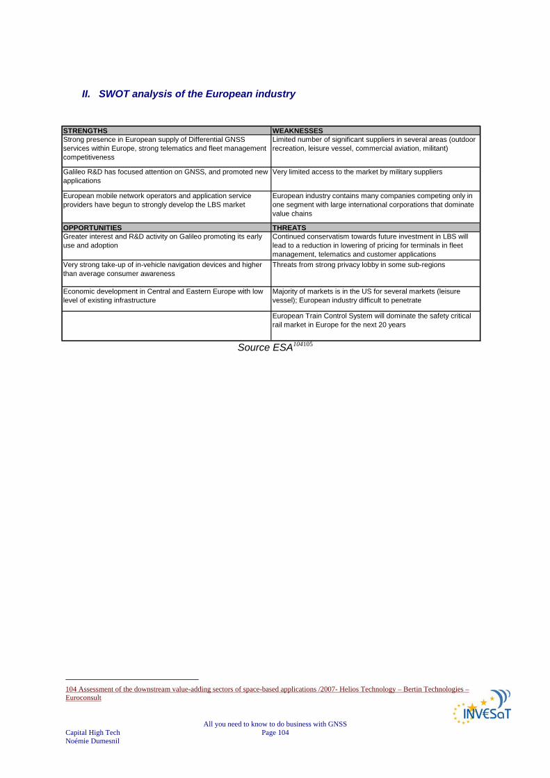
All you need to know to do business with GNSS Capital High Tech Page 104 Noémie Dumesnil
II. SWOT analysis of the European industry
STRENGTHS WEAKNESSESStrong presence in European supply of Differential GNSS services within Europe, strong telematics and fleet management competitiveness
Limited number of significant suppliers in several areas (outdoor recreation, leisure vessel, commercial aviation, militant)
Galileo R&D has focused attention on GNSS, and promoted new applications
Very limited access to the market by military suppliers
European mobile network operators and application service providers have begun to strongly develop the LBS market
European industry contains many companies competing only in one segment with large international corporations that dominate value chains
OPPORTUNITIES THREATSGreater interest and R&D activity on Galileo promoting its early use and adoption
Continued conservatism towards future investment in LBS will lead to a reduction in lowering of pricing for terminals in fleet management, telematics and customer applications
Very strong take-up of in-vehicle navigation devices and higher than average consumer awareness
Threats from strong privacy lobby in some sub-regions
Economic development in Central and Eastern Europe with low level of existing infrastructure
Majority of markets is in the US for several markets (leisure vessel); European industry difficult to penetrate
European Train Control System will dominate the safety critical rail market in Europe for the next 20 years
Source ESA104105
104 Assessment of the downstream value-adding sectors of space-based applications /2007- Helios Technology – Bertin Technologies – Euroconsult
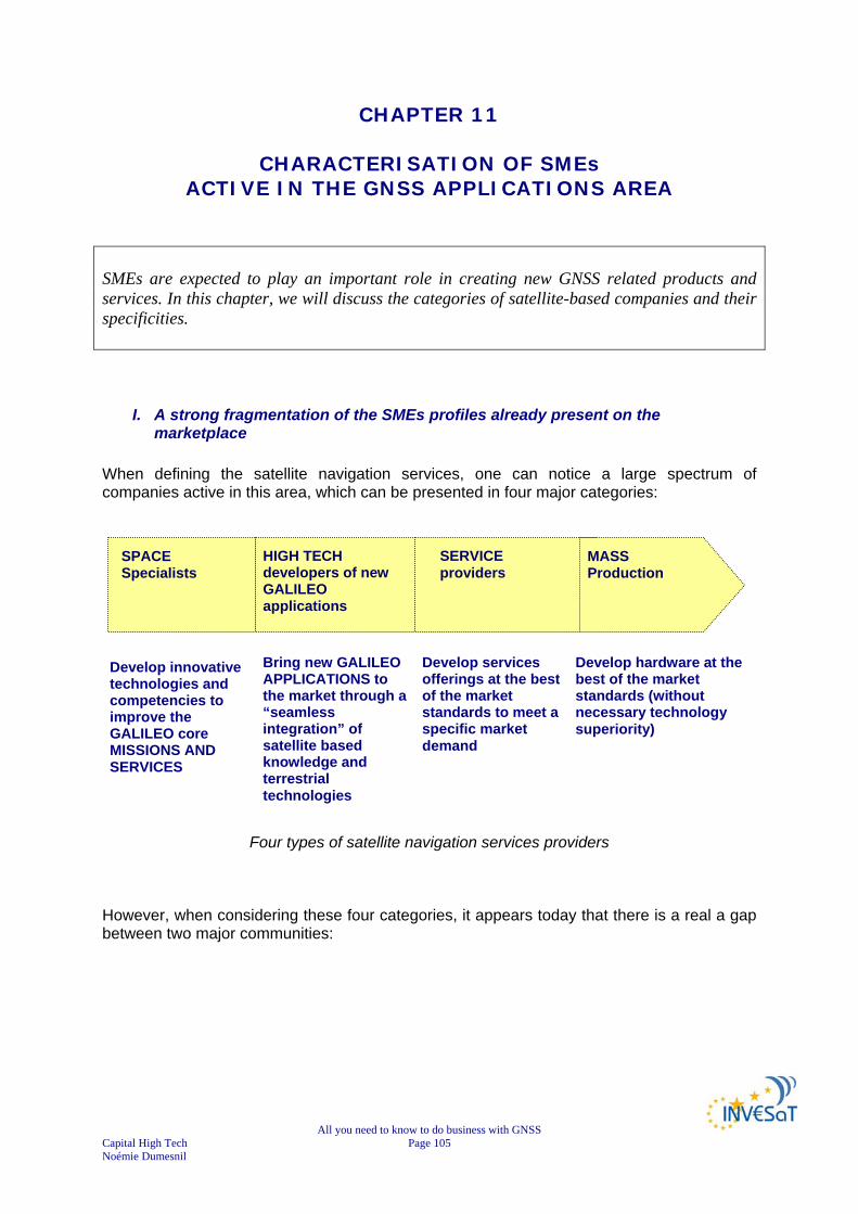
All you need to know to do business with GNSS Capital High Tech Page 105 Noémie Dumesnil
CHAPTER 11
CHARACTERISATION OF SMEs ACTIVE IN THE GNSS APPLICATIONS AREA
SMEs are expected to play an important role in creating new GNSS related products and services. In this chapter, we will discuss the categories of satellite-based companies and their specificities.
I. A strong fragmentation of the SMEs profiles already present on the marketplace
When defining the satellite navigation services, one can notice a large spectrum of companies active in this area, which can be presented in four major categories:
Four types of satellite navigation services providers However, when considering these four categories, it appears today that there is a real a gap between two major communities:
Develop innovative technologies and competencies to improve the GALILEO core MISSIONS AND SERVICES
Develop hardware at the best of the market standards (without necessary technology superiority)
Bring new GALILEO APPLICATIONS to the market through a “seamless integration” of satellite based knowledge and terrestrial technologies
Develop services offerings at the best of the market standards to meet a specific market demand
SPACE Specialists
HIGH TECH developers of new GALILEO applications
SERVICE providers
MASS Production

All you need to know to do business with GNSS Capital High Tech Page 106 Noémie Dumesnil
Two different communities of satellite navigation services providers
1) Technology push strategy The first community is known as the Technology Pushers; Such SMEs are clearly working on two major areas circled in the graph below:
Classes of innovation in Satellite Navigation Services106
106 PROGENY – GALILEO JOINT UNDERTAKING. Premiers résultats RDTV3. F. Ghiron
MARKET PULL
TECHNO PUSH
SPACE Specialists
HIGH TECH developers of new GALILEO applications
SERVICE providers
MASS Production
Technology Superiority
Cost differentiation
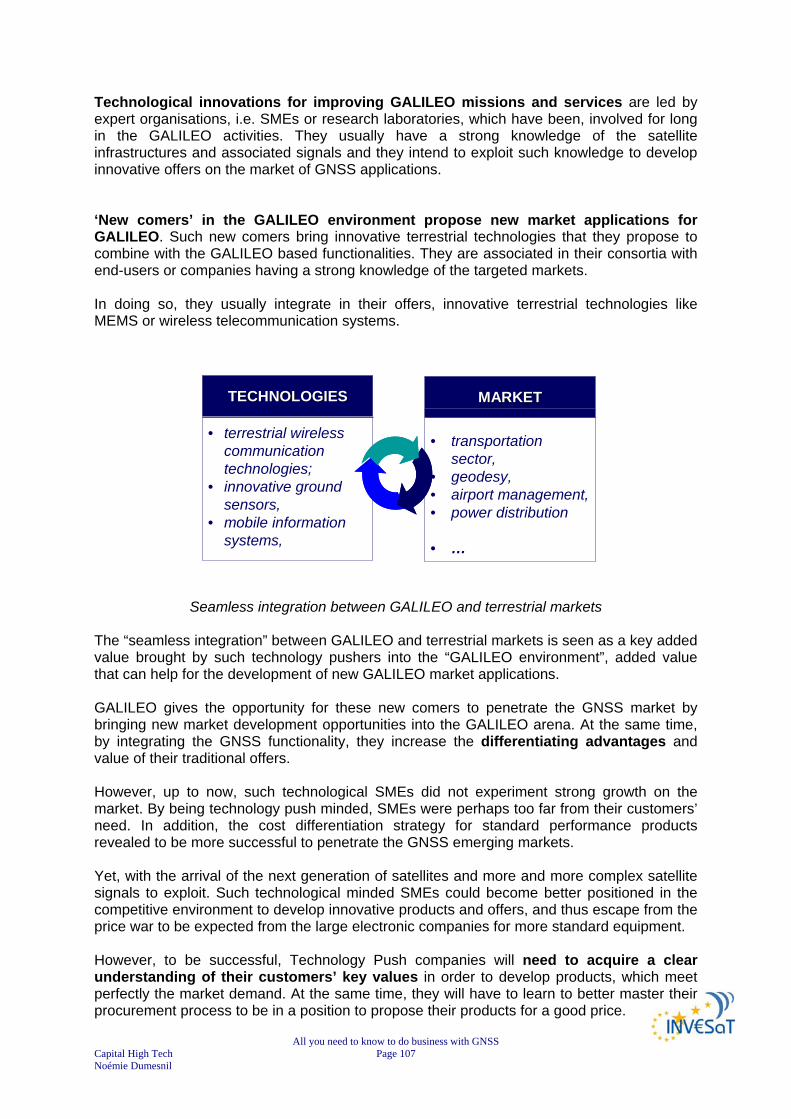
All you need to know to do business with GNSS Capital High Tech Page 107 Noémie Dumesnil
Technological innovations for improving GALILEO missions and services are led by expert organisations, i.e. SMEs or research laboratories, which have been, involved for long in the GALILEO activities. They usually have a strong knowledge of the satellite infrastructures and associated signals and they intend to exploit such knowledge to develop innovative offers on the market of GNSS applications.
‘New comers’ in the GALILEO environment propose new market applications for GALILEO. Such new comers bring innovative terrestrial technologies that they propose to combine with the GALILEO based functionalities. They are associated in their consortia with end-users or companies having a strong knowledge of the targeted markets. In doing so, they usually integrate in their offers, innovative terrestrial technologies like MEMS or wireless telecommunication systems.
Seamless integration between GALILEO and terrestrial markets The “seamless integration” between GALILEO and terrestrial markets is seen as a key added value brought by such technology pushers into the “GALILEO environment”, added value that can help for the development of new GALILEO market applications. GALILEO gives the opportunity for these new comers to penetrate the GNSS market by bringing new market development opportunities into the GALILEO arena. At the same time, by integrating the GNSS functionality, they increase the differentiating advantages and value of their traditional offers. However, up to now, such technological SMEs did not experiment strong growth on the market. By being technology push minded, SMEs were perhaps too far from their customers’ need. In addition, the cost differentiation strategy for standard performance products revealed to be more successful to penetrate the GNSS emerging markets. Yet, with the arrival of the next generation of satellites and more and more complex satellite signals to exploit. Such technological minded SMEs could become better positioned in the competitive environment to develop innovative products and offers, and thus escape from the price war to be expected from the large electronic companies for more standard equipment. However, to be successful, Technology Push companies will need to acquire a clear understanding of their customers’ key values in order to develop products, which meet perfectly the market demand. At the same time, they will have to learn to better master their procurement process to be in a position to propose their products for a good price.
TECHNOLOGIESTECHNOLOGIES
• terrestrial wireless communication technologies;
• innovative ground sensors,
• mobile information systems,
MARKETMARKET
• transportation sector,
• geodesy, • airport management, • power distribution
• …
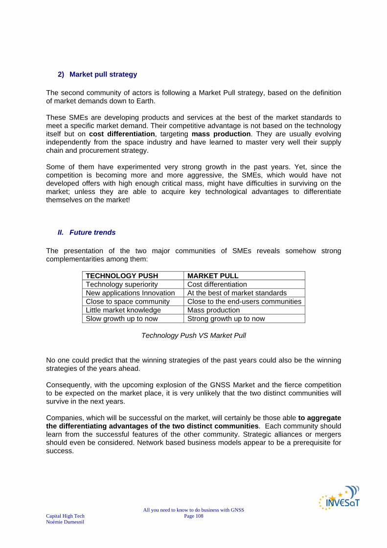
All you need to know to do business with GNSS Capital High Tech Page 108 Noémie Dumesnil
2) Market pull strategy
The second community of actors is following a Market Pull strategy, based on the definition of market demands down to Earth.
These SMEs are developing products and services at the best of the market standards to meet a specific market demand. Their competitive advantage is not based on the technology itself but on cost differentiation, targeting mass production. They are usually evolving independently from the space industry and have learned to master very well their supply chain and procurement strategy. Some of them have experimented very strong growth in the past years. Yet, since the competition is becoming more and more aggressive, the SMEs, which would have not developed offers with high enough critical mass, might have difficulties in surviving on the market; unless they are able to acquire key technological advantages to differentiate themselves on the market!
II. Future trends The presentation of the two major communities of SMEs reveals somehow strong complementarities among them:
TECHNOLOGY PUSH MARKET PULL Technology superiority Cost differentiation New applications Innovation At the best of market standards Close to space community Close to the end-users communities Little market knowledge Mass production Slow growth up to now Strong growth up to now
Technology Push VS Market Pull
No one could predict that the winning strategies of the past years could also be the winning strategies of the years ahead. Consequently, with the upcoming explosion of the GNSS Market and the fierce competition to be expected on the market place, it is very unlikely that the two distinct communities will survive in the next years. Companies, which will be successful on the market, will certainly be those able to aggregate the differentiating advantages of the two distinct communities. Each community should learn from the successful features of the other community. Strategic alliances or mergers should even be considered. Network based business models appear to be a prerequisite for success.
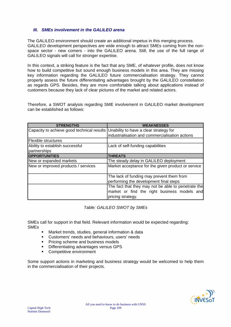
All you need to know to do business with GNSS Capital High Tech Page 109 Noémie Dumesnil
III. SMEs involvement in the GALILEO arena The GALILEO environment should create an additional impetus in this merging process. GALILEO development perspectives are wide enough to attract SMEs coming from the non-space sector - new comers - into the GALILEO arena. Still, the use of the full range of GALILEO signals will call for stronger expertise. In this context, a striking feature is the fact that any SME, of whatever profile, does not know how to build competitive but sound enough business models in this area. They are missing key information regarding the GALILEO future commercialisation strategy. They cannot properly assess the future differentiating advantages brought by the GALILEO constellation as regards GPS. Besides, they are more comfortable talking about applications instead of customers because they lack of clear pictures of the market and related actors.
Therefore, a SWOT analysis regarding SME involvement in GALILEO market development can be established as follows:
STRENGTHS WEAKNESSESCapacity to achieve good technical results Unability to have a clear strategy for
industrialisation and commercialisation actionsFlexible structuresAbility to establish successful partnerships
Lack of self-funding capabilities
OPPORTUNITIES THREATSNew or expanded markets The steady delay in GALILEO deploymentNew or improved products / services Market acceptance for the given product or service
The lack of funding may prevent them from performing the development final stepsThe fact that they may not be able to penetrate themarket or find the right business models andpricing strategy.
Table: GALILEO SWOT by SMEs
SMEs call for support in that field. Relevant information would be expected regarding: SMEs
Market trends, studies, general information & data Customers’ needs and behaviours, users’ needs Pricing scheme and business models Differentiating advantages versus GPS Competitive environment
Some support actions in marketing and business strategy would be welcomed to help them in the commercialisation of their projects.
All you need to know to do business with GNSS Capital High Tech Page 110 Noémie Dumesnil
CHAPTER 12
THE 8 GOLDEN RULES FOR GNSS SMES
In this chapter, we will list eight golden rules for start-ups starting a satellite based business. References to chapters will be provided for more information on the related rule.
I. A CLEAR BUSINESS FOCUS ....................................................................111
II. A CLEAR POSITIONING IN THE GNSS COMPETITVE ENVIRONMENT.113
III. A NETWORK-BASED BUSINESS MODEL ................................................114
IV. A STRONG MARKET KNOWLEDGE & CUSTOMER VALUE MANAGEMENT ..........................................................................................116
V. CLEAR ROUTES TO MARKET GROWTH .................................................118
VI. PRICING AND BILLING THE ADDED VALUE ...........................................120
VII. BUILDING A STRONG BARGAINING POWER .........................................123
VIII. ADEQUATE TEAM / MANAGEMENT.........................................................126
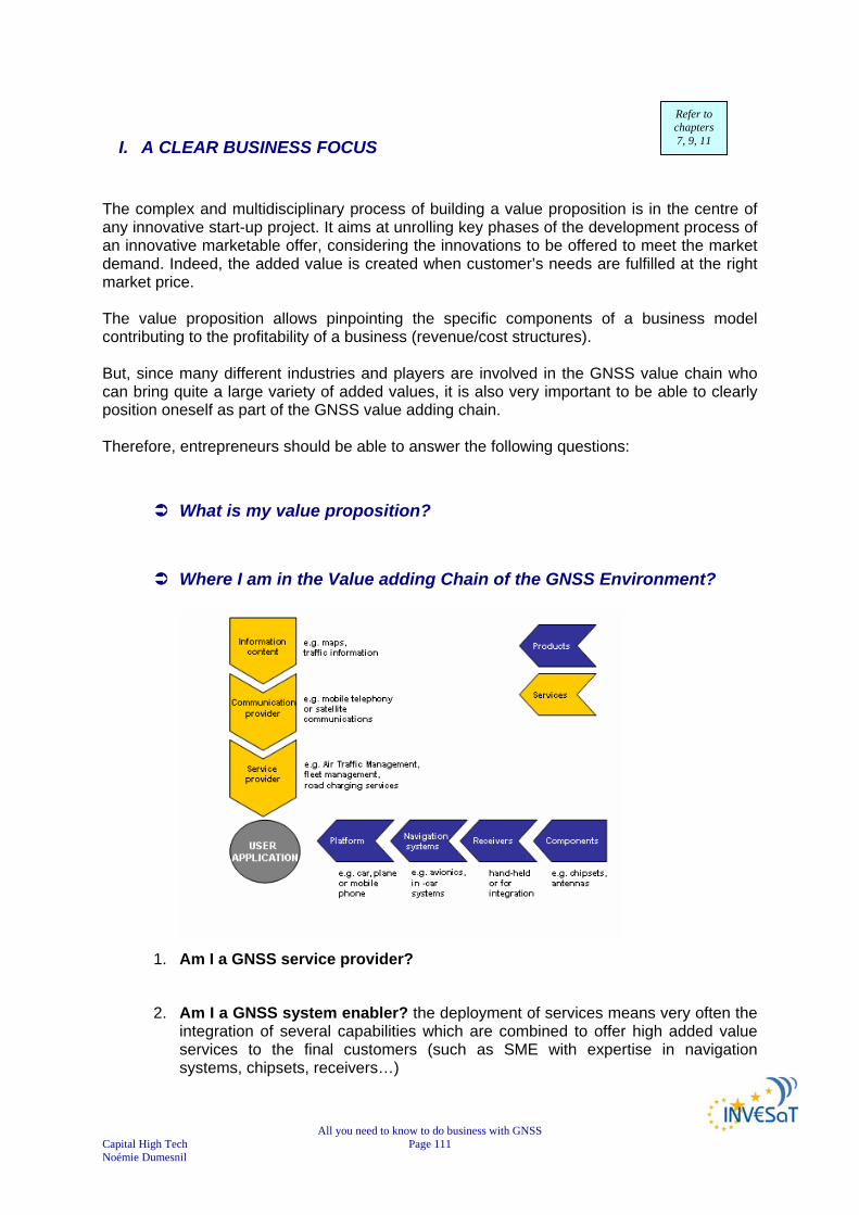
All you need to know to do business with GNSS Capital High Tech Page 111 Noémie Dumesnil
I. A CLEAR BUSINESS FOCUS The complex and multidisciplinary process of building a value proposition is in the centre of any innovative start-up project. It aims at unrolling key phases of the development process of an innovative marketable offer, considering the innovations to be offered to meet the market demand. Indeed, the added value is created when customer’s needs are fulfilled at the right market price. The value proposition allows pinpointing the specific components of a business model contributing to the profitability of a business (revenue/cost structures). But, since many different industries and players are involved in the GNSS value chain who can bring quite a large variety of added values, it is also very important to be able to clearly position oneself as part of the GNSS value adding chain. Therefore, entrepreneurs should be able to answer the following questions:
What is my value proposition?
Where I am in the Value adding Chain of the GNSS Environment?
1. Am I a GNSS service provider?
2. Am I a GNSS system enabler? the deployment of services means very often the integration of several capabilities which are combined to offer high added value services to the final customers (such as SME with expertise in navigation systems, chipsets, receivers…)
Refer to chapters 7, 9, 11

All you need to know to do business with GNSS Capital High Tech Page 112 Noémie Dumesnil
3. Am I involved in the development of service activities related to mobile telecommunication and geographic information systems: there are more and more services, which combine GNSS capabilities with telecommunication and mapping capabilities. Advances in geographical information systems and digital mapping provide the necessary data to support new Location Based Services. The potential of GNSS services can be significantly increased, by combining with positioning systems a few telecommunication satellites. For instance, hybridisation of communication and satellite navigation signals will enhance indoor positioning capabilities, which is a benefit of paramount importance for users.
What are the unique selling points of my business activities?
• Do I offer a new service for a new class of customers? • Do I offer a breakthrough in performance of GNSS applications
thanks to the introduction of an innovative technology? • Do I offer a strong cost advantage on already existing services or
technologies? • Do I offer another comparative competitive advantage? (e.g.
reliability or image as service partner)

All you need to know to do business with GNSS Capital High Tech Page 113 Noémie Dumesnil
II. A CLEAR POSITIONING IN THE GNSS COMPETITVE ENVIRONMENT Differentiation from direct or indirect competitors is key in the early phase of the innovative business services to maximise the probability of reaching the forecasted cash flows. Therefore, entrepreneurs should be able to answer to the following questions: “Why will the customer choose my product/service rather than the one proposed by my competitors?”
Who are the most direct leading competitors?
Do you know other direct or indirect competitors?
How does your offer compare to your direct or indirect competing solutions?
• A breakthrough in innovation with
a totally new service, a totally new product (with new functionalities offered to
customers) a totally new combination of products & services?
• A breakthrough of at least 25% in terms of performance? • An overall cost advantage of at least 25%?
Refer to chapter 5, 6, 7, 8, 9, 10

All you need to know to do business with GNSS Capital High Tech Page 114 Noémie Dumesnil
III. A NETWORK-BASED BUSINESS MODEL In the GNSS arena, most of the business models to be developed are network-based. It is important to understand that the viability of a network-structured business model. Its profitability and growth are greatly dependent upon the generation of value, not only for the customer, but also for the network of firms that collaborate to provide such product/service. Value creation is then determined not only by the firm-level resources and aggregated competencies but more important, on how effectively and efficiently resources are combined and governed at the network level. Therefore, the key issues for a successful business model in the area consist in favouring the value appropriation by the different players:
• upstream partners (e.g. satellite infrastructure), • service distribution and billing channels (e.g. telecom providers for service
delivery) • other firms with complementary assets are needed for service offering • supply chain management
Moreover, creating and capturing value requires a central firm exploring the potential to create value for customers in a radically new way and shaping the external environment. This central firm brings together players with different assets and competences. This implies that it has set up an inter-organisational network and manages the network by means of mergers and acquisitions, strategic alliances; licensing agreements contacting and other type of relationships. Maximise the joint created value and assure that the created value is shared among the network participants, so that each of them is better off than when they would leave the network. In this general context, entrepreneurs should be able to answer to the following questions:
Who are my key partners?
• Supply chain? • Complementary technological blocks? • En-powering information supplier? • Distributors? • Billing enablers?
Do I bring value to them? If yes, how?
How have I secured my network based business model?
How do I manage ‘my network’ today?
Refer to chapters
9, 11
All you need to know to do business with GNSS Capital High Tech Page 115 Noémie Dumesnil
• What is the level of connection with each of my key partners? • First contact established? • Discussions in progress but nothing formalised yet? • Agreements already signed?

All you need to know to do business with GNSS Capital High Tech Page 116 Noémie Dumesnil
IV. A STRONG MARKET KNOWLEDGE & CUSTOMER VALUE MANAGEMENT Many SMEs active in the GNSS area do lack marketing skills and often reveal little market knowledge. Teams feel that there is a huge potential growth and opportunities in terms of volume and value, but miss accurate data about their market. Particularly, time-to-market appreciation and the cash-flow capability of the economic model as estimated by the entrepreneurs are often weak points of the business models. Yet, customer and market knowledge is critical to ensure the relevance of your products and services and to develop new business opportunities: Managing customer value involves coordinating products, prices, service, customer relationships, marketing communications, and quality assurance in a strategically coherent and cost-effective way. The aim is to provide a high value proposition in terms of what the customer really wants. Therefore, entrepreneurs should be able to answer to the following questions:
How can I qualify my market targets? Please, use Chapters 4, 5, 6, 7 and 8 to better qualify it!
Do I intend to capture an existing demand or to create a new demand?
What are the associated key market figures I can refer to in the literature? Please, use Chapters 4, 5, 6, 7 and 8 to better qualify it!
How have customers been involved in the development process?
What are my Key Customers’ Values?
What are the validation steps the customers have brought so far?
• Product / service functions • Price • Quality • Others •
How many of my customers can be my reference customers? Are they
well-known on the market place?
What is the best channel strategy to distribute my product/service?
Refer to chapters 4, 5, 6, 7

All you need to know to do business with GNSS Capital High Tech Page 117 Noémie Dumesnil
Which are the best customers relationships to be implemented to assure long-term profitability?

All you need to know to do business with GNSS Capital High Tech Page 118 Noémie Dumesnil
V. CLEAR ROUTES TO MARKET GROWTH As seen before, there is a large spectrum of potential activities to be developed on the GNSS markets: some of them are expected to be high growth on large market segments; others can be seen as enabling companies like specialised GALILEO design offices with much lower expectations in terms of growth development. In any case, entrepreneurs should know what types of SME profiles they are. The two dimensions of the ‘classical’ BCG matrix (market share vs. market growth) could help them assess their growth profile, now and in 3/5 years time
What is the maximum size of my total reachable market? (in volume and in value?)
What is the market growth potential? Expected growth this year? Expected growth in 3 years?
What is my current market share? How will my market share evolve over the next three years?
Does my long-term profitability require being a market leader?
Source: BCG MATRIX (QuickMBA.com)
The growth profiles of companies will allow determine the profiles of potential investors that are likely to invest into their ventures:
• Equity investors prefer investments in growth markets, which are either existing markets with significant potential, virgin or emerging markets.
• Market growth should be within the targeted segments (not just the overall market), respectively markets with minimum double-digit growth, better 25% or more annually.
• Although investors base their decisions on numerous criteria, it is important to show high-growth capability of a business. Business growth is considered as of growth and level of revenues within the next 5 to 7 years.
• Investors – especially venture capital funds – typically appreciate annual growth rates of 50-100% or more and businesses which can grow to annual revenues of MEUR 25-100 or more depending the investor’s investment model and strategy.
• It is helpful to show a “commercial proof or concept”, as e.g. a solution developed in collaboration with customers, field tests with clients, etc.
• Winning arguments are always flagship customers or revenue guarantees early in the process.
Refer to chapters
4, 5, 6, 7 8

All you need to know to do business with GNSS Capital High Tech Page 119 Noémie Dumesnil
Several factors influence market modelling and consequently business revenues.
Source: A. Shaw & JKIC 2005 – SPACETECH BB
When defining you route to market growth it is fundamental to clearly study your market environment and external factors, in order to identify how much of this market you can potentially acquire.
Source: A. Shaw & JKIC 2005 – SPACETECH BB
It is important to recall however that, when the Business Models forecast strong growth processes, the entrepreneurs should be able to detail the overall strategy they will be implementing in order to achieve such a growth. The description of intermediate milestones should also be presented together with possible contingency plan in case of problems.
!

All you need to know to do business with GNSS Capital High Tech Page 120 Noémie Dumesnil
VI. PRICING AND BILLING THE ADDED VALUE As seen in the previous section the GNSS downstream sector value chain is complex and involves different players, each with different roles and strategic stakes. Consequently, most of the business models to be developed are network-based which implies the necessity to share revenues among the various value chain players thus influencing the billing and pricing strategy. The necessity to maintain a so-called upside potential and a balanced risk-rewarded ratio for each of the (network) partners involved is extremely important from a financial perspective in this type of business. Therefore, to be one of the winners, players must bring distinctive answers to the following questions:
A. Referring to the whole added value chain as detailed in Golden Rule I,
To which party does the end-customer purchase the final application?
• This question relates to the party that has the most legitimacy to acquire customers to minimise marketing and sales expenses.
Who creates the values in the value adding chain?
• Direct service providers? • Content aggregators? • Telecommunication providers? • Infrastructure providers (network manufacturers, LDT and
middleware providers, terminal equipment, application developers) whose revenues are generally linked to one-off capital expenses
How much does the provision of the added value in a given GNSS application value chain cost to each player?
• This question determines the boundaries of a negotiation–based
revenue split.
Who bills whom?
• Which billing party is accepted by the customer? • Can the value-adders bill the customer? • What if someone in the chain does not pay?
Refer to chapters 3, 8, 9
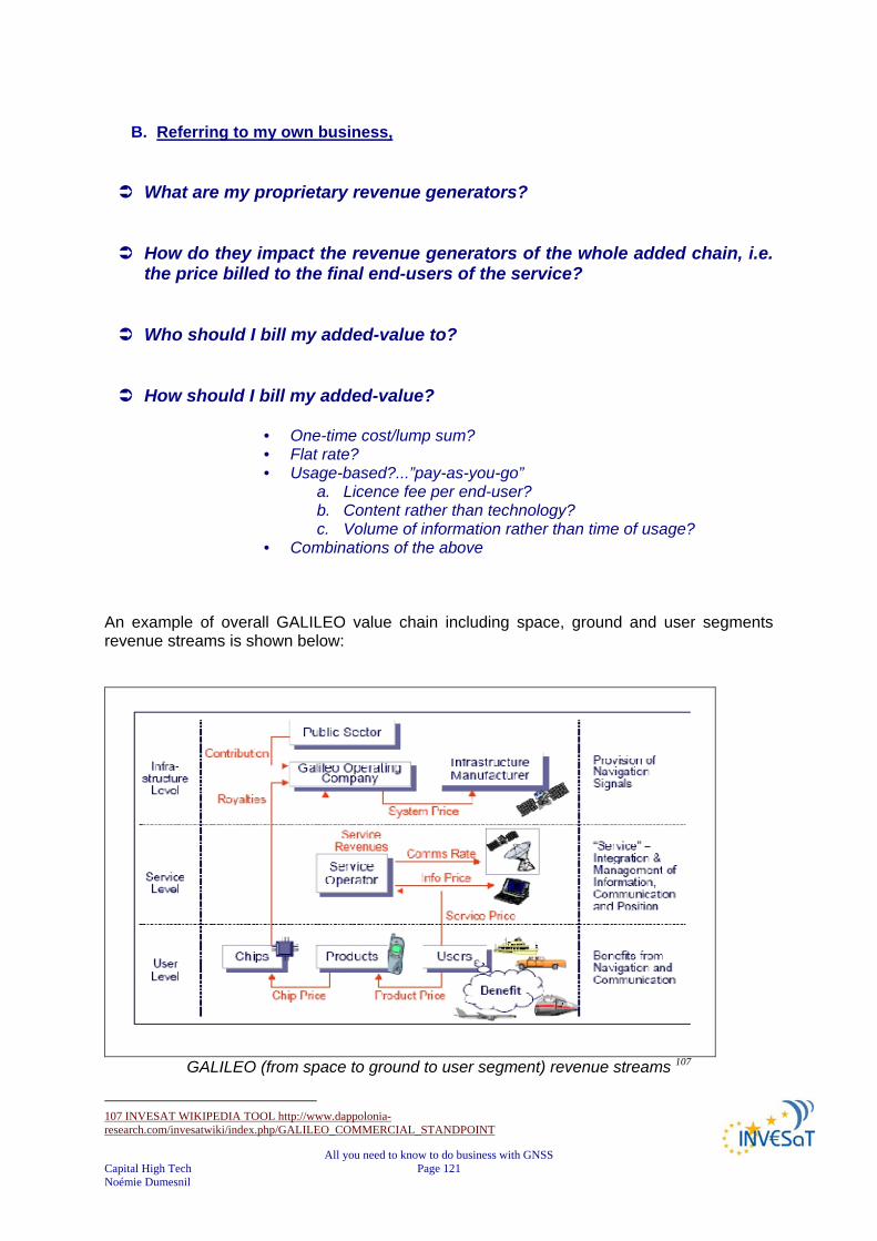
All you need to know to do business with GNSS Capital High Tech Page 121 Noémie Dumesnil
B. Referring to my own business,
What are my proprietary revenue generators?
How do they impact the revenue generators of the whole added chain, i.e. the price billed to the final end-users of the service?
Who should I bill my added-value to?
How should I bill my added-value?
• One-time cost/lump sum? • Flat rate? • Usage-based?...”pay-as-you-go”
a. Licence fee per end-user? b. Content rather than technology? c. Volume of information rather than time of usage?
• Combinations of the above An example of overall GALILEO value chain including space, ground and user segments revenue streams is shown below:
GALILEO (from space to ground to user segment) revenue streams 107
107 INVESAT WIKIPEDIA TOOL http://www.dappolonia-research.com/invesatwiki/index.php/GALILEO_COMMERCIAL_STANDPOINT

All you need to know to do business with GNSS Capital High Tech Page 122 Noémie Dumesnil
An example of location based value chain revenue streams are shown below:
LBS revenue streams 108
108 http://www.dappolonia-research.com/invesatwiki/index.php/GALILEO_COMMERCIAL_STANDPOINT

All you need to know to do business with GNSS Capital High Tech Page 123 Noémie Dumesnil
VII. BUILDING A STRONG BARGAINING POWER As explained before, the specificity of the GNSS environment calls for the implementation of network-based business models. Such a concept of ‘network-based’ business model might appear very simple in theory. Yet, when operating in the field, it becomes quite complex and an even risky exercise for all isolated? Individual? Entrepreneurs and small start-up companies who have not the capacity to build strong enough bargaining power. Indeed, when looking for partners, entrepreneurs have to present their ideas and innovations and there is always some risk for them to be stolen their ideas if they have not built in the meantime, strong barriers against potential new-entrants and competitors. There is no such recipe (miracle solution) to be proposed but only some possible routes to be explored carefully:
IPR Structure & Protection: patenting or not patenting ? IPR (intellectual property rights) protection is often seen as a good means to reinforce bargaining power. Indeed, IPRs are considered assets, which represent barriers to entry (could be e.g. also know-how, or a process, etc; e.g. in E/O data processing). Moreover, it is important to mention that one of the most important factors in today’s technology investment business is intellectual property rights (IPRs). Investors of all types prefer a strong IPR structure (clear situation, technology heritage, clusters of collaborators and no centred propriety, vertical control etc.).
However, the protection of innovations, which are most often service-based or software-based rather than technologically-oriented, is not an easy undertaking.
Moreover, depending on the business model and the innovation, some entrepreneurs would prefer not to file a patent in order to avoid being copied or bypassed.
In some cases, due to high entry barriers or other advantages, patenting my not be necessary depending trades between cost-benefit and time-to-market. As a consequence, most of the time, the law of secrecy is commonly used: In such cases, strong technology know-how compensates the lack of protection. Still, this leading edge know-how needs to be demonstrated to your partners!
Our advice: Ask for the opinion of an IPR expert about the IPR status and prospects, IPR Pros and Cons for your project.
Remind also that the New European Patent should bring new IPR opportunities in the years ahead: Do not wait for your competitors to protect their developments before you!
!

All you need to know to do business with GNSS Capital High Tech Page 124 Noémie Dumesnil
Do you have a chance to lock the access to market through a strong partnership with one of the largest reference customers or through an exclusive partnership with the billing operator?
Strong market knowledge is always a prerequisite for success. Therefore, potential partners will consider any of the following as strong assets:
• you can bring already a strong distribution network (through partnership for instance with other SMEs in other European regions)
• you benefit already from a strong customers’ database (because you are already operating on the market with other products or services)
• you have a strong partnership agreement with the operator who is in direct contacts with the end-customers
• you are already working for the largest reference customers on the market..
Do you have a chance to control the en-powering content production and/or delivery of the application?
Many GNSS applications are en-powered by high added value information content (in the same way as the NAVTEQ content data empower the Tom-Tom receivers) The mastery of the content production or delivery process will allow reinforce your bargaining power. The exclusive partnership with such content data providers will also be a good asset against competitors.
Can you demonstrate high enough cash flow capabilities ? When the market growth potential is high, it is very important to be among the first to penetrate the market. All is about speed /time-to-market and internationalisation! Then, you must know that a real race against the clock is launched as soon as you start promoting your idea in the marketplace and competitive environment (including the investment community). To be considered as a credible potential player, you should be able to demonstrate your financial capabilities to penetrate very rapidly the market. A healthy equity structure is necessary (with strong reference investors and strong financial assets). Indeed, all this bargaining building process might look as a “chicken and egg” problem! Yet, no one can deny that this is all about the tough challenge of isolated? Entrepreneurs!
!
All you need to know to do business with GNSS Capital High Tech Page 125 Noémie Dumesnil
Can you build an attractive business plan ?
The ultimate objective of all these thoughts and assessment related to business creation is to develop a business plan; it is mandatory when starting up a business. It helps you to:
• determine your chance of making a good profit • assess your start-up costs and investment • attract and convince investors • providing a revenue assessment (identify your market, your customers, potential
market share) • define an effective marketing strategy • make an analysis of the competitive environment • assess risks
When looking for funds for your venture, a solid, formal business plan is required. Some specific guides have been developed by the European Commission initiative GATE2GROWTH, the pan-European gateway to business and innovation financing in order to support entrepreneurs developing their business plan.
• Business planning tool: Gate2Growth Guide to Business Plan Writing 109 • Finance and accounting tool: Gate2Growth Budgeting Module (yearly
projections)110 • SME fundraising tool: Gate2Growth Guide to Financing Innovation111
The next step would be to assess your business plan on the GATE2GROWTH Online Self Assessment Tool112 to assess your business plan readiness for investors. SAT Light113 is a quick test (10 – 15 minutes) that challenges the completeness of your business plan through a series of questions of the same type as the ones investors will ask, without financial analysis. SAT Pro114 provides you with an expert's opinion on the completeness of the business plan including financial calculations. It allows you to see how the investment opportunity looks through the eyes of an investor. The test takes between 30 – 50 minutes. Both test results are provided immediately after completion of the test on screen as well as by e-mail, including a full report with feedback. SAT Pro has the additional comprehensive financial conclusions and sensitivity analysis. SAT-Light and SAT-Pro have been developed under the Gate2Growth initiative by InvestorNet115 with the support of the European Commission. Only good and complete business plans catch the interest of investors!
109 http://entrepreneurs.gate2finance.com/node/117 110 http://entrepreneurs.gate2finance.com/node/82 111 http://entrepreneurs.gate2finance.com/node/118 112 http://investornet.gate2finance.com/toolbox 113 http://www.configworks-gmbh.online.de/sat/chooseLightOrPro.jsp 114 http://www.configworks-gmbh.online.de/sat/chooseLightOrPro.jsp 115 http://investornet.gate2finance.com/
!

All you need to know to do business with GNSS Capital High Tech Page 126 Noémie Dumesnil
VIII. ADEQUATE TEAM / MANAGEMENT It is stated that three business creations out of five are failing due to problems within the team. In order to overcome managerial barriers, it is thus necessary to constitute an adapted and coherent entrepreneurial team. This is particularly true when developing satellites-based services, which involve strong networking capabilities. The one-man band approach is no longer applicable. Instead, Multi-cultural teams are needed, sales forces, manufacturing experts or project managers are key people who must be found in order to meet the business plan option chosen by entrepreneurs and investors Incubators have to support men and women in the transformation of their project into a company, and in their own personal change as entrepreneur. The latest issue is of relevance for researchers whose desires are to become entrepreneurs. Researchers are interested “in being right”, i.e. to explain new phenomena or to bring answers to questions coming from industry. They have to prove that they have the right answers to the issues they face. Entrepreneurs are motivated “to be the first”, i.e. to obtain orders as a result of their venture. Sometimes they lose: their proposition was not the best suited to customer demand. Sometimes, hopefully, they win: their proposition brought the right added value to the customer. It is in principle expected by investors and stakeholders that someone with entrepreneurial drive in the team, who can take critic, but is also able to build and manage an organisation beyond the 25 people scale and lead the team. The management should also be able to create a culture geared to the company’s mission, to structure the business well and to attract the right people. Often teams are not complete, which is not necessarily a problem when early-stage. Global business requires additional management skills. External support often helps the entrepreneur face the most stringent business constraints with key new competencies, whereas investors can suggest the recruitment of top managers capable of facing the most relevant business risks.
Refer to chapter
11

SOURCES
Find below the main sources used to develop the INVESaT booklet.
Presentations from EURISY CONFERENCE GALILEO Services: Chances for Business. 24/25 April 2006 - PRAGUE, Czech Republic http://progeny.GALILEOprojects.eu/67.0.html?&no_cache=1&dlpath=Workshop_Chance_for_Business
GALILEO, New EU Member states, and Market Opportunities: Paul Verhoef,
European Commission The GALILEO Programme status: Hans Peter Marchlewski, GALILEO Joint
Undertaking (GJU) Market Development perspectives: Pedro Pedreira, European GNSS Supervisory
Authority ESA vision: Rafael Lucas Rodriguez, European Space Agency Overview of the GALILEO Services, approach & business strategy: Ignacio González,
European Navigation Concessionnaire The current drivers, market and players of GNSS based applications: Pascal
Campagne, France Développement Conseil (FDC) The future market of GNSS based applications: Nina Costa, ESYS, UK The GNSS market from the financial perspective: Jeff Rath, CanaccordAdams,
Canada GNSS Services: Separating the business opportunities from the hype!: Owen
Goodman, Fugro N.V., Netherlands The Challenges for SMEs in the GNSS Environment: Karel Havlicek, European
Assoc. of Craft, Small and Medium-sized Enterprises (UEAPME) TomTom: Lucien Groenhuijzen, Business Development Manager Septentrio: Peter Grognard, CEO NemeriX: Ron Torten, CEO
Journée navigation Toulouse, Cité de l’espace - 7/12/2006
Introduction Journée navigation Toulouse, Cité de l’espace : Jérôme LEGENNE,
CNES Etat et tendances du marché des applications de positionnement : Pascal
CAMPAGNE, France Développement Conseil
AEROSPACE VALLEY/DAS NPT - Journée PME/TPE – 03/05/2007 Applications de la Navigation par Satellite: Marc JEANNOT- CNES Toulouse Introduction à la Navigation par Satellite : Luis RUIZ - CNES Toulouse
Assessment of the downstream value-adding sectors of space-based
applications. 21/03/2007 - Helios Technology/Bertin Technologies/Euroconsult
PROGENY – GALILEO JOINT UNDERTAKING Document repository WP5000/WP5100
EGNOS_GALILEO_overview_270606 EGNOS and GALILEO Programmes - Overview and Status (PROGENY presentation) EGNOS - European Geostationary Navigation Overlay Service: General Concept and
legal aspects, Giorgio Solari - GALILEO Joint Undertaking EGNOS Workshop, Gdynia, 27-28 October 2005 EGNOS - European Geostationary Navigation Overlay Service: Programmatic
aspects - May 2006 EGNOS/GALILEO - Programme Status: Francisco Salabert, GALILEO Joint
Undertaking, ERNP, June 2006 GALILEO Overall Programme Status: Luis Ruiz, GALILEO Joint Undertaking
ION Conference, September 2005 GALILEO applications: opportunities for the new knowledge-based economy “The
Industrial policies for the Aerospace sector” ESRIN – Frascati, 10th February 2006 Mario Musmeci, Business Development Division GALILEO JOINT UNDERTAKING GALILEO R&D activities Overview: Technical Division, GALILEO Joint Undertaking,
June 2006
Directorate General Energy and Transport of the European Commission http://ec.europa.eu/dgs/energy_transport/GALILEO/index_en.htm
Business in Satellite Navigation – an overview of market development and
emerging applications - GALILEO Joint Undertaking http://ec.europa.eu/dgs/energy_transport/galileo/documents/brochure_en.htm
Telespazio France vision on Galileo applications June 2007 - N. Vincent Director Navigation – Telespazio France http://www.telematicsupdate.com/naveurope2007/presentations/NicolasVincent_Telespazio.pdf
INVESAT WIKIPEDIA TOOL
http://www.dappolonia-research.com/invesatwiki/index.php/Main_Page
Galileo Information Day - 27 – 28 March 2007 - São José Dos Campos GNSS Programme Overview and status in Europe: Dr Daniel Ludwig -
Programme Advisor European GNSS Supervisory Authority (GSA) http://www.galileoic.org/la/files/GSA%20Doscampos_22March07.pdf
Websources:
http://www.3g.co.uk/PR/Sept2006/3701.htm http://www.totaltele.com/View.aspx?ID=91162&t=4