Embed Size (px)
Citation preview
All agenda items will be heard by the County Board of Commissioners on, Tuesday, October 23rd, 2018. The meeting will begin at 9:00 A.M. in the Commissioners Room, of the Blue Earth County Courthouse, 204 South Fifth Street, Mankato,
Minnesota.
Blue Earth County Planning Commission Members:
Chair Lyle Femrite, Kurt Anderson, Bill Anderson, Kip Bruender,
Barry Jacques, Michael Riley and Joe Smentek.
AGENDA Blue Earth County Planning Commission
Regular Meeting Wednesday, October 3, 2018 - 7:30 PM
Blue Earth County Commissioners Room County Courthouse, 204 South Fifth Street, Mankato, Minnesota
1. CALL TO ORDER
2. APPROVAL OF MINUTES – September 5th, 2018 Regular Meeting
3. APPROVAL OF AGENDA
4. NEW BUSINESS
PC 21-18
Thomas Lyons - Request for review and approval of the Preliminary Plat of the Lyons Subdivision, a
Subdivision Plat consisting of one lot. This portion of the property is zoned Rural Townsite. It is also within
the Shoreland Overlay District of Lake Ballantyne and the Urban Fringe Overlay District of the City of
Madison Lake. The proposed plat is located in the Southeast Quarter of the Northeast Quarter of Section
28, Jamestown Township.
PC 22-18
SN Mankato LLC & W W Land Company LLC - Request for review and approval of a conditional use
permit to cut and fill in a Bluff Impact Zone as part of a ravine stabilization project. The property is zoned
Highway Business and is within the Urban Fringe Overlay District of the City of Mankato. The site is
located in the southeast corner of the Southwest Quarter of the Northeast Quarter of Section 19, South Bend
Township.
5. OTHER BUSINESS
• Update/Review of County Board action of items from previous Planning Commission meeting
a) Berndt – Transfer of Residential Development Right – approved as recommended.
b) Associated Finishing, LLC – Bluff stabilization project – approved as recommended.
c) 2nd Public Information Meeting for the Land Use Plan Update
6. ADJOURNMENT
Anyone speaking to the Planning Commission shall state their name and address for the record.
Thank you.

MINUTES
Blue Earth County Planning Commission
Regular Meeting
Wednesday September 5, 2018
7:00 p.m.
1. CALL TO ORDER
The meeting was called to order at 7:46 p.m. by Chairman Lyle Femrite. Planning
Commission members present were Bill Anderson, Kurt Anderson, Lyle Femrite, Barry
Jacques, Kip Bruender, Michael Riley and Joe Smentek. County staff members Aaron
Stubbs, Garett Rohlfing, George Leary, and Meghan Bajula-Hagen were also present.
2. APPROVAL OF MINUTES
Mr. Bruender made a motion to approve the minutes for the August 1st, 2018 regular
Planning Commission meeting. Mr. Smentek seconded the motion and the motion carried
unanimously.
3. APPROVAL OF AGENDA
Mr. Leary indicated there was no change to the agenda.
4. NEW BUSINESS
PC 19-18
Russel & Janice Berndt - Request for review and approval of a Conditional Use Permit to transfer
a Residential Development Right from the Southwest Quarter of the Southeast Quarter to the
Southeast Quarter of the Southeast Quarter of Section 6, Lyra Township. The sending and
receiving properties are zoned Conservation and include some areas within the Shoreland Overlay
District of the Blue Earth River.
Mr. Rolfing presented the staff report.
The applicants were present and commented that they would be the ones building and that their
daughter would be moving into the existing home.
There was little discussion by the Planning Commission and no public comment.
Mr. Smentek made a motion to forward a recommendation of approval to the County Board with
the findings proposed by staff. Mr. Bill Anderson seconded the motion and the motion carried
unanimously.
PC 20-18
Associated Finishing, LLC - Request for review and approval of a Conditional Use Permit to
allow for a Bluff Stabilization Project. The proposed stabilization project will require the
movement of approximately 30,000 cubic yards of material, and the disturbance of approximately
3.4 acres. The property is zoned Light Industrial and is described as Lot 2, Block 1 of the Turtle /
Klammer Subdivision, all located in part of the Northwest Quarter of the Northeast Quarter of
Section 23, South Bend Township.
Mr. Stubbs presented the staff report.
The applicants present and made no further comment.
June Londquist, South Bend Township Chair, was present and commented that the project would
be a good improvement.
Mr. Femrite stated that the project looks like quite an improvement.
Mr. Bruender stated that they started the project four to five months ago. He indicated he has been
on site and it will be a nice safe site once completed.
Mr. Bruender made a motion to forward a recommendation of approval to the County Board with
the findings proposed by staff. Mr. Smentek seconded the motion and the motion carried
unanimously.
5. COUNTY BOARD ACTIONS ON PREVIOUS MONTH’S AGENDA
Key Cities Conservation Club - Conditional Use Permit to allow a grading project of
approximately 715 cubic yards of material for the creation of a berm to enhance the use of the
property for firearms educational and training purposes. Mr. Leary advised the Commission that
the request was approved with conditions recommended by the Planning Commission.
6. ADJOURNMENT
Mr. Smentek made a motion to adjourn the meeting. Mr. Jacques seconded the motion and the
meeting was adjourned at 8:25 p.m.
_________________________________ ______________________
Planning Commission Chair Date
_________________________________ ______________________
Planning Commission Secretary Date
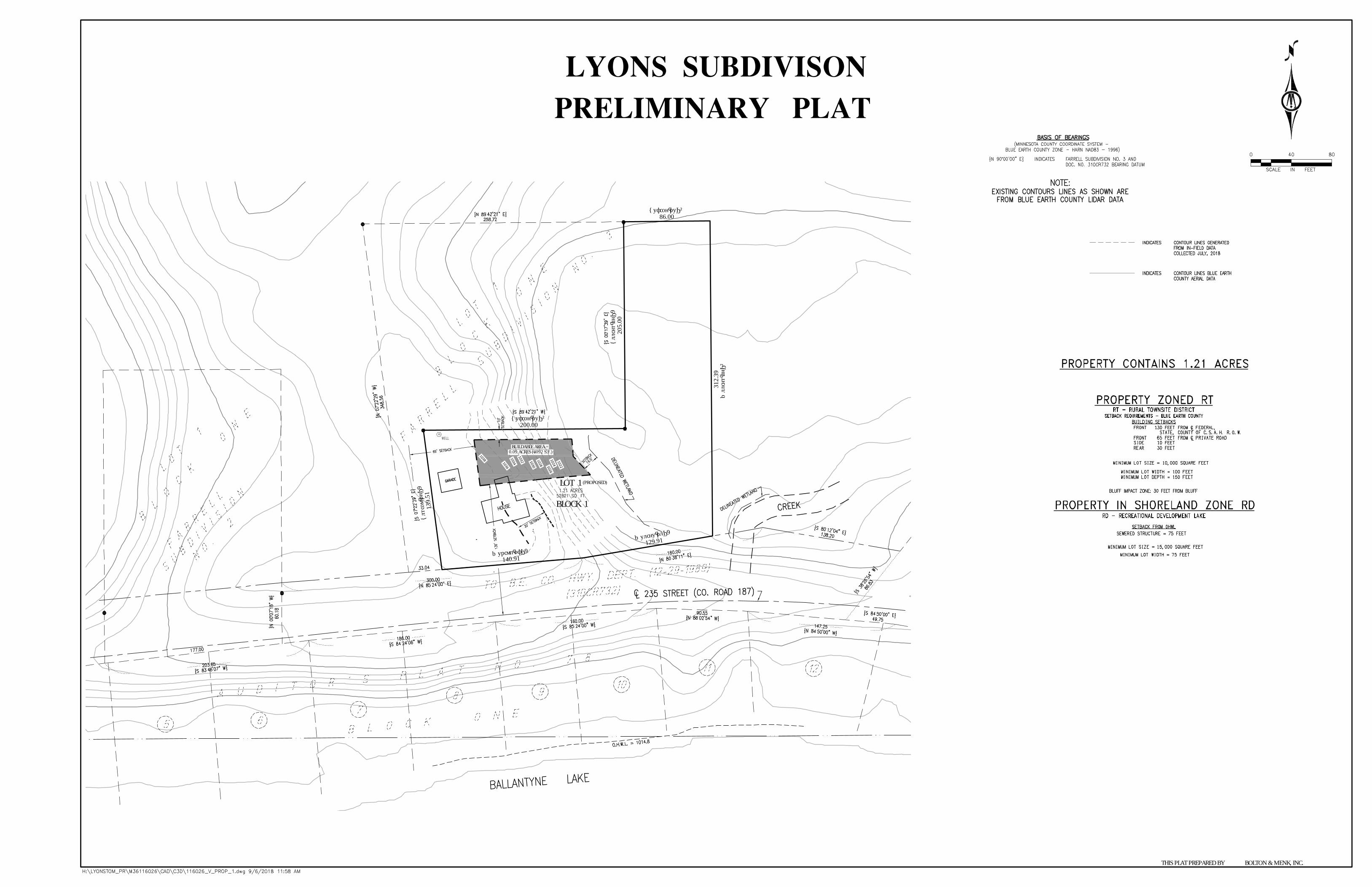
PC 21-18
Tom Lyons
Preliminary Plat
10/03/2018
1
Property Owner and Applicant
Tom Lyons
23560 Nuthatch Road
Madison Lake, MN 56063
Request and Location
Request for review and approval of the Preliminary Plat of the Lyons Subdivision, a Subdivision
Plat consisting of one lot. This portion of the property is zoned Rural Townsite. It is also within
the Shoreland Overlay District of Lake Ballantyne and the Urban Fringe Overlay District of the
City of Madison Lake. The proposed plat is located in the Southeast Quarter of the Northeast
Quarter of Section 28, Jamestown Township.
Legal Description
As defined on the Plat of Lyons Subdivision.
Zoning
The property is zoned Rural Townsite.
General Site Description and Project Proposal
The entire parcel has been in the Lyons family for several generations. Within the larger parcel are
areas of farm land, wooded areas, steep slopes, a small creek, and large areas of wetland. Over
time, portions of the parcel have been cut-out to accommodate other Subdivision Plats and
residential developments. Currently, the 78.06-acre parcel has one residential structure that was
constructed in 1887, a 20’ x 20’ detached garage that was built in 1950, and a small 10’ x 12’
garden shed.
The house has fallen into disrepair and the applicant does not have the desire to reconstruct it.
However, he would like to retain ownership of the surrounding property for the future enjoyment
of his family. In September of 2018, a Variance was approved to reduce the required Buildable
Area from 43,560 ft2 to 4,092 ft2. The applicant is now requesting approval of a Preliminary Plat
to allow for the developed portion of the parcel to be split from the larger remaining parcel.
Project Outcome
If approved, the Lyons Subdivision will include one lot. See Attachment A-3
• Lot 1 Block 1 – will include a 1.21-acre Parcel with a 4,092 ft2 Buildable Area
Existing Land Use within One Mile
North: One residential property, woodland, cropland, Mud Lake, and areas of wetland
South: County Road 187, several residential properties, and Lake Ballantyne
East: An unnamed creek, areas of wetland, two residential properties, cropland, a boundary for
the City of Madison Lake, and Duck Lake
West: Woodland, areas of wetland, several residential properties, a private pond, and cropland
PC 21-18
Tom Lyons
Preliminary Plat
10/03/2018
2
Access
No change in access is being proposed. The existing access is to and from County Road 187. The
Access is secured by an Access Easement, Recorded in 1994. This easement agreement gives
permanent Access to the property using the driveway of the residential property to the north, Lot
1 of the Farrell Subdivision No.3.
Land Use Plan
The Urban Development Goal of the current Land Use Plan calls for the County to support orderly
growth out from urban areas with urban utility services. As discussed previously, this is an
urbanized area by Blue Earth County standards and most of the properties in this area have
connections to the sewer district. Therefore, it appears the proposal is not in conflict with the
currently adopted Land Use Plan.
NATURAL RESOURCES INFORMATION
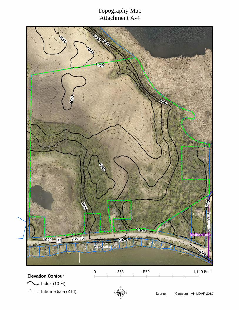
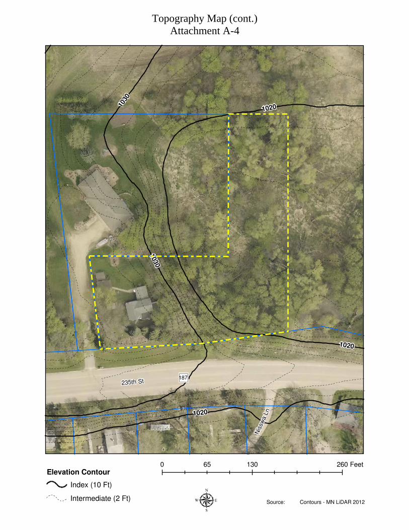
Topography
The topography of this site ranges between areas of gradual elevation changes to areas that meet
the County’s definition of a bluff. See Attachment A-4
Floodplain
The nearest area of mapped FEMA Floodplain is over 2 miles away. Therefore, no attachment has
been included.
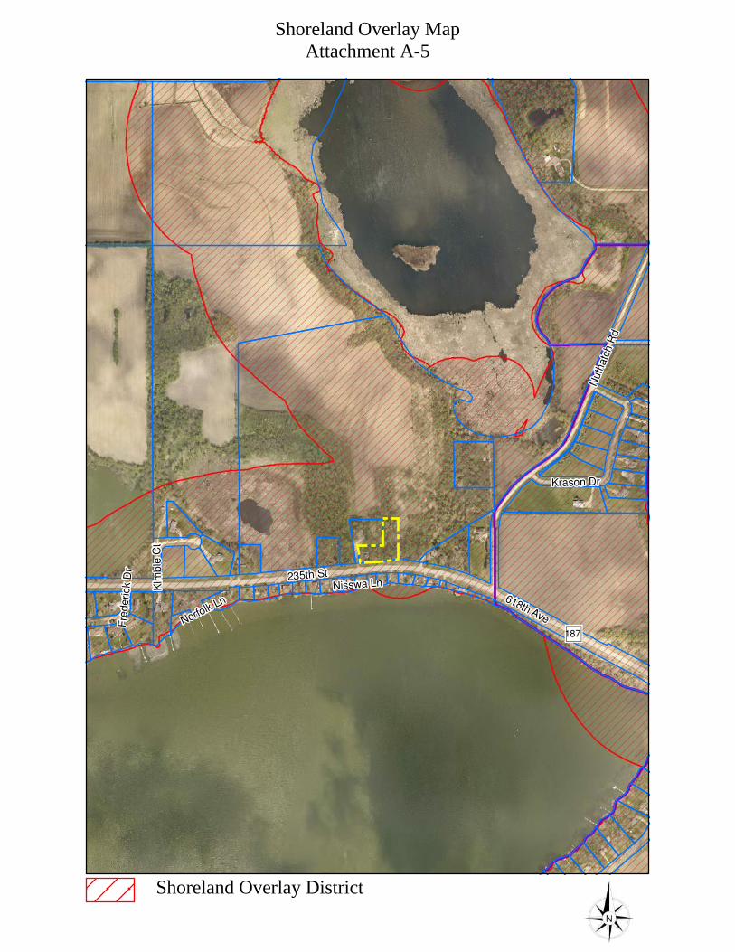
Shoreland
The entire property is within the Shoreland Overlay District of Madison Lake and Mud Lake.
See Attachment A-5
Township Review
In a letter dated August 22, 2018, Jim Anderson the Clerk for Jamestown Township stated that the
applicant attended the August 2018 Township Meeting. During this meeting, the applicant
explained his proposed project. He also stated that he explored alternative options, but the survey
and wetland delineation proved that the current request is the minimum available around the
existing development. The Jamestown Township Board approved of the applicants request with
no additional conditions required.

PC 21-18
Tom Lyons
Preliminary Plat
10/03/2018
3
City of Madison Lake Review
On September 4, 2018 staff received an email from Curt Kephart, the City Administrator for the
City of Madison Lake. Mr. Kephart stated that this request was reviewed by the City Council at
their September 4th meeting. He stated that a primary concern expressed by the Council was related
to potential impacts to water quality, and the possible environmental impacts development could
impose on the existing conditions of this site. Mr. Kephart stated the City Council supports
whatever action is taken by the County’s Board of Adjustment but asked that staff ensures the
Board is aware of their concerns and implications of potential annexation.
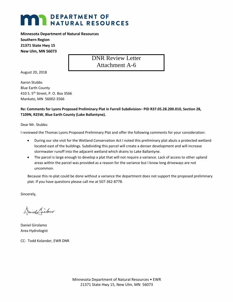
Minnesota Department of Natural Resources Review
Staff initially contacted the DNR for review comments on August 9, 2018. At that time, Area
Hydrologist Dan Girolamo stated he would review the request and provide comments the next
week. On August 15, 2018, Mr. Girolamo stated the DNR was not in favor of the request because
adding a second home to the property would negatively impact the nearby delineated wetland.
Staff contacted Mr. Girolamo and attempted to better explain the request. It was clarified that this
parcel currently has a residential structure that is considered a legal non-conforming structure
which could be repaired or replaced in its current 3D footprint under Subdivision 4 of MN State
Statute 394.36 NONCONFORMITIES. It was also reiterated that this request would not allow
a second dwelling to be built on the property. At that time, Mr. Girolamo stated he would amend
his review comments. On August 20, 2018, Mr. Girolamo provided an amended review letter
which stated the DNR was not in support of the request and still referred to the construction of a
second dwelling on this property. Staff called Mr. Girolamo again to try and further clarify the
request. Mr. Girolamo sent an email on August 22, 2018 stating that the last letter he sent was the
final review letter from the DNR. Staff replied to Mr. Girolamo’s email and explained that his
review comments still did not reflect accurate information because there was not a second dwelling
being proposed, nor would the approval of this request allow for a second dwelling to be
constructed on this parcel. On August 23, 2018, Dan Girolamo sent staff a third review letter. In
this letter he stated the DNR does not support this request. He stated that subdividing this parcel
will create a denser development and will increase stormwater runoff into the adjacent wetlands.
In addition, he stated that the parcel is large enough to develop a plat which does not require a
variance. He stated that lack of access to other upland areas was provided as a reason for the
variance but that long driveways are not uncommon. See Attachment A-6
Environmental Health Review
See Attachment A-7

PC 21-18
Tom Lyons
Preliminary Plat
10/03/2018
4
APPLICABLE SECTIONS OF THE CODE OF ORDINANCES
Sec. 20-81. – Major subdivision plat determination
The determination of when a Plat is required shall be based upon existing and proposed land
divisions within each individual quarter-quarter section. A Plat is required if any of the following
conditions exist:
1.) A land division is proposed in any area outside of either the Agricultural, or Conservation
zoning districts, except when exempted in Section 20-102 (e) or (f)
CODE OF ORDINANCES REVIEW
Based on the information submitted by the applicant, contained in this report, and as required in
Section 24-47 (f) (l), of the Blue Earth County Code of Ordinances, the following opinions have
been developed for this request:
1. That the proposed subdivision conforms with the county land use plan.
2. That the proposed subdivision conforms with the county land division ordinance.
3. That the proposed subdivision will not degrade the water quality of the county.
4. That the proposed subdivision will not adversely increase the quantity of water runoff.
5. That soil conditions are adequate to accommodate the proposed subdivision.
6. That the proposed subdivision does not create a potential pollution hazard.
7. That adequate utilities, access roads, drainage and other necessary facilities have been or are
being provided.
8. That the proposed subdivision will not be injurious to the use and enjoyment of other property
in the immediate vicinity for the purposes already permitted.
9. That the establishment of the proposed subdivision will not impede the normal and orderly
development and improvement of surrounding vacant property for predominant uses in the
area.
Recommendation
Staff recommends APPROVAL of the Preliminary Subdivision Plat of the Lyons Subdivision, a
subdivision consisting of one lot contingent upon the following conditions:
1. Prior to applying for the Final Plat, the property owner shall have the currently unsealed well,
located on the west side of the property, sealed by a licensed well contractor.
PC 21-18
Tom Lyons
Preliminary Plat
10/03/2018
5
Attachments:
A-1 General Location Map
A-2 Site Map
A-3 Preliminary Plat
A-4 Topography Map
A-5 Shoreland Overlay Map
A-6 DNR Review Letter
A-7 Environmental Health Comments

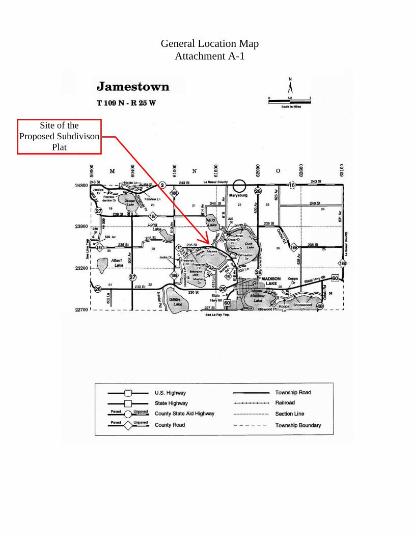
Attachment A-1
General Location Map
General Location MapAttachment A-1
Site of theProposed Subdivison
Plat
!
!
!
!
!
!
!
!
!!
!!
! ! !!!
!
!!!
!!
235th St
Nisswa Ln
")187
Madison Lake
µ0 490 980245 Feet
Current Site MapAttachment A-2

!
!
!
!!
!
235th St
Nisswa Ln
")187
µ0 120 24060 Feet
Current Site Map (cont.)Attachment A-2
S 07
°31'
52" E
139.
51S 89°32'58" W
200.00
S 00
°27'
02" E
205.
00
S 89°32'58" W86.00
N 0
0°27
'02"
W31
2.39
N 80°28'50" E
129.91
N 85°14'39" E140.91
BLOCK 1
LOT 1
10361034
1032 10301028 102610241022
1038
(PROPOSED)
0.09 ACRES (4092 S.F.)BUILDABLE AREA =
LYONS SUBDIVISON
BOLTON & MENK, INC.THIS PLAT PREPARED BY
PRELIMINARY PLAT
235th St
Nuth
at c
h R
d
Nisswa Ln
")187
1020
1030
1040
1050
1020
10301
020
1020
1030
1040
1050
1020
1050
1050
Madison Lake
µ
0 570 1,140285 Feet
-
Elevation Contour
Index (10 Ft)
Intermediate (2 Ft)Source: Contours - MN LiDAR 2012
Topography MapAttachment A-4
235th St
Nis
swa L
n
")187
1020
1030
1020
1020
1030
µ
0 130 26065 Feet
-
Elevation Contour
Index (10 Ft)
Intermediate (2 Ft)Source: Contours - MN LiDAR 2012
Topography Map (cont.)Attachment A-4
")187
235th St
Nuth
atc
h R
d
618th Ave
Krason Dr
Norfolk Ln
Nisswa Ln
Kim
ble
Ct
Fre
de
rick D
r
Shoreland Overlay MapAttachment A-5
Shoreland Overlay District
Minnesota Department of Natural Resources • EWR 21371 State Hwy 15, New Ulm, MN 56073
Minnesota Department of Natural Resources
Southern Region
21371 State Hwy 15
New Ulm, MN 56073
August 20, 2018
Aaron Stubbs
Blue Earth County
410 S. 5th Street, P. O. Box 3566
Mankato, MN 56002-3566
Re: Comments for Lyons Proposed Preliminary Plat in Farrell Subdivision– PID R37.05.28.200.010, Section 28,
T109N, R25W, Blue Earth County (Lake Ballantyne).
Dear Mr. Stubbs:
I reviewed the Thomas Lyons Proposed Preliminary Plat and offer the following comments for your consideration:
During our site visit for the Wetland Conservation Act I noted this preliminary plat abuts a protected wetland
located east of the buildings. Subdividing this parcel will create a denser development and will increase
stormwater runoff into the adjacent wetland which drains to Lake Ballantyne.
The parcel is large enough to develop a plat that will not require a variance. Lack of access to other upland
areas within the parcel was provided as a reason for the variance but I know long driveways are not
uncommon.
Because this re-plat could be done without a variance the department does not support the proposed preliminary
plat. If you have questions please call me at 507-362-8778.
Sincerely,
Daniel Girolamo
Area Hydrologist
CC: Todd Kolander, EWR DNR
DNR Review LetterAttachment A-6

Environmental Health ReviewAttachment A-7

PC 22-18
SN Mankato LLC and W W Land Company LLC
Bluff Impact Zone Cutting & Filling Backslope Project
10/03/2018
1
Property Owners and Applicants
SN Mankato LLC W W Land Company LLC
PO Box 6699 53936 208th Lane
Rochester, MN 55903 Mankato, MN 56001
Request and Location
Request for review and approval of a conditional use permit to cut and fill in a Bluff Impact Zone
as part of a ravine stabilization project. The property is zoned Highway Business and is within the
Urban Fringe Overlay District of the City of Mankato. The site is located in the southeast corner
of the southwest quarter of the northeast quarter of Section 19, South Bend Township.
General Site Description and Project Proposal
The site involves three properties and includes a ravine system needing repair. Two of the
properties are owned by SN Mankato and one by W W Land Company. The stabilization project
will include cutting and/or filling in a bluff impact zone, which requires approval of a conditional
use permit. The project has been designed by an engineer. A variance request was scheduled to
be reviewed by the Board of Adjustment on October 3rd. The variance request was to increase the
allowed three-feet horizontal to one-foot vertical backslope to two-feet horizontal to one-foot
vertical. The outcome of the variance request was unknown at the time this report was written.
Project Outcome
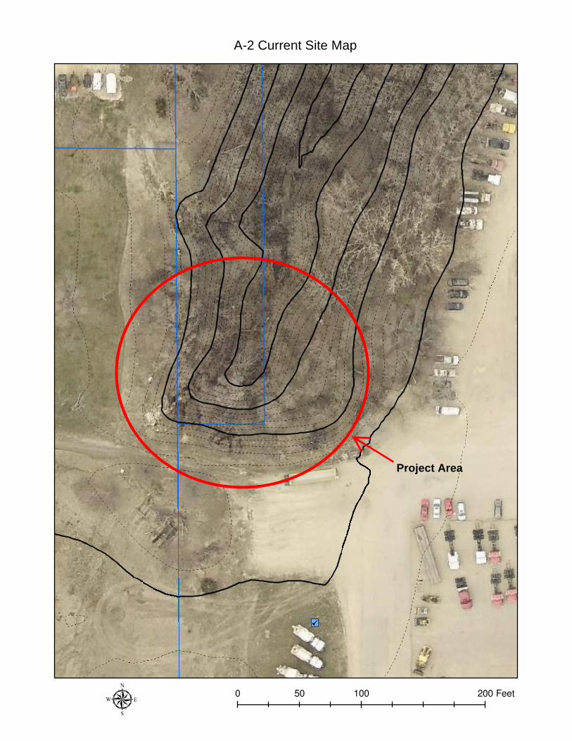
If approved, the applicants will move forward with the ravine stabilization. See Attachment A-2
Land Use Plan
The current Land Use Plan adopted in 1998 lists the following item as Goals or Policies in Blue
Earth County:
• Natural Environment Protection Goal – It is the County’s best interest to adopt performance
standards to protect natural resources such as bluff areas, rivers, wetlands, and wooded
areas from development pressures.
Access
No change in access is being proposed. The existing access is to and from 208th Lane which serves
as a frontage road to US Hwy 169.
PC 22-18
SN Mankato LLC and W W Land Company LLC
Bluff Impact Zone Cutting & Filling Backslope Project
10/03/2018
2
Existing Land Use within ¼ mile of the Project Area
North: The continuation of the wooded ravine system which leads to Minneopa Creek, one
feedlot, one residence, the Chicago and Northwestern Railroad, and Minneopa Creek
Northwest: A business owned by one of the applicants and cropland
South: US Hwy 169 and cropland
Southeast: US Hwy 169, cropland and three businesses
East: One business owned by one of the applicants, three single family dwellings and
CSAH 69
West: Three businesses and cropland
Southwest: Junction of US Hwy 169 and State Hwy 60 and cropland
NATURAL RESOURCES INFORMATION
Topography
The topography of the surrounding area leading to the ravine system has a gentle slope. The ravine
system has topography features that meet the County’s definition of a bluff. See Attachment A-2
Floodplain
Although Minneopa Creek likely includes areas prone to flooding, it has not been mapped by
FEMA. The nearest area of mapped FEMA floodplain is over one mile away. Therefore, no
attachment has been included.
Shoreland
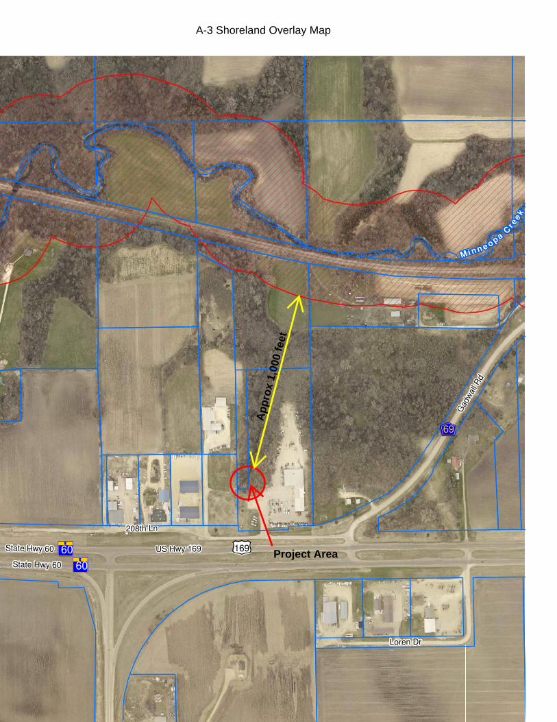
The nearest area of shoreland is approximately 1,000 feet away.
See Attachment A-3
Township Review
The applicants were scheduled to meet with the Township at their October 2nd meeting. At the
time this report was written, no comments had been received from the township.
City of Mankato Review
At the time this report was written, no comments had been received from the city.
Environmental Health Review
See Attachment A-5
PC 22-18
SN Mankato LLC and W W Land Company LLC
Bluff Impact Zone Cutting & Filling Backslope Project
10/03/2018
3
APPLICABLE SECTIONS OF THE CODE OF ORDINANCES
Sec. 24-3 Definitions and word usage
Filling means any soil, earth, sand, gravel, rock or any similar material deposited, placed, pushed,
pulled or transported and shall include the conditions resulting there from.
Grading means changing the natural or existing topography of the land.
Sec. 24-304 Erosion Control
(c) Development of bluff zones and steep slopes.
(3) Filling or cutting activity in any bluff zone shall be considered a conditional use. In no case
shall cutting or filling be allowed for the purpose of establishing a site for the erection of a
structure.
(d) Erosion and sediment control.
(1) Erosion and siltation control measures shall be coordinated with the different stages of
development. Appropriate control measures shall be installed prior to development when
necessary to control erosion…
(4) Whenever possible, natural vegetation shall be retained and protected.
(6) When soil is exposed, the exposure shall be for the shortest feasible period of time. No
exposure shall be planned to exceed 60 days. Such time period may be extended only if the
Planning Commission is satisfied that adequate protective measures have been established
and will remain in place.
(e) Exposed slopes.
(1) No exposed slope should be steeper in grade than three (3) feet horizontal to one (1) foot
vertical.
(4) Exposed slopes shall be protected by whatever means will effectively prevent erosion
considering the degree of slope, soils material and expected length of exposure. Slope
protection shall consist of mulch, sheets of plastic, burlap or jute netting, sod blanket,
erosion mat, fast growing grasses or temporary seeding of annual grasses. Mulch consists
of hay, straw, wood chips, corn stalks, bark or other protective material. Mulch should be
anchored to slopes with liquid asphalt, stakes and netting, or worked into the soil to provide
additional slope stability.
(5) Control measures, other than those specifically stated in this subsection, may be used in
place of such measures if they will as effectively protect exposed slopes.
PC 22-18
SN Mankato LLC and W W Land Company LLC
Bluff Impact Zone Cutting & Filling Backslope Project
10/03/2018
4
STANDARDS FOR GRANTING A CONDITIONAL USE PERMIT
Sec. 24-47 Planning Commission
(f) Findings required.
1) Enumeration. The Planning Commission shall not forward a recommendation of approval for
a conditional use permit unless they find the following facts at the hearing where the applicant
shall present a statement and evidence in such form as the Planning Agency may require:
a. That the proposed use conforms with the county land use plan.
b. The demonstrated need for the proposed use.
c. That the proposed use will not degrade the water quality of the county.
d. That the proposed use will not adversely increase the quantity of water runoff.
e. That soil conditions are adequate to accommodate the proposed use.
f. That the proposed use does not create a potential pollution hazard.
g. That adequate utilities, access roads, drainage and other necessary facilities have been or
are being provided.
h. That adequate measures have been or will be taken to provide sufficient off-street parking
and loading space to serve the proposed use.
i. That facilities are provided to eliminate any traffic congestion or traffic hazard which may
result from the proposed use.
j. That the conditional use will not be injurious to the use and enjoyment of other property in
the immediate vicinity for the purposes already permitted.
k. That the establishment of the conditional use will not impede the normal and orderly
development and improvement of surrounding vacant property for predominant uses in the
area.
l. That adequate measures have been or will be taken to prevent or control offensive odor,
fumes, dust, noise and vibration, so that none of these will constitute a nuisance, and to
control lighted signs and other lights in such a manner that no disturbance to neighboring
properties will result.
m. That the density of proposed residential development is not greater than the density of the
surrounding neighborhood or not greater than the density indicated by the applicable
zoning district.

PC 22-18
SN Mankato LLC and W W Land Company LLC
Bluff Impact Zone Cutting & Filling Backslope Project
10/03/2018
5
n. That the intensity of proposed commercial or industrial development is not greater than the
intensity of the surrounding uses or not greater than the intensity characteristic of the
applicable zoning district.
o. That site-specific conditions and such other conditions are established as required for the
protection of the public's health, safety, morals and general welfare.
Proposed Findings of Facts
(The proposed findings below are directly related to the above standards, labeled, items a-o)
After careful review of the project and all associated documents, staff has developed the following
suggested findings for this project:
a. That the proposed use conforms with the county land use plan.
The Natural Environment Goal of the current Land Use Plan states: Blue Earth County
contains large areas of sensitive land. It is in the County’s best interest to adopt performance
standards to protect natural resources such as bluff areas… from development pressures. The
ravine system has been in place for many years. It is certainly possible, if not likely, that
development of the highway system and the addition of impervious surface area on neighboring
properties is contributing to the problem. By addressing the problem with an engineered plan,
the ravine system will be stabilized. With continued monitoring and maintenance, the sediment
leaving the area leading to Minneopa Creek will be reduced. Therefore, it appears the request
is consistent with the intent of the comprehensive plan.
b. The demonstrated need for the proposed use.
The head of the ravine system is actively eroding and will likely continue to expand if not
corrected. The expansion of the ravine head will cause further sediment to leave the area.
Therefore, it appears that a need for the proposed use has been established.
c. That the proposed use will not degrade the water quality of the county.
In addition to preventing the continued expansion of the ravine head, the project will also
reduce sediment from leaving the site and moving toward Minneopa Creek. Therefore, the
project will not likely degrade the water quality of the county.
d. That the proposed use will not adversely increase the quantity of water runoff.
The ravine stabilization project itself should not increase the quantity of water runoff.
Additional parking space is proposed in the area, but that expansion is not specifically part of
the ravine stabilization project. Therefore, it seems unlikely that the project would adversely
increase the quantity of water runoff.
e. That soil conditions are adequate to accommodate the proposed use.
The engineered plans are required to ensure as much as possible, the project area will be
stabilized.
PC 22-18
SN Mankato LLC and W W Land Company LLC
Bluff Impact Zone Cutting & Filling Backslope Project
10/03/2018
6
f. That the proposed use does not create a potential pollution hazard.
At no point should the proposed project generate any pollutants, and therefore would not likely
pose a pollution risk to the county.
g. That adequate utility, access roads, drainage and other necessary facilities have been or are
being provided.
The proposal has been reviewed by the County’s Wetland Specialist as well as Planning and
Zoning staff. They expressed no concerns with the proposed project area provided the
engineering specifications are followed. If all erosion control measures are properly installed
and maintained, it appears likely that the necessary drainage is being provided.
h. That adequate measures have been or will be taken to provide sufficient off-street parking and
loading space to serve the proposed use.
This standard does not apply to this request.
i. That facilities are provided to eliminate any traffic congestion or traffic hazard which may
result from the proposed use.
This standard does not apply to this request.
j. That the conditional use will not be injurious to the use and enjoyment of other property in the
immediate vicinity for the purposes already permitted.
This request is for a ravine/bluff stabilization project on a parcel in the Highway Business
zoned area. The stabilization of this ravine and bluff seems unlikely to be injurious to the use
and enjoyment of the properties in the immediate vicinity.
k. That the establishment of the conditional use will not impede the normal and orderly
development and improvement of surrounding vacant property for predominant uses in the
area.
The proposed use does not create any additional setback requirements for a residential or
industrial structure. Therefore, it seems unlikely that this project would impede the
development of surrounding vacant property in the area.
l. That adequate measures have been or will be taken to prevent or control offensive odor, fumes,
dust, noise and vibration, so that none of these will constitute a nuisance, and to control lighted
signs and other lights in such a manner that no disturbance to neighboring properties will result.
This project will occur in an area that is zoned Highway Business. None of the activities
related to this project should be greater in intensity than the surrounding uses, and therefore
should not generate any of the above listed items to the point where they become a nuisance.
m. That the density of proposed residential development is not greater than the density of the
surrounding neighborhood or not greater than the density indicated by the applicable zoning
district.
This standard does not apply to this request.
PC 22-18
SN Mankato LLC and W W Land Company LLC
Bluff Impact Zone Cutting & Filling Backslope Project
10/03/2018
7
n. That the intensity of proposed commercial or industrial development is not greater than the
intensity of the surrounding uses or not greater than the intensity characteristic of the applicable
zoning district.
This standard does not apply to this request.
o. That site-specific conditions and such other conditions are established as required for the
protection of the public's health, safety, morals and general welfare.
The protection of the public's health, safety, morals and general welfare are addressed in the
conditions recommended below.
Recommendations
Staff recommends APPROVAL of the permit to cut and fill in a Bluff Impact Zone as part of a
ravine stabilization project. with the following conditions:
1. Prior to the commencement of the stabilization project, the applicant shall apply for, and
obtain a County Land Disturbance Permit.
2. All necessary erosion control measures shall be installed prior to the commencement of
this proposed project and properly maintained.
3. Any changes to the approved stabilization plan shall be reviewed and approved by the
Planning Agency prior to the commencement of the proposed changes.
4. If approved, the stabilization project shall commence within one year of the date of final
approval. Any proposed time extensions shall first be reviewed by the Planning Agency.
5. Within 30 days of completion of the project, an as-built report from the consulting engineer
shall be provided to the Planning Agency. Said report shall also verify the elevation of the
stormwater intakes and the wetland boundary.
6. No fill may be placed within the wetland boundary, including snow from snow removal.
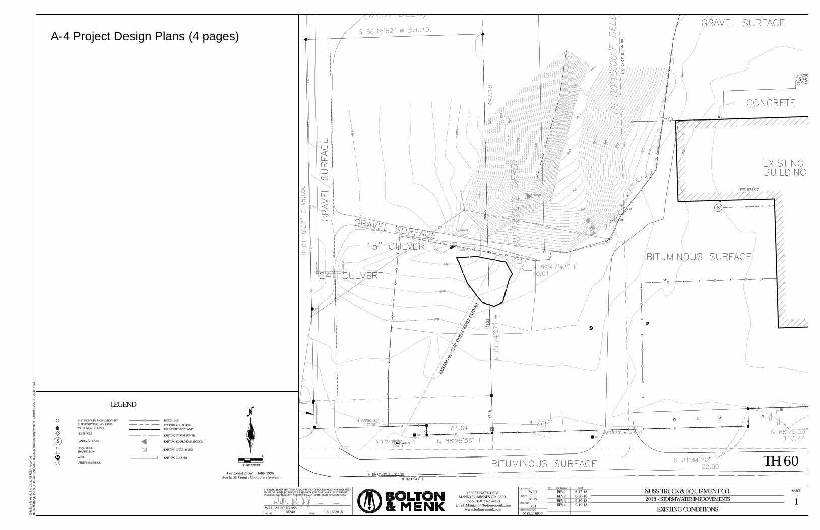
Attachments
A-1 General Location Map
A-2 Current Site Map
A-3 Shoreland Overlay Map
A-4 Project Design Plans
A-5 Environmental Health Review


Attachment A-1
General Location Map
�e
µ0 100 20050 Feet
A-2 Current Site Map
Project Area
+,169
EF69
?A@60?A@60
208th Ln
US Hwy 169
Gad
wal
l Rd
Loren Dr
State Hwy 60
State Hwy 60
M inn e opa Cre
ek
A-3 Shoreland Overlay Map
Project Area
App
rox
1,00
0 fe
et
S S
S
FFE=974.07
>>
>>
>>
>>
>>
>>
>>
>>
>>
>>
>>
>>
>>
>>
SCALE IN FEET
0 30
Horizontal Datum: HARN 1996Blue Earth County Coordinate System
1EXISTING CONDITIONS
DATELIC. NO.
I HEREBY CERTIFY THAT THIS PLAN, SPECIFICATION, OR REPORT WAS PREPAREDBY ME OR UNDER MY DIRECT SUPERVISION AND THAT I AM A DULY LICENSEDPROFESSIONAL ENGINEER UNDER THE LAWS OF THE STATE OF MINNESOTA.
SHEET
Bol
ton
& M
enk,
Inc.
201
8, A
ll Ri
ghts
Res
erve
dc H:
\NU
SSTR
UCK
_PR\
M13
1169
36\C
AD\C
3D\1
1693
6_St
orm
wat
erIm
prov
emen
ts.d
wg
9/19
/201
8 10
:12:
47 A
M
DESIGNED
DRAWN
CHECKED
CLIENT PROJ. NO.
ISSUED FOR DATENO.
R
1960 PREMIER DRIVEMANKATO, MINNESOTA 56001
Phone: (507) 625-4171Email: [email protected]
www.bolton-menk.comWILLIAM DOUGLASS18240 08/16/2018
NUSS TRUCK & EQUIPMENT CO.2018 - STORMWATER IMPROVEMENTS
WRD
MDS
JCH
M13.116936
DELINEATED WETLAND
TH 60
>> EXISTING STORM SEWER
LEGEND
REV 1 8-17-18REV 2 8-30-18
3/4" IRON PIPE MONUMENT SETMARKED BY REG. NO. 19789MONUMENT FOUND
HAND HOLE
LIGHT POLE
SANITARY COVER
TRAFFIC SIGN
UTILITY MANHOLE
FENCE LINE
WELL
PROPERTY / LOT LINE
SEX
ISTIN
G 60
" CM
P ST
ORM
SEW
ER O
UTFA
LL
REV 3 9-10-18
EXISTING FLARED END SECTION
EXISTING CATCH BASIN
EXISTING CULVERT
REV 4 9-19-18
A-4 Project Design Plans (4 pages)
LP TANKS
MS
MS
MS
MS
MSMS
MS
MS
MS
MS
MS
MSMS
MS
>>>>
>>
>>
>>
>>
>>
>>
>>
>>
>>
>>
>>
>>
>>
>>
>>
>>
>>
>>
>>
MSMSMS
SCALE IN FEET
0 30
Horizontal Datum: HARN 1996Blue Earth County Coordinate System
2STORM SEWER AND EROSION CONTROL
DATELIC. NO.
I HEREBY CERTIFY THAT THIS PLAN, SPECIFICATION, OR REPORT WAS PREPAREDBY ME OR UNDER MY DIRECT SUPERVISION AND THAT I AM A DULY LICENSEDPROFESSIONAL ENGINEER UNDER THE LAWS OF THE STATE OF MINNESOTA.
SHEET
Bol
ton
& M
enk,
Inc.
201
8, A
ll Ri
ghts
Res
erve
dc H:
\NU
SSTR
UCK
_PR\
M13
1169
36\C
AD\C
3D\1
1693
6_St
orm
wat
erIm
prov
emen
ts.d
wg
9/19
/201
8 10
:13:
00 A
M
DESIGNED
DRAWN
CHECKED
CLIENT PROJ. NO.
ISSUED FOR DATENO.
R
1960 PREMIER DRIVEMANKATO, MINNESOTA 56001
Phone: (507) 625-4171Email: [email protected]
www.bolton-menk.comWILLIAM DOUGLASS18240 08/16/2018
NUSS TRUCK & EQUIPMENT CO.2018 - STORMWATER IMPROVEMENTS
WRD
MDS
JCH
M13.116936
DELINEATED WETLAND
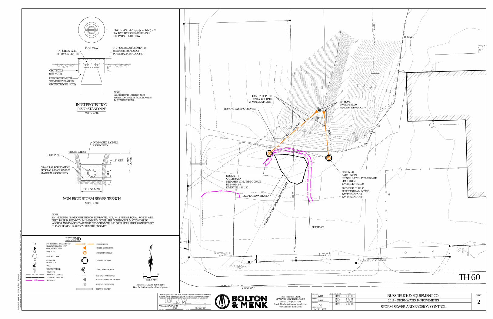
15" HDPE - 97 LIN FT
15" HDPE - 1
33 LIN FT
SILT FENCEMS TH 60
PLAN VIEW
1'-0
"
1'-0" UNLESS ADJUSTMENT ISREQUIRED BECAUSE OFPOTENTIAL FOR FLOODING
NOT TO SCALE
NOTE:ALL GEOTEXTILE USED FOR INLETPROTECTION SHALL BE MONOFILAMENTIN BOTH DIRECTIONS
INLET PROTECTIONRISER STANDPIPE
PERFORATED METALSTANDPIPE WRAPPEDGEOTEXTILE (SEE NOTE)
GEOTEXTILE(SEE NOTE)
1" HOLES SPACED8"-10" ON CENTER
ANTIVORTEX ROD, 5/8"Ø MINIMUM,TACK WELD TO STANDPIPE ANDSET PARALLEL TO FLOW
>> STORM SEWER
LEGEND
15" HDPEINVERT=938.00RANDOM RIPRAP, CL IV
BURY 15" HDPE ONVARIABLE GRADE
2' MINIMUM COVER
DELINEATED WETLAND
DESIGN - HCATCH BASINNEENAH R-1733, TYPE C GRATERIM = 964.99INVERT NE = 961.50
DESIGN - HCATCH BASINNEENAH R-1733, TYPE C GRATERIM = 968.50INVERT NE = 965.00
PROVIDE FUTURE 4"PE UNDERDRAIN ACCESSINVERT E = 965.10INVERT S = 965.10
REMOVE EXISTING CULVERT
SILT FENCE
NON-RIGID STORM SEWER TRENCHNOT TO SCALE
OD + 24" MAX
12" MIN
6"
OD
COMPACTED BACKFILLAS SPECIFIED
GRANULAR FOUNDATION,BEDDING & ENCASEMENTMATERIAL AS SPECIFIED
HDPE PIPE
2' M
INCO
VER
GROUND SURFACE
NOTE15" HDPE PIPE IS SMOOTH INTERIOR, DUAL-WALL, ADS, N-12 PIPE OR EQUAL, WHICH WILLNEED TO BE BURIED WITH 24" MINIMUM COVER. THE CONTRACTOR MAY CHOOSE TOANCHOR AND DAYLIGHT A BUTT-FUSED SOLID WALL 16" DR 21 HDPE PIPE PROVIDED THATTHE ANCHORING IS APPROVED BY THE ENGINEER.
REV 1 8-17-18REV 2 8-30-18
3/4" IRON PIPE MONUMENT SETMARKED BY REG. NO. 19789MONUMENT FOUND
HAND HOLE
LIGHT POLE
SANITARY COVER
TRAFFIC SIGN
UTILITY MANHOLE
FENCE LINE
WELL
PROPERTY / LOT LINE
EXIST
ING
60" C
MP
STOR
M SE
WER
OUT
FALL
REV 3 9-10-18
FLARED END SECTION
STORM SEWER INLET
RANDOM RIPRAP, CL IV
INLET PROTECTION
>> EXISTING STORM SEWER
EXISTING FLARED END SECTION
EXISTING CATCH BASIN
EXISTING CULVERT
REV 4 9-19-18

LP TANKS
MS
MS
MS
MS
MSMS
MS
MS
MS
MS
MS
MSMS
MS
>>>>
>>
>>
>>
>>
>>
>>
>>
>>
>>
>>
>>
>>
>>
>>
>>
>>
>>
>>
>>
MSMSMS
SCALE IN FEET
0 30
Horizontal Datum: HARN 1996Blue Earth County Coordinate System
3SLOPE REPAIR
DATELIC. NO.
I HEREBY CERTIFY THAT THIS PLAN, SPECIFICATION, OR REPORT WAS PREPAREDBY ME OR UNDER MY DIRECT SUPERVISION AND THAT I AM A DULY LICENSEDPROFESSIONAL ENGINEER UNDER THE LAWS OF THE STATE OF MINNESOTA.
SHEET
Bol
ton
& M
enk,
Inc.
201
8, A
ll Ri
ghts
Res
erve
dc H:
\NU
SSTR
UCK
_PR\
M13
1169
36\C
AD\C
3D\1
1693
6_St
orm
wat
erIm
prov
emen
ts.d
wg
9/19
/201
8 10
:13:
09 A
M
DESIGNED
DRAWN
CHECKED
CLIENT PROJ. NO.
ISSUED FOR DATENO.
R
1960 PREMIER DRIVEMANKATO, MINNESOTA 56001
Phone: (507) 625-4171Email: [email protected]
www.bolton-menk.comWILLIAM DOUGLASS18240 08/16/2018
NUSS TRUCK & EQUIPMENT CO.2018 - STORMWATER IMPROVEMENTS
WRD
MDS
JCH
M13.116936
DELINEATED WETLANDSILT FENCEMS TH 60
>> PROPOSED STORM SEWER
LEGEND
DELINEATED WETLAND
BACKFILL, GRADE, AND RESEEDBANK WITH SELECT BORROW TOMATCH THE EXISTING UNERODEDSLOPE (2:1 MAXIMUM SLOPE).6" (MIN) TOPSOIL, EROSIONCONTROL BLANKET AND MNDOT36-211 SEED MIXTURE
SILT FENCE
REV 1 8-17-18REV 2 8-30-18
3/4" IRON PIPE MONUMENT SETMARKED BY REG. NO. 19789MONUMENT FOUND
HAND HOLE
LIGHT POLE
SANITARY COVER
TRAFFIC SIGN
UTILITY MANHOLE
FENCE LINE
WELL
PROPERTY / LOT LINE
REV 3 9-10-18
PROPOSED FLARED END SECTION
PROPOSED STORM SEWER INLET
BACKFILL AREA AND EROSION CONTROL BLANKET
INLET PROTECTION
RANDOM RIPRAP, CL IV
>> EXISTING STORM SEWER
EXISTING FLARED END SECTION
EXISTING CATCH BASIN
EXISTING CULVERT
REV 4 9-19-18
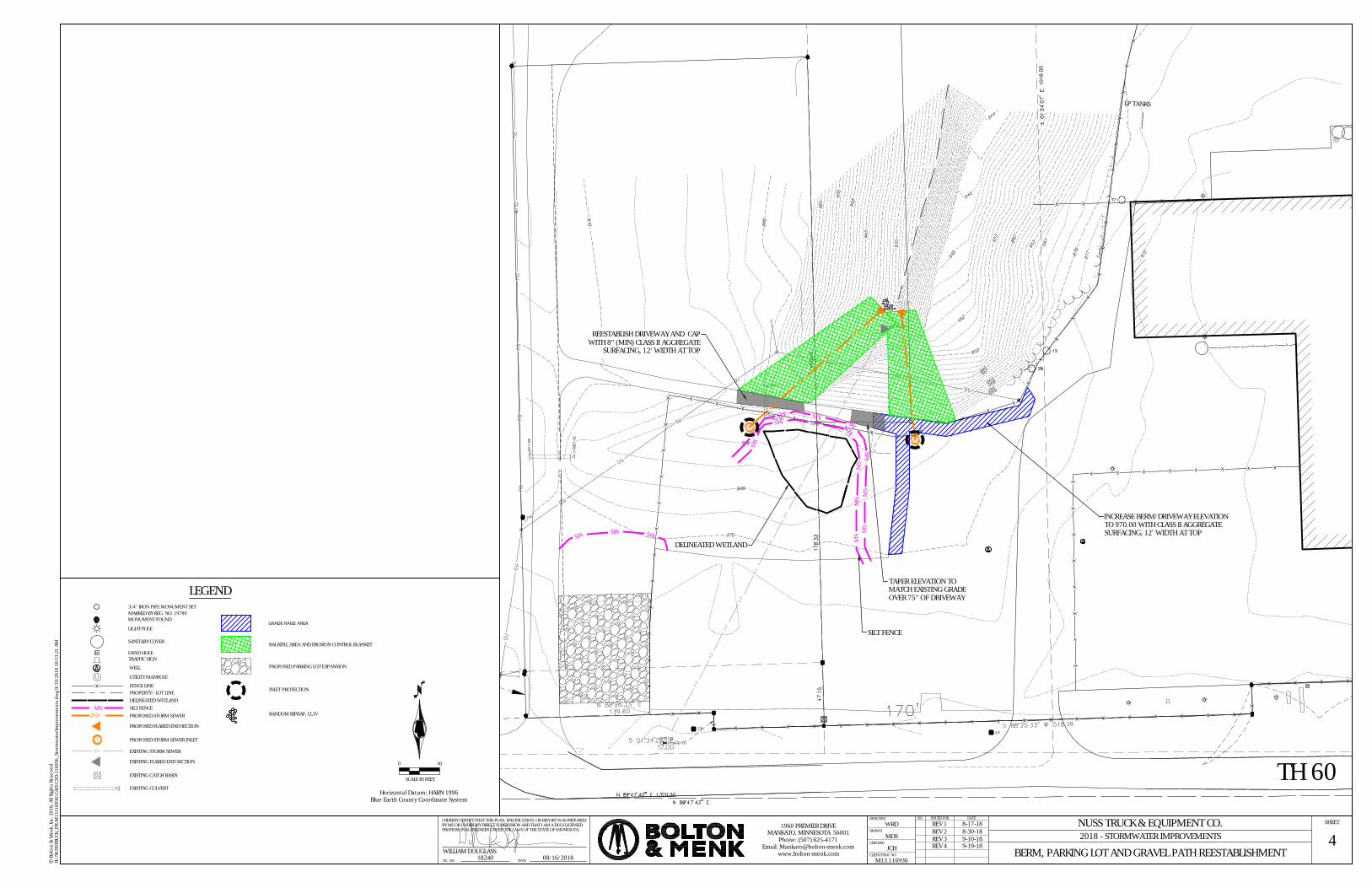
LP TANKS
MS
MS
MS
MS
MSMS
MS
MS
MS
MS
MS
MSMS
MS
>>>>
>>
>>
>>
>>
>>
>>
>>
>>
>>
>>
>>
>>
>>
>>
>>
>>
>>
>>
>>
MSMSMS
SCALE IN FEET
0 30
Horizontal Datum: HARN 1996Blue Earth County Coordinate System
4BERM, PARKING LOT AND GRAVEL PATH REESTABLISHMENT
DATELIC. NO.
I HEREBY CERTIFY THAT THIS PLAN, SPECIFICATION, OR REPORT WAS PREPAREDBY ME OR UNDER MY DIRECT SUPERVISION AND THAT I AM A DULY LICENSEDPROFESSIONAL ENGINEER UNDER THE LAWS OF THE STATE OF MINNESOTA.
SHEET
Bol
ton
& M
enk,
Inc.
201
8, A
ll Ri
ghts
Res
erve
dc H:
\NU
SSTR
UCK
_PR\
M13
1169
36\C
AD\C
3D\1
1693
6_St
orm
wat
erIm
prov
emen
ts.d
wg
9/19
/201
8 10
:13:
21 A
M
DESIGNED
DRAWN
CHECKED
CLIENT PROJ. NO.
ISSUED FOR DATENO.
R
1960 PREMIER DRIVEMANKATO, MINNESOTA 56001
Phone: (507) 625-4171Email: [email protected]
www.bolton-menk.comWILLIAM DOUGLASS18240 08/16/2018
NUSS TRUCK & EQUIPMENT CO.2018 - STORMWATER IMPROVEMENTS
WRD
MDS
JCH
M13.116936
DELINEATED WETLANDSILT FENCEMS
TH 60
>> PROPOSED STORM SEWER
GRADE RAISE AREA
LEGENDTAPER ELEVATION TOMATCH EXISTING GRADEOVER 75" OF DRIVEWAY
DELINEATED WETLAND
INCREASE BERM/DRIVEWAY ELEVATIONTO 970.00 WITH CLASS II AGGREGATESURFACING, 12' WIDTH AT TOP
REESTABLISH DRIVEWAY AND CAPWITH 8" (MIN) CLASS II AGGREGATE
SURFACING, 12' WIDTH AT TOP
SILT FENCE
REV 1 8-17-18REV 2 8-30-18
3/4" IRON PIPE MONUMENT SETMARKED BY REG. NO. 19789MONUMENT FOUND
HAND HOLE
LIGHT POLE
SANITARY COVER
TRAFFIC SIGN
UTILITY MANHOLE
FENCE LINE
WELL
PROPERTY / LOT LINE
REV 3 9-10-18
>> EXISTING STORM SEWER
EXISTING FLARED END SECTION
EXISTING CATCH BASIN
EXISTING CULVERT
PROPOSED FLARED END SECTION
PROPOSED STORM SEWER INLET
PROPOSED PARKING LOT EXPANSION
INLET PROTECTION
RANDOM RIPRAP, CL IV
BACKFILL AREA AND EROSION CONTROL BLANKET
REV 4 9-19-18
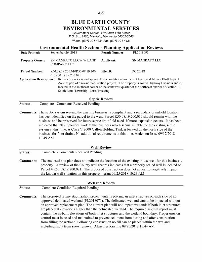
BLUE EARTH COUNTYENVIRONMENTAL SERVICES
Government Center, 410 South Fifth StreetP.O. Box 3566, Mankato, Minnesota 56002-3566
Phone: (507) 304-4381 Fax: (507) 304-4431
Environmental Health Section - Planning Application ReviewsDate Printed: September 26, 2018 Permit Number: PL2018093
Property Owner: SN MANKATO LLCW W LANDCOMPANY LLC
Applicant: SN MANKATO LLC
Parcel Number: R50.08.19.200.010R50.08.19.200.017R50.08.19.200.021
File ID: PC 22-18
Application Description: Request for review and approval of a conditional use permit to cut and fill in a Bluff ImpactZone as part of a ravine stabilization project. The property is zoned Highway Business and islocated in the southeast corner of the southwest quarter of the northeast quarter of Section 19,South Bend Township. Nuss Trucking
Septic ReviewStatus: Complete - Comments Received Pending
Comments: The septic system serving the existing business is compliant and a secondary drainfield locationhas been identified on the parcel to the west. Parcel R50.08.19.200.010 should remain with thebusiness and be preserved for future septic drainfield needs if more expansion occurs. It has beenindicated that 30 employees work at this business which seems suitable for the existing septicsystem at this time. A Class V 2000 Gallon Holding Tank is located on the north side of thebusiness for floor drains. No additional requirements at this time. Anderson Jesse 09/17/201810:49 AM
Well ReviewStatus: Complete - Comments Received Pending
Comments: The enclosed site plan does not indicate the location of the existing in-use well for this business /property. A review of the County well records indicates that a properly sealed well is located onParcel # R50.08.19.200.021. The proposed construction does not appear to negatively impactthe known well situation on this property. grant 09/25/2018 10:23 AM
Wetland ReviewStatus: Complete-Condition Required Pending
Comments: The proposed ravine stabilization project entails placing an inlet structure on each side of anapproved delineated wetland (PL2018071). The delineated wetland cannot be impacted withoutan approved replacement plan. The current plan will not impact wetlands if both inlet structuresare placed at elevations higher than the delineated wetland. The required as-built report mustcontain the as-built elevations of both inlet structures and the wetland boundary. Proper erosioncontrol must be used and maintained to prevent sediment from during and after constructionfrom filling the wetland. Following construction no fill can be placed within the wetland,including snow from snow removal. Altrichter Kristine 09/25/2018 11:44 AM
A-5


![FEDERAL ELECTION COMMISSION 11 CFR Part 100, 104, 114 ... · electioneering communications reporting provisions as constitutional because they “d[o] not prevent anyone from speaking?”](https://img.pdfslide.us/doc/110x75/5f3ed63ca927ed5f5e751097/federal-election-commission-11-cfr-part-100-104-114-electioneering-communications.jpg)