Embed Size (px)
Citation preview
Envirorlrnental Geology of H a r r i s o n Bay, Northern Alaska
By James U . Craig a n d Glenn P. Thrasher
Open-File Repor t 82-35
T h i s r e p o r t has n o t been e d i t e d f o r c o n f o r m i t y w i t h M i n e r a l s Management Service and U.S. Geological Survey e d i r o r i a l s t a n d a r d s o r s t r a t i g r a p h i c nomencla ture .
Any use of trade names is f o r d e s c r i p t i v e p u r p o s e s o n l y and d o e s not c o n s t i t u t e endorsement of these p r o d u c t s by the M i n e r a l s Management S e r v i c e and G e o l o g i c a l Survey .
CONTENTS
Page
. . . . . . . . . . . . . . . . . . . . . . . . Abstract ... 1
. . . . . . . . . . . . . . . . . . . . . . . . . . . Introduction 2
. . . . . . . . . . . . . . . . . . . . . . PurposeofStudy 2
. . . . . . . . . . . . . . . . . . . . . . Data Acquisition 2
. . . . . . . . . . . . . . . . . . . . . . . . . Surficial Geology 6
Bathymetry . . . . . . . . . . . . . . . . . . . . . . . . . 6
. . . . . . . . . Sea-floor Microrelief and Shelf Processes 7
. . . . . . . . . . Ice-Gouge Trends and Sea-floor Coverage 9
. . . . . . . . . . . . . . . . . . . . . . . . . . . Stratigraphy 1 2
Holocene Deposits . . . . . . . . . . . . . . . . . . . . . 1 2
Pleistocene Deposits . . . . . . . . . . . . . . . . . . . . 12
Late Cretaceous to Tertiary Deposits . . . . . . . . . . . . 16
Environmental Considerations . . . . . . . . . . . . . . . . . . . 20
Summary . . . . . . . . . . . . . . . . . . . . . . . . . . . . . . 23

ILLUSTKATIONS
P l a t e 1. Bathymetric Map of Harr ison Bay, Northern Alaska
2. Map of Sea-Floor Microre l ie f i n Harr ison Bay, Northern Alaska
3. Map of Sea-Floor Ice-Gouge C h a r a c t e r i s t i c s i n Xarr ison Bay, Northern Alaska
4. Isopach Map of Holocene Deposit in Harrison Bay, Northern Alaska
5. S t r u c t u r e Map of In fe r r ed Late Cretaceous t o T e r t i a r y Sect ion i n Harr ison Bay, Northern Alaska
6. Twelve-Channel CDP Seismic P r o f i l e w i th Veloc i ty Analysis and Recording Parameters
F igure 1. Survey Area i n Rela t ion t o Tenta t ive Boundary of S a l e 7 1 . . . . . . . . . . . . . . . . . . . . . . . . . 3
. . . . . . . . . . . . . . . . . . 2. Instrument Deployment 4
3. Sea-Floor P r o f i l e s . . . . . . . . . . . . . . . . . . . 8
4. Side-Scan Sonographs . . . . . . . . . . . . . . . . . . 10
5. Subbottom P r o f i l e s . . . . . . . . . . . . . . . . . . . 13
6. Near Trace Seismic P r o f i l e s . . . . . . . . . . . . . . . 1 8
iii

ABSTRACT
The s u r f i c i a l and shal low subsur face geology of Harrison Bay on t h e Beaufort Sea coas t was mapped as p a r t of t h e U.S. Geological Survey's p r e l e a s e eva lua t ion f o r Outer Cont inenta l Shelf (OCS) O i l and Gas Lease S a l e 71. During the 1980 summer season, approximately 1600 km of muli- sensored, h igh- reso lu t ion geophysical p r o f i l e d a t a were c o l l e c t e d along a r e c t a n g u l a r g r i d with 4.8 km l i n e spacing. I n t e r p r e t a t i o n of t he se d a t a i s presented on f i v e maps showing bathymetry, sea-floor m i c r o r e l i e f , ice-gouge c h a r a c t e r i s t i c s , Holocene sediment th ickness , and geologic s t r u c t u r e t o depths of approximately 1000 m.
On a broad s c a l e , t h e s e a f l o o r is shal low and almost f l a t , a l though mic ro re l i e f f e a t u r e s produced by sediment t r a n s p o r t and ice-gouge processes t y p i c a l l y v a r y up t o s e v e r a l meters i n amplitude. Microre l ie f bedforms r e l a t e d t o hyd rau l i c processes a r e predominant i n water depths less than 1 2 m. Microre l ie f caused by i c e gouging g e n e r a l l y i n c r e a s e s wi th water depth, reaching a maximum of 2 m o r more i n water dep ths beyond t h e 20 m i soba th . This i n t e n s e l y gouged a r e a l i e s beneath t h e shea r zone between t h e s ea sona l l a n d f a s t i c e and t h e mobile po l a r ice pack,
The th ickness of recent (Holocene) sediment i n c r e a s e s of fshore , from 2 m nea r t h e C o l v i l l e River d e l t a t o 30 m o r more on t h e o u t e r s h e l f . The t h i n Holocene l a y e r is unde r l a in by a complex hor izon i n t e r p r e t e d t o be t h e upper su r f ace of a P l e i s tocene d e p o s i t s i m i l a r i n composition t o t h e p re sen t Arc t i c Coastal P l a in . The base of t h e i n f e r r e d P l e i s tocene s e c t i o n i s i n t e r p r e t e d t o be a low-angle unconformity 100 m below s e a l e v e l . Beneath t h i s Tertiary-Quaternary unconformity, s t r a t a a r e i n t e r p r e t e d t o be a l l u v i a l f a n - d e l t a p l a i n d e p o s i t s corresponding t o t h e C o l v i l l e Group and younger formations of Late Cretaceous t o T e r t i a r y age. Numerous high-angle f a u l t s downthrown t o t h e n o r t h t r end ac ros s t he survey a r e a , With few except ions, t h e s e f a u l t s t e rmina te a t o r below t h e 100 m unconformity, sugges t ing t h a t most t ec ton ism occurred before Quaternary t i m e . Acoustic anomalies sugges t ing gas accumulation are r a r e , and where i d e n t i f i e d t y p i c a l l y occur ad j acen t t o f a u l t s . A l a t e r a l l y continuous zone of poor seismic d a t a occurs i n t h e nearshore area and is i n t e r p r e t e d t o be caused by subsea permafrost . This r e p o r t d e s c r i b e s t he se geologic condi t ions i n Harr ison Bay and d i scus se s p o t e n t i a l hazards that they may pose f o r f u t u r e o i l and gas ope ra t i ons i n Sa le 71 and ad j acen t Beaufort Sea s h e l f a r ea s .

INTRODUCTION
Purpose of Study
Harr ison Bay i s loca t ed on Alaska ' s Beaufort Sea coas t , about 100 Icm w e s t of Prudhoe Bay. Harrison Bay and ad j acen t o f f s h o r e a r e a s have been t e n t a t i v e l y s e l e c t e d f o r i n c l u s i o n i n proposed O i l and Gas k a s e Sa le 71 (Figure 1 ) . In o rde r t o i d e n t i f y geologic f e a t u r e s o r condi t ions t h a t might prove hazardous t o petroleum exp lo ra t i on and development, the U . S . Geological Survey (USGS) con t r ac t ed with Western Geophysical Company t o acqui re and process h igh- reso lu t ion geophysical data w i th in the proposed s a l e a r ea . This survey c o l l e c t e d t r a c t - s p e c i f i c d a t a over about 40% of t h e Sa le 71 a r ea . Poor weather and sea-ice condi t ions prevented d a t a c o l l e c t i o n over t h e remaining t r a c t s .
This s tudy was designed t o c o n t r i b u t e t o an understanding of t he s u r f i c i a l geology of t h e s e a f l o o r a s w e l l a s t h e s t r u c t u r e and s t r a t i g r a p h y i n t h e shal low geologic s ec t i on . It i s our hope t h a t both t h e p r i v a t e and t h e pub l i c s e c t o r s w i l l f i n d t h i s information u s e f u l when planning f o r offshore development i n t h e S a l e 7 1 a r ea . Copies of t h e da t a , base maps, and d i g i t a l nav iga t ion t a p e s can be obtained from t h e Nat ional Geophysical and So la r -Te r r e s t r i a l Data Center (address : NOAAINGSDG, Code D-621, Boulder, Colorado 80303). I n q u i r i e s should r e f e r t o OCS Sa le 71, d a t a s e t i d e n t i f i e r AK 19181.
Data Acquis i t ion
From J u l y 20 t o September 22, 1980, approximately 1600 km of p r o f i l e data were c o l l e c t e d from t h e v e s s e l MV Arctic Sun. Marine h igh- reso lu t ion seismic ope ra t i ons r e q u i r e both open water and a r e l a t i v e l y calm sea s t a t e . The s h i p ' s course and speed must be maintained along prep lo t t ed l i n e s t o a l l ow succes s fu l common-depth-point (CDP) processing of d i g i t a l se i smic da t a . During t h e 1980 f i e l d season, survey ope ra t i ons were cons t ra ined by both poor v i s i b i l i t y because of fog and f requent i ncu r s ions of t h e o f f sho re ice pack. I n September, when poor v i s i b i l i t y condi t ions and ice pack i n c u r s ~ o n s were less f requent , seawater temperatures below 0°C caused a p e r s i s t e n t malfunct ion of t he water gun se i smic source. High sea s t a t e s , which inc rease background no i se and cause degrada t ion of record q u a l i t y , were a l s o more f requent l a t e r i n t he f i e l d season.
A s u i t e of ins t ruments was deployed f o r t h i s h igh- reso lu t ion geophysical survey, each instrument had a d i f f e r e n t r e s o l u t i o n and sea-f loor pene t r a t i on depth. Figure 2 i s a diagram of t h e equipment and deployment scheme f o r t h i s survey. The analog geophysical instruments
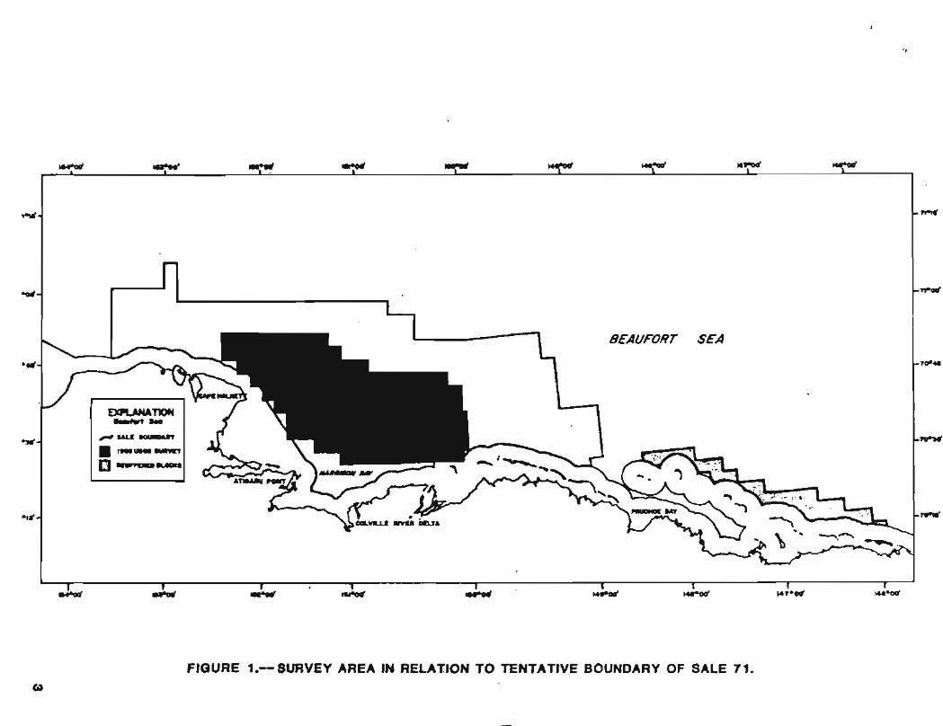
FIGURE 1.0- SURVEY AREA IEl RELATION TO TENTATIVE BOUNDARY OF SALE 71.

M V ARCTIC SUN
Streamer
-Navigation Antenna Fathometer -> t o w Dmpth - Om 10m
40 m m + $ 3.5 ICHZ Protiler
Tow Depth - 2m I r n -
$ Side-Scan Sonar Tow Dmpth - 5m
32m
34m
Surface Towed Sled Water Gun Array (2)
j--- Single-Channel Length - 8m Hydrophone
Figure 2.- Instrument Deployment
Uniboom
V
149m
Tow Dmpth - I m
12 - Channel Hydrophone Streamer Group Interval - 11.67m Tow Dmpth - Om
1 l S m
d/ - Center, Group 12
183m

included a high-frequency (40-kHz) fa thometer , a side-scan sonar , a 3.5-kHz subbottom p r o f i l e r , and an e lec t ro-mechanica l subbottom p r o f i l e r (Uniboom). The m u l t i c h a n n e l se i smic system cons i s t ed of t w o 15-cubic- inch water guns as the sound source, a 12-channel hydrophone s t reamer, and a d i g i t a l recording system. The analog d a t a were displayed on 19-inch, dry-paper recorders , wi th sweep s c a l e s ranging from 0.125 s ( fa thometer records) t o 0 . 5 s (near- t race of seismic d a t a ) . The side-scan sonar records show a p l an ime t r i c view of t h e s e a f l o o r f o r about 200 m on e i t h e r s i d e of the s h i p ' s t rack . The v e r t i c a l r e s o l u t i o n of t h e analog systems, set both by instrument frequency and recorder s c a l e , i s as fo l lows: fa thometer , 0.2 m; side-scan sonar , 2 t o 4 m; 3.5-kHz p r o f i l e r , 1 . 0 m; uniboom, 2.0 m; and d i g i t a l se i smic system, 10 m. All inst ruments produced accep tab l e records except f o r the Uniboom p r o f i l e r . Poor data q u a l i t y from t h i s instrument could have been caused by i t s towing c h a r a c t e r i s t i c s o r high power output (800 j o u l e s ) f o r t h e shallow water and hard bottom of t he survey area.
Navigation c o n t r o l was an important cons ide ra t i on f o r t h i s t r a c t - s p e c i f i c survey, The s h i p was requi red t o maintain course w i th in 30 m of p r e p l o t t e d fix po in t s a t 300- i n t e r v a l s . The primary naviga t ion system was an ARGO DM-54, with t h r e e shore-based t ransponder s t a t i o n s l oca t ed on bench marks. A Motorola Mini-Ranger 111 system wi th f o u r shore s t a t i o n s was used as t h e secondary navigation system t o c a l i b r a t e t h e ARGO, f o r l a n e count v e r i f i c a t i o n , and as a back-up. These systems have a f i e l d accuracy of about +5 m and worked we l l throughout t h e survey which w a s conducted 5 to-60 km of fshore .
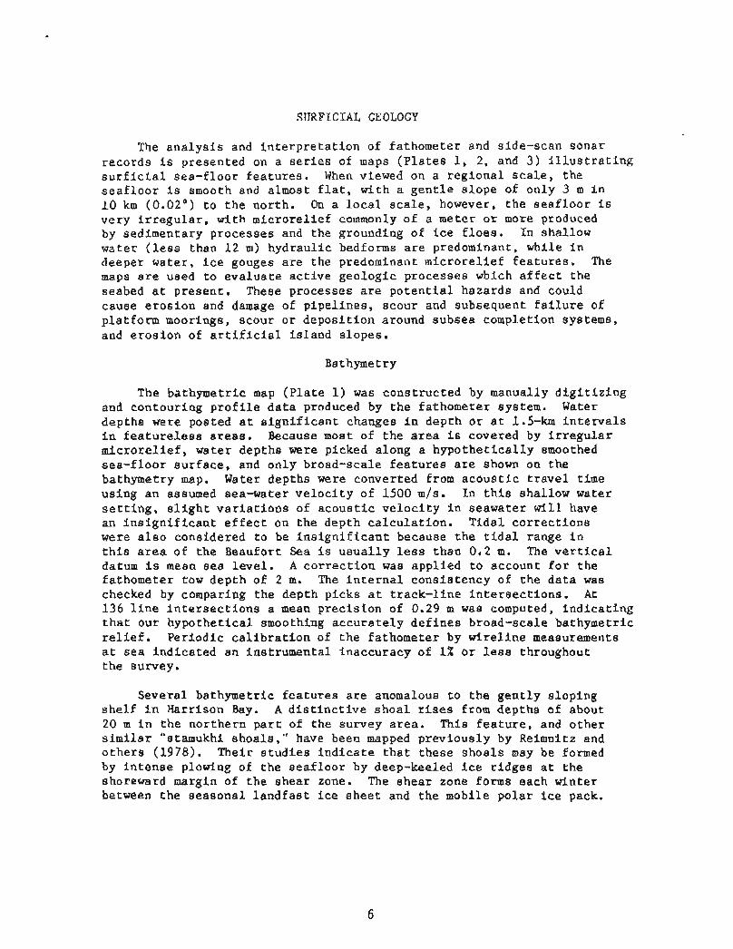
SURFICIAL GEOLOGY
The a n a l y s i s and i n t e r p r e t a t i o n of fa thometer and s ide-scan sonar records i s presented on a s e r i e s of maps ( p l a t e s 1, 2, and 3) i l l u s t r a t i n g s u r f i c i a l sea- f loor f e a t u r e s . When viewed on a r eg iona l s c a l e , t he s e a f l o o r i s smooth and almost f l a t , w i th a g e n t l e s lope of on ly 3 m i n 1 0 km (0.02") t o t h e nor th . On a l o c a l s c a l e , however, t h e s e a f l o o r is ve ry i r r e g u l a r , wi th mic ro re l i e f commonly of a meter or more produced by sedimentary processes and t h e grounding of i c e f l o e s . I n shal low water ( l e s s than 12 m) hydraul ic bedforms a r e predominant, while i n deeper water , ice gouges a r e t he predominant mic ro re l i e f f e a t u r e s . The maps a r e used t o e v a l u a t e a c t i v e geologic processes which a f f e c t t h e seabed a t p r e sen t . These processes a r e p o t e n t i a l hazards and could cause e r o s i o n and damage of p ipe l ines , scour and subsequent f a i l u r e of p la t form moorings, scour o r depos i t i on around subsea completion systems, and e ros ion of a r t i f i c i a l i s l and s lopes .
Bathymetry
The bathymetr ic map ( P l a t e 1 ) was cons t ruc ted by manually d i g i t i z i n g and contour ing p r o f i l e d a t a produced by t h e fathometer system. Water depths were posted a t s i g n i f i c a n t changes i n depth o r a t 1.5-km i n t e r v a l s i n f e a t u r e l e s s a r ea s . Because most of t h e a r e a i s covered by i r r e g u l a r m i c r o r e l i e f , water depths were picked along a h y p o t h e t i c a l l y smoothed sea- f loor su r f ace , and only broad-scale f e a t u r e s a r e shown on the bathymetry map. Water depths were converted from a c o u s t i c t r a v e l t i m e us ing an assumed sea-water v e l o c i t y of 1500 m / s . In t h i s shal low water s e t t i n g , s l i g h t v a r i a t i o n s of a c o u s t i c v e l o c i t y i n seawater w i l l have an i n s i g n i f i c a n t e f f e c t on t h e depth c a l c u l a t i o n . T ida l c o r r e c t i o n s were a l s o considered t o be i n s i g n i f i c a n t because t h e t i d a l range i n t h i s a r e a of t h e Beaufort Sea i s u s u a l l y less than 0.2 m. The v e r t i c a l datum i s mean s e a l e v e l . A c o r r e c t i o n was app l i ed t o account f o r t h e fathometer tow dep th of 2 m. The i n t e r n a l cons i s t ency of t h e d a t a was checked by comparing t h e depth p icks a t t rack- l ine i n t e r s e c t i o n s . A t 136 l i n e i n t e r s e c t i o n s a mean p rec i s ion of 0.29 rn was computed, i n d i c a t i n g t h a t our hypo the t i ca l smoothing a c c u r a t e l y d e f i n e s broad-scale bathymetr ic r e l i e f . Per iod ic c a l i b r a t i o n of t h e fathometer by w i r e l i n e measurements a t s e a i nd i ca t ed an ins t rumenta l inaccuracy of 1% o r less throughout t h e survey,
Severa l bathymetr ic f e a t u r e s a r e anomalous t o t h e g e n t l y s lop ing s h e l f i n Harr ison Bay. A d i s t i n c t i v e s h o a l rises from depths of about 20 m i n t h e nor thern p a r t of the survey a r e a . This f e a t u r e , and o t h e r s i m i l a r "stamukhi shoa l s , " have been mapped p rev ious ly by Reimnitz and o t h e r s (1978). Their s t u d i e s i n d i c a t e t h a t these shoa l s may be formed by i n t e n s e plowing of t he s e a f l o o r by deep-keeled i c e r i d g e s a t t h e shoreward margin of t h e shear zone. The shea r zone forms each win te r between t h e seasona l l a n d f a s t i c e shee t and t h e mobile po l a r ice pack.
Another cur ious f e a t u r e , a l s o prev ious ly recognized by Barnes and Reimnitz ( 1 9 7 4 ) , i s a broad t e r r a c e between 17- and 19- depths i n c e n t r a l Harrison Bay. The o r i g i n of this f e a t u r e i s uncer ta in , a l though i t s l o c a t i o n i n t h e lee of t h e stamukhi shoa l sugges ts t he se f e a t u r e s may be r e l a t e d .
Sea-floor Microre l ie f and Processes
The d i s t r i b u t i o n of mic ro re l i e f f e a t u r e s , shown on P l a t e 2, i s an i n d i c a t i o n of t h e i n t e n s i t y of r ecen t geo logic processes t h a t shape the s e a f l o o r i n Harr ison Bay. By ana lyz ing both fathometer and side-scan sonar records, we were a b l e t o d i f f e r e n t i a t e mic ro re l i e f i n t o two bas i c types: bedforms produced by the hyd rau l i c a c t i o n of oceanic c u r r e n t s , and gouges produced by t h e a c t i o n of grounding ice. These mic ro re l i e f f e a t u r e s cannot be mapped i n d i v i d u a l l y a t the map s c a l e of 1:250,000 o r t r aced between survey l i n e s spaced a t 4.8 km. To cons t ruc t t h i s map, t h e maximum amplitude ( c r e s t t o t rough) of t h e l a r g e s t mic ro re l i e f f e a t u r e i n a 1.5-km i n t e r v a l was p l o t t e d and equa l mic ro re l i e f a r e a s were contoured. Because wide v a r i a t i o n i n mic ro re l i e f amplitude may occur i n t h i s d i s t a n c e , we se l ec t ed contour i n t e r v a l s of <0.5-m, 0.5- t o l-m, 1- t o 2-m, and >2-1n. This map i s a gene ra l i n t e r p r e t a t i o n of ve ry i r r e g u l a r , l o c a l i z e d , and probably t r a n s i e n t sea- f loor f e a t u r e s , and we expect some change i n t h e map contours dur ing t h e next few years .
The micro re l i e f map i n d i c a t e s t h e p r e c i s i o n of t h e bathymetr ic contours shown on P l a t e 1. A s p rev ious ly s t a t e d , bathymetr ic d a t a were picked on a hypo the t i ca l l y smoothed s e a f l o o r , thereby e l imina t ing t h e e f f e c t s of mic ro re l i e f v a r i a b i l i t y and i l l u s t r a t i n g on ly broad s c a l e f e a t u r e s . This means t h a t i n c e n t r a l Harr ison Bay where t h e s e a f l o o r has mic ro re l i e f up t o 1 m, t h e bathymetr ic contours a r e s t r i c t l y accu ra t e t o 4-0.5 m. This i s an important cons ide ra t i on f o r t r u e water depths i n no r rheas t e rn Harr ison Bay where t h e v a r i a b i l i t y produced by mic ro re l i e f (f 1 m) may be g r e a t e r than t h e bathymetr ic contour i n t e r v a l .
The s e a f l o o r i n Harrison Bay can g e n e r a l l y be d iv ided i n t o a r e a s dominated by two types of a c t i v e geologic processes . These a r e : hyd rau l i c processes involv ing the t r a n s p o r t , depos i t i on , o r r e d i s t r i b u t i o n of sediment by bottom cu r r en t s , and i c e gouging by deep-keeled ice f l o e s pushed i n t o shal low water by wind and s e a cu r r en t s . Over most of t h e survey a r e a , hyd rau l i c and i c e grounding processes t oge the r a c t i v e l y rework the s e a f l o o r , a l though i c e gouges a r e t h e predominant mic ro re l i e f form i n water depths g r e a t e r than about 12 m.
Along t h e shoreward margin of t h e survey a r e a and g e n e r a l l y i n water depths l e s s than 12 m, t h e sea-bed mic ro re l i e f i s dominated by hydrau l i c bedforms (Figure 3, A) . Linear shoa l s , sand waves, and scour channels a r e evidence of a c t i v e sediment movement. The micro re l i e f i n t h i s a r e a may reach 1 t o 2 m, and t h e seabed i s t y p i c a l l y devoid of i c e gouges. Two o t h e r a r e a s conta in ing hydrau l i c bedforms were mapped


on shoa l s f u r t h e r o f fshore . Although these shoals were probably c r ea t ed by t he shoreward push of grounding ice, the bedforms p r e s e n t on t h e i r surfaces i n d i c a t e s a c t i v e hydrau l ic reworking of t he se areas (Reimditz and o t h e r s , 1978).
Between approximately 12- and 20- water depths , t h e i c e gouges a r e t y p i c a l l y shal low and smooth i n appearance (Figure 3, B). Low f l ank ing r i d g e s and f l a t t roughs of t he gouges suggest t h a t they have been reshaped by bottom cu r r en t s and p a r t i a l l y f i l l e d wi th sediment. Micro- r e l i e f i n t h i s c e n t r a l a r e a i s t y p i c a l l y 0.5 t o 1 m. Patches of smooth sediment a r e r a r e i n t h i s a r e a s a t u r a t e d by i c e gouges. In water dep ths g r e a t e r than 20 t o 2 2 m, t h e mic ro re l i e f produced by ice gouges i s >2 m and t h e gouges have sharp-crested r i d g e s and V-shaped troughs (Figure 3, C). These c h a r a c t e r i s t i c s suggest that ice gouging i s ve ry a c t i v e and i n t e n s e , and hydraul ic processes p lay a l i m i t e d r o l e i n reshaping t h e seabed.
Ice-Gouge Trends and Sea-floor Coverage
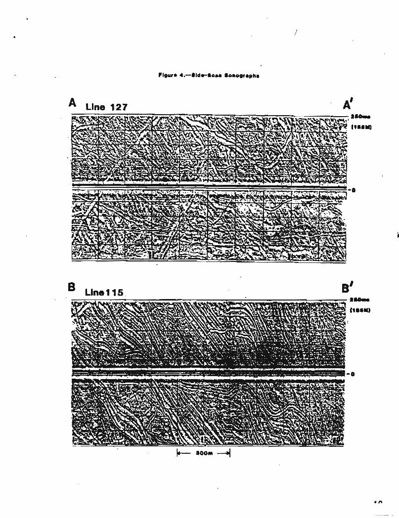
Side-scan sonar records (F igure 4) were analyzed t o d e f i n e t h e sea- f loor coverage and genera l o r i e n t a t i o n of i c e gouges i n Harr ison Bay ( P l a t e 3). These micro re l i e f f e a t u r e s , unique t o sha l low a r c t i c shelf areas, have received cons iderab le a t t e n t i o n (Reimnitz and Barnes, 1974; Reimnitz and o the r s , 1978) and t h e i r o r i g i n i s w e l l e s t ab l i shed . When deep-keeled f l o e s a r e d r iven i n t o shal low water by wind and s e a c u r r e n t s , a l a r g e groove (gouge o r scour ) i s plowed i n t o t h e seabed. The deep-keeled f l o e s a r e remnants of p r e s su re r i d g e s formed i n the shea r zone between t h e seasona l l a n d f a s t ice and t h e mobile po l a r ice pack. I ce gouges may be s e v e r a l t e n s of meters wide and s e v e r a l meters deep. The ice-gouge map ( P l a t e 3) can be used wi th t h e mic ro re l i e f map ( P l a t e 2) t o i n d i c a t e t h e d i s t r i b u t i o n and r e l a t i v e a c t i v i t y of p r e sen t geo logic processes i n Harr ison Bay.
Ice-gouge coverage (percent of t h e s e a f l o o r covered by ice gouges) was es t imated by v i s u a l l y comparing t h e sonograph records t o schematic c h a r t s . Because of t h e high l o c a l v a r i a b i l i t y of gouge d e n s i t i e s , gouge widths, and t h e problem of over lapping gouges, we d iv ided t h e survey a r e a i n t o t h e s e broad ca t ego r i e s : gouge-free; low d e n s i t y ((10% coverage); medium d e n s i t y (10% t o 50% coverage); and h igh d e n s i t y 0 5 0 % coverage). The high dens i ty a r e a i s considered a s s a t u r a t e d gouging; t h a t is , t h e e n t i r e s e a f l o o r is covered by c ross -cu t t ing gouges and no new gouges can be formed without a f f e c t i n g t h e e x i s t i n g gouges. The o r i e n t a t i o n o r t rend of ice gouges was measured by means of graphs cons t ruc ted t o c o r r e c t f o r width exaggera t ion on t h e sonograph records. Dominant ice-gouge t r ends were measured i n 15O increments from the s h i p ' s heading and p l o t t e d a t 10 f ix -poin t i n t e r v a l s (3 km) along the survey t r acks .
The i n t e r p r e t a t i o n s of microre l ief based on fathometer da ta ( P l a t e 2 ) and ice-gouge coverage on he b a s i s of s ide-scan sonographs ( P l a t e 3) a r e cons i s t en t . The hydraul ic bedform area c l o s e l y matches t he low- coverage a r e a f o r i c e gouges, sugges t ing t h a t while i c e gouging may occur i n shal low water , t h e hyd rau l i c processes qu ick ly erode and f i l l t he gouges. The i c e gouge coverage map a l s o i n d i c a t e s t h e abrupt t r a n s i t i o n from low- t o saturation-gouged condi t ions . This narrow t r a n s i t i o n could i n d i c a t e t h e over lap of sediment depos i t i on on an ice gouged s e a f l o o r . Seaward of t he 12- t o 1 5 9 i soba ths , high d e n s i t y o r s a t u r a t e d i c e gouging i s t y p i c a l of Harr ison Bay.
The o r i e n t a t i o n of i nd iv idua l i c e gouges is v a r i a b l e i n l o c a l i t i e s throughout Harr ison Bay, a l though s e v e r a l gene ra l p a t t e r n s o r t rends can be i d e n t i f i e d . The dominant t rend is NW, p a r a l l e l t o t he bathymetr ic contours , and sugges ts t h a t movement of grounded i c e i s l a r g e l y c o n t r o l l e d by sea-f loor r e l i e f . A secondary t r end of NE presumably i n d i c a t e s onshore i c e movement d i r e c t e d by p r e v a i l i n g wind o r s e a cu r r en t s . Two c o n t r a s t i n g i c e gouge t r end a r e a s a r e de l inea t ed on P l a t e 3. In western Harr ison Bay, ice gouges t rend uniformly i n a NW d i r e c t i o n ( a r e a 2). In c e n t r a l and e a s t e r n Harr ison Bay, i c e gouges v a r y widely i n o r i e n t a t i o n and f r e q u e n t l y meander without a c o n s i s t e n t t rend ( a r e a 1). Examples of t h e s e c o n t r a s t i n g a r e a s a r e shown i n Figure 4, and the r o s e diagram on P l a t e 3 c h a r a c t e r i z e s t h e i r r e g u l a r t r ends found i n e a s t e r n Harrison Bay. A p o s s i b l e explana t ion f o r t h i s c o n t r a s t i n ice-gouge t rend is t h a t gouges i n e a s t e r n Harr ison Bay a r e produced during i c e i ncu r s ions i n t h e summer open-water season when v a r i a b l e wind and s e a c u r r e n t s move ice around t h e bay. The r e g u l a r t rend i n western Harr ison Bay sugges ts t h e i n f luence of t h e o u t e r stamukhi shoa l . This f e a t u r e could s h e l t e r western Harr ison Bay from t h e i ncu r s ions of deep-keeled i c e and focus i c e moving from e a s t e r n Harr ison Bay a long bathymetr ic contours .
Sea-floor evidence for an e a r l y win te r shea r zone along the 10- i s o b a t h and t h e midwinter shear zone seaward of t h e 20711 i soba th , a s repor ted by Reimnitz and o t h e r s (1978) and S t r i n g e r (1978), i s not recognized i n our sonograph data. The d a t a sets a r e no t s t r i c t l y comparable because t he se i n v e s t i g a t o r s mapped su r f ace i c e f e a t u r e s from s a t e l l i t e and a e r i a l images whereas our i n t e r p r e t a t i o n i s based on sea- f loor f e a t u r e s produced by t h e underside of t he i c e . W e do, however, recognize a major change i n seabed mic ro re l i e f and gouge appearance seaward of t he 20- t o 22- i soba ths and be l i eve t h a t t h i s i n t e n s e l y gouged a r e a i s produced beneath t h e midwinter shea r zone.

STRATIGRAPHY
Three d i s t i n c t s t r a t i g r a p h i c u n i t s a r e p re sen t i n t h e subsur face o f Harr ison Bay. Each u n i t i s separa ted by an unconformity and can be mapped according t o i t s unique se i smic charac te r . From t h e s e a f l o o r downward, t h e s e u n i t s a r e designated by t h e i r i n f e r r e d age a s Holocene, P le i s tocene , and Upper Cretaceous t o T e r t i a r y depos i t s . Our i n t e r p r e t a t i o n of subsur face l i t h o l o g y , d e p o s i t i o n a l environment, and age a r e specu la t i ve because core d a t a i s l i m i t e d i n t h i s a rea . However, our conclusions a r e based on recognized onshore s t r a t i g r a p h y and we l l da t a , a s wel l a s previous se i smic surveys and sha l low boreholes i n ad j acen t o f f sho re a r e a s .
Holocene Deposits
An a c o u s t i c a l l y t r anspa ren t sediment l a y e r beneath t h e sea-f loor s u r f a c e was de l inea t ed by t h e 3.5-kHz subbottom p r o f i l e r . The th ickness of t h i s l a y e r was measured from t h e s e a f l o o r t o a P l e i s tocene r e f l e c t i v e s u r f a c e ( i n f e r r e d age) and contoured a t 2-m i n t e r v a l s on P l a t e 4. Seismic t r a v e l t i m e w a s converted t o subbottom depth us ing an assumed a c o u s t i c v e l o c i t y of 1.6 kmls. Acoustic pene t r a t i on of s e v e r a l t e n s of meters by t h i s low-energy a c o u s t i c system sugges ts t h a t t h i s s u r f i c i a l l a y e r i s unconsol idated. Its upper s t r a t i g r a p h i c p o s i t i o n i n d i c a t e s t h a t t h e s e sediments probably accumulated s i n c e t h e p o s t g l a c i a l marine t r ansg re s s ion , and on t h i s b a s i s we i n f e r t he age of t h i s depos i t t o be Holocene. The Holocene depos i t g e n e r a l l y th ickens away from t h e C o l v i l l e River , i n d i c a t i n g t h a t s t rong ocean c u r r e n t s have a c t i v e l y r e d i s t r i b u t e d sediment away from t h i s source. S u r f i c i a l sampling (Barnes and Reimnitz, 1974; Barnes and o t h e r s , 1980) and sha l low cor ing (Barnes and o t h e r s , 1979; Harding and Lawson, 1979; Osterkamp and Harrison, 1980) of t h i s d e p o s i t i n d i c a t e t h a t sediment l i t h o l o g y v a r i e s g r e a t l y over s h o r t d i s t a n c e s , probably i n response t o a c t i v e i c e gouging and hydrau l i c processes . The t y p i c a l sediment l i t h o l o g y i s poorly s o r t e d , sandy s i l t wi th occas iona l g r ave l components. Occasional i n t e r n a l r e f l e c t i n g hor izons i n our subbottom p r o f i l e d a t a a r e i n t e r p r e t e d t o be sand, o r perhaps g rave l , i n t e r b e d s ,
P l e i s tocene Deposits
A s t r o n g and continuous r e f l e c t o r is t e n a t i v e l y i d e n t i f i e d a s t h e Holocene-Pleistocene boundary (F igure 5). The h ighly r e f l e c t i v e c h a r a c t e r of t h i s horizon, e l imina t ing pene t r a t i on by t h e 3.5-kHz a c o u s t i c s i g n a l , could be caused by a change i n l i t h o l o g y , conso l ida t ion s t a t e , o r i n t e r s t i t i a l gas . The l a c k of a v a i l a b l e borehole d a t a i n Harr i son Bay makes our i n t e r p r e t a t i o n of t he na tu re of t h i s a c o u s t i c horizon specu la t i ve . Because t h e a c o u s t i c cha rac t e r of t h e r e f l e c t i n g

SHORELINE


horizon i s s i m i l a r i n appearance t o many n a t u r a l r e l i e f f e a t u r e s on t h e A r c t i c Coastal P l a in , and i t l i e s unconformably beneath t h e Holocene d e p o s i t , we i n t e r p r e t t h i s r e f l e c t o r t o r ep re sen t the upper s u r f a c e of a P l e i s tocene depos i t . The r e l i e f of the p re t r ansg re s s ive P l e i s tocene su r f ace can be i n f e r r e d from t h e Holocene isopach map ( P l a t e 4 ) .
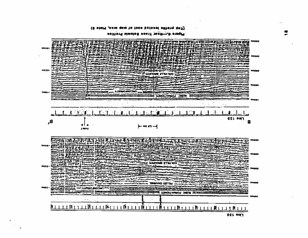
The a c o u s t i c cha rac t e r of t h e P l e i s tocene s u r f a c e v a r i e s i n Harr i son Bay from a heterogeneous, h igh- re l ie f horizon t o a uniform, low- r e l i e f horizon. We d i f f e r e n t i a t e d t he se l a t e r a l l y continuous and d i s t i n c t r e f l e c t o r types and i n f e r t h a t they r ep re sen t t h e su r f ace of a nonmarine c o a s t a l p l a i n depos i t (Unit A) and a marine depos i t of equ iva l en t age (Unit B). The i n t e r n a l s t r a t i g r a p h y of t h e P l e i s tocene depos i t cannot be resolved by our s u i t e of geophysical instruments . A prominent low-angle unconformity, recognized only i n t h e near - t race se i smic records , was i d e n t i f i e d a t approximately 100 m below s e a l e v e l and i n f e r r e d t o be t h e base of t he P l e i s tocene s e c t i o n (F igure 6 ) . I f the Ple i s tocene depos i t found o f f sho re corresponds t o t h e Gubic Formation i n ad j acen t onshore a r e a (Black, 1964), we expect t h i s s e c t i o n t o i nc lude a d i v e r s e assortment of l i t h o l o g i e s depos i ted dur ing s e v e r a l t ransgress ive- regress ive cyc l e s on the Arctic Coastal P l a in .
The d i s t i n c t i o n between highly v a r i a b l e , c o a s t a l p l a i n sediment (Unit A) , and uniform marine sediment (Unit B) may be u s e f u l foundat ion informat ion because these d e p o s i t s l i e beneath a r e l a t i v e l y t h i n Holocene l a y e r .
hit A i s e a s i l y recognized by i t s d i v e r s e a c o u s t i c appearance, vary ing from a d i f f u s e t o a sha rp r e f l e c t i n g su r f ace . It o f t e n has a "jumpy" appearance (Figure 5, E) , where energy bounces from r e f l e c t o r s spaced s e v e r a l meters v e r t i c a l l y and t e n s of meters l a t e r a l l y . The r e f l e c t i v e su r f ace of bit A has r e l i e f s i m i l a r i n appearance and s i z e t o f e a t u r e s of the present c o a s t a l p l a i n , inc lud ing thermokarat topography, V-shaped stream channels (F igure 5, D) , thaw l a k e s (F igure 5, F), and beach r idges . These f e a t u r e s , now covered by Holocene sediment, were probably modified by the Holocene t ransgress ion . Although 2 t o 10 m of r e l i e f are p re sen t on t h e s u r f a c e of Unit A, most of t h e f e a t u r e s a r e no t shown on P l a t e 4 because of t h e map s c a l e and wide survey g r i d .
Unit B has a sharp, s t r o n g l y r e f l e c t i v e surface wi th uniformly low r e l i e f . Its a c o u s t i c c h a r a c t e r c o n t r a s t s greatly wi th the heterogeneous appearance of Unit A ' s s u r f a c e , Several f e a t u r e s on t h e s u r f a c e of Unit B a r e i n t e r p r e t e d t o r ep re sen t sedimentary bedforms, such as beaches (Figure 5, B) and o f f sho re bars , and they sugges t t h a t t h i s depos i t i s marine i n o r i g i n .

The contac t between Un i t A and U n i t B generally fol lows the 12-m isopach contour, and the d i s t r i b u t i o n of 'Uni t B i s shaded on Plate 4. The contac t between these P l e i s tocene u n i t s is of i n t e r e s t because i t may represen t an anc i en t s h o r e l i n e now buried i n t h e subsurface. Commonly, t h e con tac t is abrupt and a s h o r e l i n e b lu f f s e v e r a l meters h igh i s recognized (Figure 5; A, B, C) . There is no sea-f loor express ion of t he b lu f f . Small s t ream channels , which could be ex tens ions of dra inage of t h e C o l v i l l e o r o t h e r r i v e r s , f r equen t ly c u t t he s h o r e l i n e b l u f f t o the l e v e l of Unit B. The age of t h i s s h o r e l i n e a t approximately -32 + 2 m i s uncer ta in , a l though we be l i eve t h a t i t i s a P le i s tocene f e a t u r e . The Holocene t e r r a c e s and submarine v a l l e y s recognized i n o t h e r Alaskan a r e a s by Barnes and Hopkins (1978) have sea-f loor express ion . It i s a l s o pos s ib l e t h a t t h i s s h o r e l i n e was formed by a l a r g e l ake on t h e A r c t i c Coastal P l a in i n P l e i s tocene t i m e .
l a t e Cretaceous t o T e r t i a r y Deposits
The i n t e r p r e t a t i o n of deep geologic s t r u c t u r e and s t r a t i g r a p h y i n Harr i son Bay ( P l a t e 5) i s based on se i smic r e f l e c t i o n da t a , inc lud ing near - t race analog p r o f i l e s and twelve-channel d i g i t a l se i smic s ec t i ons . D i g i t a l seismic d a t a were recorded i n t h e f i e l d f o r two-way t r a v e l t i m e of 1 second at a sample r a t e of 112 m s , These d a t a are considered t o be "high r e so lu t ion" because of t h e h igh frequency seismic source and t h e s h o r t group i n t e r v a l on t h e hydrophone s t reamer. The f i e l d tapes were processed a t 1 ms a s a 12-fold CDP s t a c k and displayed i n r e l a t i v e t r u e amplitude and automatic g a i n c o n t r o l s ec t i ons . Veloci ty ana lyses were made of t h e s e c t i o n s a t f i v e f ix -poin t i n t e r v a l s (1.5 km) along each survey t rack . An example CDP s e c t i o n wi th i t s corresponding v e l o c i t y a n a l y s i s and a more complete l i s t i n g of recording and processing parameters i s g iven i n P l a t e 6.
~ h e ' s e i s m i c s e c t i o n ( t o approximately 1OOO-m depth) c o n s i s t s of p a r a l l e l t o s l i g h t l y d ive rgen t r e f l e c t o r s wi th h igh amplitude and good con t inu i ty . The r e f l e c t o r s tend t o o f f l a p t o t h e North and occas iona l ly va ry i n amplitude, This seismic c h a r a c t e r sugges ts t h e widespread depos i t i on of interbedded sand and s h a l e l i t h o l o g i e s . The lower p a r t of t h e seismic s e c t i o n g e n e r a l l y c o n s i s t s of hummocky, discont inuous r e f l e c t o r s of v a r i a b l e amplitude. This c h a r a c t e r sugges ts t h e depos i t i on of l a t e r a l l y discont inuous sand bodies i n a dominantly s h a l e s e t t i n g . We i n t e r p r e t t h e seismic s e c t i o n t o r ep re sen t a prograding sequence, c o n s i s t i n g l a r g e l y of a l l u v i a l fan-de l ta p l a i n depos i t s . On t h e b a s i s of an examination of wel l l ogs from onshore we l l s ( s e e P l a t e 5 f o r l o c a t i o n ) and a r eg iona l s y n t h e s i s by ~ r o s ~ 6 and T a i l l e u r (1971), we i n f e r t h a t t h i s s e c t i o n corresponds t o t h e C o l v i l l e Group, a t h i c k r eg re s s ive sequence deposi ted on t h e Arc t i c platform i n Late Cretaceous t o T e r t i a r y time. This broad age d e f i n i t i o n i s caused by d i f f i c u l t i e s i n de f in ing s t r a t i g r a p h i c boundaries i n a predominantly
nonmarine sequence. Most workers u sua l ly refer t o t h i s r eg re s s ive sequence as "Co lv i l l e Group and younger." We a l s o do no t attempt t o d i v i d e t h e s e c t i o n i n t o Upper Cretaceous (Schrader Bluff and Pr ince Creek) o r T e r t i a r y (Sagavanirktok) formations because t h e r e i s no a v a i l a b l e o f f sho re w e l l c o n t r o l .
W e s e l ec t ed a prominent marker horizon i n t he upper p a r t of t h i s f an -de l t a sequence t o i n d i c a t e t h e geologic s t r u c t u r e ( P l a t e 5). Depths t o the marker hor izon a r e contoured i n meters below s e a l e v e l us ing an assumed se i smic v e l o c i t y of 1.8 km/s. Our v e l o c i t y ana lyses a r e i n agreement wi th r e f r a c t i o n v e l o c i t i e s repor ted for the Beaufort Shelf by Houtz and o t h e r s (1981). "Shallow" f a u l t s t h a t d i s p l a c e t h e marker horizon a r e shown as s o l i d l i n e s , and "deep" f a u l t s which te rmina te below i t a r e shown a s dashed l i n e s .
I n genera l , t h e s t r u c t u r e of t h e i n f e r r e d Late Cretaceous t o T e r t i a r y s e c t i o n i s subdued, wi th s t r a t a dipping g e n t l y t o t h e n o r t h e a s t (0.5' t o 1.0') and smal l displacements by f a u l t s ( l e s s than 50 m). The Barrow Arch, thought t o t rend through t h i s o f f sho re a r e a , i s no t v i s i b l e i n the 1 s se i smic s ec t i ons . High-angle normal f a u l t s w i th down-to-basin displacement ( t o t h e North) a r e most common. The occas iona l high-angle r eve r se f a u l t s are c l o s e l y a s soc i a t ed w i t h t he normal f a u l t s and produce narrow h o r s t blocks. With r a r e except ion, a l l f a u l t s t e rmina te a t o r below t h e unconformity between P l e i s tocene and Late Cretaceous t o T e r t i a r y d e p o s i t s a t 100 m below s e a l e v e l (F igure 6) . The normal and r eve r se f a u l t s may be l i s t r i c (growth) f a u l t s and a s soc i a t ed a n t i t h e t i c f a u l t s , but t h e i r lower curved po r t i ons a r e no t v i s i b l e on t h e 1-second sec t ions . Growth f a u l t s are t y p i c a l of prograding sequences. The dominant t rend of t h e f a u l t s i s NW, with a secondary t rend E. Monoclines a r e occas iona l ly recognized above "deep" f a u l t t r a c e s , and sp lay f a u l t s are common. A long NW-trending f a u l t system b i s e c t s t h e survey a r e a , and i n some l o c a t i o n s d i s p l a c e s horizons above t h e -100 m unconformity. Although se i smic r e s o l u t i o n i n t h e upper 200 m s i s gene ra l l y poor, owing t o s t rong r eve rbe ra t i ons , evidence of f a u l t displacement t o 60 m below sea l e v e l was recognized i n t h e near - t race p r o f i l e s (Figure 6) . The upper e x t e n t of these shal low f a u l t s is uncer ta in . The h igh ly i r r e g u l a r s u r f a c e of t h e i n f e r r e d P le i s tocene depos i t and t h e ice gouged na tu re of t h e s e a f l o o r would tend t o obscure any f a u l t displacement of t he se depos i t s . Because most f a u l t s were found t o te rmina te a t o r below t h e -100-m unconformity, we conclude t h a t t e c t o n i c a c t i v i t y has been in f r equen t i n Quaternary time. Se i smic i ty s t u d i e s by Biswas and Gedney (1979) support t h i s conclusion.

Another o b s e r v a t i o n from these seismic d a t a i s t h a t a con t inuous zone of poor q u a l i t y d a t a i s found along the shoreward margin of t h e survey a r e a ( P l a t e 5 ) . The na ture of t h i s r a t h e r ab rup t degradat ion of se l smic d a t a i s uncer ta in . One explana t ion i s t h a t i t i s caused by problems of se i smic d a t a recording i n a shal low-water , hard-bottom a rea . Another explana t ion i s t h a t i t i s r e l a t e d t o t h e occurrence of h igh v e l o c i t y , bonded permafrost i n t h e upper geologic s e c t i o n . Sellmann and o t h e r s (1981) mapped a high v e l o c i t y l a y e r t h a t they i n t e r p r e t e d t o be permafrost i n Harrison Bay. The d i s t r i b u t i o n of t h i s permafrost l a y e r and a s soc i a t ed acous t i c anomalies co inc ides c l o s e l y with t h e a r e a of poor q u a l i t y se i smic d a t a i n our records . Because permafrost occurrence has been confirmed by d r i l l i n g programs i n nearshore a r ea s of t h e Beaufort Sea (Sellmann and o t h e r s , 1980; and Harding and Lawson, 1979), t he a r e a of poor se i smic d a t a was mapped and we specu la t e t h a t i t may be r e l a t e d t o a bonded permafrost l a y e r i n t h e upper geologic s ec t i on . It i s a l s o poss ib le t h a t d i scont inuous , ice-bonded sediment may be encountered elsewhere i n t h i s area because t h e e n t i r e she l f was exposed s u b a e r i a l l y i n P le i s tocene time. However, t h i n o r d i scont inuous ice l e n s e s would probably no t be resolved by low-frequency seismic systems.
Shallow gas accumulations a r e o f t e n i d e n t i f i e d by a c o u s t i c anomalies. We mapped s e v e r a l a c o u s t i c anomalies tha t t y p i c a l l y occur i n s t r u c t u r e s ad j acen t t o f a u l t s ( P l a t e 5). These anomalies have b r i g h t s p o t (amplitude i nc rease ) , r e f l e c t o r pull-down, and a t t e n u a t i o n of high- f requency s i g n a l c h a r a c t e r i s t i c s . I n some a r e a s away from f a u l t t r a c e s , increased amplitude of r e f l e c t o r s (b r igh t en ing ) i s v i s i b l e a l though t y p i c a l l y n o t accompanied by se i smic c h a r a c t e r i s t i c s i n d i c a t i v e of low- v e l o c i t y (gae-containing) s t r a t a , such a s r e f l e c t o r wipe-out, pull-down, o r phase r e v e r s a l . Consequently, we d id no t map these l o c a l anomalies a s pos s ib l e shal low gas accumulations. On t h e b a s i s of t h e onshore w e l l evidence, we do suspec t t h a t sma l l s t r a t i g r a p h i c t r a p s con ta in minor accumulatfons of gas throughout t h e Late Cretaceous t o T e r t i a r y s e c t i o n . Brosge and T a i l l e u r (1971) s t a t e , " t he numerous s t rong gas shows i n t h e nonmarine beds i n d i c a t e t h a t t h e C o l v i l l e i s l i k e l y t o be an important ga s reservoi r . " These au tho r s po in t t o t h e r e l a t i o n s h i p between abundant c o a l depos i t s and e x c e l l e n t r e s e r v o i r p r o p e r t i e s of t h e nonmarine beds and specula te t h a t , " t he upper C o l v i l l e and poss ib ly t h e T e r t i a r y a r e probable sources and r e s e r v o i r s f o r gas" i n o f f sho re a r e a s . The occurrence of gas hydra tes i n permafrost o r i n t e r s t i t i a l ga s i n s t r a t a formerly f rozen was d i scussed by Sellmann and o t h e r s (1981). We a l s o expect permafrost and assoc ia ted gas hydra tes t o be more common i n t h e nearshore a r e a s of Harr ison Bay, e s p e c i a l l y i n t he poor-data a r e a s shown on the map. We acknowledge t h a t t he se i n t e r p r e t a t i o n s of s t r a t i g r a p h y , shal low gas occurrence, and subsea permafrost d i s t r i b u t i o n i n Harr ison Bay a r e a h igh ly specu la t i ve because t h e r e is no a v a i l a b l e o f f sho re w e l l d a t a .

ENVIRONMENTAL CONSIDERATIONS
In t h i s s e c t i o n , we w i l l p resen t an overview of geo log ica l condi t ions i n t he survey a r e a and b r i e f l y desc r ibe p o t e n t i a l hazards t o f u t u r e petroleum explora t ion and product ion a c t i v i t i e s . This s tudy i s not a comprehensive geologic eva lua t ion , rather i t i s a pre l iminary i n t e r p r e t a t i o n cons t ra ined by a r e a l l i m i t s and geophysical r e so lu t ion . For example, t h e a c t i v e process of c o a s t a l e ro s ion , considered t o be a p o t e n t i a l hazard t o sho re l i ne development (Hopkins and Hartz; 1978), i s beyond the scope of t h i s survey. We do be l i eve , however, that many of our i n t e r p r e t a t i o n s can be ex t r apo la t ed i n t o ad j acen t o f f sho re a r e a s t h a t , a t p r e sen t , have very l i m i t e d d a t a coverage. This r epo r t d e s c r i b e s geo log ica l condi t ions t y p i c a l of t h e i nne r Beaufort Sea s h e l f and poin ts ou t important gaps i n knowledge of t h i s s e t t i n g .
The bathymetry of Harrison Bay i s cha rac t e r i zed a s shal low and almost f l a t . Because of i t s g e n t l e seaward s lope (<0.5*) and t h i n l a y e r of recent marine sediment, we be l i eve t h a t t h e p o t e n t i a l f o r mass movement i n Harr ison Bay i s n e g l i g i b l e . The a c t i v e processes of ice gouging and sediment r e d i s t r i b u t i o n do have a major e f f e c t on t h e s t a b i l i t y of t he s e a f l o o r , and t h e scour p o t e n t i a l of t h e s e processes should be considered i n t h e des ign of seabed i n s t a l l a t i o n s . Hydraulic processes are most a c t i v e i n water dep ths l e s s than 1 2 m and on o f f sho re shoa ls . Bedforms such as sand waves i n d i c a t e t h a t scour and r e d i s t r i b u t i o n of sediment may a f f e c t up t o 1 m of sediment (Barnes and Reimnitz, 1979). Hydraulic processes are e s p e c i a l l y pronounced during t h e late-summer open-water storms.
I ce gouging may occur I n a l l water dep ths , and gouges are t h e predominant mic ro re l i e f f e a t u r e i n water dep ths g r e a t e r than 1 2 m. The microre l ie f produced by i c e gouges i n most of Harrison Bay i s less than 1 m, a l though i n water depths g r e a t e r than 20 m, ice-gouge micro- r e l i e f i s 2 m o r more, P ipe l ine i n s t a l l a t i o n s i n a l l p a r t s of t h e bay should al low f o r t h e maximum i n c i s i o n depth of expected gouging a s wel l a s f o r t h e temporary overpressur ing e f f e c t du r ing gouging. In t h e i n t e n s e l y gouged a r e a beneath t he shear zone, a reasonable s a f e t y factor might r e q u i r e b u r i a l of p i p e l i n e s o r subsea completions 5 m below mudline, Our d a t a i n d i c a t e t h e i nc reas ing i n t e n s i t y of i c e gouging wi th water depth. The meandering t r ends and sha l low mic ro re l i e f produced by i c e gouges shoreward of t h e 2 0 3 i s o b a t h i n Harr ison Bay suggest t h a t sea-f loor gouging probably occurs dur ing t h e summer open-water season and i s g e n e r a l l y less i n t e n s e than beneath t he shear zone. P ro t ec t i on from ice r i d g e s grounding i n western Harrison Bay i s probably provided by the o u t e r shoa l s (Reimnitz and o t h e r s , 1978). Reimnitz and o t h e r s (1977) r e p o r t t h a t a complete d i s r u p t i o n
of rhe shallow seabed by i ce gouging may occur in 50 to 100 years, with hydraul ic processes a c t i v e a t a seasona l time scale. Ice grounding i n t he open-water season would impose in f requent and probably lower s t r e s s e s on a r t i f i c i a l s t r u c t u r e s than would large ice r idges d r iven by t h e po l a r i c e pack.
From our examination of t h e a v a i l a b l e evidence, we conclude t h a t c u r r e n t scour o r depos i t ion a r e p o t e n t i a l environmental hazards i n water depths l e s s than about 1 2 m. Between 1 2 m and 20 rn ( t h e l a n d f a s t i c e zone), p o t e n t i a l hazards w i l l be i c e ove r r ide dur ing e a r l y win te r and sp r ing breakup periods and the d i s r u p t i o n of t h e s e a f l o o r by ice gouging. In water depths g r e a t e r than about 20 m, t h e major hazard w i l l be pressure r idging and i n t e n s e i c e gouging f o r c e s r e l a t e d t o t h e movement of t h e po la r i c e pack. We presume t h a t t h e technology f o r development i n t h e l and fa s t i c e zone shoreward of t h e 20- i s o b a t h i n Harr ison Bay w i l l d i f f e r from t h a t designed f o r t h e shea r zone f u r t h e r seaward. Valuable information w i l l be gained from t h e performance of exp lo ra t i on i s l a n d s (Issungnak and T a r s u i t ) i n t h e Canadian Beaufort Sea.
The th ickness and i n f e r r e d conso l ida t ion s t a t e of sediments i n t h e shal low subbottom s e c t i o n is def ined by t h e 3.5-kHz subbottom p r o f i l e r . These d a t a are also used t o i d e n t i f y gas-charged sediments and gas plumes i n t he water column. The shal low subbottom condi t ions a r e important i n t he eva lua t ion of foundat ion s t a b i l i t y . We found t h a t a r e l a t i v e l y t h i n l a y e r ( 2 t o 25 m) of unconsol idated (Holocene) sediment o v e r l i e s a complex subbottom hor izon i n f e r r e d t o be a P le i s tocene c o a s t a l p l a i n deposit. We recognize no unusual c h a r a c t e r i s t i c s i n t he Holocene l a y e r , such a s gas-charged sediment, t h a t might create uns t ab l e foundat ion condi t ions.
The major unce r t a in ty i s t h e composition of t h e m a t e r i a l underlying t h e Holocene l aye r . Of t h e two i n f e r r e d P le i s tocene u n i t s , one is h ighly v a r i a b l e i n r e l i e f and a c o u s t i c appearance (Unit A) . High- r e s o l u t i o n d a t a from Norton Sound ( S t e f f y and o t h e r s , 1981) con ta in s a r e a s of similar acous t i c appearance, A s tudy by Nelson and o t h e r s (1979) c o r r e l a t e d these Norton Sound a r e a s t o sha l low b iogenic gas accumulations i n Quaternary peat d e p o s i t s a l s o capped by t h e t h i n Holocene l aye r . Because Norton Sound and Harrison Bay have many s i m i l a r i t i e s , inc lud ing l o c a t i o n a s shal low bays o f f major Arc t i c r i v e r s and emergence a s tundra a r e a s i n P le i s tocene t i m e , i t i s poss ib l e t h a t t h e subsurface c o a s t a l p l a i n depos i t (Unit A) con t a in s i n t e r s t i t i a l gas . The v a r i e t y of subbottom f e a t u r e s , such a s f i l l e d channels , thaw-lake depos i t s , and a buried sho re l i ne , could c r e a t e v a r i a b l e foundat ion condi t ions beneath a t h i n Holocene l aye r . The l a t e r a l change from pea ty beds wi th a s soc i a t ed gas-charged sediments
t o alluvial g rave l depos i t s i n b u r i e d stream channels i s poss ib l e over d i s t a n c e s of 10 km. Because t h i s c o a s t a l p l a i n depos i t was exposed t o Arc t ic condi t ions d u r i n g P l e i s tocene time, i t i s poss ib l e t h a t areas of permafrost e x i s t i n this mater ia l . '
In c o n t r a s t t o t h i s complex, nonmarine depos i t , t h e second Ple i s tocene d e p o s i t (Unit B) i s i n f e r r e d t o be marine i n o r i g i n . Foundation cond i t i ons i n t h e o u t e r po r t i on of t he survey a r e a may t h e r e f o r e be more s t a b l e , wi th a t h i c k l a y e r of Holocene marine sediment over ly ing an o lde r marine depos i t . The composition and geotechnica l p r o p e r t i e s of t he subsurface u n i t s should be i n v e s t i g a t e d by shal low boreholes , a s a t p r e sen t , t h e l ack of ground-truth d a t a is a major gap i n our eva lua t ion of foundat ion condi t ions and t h e occurrence of g r ave l i n Harrison Bay.
/ On t h e bas i s of previous work (Brosge and T a i l l e u r , 1971) and onshore
wel l d a t a , we i n f e r t h a t s t r a t a i n the upper 1000 m correspond t o the C o l v i l l e Group. This Late Cretaceous t o T e r t i a r y d e p o s i t r ep re sen t s a major r eg re s s ive sequence c o n s i s t i n g of nonmarine ( a l l u v i a l fan-del ta p l a i n ) and marine (p rode l t a ) d e p o s i t s . The probable a s s o c i a t i o n of o rganic- r ich beds ( sha l e and c o a l ) wi th c l a s t i c r e s e r v o i r beds c r e a t e s good condi t ions f o r gas gene ra t i on and accumulation. Small q u a n t i t i e s of gas have been repor ted i n many onshore,wells and a r e l ikewise expected t o be presen t i n t h e o f f sho re a r e a (Brosge and T a i l l e u r , 1971). Acoustic anomalies i n d i c a t i n g gas-charged sediment a r e r a r e , however, i n our seismic da ta . Where p re sen t , a c o u s t i c anomalies tend t o occur i n s t r u c t u r e s r e l a t e d t o f a u l t s ,
Several f a u l t t r ends a r e recognized i n t h e survey a r e a , The high-angle normal and r eve r se f a u l t s u s u a l l y te rmina te a t o r below a low-angle unconformity a t 100 rn below s e a l e v e l , however occas iona l ly faults do o f f s e t shal lower horizons. I f we assume t h a t t h i s unconformity i n d i c a t e s t he Tertiary-Quaternary boundary, t hen t e c t o n i c a c t i v i t y i n Quaternary time was r a r e . This conc lus ion i s supported by s e i s m i c i t y s t u d i e s of Biswas and Gedney (1979), who p l o t t e d r ecen t earthquake e p i c e n t e r s i n nor thern Alaska. In some cases the long NW-trending f a u l t s o f f s e t horizons i n t he i n f e r r e d P le i s tocene s e c t i o n . The upper e x t e n t of these f a u l t s should be def ined by a d d i t i o n a l high-resolut ion s e i smic d a t a focusing on the i n t e r v a l above -200 m.
The d i s t r i b u t i o n of subsea permafrost is another uncer ta in ty . If Harr ison Bay was exposed t o s u b a e r i a l Arc t i c cond i t i ons during P l e i s tocene t i m e , remnant permafrost may e x i s t l o c a l l y throughout t h e survey a rea . W e recognize a continuous zone of poor q u a l i t y d a t a t h a t g e n e r a l l y p a r a l l e l s t he sho re l i ne of Harr ison Bay ( P l a t e 5). This se i smic anomaly c l o s e l y fol lows t h e a r e a def ined a s subsea permafrost by Sellmann and o t h e r s (1981) on t h e b a s i s of se i smic evidence. We were unable, however, t o e x t r a c t conclusive evidence (by r e f r a c t i o n methods) from our r e f l e c t i o n da t a . Because seismic techniques have u s u a l l y been ambiguous i n t h e i r d e f i n i t i o n of permafrost, e s p e c i a l l y t h e lower su r f ace of ice-bounded m a t e r i a l , we suggest t h a t d r i l l i n g ope ra t i ons a r e needed t o d e f i n e the d i s t r i b u t i o n and p r o p e r t i e s of permafrost i n Harr ison Bay,
This s tudy has produced a s e r i e s of maps and a d e s c r i p t i o n of sha l low geologic condi t ions i n Harr ison Bay that: w i l l be used i n a t r a c t - s p e c i f i c hazards eva lua t ion f o r OCS Lease Sa le 71. This information may a l s o be appl ied t o ad jacent unsurveyed a r e a s of t h e western Beaufort Sea s h e l f t e n t a t i v e l y scheduled f o r f u t u r e OCS s a l e s . Many of our i n t e r p r e t a t i o n s a r e based on previous syn thes i s r e p o r t s produced I n support of OCS a c t i v i t i e s (Barnes and Reimnitz, 1974; Grantz and o t h e r s , 1976; Barnes and Hopkins, 1978; Grantz and o t h e r s , 1980), a l though our e v a l u a t i o n of subsurface s t r a t i g r a p h y and s t r u c t u r e of Harrison Bay i s a new c o n t r i b u t i o n t o a v a i l a b l e knowledge concerning t h e Beaufort Sea. With regard t o t h e shal low geology, t h e r e i s s t i l l a lack of d a t a concerning the composition, age, and geotechnica l p r o p e r t i e s of t h e se i smic u n i t s i d e n t i f i e d . This d a t a gap l i m i t s t h e eva lua t ion of foundat ion s t a b i l i t y and t h e a v a i l a b i l i t y of g r a v e l resources i n t he o f f s h o r e a r ea . The d i s t r i b u t i o n and p r o p e r t i e s of subsea permafrost i s another gap i n our knowledge t h a t could a f f e c t downhole cas ing programs and w e l l con t ro l . In t h e deeper geologic s e c t i o n , t h e l o c a t i o n and upper ex t en t of f a u l t s and p o s s i b l e gas-containing s t r u c t u r e s a s s o c i a t e d wi th f a u l t s i s important f o r s a f e exp lo ra t i on and development d r i l l i n g opera t ions . To f i l l t he se known d a t a gaps, t h e r e is an obvious need f o r both borehole d r i l l i n g and a d d i t i o n a l h igh- reso lu t ion geophysical surveys. With regard t o a c t i v e environmental processes , i c e movement and seabed i n t e r a c t i o n i s t h e dominant f o r c e a f f e c t i n g all of f sho re a c t i v i t i e s , p a r t i c u l a r l y seaward of t h e 2 0 3 i soba th . Addit ional s t udy of ice zonat ion and dynamic ice processes i s needed t o i n s u r e t h e s a f e t y of o f f sho re opera t ions i n t h e h o s t i l e Arc t i c marine environment.

REFERENCES CITED
Barnes, P. W . and Hopkins, D. M . , e d s . 1978, Geological s c i e n c e s , i n Environmental assessment of t h e Alaskan c o n t i n e n t a l s h e l f , interim s y n t h e s i s r e p o r t : Beaufort/Chukchi: NOAA/BLM (OCSEAP), p. 101-133.
Barnes, P. W., and Reimnitz, Erk, 1974. Sedimentary p r o c e s s e s on Arctic s h e l v e s o f f t h e n o r t h e r n c o a s t of Alaska, i n Reed, 5. C. and S a t e r , J. E. eds . , The Coast and Shelf of t h e Beaufor t Sea: A r c t i c I n s t i t u t e of North America, A r l i n g t a n , V i r g i n i a , p . 439-476.
Barnes, P. W., and Reimnitz, Erk, 1979, Ice gouge o b l i t e r a t i o n and sediment r e d i s t r i b u t i o n e v e n t , 1977-1978, Beaufor t Sea, Alaska: U.S. Geological Survey, Open-File Report 79-848, 22 p.
Barnes, P. W. , Reimnitz, Erk, and Ross, Robin, 1980. Nearshore s u r f i c i a l sediment t ex tu res -Beaufor t Sea, Alaska: U.S. Geological Survey Open-File Report 80-196, 41 p.
Barnes, P. W., Reimnitz, Erk, Toimil , L., Maurer, D. and McDowell, D,, 1979. Core d e s c r i p t i o n s and p r e l i m i n a r y o b s e r v a t i o n s of v i b r a c o r e s from t h e Alaskan Beaufor t Sea s h e l f : U.S. Geolog ica l Survey Open-File Report 79-351, 71 p.
Biswas, N. N. and Gedney, L., 1979. Se i smotec ton lc s t u d i e s of n o r t h e a s t and wes te rn Alaska, i n Environmental Assessment of t h e Alaskan C o n t i n e n t a l S h e l f , Annual Report : NOAA/BLM (OCSEAP), v . 10, p . 155-207.
Black, R. F., 1964. Gubic fo rmat ion of Quaternary age i n n o r t h e r n Alaska: U.S. Geological Survey P r o f e s s i o n a l Paper 302-C, p. 59-91.
/ Brosge, W. P. and T a i l l e u r I. L., 1971. Northern Alaska pet roleum prov ince , i n Cram, I, H, ed , Future Petroleum Provinces of t h e United S ta tes -The i r Geologic P o t e n t i a l : AAPG Mem. 15, v . 1, p. 68-99.
Grantz, Arthur , Barnes, P, W , , D i n t e r , D. A . , Lynch, M. B., Reimnitz, Erk, and S c o t t , E, W., 1980, Geologic framework, hydrocarbon p o t e n t i a l , environmental c o n d i t i o n s , and a n t i c i p a t e d technology f o r e x p l o r a t i o n and development of t h e Beaufor t Shelf North of Alaska: U.S. Geological Survey Open-File Report 80-94, 42 p.
Grantz, Arthur , Barnes, P. W., E i t t r e i m , S. L. , Reimnitz, Erk, S c o t t , E. W., Smith, R. A , , Stewar t , George, and Toimil , L. J., 1976, Summary Report of t h e sediments , s t r u c t u r a l framework, pet roleum p o t e n t i a l , environmental c o n d i t i o n s , and o p e r a t i o n a l c o n s i d e r a t i o n s of t h e United S t a t e s Beaufor t Sea, Alaska a r e a . U.S, Geological Survey, Open-File Report 76-830, 32 p.
Harding-Lawson A s s o c i a t e s , 1979, USGS g e o t e c h n i c a l i n v e s t i g a t i o n , Beaufor t Sea, 1979: NGSTOC Boulder, Colorado, 3 v o l . and s u p p o r t i n g doc. ref. #AD17 718.

1;o~lci ;is, D. El . , a n d B a r t z , K. W., 1975. C o a s t a l morphology, coas ta l ~ r o s i o n , and barr ier i s l a n d s of the Reaufor t Sea, A l a s k a : 11, S , : t ~ o l , ~ g i r c ? l S u r v e y Open-File l i e p o r t 78-1063, 54 p .
I I o u t z , K. E . , E i t t r e i rn , Stephen and Grantz Arthur , 1981. Acoust ic p r o p e r t i e s of n o r t h e r n Alaska s h e l v e s i n r e l a t i o n t o t h e r e g i o n a l geology: J o u r n a l of Geophysical Research, v . 86, no. B 5 , p . 3935-3943.
Nelson, Hans, Thor, D. R., Sandstorm, M. W . , and Kvenvolden, K. A . , 1979, Modern b i o g e n i c gas-generated c r a t e r s ( s e a - f l o o r "pockmarks") on t h e Rering S h e l f , Alaska: Geolog ica l S o c i e t y of America B u l l e t i n , v . 90, 1144-1152 p .
Osterkamp, T. E. and Har r i son , W. D., 1980, Subsea permaf ros t : probing thermal regime and data a n a l y s i s , i n Environmental assessment of t h e Alaskan c o n t i n e n t a l s h e l f , Annual r e p o r t , v . I V : Hazards, NOAAIBLM (OCSEAP), p . 497-640.
Reimnitz, Erk , Barnes, P. W. , T o i l m i l , L. J., and Melchoir , J., 1977, Ice gouge r e c u r r e n c e and r a t e s of sediment reworking, Beaufor t Sea, Alaska. Geology, v . 5, 405-408 p .
Reimnitz, Erk, Toimil , L. J. and Barnes, P , W., 1978. A r c t i c c o n t i n e n t a l s h e l f morphology r e l a t e d t o s e a - i c e z o n a t i o n , Beaufor t Sea, Alaska: Marine Geology, v . 28, n. 3 / 4 , p. 179-210.
Sellmann, P. V. , Chamberlain, E., Delaney, A . , and Neave, K. G. , 1980, De l inea t ion and e n g i n e e r i n g c h a r a c t e r i s t i c s of pe rmaf ros t beneath t h e Beaufor t Sea, i n Environmental assessment of t h e Alaskan c o n t i n e n t a l shelf, Annual Report , NOAA/BLM (OCSEAP), v. I V , p . 125-158.
Sellmann, P. V., Neave, K. G . , Chamberlain, E. J., and Tlelaney, A. J., 1981. D e l i n e a t i o n and e n g i n e e r i n g c h a r a c t e r i s t i c s of permafrost beneath t h e Beaufor t Sea, i n Environmental assessment of t h e Arct ic c o n t i n e n t a l shelf, Annual Report: NOAA/BLM (OCSEAP), 20 p . i n p r e s s .
S t e f f y , D. A . , Turner, B. W., Lybeck, L. D., and Roe, J. T., 1981, Isopach map of Holocene sed imenta ry u n i t s , Norton Sound, Alaska : U.S. Geological Survey Open-File r e p o r t 81-720, 1 o v e r s i z e d map, s c a l e 1 : 250,000.
S t r i n g e r , W. J., 1978, Morphology of Beaufor t , Chukchi, and Bering s e a s nearshore i c e c o n d i t i o n s by means of s a t e l l i t e and a e r i a l remote s e n s i n g : Geophysical I n s t i t u t e , U n i v e r s i t y of Alaska, Fai rbanks , v . 1, 208 p .