Embed Size (px)
Citation preview
Chapter 1Chapter 2
2Chapter
Anticipated Sediment Delivery to the Lower Elwha River During and Following Dam Removal
By Christiana R. Czuba, Timothy J. Randle, Jennifer A. Bountry, Christopher S. Magirl, Jonathan A. Czuba, Christopher A. Curran, and Christopher P. Konrad
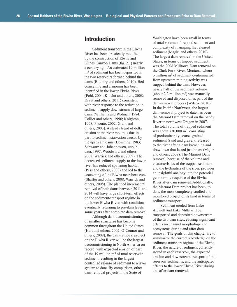
AbstractDuring and after the planned incremental removal of two large, century-old concrete dams between 2011 and 2014, the sediment-transport regime in the lower Elwha River of western Washington will initially spike above background levels and then return to pre-dam conditions some years after complete dam removal. Measurements indicate the upper reaches of the steep-gradient Elwha River, draining the northeast section of the Olympic Mountains, carries between an estimated 120,000 and 290,000 cubic meters of sediment annually. This large load has deposited an estimated 19 million cubic meters of sediment within the two reservoirs formed by the Elwha and Glines Canyon Dams. It is anticipated that from 7 to 8 million cubic meters of this trapped sediment will mobilize and transport downstream during and after dam decommissioning, restoring the downstream sections of the sediment-starved river and nearshore marine environments. Downstream transport of
sediment from the dam sites will have significant effects on channel morphology, water quality, and aquatic habitat during and after dam removal. Sediment concentrations are expected to be between 200 and 1,000 milligrams per liter during and just after dam removal and could rise to as much as 50,000 milligrams per liter during high flows. Downstream sedimentation in the river channel and flood plain will be potentially large, particularly in the lower Elwha River, an alluvial reach with a wide flood plain. Overall aggradation could be as much as one to several meters. Not all reservoir sediment, however, will be released to the river. Some material will remain on hill slopes and flood plains within the drained reservoirs in quantities that will depend on the hydrology, precipitation, and mechanics of the incising channel. Eventually, vegetation will stabilize this remaining reservoir sediment, and the overall sediment load in the restored river will return to pre-dam levels.
28 Coastal Habitats of the Elwha River, Washington—Biological and Physical Patterns and Processes Prior to Dam Removal
IntroductionSediment transport in the Elwha
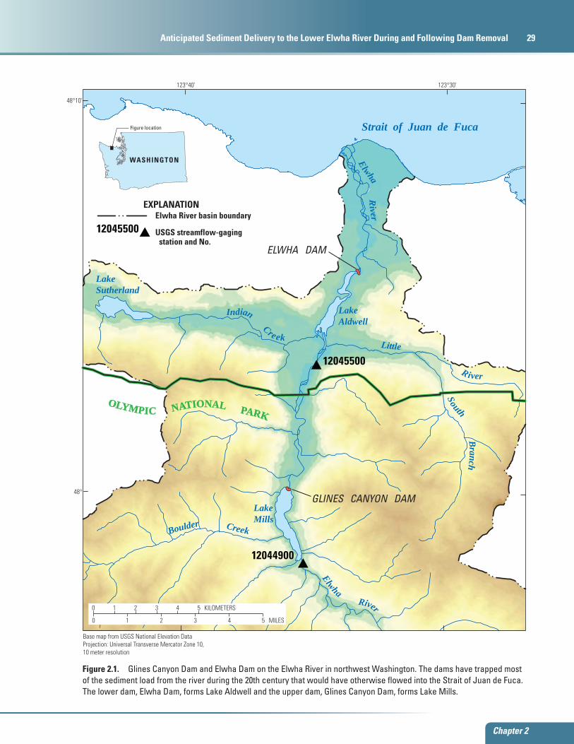
River has been drastically modified by the construction of Elwha and Glines Canyon Dams (fig. 2.1) nearly a century ago. An estimated 19 million m3 of sediment has been deposited in the two reservoirs formed behind the dams (Bountry and others, 2010). Bed coarsening and armoring has been identified in the lower Elwha River (Pohl, 2004; Kloehn and others, 2008; Draut and others, 2011) consistent with river response to the reduction in sediment supply downstream of large dams (Williams and Wolman, 1984; Collier and others, 1996; Knighton, 1998; Pizzuto, 2002; Grant and others, 2003). A steady trend of delta erosion at the river mouth is due in part to sediment starvation caused by the upstream dams (Downing, 1983; Schwartz and Johannessen, unpub. data, 1997; Woodward and others, 2008; Warrick and others, 2009). The decreased sediment supply to the lower river has reduced spawning habitat (Pess and others, 2008) and led to the coarsening of the Elwha nearshore zone (Shaffer and others, 2008; Warrick and others, 2008). The planned incremental removal of both dams between 2011 and 2014 will have large short-term effects on the sediment-transport regime in the lower Elwha River, with conditions eventually returning to pre-dam levels some years after complete dam removal.
Although dam decommissioning of smaller structures has become common throughout the United States (Hart and others, 2002; O’Connor and others, 2008), the dam-removal project on the Elwha River will be the largest decommissioning in North America on record, with expected erosion of part of the 19 million m3 of total reservoir sediment resulting in the largest controlled release of sediment to a river system to date. By comparison, other dam-removal projects in the State of
Washington have been small in terms of total volume of trapped sediment and complexity of managing the released sediment (Magirl and others, 2010). The largest dam removal in the United States, in terms of trapped sediment, was the 2008 Milltown Dam removal on the Clark Fork River, Montana, where 5 million m3 of sediment contaminated from upstream mining activity was trapped behind the dam. However, nearly half of the sediment volume (about 2.2 million m3) was manually removed and disposed of as part of the dam-removal process (Wilcox, 2010). In the Pacific Northwest, the largest dam-removal project to date has been the Marmot Dam removal on the Sandy River in northwest Oregon in 2007. The total volume of trapped sediment was about 730,000 m3, consisting of predominantly coarse-grained sediment (sand and gravel), released to the river after a dam breaching and drawdown that lasted just hours (Major and others, 2008). The Marmot Dam removal, because of the volume and characteristics of the trapped sediment and the hydraulics of the river, provides an insightful analogy into the potential geomorphic response of the Elwha River after dam removal. Additionally, the Marmot Dam project has been, to date, the most completely studied and monitored project of its kind in terms of sediment transport.
Sediment eroded from Lake Aldwell and Lake Mills will be transported and deposited downstream of the two dam sites, causing significant effects on channel morphology and ecosystems during and after dam removal. The goals of this chapter are to summarize the current knowledge on the sediment-transport regime of the Elwha River, the nature of sediment currently stored in each reservoir, the expected erosion and downstream transport of the reservoir sediments, and the anticipated effects to the lower Elwha River during and after dam removal.
Chapter 2
Introduction 29
Chapter 2
Anticipated Sediment Delivery to the Lower Elwha River During and Following Dam Removal 29
tac11-0558_fig 01
12045500
12044900
12045500 USGS streamflow-gaging station and No.
Elwha River basin boundaryEXPLANATION
ELWHA DAM
GLINES CANYON DAM
Strait of Juan de Fuca
LakeSutherland
LakeAldwell
LakeMills
Elwha RiverElwha R
iver
Indian Creek Little R iver
South Branch
Boulder Creek
123°30'123°40'
48°10'
48°
OLYMPIC NATIONAL PARK
Figure location
WASHINGTON
0 51 2 3 4 MILES
0 51 2 3 4 KILOMETERS
Base map from USGS National Elevation DataProjection: Universal Transverse Mercator Zone 10, 10 meter resolution
Figure 2.1. Glines Canyon Dam and Elwha Dam on the Elwha River in northwest Washington. The dams have trapped most of the sediment load from the river during the 20th century that would have otherwise flowed into the Strait of Juan de Fuca. The lower dam, Elwha Dam, forms Lake Aldwell and the upper dam, Glines Canyon Dam, forms Lake Mills.
30 Coastal Habitats of the Elwha River, Washington—Biological and Physical Patterns and Processes Prior to Dam Removal
Sidebar 2.1 Geomorphic Response to Removal of Marmot Dam, Sandy River, Oregon, USA – What Have We Learned?
G.E. Grant, J.J. Major, J.E. O’Connor, C.J. Podolak, M.K. Keith, K.R. Spicer, S. Pittman, H.M. Bragg, J.R. Wallick, D.Q. Tanner, A. Rhode, and P.R. Wilcock
Dam removal has emerged as an important river restoration strategy in the United States. Removals offer an excellent setting for validating analytical models of sediment transport and morphologic change, and testing the capacity of the models to simulate channel evolution in response to changing water and sediment-transport regimes. The largest instantaneous and uncontrolled release of sediment accompanying a dam removal to date (2011) occurred with the breaching of the Marmot Dam coffer dam on the gravel-bed Sandy River in Oregon in October 2007.
Marmot Dam was a concrete diversion dam built in 1913 that stood 14.3 m high by 50 m wide. At the time of removal, the upstream reservoir was completely filled with approximately 750,000 m3 of sand and gravel. The decision to remove the dam was motivated by a combination of increasing maintenance costs and unfavorable economics. To remove the concrete structure, a temporary coffer dam was constructed out of river bed and reservoir sediment approximately 70 m upstream. The main concrete structure was dynamited in July 2007, but the river was allowed to naturally breach the coffer dam and erode the remaining impounded sediment (730,000 m3) during the first autumn storms in October 2007, setting off a dramatic sequence of geomorphic events, upstream and downstream.
Sediment transport and morphologic change were monitored in the days, weeks, months, and years following removal through event-based measurements of suspended sediment and bedload, repeat surveys of channel cross-section and planform change, reservoir incision, and repeat lidar surveys. Measurements of sediment transport immediately downstream of the dam following breaching showed a rapid initial increase in fine suspended sediment within minutes, followed by high rates of suspended-sediment load and bedload transport of sand and, later, gravel. The elevated sediment load was derived from eroded reservoir sediment, which mobilized when a meters-tall knickpoint migrated about 200 m upstream in the first hour after breaching. Over the following days and months, the knickpoint migrated upstream more slowly; within 7 months the knickpoint had migrated 2 km upstream. Knickpoint migration, vertical incision, and lateral erosion evacuated about 15 percent of the initial reservoir volume (125,000 m3) within 60 hours following breaching, and by the end of high flows in May 2008, about 50 percent of the reservoir sediment volume had been evacuated.
About 25 percent of the total volume of sediment eroded from the reservoir was redeposited in a sediment wedge extending about 2 km downstream of the former dam site. The balance of material has been distributed along, and partly fills, pools within the Sandy River gorge, a narrow bedrock canyon extending 2–9 km downstream of the former dam site, but most sediment likely is broadly dispersed along the channel farther downstream. A two-fraction sediment budget indicates that most of the gravel eroded from the reservoir reach was deposited along the channel immediately downstream of the dam site, whereas sand input to and eroded from the reservoir reach largely passed through the gorge and was broadly dispersed farther downstream, chiefly along an 8-km-long channel reach downstream of the river gorge.
Sediment monitoring during dam removal provided insight into the: (1) speed with which unconsolidated reservoir sediment can be eroded even by modest flows; (2) importance of bedrock and longitudinal profile controls on the redistribution of sediment; (3) distinctly different fate of coarse and fine fractions of sediment; (4) importance of the sequence of flows in determining rates of erosion but not final state; and (5) value of coupling upstream and downstream sediment dynamics in models and field campaigns to understand dam removal.
Chapter 2
Introduction 31
Chapter 2
Anticipated Sediment Delivery to the Lower Elwha River During and Following Dam Removal 31
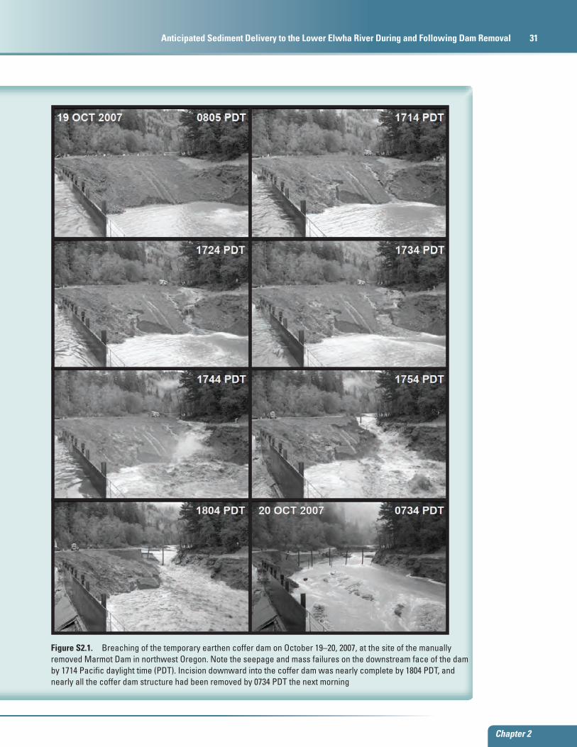
Figure S2.1. Breaching of the temporary earthen coffer dam on October 19–20, 2007, at the site of the manually removed Marmot Dam in northwest Oregon. Note the seepage and mass failures on the downstream face of the dam by 1714 Pacific daylight time (PDT). Incision downward into the coffer dam was nearly complete by 1804 PDT, and nearly all the coffer dam structure had been removed by 0734 PDT the next morningwatac11-0558_fig S2-1
32 Coastal Habitats of the Elwha River, Washington—Biological and Physical Patterns and Processes Prior to Dam Removal
Sediment SupplyElwha Dam is a 32-m high concrete
gravity dam constructed in 1913 at 7.9 km upstream of the river mouth (fig. 2.1), forming Lake Aldwell with an original storage capacity of 10 million m3. Glines Canyon Dam is a 64-m high concrete arch dam constructed in 1927 at 21.7 km upstream of the river mouth, forming Lake Mills with an original storage capacity of 50 million m3. A mapping and sampling effort conducted in 1994–95 on Lake Mills and Lake Aldwell provided much of the current knowledge of sediment deposited in the two reservoirs (Gilbert and Link, 1995), and additional reservoir surveys conducted in July 2010 updated the estimate of total sediment volume accumulated in the two reservoirs combined to 19 million m3 since construction of the dams (Bountry and others, 2010). The upstream sediment supply to Lake Mills was estimated from the volume of accumulated sediment (Gilbert and Link, 1995; Bountry and others, 2010), as well as from field measurements of suspended sediment and bedload transport (Curran and others, 2009).
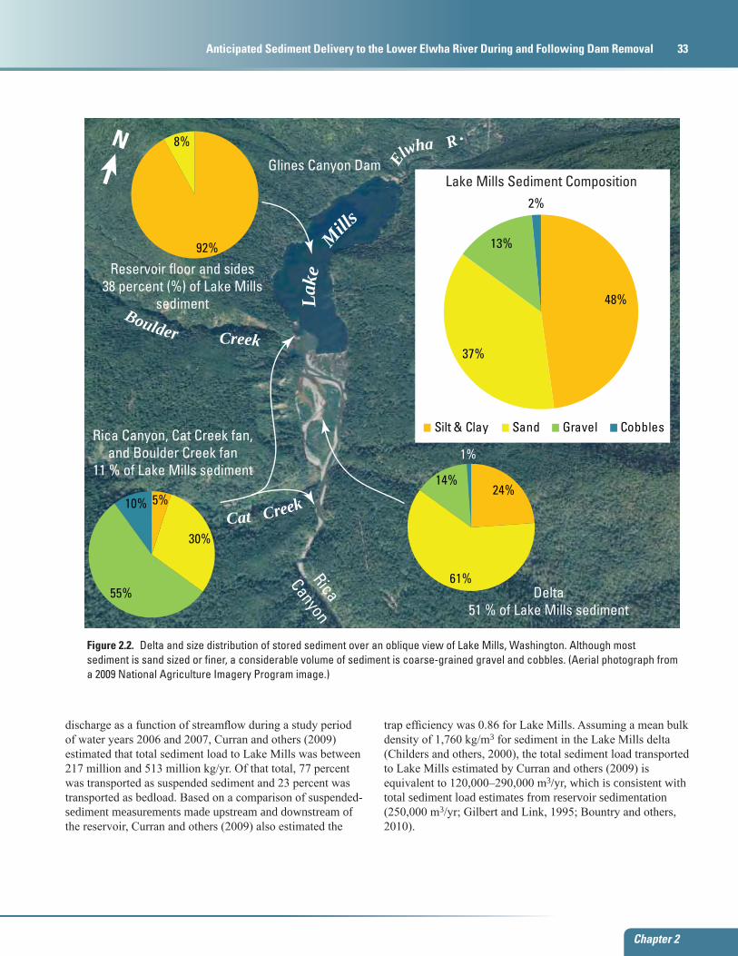
The Lake Mills delta extends upstream into Rica Canyon, has a total length of about 3,000 m, and is as much as 33-m thick (Bountry and others, 2010). The volume of sediment stored in Lake Mills has been measured by combined topographic and bathymetric surveys resulting in estimates of 10.6 million m3 of sediment in 1994 (Gilbert and Link, 1995) and 15.6 million m3 (± 2.7 million m3) of sediment in July of 2010 (Bountry and others, 2010). In 1994, about 51 percent of this material was stored in the delta at the reservoir entrance, 38 percent was stored on the reservoir floor and sides, and the remaining 11 percent was stored
in Rica Canyon and on the alluvial fans of Cat Creek and Boulder Creek (Gilbert and Link, 1995; fig. 2.2).
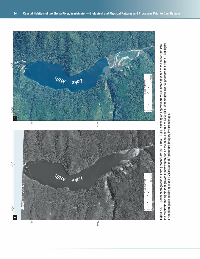
Sediment in the Lake Mills delta fines in the downstream direction and from upper deposits into deeper, older deposits (Gilbert and Link, 1995). Sediment stored in Lake Mills was composed of 48 percent silt and clay, 37 percent sand, and 15 percent gravel, cobbles, and boulders (Gilbert and Link, 1995; fig. 2.2). The delta consists of gravel, cobbles, and boulders at the upstream end transitioning to sand, gravels, and cobbles in the central area. Post-dam deposits also form a gently sloping wedge of fine-grained sediment on the reservoir floor away from the delta that extends to the dam face (Gilbert and Link, 1995). In the years following extensive study of delta dynamics during the 1990s (Childers and others, 2000), the delta in Lake Mills has prograded about 400 m to the mouth of Boulder Creek, and trees and other vegetation have grown extensively over the delta surface (fig. 2.3).
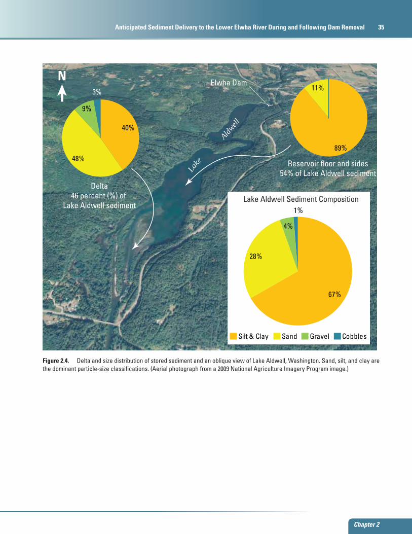
The Lake Aldwell delta held an estimated 3.0 million m3 of sediment in 1994 (Gilbert and Link, 1995). Because no record of a pre-dam survey of the Lake Aldwell topography exists, the sediment volume estimate is based on drill holes and surface exploration. Based on additional reservoir surveys in July 2010, the volume of sediment in Lake Aldwell was estimated at 3.0 million m3 (± 0.8 million m3) (Bountry and others, 2010), suggesting that there was no measurable increase in reservoir sediment volume between 1994 and 2010. About 46 percent of the sediment in Lake Aldwell is stored in the delta and 54 percent is stored on the reservoir floor and sides; the sediment is composed of 67 percent silt and clay, 28 percent sand, and 5 percent gravel, cobbles, and boulders (fig. 2.4;
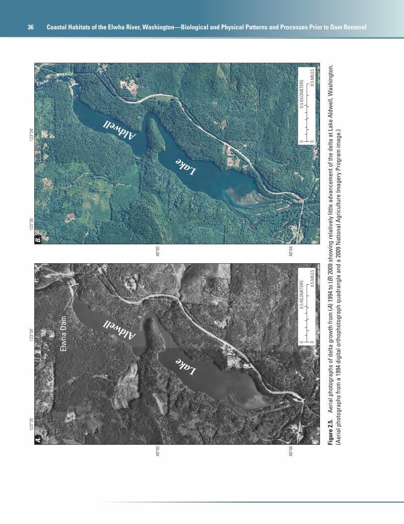
Gilbert and Link, 1995). The Lake Aldwell delta is about 750-m long and as much as 5–7-m thick and is nested in older river-terrace deposits (Gilbert and Link, 1995). The upstream area of the delta consists primarily of gravel, cobbles, and boulders, and the deltaic deposits transition to predominantly silt and sand at the distal extent. Similar to deposition patterns in Lake Mills, the post-dam, fine-grained sediment forms a gently sloping wedge on the Lake Aldwell reservoir floor that extends to the dam face (Gilbert and Link, 1995). In contrast to the dynamic changes observed on the Lake Mills delta, the Lake Aldwell delta has remained relatively unchanged between 1994 and 2010 (fig. 2.5).
Estimates of the annual sediment load into Lake Mills can be used to approximate the sediment discharge rates in the Elwha River as well as the long-term anticipated sediment load into the Strait of Juan de Fuca after the initial sediment pulse following dam removal subsides. Based on sediment accumulation rates in both reservoirs, the long-term sediment loads were estimated to be 130,000 m3/yr for coarse sediment and 120,000 m3/yr for fine sediment, thus totaling 250,000 m3/yr (Gilbert and Link, 1995; Bountry and others, 2010). These volumetric estimates can be compared to sediment discharge estimates by Curran and others (2009). Using field measurements of suspended sediment (1995–98, 2006–07) and bedload (1994–97) at the Elwha River above Lake Mills (U.S. Geological Survey streamflow-gaging station 12044900), regression equations were developed to estimate both suspended-sediment and bedload discharge as a function of streamflow (Curran and others, 2009). Applying regression equations for suspended-sediment and bedload
Chapter 2
Sediment Supply 33
Chapter 2
Anticipated Sediment Delivery to the Lower Elwha River During and Following Dam Removal 33
watac11-0558_fig 2-02
Rica
Canyon
N
Elwha R .
Lak
e M
ills
Cat Creek
Boulder Creek
48%
37%
13%
2%
Silt & Clay Sand Gravel Cobbles
Lake Mills Sediment Composition
Delta51 % of Lake Mills sediment
Reservoir floor and sides 38 percent (%) of Lake Mills
sediment
Rica Canyon, Cat Creek fan, and Boulder Creek fan
11 % of Lake Mills sediment24%
61%
14%
1%
Glines Canyon Dam
92%
8%
5%
30%
55%
10%
Figure 2.2. Delta and size distribution of stored sediment over an oblique view of Lake Mills, Washington. Although most sediment is sand sized or finer, a considerable volume of sediment is coarse-grained gravel and cobbles. (Aerial photograph from a 2009 National Agriculture Imagery Program image.)
discharge as a function of streamflow during a study period of water years 2006 and 2007, Curran and others (2009) estimated that total sediment load to Lake Mills was between 217 million and 513 million kg/yr. Of that total, 77 percent was transported as suspended sediment and 23 percent was transported as bedload. Based on a comparison of suspended-sediment measurements made upstream and downstream of the reservoir, Curran and others (2009) also estimated the
trap efficiency was 0.86 for Lake Mills. Assuming a mean bulk density of 1,760 kg/m3 for sediment in the Lake Mills delta (Childers and others, 2000), the total sediment load transported to Lake Mills estimated by Curran and others (2009) is equivalent to 120,000–290,000 m3/yr, which is consistent with total sediment load estimates from reservoir sedimentation (250,000 m3/yr; Gilbert and Link, 1995; Bountry and others, 2010).
34 Coastal Habitats of the Elwha River, Washington—Biological and Physical Patterns and Processes Prior to Dam Removal
11-0
558_
fig 2
-03
123°
36'
123°
37'
48°
47°5
9'
48°
47°5
9'
123°
36'
123°
37'
0.5
MIL
ES0
0.5
KILO
MET
ERS
0
0.5
MIL
ES0
0.5
KILO
MET
ERS
0
Lake Mills
Lake Mills
Elwha River
Glin
es C
anyo
n Da
m
A.
B.
Figu
re 2
.3.
Ae
rial p
hoto
grap
hs o
f del
ta g
row
th fr
om (A
) 199
0 to
(B) 2
009
show
ing
an a
ppro
xim
atel
y 40
0-m
eter
adv
ance
of t
he d
elta
fron
t int
o th
e re
serv
oir a
nd s
igni
fican
t gro
wth
of n
ew v
eget
atio
n on
the
delta
ic s
urfa
ce a
t Lak
e M
ills,
Was
hing
ton.
(Aer
ial p
hoto
grap
hs fr
om a
199
0 di
gita
l or
thop
hoto
grap
h qu
adra
ngle
and
a 2
009
Nat
iona
l Agr
icul
ture
Imag
ery
Prog
ram
imag
e.)
Chapter 2
Sediment Supply 35
Chapter 2
Anticipated Sediment Delivery to the Lower Elwha River During and Following Dam Removal 35
watac11-0558_fig 2-04
N
L
ak
e
Aldwell
Silt & Clay Sand Gravel Cobbles
67%
28%
4%
1%Lake Aldwell Sediment Composition
40%
48%
9%
3%
89%
11%
Delta46 percent (%) of
Lake Aldwell sediment
Elwha Dam
Reservoir floor and sides54% of Lake Aldwell sediment
Figure 2.4. Delta and size distribution of stored sediment and an oblique view of Lake Aldwell, Washington. Sand, silt, and clay are the dominant particle-size classifications. (Aerial photograph from a 2009 National Agriculture Imagery Program image.)
36 Coastal Habitats of the Elwha River, Washington—Biological and Physical Patterns and Processes Prior to Dam Removal
11-0
558_
fig 2
-05
123°
34'
123°
35'
48°0
5'
48°0
4'
123°
34'
123°
35'
48°0
5'
48°0
4'
0.5
MIL
ES
00.
5 KI
LOM
ETER
S
00.
5 M
ILES
00.
5 KI
LOM
ETER
S
0
Elw
ha D
am
Lake
Aldwell
Lake
Aldwell
Elwha River
A.
B.
Figu
re 2
.5.
Aeria
l pho
togr
aphs
of d
elta
gro
wth
from
(A) 1
994
to (B
) 200
9 sh
owin
g re
lativ
ely
little
adv
ance
men
t of t
he d
elta
at L
ake
Aldw
ell,
Was
hing
ton.
(A
eria
l pho
togr
aphs
from
a 1
994
digi
tal o
rthop
hoto
grap
h qu
adra
ngle
and
a 2
009
Nat
iona
l Agr
icul
ture
Imag
ery
Prog
ram
imag
e.)
Chapter 2
Anticipated Sediment Effects from Dam Removal 37
Chapter 2
Anticipated Sediment Delivery to the Lower Elwha River During and Following Dam Removal 37
Anticipated Sediment Effects from Dam Removal
Elwha and Glines Canyon Dams are slated for decommissioning beginning in September 2011, and one of the primary concerns during and after removal of the dams is the fate of the estimated 19 million m3 of total stored reservoir sediments. Of the four general categories of sediment-management alternatives originally considered for dam decommissioning (no action, river erosion, mechanical removal, and stabilization; Randle, 2002), the river-erosion alternative; that is, allowing the river to erode part of the stored sediment using natural river-transport processes (Randle and others, 1996), was selected because it was deemed the most cost-effective way to fully restore the river system (U.S. Department of the Interior, 1995, 1996, 2005a, 2005b).
Several key scientific investigations provide insight into the potential erosion and transport of reservoir sediment in response to the removal of Elwha and Glines Canyon Dams. A field experiment was conducted on Lake Mills in April 1994 that used a trial drawdown of the reservoir levels to demonstrate the potential effects of removing Glines Canyon Dam on the erosion and transport of Lake Mills sediment (Childers and others, 2000). Changes in sediment transport and suspended-sediment concentration during and after
dam removal were investigated by the Bureau of Reclamation using a mass-balance model to simulate reservoir sediment erosion and a one-dimensional sediment-transport model, HEC-6, to simulate hydraulics and sediment transport of the river downstream of Elwha Dam (Randle and others, 1996). Laboratory physical modeling experiments were conducted by Bromley and others (2011) to investigate the dynamics of sediment erosion from the Lake Mills delta during dam removal. Additionally, Konrad (2009) simulated the dam-removal response in the entire Elwha River using a one-dimensional model developed by Bennett (2001).
Although there is agreement among these various simulations, the responses of the river to dam removal are still not certain. Adaptive management will monitor erosion of the reservoir sediments and effects to the lower river during and after dam removal to determine if alterations to the dam-removal and management strategy are necessary (Randle and Bountry, 2010). Management concerns during dam removal include the release of fine-grained sediment (silt and clay-sized material) affecting downstream water quality and the release of accumulated coarse-grained sediment (sand, gravel, and cobbles) with the potential to affect downstream channel geomorphology, flooding potential, channel-migration rates, habitat productivity, and coastal processes.
38 Coastal Habitats of the Elwha River, Washington—Biological and Physical Patterns and Processes Prior to Dam Removal
Erosion of Reservoir Sediment
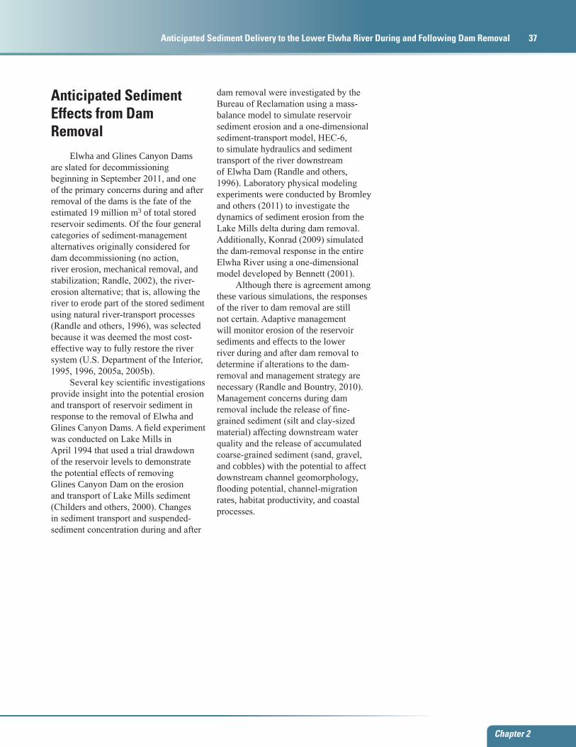
Elwha and Glines Canyon Dams will be removed concurrently over a 2–3-year period. Each dam, and associated reservoir water-surface elevation, will be drawn down in controlled increments of 2–6 m to allow erosion and redistribution of the delta sediment in the remaining reservoir. The maximum drawdown rate for each increment will be limited to 0.46 m/d in an effort to prevent initiation of reservoir landslides. As reservoir levels are lowered, headcut erosion will propagate upstream through the reservoir sediment. Periods of constant reservoir elevation between the incremental lowering will allow river processes like meandering and channel migration to induce lateral erosion of the sediment (Randle and others, 1996). Observations during the 1994 drawdown experiment of Lake Mills (Childers and others, 2000) showed that unvegetated deltaic sediment was readily mobilized and transported out of the reservoir (fig. 2.6).
As the two dams are incrementally removed, each delta will prograde, releasing fine sediment into suspension and transporting coarse-grained sediment farther into the shrinking reservoir. In the early stages of drawdown, the large reservoir capacity in the existing pool will allow much of the fine sediment to fall back out of suspension and not pass downstream of the dam site. This response was observed during the 1994 drawdown experiment as the maximum suspended-sediment concentration measured in the draining Lake Mills reservoir was 6,110 mg/L,
although the measured suspended-sediment concentration downstream of the dam in Glines Canyon did not exceed 20 mg/L (Childers and others, 2000). As the remaining reservoir water volume decreases from the lowered water surface and infilling from the prograding delta, the capacity of the reservoir to retain suspended sediment will decrease and more suspended sediment will progressively exit the reservoir. Additionally, the volumes of fine-sediment erosion will increase and mix with an ever decreasing reservoir water volume, resulting in increased suspended-sediment concentrations released from the reservoir.
Coarse sediment transported as bedload, however, will remain in the reservoir until the prograding delta reaches the lowered dam structure. After the top one-half to two-thirds of each dam has been removed, the volume of sediment eroded and prograded toward the dam site may be sufficient to completely fill the remaining reservoir volume behind the partially lowered dam (Randle, 2006; Randle and Bountry, 2010). Thereafter, each successive increment of dam removed will draw down the reservoir and release pulses of bedload and suspended-sediment load to the river.
A primary goal during the dam-removal process is to erode as much sediment as possible across the delta flood plain to avoid stranding large wedges of sediment in the former reservoir inundation area. Large wedges of sediment would be susceptible to catastrophic mass wasting even after the dams are completely removed, endangering people and structures downstream and potentially affecting
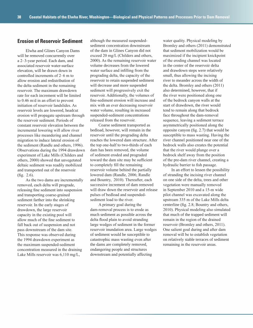
water quality. Physical modeling by Bromley and others (2011) demonstrated that sediment mobilization would be maximized if the incipient knickpoint of the eroding channel was located in the center of the reservoir delta and drawdown steps were relatively small, thus allowing the incising river to meander across the width of the delta. Bromley and others (2011) also determined, however, that if the river were positioned along one of the bedrock canyon walls at the start of drawdown, the river would tend to remain along that bedrock face throughout the dam-removal sequence, leaving a sediment terrace asymmetrically positioned along the opposite canyon (fig. 2.7) that would be susceptible to mass wasting. Having the river channel positioned near one of the bedrock walls also creates the potential that the river would plunge over a bedrock shelf away from the position of the pre-dam river channel, creating a hydraulic barrier to fish passage.
In an effort to lessen the possibility of stranding the incising river channel on one side of the delta, trees and other vegetation were manually removed in September 2010 and a 15-m wide pilot channel was excavated along the upstream 335 m of the Lake Mills delta centerline (fig. 2.8; Bountry and others, 2010). Physical modeling also simulated that much of the trapped sediment will remain in the region of the drained reservoir (Bromley and others, 2011). One salient goal during and after dam removal will be to establish vegetation on relatively stable terraces of sediment remaining in the reservoir areas.
Chapter 2
Anticipated Sediment Effects from Dam Removal 39
Chapter 2
Anticipated Sediment Delivery to the Lower Elwha River During and Following Dam Removal 39
watac11-0558_fig 2-06
A. B.
Figure 2.6. Drawdown experiment at the Lake Mills delta, Washington, in 1994. (A) Eroded sediment redeposited at the distal end of the prograding delta across the entire width of the receding reservoir. (B) The incised active channel showed the underlying stratigraphy of the delta and multiple, inset terraces. Lack of stabilizing vegetation and the coarse, non-cohesive nature of the sediment allowed vigorous incision and downstream transport (adapted from Randle and Bountry, 2008).
Figure 2.7. Physical model experiments of sediment erosion (A) without a pilot channel and (B) with a pilot channel showing the extensive and potentially problematic high terrace of alluvial sediment that may remain if the incising channel starts along one of the bedrock walls, Lake Mills, Washington. (Photographs courtesy of Chris Bromley; adapted from Randle and Bountry, 2008.)
watac11-0558_fig 2-07
A. B.

40 Coastal Habitats of the Elwha River, Washington—Biological and Physical Patterns and Processes Prior to Dam Removal
Figure 2.8. Lake Mills delta, Washington, (A) before construction of a pilot channel and removal of vegetation, September 13, 2010; (B) with the newly constructed center pilot channel passing flow after a 5.5-meter reservoir drawdown, November 3, 2010; and (C) after a flood that peaked on December 12, 2010, at 632 cubic meters per second (22,300 cubic feet per second), December 15, 2010. ([A] Photograph courtesy of Tom Roorda, Northwestern Territories, Inc.; [B] photograph courtesy of Dick Bauman, Bureau of Reclamation; and [C] photograph courtesy of Dick Bauman, Bureau of Reclamation.)
watac11-0558_fig 2-08
A.
C.
B.
Chapter 2
Anticipated Sediment Effects from Dam Removal 41
Chapter 2
Anticipated Sediment Delivery to the Lower Elwha River During and Following Dam Removal 41
Sediment Delivery Downstream of Dam Sites
Typical downstream river response to dam removal includes increased turbidity and sediment concentrations (Randle, 2002; Stanley and Doyle, 2002; Major and others, 2008) as well as geomorphic responses to the increased sediment loads, although the magnitude of these effects tends to decrease with time and distance from the dam (Pizzuto, 2002). The modeling efforts by Randle and others (1996) and Konrad (2009), along with observations from the 1994 drawdown (Childers and others, 2000) and the physical modeling experiments by Bromley and others (2011) provided much of the basis for expectations of the sediment delivery to the Elwha River downstream of both dam sites and the response of the river.
Based on results from the Bureau of Reclamation mass-balance modeling, between one-half and two-thirds of silt and clay-sized sediment in the reservoirs are expected to erode and be transported downstream as suspended load, and between one-quarter and one-third of the sand and gravel-sized sediments are expected to erode from the reservoirs and be transported downstream as bedload (Randle and others, 1996; Randle, 2006). Extrapolating these earlier model simulation results (Randle and others, 1996) to the updated estimate of 19 million m3 of accumulated reservoir sediment since construction of the dams (Bountry and others, 2010), it is estimated that 7–8 million m3 of sediment will erode from the reservoirs and be released to the river downstream.
Fine-Sediment TransportMuch of the fine sediment released
during dam removal will be transported in suspension directly to the Strait of Juan de Fuca, resulting in increased suspended-sediment concentrations and turbidity throughout the lower river (Randle and others, 1996). Simulated suspended-sediment concentrations at Glines Canyon Dam were high during dam removal, exceeding 10,000 mg/L for several weeks each year (Konrad, 2009). Simulated suspended-sediment concentrations at the river mouth did not exceed 500 mg/L nearly as often as downstream of Glines Canyon Dam, generally less than 20 days in a 3 month period. The Konrad (2009) simulations were consistent with earlier model simulation results by the Bureau of Reclamation (Randle and others, 1996). Based on the Bureau of Reclamation model simulation results, suspended-sediment concentrations are expected to be typically between 200 and 1,000 mg/L during the dam-removal period with temporary peaks as high as 30,000–50,000 mg/L (Randle and others, 1996). For comparison, based on the regressions developed with suspended-sediment concentration data collected in the Elwha River just upstream of Lake Mills (Curran and others, 2009), the background suspended-sediment concentration in the Elwha River at a median flow of 34 m3/s would be 4.6 mg/L and the concentration at 101 m3/s (a discharge value exceeded only 5 percent of the time) would be 121 mg/L.
After dam removal, fine-sediment concentrations are expected to return to natural, background levels within 2–5 years after complete removal (Randle and others, 1996). Similarly, Konrad’s (2009) simulations suggested that suspended-sediment transport likely will return to normal levels during low to moderate flows within 4 years after dam removal. However, larger flow events may still generate high suspended-sediment concentrations, as erosion is expected to further widen the channels in the drained reservoir region (Randle and others, 1996). These episodic high discharge values may cause high suspended-sediment concentrations and bed instability that may have deleterious effects on Chinook salmon incubation through infill of spawning gravels and reduction of flow to salmon redds (Konrad, 2009).
Coarse-Sediment TransportThe exact timing of the arrival of
the coarse-grained bedload to the lower Elwha River is not certain. Coarse material will be released downstream once the prograding deltas have reached the lowered dam faces. However, the rate of transport downstream will depend on the rate of dam removal and the driving hydrology in the years during and following dam removal (Randle and others, 1996; Konrad, 2009). If the winter seasons are wet, the resulting high river flows will be able to transport larger quantities and sizes of sediment downstream at a faster rate. In contrast, if dry conditions persist, the river will have less capacity to transport this coarse material downstream and more time will elapse before this coarse sediment arrives in the lower river.
42 Coastal Habitats of the Elwha River, Washington—Biological and Physical Patterns and Processes Prior to Dam Removal
Although 95 percent of the sediment from the Lake Aldwell delta consists of sand, silt, and clay and probably will have a minimal geomorphic affect on the lower Elwha River, much of the coarser material from the Lake Aldwell delta may start to arrive in deposits in the lower river during the second winter (2012–13), accreting some existing gravel bars and probably transporting downstream relatively quickly. Farther upstream, no coarse bedload will exit Lake Mills until the prograding delta impinges against the lowered Glines Canyon Dam structure. Coarse sediment release may begin during the second winter season (2012–13), although large quantities of bedload probably will not pass the Glines Canyon Dam site until the winter of the final year of dam removal (2013–14). This enhanced bedload will then transport down the middle reach of the river for another 2–5 years after complete removal of Glines Canyon Dam (Randle and others, 1996).
Although the first appreciable transport of coarse reservoir material to the lower river may start to be observed in the winter of the third year of dam removal (2013–14), whole-scale geomorphic changes and concomitant increases in bedload and sediment caliber associated with downstream translation of reservoir sediment will affect the lower river 4–7 years after the start of dam removal. Bedload transport rates are then expected to return to background conditions 7–10 years after the start of dam removal. However, there is considerable uncertainty in the bedload transport and system response.
Geomorphic Effects due to Released Sediment
The lower river downstream of Elwha Dam will undergo geomorphic changes due to the increased sediment supply during and after dam removal (Draut and others, 2008; Konrad, 2009). Initially, as only fine material is released from the reservoirs, bimodal grain-size distributions will result downstream due to the newly transported sand combined with the armored cobble and boulder bed (Kloehn and others, 2008). As dam removal progresses and fine and coarse sediment are released downstream, the river is expected to become transport-limited: sediment will deposit in areas where the transport capacity of the river is less than the sediment supply (that is, pools, side channels, recirculation zones, and flood plain edges along the channel). Most aggradation is expected to occur in river pools during periods of low river discharge. Aggradation on riffles is not as likely to occur, but is possible depending on the magnitude and frequency of peak flows during and after dam removal.
Simulations by Konrad (2009) showed that within 4 years after completion of dam removal the lower Elwha River will aggrade as much as about 2.5 m in the upper part of the lower river and relatively little near the river mouth. Similarly, Bureau of Reclamation simulations suggest that areas of the lower river will aggrade between 0–3 m in the short term and in the decades after dam removal up to an average of 1.4 m throughout the lower river (Randle and others, 1996; Randle,
2006). Overall, river reaches with the greatest potential for morphological change include depositional reaches with lower slopes (for example, lower Elwha River), valley expansions (for example, upstream of Lake Aldwell), or upstream of constrictions where backwater exists at higher flow (for example, upstream of Glines Canyon) (Konrad, 2009). In the decades after dam removal, channel migration is expected to increase in the lower reach (Kloehn and others, 2008). Due to aggradation and fining of material in the lower river, the channel could shift from the current anabranching form (see Warrick and others, 2011, chapter 3, this report) to a braided system (Draut and others, 2008), likely resulting in a straighter channel alignment (steeper slope), which is consistent with a braided channel planform (Randle and Bountry, 2008).
The sediment released from these dam removals will affect downstream flood risk and ecosystems. Simulations from the Bureau of Reclamation suggest that sedimentation would increase the 100-year flood stage along the lower Elwha River by less than 1 m (Randle and others, 1996; Randle, 2006). In response to these simulations, existing levees along the lower Elwha River were raised and new levees were constructed to protect landowners downstream. In the lower river reaches, the initial increase in sediment load will disrupt aquatic and riparian ecology. However, sediment deposition and the incorporation of large woody debris and organic matter will lead to an overall increase in quantity and quality of fish habitat (Woodward and others, 2008).
Chapter 2
Anticipated Sediment Effects from Dam Removal 43
Chapter 2
Anticipated Sediment Delivery to the Lower Elwha River During and Following Dam Removal 43
Sediment Monitoring During and After Dam Removal
Even with the current simulations, there is considerable uncertainty in the timing and magnitude of the system response to the removal of Elwha and Glines Canyon Dams. Observations from the Marmot Dam removal suggested smaller overall aggradation rates downstream and a faster chronology of river responses than numerical simulations (Major and others, 2008). Studies of the Milltown Dam removal determined that (1) reservoir erosion occurred at greater rates than simulated by numerical modeling due to greater-than-anticipated lateral erosion (Johnsen, 2011), and (2) a sediment pulse that traveled by both translation and dispersion produced downstream pool filling, fine sediment infiltration (Evans and Wilcox, 2010), and sedimentation of side channels, but minimal overall aggradation (Wilcox, 2010).
Monitoring of river reaches downstream of the Elwha and Glines Canyon Dam sites will provide important insight into these geomorphic processes as the Elwha River adjusts to and recovers from the dam-removal process. During initial reservoir drawdown, monitoring activities will be focused on reservoir surveys, reservoir elevation, turbidity, discharge, and investigations to characterize the areas of erosion and the advancement of the delta fronts (Randle and Bountry, 2010). Turbidity will be measured continuously upstream of Lake Mills and at the new surface-water diversion structure at river kilometer (RKm) 5.3 to monitor water quality in the river where water is diverted into the Elwha Water Treatment Plant (Randle and Bountry, 2010). If suspended sediment degrades water quality beyond an acceptable threshold, the pace of dam removal will be adjusted within the
adaptive management framework to reduce effects for downstream water users. Additionally, an acoustic Doppler current profiler (ADCP) and a laser in-situ scattering and transmissometry (LISST) system will be installed at the water diversion structure to enable the quantification of suspended-sediment load in the lower river at least through 2013. Physical samples will be collected through at least the end of 2013 to quantify the suspended-sediment concentration carried by the river under different hydrologic conditions. These samples, in turn, will be used with turbidity data, acoustic-backscatter data, and LISST data to estimate the continuous suspended-sediment load carried within the lower Elwha River.
Monitoring of riverbed aggradation and potential increase in flood stage downstream of the dams will begin once sand and gravel have begun to transport downstream of the reservoir sites, using a combination of stage recorders, channel cross-section surveys, and longitudinal profile surveys (Randle and Bountry, 2010). A series of geophone bedload sensors were installed along the crest of the diversion weir at the new Elwha Water Treatment Plant (RKm 5.3) to continuously measure acoustic energy generated by bedload transport during and after dam removal (Marr and others, 2009; Randle and others, 2009). To fully quantify flux of bedload, however, physical measurements of bedload are needed to correlate acoustic energy measured with the geophones to gravel transport. There are currently no plans to measure bedload in the lower river during the dam-removal project. Over the long term, river-based monitoring will focus on the restoration of vegetation, habitat, sediment dynamics, the function of large woody debris, and morphological processes in the lower river, estuary, and nearshore zone (Woodward and others, 2008).
Although some monitoring of sediment load and geomorphic response of the river corridor during and after dam removal will occur, the amount of basic geomorphic research currently planned during the project is relatively modest. No measurements of bedload transport are currently planned. Suspended-sediment load will be measured in the lower river through 2013, but monitoring beyond 2014 is unfunded and no suspended-sediment measurements are planned upstream of Lake Mills or between the two reservoirs. These additional monitoring sites would provide spatial resolution of the rate of sediment mobilization and downstream transport and enable the construction of a quantifiable sediment budget throughout the river. Finally, there are no plans to collect remotely-sensed geomorphic data sets of repeat aerial photography or lidar during the project. Such public data sets would enable a wealth of follow-on analyses that could provide important insight well after completion of the dam removals.
The restoration of the Elwha River represents a true “best case” for what a full-on watershed restoration scheme might hope to accomplish. The removal of Elwha and Glines Canyon Dams is unique, in part, because the project represents the largest controlled release of sediment in the history of North America. This particular project is also unique because it encompasses an entire watershed including the estuarine and marine habitats of a predominantly pristine wilderness historically home to all runs of Pacific Northwest anadromous salmonids. It is imperative that the response and recovery of the Elwha River during and after dam decommissioning are studied if reasonable expectations for other watershed-based restoration efforts are to be established. A sound technical narrative of this unprecedented project is needed to describe the fate of the sediment in the years to decades after dam removal.
44 Coastal Habitats of the Elwha River, Washington—Biological and Physical Patterns and Processes Prior to Dam Removal
SummaryThe presence of Elwha Dam and
Glines Canyon Dam have significantly altered the sediment transport and geomorphic processes of the Elwha River and the nearshore environment in the Strait of Juan de Fuca. The planned removal of the dams from 2011 to 2014 will release an anticipated 7–8 million cubic meters of the estimated 19 million cubic meters of stored reservoir sediment to erosion and transport downstream. During dam decommissioning, fine sediment is expected to be more readily mobilized than coarse sediment.
Studies indicate that suspended-sediment concentration during low to moderate flows will return to pre-dam levels within a few years after the dams are completely removed. Storm events will continue to generate higher concentrations of suspended sediment until the reservoir sediment is no longer significantly eroding over the long term. Generally, recovery rates of sediment-transport regimes relative to background conditions are expected to take 4–7 years following complete dam removal. The magnitude, timing, and frequency of storm events during and soon after dam removal are the mechanisms causing the overall transport of released sediment to the river downstream and the time until long-term stabilization of the sediment has been obtained.
References Cited
Bennett, J.P., 2001, User’s guide for mixed-size sediment transport model for networks of one-dimensional open channels: U.S. Geological Survey Water-Resources Investigations Report 01-4054, 33 p. (Also available at http://pubs.er.usgs.gov/djvu/WRI/WRI%202001%204054.pdf.)
Bountry, J.A., Ferrari, R., Wille, K., and Randle, T.J., 2010, 2010 survey report and area-capacity tables for Lake Mills and Lake Aldwell on the Elwha River, Washington: Denver, Colo., U.S. Department of the Interior, Bureau of Reclamation, Technical Service Center, Report No. SRH-2010-23, 66 p.
Bromley, C., Randle, T., Grant, G., and Thorne, C., 2011, Physical modeling of the removal of Glines Canyon Dam and Lake Mills from the Elwha River, Washington, chap. 7 of Papanicolaou, A.N., and Barkdoll, B.D., eds., Sediment dynamics upon dam removal: American Society of Civil Engineers Manuals and Reports on Engineering Practice No. 122, p. 97-114.
Childers, D., Kresch, D.L., Gustafson, S.A., Randle, T.J., Melena, J.T., and Cluer, B., 2000, Hydrologic data collected during the 1994 Lake Mills drawdown experiment, Elwha River, Washington: U.S. Geological Survey Water-Resources Investigations Report 99-4215, 115 p.
Collier, M., Webb, R.H., and Schmidt, J.C., 1996, Dams and rivers—A primer on the downstream effects of dams: U.S. Geological Survey Circular 1126, 94 p.
Curran, C.A., Konrad, C.P., Higgins, J.L., and Bryant, M.K., 2009, Estimates of sediment load prior to dam removal in the Elwha River, Clallam County, Washington: U.S. Geological Survey Scientific Investigations Report 2009-5221, 18 p. (Also available at http://pubs.usgs.gov/sir/2009/5221/.)
Downing, J., 1983, The coast of Puget Sound—Its processes and development: Seattle, University of Washington Press, 126 p.
Draut, A.E., Logan, J.B., and Mastin, M.C., 2011, Channel evolution on the dammed Elwha River, Washington, USA: Geomorphology, v. 127, p. 71-87.
Draut, A.E., Logan, J.B., McCoy, R.E., McHenry, M., and Warrick, J.A., 2008, Channel evolution on the lower Elwha River, Washington, 1939–2006: U.S. Geological Survey Scientific Investigations Report 2008-5127, 26 p. (Also available at http://pubs.usgs.gov/sir/2008/5127/.)
Evans, E.G., and Wilcox, A.C., 2010, Spatial variation of fine sediment infiltration in a gravel-bedded river [poster]: Eos, Transactions of the American Geophysical Union Fall Meeting, San Francisco, Calif., 2010, Supplemental Abstract H31E-1052.
Gilbert, J., and Link, R.A., 1995, Alluvium distribution in Lake Mills, Glines Canyon Project and Lake Aldwell, Elwha Project, Washington: U.S. Department of the Interior, Elwha Technical Series PN-95-4, 60 p.
Grant, G.E., Schmidt, J.C., and Lewis, S.L., 2003, A geological framework for interpreting downstream effects of dams on rivers, in O’Connor, J.E., and Grant, G.E., eds., A peculiar river—Geology, geomorphology, and hydrology of the Deschutes River, Oregon: American Geophysical Union Water Science and Application Series, no. 7, 220 p.
Hart, D.D., Johnson, T.E., Bushaw-Newton, K.L., Horwitz, R.J., Bednarek, A.T., Charles, D.F., Kreeger, D.A., and Velinsky, D.J., 2002, Dam removal—Challenges and opportunities for ecological research and river restoration: BioScience, v. 52, no. 8, p. 669-681.
Chapter 2
References Cited 45
Chapter 2
Anticipated Sediment Delivery to the Lower Elwha River During and Following Dam Removal 45
Johnsen, J.W., 2011, Sampling and modeling of sediment transport and reservoir erosion following dam removal—Milltown Dam, Montana: Missoula, University of Montana, M.S. thesis.
Kloehn, K.K., Beechie, T.J., Morley, S.A., Coe, H.J., and Duda, J.J., 2008, Influence of dams on river-floodplain dynamics in the Elwha River, Washington: Northwest Science, v. 82 (special issue), p. 224-235.
Knighton, D., 1998, Fluvial forms and processes: London, Arnold, 383 p.
Konrad, C.P., 2009, Simulating the recovery of suspended sediment transport and river-bed stability in response to dam removal on the Elwha River, Washington: Ecological Engineering, v. 35, no. 7, p. 1104-1115.
Magirl, C.S., Connolly, P.J., Coffin, B., Duda, J.J., Curran, C.A., and Draut, A.E., 2010, Sediment management strategies associated with dam removal in the State of Washington, in Bernard, J.M., and Webb., J.W., eds.: Joint Federal Interagency Conference on Sedimentation and Hydrologic Modeling, Las Vegas, Nev., June 28–July 1, 2010 [Proceedings], 10 p.
Major, J.J., O’Connor, J.E., Grant, G.E., Spicer, K.R., Bragg, H.M., Rhode, A., Tanner, D.Q., Anderson, C.W., and Wallick, J.R., 2008, Initial fluvial response to the removal of Oregon’s Marmot Dam: Eos, American Geophysical Union Transactions, v. 89, no. 27, p. 241-252.
Marr, J.D.G., Johnson, S.R., Ellis, C.R., Randle, T.J., and Hilldale, R.C., 2009, Laboratory research and development of bedload impact-plate sensors: International Association of Hydraulic Engineering and Research Biennial Congress, 33rd, Vancouver, British Columbia, 2009 [Proceedings].
O’Connor, J., Major, J., and Grant, G., 2008, The dams come down—Unchaining U.S. rivers: Geotimes; Earth, Energy and Environment News, v. 53, no. 3, p. 22-28.
Pess, G.R., McHenry, M.L., Beechie, T.J., and Davies, J., 2008, Biological impacts of the Elwha River dams and potential salmonid responses to dam removal: Northwest Science, v. 82 (special issue), p. 72-90.
Pizzuto, J., 2002, Effects of dam removal on river form and process: Bioscience, v. 52, no. 8, p. 683-691.
Pohl, M., 2004, Channel bed mobility downstream of the Elwha dams, Washington: The Professional Geographer, v. 56, p. 422-431.
Randle, T.J., 2002, Dam removal and sediment management, in Graf, W.L., ed., Dam removal research—Status and prospects: Proceedings of the Heinz Center’s Dam Removal Research Workshop, Washington, D.C., October 23–24, 2002, p. 81-104.
Randle, T.J., 2006, Technical memorandum to Elwha River restoration project, Olympic National Park, Application of the report entitled “Sediment analysis and modeling of the river erosion alternative”: U.S. Department of the Interior, Bureau of Reclamation, Elwha Technical Series PN-95-9, 1996.
Randle, T.J., and Bountry, J.A., 2008, Elwha River sediment management in International Conference on Hydro-Science and Engineering, 8th, September 8–12, 2008, Proceedings: Nagoya, Japan, International Conference on Hydro-Science and Engineering–2008, 10 p., 2008.
Randle, T.J., and Bountry, J.A., 2010, Elwha River restoration—Sediment adaptive management summary: Denver, Colo., U.S. Department of the Interior, Bureau of Reclamation, Technical Service Center, 14 p.
Randle, T.J., Hilldale, R.C., Marr, J.D.G., and Johnson, S.R., 2009, Continuous surrogate bedload measurement on the Elwha River following dam removal, in International Association of Hydraulic Engineering and Research Biennial Congress, 33rd, Vancouver, British Columbia, 2009.
Randle, T.J., Young, C.A., Melena, J.T., and Ouellette, E.M., 1996, Sediment analysis and modeling of the river erosion alternative: Denver, Colo., U.S. Department of the Interior, Bureau of Reclamation, Technical Service Center, Elwha Technical Series PN-95-9, 136 p.
Shaffer, J.A., Crain, P., Winter, B., McHenry, M.L., Lear, C., and Randle, T.J., 2008, Nearshore restoration of the Elwha River through removal of the Elwha and Glines Canyon dams—An overview: Northwest Science, v. 82 (special issue), p. 48-58.
Stanley, E.H., and Doyle, M.W., 2002, A geomorphic perspective on nutrient retention following dam removal: BioScience, v. 52, no. 8, p. 693-701.
U.S. Department of the Interior, 1995, Elwha River ecosystem restoration—Final environmental impact statement, Elwha River Ecosystem Restoration: Olympic National Park, National Park Service, 215 p.
U.S. Department of the Interior, 1996, Elwha River ecosystem restoration implementation—Final environmental impact statement, Elwha River Ecosystem Restoration Implementation: Olympic National Park, National Park Service, 199 p.
U.S. Department of the Interior, 2005a, Elwha River ecosystem restoration implementation—Final supplement to the final environmental impact statement: Olympic National Park, National Park Service, 366 p.
46 Coastal Habitats of the Elwha River, Washington—Biological and Physical Patterns and Processes Prior to Dam Removal
U.S. Department of the Interior, 2005b, Record of decision, Elwha River ecosystem restoration implementation—Final supplemental environmental impact statement: Olympic National Park, National Park Service, 14 p.
Warrick, J.A., Cochrane, G.R., Sagy, Y., and Gelfenbaum, G., 2008, Nearshore substrate and morphology offshore of the Elwha River: Northwest Science, v. 82 (special issue), p. 153-163.
Warrick, J.A., Draut, A.E., McHenry, M.L., Miller, I.M., Magirl, C.S., Beirne, M.M., Stevens, A.W., and Logan, J.B., 2011, Geomorphology of the Elwha River and its delta, chap. 3 of Duda, J.J., Warrick, J.A., and Magirl, C.S., eds., Coastal habitats of the Elwha River, Washington—Biological and physical patterns and processes prior to dam removal: U.S. Geological Survey Scientific Investigations Report 2011-5120, p. 47-74.
Warrick, J.A., George, D.A., Gelfenbaum, G., Ruggiero, P., Kaminsky, G.M., and Beirne, M., 2009, Beach morphology and change along the mixed grain-size delta of the dammed Elwha River, Washington: Geomorphology, v. 111, no. 3–4, p. 136-148.
Wilcox, A.C., 2010, Sediment transport and deposition resulting from a dam-removal sediment pulse—Milltown Dam, Clark Fork River, Mont.: Eos, Transactions of the American Geophysical Union Fall Meeting, San Francisco, Calif., 2010, abstract #H31E-1045.
Williams, G.P., and Wolman M.G., 1984, Downstream effects of dams on alluvial rivers: U.S. Geological Survey Professional Paper 1286, 83 p.
Woodward, A., Schreiner, E.G., Crain, P., Brenkman, S.J., Happe, P.J., Acker, S.A., and Hawkins-Hoffman, C., 2008, Conceptual models for research and monitoring of Elwha dam removal—Management perspective: Northwest Science, v. 82 (special issue), p. 59-71.