Embed Size (px)
Citation preview
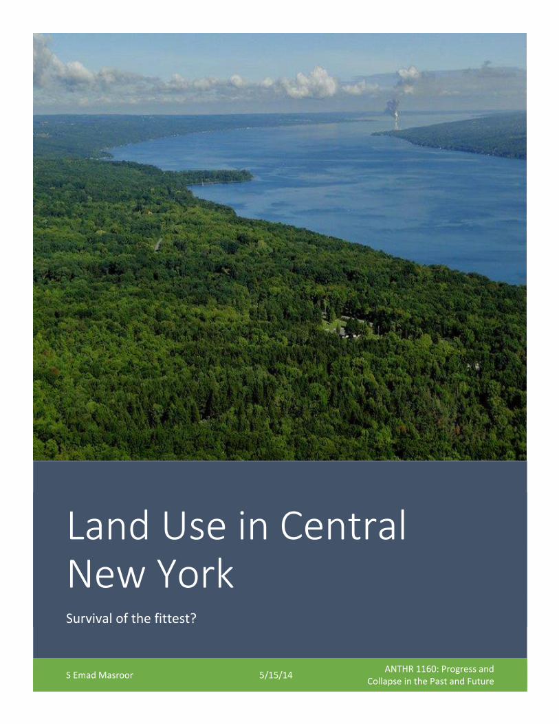
Land Use in Central New York Survival of the fittest?
S Emad Masroor 5/15/14 ANTHR 1160: Progress and
Collapse in the Past and Future
Emad Masroor ANTHR 1160
Final Paper: 05/15/14 While a constantly changing landscape is a hallmark of most settled regions in the world, the changes
that have taken place in the landscape of Central New York are particularly interesting because they do
not fit into the overall picture of continuous ‘development’ in the United States during the nineteenth
and twentieth centuries. As evidenced by the expansion of both urban and rural settlements all across
the world during this period, ‘development’ usually involves a change in the landscape from natural to
anthropogenic. Central New York, however, seems to have undergone the reverse – its landscape
changed from largely human to largely natural. While not uncommon, this process does challenge
conventional notions about economic development.
In this paper, I will examine the changes in land use of Central New York over the past 150 years. In the
mid-nineteenth century, this region had all the trappings of an agricultural utopia, and was intensively
farmed as much as was physically possible. Today this region is largely a forest– a remarkable
transformation. How and why did this change occur?
Empirical data documenting the Decline of Farming
For the purposes of this paper, I have focused on what is described as the ‘Central Plateau’ region of
New York State, according to Agricultural Regions of New York State (Conklin and Hardy 1963),
particularly the counties closest to the Finger Lakes region. During the late nineteenth century, this
region was intensively farmed, with almost one hundred percent of the land area of some counties
being used for cultivation.
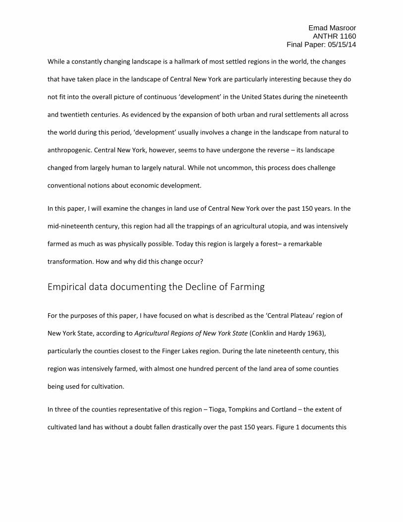
In three of the counties representative of this region – Tioga, Tompkins and Cortland – the extent of
cultivated land has without a doubt fallen drastically over the past 150 years. Figure 1 documents this
Emad Masroor ANTHR 1160
Final Paper: 05/15/14 steep decline, from about 300,000 acres in 1880 in each county to approximately 100,000 acres today.
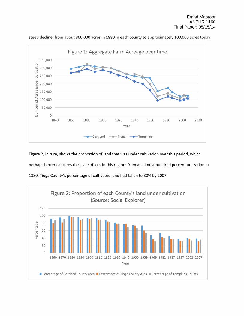
Figure 2, in turn, shows the proportion of land that was under cultivation over this period, which
perhaps better captures the scale of loss in this region: from an almost hundred percent utilization in
1880, Tioga County’s percentage of cultivated land had fallen to 30% by 2007.
0
50,000
100,000
150,000
200,000
250,000
300,000
350,000
1840 1860 1880 1900 1920 1940 1960 1980 2000 2020
Nu
mb
er o
f A
cres
un
der
cu
ltiv
atio
n
Year
Figure 1: Aggregate Farm Acreage over time
Cortland Tioga Tompkins
0
20
40
60
80
100
120
1860 1870 1880 1890 1900 1910 1920 1930 1940 1950 1959 1969 1982 1987 1997 2002 2007
Per
cen
tage
Year
Figure 2: Proportion of each County's land under cultivation(Source: Social Explorer)
Percentage of Cortland County area Percentage of Tioga County Area Percentage of Tompkins County
Emad Masroor ANTHR 1160
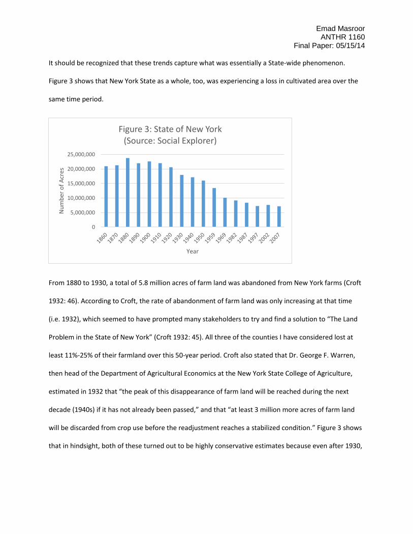
Final Paper: 05/15/14 It should be recognized that these trends capture what was essentially a State-wide phenomenon.
Figure 3 shows that New York State as a whole, too, was experiencing a loss in cultivated area over the
same time period.
From 1880 to 1930, a total of 5.8 million acres of farm land was abandoned from New York farms (Croft
1932: 46). According to Croft, the rate of abandonment of farm land was only increasing at that time
(i.e. 1932), which seemed to have prompted many stakeholders to try and find a solution to “The Land
Problem in the State of New York” (Croft 1932: 45). All three of the counties I have considered lost at
least 11%-25% of their farmland over this 50-year period. Croft also stated that Dr. George F. Warren,
then head of the Department of Agricultural Economics at the New York State College of Agriculture,
estimated in 1932 that “the peak of this disappearance of farm land will be reached during the next
decade (1940s) if it has not already been passed,” and that “at least 3 million more acres of farm land
will be discarded from crop use before the readjustment reaches a stabilized condition.” Figure 3 shows
that in hindsight, both of these turned out to be highly conservative estimates because even after 1930,
0
5,000,000
10,000,000
15,000,000
20,000,000
25,000,000
Nu
mb
er o
f A
cres
Year
Figure 3: State of New York (Source: Social Explorer)
Emad Masroor ANTHR 1160
Final Paper: 05/15/14 10 million acres of farmland were lost in New York State before stabilizing at about 7 million acres in the
final decade of the twentieth century.
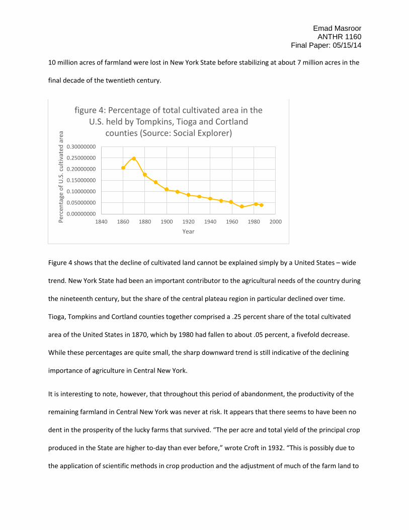
Figure 4 shows that the decline of cultivated land cannot be explained simply by a United States – wide
trend. New York State had been an important contributor to the agricultural needs of the country during
the nineteenth century, but the share of the central plateau region in particular declined over time.
Tioga, Tompkins and Cortland counties together comprised a .25 percent share of the total cultivated
area of the United States in 1870, which by 1980 had fallen to about .05 percent, a fivefold decrease.
While these percentages are quite small, the sharp downward trend is still indicative of the declining
importance of agriculture in Central New York.
It is interesting to note, however, that throughout this period of abandonment, the productivity of the
remaining farmland in Central New York was never at risk. It appears that there seems to have been no
dent in the prosperity of the lucky farms that survived. “The per acre and total yield of the principal crop
produced in the State are higher to-day than ever before,” wrote Croft in 1932. “This is possibly due to
the application of scientific methods in crop production and the adjustment of much of the farm land to
0.00000000
0.05000000
0.10000000
0.15000000
0.20000000
0.25000000
0.30000000
1840 1860 1880 1900 1920 1940 1960 1980 2000Per
cen
tage
of
U.S
. cu
ltiv
ated
are
a
Year
figure 4: Percentage of total cultivated area in the U.S. held by Tompkins, Tioga and Cortland
counties (Source: Social Explorer)
Emad Masroor ANTHR 1160
Final Paper: 05/15/14 its most efficient use” (Croft 1932: 49). The productivity of land – in Central New York as much as
throughout the State – was on a constant rise throughout the time during which cultivated area fell
drastically, which of course meant that overall output of goods from the Central New York does not
show a downward trend during this period. As Frank Walrath stated in 1927 about the farmers of a
generation before his time, “A regular day’s work in harvest time was the cradling of 3 acres of grain…
Today the average Tompkins County farmer cuts and binds 8 to 10 acres per day” (Walrath 1927: 204).
Enter the Forests
It is quite clear, through casual observation, that most of the land that was abandoned is today covered
in forests. Tompkins, Tioga and Cortland counties alone are home to no less than 38 State Forests –
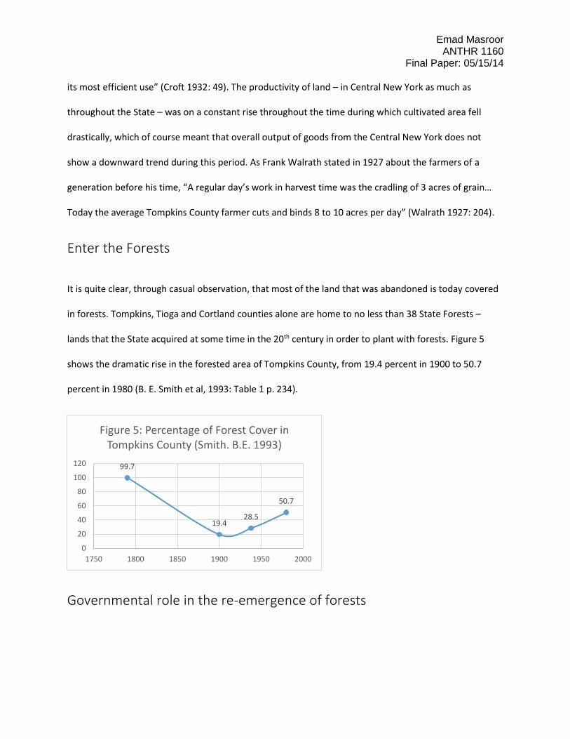
lands that the State acquired at some time in the 20th century in order to plant with forests. Figure 5
shows the dramatic rise in the forested area of Tompkins County, from 19.4 percent in 1900 to 50.7
percent in 1980 (B. E. Smith et al, 1993: Table 1 p. 234).
Governmental role in the re-emergence of forests
99.7
19.428.5
50.7
0
20
40
60
80
100
120
1750 1800 1850 1900 1950 2000
Figure 5: Percentage of Forest Cover in Tompkins County (Smith. B.E. 1993)
Emad Masroor ANTHR 1160
Final Paper: 05/15/14 The growth of forests in formerly-cultivated areas was a carefully-planned process that was
implemented by the New York State government over several decades. For example, in 1894, Article VII,
7 of the constitution of the State of New York (Department of State, NY: 2014, XIV: 1) was amended to
include that:
‘The lands of the State, now owned or hereinafter acquired, constituting the forest preserve as
fixed by law, shall forever be kept as wild forest lands. They shall not be leased sold or
exchanged, or be taken by any corporation, public or private, nor shall the timber thereon be
sold, removed, or destroyed.’
At the same time, the government seems to have encouraged the growth of forests on privately-owned
land, as well. For example, a 1912 legislation “provided a 35-year property tax exemption” for private
landowners who planted up to a hundred acres of forests.
What incentive did the Government have to increase forest cover in Central New York? The
documentation for one of the State forests in the region, Shindagin Hollow State Forest, gives us some
reasons officially posited by the government.
‘In order to reduce soil erosion, protect water quality, provide forest products and recreational
opportunities, the State of New York began acquiring property for reforestation during the
1930's under the auspices of the State Reforestation Law of 1929 and the Hewitt Amendment of
1931. These laws allowed the Conservation Department to acquire land, by gift or purchase, for
reforestation.’ (Department of Environmental Conservation, NY http://www.dec.ny.gov)
Both of these factors – legislation and the encouragement of private forests – must have contributed to
the growth of forests in New York State starting in the first half of the twentieth century. As far as
growing forests with no economic value was a worthy objective, these policies and practices seem to
Emad Masroor ANTHR 1160
Final Paper: 05/15/14 have had considerable success. At the turn of the nineteenth century, the ‘Forest Preserve’ of New York
State grew from 685,259 acres in 1883 to 2,193,627 acres in 1930 (Croft 1932: 67). Today, 18.9 million
acres of New York State is forested, a growth pattern similar to that of Central New York (Croft 1932:
67).
A ‘natural’ transformation or a contrived one?
I believe that there can be two ways of analyzing these changes. The first mirrors the views of Frank
Josiah Walrath, who in 1927 noted that:
‘Agriculture has passed through an evolution. As the agriculture of the county changed, rural life
changed. The change has been from a country filled with farm people leading a simple life to a
country sparsely peopled. Economic pressure has wrought this change. Fewer people produce
more than the people of a generation or two ago. More people are free to go to the city. Soil
depletion has lowered yields until much land is no longer economically used. It has passed out of
agriculture. The best lands produce more than ever before under modern methods of
cultivation. The poor lands produce less than ever. It requires a long time to convince owners of
the poorer land that their efforts will always be poorly repaid and that they should give up the
tilling of the poor land for a better region or for employment in the ever-growing industry of our
villages and cities.’ (Walrath, Frank J. 1927: 265)
Walrath espouses the view that these changes were the inevitable result of the mechanization of farm
labor and the increasing attraction of cities. He claims that in places where a lot of soil depletion took
place, the land just did not have the fertility required by commercial agriculture. According to Walrath,
the owners of poorer land will always be poorly repaid, and this increasing economic pressure was what
forced people to give up much of the land.
Emad Masroor ANTHR 1160
Final Paper: 05/15/14 According to this view, the State then began to step in as land was being abandoned, in an attempt to
regularize – and, perhaps, justify – the depopulation of what had been declared ‘sub-marginal’ lands. It
was in this backdrop that much of the legislation about forests in New York State came about; people
were worried about all the abandoned land, and the State philanthropically decided to acquire it in
order to forest this land for the common good.
Evidence of state manipulation
However, there can be another construal of the same events which defined the transition from an
agrarian to a forest landscape. Maps produced by the State during the period of most rapid
abandonment – such as Economic Viability of Farm Areas (1969) by Howard E Conklin and Robert E
Linton – classified land according to its ‘viability’ for farming. The following series of images serve to
show that, as far as Central New York was concerned, the State wished to encourage the trend of
abandonment.
Emad Masroor ANTHR 1160
Final Paper: 05/15/14
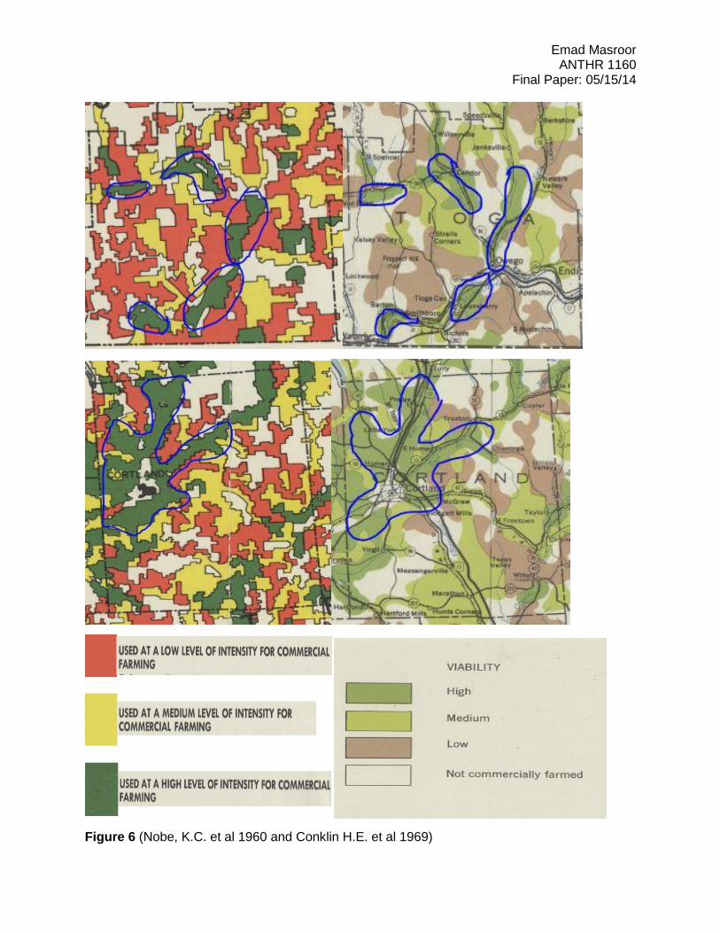
Figure 6 (Nobe, K.C. et al 1960 and Conklin H.E. et al 1969)
Emad Masroor ANTHR 1160
Final Paper: 05/15/14 Figure 6 shows two sets of maps. Those on the right are part of the State-produced Economic Viability of
Farm Areas, while those on the left are actual agricultural survey maps. The former, produced by the
‘Office of Planning Coordination’ in the State of New York, has areas of ‘high viability’ that correspond
more or less exactly with the regions of intensive commercial farming as shown in the latter. The blue
lines encircle these areas of interest.
I believe that the correspondence between these maps shows that the reforestation of Central New
York was not necessarily a natural product of prevailing conditions. In fact, this reforestation and land-
abandonment may well have been caused by the policies of the state. By using language such as ‘high,
medium or low viability’ of farm areas, the State clearly reveals its bias in favor of farm abandonment in
this part of New York even up to the 1960s.
Moreover, in some parts of Central New York, the government proceeded to carry out its reforestation
program without regard to the condition of the land’s inhabitants. While it was common for scholars
such as Frank Walrath to question the agrarian use of ‘sub-marginal’ lands, there are many documented
instances of this classification being applied to entirely healthy farmsteads. Inside what is now the Finger
Lakes National Forest of Schuyler County, it has been found that in nine out of eighteen farms studied by
archaeologists (Wurst and Ridarsky 2014: 227), costly capital improvements were still occurring well into
the twentieth century. This casts doubt on the official narrative that reforestation was carried out only
in areas that were abandoned by the farmers themselves. Wurst and Ridarsky have found evidence not
only of house construction a few years before farms were purchased by the government, but also of a
vast array of consumer good being used by the residents of these farms. Even more significantly, Wurst
found that a house which was valued under the 1930 census at $4,000 was in 1935 evaluated at just
$300 (Wurst 2014: 233), no doubt to speed up the process of reforestation.
Emad Masroor ANTHR 1160
Final Paper: 05/15/14
Social Darwinism?
It cannot be emphasized enough here that the contraction of cultivated land is an act that is far from
being limited to the re-drawing of maps. It involves the displacement and relocation of people, many of
whom were tied to the land and would have had nowhere else to turn to for work except for the
overcrowded cities of the United States. Croft’s statements, for example, that “it requires a long time to
convince owners of the poorer land that their efforts will always be poorly repaid” and that “they should
give up the tilling of the poor land for a better region or for employment in … industry” clearly show a
complete disregard for those who would be most affected by the decisions about reforestation. By
offering financial incentives to farmers who planted forests (instead of cultivating the land), and by
promoting the classification of certain parts of New York as being ‘unviable’ for farming, the State
actively helped bring about the collapse of a way of life for thousands of people.
The reforestation of Central New York clearly favored large commercial farms over smaller, less
profitable farms in a process that can only be called social Darwinism. Those who found their property
to be suddenly worthless as a result of the government classifying their land as ‘sub-marginal’ or
‘unviable’ are the unsung victims of the region’s Reforestation programs. It seems that the state went to
great lengths to discourage extensive farming to the benefit of the larger commercial farms that
remained, with less successful farms being sacrificed to create artificial forests that would provide
marginal benefits to the remaining farms.
As Croft noted in 1932,
‘If Conservation may be defined as ‘wise use’, it follows naturally that from the point of view of
utilization, a forest cannot be left completely to the forces of nature and be expected to
produce the greatest public benefits, however useful it may be for protection and recreation,
Emad Masroor ANTHR 1160
Final Paper: 05/15/14
such a policy seems more likely to serve the purposes of a very exclusive and restricted
minority.’
Conclusion
While natural factors such as a decline in productivity may certainly have played a part in the change
from farms to forests in Central New York, I think that the above pieces of evidence are sufficient to
prove that the state was an active participant in this process. It is unclear whether the government was
an orchestrator of these changes or simply a facilitator, but the more important question is why the
state would consider this change of land use to be a goal worth pursuing in the first place.
Foresting a previously-farmed area does not make economic sense for those who till the soil, no matter
how much an economist would tell the farmer otherwise. It only benefits those who live off the newly-
created forests, because they can then enjoy their recreational use as well as other spillover benefits,
such as improved drainage and soil protection. While more investigative work needs to be done in the
rest of Central New York before the conclusions of Schuyler, Tioga, Tompkins and Cortland Counties can
be generalized to the whole region, I believe that the state was certainly trying to ‘serve the purposes of
a very exclusive and restricted minority’ through reforestation programs.
Emad Masroor ANTHR 1160
Final Paper: 05/15/14
References Cited
Walrath, Frank J.
1927 A History of the Agriculture of Tompkins County, New York. A thesis presented to
the faculty of the Graduate School of Cornell University in Partial Fulfillment of
the Requirement for the Degree of Doctor of Philosophy
Croft, Alfred R.
1932 Some Aspects of the Reforestation Problem in the State of New York. A thesis
presented to the faculty of the Graduate School of Cornell University in Partial
Fulfillment of the Requirement for the Degree Doctor of Philosophy
U.S. Census Bureau
1790-2000 Social Explorer; Michael R. Haines. Historical, Demographic, Economic, and
Social Data: The United States
Nobe, K.C., Hardy, E.E. and Conklin, H.E.
1960 The Extent and Intensity of Farming in Western New York State, An Extension
Publication of the New York StateCollege of Agriculture.
Conklin, Howard E. and Linton, Robert E.
1969 Economic Viability of Farm Areas, State of New York, Office of Planning
Coordination.
Emad Masroor ANTHR 1160
Final Paper: 05/15/14 U.S. Department of Commerce, Bureau of the Census
1860 – 2007 Census of Agriculture
1860 – 2010 Census of Population and Housing
Smith, Bryce E., Marks, P.L. and Gardescu, Sana
1993 Bulletin of the Torrey Botanical Club, Vol. 120, No. 3 (Jul. - Sep., 1993), pp. 229-
247: Two Hundred Years of Forest Cover Changes in Tompkins County, New
York
Wurst, LouAnn and Ridarsky, Christina L.
2014 International Journal of Historical Archaeology Vol. 18 No. 2 (Jun. 2014) pp. 224-
241 The Second time as Farce: Archaeological Reflections on the New Deal.