Embed Size (px)
Citation preview
ANSWER SHEET
PART 2
INTERMEDIATE LAND NAVIGATION
PART 2 INTERMEDIATE LAND NAVIGATION PAGE 2
1. Knowing these four basic skills, it is impossible to be totally lost; what are they?
a. Track Present Location / Determine Distance / Sense of Direction / How to Read a Topographic Map
b. Track Present Location / Determine Distance / Night Navigation / How to Read a Topographic Map
c. Track Present Location / Staying on Course / Sense of Direction / Terrain and Map Association
d. Track Present Location / Plan to Navigate / Sense of Direction / How to Read a Topographic Map
2. TRUE False (circle one)
A hiker’s path isn’t straight, small detours are made in following a general bearing – like around a big log in
the way, a boulder, or avoiding a small water pond, etc. – since the land has so many irregularities. The
idea is to be conscious of the detours, keep them short, and try to zig as often as you zag. If you must make
a sizeable detour, you are better off plotting a new travel bearing.
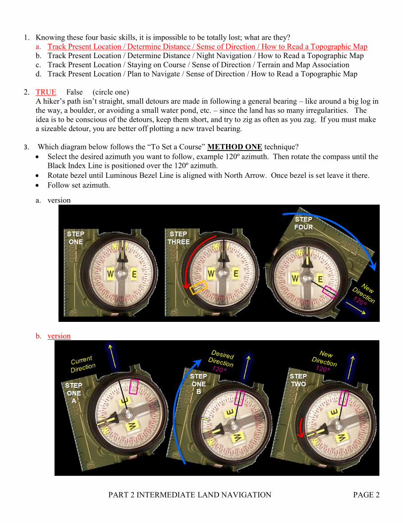
3. Which diagram below follows the “To Set a Course” METHOD ONE technique?
Select the desired azimuth you want to follow, example 120º azimuth. Then rotate the compass until the Black Index Line is positioned over the 120º azimuth.
Rotate bezel until Luminous Bezel Line is aligned with North Arrow. Once bezel is set leave it there.
Follow set azimuth.
a. version
b. version
PART 2 INTERMEDIATE LAND NAVIGATION PAGE 3
4. Using compass without a referenced intermediate or distant landmark is known as?
a. Compass Direction
b. Compass Following
c. Compass Bearing
d. Compass Heading
5. The compass provides the forward part of the navigation; but by itself it has no way of preventing drift,
known as?
a. Lateral errors (drifting left or right while walking the same azimuth bearing)
b. Azimuth errors (the compass needle drifting several degrees left or right while walking)
c. Bearing errors (miss calculating the azimuth to your destination by several degrees and walking it)
d. Intermediate errors (selecting an intermediate landmark, walking to it, but reaching the wrong landmark)
6. True FALSE (circle one)
Compass Following is when you drift (Lateral Error) left or right purposely, to avoid an obstacle.
7. To prevent lateral drift you need to use?
a. The Luminous Magnetic Arrow aligned with the Fixed Index Line
b. One distant landmark beyond your destination, until destination is reached
c. The Luminous Magnetic Arrow aligned with the Luminous Bezel Line
d. Intermediate landmarks that are a short distances between each, until destination is reached
8. GIVEN THE NECESSITY OF OCCASIONAL DETOURS, you can come close to your destination by?
a. Make careful, accurate sightings on both destination and intermediate landmarks.
b. Recheck bearings often, to avoid accumulation of small errors (lateral drift).
c. Continually relate your progress to the map.
d. All of the above.
9. TRUE False (circle one)
Compass Following is when you drift (Lateral Error) left or right unknowingly, but you remain on the same
azimuth bearing.
10. A baseline is?
a. Following a river or stream, until you reach your destination.
b. Targeting an intermediate landmark on your bearing line that will always be insight; walk to it and then
select another intermediate landmark to continue.
c. Lining up two distant objects on your bearing line that will always be in sight; when off course align the
two points to get back on course.
d. Setting an azimuth course on your lensatic compass using one of three methods. Then following your
set course to your destination.
11. TRUE False (circle one)
To get around an obstacle like a hill; you take a 90º turn (left), pace count till you clear hill, turn 90º
(right), walk till you clear hill, turn 90º (right), pace count same amount as before, turn 90º (left) and
continue on your course bearing.
12. TRUE False (circle one)
The GENUINE LENSATIC COMPASS is so durable that it should never malfunction, unless you
deliberately mistreat, or break the lensatic compass.
PART 2 INTERMEDIATE LAND NAVIGATION PAGE 4
13. A back azimuth is?
a. The 90º turn of direction from an azimuth. It is comparable to doing a right or left turn.
b. The 180º reverse direction of an azimuth. It is comparable to doing an about face.
c. The 180º intermediate landmark behind you. It is comparable to watching your back.
d. The 90º turn of a landmark (right or left). It is comparable to getting around an obstacle.
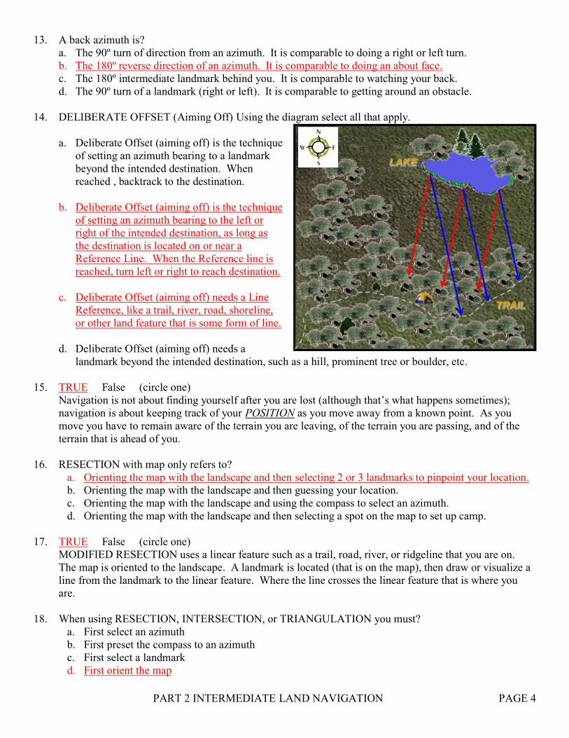
14. DELIBERATE OFFSET (Aiming Off) Using the diagram select all that apply.
a. Deliberate Offset (aiming off) is the technique
of setting an azimuth bearing to a landmark
beyond the intended destination. When
reached , backtrack to the destination.
b. Deliberate Offset (aiming off) is the technique
of setting an azimuth bearing to the left or
right of the intended destination, as long as
the destination is located on or near a
Reference Line. When the Reference line is
reached, turn left or right to reach destination.
c. Deliberate Offset (aiming off) needs a Line
Reference, like a trail, river, road, shoreline,
or other land feature that is some form of line.
d. Deliberate Offset (aiming off) needs a
landmark beyond the intended destination, such as a hill, prominent tree or boulder, etc.
15. TRUE False (circle one)
Navigation is not about finding yourself after you are lost (although that’s what happens sometimes);
navigation is about keeping track of your POSITION as you move away from a known point. As you
move you have to remain aware of the terrain you are leaving, of the terrain you are passing, and of the
terrain that is ahead of you.
16. RESECTION with map only refers to?
a. Orienting the map with the landscape and then selecting 2 or 3 landmarks to pinpoint your location.
b. Orienting the map with the landscape and then guessing your location.
c. Orienting the map with the landscape and using the compass to select an azimuth.
d. Orienting the map with the landscape and then selecting a spot on the map to set up camp.
17. TRUE False (circle one)
MODIFIED RESECTION uses a linear feature such as a trail, road, river, or ridgeline that you are on.
The map is oriented to the landscape. A landmark is located (that is on the map), then draw or visualize a
line from the landmark to the linear feature. Where the line crosses the linear feature that is where you
are.
18. When using RESECTION, INTERSECTION, or TRIANGULATION you must?
a. First select an azimuth
b. First preset the compass to an azimuth
c. First select a landmark
d. First orient the map
PART 2 INTERMEDIATE LAND NAVIGATION PAGE 5
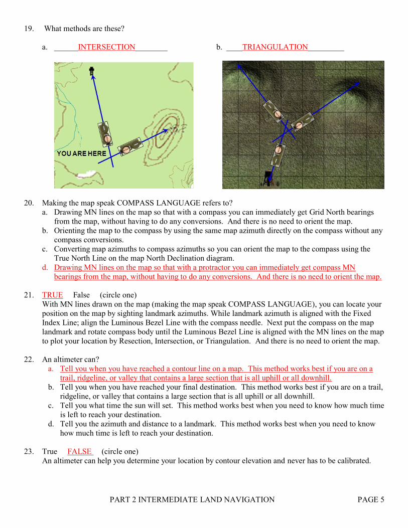
19. What methods are these?
a. ______INTERSECTION________ b. ____TRIANGULATION_________
20. Making the map speak COMPASS LANGUAGE refers to?
a. Drawing MN lines on the map so that with a compass you can immediately get Grid North bearings
from the map, without having to do any conversions. And there is no need to orient the map.
b. Orienting the map to the compass by using the same map azimuth directly on the compass without any
compass conversions.
c. Converting map azimuths to compass azimuths so you can orient the map to the compass using the
True North Line on the map North Declination diagram.
d. Drawing MN lines on the map so that with a protractor you can immediately get compass MN
bearings from the map, without having to do any conversions. And there is no need to orient the map.
21. TRUE False (circle one)
With MN lines drawn on the map (making the map speak COMPASS LANGUAGE), you can locate your
position on the map by sighting landmark azimuths. While landmark azimuth is aligned with the Fixed
Index Line; align the Luminous Bezel Line with the compass needle. Next put the compass on the map
landmark and rotate compass body until the Luminous Bezel Line is aligned with the MN lines on the map
to plot your location by Resection, Intersection, or Triangulation. And there is no need to orient the map.
22. An altimeter can?
a. Tell you when you have reached a contour line on a map. This method works best if you are on a
trail, ridgeline, or valley that contains a large section that is all uphill or all downhill.
b. Tell you when you have reached your final destination. This method works best if you are on a trail,
ridgeline, or valley that contains a large section that is all uphill or all downhill.
c. Tell you what time the sun will set. This method works best when you need to know how much time
is left to reach your destination.
d. Tell you the azimuth and distance to a landmark. This method works best when you need to know
how much time is left to reach your destination.
23. True FALSE (circle one)
An altimeter can help you determine your location by contour elevation and never has to be calibrated.
PART 2 INTERMEDIATE LAND NAVIGATION PAGE 6
24. UTM grid & Zone can be found on the map margin, what is it used for?
a. United Tracker Members – Rescue teams that locate lost hikers
b. Universal Transverse Mercator – world grid map coordinates system and GN refers to UTM grid.
c. Unit Tick Marks – tick marks on the side of the map border, used for plotting azimuths
d. Universal Travel Measurement – a measuring system to calculate distance on the ground
25. TRUE False (circle one)
The UTM grid is based on the METER SYSTEM, and grid lines are always one kilometer apart (1,000
meters), making it much easier to estimate distance on a map and coordinate grid position.
26. A full UTM coordinate number is as follows Zone 12 E559755N 4281265m. Match the digits to the
meters (area covered).
a__ 4 digit (Zone 12 E59 N81) a. 1000m x 1000m area = 1000 sq Km
b__ 6 digit (Zone 12 E597 N812) b. 100m x 100m area = 10 sq Km
c__ 8 digit (Zone 12 E5975 N8126) c. 10m x 10m area = 100 sq meters
d__ 10 digit (Zone 12 E59755 N81265) d. 1m x 1m area = 1 sq meter
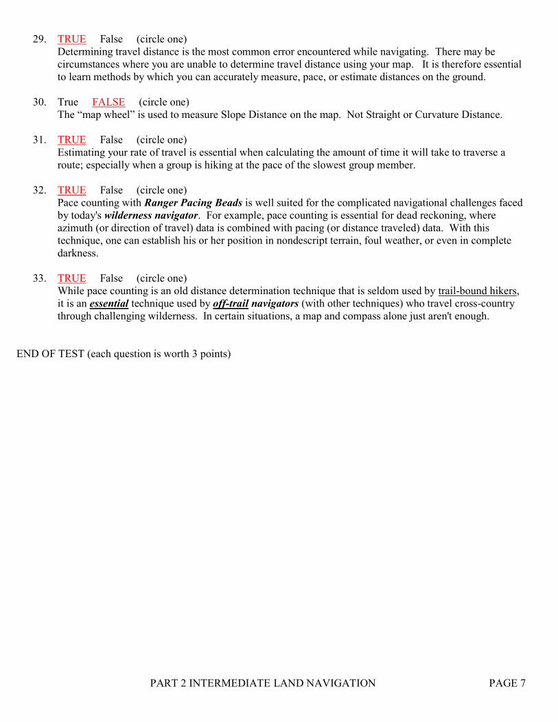
27. Select the correct coordinates.
a. Zone 9 E6165 N9624
b. Zone 9 E6260 N9522
c. Zone 9 E6160 N9524
d. Zone 9 E6265 N9622
28. There are three techniques to measure distance on a map. (Select all three)
a. Straight Line Distance d. Estimation Distance
b. Speed Distance e. Pace Count Distance
c. Curvature Distance f. Slope Distance
PART 2 INTERMEDIATE LAND NAVIGATION PAGE 7
29. TRUE False (circle one)
Determining travel distance is the most common error encountered while navigating. There may be
circumstances where you are unable to determine travel distance using your map. It is therefore essential
to learn methods by which you can accurately measure, pace, or estimate distances on the ground.
30. True FALSE (circle one)
The “map wheel” is used to measure Slope Distance on the map. Not Straight or Curvature Distance.
31. TRUE False (circle one)
Estimating your rate of travel is essential when calculating the amount of time it will take to traverse a
route; especially when a group is hiking at the pace of the slowest group member.
32. TRUE False (circle one)
Pace counting with Ranger Pacing Beads is well suited for the complicated navigational challenges faced
by today's wilderness navigator. For example, pace counting is essential for dead reckoning, where
azimuth (or direction of travel) data is combined with pacing (or distance traveled) data. With this
technique, one can establish his or her position in nondescript terrain, foul weather, or even in complete
darkness.
33. TRUE False (circle one)
While pace counting is an old distance determination technique that is seldom used by trail-bound hikers,
it is an essential technique used by off-trail navigators (with other techniques) who travel cross-country
through challenging wilderness. In certain situations, a map and compass alone just aren't enough.
END OF TEST (each question is worth 3 points)