Embed Size (px)
Citation preview

#22_Answer_exWAPDA_20Oct03.doc Sheet No. 1 / 1
S. TAKAHASHI
Answer Sheet for Questionnaire on
Preparatory Study on the Project for Development of Flood Outflow Water in Balochistan Province
in the Islamic Republic of Pakistan Date: 20-Oct-2003(Mon) Time:
Interviewer: Name; TAKAHASHI Shinya Position; Hydro-Geologist JICA Preparatory Study Team
Interviewee: Organization: Drilling Division, WRPD&M Directorate, I&P Dept., GoB Address: Siryad Road, Quetta Telephone 081 9211602 E-mail: Answered by: Mr. Imram Durrani. Position: Deputy Director, Drilling Division Office: Office for Drilling Division, WRPD& M Directorate (ex-WAPDA)
Subject: Present status of library and laboratory of ex-WAPDA Answer: • In 1993, monitoring activities of WAPDA was taken over by the Bureau of Water
Resources (BoWR), I&P Dept., GoB that was established in the same year. • The drilling activities were still operated under WAPDA till 1998. • All the drilling activities that were operated not only WAPDA but also divisions under
I&P dept., GoB were incorporated/integrated into the BoWR, I&P dept., GoB in 1998. • BoWR was renamed into Water Resources Planning, Development and Monitoring
(WRPD&M) Directorate, I&P dept., in year of 2002. • Presently, WAPDA is in charge of power generation, transmission & distribution and
tariff charging/collection. *****
• The laboratory taken by WAPDA was totally not operational, no plan to reopen. • The documents in the library have not been updated since 1993. ==End of Document==
#23_Answer_UNDP_20Oct03.doc Sheet No. 1 / 1
S. TAKAHASHI
Answer Sheet for Questionnaire on
Preparatory Study on the Project for Development of Flood Outflow Water in Balochistan Province
in the Islamic Republic of Pakistan Date: 20-Oct-2003(Mon) Time:
Interviewer: Name; TAKAHASHI Shinya Position; Hydro-Geologist, JICA Preparatory Study Team
Interviewee: Organization: UNDP Address: Zangi Lora Park, Sariab RoadQuetta Telephone 081 9211638, 449690, 445981 E-mail: Answered by: Mr. Aijaz Position: Irrigation officer Office: Area Development Program Balochistan, UNDP
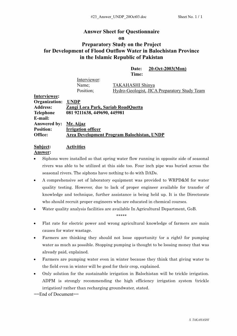
Subject: Activities Answer: • Siphons were installed so that spring water flow running in opposite side of seasonal
rivers was able to be utilized at this side too. Four inch pipe was buried across the seasonal rivers. The siphons have nothing to do with DADs.
• A comprehensive set of laboratory equipment was provided to WRPD&M for water quality testing. However, due to lack of proper engineer available for transfer of knowledge and technique, further assistance is being held up. It is the Directorate who should recruit proper engineers who are educated in chemical courses.
• Water quality analysis facilities are available In Agricultural Department, GoB. *****
• Flat rate for electric power and wrong agricultural knowledge of farmers are main causes for water wastage.
• Farmers are thinking they should not loose opportunity (or a right) for pumping water as much as possible. Stopping pumping is thought to be loosing money that was already paid, explained.
• Farmers are pumping water even in winter because they think that giving water to the field even in winter will be good for their crop, explained.
• Only solution for the sustainable irrigation in Balochistan will be trickle irrigation. ADPM is strongly recommending the high efficiency irrigation system (trickle irrigation) rather than recharging groundwater, stated.
==End of Document==
#24_Answer_HydyatKhan_20Oct03.doc Sheet No. 1 / 1
S. TAKAHASHI
Answer Sheet for Questionnaire on
Preparatory Study on the Project for Development of Flood Outflow Water in Balochistan Province
in the Islamic Republic of Pakistan Date: 20-Oct-2003(Mon) Time:
Interviewer: Name; TAKAHASHI Shinya Position; Hydro-Geologist, JICA Preparatory Study Team
Interviewee: Organization: I&P Dept., Address: Sariab Road, Quetta Telephone 081 E-mail: Answered by: Mr. Ashan Hidyat Khan Position: Executive Engineer (Irrigation), I & P, Dept Office: Branch office of I & P, Dept.
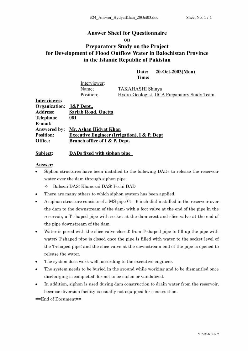
Subject: DADs fixed with siphon pipe Answer: • Siphon structures have been installed to the following DADs to release the reservoir
water over the dam through siphon pipe. Balozai DAS; Khanozai DAS; Pechi DAD
• There are many others to which siphon system has been applied. • A siphon structure consists of a MS pipe (4 – 6 inch dia) installed in the reservoir over
the dam to the downstream of the dam; with a foot valve at the end of the pipe in the reservoir, a T shaped pipe with socket at the dam crest and slice valve at the end of the pipe downstream of the dam.
• Water is pored with the slice valve closed; from T-shaped pipe to fill up the pipe with water; T-shaped pipe is closed once the pipe is filled with water to the socket level of the T-shaped pipe; and the slice valve at the downstream end of the pipe is opened to release the water.
• The system does work well, according to the executive engineer. • The system needs to be buried in the ground while working and to be dismantled once
discharging is completed; for not to be stolen or vandalized. • In addition, siphon is used during dam construction to drain water from the reservoir,
because diversion facility is usually not equipped for construction. ==End of Document==

#25_Answer_ForestDept_21Oct03.doc Sheet No. 1 / 1
S. TAKAHASHI
Answer Sheet for Questionnaire On Preparatory Study on the Project
For Development of Flood Outflow Water in Balochistan Province In the Islamic Republic of Pakistan
Date: 21-Oct-2003(Mon) Time:
Interviewer: Name; TAKAHASHI Shinya Position; Hydro-Geologist, JICA Preparatory Study Team
Interviewee: Organization: Forest Department Address: Spinny Road, Quetta 83700 Pakistan Telephone 081 9201137, E-mail:[email protected] Answered by: Dr. Mohammad Saleem, Chief Conservator Mr. Manzooc, Conservator of Wild Life Mr. Abdul Raziq, Conservator of Forest, Juniper Eco-system and
National Park Position: (see above) Office: Forest Department and Fields
Subject: Water Shed Management • Written strategies or policies for the Forest Department are not established. • ‘Balochistan Conservation Strategy’ published by P&D and IUCN covers all the
aspects. • Programs are worked out on project basis. • P&D instructed or declared water shed management should be included for DAD
construction program (PC-I). • At present, no coordination or no talk between Forest Department and I&P dept are
made regarding Water Shed Management for DADs. • No fund is shared for such water shed management of DAD. • Earlier, personnel were invited to discussions for DAD. Presently no one are invited to
such talks. Field Visit: - Depleted Range Rehabilitation Project (Drought Relief Program, Tor Ragha State
Forest District, Quetta, commenced on 04-01-2001 (Spinkerez area) - Karak Area Water Shed Planning and Management Project Quetta, 1996-1997. - Earthen bunds, hillside ditches with shrub plantation are observed. A dam was
constructed in Karak area. The design and quality of the dam is questionable though dam height is not high
- In addition to those project above, a water shed management project was performed in Berwery water shed area in 1987. Since then no major flood occurred in the area.
- .==End of Document==

#26_Answer_WRPD&M_22Oct03.doc Sheet No. 1 / 2
S. TAKAHASHI
Answer Sheet for Questionnaire on Preparatory Study on the Project
for Development of Flood Outflow Water in Balochistan Province in the Islamic Republic of Pakistan
Date: 22-Oct-2003 (Sat) Time: 09:45
Interviewer: Name; TAKAHASHI Shinya Position; Hydro-Geologist JICA Preparatory Study Team
Interviewee: Organization: Water Resources Planning, Development and Monitoring
(WRPD&M) Directorate, I&P Dept. Address: Quetta Telephone: 081 9211190 Fax: E-mail: Answered by: Mr. Amjad Ali Shal, Deputy Director (Monitoring) Mr. Habibi, Field officer Position: (see above) Office: office (WRPD&M Directorate) and QA-4 site Subject: Discussion on the Behavior of QA-4 The Monitoring hole MNW-QA-04 was visited. - 30-11.518 N, 67-02.074 E - The QA-04 is located in a middle part of cantonment daily farm that used to be used
for maize cropping for cow producing milk for military supply. - No vital orchard field was seen around. - About 100 m away from the QA-4, Habibi nullah (river), a seasonal river, was
observed. - Sewage water from Nureeabad was flowing along the Habibi nullha for a year in
addition to flood water in wet seasons. - A pumping facility was observed at the Habibi River near the QA-4 (some 100m
apart); the pumping facility was used for irrigation purpose for the Cantonment daily field till 7 – 10 years ago.
- The sewage water was diverted from the Habibi River to ponds close to QA-4 (78-80 m apart). Presently no water is visible along the river.
- Nureeabad used only flood water before. The start used tube wells for about 30-35 years, explained by an inhabitant. Nureeabad expanded towards the hillside as it developed and water was pressure-sent to the higher area accordingly.
- In the inventory prepared by WRPD&M Directorate, twelve wells are recorded as constructed in; (1) 2001, (2)2001, (3) 1970(dry). (4)2000, (5)1970(dry), (6)1975, (7)1989, (8)1974, (9)2001, (10)2002, (11)1968, (12) 1961.
- It was confirmed by the inhabitant that there are 4 DAD near the area. Habibi Dara I (1977), Habibi Dara II (1992), Shaghai I (1996), Shaghai II (1994).
- From the information above, it is difficult to conclude that the groundwater rising was due to the effects of any of those 4 dams. Construction timings do not match the groundwater rising
- No decisive conclusions are reached at this moment

#26_Answer_WRPD&M_22Oct03.doc Sheet No. 2 / 2
S. TAKAHASHI
Automatic Water Level Gauging Station - Screen Position in Wells The information below was provided.
No. Screen Position QTA-01 110–130 QTA-11 389–429 QTA-02 110–135 MST-01 85–95 QTA-03 120–130,
138–148 MST-02 78-88,128-138
QTA-04 114–130 MST-03 200-210, 297-307
QTA-05 N/A MST-04 231-255 QTA-06 131–147 MGR-01 212-236 QTA-07 168–184 MGR-02 197-213,
265-281 QTA-08 85–101 QTA-09 241–257 QTA-10 381–421
- .==the end of the document==


#27_Answer_SecretaryI&P_24Oct03.doc Sheet No. 1 / 1
S. TAKAHASHI
Answer Sheet for Questionnaire on
Preparatory Study on the Project for Development of Flood Outflow Water in Balochistan Province
in the Islamic Republic of Pakistan Date: 24-Oct-2003(Fri) Time:
Interviewer: Name; TAKAHASHI Shinya Position; Hydro-Geologist, JICA Preparatory Study Team
Interviewee: Organization: I&P Dept., Address: Civil Secretariats, Sariab Road, Quetta Telephone 081 E-mail: Answered by: Mr. Mubawar Khan Mandokhail Position: Secretary, I & P, Dept Office: Civil Secretariat.
Subject: Courtesy visit – Flood Dispersion Answer: • K Noda, S Takahashi and K Koga made a courtesy visit to the Secretary to appreciate
his cooperation for the survey made by the Team. • On the occasion of the final meeting with the Secretary, a confirmation of opinion of
the department was made on ‘flood dispersion method’ for recharging purpose. • The answers were:
The department is always ready to apply any types of improved measures for recharging groundwater.
The mentioned ‘Flood dispersion method for recharging purpose’ has not been adopted because flood water has to be spread over on the wide area of a piedmont. Due to high evaporation potential in Balochistan the loss of water will be higher than DAD.
In response to the question on whether this type of method was implemented, the answer was ‘Not yet’.
• The Team expressed their thankfulness for his cooperation again to the Secretary. ==End of Document==

#28_Answer_WB_ISLMBD_27Oct03.doc Sheet No. 1 / 1
S. TAKAHASHI
Answer Sheet for Questionnaire on
Preparatory Study on the Project for Development of Flood Outflow Water in Balochistan Province
in the Islamic Republic of Pakistan Date: 27-Oct-2003 (Mon) Time:
Interviewer: Name; TAKAHASHI Shinya Position; Hydro-Geologist, JICA Preparatory Study Team
Interviewee: Organization: World Bank, Islamabad, Pakistan, Address: Islamabad Telephone 9090103 E-mail: Answered by: Mr. Addul Salam Position: Chief, Library Office: World Bank
Subject: Collection of Documents and Information Answer: • K Noda and S Takahashi visited the WB office in Islamabad. • Information and documents on the future plan and strategy of WB to be implemented
in Pakistan and Balochistan were collected.==End of Document==

#29_Answer_ADB_ISLMBD_27Oct03.doc Sheet No. 1 / 1
S. TAKAHASHI
Answer Sheet for Questionnaire on
Preparatory Study on the Project for Development of Flood Outflow Water in Balochistan Province
in the Islamic Republic of Pakistan Date: 27-Oct-2003 j(Mon) Time:
Interviewer: Name; TAKAHASHI Shinya Position; Hydro-Geologist, JICA Preparatory Study Team
Interviewee: Organization: Asian Development Bank, Islamabad, Pakistan, Address: Islamabad Telephone 092-51-2825011-16 E-mail: [email protected] Answered by: Mr. Raza M. Farrukh Position: Project Implementaion Officer Office: ADB, Islamabad
Subject: Collection of Documents and Information Answer: • K Noda and S Takahashi visited the ADB office in Islamabad. • Information and documents on the future plan and strategy of WB to be implemented
in Pakistan and Balochistan were collected. • In addition to the information, A TA report on ‘Balochistan Groundwater Resource
Reassessment’ was requested to locate. In the following day, it was reported that the report was not available in the office, the report might be available from the web==End of Document==

(2) 質問票・回答 – 利 水 計 画
番号 訪問先 質問事項
#01_N Honorary Consulate General of Japan, Quetta Organization of Provincial Government of Balochistan, etc
#02_N Agriculture, Cooperatives and Flood Department, Balochistan
Important Items of Development Strategy in Agriculture, Cooperatives and Food Development, etc
#03_N Agriculture Extension Directorate General Prices on Agro-economy, etc #04_N Agriculture Economics and Marketing
Directrate Cropping Pattern, etc
#05_N Agriculture, Cooperatives and Food Department, Balochistan Province
Present Irrigation Method and Gross Irrigation Water Requirement
#06_N Babu & Company, Mir Afzal Khan & Co. (Private Shops)
Procurement Possibility of Trickle Irrigation Facilities, Material and Parts
#07_N On farm Water Management / Trickle Irrigation Directorate Rani Bagh, Sariab Road, Quetta
Definition and Naming of “Directorate General” and “Directorate” in Organization of Agriculture, Cooperatives and Food Department
#08_N Trickle Irrigation Scheme / Agriculture Model Farm Sariab Road, Quetta
Crop Water Requirements
#09_N Agriculture Extension Directorate Future Plan of On-farm Water Management Projects
#10_N UNDP, Quetta Concept of UNDP’s Future Activities in Balochistan
#11_N Water Resources Research Centre (WRRC) Irrigation Related Major Activities of WRRC, etc
#12_N Arid Zone Research Centre (AZRC), Federal Government
Agricultural Land Owner, etc
#13_N World Bank in Pakistan Future Strategy and Projects for Aid in Balochistan for Water Sector
#14_N Asia Development Bank in Pakistan Future Strategy and Projects for Aid in Balochistan for Water Sector

#01_N_10_10_Answer_Organization_Consulate.doc Sheet No. 1 / 1
Answer Sheet for Questionnaire on
Preparatory Study on the Project for Development of Flood Outflow Water in Balochistan Province
in the Islamic Republic of Pakistan Date: 10-Oct.-2003 (Fri.) Time: 16: 20
Interviewer: Name; NODA Kuninobu Position; Water Utilization Expert JICA Preparatory Study Team
Interviewee: Organization; Honorary Consulate General of Japan, Quetta Address; 53-A, Jinnah Town, Samungli Road, Quetta Telephone; 081-829478 E-mail; [email protected] Answered by; Mr. Syed Nadeem Shah (Name of Interviewee) Position; Honorary Consul General Office; (Section, Department)
Subject: 1. Organization of Provincial Government of Balochistan 2. Organization of District Government in Balochistan Answer:
1. Organization of Provincial Government of Balochistan
See two (2) sheets of (1/3) and (2/3) of organization charts attached.
2. Organization of District Government in Balochistan
See one (1) sheets of (3/3) of organization chart attached. Attachment: Three (3) sheets of organization charts.


#02_N_10_13_Answer_Secretary_AgriDept.doc Sheet No. 1 / 2
Answer Sheet for Questionnaire on
Preparatory Study on the Project for Development of Flood Outflow Water in Balochistan Province
in the Islamic Republic of Pakistan Date: 13-Oct.-2003 (Mon.) Time: 11: 30
Interviewer: Name; NODA Kuninobu Position; Water Utilization Expert JICA Preparatory Study Team
Interviewee: Organization; Agriculture, Cooperatives and Food Department, Balochistan
Province Address; Civil Secretariat Block-2, Quetta Telephone; 081-9201261 & 9201179 E-mail; Answered by; Mr. Abdul Salam Baloch (Name of Interviewee) Position; Secretary Office; Agriculture, Cooperatives and Food Department (Section, Department)
Subject: 1. Important Items of Development Strategy in Agriculture, Cooperatives and Food Development
2. Persons in Charge of Important Items 3. Organization Chart of Department Answer:
1. Important Items of Development Strategy in Agriculture, Cooperatives and Food Development
- On-farm water management - High efficiency irrigation system (Trickle, Bubbler, Sprinkler) - Ganda (earthen dike weir in Bolan and Jhalmagsi) and Bandat (earthen
dike fields in other parts of Province, namely fields of Sailaba system) - Agriculture and construction machinery
As for the on-farm water management, there was a project of OECF of 1997 for
five (5) districts. Facilities constructed and the systems established by the project are not well functioning due to shortage of the budget and the technology. Follow-up project is necessary.

#02_N_10_13_Answer_Secretary_AgriDept.doc Sheet No. 2 / 2
2. Persons in Charge of Important Items
- Director of On-farm water management and Trickle Irrigation under Director General of Agriculture Extension
・ On-farm water management ・ High efficiency irrigation system (Trickle, Bubbler, Sprinkler)
- Director of Agriculture Engineering
・ Ganda (earthen dike weir in Bolan and Jhalmagsi) and Bandat (earthen dike fields in other parts of Province, namely fields of Sailaba system)
・ Agriculture and construction machinery
3. Organization Chart of Department
See one (1) sheet of attachment.


#03_N_10_15a_Answer_ExtensionDG_AgriDept.doc Sheet No. 1 / 1
Answer Sheet for Questionnaire on
Preparatory Study on the Project for Development of Flood Outflow Water in Balochistan Province
in the Islamic Republic of Pakistan Date: 15-Oct.-2003 (Wed.) Time: 9: 30
Interviewer: Name; NODA Kuninobu Position; Water Utilization Expert JICA Preparatory Study Team
Interviewee: Organization; Agriculture Extension Directorate General Address; Rani Bagh, Sariab Road, Quetta Telephone; 081-9211500 E-mail; Answered by; Mr. Pir Muhammad Achakzai (Name of Interviewee) Position; Director General Office; Agriculture Extension Directorate General in Agriculture, Cooperatives and Food Department (Section, Department)
Subject: 1. Prices on Agro-economy 2. Agricultural Statistics of Balochistan 3. Price Trend of Agricultural Commodities Answer:
1. Prices on Agro-economy
Director of Agriculture Economics and Marketing was introduced for the data collection concerned.
2. Agricultural Statistics of Balochistan
The book named “Agricultural Statistics Balochistan 2001-02, Statistical Wing, Directorate General Agriculture (Extension) Balochistan Quetta” was given.
See a sheet (1/1) of copy of the cover attached.
3. Price Trend of Agricultural Commodities
Director of Agriculture Economics and Marketing was introduced for the data collection concerned.
#04_N_10_15b_Answer_Director_Marketing.doc Sheet No. 1 / 1
Answer Sheet for Questionnaire on
Preparatory Study on the Project for Development of Flood Outflow Water in Balochistan Province
in the Islamic Republic of Pakistan Date: 15-Oct.-2003 (Wed.) Time: 10: 30
Interviewer: Name; NODA Kuninobu Position; Water Utilization Expert JICA Preparatory Study Team
Interviewee: Organization; Agriculture Economics and Marketing Directorate Address; Rani Bagh, Sariab Road, Quetta Telephone; 081-9211504 E-mail; Answered by; Mr. Abdullah Baloch (Name of Interviewee) Position; Director Office; Agriculture Economics and Marketing Directorate in Agriculture
Extension Directorate General (Section, Department)
Subject: 1. Cropping Pattern 2. Prices on Agro-economy 3. Price Trend of Agricultural Commodities Answer:
1. Cropping Pattern
JICA F/S of 1997 can basically be used. As for the detailed cropping area, “Agricultural Statistics Balochistan 2001-02” can be referred to.
2. Prices on Agro-economy
See the collected data of “I. Cost of Production per Acre” (1/6) ~ (6/6).
3. Price Trend of Agricultural Commodities
See the collected data of :
“II. Monthly Comparison of Wholesale Prices of Onion (dry) of Different Markets in Pakistan for the Year 2002” (1/1), and
“III. Monthly Wholesale Prices of Agriculture Commodities and Livestock Products, 1990 ~ 2003” (1/14) ~ (14/14)
#05_N_10_15c_Answer_OFWM_TRCL.doc Sheet No. 1 / 2
Answer Sheet for Questionnaire on
Preparatory Study on the Project for Development of Flood Outflow Water in Balochistan Province
in the Islamic Republic of Pakistan Date: 15-Oct.-2003 (Wed.) Time: 11: 30
Interviewer: Name; NODA Kuninobu Position; Water Utilization Expert JICA Preparatory Study Team
Interviewee: Organization; Agriculture, Cooperatives and Food Department, Balochistan
Province Address; Rani Bagh, Sariab Road, Quetta Telephone; 081-9211519 E-mail; Answered by; Mr. Muhammad Ishaq Baloch (Name of Interviewee) Position; Director Office; On-farm Water Management and Trickle Irrigation Directorate in Agriculture Extension Directorate General (Section, Department)
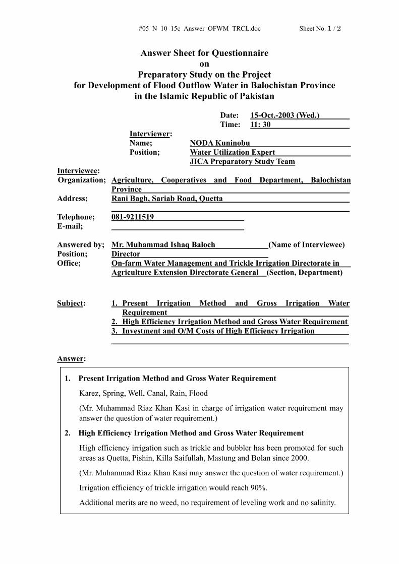
Subject: 1. Present Irrigation Method and Gross Irrigation Water Requirement
2. High Efficiency Irrigation Method and Gross Water Requirement 3. Investment and O/M Costs of High Efficiency Irrigation Answer:
1. Present Irrigation Method and Gross Water Requirement
Karez, Spring, Well, Canal, Rain, Flood
(Mr. Muhammad Riaz Khan Kasi in charge of irrigation water requirement may answer the question of water requirement.)
2. High Efficiency Irrigation Method and Gross Water Requirement
High efficiency irrigation such as trickle and bubbler has been promoted for such areas as Quetta, Pishin, Killa Saifullah, Mastung and Bolan since 2000.
(Mr. Muhammad Riaz Khan Kasi may answer the question of water requirement.)
Irrigation efficiency of trickle irrigation would reach 90%.
Additional merits are no weed, no requirement of leveling work and no salinity.

#05_N_10_15c_Answer_OFWM_TRCL.doc Sheet No. 2 / 2
3. Investment and O/M Costs of High Efficiency Irrigation
Direct cost of facilities and materials: Rs. 90,000.-/ha in 2001-02
Rs. 125,000.- ~ 140,000.-/ha in 2003
excluding water source facilities such as the pump.

#06_N_10_18_Answer_Trickle_Shop.doc Sheet No. 1 / 1
Answer Sheet for Questionnaire on
Preparatory Study on the Project for Development of Flood Outflow Water in Balochistan Province
in the Islamic Republic of Pakistan Date: 18-Oct.-2003 (Sat.) Time: 17: 00
Interviewer: Name; NODA Kuninobu Position; Water Utilization Expert JICA Preparatory Study Team
Interviewee: Organization; Babu & Company, Mir Afzal Khan & Co. (Private Shops) Address; Suraj Gang Bazar, Quetta Telephone; 081-820174, 081-822645 E-mail; [email protected] Answered by; (Name of Interviewee) Position; Shopkeeper Office; (Section, Department)
Subject: Procurement Possibility of Trickle Irrigation Facilities, Materials and Parts Answer:
Procurement Possibility of Trickle Irrigation Facilities, Materials and Parts
1. No stock of the Trickle irrigation facilities, materials and parts is available in Quetta.
2. Those should be ordered and transported from Karachi.
Note.
According to information of the Trickle Irrigation Scheme / Agricultural Model Farm Sariab Road Quetta, only PVC pipes made in Pakistan is used, and polyethylene pipes and emitters are imported from Dubai, Saudi Arabia and UK.
Attachment: One (1) sheet of shops’ addresses.


#07_N_10_21a_Answer_DefinitionDG_AgriDept.doc Sheet No. 1 / 1
Answer Sheet for Questionnaire on
Preparatory Study on the Project for Development of Flood Outflow Water in Balochistan Province
in the Islamic Republic of Pakistan Date: 21-Oct.-2003 (Tue.) Time: 9: 30
Interviewer: Name; NODA Kuninobu Position; Water Utilization Expert JICA Preparatory Study Team
Interviewee: Organization; On-farm Water Management / Trickle Irrigation Directorate Address; Rani Bagh, Sariab Road, Quetta Telephone; 081-9211519 E-mail; Answered by; Mr. Mamsoor Ahmed Bajwa (Name of Interviewee) Position; Assitant Director Office; On-farm Water Management / Trickle Irrigation Directorate, Agriculture, Cooperatives & Food Dept. (Section, Department)
Subject: Definition and Naming of “Directorate General” and “Directorate” in Organization of Agriculture, Cooperatives and Food Department Answer:
Definition and Naming of “Directorate General” and “Directorate” in Organization of Agriculture, Cooperatives and Food Department
1. Present definition and naming have been succeeded.
2. There is no clear definition of “Directorate General” and “Directorate”. Both names are sometimes used at the same level of the hierarchy of the organization. Examples are (i) Agriculture Research Directorate General, (ii) Agricultural Extension Directorate General, (iii) Agriculture Engineering Directorate, Food Directorate at the same level.
3. Some persons feel need of improvement but in actual no action has been taken.

#08_N_10_21b_Answer_Trickle_ModelFarm.doc Sheet No. 1 / 2
Answer Sheet for Questionnaire on
Preparatory Study on the Project for Development of Flood Outflow Water in Balochistan Province
in the Islamic Republic of Pakistan Date: 21-Oct.-2003 (Tue.) Time: 11: 00
Interviewer: Name; NODA Kuninobu Position; Water Utilization Expert JICA Preparatory Study Team
Interviewee: Organization; Trickle Irrigation Scheme / Agriculture Model Farm Sariab Road Address; Sariab Road, Quetta Telephone; 081-892323 E-mail; Answered by; Mr. Muhammad Riaz Khan Kasi (Name of Interviewee) Position; Assistant Engineer Office; On-farm Water Management and Trickle Irrigation Directorate in Agriculture Extension Directorate General (Section, Department)
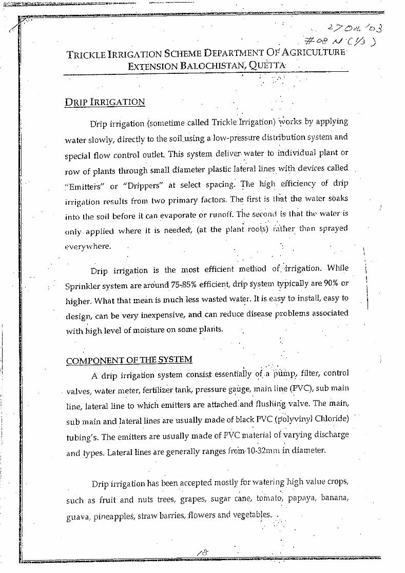
Subject: 1. Crop Water Requirements 2. High Efficiency Irrigation Method 3. Extension Plan of High Efficiency Irrigation Method Answer:
1. Crop Water Requirement
Mr. Muhammad Riaz Khan Kasi estimates the crop water requirements with use of the CROPWAT (computer program) introduced in FAO Irrigation and Drainage Paper 33.
2. High Efficiency Irrigation Method
Concept of the high efficiency irrigation development of the On-farm Water Management and Trickle Irrigation Directorate is mentioned in the attached paper named “Trickle Irrigation Scheme Department of Agriculture Extension Balochistan, Quetta”.
Programme for Farm Demonstration Centres (FDCs) is mentioned in the collected paper named “On-farm Water Management Demonstration Centres - Handbook and Records”.

#08_N_10_21b_Answer_Trickle_ModelFarm.doc Sheet No. 2 / 2
3. Extension Plan of High Efficiency Irrigation Method
Mr. Muhammad Riaz Khan Kasi explained that the On-farm Water Management and Trickle Irrigation Directorate has a plan to extend the high efficiency irrigation method for the following areas:
- Quetta - Pishin - Killa Abdullah - Killa Saifullah (incl. Muslimbagh) - Zhob - Loralai - Ziarat - Mastung - Kalat - Khuzdar - Lasbela


#09_N_10_22a_Answer_FuturePlan_Extention.doc Sheet No. 1 / 1
Answer Sheet for Questionnaire on
Preparatory Study on the Project for Development of Flood Outflow Water in Balochistan Province
in the Islamic Republic of Pakistan Date: 22-Oct.-2003 (Wed.) Time: 9: 30
Interviewer: Name; NODA Kuninobu Position; Water Utilization Expert JICA Preparatory Study Team
Interviewee: Organization; Agriculture Extension Directorate Address; Rani Bagh, Sariab Road, Quetta Telephone; E-mail; Answered by; Mr. Inam-ul-Haq (Name of Interviewee) Position; Assitant Director Office; Agriculture Extension Directorate in Agriculture Extension
Directorate General (Section, Department)
Subject: Future Plan of On-farm Water Management Projects Answer:
Future Plan of On-farm Water Management Project Mr. Inam-ul-Haq, Assistant Director, expressed his idea of a future plan of on-farm water
management projects. He emphasized that it is not the official plan of the Agricultural
Extension Directorate but his own private idea.
Future Plan
On-farm Water Management Balochistan was the OECF assisted project. Five (5) training
and demonstration centers, which include training of the high efficiency irrigation, were
completed in 2000. However, they are not being operated due to budget shortage. The
restoration of those is expected to be realized with the foreign aid.
Locations are (i) Musa Khel Distri, (ii) Killa Saifulla District, (iii) Kalat District, (iv) Lasbela
District and (v) Nasilabad.
PC-1 (1991) of the Project has been presented for reference.
#10_N_10_22b_Answer_Concept_UNDP.doc Sheet No. 1 / 1
Answer Sheet for Questionnaire on
Preparatory Study on the Project for Development of Flood Outflow Water in Balochistan Province
in the Islamic Republic of Pakistan Date: 22-Oct.-2003 (Wed.) Time: 12: 00
Interviewer: Name; NODA Kuninobu Position; Water Utilization Expert JICA Preparatory Study Team
Interviewee: Organization; UNDP, Quetta Address; Sariab Road, Quetta Telephone; 081-9211638, 4499690, 445981 E-mail; [email protected] Answered by; Dr. Rashid Javid (Name of Interviewee) Position; Programme Coordinator Office; Area Development Programme Balochistan, UNDP (Section, Department)
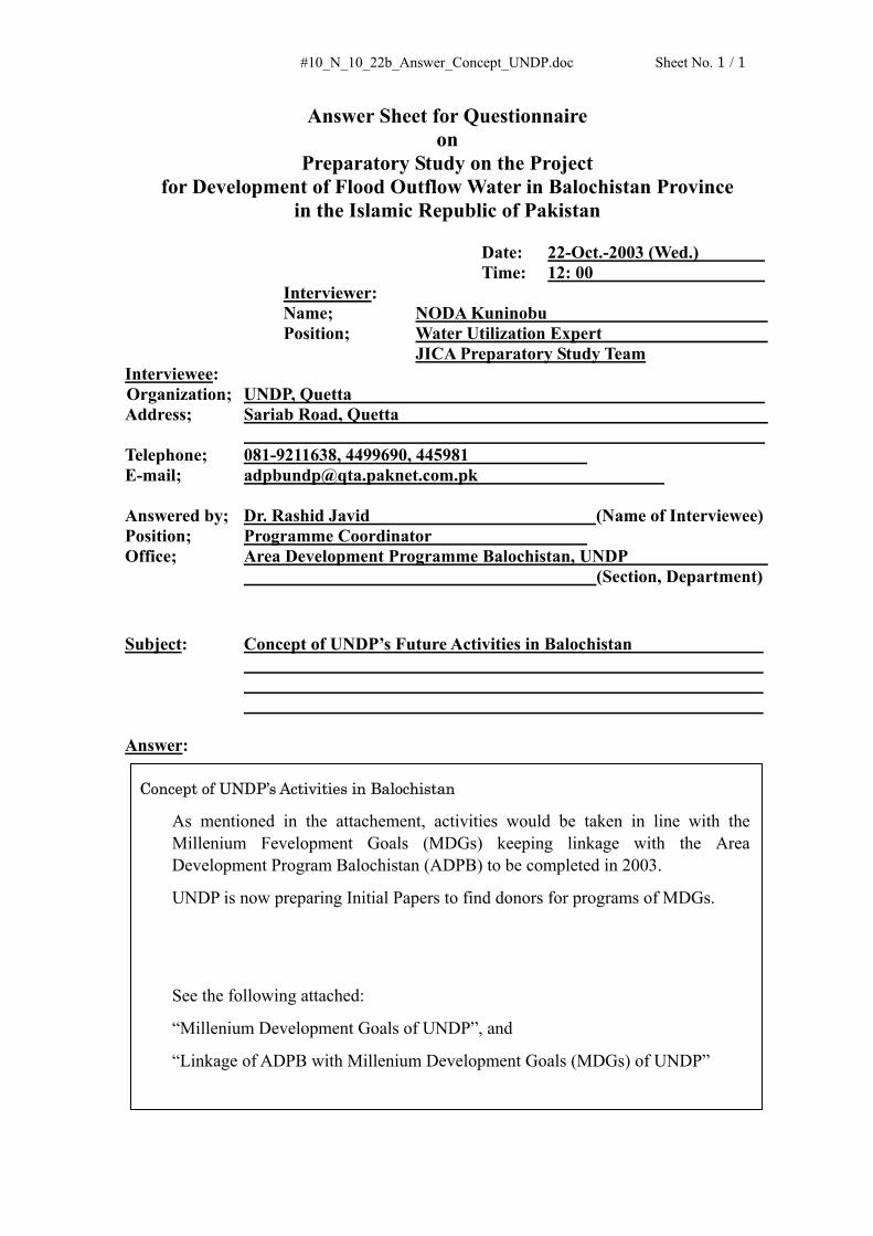
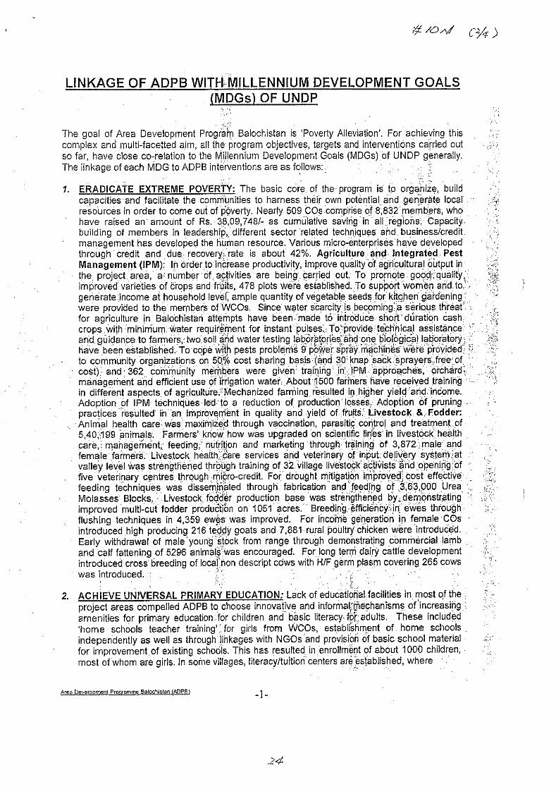
Subject: Concept of UNDP’s Future Activities in Balochistan Answer:
Concept of UNDP’s Activities in Balochistan
As mentioned in the attachement, activities would be taken in line with the Millenium Fevelopment Goals (MDGs) keeping linkage with the Area Development Program Balochistan (ADPB) to be completed in 2003.
UNDP is now preparing Initial Papers to find donors for programs of MDGs.
See the following attached:
“Millenium Development Goals of UNDP”, and
“Linkage of ADPB with Millenium Development Goals (MDGs) of UNDP”


#11_N_10_23a_Answer_TrickleEquipment_WRRC.doc Sheet No. 1 / 1
Answer Sheet for Questionnaire on
Preparatory Study on the Project for Development of Flood Outflow Water in Balochistan Province
in the Islamic Republic of Pakistan Date: 23-Oct.-2003 (Thu.) Time: 10: 00
Interviewer: Name; NODA Kuninobu Position; Water Utilization Expert JICA Preparatory Study Team
Interviewee: Organization; Water Resources Research Centre (WRRC) Address; 47 - Gul Town, Quetta Telephone; 081-9202418 E-mail; Answered by; Dr. Jalal-ud-Din Qureshi (Name of Interviewee) Position; Deputy Director Office; Water Resources Research Centre (WRRC) in Pakistan Council
of Research in Water Resources (PCRWR) (Section, Department)
Subject: 1. Irrigation Related Major Activities of WRRC 2. Establishment of Supply Company of Trickle Irrigation Facilities
(Materials and Parts) Answer:
1. Irrigation Related Major Activities of WRRC The following are the irrigation related major activities: See the attached sheet (1/2).
- Promotion of development and fabrication of trickle irrigation system on orchards See the attached sheet (2/2).
- Determination of water requirement of orchards in Balochistan through Lysimetric and other advanced techniques.
- Survey of Trickle irrigation system in Balochistan
2. Establishment of Supply Company Trickle Irrigation Facilities (Materials and Parts)
The following are the irrigation related major activities:


#12_N_10_23b_Answer_Sailaba_AZRC.doc Sheet No. 1 / 2
Answer Sheet for Questionnaire on
Preparatory Study on the Project for Development of Flood Outflow Water in Balochistan Province
in the Islamic Republic of Pakistan Date: 23-Oct.-2003 (Thu.) Time: 11: 15
Interviewer: Name; NODA Kuninobu Position; Water Utilization Expert JICA Preparatory Study Team
Interviewee: Organization; Arid Zone Research Centre (AZRC), Federal Government Address; P.O. Box 63, Brewery Road, Quetta Telephone; 081-853620 E-mail; [email protected] Answered by; Dr. Mohammad Afzal (Name of Interviewee) Position; Chief Scientific Officer Office; Animal Sciences Division, Pakistan Agricultural Research Council (Section, Department)
Subject: 1. Agricultural Land Owner 2. Agricultural Economics of Khushkaba and Sailaba 3. Trickle Irrigation Experiments Answer:
1. Agricultural Land Owner
a. Government Land Legal land could be transferred to the tribe head and the farmer.
b. Tribe Head’s Land Tribe head’s land would never be transferred to the farmer.
2. Agricultural Economics of Khushkaba and Sailaba Khushkaba
Sailaba

#12_N_10_23b_Answer_Sailaba_AZRC.doc Sheet No. 2 / 2
a. Khushkaba Khushkaba is the rainfed field with Bandat (bench terrace with earth dikes), which is located in the upper slope area of a valley. The yield is 50% of it with the tube well irrigation,
b. Sailaba Sailaba is the flood irrigation field with Bandat (bench terrace with earth dikes), which is located along the seasonal river. The yield is 70%~80% of it with the tube well irrigation.
3. Trickle Irrigation Experiments
AZRC does not conduct the trickle irrigation experiments.

#13_N_10_27a_Answer_WB_Islama.doc Sheet No. 1 / 1
Answer Sheet for Questionnaire on
Preparatory Study on the Project for Development of Flood Outflow Water in Balochistan Province
in the Islamic Republic of Pakistan Date: 27-Oct.-2003 (Mon.) Time: 9: 30
Interviewer: Name; NODA Kuninobu Position; Water Utilization Expert JICA Preparatory Study Team
Interviewee: Organization; World Bank in Pakistan Address; 20-A, Shahrah-e-Jamhuriat, Ramna 5, (G - 5/1), Islamabad Telephone; 051-9090103 E-mail; [email protected] Answered by; Mr. Abdul Salam (Name of Interviewee) Position; Chief of Library Office; Library of World Bank in Pakistan (Section, Department)
Subject: Future Strategy and Projects for Aid in Balochistan for Water Sector Answer:
Future Strategy and Projects for Aid in Balochistan for Water Sector
There is an overall strategy that is the Pakistan’s Poverty Reduction Strategy. See “Pakistan Country Assistance Strategy FY03-05, World Bank, June 24, 2002”.
1. Projects
After the Balochistan Community Irrigation and Agriculture Project, there are no planned projects to be implemented during coming three (3) years from 2004 to 2006.
2. Fund
Fund allocation to Balochistan Province will be made until the end of 2004 for the ongoing project such as Drought Emergency Recovery Assistance Programme (DERA). There is no plan of fund allocation from 2005.

#14_N_10_27b_Answer_ADB_Islama.doc Sheet No. 1 / 1
Answer Sheet for Questionnaire on
Preparatory Study on the Project for Development of Flood Outflow Water in Balochistan Province
in the Islamic Republic of Pakistan Date: 27-Oct.-2003 (Mon.) Time: 9: 30
Interviewer: Name; NODA Kuninobu Position; Water Utilization Expert JICA Preparatory Study Team
Interviewee: Organization; Asian Development Bank in Pakistan Address; OPF Building, Shahrah-e-Jamhuriyat, Sector G - 5/2, Islamabad Telephone; 051-2825011-16 E-mail; [email protected] Answered by; Mr. Raza M. Farrukh (Name of Interviewee) Position; Project Implementation Officer Office; Project Implementation Office (Section, Department)
Subject: Future Strategy and Projects for Aid in Balochistan for Water Sector Answer:
Future Strategy and Projects for Aid in Balochistan for Water Sector
There is an overall strategy that is the Bank’s Country Strategy and Program (CPS) for Pakistan for the period 2002-2006. See “ADB Pakistan Sector Assessment Review, Asian Development Bank, October 2003”. Ongoing project such as Drought Impact Mitigation & Recovery Component (DIMRC) would finish in 2004/
There is the planned project “2nd Flood Protection Sector Project” to be implemented during coming three (3) years from 2004 to 2006. There is no other planned project.
It is noted that the ADB Programming Mission to be dispatched to Balochistan in December 2003 might formulate other projects in the water sector.

(3) 質問票・回答 – 建設機械計画
番号 訪問先 質問事項
#01_K Agriculture, Cooperative and Food Dept., Balochistan
Present Conditions of the Equipment Supplied by Past Japan’s Grant Aid Programs, etc.
#02_K Agriculture, Cooperative and Food Dept., Balochistan
List of All the Construction Equipment, Rental Charge, Organization Chart, Annual Budget, etc.
#03_K Agriculture, Cooperative and Food Dept., Balochistan
Future Plan Proposed by Directorate of Agricultural Engineering, etc.
#04_K Communication and Works, Balochistan Present Conditions of the Equipment and Repair Workshop
#05_K Communication and Works, Balochistan List of All the Construction Equipment, Rental Charge, Organization Chart, Annual Budget, etc.
#06_K Haji Musa Jan (Contractor) Availability of Labor, Construction Materials and Equipment, etc.
#07_K Irrigation and Power Dept., Balochistan List of All the Construction Equipment, Rental Charge, Organization Chart, Annual Budget, etc.
#08_K Irrigation and Power Dept., Balochistan Present Conditions of the Equipment/ Repair Workshop
#09_K Irrigation and Power Dept., Balochistan Rental Charge of Bulldozer/ Drilling Machine
#10_K Irrigation and Power Dept., Balochistan Bidding Procedure, Contact Document, Cost Data, Norm of Cost Estimate, etc.
#11_K Irrigation and Power Dept., Balochistan Contract Document, Bidding Procedure, Local Contractor
#12_K Public Health Engineering Dept. List of the Machinery, Present Conditions of the Machinery

#01_K_Answer_Agri._Dept(1).doc Sheet No. 1 / 2
Answer Sheet for Questionnaire on
Preparatory Study on the Project for Development of Flood Outflow Water in Balochistan Province
in the Islamic Republic of Pakistan Date: 8-Oct.-2003 (Wed.) Time: 16: 00
Interviewer: Name; Koji KOGA Position; Construction Equipment Planner JICA Preparatory Study Team
Interviewee: Organization; Agriculture, Cooperative and Food Department, Balochistan
Province Address; Link Sariab Road, Quetta Telephone; 081-9211318 E-mail; Answered by; Mr. Jamil Rind (Name of Interviewee) Position; Deputy Director Office; Directorate of Agricultural Engineering (Section, Department)
Subject: 1. Present Conditions of the Equipment Supplied by Past Japan’s Grand Aid Programs
2. Present Conditions of the Repair Workshop Owned by Directorate of Agricultural Engineering
Answer:
1. Present Conditions of the Equipment Supplied by Past Japan’s Grand Aid Programs
①農業技術部が所有する全ての施設、機材は、全て標準使用年数を超えて
運営している。これは、バロチスタン州内の各地区に配置された施設、
職員が、維持管理マニュアルに従って所有する機材をうまく管理・運営
していることに起因する(実際、20 年前に供与されたブルドーザは現
在においても稼働可能な状態にある)。
②同部が所有する機材は、農業用あるいは洪水防御用として農民に貸出さ
れている。また、農業目的以外としては、灌漑発電局が実施している地
下水涵養ダム(DAD)建設用として建設業者へ貸出されている
2. Present Conditions of the Repair Workshop Owned by Directorate of Agricultural Engineering
#01_K_Answer_Agri._Dept(1).doc Sheet No. 2 / 2
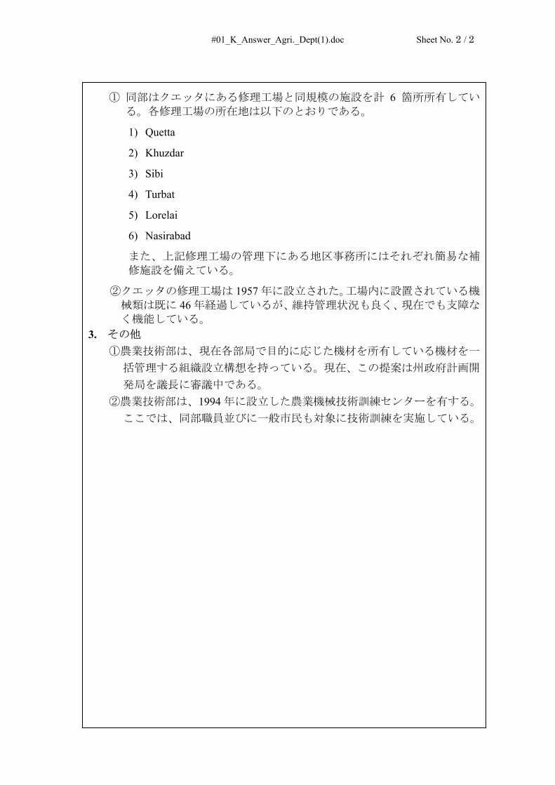
① 同部はクエッタにある修理工場と同規模の施設を計 6 箇所所有してい
る。各修理工場の所在地は以下のとおりである。
1) Quetta
2) Khuzdar
3) Sibi
4) Turbat
5) Lorelai
6) Nasirabad
また、上記修理工場の管理下にある地区事務所にはそれぞれ簡易な補
修施設を備えている。
②クエッタの修理工場は 1957 年に設立された。工場内に設置されている機
械類は既に 46 年経過しているが、維持管理状況も良く、現在でも支障な
く機能している。 3. その他
①農業技術部は、現在各部局で目的に応じた機材を所有している機材を一
括管理する組織設立構想を持っている。現在、この提案は州政府計画開
発局を議長に審議中である。 ②農業技術部は、1994 年に設立した農業機械技術訓練センターを有する。
ここでは、同部職員並びに一般市民も対象に技術訓練を実施している。

#02_K_Answer_Agri._Dept(2).doc Sheet No. 1 / 2
Answer Sheet for Questionnaire on
Preparatory Study on the Project for Development of Flood Outflow Water in Balochistan Province
in the Islamic Republic of Pakistan Date: 10-Oct.-2003 (Fri.) Time: 10: 00
Interviewer: Name; Koji KOGA Position; Construction Equipment Planner JICA Preparatory Study Team
Interviewee: Organization; Agriculture, Cooperative and Food Department, Balochistan
Province Address; Link Sariab Road, Quetta Telephone; 081-9211318 E-mail; Answered by; Mr. Syed Saadat Hussain Naqvi (Name of Interviewee) Position; Director Office; Directorate of Agricultural Engineering (Section, Department)
Subject: 1. Refer to Detailed Questionnaire Attached Herewith Answer:
1. Detailed Questionnaire Attached Herewith
各質問項目に対する答えは、後日紙面で回答する。
2. その他
① 農業組合食糧局は圃場内整備及び農地開発を担当し、灌漑発電局は圃場
外のインフラ整備(Delay Action Dam、灌漑水路等)を担当する。
② 農業組合食糧局が担当する事業は、機材(ブルドーザ、トラクター等)
を補助金による有利なレートで農民へ貸出す方式で実施している。
③ 灌漑発電局が担当する事業では、建設業者が工事を請け負い、一部機材
を建設業者へ貸出す方式で実施している。

#02_K_Answer_Agri._Dept(2).doc Sheet No. 2 / 2
Questionnaire I. The following equipment were supplied on the Basic Design Study on the Project for
Agricultural Land Development & Reclamation in the Province of Balochistan, 1994.
1) Bulldozers, 140HP class :77 units
2) Spare parts for Bulldozer :For 3 years
3) Transporter, 6 x 6 Max. loading 20 t :6 units
4) Spare parts for Transporter :For 3 years
5) Fuel Tanker, 6 x 4 Tank capacity 7,000 l :6 units
6) Pick-up car, 4 x4 Double cabin type :6 units
7) Jeep, 4 x 4 :5 units
In addition, the following bulldozers were supplied by Japan’s grand aid KR-II programs.
A) 1982-1983:Bulldozer 140HP, 117 units
B) 1987-1988:Bulldozer 120HP, 86 units
C) 1990-1991:Bulldozer 140HP, 10 units
II. Detailed Items to be confirmed are as follows:
1. List of the bulldozers owned by Agriculture Engineering Department, which was classified into 3
category that is 1) Number of workable, 2)Number of none-workable (under repairing), and
3)Number of scrap
2. List of all the construction equipment owned by Agriculture Engineering Department, including
quantity, past year, and conditions (workable, none-workable, or scrap) of each equipment
3. Respective rental charge of the bulldozer for the following cases.
① Agriculture purpose:250 Rp/hour(If the charge will be paid by cash)
② Agriculture purpose:300 Rp/hour (If the charge will be paid by a special fund), Poor farmer
only can be applied. 30 Rp (10%) of 300 Rp is required to be paid by poor farmer、the remains
is paid by some funds)
③ The work except agriculture purpose:700 Rp/hour
4. Organization chart of the Agriculture Engineering Department, and Number of engineer, operator,
mechanic, officer etc.
5. Annual budget of the Agriculture Engineering Department, which was classified into each items
6. Organization chart of district/ regional repair workshops
7. Number of each facilities/ equipment installed and number of the working staffs in each district/
regional repair workshops
8. Method of daily/ regular basis for each construction equipment
9. Method of management for spare parts of the construction equipment
10. Technical training center for agricultural machine, which was opened in 1994 (Training
course, Number of trainer, Number of instructor and officer, Annual budget, etc.), Available of the
Brochure on the said Technical training center

#03_Answer_TechnoConsult_09Oct03.doc
S. TAKAHASHI
Answer Sheet for Questionnaire on
Preparatory Study on the Project for Development of Flood Outflow Water in Balochistan Province
in the Islamic Republic of Pakistan Date: 09-Oct-2003(Thu) Time:
Interviewer: Name; TAKAHASHI Shinya Position; HYdro- JICA Preparatory Study Team
Interviewee: Organization: Techno-Consult International under WASA project. Address: 2nd Floor WASA, office, ZArghoon Road Quetta Telephone: +081 450485 E-mail: Answered by:
- Dr. Muhammad Bashir Lakhani, Team Leader, Investigation Phase – Technical Support Team
- Mr. Muhammad Jahazeb Maik, GIS-expert, Investigation Phase – Technical Support Team
- Mr. Anwer Jhah Khan, GIS Specialist / Cartographer, Ministry of Petroleum and Natural Resources, Geological Survey of Pakistan, Quetta
Position: (see above) Office: WASA office
Subject: 1) Request for Information • Groundwater resources in Pishin-Lore groundwater basin are being assessed for a
further development for water supply to Quetta City. • GIS presentation is being prepared for WASA by the consultant • Groundwater monitoring data is being supplied on monthly basis form the Water
Resources Planning Development and Monitoring (WRPD&M) Directorate, Irrigation and Power Department, GoB, Quetta.
• The assessment will be completed by the end of December this year. A satellite imagery showing groundwater monitoring stations in Pishin-Lora groundwater basin and a GIS presentation was given as a sample information. === end of document===

#04_K_Answer_Comm. & Works_Dept(1).doc Sheet No. 1 / 2
Answer Sheet for Questionnaire on
Preparatory Study on the Project for Development of Flood Outflow Water in Balochistan Province
in the Islamic Republic of Pakistan Date: 20-Oct.-2003 (Mon.) Time: 9: 30
Interviewer: Name; Koji KOGA Position; Construction Equipment Planner JICA Preparatory Study Team
Interviewee: Organization; Communication and Works Department Address; Whyite Road, Quetta Telephone; 081-9202867 E-mail; Answered by; Mr. Qazi Amanullah (Name of Interviewee) Position; Chief Engineer-I Office; Communication and Works Department (Section, Department)
Subject: 1. Present Conditions of the Equipment and Repair Workshop Answer:
1. Present Conditions of the Equipment and Repair Workshop
① C&W Dept.が所有する修理工場並びに道路建設用機材に関する資料は、
修理工場の Executive Engineer と面談して入手する。
2. その他
機材に関する予算申請の手順について下記の通り確認した。
① Budget for Development
予算書(PC-I 見積り)を P&D Dept.へ提出、承認後 Finance Dept.へ提出され、
予算がリリースされる。
② Budget for Non-Development (従業員の給料及び施設維持費等)
予算書を直接 Finance Dept.へ提出、予算がリリースされる。
また、参考までに水電力公団(WAPDA)の現在の担当分野について下記の
通り確認した。

#04_K_Answer_Comm. & Works_Dept(1).doc Sheet No. 2 / 2
水電力公団は、全ての州の送電網工事と大規模の貯水ダム・灌漑水路の工
事を担当している。したがって、クエッタにあった地下水開発部門(Drilling機材と地下水調査部門)は灌漑発電局へ移管された。

#05_K_Answer_Comm. & Works_Dept(2).doc Sheet No. 1 / 2
Answer Sheet for Questionnaire on
Preparatory Study on the Project for Development of Flood Outflow Water in Balochistan Province
in the Islamic Republic of Pakistan Date: 20-Oct.-2003 (Mon.) Time: 11: 00
Interviewer: Name; Koji KOGA Position; Construction Equipment Planner JICA Preparatory Study Team
Interviewee: Organization; Communication and Works Department Address; Eastern By-pass Road, Quetta Telephone; 081-892487 E-mail; Answered by; Mr. Noor Ahmed (Name of Interviewee) Position; Executive Engineer Office; E&M Workshop Division (Section, Department)
Subject: Refer to the Detailed Questionnaire attached Answer:
1. Detailed Questionnaire
各質問の内、可能な限り資料を入手した。
2. その他
修理工場及び待機している下記建設機械を視察した。
① 砕石生産設備(現在修理中)
② モーターグレーダ
③ 振動ローラ
④ タイヤローラ
⑤ トラック&トレーラ
⑥ アスファルト生産設備(1991 年中国からの無償供与)

#05_K_Answer_Comm. & Works_Dept(2).doc Sheet No. 2 / 2
Questionnaire Detailed Items to be confirmed are as follows:
1. List of the bulldozers owned by Irrigation and Power Department, which was classified into 3
category that is 1) Number of workable, 2)Number of none-workable (under repairing), and
3)Number of scrap
2. List of all the construction equipment owned by C & W Department, including quantity, past year,
and conditions (workable, none-workable, or scrap) of each equipment
3. In case that your owned construction equipment rent to the Contractor, How much a rental charge of
each construction equipment per hour
4. Organization chart of the Machinery and Equipment Section, and Number of engineer,
administrator, operator, mechanic, electrician, officer etc. of the repair workshop
5. Annual budget of the Machinery and Equipment Section, which was classified into each items
6. Organization chart of repair workshop
7. Number of each facilities/ equipment installed and number of the working staffs in repair workshop
8. Method of daily/ regular basis for each construction equipment
9. Method of management for spare parts of each construction equipment

#06_K_Answer_Contractor.doc Sheet No. 1 / 1
Answer Sheet for Questionnaire on
Preparatory Study on the Project for Development of Flood Outflow Water in Balochistan Province
in the Islamic Republic of Pakistan Date: 15-Oct.-2003 (Wed.) Time: 12: 00
Interviewer: Name; Koji KOGA Position; Construction Equipment Planner JICA Preparatory Study Team
Interviewee: Contractor; Haji Musa Jan Address; 162 Sumungli Town, Quetta Telephone; 081-828029 E-mail; Answered by; Mr. Haji Musa Jan (Name of Interviewee) Position; President Office; Quetta (Section, Department)
Subject: 1. Brochure of the Contractor (Capability of local contractor) 2. Availability of Labor, Construction Materials and Equipment Answer:
1. Brochure of the Contractor
当コントラクターの説明書を入手した。
2. Availability of Labor, Construction Materials and Equipment
①LaborはSkilled LaborからCommon Laborまでパキスタン国内で雇用可能。
②建設材料は全てパキスタン国内で調達可能。
③建設機械は、当コントラクターの場合、主要な機械は所有しており、また
レンタル会社とリース契約して所有している機械もある。これら機械リス
トは、上記 Brochure にリース契約書と共に添付されている。
④参考までに 2003 年現在の主要な Material Price 及び Labor wage は次の通
り。
- Steel : Rp. 31,000/ton, Cement : Rp. 245/bag(50kg), Diesel oil : Rp. 21/liter
- Skilled Mason wage : Rp. 500/day, Common labor wage : Rp. 150/day

#07_K_Answer_Irrigation_Dept(1).doc Sheet No. 1 / 2
Answer Sheet for Questionnaire on
Preparatory Study on the Project for Development of Flood Outflow Water in Balochistan Province
in the Islamic Republic of Pakistan Date: 11-Oct.-2003 (Sat.) Time: 10: 00
Interviewer: Name; Koji KOGA Position; Construction Equipment Planner JICA Preparatory Study Team
Interviewee: Organization; Irrigation and Power Department, Balochistan Province Address; Saryab Road, Quetta Telephone; 081-9211113 E-mail; Answered by; Mr. Arbab Yousaf (Name of Interviewee) Position; Director General Office; Water Resources Planning, Development & Monitoring Directorate (Section, Department)
Subject: 1. Refer to Detailed Questionnaire Attached Herewith Answer:
1. Detailed Questionnaire Attached Herewith
各質問項目に対する答えは、Deputy Director である Mr. Nadir Ali が回答を
準備する。
2. その他
① 灌漑発電局はクエッタに一箇所修理工場を所有する。
② 灌漑発電局の組織図は後日に渡す。
③ 日本政府の一般無償案件で WAPDA へ供与された 5 台の井戸掘り用リ
グ機材は、1998 年に灌漑発電局へ移管された。

#07_K_Answer_Irrigation_Dept(1).doc Sheet No. 2 / 2
Questionnaire Detailed Items to be confirmed are as follows:
1. List of the bulldozers owned by Irrigation and Power Department, which was classified into 3
category that is 1) Number of workable, 2)Number of none-workable (under repairing), and
3)Number of scrap
2. List of all the construction equipment owned by Irrigation and Power Department, including
quantity, past year, and conditions (workable, none-workable, or scrap) of each equipment
3. In case that your owned construction equipment rent to the Contractor, How much a rental charge of
each construction equipment per hour
4. Organization chart of the Machinery and Equipment Section, and Number of engineer,
administrator, operator, mechanic, electrician, officer etc. of the repair workshop
5. Annual budget of the Machinery and Equipment Section, which was classified into each items
6. Organization chart of repair workshop
7. Number of each facilities/ equipment installed and number of the working staffs in repair workshop
8. Method of daily/ regular basis for each construction equipment
9. Method of management for spare parts of each construction equipment

#08_K_Answer_Irrigation_Dept(2).doc Sheet No. 1 / 2
Answer Sheet for Questionnaire on
Preparatory Study on the Project for Development of Flood Outflow Water in Balochistan Province
in the Islamic Republic of Pakistan Date: 11-Oct.-2003 (Sat.) Time: 11: 00
Interviewer: Name; Koji KOGA Position; Construction Equipment Planner JICA Preparatory Study Team
Interviewee: Organization; Irrigation and Power Department, Balochistan Province Address; Saryab Road, Quetta Telephone; 081-921120 E-mail; Answered by; Mr. Nadir Ali (Name of Interviewee) Position; Deputy Director, Workshop & Store Office; Water Resources Planning, Development & Monitoring Directorate (Section, Department)
Subject: 1. Present Conditions of the Equipment Owned by Irrigation and Power Department
2. Present Conditions of the Repair Workshop Owned by Irrigation and Power Department
Answer:
1. Present Conditions of the Equipment Owned by Irrigation and Power Department
①全ての機材は、バロチスタン州の各地区事務所の Executive Engineer の管
理下で稼働中である。通常の点検・修理は近くの民間修理工場で実施し
ている。クエッタの修理工場では、オーバーホール(大修理)等が必要
な時にのみ各地区事務所から搬送され、修理を実施する。
②井戸掘り用リグ機材は全て稼働可能な状態にある。尚、現在リグ機材の
スペアパーツ、特に消耗品であるビッドが不足している。不足している
ビットの仕様及び数は以下の通りである。
1)ビット 12”1/4 diameter :100 nos.
2)ビット 17”1/2 diameter :100 nos.
尚、ビットの消耗は、参考値として深さ約 1,000 フィートで全損となる。

#08_K_Answer_Irrigation_Dept(2).doc Sheet No. 2 / 2
2. Present Conditions of the Repair Workshop Owned by Irrigation and Power Department
① 修理工場内に設置された機械類は、1986 年に USAID によって供与され
た。
② 年間予算では、2001-2002 年は、14 台のブルドーザと 1 台のバックホ
ーの修理用として Rp. 10 million、2002-2003 年も同額の Rp. 10 millionが配分された。2003-2004 年については、ブルドーザ(D6D)のスペア
パーツ調達用として Rp. 10 million 予算化されており、まもなく配分さ
れる予定。
#09_K_Answer_Irrigation_Dept(3).doc Sheet No. 1 / 1
Answer Sheet for Questionnaire on
Preparatory Study on the Project for Development of Flood Outflow Water in Balochistan Province
in the Islamic Republic of Pakistan Date: 21-Oct.-2003 (Tue.) Time: 12: 00
Interviewer: Name; Koji KOGA Position; Construction Equipment Planner JICA Preparatory Study Team
Interviewee: Organization; Irrigation and Power Department, Balochistan Province Address; Saryab Road, Quetta Telephone; 081-921120 E-mail; Answered by; Mr. Nadir Ali (Name of Interviewee) Position; Deputy Director, Workshop & Store Office; Water Resources Planning, Development & Monitoring Directorate (Section, Department)
Subject: 1. Rental Charge of Bulldozer D6D 2. Rental Charge of Drilling Machine Answer:
1. Rental Charge of Bulldozer D6D
建設業者へ貸出すブルドーザの賃貸価格は下記の通り。
① Rp. 870 per hour without P.O.L.(Petrol, Oil and Lubricant)
② Rp. 1,320 per hour with P.O.L
2. Rental Charge of Drilling Machine
建設業者へ貸出す井戸掘削用機材の賃貸価格は以下の通り。
① Tube Well 掘削費(深さ 500 feet) :Rp. 24,000
②維持修理費(深さ 500 feet) :Rp. 23,700
③注入器による循環用オイルの Supply 費 :Rp. 36,300
以上①~③の合計は Rp. 84,000 (深さ 500 feet)
したがって、1 feet 当りの価格は Rp. 168 と算出される。

#10_K_Answer_Irrigation_Dept(4).doc Sheet No. 1 / 1
Answer Sheet for Questionnaire on
Preparatory Study on the Project for Development of Flood Outflow Water in Balochistan Province
in the Islamic Republic of Pakistan Date: 13-Oct.-2003 (Mon.) Time: 12: 30
Interviewer: Name; Koji KOGA Position; Construction Equipment Planner JICA Preparatory Study Team
Interviewee: Organization; Irrigation and Power Department Address; Sariab Road, Quetta Telephone; 081-9211155 E-mail; Answered by; Mr. Qutab Khan (Name of Interviewee) Position; Sub-Divisional Officer Office; Sub Divisional Office, Irrigation (Section, Department)
Subject: 1. Bidding Procedure 2. Contract Document 3. Cost Data (Labor wage, material price and equipment cost) 4. Norm of Cost Estimate (Authorized Norm) 5. Contractor (Major local contractor in Quetta) Answer:
1. Bidding Procedure
Bidding Procedure に関して記載されている資料を収集して渡す。
2. Contract Document
州政府資金と ADB 資金の 2 種類の Contract Document を準備する。
3. Cost Data (Labor wage, material price and equipment cost)
州政府計画開発局(Planning and Development Dept.)がまとめた、Engineer’s Estimate時に適用する各単価が記載されたDocument、“Composite Schedule of Rate 1998”のコピーを渡す。
4. Norm of Cost Estimate (Authorized Norm)
先に渡した“PC-I/ Estimate, Construction of Wali DAD Delay Action Dam”の報
告書の中に、Detailed Estimate が含まれている。この中で参照している各工
事項目の単価は、全て上記 3 の Document で設定された単価である。
5. Contractor (Major local contractor in Quetta)
Quetta 周辺に事務所を持ち、DAD 建設の経験豊富な建設業者を紹介する。
#11_K_Answer_Irrigation_Dept(5).doc Sheet No. 1 / 1
Answer Sheet for Questionnaire on
Preparatory Study on the Project for Development of Flood Outflow Water in Balochistan Province
in the Islamic Republic of Pakistan Date: 14-Oct.-2003 (Tue.) Time: 12: 00
Interviewer: Name; Koji KOGA Position; Construction Equipment Planner JICA Preparatory Study Team
Interviewee: Organization; Irrigation and Power Department Address; Sariab Road, Quetta Telephone; 081-9211155 E-mail; Answered by; Mr. Qutab Khan (Name of Interviewee) Position; Sub-Divisional Officer Office; Sub Divisional Office, Irrigation (Section, Department)
Subject: 1. Contract Document 2. Bidding Procedure 3. Local Contractor Answer:
1. Contract Document
州政府資金の場合、建設業者は Total Amount のみを記載して応札する。一方、
WB あるいは ADB 資金の場合は、各 Pay Item に単価を記載した上で Total Amount を集計、記載して応札する。州政府資金の Contract Document と ADB資金の Tender Document を入手した。
2. Bidding Procedure
入札及び評価手続きが記載された資料を入手した。
3. Local Contractor
DAD 建設の経験豊富な Local Contractor との面談日を設定した。
州政府の公共工事に応札できる Contractor は、州政府各局で以下のカテゴリ
ー別(応札可能なプロジェクトの予算別)に登録されている。
カテゴリーA:100~10 million Rp.
カテゴリーB:10~2.5 million Rp.
カテゴリーC:2.5~0.1 million Rp.

#12_K_Answer_Public Health Eng._Dept.doc Sheet No. 1 / 1
Answer Sheet for Questionnaire on
Preparatory Study on the Project for Development of Flood Outflow Water in Balochistan Province
in the Islamic Republic of Pakistan Date: 20-Oct.-2003 (Mon.) Time: 13: 00
Interviewer: Name; Koji KOGA Position; Construction Equipment Planner JICA Preparatory Study Team
Interviewee: Organization; Public Health Engineering Department Address; Eastern By-pass Road, Quetta Telephone; 081-892215 E-mail; Answered by; Mr. Thaikh Nawax Ahmed (Name of Interviewee) Position; Executive Engineer Office; (Section, Department)
Subject: 1. List of the Machinery Owned by PHE Dept. 2. Present Conditions of Each Machinery Answer:
1. List of the Machinery Owned by PHE Dept.
Public Health Engineering Dept.が現在所有している井戸掘り用リグ機材は下
記の 4 台であることを確認した。
①1987 年モデル :1 台
②1985 年モデル :3 台
したがって、1996 年に日本政府の一般無償案件で供与されたリグ機材は含
まれていないことを確認した。
尚、詳細な機材リストを別途入手した。
2. その他
井戸掘削工事は、灌漑及び飲料水の両方を目的とする場合は灌漑発電局が担
当、リグ機材を建設業者へ貸出し工事を行う。一方、Rural Area で飲料水を
目的とする場合(地方給水)は、Public Health Engineering Dept.が担当し、所
有するリグ機材を使用して直営方式で工事を行う。
尚、Public Health Engineering Dept.は現在水質等検査する試験所は所有してい
ない

(4) 質問票・回答 – 社会条件調査/住民参加調査
番号 訪問先 質問事項
#01_S Irrigation Division Quetta, Balochistan Province BCIA Project of Irrigtion Department,
etc
#02_S Forest and Wildlife Department, Balochistan
Province
List of Natural conservation and
Cultural ruins in Balochistan, etc
#03_S SPO (Strengthening Participatory Organization)
NGO
SPO organization structure, etc
#01_S_Answer_1.doc Sheet No. 1 / 1
Answer Sheet for Questionnaire on
Preparatory Study on the Project for Development of Flood Outflow Water in Balochistan Province
in the Islamic Republic of Pakistan Date: 23-Oct.-2003 Time: 14: 30
Interviewer: Name; N. Shimmura Position; Social Condition Specialist JICA Preparatory Study Team
Interviewee: Organization; Irrigation Division Quetta, Balochistan Province Address; Office of the Irrigation Division, Sariab Road, Quetta
Telephone; 081-9211005 E-mail; Answered by; Mr. Saleem Khal (Name of Interviewee) Position; BCIA (Balochistan Community Irrigation and Agriculture) Project
officer Office; BCIA Project office in Irrigation division
Subject: We (JICA Study Team) would like to know 1. BCIA Project of Irrigation department 2. Model districts of farmer participatory Project Answer:
1. BCIA Project of Irrigation department
Refer to our department’s BCIA Project reports.
2. Model districts of farmer participatory Project
Refer to our department’s List of BCIA Project districts

#02_S_Answer_2.doc Sheet No. 1 / 1
Answer Sheet for Questionnaire on
Preparatory Study on the Project for Development of Flood Outflow Water in Balochistan Province
in the Islamic Republic of Pakistan Date: 24-Oct.-2003 Time: 9: 30
Interviewer: Name; N. Shimmura Position; Social Condition Specialist JICA Preparatory Study Team
Interviewee: Organization; Forest and Wildlife Department, Balochistan Province Address; Office of the Forest and Wildlife Department, Spinny Road, Quetta
Telephone; 081-9201137 E-mail; Answered by; Mr. Syed Ali Imran (Name of Interviewee) Position; Forests Coordinator Office; Forest and Wildlife Department
Subject: We (JICA Study Team) would like to know 1. List of Natural conservation and Cultural ruins in Balochistan 2. Balochistan conservation strategy of Natural and cultural ruins Answer:
1. List of Natural conservation and Cultural ruins in Balochistan
Refer to our organization’s List of Natural conservation and Cultural ruins.
2. Balochistan conservation strategy of Natural and cultural ruins
Refer to book of「Balochistan Conservation strategy」IUCN published.
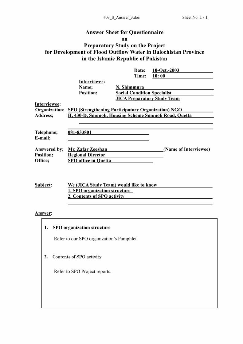
#03_S_Answer_3.doc Sheet No. 1 / 1
Answer Sheet for Questionnaire on
Preparatory Study on the Project for Development of Flood Outflow Water in Balochistan Province
in the Islamic Republic of Pakistan Date: 10-Oct.-2003 Time: 10: 00
Interviewer: Name; N. Shimmura Position; Social Condition Specialist JICA Preparatory Study Team
Interviewee: Organization; SPO (Strengthening Participatory Organization) NGO Address; H, 430-D, Smungli, Housing Scheme Smungli Road, Quetta
Telephone; 081-833801 E-mail; Answered by; Mr. Zafar Zeeshan (Name of Interviewee) Position; Regional Director Office; SPO office in Quetta
Subject: We (JICA Study Team) would like to know 1. SPO organization structure 2. Contents of SPO activity Answer:
1. SPO organization structure
Refer to our SPO organization’s Pamphlet.
2. Contents of SPO activity
Refer to SPO Project reports.

添付資料 - 5 現場踏査記録
水文・地質/地下水開発計画


S. TAKAHASHI
##01MurghaiKotalDAD_QTA_20SEP03.doc Record of Field Visit (#01) Date visited: 20-Sep-2003 Name of site visited: Murghai Kotal Delay Action Dam (#120)、 proposed by JICA F/S(1997) for stage II
construction District: Quetta Coordinates (by handy GIS): 30-19.083N: 66-56.643E Persons met: Ahsan Hidayat Khan, Executive Engineer Descriptions: Cost incurred: Rp. 4.5 million
Date of Completion:30- June 1979 Restoration: 30-June-1979, Restored in June 2003 Catchment and Reservoir - Catchment’s Area: 19.7 sq.km - River Discharge: 56.64 cumec - Storage Capacity: 80 AF (104,000 m3) - Storage Depth: 44 ft (13.4 m) Components of DAD - Dam type: Homogeneous earth fill type - Crest length: 323 ft (9.8 m) - Height: 57 ft (17.3 m) - Crest Width: 6.1 m - Bottom Width: 103.66 m - Side Slope D/S (upper): 3:1 - Side Slope D/S Berm (Lower): 4.57 - Side Slope U/S: 2:1 - Stone Pitching on U/S Slope: 0.457 - Shingle: 0.565 - H.G. Line (Assumed Saturation line):1: 5 Spillway - Length: 67.378 m - Width: 12.196 m - Crest Level: 44 ft (13.4 m) - Side slope: nil - Stone pitching on bed and slopes: rocky bed - Gabion barrier walls :RCC wall 4 nos. - Design discharge (return period): 2200 cusec, ( 50 year) Outlet structure: - Discharge: 13 cusec - Length of 12 inch dia, 131.09, MS pipe with ‘strainer’ facility in the reservoir Benefits - Surface Well: 107 nos - Spring: nil nos - Kareze: 3 nos - Tube well:35 nos - Additional cultivation: ** acres - Farm families: ** Observations • One of the stage II DAD proposed by JICA F/S Study (1997) • Flood in Feb. 2003: 165 AF (203,000 m3) spilled out, 80 AF (96,000 m3) was stored and
percolated (disappeared) within 6 days • Karezes downstream dried up after the last draught, was not yet restored by the DAD

S. TAKAHASHI
##01MurghaiKotalDAD_QTA_20SEP03.doc • Contractor arranged machinery for construction. • Tube well records: constructed in1993 to the depth 600 ft, with groundwater level 95 ft,
draw-down 195 ft. In 2003 groundwater level was 400 ft. Record of screen position is available on the tube well site.
• It was told the DAD was breached by flood during construction. The breached part was re-constructed with a few days.

S. TAKAHASHI
##02DaraDAD_QTA_20SEP03.doc Record of Field Visit (#02) Date visited: 20-Sep-2003 Name of site visited: Dara Delay Action Dam, proposed by JICA F/F (1997) for Stage 1 construction (#115 in
Briefing paper) District: Quetta Coordinates (by handy GIS): 30-19.314 N: 60-00.962 E Persons met: Ahsan Hidayat Khan, Executive Engineer Descriptions: Cost incurred:
Date of Completion: 2001 Catchment and Reservoir - Catchment’s Area: 6.70 sqm - River Discharge: 3875 cusec - Storage Capacity: 218 AF (283,400 m3) - Storage Depth: 40 ft (12.2 m) Components of DAD - Dam type: Homogeneous earth fill type - Crest length: 362 m - Height: 50 ft (15.2 m) - Crest Width: 6.09 m - Bottom Width: 82.31m - Side Slope D/S (upper): 3:1 - Side Slope D/S Berm (Lower): 3:1 - Side Slope U/S: 2:1 - Stone Pitching on U/S Slope: 0.65 ft - Shingle: 0.33 ft - H.G. Line (Assumed Saturation line):1: 5 Spillway - Length: 44.81 m - Width: 22.86 m - Crest Level: 40 ft (12.2 m) - Side slope: 0.2511 - Stone pitching on bed and slopes: nil - Gabion barrier walls :nil - Design discharge (return period): 3875 cusec ( ** year) Outlet structure: - Discharge: 12 cusec - Length of 6 inch dia, 420 MS pipe with ‘strainer’ facility in the reservoir Benefits - Surface Well: ** nos - Spring: ** nos - Kareze: ** nos - Tube well:** nos - Additional cultivation: ** acres - Farm families: ** Observations • Assisted by Federal Government • One of the stage I DAD of JICA Study of 1997 • No flood has yet to come after construction

S. TAKAHASHI
##03DargaiDAD_PSN_21SEP03.doc Record of Field Visit (#03) Date visited: 21-Sep-2003 Name of site visited: Dargai Delay Action Dam (#174 in Briefing paper) District: Pishin Coordinates (by handy GIS): 30-29.622 N: 67-08.587E Persons met: Descriptions: Constructed under Draught Emergency Relief Assistance (DERA), ADB/WB
Cost incurred: Rp. 25.25 million Date of Completion: under construction (scheduled by *****mm/yy) Catchment and Reservoir - Catchment’s Area: 50 sq.mile (47.4 km2) - River Discharge: 7,000 cusec (198 m3/sec) from Daragai river, 6,500 cusec (175.5 m3) from Garki river - Storage Capacity: 850 AF (1,105,000 m3) - Storage Depth: 44 ft (13.4 m) Components of DAD - Dam type: Homogeneous earth fill type - Crest length: 3,365 ft, using low undulating area (1,025.7 m) - Height: 38.5 ft (11.7 m) - Crest Width: 20 ft (6.1 m) - Bottom Width: 323.6 ft (98.6 m) - Side Slope D/S (upper): 3.0 : 1 - Side Slope D/S Berm (Lower): no berm constructed - Side Slope U/S: 2.0 : 1 - Stone Pitching on U/S Slope: 1.5 ft (0.46 m) - Shingle: non - H.G. Line (Assumed Saturation line):1: 5 Spillway - Length: 225 ft (68.6 m) - Width: 225 ft - Crest Level: 44 ft - Side slope: 2:1 - Stone pitching on bed and slopes: 1.5 thick in gabion wall - Gabion barrier walls :nil - Design discharge (return period): 7,000 cusec, 30 year (198 m3/sec) Outlet structure: - Discharge: ? - Length of 6 inch dia, GI pipe with ‘strainer’ facility in the reservoir: Benefits - Surface Well: nil - Spring: nil - Kareze: 7 nos - Tube well:5 nos - Additional cultivation: 6,314 acres (757.7 Ha) - Farm families: ** Observations • Constructed on Dargai river bed, with water to be diverted from Gharki river flowing
pallarell to Dargai river • A piezometer to be installed • Construction equipment on site: 2 loaders, 4 dump trucks, 1 compactor, 3 water

S. TAKAHASHI
##03DargaiDAD_PSN_21SEP03.doc bowsers, 4 tractors, 1 bulldozers

S. TAKAHASHI
##04KhanozaiDAM_PSN_21SEP03.doc Record of Field Visit (#04) Date visited: 21-Sep-2003 Name of site visited: Khanozai Reservoir off take Dam (#146 in Briefing paper) District: Pishin Coordinates (by handy GIS): 30-37.417 N: 67-20.938E Persons met: Descriptions: Cost incurred: Rp 1.2 million
Date of Completion: 1940 Date of Rehabilitation: 1960 Catchment and Reservoir - Catchment’s Area: (3.89 sq.km) - River Discharge: (87.79 cumec) - Storage Capacity: 3,207,100 cb.m - Storage Depth: 30 ft Components of DAD - Dam type: Homogeneous earth fill type - Crest length: ? (670.6 m) - Height: ? (11.6 m) - Crest Width: 20 ft - Bottom Width: 210 ft (64.10m) - Side Slope D/S (upper): 3:1 - Side Slope D/S Berm (Lower): no berm constructed - Side Slope U/S: 2:1 - Stone Pitching on U/S Slope: 1.5 ft thick - Shingle: ? - H.G. Line (Assumed Saturation line):1: 5 Spillway - Length: 50 ft - Width: 25 ft - Crest Level: rl.492.10 ft - Side slope: 2:1 - Stone pitching on bed and slopes: 1.5 ft thick in gabion wall - Gabion barrier walls :2 nos. - Design discharge (return period): 30 year Outlet structure: - Pipe under the DAD was NOT Equipped - Intake tower observed Benefits - Surface Well: nil - Spring: nil - Kareze: 3 nos - Tube well:70 nos - Additional cultivation: 400 acres - Farm families: 700 Observations • Old storage type dam constructed in 1940, rehabilitated in1960. • In the year of 2000, the DAD was de-silted. • Detail structure not known • 4 – 6 floods arrested in 2003; Water being stored for 2 month • Kareze (approx 100 feet deep) just downstream abandoned

S. TAKAHASHI
##04KhanozaiDAM_PSN_21SEP03.doc • Groundwater being pumped up from approx 400 ft deep in tube wells ( approx 100 tube
wells downstream of the dam) • Water percolating from the reservoir, according to an officer accompanied
S. TAKAHASHI
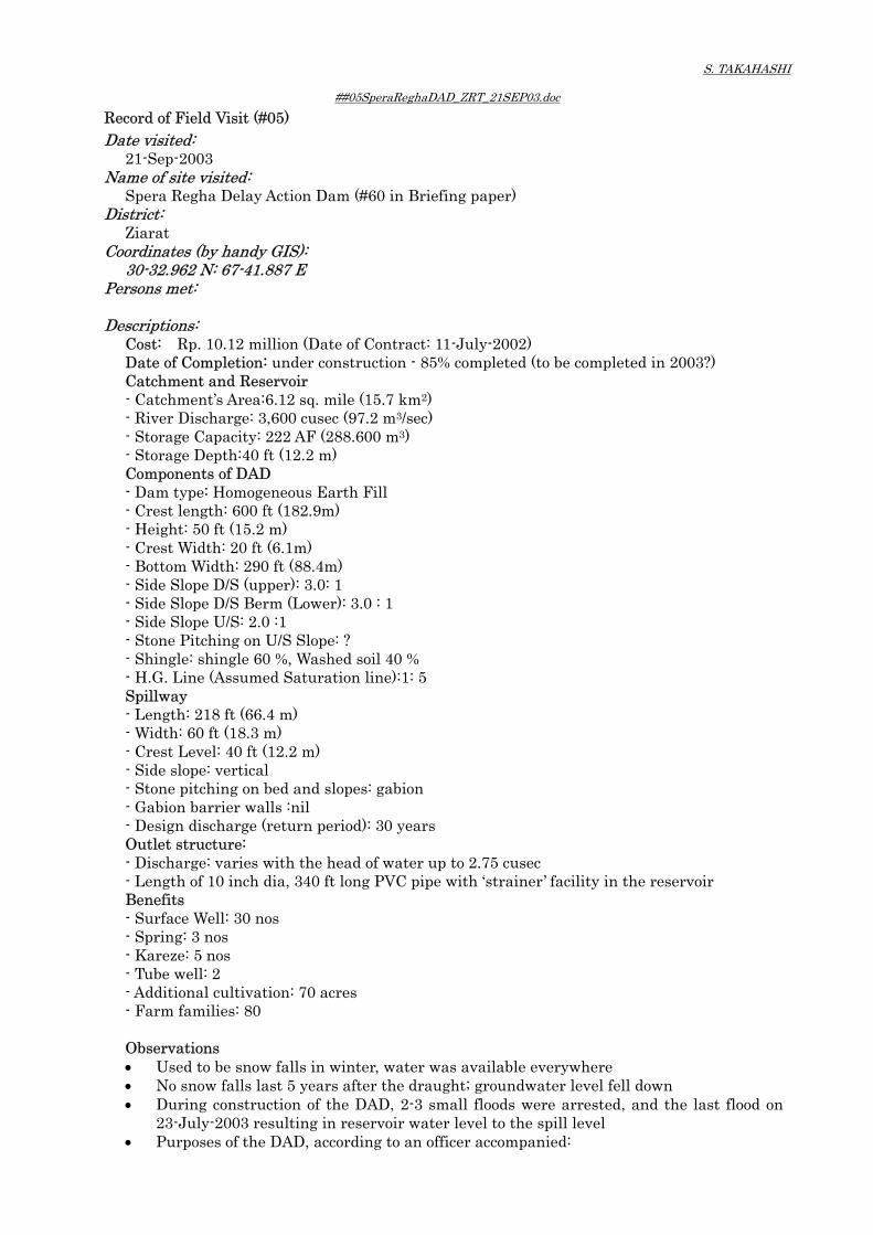
##05SperaReghaDAD_ZRT_21SEP03.doc Record of Field Visit (#05) Date visited: 21-Sep-2003 Name of site visited: Spera Regha Delay Action Dam (#60 in Briefing paper) District: Ziarat Coordinates (by handy GIS): 30-32.962 N: 67-41.887 E Persons met: Descriptions: Cost: Rp. 10.12 million (Date of Contract: 11-July-2002)
Date of Completion: under construction - 85% completed (to be completed in 2003?) Catchment and Reservoir - Catchment’s Area:6.12 sq. mile (15.7 km2) - River Discharge: 3,600 cusec (97.2 m3/sec) - Storage Capacity: 222 AF (288.600 m3) - Storage Depth:40 ft (12.2 m) Components of DAD - Dam type: Homogeneous Earth Fill - Crest length: 600 ft (182.9m) - Height: 50 ft (15.2 m) - Crest Width: 20 ft (6.1m) - Bottom Width: 290 ft (88.4m) - Side Slope D/S (upper): 3.0: 1 - Side Slope D/S Berm (Lower): 3.0 : 1 - Side Slope U/S: 2.0 :1 - Stone Pitching on U/S Slope: ? - Shingle: shingle 60 %, Washed soil 40 % - H.G. Line (Assumed Saturation line):1: 5 Spillway - Length: 218 ft (66.4 m) - Width: 60 ft (18.3 m) - Crest Level: 40 ft (12.2 m) - Side slope: vertical - Stone pitching on bed and slopes: gabion - Gabion barrier walls :nil - Design discharge (return period): 30 years Outlet structure: - Discharge: varies with the head of water up to 2.75 cusec - Length of 10 inch dia, 340 ft long PVC pipe with ‘strainer’ facility in the reservoir Benefits - Surface Well: 30 nos - Spring: 3 nos - Kareze: 5 nos - Tube well: 2 - Additional cultivation: 70 acres - Farm families: 80 Observations • Used to be snow falls in winter, water was available everywhere • No snow falls last 5 years after the draught; groundwater level fell down • During construction of the DAD, 2-3 small floods were arrested, and the last flood on
23-July-2003 resulting in reservoir water level to the spill level • Purposes of the DAD, according to an officer accompanied:

S. TAKAHASHI
##05SperaReghaDAD_ZRT_21SEP03.doc To capture flood water To regulate water discharge to downstream along river To recharge groundwater
• At present 4-5 l/sec of water being released from the discharging pipe. • Discharged water running about 4 - 5 km long along the river, being expected to
recharge groundwater • Silt deposited in the reservoir is taken out by farmers, explained.

S. TAKAHASHI
##06ChinjanDAD_LRL_21SEP03.doc Record of Field Visit (#06) Date visited: 21-Sep-2003 Name of site visited: Chinjan Delay Action Dam (not listed in Briefing paper) District: Loralai Coordinates (by handy GIS): 30-34.738 N: 67-57.681 E Persons met: Habib-Ullah Khan Superintending Engineer Irrigation Circle Loralai,
Surat Khan Executive Engineer Irrigation Division Loralai Descriptions: Cost: Rp. 16.93 million
Date of Completion: under construction - 85% completed (24th Nov. 2002 – Feb. 2004) Catchment and Reservoir - Catchment’s Area:24.39 sq. mile (62.44 km2) - River Discharge: 5700 cusec - Storage Capacity: 1,314 AF (1,576,800 m3) - Storage Depth:35 ft Components of DAD - Dam type: Homogeneous Earth Fill - Crest length: 490 ft (149.4 m) - Height: 55 ft (16.8 m) - Crest Width: 20 ft (6.1 m) - Bottom Width: 342.5 ft (104.4 m) - Side Slope D/S (upper): 3.0: 1 - Side Slope D/S Berm (Lower): 3.0 : 1 - Side Slope U/S: 2.5 :1 - Stone Pitching on U/S Slope: 1.5 ft (0.45 m) - D/S Shingle: 0.5 ft (0.15 m) - H.G. Line (Assumed Saturation line):1: 5 Spillway - Length: 417 ft (127.1 m) - Width: 62.5 ft (19.1 m) - Free Board: 5 ft (1.5 m) - Crest Level: RL 540 ft - Side slope: - - Stone pitching on bed and slopes: Rock formation - Gabion barrier walls :not provided due to rock - Design discharge (return period): 5,716 cusec (161.9 cumec) Outlet structure: - Discharge: 20 - Length of 12 inch dia, 450 ft long PVC pipe with ‘strainer’ facility in the reservoir Benefits - Surface Well: 70 nos - Spring: nil nos - Kareze: 6 nos - Tube well: 50 - Additional cultivation: 1,500 acres (607.1 ha) - Farm families: 60 Observations • Constructed on a narrow valley, shallow rock foundation • Dam is not founded on rock foundation, according to an officer • Recharging effect seems to be small due to thin and narrow alluvial deposit below the
DAD • Floods were arrested before construction of ‘strainer’ facility around the intake MS pipe

S. TAKAHASHI
##06ChinjanDAD_LRL_21SEP03.doc
S. TAKAHASH
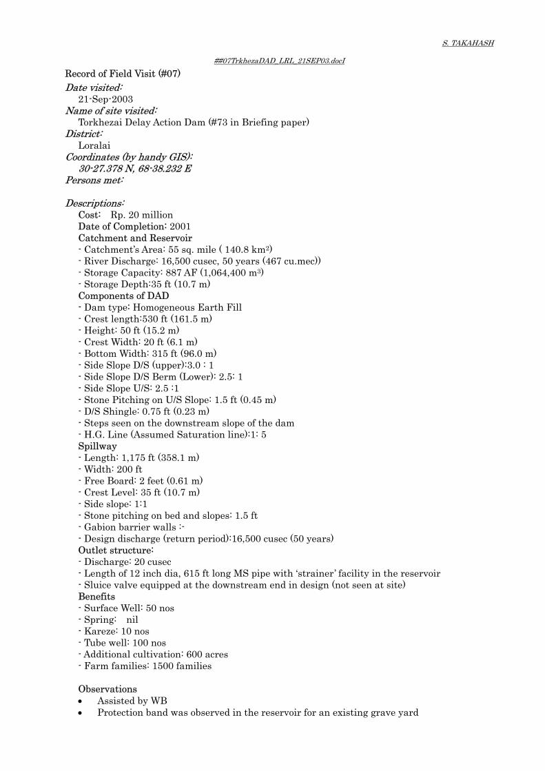
##07TrkhezaDAD_LRL_21SEP03.docI Record of Field Visit (#07) Date visited: 21-Sep-2003 Name of site visited: Torkhezai Delay Action Dam (#73 in Briefing paper) District: Loralai Coordinates (by handy GIS): 30-27.378 N, 68-38.232 E Persons met: Descriptions: Cost: Rp. 20 million
Date of Completion: 2001 Catchment and Reservoir - Catchment’s Area: 55 sq. mile ( 140.8 km2) - River Discharge: 16,500 cusec, 50 years (467 cu.mec)) - Storage Capacity: 887 AF (1,064,400 m3) - Storage Depth:35 ft (10.7 m) Components of DAD - Dam type: Homogeneous Earth Fill - Crest length:530 ft (161.5 m) - Height: 50 ft (15.2 m) - Crest Width: 20 ft (6.1 m) - Bottom Width: 315 ft (96.0 m) - Side Slope D/S (upper):3.0 : 1 - Side Slope D/S Berm (Lower): 2.5: 1 - Side Slope U/S: 2.5 :1 - Stone Pitching on U/S Slope: 1.5 ft (0.45 m) - D/S Shingle: 0.75 ft (0.23 m) - Steps seen on the downstream slope of the dam - H.G. Line (Assumed Saturation line):1: 5 Spillway - Length: 1,175 ft (358.1 m) - Width: 200 ft - Free Board: 2 feet (0.61 m) - Crest Level: 35 ft (10.7 m) - Side slope: 1:1 - Stone pitching on bed and slopes: 1.5 ft - Gabion barrier walls :- - Design discharge (return period):16,500 cusec (50 years) Outlet structure: - Discharge: 20 cusec - Length of 12 inch dia, 615 ft long MS pipe with ‘strainer’ facility in the reservoir - Sluice valve equipped at the downstream end in design (not seen at site) Benefits - Surface Well: 50 nos - Spring: nil - Kareze: 10 nos - Tube well: 100 nos - Additional cultivation: 600 acres - Farm families: 1500 families Observations • Assisted by WB • Protection band was observed in the reservoir for an existing grave yard

S. TAKAHASH
##07TrkhezaDAD_LRL_21SEP03.docI • Flood to the MWL, spilling over 2 month ago. Water was still seen in the reservoir. • Water being released from the MS pipe installed, flowing as a small river. The river
disappears somewhere downstream according to an officer • The DAD was meant to benefit to villages, Dirgi Shabozai and Oriagai & Zangiwal
(38-23.727N, 68-37.546E). At Oriagai and Zangiwal, groundwater level in tube wells increased by 50-60 ft around 25-30 days after flood into the Torkazai DAD reservoir, but the increment is not sufficient to revitalize the existing Karezes.
• Dirigi Shabozai was proved not to be benefited. • Instead, spring emerged in a village (Maratangi) 30 km away (have to be confirmed),
explained. • ***** Beneficiary area 30 km away – Maratangi village (30-30.530N, 68-56.693E) • Water to the Maratangi village is being taken from a perennial flow originating from a
adjacent water shed to the one of Torkazai river. • After the completion of the Torkazai DAD, the water shed area of both Torkazai river
and Maratangi river received a fairly amount of water, which gave the villagers impression that the DAD has increased the water volume to the village Maratangi.

S. TAKAHASH
##08EarthKhulaDAD__KSF_22SEP03.doc Record of Field Visit (#08) Date visited: 22-Sep-2003 Name of site visited: Earth Khula Delay Action Dam (#87 in Briefing paper) District: Killa Saifullah Coordinates (by handy GIS): 30-40.601 N, 68-21.684 E Persons met: Mr. Sher Affgan Khan, Assistant Engineer Descriptions: Cost: Rp. 14.45 million
Date of Construction: Feb 2001 – Jun 2002 Catchment and Reservoir - Catchment’s Area:20.5 sq. mile ( 52.5 km2) - River (Flood) Discharge: 7000 cusec ( cumec) - Storage Capacity:594 AF (712,800 m3) - Storage Depth:32 ft (9.8 m) Components of DAD - Dam type: Homogeneous Earth Fill - Crest length: 825 ft (251.5 m) - Height: 42 ft (12.8 m) - Crest Width:20 ft (6.1 m) - Bottom Width:250 ft - Side Slope D/S (upper): 3.0: 1 - Side Slope D/S Berm (Lower): 3.0: 1 - Side Slope U/S: 2.5:1 - Stone Pitching on U/S Slope: 1.5 ft (0.46 m) - D/S Shingle: 0.3 ft (0.09 m) - H.G. Line (Assumed Saturation line):1: 5 Spillway - Length: 150 ft ( m) - Width: 170 ft (51.8 m) - Free Board: 7 feet - Crest Level: 129.85 ft - Side slope: vertical - Stone pitching on bed and slopes: nil - Gabion barrier walls :nil - Design discharge & return period: 7,000 cusec, 50 year ( cumec) Outlet structure: - Discharge: 4 cusec - Length of 12 inch dia, 333 ft long MS pipe with ‘strainer’ facility in the reservoir Benefits - Surface Well: 10 nos - Spring: 1 nos - Kareze: 5 nos - Tube well: 250 nos - Additional cultivation: 200 acres (80.9 ha) - Farm families: 200 Observations • Funded by the Government of Balochistan and federal government for draught program• Rainfall 11-12 feet/year • Groundwater level in wells 2 km downstream not fluctuated after the DAD • Piezometer to be installed in area downstream

S. TAKAHASH
##08EarthKhulaDAD__KSF_22SEP03.doc • Marginal band constructed: 1100 ft long, 15 feet crest-wide, 14-19 ft high, with slope of
2.0:1 • Water seen in the reservoir (indication not smooth percolation from the reservoir bed)

S. TAKAHASH
##09ToraKhuleFIS__KSF_22SEP03.docI Record of Field Visit (#09) Date visited: 22-Sep-2003 Name of site visited: Tora Khul Flood Irrigation Scheme (not listed in Briefing paper) District: (Killa Saifullah) Coordinates (by handy GIS): 30-50.448 N, 68-43.935 E Persons met: Descriptions: Cost: Rp.16.4 million
Funded by: the Government of Balochistan Date of Completion: 29-March-2003 to June 2004; under construction (35%) Components: - Diversion weir: 175 ft long - Off take flood regulator:2# R/L side - Marginal Bunds - Left side=830 ft - Right Side =85 ft - Out let 12# - Flood channel right side = 3000 ft - Flood channel left side = 3000 ft - Drop structure 3# on left side - Drop structure 1 # on right side Benefits - 200 cusec (5.7 cumec) for left bank,200 cusec (5.7 cumec) for right bank to be irrigated - Command area: 4,000 acres (1,618.8 ha) - 250 house hold to be benefited Observations • An intake weir across the river with intake gates on both bank • An intake gate is equipped with ‘barrier board’ above, making opening between the
barrier board above and weir below. • The limited opening is provided to limit excessive water flow in to the channel or to
release a certain volume of flood water to downstream • Main channel is provided on both side of the river. • The structures are under construction.

S. TAKAHASH
##10ToiwarFIS_KSF_22SEP03.doc Record of Field Visit (#10) Date visited: 22-Sep-2003 Name of site visited: Toiwar Flood Irrigation Schem (not listed in Briefing paper) District: (Killa Saifullah) Coordinates (by handy GIS): 30-54.331 N, 68-44/.780 E Persons met: Descriptions: Cost: Rp. 81.73 million
Date of Completion:9-Nov-2001 Catchment and Reservoir - Catchment’s Area: 900 sq. mile (2304 km2) - River Discharge: 72,000 cusec ( cumec) - Length of Flood Channel: 36,427 ft (11,102.9m) - Discharge of Channel: 500 cusec (14.16 cumec) Benefits - Command area: 5,000 acres (2023.5 ha) Observations • An intake barrage across the river with intake gate on the right bank • The intake gate consists of 2 sand releasing gate and 3 water intake gates. • The water intake gates are equipped with ‘barrier board’ on the above to regulate
volume of water intake • Water taken through the gates is led to downstream along a some 300 m long – concrete
walled channel constructed on the right bank side of the river, thereafter lead to an excavated channel on the right bank downstream
• Detail information was provided on request on 22 Oct 2003, as attached.


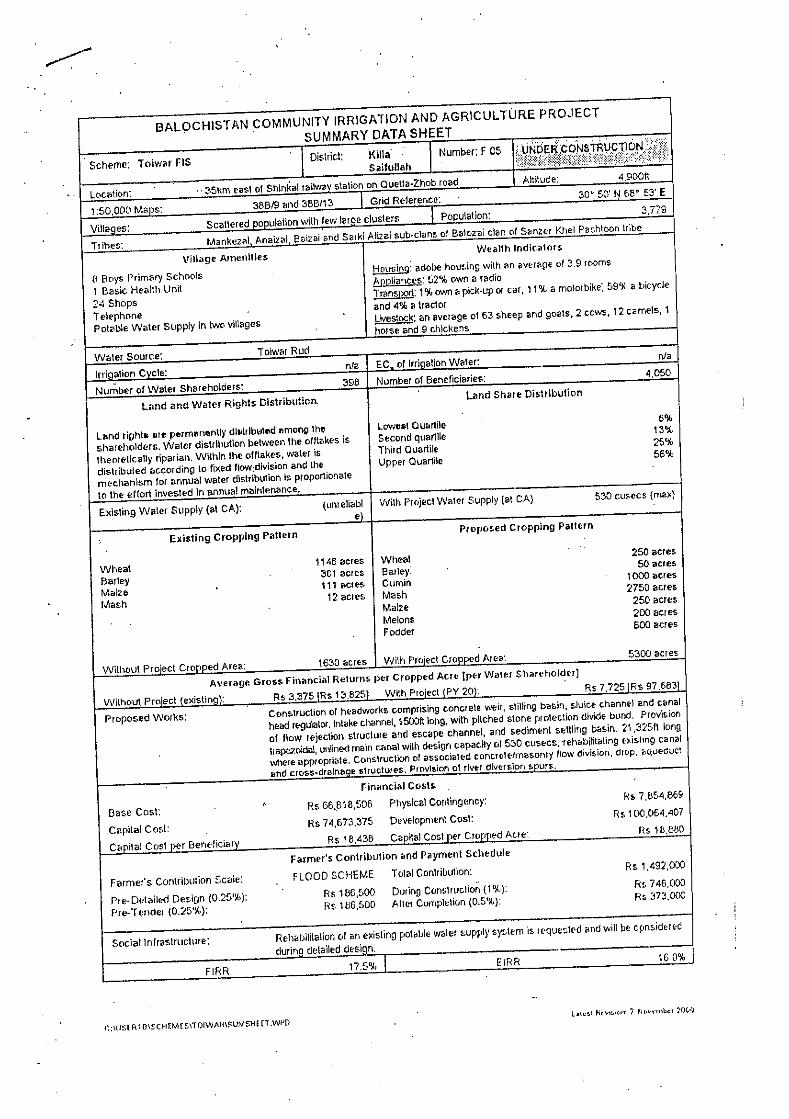


S. TAKAHASHI
##11MargetLKD_QTA_23SEP03.doc Record of Field Visit (#11) Date visited: 23-Sep-2003 Name of site visited: Marget Leaky Dam (not listed in Briefing paper) District: Quetta Coordinates (by handy GIS): 30-08.257 N, 67-15.989 E Persons met: Dr. Abdul Majeed (IUCN), Mr. Jalal-ud-Din Qureshi (PCRWR) Descriptions: Date of Completion: 22-October-2002
Executed by: Pakistan Council of Research of Water Resources(PCRWR), Ministry of Science and Technology <Upstream site> Cost: Rp.1.2 million Catchment and Reservoir - Catchment’s Area: 1.79 sq. km2 - River Discharge: 450 cusec (12.7 cumec) - Storage Capacity: 9 AF ( 10,800 m3) - Total excavation of Foundation and Dam section: 15,000 c.ft (139.4 m3) - No. of steps: 4 <Downstream site> Cost: Rp.1.27 million Catchment and Reservoir - Catchment’s Area: 1.79 sq. km - River Discharge: 1,225 cusec (34.7 cumec) - Storage Capacity: 5.11 AF ( 6,132 m3) - Total excavation of Foundation and Dam section: 74,361 cft (2,105.7 m3) - No. of steps: 3 Observations • The LEAKY DAM was constructed on researching basis. • The LEAKY DAM was made with gabions (boulders and stream stone packed in
steal-wired-cage) along with provision of outlet pipes at intervals throughout the embankment height.
• No structural preparation is prepared for water spilling out. • The LEAKY DAM was meant to be designed to abate water flow energy by the dam so
that silt settle down behind the dam, resulting in relatively silt free water flowing out through the dam body itself to downstream. At the second leaky dam, the same process takes place so that more silt-free water is released. Eventually, water can percolate in to the ground through the riverbed downstream without causing serious siltation problem.
• The LEAKY DAM is proposed by PCRWR because PCRWR believes that DAD will soon be not effective in recharging groundwater though DAD can recharge groundwater for an initial few years.
• Trial on watershed management is demonstrated; such as forestation, putting up of check dams made up with locally available cobble and bolder.
• Two local persons are employed to secure the project site from livestock that may destroy afforested small trees.
• Seven (7) piezometer boreholes and a rain fall gauge are installed. Due to no trained person who lives there and can take readings form the observation facility, data are collected by Engineer from Quetta city once flood or rainfall event takes place.

S. TAKAHASHI
##11MargetLKD_QTA_23SEP03.doc • It is said that the water level downstream came up after the construction of the Leaky
dam • After the completion of the dam a few flood event occurred during the last wet season.
The Maximum rainfall was 72 mm; Water level in the reservoir came up to some 1.5 m at the dam, releasing flood water through the dam body. The structure successfully retarded duration of flood water flow, an officer explained.
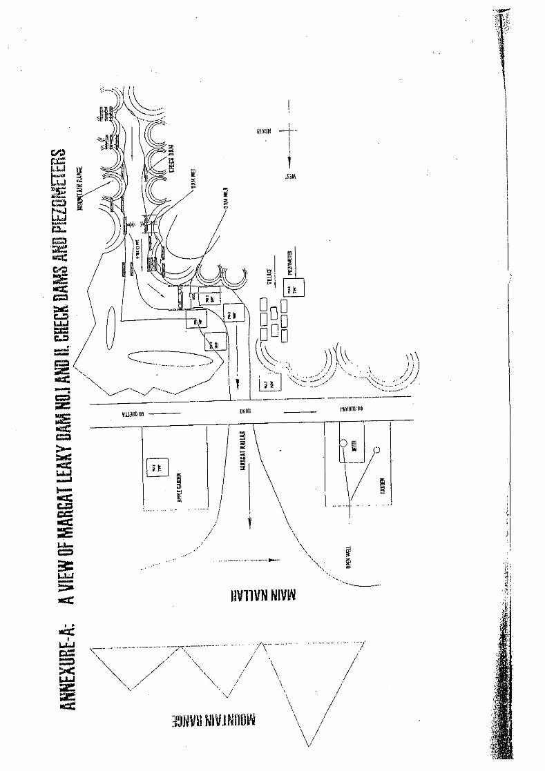


S. TAKAHASHI
##12PadeMaranDAD_KLT_24SEP03.doc Record of Field Visit (#12) Date visited: 24-Sep-2003 Name of site visited: Pade Maran Delay Action Dam (#06 in Briefing paper) District: Kalat Coordinates (by handy GIS): 29-21.325 N, 66-42.429 Persons met: Mr. Abdul Hayee Langove, Agriculturist, Mngocher, Kalat
Mr. Anwar-Ul-Hab, Executive Engineer, Irrigation Division, Mastung Descriptions: Cost: Rp. 7.5253 million
Date of Completion: July 2003 Catchment and Reservoir - Catchment’s Area: 16 sq. mile (40.96 km2) - River Discharge: 38,000 cusec, 30 years (1,076 cumec) - Storage Capacity: 205 AF (252.800 m3) - Storage Depth:35 ft (10.7 m) Components of DAD - Dam type: Homogeneous Earth Fill - Crest length: 900 ft (274.3 m) - Height: 45 ft (13.7m) - Free Board: 4.0 ft (1.2 m) - Crest Width: 20 ft (6.1 m) - Bottom Width: 242.5 ft (73.9 m) - Side Slope D/S (upper):2.0: 1 - Side Slope D/S Berm (Lower): 2.5 : 1 - Side Slope U/S: ** :1 - Stone Pitching on U/S Slope:1.0 ft thick - D/S Shingle: ** ft - H.G. Line (Assumed Saturation line):1: # Spillway - Length: 1,400ft (426.7 m) - Width: 80 ft (24.4 m) - Free Board: ? feet - Crest Level: 35 ft (10.7 m) - Side slope: 0.5 : 1 - Stone pitching on bed and slopes: only on slop - Gabion barrier walls :6 nos. size 3 x 3.5 ft - Design discharge, return period: 38,000 cusec, 30 years (1,076 cumec) Outlet structure: - Discharge: 3.5 cusec - Length of 12 inch dia, 290 ft long MS pipe with ‘strainer’ facility in the reservoir Benefits - Surface Well: 6 nos - Spring: nil - Kareze: nil - Tube well: 65 nos - Additional cultivation: 115 acres - Farm families: 24 Observations • Both slopes of upstream and downstream seem to too steep (1.5 – 1.25: 1 ?); Crest width
approx 4 m; Longitudinal cracks observed on the crest, and traverse crack on left

S. TAKAHASHI
##12PadeMaranDAD_KLT_24SEP03.doc abutment side.
The above was explained such that; the spillway was not excavated to a designed depth. Being feared from water overtopping the dam crest, contractor rushed embanking improperly on top of the designed height of the constructed dam. The top 5 feet therefore is in poor quality, to be removed due to the completion of excavation of the spillway to the designed depth.
Other explanation on slope gradient was that the embankment to a designed height was urged without completing a designed width due to an impending wet season. The slope is yet to be completed to the design, which will be completed.
• It was observed that seepage appears on the slope downstream making the embanked material muddy. Toe drain is supposed not effective, which reduces the stability of the dam.
• The fist flood came on 6th August to 35 feet deep, 1.5 – 2 ft deep water was impounded when visited.
• In the downstream, open surface wells were used about 30 years ago; in 1981 electricity came, thereafter tube wells increased; resulting in depletion of groundwater.
• Groundwater level of 700 feet tube well was 300 ft deep ten (10) years ago, 250ft after the DAD; has risen up by 50 ft (15m)
• Released water from the MS pipe irrigated the downstream

S. TAKAHASHI
##13DashtakDAD_KZD_24SEP03.doc Record of Field Visit (#13) Date visited: 24D-Sep-2003 Name of site visited: Dashtak Delay Action Dam (not listed in Briefing paper) District: Khuzdar Coordinates (by handy GIS): 28-21.663 N, 66-21.811 E Persons met: Mr. Noor Rahmed Baloch, Supperintending Engineer, Irrigation Circle, Kalat/Mekran,
Khuzdar
Descriptions: Cost: Rp. 36.20 million
Date of Completion: under construction (39 % progress), to be completed on 30-Jul-2005 Catchment and Reservoir - Catchment’s Area: 62.16 sq. mile (169.1 km2) - River Discharge: 1828.80 cum/s (flood discharge) - Storage Capacity: 200.42 Ha/m ( 2,004,000 m3) - Storage Depth:11.58 m Components of DAD - Dam type: Homogeneous Earth Fill - Crest length: 304.87 m - Height: 14.63 m - Crest Width: 6.09 m - Bottom Width: 102.44 m - Side Slope D/S (upper): 3.0 : 1 - Side Slope D/S Berm (Lower): 5.0 : 1 - Side Slope U/S: 2.0 :1 - Stone Pitching on U/S Slope: 0.3 m - D/S Shingle: 0.15 m - H.G. Line (Assumed Saturation line):1: 5 Auxiliary Bund - Length: 1,051.82 m - Height at RD 3200: 17.68 m - Height at RD 3450 to 6300: 7.62 m - Top width: 6.09 m - Side Slopes (RD 2850-3450 U/S): 2.0:1 - Side Slopes (RD 2850-3450 D/S): 5.0 :1 & 3.0 :1 -Side Slopes (Both side)RD 3450-6300: 2.0:1 & 2.0:1 - Stone Pitching on U/S Slope: 0.22 m Spillway - Length: 152.43 m - Width: 48.78 m - Free Board: 1.5 m2 - Crest Level: R.L 488.0 m - Side slope: 1:1 both - Stone pitching on bed and slopes: 0.22 m. - Cut-off wall PCCl:1 no. - Gabion barrier walls @ 100’ interval: 6 No. - Design discharge, return period: 1,828 cumec, 50 year Outlet structure: - Discharge: 0.0056 cmec - Length of 2 nos. x 10 inch dia, 121.95m long, 6.09 m high in the reservoir, ** pipe with

S. TAKAHASHI
##13DashtakDAD_KZD_24SEP03.doc ‘strainer (Filter media in circular shape around the strainer pipe; dia:top=2.44, bottom=11.58)’ facility in the reservoir Benefits * 350 farm families will be benefited. The yield of springs and karezes of the area will be increased. * The groundwater table will be raised & tube wells. * The source of irrigation in the area will be recharged. :*Are area under cultivation: 400 Ha (As described in the sheet shown to the team) Observations • Under construction: a water bowser was spreading water onto the embankment
material. 1 foot lay placing -> water spreading -> compaction • Two dozers and a tractor were operated on the embankment site. • Quality control of the compacted material was not performed (virtually difficult to
station an Engineer or technician on site due to a remote location). • Three key trenches (5 ft wide 5 ft deep, approx) were provided in the foundation
ground. • Two intake MS pipes without (before) gravel filter around them were seen in the
reservoir that was half impounded. • At a beneficiary area (28-19.274 N, 66-21.397 E), a tube well equipped with 50 HP
electric submersible pump was producing 15-20 l/sec of water to an irrigation channel. • Near the area a test tube well was left open, in which GWL was some 10 m deep. • A worker for construction is paid Rp 150 per day with three meals

S. TAKAHASHI
##14KohoriDAD_KZD_24SEP03.doc Record of Field Visit (#14) Date visited: 24-Sep-2003 Name of site visited: Khori Delay Action Dam (#21 listed in Briefing paper) District: Khuzdar Coordinates (by handy GIS): 27-45.330 N, 66-55.960 N Persons met: Mr. Noor Ahmed Baloch, Superintending Engineer, Kalat/Mekran Irrigation Circle,
Khuzdar Descriptions: Cost: Rp. 16.412 million
Date of Completion: under construction (progress 71 %) to be completed on 30-Jun-2004 Catchment and Reservoir - Catchment’s Area:31.50 sq. km - River Discharge: 500.37 cum/s - Storage Capacity: 206.10 Ha/m (2,061,000 m3) - Storage Depth:12.19 m Components of DAD - Dam type: Homogeneous Earth Fill - Crest length:176.83 m - Height:15.25 m - Crest Width: 6.09 m - Bottom Width: 106 70 m - Side Slope D/S (upper): 3.0 : 1 - Side Slope D/S Berm (Lower): 5.0 : 1 - Side Slope U/S: 2.0 :1 - Stone Pitching on U/S Slope: 0.45 m - D/S Shingle: 0.22 m - H.G. Line (Assumed Saturation line):1: 5 Spillway - Length: 457.32 m - Width: 30.48 m - Free Board: 1.52 m - Crest Level: 532.0 - Side slope: 1 : 1 both side - Stone pitching on bed and slopes: 0.45 m - Gabion barrier walls :7 nos. - Design discharge, return period: 500.37 cumec, 50 yera Outlet structure: - Discharge: 0.0056 cum/se - Length of 12 inch dia, 121.95 m long MS pipe strainer (Filter media in circular shape around the strainer pipe) Benefits - Surface Well: 5 nos - Spring: 2 nos - Kareze: 1 nos - Tube well: 0 - Additional cultivation: 100 acres - Farm families:350 families, 4,500 heads - Existing 7 nos irrigation schemes of Karakh valley will be benefited. -1,619 ha area under cultivation Observations

S. TAKAHASHI
##14KohoriDAD_KZD_24SEP03.doc • The reservoir was half impounded. Intake structure (10 ft high strainer intake) was not
visible. • Both slopes of up/down stream looked steeper than designed and felt unstable (too
steep). On the both slope of up/down, proper lip-rap material (stone pitching) were yet to be placed.
It was explained that the embankment was urged to the crest level due to the impending flood season. The dam slopes were not completely embanked to the design shape (gradient).
• Thirty (30) years life time is considered as the life time of the dam. • The spillway was under construction, while the embankment was reached to the crest.
It was observed that seepage appeared on the slope downstream making the embanked material muddy. Toe drain is supposed not effective, which reduces the stability of the dam. Additional embankment was intended to stabilize the dam. It was suggested by the team that the additional embankment must be pervious or toe drain material shall be replaced with pervious material immediately.
• It was explained that investigation before construction was not performed as a matter of the usual course of action.

S. TAKAHASHI
##15GateroDAD_KZD_25SEP03.doc Record of Field Visit (#15) Date visited: 25-Sep-2003 Name of site visited: Gatero Delay Action Dam (#22 listed in Briefing paper) District: Khuzdar Coordinates (by handy GIS): 27-35.710 N, 66-68.558 E Persons met: Mr. Noor Ahmed Baloch, Superintending Engineer, Kalat/Mekran Irrigation Circle,
Khuzdar Descriptions: Cost: Rp. 15.533 million
Date of Completion: Under Construction, 83% Progress(02-Nov-2002 – 30-Jun-2004) Catchment and Reservoir - Catchment’s Area: 77.67 sq. km - River Discharge: 283 Cum/s - Storage Capacity: 180.95 Ha/m (1,809,500 m3) - Storage Depth: 10.67 m Components of DAD - Dam type: Homogeneous Earth Fill - Crest length: 259.14 m - Height:13.72 m - Crest Width: 6.09 m - Bottom Width: 96.03 m - Side Slope D/S (upper): 3.0 : 1 - Side Slope D/S Berm (Lower): 5.0: 1 - Side Slope U/S: 2.0 :1 - Stone Pitching on U/S Slope: 0.45 m - D/S Shingle: not provided - H.G. Line (Assumed Saturation line):1: 5 Spillway - Length: 182.92 m - Width: 74.69 m - Free Board: 1.52 m - Crest Level: 13.7 m - Side slope: 1 :1 both side - Stone pitching on bed and slopes: 0.45 m - Gabion barrier walls :1.83 x 0.91 m - Flexible apron: 6.09 x 0.91 m - Design discharge, return period: 283 cumec, 50 year Outlet structure: - Discharge: 2 Cs - Length of 12 inch dia, 121.95 m long M.S pipe strainer (filter media in circle shape around the strainer pipe) Benefits - Surface Well: 5 nos - Spring: 2 nos - Kareze: 7 nos - Tube well: 40 nos - Additional cultivation: 450 acres - Farm families: 412 families, 4,450 head - Area under cultivation : 3,705 ha Observations

S. TAKAHASHI
##15GateroDAD_KZD_25SEP03.doc • Due possibly to the reason of under construction, both slopes U/S and D/S looked too
steep. • It was explained the some more embankment would be done (present crest width=some
8 m as against 6 m of designed crest with). • No heavy equipment was visible within the site. • The reservoir was partially impounded to such a level that the intake strainer facility
was not visible. • Water being released from the MS pipe was not so clean, not suitable for recharging to
the ground due to turbidity. • Seepage from the downstream slope would have occurred. • ** • Area irrigated by surface flow was visited (27-36.664 N, 66-09.950 E) • Water appeared after the DAD construction from a kareze that was dry before the DAD,
explained. • Tube wells were used before the DAD. Due to surface water being available, farmers do
not want use tube wells any more. • The dug wells for observation purpose (?) were visited. A dug well just beside the
surface run-off was dry. Geological succession was: 3 m sand and gravel; 4-5 m silt with gravel in it to the bottom of the dug well. It is considered superficial thin layer of the ground is impervious.
• In the second dug well, water was there some 10 m below the ground. Geology of the well was: some 3 m thick of sand and grave, some 2 m thick of clayey layer below and again sand and gravel to the bottom of the well.
• It was explained that water table in tube wells have risen up after the dam was impounded by flood.
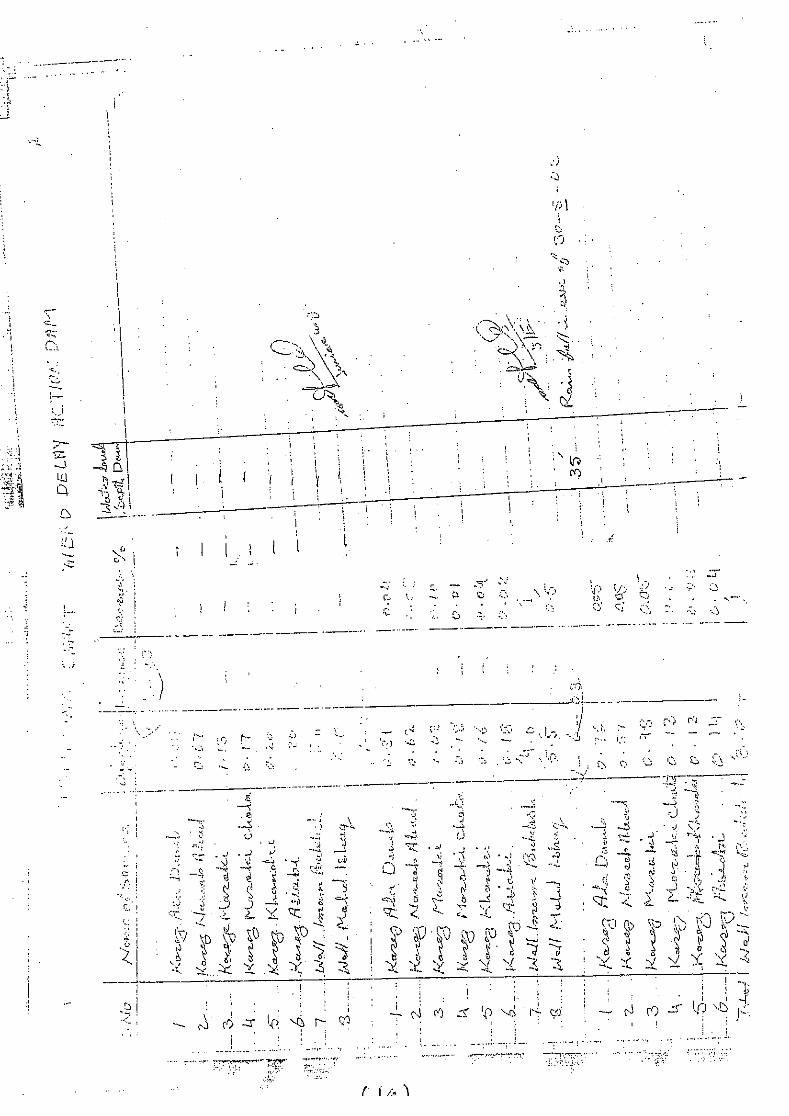
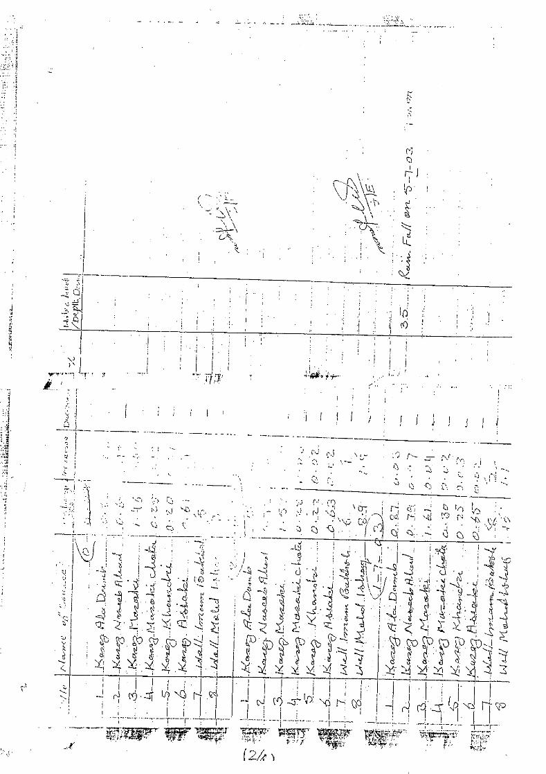

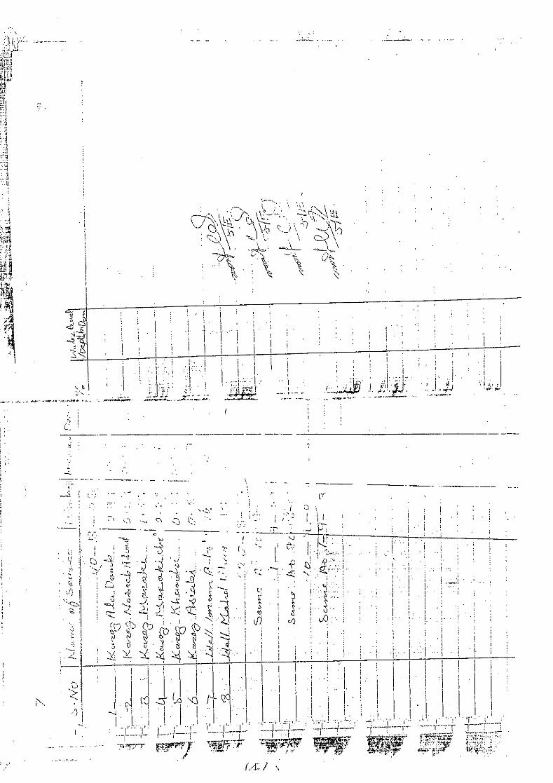

S. TAKAHASHI
##16HazarGunjiDAD_KZD_25SEP03.doc Record of Field Visit (#16) Date visited: 25-Sep-2003 Name of site visited: Hazar Gunji Delay Action Dam (#20 listed in Briefing paper) District: Kuzdar Coordinates (by handy GOS): 27-30.478 N, 66-08.845 E Persons met: Mr. Noor Ahmed Baloch, Superintending Engineer, Kalat/Mekran Irrigation Circle,
Khuzdar Descriptions: Cost: Rp. 0.52 million
Date of Completion: 31-12-1981 Catchment and Reservoir - Catchment’s Area: 18.13 km2 - River Discharge: 36.81 cumes - Storage Capacity: 121.49 Ha/m (1,214,900 m3) - Storage Depth: 7.82 m Components of DAD - Dam type: Homogeneous Earth Fill - Crest length: 288.60 m - Height: 10.97 m - Crest Width: 6.09 m - Bottom Width: 64.02 ft - Side Slope D/S (upper): 3.0 : 1 - Side Slope D/S Berm (Lower): 3.0 : 1 - Side Slope U/S: 3.0 :1 - Stone Pitching on U/S Slope: 0.45 m - D/S Shingle: not provided - H.G. Line (Assumed Saturation line):1: 4 Spillway - Length: 30.48 m - Width: 10.0 m - Free Board: 1.52 m - Crest Level: 7.62 m - Side slope: 1:1 both side - Stone pitching on bed and slopes: not provided - Gabion barrier walls : not provided - Design discharge, return period: 36.81 cumec, 50 year Outlet structure: Not equipped Benefits - Surface Well: 15 nos - Spring: 3 nos - Kareze: 2 nos - Tube well: 14 nos - Additional cultivation: 154 Ha - Farm families: 275 family, 2000 heads Observations • The reservoir was impounded to a half depth. • Outlet pipe was not equipped.

S. TAKAHASHI
##16HazarGunjiDAD_KZD_25SEP03.doc • Seepage water of about 1 – 2 l/sec was flowing from the dam toe area. The seeping
water was being led by a straight-aligned canal to downstream. • From the observation of green grasses near the dam toe, the area were wetted with the
seepage from the dam. • The upstream slope and the dam crest were nicely lined with pebble (shingle). • The downstream slope was not lined. Gullies are observed on the slope. • On the berm of 20 ft wide, sink (?) holes were observed.

S. TAKAHASHI
##17MariumDAD_QTA_30SEP03.doc Record of Field Visit (#17) Date visited: 30-Sep-2003 Name of site visited: Marium Delay Action Dam (#118 listed in Briefing paper) District: Quetta Coordinates (by handy GIS): 30-16.081 N, 87-11.483 E Persons met: Mr. Qutob Khan, subdivision officer, I&P department, Quetta
Descriptions: Cost: Rp. 3.0 million
Date of Completion: 1993 Catchment and Reservoir - Catchment’s Area: 1.5 sq. mile (3.84 km2) - River Discharge: 1,861 Cusec (52.7 cumec) - Storage Capacity: 43 AF (53,000 m3) - Storage Depth: 35 ft (10.7m) Components of DAD - Dam type: Homogeneous Earth Fill - Crest length: 298 ft (90.8 m) - Height: 46.5 ft (14.2 m) - Crest Width: 20 ft (6.1 m) - Bottom Width: 365 ft (111.3 m) - Side Slope D/S (upper): 3.5 : 1 - Side Slope D/S Berm (Lower): 3.5 : 1 - Side Slope U/S: 2.0 :1 - Stone Pitching on U/S Slope: 1.5 ft - D/S Shingle: 0.5 ft - H.G. Line (Assumed Saturation line):1: 5 Spillway - Length: 125 ft - Width: 41 ft (12.5 m) - Free Board: 3 feet - Crest Level: 35 ft (10.7 m) - Side slope: 1.5:1 - Stone pitching on bed and slopes: 0.75 - Gabion barrier walls :3 nos - Design discharge (return period): 1,861cusec (30 years) Outlet structure: Outlet structure was not equipped. Benefits (not identified in the village close-by, might be identified in orchard field downstream) - Surface Well: ** nos - Spring: ** nos - Kareze: ** nos - Tube well:** nos - Additional cultivation: ** acres - Farm families: ** Observations • The dam was seen on a narrow and steep valley. • Muddy water was visible. The water level was close to the bottom of the reservoir.
S. TAKAHASHI
##17MariumDAD_QTA_30SEP03.doc • Last flood came in August this year to a level unknown. • Since the construction in 1993, water did not spill out. For the last 7 years, no flood was
available to the reservoir. • Sand and gravel was not seen on the floor of the valley. The dam looked to be founded
on weathered rock foundation. No appreciably thick riverbed material was seen on the river bed downstream of the dam.
• No significant seepage from the foundation was expected. • Seepage from the toe of the dam was observed. The seepage might recharge aquifer
downstream where orchard fields were visible. • Upstream slope of the dam was nicely lined with flatly crashed rock material while the
downstream be nicely lined with shingle layer. • Reservoir level monitoring gauge (poles) was installed in 2003. **** • Water transmission canal and bridge were seen. The water from a perennial stream
was used to be sent to a army camp and for public use in Quetta. Not functional at the moment.

S. TAKAHASHI
##18KachDAD_QTA_30SEP03.doc Record of Field Visit (#18) Date visited: 30-Sep-2003 Name of site visited: Kach Delay Action Dam, proposed by JICA F/S (1997), PC-I yet to be prepared District: Quetta Coordinates (by handy GIS): 30-18.903 N, 67-05.277 E (the breached existing dam) Persons met: Mr. Qutobe Khan, subdivision officer
Descriptions: PC-I is yet to be prepared.
• The DAD dam was proposed by JICA F/S report (1997) to be constructed in 2nd stage. • The DAD is proposed to be constructed by using the existing breached dam as an
upstream part of the dam body, and is meant to be rehabilitation of the existing dam; according to F/S report.
• At a downstream of the dam, an intake structure was observed. The water off-take by the intake (Sra Ghurgi) was led to an area downstream of Dara DAD which was also proposed by the F/S.
• Water release from outlet devices has to be met for Sra Ghurgi irrigation intake as well as recharging purposes, according to the F/S.
Observations • The breached existing dam was constructed in 1962 by the army and was breached in
1987-88. • The existing dam was filled with sediment to the maximum level, indicating high
sediment load from the water shed.
S. TAKAHASHI ##19WaliDadDAD_Qtaq_01OCT03.doc
Record of Field Visit (#19) Date visited: 01-Oct-2003 Name of site visited: Wadi Dat Delay Action Dam, proposed by JICA F/S (1997), Construction just started. District: Quetta Coordinates (by handy GIS): 30-06.204 N, 66-55.298 E Persons met: Mr. Qutob Khan, subdivision officer, Quetta Descriptions: Cost: Rp. 10.422 Million
Date of Completion: Under construction, to be completed in July 2004 Catchment and Reservoir - Catchment’s Area: 2.5 sq. mile ( km2) - River (flood) Discharge: 2,500 cusec (50 year) - Storage Capacity: 203.0 AF ( m3) – 30 years - Storage Depth: 32 ft Components of DAD - Dam type: Homogeneous Earth Fill - Crest length:660 ft - Height: 42 ft - Crest Width: 6.0 ft - Bottom Width: 239 ft - Side Slope D/S (upper): 2.0 : 1 - Side Slope D/S Berm (Lower): not provided - Side Slope U/S: 2.5 :1 - Stone Pitching on U/S Slope: 1.5 ft - D/S Shingle: 0.5 ft - H.G. Line (Assumed Saturation line):varies - Toe-Drain: 5 ft deep filled with shingle - D/S horizontal drain: 3.0 ft thick, width equivalent to 1/3 of dam height Spillway - Length: 500 ft - Width: 95 ft - Free Board: feet - Crest Level: 4 ft high - Side slope: stone masonry wall in two steps - Stone pitching on bed: 4 nos PCC Cut off wall filled with stone pitching & gabion apron. - Gabion barrier walls :? - Design discharge, return period: 2500 cusec, 30 year Outlet structure: - Discharge: ? - Length of 12 inch dia, 365 ft long MS pipe with ‘strainer’ facility in the reservoir Construction of Check dam - One No. gabion check/detention dam in proposed to help to some extent trapping silt from entering into the reservoir. Provision and installation of Piezometer - to upkeep & check groundwater recharging. This activity will be monitored & groundwater recharge quantification will be done by the staff of WRPD&M Directorate, I&P Dept. Water shed management - Equivalent to 1.0 % of total cost of the project has also been planned for implementation. This includes execution of contour trenches / check / silt traps ant very small creekd on the upstream contours of the catchment area. This activity will be carried out in close

S. TAKAHASHI ##19WaliDadDAD_Qtaq_01OCT03.doc
consultation with field officers of the Forest Department. Benefits - Surface Well: 38 nos - Spring: nil - Kareze: nil - Tube well: 30 nos - Additional cultivation: - Farm families: - Infrastructure of new vegetable market, Bus & Truck terminal, a large No. of public & provate property will also be saved from flood havoc. Observations • The DAD was proposed by JICA F/S (1997) to be constructed in 3 stage III. • The proposed DAD by JICA was located at the location where old DAD that was washed
out was located. • The DAD presently being constructed is located at the pivot of the alluvial fan; the
location of the DAD is approx 500 m downstream of the old DAD. • PC-I for the DAD was prepared in May 2003, under Provincial Sector Development
Program (PSDP). • The DAD was proposed for recharging purposes and flood protection only. • The contract was awarded in August 2003. Construction period is for a year. • Down the DAD on the alluvial fan, the Quetta Development Authority has developed
lands as residential area (houses yet to be constructed).
S. TAKAHASHI
##20BrewaryDAD_QTA_01OCT03.doc Record of Field Visit (#20) Date visited: 20-Oct-2003 Name of site visited: Brewary Delay Action Dam, proposed by JICA F/S (1997) as Stage I project. Tendering on
progress, to be awarded sonly. District: Quetta Coordinates (by handy GIS): 30-10.647 N, 66-56.048 N
Persons met: Mr. Qutob Khan, subdivision officer, Quetta
Descriptions: Cost: Rp.24.225million
Date of Completion: Catchment and Reservoir - Catchment’s Area: 10.9 sq. mile (27.9 km2) - River Discharge: 5,600 cusec, 1000 years !!!! (158.6 cumec) - Storage Capacity: 662 AF ( 816,000 m3) - Storage Depth: 47 ft (14.3 m) Components of DAD - Dam type: Homogeneous Earth Fill - Crest length: 779 ft (237.4 m) - Height: 57 ft (17.4 m) - Free board: 5.0 ft (1.5 m) - Crest Width:325 ft(?) - Top width: 20 ft (6.1 m) - Bottom Width: 325 ft (99.1 m) - Side Slope D/S (upper): 3.0 : 1 - Side Slope D/S Berm (Lower): 3.0 : 1 - Side Slope U/S: 2.0 :1 - D/S horizontal filter between the dam and foundation, 3.0 ft thick, width equivalent to 1.5 times of dam height from the toe toward the dam axis. - Toe Drain: 5 ft deep filled with shingle - Stone Pitching on U/S Slope: 1.5 ft - D/S Shingle: 0.5 ft - H.G. Line (Assumed Saturation line):1: 5 Spillway - Length: 517 ft (157.6 m) - Width: 150 ft (45.7 m) - Free Board: 3 feet - Crest Level: 533.75 ft - Side slope: 0.5 : 1 - Stone pitching on bed and slopes: 1.5 ft thick - Gabion barrier walls :5 nos. - Design discharge (return period): 5,600 cusec, 1000 year (158.6 cumec) Outlet structure: - Discharge: 13 cusec - 2 nos length of 12 inch dia, 420 ft long MS pipe with ‘strainer’ facility in the reservoir. The strainer facility consists of ‘SPWAL filling’ and Shingle filling in rabble masonry cylinder of 11 ft dia with PVC weep holes in the masonry. Diversion bund and leading cut/feeding channel - Crest length: 370 ft (112.8 m)
S. TAKAHASHI
##20BrewaryDAD_QTA_01OCT03.doc - Height; 27 ft (8.2 m) - Upstream slope 2:1 -Downstream slope 2:1 - Downstream shingle 0.5 ft thick Benefits - Surface Well: 26 nos - Spring: 1 nos - Kareze: 1 nos - Tube well: 10 nos - Additional cultivation: 80 acres - Farm families: 50 Water Shed management - water shed management equivalent to 1 % of total cost of the project has also been planned for implementation. This includes execution of contour trenches/check / silt traps at very samll creeks on the upstream contours of the catchments area. This activity will be carried out in close consultation with field officers of the Forest Department. Observations • JICA proposed DAD site was located near the very narrow gouge downstream the
present site proposed by I & P dept. • The right bank of the DAD consists of steep rock slope (limestone) while the left
consisted of terrace deposit abutting on the right bank hill. • The reservoir and the catchment area elongates NW – SE. • The groundwater in the area emerges at the gouge. • A recreation field exists on the left bank just upstream of the gouge. • Two wells were being drilled downstream of the DAD site. • Behind the ridge of the left bank, limestone is being mined.
S. TAKAHASHI
##21GhutaiShelaDAD_QTA_01OCT03.doc Record of Field Visit (#21) Date visited: 01-Oct-2003 Name of site visited: Ghutai Shela Delay Action Dam, proposed by JICA for Stage III construction District: Quetta Coordinates (by handy GIS): 30-12.844 N, 66-56.816 E Persons met: Mr. Qutob Khan
Descriptions: Cost: Rp. 5.16 million
Date of Completion: 2002 Catchment and Reservoir - Catchment’s Area: 0.48 sq. mile (1.2 km2) - River Discharge: 547Cusec,30 years (15.5 cumec) - Storage Capacity: ? AF ( m3) - Storage Depth: ft (12.19 m) Components of DAD - Dam type: Homogeneous Earth Fill - Crest length: 430 ft (131.1 m) - Height: 50 ft (15.2 m) - Crest Width: 20 ft (6.1 m) - Bottom Width: 380 ft (115.8 m) - Side Slope D/S (upper):3.0 : 1 - Side Slope D/S Berm (Lower): 3.0 : 1 - Side Slope U/S: 2.0 :1 - Stone Pitching on U/S Slope: 1.5 ft (0.46 m) - D/S Shingle: 0.5 ft (0.15 m) - H.G. Line (Line of Saturation) : 1: 5 Spillway - Length: ? ft (91.15 m) - Width: ? ft (13.71 m) - Free Board: ? ft ( m) - Crest Level: ? ft ( 378.5m) - Side slope: ? - Stone pitching on bed and slopes: 0.15 ft - Gabion barrier walls :3 nos. - Design discharge, return period: 547 cusec, 30 year (15.5 cumec) Outlet structure: - Discharge: 10 cumec - Length of 8 inch dia, 290 ft long MS pipe with ‘strainer’ facility in the reservoir Benefits - Surface Well: ? nos - Spring: ? nos - Kareze: ? nos - Tube well: ? nos - Additional cultivation: ? acres - Farm families: ? Observations • After the completion of the DAD, a flood water was arrested to a depth approx 15 ft. • About 1.5 month was needed to release the water from the reservoir, through the outlet
pipe, reservoir bed itself and evaporation.

S. TAKAHASHI
##21GhutaiShelaDAD_QTA_01OCT03.doc • No water was seen in the reservoir when visited. • Approx 2-3 m thick of sedimentation was observed. The upper part of the sedimentation
was virtually clay that looked impervious. • Upper part of inlet pipe of some 1 m was exposed; children removed the filter rock
material around the pipe, explained. • Similarly, parts of rip rap rock material at the crest level were removed and found on
the upstream slope or at the bottom of the reservoir; children did, explained. • The toe of the dam was beautifully protected with rock material. • Recharging pit at the downstream was found buried with soil. Outlet pipe was not
visible. The pipe could be choked due to no flow in the pipe. Needs to be rehabilitated.

S. TAKAHASHI
##22KhushabDAD_PSN_02OCT03.doc Record of Field Visit (#22) Date visited: 02-Oct-2003 Name of site visited: Khushab Delay Action Dam (#147 listed in Briefing paper) District: Pishin Coordinates (by handy GIS): 30-33.260 N, 67-19.545 E Persons met: Mr, Jam Mohammad, Pishin
Descriptions: Cost: Rp. Million
Date of Completion: 30-June-1986 Catchment and Reservoir - Catchment’s Area: sq. mile (15.20 km2) - River Discharge,: cusec (75.12 cumec) - Storage Capacity: 240 AF (392,900 m3) - Storage Depth: 40 ft (12.2 m) Components of DAD - Dam type: Homogeneous Earth Fill - Crest length: ft (164.0 m) - Height: ft (15.4 m) - Crest Width: ft ( m) - Bottom Width: ft ( m) - Side Slope D/S (upper): ** : 1 - Side Slope D/S Berm (Lower): ** : 1 - Side Slope U/S: ** :1 - Stone Pitching on U/S Slope: 1.5 ft ( m) - D/S Shingle: Nil - H.G. Line (Assumed Saturation line):1: 5 Spillway - Length: 300 ft ( m) - Width: 50 ft ( m) - Free Board: 5 ft ( m) - Crest Level: ft ( m) - Side slope: 1:** - Stone pitching on bed and slopes: Nil - Gabion barrier walls :1 nos. concrete wall with rcc apron - Design discharge, return period: cusec, year ( cumec) Outlet structure: - Discharge: ? cusec - Length of inch dia, ft long pipe with ‘strainer’ facility in the reservoir Benefits - Surface Well: nil - Spring: nil - Kareze: 2 nos. - Tube well: 40 nos - Additional cultivation: 150 acres - Farm families: 150 Observations • Although the DAD was constructed in 1980th, outlet pipe was seen in the reservoir. The
outlet part of the pipe was though not seen possibly due to buried under the soil.

S. TAKAHASHI
##22KhushabDAD_PSN_02OCT03.doc • Presently the water was said to be 10-12 ft deep, whereas silt to be 30 ft deep. • About 30 – 40 days ago, a flood reached in to the reservoir to the spillway level. The
present water level was seen just below the spill level. • It is said the reservoir was totally silt up. No seepage even was seen from the toe.
Water was completely held in the reservoir. • De-siltation has been proposed, explained. • As against the other DADs observed, U/S slope looked gentler that that of D/S. • U/S slope was nicely lined with gravel and D/S with shingle. No remarkable erosions
were seen on the D/S slope.

S. TAKAHASHI
##23BalozaiDAD_PSN_02Oct03.doc Record of Field Visit (#23) Date visited: 02-Oct-2003 Name of site visited: Balozai Delay Action Dam (#133 listed in Briefing paper) District: Pishin Coordinates (by handy GIS): 30-38.461 N, 57-22.486 E
Persons met:
Descriptions: Cost: Rp. million
Date of Completion: 30-June-1983 Catchment and Reservoir - Catchment’s Area: sq. mile (6.48 km2) - River Discharge: cusec ( 79.30 cumec) - Storage Capacity: 400 AF (3,022,100 m3) - Storage Depth: 25 ft (7.6 m) Components of DAD - Dam type: Homogeneous Earth Fill - Crest length: ft (853.4 m) - Height: ft (12.2 m) - Crest Width: ft (6.10 m) - Bottom Width: ft ( 67.10 m) - Side Slope D/S (upper): 3: 1 - Side Slope D/S Berm (Lower): nil - Side Slope U/S: 2:1 - Stone Pitching on U/S Slope: 1.5 ft ( m) thick - D/S Shingle: nil - H.G. Line (Assumed Saturation line):1: 5 Spillway - Length: 50 ft ( m) - Width: 20 ft ( m) - Free Board: 4 ft ( m) - Crest Level: rl 493.16 ft ( m) - Side slope: 1: 2 - Stone pitching on bed and slopes: 1.5 in gabion - Gabion barrier walls :2 nos gabion - Design discharge, return period:250 cusec,30 year ( cumec) Outlet structure: - not provided Benefits - Surface Well: nil nos - Spring: nil nos - Kareze: 5 no - Tube well: 50 nos - Additional cultivation: 100 acres - Farm families: 500 Observations • The DAD was constructed in 1960th by a public sector, taken over in 1981 by Irrigation
and Power department.

S. TAKAHASHI
##23BalozaiDAD_PSN_02Oct03.doc • In 2002, Desilting works were carried out where some 11 million cu ft of silt was
removed from the reservoir. • After the 7 yeas long lasting draught, and after the de-siltation works in 2002, floods
came in August 2003. • The reservoir was filled up to three quarters or the full supply level when observed. • No water release pipe was equipped. No seepage was visible at the dam toe. • 250 Tube wells and 7 karazes are benefited from the DAD, explained. • ****** • The removed silt was dumped on the downstream slop of the dam. Due to impervious
nature of the removed silt, smooth drain function of the downstream slope might be malfunctioned. Some part of the dumped silt was about to slip down though the collapse was thought not to damage the dam body itself.
S. TAKAHASHI ##24JigdaDAD_PSN_02Oct03.doc
Record of Field Visit (#24) Date visited: 02-Oct-2003 Name of site visited: Jigda Delay Action Dam proposed by JICA F/S for Stage-I construction District: Pishin Coordinates (by handy GIS): 30-39.528 N, 67-13.392
Persons met:
Descriptions: Proposed Dam: component was yet to be decided.
Cost: Rp. 10 million Date of Completion: Catchment and Reservoir - Catchment’s Area: 6.84 sq. mile ( km2) - River Discharge: 3500 cusec ( cumec) - Storage Capacity: 168 AF ( m3) - Storage Depth: 40 ft ( m) Components of DAD - Dam type: Homogeneous Earth Fill - Crest length: 475.10 ft ( m) - Height: 50 ft ( m) - Crest Width: 20 ft ( 6.1 m) - Bottom Width: 290 ft ( 88.41m) - Side Slope D/S (upper): 3: 1 - Side Slope D/S Berm (Lower): 3: 1 - Side Slope U/S: 2:1 - Stone Pitching on U/S Slope: 1.5 ft ( m) thick - D/S Shingle: 0.5 ft ( m) thick - H.G. Line (Assumed Saturation line):1: 5 Spillway - Length: 350 ft ( m) - Width: 100 ft ( m) - Free Board: ft ( m) - Crest Level: 465.10 ft ( m) - Side slope: vertical wall - Stone pitching on bed and slopes:1.5 in gabion - Gabion barrier walls :5 nos - Design discharge, return period: 3500 cusec, 30 year ( cumec) Outlet structure: - Discharge: ? - Length of 12 inch dia, 340 ft long MS pipe with ‘strainer’ facility in the reservoir Benefits - Surface Well: nil - Spring: nil - Kareze: 2 nos - Tube well: 100 nos - Additional cultivation: 350 acres - Farm families: 750 Observations

S. TAKAHASHI ##24JigdaDAD_PSN_02Oct03.doc
• PC-I for the DAD was yet to be prepared. A topo-survey for design purposes was completed.
• River deposit consisted of sand and silt with breccia/fragment of shale stone. The deposit looked less pervious.
• Thickness of the deposit was inferred to be less than 10 m. Much percolation to the river deposit was doubtful.
• **** • The DAD was meant to recharge the existing Sharan Karage (30-39.915 N, 67-12.389
E) some 1.5 km downstream. The Karage was excavated in less consolidated silt stone and sandy silt stone. Water was collected from the sandy part of the soft rock layer.
• Down the Karage, beautiful orchard fields were observed.

S. TAKAHASHI
##25KhushdilKhanBund_PSN_02OCT03.doc Record of Field Visit (#25) Date visited: 02-Oct-2003 Name of site visited: Khushdil Khan Bund, Rehabilitation and Improvement Project
(not listed in Briefing paper) District: Pishin Coordinates (by handy GIS): 30-40.269 N, 67-03.455 N Persons met: Descriptions: Original Component:
- Year of Completion: 1890 - Original Storage Capacity: 23,800 AF (29,345,000 m3) - (Present Storage Capacity: 6,031 AF (7,436,000 m3) - Earth Embankment
• Length = 3,500 ft (1,066.8 m) • Height = 38 ft (11.6 m) • Pond Height = 31 ft (9.4 m)
- Conveyance System • Main Canal: Length=6,800 ft(2.1km), Discharge Capacity=45 Cusecs(1.3cumec) • Sarala Canal: Length =30,250 ft(9.2km), Discharge Capacity=25 Cusecs(0.7cumec) • Shebo Canal: Length = 70,635 ft(2.2km), Discharge Capacity=20 Cusecs (0.7cumec)
Rehabilitation works undertaken (Removal of Silt from the reservoir) - A part of sediment in the reservoir was removed in 2002 for resume the reservoir capacity to some extent. - Further de-siltation is in consideration. Proposed Component: - Cost: Rp.1,008 million - Construction of a new earth fill dam:
• Location: some 2,500 ft downstream of the existing bund • Dimensions: yet to be detailed • Additional storage capacity: 14,500 – 15,000 AF
- Construction of New outlet/draw-off tower - Construction of an RCC conduit and off-take channel - Construction of a new spillway - Relocation of existing main road from the existing dam crest to the new dam crest downstream - Raising, remodeling, rehabilitation and improvement of the intake structure - Provision of flood protection bunds around the proposed reservoir rim - Rehabilitation of the Tor Murgha Feeder Canal embankments - Training works of the Timrak Nullah - Partial demolition of the existing bund - Development of tube wells and conveyance structures - Remodeling of 100,000ft of primary and secondary channels. - Development of on-farm channels for a total length of about 400,000ft - Provision of agricultural extension services - Watershed Management through forestation of 100 km2 and range management through fuel and forage generation over 10 km2 with in the catchments area if 1,100 km2 Benefits: - Storage capacity will be increased enough to meet irrigation water requirement of about 6,500 Acre

S. TAKAHASHI ##26SanzaliDAD_PSN_02OCT03.doc
Record of Field Visit (#26) Date visited: 02-Oct-2003 Name of site visited: Sanzali Delay Action Dam, Proposed by JICA F/S (1997) for Stage III construction District: Pishin Coordinates (by handy GIS): 30-31.312 N, 67-03.708 E Persons met: Descriptions: PC-I is yet to be prepared
Cost: Rp.12 million Date of Completion: Catchment and Reservoir (JICA F/S) - Catchment’s Area: 10.4 km2 - River Discharge: 142 m3/sec, 1/100 year - Storage Capacity: 508,000 m3 - Storage Depth: 36 ft Components of DAD (JICA F/S) - Dam type: Homogeneous Earth Fill - Crest length: 210.0 m - Height: 14.0 m - Crest Width: 6.1 m - Bottom Width: 270 ft ( m) - Side Slope D/S (upper): 3 : 1 - Side Slope D/S Berm (Lower): 3 : 1 - Side Slope U/S: 2 :1 - Stone Pitching on U/S Slope: 1.5 ft - D/S Shingle: 0.5 ft - H.G. Line (Assumed Saturation line):1: 5 Spillway - Length: 200 ft - Width: 50 ft - Free Board: 5 feet - Crest Level: rl. 226.10 ft - Side slope: vertical gabion wall - Stone pitching on bed and slopes: 1.5 ft thick in gabion wall - Gabion barrier walls :2 nos. - Design discharge, return period: 142m3/sec, 100 year Outlet structure: - Discharge: 12 cusec - Length of 12 inch dia, 300 ft long MS pipe with ‘strainer’ facility in the reservoir Benefits - Surface Well: 5 nos - Spring: 2 nos - Kareze: 5 nos - Tube well: 20 nos - Additional cultivation: 50 acres - Farm families: 300 Observations • The river bed was composed of silty sand with gravel. The permeability of the

S. TAKAHASHI ##26SanzaliDAD_PSN_02OCT03.doc
unconsolidated material was inferred to be a lower rang of 1x 10⁻³cm/sec • The rock formation was composed of silt stone and conglomerate. The silt stone seemed
less pervious in a order of 10-4cm/sec, whereas the conglomerate was considered pervious.
• Due to the nature of less consolidated rock formation, fine material such as silt and clay will be accumulated in the reservoir.
S. TAKAHASHI
##27NariRiverFD_SIB_03OCT03.doc Record of Field Visit (#27) Date visited: 03-Oct-2003 Name of site visited: 5 flood distribution structures, Nari River (Proposed Mega Project #4 in Briefing paper) District: Sibi Coordinates (by handy GIS): See below Persons met: Descriptions: Observations
• Sibi is the second biggest city in Balochistan. • The Nari river is the largest river in Balochistan, the catchment area of the river: 9296
sq. moles, a maximum discharge: 180,000 cusec during 1982-83. • Traditionally, earth-filled embankments (Ganda) are constructed across the Nari river
before each flood season, to capture flood water into field for irrigation purposes (Flood distribution).
• Such constructed earth embankments are intentionally breached once the targeted lands have obtained enough water for cultivation, or left to be breached by natural flood.
• Funds for embankment works are incurred by community itself that is benefited by the embankment, or work itself is done by the community.
• Such communities are requesting the Government to construct permanent structures across the river to capture flood water.
• ***Visits*** • Four (4) sites out of the existing five (5) sites were visited (described in the order from
upstream). • Erri Ganda (29-18.289N, 67-46.849 E): A new embankment was under construction for
the second flood season in winter. MPA funded on the work from his own development fund, not from the Government. MPA provided funds in shape of Dozer Hours, which in not enough to meet with requirement, hence the same is included in PC-I to construct the required size if ganda.
• Haji Shaher Ganda (29-15.722N, 67-49.022E): A breached embankment was observed. Flood came this year before new Ganda was constructed, explained.
• Tool Ganda (29-13.059 N, 67-51.092 E): A newly constructed but breached embankment was observed. Flood water was successfully captured and distributed to the irrigated area, explained.
• Ghazi Ganda (29-11.256 N, 67-50.092 E): A concrete intake structure was constructed about 20 years ago. Due to a curving location of the river, river water runs into the forefront side bank, leaving much sand sedimentation in the other bank of the river. Farmers on the other side construct an embankment across the river, just downstream of the concrete intake structure to obtain flood water.
•

S. TAKAHASHI
##28BolanWeirIrrigationScheme_SIB_04OCT03.doc Record of Field Visit (#28) Date visited: 04-Oct-2003 Name of site visited: Balon Weir Irrigation Scheme( not listed in Briefing paper) District: Coordinates (by handy GIS): Weir: 29-29.880 N, 67-34.116 E
A distribution weir along Dadar canal: 29-29.020 N, 67-36.167 E Persons met: Descriptions: Original scheme was constructed in 1963-64 which was badly damaged by the flood of 1986 and then get remodeled in the year of 1990-91
## Item Original Scheme Remodeled Schem 1 • Estimated Cost • Rp. 1.1 mill • Rp. 14.24 mill 2 • Date of Start • 17-5-1960 • 31-1-1988 3 • Date of Completion • 28-2-1963 • 30-6-1991 4 • Length of Pacca weir • 350ft concrete • 350 ft 5 • Length of Rock fill weir • Nil • 1,250 ft 6 • Length of Marginal Bund • 1,600 ft • 1,00 ft 7 • Maximum Designed Discharge • 63,000 cusec • 63,000 cusec 8 • Discharge of Dhadar Canal • 50 cusec • 50 cusec 9 • Discharge of Inami Canal • 31 cusec • 31 cusec 10 • Length of Inami Main Canal • 13,000 ft • 13,400 ft 11 • Length of Dhadar Main canal • 12,300 ft • 12,500 ft 12 • C.C.A (Acres • 16,000 acres • 16,000 acres 13 • Area under irrigation (Acres) • 8,000 acres • 8,000 acres
14 • Catchment area of Bolan river • 800 sq. miles • 800 sq. miles The Maximum flood recorded in August 1986 was 250,000 cusec.
Observations • Balon River is a perennial river.

S. TAKAHASHI
##29IsplengiDAD_MTG_04OCT03.doc Record of Field Visit (#29) Date visited: 04-Oct-2003 Name of site visited: Isplengi DAD (not listed in Briefing paper) District: Mastung Coordinates (by handy GIS): 29-37.458 N, 67-00.895 E Persons met:
Descriptions: Cost: Rp. 5.56 Million
Date of Completion: under construction to be completed in August 2004 Catchment and Reservoir - Catchment’s Area: 31.64 sq. mile (81.0 km2) - River Discharge: 6,350 cusec, 30 years ( 179.8 cumec) - Storage Capacity: 197 AF (242,900 m3) - Storage Depth:30 ft (9.1m) Components of DAD - Dam type: Homogeneous Earth Fill - Crest length: 490 ft (149.4 m) - Height: 40 ft (12.2 m) - Crest Width: 20 ft (6.1m) - Bottom Width: 220 ft ( m) - Side Slope D/S (upper): 2.0 : 1 - Side Slope D/S Berm (Lower): 3.0 : 1 - Side Slope U/S: 2.0 :1 - Stone Pitching on U/S Slope: 1.5 ft (0.45m) thick - D/S Shingle: only on level portion top of counter Berm and top 0.5 thick - H.G. Line (Assumed Saturation line):1: 5 Spillway - Length: 400 ft ( m) - Width: 80 ft ( m) - Free Board: 50 ft ( m) - Crest Level: 10 ft ( m) below from top of Bund - Side slope: 1.5 : 1 - Stone pitching on bed and slopes: ? - Gabion barrier walls : 5 nos. size 3’ x 5’ - Design discharge , return period: 6,500 cusec, 30 year (179.8 cusmec) Outlet structure: - Discharge: 3.5 cusec - Length of 10 inch dia, 280 ft long MS pipe with ‘strainer’ facility in the reservoir Benefits - Surface Well: 5 nos - Spring: nil - Kareze: nil - Tube well: 95 nos - Additional cultivation under flood water cultivation: 150 acres (60.7 ha) - Farm families: Observations • The construction was commenced in September 2003. • The less pervious key trench material on the river bed was just placed.

S. TAKAHASHI
##29IsplengiDAD_MTG_04OCT03.doc • On the steep right bank, concrete key walls are to be provided instead of impervious
soil material (due to difficult compaction of soil on a steep slope). • A longitudinal trench along the river bed was seen excavated for installation of outlet
MS pipe. The gradient of the MS pipe to be installed is designed to be 1.35/100. Outlet portion of the MS pipe was in a lower elevation that the riverbed.
• In the trench for the MS pipe, a geological section of the river bed was observed, indicating a permeability of a lower side of 10-3 cm/sec.
• It was explained a layer of 1 foot is compacted 8 times with a roller of 18 tons. • It was told that karezes downstream dried up about 15 year back.
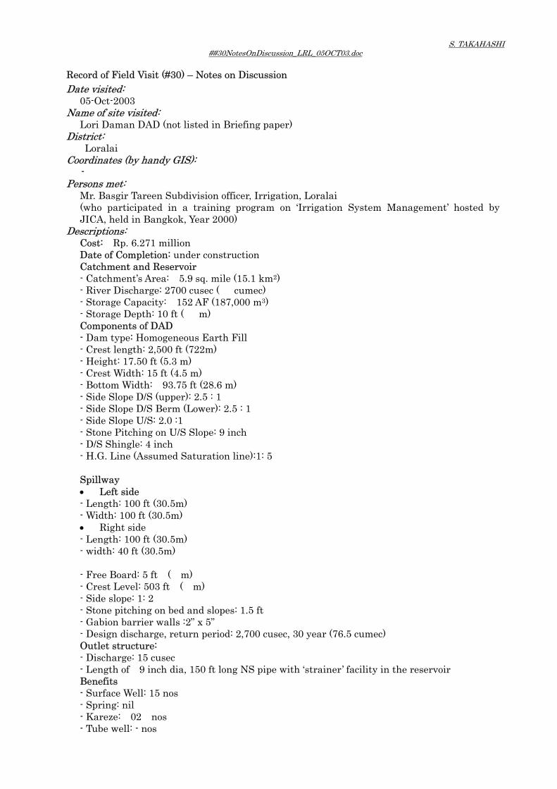
S. TAKAHASHI ##30NotesOnDiscussion_LRL_05OCT03.doc
Record of Field Visit (#30) – Notes on Discussion Date visited: 05-Oct-2003 Name of site visited: Lori Daman DAD (not listed in Briefing paper) District: Loralai Coordinates (by handy GIS): - Persons met: Mr. Basgir Tareen Subdivision officer, Irrigation, Loralai
(who participated in a training program on ‘Irrigation System Management’ hosted by JICA, held in Bangkok, Year 2000)
Descriptions: Cost: Rp. 6.271 million
Date of Completion: under construction Catchment and Reservoir - Catchment’s Area: 5.9 sq. mile (15.1 km2) - River Discharge: 2700 cusec ( cumec) - Storage Capacity: 152 AF (187,000 m3) - Storage Depth: 10 ft ( m) Components of DAD - Dam type: Homogeneous Earth Fill - Crest length: 2,500 ft (722m) - Height: 17.50 ft (5.3 m) - Crest Width: 15 ft (4.5 m) - Bottom Width: 93.75 ft (28.6 m) - Side Slope D/S (upper): 2.5 : 1 - Side Slope D/S Berm (Lower): 2.5 : 1 - Side Slope U/S: 2.0 :1 - Stone Pitching on U/S Slope: 9 inch - D/S Shingle: 4 inch - H.G. Line (Assumed Saturation line):1: 5 Spillway • Left side - Length: 100 ft (30.5m) - Width: 100 ft (30.5m) • Right side - Length: 100 ft (30.5m) - width: 40 ft (30.5m) - Free Board: 5 ft ( m) - Crest Level: 503 ft ( m) - Side slope: 1: 2 - Stone pitching on bed and slopes: 1.5 ft - Gabion barrier walls :2” x 5” - Design discharge, return period: 2,700 cusec, 30 year (76.5 cumec) Outlet structure: - Discharge: 15 cusec - Length of 9 inch dia, 150 ft long NS pipe with ‘strainer’ facility in the reservoir Benefits - Surface Well: 15 nos - Spring: nil - Kareze: 02 nos - Tube well: - nos

S. TAKAHASHI ##30NotesOnDiscussion_LRL_05OCT03.doc
- Additional cultivation: - acres - Farm families: - Observations (hearing) It was explained that: • Less pervious top layer in the reservoir area is to be removed to attain smooth
recharge. • An infiltration pond (100 ft x 30 ft, 50 ft deep) is to be provided downstream of the dam.• Groundwater level is to be monitored in an ‘injection well’ to be provided at the
downstream. It was also explained about a village Muslimbad, Quilla Saifullah where;
• The community (20,000 heads) has not allow tube wells to be installed within the area.
• The last prolonged draught has only affected the village to minimal level. • (location: 75 miles from Loralai to Quetta).

S. TAKAHASHI
##31ShaghaiI&IIDAD_QTA_10OCT03.doc Record of Field Visit (#31) Date visited: 10-Oct-2003 Name of site visited: Shaghai-I & II DAD (#109 ans #110 listed in Briefing paper) District: Quetta Coordinates (by handy GIS): Shaghai I: 30-12.710 N, 67-04.212 E
Shaghi II: 30-12.870 N, 67-04.266 E Persons met: Mr. Qotobu Khar, subdivional offier, I&P dep., Quetta
Mr. Abdul Jabbar, Sub. Engineer, I&P, Quetta Mr. Jalal-ud-Din Qureshi, Hydrogiologisy/Dty Director, PCRWR
Descriptions: Shaghai-I Shaghai II Cost: Rp. million 6.41 4.08 Date of Completion: 1995-96 1995-96 Catchment and Reservoir - Catchment’s Area: 2.89sq.mile( 7.4 sq.km) 1.40sq.mile(3.6 sq.km) - River Discharge: 2100 cusec( 59.5cumec) 1200 cusec (34.0 cusec) - Storage Capacity: 309 AF (380,000 c.m) 168 AF (207,000 c. m) - Storage Depth: 40ft (12.2 m) 30 ft (9.1 m ) Components of DAD - Dam type: Homogeneous Earth Fill Homogeneous Earth Fill - Crest length: 800ft (242.2 m) 450ft (45.4 m) - Height: 50ft (15.1 m) 40ft (12.1 m) - Crest Width: 20ft (6.1 m) 20ft (6.1 m) - Bottom Width: 315ft (95.4 m) 220ft (66.6 m) - Side Slope D/S (upper): 3.5:1 3.0:1 - Side Slope D/S Berm (Lower): 3.5:1 - - Side Slope U/S: 2:1 2:1 - Stone Pitching on U/S Slope: 1.5ft (0.45 m) 1.5ft (0.45 m) - D/S Shingle: 0.5ft (0.15 m) 0.5ft (0.15 m) Spillway - Length: 100ft ( 30.3m) 439ft(132.9 m) - Width: 100ft ( 30.3 m) 30ft (9.1m) - Free Board: - - - Crest Level: 464.5ft (141.0 m) 470.2ft (142.4 m) - Side slope: 0.5:1 1:1 - Stone pitching on bed non gabion - Gabion barrier walls non - - Design discharge (return period):
2100cusec 1200cusec
Outlet structure: - Discharge: - - - Length of inch dia, ft long pipe with ‘strainer’ facility in the reservoir
6 inch dia; 370ft long; GI pipe
6 inch dia; 360ft lomg GI pipe
Benefits for the Cantonment area for the Cantonment area
Observations: • It is said both Shagai I
and II was recharging the area of observation hole
• The reservoir was almost empty.
• A small pond was observed at the bottom of
• The dam is located just adjacent to Shaghai I DAD; some 300 m apart.

S. TAKAHASHI
##31ShaghaiI&IIDAD_QTA_10OCT03.doc MNW-QA-4; Groundwater level of which rose from Nov-89, claiming due to dam construction.
• MNW-QA-4 is located near Habib nallha (river). Habib Dara I & II DAD were constructed 1972 and 93 respectively.
• No DAD constructed in or around ‘89 has been identified.
the reservoir. • The bottom of the
reservoir was covered with clayey material due to siltation.
• Outlet pipe and the surrounding protection/filter stone were exposed in the reservoir. NO serious damage was seen.
• It was judged sediment load was not so high.
• Discharging pipe at the downstream was protected /covered by stone.
• Both slopes of the dam body were nicely lined with stone pitching on U/S and shingle on D/S.
• Reservoir water monitoring poles were observed.
• The reservoir was almost empty too.
• No ‘berm’ on the D/S slope was observed due to low dam height, explained.
• Both slopes of the dam body were nicely lined.
• At the toe of the dam, small gravel mound for toe drain was observed.
• At the discharging pipe outlet, were observed a sedimentation pit (2x4.5 ft, 4.5 ft deep, a leading canal (1x0.75ft, 20ft long and infiltration pond (15x15ft) filled with pebble/bolder.
• The infiltration facility was partially broken and was not properly cleaned.
• Down the infiltration pit, several trench for recharging were observed.

S. TAKAHASHI
##32ZiargaiArtificialGroundwaterRecharge_QTA_10OCT03.doc Record of Field Visit (#32) Date visited: 10-Oct-2003 Name of site visited: Ziargai Artificial Groundwater Recharge Pilot Scheme(not listed in Briefing paper) District: Quetta Coordinates (by handy GIS): 30-27.874 N, 67-07.677 E Persons met: Mr. Abdul Jabbar, Sub. Engineer, I&P, Quetta
Mr. Jalal-ud-Din Qureshi, Hydrogiologisy/Dty Director, PCRWR Descriptions: • Balochistan Minor Irrigation and Agricultural Development
• Funded by: WB, KfW, GoPakistan; Dutch Government for TA • Component (from the Final report prepared in 1990): A. RECHARGE WORKS (construction undertake in 1986) - The diversion structure, a sluice and off-take weir for 2-year flood, whole structure for
25-year flood, with a free board for 100-year flood. - The guide bund and chute - The storage reservoir (72,000qu.m) with outlet pipe of 305 mm dia discharging 0.23
cumes that was meant to empty the reservoir within 24 hours. - The recharge area (Zigzag channels of about 5200 m) B. MONITORING WORKS (undertaken from 1984 to 1987) - Rainfall monitoring gauge (1986- 1987) - Flow and water level (1986 – 1987) - Soil moisture status (1986 – 1987) - Groundwater - Dug Well (1984 – 1987) • Preliminary Results ((from the Final report prepared in 1990) A. RAINFALL ANDRUNOFF - Quote, “One interesting feature of rainfall events is the importance of antecedent
wetness conditions. The third event produced the largest amount of runoff despite arising from a rainfall event of significantly lower quantity and intensity. This s because it was preceded by a considerable period of wet weather which left the surface soil moisture conditions closer to saturation than the other events. This can be indexed by an antecedent precipitation index (API) which is designed to reflect the rainfall over the previous several days”, unquote.
B. SOIL MOUSTURE STATUS - Quote,”The from seems to have reached 2-3 metre depth after 1 month, 5-6 metre after
3-months, and 6-8 metre after 4 months. This would seem to indicate a rate of movement of the front of the order of 1.5-2 metre per month or 20 metre per year. If this is an indication of the percolation rate, then we may be talking in terms of recharged water taking 4 years to reach the ground table. Hydraulic conductivity increased with moisture content, so that this time may reduce considerably over a long period encompassing several recharge events”, unquote.
C. GROUNDWATER - Quote, “the groundwater table in this part of the Quetta valley is falling due to excessive
abstraction. The fall appears to be of the order of 3 metre per year, although the further development of wells should increase this rate,” unquote.
Observations • The pilot project was totally abandoned. • Reservoir capacity was felt too small (72,000 qu.m). • Bottom out let was felt too small (0.302 m dia). • It was thought on the site that: major part of 2-year flood went through sluice weir to

S. TAKAHASHI
##32ZiargaiArtificialGroundwaterRecharge_QTA_10OCT03.doc downstream. Only the maximum of 72,000 qu.m was stored in the reservoir, only a part of the stored water contribute recharging the groundwater, it seemed to be.
• At the bottom of the zigzag channel, thin silty –clayey sediment layer was seen, which might have reduced the infiltration rate.
• It was felt on site major part of flood water ran in to the downstream side, not contributing in recharging groundwater.
• It was felt on site, a delay action dam with a properly designed discharging pipe, and facility for recharging such as zigzag channel or infiltration pond would have been useful.

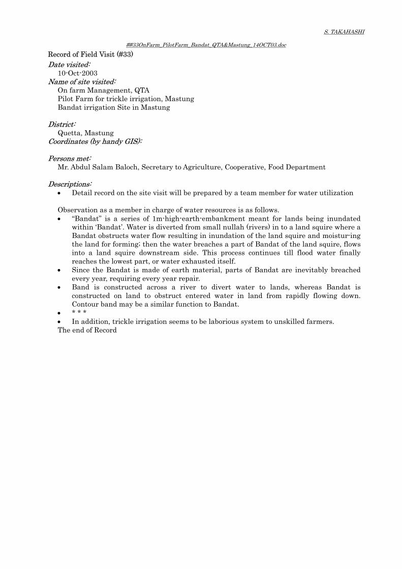
S. TAKAHASHI
##33OnFarm_PilotFarm_Bandat_QTA&Mastung_14OCT03.doc Record of Field Visit (#33) Date visited: 10-Oct-2003 Name of site visited: On farm Management, QTA
Pilot Farm for trickle irrigation, Mastung Bandat irrigation Site in Mastung
District: Quetta, Mastung Coordinates (by handy GIS): Persons met: Mr. Abdul Salam Baloch, Secretary to Agriculture, Cooperative, Food Department
Descriptions: • Detail record on the site visit will be prepared by a team member for water utilization
Observation as a member in charge of water resources is as follows. • “Bandat” is a series of 1m-high-earth-embankment meant for lands being inundated
within ‘Bandat’. Water is diverted from small nullah (rivers) in to a land squire where a Bandat obstructs water flow resulting in inundation of the land squire and moistur-ing the land for forming; then the water breaches a part of Bandat of the land squire, flows into a land squire downstream side. This process continues till flood water finally reaches the lowest part, or water exhausted itself.
• Since the Bandat is made of earth material, parts of Bandat are inevitably breached every year, requiring every year repair.
• Band is constructed across a river to divert water to lands, whereas Bandat is constructed on land to obstruct entered water in land from rapidly flowing down. Contour band may be a similar function to Bandat.
• * * * • In addition, trickle irrigation seems to be laborious system to unskilled farmers. The end of Record

添付資料 - 6 収集資料リスト

Ref
No.
(PB
L-**
-01)
TITL
E O
F R
EPO
RT
/ DA
TAV
OLU
ME
CO
NTE
NTS
YEA
RA
GEN
CY
/SO
UR
CE
Lang
uage
Tran
slat
ion
to E
nglis
hN
ame
ofC
olle
ctor
Polic
y an
d St
atis
tics a
t Nat
iona
l Lev
el
JST-
PN-0
1Te
n Y
ear P
ersp
ectiv
e D
evel
opm
ent P
lan
2001
-11
and
Thre
eY
ear D
evel
opm
ent P
rogr
amm
e 20
01-0
4, Is
lam
abad
,42
1 pa
ges
Long
and
med
ium
term
dev
elop
men
t pla
n of
Paki
stan
2001
Plan
ning
Com
mis
sio
Engl
ish
-N
oda
JST-
PN-0
2A
nnua
l Pla
n 20
03-0
4, Is
lam
abad
June
, 200
3, G
over
nmen
t of
Paki
stan
120
page
sA
nnua
l Pla
n of
eco
nom
ic fr
amew
ork
and
publ
icse
ctor
dev
elop
men
t pro
gram
me
2003
Plan
ning
Com
mis
sio
Engl
ish
-N
oda
JST-
PN-0
3Pu
blic
Sec
tor D
evel
opm
ent P
rogr
amm
e, 2
002-
2003
, Jun
e20
02, G
over
nmen
t of P
akis
tan
61 p
ages
Ann
ual p
lan
of p
ublic
sect
or d
evel
opm
ent
prog
ram
me
2002
Plan
ning
Com
mis
sio
Engl
ish
-N
oda
JST-
PN-0
4Pu
blic
Sec
tor D
evel
opm
ent P
rogr
amm
e, 2
003-
04, J
une,
2003
, Gov
ernm
ent o
f Pak
ista
n85
pag
esA
nnua
l pla
n of
pub
lic se
ctor
dev
elop
men
tpr
ogra
mm
e20
03Pl
anni
ngC
omm
issi
oEn
glis
h-
Nod
a
JST-
PN-0
5Es
timat
es o
f For
eign
Ass
ista
nce
2003
-200
4, G
over
nmen
t of
Paki
stan
42 p
ages
List
of p
roje
cts u
nder
For
eign
ass
ista
nce
Fina
nce
Div
isio
nEn
glis
h-
Nod
a
JST-
PN-0
6Pa
kist
an S
tatis
tical
Yea
r Boo
k 20
02, F
eder
al B
urea
u of
Stat
istic
s, G
over
nmen
t of P
akis
tan
712
page
s and
note
sN
atio
nal s
tatis
tics o
f Pak
ista
n20
02St
atis
tics
Div
isio
nEn
glis
h-
Nod
a
JST-
PN-0
7Ec
onom
ic S
urve
y 20
01-2
002,
Gov
ernm
ent o
f Pak
ista
n17
9 pa
ges
Nat
iona
l sta
tistic
s on
econ
omic
s of P
akis
tan
2002
Fina
nce
Div
isio
nEn
glis
h-
Nod
a
Polic
y an
d St
atis
tics a
t Pro
vinc
ial L
evel
Gov
ernm
ent
PBL-
PP-0
19t
h Fi
ve Y
ear P
lan
1998
-99
to 2
002-
03, P
rovi
nce
ofB
aloc
hist
an, P
lann
ing
and
Dev
elop
men
t Dep
artm
ent,
122
page
sD
evel
opm
ent p
olic
y an
d st
rate
gy o
f Bal
ochi
stan
Prov
ince
1998
P&D
Dep
t.En
glis
h-
Shin
mur
a
PBL-
PP-0
1'G
OV
ERN
MEN
T O
F B
ALO
CH
ISTA
N W
hite
Pep
er B
udje
t20
03-2
004
35 p
ages
Whi
te p
aper
bud
get
2003
Engl
ish
-N
oda
PBL-
PP-0
2Pu
blic
Sec
tor D
evel
opm
ent P
rogr
am 2
003-
04, J
une
2003
,G
over
nmen
t of B
aloc
hist
an10
1 pa
ges a
ndan
nexe
sLi
st o
f pro
ject
s for
pub
lic se
ctor
dev
elop
men
tpr
ogra
mm
e20
03P&
D D
ept.
Engl
ish
-Sh
inm
ura
PBL-
PP-0
3D
evel
opm
ent S
tatis
tics o
f Bal
ochi
stan
200
0-01
, Bur
eau
ofSt
atis
tics,
Plan
ning
& D
evel
opm
ent D
epar
tmen
tD
evel
opm
ent S
tatis
tics o
f Bal
ochi
stan
2002
P&D
Dep
t.En
glis
h-
Shin
mur
a
PBL-
PP-0
4A
gric
ultu
ral S
tatis
tics B
aloc
hist
an 2
001-
02, S
tatis
tical
Win
g, D
irect
orat
e G
ener
al A
gric
ultu
re (E
xten
sion
)17
2 pa
ges
Agr
icul
tura
l sta
tistic
s in
Bal
ochi
stan
Pro
vinc
e20
02Ex
tens
ion
Dire
ctor
ate
Engl
ish
-N
oda
PBL-
PP-0
5K
illa
Abd
ulla
h, A
Dis
trict
Pro
file,
Bur
eau
of S
tatis
tics,
Gov
ernm
ent o
f Bal
ochi
stan
88 p
ages
and
anne
xes
Stat
istic
s on
dist
ict p
rofil
e19
97P&
D D
ept.
Engl
ish
-St
udy
team
PBL-
PP-0
6Pi
shin
, A D
istri
ct P
rofil
e, B
urea
u of
Sta
tistic
s, G
over
nmen
tof
Bal
ochi
stan
82 p
ages
and
anne
xes
Stat
istic
s on
dist
ict p
rofil
e19
97P&
D D
ept.
Engl
ish
-St
udy
team
PBL-
PP-0
7Q
uetta
, A D
istri
ct P
rofil
e, B
urea
u of
Sta
tistic
s, G
over
nmen
tof
Bal
ochi
stan
107
page
s and
anne
xes
Stat
istic
s on
dist
ict p
rofil
e19
97P&
D D
ept.
Engl
ish
-St
udy
team
Prep
arat
ory
Stud
y on
Flo
od U
tiliz
atio
n D
evel
opm
ent i
n B
aloc
hist
anC
olle
cted
Rep
ort &
Dat
a
1/11

Ref
No.
(PB
L-**
-01)
TITL
E O
F R
EPO
RT
/ DA
TAV
OLU
ME
CO
NTE
NTS
YEA
RA
GEN
CY
/SO
UR
CE
Lang
uage
Tran
slat
ion
to E
nglis
hN
ame
ofC
olle
ctor
Prep
arat
ory
Stud
y on
Flo
od U
tiliz
atio
n D
evel
opm
ent i
n B
aloc
hist
anC
olle
cted
Rep
ort &
Dat
a
PBL-
PP-0
8M
astu
ng, A
Dis
trict
Pro
file,
Bur
eau
of S
tatis
tics,
Gov
ernm
ent o
f Bal
ochi
stan
60 p
ages
and
anne
xes
Stat
istic
s on
dist
ict p
rofil
e19
97P&
D D
ept.
Engl
ish
-St
udy
team
PBL-
PP-0
9K
alat
, A D
istri
ct P
rofil
e, B
urea
u of
Sta
tistic
s, G
over
nmen
tof
Bal
ochi
stan
66 p
ages
and
anne
xes
Stat
istic
s on
dist
ict p
rofil
e19
97P&
D D
ept.
Engl
ish
-St
udy
team
PBL-
PP-1
0K
huzd
ar, A
Dis
trict
Pro
file,
Bur
eau
of S
tatis
tics,
Gov
ernm
ent o
f Bal
ochi
stan
52 p
ages
and
anne
xes
Stat
istic
s on
dist
ict p
rofil
e19
97P&
D D
ept.
Engl
ish
-St
udy
team
PBL-
PP-1
1K
ech,
A D
istri
ct P
rofil
e, B
urea
u of
Sta
tistic
s, G
over
nmen
tof
Bal
ochi
stan
83 p
ages
and
anne
xes
Stat
istic
s on
dist
ict p
rofil
e19
97P&
D D
ept.
Engl
ish
-St
udy
team
Don
orPB
L-PP
-12
Paki
stan
Cou
ntry
Ass
ista
nce
Stra
tegy
Fy0
3-05
, Wor
ld B
ank
38 p
ages
and
anne
xes
Ass
ista
nce
stra
tegy
for P
akis
tan
2002
WB
Isla
mab
adEn
glis
h-
Nod
a
PBL-
PP-1
3Pa
kist
an P
over
ty A
sses
smen
t, W
orld
Ban
k16
9 pa
ges
Pove
rty in
Pak
ista
n: V
ulne
rabi
lity,
Soc
ial G
aps,
and
Dyn
amic
s20
02W
BIs
lam
abad
Engl
ish
-N
oda
PBL-
PP-1
4A
DB
Pak
ista
n Se
ctor
Ass
essm
ent R
evie
w, A
sian
Dev
elop
men
t Ban
k, O
ctob
er 2
003
81 p
ages
Ass
ista
nce
stra
tegy
for P
akis
tan
2003
AD
BIs
lam
abad
Engl
ish
-N
oda
PBL-
PP-1
5A
DB
Pak
ista
n Ec
onom
ic U
pdat
e (J
uly
2002
- Ju
ne 2
003)
,A
sian
Dev
elop
men
t Ban
k, A
ugus
t 200
333
pag
esSt
atis
tics o
n ec
onom
ics
2003
AD
BIs
lam
abad
Engl
ish
-N
oda
Wat
er R
esou
rces
& F
acili
ties
Nat
iona
l Wat
er R
esou
rces
PBL-
NW
-01
Min
istry
of W
ater
and
Pow
er, G
over
nmen
t of P
akis
tan
46 p
ages
Gui
debo
ok o
f Min
istry
of W
ater
and
Pow
er-
Min
istry
of
W&
PEn
glis
h-
Taka
hasi
PBL-
NW
-02
Wat
er C
onse
rvat
ion:
A G
uide
to P
rom
otin
g Pu
blic
Aw
aren
ess,
Wat
er R
esou
rces
Ser
ies N
o.81
, Eco
nom
ic a
ndSo
cial
Com
mis
sion
for A
sia
and
the
Paci
fic, U
nite
d N
atio
ns
96 p
ages
Gui
debo
ok o
n w
ater
con
serv
atio
n20
01U
nite
dN
atio
nsEn
glis
h-
Taka
hasi
PBL-
NW
-03
Paki
stan
Cou
ncil
of R
esea
rch
in W
ater
Res
ourc
esIs
lam
abad
, Aug
ust 1
993
24 p
ages
Bro
chur
e of
Pak
ista
n C
ounc
il of
Res
earc
h in
Wat
er R
esou
rces
(PC
RW
R)
1993
PCR
WR
Engl
ish
-Ta
kaha
si
PBL-
NW
-04
Publ
icat
ion
Cat
alog
ue o
f Geo
logi
cal S
urve
y of
Pak
ista
n(1
985
to 1
994)
, Geo
logi
cal S
urve
y of
Pak
ista
n, 1
994,
Min
istr y
of P
etro
leum
and
Nat
ural
Res
ourc
es
34 p
ages
Publ
icat
ion
cata
logu
e19
94G
SPEn
glis
h-
Taka
hasi
PBL-
NW
-05
Wat
er S
uppl
y an
d Su
nita
tion
in P
akis
tan,
Cur
rent
Sta
tus,
Issu
es, a
nd F
utur
e St
rate
gies
, Mul
ti-do
nor S
uppo
rt U
nit
(MSU
), O
ctob
er 2
001
23 p
ages
Pape
r on
curr
ent s
tatu
s, is
sues
and
futu
rest
rate
gies
in P
akis
tan
2/11

Ref
No.
(PB
L-**
-01)
TITL
E O
F R
EPO
RT
/ DA
TAV
OLU
ME
CO
NTE
NTS
YEA
RA
GEN
CY
/SO
UR
CE
Lang
uage
Tran
slat
ion
to E
nglis
hN
ame
ofC
olle
ctor
Prep
arat
ory
Stud
y on
Flo
od U
tiliz
atio
n D
evel
opm
ent i
n B
aloc
hist
anC
olle
cted
Rep
ort &
Dat
a
Prov
inci
al W
ater
Res
ourc
es, B
aloc
hist
anPB
L-PW
-01
Mon
itorin
g an
d Ev
alua
tion
Rep
ort o
n Pi
lot P
hase
s of
Gro
undw
ater
Exp
loita
tion
thro
ugh
250
Win
dmill
s in
Dro
ught
Stri
cken
Are
as o
f Bal
ochi
stan
, Wat
er R
esou
rces
Res
earc
h C
entre
, Que
tta, N
ovem
ber,
2001
25 p
ages
and
tabl
esM
onito
ring
and
Eval
uatio
n R
epor
t on
Gro
undw
ater
Exp
loita
tion
inB
aloc
hist
an20
01I&
P D
ept.
and
PCR
WR
Engl
ish
-Ta
kaha
si
PBL-
PW-0
2PC
-II;
Impa
ct E
valu
atio
n St
udy
of M
auhs
ar D
elay
Act
ion
Dam
in C
onse
rvin
g W
ater
Res
ourc
es o
f Bal
ochi
stan
, Jun
e20
00, B
urea
u of
Wat
er R
esou
rces
7 pa
ges
Stud
y Pl
an o
f Im
pact
Eva
luat
ion
on M
auhs
arD
elay
Act
ion
Dam
2000
I&P
Dep
t.En
glis
h-
Taka
hasi
PBL-
PW-0
3PC
-1 P
rofo
rma
for E
nhan
cem
ent a
nd M
anag
emen
t of
Gro
udw
ater
Res
ourc
es in
Bal
ochi
stan
, Pak
ista
n C
oubc
il of
Res
earc
h in
Wat
er R
esou
rces
Isla
mab
ad, M
ay 2
003
27 p
ages
Stud
y Pl
an o
f Enh
ance
men
t and
Man
agem
ent o
fG
roud
wat
er R
esou
rces
in B
aloc
hist
an20
03PC
RW
REn
glis
h-
Taka
hasi
PBL-
PW-0
4R
epor
t on
Leak
y D
am fo
r Gro
undw
ater
Rec
harg
e W
ater
shed
Man
agem
ent,
Mon
itorin
g Pr
ogra
m a
t Mar
gat A
rea,
Dis
trict
Que
tta, B
aloc
hist
an, S
epte
mbe
r 200
3, W
ater
Res
ourc
es
15 p
ages
Prog
ram
on
Gro
undw
ater
Rec
harg
e W
ater
shed
Man
agem
ent,
Mon
itorin
g at
Mar
gat A
rea
with
the
Leak
y D
am
2003
WR
RC
inPC
RW
REn
glis
h-
Taka
hasi
PBL-
PW-0
5B
aloc
hist
an M
inor
Irrig
atio
n an
d A
gric
ultu
al D
evel
opm
ent
Proj
ect:
AR
TIFI
CIA
L G
RO
UN
DW
ATE
R R
ECH
AR
GE
Fina
lR
epor
t Par
t-B, V
ol:3
and
Vol
:4, H
alcr
ow-U
LG
48 p
ages
and
tabl
esSt
udy
repo
rt on
arti
ficia
l gro
undw
ater
rech
arge
1990
Hal
crow
,Eu
roco
nsul
tEn
glis
h-
Taka
hasi
PBL-
PW-0
6B
aloc
hist
an M
inor
Irrig
atio
n an
d A
gric
ultu
al D
evel
opm
ent
Proj
ect:
AR
TIFI
CIA
L G
RO
UN
DW
ATE
R R
ECH
AR
GE:
Apr
elim
inar
y ex
amin
atio
n of
eco
nom
ic v
iabi
lity;
INTE
RN
AL
33 p
ages
and
tabl
esIN
TER
NA
L R
EPO
RT,
not
for o
utsi
dedi
strib
utio
n, o
n pr
elim
inar
y ex
amin
atio
n of
econ
omic
via
bilit
y of
arti
ficia
l gro
undw
ater
--
Engl
ish
-Ta
kaha
si
PBL-
PW-0
7PC
-I fo
r Con
stru
ctio
n of
Dar
gai D
elay
Act
ion
Dam
, Dro
ught
Emer
genc
y R
elie
f Ass
ista
nce
Prog
ram
me
(DER
A),
Janu
ary
2002
, Irr
igat
ion
Div
isio
n, P
ishi
n
-Pr
ojec
t im
plem
enta
tion
plan
and
cos
t est
imat
efo
r Dar
gai D
AD
2002
I&P
Dep
t.En
glis
h-
Taka
hasi
PBL-
PW-0
8PC
-I fo
r Con
stru
ctio
n of
Tor
khez
ai D
elay
Act
ion
Dam
,Fe
brua
ry 2
000,
Lor
alai
Irrig
atio
n D
ivis
ion
-Pr
ojec
t im
plem
enta
tion
plan
and
cos
t est
imat
efo
r Tor
khez
ai D
AD
2000
I&P
Dep
t.En
glis
h-
Taka
hasi
PBL-
PW-0
9St
udy
on H
ydra
ulic
Rel
atio
nshi
p be
twee
n Pe
chi D
amR
eser
voir
and
the
Adj
acen
t Kar
ezes
usi
ng Is
otop
ic a
ndC
hem
ical
Tec
hniq
ues,
1995
, Wat
er R
esou
rces
Res
earc
hC
tQ
tt
46 p
ages
Rep
ort o
n su
rvey
and
eva
luat
ion
on h
ydra
ulic
rela
tions
hip
betw
een
dam
and
kar
ezes
1995
WR
RC
inPC
RW
REn
glis
h-
Taka
hasi
PBL-
PW-1
0B
aloc
hist
an G
roun
dwat
er A
vaila
bilit
y an
d Fu
ture
Pla
nnin
g of
Que
tta V
alle
y (S
outh
ern
Part)
- In
vent
ory
of W
ater
ing
Poin
ts -
Bas
ic D
ata
Serie
s-1(
Vol
ume-
I), W
ater
Res
ourc
esPl
anni
ng D
evel
opm
ent &
Mon
itorin
g D
irect
orat
e,
19 p
ages
and
tabl
es &
figu
res
Rep
ort o
n in
vest
igat
ion
of g
roun
dwat
er20
02W
RPD
&M
Dire
ctor
ate
in I&
P D
ept.
Engl
ish
-Ta
kaha
si
PBL-
PW-1
1B
aloc
hist
an G
roun
dwat
er A
vaila
bilit
y an
d Fu
ture
Pla
nnin
g of
Que
tta V
alle
y (N
orth
ern
Part)
- In
vent
ory
of w
ater
ing
Poin
ts- B
asic
Dat
a Se
ries-
1(V
olum
e-II
), W
ater
Res
ourc
esPl
anni
ng D
evel
opm
ent &
Mon
itorin
g D
irect
orat
e, M
arch
,
20 p
ages
and
tabl
esR
epor
t on
inve
stig
atio
n of
gro
undw
ater
2002
WR
PD&
MD
irect
orat
ein
I&P
Dep
t.
Engl
ish
-Ta
kaha
si
3/11
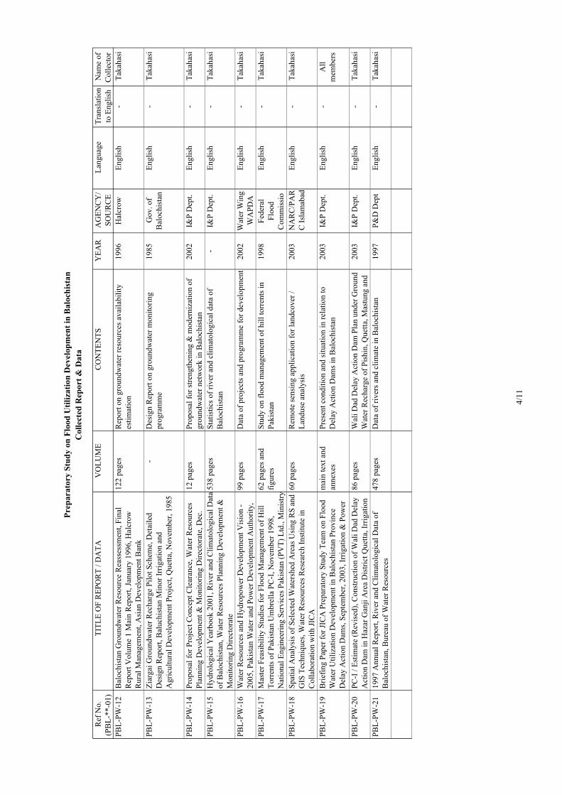
Ref
No.
(PB
L-**
-01)
TITL
E O
F R
EPO
RT
/ DA
TAV
OLU
ME
CO
NTE
NTS
YEA
RA
GEN
CY
/SO
UR
CE
Lang
uage
Tran
slat
ion
to E
nglis
hN
ame
ofC
olle
ctor
Prep
arat
ory
Stud
y on
Flo
od U
tiliz
atio
n D
evel
opm
ent i
n B
aloc
hist
anC
olle
cted
Rep
ort &
Dat
a
PBL-
PW-1
2B
aloc
hist
an G
roun
dwat
er R
esou
rce
Rea
sses
smen
t, Fi
nal
Rep
ort V
olum
e 1
Mai
n R
epor
t, Ja
nuar
y 19
96, H
alcr
owR
ural
Man
agem
ent,
Asi
an D
evel
opm
ent B
ank
122
page
sR
epor
t on
grou
ndw
ater
reso
urce
s ava
ilabi
lity
estim
atio
n19
96H
alcr
owEn
glis
h-
Taka
hasi
PBL-
PW-1
3Zi
arga
i Gro
undw
ater
Rec
harg
e Pi
lot S
chem
e, D
etai
led
Des
ign
Rep
ort,
Bal
uchi
stan
Min
or Ir
rigat
ion
and
Agr
icul
tura
l Dev
elop
men
t Pro
ject
, Que
tta, N
ovem
ber,
1985
-D
esig
n R
epor
t on
grou
ndw
ater
mon
itorin
gpr
ogra
mm
e19
85G
ov. o
fB
aloc
hist
anEn
glis
h-
Taka
hasi
PBL-
PW-1
4Pr
opos
al fo
r Pro
ject
Con
cept
Cle
aran
ce, W
ater
Res
ourc
esPl
anni
ng D
evel
opm
ent &
Mon
itorin
g D
irect
orat
e, D
ec.
12 p
ages
Prop
osal
for s
treng
then
ing
& m
oder
niza
tion
ofgr
ound
wat
er n
etw
ork
in B
aloc
hist
an20
02I&
P D
ept.
Engl
ish
-Ta
kaha
si
PBL-
PW-1
5H
ydro
logi
cal Y
earb
ook
2001
, Riv
er a
nd C
limat
olog
ical
Dat
aof
Bal
ochi
stan
, Wat
er R
esou
rces
Pla
nnin
g D
evel
opm
ent &
Mon
itorin
g D
irect
orat
e
538
page
sSt
atis
tics o
f riv
er a
nd c
limat
olog
ical
dat
a of
Bal
ochi
stan
-I&
P D
ept.
Engl
ish
-Ta
kaha
si
PBL-
PW-1
6W
ater
Res
ourc
es a
nd H
ydro
pow
er D
evel
opm
ent V
isio
n -
2005
, Pak
ista
n W
ater
and
Pow
er D
evel
opm
ent A
utho
rity,
99 p
ages
Dat
a of
pro
ject
s and
pro
gram
me
for d
evel
opm
ent
2002
Wat
er W
ing
WA
PDA
Engl
ish
-Ta
kaha
si
PBL-
PW-1
7M
aste
r Fea
sibi
lity
Stud
ies f
or F
lood
Man
agem
ent o
f Hill
Torr
ents
of P
akis
tan
Um
brel
la P
C-I
, Nov
embe
r 199
8,N
atio
nal E
ngin
eerin
g Se
rvic
es P
akis
tan
(PV
T) L
td.,
Min
istry
62 p
ages
and
figur
esSt
udy
on fl
ood
man
agem
ent o
f hill
torr
ents
inPa
kist
an19
98Fe
dera
lFl
ood
Com
mis
sio
Engl
ish
-Ta
kaha
si
PBL-
PW-1
8Sp
atia
l Ana
lysi
s of S
elec
ted
Wat
ersh
ed A
reas
Usi
ng R
S an
dG
IS T
echn
ique
s, W
ater
Res
ourc
es R
esea
rch
Inst
itute
inC
olla
bora
tion
with
JIC
A
60 p
ages
Rem
ote
sens
ing
appl
icat
ion
for l
andc
over
/La
ndus
e an
alys
is20
03N
AR
C/P
AR
C Is
lam
abad
Engl
ish
-Ta
kaha
si
PBL-
PW-1
9B
riefin
g Pa
per f
or JI
CA
Pre
para
tory
Stu
dy T
eam
on
Floo
dW
ater
Util
izat
ion
Dev
elop
men
t in
Bal
ochi
stan
Pro
vinc
eD
elay
Act
ion
Dam
s, Se
ptem
ber,
2003
, Irr
igat
ion
& P
ower
mai
n te
xt a
ndan
nexe
sPr
esen
t con
ditio
n an
d si
tuat
ion
in re
latio
n to
Del
ay A
ctio
n D
ams i
n B
aloc
hist
an20
03I&
P D
ept.
Engl
ish
-A
llm
embe
rs
PBL-
PW-2
0PC
-I /
Estim
ate
(Rev
ised
), C
onst
ruct
ion
of W
ali D
ad D
elay
Act
ion
Dam
in H
azar
Gan
ji A
rea
Dis
trict
Que
tta, I
rrig
atio
n86
pag
esW
ali D
ad D
elay
Act
ion
Dam
Pla
n un
der G
roun
dW
ater
Rec
harg
e of
Pis
hin,
Que
tta, M
astu
ng a
nd20
03I&
P D
ept.
Engl
ish
-Ta
kaha
si
PBL-
PW-2
119
97 A
nnua
l Rep
ort,
Riv
er a
nd C
limat
olog
ical
Dat
a of
Bal
ochi
stan
, Bur
eau
of W
ater
Res
ourc
es47
8 pa
ges
Dat
a of
rive
rs a
nd c
limat
e in
Bal
ochi
stan
1997
P&D
Dep
tEn
glis
h-
Taka
hasi
4/11

Ref
No.
(PB
L-**
-01)
TITL
E O
F R
EPO
RT
/ DA
TAV
OLU
ME
CO
NTE
NTS
YEA
RA
GEN
CY
/SO
UR
CE
Lang
uage
Tran
slat
ion
to E
nglis
hN
ame
ofC
olle
ctor
Prep
arat
ory
Stud
y on
Flo
od U
tiliz
atio
n D
evel
opm
ent i
n B
aloc
hist
anC
olle
cted
Rep
ort &
Dat
a
Irri
gatio
n
PBL-
IR-0
1写
真集
パキスタンの農
業・農
村と水
、2001年3月
69頁
パキスタンの農
業・農
村と水
に関
係す
る写
真と
解説
2001
JIC
A 清
水
専門家
日本語
-野田
PBL-
IR-0
2PA
KIS
TAN
国情・農業・灌漑、
2003
年6月
63頁
と図
表パキスタンの国
情・農
業・灌
漑に関
する解
説と
データ
2003
JIC
A 清
水
専門家
日本語
-野田
PBL-
IR-0
3O
n-fa
rm W
ater
Man
agem
ent D
emon
stra
tion
Cen
tres -
Han
dboo
k an
d R
ecor
ds, F
eder
al M
anag
emen
t Cel
l,Pr
ovin
cial
Dire
ctor
ates
of O
FWM
, FA
TA, F
AN
A &
ICTA
,M
inis
try o
f Foo
d, A
gric
ultu
re a
nd C
oope
rativ
es
14 p
ages
and
14
form
sN
atio
nal g
uide
line
for e
stab
lishm
ent o
f on-
farm
wat
er m
anag
emen
t dem
onst
ratio
n ce
ntre
s-
Min
istry
of
Food
, Agr
i.an
dC
oope
rativ
e
Engl
ish
-N
oda
PBL-
IR-0
4PC
-1 fo
r On-
farm
Wat
er M
anag
emen
t Bal
ochi
stan
(Jap
anA
ssis
ted)
, Agr
icul
ture
Dep
artm
ent,
Sept
embe
r 199
120
pag
es a
ndan
nexe
sPr
ojec
t im
plem
enta
tion
plan
and
cos
t est
imat
efo
r on-
farm
wat
er m
anag
emen
t in
Bal
ochi
stan
1991
Agr
icul
ture
Dep
t.En
glis
h-
Nod
a
PBL-
IR-0
5B
aloc
hist
an C
omm
unity
Irrig
atio
n an
d ag
ricul
ture
Pro
ject
,Im
plem
enta
tion
Com
plet
ion
Rep
ort,
Vol
ume
II, A
ppen
dice
s,Ju
ne 2
002,
Hal
crow
- Eu
roco
nsul
t
-K
ey in
form
atio
n of
sche
mes
2002
I&P
Dep
t.En
glis
h-
Nod
a
Agr
icul
ture
PBL-
AG
-01
Agr
icul
ture
Sta
tistic
s of P
akis
tan
2000
-01,
Min
istry
of
Food
, Agr
icul
ture
and
Liv
esto
ck, G
over
nmen
t of P
akis
tan
289
page
sN
atio
nal s
tatis
tics o
n ag
ricul
ture
of P
akis
tan
2001
Econ
omic
Win
gEn
glis
h-
Nod
a
PBL-
AG
-02
I. C
ost o
f Pro
duct
per
Acr
e, II
. Mon
thly
Com
paris
on o
fW
hole
sale
Pric
es o
f Oni
on (d
ry) o
f Diff
eren
t Mar
kets
inPa
kist
an fo
r the
Yea
r 200
2, II
I. M
onth
ly W
hole
sale
Pric
esof
Agr
icul
ture
Com
mod
ities
and
Liv
esto
ck P
rodu
cts,
1990
~200
3
I: 6
page
s,II
: 1pa
ge,
III:
14 p
ages
Dat
a of
stat
istic
s on
agro
-eco
nom
y20
03A
gric
ultu
reEc
onom
ics
and
Mar
ketin
gD
irect
orat
e
Engl
ish
-N
oda
PBL-
AG
-01
Res
earc
h an
d D
evel
opm
ent A
chie
vem
ents
of P
AR
C 2
000-
2001
, Dire
ctor
ate
of P
lann
ing,
Pak
ista
n A
gric
ultu
ral
25 p
ages
Expl
anat
ion
of g
ricul
tura
l res
earc
h an
dde
velo
pmen
t pro
ject
s by
PAR
C20
02PA
RC
Engl
ish
-N
oda
PBL-
AG
-03
Are
a D
evel
opm
ent P
rogr
amm
e B
aloc
hist
an (A
DPB
),A
chie
vem
ents
of t
he P
roje
ct fo
r the
yea
r 200
2, U
ND
P18
pag
esB
riefin
g pa
per o
n pr
ojec
ts o
vers
een
by U
ND
Pan
d G
over
nmen
t of B
aloc
hist
an-
UN
DP
Engl
ish
-N
oda
PBL-
AG
-04
Are
a D
evel
opm
ent P
rogr
amm
e B
aloc
hist
an (A
DPB
), Ta
rget
sof
the
Proj
ect f
or th
e ye
ar 2
003,
UN
DP
8 pa
ges
Brie
fing
pape
r on
proj
ects
to b
e ov
erse
en b
yU
ND
P an
d G
over
nmen
t of B
aloc
hist
an-
UN
DP
Engl
ish
-N
oda
PBL-
AG
-05
Are
a D
evel
opm
ent P
rogr
amm
e B
aloc
hist
an (A
DPB
),A
chie
vem
ents
of t
he P
roje
ct u
p to
May
200
3, U
ND
P18
pag
esB
riefin
g pa
per o
n pr
ojec
ts o
vers
een
by U
ND
Pan
d G
over
nmen
t of B
aloc
hist
an-
UN
DP
Engl
ish
-N
oda
PBL-
AG
-06
Are
a D
evel
opm
ent P
rogr
amm
e B
aloc
hist
an (A
DPB
), A
Wor
king
Pap
er O
utlin
ing
Ach
ieve
men
ts o
f the
Pro
ject
(for
10 p
ages
Brie
fing
pape
r on
proj
ects
ove
rsee
n by
UN
DP
and
Gov
ernm
ent o
f Bal
ochi
stan
-U
ND
PEn
glis
h-
Nod
a
5/11

Ref
No.
(PB
L-**
-01)
TITL
E O
F R
EPO
RT
/ DA
TAV
OLU
ME
CO
NTE
NTS
YEA
RA
GEN
CY
/SO
UR
CE
Lang
uage
Tran
slat
ion
to E
nglis
hN
ame
ofC
olle
ctor
Prep
arat
ory
Stud
y on
Flo
od U
tiliz
atio
n D
evel
opm
ent i
n B
aloc
hist
anC
olle
cted
Rep
ort &
Dat
a
Con
sulti
ng C
ompa
ny
PBL-
CC
-01
Intro
duct
ion
to S
ervi
ces R
ende
red
by S
AM
PAK
Mat
eria
lTe
stin
g La
bora
tory
13 p
ages
Com
pany
bro
chur
e-
SAM
PAK
Engl
ish
-Ta
kaha
shi
PBL-
CC
-02
Hig
hway
Eng
inee
ring,
Brid
ges,
Mat
eria
l & S
oil T
estin
g,Su
rvey
and
Map
ping
Wor
k-
Com
pany
bro
chur
eSA
MPA
KEn
glis
h-
Taka
hash
i
PBL-
CC
-03
Nat
iona
l Eng
inee
ring
Cor
pora
tion
Paki
stan
-C
ompa
ny b
roch
ure
NEC
Engl
ish
-Ta
kaha
shi
PBL-
CC
-04
Prof
ile o
f the
Firm
, Cam
eos C
onsu
lting
Eng
inee
rs,
Arc
hite
cts a
nd P
lann
ers
55 p
ages
Com
pany
bro
chur
eC
AM
EOS
Engl
ish
-Ta
kaha
shi
Con
stru
ctio
n &
Mac
hine
ry
PBL-
CM
-01
Dis
trict
Wis
e D
istri
butio
n of
Bul
ldoz
ers
1 pa
geLi
st o
f num
ber o
f bul
ldoz
er in
eac
h di
stric
t,ow
ned
by A
gric
ultu
ral E
ngin
eerin
g D
ept.
2003
Agr
icul
tura
lEn
gine
erin
gD
ept.
Engl
ish
-K
oga
PBL-
CM
-02
All
the
data
pre
pare
d by
Agr
icul
tura
l Eng
inee
ring
Dep
t., in
acco
rdan
ce w
ith th
e de
taile
d qu
estio
nnai
re12
pag
es1)
Lis
t of e
quip
men
t sup
plie
d by
Japa
n's g
rand
aid
incl
udin
g K
R2,
2) L
ist o
f num
ber o
fbu
lldoz
er c
lass
ified
into
wor
kabl
e, n
on-
wor
kabl
e, a
nd sc
rap,
3) L
ist o
f all
the
cons
truct
ion
equi
pmen
t, 4)
Ren
tal c
harg
e of
the
bulld
ozer
in e
ach
purp
ose,
5) O
rgan
izat
ion
char
tof
Agr
icul
tura
l Eng
inee
ring
Dep
t., 6
) Ann
ual
budg
et, 7
) Org
aniz
atio
n ch
art o
f eac
h re
pair
wor
ksho
p, 8
) Num
ber o
f fac
ilitie
s ins
talle
d an
dst
affs
in re
pair
wor
ksho
p, 9
) Met
hod
of d
aily
basi
s of e
ach
equi
pmen
t, 10
) Inf
orm
atio
n on
the
tech
nica
l tra
inin
g ce
nter
2003
Agr
icul
tura
lEn
gine
erin
gD
ept.
Engl
ish
-K
oga
PBL-
CM
-03
Subj
ect:
Proc
urem
ent o
f Gra
ders
and
Bul
ldoz
ers u
nder
Japa
nese
Gra
nd a
nd th
eir D
istri
butio
n, d
ated
the
29th
Mar
ch,
1983
3 pa
ges
List
of n
umbe
r of e
ach
equi
pmen
t whi
ch w
asdi
strib
uted
to e
ach
depa
rtmen
t19
83A
gric
ultu
ral
Engi
neer
ing
Dep
t.
Engl
ish
-K
oga
PBL-
CM
-04
10th
Fiv
e Y
ear P
lan
2003
-200
82
page
sEa
ch p
ropo
sed
sche
me
and
prop
osed
bud
get,
whi
ch w
ere
prop
osed
to P
&D
Dep
t. by
Agr
icul
tura
l Dep
t.
2003
Agr
icul
tura
lEn
gine
erin
gD
ept.
Engl
ish
-K
oga
6/11

Ref
No.
(PB
L-**
-01)
TITL
E O
F R
EPO
RT
/ DA
TAV
OLU
ME
CO
NTE
NTS
YEA
RA
GEN
CY
/SO
UR
CE
Lang
uage
Tran
slat
ion
to E
nglis
hN
ame
ofC
olle
ctor
Prep
arat
ory
Stud
y on
Flo
od U
tiliz
atio
n D
evel
opm
ent i
n B
aloc
hist
anC
olle
cted
Rep
ort &
Dat
a
PBL-
CM
-05
Each
brie
f Lis
t pro
pose
d by
10t
h Fi
ve Y
ear P
lan
2003
-200
814
pag
es-
2003
Agr
icul
tura
lEn
gine
erin
gD
ept.
Engl
ish
-K
oga
PBL-
CM
-06
Lubr
icat
ion
& M
aint
enan
ce G
uide
, D&
D T
ract
ors
39 p
ages
Safe
ty, M
aint
enan
ce re
com
men
datio
ns, W
alk-
Aro
und
insp
ectio
n, F
uel a
nd lu
bric
ant
spec
ifica
tions
, Lub
ricat
ion
and
mai
nten
ance
char
t, Ev
ery
10 se
rvic
e ho
urs o
r dai
ly, E
very
50
serv
ice
hour
s or w
eekl
y, E
very
100
serv
ice
hour
sor
2 w
eeks
, Eve
ry 2
50 se
rvic
e ho
urs o
r mon
thly
,Ev
ery
500
serv
ice
hour
s or 3
mon
ths,
Ever
y10
00 se
rvic
e ho
urs o
r 6 m
onth
s, Ev
ery
2000
serv
ice
hour
s or 1
yea
r, W
hen
requ
ired,
Ref
illca
paci
ties,
G.E
.T. b
olt t
orqu
es, S
eria
l num
ber
loca
tions
1982
Agr
icul
tura
lEn
gine
erin
gD
ept.
Engl
ish
-K
oga
PBL-
CM
-07
Min
utes
of t
he M
eetin
g of
the
Com
mitt
ee H
eld
on 1
5th
July
2002
at 9
:00
A.M
. in
the
Off
ice
of th
e A
CS
(Dev
.) to
Con
side
r Cre
atio
n of
Eng
inee
ring
Aut
horit
y B
aloc
hist
an
2 pa
ges
-20
02A
gric
ultu
ral
Engi
neer
ing
Dep
t.
Engl
ish
-K
oga
PBL-
CM
-08
Org
anog
ram
me
Bal
ochi
stan
Agr
icul
tura
l Eng
inee
ring
Aut
horit
y3
page
s-
-A
gric
ultu
ral
Engi
neer
ing
Dep
t.
Engl
ish
-K
oga
PBL-
CM
-09
Det
ail o
f Mac
hine
ry A
vaila
ble
with
Dep
artm
ent
2 pa
ges
List
of a
ll th
e m
achi
nerie
s ow
ned
by I
& P
Dep
t.20
03I &
P D
ept.
Engl
ish
-K
oga
PBL-
CM
-10
List
of D
ozer
Cat
ter P
iller
D6D
will
be
got r
epai
r und
erPS
DP
2002
-200
31
page
List
of b
ulld
ozer
D6D
, whi
ch w
ill b
e go
t rep
air
durin
g 20
02-2
003
2003
I & P
Dep
t.En
glis
h-
Kog
a
PBL-
CM
-11
List
of M
achi
nery
Inst
alle
d in
Irrig
atio
n W
orks
hop
Que
tta3
page
sLi
st o
f all
the
mac
hine
ries i
nsta
lled
in re
pair
wor
ksho
p, w
hich
wer
e in
stal
led
by U
SAID
in19
86
2003
I & P
Dep
t.En
glis
h-
Kog
a
PBL-
CM
-12
Seni
ority
Lis
t of S
taff
in re
spec
t of D
eput
y D
irect
or W
/SG
.W.D
.DIR
: QTA
.4
page
sLi
st o
f wor
king
staf
fs in
repa
ir w
orks
hop
2003
I & P
Dep
t.En
glis
h-
Kog
a
PBL-
CM
-13
List
of M
achi
nery
in R
espe
ct o
f Dep
uty
Dire
ctor
Dril
ling
1 pa
geLi
st o
f dril
ling
rigs a
nd c
rane
ow
ned
by I
& P
Dep
t.20
03I &
P D
ept.
Engl
ish
-K
oga
7/11
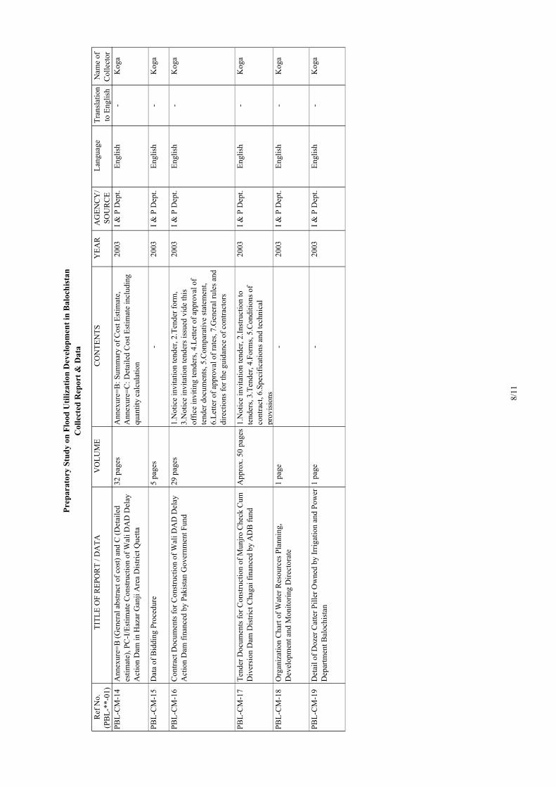
Ref
No.
(PB
L-**
-01)
TITL
E O
F R
EPO
RT
/ DA
TAV
OLU
ME
CO
NTE
NTS
YEA
RA
GEN
CY
/SO
UR
CE
Lang
uage
Tran
slat
ion
to E
nglis
hN
ame
ofC
olle
ctor
Prep
arat
ory
Stud
y on
Flo
od U
tiliz
atio
n D
evel
opm
ent i
n B
aloc
hist
anC
olle
cted
Rep
ort &
Dat
a
PBL-
CM
-14
Ann
exur
e=B
(Gen
eral
abs
tract
of c
ost)
and
C (D
etai
led
estim
ate)
, PC
-I/E
stim
ate
Con
stru
ctio
n of
Wal
i DA
D D
elay
Act
ion
Dam
in H
azar
Gan
ji A
rea
Dis
trict
Que
tta
32 p
ages
Ann
exur
e=B
: Sum
mar
y of
Cos
t Est
imat
e,A
nnex
ure=
C: D
etai
led
Cos
t Est
imat
e in
clud
ing
quan
tity
calc
ulat
ion
2003
I & P
Dep
t.En
glis
h-
Kog
a
PBL-
CM
-15
Dat
a of
Bid
ding
Pro
cedu
re5
page
s-
2003
I & P
Dep
t.En
glis
h-
Kog
a
PBL-
CM
-16
Con
tract
Doc
umen
ts fo
r Con
stru
ctio
n of
Wal
i DA
D D
elay
Act
ion
Dam
fina
nced
by
Paki
stan
Gov
ernm
ent F
und
29 p
ages
1.N
otic
e in
vita
tion
tend
er, 2
.Ten
der f
orm
,3.
Not
ice
invi
tatio
n te
nder
s iss
ued
vide
this
offic
e in
vitin
g te
nder
s, 4.
Lette
r of a
ppro
val o
fte
nder
doc
umen
ts, 5
.Com
para
tive
stat
emen
t,6.
Lette
r of a
ppro
val o
f rat
es, 7
.Gen
eral
rule
s and
dire
ctio
ns fo
r the
gui
danc
e of
con
tract
ors
2003
I & P
Dep
t.En
glis
h-
Kog
a
PBL-
CM
-17
Tend
er D
ocum
ents
for C
onst
ruct
ion
of M
unjro
Che
ck C
umD
iver
sion
Dam
Dis
trict
Cha
gai f
inan
ced
by A
DB
fund
App
rox.
50
page
s1.
Not
ice
invi
tatio
n te
nder
, 2.In
stru
ctio
n to
tend
ers,
3.Te
nder
, 4.F
orm
s, 5.
Con
ditio
ns o
fco
ntra
ct, 6
.Spe
cific
atio
ns a
nd te
chni
cal
prov
isio
ns
2003
I & P
Dep
t.En
glis
h-
Kog
a
PBL-
CM
-18
Org
aniz
atio
n C
hart
of W
ater
Res
ourc
es P
lann
ing,
Dev
elop
men
t and
Mon
itorin
g D
irect
orat
e1
page
-20
03I &
P D
ept.
Engl
ish
-K
oga
PBL-
CM
-19
Det
ail o
f Doz
er C
atte
r Pill
er O
wne
d by
Irrig
atio
n an
d Po
wer
Dep
artm
ent B
aloc
hist
an1
page
-20
03I &
P D
ept.
Engl
ish
-K
oga
8/11

Ref
No.
(PB
L-**
-01)
TITL
E O
F R
EPO
RT
/ DA
TAV
OLU
ME
CO
NTE
NTS
YEA
RA
GEN
CY
/SO
UR
CE
Lang
uage
Tran
slat
ion
to E
nglis
hN
ame
ofC
olle
ctor
Prep
arat
ory
Stud
y on
Flo
od U
tiliz
atio
n D
evel
opm
ent i
n B
aloc
hist
anC
olle
cted
Rep
ort &
Dat
a
PBL-
CM
-20
Com
posi
te S
ched
ule
of R
ates
199
8 V
olum
e-I,
July
199
8A
ppro
x. 3
00pa
ges
1.C
arria
ge, 2
.Loa
ding
, Un-
load
ing
and
stac
king
,3.
Earth
wor
k, 4
.Dis
man
tling
(Dem
oliti
on),
5.Pl
ain
and
rein
forc
ed c
oncr
ete,
6.P
rest
ress
edco
ncre
te, 7
.Pile
foun
datio
n co
ncre
te, 8
.Dam
ppr
oof c
ours
e an
d w
ater
pro
ofin
g, 9
.Cem
ent
conc
rete
blo
ck m
ason
ry, 1
0.C
emen
t con
cret
eho
llow
blo
ck m
ason
ry, 1
1.B
rick
wor
k, 1
2.St
one
mas
onry
, 13.
Roo
fing,
14.
Flor
ing,
15.
Fini
shin
g,16
. Woo
d w
ork,
17.
Pain
ting
and
varn
ishi
ng,
18.L
inin
g of
can
als,
19.P
rote
ctio
n an
d di
vers
ion
wor
ks, 2
0.O
utle
ts, 2
1.R
oad
and
road
stru
ctur
es,
22.S
heet
pili
ng, 2
3.Pl
umbi
ng, s
anita
ryin
stal
latio
ns a
nd g
as fi
tting
s, 24
.Sur
face
drai
nage
, 25.
Sew
erag
e, 2
6.Si
nkin
g of
wel
ls,
27.T
ubew
ell a
nd w
ater
supp
ly, 2
8.Ir
on st
eel a
ndal
umin
um w
ork,
29.
Hor
ticut
ure,
30.M
isce
llane
ous,
31.E
lect
rical
inst
alla
tions
,an
d B
asic
Dat
a co
mpr
isin
g m
ater
ial p
rice,
labo
rw
age
and
rent
al c
harg
e of
equ
ipm
ent
1998
Gov
ernm
ent
ofB
aluc
hist
an
Engl
ish
-K
oga
PBL-
CM
-21
Com
posi
te S
ched
ule
of R
ates
198
6, S
peci
ficat
ions
, Par
t I,
Con
stru
ctio
n M
ater
ials
App
rox.
200
page
sC
hapt
er I
:Def
initi
ons a
nd te
rmin
olog
y, C
hapt
erII
:Wat
er, C
hapt
er II
I :C
emen
ting
mat
eria
ls,
Cha
pter
IV :C
lay
bric
ks a
nd ti
les,
Cha
pter
V:S
peci
al ti
les,
Con
cret
e til
es, G
laze
d tit
les,
Slat
e til
es, C
hapt
er V
I :A
ggre
gate
and
iner
tm
ater
ials
, Cha
pter
VII
:Sto
ne, C
hapt
er V
III
:Tim
ber,
Cha
pter
IX :P
aint
s, di
stem
pers
and
varn
ish,
Cha
pter
X :M
etal
s and
allo
ys, C
hapt
er X
I:C
oal,
Cha
pter
XII
:Bitu
men
and
tar,
Cha
pter
XII
I:S
anita
ry a
pplia
nces
and
fitti
ngs,
Cha
pter
XIV
:Pip
esC
hapt
erX
V:M
isce
llane
ous
1986
Gov
ernm
ent
ofB
aluc
hist
an
Engl
ish
-K
oga
PBL-
CM
-22
Com
posi
te S
ched
ule
of R
ates
198
7, S
peci
ficat
ions
, Par
t II,
Exec
utio
n of
Wor
ksA
ppro
x. 5
60pa
ges
Cha
pter
16.
Car
riage
and
mat
eria
ls, C
hapt
er 1
7.Ea
rthw
ork,
Cha
pter
18.
Dis
man
tling
and
prep
arat
ion
of si
te, C
hapt
er 1
9. M
orta
rs, C
hapt
er20
. Con
cret
e, C
hapt
er 2
1. B
rickw
ork,
Cha
pter
22. S
tone
mas
onry
, Cha
pter
23.
Roo
fing,
Cha
pter
24. F
loor
ing,
Cha
pter
25.
Sur
face
rend
erin
gs,
Cha
pter
26.
Woo
dwor
k, C
hapt
er 2
7. P
aint
ing
and
varn
ishi
ng, C
hapt
er 2
8. L
inin
g of
can
als,
Cha
pter
29. P
iles a
nd p
ile d
rivin
g, C
hapt
er 3
0. R
iver
1986
Gov
ernm
ent
ofB
aluc
hist
an
Engl
ish
-K
oga
9/11

Ref
No.
(PB
L-**
-01)
TITL
E O
F R
EPO
RT
/ DA
TAV
OLU
ME
CO
NTE
NTS
YEA
RA
GEN
CY
/SO
UR
CE
Lang
uage
Tran
slat
ion
to E
nglis
hN
ame
ofC
olle
ctor
Prep
arat
ory
Stud
y on
Flo
od U
tiliz
atio
n D
evel
opm
ent i
n B
aloc
hist
anC
olle
cted
Rep
ort &
Dat
a
PBL-
CM
-23
Prof
ile -
MO
OSA
JAN
- G
over
nmen
t Con
tract
orA
ppro
x. 1
00pa
ges
A.A
ffid
avits
, B.R
enew
al, C
.Pak
ista
n En
gine
erin
gC
ounc
il, D
.Inco
me
tax
certi
ficat
e, E
.Ban
kst
atem
ents
, F.L
ist o
f tec
hnic
al st
affs
and
oth
erpe
rson
al m
anag
eria
l sta
ffs,
G.L
ist o
f mac
hine
ry,
H.W
ork
orde
rs, I
.Lis
t of w
ork
com
plet
ed,
J.Per
form
ance
of w
ork
certi
ficat
es, K
.Pre
-qu
alifi
catio
n
-H
AJI
MO
OSA
JAN
(Con
tract
or)
Engl
ish
-K
oga
PBL-
CM
-24
Abs
tract
of M
achi
nery
Rec
eive
d fo
r Com
mun
icat
ion
and
Wor
ks D
epar
tmen
t1
page
List
of m
achi
nery
ow
ned
by C
&W
dep
t.20
03C
omm
unic
atio
n an
dW
orks
Engl
ish
-K
oga
PBL-
CM
-25
List
of M
achi
nery
and
Equ
ipm
ent
4 pa
ges
List
of m
achi
nery
and
equ
ipm
ent w
ith p
rese
ntst
atus
, ow
ned
by C
&W
dep
t.20
03C
omm
unic
atio
n an
dW
orks
Engl
ish
-K
oga
PBL-
CM
-26
Hire
Cha
rge
of e
ach
Equi
pmen
t1
page
Ren
tal c
harg
e lis
t of e
ach
equi
pmen
t20
03C
omm
unic
atio
n an
dW
orks
Engl
ish
-K
oga
PBL-
CM
-27
Mac
hine
ry (R
ig D
ozer
s and
Hea
vy M
achi
nery
)1
page
List
of m
achi
nery
ow
ned
by P
ublic
Hea
lthEn
gine
erin
g D
ept.
2003
Publ
icH
ealth
Engi
neer
ing
Engl
ish
-K
oga
PBL-
CM
-28
PC-I
for P
rocu
rem
ent o
f Rig
s, Sp
are
Parts
, Too
ls,
Acc
esso
ries
17 p
ages
-20
03Pu
blic
Hea
lthEn
gine
erin
gD
epar
tmen
t
Engl
ish
-K
oga
PBL-
CM
-29
PC-I
for P
rocu
rem
ent o
f Spa
re P
arts
of R
igs a
nd S
tain
less
Stee
l Scr
een
Pipe
s for
Tub
ewel
ls17
pag
es-
2003
Publ
icH
ealth
Engi
neer
ing
Engl
ish
-K
oga
Ref
eren
ces S
uppl
ied
by J
ICA
Tok
yo
PBL-
JI-0
1「地下
水涵養ダム計画調査」主報告書、平成
9年6月
、国際
協力事業団
235 頁
と添
付資
料
地下水涵養ダム計画に係る開発調査
1997
JIC
A日本語
-調査団
PBL-
JI-0
2Su
rvey
and
Eva
luat
ion
of D
elay
Act
ion
Dam
s in
Bal
ochi
stan
,W
ater
Res
ourc
es R
esea
rch
Cen
tre Q
uetta
28 p
ages
and
figire
sR
epor
t on
surv
ey a
nd e
valu
atio
n of
del
ay a
ctio
nda
ms
1989
WR
RC
inPC
RW
REn
glis
h-
Stud
yte
am
PBL-
JI-0
3R
esea
rch
Stud
y on
Sur
vey
and
Eval
uatio
n of
Del
ay A
ctio
nD
ams i
n B
aloc
hist
an, W
ater
Res
ourc
es R
esea
rch
Cen
treQ
uetta
47 p
ages
and
tabl
es &
figu
res
Rep
ort o
f res
each
stud
y on
surv
ey a
nd e
valu
atio
nof
del
ay a
ctio
n da
ms
47 p
ages
and
tabl
es&
figu
res
WR
RC
inPC
RW
REn
glis
h-
Stud
yte
am
10/1
1
Ref
No.
(PB
L-**
-01)
TITL
E O
F R
EPO
RT
/ DA
TAV
OLU
ME
CO
NTE
NTS
YEA
RA
GEN
CY
/SO
UR
CE
Lang
uage
Tran
slat
ion
to E
nglis
hN
ame
ofC
olle
ctor
Prep
arat
ory
Stud
y on
Flo
od U
tiliz
atio
n D
evel
opm
ent i
n B
aloc
hist
anC
olle
cted
Rep
ort &
Dat
a
PBL-
JI-0
4R
epor
t on
Del
ay A
ctio
n D
ams a
s Mea
ns fo
r Arti
ficia
lR
echa
rge
in B
aloc
hist
an, P
akis
tan
Cou
ncil
of R
esea
rch
inW
ater
Res
ourc
es
7 pa
ges a
nd ta
bles
Brie
f pap
er o
n gr
ound
wat
er re
char
ge w
ith D
elay
Act
ion
Dam
s20
02PC
RW
REn
glis
h-
Stud
yte
am
PBL-
JI-0
5C
onci
se P
rofil
e W
ater
Res
ourc
es R
esea
rch
Cen
tre (W
RR
C)
Que
tta (1
987
to 2
003)
29 p
ages
and
figur
esEx
plan
atio
n of
con
cise
pro
file
Wat
er R
esou
rces
Res
earc
h C
entr
(WR
RC
) Que
tta20
03W
RR
C in
PCR
WR
Engl
ish
-St
udy
team
PBL-
JI-0
6Pr
ocee
ding
s of R
egio
nal W
orks
hop
on A
rtific
ial
Gro
undw
ater
Rec
harg
e, Q
uetta
, Pak
ista
n. 1
0-14
June
199
6,Pa
kist
an C
ounc
il of
Res
earc
h in
Wat
er R
esou
rces
,
272
page
sPr
ocee
ding
s of w
orks
hop
1996
PCR
WR
,U
NES
CO
,W
RR
C
Engl
ish
-St
udy
team
PBL-
JI-0
7A
rea
Dev
elop
men
t Pro
gram
me
Bal
ochi
stan
, Ann
ual
Prog
ress
Rep
ort 1
999,
Uni
ted
Nat
ions
Dev
elop
men
tPr
ogra
mm
e, W
orld
Foo
d Pr
ogra
mm
e, P
lann
ing
&D
evel
opm
ent D
epar
tmen
t Gov
ernm
ent o
f Bal
ochi
stan
,
28 p
ages
and
anne
xes
Brie
fing
pape
r on
proj
ects
ove
rsee
n by
UN
DP
and
Gov
ernm
ent o
f Bal
ochi
stan
1999
UN
DP,
WFP
, P&
DD
ept.
Engl
ish
-St
udy
team
PBL-
JI-0
8A
rea
Dev
elop
men
t Pro
gram
me
Bal
ochi
stan
, Ann
ual
Prog
ress
Rep
ort 2
000,
Uni
ted
Nat
ions
Dev
elop
men
tPr
ogra
mm
e, W
orld
Foo
d Pr
ogra
mm
e, P
lann
ing
&D
evel
opm
ent D
epar
tmen
t Gov
ernm
ent o
f Bal
ochi
stan
,
40 p
ages
and
anne
xes
Brie
fing
pape
r on
proj
ects
ove
rsee
n by
UN
DP
and
Gov
ernm
ent o
f Bal
ochi
stan
2000
UN
DP,
WFP
, P&
DD
ept.
Engl
ish
-St
udy
team
PBL-
JI-0
9A
rea
Dev
elop
men
t Pro
gram
me
Bal
ochi
stan
, Ann
ual
Prog
ress
Rep
ort 2
001,
Uni
ted
Nat
ions
Dev
elop
men
tPr
ogra
mm
e, W
orld
Foo
d Pr
ogra
mm
e, P
lann
ing
&D
evel
opm
ent D
epar
tmen
t Gov
ernm
ent o
f Bal
ochi
stan
,
40 p
ages
and
anne
xes
Brie
fing
pape
r on
proj
ects
ove
rsee
n by
UN
DP
and
Gov
ernm
ent o
f Bal
ochi
stan
2002
UN
DP,
WFP
, P&
DD
ept.
Engl
ish
-St
udy
team
PBL-
JI-1
0A
rea
Dev
elop
men
t Pro
gram
me
Bal
ochi
stan
, Ann
ual
Prog
ress
Rep
ort 2
002,
Uni
ted
Nat
ions
Dev
elop
men
tPr
ogra
mm
e(U
ND
P), W
orld
Foo
d Pr
ogra
mm
e(W
FP),
Gov
ernm
ent o
f Bal
ochi
stan
(GoB
)
64 p
ages
and
anne
xes
Brie
fing
pape
r on
proj
ects
ove
rsee
n by
UN
DP
and
Gov
ernm
ent o
f Bal
ochi
stan
2002
UN
DP,
WFP
, P&
DD
ept.
Engl
ish
-St
udy
team
PBL-
JI-1
1Po
verty
and
Vul
nera
bilit
y in
Sou
th A
saia
70 p
ages
Pape
r on
pove
rty a
nd v
ulne
rabi
lity
2002
WB
Engl
ish
-St
udy
team
PBL-
JI-1
2B
ridgi
ng T
roub
led
Wat
ers A
sses
sing
Wor
ld B
ank
Wat
erR
esou
rces
Stra
tegy
116
page
sPa
per o
n w
ater
reso
urce
s stra
tegy
2002
WB
Engl
ish
-St
udy
team
11/1
1