Embed Size (px)
Citation preview
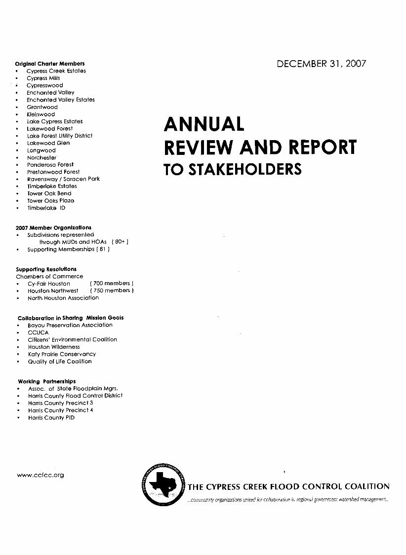
Original Charter Members Cypress Creek Estates Cypress Mills Cypresswood Enchanted Valley Enchanted Valley Estates Grantwood Kleinwood Lake Cypress Estates Lakewood Forest Lake Forest Utility District Lakewood Glen Longwood Norchester Ponderosa Forest - Prestonwood Forest Ravensway / Saracen Park Timberlake Estates Tower Oak Bend Tower Oaks Plaza Timberlake ID
2007 Member Organizations Subdivisions represented
through MUDS and HOAs ( 80+ ) Supporting Memberships ( 81 )
Supporting Resolutions Chambers of Commerce
Cy-Fair Houston ( 700 members ] Houston Northwest ( 750 members ] North Houston Association
Collaboration in Sharing Mlsslon Goals Bayou Preservation Association CCUCA Citizens' Environmental Coalition Houston Wilderness Katy Prairie Conservancy Quality of Life Coalition
Working Partnerships Assoc. of State Floodplain Mgrs. Harris County Flood Control District Harris County Precinct 3 Harris County Precinct 4 Harris County PID
DECEMBER 31,2007
ANNUAL REVIEW AND REPORT TO STAKEHOLDERS
I
THE CYPRESS CREEK FLOOD CONTROL COALITION . community organlzatrons unrted ior collaborat~on In reg~onal government watershed management
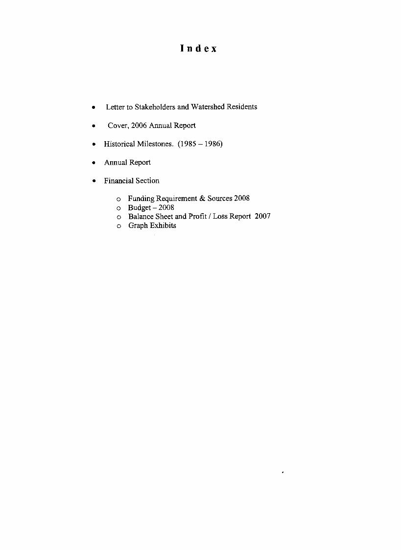
I n d e x
Letter to Stakeholders and Watershed Residents
Cover, 2006 Annual Report
Historical Milestones. (1985 - 1986)
Annual Report
Financial Section
o Funding Requirement & Sources 2008 o Budget - 2008 o Balance Sheet and Profit / Loss Report 2007 o Graph Exhibits
Letter to the Stakeholders and Watershed Residents.
2007 finished with notable accomplishments and cautious optimism looking into the future. The mission goals agreed when our 1999 charter was crafted in the shadow of the 1998 and 1994 flooding continued to be the driving force for your Board of Directors in this 9th year of the Cypress Creek Flood Control Coalition (CCFCC) existence. The greatest accomplishment of which I am very pleased to report is the recognition given CCFCC by our elected politicians, top-level government officials and the private sector as the respected community voice in representing and obtaining their cooperation and assistance in the quest for our goals. Actions and events directly and / or indirectly influencing progress on achieving our charter goals include:
Drainage / Flood Damage Reduction: "Cause and effect" research essential for correcting significant flaws in FEMA computer modeling which has under calculated the Upper Cypress Creek Watershed floodplains was completed. Discussions over the last 2 years laying the groundwork for joint planning between CCFCC and HCFCD in 2008 concerning financing strategies for the master watershed plan were successfully concluded. The "Upper Langham Creek Frontier Program Feasibility Study" was completed by HCFCD thereby setting the stage as a possible prototype for our watershed. The Board was briefed by HCFCD on their Upper Cypress Creek Watershed flooding easements. (Total 5,227 acres acquired to date). Excavation of the Cypress Creek regional detention basin / nature preserve adjacent to the North Eldridge Parkway neared completion.
Legal: FEMA adopted the erroneous TSARP floodplains delineation (understated locations and depths) and is now in court faced with a federal judge denial of their motions to dismiss a lawsuit filed by the Sierra Club to stop such action. Although technical facts supporting the Sierra litigation includes data derived from CCFCC's research, we are not a party to the litigation.
Preservation / Reforestation 'The Cypress Creek Greenway Project continued to attact increased and wide spread community and local goverenment interest as the foundation and cornerstones for CCFCC preservation undertakings. A $95 million Harris County bond package for parks on the November ballot which includes funds critical to development within the Cypress Creek watershed was approved by voters. Eight (8) projects in their 12,500 square mile Gulf Coast Planning region received "Best of the Best" honor awards given by the Houston-Galveston Area Council in recognition for best practices and innovative approaches. Two of the 8 projects in this entire 13-county area are in the Cypress Creek Watershed 1 Cypress Creek Greenway Project corridor. Details are provided in this report. A mitigation initiative, 3-years in the making, encompassing wetlands in the Spring Creek and Cypress Creek watersheds was signed by the US Army Corps of Engineers and Legacy Land Trust. Houston passed a new ordinance requiring developers to share in park costs. (Will Harris County follow suit?). c o n t i n u e d n e x t p a g e . . . . . . .

TxDOT planted 30,705 trees at a cost of $2.1 million in a reforestation project along Texas State Highway 249 - - a main traffic artery intersecting the Cypress Creek Watershed.
Engineering Research Engineering research continues to be the backbone of CCFCC's flood mitigation program. Refer to the Financial Section of this report for details. Legislation was signed in June by Texas Gov. Rick Perry making Rice University home to Texas' first research center focused exclusively on predicting and planning for disasters caused by hurricanes and tropical storms. CCFCC also completed pre- contract reviews (including consultation with the Association of State Floodplain Managers) and issued a contract to the Center's Director, Dr. Phillip Bedient, the Herman Brown Professor of Engineering and one of the nation's foremost experts on urban flooding to manage a "No Adverse Impact" [NAI) research project encompassing the Cypress Creek Watershed.
Communications: The 2006 Annual Report contains considerable background Information about the watershed and our Coalition's goals which provides a wealth of knowledge on these subjects. You are encouraged to read this 2007 Annual Report as an appendix to the 2006 Annual Report.
Preparation of monthly public service news articles and continued website upgrading was resumed and the work is now once again being done at no cost by members of your Board of Directors. We hope to contract for outside services in 2008.
Plans for 2008: Continued collaboration with the Texas Department of Transportation [TxDOT), Harris County Flood Control District (HCFCD) and elected officials to identify, acquire and excavate land for major regional detention to service both transportation and urban development in the Upper Cypress Creek Watershed Complete action to correctly identify and regulate development in the Upper Cypress Creek Watershed based on the true base flood elevations. Re-institute research on the "Future Conditions Flood Hazard Boundary" computer simulation analysis. Seek government and private sector commitments to provide key property easements supporting the Cypress Creek Greenway Project development. Locate fund raising leadership and develop a broader base of membership participation. Con.linue participation in an advisory role concerning the following:
o The Urban Stormwater Management Study o The Cypress Creek Watershed Stormwater Management Program o The Harris County Flood Control Task Force [appointment by Harris County
Commissioners Court o Director appointments to the Board of Directors for the Bayou Preservation
Association (BPA) and the Friends of Kickerillo Mischer Preserve.
Richard D. Smith, President Cypress Creek Flood Control Coalition
Letter to the Stakeholders 2007 Rev 1
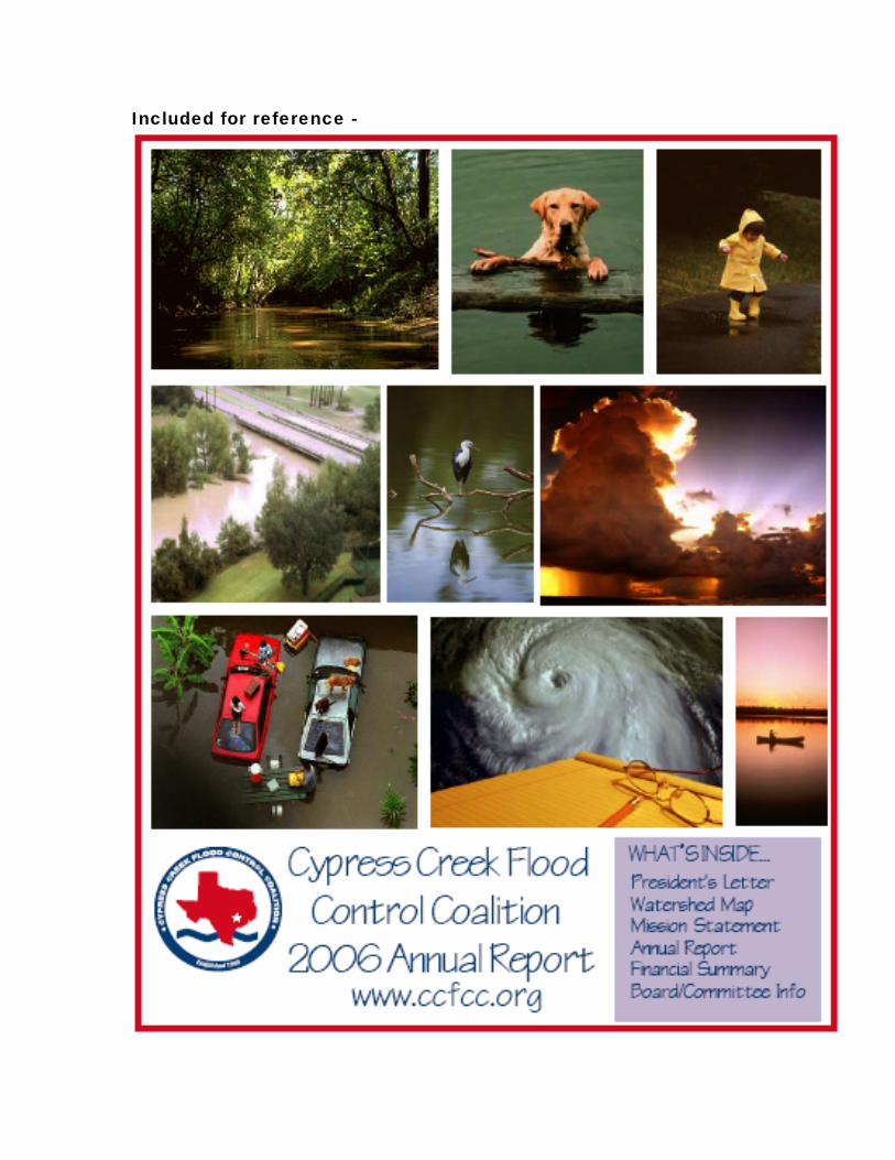
Included for reference -

Historical Milestones
1986 The U.S. Army Corps of Engineers (USACE) presented a plan covering channel construction between the mouth of Spring Creek and U.S. Highway 290 for protection against 10-year frequency floods. It included recreation and environmental mitigation plans. Right-of-way to accommodate the channel ranged from 150 to 350 feet wide. The initial cost estimate was $125 million (1 986 dollars). Congressman Bill Archer successhlly got the project approved and funded in the Water Resources Act of 1988 (PL 100-676). Twelve years later, USACE reported that Harris County no longer supported the 1986 plan because they "desire a project which is less structural and more environmentally pleasing." HCFCD said the plan was not implemented "due to concerns that a wider Cypress Creek would cause adverse flooding impacts on Spring Creek," and that "as time went on, the federal economic justification could no longer be met."
On November 18, 1986, the HCFCD Director submitted a letter to Commissioners Court advising that the TC&B master drainage plan was nearing completion and "has been performed in conformance with the criteria established by the District's drainage policy for the Cypress Creek Watershed" and "will present a reasonable approach to stormwater management and will include a regional detention plan in conjunction with.. ."
The letter recommended and Commissioners Court approved a $4,000 per acre contribution (impact fee) to be collected from developers in Cypress Creek watershed noting, "Adjustments to this amount may be necessary to take into fact inflation and actual project costs". . ."The regional program for the Cypress Creek watershed will provide a drainage system utilizing all present facilities". . . and "although the regional detention facilities will be large in size, [they will] have [the] potential to serve as recreational sites."
1985 Floodplain mapping for FEMA adoption was officially approve in September and published in the FEMA Flood Insurance Study.
source: "Historical MClestone~" , CCFCC website www.ccfcc.org

Annual Report Year Ending December 31,2007
Although Harris County's 2007 rainfall of 65.5 inches was 36% above the annual average,
notable flooding fortunately did not occur. This compares to 73,000 homes being flooded
when only 6 more inches fell in 2001, the year Tropical Storm Allison pummeled the Gulf
Coast. The challenges set forth in CCFCC's 1999 Charter were met during the year with
enthusiasm, great energy, occasional frustration and a lot of hard work by your elected
volunteer directors. The 2007 highlights and 2008 plans summarized below will be better
understood if one reads this information as a continuation from the 2006 Annual Report
(which is also available on request and is on our website).
Flood Damage Reduction: To better comprehend the dynamics of storm water flooding
and what must be done for us to obtain effective flood damage reduction in the Cypress
Creek watershed, it is fundamental we, the residents, understand that the storm water
volume and drainage rate of flow moving in an easterly direction and down hill from the
Upper Cypress Creek watershed to lower elevation communities is highly dependent on the
lay of the land. Thus it is critical to the whole process of flood damage management
throughout the watershed that these processes be accurately measured (and subsequently
monitored for change). This information is basic in the creation of effective regulations
governing land fill, new development drainage, wetlands preservation, storm water
detention I controlled release rates and other factors which, if followed, will prevent andlor
lessen the extent of out-of-bank stream flooding from becoming worse than it would if the
land were left in its natural state.
If the base flood elevation (BFE) measurements and attendant floodplain mapping are in
error, it will likely lead to erroneous assumptions in land development permits andlor design I
construction of flood damage protection infrastructure. Taking this into account led to the
Board's decision 5 years ago to undertake research - - - - consistent with our Charter
requirements - - - - to verify the accuracy of this critical information.
CCFCC has just completed a very successful initiative to assure the soundness of the
computer modeling of Cypress Creek that is relied on by Harris County. These models
predict the behavior of the creek during rainfall conditions and provide the basis for actions

by the County in regard to creek flood mitigation, including for example new development
permitting and construction of flood mitigation facilities.
When FEMA issued new flood plain maps for Cypress Creek based on modeling done
after Hurricane Allison, CCFCC undertook what became a comprehensive technical review
of the revised models. We identified a number of predicted creek behaviors that had
significant deviation from historical factual data, in specific areas in the western part of the
Cypress Creek Watershed. When we advised the Harris County Flood Control District of
these findings, they acknowledged the need for further review, which kicked off a lengthy,
collaborative study with CCFCC, wherein HCFCD undertook intensive engineering
evaluations. The result was that HCFCD created, and adopted a revised model that now
satisfactorily predicts creek behavior.
This remodeling effort now provides the basis for the reactivation of a research study that
CCFCC had requested, and HCFCD undertook, earlier in the decade, to model what
Cypress Creek behavior would be assuming the watershed were fully developed (called the
"Future Conditions Flood Hazard Boundary Study)". This study had been put on hold
understandably when the weaknesses in the model at that time were recognized; with the
new model in hand, HCFCD is soon to reactivate that study and push it to completion.
There is a regulatory philosophy, for watersheds, that is referred to as 'No Adverse
Impact". Harris County endorses this philosophy. However, the execution of it unavoidably
involves many uncertainties that strain the limits of conventional technology. An initiative is
underway at Rice University, under Dr. Phil Bedient, to develop the technology and
application methods needed to remove many of these uncertainties. We have sponsored an
effort by Dr. Bedient and his students, to apply his new concepts to Cypress Creek, in order
to establish with finer accuracy than ever before, what it takes in the way of flood mitigation
facilities in order for new developments in Cypress Creek Watershed to truly have "no
adverse impact". .
Preservation and Reforestation. In reporting on this top goal of the CCFCC alliance, it is
appropriate to look back a few years in the watershed history. Our files contain a letter dated
November 30, 1982 form the Harris County Parks Planning Department. Written to one of
our future directors, it advises,
"The Cypress Creek Parks Project was initiated in 1976 by Judge Jon
Lindsay's office. Since that time approximately 1800 acres have been acquired along
Cypress and Spring Creeks. These sites will provide both outdoor recreation needs
and provide a measure of flood control. When completed there should be an
approximate total of 2,600 acres of land. We are still concentrating on acquisition
rather than development because of the escalating cost of land. However, two sites
have been developed. Elizabeth K. Meyer Park. . . and Jessie H. Jones. . . Both
are located on the enclosed map.,"
For reasons unknown to CCFCC, this visionary quality-of-life project languished for several
decades. Surely it was not an unintended victim of the Cypress Creek community's
environmentally-based objections combined with the HCFCD decision to stop the U.S. Army
Corps of Engineers plan for channel construction between the mouth of Sprirrg Creek and
U.S. Highway 290, In any event, Judge Jon Lindsay's historical vision was resurrected by the
Cypress Creek Flood Control Coalition in the wrappings of their "Preservation Mission
Statement" and the "Cypress Creek Greenway Project".
2007 witnessed a healthy and growing recognition by the land development community in
the value of "green" development in addition to increased interest by municipal utility districts
in park and trail development. A movement is clearly underway.
The Cypress Creek Greenway Project (CCGP) continues to be CCFCC's primary means
to focus on its objective of preservation within the Cypress Creek watershed. The Greenway
will create a continuous linear greenbelt along Cypress Creek stretching from west of US 290
to the east where it connects with the Spring Creek Greenway. 'The Greenway will connect a
series of existing and future anchor parks and will include a multipurpose trail system along
the entire length of the Greenway.
The Greenway as envisioned by CCFCC will constitute a significant element in the
community goal to build a less flood-prone environment. Preserving floodway land and
where needed the adjacent 5-1 0 year floodplain, it can serve as the multi-purpose riparian
channel for floodwater conveyance along Cypress Creek and simultaneously provide
recreational opportunities, preserve the existing natural habitat and be a way to develop
awareness of the cultural and historical significance of Cypress Creek.

The CCGP advocates the development of the Greenway by encouraging a collaborative
effort among numerous participants which include Precinct 3 and 4 Parks' Departments,
HCFCD, land developers, MUD's, Hoe's, businesses, civic organizations, our elected
officials and individuals. MUD's are a key player in developing the Greenway and we have
met with 25 MUD boards to make them aware of the CCGP and to encourage their
participation.
Several things have occurred during 2007, or are in progress, to move the CCGP effort
forward. Among them are:
A $95 million Harris County bond issue for parks was approved by voters in
November. Some of those funds may be made available for use on the Cypress
Creek Greenway and to develop new anchor parks.
A board of directors has been established for the Friends of the Kickeriilo Mistier
Preserve. This non-profit organization will work with Precinct 4 in planning for and
developing the Kickerillo Mischer Preserve, a 100 acre wooded tract including a 40
acre lake along Cypress Creek at SH 249. V&W Partners, Ltd., a joint venture of
Kickerillo and Mischer, will be transferring this acreage to Harris County later in 2008.
V&W has funded the creation of a conceptual plan for the Preserve.
The Friends of the Kickerillo Mischer Preserve received a 2007 Parks and Natural
Area Regional "Best of the Best" Honor Award from the HGAC for the planning done
by the community, developer and Precinct 4 Parks Department leading to the creation
of this preserve.
HCFCD purchased 12.5 acres along Cypress Creek for flood plain preservation. This
acreage is adjacent to the 62 acre Coles Crossing Nature Preserve.
The Timber Lane UD dedicated 4.5 miles of trails on two parcels along Cypress
Creek in November. In addition, their residents approved a $6.3 million bond issue
in May for park and trail development, they received a $3.25 million Transportation
Improvement Program grant for building trails and a pedestrian bridge over Cypress
Creek, and they received a $100,000 grant from TPWD. Timber Lane certainly sets a
high bar for others to follow.
Timber Lane LID received 2007 Parks and Natural Areas Regional "Best of the Best"
recognition from the HGAC for their outstanding contribution to the region and their
master park plan.
Harris County Precinct 4 Parks Department will soon begin construction of a
multipurpose trail along Cypress Creek which will connect Meyer and Collins Parks.
4

Funds from a $10,000 grant awarded to the Cypress Creek Flood Control Coalition by
RE1 will be used for signage and benches along the connecting trail. In addition,
Precinct 4 has plans to construct trails along Cypress Creek through both Meyer and
Collins Parks.
Excavation continues on the regional detention basin at Cypress Park site and should
be completed later this year. HCFCD will be developing plans for its work following
completion of the excavation and has $1 million budgeted for this project.
Bridgeland has completed approximately 1.5 miles of trails along Cypress Creek in
the 900 acre corridor which they have set aside along Cypress Creek for preservation
and recreation.
Several MUD'S within the Cypress Creek corridor have park and trail plans in
progress and some of them have the potential for tying into the Cypress Creek
Greenway.
We continue to have interest in, and support for the Greenway from a variety of
sources. Typical of this was an unsolicited $150 contribution to the Cypress Creek
Greenway Project from the Memorial NW Ladybugs Garden Club.
For additional information please visit www.ccfcc.orq, or contact Jim Robertson, Chairman,
Cypress Creek Greenway Project at 281 -370-8243 or [email protected]
Communications: Website upgrading, resumption of our monthly public service Look Upstream newsletter, creation of an internal volunteer Communications Program
Committee and continued sponsorship of guest speakers at the Board's monthly meetings
were the highlights of actions inherent in our Communications 1 Education mission goal.
The website continues to be a depository for a growing wealth of information concerning the
CCFCC mission accomplishments, current events, historical reference material concerning
flooding, land subsidence, preservation, membership and a rather voluminous glossary. As
an example, the 1986 and 1985 "Historical Milestones" copied ,from this section of the website
is provided in this Annual Report.
Plans for 2008: Plans for the future as described in the Cvpress Creek Flood Control
Coalition 2006 Annual Report will carry over into 2008 and beyond. It is an excellent
reference document which we encourage all stakeholders to read for greater understanding
5

of the Cypress Creek Watershed evolving transition from rural country side to large scale
urban development.
Upgrading of the Coalition's funding is of paramount importance in 2008 if the Coalition is to
successfully achieve our goals of the community and local government partnership
developing and implementing a solid flood mitigation plan within the watershed. lnformation
on costs, funding contribution sources, budgets and the funding shortfall which must be
addressed are provided in the Financial lnformation section.
Summary: There are ongoing challenges facing our elected politicians, top-level
government officials and local non-profit organizations which represent the public. These
challenges include the complete of the master watershed storm water management plans,
the evaluation of possible tighter drainage regulations in this watershed taking into
consideration characteristics which are unique from others, the obtaining of funds for and the
construction of major regional detention basins in the Upper Watershed, and finding answers
to deforestation and preservation matter affecting the riparian corridors throughout the major
and tributary channels. These efforts will surely require the deep and respectful cooperation
of the above named groups.
Annual Report 2007

Financial Information 2007 Annual Report
Summary: The main driving forces affecting the 2007 budget plan were:
Budqeted Activities.
The schedule of activities used in the 2007 planning was considerably over-optimistic
resulting in a major reduction in planned expenses across the board. For example,
planned research to model where out-of-bank flooding will spread and how deep
remained "on hold" because recalibration of the FEMA TSARP computers was
prolonged; hence were not useable for this research.
Activities to be funded partially or in total by the RE1 endowment are dependent on
their program planning as it relates to the Cypress Creek Greenway Project. This has
also shifted forward into 2008.
A new "Communications Program Committee" created in 2007 has absorbed work
which was budgeted to outside service providers but is now being done by unpaid
volunteer in-house workers.
The enclosed "Funding Requirement and Sources - 2008" schedule is provided to
support the 2008 budget. Please note this budget will reduce retained earnings to
an extremely slim $5,000 at the end of the year. Financial intelligence /
recommendations from other colleague non-profits are that a 1 -year contingency
fund should be maintained annually..
Fundinq Requirements.
CCFCC has not requested voluntary MUD and/or HOA member organization donations
for several years; relying solely on the (1) limited 50-cent monthly contributions and (2)
retained earnings from prior years. Please refer to the bar chart in this section for detail
(including the projected $28,000 shortfall in 2008 if no action is taken).
continued o n n e x t p a g e . . .

Although the progress was slower than hoped, the success in resolving the Upper
Watershed BFE I floodplain mapping will now free the way forward to resuming the
research projects described elsewhere in this report. Consesuentlv we are askins all
member orsanizations to sive careful consideration to a request to be forthcominq
shortlv to participate in the 50-cent voluntarv donation on monthly water bills. If you are
an HOA I POA I CIA member, please contact any CCFCC director to arrange for a
presentation to your Municipal Utility District if desired for this purpose.
Financial Information 2007

Funding Requirements and Sources 2008
REQUIREMENTS
Engineering Research f$ 000's) Complete evaluation of remapping floodplains I floodway and Upper watershed "overflow" into Addicks watershed $ 5 Complete the "No Adverse Impact" analysis (Rice University students. $10 Resume and complete "Future Conditions Flood Hazard Boundary"
compputer simulation modeling with HCFCD Planning Dept. $35 Drainage I Regional detention basins in Upper Cypress Creek Watershed
to account for NW US 290 - Hempstead comdor project, Grand Parkway, and other Upper Cypress Creek watershed issues including Waller County
o Sub Total Engineering . . . . . . . . . . . . . . . . . . . . . . . . . . . . . . . . . . . . . . . . . $60 Cmress Creek Greenway
RE1 directed work $ 10 Other project costs - $ 1
o Sub total Cypress Creek Greenway . . . . . . . . . . . . . . . . . . . . . . . . . . . . . . $13 Other Expense
Insurance, bookkeeping, website and internet $ 5 Grant applications $ 1 All other $ 8 Contingency - $ 5
o Sub total "Other" $19
TOTAL REQUIRED FVNLN $ 9 2
BUDGETED INCOME AMOUNTS I SOLIRCES
Retained funds carry-over from 2007 o RE1 ' $ 9 o Houston Endowment Inc $ 8 o Unrestricted CCFCC voluntary contrib. $27 o Total retained funds $44
Estimated from current 50-cent per month Resident contributions . . . . . . . . . . . . . . .
SUB-TOTAL . . . . . . . . . . . . . . . . . . . . . . . . . . . . . . . . . . . . . . . . . . . . . $64 -
SHORTAGE ( $28 )3
2008 Funding Reqmts and Sources
1 The RE1 funds must be spent on the Cypress Creek Greenway Project according to their designated requirements.. These are grant funds required to be spent on the "Future Conditions Flood Hazard Boundary" research.
3 T h s shortfall in funds will require additional membershp contributions and/or grant awards.
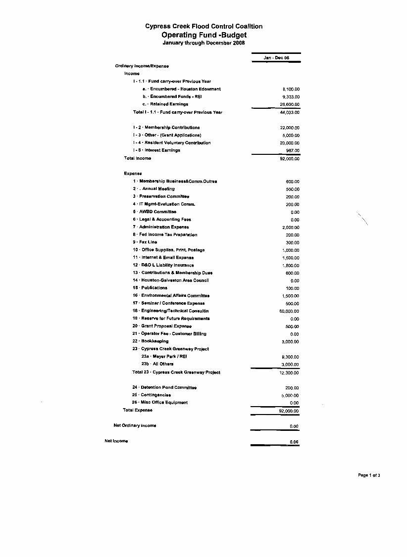
Cypress Creek Flood Control Coalition Operating Fund -Budget January through December 2008
Jan - Dec 08
Ordinary IncomelExpense
lncome
I - 1.1 . Fund canyover Previous Year
a.. Encumbered - Houston Edowment 8,100.00
b. . Encumbered Funds - RE1 9,333.00
c. . Retained Earnings 26.600.00
Total I - 1.1 . Fund canyover Previous Year 44,033.00
I - 2 . Membership Contributions
I - 3 Other - (Grant Applications)
I - 4 . Resident Voluntary Contribution
I - 5 . Interest Earnings
Total lncome
Expense
I . Membemhip Business8Comm.Outrea
2 . . Annual Meeting
3 Preservation Committee
4 . IT Mgmt-Evaluation Comm.
5 . AWBD Committee
6 . Legal 8 Accounting Fees
7 . Administration Expense
8 . Fed lncome Tax Preparation
9 . Fax Llne
10. Office Supplies, Prlnt, Postage
I 1 . Internet 8 Email Expense
12. D&O L Liability Insurance
13 - Contributions (L Membership Dues
14. Houston-Galveston h e r Council
15. Publications
16 . Envlronmental Affaln Committee
17. Seminar I Conference Expense
18. EngineeringlTechnlcal Consultin
19 . Reserve for Future Requirements
20. Grant Proposal Expense
21 . Operator Fee -Customer Billing
22. Bookkeeping
23. Cypress Creek Greenway Project
23a. Meyer Park I RE1
23b. All Others
Total 23. Cypress Creek Greenway Project
24. Detention Pond Committee
25 . Contingencies
26. Misc Office Equipment
Total Expanse
Net Ordinary Income 0.00
Net Income 0.00
Page I of 3

Cypress Creek Flood Control Coalition Profit & Loss
January through December 2007
Jan - Dec 07
Ordinary lncomelExpense
lncome
I - 4 . Resident Voluntary Contribution
I - 5 - Interest Earnings
Total lncome
Expense
1 . Membershlp Business8Comrn.Outrea
5 - AWBD Committee
6 . Legal 8 Accountlng Fees
7 - Admlnistration Expense
9 - Fax Llne
10. Office Supplies, Print, Postage
11 . Internet 8 Email Expense
12 - DBO L Liability Insurance
13 . Contributions 8 Membership Dues
15 - Publications
17 Seminar I Conference Expense
18 - EngineeringKechnicaI Consultin
22. Bookkeeping
23 - Cypress Creek Greenway Project
23a. Meyer Park I RE1 322.82
23b. All Others 2,027.42
Total 23 . Cypress Creek Greenway Project 2,350.24
Total Expense
Net Ordinary Income -19,041.30
Net Income -19,041.30
Page 2 of 3
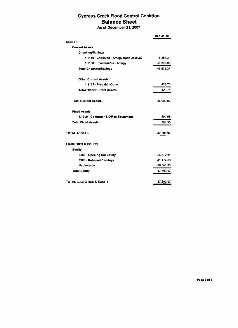
Cypress Creek Flood Control Coalition Balance Sheet
As of December 31,2007
Dec 31.07
ASSETS
Current Assets
Checklng/Savings
1.1110 - Checking - Amegy Bank 3655083
1.1130. investments - Amegy
Total ChecklnglSavings
Other Current Assets
1.1163 . Prepald - Other
Total Other Current Assets
Total Current Assets
Fixed Assets
1.1300 - Computer 8 Office Equipment
Total Fixed Assets
TOTAL ASSETS
LIABILITIES 8 EQUITY
Equity
3000. Opening Bal Equity
3900. Retained Earnings
Net Income
Total Equity
TOTAL LIABILITIES 8 EQUITY
Page 3 of 3

FUNDS RECEIVED/SPENT5 YEAR PERIOD
2003-2007
FUNDS RECEIVED
60%19%
19%2%
50c DONATIONS
GRANTS
MUD AND HOACONTRIBUTIONSINTEREST ONDEPOSITS
FUNDS SPENT
73%
4%
2%
5%
16% ENGINEERING &OTHER SVCSINSURANCE
COMPUTEREQUIPMENTCYPRESS CREEKGREENWAYALL OTHER

FUNDS RECEIVED/SPENTYEAR ENDING DEC 31, 2007
FUNDS RECEIVED
10%
90%
INTEREST ON DEPOSITS 50c DONATIONS
FUNDS SPENT
71%
4%
4%
5%
6%
10%ENGINEERING &OTHER SVCSINSURANCE
COMPUTEREQUIPMENTAWBD CONFERENCE
CYPRESS CREEKGREENWAYALL OTHER

NOTES: 2008 SHORTFALL = $68,000 OF WHICH $40,000 WILL BE COVERED BY2007 RETAINED EARNINGS
NET DIFFERENCE IN FUNDS RECEIVED VS FUNDS SPENT6 YEARS 2003-2008
NET DIFFERENCE IN FUNDS RECEIVED VS FUNDS SPENT 6 YEARS 2003-2008
9.4
34.9
18.1
-11.5-19.1
-28.0-40
-30
-20
-10
0
10
20
30
40
2003 2004 2005 2006 2007 2008 Projected
$ TH
OU
SAN
DS