Embed Size (px)
Citation preview

A World of Solutions
Annual Inspection Report Tecumseh Energy Center Industrial Landfill #0322
Prepared for:
Westar Energy
Tecumseh Energy Center
Tecumseh, Kansas
Prepared by:
APTIM Environmental & Infrastructure, Inc.
Janurary 2018

i Westar Energy January 2018
TABLE OF CONTENTS
1.0 INTRODUCTION .............................................................................................................. 1
2.0 TEC LANDFILL OVERVIEW ........................................................................................... 2
3.0 REVIEW OF AVAILABLE INFORMATION ..................................................................... 3
3.1 SUMMARY OF INSPECTION REPORTS ....................................................................... 3 3.2 SUMMARY OF PREVIOUS ANNUAL INSPECTION REPORT ........................................... 3
4.0 SUMMARY OF 2017 CONSTRUCTION .......................................................................... 4
5.0 INSPECTION SUMMARY ................................................................................................ 5
5.1 VISUAL SIGNS OF DISTRESS OR MALFUNCTION ........................................................ 5 5.2 REVIEW OF ENVIRONMENTAL CONTROL SYSTEMS ................................................... 5
6.0 CONCLUSIONS ............................................................................................................... 6
6.1 CHANGES IN GEOMETRY ......................................................................................... 6 6.2 CCR VOLUME ........................................................................................................ 6 6.3 STRUCTURAL WEAKNESS AND DISRUPTING CONDITIONS ......................................... 6 6.4 CHANGES AFFECTING STABILITY AND OPERATIONS ................................................. 6
7.0 RECOMMENDATIONS .................................................................................................... 7
8.0 RECORDS RETENTION AND MAINTENANCE ............................................................. 8
8.1 INCORPORATION OF PLAN INTO OPERATING RECORD .............................................. 8 8.2 NOTIFICATION REQUIREMENTS ............................................................................... 8
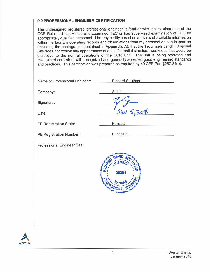
9.0 PROFESSIONAL ENGINEER CERTIFICATION ............................................................ 9

ii Westar Energy January 2018
LIST OF FIGURES AND APPENDICES
FIGURES
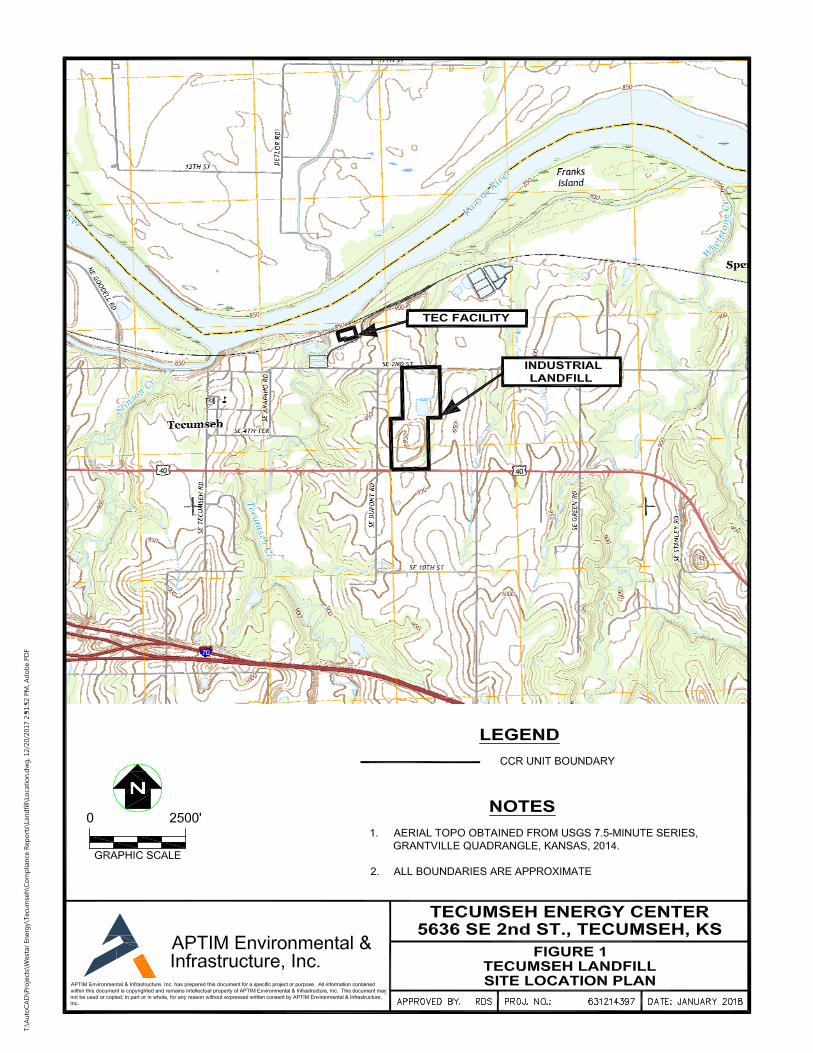
Figure 1 - Tecumseh Landfill, Site Location Plan
Figure 2 - Tecumseh Landfill, Existing Site Topography
Figure 3 - Tecumseh Landfill, Photo Log Plan View
APPENDICES
Appendix A - Annual Inspection Photo Log

iii Westar Energy January 2018
CCR Regulatory Requirements
USEPA CCR Rule Criteria 40 CFR §257.84
Tecumseh Energy Center (TEC) Annual Inspection Report
§257.84(b)(1)(i) stipulates:
“(b) Annual inspections by a qualified professional engineer. (1) Existing and new CCR landfills and any lateral expansion of a CCR landfill must be inspected on a periodic basis by a qualified professional engineer to ensure that the design, construction, operation, and maintenance of the CCR unit is consistent with recognized and generally accepted good engineering standards. The inspection must, at a minimum, include:
(i) A review of available information regarding the status and condition of the CCR unit, including, but not limited to, files available in the operating record (e.g., the results of inspections by a qualified person, and results of previous annual inspections)”
Section 3.0
§257.84(b)(1)(ii) stipulates:
“(b) Annual inspections by a qualified professional engineer. (1) Existing and new CCR landfills and any lateral expansion of a CCR landfill must be inspected on a periodic basis by a qualified professional engineer to ensure that the design, construction, operation, and maintenance of the CCR unit is consistent with recognized and generally accepted good engineering standards. The inspection must, at a minimum, include:
(ii) A visual inspection of the CCR unit to identify signs of distress or malfunction of the CCR unit.”
Section 5.0
Yes

iv Westar Energy January 2018
USEPA CCR Rule Criteria 40 CFR §257.84
Tecumseh Energy Center (TEC) Annual Inspection Report
§257.84(b)(2)(i) stipulates:
“(2) Inspection report. The qualified professional engineer must prepare a report following each inspection that addresses the following:
(i) Any changes in geometry of the structure since the previous annual inspection;”
Section 6.1
§257.84(b)(2)(ii) stipulates:
“(ii) The approximate volume of CCR contained in the unit at the time of the inspection;”
Section 6.2
§257.84(b)(2)(iii) stipulates:
“(iii) Any appearances of an actual or potential structural weakness of the CCR unit, in addition to any existing conditions that are disrupting or have the potential to disrupt the operation and safety of the CCR unit;”
Section 6.3
§257.84(b)(2)(iv) stipulates:
“(iv) Any other change(s) which may have affected the stability or operation of the CCR unit since the previous annual inspection.”
Section 6.4
YES
v Westar Energy January 2018
USEPA CCR Rule Criteria 40 CFR §257.84
Tecumseh Energy Center (TEC) Annual Inspection Report
§257.84(b)(4) stipulates:
(4) Frequency of inspections. The owner or operator of the CCR unit must conduct the inspection required by paragraphs (b)(1) and (2) of this section on an annual basis. The date of completing the initial inspection report is the basis for establishing the deadline to complete the first subsequent inspection. Any required inspection may be conducted prior to the required deadline provided the owner or operator places the completed inspection report into the facility’s operating record within a reasonable amount of time. In all cases, the deadline for completing subsequent inspection reports is based on the date of completing the previous inspection report. For purposes of this section, the owner or operator has completed an inspection when the inspection report has been placed in the facility’s operating record as required by §257.105(g)(9).
Section 1.0
§257.84(b)(5) stipulates:
“(5) If a deficiency or release is identified during an inspection, the owner or operator must remedy the deficiency or release as soon as feasible and prepare documentation detailing the corrective measures taken.”
Section 7.0
§257.84(c) stipulates:
“(c) The owner or operator of the CCR unit must comply with the recordkeeping requirements specified in §257.105(g), the notification requirements specified in §257.106(g), and the internet requirements specified in §257.107(g).”
Sections 8.0
YES

1 Westar Energy January 2018
1.0 INTRODUCTION
Aptim Environmental and Infrastructure, Inc. (Aptim) has prepared the following Annual Landfill Inspection Report (Report) at the request of Westar Energy (Westar) for the Industrial Landfill No. 0322 (Landfill) located at the Tecumseh Energy Center (TEC) in Tecumseh, Kansas. TEC is a coal-fired power plant that has been in operation since 1925. The Landfill has been deemed to be a regulated coal combustion residual (CCR) unit by the United States Environmental Protection Agency (USEPA), through the Disposal of Coal Combustion Residuals from Electric Utilities Final Rule (CCR Rule) Title 40 Code of Federal Regulations (CFR) Part §257 and §261.
In support of compliance to the CCR Rule, Mr. Richard Southorn (a qualified professional engineer with Aptim) conducted an annual site inspection of the Landfill on November 7th 2017. Prior to inspection, Mr. Southorn reviewed the relevant portions of the facility’s operating record and the 2016 Annual Inspection Report in relation to this Report.
This Report meets the requirements set forth within 40 CFR §257.84(b)(1) and (b)(2) based the review of available information and visual observation, to evaluate if the design, construction, operation, and maintenance of the Landfill is consistent with good engineering standards. The annual landfill inspection has been conducted and completed in compliance with the frequency of inspection timeframe set forth in §257.84(b)(4).
2 Westar Energy January 2018
2.0 TEC LANDFILL OVERVIEW
Westar owns and operates an industrial landfill at TEC near Tecumseh, Kansas in Shawnee County. TEC is located approximately 6.5 miles east of Topeka, Kansas and approximately 2 miles north of Highway 70 and resides in Sections 31, Township 11 South, and Range 17 East. The location of the Landfill is depicted in Figure 1. The Landfill is located due southeast of the TEC power plant, on the south side of 2nd Street. The Landfill footprint is approximately 56 acres total with approximately 32 acres used for CCR material disposal and management. The Landfill is being filled in three separate phases: Phase 1 (the northern phase, 7.4 acres), Phase 2 (the southern phase, 15.4 acres), and Phase 3 (the center phase, 9.2 acres) which is located between Phases 1 and 2. Phase 1 has a vegetated soil cap. Phase 2 is operational for current CCR material disposal. Approximately 9.2 acres of the Phase 2 has a final clay cover with established vegetation that meets the CCR Rule requirements. Phase 3 has accepted small quantities of CCR and structural fill in the past year as part of the decommissioning of the Contact Water Management Basin. A Contact Water Management Basin has historically been utilized in Phase 3. However, in 2017, structural fill and small quantities of CCR was placed in the basin and the area was graded to blend with surrounding topography. Woody vegetation was removed as part of this effort. This basin removal construction was completed in an effort to remove the potential water source of the seep that was described in the 2016 Annual Inspection. The final stages of construction were observed as part of the 2017 Annual Inspection. Recent site topography prior to basin infilling is depicted in Figure 2. CCR material is transported from the generation station, fly ash silos, and/or the bottom ash pond for disposal in the Landfill. CCR material is placed, graded by dozers, and compacted. Periodic dozing of the CCR material will occur as needed within the active area to maintain a relatively uniform grade. The CCR material will be wetted prior to the final cover placement and will form a hardened surface as it dries.
3 Westar Energy January 2018
3.0 REVIEW OF AVAILABLE INFORMATION
Prior to the on-site inspection, Mr. Southorn reviewed the available information for the Landfill as provided by Westar:
Annual Inspection Report, Tecumseh Energy Center, Industrial Landfill #0322, CB&I Environmental & Infrastructure, Inc., January 2017.
Kansas Department of Health and Environment – Bureau of Waste Management (KDHE-BWM) Industrial Landfill Permit No. 0322, October 15, 2015.
Tecumseh Energy Center Weekly Inspection Reports, January through October 2017.
Mr. Southorn verified the available information during the annual site inspection on November 7th 2017.
3.1 Summary of Inspection Reports
Based on a review of the routine inspection reports, it was determined that all stormwater conveyance systems are operating as designed. Native grasses along the landfill side slopes have been properly maintained throughout the year. It is noted that animal burrows have been observed along the eastern berm of the Landfill. The United States Department of Agriculture (USDA) and Wildlife Services investigated the burrows. No animals were captured, however, the holes were filled in. There were no other deficiencies or malfunctions noted throughout the year.
3.2 Summary of Previous Annual Inspection Report
Based on a review of the 2016 Annual Inspection Report, it was determined that all landfilling operations and environmental control features were in good working condition and functioning as designed. The 2016 Annual Inspection Report verified the previously reported seeps and noted that no additional seeps were present. Westar completed the clearing and grubbing of woody vegetation on the Landfill cap in 2016 based on the recommendation of the 2015 Annual Inspection Report. It was noted that woody vegetation remained in the previous seep locations. Discussion with Westar indicate that this vegetation will be removed upon agreement of remedial activities by KDHE regarding the seeps. Vegetation along the landfill sideslopes in all other areas was well established and properly maintained. Stormwater drainage features, contact water management systems, and overall site conditions were assessed and were been determined to operate as designed.

4 Westar Energy January 2018
4.0 SUMMARY OF 2017 CONSTRUCTION
As previously noted, in 2017 the Phase 3 Contact Water Management Basin was infilled and removed. The purpose of the basin infilling was to remove the potential water source of the seep to the east. The basin was filled with structural fill and small quantities of CCR, with the upper two feet being comprised of clayey soils. The construction area was in the process of being fine-graded at the time of the 2017 Annual Inspection. A stormwater channel was also being installed along the western toe of slope of the closed Phase II area to promote drainage and remove ponding of water that was occurring outside of the landfill boundary. Seeding had not yet occurred at the time of the Annual Inspection. Construction was on-going and being completed in conjunction with the Phase 3 Contact Water Management Basin filling project.

5 Westar Energy January 2018
5.0 INSPECTION SUMMARY
During the on-site inspection, Mr. Southorn focused on geotechnical signs of distress or malfunction such as slumping at the toe of slopes, tensile cracking, abnormal or excessive erosion on the side slopes or stormwater management facilities slope bulging, and groundwater/surface water seepage or ponding. These visual signs are potential indicators of structural weakness of the Landfill.
It is noted that a seep was observed in 2016, with the likely source of water deriving from the Phase II Contact Water Management Basin. Slope stabilization measures had been taken at the location of the seep in 2016, which included placing riprap along the seep area. In 2017, the basin was removed to eliminate the likely water source of the seep.
5.1 Visual Signs of Distress or Malfunction
Particular focus was spent inspecting the seep area identified in 2016 to ensure that the stabilization techniques were working and that conditions had not worsened since 2016. The slope appeared stable, and no water was observed to be seeping out of the slope. This is likely attributed to construction efforts to remove the Contact Water Management Basin through the placement of structural fill. These activities have removed the likely water source that was observed to be seeping out of the sideslope during 2016.
No new seeps were observed during the 2017 Inspection. Vegetation along the landfill side slopes in all other areas are well established and properly maintained. Stormwater drainage features, contact water management systems, and overall site conditions were assessed and have been determined to operate as designed.
5.2 Review of Environmental Control Systems
With no evidence to the contrary, the environmental control systems at the Landfill are believed to be in good operating condition and functioning as intended. At the time of inspection, stormwater conveyance systems such as the perimeter drainage ditches and outfall pipe were operating as designed. The contact management system is operating as designed and appears to be in good working condition.

6 Westar Energy January 2018
6.0 CONCLUSIONS
Based on a review of the available facility information and on-site inspection, the following conclusions were developed: 6.1 Changes in Geometry
As of the date of this inspection, the Landfill is actively accepting CCR material. Changes in geometry of the Landfill since the previous annual inspection consist of CCR placement within Phase 2 and Phase 3 of the Landfill. This was determined using the previously conducted survey and comparing it to the images taken during the site visit on November 7, 2017 (see Appendix A). Minor grading has occurred in this area to promote positive drainage of non-contact stormwater into the stormwater conveyance system.
6.2 CCR Volume
The total permitted disposal capacity for the Landfill is 934,000 cubic yards (cy). The 2015 Annual Landfill Inspection Report determined the average fill rate for the Landfill is approximately 15,425 tons per year (tons/yr) of CCR material (8,846 tons of fly ash and 6,579 tons of bottom ash). However, it was reported by Westar personnel that in 2017 all fly ash went out for beneficial reuse and no bottom ash was hauled to the Landfill. Therefore, it is assumed that the remaining capacity of 749,944 cy, determined in the 2016 Annual Inspection Report, is the current remaining capacity. Therefore, the volume of CCR material contained within the Landfill is estimated to be approximately 184,056 cy. Based on the assumed fill rate, it is estimated that the Landfill has a remaining operational life of approximately 49 years.
6.3 Structural Weakness and Disrupting Conditions
No signs of distress or malfunction were observed that would indicate actual or potential structural weakness at the Landfill.
6.4 Changes Affecting Stability and Operations
Placement of structural fill with small quantities of CCR and regrading of the former Contact Water Management Basin has removed ponding water from the landfill plateau and may have eliminated water seeping through the sideslope of the landfill in Phase 3. This construction project has reduced the potential for sideslope failure and has improved the safety of the landform.

7 Westar Energy January 2018
7.0 RECOMMENDATIONS
Based on the on-site inspection performed on November 7th 2017, Aptim recommend the following actions:
Inspect the 2016 seep area during routine inspections to determine whether the seep is eliminated due to the removal of the Phase 3 Contact Water Management Basin. If the seep returns, implement remedial activities as deemed appropriate by KDHE.
Continue the current maintenance procedures for the landfill.
Continue to monitor erosion controls and vegetative cover in line with the routine inspections.
Continue to monitor stormwater conveyance features for signs of erosion or malfunction in line with the routine inspections
There were no deficiencies or releases identified during the 2017 Annual Landfill Inspection that required the owner or operator to perform corrective actions as required under §257.84(b)(5).

8 Westar Energy January 2018
8.0 RECORDS RETENTION AND MAINTENANCE
8.1 Incorporation of Plan into Operating Record
§257.105(g) of 40 CFR Part §257 provides record keeping requirements to ensure that this Report will be placed in TEC’s operating record. Specifically, §257.105(g) stipulates:
§257.105(g): “(g) Operating criteria. The owner or operator of a CCR unit subject to this subpart must place the following information, as it becomes available, in the facility's operating record: (9) The periodic inspection report as required by §257.84(b)(2).”
This Report will be placed within the Facility Operating Record upon Westar’s review and approval.
8.2 Notification Requirements
§257.106(g) of 40 CFR Part §257 provides guidelines for the notification of the availability of the initial and periodic Report. Specifically, §257.106(g) stipulates:
§257.106(g): (g) Operating criteria. The owner or operator of a CCR unit subject to this subpart must notify the State Director and/or appropriate Tribal authority when information has been placed in the operating record and on the owner or operator's publicly accessible internet site. The owner or operator must: (7) Provide notification of the availability of the periodic inspection reports specified under §257.105(g)(9).”
The State Director and appropriate Tribal Authority will be notified upon placement of this Report in the Facility Operating Record.
§257.107(g) of 40 CFR Part §257 provides publicly accessible Internet site requirements to ensure that this Report is accessible through the Westar webpage. Specifically, §257.107(g) stipulates:
§257.107(g): (g) Operating criteria. The owner or operator of a CCR unit subject to this subpart must place the following information on the owner or operator's CCR Web site: (7) The periodic inspection reports specified under §257.105(g)(9).”
This Report will be uploaded to Westar’s CCR Compliance reporting Website upon Westar’s review and approval.

Volume Title Here
FIGURES
Figure 1 – Tecumseh Landfill, Site Location PlanFigure 2 – Tecumseh Landfill, Existing Site TopographyFigure 3 – Tecumseh Landfill, Photo Log Plan View

CCR UNIT BOUNDARY
LANDFILL CELL BOUNDARY
BERM STRUCTURE
1. EXISTING CONTOURS DEVELOPED BY PROFESSIONAL
ENGINEERING CONSULTANTS IN JUNE 2016.
2. FOR CLARITY, NOT ALL SITE FEATURES MAY BE SHOWN.
3. CCR UNIT BOUNDARY IS APPROX. 57.3 ACRES.
4. ALL BOUNDARIES SHOWN ARE APPROXIMATE.
GRAPHIC SCALE
0 350'
APTIM Environmental
& Infrastructure, Inc.
APTIM Environmental & Infrastructure, Inc. has prepared this document for a specific project
or purpose. All information contained within this document is copyrighted and remains
intellectual property of APTIM Environmental & Infrastructure, Inc. This document may not
be used or copied, in part or in whole, for any reason without expressed written consent by
APTIM Environmental & Infrastructure, Inc.

1 2
3
4
5
6
7
8
9
11
17
12
22
23
21
16
15
13
14
18
19
20
42
29
2830
27
24
26
25
31
32
33
34
35
36
37
38
39
40
41
43
APTIM Environmental
& Infrastructure, Inc.
APTIM Environmental & Infrastructure, Inc. has prepared this document for a specific project
or purpose. All information contained within this document is copyrighted and remains
intellectual property of APTIM Environmental & Infrastructure, Inc. This document may not
be used or copied, in part or in whole, for any reason without expressed written consent by
APTIM Environmental & Infrastructure, Inc.
CCR UNIT BOUNDARY
LANDFILL CELL BOUNDARY
BERM STRUCTURE
2017 ANNUAL INSPECTION
PHOTOGRAPH (ARROW DENOTES
DIRECTION OF VIEW)
1. EXISTING CONTOURS DEVELOPED BY PROFESSIONAL
ENGINEERING CONSULTANTS IN JUNE 2016.
2. FOR CLARITY, NOT ALL SITE FEATURES MAY BE SHOWN.
3. ALL BOUNDARIES SHOWN ARE APPROXIMATE.
4. REFER TO APPENDIX A FOR PHOTOGRAPHIC
DOCUMENTATION.
GRAPHIC SCALE
0 350'

Volume Title Here
APPENDIX A
Annual Inspection Photo Log

Photographic Documentation
Project: TEC Landfill Photographer: Richard Southorn
Page 1 of 22
Photograph No. 1 Date: November 7, 2017 Direction: 172° S Description: Vegetated cover on plateau area of Phase 1. Vegetation is well established and maintained. No evidence erosion, ponding, or animal burrows. No stability concerns.
Photograph No. 2 Date: November 7, 2017 Direction: 150° SE Description: Vegetated cover on plateau area of Phase 1. Vegetation is well established and maintained. No evidence erosion, ponding, or animal burrows. No stability concerns.

Photographic Documentation
Project: TEC Landfill Photographer: Richard Southorn
Page 2 of 22
Photograph No. 3 Date: November 7, 2017 Direction: 52° NE Description: North slope of Phase 1. Vegetation is well established and maintained. No evidence of sloughing, tensile cracking, or other indications of stability concerns.
Photograph No. 4 Date: November 7, 2017 Direction: 80° E Description: North slope of Phase 1. Vegetation is well established and maintained. No evidence of sloughing, tensile cracking, or other indications of stability concerns.

Photographic Documentation
Project: TEC Landfill Photographer: Richard Southorn
Page 3 of 22
Photograph No. 5 Date: November 7, 2017 Direction: 303° NW Description: Monitoring Well (MW)‐1 along the northern border. The monitoring well is on a stable concrete pad.
Photograph No. 6 Date: November 7, 2017 Direction: 284° W Description: Outfall 014, which is free draining and free of obstructions.

Photographic Documentation
Project: TEC Landfill Photographer: Richard Southorn
Page 4 of 22
Photograph No. 7 Date: November 7, 2017 Direction: 111° E Description: East slope of Phase 1. Vegetation is well established and maintained. No evidence of sloughing, tensile cracking, or other indications of stability concerns.
Photograph No. 8 Date: November 7, 2017 Direction: 219° SW Description: Vegetated cover on plateau area of Phase 1. Vegetation is well established and maintained. No evidence erosion, ponding, or animal burrows. No stability concerns. Construction equipment in the background are located on Phase 3 plateau, where the former contact water management basin has been filled to surrounding grade with structural fill.
Photographic Documentation
Project: TEC Landfill Photographer: Richard Southorn
Page 5 of 22
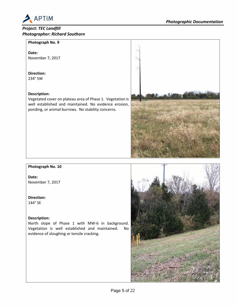
Photograph No. 9 Date: November 7, 2017 Direction: 234° SW Description: Vegetated cover on plateau area of Phase 1. Vegetation is well established and maintained. No evidence erosion, ponding, or animal burrows. No stability concerns.
Photograph No. 10 Date: November 7, 2017 Direction: 144° SE Description: North slope of Phase 1 with MW‐6 in background. Vegetation is well established and maintained. No evidence of sloughing or tensile cracking.

Photographic Documentation
Project: TEC Landfill Photographer: Richard Southorn
Page 6 of 22
Photograph No. 11 Date: November 7, 2017 Direction: 178° S Description: East slope of Phase 3. Vegetation is well established and maintained. No evidence of sloughing, tensile cracking, or other indications of stability concerns.
Photograph No. 12 Date: November 7, 2017 Direction: 250° W Description: Wattle installed around the final cover construction area of Phase 3. A contact water management basin was previously located in the area near the construction equipment. The basin was in the final stages of being removed at the time of the Annual Inspection. The basin was being filled with structural fill to surrounding grade. This work was performed to remove the potential source of seeps observed on the eastern slopes during the 2016 Annual Inspection. The area has been leveled and no ponding of water was observed.
Photographic Documentation
Project: TEC Landfill Photographer: Richard Southorn
Page 7 of 22
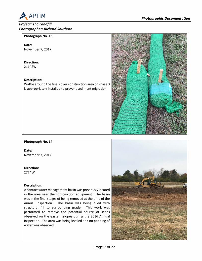
Photograph No. 13 Date: November 7, 2017 Direction: 211° SW Description: Wattle around the final cover construction area of Phase 3 is appropriately installed to prevent sediment migration.
Photograph No. 14 Date: November 7, 2017 Direction: 277° W Description: A contact water management basin was previously located in the area near the construction equipment. The basin was in the final stages of being removed at the time of the Annual Inspection. The basin was being filled with structural fill to surrounding grade. This work was performed to remove the potential source of seeps observed on the eastern slopes during the 2016 Annual Inspection. The area was being leveled and no ponding of water was observed.

Photographic Documentation
Project: TEC Landfill Photographer: Richard Southorn
Page 8 of 22
Photograph No. 15 Date: November 7, 2017 Direction: 277° W Description: Seep area identified in 2016 Annual Inspection. Riprap had been placed to stabilize the slope and prevent potential erosion or slope movement. No water was observed to be seeping out of the sideslope at the time of inspection. It is anticipated that the construction project to remove the contact water management basin may mitigate the seep in this area. No visual identifiers of concern at this time.
Photograph No. 16 Date: November 7, 2017 Direction: 360° N Description: Piezometer‐1 near previously noted seep area. Used to gauge water levels in CCR unit as part of seep evaluation. Wattle around the final cover construction area of Phase 3 is appropriately installed to prevent sediment migration.

Photographic Documentation
Project: TEC Landfill Photographer: Richard Southorn
Page 9 of 22
Photograph No. 17 Date: November 7, 2017 Direction: 347° N Description: Observing the vegetated cover at Phases 1 and the undisturbed areas of Phase 3 (outside of construction area). Vegetation is well established and maintained. No evidence erosion, ponding, or animal burrows. No stability concerns.
Photograph No. 18 Date: November 7, 2017 Direction: 199° S Description: Phase 3 construction area where former contact water management basin has been filled to surrounding grade. No signs of ponding water. Seeding has not yet occurred (construction was ongoing at the time of inspection).

Photographic Documentation
Project: TEC Landfill Photographer: Richard Southorn
Page 10 of 22
Photograph No. 19 Date: November 7, 2017 Direction: 298° NW Description: Phase 3 construction area where former contact water management basin has been filled to surrounding grade. No signs of ponding water. Seeding has not yet occurred (construction was ongoing at the time of inspection).
Photograph No. 20 Date: November 7, 2017 Direction: 140° SE Description: Phase 3 construction area where former contact water management basin has been filled to surrounding grade. No signs of ponding water. Seeding has not yet occurred (construction was ongoing at the time of inspection).

Photographic Documentation
Project: TEC Landfill Photographer: Richard Southorn
Page 11 of 22
Photograph No. 21 Date: November 7, 2017 Direction: 194° S Description: Sideslope near seep area observed during the 2016 Annual Inspection. Vegetation is well established and maintained. No evidence of stability concerns or erosion.
Photograph No. 22 Date: November 7, 2017 Direction: 349° N Description: Vegetation is well established and maintained. No evidence of stability concerns or erosion.

Photographic Documentation
Project: TEC Landfill Photographer: Richard Southorn
Page 12 of 22
Photograph No. 23 Date: November 7, 2017 Direction: 203° SW Description: Vegetation on sideslope.
Photograph No. 24 Date: November 7, 2017 Direction: 148° SE Description: Active face of Phase 2. The active face is well maintained. CCR material is being spread by a dozer (not shown in photograph).

Photographic Documentation
Project: TEC Landfill Photographer: Richard Southorn
Page 13 of 22
Photograph No. 25 Date: November 7, 2017 Direction: 190° S Description: Active face of Phase 2. The active face is well maintained. CCR material is being spread by a dozer. No fugitive dust observed to be generated as part of operations.
Photograph No. 26 Date: November 7, 2017 Direction: 239° SW Description: Active face of Phase 2. The active face is well maintained. No fugitive dust observed to be generated as part of operations.

Photographic Documentation
Project: TEC Landfill Photographer: Richard Southorn
Page 14 of 22
Photograph No. 27 Date: November 7, 2017 Direction: 6° N Description: Overview of Phase 3 construction area where the contact water management basin has been removed by placement of fill to surrounding grade. The overview shows the uniformity in fill placement and the complete removal of standing water.
Photograph No. 28 Date: November 7, 2017 Direction: 138° SE Description: Vegetation on sideslope near active area is well established and maintained. Vegetation is well established and maintained. No evidence of stability concerns or erosion.
Photographic Documentation
Project: TEC Landfill Photographer: Richard Southorn
Page 15 of 22
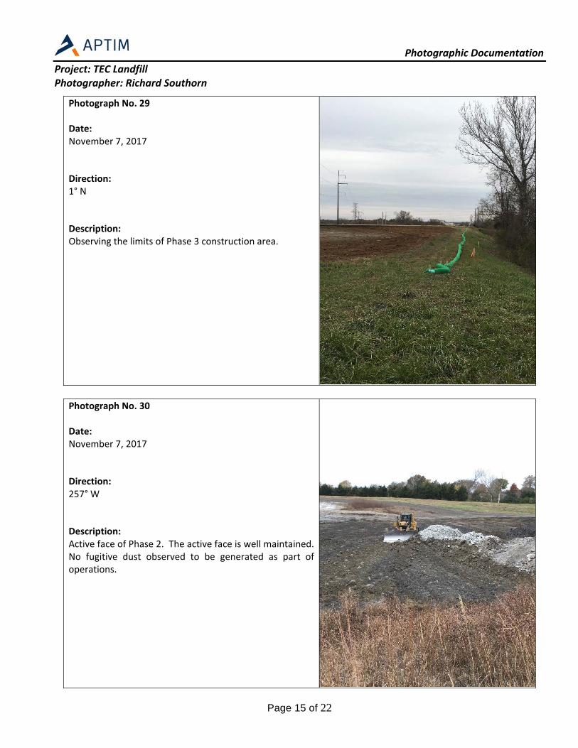
Photograph No. 29 Date: November 7, 2017 Direction: 1° N Description: Observing the limits of Phase 3 construction area.
Photograph No. 30 Date: November 7, 2017 Direction: 257° W Description: Active face of Phase 2. The active face is well maintained. No fugitive dust observed to be generated as part of operations.

Photographic Documentation
Project: TEC Landfill Photographer: Richard Southorn
Page 16 of 22
Photograph No. 31 Date: November 7, 2017 Direction: 261° W Description: Active face of Phase 2. The active face is well maintained. No fugitive dust observed to be generated as part of operations.
Photograph No. 32 Date: November 7, 2017 Direction: 127° SE Description: East slope of Phase 2. Vegetation is well established and maintained. No evidence of sloughing, tensile cracking, or other indications of stability concerns.

Photographic Documentation
Project: TEC Landfill Photographer: Richard Southorn
Page 17 of 22
Photograph No. 33 Date: November 7, 2017 Direction: 268° W Description: Observing the certified closed area of Phase 2. Vegetation is well established and maintained. No evidence of ponding, erosion, animal burrows, or stability concerns.
Photograph No. 34 Date: November 7, 2017 Direction: 285° W Description: Observing the certified closed area of Phase 2. Vegetation is well established and maintained. No evidence of ponding, erosion, animal burrows, or stability concerns.

Photographic Documentation
Project: TEC Landfill Photographer: Richard Southorn
Page 18 of 22
Photograph No. 35 Date: November 7, 2017 Direction: 268° W Description: Observing the certified closed area of Phase 2. Vegetation is well established and maintained. No evidence of ponding, erosion, animal burrows, or stability concerns.
Photograph No. 36 Date: November 7, 2017 Direction: 322° NW Description: Observing the certified closed area of Phase 2. Vegetation is well established and maintained. No evidence of ponding, erosion, animal burrows, or stability concerns.
Photographic Documentation
Project: TEC Landfill Photographer: Richard Southorn
Page 19 of 22
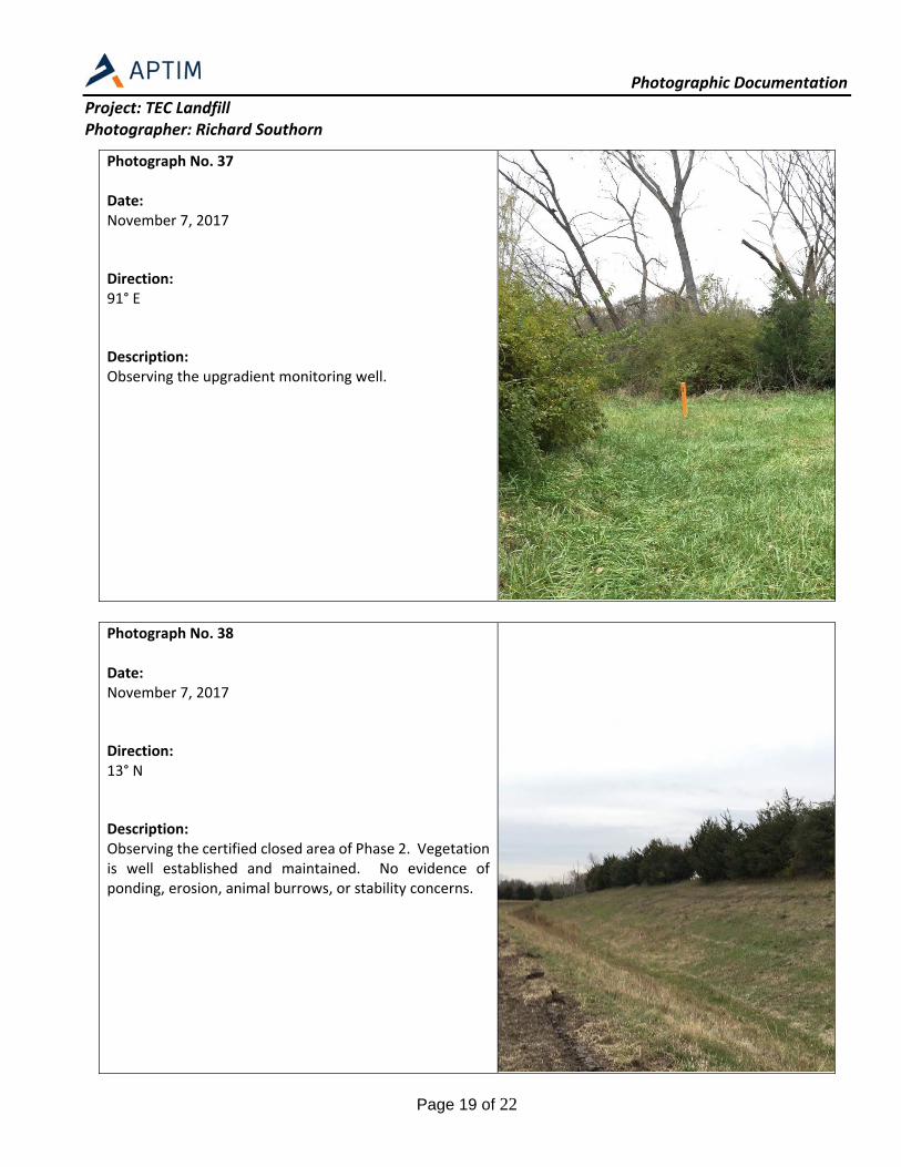
Photograph No. 37 Date: November 7, 2017 Direction: 91° E Description: Observing the upgradient monitoring well.
Photograph No. 38 Date: November 7, 2017 Direction: 13° N Description: Observing the certified closed area of Phase 2. Vegetation is well established and maintained. No evidence of ponding, erosion, animal burrows, or stability concerns.

Photographic Documentation
Project: TEC Landfill Photographer: Richard Southorn
Page 20 of 22
Photograph No. 39 Date: November 7, 2017 Direction: 190° S Description: A stormwater channel is being installed along the western toe of slope of the closed Phase 2 area to promote drainage and remove ponding of water that was occurring outside of the landfill boundary. Seeding had not yet occurred at the time of the Annual Inspection. Construction was on‐going and being completed in conjunction with the Phase 3 contact water management basin filling project.
Photograph No. 40 Date: November 7, 2017 Direction: 37° NE Description: The stormwater channel that is being constructed at its intersection with the perimeter road. Stormwater will enter a riprap lined section before passing through a stormwater culvert.

Photographic Documentation
Project: TEC Landfill Photographer: Richard Southorn
Page 21 of 22
Photograph No. 41 Date: November 7, 2017 Direction: 54° NE Description: Photograph shows the former soil stockpile location that was used for construction soils in 2017. The site has been restored to grade and is in good condition.
Photograph No. 42 Date: November 7, 2017 Direction: 84° E Description: Phase 3 construction area where former contact water management basin has been filled to surrounding grade. No signs of ponding water. Seeding has not yet occurred (construction was ongoing at the time of inspection).

Photographic Documentation
Project: TEC Landfill Photographer: Richard Southorn
Page 22 of 22
Photograph No. 43 Date: November 7, 2017 Direction: 63° NE Description: Vegetated cover on plateau area of Phase 1. Vegetation is well established and maintained. No evidence erosion, ponding, or animal burrows. No stability concerns.