Embed Size (px)
Citation preview

Golder Associates Ltd.
500 - 4260 Still Creek Drive, Burnaby, British Columbia, Canada V5C 6C6 Tel: +1 (604) 296 4200 Fax: +1 (604) 298 5253 www.golder.com
Golder Associates: Operations in Africa, Asia, Australasia, Europe, North America and South America
Golder, Golder Associates and the GA globe design are trademarks of Golder Associates Corporation.
Dear Dr. Eyre,
Golder Associates Ltd. (Golder) completed an inspection of the Carmacks Copper project site for Copper North Mining Corp. (CNMC), on July 10, 2012. The inspection of the proposed future site of the Carmacks Copper mine was completed as part of the requirement of the Quartz Mining License (QML – 0007) for an annual inspection. The inspection was to evaluate the condition and stability of the existing facilities in the area of the proposed new mine and the proposed facilities which will include a heap leach pad, an open pit mine area, a waste rock storage area, a processing plant and related facilities, ore preparation facilities, ore stockpiles, water diversion structures and/or other related operations or facilities. The inspection was limited in that there are no structures on site at present with the exception of the mine exploration camp and there are no current activities currently at the site. An inspection was however, completed of the entire project area.
1.0 INSPECTION
The inspection by Golder was completed by John Hull and Ben Wickland of Golder Associates, with Scott Casselman, a representative of CNMC. CMNC staff Sally Eyre, Doug Ramsey and Peter Oates were also present. The inspection focused on the existing site conditions and the limited site infrastructure. Photographs of the site at the time of the inspection are presented in Appendix A. Data from vibrating wire piezometers and thermistors collected during the visit are presented in Appendix B.
The project is in the advanced exploration stage and final permitting for the proposed future mine. As noted the only infrastructure on site, at present, is the exploration camp and a series of access roads to the proposed open pit mine area and other areas of the property. The access roads were developed to provide access for exploration activities.
The inspection of the camp area indicated there is no erosion of sediments from the pad area into the surrounding natural area. The slope behind or west of the camp is stable and is not impacting or causing any
August 15, 2012 Project No. 07-1413-0077 Doc. No. 191 Rev. 0
Sally Eyre President & CEO Copper North Mining Corp. 2060 - 1111 West Georgia Street Vancouver, BC V6E 4M3
ANNUAL INSPECTION, JULY 10, 2012
CARMACKS COPPER PROJECT, CARMACKS, YUKON

Sally Eyre
07-1413-0077 Doc. No. 191 Rev. 0
President & CEO August 15, 2012
2/4
safety issues with the camp structures or operations. There is minor slumping and ravelling of small sections of the slope, but these are not impacting camp safety nor would they represent an issue to workers on the project. Some re-growth of vegetation was observed in the camp area.
In addition to the camp, the inspection included the area proposed for the heap leach facility, events pond, and the heap leach sediment pond. This portion of the site also includes the area planned for the process plant west of the heap leach embankment. None of these structures have been developed and site preparation in these areas has been limited to the clearing of trees and organic soils (complete in 1997-1998), development of a series of access roads, and drilling platforms established as part of the exploration programs. Since the initial clearing, vegetation re-growth has been occurring.
Erosion and sediment control measures in the area were initially put into place in September 2008 and further maintained in September 2009 and August 2010. These included a series of ditches and berms to divert water into vegetated areas and to break up flow to reduce the potential for erosion, sediment catch basins, and silt fences. No recent work has been completed to maintain the drainage works in 2011 and the inspection indicated that there has been little new erosion of sediments along the access roads and that the sediment basins are generally trapping and containing the sediment adequately. One catch basin on the road north east of the camp site was near capacity for sediment and should be re-excavated. Otherwise, sediment catch basins had additional capacity.
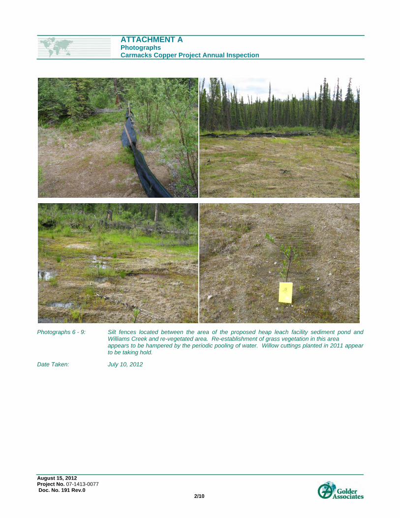
Further down slope of the proposed HLF sediment pond, and within the floodplain of Williams Creek, a series of silt fences have been installed and the area seeded, where sediment from previous site erosion has accumulated. At the time of the inspection, it was observed that the silt fencing surrounding these areas is working effectively and there is no evidence of recent sediment movement. Grass seed was used in 2009 to promote the re-establishment of vegetation and further stabilize the sediment. The approach was noted to be generally effective in 2011, but with limited re-growth in one particular area attributed to periodically pooling of water. The area was re-vegetated with woody plants (willow cuttings), and volunteer species appear to be tolerating saturated soil conditions. No movement of sediment beyond the existing silt fences was observed, nor does it appear that sediment has entered Williams Creek. These erosion control measures are of a temporary nature that should be inspected annually and ongoing minor maintenance activities should be anticipated.
The area where the open pit is to be developed was inspected. The excavation slopes of the trenches developed as part of the effort to obtain bulk samples during exploration activities were observed to be in reasonable condition and there was no observed slumping or failures of the excavation slopes. The leached ore pile adjacent the trench was observed to be stable. There were no visual signs of erosion observed in the area of the proposed open pit. Several of the closed drill pads were inspected and there did not appear to be any erosion noted from these areas that require attention.
The area of the proposed waste rock storage area (WRSA) and the present access road crossing at North Williams Creek was inspected. The waste rock storage area is tree covered and the drill pads in the area of the proposed waste rock storage area are re-vegetated with healthy ground cover including new trees with 25 to 50 mm diameter trunks. No signs of sediment movement into the surrounding area were observed. The small sediment catch basins at the drill pads have additional capacity to manage more sediment, if required.

Sally Eyre
07-1413-0077 Doc. No. 191 Rev. 0
President & CEO August 15, 2012
3/4
Local erosion was observed on the main access road to the north of the WRSF, in the area of the North Williams creek crossing. The local erosion is attributed to reduced flow in the culvert leading to temporary overtopping of the road from the ponded area adjacent the road. The invert of the culvert inlet was observed to be bent upward and was partly blocked by woody debris. The woody debris was removed. It is recommended that the culvert mouth be restored to allow full flow. It is recommended that the area of local erosion on the road be filled with coarse gravel to level the grade.
Minor erosion along the ditches of the access road on the north side of North Williams Creek was observed. A series of diversion ditches were created along the access road to divert water and sediment from the road into adjacent vegetated areas in 2010. These diversions appear to be working effectively at present. Annual inspection and the requirement for minor maintenance of these sediment control measures should be anticipated.
The process plant and the crusher / truck shop areas were inspected. The process plant site is partially cleared and the crusher / truck shop site is still tree covered. There was no apparent erosion along any of the access roads in these two areas or at the weather station located just to the west of the crusher / truck shop area.
The new camp site was inspected and it is still tree covered. The site adjacent to the camp where the new water wells were installed was also inspected and there is no apparent movement of sediment beyond the work pads around the wells.
The site access road crossing of Williams Creek has a single culvert. As noted in 2011, the sand bags that were previously placed surrounding the culvert entrance and exit are deteriorated. In 2012, the exit of the culvert was observed to be partly in filled by granular material. In addition, it appears that further flow has passed over two segments of the road near the crossing. It is anticipated that this was again a temporary condition, which likely occurred at the beginning of the freshet, potentially when the culvert was still frozen/blocked by snow. Some erosion of the roadbed material has occurred. It is recommended to excavate the material out of the exit of the culvert, re-establishing the support of the fill materials adjacent to the culvert inlet and outlet, re-establish the bank protection on the upstream and downstream side of the culvert and extend the protection to the location where flow has occurred across the access road. Further, a coarse gravel material should be placed across the road at the low points (where erosion occurred) so that future flows across the road do not result in new erosion of the road embankment.
The general site development has not started yet. Therefore, there are no stability concerns associated with the undeveloped facilities and no maintenance required. No permanent water diversion structures are in place. There are however, temporary water management diversion structures (i.e., ditches and sediment catch basins) in place that are appropriate for the exploration stage of the property. It is recommended that they continue to be inspected annually and that ongoing maintenance be conducted, as deemed necessary.
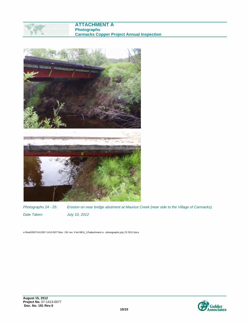
The access road crossing at Merrice Creek includes a single span bridge set on grade. No steelwork or abutment foundations were observed, and the creek banks were being eroded and under cut at the crossing location. The bridge should be re-set or the abutments protected against further erosion. This work should be completed in 2012 if possible, or if not possible then it will be critical to fixed and re-inspected in 2013.

Sally Eyre
07-1413-0077 Doc. No. 191 Rev. 0
President & CEO August 15, 2012
4/4
2.0 THERMISTOR DATA
Readings from thermistors taken during the site visit are presented in Attachment B. The thermistor data indicate cooling of ground at depths below 6.5 m at BH17-07, located in the footprint of the heap leach facility confining embankment.
It is recommended that vegetation in the lower footprint area of the HLF and confining embankment be re-cleared of vegetation in 2012 or 2013 to promote thaw of permafrost ground prior to development of the area. Vegetation may promote re-establishment of permafrost and ground ice and should therefore be cleared to allow thaw over the warmer months.
3.0 RECOMMENDED ACTIONS
The inspection of the proposed mine site for the Carmacks Copper was completed on July 10, 2011 and indicated that as the site development has not been started yet, there is limited infrastructure and limited requirements for maintenance or further investigations. Recommended actions are summarized as follows:
Clearing of vegetation in the footprint of the area of the lower HLF and confining embankment to promote thaw of permafrost ground.
Maintenance of culvert and roadbed at the Williams Creek crossing.
Maintenance of culvert and roadbed at the North Williams Creek crossing.
Clearing of the sediment trap on the access road to the lower re-vegetated area near Williams Creek at the proposed HLF sedimentation pond location.
Re-set the bridge or apply erosion protection for the crossing at Merrice Creek
Should be done this year if possible, if not then it will be critical to be fixed next year.
To be re-inspected following works.
It is understood that the recommended maintenance work will be carried out by CNMC.
We trust that this letter satisfies your requirements. If you require additional information, please do not hesitate to contact us.
Yours very truly,
GOLDER ASSOCIATES LTD.
Ben Wickland, Ph.D., P.Eng.(BC) John Hull, P.Eng. (BC, NWT, NU, YK) Senior Geotechnical Engineer Principal BW/JAH/np Attachments: Attachment A – Photographs
Attachment B – Thermistor Data
o:\final\2007\1413\07-1413-0077\doc. 191 rev. 0 let 0815_12\let1.docx

ATTACHMENT A Photographs

ATTACHMENT APhotographs Carmacks Copper Project Annual Inspection
August 15, 2012 Project No. 07-1413-0077 Doc. No. 191 Rev.0 1/10
Photographs 1 - 5: Carmacks Exploration Camp slope - north of camp, exploration camp trailers, core box storage and logging shacks.
Date Taken: July 10, 2012
ATTACHMENT APhotographs Carmacks Copper Project Annual Inspection
August 15, 2012 Project No. 07-1413-0077 Doc. No. 191 Rev.0 2/10
Photographs 6 - 9: Silt fences located between the area of the proposed heap leach facility sediment pond and Williams Creek and re-vegetated area. Re-establishment of grass vegetation in this area
appears to be hampered by the periodic pooling of water. Willow cuttings planted in 2011 appear to be taking hold.
Date Taken: July 10, 2012

ATTACHMENT APhotographs Carmacks Copper Project Annual Inspection
August 15, 2012 Project No. 07-1413-0077 Doc. No. 191 Rev.0 3/10
Photograph 10: View of proposed heap leach facility taken from proposed pit area, looking south west.
Date Taken: July 10, 2012
Photograph 11: View of proposed heap leach facility area from near the proposed events pond, looking north west.
Date Taken: July 10, 2012

ATTACHMENT APhotographs Carmacks Copper Project Annual Inspection
August 15, 2012 Project No. 07-1413-0077 Doc. No. 191 Rev.0 4/10
Photograph 13: Re-vegetation on drill access road in the events pond area.
Date Taken: July 10, 2012
Photographs 14 - 15: Re-vegetation in the heap leach facility area.
Date Taken: July 10, 2012

ATTACHMENT APhotographs Carmacks Copper Project Annual Inspection
August 15, 2012 Project No. 07-1413-0077 Doc. No. 191 Rev.0 5/10
Photograph 16: Drill pad sediment basin trap near the proposed events pond.
Date Taken: July 10, 2012

ATTACHMENT APhotographs Carmacks Copper Project Annual Inspection
August 15, 2012 Project No. 07-1413-0077 Doc. No. 191 Rev.0 6/10
Photograph 17: Water supply well and pad near proposed camp site.
Date Taken: July 10, 2012

ATTACHMENT APhotographs Carmacks Copper Project Annual Inspection
August 15, 2012 Project No. 07-1413-0077 Doc. No. 191 Rev.0 7/10
Photograph 18: Inlet of culvert on crossing of North Williams Creek.
Date Taken: July 10, 2012
Photograph 19: Erosion on road immediately north of North Williams Creek crossing.
Date Taken: July 10, 2012

ATTACHMENT APhotographs Carmacks Copper Project Annual Inspection
August 15, 2012 Project No. 07-1413-0077 Doc. No. 191 Rev.0 8/10
Photographs 20 - 21: View of culvert inlet (top) and outlet (bottom) at access road crossing of Williams Creek. Note sand bags used for embankment support on upstream and downstream side of the culvert which have deteriorated.
Date Taken: July 10, 2012

ATTACHMENT APhotographs Carmacks Copper Project Annual Inspection
August 15, 2012 Project No. 07-1413-0077 Doc. No. 191 Rev.0 9/10
Photographs 22 - 23: Erosion on access road near Williams Creek crossing where water appears to have flowed across and where some road bed material has eroded.
Date Taken: July 10, 2012
ATTACHMENT APhotographs Carmacks Copper Project Annual Inspection
August 15, 2012 Project No. 07-1413-0077 Doc. No. 191 Rev.0 10/10
Photographs 24 - 25: Erosion on near bridge abutment at Maurice Creek (near side to the Village of Carmacks).
Date Taken: July 10, 2012
o:\final\2007\1413\07-1413-0077\doc. 191 rev. 0 let 0815_12\attachment a - photographs july 23 2012.docx

ATTACHMENT B Thermistor Data

THERMISTOR LOCATION PLAN
COPPER NORTH MINING CORP.CARMACKS COPPER PROJECT
YUKON TERRITORY
FIGURE 1
N:\Bur-Graphics\Projects\2007\1413\07-1413-0077\Drafting\July 2012 Figures\New Thermistor Figure\0714130077_1000-01.dwg | Layout: ANSI_D_FIGURE_PORTRAIT | Modified: matrobertson 07/18/2012 4:04 PM | Plotted: matrobertson 07/18/2012
JUL-18-12M.R.
JUL-18-12B.W.
07-1413-0077 0714130077_1000-01
LEGEND
REFERENCES1.) M3 Engineering Ltd., CAD Files: 000-CI-001.dwg, Dated December 16th, 2008.2.) Western Copper Corporation, CAD Files: sheet 1 to 9 Final.dwg, Received January 14th, 2007.3.) Western Copper Corporation, CAD Files: End_of_yr_01, _03, _06.dwg, Dated March 30th, 2007.4.) 2012 MineSight HLF Model Export.
500 100 200150 250
SCALE IN METRES
Proposed Mine Access Road
Existing Access Road
FOR DISCUSSION PURPOSES ONLYNOT FOR CONSTRUCTION
Approximate 2007 Borehole Location with Thermistor Installation. (Installed by Golder)
Approximate Borehole Location with Thermistor Installation (Installed by Knight Piezold)

Carmacks Copper Project BH-01-07 Graph of Thermisor ReadingsT07-01
07-1413-0077
O:\Active\_2007\1413\07-1413-0077 Carmacks-Field Investigation\3700 HLF Conceptual Design\Thermistor Data\Carmacks 2007 Thermistors -Dbase Last Updated July 12 2012.xlsm
0
5
10
15
20
25
30
35
40
-2 0 2 4 6 8 10 12 14
Ve
rtic
alD
ep
thB
elo
wG
rou
nd
Su
rfa
ce
(m)
Temperature (deg C)
13-Sep-07
25-Sep-07
14-Oct-07
1-Nov-07
1-May-08
16-Jun-08
29-Jul-08
16-Jun-09
13-Aug-09
08-Jul-10
29-Jun-11
10-Jul-12
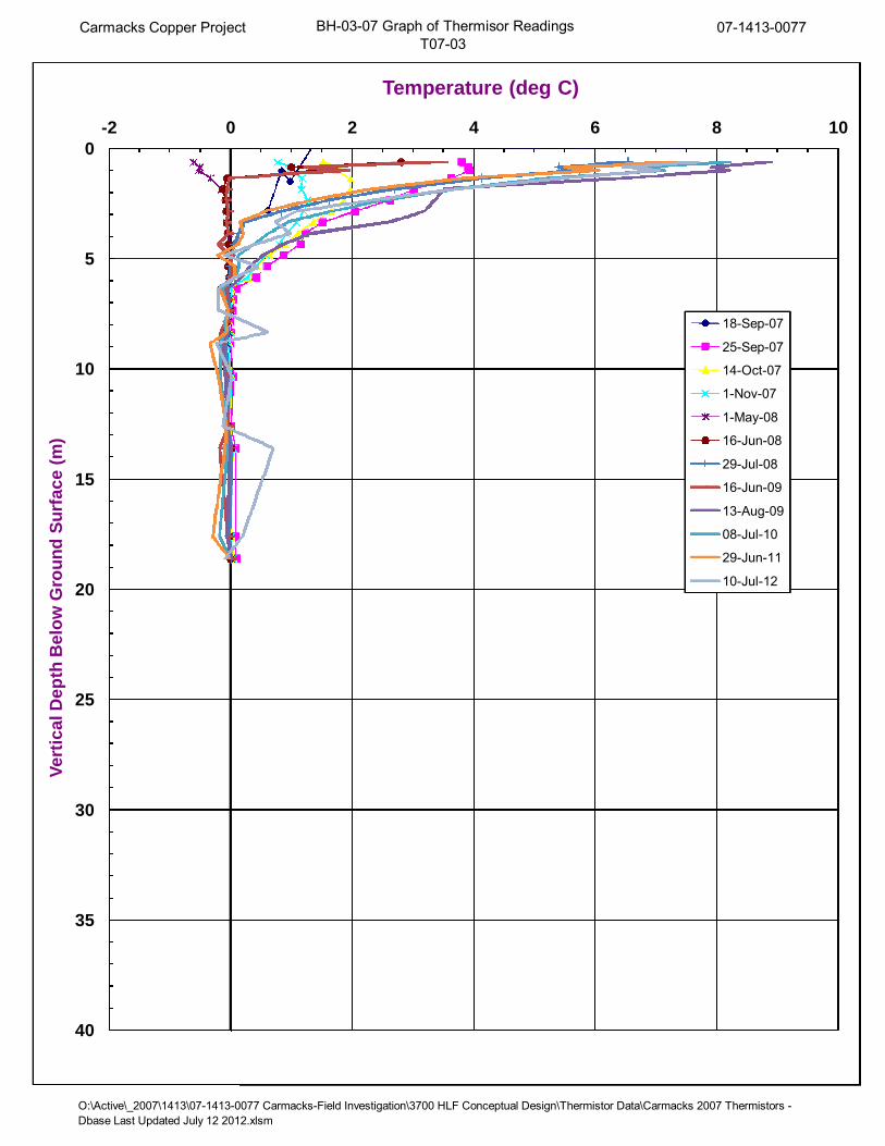
Carmacks Copper Project BH-03-07 Graph of Thermisor ReadingsT07-03
07-1413-0077
O:\Active\_2007\1413\07-1413-0077 Carmacks-Field Investigation\3700 HLF Conceptual Design\Thermistor Data\Carmacks 2007 Thermistors -Dbase Last Updated July 12 2012.xlsm
0
5
10
15
20
25
30
35
40
-2 0 2 4 6 8 10
Ve
rtic
alD
ep
thB
elo
wG
rou
nd
Su
rfa
ce
(m)
Temperature (deg C)
18-Sep-07
25-Sep-07
14-Oct-07
1-Nov-07
1-May-08
16-Jun-08
29-Jul-08
16-Jun-09
13-Aug-09
08-Jul-10
29-Jun-11
10-Jul-12

Carmacks Copper Project BH-06-07 Graph of Thermisor ReadingsT07-06
07-1413-0077
O:\Active\_2007\1413\07-1413-0077 Carmacks-Field Investigation\3700 HLF Conceptual Design\Thermistor Data\Carmacks 2007 Thermistors -Dbase Last Updated July 12 2012.xlsm
0
5
10
15
20
25
30
35
40
-2 0 2 4 6 8 10 12 14 16 18 20 22 24 26
Ve
rtic
alD
ep
thB
elo
wG
rou
nd
Su
rfa
ce
(m)
Temperature (deg C)
2-Oct-07
4-Oct-07
14-Oct-07
1-Nov-07
1-May-08
16-Jun-08
29-Jul-08
16-Jun-09
13-Aug-09
08-Jul-10
29-Jun-11
10-Jul-12

Carmacks Copper Project BH-12-07 Graph of Thermisor ReadingsT07-04
07-1413-0077
O:\Active\_2007\1413\07-1413-0077 Carmacks-Field Investigation\3700 HLF Conceptual Design\Thermistor Data\Carmacks 2007 Thermistors -Dbase Last Updated July 12 2012.xlsm
0
5
10
15
20
25
30
35
40
-2 0 2 4 6 8 10 12 14 16 18 20 22 24 26 28
Ve
rtic
alD
ep
thB
elo
wG
rou
nd
Su
rfa
ce
(m)
Temperature (deg C)
18-Sep-07
25-Sep-07
4-Oct--07
14-Oct-07
1-Nov-07
1-May-08
29-Jul-08
17-Jun-08
16-Jun-09
13-Aug-09
08-Jul-10
29-Jun-11
10-Jul-12

Carmacks Copper Project BH-13-07 Graph of Thermisor ReadingsT07-05
07-1413-0077
O:\Active\_2007\1413\07-1413-0077 Carmacks-Field Investigation\3700 HLF Conceptual Design\Thermistor Data\Carmacks 2007 Thermistors -Dbase Last Updated July 12 2012.xlsm
0
5
10
15
20
25
30
35
40
-2 0 2 4 6 8 10 12 14 16
Ve
rtic
alD
ep
thB
elo
wG
rou
nd
Su
rfa
ce
(m)
Temperature (deg C)
4-Oct-07
14-Oct-07
1-Nov-07
1-May-08
16-Jun-08
29-Jul-08
16-Jun-09
13-Aug-09
08-Jul-10
29-Jun-11
10-Jul-12

Carmacks Copper Project BH-17-07 Graph of Thermisor ReadingsT07-02
07-1413-0077
O:\Active\_2007\1413\07-1413-0077 Carmacks-Field Investigation\3700 HLF Conceptual Design\Thermistor Data\Carmacks 2007 Thermistors -Dbase Last Updated July 12 2012.xlsm
0
5
10
15
20
25
30
35
40
-2 0 2 4 6 8 10 12 14
Ve
rtic
alD
ep
thB
elo
wG
rou
nd
Su
rfa
ce
(m)
Temperature (deg C)
29-Sep-07 3:00 PM
14-Oct-07
1-Nov-07
1-May-08
16-Jun-08
29-Jul-08
16-Jun-09
13-Aug-09
08-Jul-10
29-Jun-11
10-Jul-12
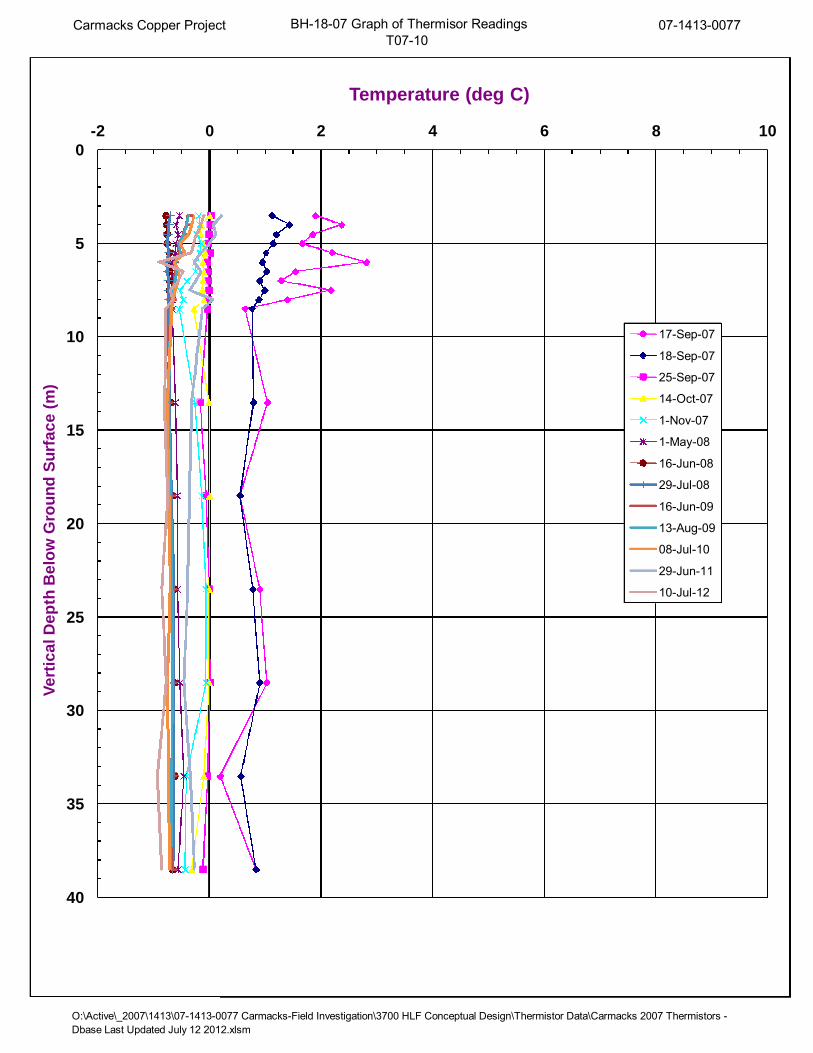
Carmacks Copper Project BH-18-07 Graph of Thermisor ReadingsT07-10
07-1413-0077
O:\Active\_2007\1413\07-1413-0077 Carmacks-Field Investigation\3700 HLF Conceptual Design\Thermistor Data\Carmacks 2007 Thermistors -Dbase Last Updated July 12 2012.xlsm
0
5
10
15
20
25
30
35
40
-2 0 2 4 6 8 10
Ve
rtic
alD
ep
thB
elo
wG
rou
nd
Su
rfa
ce
(m)
Temperature (deg C)
17-Sep-07
18-Sep-07
25-Sep-07
14-Oct-07
1-Nov-07
1-May-08
16-Jun-08
29-Jul-08
16-Jun-09
13-Aug-09
08-Jul-10
29-Jun-11
10-Jul-12

Carmacks Copper Project BH-23-07 Graph of Thermisor ReadingsT07-08
07-1413-0077
O:\Active\_2007\1413\07-1413-0077 Carmacks-Field Investigation\3700 HLF Conceptual Design\Thermistor Data\Carmacks 2007 Thermistors -Dbase Last Updated July 12 2012.xlsm
0
5
10
15
20
25
30
35
40
-2 0 2 4 6 8 10 12 14 16 18 20
Ve
rtic
alD
ep
thB
elo
wG
rou
nd
Su
rfa
ce
(m)
Temperature (deg C)
4-Oct-07
14-Oc-07
1-Nov-07
1-May-08
29-Jul-08
17-Jun-08
16-Jun-09
13-Aug-09
08-Jul-10
29-Jun-11
10-Jul-12

Carmacks Copper Project BH-26-07 Graph of Thermisor ReadingsT07-07
07-1413-0077
O:\Active\_2007\1413\07-1413-0077 Carmacks-Field Investigation\3700 HLF Conceptual Design\Thermistor Data\Carmacks 2007 Thermistors -Dbase Last Updated July 12 2012.xlsm
0
5
10
15
20
25
30
35
40
-2 0 2 4 6 8 10
Ve
rtic
alD
ep
thB
elo
wG
rou
nd
Su
rfa
ce
(m)
Temperature (deg C)
29-Sep-07
14-Oct-07
1-Nov-07
1-May-08
16-Jun-08
29-Jul-08
16-Jun-09
13-Aug-09
08-Jul-10
10-Jul-12

Carmacks Copper Project BH-29-07 Graph of Thermisor ReadingsT07-09
07-1413-0077
O:\Active\_2007\1413\07-1413-0077 Carmacks-Field Investigation\3700 HLF Conceptual Design\Thermistor Data\Carmacks 2007 Thermistors -Dbase Last Updated July 12 2012.xlsm
0
5
10
15
20
25
30
35
40
-4 -2 0 2 4 6 8
Ve
rtic
alD
ep
thB
elo
wG
rou
nd
Su
rfa
ce
(m)
Temperature (deg C)
25-Sep-07
14-Oct-07
1-Nov-07
1-May-08
16-Jun-08
29-Jul-08
16-Jun-09
13-Aug-09
08-Jul-10
29-Jun-11
10-Jul-12